crime mapping in police departments: the … · crime mapping in police departments: the challenges...
TRANSCRIPT

CRIME MAPPING IN POLICEDEPARTMENTS:
THE CHALLENGES OF BUILDINGA MAPPING SYSTEM
by
Lorraine Green MazerolleUniversity of Cincinnati
Charles Bellucciand
Frank GajewskiJersey City Police Department
Abstract: This paper identifies the challenges facing police depart-ments that seek to implement computerized crime mapping systems.The first part of the paper highlights the importance of police depart-ments identifying primary "end-users" and then designing systemsthat accomplish the tasks specific to the needs of their end-users. Datatransfer, geocoding, data integration, system customization, and confi-dentiality issues are discussed. The second part of the paper illustratesthe practicalities of implementing geographic mapping systems drawingfrom our experiences with the Drug Market Analysis Program. We pro-file the Jersey City, NJ crime mapping system to highlight some of the
Address correspondence to: Lorraine Green Mazerolle, Division of Criminal Jus-tice, University of Cincinnati, PO Box 210389, Cincinnati, OH 45221-0389 ([email protected]).

132 — Lorraine Green Mazerolle et al.
difficulties encountered in implementing a computerized crime mappingsystem for street-level use. The paper concludes that police depart-ments planning to implement computer crime mapping capabilities needto think carefully about who, what, where, when and how the systemwill be used and then design the system data sources and interfacesaccordingly.
INTRODUCTION
Mapping crime in police departments has emerged as a popularmeans to display, analyze, and understand the distribution of crimeproblems (see McEwen and Taxman, 1995; Maltz et. al., 1991; Rich,1995). Crime analysts and police department planners use comput-erized maps to examine crime trends, identify emerging crime pat-terns, and present graphic representations of crime data to manage-ment, line officers, and the community. Street-level problem-solvingofficers use computerized crime mapping capabilities to map out thelocations of specific crime problems on their beat, search the regu-larity of locations where a suspect is arrested, and display patterns ofcrime activity at the local level.
For many types of inquiries, crime analysts and street problem-solvers need similar computerized crime mapping systems: they bothmerge Census data and land use data (such as percent of residentialproperties versus business properties) with police calls, arrests, andfield investigations. Crime analysts and problem-solvers also usecomputer maps to identify emerging patterns of crime activity. Inmany ways, however, crime analysts and street-level problem-solversdemand different types of inquiry systems for their different pur-poses. Crime analysts typically create thematic maps that help themto analyze the distribution of crimes against important population,land use, and household data at the Census-tract level. By contrast,street-level problem-solvers typically create point maps that plot theexact locations of arrests, for example, against specific types of envi-ronmental characteristics such as the locations of bars, pay phones,and video arcades on a beat.
This paper examines the challenges that confront police depart-ments in designing and implementing computerized crime-mappingcapabilities. The paper begins by identifying some of the factors thatpolice departments need to consider when they decide to build acrime mapping system. We contrast the different needs of crime ana-lysts and street-level problem-solvers, the needs of rural versus city

Crime Mapping in Police Departments — 133
police departments, and the capabilities of mainframe versus per-sonal computer (PC)-based mapping systems. The second part of thepaper discusses the specific challenges confronting departments thatplan to implement PC-based crime mapping systems. In the thirdsection we profile the Jersey City (NJ) Drug Market Analysis Systemas an example of a PC-based computerized mapping system that wasdesigned and implemented for operational use by street-level prob-lem-solving officers.
DIFFERENT SYSTEMS FOR DIFFERENT PURPOSES
Crime mapping systems provide police departments with a pow-erful tool with which to examine a vast array of data. Police data (ar-rests, calls for service, and crime incidents) can be mapped with Cen-sus data and any other information for which an address is available(e.g., bars, fast-food locations, pay phones). While the opportunity tomap crime appeals to many police agencies, the practicalities of pur-chasing, installing, customizing, and using crime mapping systemsare far from straightforward. Moreover, without having a clear pictureof who (in the department) is going to use the system, many enthusi-astic ventures into crime mapping end up as frustrating experiencesthat fail to live up to early expectations. We propose that differentpolice agencies need different types of crime mapping systems.Moreover, even within a police agency, different police functions willmost likely demand different types of applications. Consistent withthis proposition, we examine several factors that police agencies maywant to consider in building their crime mapping systems.
Mapping Systems for Crime Analysts and Problem-Solvers
In this section we identify and discuss two primary crime mappingsystem "end-users": crime analysts and street-level problem-solvers.1
These end-users have different interests and functions within the po-lice organization. As such, their respective demands of a crime map-ping system can be divergent. This section contrasts some demandsof crime mapping systems that are typical from crime analysts andstreet-level problem-solving officers.
Computerized crime maps provide crime analysts and depart-mental planners with a means to spatially relate crime conditions,patterns, and trends. For example, an analyst can search for placeswhere high levels of crime correlate with relatively low levels of patrol

134 — Lorraine Green Mazerolle et al.
assignments. Patterns can be explored within a mapping system bysearching places with elevated levels of crime against patrol deploy-ment patterns across temporal dimensions. Trends can be uncoveredby using past patterns to predict the locations of emerging hot spotsof crime.
Graphic presentations of search findings provide a powerful me-dium to communicate conditions, patterns, and trends, often creatingan avenue for analysts to bring about significant policy changes. InJersey City, for example, computerized crime mapping capabilitieshave been used by departmental planners to develop beat boundariesand to help match community service officers with particular ethnicand racial neighborhoods. In another project, the Jersey City PoliceDepartment crime mapping system was used to merge crime datawith neighborhood characteristics. Boundaries were created to matchCensus data with police data aggregated to the beat level of analysis.In this project, workload data were merged with indicators of crime(such as emergency calls and arrests) and then mapped along withCensus data showing population densities, proportions of youths bydistrict, and other community-level factors that correlated with highor low work loads. Using these maps, the police department em-barked upon a restructuring project that precipitated widespreadchanges to the organizational structure and function of the depart-ment.
While police department planners and crime analysts are typi-cally interested in using computerized crime mapping systems to an-swer broad-based policy questions, street-level problem-solvers usecrime mapping to answer different types of questions. Street officersstill require mapping tools to examine conditions, patterns andtrends in crime problems, but the units of inquiry and their dataneeds are often quite different from crime analysts' demands. For ex-ample, street-level officers tend to explore crime maps to identify theenvironmental features that are consistent with different types ofproblems. Bars are often found to be focal points for open-air drugsales (Eck, 1994; Roncek and Maier, 1991; Weisburd and Green,1994); assault and robbery problems tend to occur along mainthroughways and, in particular, near bus stops; and prostitutionproblems are often found along main throughways. Knowing theunique distributions of crime problems for specific categories of crimeis critical for street-level problem-solving officers.
While crime mapping systems can be used by both street-level of-ficers and citywide crime analysts, many police departments cus-tomize their inquiry system to meet the specific demands of one

Crime Mapping in Police Departments — 735
group over another. For example, crime analysts will typically de-mand a mapping system that can routinize the creation of thematicmaps describing the changing patterns of crime across the city overthe last six months. By contrast, beat officers will typically demandthat their mapping system help them to pinpoint crime patterns forspecific categories of crime. For example, the Jersey City ViolentCrimes Unit used their mapping system to identify robbery incidentpatterns over a two-week period when they suspected that one par-ticular group was involved in a spate of crimes.
A mapping system designed to routinize thematic maps using six-monthly or yearly blocks of data will frustrate a beat officer askingvery different questions and needing more specific time-frame data.Therefore, we suggest that police departments need to identify theprimary end-user from the outset, and then prioritize the customiza-tion of crime mapping systems accordingly.
Rural, Suburban and City Crime Mapping Systems
Crime mapping systems will be used differently depending onwhether the police department is a rural, suburban, or city depart-ment. Rural departments face very different crime problems thansuburban and city jurisdictions. As such, crime mapping systemsneed to be customized around the types of questions that are mostpertinent to particular departments. For example, rural departmentsmay want to search for a stretch of road where most traffic infringe-ments are given against the locations of traffic accidents by time ofday and day of week. By contrast, city departments may want tosearch for drug-selling clusters or pinpoint the exact locations of rob-beries by bus stop locations.
The geocoding challenges of rural, suburban, and city depart-ments are also quite different. For rural departments, pinpointing theexact location of an incident may be impossible for many incidentsdue to vague location descriptions within the data, as well as the ex-istence of roads that do not exist in the map files. Therefore, thematicmapping may be more pertinent at the block-group level of analysisfor rural departments. By contrast, pinpointing crime locations andidentifying clusters of crime activity (hot spots) will be highly relevantfor city and possibly suburban departments.
Over all, finding solutions to geocoding problems and developingcustomized mapping systems are very different processes for city,rural, and suburban police departments. Therefore, a crime mappingsystem that may be useful for a city agency may have limited rele-

736 — Lorraine Green Mazerolle et al.
vance for a suburban department and even less applicability for arural department.
Different Platforms
Some police departments have purchased sophisticated mappingsystems (such as Arclnfo) that run off UNIX or VAX systems. Othershave purchased less expensive mapping software (such as Maplnfoand Atlas) that can be easily installed and run off PCs. While softwareis available that allows for easy conversion of files back and forthbetween different platforms (e.g., ArcLink), police departments needfrom the outset to make up-front commitments regarding whichplatform they wish to "house" their mapping system. The followingissues are raised regularly while police department are choosing be-tween different mapping platforms:
(1) Cost PC mapping software such as Maplnfo, Arc View or Atlasare considerably cheaper than mainframe mapping softwaresystems such as Arclnfo.
(2) Training: PC mapping software such as Maplnfo is generallyregarded as requiring considerably less training than main-frame software such as Arclnfo. Arclnfo systems are often de-pendent on specialized computer personnel to produce maps,whereas Maplnfo requires a shorter learning curve and lessstart-up expertise to produce useful maps.
(3) Capabilities: One question often raised by police departmentscenters on the relative capabilities of different mapping soft-ware. While most police departments tend to underutilizetheir system capabilities, Arclnfo generally provides moreanalytic capabilities than Maplnfo. However, for thematicmapping and basic crime analysis in police departments, PCmapping systems will provide most of the capabilities neededby police.
(4) Technical Support One question that is raised by many policedepartment personnel is access to (or lack of) technical sup-port. Police departments need to talk with other departmentsthat have recently purchased similar software to ensure thatthey will have adequate access to technical assistance.
PC MAPPING SYSTEMS: THE CHALLENGES
The power of computerized crime mapping is the ability to drawfrom and organize a vast array of data in a form that can be quickly

Crime Mapping in Police Departments — 137
digested and understood. Graphic presentation of various types ofinformation on a map allows the user to easily convey a story. How-ever, many police departments become frustrated when they attemptto implement crime mapping systems. This section surveys some ofthe typical problems encountered by departments in their efforts toimplement PC computer mapping systems.
Real Time Versus Archive Data
One technological challenge facing police departments interestedin crime mapping is making call, arrest, incident, and other routinesources of police data accessible to the police on a "real-time" basis.As emergency calls are logged, arrest reports typed and investigationsrecorded, line officers need access to these data. Failure to integratethese data with mapping systems on a real-time basis can lead toofficers developing negative opinions of crime mapping systems andperceptions that the systems cannot aid in their problem-solving ac-tivities. (See a later section for a discussion of this issue.)
One solution to a demand for "real-time" police data is applyingglobal positioning systems (GPS) technology to policing. This involvesinstallation of receivers in moving vehicles,2 on people,3 or on ani-mals4 that then transmit information to satellites that pinpoint theposition of the receiver at routine or specific points in time. Satelliteinformation is then transmitted to a computer terminal (PC or main-frame) that then uses the real-time data to track the locations of themoving objects.
In policing, GPS systems could be used5 to track police vehicle lo-cations periodically throughout a shift, relay arrest locations, identifyarrival times at crime scenes, track police responses to emergencycalls for service, or pinpoint the locations of police vehicles closest toan emergency call for service. The obvious problem with GPS tech-nology applied to policing, however, is the specter of surveillance bysupervisors over line officers (also see Sorensen, this volume).
Data Transfer
Many police departments have opted to purchase and install PCmapping systems. One of the first challenges confronting police de-partments that have invested in these systems is the retrieval of po-lice data. The problem is that police department data are often storedon UNIX or VAX systems. While the transfer of these data is relativelystraightforward,6 modifications to the main system interfaces aregenerally necessary to facilitate easy transfer of the data into the PC

138 — Lorraine Green Mazerolle et al.
environment. For example, system managers often need to install amenu option and programming routine to retrieve sets of data (bycrime type and time period), size the retrieved data sets, and thensave the data as transferable ASCII files.
Geocoding
Police departments generally confront many problems in mergingpolice data with computer maps. Even when data transfer problemsare solved, police data often comes in a form that is difficult to cleanand prepare for mapping. While most police computer-aided dispatch(CAD) systems contain "geofiles" (master lists of addresses linked to alocation identifier) that are designed to automatically check andprompt call-takers to enter addresses accurately, incoming policedata must still be processed (or geocoded) within the mapping systemto enable cases to be mapped. Those departments that do not haveaddress-checking procedures set up at the call-taking stage confrontnumerous cleaning and geocoding problems when they bring the datainto the mapping environment.
There are many ways that police departments can improve theirgeocoding "hit" rates. Methods to improve the integrity of incomingdata include training call-takers, blocking incorrect addresses fromentry to the system until they have been checked against the geofile,implementing E-911 systems that automatically record the locationof the emergency call,7 regularly updating geofiles, and making geo-files fit the format of the mapping system street files.8 Other ways toenhance the geocode rate of incoming data are to write routinecleaning programs to process incoming data before geocoding is at-tempted, and to permanently alter street files to match the form ofincoming police department data. One final way to increase the geo-code rate of police data is to purchase mapping utilities that attemptto geocode data to a range of alternatives, and then provide "out files"to identify the final match that was made (e.g., MapMarker). Overall,the time taken to retrieve, download, clean, and geocode police datapresents challenges for implementing street-level mapping systemswhose users often demand real-time data for problem-solving activi-ties.
Managing Data Files
Another challenge for those implementing PC crime mapping sys-tems relates to developing procedures for managing large and evolv-ing data files. PC crime mapping systems have to be set up in a way

Crime Mapping in Police Departments — 139
that provides system managers with automated and routine proce-dures that allow for accurate, convenient, and easy methods to: cleanincoming data; append new data to master data files; re-index files;purge old data; and allow room on PC environments to store largeamounts of data. Investments in automating these procedures at thestart of building a crime mapping system will increase the integrity ofthe data used in the system for street-level problem-solving officers.
Customizing the System
Over the last five years, PC mapping software companies have in-troduced more user-friendly, windows-based mapping systems thatoffer easier and more sophisticated inquiry options than older, DOSversions. However, police departments need to either hire outsideconsultants or develop in-house expertise to take advantage of theprogramming options of the software to allow users to customizemapping environments, and to allow officers to easily access data andconduct common types of inquiries. The easier the access to systemqueries, the more often officers will use the system for problem-solving activities.
Personalizing the System
Once a mapping system is customized, another challenge to policedepartments is to build mapping systems that allow officers to intro-duce new, idiosyncratic data and personalize existing data. For ex-ample, some beat officers collect data on the home or business ad-dresses of community members who are cooperative with their prob-lem-solving activities. Others collect information about, and monitorthe locations of, vacant lots, abandoned buildings, and other types ofenvironmental factors that they believe contribute to emerging crimeproblems. These types of data need to be readily accessible to beatofficers, and system enhancements must be routinely made to allowfor new, idiosyncratic and personalized data to be integrated into themain mapping system.
Documentation
The need for careful documentation on the uses, available data,and typical search routines included in a customized crime mappingsystem is not usually regarded as a priority for departments buildingcrime mapping systems. However, careful documentation of a map-

140 — Lorraine Green Mazerolle et al.
ping system can greatly enhance its use and provide access to it by agreater number of people.
Confidentiality
The confidentiality of maps that pinpoint crime locations is anarea of concern that is typically neglected in discussions regardingthe development of crime mapping systems.9 Anytime data are map-pable to the address-level of analysis, police departments need toconcern themselves with issues of confidentiality. For example, policeneed to proceed with caution when creating maps that reveal ad-dresses of community members who facilitate problem-solving activi-ties; home addresses of people that have been contacted, but not ar-rested, in the field; or locations of people calling the police about par-ticularly sensitive crime problems. The problems of confidentialitycannot be easily resolved. Beyond setting up password protectionsand creating search and query options that block the display of someparticularly sensitive fields, police departments need to think care-fully about circulating maps that may raise confidentiality concerns.
In sum, building computerized crime mapping systems requires aconsiderable amount of forethought and planning to ensure both theintegrity of the system and its long term usability. Ideally, police de-partments should consider building in-house skills for system design,creation, and management rather than relying on external consult-ants. Initial investments in police department personnel will allowdepartments to develop their systems over time, resolve data prob-lems as they arise, and keep abreast of new technological advancesas they emerge.
THE JERSEY CITY DRUG MARKET ANALYSIS SYSTEM:THE PRACTICE OF BUILDING A PC MAPPING SYSTEM
In 1989, the U.S. National Institute of Justice (NIJ) funded fivecities (Jersey City, Kansas City, Pittsburgh, Hartford, and San Diego)to be part of the Drug Market Analysis Program (DMAP). DMAP com-prised three broad objectives: to develop a systematic process foridentifying drug markets (see Weisburd and Green, 1994); to developa computerized crime mapping system for operational drug enforce-ment purposes; and to develop, implement, and evaluate an innova-tive enforcement strategy targeting street-level drug markets (seeWeisburd and Green, 1995). This section examines the second objec-

Crime Mapping in Police Departments — 141
tive of the Jersey City DMAP: building a computerized crime mappingsystem that was developed as an operational tool for the project.
Building the DMA System
The DMA computer system was envisioned as an independent mi-cro-computer network to be linked to the main computer system inJersey City through a complex set of mini/micro computer interfaces.The configuration utilized the department's CAD system mini-computers that acted as host servers for seven 386 PCs: one at eachof the four police districts located throughout the city, two at the nar-cotics unit (one for the experimental team and one for the controlteam) and one at the Center for Crime Prevention Studies at RutgersUniversity in Newark. The mini-computers were capable of storingdata files in MS-DOS format, which assured compatibility with theremote PCs. All PCs were remotely linked to the mini computers via9600-baud modems utilizing dedicated telephone lines, except for theRutgers University link that used a 2400-baud call guard dial-upmodem with a password and call back feature for security reasons.The DMA system used FoxPro for database management and Maplnfo(for DOS) for geographic data analysis.
One of the first major problems encountered was the accuracy ofthe street files supplied by Maplnfo. While Maplnfo correctly statesthat its Topologically Integrated Geographic Encoding and Referenc-ing (TIGER) files are 85% accurate (or better), there was no way oftelling which street coordinates were inaccurate or missing. To iden-tify inaccurate location information, we created a database with allthe street addresses and intersections in the jurisdiction and thengeocoded call and arrest databases in Maplnfo. The unmatched loca-tions were then checked and corrected. In Jersey City, the police de-partment's geofiles along with databases from other city agencies(Traffic Engineering and the Department of Urban Research and De-sign) allowed for accurate construction and checking of all addressesin Jersey City. We also spent time driving the streets of Jersey Cityand checking the addresses on new streets and on some segmentsthat consistently generated unmatchable addresses during geocodingattempts. With these early efforts to correct the map files we estimatethat the Jersey City map files are now about 99% correct.
In the early stages of DMAP, it became apparent that the policedepartment's investigation and arrest data would present a problemfor geocoding in Maplnfo. The Electronic Data Processing (EDP) Unitkeyed arrest and investigation information into a Local Area Network(LAN) system directly from hard copy reports. Since EDP's needs for

142 — Lorraine Green Mazerolle et al.
these data concerned only Uniform Crime Reports reporting require-ments, exact location information was not a priority. Therefore, loca-tion information was not standardized, nor was it even consideredimportant. We identified thousands of common names, variations onstreet extensions, and other idiosyncratic ways of entering incidentlocations.
Initially, we thought that implementation of the new ManagementInformation System (MIS) would supersede the LAN system of re-cording arrest and investigation data. Unfortunately, the departmentwas unable to install the MIS during the operational period of DMAP,and we were compelled to correct the problems of the local area net-work reporting system to gather arrest and investigation data.
To overcome this problem, we wrote a series of programs to"parse-out" location information. These data were then matched to amaster street name file or a common place name file. Locations thatwere unable to be corrected ultimately had to be reviewed one at atime and manually adjusted. Needless to say, this was a very timeconsuming and tedious task. Initially, locations were successfullygeocoded in about 40% of cases. After running through the "cleaningprograms," the match rate reached 85%. Finally, after manually cor-recting the incoming data, over 90% of the arrest and investigationdata were geocoded. At times, a 96% match rate was possible. At thesame time, a training program was undertaken to impress upon EDPpersonnel the importance of entering location data in a correct andstandardized way. Afterward, the geocode match rate improved sub-stantially.
The CAD data were less complicated. With the geofiles integratedwith the CAD system, the match rate for the call data was generally98%. The two percent errors occurred when the Communication Bu-reau's call-takers "forced" location information into the system, eventhough the CAD geofile indicated that the address was not valid.
One of the problems that plagued the DMAP was the lack of abilityto transfer arrest and investigation in a timely manner. For the op-erational component of the DMAP, the lag time in transferring dataseriously undermined the perceived worth of the system (see a latersection for further discussion of this issue). EDP was responsible forkeying information into the LAN system after receiving the hard cop-ies from the various divisions and units throughout the department.The hard copies were prepared by these units and then reviewed byclerical personnel before being delivered to the EDP. This initial proc-ess took about five days. It took another two days for EDP to key theinformation into the LAN. By this time, the data were already seven

Crime Mapping in Police Departments — 143
days behind. Moreover, the design of the LAN databases made it diffi-cult to download data for DMAP purposes on a daily basis. The cen-tral problem revolved around the lack of assigning a case controlnumber to individual records. To guard against downloading dupli-cate records, we had to wait until the tenth of each month before re-trieving the prior month's data. This resulted in the DMA systemregularly being at least one month behind in arrest and investigationrecords.
A second problem emerged when we tried to update data on theDMA system. After the data were retrieved, cleaned, and formatted tofit the DMA system file structures, the master data files had to beupdated on a routine basis with new, incoming data. Once again, thisrequired human intervention and time scheduling to ensure data in-tegrity in updating master files.
Experiences with the Jersey City DMA System
The Jersey City DMA system was designed to be an operationaltool for the narcotics detectives responsible for carrying out theDMAP experiment (see Weisburd and Green, 1995). For 20 years be-fore the start of the DMAP experiment, the Jersey City Police Depart-ment narcotics squad had used traditional drug enforcement tacticsto tackle the drug problem in the city. These tactics included sur-veillances, arrests, search warrants and "street pops." The informa-tion that the narcotics squad had about drug activity in the city de-rived primarily from personal observations, common knowledge about"hot" drug locations, and information gleaned from backgroundchecks that could be done manually from the Bureau of Criminal In-telligence suspect files. The detectives tended to think about theirjobs in terms of the number of people they could arrest. They spenttheir time cruising popular drug spots, making arrests, and figuringout ways to get at middle-level suppliers. In this way, narcotics de-tectives thought of their jobs in a suspect- or people-oriented wayrather than in a place- or community-oriented way.
From the very beginning of the DMAP in Jersey City, we wanted todevelop a computerized crime mapping system that would become anoperational tool for narcotics detectives during the experimentalphase of the project. The experimental team of narcotics detectiveswere to follow a stepwise problem-solving strategy to control drugactivity at their allocated drug hot spots (see Weisburd and Green,1995). The crime mapping system was an important information toolto help them analyze drug activity in their designated hot spots.

144 — Lorraine Green Mazerolle et al.
The first step taken to design the Jersey City DMA system was tointerview every member of the narcotics squad. We asked detectivesfor their ideas in developing an inquiry system that would help themto control drug market activity. When we examined the detectives'responses, their requests clearly fell into three categories. First, de-tectives provided logistical requests about the computer system. Forexample, they requested that the system not be locked up overnight,and indicated that up-to-date information was essential.
Second, detectives wanted the DMA system to allow them to makevarious types of "suspect-specific" requests. They wanted to reviewsuspects' prior arrest histories, car registration details, vehicle typepreferences, social security numbers, employment histories, and ali-ases and nicknames. Detectives also needed information on whethersuspects had registered firearms and names of co-offenders. Theyalso wanted to be able to search for names of people meeting par-ticular profiles.
Finally, several detectives wanted the DMA system to allow for"place-specific" requests. While clearly in the minority of requestscompared to person-specific requests, some detectives wanted thesystem to help them identify the hours of operation at drug markets,the common methods of sales, the type of drugs sold, and the physi-cal layout of a specific drug market area. They also wanted the DMAsystem to provide general information about the types of clientelewho frequented particular drug markets and to generate lists ofplaces where suspects had been known to sell or buy drugs.
Detectives could easily list the types of inquiries that they wantedto generate about a suspect. Most detectives could identify five or six"wish-list" items relating to the types of suspect information theywanted to build into the DMA system. By contrast, when it came tolisting information needs about a place, detectives were not so clearabout the sorts of information they might need. For example, detec-tives did not request that the DMA system provide information aboutcommunity members who might help them to clean up drug problemareas, nor did they request information about block watch groups orother community organizations in a problem area. They also did notrequest information about other agencies working in problem areasthat they could coordinate their enforcement efforts with.
The difficulty that detectives had in thinking of place-specific andcommunity-related information derived from one central issue: in thepast detectives had been driven by informal department policy thatrewarded those who made the most arrests. From the detectives'point of view, getting specific information about particular suspects

Crime Mapping in Police Departments — 145
was going to facilitate their work in the short term much more thangeneral place-specific information that could facilitate their problem-solving activities. From the detectives' perspective, working in non-traditional ways to reduce the level of drug activity at problem placeswas not going to give them visibility or maintain their arrest quotas.Moreover, narcotics detectives in Jersey City felt that non-traditionaldrug control tactics that decreased their monthly arrest rates wouldsubsequently reduce their overtime payments. These structural fac-tors severely limited our efforts to impress upon the detectives theworth of problem-solving activities.
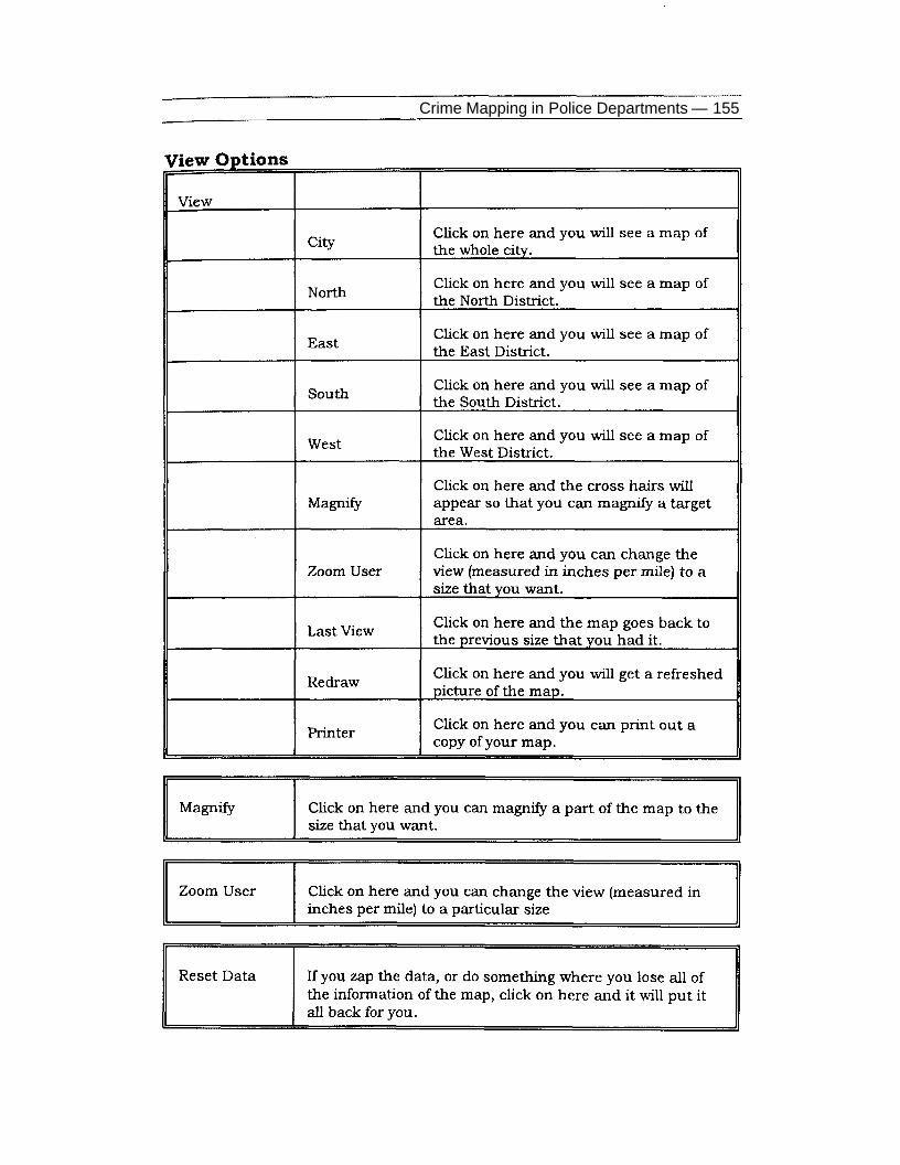
The DMA system was designed by the Jersey City Police Depart-ment and by staff from the Center for Crime Prevention Studies atRutgers University. The system was driven entirely by the DOS ver-sion of Maplnfo, with Mapcode applications written to customize in-quiry options.10 The DMA system was programmed by LieutenantCharlie Bellucci of the Jersey City Police Department, and was builtaround a series of custom-designed, pull-down menus that provideda series of search facilities designed to focus detectives on activitieswithin drug market boundaries (see appendix). Our system providedan inquiry system that was designed to make users think about drugproblems and possible solutions from a geographic perspective. Forexample, the system would prompt users for a drug market number,zoom on the market and then allow users to display counts of callsand arrests. DMA system users could request searches by market,police district, or for the entire city on the locations of suspects byage, race, gender, aliases, or crime involvements. For each drug mar-ket, users could search for information on the type of drug sold, thetimes of most activity (for arrests or calls), and the hottest corner in-side a drug market.
The DMA system allowed detectives to identify the exact locationsof drug market activity. It also allowed them to examine the proximityof drug markets to other places of interest such as bars, schools andhighway exits, and to undertake inquiries about arrest histories, citi-zen complaints and social characteristics of drug markets. The de-tectives could build custom-designed maps of areas of interest wherestores, schools and community group locations could be highlightedon the maps, and print out hard copies of maps of any portion of Jer-sey City.
Before the start of the DMAP, every narcotics detective partici-pated in a series of DMA system training sessions. In groups of threeor four, every detective received hands-on training that taught thebasics of turning on a computer and the steps involved in each DMA

146 — Lorraine Green Mazerolle et al.
system module. Many detectives had no experience with computers,and a handful were excited to have the computer age brought to theirwork environment; others were more skeptical.
To generate at least a base-level of expertise in the DMA system,we initiated a "specialist program" where one detective in each squadself-selected themselves to become the "computer expert" for thesquad. In the past, a squad member was designated the "surveillanceman," the "sweep man," or the person who generated informants.Selecting one member of the squad to learn the features of the com-puter system fit well with past task specializations within eachsquad.
The Jersey City DMA system included several important features.For example, the system was built to be "police proof." LieutenantBellucci, understanding the frustrations that narcotics detectiveswould go through in learning the way the system worked, created a"reset data" feature that allowed a detective who had "zapped" alldata from the system to regain control over the computer, reset allthe data and maps to the default setting, and begin the search proce-dure again.
Since the inception of the Jersey City DMA system, problemsarose in keeping data up-to-date. This difficulty proved to be a sig-nificant drawback for the operational dimension of the DMA experi-ment, leading to many frustrations among narcotics squad detectives.Although the DMA system allowed detectives to search for suspects,they felt that the geographic overlay of the system merely "cluttered"their inquiries. For example, one detective stated, "We only need toget information about the [suspects]... why are you making me lookat this map?" Another commented, "Why do I need to use this map? Iknow where every street in the city is already." Yet another said, "Ican't really see the point of the map — we go where the action is andthat means tracking down a suspect, not looking at a map." Apartfrom highlighting the difficulties of introducing computer technologyinto police operational units, these comments illustrate the frustra-tions felt by detectives in changing the focus of their mode of opera-tion. The Jersey City DMA experiment sought to change detectives'activities from being arrest-oriented to being more focused on theproblems of a place. The DMA system was the tool of a new approachfor controlling drug problems in specific hot spots. As such, the new"tool" was seen as symbolic of change and became a focal point ofdetective resistance to implementing problem-solving approaches tocontrolling drug problems.

Crime Mapping in Police Departments — 147
During the course of the experiment, however, some detectivescame to appreciate the system. Some officers offered suggestions asto how the DMA system could be improved. Some of the specific re-quests from the narcotics officers for DMA system enhancements in-cluded adding more custom information to the maps, such as draw-ing the directions of one-way streets; identifying whether a particularstreet was one or two lanes; and drawing buildings of choice on themaps.
DMA System Usage
We conducted two surveys, in May and December 1992, of nar-cotics detectives in Jersey City to determine the usage level and per-ceptions of the DMA system. A selection of the results appears in Ta-ble 1.
Table 1: DMA System Usage
Table 1 suggests that the DMA system served an important func-tion during the project, at least for some of the detectives. The level ofuse increased between the first survey, conducted two months afterthe start of the experiment, and the second survey, undertaken eightmonths after the initiation of DMAP. The DMA system was both usedmore frequently and seen as more helpful as the experiment pro-ceeded. At the start of the experiment, ten officers never used thecomputer system. By December, only one detective claimed to never

148 — Lorraine Green Mazerolle et al.
use the computer. It was disappointing, however, to note that by De-cember 1992 only six persons were actively printing out maps. Thisresult is most likely because across the six squads of officers, onlyone person received in-depth training on the DMA system.
Nineteen officers were satisfied with the DMA system by Decem-ber, compared to only ten in May. An increase, however, was seen inthe number of detectives who used the DMA system to gather infor-mation about suspects — from 11 detectives in May to 24 by Decem-ber. There are two possible explanations for this increase: the detec-tives became more suspect-oriented, or they simply found the infor-mation helpful. Based on our monitoring of the DMA experiment ac-tivities (see Weisburd and Green, 1995), it is suggested that the latterproposition is the more likely.
Over all, these results are consistent with our field observations ofthe narcotics detectives' activities during the course of the DMA ex-periment. One of the biggest hurdles that we had to overcome duringthe DMA project in Jersey City was coercing narcotics detectives tothink more in terms of targeting and cleaning up drug hot spotsrather than "bouncing" around the city and targeting the people in-volved in the drug trade. The DMA system provided a constant re-minder and an inquiry tool that encouraged narcotics detectives tothink about the problems associated with drug hot spots and thepatterns of drug activity within market boundaries. This was in starkcontrast to the way they had previously thought about the drugproblem in Jersey City.
CONCLUSION
Building a computerized mapping system in police departmentspresents many challenges. The first challenge concerns the decisionwhether to build a mapping system for crime analysts and police de-partment planners, or to invest resources into building a tool forstreet-level problem-solving officers. While there is overlap in thesystem needs of both "user-groups," many system demands, includ-ing data needs and types of inquiries, will be different for these twodifferent end purposes. As such, police departments need to decidewhere they want to invest their energies and then build their map-ping systems accordingly.
A second challenge concerns the ability of police departments tointegrate PC mapping capabilities within mainframe computing envi-ronments. This requires investments to build links between the stor-age systems at the mainframe level with the data requirements for

Crime Mapping in Police Departments — 149
mapping purposes. Some problems include timely download capa-bilities; building "blocks" in the system to guard against overlappingdownloading; and building PC protocols to accept, clean, and appendnew, incoming data with the existing master files at the PC level.Automatic cleaning, appending, archiving and re-indexing are essen-tial features that must be created to ensure the integrity of the databeing mapped.
Building custom menus that are user-friendly and that enable of-ficers to undertake searches and inquiries that fit with their problem-solving activities is a third challenge to police departments contem-plating building crime mapping systems for street-level use. Commontypes of inquiries, that can be easily built, must fit with the types ofinformation that line officers need to facilitate their problem-solvingefforts. Custom-built systems must accommodate changes from timeto time and be adaptable across a range of problem-solving efforts.For example, detectives in a violent crimes unit need to make differ-ent types of inquiries of a mapping system than narcotics detec-tives.11 Similarly, a beat officer is interested in undertaking searchesof quite a different kind from either narcotics detectives or violentcrime squad detectives.
Computerized mapping systems have a lot to offer police depart-ments. Whether a police department chooses to implement PC-basedcrime mapping capabilities for street-level use or to develop morethematic mapping capabilities for crime analysis or policy planningpurposes, graphic presentation of crime data provides a means toidentify, analyze and communicate problems, priorities and plans ina quick and easy manner. The power of mapping crime, however, isgreatly enhanced when police departments invest resources in plan-ning, pilot testing, and solving logistical problems from the outset.
•This paper was supported under awards 90-IJ-CX-K004 and 91-MU-CX-K005 from the National Institute of Justice, U.S. Department of Justice.Points of view in this document are those of the authors and do not nec-essarily represent the official position of the U.S. Department of Justice.

150 — Lorraine Green Mazerolle et a/.
NOTES
1. There are many other end-users in a police department. For example,specialized detectives will have different demands than street-level prob-lem-solvers; housing unit officers demand a different type of analytic ca-pability than detectives; and district captains are interested in differenttypes of maps compared to headquarters planners.2. Taxicabs are being fitted with GPS to locate them when a driver is indanger; cars are being fitted with GPS to locate them if they are stolen);and the MacMahon Productivity Monitoring System in Australia is usingGPS to track and monitor payloads in earth-moving vehicles.3. Proposals have been put forth to install GPS receivers rather thanelectronic monitoring devices on parolees.4. An application that won the GPS world application of the year wastracking sheep around Chernobyl to determine radiation levels.5. GPS are currently being pilot tested in several jurisdictions. One de-partment on Cape Cod, MA, for example, is testing a GPS.6. Some of the problems encountered in building a link between amainframe system and a PC include: installing the software on themainframe to create files that may be downloaded, building the physicalconnection between the PC and mainframe, installing "dial-up" softwarethat is compatible with the mainframe system, and creating data files inthe PC-database form that "fit" the records downloaded from the main-frame system.
7. E-911 systems enhance the integrity of the location from where thecall is made. However, it does not help to enhance the integrity of thedispatch location (or the location where the event is occurring) if this lo-cation is different from the call location.
8. For example, ensure that the geofile and the street files record ad-dresses in the same way (e.g., Ave not Av; E Third Street and not E 3rd orThird Street E).
9. Two important exceptions include an NlJ-sponsored conference heldin May 1994, and the NIJ Center for Crime Mapping roundtable discus-sions in February 1997, where the issue of confidentiality in mappingwas the topic of roundtable discussions.
10. The mapping capabilities of Maplnfo have evolved tremendouslysince the original DMA system was created. For instance, Maplnfo nolonger supports, to any great extent, the DOS version of Maplnfo. In-stead, it now focuses its support on the Windows-based mapping envi-ronment, which includes many features that were unavailable at the timethe DOS version of the Jersey City DMA system was created.

Crime Mapping in Police Departments — 151
11. Since the conclusion of the DMAP experiment in Jersey City, NIJ hasfunded two additional projects in Jersey City that build upon our experi-ence with implementing computerized crime mapping capabilities at thestreet level. First, NIJ funded a problem-oriented policing project with theViolent Crimes Squad. As with the DMA project, we built an inquiry sys-tem to facilitate their problem solving efforts. One of the interesting fea-tures of this new system was the aggregation of data within the violentcrime places to enable detectives to "assess" the changes in calls andarrests over the life course of a problem "case." This process follows veryclosely the recommendations of Eck and Spelman (1987) in their plea forofficers to be more sophisticated in their assessment phase of the SARAproblem solving model. Second, NIJ recently funded a project to tackledrug and violent crime problems in public housing. This project aims tobuild a mapping system that allows for apartments and common areas tobe systematically linked to police department data.
REFERENCES
Eck, J. (1994). Drug Markets and Drug Places: A Case Control Study ofthe Spatial Structure of Illicit Drug Dealing. Doctoral dissertation,University of Maryland, College Park.and W. Spelman (1987). Problem Solving: Problem Oriented Policingin Newport News. Washington, DC: Police Executive Research Fo-rum and U.S. National Institute of Justice.
Maltz, M., A. Gordon and W. Friedman (1991). Mapping Crime in ItsCommunity Setting: Event Geography Analysis. New York, NY:Springer- Verlag.
McEwen, J.T. and F.S. Taxman (1995). "Applications of Computer Map-ping to Police Operations." In: J.E. Eck and D. Weisburd (eds.),Crime and Place. Crime Prevention Studies, vol. 4. Monsey, NY:Criminal Justice Press.
Rich, T. (1995). The Use of Computerized Mapping in Crime Control andPrevention Programs. Research in Action (July). Washington, DC:U.S. National Institute of Justice.
Roncek, D. and P. Maier (1991). "Bars, Blocks and Crimes Revisited:Linking the Theory of Routine Activities to the Empiricism of 'HotSpots."1 Criminology 29(4):725-754.

152 — Lorraine Green Mazerolle et al.
Weisburd, D. and L. Green (1995). "Policing Drug Hot Spots: Findingsfrom the Jersey City DMA Experiment." Justice Quarterly12(4):711-735.(1994). "Defining the Drug Market: The Case of the Jersey City DMASystem." In: D.L. MacKenzie and C. Uchida (eds.), Drugs andCrime: Evaluating Public Policy Initiatives. Thousand Oaks, CA:Sage.
APPENDIX:The Jersey City Drug Market Analysis System Menus

Crime Mapping in Police Departments — 153

154 — Lorraine Green Mazerolle et a/.
Crime Mapping in Police Departments — 155