css, livability and complete streetsfederal highway administration 5 planning regs. and complete...
TRANSCRIPT
1 Federal Highway Administration
CSS, Livability and Complete
Streets
Kirk D. Fauver
Environmental and Transportation Planning Coordinator
FHWA Texas Division
June 5, 2014

2 Federal Highway Administration
What are complete streets?
Roadways that serve all users—all ages
and abilities, vehicle drivers, pedestrians,
bicyclists, transit riders
Multimodal networks
Suitable for all ages and abilities
Vary by
environment
(e.g., urban/rural)
Vary by Context
From Charlotte NC’s Urban Streets Design Guidelines

3 Federal Highway Administration
What are complete streets?
Are based on community
vision
Are the outcome of good
planning and design

4 Federal Highway Administration
Past & Present
Past & Present
FHWA has no formal policy called Complete
Streets…
…But there are federal policies and guidance
that promote similar goals
SAFETEA-LU built on existing law and policy
to better include walking and biking

5 Federal Highway Administration
Planning regs. and complete streets
Federal Regulations
23 U.S.C. 217 (g) Planning and Design.
1. In General.—Bicyclists and pedestrians
shall be given due consideration in the
comprehensive transportation plans
developed by each metropolitan planning
organization and State…
2. Safety considerations.—Transportation
plans and projects shall provide due
consideration for safety and contiguous
routes for bicyclists and pedestrians...

6 Federal Highway Administration
Overlapping Strategies
Livability
Sustainability
Community impact assessment
Scenario planning
Land use and transportation
Smart growth
Walkable communities
Walkable Thoroughfares
Healthy neighborhoods
Transit‐oriented development (TOD)
Complete Streets
Context‐Sensitive Solutions (CSS), and many others.
7 Federal Highway Administration
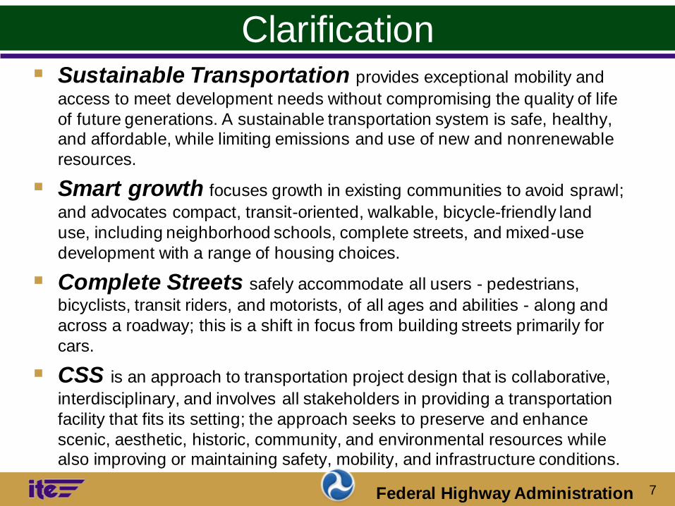
Clarification Sustainable Transportation provides exceptional mobility and
access to meet development needs without compromising the quality of life
of future generations. A sustainable transportation system is safe, healthy, and affordable, while limiting emissions and use of new and nonrenewable
resources.
Smart growth focuses growth in existing communities to avoid sprawl;
and advocates compact, transit-oriented, walkable, bicycle-friendly land
use, including neighborhood schools, complete streets, and mixed-use
development with a range of housing choices.
Complete Streets safely accommodate all users - pedestrians,
bicyclists, transit riders, and motorists, of all ages and abilities - along and
across a roadway; this is a shift in focus from building streets primarily for
cars.
CSS is an approach to transportation project design that is collaborative,
interdisciplinary, and involves all stakeholders in providing a transportation
facility that fits its setting; the approach seeks to preserve and enhance
scenic, aesthetic, historic, community, and environmental resources while also improving or maintaining safety, mobility, and infrastructure conditions.

8 Federal Highway Administration
Refresher - Goals of CSS
In harmony with the community & preserve the
environmental, scenic, aesthetic, historic & natural
resource values of the area
A safe facility for all users & the community
Solve problems that are agreed upon by a full range of
stakeholders
• Multidisciplinary approach with inclusion of public
• Designed & built with minimal disruption to the community
• Adding lasting value to the community, environment & transportation system

9 Federal Highway Administration
Core Principles of CSS
Strive toward a shared stakeholder vision to provide a
basis for decisions
Demonstrate a comprehensive understanding of
context—transportation and other elements
Foster continuing communication and collaboration to
achieve consensus
Exercise flexibility and creativity to shape effective
transportation solutions, while preserving and
enhancing community and natural environments
CSS Integration Guide, Chapter 2.2

10 Federal Highway Administration
Benefits of CSS
Solves the “right problem”
Conserves resources
Facilitates and streamlines NEPA compliance
Saves time and planning costs
Builds community support
Helps prioritize transportation funds
Decision-making process that builds consensus
Photo: James M. Daisa, PE, Arup.

11 Federal Highway Administration
What is Livability?
In practice, livable transportation systems
accommodate a range of modes (walking,
bicycling, transit, and automobiles) by
creating mobility choice within more
balanced multimodal transportation
networks.

12 Federal Highway Administration
What is Livability?
Livability in transportation is about
integrating the quality, location, and type
of transportation facilities and services
available with other more comprehensive
community plans and programs to help
achieve broader community goals.

13 Federal Highway Administration
Livability Principles
Provide more transportation choices
Promote equitable, affordable housing
Enhance economic competitiveness
Support existing communities
Coordinate policies and leverage
investment
Value communities and neighborhoods

14 Federal Highway Administration
Tie Between CSS and Livability?
Transportation is the Means
CSS is the Process
Livability and Sustainability are Outcomes
A Complete Street is the infrastructure
component among the terminologies and a
policy that supports an outcome.

15 Federal Highway Administration
Providing Transportation Choices Facilities for pedestrians, bicyclists, & other non-
motorized forms of transportation
Sidewalks & multimodal pathways
Bicycle infrastructure
Crosswalk enhancements
Traffic calming
Lighting & security infrastructure
• Safe routes for non-drivers -
children, older adults, individuals
with disabilities & lower income
16 Federal Highway Administration
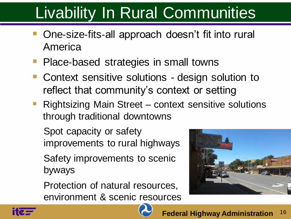
Livability In Rural Communities
One‐size‐fits‐all approach doesn’t fit into rural America
Place‐based strategies in small towns
Context sensitive solutions - design solution to
reflect that community’s context or setting
Rightsizing Main Street – context sensitive solutions
through traditional downtowns
• Spot capacity or safety
improvements to rural highways
• Safety improvements to scenic
byways
• Protection of natural resources,
environment & scenic resources

17 Federal Highway Administration
Programs that Support Livability
Bicycle & Pedestrian
Congestion Mitigation & Air Quality Improvement (CMAQ)
National Scenic Byways
Recreational Trails
Safe Routes to School
Transportation, Community & System Preservation (TCSP)
Transportation Enhancement Activities
Federal Lands Highways
Indian Reservation Roads
Context Sensitive Solutions National Highway System
Surface Transportation
18 Federal Highway Administration
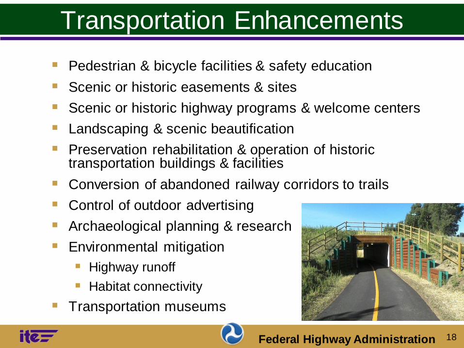
Transportation Enhancements
Pedestrian & bicycle facilities & safety education
Scenic or historic easements & sites
Scenic or historic highway programs & welcome centers
Landscaping & scenic beautification
Preservation rehabilitation & operation of historic transportation buildings & facilities
Conversion of abandoned railway corridors to trails
Control of outdoor advertising
Archaeological planning & research
Environmental mitigation
Highway runoff
Habitat connectivity
Transportation museums

19 Federal Highway Administration
Safe Routes to Schools
Enable & encourage children, including those with disabilities, to walk & bicycle to school
Make bicycling & walking to school a safer & more
appealing transportation alternative,
Encouraging a healthy & active lifestyle from an early age
Facilitate projects & activities that improve safety &
reduce traffic, fuel consumption, & air pollution in the vicinity of schools

20 Federal Highway Administration
Walkable Communities
Mixed land uses in close proximity
Building line & street enclosure
Minimize front yard parking lots
Building entries that front onto street
Building, landscape & street design
that is pedestrian-scale
Relatively compact developments
Highly-connected circulation network
Small block sizes
Streets & public spaces that contribute
to “place-making”

21 Federal Highway Administration
Livability within Community Context
Street design that complements buildings, public spaces,
streetscape & landscape
Thoroughfare design to serve adjacent context based
upon desired character
Rural Residential
Neighborhood Small Town
Neighborhood
Commercial Downtown
▫ Design speed
▫ Lane width
▫ Parking
▫ Bike lanes
▫ Sidewalks
▫ Pathways
▫ Streetscape
▫ Landscape
▫ Street lighting
22 Federal Highway Administration
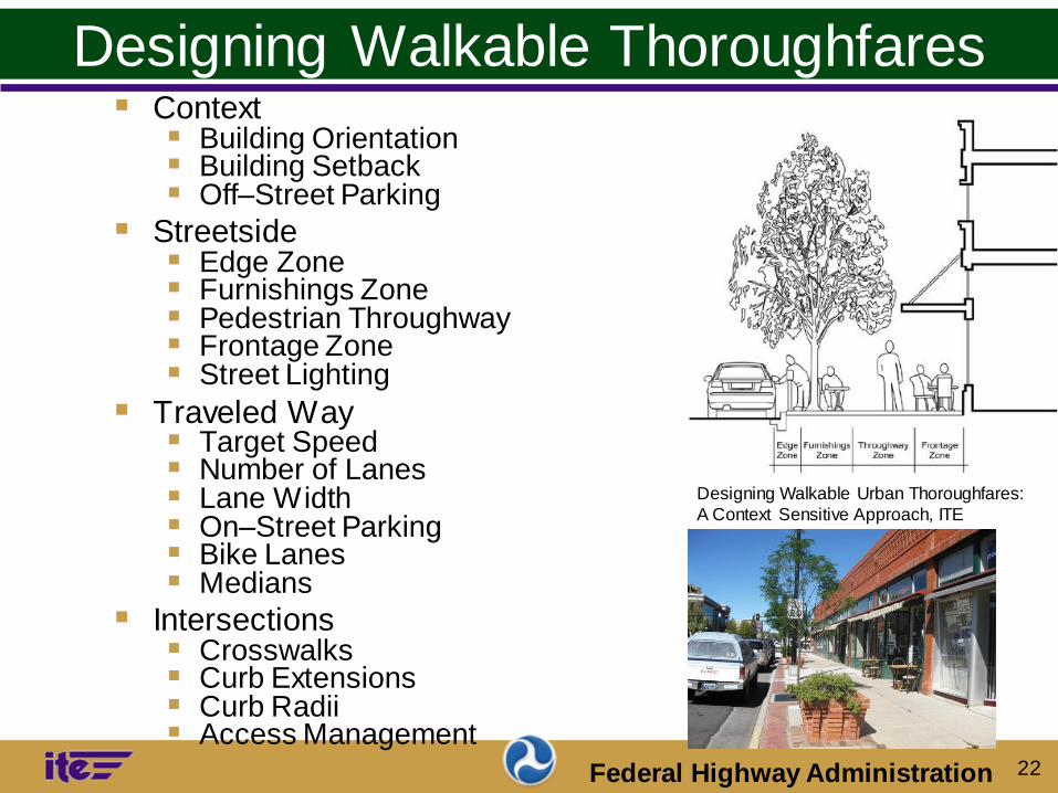
Designing Walkable Thoroughfares Context
Building Orientation Building Setback Off–Street Parking
Streetside Edge Zone Furnishings Zone Pedestrian Throughway Frontage Zone Street Lighting
Traveled Way Target Speed Number of Lanes Lane Width On–Street Parking Bike Lanes Medians
Intersections Crosswalks Curb Extensions Curb Radii Access Management
Designing Walkable Urban Thoroughfares:
A Context Sensitive Approach, ITE
23 Federal Highway Administration
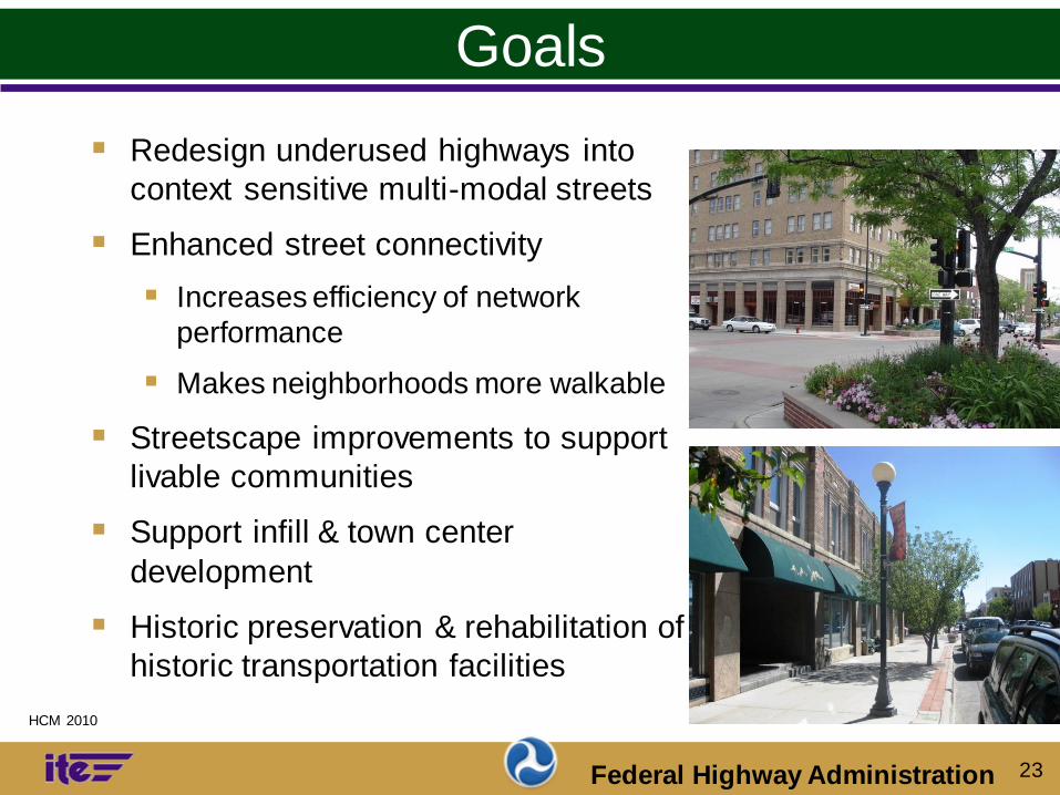
Goals
Redesign underused highways into
context sensitive multi-modal streets
Enhanced street connectivity
Increases efficiency of network
performance
Makes neighborhoods more walkable
Streetscape improvements to support
livable communities
Support infill & town center
development
Historic preservation & rehabilitation of
historic transportation facilities
HCM 2010
24 Federal Highway Administration
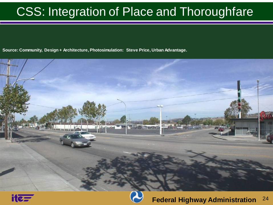
CSS: Integration of Place and Thoroughfare
Source: Community, Design + Architecture, Photosimulation: Steve Price, Urban Advantage.
25 Federal Highway Administration
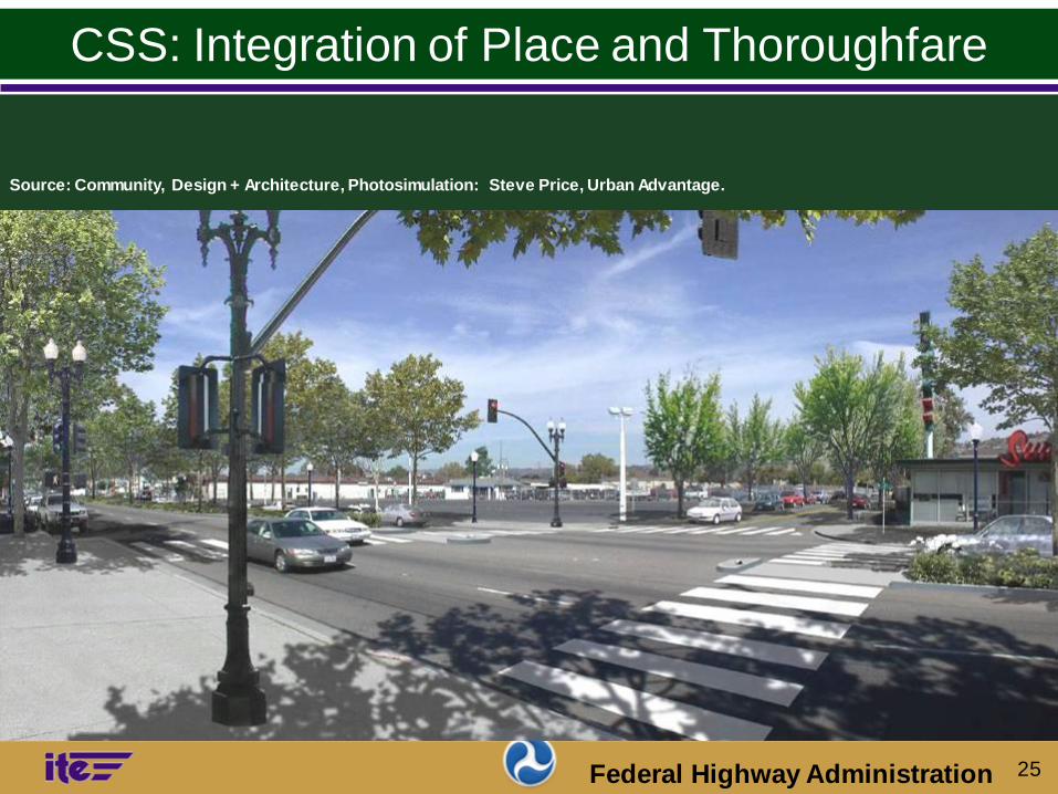
CSS: Integration of Place and Thoroughfare
Source: Community, Design + Architecture, Photosimulation: Steve Price, Urban Advantage.
Source: Community, Design + Architecture, Photosimulation: Steve Price, Urban Advantage.

26 Federal Highway Administration
CSS: Integration of Place and Thoroughfare
Source: Community, Design + Architecture, Photosimulation: Steve Price, Urban Advantage.
Source: Community, Design + Architecture, Photosimulation: Steve Price, Urban Advantage.

27 Federal Highway Administration
Context zones: Suburbs to urban cores
Street classification:
Functional class Arterial
Collector
Thoroughfare type Boulevard
Avenue
Street
Compatibility and mutual support
CSS Design Framework
Photo: Community Design + Architecture

28 Federal Highway Administration
Example: Urban Boulevard in an
Urban Center (C-5) context Photo: James M. Daisa, P.E., Arup.

29 Federal Highway Administration
Contact Information
Kirk D. Fauver
FHWA Texas Division
300 E. 8th Street, Room 826
Austin, TX 78701
E-Mail: [email protected]
PH: 512-536-5952