cuivre river - missouri department of conservation cuivre river originates in northeast missouri, in...
TRANSCRIPT

CUIVRE RIVERWATERSHED
INVENTORY AND ASSESSMENT
PREPARED BY:DEVONA L WEIRICH
Fisheries Management BiologistMissouri Department of Conservation
February 3, 1993
For additional information, contactFisheries Regional Supervisor
Missouri Department of Conservation2500 S. Halliburton, Kirksville, MO 63501
ACKNOWLEDGEMENTSI would like to thank all of the Fisheries Management District 4 staff who assisted with thisproject by conducting background research, field work, fish identification, map measurements,writing and editing. One person in particular, Laurie Peach, is deserving of a specialacknowledgment for keeping this project moving forward when some staff were diverted to othercommitments. Without everyone’s help and information provided by cooperating agencies thisplan would not be possible.
Thank you.Devona Weirich
EXECUTIVE SUMMARYThe Cuivre River is a low gradient, seventh order river located in northeast Missouri. Itoriginates in Audrain and Pike counties and flows south-eastward through Pike, Montgomery,Lincoln, Warren and St. Charles counties to its confluence with the Mississippi River nearWinfield, Missouri. Its major tributaries are the West Fork Cuivre River and the North ForkCuivre River. The entire watershed is 1,235 square miles. The average annual discharge ofCuivre River at the Troy gage station for its 61-year period of record is 650 cubic feet per second.
One percent of the watershed is in public ownership. There is one state park, five MissouriDepartment of Conservation (MDC) lake or wildlife areas and three MDC stream fishingaccesses. Approximately 23% of the watershed is forested and 77% is cultivated, pastured orotherwise developed.
Water-quality problems in the Cuivre River drainage are related to soil erosion and animal waste.The sediment yield reaching waterways was estimated at 2.5 tons per acre per year (Anderson1980). Pollution from point sources is minimal. There are no chronic fish kill areas.
Sixteen plant and animal species listed on Missouri’s rare and endangered 1991 checklist arefound in the Cuivre River Basin. Ten of these species live in water or require very dampenvironments for their survival. Seventy-one different fish species have been identified in fish

CO2
collections, fish kills or creel surveys conducted between 1941 and 1992; sport fish present include largemouth bass, smallmouth bass, channel catfish, flathead catfish, black crappie, white crappie, walleye, white bass, common carp, freshwater drum, buffalo, bluegill and green sunfish. The ghost shiner, a species on the Missouri River watch list, is found in the Cuivre River Basin. In fish samples collected after 1970 at 40 sites, the most widespread fish were the green sunfish (present at 98% of the sites), orangethroat darter (88%), bluntnose minnow (88%), red shiner (85%) and redfin shiner (85%). The most abundant fish among 37,177 fish collected were the red shiner (25% of all fish sampled), redfin shiner (12%), bluntnose minnow (11%), bigeye shiner (9%) and orangethroat darter (6%).
Overall, most streams appear to be in fair condition. Some problems encountered include 1) insufficiently forested riparian corridors; 2) soil and streambank erosion; 3) sedimentation and deterioration of aquatic habitat 4) limited public access to streams; 5) deterioration of natural features and; 6) low public involvement in stream-related programs. Improvements in the quality of riparian and stream habitat will depend upon the cooperation of private landowners who have control of 99% of the watershed. The Missouri Department of Conservation can help educate the public about stream resources and their care; publicize stream assistance programs and assist landowners by providing technical advice for correcting stream erosion problems; protect native fish assemblages from the introduction of exotic species and the destruction of critical habitat; increase management of game fish populations; increase number of public stream access; and assist other public entities in creating similar opportunities.

CO3
TABLE OF CONTENTS
WATERSHED LOCATION 2. Flow duration curve and 90:10 ratio
Area Description Flood Frequency
GEOLOGY/GEOMORPHOLOGY Dam and Hydropower Influences
Physiographic Region WATER QUALITY AND USE
Geology Beneficial Use Attainment
Soils Boating
Stream Orders Chemical Quality of Stream Flow
Watershed Area/Stream Length Point Source Pollution
Channel Gradients Nonpoint Source Pollution
LAND USE Fish Contamination Levels
Soil Conservation Projects Health Advisories and Fish Kills
Public Areas HABITAT CONDITIONS
Corps of Engineers 404 Jurisdiction Channel Alterations
Soil Conservation and Watershed Projects Unique Habitats
HYDROLOGY Improvement Projects
Precipitation Stream Habitat Assessment
U.S. Geological Survey Gaging Stations BIOTIC COMMUNITY
Permanence/Intermittence of Flow in Stream Reaches
Fish Community
Fish Distribution Average Annual Discharge
Detailed Hydrologic Data Intolerant Species
Sport Fish 1. 7-day Q2,Q10,Q20 low flows and slopeindex
CO4
Fish Stockings
Fishing Regulations
Aquatic Invertebrates
Mussels
Crayfish
Aquatic Insects
Threatened and Endangered Species
MANAGEMENT PROBLEMS AND OPPORTUNITIES
Riparian and Aquatic Habitat Protection
Aquatic Community Protection
Public Use
Public Awareness
ANGLER GUIDE
GLOSSARY
LITERATURE CITED
LIST OF FIGURES
LIST OF TABLES

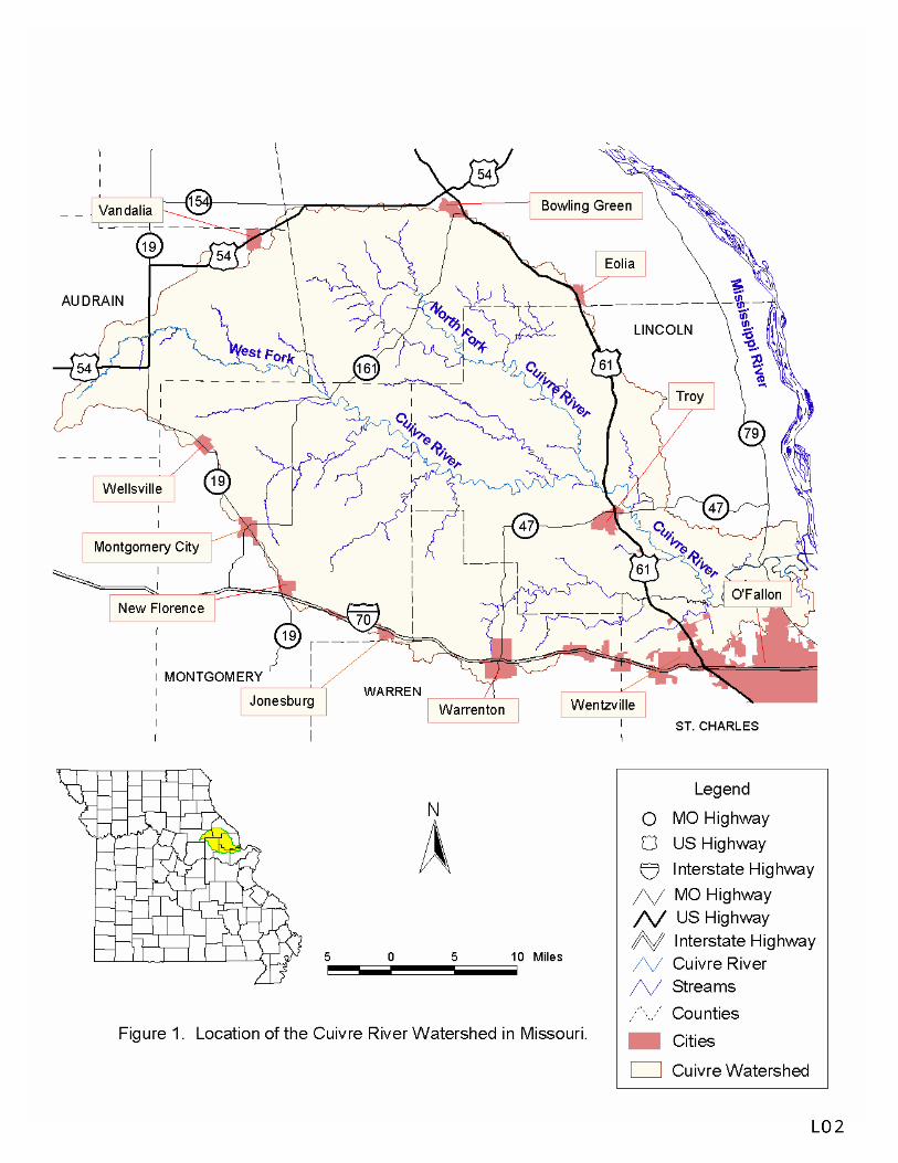
LOCATION The Cuivre River originates in northeast Missouri, in Audrain and Pike counties. It flows southeast through Pike, Montgomery, Lincoln, Warren and St. Charles counties to its confluence with the Mississippi River at river mile 236.5 (measured from the mouth of the Ohio River) near Winfield, Missouri (Figure 1). The watershed drains 1,235 square miles of the Upper Mississippi River Basin. Its two major tributaries are the West Fork Cuivre River and the North Fork Cuivre River. Other major streams include Big Creek, a tributary to the Cuivre River; Elkhorn Creek, a tributary to the West Fork Cuivre River; and Indian and Sulphur creeks, both tributaries to the North Fork Cuivre River.

GEOLOGY
Physiographic Region
The Cuivre River Basin lies in the Dissected Till Plains of the Central Lowland Physiographic Province (Fenneman 1938). This area is a part of the Glaciated Plains Natural Division (Thom and Wilson 1980) (Figure nd). It is characterized by soils and topography resulting from the influence of the Kansan stage of Pleistocene glaciation. The western and northern portion of the basin lies in the Eastern Section of the Dissected Till Plains and the southeastern and eastern edge of the basin lies in the Lincoln Hills Section.
The Eastern Section has claypan soil and the land is generally flat except for steep hills near streams. Shale underlies most of this area. Aquifers and recharge to streams during dry periods are poor. Stream substrates are dominated by sand and silt. Stream water is frequently turbid from large quantities of fine sediments in runoff water (Pflieger 1971).
Historically, prairies dominated the upland landscape. Deciduous trees grew in rugged areas and bottomland trees grew along the streams. Wet prairies and springs were uncommon. Terrain in the Lincoln Hills Section is hillier and steeper than in the Eastern Section. Limestone replaces shale as the predominant bedrock and some karst topography is present. The streams tend to be clear and have substrates of gravel and rubble.
Presettlement vegetation was mainly deciduous forest with prairie constituting less than 5 percent of the section. There were also glade, cliff and march communities. The flora and fauna of this section are similar to that found in the Ozarks (Thom and Wilson 1980).
Geology
Pennsylvanian shales and sandstone are the principal bedrocks of the region (Figure ge). Mississippian and older rock, primarily limestone, line the surface along the Mississippi River. Lincoln and Pike counties show some karst topography.
The stratum in the region generally slants to the west. Many limestone areas have east-facing escarpments hidden by glacial drift. Some escarpments are at least 50 feet thick.
Soils developed from glacial and loess deposits. Loess deposits vary from a few feet to 90 feet in depth. The land has a submature-to-mature erosion cycle. Relief is from 100 to 300 feet.
Streams meander through broad valleys dotted by many oxbows and sloughs. The channels typically are bordered by high alluvial banks. The pools are generally long and riffle sections are sometimes lacking or are poorly defined. Silt, sand and gravel are common substrates. Water flows tend to be intermittent or have a low base.

The following list identifies the geological characteristics for the basin by county (Missouri Department of Natural Resources 1986): Audrain - characterized by Pennsylvanian (Desmoinesian Series) rock types which consist of alternating thin limestone, shale and sandstone. Coal deposits and clay also are present. Lincoln - primarily Mississippian formation of limestone, shale and sandstone. Near the Mississippi River flood plain quaternary alluvium predominates. Montgomery - contains Pennsylvanian and Mississippian formations of limestone, shale and sandstone, coal and clay. Pike - a combination of Pennsylvanian and Mississippian formations. St. Charles - generally Mississippian formation of limestone, shale and sandstone. Near the Mississippi River flood plain quaternary alluvium predominates. Warren - is Mississippian formation composed primarily of limestone, shale and sandstone. Soils The majority of the West Fork Cuivre River subbasin lies in the Central Claypan region (Figure 2, contact authors for information on Figure 2). Its soil is a poorly draining type known as a Putnam-Mexico (Soil Conservation Service 1979). The silt-loam surface overlies a silty clay subsoil. The landscape tends to be nearly level to gently sloping; slopes range from 0 to 5 percent. Stream valleys tend to be shallow and narrow. Alluvium is present in the river bottoms. This region was originally covered by prairie grasses but is now heavily cultivated. This soil is well suited for growing corn, soybeans, grain sorghum and hay crops. The remaining areas of the West Fork subbasin and most of the North Fork Cuivre River and Cuivre River subbasin lie in the Central Mississippi Valley Wooded Slopes region (Figure 2). The soil types are Hatton-Keswick-Lindley-Goss, Menfro-Winfield-Lindley, and Hatton-Keswick-Goss-Gasconade (SCS 1979). In general, these soils formed under prairie and forest vegetation. They tend to be well-drained loamy and clayey upland soils with some areas of chert. Ridgetops are gently sloping but valley sides can be very steep, up to 50 percent. Small fields of grain sorghum, corn or hay are commonly found on ridgetops. Steeper valley sides are often pastured or left in forest. Lastly, a small area near the mouth of the Cuivre River is in the Missouri and Mississippi Alluvium region (SCS 1979). This alluvial (waster-deposited) soil is quite deep and is a mixture of silt, loam and clay. The landscape tends to be moderately flat with large bottomland crop fields; slopes do not exceed 3 percent. Stream Order Stream order was determined using the Strahler method (Strahler 1959) from United States Geological Survey (USGS) 7.5-minute topographic maps. Within the basin are 112 third-order-and-larger streams. Of these, 84 are third order, 21 are fourth, four are fifth, two (the North Fork Cuivre River and the

West Fork Cuivre River) are sixth and one (the Cuivre River) is seventh (Table 1 , Table 2 , Table 3). Each third order-or-larger stream was assigned a code number based on a 1981 method devised by Pflieger, Haverland and Schene Jr. 91981). The North Fork and West Fork Cuivre rivers were given two code numbers because of their length. Segment 1 includes the sixth order reach and segment 2 includes the fifth-order-and-smaller segments. Watershed Area/Stream Length Watershed area and stream length for third-order-and-large streams were determined from USGS 7.5-minute topographic maps. Appendix A summaries the dates and names of these maps. The watershed area was digitized using PADPAC software (Taylor 1988) on a Houston Instrument True Grid Digitizing tablet, Model T.G.-1017; stream mileage was measured with calipers. The total Cuivre River watershed is 1,235 square miles. The Cuivre River (below confluence of the North Fork Cuivre River and the West Fork Cuivre River) is 32.6 miles long and drains only 305 square miles. The North Fork and West Fork rivers are 37.9 and 76.8 miles long and drain 346 and 584 square miles, respectively. Measuring from the mouth of a stream to its headwaters, there are 420.9 miles of third order streams, 155.1 miles of fourth order streams, 93.9 miles of fifth order streams, 114.7 miles of sixth order streams and 32.6 miles of a seventh order stream (Table 1, Table 2, Table 3). Channel Gradient Gradient information for fourth-order-and-larger streams was obtained from USGS 7.5 minute topographic maps. Gradient plots of these streams are provided in Appendix A (Contact authors for information from Appendix A). The Cuivre River is a low-gradient stream, averaging 1.2 feet per mile. The gradient of the West Fork Cuivre River changes from 4.1 to 16.6 feet per mile along its length and the North Fork Cuivre River increases from 3.2 to 40.0 feet per mile at it's headwaters (Table 4 ; Figure 3). In general, the gradients of major tributaries are lowest in the West Fork Cuivre subbasin. This drainage encompasses the largest portion of the basin's Central Claypan Area. This soil formation is characterized by fairly low relief with slopes from 0 to 5 percent.


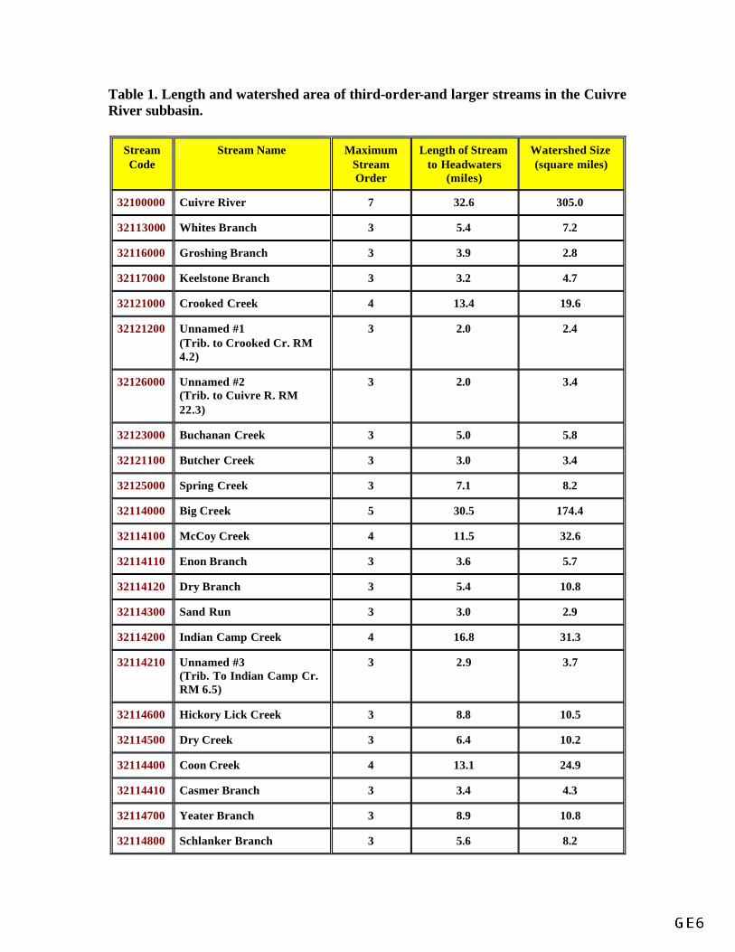
Table 1. Length and watershed area of third-order-and larger streams in the Cuivre River subbasin.
Stream Code
Stream Name Maximum Stream Order
Length of Stream to Headwaters
(miles)
Watershed Size (square miles)
32100000 Cuivre River 7 32.6 305.0
32113000 Whites Branch 3 5.4 7.2
32116000 Groshing Branch 3 3.9 2.8
32117000 Keelstone Branch 3 3.2 4.7
32121000 Crooked Creek 4 13.4 19.6
32121200 Unnamed #1 (Trib. to Crooked Cr. RM 4.2)
3 2.0 2.4
32126000 Unnamed #2 (Trib. to Cuivre R. RM 22.3)
3 2.0 3.4
32123000 Buchanan Creek 3 5.0 5.8
32121100 Butcher Creek 3 3.0 3.4
32125000 Spring Creek 3 7.1 8.2
32114000 Big Creek 5 30.5 174.4
32114100 McCoy Creek 4 11.5 32.6
32114110 Enon Branch 3 3.6 5.7
32114120 Dry Branch 3 5.4 10.8
32114300 Sand Run 3 3.0 2.9
32114200 Indian Camp Creek 4 16.8 31.3
32114210 Unnamed #3 (Trib. To Indian Camp Cr. RM 6.5)
3 2.9 3.7
32114600 Hickory Lick Creek 3 8.8 10.5
32114500 Dry Creek 3 6.4 10.2
32114400 Coon Creek 4 13.1 24.9
32114410 Casmer Branch 3 3.4 4.3
32114700 Yeater Branch 3 8.9 10.8
32114800 Schlanker Branch 3 5.6 8.2

32124000 Sugar Creek 4 13.8 35.6
32124100 Little Sugar Creek 3 8.0 8.9
32124200 Unnamed #4 (Trib. to Sugar Cr. RM 7.4)
3 2.9 3.3
32124300 Unnamed #5 (Trib. to Sugar Cr. RM 9.9)
3 3.9 5.6
TOTAL 3 94.4 122.8
TOTAL 4 68.6 144.0
TOTAL 5 30.5 174.4
TOTAL 6 0 0
TOTAL 7 32.6 305.0

Table 2. Length and watershed area of third-order-and larger streams located in the West Fork Cuivre River subbasin.
Stream Code Stream Name Maximum Stream Order
Length of Stream to
Headwaters (miles)
Watershed Size (square
miles)
32210000 West Fork Cuivre River (Segment 1)
6 76.8 584.1
32220000 West Fork Cuivre River (Segment 2)
5
32210000-A Unnamed #6 (Trib. to West Fork Cuivre
River RM 1.1)
3 4.4 3.5
32213000 Cottonwood Branch 3 3.4 4.0
32214000 Turkey Creek 3 4.6 8.0
32210000-B Unnamed #7 (Trib. to West Fork Cuivre River
RM 13.6)
3 2.6 2.1
32211000 Lead Creek 4 8.0 53.2
32211200 Little Lead Creek 4 13.2 20.1
32211210 Lost Branch 3 5.0 6.4
32211100 Big Lead Creek 3 20.5 25.2
32215000 Camp Creek 4 19.0 56.9
32215100 Baily Branch 3 3.4 4.3
32215110 Unnamed #8 (Trib. to Bailey Branch RM 2.1)
3 1.8 1.6
32215200 Rock Branch 3 6.1 6.1
32215300 Unnamed #9 (Trib. to Camp Cr. RM 7.9)
3 3.3 3.3
32215400 Camp Branch 3 10.3 17.3
32216000 Bear Creek 4 22.1 58.3
32216100 Unnamed #10 (Trib. to Bear Cr. RM 5.8)
3 4.1 3.9
32216200 Little Bear Creek 3 11.8 16.9

32216200 Prices Branch 3 8.0 10.4
32216300 Brush Creek 3 14.4 30.1
32210000-C Unnamed #11 (Trib. to West Fork Cuivre
River RM29.4)
3 2.4 3.4
32222000 Elkhorn Creek 5 27.3 98.2
32222100 Long Branch 3 6.0 6.9
32222299 Wolf Creek 4 12.5 13.4
32222210 32222300
Little Wolf Creek White Oak Creek
4 4
5.9 9.2
5.2 16.5
32222310 Unnamed #12 (Trib. to White Oak Cr. RM
2.5)
3 1.9 2.0
32222310 Little Elkhorn Creek 4 6.8 12.9
32222410 Unnamed #13 (Trib. to Elkhorn Cr. RM 2.7)
3 2.4 2.6
32223000 Coon Creek 4 18.8 47.8
32223100 Crooked Creek 3 5.8 7.7
32223200 Unnamed #14 (Trib. to Coon Cr. RM 5.0)
3 4.4 4.0
32223300 Unnamed #15 (Trib. to Coon Cr. RM 10.3)
3 1.2 1.2
32223400 Little Coon Creek 4 5.8 7.6
32223410 Unnamed #16 (Trib. to L. Elkhorn Cr. RM
1.9)
3 1.6 1.6
32224000 Sandy Creek 4 12.1 29.6
32224200 Unnamed #17 (Trib. to Sandy Cr. RM 4.8)
3 3.3 3.6
32224300 Unnamed #18 (Trib. to Sandy Cr. RM 9.3)
3 2.7 4.8
32224100 Johns Branch 3 4.0 5.0
32225000 Lost Creek 3 5.9 7.6
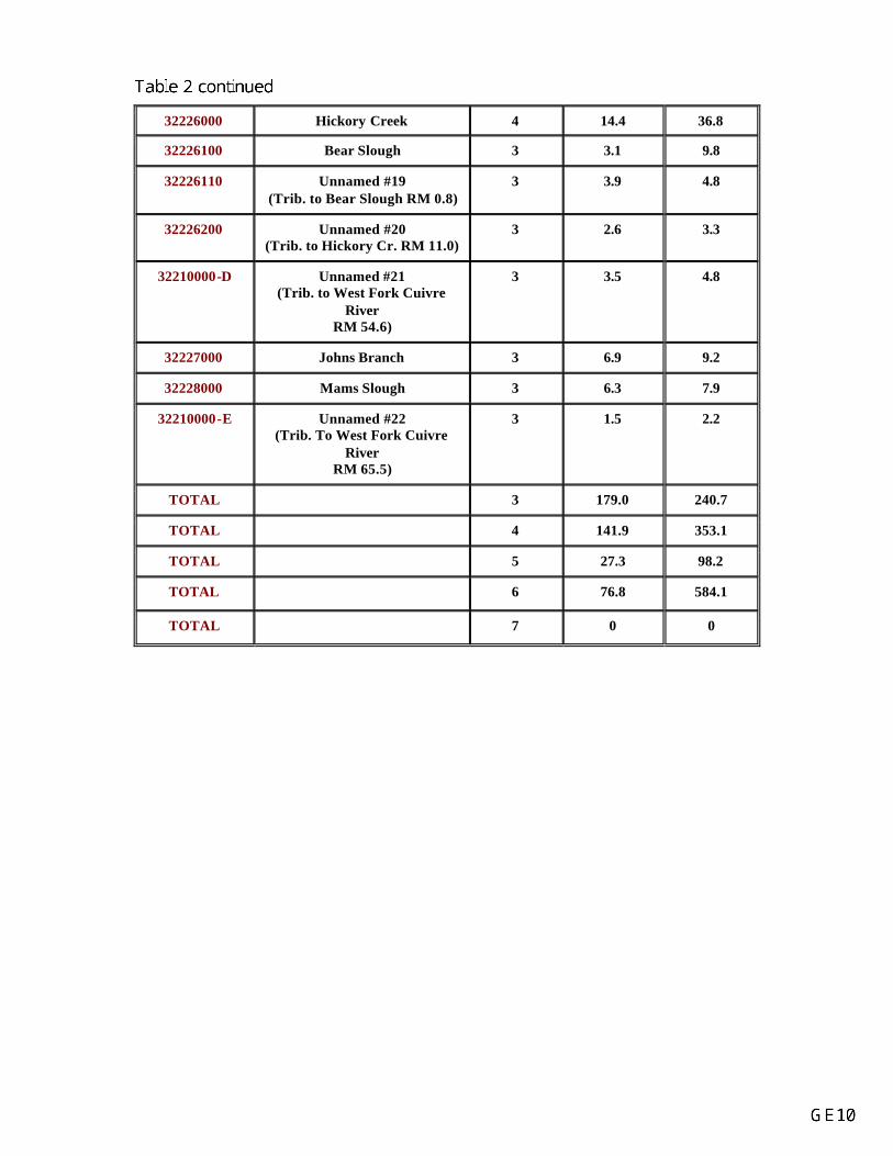
32226000 Hickory Creek 4 14.4 36.8
32226100 Bear Slough 3 3.1 9.8
32226110 Unnamed #19 (Trib. to Bear Slough RM 0.8)
3 3.9 4.8
32226200 Unnamed #20 (Trib. to Hickory Cr. RM 11.0)
3 2.6 3.3
32210000-D Unnamed #21 (Trib. to West Fork Cuivre
River RM 54.6)
3 3.5 4.8
32227000 Johns Branch 3 6.9 9.2
32228000 Mams Slough 3 6.3 7.9
32210000-E Unnamed #22 (Trib. To West Fork Cuivre
River RM 65.5)
3 1.5 2.2
TOTAL 3 179.0 240.7
TOTAL 4 141.9 353.1
TOTAL 5 27.3 98.2
TOTAL 6 76.8 584.1
TOTAL 7 0 0

Table 3. Length and watershed area of third-order-and-larger streams located in the North Fork Cuivre River subbasin.
Stream Code Stream Name Maximum Stream Order
Length of Stream to
Headwaters (miles)
Watershed Size (square
miles)
32310000 North Fork Cuivre River (Segment 1)
6 37.9 345.9
32320000 North Fork Cuivre River (Segment 2; to mouth of
Irvine Branch)
5
32311000 Paris Branch 3 4.8 4.7
32312000 Hupp Branch 3 2.8 3.0
32313000 Nulls Creek 3 8.3 8.8
32314000 Fort Branch 3 4.0 7.2
32314100 Draper Branch 3 2.2 3.3
32316000 Mill Creek 4 7.5 17.4
32316100 Unnamd #23 (Trib. to Mill Cr. RM 2.3)
3 2.8 1.9
32316200 Unnamed #24 (Trib. to Mill Cr. RM 3.7)
3 2.9 2.4
32319000 Sitton Branch 3 4.5 4.9
32317000 Unnamed #25 (Trib. to North Fork Cuivre
River RM 14.8)
3 3.7 3.9
32321000 Sulphur Creek (to mouth of Middle Sulphur
Cr.)
5 10.6 81.3
32321100 Sandy Creek 4 11.3 51.5
32321110 Little Sandy Creek 3 9.2 11.4
32321120 Brushy Creek 4 6.6 15.0
32321122 Unnamed #26 (Trib. to Brushy Cr. RM 2.9)
3 2.9 2.6
32321121 Reid Creek 3 7.2 8.4
32321200 Unnamed #27 (Trib. to Sulphur Cr. RM 4.6)
3 4.3 3.7

32321300 West Sulphur Creek 3 9.5 10.7
32321500 East Sulphur Creek 3 5.7 6.1
32323000 Indian Creek 5 35.5 107.1
32323700 Sandy Creek 3 4.1 4.2
32323200 Lewellen Branch 3 4.8 4.9
32323100 Moore Branch 3 4.9 5.9
32323000-A Roundtop Branch 3 4.8 7.3
32323600 Shady Creek 4 12.4 27.3
32323800 Brush Branch 3 8.1 10.9
32323000-B Unnamed #28 (Trib. to Indian Cr. RM 19.7)
3 5.1 5.3
32323620 Haw Creek 3 4.9 5.5
32323610 Unnamed #29 (Trib. to Shady Cr. RM 2.1)
3 3.7 5.8
32322000 Unnamed #30 (Trib. to NFCR RM 23.2)
3 2.2 2.0
32327000 Jones Branch 3 2.3 2.0
32328000 Unnamed #31 (Trib. to NFCR RM 33.2)
3 2.7 2.8
32324000 Lick Creek 3 10.9 14.5
32329000 Cuivre Creek 3 6.4 10.3
32325000 Irvine Branch 4 6.8 13.8
32325100 Jasper Spring Branch 3 4.2 5.7
32329100 Dry Straw Branch 3 3.6 2.9
TOTAL 3 147.5 173.0
TOTAL 4 44.6 125.0
TOTAL 5 36.1 188.4
TOTAL 6 37.9 345.9
TOTAL 7 0 0

Figure 3. Gradient plot of Cuivre River, West Fork Cuivre River, and North Fork Cuivre River.

Table 4. Average gradient, by stream order, of the Cuivre River, the West Fork Cuivre River and the North Fork Cuivre River.
Stream Stream Code Order Segment Length
(miles) Average Gradient
(ft/mile)
Cuivre River 32100000 7 32.6 1.2
West Fork Cuivre River 32210000 6 31.9 4.1
32220000 5 18.0 5.8
4 15.6 3.4
3 8.9 6.4
2 0.8 13.2
1 1.6 16.6
North Fork Cuivre River
32310000 32320000
6 5
19.6 4.5
3.2 4.3
4 13.9 10.9
Irvine Branch* 32325000 4 2.2 30.8
3 2.3 30.0
2 1.4 30.0
1 0.8 40.0
* Irvine Branch forms the headwaters of the North Fork Cuivre River.

LAND USE Recent Land Use Most of the region was originally covered by prairie grasses broken by bands of timber that ran along the major streams. Today, almost all the areas covered by prairie grasses have been cultivated with much of the timber removed near streams. An estimate of current land use was determined from the 1987 National Resources Inventory conducted by the U.S. Soil Conservation Service and from data gathered in the 1989 Missouri Forest Inventory (Hansen 1991; Ostrom 1991) conducted by the U.S. Forest Service with the cooperation of the Missouri Department of Conservation. Specific information about land in the Cuivre River watershed was retrieved from the Forest Inventory database using a customized polygon that outlined the boundaries of the watershed (Clark 1991). Changes in land use were determined by comparing results of 1972 and 1989 forest inventories. These surveys indicated that 99% of the watershed is privately owned and that 1% is publicly owned. Approximately 23% (287,700 acres) of the watershed is forested; 77% (946,600 acres) is cultivated, pastured or otherwise developed (nonforest land). Of commercial quality forested land (timberland: 279,400 acres), 8.7% (24,200 acres) occurs on hydromesic ("moderately wet soils where insufficient drainage or infrequent flooding limits growth and species occurrences to some extent") or hydric ("very wet sites where excess water seriously limits both growth and species occurrence") soils. In addition, 4,700 acres of timberland were converted to nonforest use between 1972 and 1989 (Clark 1991). Urban growth is highest in Lincoln, Warren and St. Charles counties. These counties contain the largest towns in the basin: Wentzville (population 5,030 in 1987, Missouri Department of Economic Development and the Community 1990), Warrenton (population 4,420, Troy (population 3,100, U.S. Bureau of the Census 1988) and Wright City (population 1,250, Wright City Clerk, personal communication). Soil Conservation Projects There are no PL-566 soil conservation projects in the watershed and none have been proposed as of this date. However, there are five active and one completed small watershed projects under the Soil and Water Conservation Districts of Montgomery and Warren counties. The projects are located on the watersheds of Elkhorn Creek, Prices Branch, Wolf Creek, Little Coon Creek, Bear Creek and Yeatter Branch. As of December 1991, acreage with implemented conservation practices to acreage needing treatment was as follows: Elkhorn Creek 1,479 of 2,957 acres (project completed), Prices Branch 1,351 of 3,245, Wolf Creek 497 of 8,200 acres, Little Coon Creek 220 of 2,990 acres, Bear Creek 0 of 2,950 acres (project just starting) and Yeatter Branch 1,014 of 3,097 acres (S. Boone, Missouri Department of Natural Resources, personal communication). Public Areas Only 1% of the Cuivre River Basin is publicly owned. The largest public area is Cuivre River State Park, managed by the Missouri Department of Natural Resources (Figure lu). It is located within Lincoln County and encompasses about 6,250 acres. A wide range of recreational activities is permitted

in the park, including horseback riding, camping, picnicking, hiking, swimming, stream fishing and lake fishing. Lincoln Lake (55 acres), located in park, is managed by the MDC. The MDC manages three public fishing accesses in the basin (Figure pa). Two--Riggs Ferry and Old Monroe-- are along the Cuivre River. Each has approximately 160 feet of stream frontage and is located in a highway right-of-way. The third access, R. H. Crouch, is along the West Fork Cuivre River. It has 0.4 miles of stream frontage. No MDC access has a boat ramp, although the streams in these reaches are floatable by canoe or small johnboat during normal flows. Anglers can also access the Cuivre River State Park. The trail to the water is steep and not well-suited for launching a boat. The only access with a concrete ramp is privately owned and located in Old Monroe near the mouth of Cuivre River. It is open to the public for a fee. Two additional MDC-managed access points were recommended along the Cuivre River (Gann 1989 memorandum). One site is proposed near Moscow Mills (T48N, R1E, Survey 1791) and the other is located off a county gravel road from Highway MM (T48N, R2E, Section 30). The Moscow Mills access would be about 10 miles downstream from the Riggs Ferry access, and the Highway MM site would be 17 miles downstream of Riggs Ferry and 9 miles upstream from the Old Monroe access. In addition to access points there are four natural areas (Thom and Iffrig 1985) and several wildlife areas within the basin (Figure pa). The MDC manages William G. White and Erma Parke White Memorial Wildlife Area (810 acres), William R. Logan Conservation Area (1,798 acres), Vonaventure Memorial Forest and Wildlife Area (203 acres), David Kessler Memorial State Wildlife Area (157 acres) and Vandalia Community Lake (146 acres). Three of the nature areas--Pickerelweed Pond, Big Sugar Creek and George A. Hamilton Forest-- are located in Cuivre River State Park, Lincoln County. The other natural area, Sandy Creek Natural Tunnel, is privately owned by Edith and Merton Carlson. It is about 6 miles northwest of Whiteside, Lincoln County. Corps of Engineers 404 Jurisdiction
Waters of the Cuivre River Basin are under the jurisdiction of the Lower Mississippi Valley Division, St. Louis District of the U.S. Army Corps of Engineers. Applications for 404 permits should be directed to the St. Louis office: 1222 Spruce St., St. Louis, MO 63103-2833; (314 331-8010).


HYDROLOGY
Precipitation The average annual precipitation for the Cuivre River Basin is 36 inches. Precipitation peaks in spring (March-May) and averages 12 inches. Precipitation is next highest in summer and fall (11 inches each season), and lowest in winter (5-6 inches). For comparison, the state’s average annual precipitation ranges from 32 inches in the northwest to 48 inches in the southeast (Missouri Department of Natural Resources 1986). U.S. Geological Gaging Stations Only one U.S. Geological Survey (USGS) gaging station, number 05514500, is active in the Cuivre River Basin. It is located on the Cuivre River, on the downstream side of the U.S. Highway 61 bridge, 1.2 miles downstream from the confluence of the North Fork Cuivre River and the West Fork Cuivre River, and 2 miles north of Troy in Lincoln County (Table 5; Figure gs). The datum of the gage is 450.27 feet above the National Geodetic Vertical Datum of 1929. It is a water-stage recorder and crest-stage gage. It has been recording hydrographic data from February 1922 to July 1972 and May 1979 to the present. Water-quality data was collected as this station from 1972 to 1975 and from 1982 to the present. A National Weather Service gage-height telemeter also is present at this site. From October 1930 to July 1939 there was a nonrecording gage at the present site. Prior to October 1930, there was a nonrecording gage 3 miles downstream of the present one, at datum 445.96 feet. There are six other gage stations (three low-flow and three crest-stage record stations) in the basin which are currently inactive (Table 5; Figure gs). They were used before 1966. Permanence/Intermittence of Flow in Stream Reaches Permanence of stream flow and pools was determined for fourth-order-and-larger streams from USGS topographic maps and literature review. No streams in the Cuivre River Basin are currently identified as losing streams by the Missouri Department of Natural Resources, Division of Geology and Land Survey (Duchrow 1992a). The USGS identified perennial reaches of stream with solid blue lines, defining perennial as streams having water 12 months of the year during years of normal precipitation. Intermittent streams were indicated by a broken line and were defined as streams carrying water less than 12 months of the year. Funk (1968) classified streams as permanent if they had flow during drought. Funk’s classification was meant to identify streams capable of sustaining fish populations. The results of these two methods are summarized in Table 6. In general, fewer miles of stream had permanent pools during drought than were indicated as perennial stream by the USGS. The entire seventh order reach of the Cuivre River always has water that supports fish. Seventy to 75 percent of the West Fork Cuivre River and the North Fork Cuivre River have permanent pools.

Average Annual Discharge The average annual discharge at gage station #05514500 on the Cuivre River near Troy for the last 61-year period is 650 cubic feet per second (U.S. Geological Survey 1990). Actual discharge into the Mississippi River is larger because drainage from 305 square miles enters Cuivre River below this gage station. Stream flows are lowest in August, September and October and highest in March, April and May (Figure 6). The highest instantaneous peak flow, 120,000 cfs, was recorded on October 5, 1941. The lowest instantaneous peak flow was 0 cfs and occurred several times. Detailed Hydrologic Data 7-day Q2, Q10, Q20 low flows and slope index: Every 20 years Cuivre River flows fall below 0.1 cfs for seven days. Available seven-day Q2, Q10 and Q20 flows for the Cuivre River, the West Fork Cuivre River, the North Fork Cuivre River and Big Creek are summarized in Table 7. The slope index (the ratio of the seven-day Q2 to Q20) for the Cuivre River gaging station near Troy is 45. This indicates highly variable low flows. A slope index of 45 is high even for the Dissected Till Plains physiographic region (Spears and Schrader 1989). Flow duration curve and 90:10 ratio: Figure 7 shows a flow duration curve which allows for interbasin comparisons of discharge variability. Median discharge (discharge exceeded 50% of the time) is about 100 cfs. The 90:10 ratio (discharge exceeded 90% of the time to that exceeded 10% of the time) is 218. This value indicates highly variable flows. Flood Frequency Flood magnitude for the Cuivre River near Troy, Lincoln County, is provided in Table 8 for 2-5-, 10-, 25-, 50- and 100-year recurrence intervals. The flood magnitude for the Cuivre River is high for its small basin area (Hauth 1974). The Corps of Engineers (Corps of Engineers 1991) identified three locations along the Cuivre River and one site along the North Fork Cuivre River that frequently flood; the town of Old Monroe; near the town of Chain of Rocks; Highway C to Highway 61; and the town of Silex. Dam and Hydropower Influence In 1985, the Missouri Department of Natural Resources (MDNR) inventorial 3,789 large lakes (dam height at least 6 feet and impounding 50 or more acre-feet or dam at least 25 feet high and storing at least 15 acre-feet of water) in the state (MDNR 1986). Its survey indicated that four of the six counties within the basin had 85-100 dams. Two counties, Lincoln and Pike had 45-65 impoundments. This is a high density of large lakes when compared with other areas around the state. No hydroelectric power reservoirs are located within the Cuivre watershed. However, the lower reaches of the Cuivre River (up

to the vicinity of Moscow Mills) are influenced by the stage of the Mississippi River regulated by Lock and Dam 26R near Alton, Illinois. Near the mouth of the Cuivre River, the mean pool elevation in the Mississippi River is 423.2 feet m.s.l.; its highest pool elevation, 442.5 feet m.s.l., occurred in April 1973. During dry periods the water level rarely drops below 418 feet m.s.


Table 6. Permanence of stream flow in fourth-order-and-larger streams in the Cuivre River Basin.
Perennial Streama Permanent/
Intermittent Poolsb Stream Code
Stream Name Order Miles % of Total
Length Miles
% of Total Length
Total Length (miles)
Cuivre River 32100000 Cuivre River 7 32.6 100 34.5/0 100 32.6 32114000 Big Creek 5 28.5 93 9/13.5 74 30.5 32114400 Coon Creek 4 3.8 29 0/9 69 13.1 32121000 Crooked Creek 4 9.0 67 0/5.5 41 13.4 32114200 Indian Camp Creek 4 14.5 86 2/5.5 45 16.8 32114100 McCoy Creek 4 9.2 80 2/4 52 11.5 32124000 Sugar Creek 4 8.6 62 0/11 80 13.8
West Fork Cuivre River 32210000 West Fork Cuivre River 6 73.5 96 34.5/19 70 76.8 32220000 32216000 Bear Creek 4 17.7 80 0/14.5 66 22.1 32215000 Camp Creek 4 10.3 54 5/4.5 50 19.0 32223000 Coon Creek 4 11.0 58 0/7.5 40 18.8 32222000 Elkhorn Creek 5 20.0 73 0.5/15 57 27.3 32226000 Hickory Creek 4 7.4 51 0/6 42 14.4
32211000 Lead Creek (includes Big
Lead Creek) 4 8.0 27 0.59.5 35 28.5
32223400 Little Coon Creek 4 2.9 50 - - 5.8 32222400 Little Elkhorn Creek 4 0 0 - - 6.8 32224000 Little Lead Creek 4 10.2 77 0/3.5 26 13.2 32224000 Sandy Creek 4 8.4 69 0/5.5 45 12.1 32222300 White Oak Creek 4 4.2 46 - - 9.2 32222200 Wolf Creek 4 4.3 34 0/2 16 12.5
North Fork Cuivre River
32310000 32320000
North Fork Cuivre River (to mouth of Irvine
Branch) 6 37.9 100 20.5/8 75 37.9
32321120 Brushy Creek 4 2.9 44 - - 6.6 32323000 Indian Creek 5 19.4 76 0/17 67 25.5 32316000 Mill Creek 4 3.2 43 - - 7.5 32321100 Sandy Creek 4 7.3 64 - - 11.3 32323600 Shady Creek 4 5.6 45 - - 12.4
32321000 Sulphur Creek (to mouth of Middle Sulphur Creek)
5 10.6 100 1.5/9.5 100 10.6
a USGS 7.5-minute topographic maps (Appendix A) b Funk (1968)

Figure 6. Annual hydrograph of Cuivre River near Troy at gage #05514500, 1922 to 1972 and1979 to 1990.

Table 7. Seven-day low-flow characteristics for the Cuivre River, the West Fork Cuivre River, the North Fork Cuivre River and Big Creek (Skelton, 1976).
Station Number
Station Name Period of Record
Q2 (cfs)
Q10 (cfs)
Q20 (cfs)
05514500a Cuivre River near Troy 1922-1972 4.5 0.3 0.1 5-5143.0b North Fork Cuivre River at Silex 1962-1965 0.5 0 0 5-5144.5b West Fork Cuivre River above Troy 1962-1965 1.0 0 0 5-5146b Big Creek near Moscow Mills 1962-1964 0.2 0 0 a - water-stage recorder and crest-stage gage b - low-flow partial record station
Table 8. Flood-frequency data for the Cuivre River, Cuivre River gage station at Troy, Missouri, in Lincoln County (Hauth 1974) Magnitude of Flood (cfs) 2-Year 5-Year 10-Year 25-Year 50-Year 100-Year 23,300 39,600 50,600 64,400 74,400 84,000

Figure 7. Flow duration curve for the Cuivre River near Troy, gage station #05514500, 1923 to1972 and 1979 to 1985.

WATER QUALITY AND USE
Beneficial Use Attainment Water quality in Cuivre River, the first 42 miles of West Fork Cuivre River and the first 24 miles of the North Cuivre River is satisfactory for fish, wildlife and livestock watering (MDNR 1992). Standards for whole body contact recreation are met in these same reaches except on the portion of Cuivre River and the first 24 miles of the North Fork Cuivre River. The Cuivre River is not designated for use as a drinking water supply and is not considered a navigable stream as defined by the U.S. Army Corps of Engineers. The streams have no public surface water withdrawals. During periods of drought riparian landowners probably remove some water. In Lincoln and Audrain counties at least 500 million gallons of water are used annually for irrigation (MDNR 1986). Less irrigation occurs (or data are available) for the remaining basin counties.
Boating The North Fork, the West Fork and the Cuivre River can be floated by canoe or small johnboat during normal flows. The most frequently floated sections are Davis to Highway 61 on the North Fork Cuivre River (5 miles), Highway D to Highway 61 on the West Fork Cuivre River (13 miles) and from Highway 61 downstream on the Cuivre River (25 miles; Pemberton 1978). Logjams occasionally interfere with boating on the West Fork. The lower reaches of the Cuivre River (up to the vicinity of Moscow Mills) are influenced by water levels in the Mississippi River. On the Cuivre River, large johnboats usually can motor upstream from the mouth to about river mile 14 (2.5 miles upstream from the confluence with Big Creek). When the Mississippi River stage is low, however, a shallow riffle just upstream from Chain of Rocks impedes boat passage further upstream. Boaters can use three MDC-managed accesses--Riggs Ferry and Old Monroe on the Cuivre River, and R. H. Crouch on the West Fork Cuivre River--to launch their boats, but none of these accesses has a concrete boat ramp (Figure pa, see land use chapter). Small boats must be carried to the water by hand. A small, privately-owned concrete boat ramp is located near Old Monroe along Cuivre River and is open to the public for a fee. The next closet ramp is at Cuivre Island Conservation Area along the Mississippi River in Cuivre Slough. Chemical Quality of Stream Flow Water-quality data were collected at the Cuivre River gage station (#05514500) near Troy from 1972 to 1975 and from water year 1983 to the present. Generally, Cuivre River has hard water that is periodically turbid, high in total phosphorus, manganese and fecal coliform, and low in dissolved oxygen. The high total phosphorus level is probably associated with the large amount of land (77%) under cultivation, pasture-use or urban development. Omernik (1977) demonstrated a direct relationship between amount of phosphorus and the proportions of agricultural land in a watershed. Two water years, 1974 and 1990, were arbitrarily selected to compare water quality values between the 1970s

and 1990s (Table 9). Most water quality parameters were similar except total phosphorus, dissolved oxygen, fecal coliform and streptococci counts. State standards for fecal coliform and manganese were exceeded in 1990 and 1974 and dissolved oxygen levels fell below the standard in 1990. Point Source Pollution/Nonpoint Source Pollution The basin’s principal water-quality problems are related to soil erosion and animal waste (Figure ps). Sheet erosion in the watershed for all land types (e.g., tilled land, permanent pasture and forest) is 9.2 tons per acre per year. The sediment yield to waterways is 2.5 tons per acre per year, and 88% of that sediment comes from sheet and rill erosion. Of the remaining sediment yield, 9% comes from gully erosion, 3% from streambank erosion and 1% from urban and development areas (Anderson 1980). Excessive stream sediment often reduces populations of fish and other aquatic organisms, reduces habitat quality and quantity, increases turbidity and raises water temperatures. Low levels of dissolved oxygen can occur at high flows. The basin’s livestock population is high, estimated at 1,565,000 human population equivalents (MDNR 1984). Pollution from animal wastes can increase organic and bacteria levels, increase turbidity, foster excessive algae, lower dissolved oxygen levels (high B.O.D.) And produce high levels of ammonia. Pollution from point sources is minimal. In 1988, the MDNR issued 16 permits for point discharges in the basin. Point sources affected 7.6 miles of stream. Upon inspection of discharge sites, the MDNR found predominately aesthetic impacts on receiving streams. The major problems were bad odor, water discoloration and excessive algae. Sedimentation and a reduction in benthic fauna were less-common problems. During worst-case situations low oxygen levels and high ammonia levels were also possible. No industrial or mining point-source discharges were permitted. Two potential sources of nonpoint pollution are found in the basin. Shenandoah Stables (Lincoln County near Crooked Creek) is contaminated with dioxin and 13.5 acres of coal near Vandalia (Audrain County, near Shady Creek) are a source of sediment and acid runoff (MDNR 1984).
Fish Contamination Levels, Health Advisories and Fish Kills Although several fish kills have been documented throughout the Cuivre River Basin, there are no chronic fish kill problems. A major fish kill occurred in Cuivre River in August 1992. Approximately, 44,617 fish died. Species killed included largemouth bass, white bass, channel catfish, fathead catfish, sunfish, crappie, gizzard shad, carpsuckers, common carp, buffalo, shortnose gar, freshwater drum, bighead carp and northern pike (one fish observed) (Duchrow 1992b). After extensive investigation, the cause of this kill remains unknown. Data regarding other fish kills that have occurred since 1970 are summarized in Table 10. There is general health advisory for consuming fish in the basin (Missouri Department of Health 1992). The advisory cautions people to limit their consumption of buffalo, drum, suckers and paddlefish to no more than one pound a week for fish taken within Missouri outside the Ozark region.

Table 9. Selected water-quality data for the Cuivre River near Troy at gage station #05514500, water years 1974 and 1990 (USFS 1974; USGS 1990; Code of State Regulations 10 CSR 20.7).
State Standard Water Year Parameter
I III VI VII 1974 1990
Temperature (oF) 90o max 32-79 34-79
Specific Conductance (us/cm)
248-440 361-462
Ph 7.3-7.9 7.6-8.0
Turbidity (NTU) 2.5-31
Sediment, suspended (mg/L)
29-50
Oxygen, dissolved (mg/L)
5 6.9-12.6 4.5-13.1
Coliform, fecal (colonies/100 ml)
200 non-storm
runoff 60-1400 <4-K710
Streptococci, fecal (colonies/100 ml)
20-550 <4-180
Total Hardness (mg/L CaCO3
120-200 170-220
Nitrogen, Total Ammonia (mg/L as N)
1.4 chronic level at this temp & Ph
0-0.16 0.01-0.14
Phosphorus, Total (mg/L as P)
0.07-0.26 0.06-0.47
50 50 190-490 84-610 Manganese, dissolved (ug/L as Mn)
2.2 2.2 0.1-0.3 <0.01-0.04 Fluoride, dissolved (mg/L as F)
K: Non-ideal count of colonies (e.g., sample was not diluted enough, colonies merged) I: Protection of aquatic life III: Drinking water supply VI: Whole-body-contact recreation VII:Groundwater


Table 10: Fish kill data for the Cuivre River Basin, 1970-present.
Year Stream County
(Nearest Town) Number of Fish Killed
Estimated Value
Discharged Substance
Source
1970 Tributary to
Little Sandy Creek Lincoln
(Whiteside) 25.33 *
Feedlot wastes
Fuchs 1970
1970 Crooked Creek Lincoln 349,000 * Pesticides Czarneski
1983a
1976 West Fork Cuivre
River Lincoln
(Hawk Point) 40 *
Chicken Manure
Robinson- Wilson 1976a;
Duchrow 1976
1976 West Fork Cuivre
River Lincoln
(Hawk Point) 1,696 $102.60 Unidentified
Robinson- Wilson 1976a
Robinson- Wilson 1976b
1978 Unnamed Creek Warren
(Warrenton) Undeter-
mined * Herbicide
Czarnezki 1979a
1978 Little Elkhorn Creek Montgomery (Montgomery
City) 10,523 $836.00 Molasses
Czarnezki 1979a
1979 Cuivre River Lincoln
(Old Monroe) 20,031 $13,371.85 Unidentified
Czarnezki 1979b
1980 McCoy Creek St. Charles
(Wentzville) 6,790 $879.48 Chlorine
Czarnezki 1981
1980 Indian Camp Creek St. Charles (Floristell)
250 * Anaerobic discharge
Czarnezki 1981
1982 West Fork Cuivre
River Lincoln
(Hawk Point) 5,255 $4,485.00
Chicken manure
Czarnezki 1983b
1987 Big Lead Creek Lincoln 2,256 $499.00 Unidentified Bush 1989
1989 Cuivre Creek Pike 100 $51.36 Sewage Buchanan
1990
1992 Cuivre River Lincoln 44,617 $45,486.46 Unknown Duchrow
1992b
* Data unavailable
HABITAT CONDITIONS
Channel Alterations The lower reaches of the Cuivre River were substantially altered by channelizationprior to 1927. Eight miles of stream were lost when a straight channel was cut across several meander loops near the mouth of the river. Elsewhere in the basin, small channelization projects occur on private property or with road and bridge construction but are not considered a major problem. Unique Habitat In the early 1980s the MDC inventoried counties within the Cuivre River Basin for unique natural features. Results of the Missouri Natural Features Inventory for Pike, Lincoln, Warren and St. Charles counties were reported by Bogler and Nigh (1986); Reese (1986) compiled data for Audrain and Montgomery counties. The inventories focused on seven categories of natural features: examples of undisturbed natural communities; habitat of rare or endangered species habitat of relict species; outstanding geological formations; areas for nature studies; other unique features; and special aquatic areas having good water quality, flora and fauna. These studies identified 99 potential natural features in the Cuivre River Basin. Twenty-six sites had notable, exceptional or highly significant natural features; twelve sites were in the lower Cuivre River subbasin, seven in the West Fork Cuivre River subbasin and seven in the North Fork Cuivre River drainage. Forty-nine sites were in a degraded condition and did not qualify as a natural feature. The quality of the remaining 24 sites was undetermined. The inventory identified five unique reaches of stream, all in Lincoln County. Two reaches—Big Sugar Creek and Sandy Creek Natural Tunnel—are Natural Areas. Big Sugar Creek Natural Area is 2.3 miles long and is located in Cuivre River State Park. It is a fine example of an intermittent Ozark Border headwaters stream. Limestone bedrock, small bluffs, gravel bars and numerous pools and riffles can be found along its length. Sandy Creek Tunnel Natural Area is located on a 20-acre tract about 6 miles northwest of Whiteside. It is best known for its natural tunnel and secondarily for having a high-quality stream and limestone glade. Sulphur and Mill creeks have notable geological formations. Limestone bluffs 70 feet high and narrows 15-20 feet wide can be found along a 0.5 mile reach of Sulphur creek in Township 51 North, Range 2 West, Northwest 1/4 Section 8. Some mesic forest and glade communities are also present. A 3/4-mile section of Mill Creek in the southeast corner of the William Logan Conservation Area has sandstone bluffs, overhangs and waterfalls. Several populations of the rare heart-leaf plantain (Plantago cordata) are found in damp woods along the stream. Lastly, the lower 2.4 miles of Bear Creek were characterized as an exceptional Ozark Border headwaters stream. The surrounding land also supports some high-quality talus, dry and mesic forests. The inventories documented eight rare species associated with notable or better quality habitat. Eight other sensitive species have been observed in the basin since 1986 (MDC 1991b; Fisheries District 4, MDC, unpublished data; J. Meyer, MDC, personal communication; A. C. Buchanan, MDC, personal communication; Table 11).

Improvement Projects Currently, there are no MDC stream habitat improvement projects in the basin. Stream Habitat Assessment Stream and riparian habitat quality were evaluated at 26 sites in the basin from 1989 to 1991 (Figure hb). Habitat quality was described using the MDC Stream Habitat Assessment Device (SHAD), versions 6/89 and 8/89. Sample sites were the same as those selected for fish collections in 1989 and 1990, except for SHAD surveys done on the lower reaches of the Cuivre River during 1991. The surveys helped point out some common problems throughout the basin and provided a standardized description of habitat conditions at specific locations. The most common problem throughout the basin was the lack of 100-foot-wide tree corridors along both streambanks. Out of 26 SHAD surveys only two sites had a 100-foot-wide tree corridor along both streambanks. Twelve of 26 sites had a 100-foot-wide tree corridor on at least one side of the stream. Agricultural activities (crops of pasture) were prevalent in bottomland areas and were often the reason for narrow riparian corridors. Eight areas showed signs of moderate streambank erosion: the Cuivre River (RM 27); the West Fork Cuivre River (RM 2.3); the North Fork Cuivre River (RM 11.4, 24); Indian Creek (RM 8.5); Elkhorn Creek (RM 11.5); and Big Creek (RM 5.6, 12.2). Narrow riparian corridors and previous channelization or levees were often associated with these problems. Litter such as old car bodies, tires and trash was observed in isolated areas along or in some streams. During a fish kill investigation in 1992 Duchrow (1992b) indicated that litter was particularly bad on the lower reaches of the North Fork Cuivre River. There are two permitted sand and gravel dredging operators in the Cuivre River (McGrath 1992). Gravel is removed on the West Fork Cuivre River (Township 49 North, Range 1 West, Section 8), Cuivre River (Township 49 North, Range 1 West, Section 14 and Township 49 North, Range 1 East, Section 29) and Coon Creek (Township 48 North, Range 1 West, Sections 21 and 22). Annually, private landowners request assistance from the MDC for stream-related problems. From 1989 to 1991, nine requests were received involving streams within the basin (Table 12, contact authors for Table 12 information). A biologist inspected each site. The most common problem was an insufficient tree corridor along the stream. In two instances, levee constriction of the flood plain also contributed to the problem.

Table 11. Sensitive species of Cuivre River Basin (Bogler and Nigh 1986; Reese 1986; MDC 1991a; MDC 1991b; Fisheries District 4, MDC, unpublished data; J. Meyer, MDC, person communication; A.C. Buchanan, MDC, personal communication).
Species Common Name Federal Status Missouri Status Mammals
Lutra canadensis River Otter Watch list Species Common Name Federal Status Missouri Status
Ambystoma annulatum Ringed salamander Watch list Hemidactylium scutatum Four-toed salamander Rare
Birds Tympanuchus cupido Greater prairie chicken Rare
Fish Notropis buchanani Ghost shiner Watch list
Mussels Obovaria olivaria Hickorynut Watch list
Ferns Ophioglossum vulgtum var
pycnostichum Adder’s tongue Watch list
Pilularia americana American pillwort Watch list Aquatic Plants
Lemna trisulca Star duckweed Rare Najas gracillima Thread-like naiad Endangered
Eleocharis lanceolata Lance-like spike rush Status Undetermined Terrestrial Plants
Aralia nudicaulis Wild sarsaparilla Rare Gaylussacia baccata Black huckleberry Endangered Microseris cuspidata Prairie dandelion Rare
Plantago cordata Heart-leaf plantain Watch list Tomanthera auriculata Auriculate false foxglove C2 Rare
C-2 - taxon is a candidate for federal listing


BIOTIC COMMUNITY
Fish Community Fish Sampling Since 1941, the fish communities at 48 localities in the Cuivre River Basin have been studied. Ten sites were surveyed in 1941, 13 from 1962 to 1967, 15 from 1978 to 1979 and 25 from 1986 to 1991 (Table 13, Figure fs). A total of 71 samples were collected. Collection data were summarized by time period. Time period I included the oldest collections, those made prior to 1946; time period II include samples taken from 1946 to 1970; and time period III or recent collections are those made after 1970. Fourteen sits were sampled in two or more time periods. In addition, creel survey data were collected by telephone from 1983 to 1988 (A. S. Weithman, MDC, unpublished). In 69 of the 71 fish community samples, fish were captured with seines. Electrofishing equipment was used at three sites: site 4 in 1962 and sites 44 and 47 in 1990, in conjunction with seining. Only electrofishing equipment was used at site 48, on the Cuivre River in 1991. A fish toxicant was used once in conjunction with seining, at site 37 in 1967. Fisheries Management District 4 staff used seines with the following dimensions when making collections from 1989 to 1990; 6-by-4 feet with 1/8-inch mesh, 15-by-6 feet with 1/4-inch mesh and 25-by-8 feet with 1/4-inch mesh. A summary of seine sizes and other gear used at each site during this period (1989-1990) is given in Appendix B, Table 1. Seines were generally pulled through habitat types in an upstream direction or held around cover that was then disturbed to scare fish into the net. When the 1/8-inch mesh seine was used in riffles, it was held stationary and the substrate upstream from it was disturbed. At least two riffle/pool sequences were sampled at each site. The number of seine hauls at each site varied. Seining continued until a gallon jar of specimens was collected or no new species were observed. Large fish were identified and enumerated in the laboratory. Fish Distribution Seventy-one different fish species have been observed in the basin since the 1940s (Table 14). Investigators surveying the fish population collected 47 species in period I, 54 species in period II and 62 species in period III; altogether, 66 different species were observed. In addition, five other species were reported caught by anglers (A. S. Weithman, MDC, unpublished data), collected by Cuivre River State Park personnel (and verified) or were among dead fish observed in the Cuivre River after a major fish kill during 1992 (Duchrow 1992b). Fish distribution maps for each species collected by Fisheries Management staff, state park personnel (only one species) and earlier investigators are included in Appendix B. Distribution data obtained from the creel surveys and 1992 fish kill were not included because the original location of the fish could not be determined. Fish fauna of the Cuivre River Basin is transitional in nature, having high proportions of Ozark and Prairie species. On the mainstem of the Cuivre River, 29 fish species were collected in period III. According to the faunal region classification of species as developed by Pflieger (1971), they could be described as 22% Prairie, 29% Wide-ranging, 20% Ozark, 10% Big River, 10% Ozark-Prairie, 6% Lowland and 2% Ozark-Lowland (Figure 14). In terms of numbers of fish represented in samples, Prairie fish accounted for 73% of all fish collected in the Cuivre River mainstem. The samples, however,

were dominated by one extremely abundant Prairie species, the red shiner. It accounted for 66% of all fish caught in the mainstem. The red shiner is particularly tolerant of high turbidity and silty conditions which are typical of this section of the river. The fish fauna of the Big Creek and Sugar Creek drainages, tributaries entering the Cuivre River downstream of the confluence of the West Fork and North Fork Cuivre rivers, differs from the mainstem by favoring Ozark species (Figure 14). In these tributaries, no one species totally dominates in abundance. Habitat conditions consisting of rocky substrates, clear water and cooler water temperatures support fish like the bigeye shiner, orangethroat darter, steelcolor shiner and striped shiner. On the West Fork and North Fork Cuivre River drainages, numbers of Ozark and Prairie species are similarly represented; 29% and 31% were Ozark and 20% and 23% were Prairie, respectively in these streams. This subbasin differed in the relative abundance of fish present. The West Fork had numerous wide-ranging fish and fewer Prairie fish while the North Fork had high numbers of Prairie fish and few Wide-ranging fish (Figure 15). In the West Fork no one species was strongly dominant, but in the North Fork the red shiner was extremely abundant. It accounted for 42% of the fish in the North Fork collections while contributing only 15% to the West Fork collections. Basin-wide, the green sunfish was the most widely distributed fish in period III samples. It was observed at 98% of the 40 sites surveyed. The next most widespread fish were the orangethroat darter (88%), bluntnose minnow (88%), red shiner (85%) and redfin shiner (85%). Pflieger (1971) indicated that the green sunfish and bluntnose minnow were among ubiquitous fish in the state. The most abundant fish, the red shiner, accounted for 25% of the 37,177 fish collected in recent samples. It was followed in abundance by the redfin shiner (12%), bluntnose minnow (11%), bigeye shiner (9%) and orangethroat darter (6%). Ten new species were found in the basin after 1970 (Appendix B, contact authors for Appendix B information). Seven of these species-- brook silverside, skipjack herring , silver chub , mimic shiner , bigmouth buffalo , stonecat and freckled madtom--were collected by field investigators from the larger reaches (fourth-order-and-larger) of the Cuivre River or its major tributaries. Two species-- northern pike and bighead carp --were observed in 1992 among dead fish after a major fish kill on the Cuivre River. One species, pirate perch , was collected by State Park personnel while sampling Little Sugar Creek in 1983. The bighead carp is an exotic species from China that has recently been found in Missouri. Observations of the brook silverside and mimic shiner represent extensions in range from that reported by Pflieger (1975). Although less dramatic, the steelcolor shiner, bluegill, mosquitofish, quillback, northern studfish and bullhead minnow appear to be more widespread than in the past (Appendix B, contact authors for Appendix B information). The increased prevalence of the bluegill and mosquitofish , quillback , northern studfish and bullhead minnow appear to be more widespread than in the past (Appendix B). The increased prevalence of the bluegill and mosquitofish is probably partly due to their introduction into ponds and sewage lagoons. The golden redhorse , blackside darter and white sucker appear to be less widespread than in the past (Appendix B).

Intolerant Species Twenty-six intolerant species, species ver sensitive to changes in environmental condition, have been observed in the Cuivre River Basin (Table 14; W. L. Pflieger, MDC, unpublished data). Streams supporting the highest proportion of intolerant species during period III were the West Fork Cuivre River (38%), Sandy Creek (37%), North Fork Cuivre River (32%), Cuivre River (31%) and Bear Creek (30%) (Table 15). Streams showing the greatest number of intolerant species missing in period III (but found in period I or II) were Lead Creek and tributaries (6), Big Creek and tributaries (3), Mill Creek (3) and Elkhorn Creek (3) (Table 15). The disappearance of intolerant species from streams suggests a deterioration of their habitat quality. In addition, the Big Creek drainage also has two intolerant species of unknown status; the southern redbelly dace and banded sculpin were last found in period II but the areas where these fish were collected were not resampled in period III. The ghost shiner, a species on the state watch list (a watch list designation is defined as not currently rare or endangered, but has a restricted distribution or has experienced sufficient decline to indicate it may soon become rare or endangered [MDC 1991a]), was found at nine sites along the mainstem portions of the Cuivre, the North Cuivre River and the West Fork Cuivre rivers, at or near localities where they were previously collected (Appendix B). During period III, the bluntnose darter and highfin carpsucker maybe have become extirpated in the basin (Table 15, Appendix B; contact authors for Table 15 information). They were not recollected in areas where they were previously observed (Appendix B). Pflieger (1975) indicated that these species have been declining in abundance for years. Sportfish Anglers can pursue eight species of game fish and a variety of other sport fish in the Cuivre River Basin. Game fish include smallmouth bass, largemouth bass, channel catfish, flathead catfish, black crappie, white crappie, walleye and white bass. Bluegill, common carp, freshwater drum and green sunfish are the most commonly sought after non-game fish. Black bass (largemouth and smallmouth bass) were widely distributed, occurring in nearly all major streams sampled (Appendix B). Channel catfish and crappie were less commonly found. However, they probably do occur in most streams with permanent pools of water. Flathead catfish and white bass were only collected from Cuivre River (Appendix B). No single game fish exceeded 1% of the total number of fish collected. This low estimate of abundance is not unusual for large fish such as them because they are not fully vulnerable to capture in a seine as adults. Walleye were not collected by field investigators in Cuivre River but were caught by fishermen during creel surveys. Walleye are found in the upper Mississippi River and probably travel up into the Cuivre River. From 1983 to 1988, the Cuivre River annually supported an estimated 9,276 to 25,128 fishing trips. During this period, catfish were the most sought-after species by anglers. Catfish anglers accounted for 43% of all hours fished. On average 10,493 catfish, 8,905 sunfish, 3,561 crappie, 1,773 bass, 1,766 common carp, 1619 freshwater drum, 328 white bass and 79 walleye were harvested each year. The overall quality of the fishery was rated as fair by anglers (A. S. Weithman, MDC, unpublished data). Fish Stockings Grass carp, bluegill, largemouth bass, crappie, redear sunfish, channel catfish and mosquitofish often are stocked in lakes, sewage lagoons and ponds within the basin and probably enter streams during periods of high precipitation. Bait bucket releases also occur into streams.
Fishing Regulations Statewide fishing regulations apply to all streams in the basin. Special regulations (3CSR10-4.115) apply to fishing in public lakes managed by the MDC (see current Wildlife Code for more detail). Aquatic Invertebrates Mussels Sixteen mussel species are found in the Cuivre River Basin (Table 16; Oesch 1984; A. C. Buchanan, MDC, personal communication). Most species are commonly found; however, one species, the hickorynut, is on the state watch list. Although the streams in the basin are not open for commercial harvest operations, they do contain seven species--the mapleleaf, pimpleback, threeridge, Wagbash pigtoe, mucket, yellow sandshell and pocketbook--which are commercially important. Their shells may be used in the bottom, pearl or polished chip industry. Native mussel populations may become threatened in the future if the zebra mussel, Dreissena polymorpha, a harmful European mussel recently detected in the Missouri portion of the Mississippi River, becomes overly abundant. This mussel is prolific and has the ability to adhere to almost any firm substrate and clog or smother objects. It could damage native mussel populations, water intakes, boat motors, aquatic habitats and the aquatic food chain (it removes significant amounts of phytoplankton from the water). Crayfish Five species of crayfish--northern crayfish (Orconectes virilis), golden crayfish (Orconectes luteus), papershell crayfish (Orconectes immunis), prairie crayfish, (Procambarus gracilis) and devil crayfish (Cambarus diogenes)--are found in the Cuivre River Basin (Pflieger 1987). The northern, golden and papershell crayfishes are primarily aquatic, while the prairie and devil crayfishes live on land in burrows. Northern and golden crayfish were incidentally captured in our seine in our seine collections of stream fish. Crayfish distribution information from fisheries management personnel (Fisheries District 4, MDC, unpublished data) and Pflieger’s collection (W. L. Pflieger, MDC, unpublished data) is summarized in Appendix C (contact authors for information from Appendix C). Aquatic Insects Benthic invertebrates of the Cuivre drainage were studied by Duchrow (1974) to evaluate the effects of pollution and water quality. He collected invertebrate samples in 1969 and 1970 at 17 locations in the basin including the Cuivre River, Big Creek, North Fork Cuivre River, Sulphur Creek, Indian Creek, West Fork Cuivre River, Lead Creek, Elkhorn Creek, White Oak Creek and Hickory Creek. Duchrow used a species diversity index, "d", described by Wilhm (1967) and found that benthic invertebrate species diversity was low ("d" usually less than 3.0) and silt-intolerant species often were absent. He concluded that these conditions implied pollution. Siltation, organic pollution from agricultural operations and municipal sewage discharges were indicated as major problems in the basin. Threatened and Endangered Species Sixteen sensitive plant and animal species are found in the Cuivre River Basin (Bogler and Nigh) 1986; MDC 1991a; MDC 1991b; Fisheries District 4, MDC, unpublished data; Reese 1986; J. Meyer, MDC, personal communication; A.C. Buchanan, MDC, personal communication; Table 11, contact
authors for information from Table 11). The auriculate false foxglove (Tomanthera auriculata) is rare within the state and is candidate for federal listing. Of the remaining species, the black huckleberry and thread-like naiad are considered endangered within the state. Other Missouri rare species include the greater prairie chicken, four-toed salamander, star duckweed, wild sarsaparilla and prairie dandelion. Six species--the river otter, ringed salamander, ghost shiner, hickorynut mussel, heart-leaf plantain and adder’s tongue fern--are on the Missouri watch list. Two plants, American pillwort fern and lance-like spike rush have undetermined status due to insufficient information. Five of the ten sensitive plants - American pillwort fern, heart-leaf plantain, lance-like spike rush, star duckweed and thread-like naiad - require high moisture environments for their survival. They live in very damp areas or in water. The ghost shiner (watch list) is found in large rivers. It was recently observed in the mainstem of the Cuivre River, North Fork Cuivre and West Fork Cuivre rivers, (Appendix B, contact authors for information from Appendix B). The hickory mussel was observed by Buchanan (1992) in Cuivre River. The river otter was reintroduced into the Cuivre River Basin as part of a statewide otter restoration project begun in 1982 (J. Meyer, MDC, personal communication). During 1986, 22 otters were released in the West Fork Cuivre River just north of Truxton and 23 otters were released in Argent Slough near the mouth of Cuivre River. The release program has been considered successful in Missouri. The status of the river otter has been declassified from rare in the early 1980s to watch list in 1991.

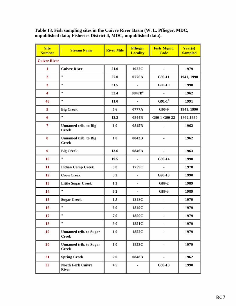
Table 13. Fish sampling sites in the Cuivre River Basin (W. L. Pflieger, MDC, unpublished data; Fisheries District 4, MDC, unpublished data).
Site Number
Stream Name River Mile Pflieger Locality
Fish Mgmt. Code
Year(s) Sampled
Cuivre River
1 Cuivre River 21.0 1922C - 1979
2 " 27.0 0776A G90-11 1941, 1990
3 " 31.5 - G90-10 1990
4 " 32.4 0847Ba - 1962
48 " 11.0 - G91-1b 1991
5 Big Creek 5.6 0777A G90-9 1941, 1990
6 " 12.2 0844B G90-1 G90-22 1962,1990
7 Unnamed trib. to Big Creek
1.0 0845B - 1962
8 Unnamed trib. to Big Creek
1.0 0843B - 1962
9 Big Creek 13.6 0846B - 1963
10 " 19.5 - G90-14 1990
11 Indian Camp Creek 3.0 1759C - 1978
12 Coon Creek 5.2 - G90-13 1990
13 Little Sugar Creek 1.3 - G89-2 1989
14 " 6.2 - G89-3 1989
15 Sugar Creek 1.5 1848C - 1979
16 " 6.0 1849C - 1979
17 " 7.0 1850C - 1979
18 " 9.0 1851C - 1979
19 Unnamed trib. to Sugar Creek
1.0 1852C - 1979
20 Unnamed trib. to Sugar Creek
1.0 1853C - 1979
21 Spring Creek 2.0 0848B - 1962
22 North Fork Cuivre River
4.5 - G90-18 1990
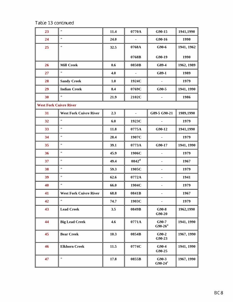
23 " 11.4 0770A G90-15 1941,1990
24 " 24.0 - G90-16 1990
25 " 32.5 0768A
0768B
G90-6
G90-19
1941, 1962
1990
26 Mill Creek 0.6 0850B G89-4 1962, 1989
27 " 4.0 - G89-1 1989
28 Sandy Creek 1.0 1924C - 1979
29 Indian Creek 8.4 0769C G90-5 1941, 1990
30 " 21.9 2102C - 1986
West Fork Cuivre River
31 West Fork Cuivre River 2.3 - G89-5 G90-21 1989,1990
32 " 6.0 1923C - 1979
33 " 11.8 0775A G90-12 1941,1990
34 " 28.4 1907C - 1979
35 " 39.1 0773A G90-17 1941, 1990
36 " 45.9 1906C - 1979
37 " 49.4 0842d - 1967
38 " 59.3 1905C - 1979
39 " 62.6 0772A - 1941
40 " 66.0 1904C - 1979
41 West Fork Cuivre River 68.8 0841B - 1967
42 " 74.7 1903C - 1979
43 Lead Creek 3.5 0849B G90-8 G90-20
1962,1990
44 Big Lead Creek 4.6 0771A G90-7 G90-26a
1941, 1990
45 Bear Creek 10.3 0854B G90-2 G90-23
1967, 1990
46 Elkhorn Creek 11.5 0774C G90-4 G90-25
1941, 1990
47 " 17.8 0855B G90-3 G90-24c
1967, 1990
Note: All sites were sampled with seines except where indicated. a D.C. electrofishing equipment and seining b D.C. electrofishing equipment only c Backpack D.C. electrofishing equipment, poor effectiveness, but site was also sampled by seine in same season. d Fish toxicant and seining
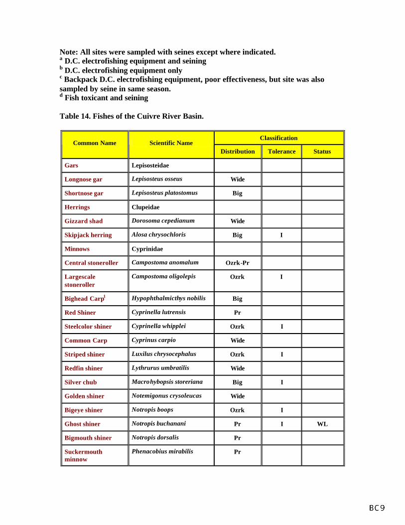
Table 14. Fishes of the Cuivre River Basin.
Classification Common Name Scientific Name
Distribution Tolerance Status
Gars Lepisosteidae
Longnose gar Lepisosteus osseus Wide
Shortnose gar Lepisosteus platostomus Big
Herrings Clupeidae
Gizzard shad Dorosoma cepedianum Wide
Skipjack herring Alosa chrysochloris Big I
Minnows Cyprinidae
Central stoneroller Campostoma anomalum Ozrk-Pr
Largescale stoneroller
Campostoma oligolepis Ozrk I
Bighead Carp1 Hypophthalmicthys nobilis Big
Red Shiner Cyprinella lutrensis Pr
Steelcolor shiner Cyprinella whipplei Ozrk I
Common Carp Cyprinus carpio Wide
Striped shiner Luxilus chrysocephalus Ozrk I
Redfin shiner Lythrurus umbratilis Wide
Silver chub Macrohybopsis storeriana Big I
Golden shiner Notemigonus crysoleucas Wide
Bigeye shiner Notropis boops Ozrk I
Ghost shiner Notropis buchanani Pr I WL
Bigmouth shiner Notropis dorsalis Pr
Suckermouth minnow
Phenacobius mirabilis Pr

Southern redbelly dace
Phoxinus erythrogaster Ozrk I
Bluntnose minnow Pimephales notatus Wide
Fathead minnow Pimephales promelas Pr
Bullhead minnow Pimephales vigilax Low
Creek chub Semotilus atromaculatus Ozrk-Pr
Hybrid shiner Cyprinella lutrensis X C. Whipplei
Hybrid minnow Notropis dorsalis X s. atromaculatus
Suckers Catostomidae
River carpsucker Carpiodes carpio Pr
Quilback carpiodes cyprinus Pr
Highfin carpsucker Carpiodes velifer Ozrk I
White sucker Catostromus commersoni Ozrk-Pr
Northern hog sucker Hypentelium nigricans Ozrk I
Smallmouth buffalo Ictiobus bubalus Wide
Bigmouth buffalo Ictiobus cyprinellus Wide
Silver redhorse Moxostoma anisurum Ozrk I
Black redhorse Moxostoma duquesnei Ozrk I
Golden redhorse Moxostoma erythrurum Ozrk I
Shorthead redhorse Moxostoma macrolepidotum Ozrk-Pr
Catfishes Ictaluridae
Black bullhead Ameiurus melas Wide
Yellow bullhead Ameirus natalis Wide
Channel catfish Ictalurus punctatus Wide
Slender madtom Noturus exilis Ozrk I
Stonecat Noturus flavus Pr I
Freckled madtom Noturus nocturnus Low I
Flathead catfish Pylodictis olivaris Wide
Pikes Esocidae
Northern pike1 Esox lucius U

Pirate Perches Aphredoderidae
Pirate perch3 Aphredoderus sayanus Low I
Killifishes Cyprinodontidae
Northern studfish Fundulus catenatus Ozrk
Blackstripe topminnow
Fundulus notatus Wide
Livebearers Poeciliidae
Mosquitofish Gambusia affinis Low
Silversides Atherinidae
Brook silverside Labidesthes sicculus Ozrk-Low I
Sculpins Cottidae
Banded sculpin Cottus carolinae Ozrk I
Sea Basses Percichthyidae
White bass Morone chrysops Big
Sunfishes Centrarchidae
Green sunfish Lepomis cyanelus Wide
Warmouth2 Lepomis gulosus Low
Orangespotted sunfish
Lepomis humillis Pr
Bluegill Lepomis macrochirus Wide
Smallmouth bass Micropterus dolomieu Ozrk I
Largemouth bass Micropterus salmoides Wide
White crappie Pomoxis annularis Wide
Black crappie Pomoxis nigromaculatus Wide
Hybrid sunfish Lepomis cyanellus X L. macrochirus
Perches Percidae
Bluntnose darter Etheostoma chlorosomum Low I
Slough darter Etheostoma gracile Low I
Johnny darter Etheostoma nigrum Ozrk-Pr
Orangethroat darter Etheostoma spectabile Ozrk
Logperch Percina caprodes Ozrk I

Blackside darter Percina maculata Pr I
Slenderhead darter Percina phoxocephala Ozrk-Pr I
Walleye2 Stizostedion vitreum Wide I
Drums Sciaenidae
Freshwater drum Aplodinotus grunniens Big
Legend
Big = Big river; Low= Lowland; Pr = Prairie; Ozrk = Ozark; Wide = Wide-ranging; I= Intolerant species; U = Undetermined; WL = on Missouri Watch List of Rare or Endangered Species. 1 Species observed in 1992 fish kill in Cuivre River (Duchrow 1992b). 2 Species reported caught by anglers (A. S. Weithman, MDC, unpublished data). 3 Species caught by Cuivre River State Park personnel in Little Sugar Creek in 1983.
Table 16. Mussels found in the Cuivre River Basin (Oesch 1984).
Common Name Scientific Name Status
Giant floater Anodonta grandis
Elktoe Alasmidonta marginata
White heelsplitter Lasmigona c. complanata
Fluted-shell Lasmigona costata
Mapleleaf Quadrula quadrula
Pimpleback Quadrula p. plicata
Threeridge Amblema p. plicata
Wabash pigtoe Fusconaia flava
Spike Elliptio dilatata
Mucket Actinonaias ligamentina
Deertoe Truncilla truncata
Fragile papershell Leptodea frafilis
Pondmussel Ligumia subrostrata
Yellow sandshell Lampsilis teres
Hickorynut Obovaria olivaria State Watch List
Pocketbook Lampsilis ovata

Figure 14. Faunal composition of fish species collected from the Cuivre River subbasin, 1971 to1991.

Figure 15. Relative abundance of fish collected from the West Fork Cuivre River and NorthFork Cuivre River drainages, 1971 to 1991.

MANAGEMENT PROBLEMS AND OPPORTUNITIES
Problems, recreational value and opportunity within the Cuivre River Basin were studied by the Corps of Engineers, St. Louis District (1991) and by Bachant and Martindale (1982). As part of the Corps study, a public meeting was held to assess local interests in and concerns for the basin. Attendees ranked major problems on a scale of zero (no problem) to four (big problem). They identified and rated the following : water quality (3.2); erosion (2.9); flooding (2.8); and environment (2.6). Other specific problems identified by the Corps study included: 1) loss or degradation of natural heritage features; 2) stream erosion and sedimentation; 3) lack of flood control; 4) need for more recreational opportunities, particularly fishing; and 5) need for more information on water quality. Bachant and Martindale conducted a survey of professional resource managers to identify recreational values and problems in major watershed throughout the state. Twenty-five professionals responded to questions about conditions in the Cuivre River Basin. Problem severity was scored from zero (no problem) to 10 (severe problem). Intensive agriculture (7.1) and poor land use (6.7) were rated the two most serious problems in the watershed, followed by: environmental intrusions (4.0); pollution (3.8); channel modifications (3.6); bank or shoreline development (3.5); intensive recreational use (3.4); water withdrawals (3.0); sand and gravel dredging (2.9); and water impoundments (2.7). Our evaluations of habitat conditions in the basin indicate the presence of 1) insufficient riparian tree corridors; 2) streambank erosion and 3) sedimentation and deterioration of aquatic habitat. Increasing educational opportunities and interest about riparian and stream management could help improve public involvement and land management along the basin’s streams. OBJECTIVES AND STRATEGIES
Objectives for the Cuivre River Basin Plan incorporate fisheries-related needs identified in the Missouri Department of Conservation Strategic Plan, Fisheries Division Operational Plan (FY 91-95), Stream Areas Program Plan, the Stream Access Acquisition Plan and this document. Four areas of concern--riparian and aquatic habitat protection, aquatic community protection, public use and public awareness--will be addressed. Objectives are presented in order of priority. The implementation of objectives will depend upon their status in Fisheries Division operational plan priorities, available manpower and funding. Riparian and Aquatic Habitat Protection GOAL I: Improve or maintain riparian and aquatic habitats in the Cuivre River Basin. Status - Problems affecting riparian and aquatic habitats include insufficient tree corridors, streambank erosion, pollution from animal waste and municipal sources and soil erosion. There are five active and one completed Special Area Land Treatment projects (SALT and EARTH projects) in the basin.Fish kills periodically occur but there are no chronic fish kill areas. In addition, many natural features are in a degraded condition. Despite these problems, MCD fish collections throughout the drainage have

indicated that most streams are in fair condition and support a wide variety of native fishes. As long as suitable habitat is available, it is expected that a natural biotic community will be present. Objective 1.1: Over a 20-year period, maintain or increase above current levels the proportion of third-order-and-larger stream reaches having a minimum tree corridor width of 100 feet on each streambank. Strategy: Protecting and enhancing the riparian tree corridor is essential to obtaining quality aquatic habitats. The tree corridor along streams significantly influences many components of the stream ecosystem including water quality, groundwater absorption and recharge to the stream, stream habitats and the food web. We believe that we can make significant improvements in habitat quality by developing a prioritized list of streams needing rehabilitation or protection. Using this list we can concentrate our efforts on a few streams rather than attack problems on every stream in the basin in the basin at once. This approach will allow us to begin where the need is greater and wisely apply limited manpower and financial resources. Tasks: * Develop criteria for prioritizing streams (e.s.,presence of rare species, amount of riparian tree corridor including that in public ownership, size of stream, permanence of water, presence of game fish, natural features, critical habitat, etc.). * Conduct field investigations to provide necessary background information for prioritizing criteria. * Using criteria, develop a prioritized list of streams in the basin needing riparian and aquatic habitat restoration and protection measures. * Implement riparian and aquatic habitat restoration and protection measures on streams according to their designated priority utilizing the Streams For The Future program and other state and federal assistance programs. * Document, in order of stream priority, the current condition of riparian corridors and streambanks by videotape, aerial photography or satellite imagery. * Reassess, according to stream priority, the condition of riparian corridors and streambanks in 20 years by videotape, aerial photography or satellite imagery. Objective 1.2: Meet state standards for water quality. Strategy: Protecting riparian corridors and implementing appropriate soil conservation measures in watersheds (e.g., Special Area Land Treatment projects [SALT and EARTH], farm Conservation Plans, etc.) will help reduce sedimentation of waterways. Streams also need protection from other pollutants. By keeping local citizenry informed on water quality issues we believe they will be more likely to report violations of water quality laws. Adequate enforcement of existing water quality laws is crucial to obtaining satisfactory water quality. Task: * Cooperate with other state and federal agencies to investigate pollution and fish kill reports, evaluate Clean Water Act permits and assist with the enforcement of existing water quality laws.

* Inform the public of water quality problems (e.g., excessive siltation, animal waste runoff, etc.) and solutions affecting aquatic habitats through media contacts, personal contacts and literature development. * Train and involve Stream Team in water quality monitoring and advocacy in the Cuivre River Basin. * Make presentation and provide technical assistance for SALT and EARTH projects, as requested, to county Soil and Water Conservation District boards who govern these projects. Aquatic Community Protection Goal II: Protect native aquatic fauna in the Cuivre River Basin. Status - Seventy-one fish species, 16 mussel species and five species of crayfish have been identified in creel surveys, fish kills and field collections made from 1941-1992. Among these animals, the ghost shiner and hickorynut mussel are on the Missouri watch list. Sport fish include smallmouth bass, largemouth bass, channel catfish, flathead catfish, black crappie, white crappie, white bass, walleye, freshwater drum, common carp, bluegill and green sunfish. Exotic fish found in the basin include bighead carp, grass carp (lakes) and mosquitofish. The zebra mussel, a potentially harmful exotic mussel, is found nearby in the Mississippi River. Objective 2.1: Maintain or improve the current species diversity of fish and invertebrate communities. Strategy: High priority should be placed on protecting native, rare and endangered species and community assemblages with natural areas or other special features. Focusing enhancement and protective efforts on a few species can be effective in helping other species that share the same habitat. Detecting changes in faunal composition and abundance can be accomplished by conducting periodic surveys of fish and invertebrate communities. Determining reasons for any change, however, will be more difficult since a variety of factors (e.g., inter- and intra-specific competition water quality, habitat condition, etc.) could be involved. Tasks: * Document locations and identify unique fish assemblages associated with natural features and special habitats such as oxbow lakes, spring branches and marshes for possible acquisition or protection through landowner easements. * Assist with recovery efforts for any state or federally-listed rare or endangered species discovered in the basin. * Survey fish communities every 10 years using a standardized sampling technique to document changes in species abundance and distribution. This will include establishing "large fish" monitoring stations on the mainstem Cuivre, West Fork Cuivre and North Fork rivers where electrofishing and netting surveys can be conducted.
* Complete fish-habitat improvement projects at MDC-managed areas where native fish habitat is limited. * Recommend fish-habitat improvement projects on private lands whenever the opportunity arises. * Conduct research projects to investigate reasons for significant changes in faunal abundance and distribution and identify corrective measures, if appropriate. * Conduct a survey of mussels on all fifth order and larger streams. Objective 2.2: Maintain or improve populations of game fish while maintaining a stable and diverse fish community. Strategy: Proper management of game fish populations will depend on obtaining adequate samples to determine their current condition. In the Cuivre River system this effort will be hampered by steep river banks and poor access to the streams. Current data are insufficient for setting specific management objectives. High priority will be place on obtaining status information and setting management objectives for channel catfish, flathead catfish, smallmouth bass, largemouth bass and crappie. Once adequate information is obtained, future management efforts will be directed toward setting appropriate regulations and protecting and improving fish habitat. Tasks: * Conduct a literature review to determine "ideal" population parameters for Missouri riverine populations of flathead catfish, channel catfish, smallmouth bass, largemouth bass and crappie. * Develop and initiate a regular sampling regime or high priority game fish to evaluate the health of their populations and provide baseline data for management decisions. * Write a game fish management plan for streams in the basin. * Complete fish habitat improvement projects at MDC-managed areas where game fish habitat is limited. * Recommend fish habitat improvement projects on private lands whenever the opportunity arises. Objective 2.3: Prevent detrimental impacts on native fauna of the Cuivre River Basin by exotic aquatic species. Strategy: Controlling the introduction of exotic species into the state is the easiest way to prevent detrimental impacts to native fauna. Once a detrimental exotic species becomes established, research will be needed to seek ways to contain it or eliminate it from the system. Tasks:

* Continue Division participation on the Missouri Aquaculture Advisory Council (MAAC) and other organizations and advocate the introduction of exotic fauna into state waters. * Develop statewide regulations and/or promote legislation to prohibit the introduction of harmful exotic fauna into Missouri waters. * Monitor for potentially harmful exotic species (e.g., zebra mussel, bighead carp) when a threat to native fauna is likely. * If harmful exotics are observed, submit research proposals to evaluate impacts and possible control measures. Public Use GOAL III: Increase stream-related recreational opportunities in the Cuivre River Basin. Status - Out of 37 Missouri watersheds, the Cuivre River drainage ranked 32nd in recreational value because of intensive agricultural use and poor land management practices (Bachant and Martindale 1982). Its worth is expected to increase in the future because of its close proximity to St. Louis. Fishing opportunities exist for smallmouth bass, largemouth bass, flathead catfish, black crappie, white crappie, channel catfish, white bass, walleye, drum, common carp and bluegill in the basin’s streams. Anglers rated the overall quality of fishing as average. Approximately 88 miles of the West Fork Cuivre, North Fork Cuivre and Cuivre rivers have permanent, fishable pools of water, and 43 miles are floatable. Between 1983 and 1988, the number of fishing trips to the Cuivre River averaged 17,742 trips per year. This level of use was lower than that observed for the Grand, Salt and Fabius rivers (Weithman 1991). Public access to major streams is poor; currently, there are only three MDC public accesses on these streams. None of these accesses has a concrete boat ramp and their total river frontage is less than 0.5 mile. The Old Monroe Access is particularly inadequate because it is too small, noisy from heavy traffic on nearby U.S. Highway 79 and has limited parking. Objective 3.1: Over a 10-year period, increase angling trips to 10%. Strategy: By improving the overall quality of the fishery from average to good we expect angling use to increase (see Objective 2.2). Angler use of streams should increase as the availability of stream accesses is improved and the public becomes more aware of available fishing opportunities. Tasks: * Conduct telephone surveys at 10 year intervals to assess angler use and the quality of the fishery. * Provide a total of six stream accesses to create a minimum of 2.5 miles of river frontage open to the public. The six accesses should be provided as follows: four on the Cuivre River, one on the West Fork Cuivre River and one on the North Fork Cuivre River. This would require purchasing four sites and abandon one site (Old Monroe) having an easement. At least two sites should be designed with boat

launching facilities. * Develop, if feasible, at least one stream access with facilities accessible to disabled anglers. * Publicize new accesses and submit fishing articles for local distribution and publication in the Missouri Conservationist or All Outdoors. Objective 3.2: Develop additional non-consumptive recreational opportunities on public lands including lands managed by MDC and other public entities. Strategy: Non-consumptive use of streams in the basin should increase as access to streams is improved and the public becomes more aware of available stream-related recreational opportunities. Tasks: * Encourage or assist the Missouri Department of Natural Resources in developing better stream access at Cuivre River State Park. * Support the concept of a big river ecosystem park at the mouth of the Cuivre River, as proposed by the Corps of Engineers (1991). * Produce and distribute a pamphlet about non-consumptive recreational opportunities available in the basin. Public Awareness GOAL IV: Increase public awareness and promote wise use of aquatic resources in the Cuivre River Basin. Status - Throughout Missouri public awareness of stream-related issue is low. At the 1991 Missouri Conference on Rivers and Streams, held in Columbia, MDC Director Jerry Presley indicated that building public awareness of stream conservation issues and programs is the greatest challenge facing water-resources agencies. Results released in 1991 from a recent Gallup poll of 606 Missourians, indicated that five of six respondents (83%) could not name any stream conservation program by name. Since private landowners own 99% of the Cuivre River’s watershed, it is logical to assume that their participation is essential for making any significant improvements to stream quality. Motivating landowners to accept help with their stream problems will be a major challenge. In a Gallup poll of 11,400 Missouri farm operators, 557 farmers (residing in the Northeastern Riverbreaks zoogeographic region which includes the Cuivre River watershed) responded to questions about streams. Forty-three percent of the cooperators indicated that they had problem with a stream on their property. However, only 29% indicated that they would welcome technical assistance (Gallup 1992). Similarly according to MDC Fisheries Management District 4 staff, interest in the MDC Streams For The Future program from this watershed has been extremely low, there are no approved private landowner cooperative projects. In addition, local participation on Stream Team (an adopt-a-stream program sponsored by the

Conservation Federation of Missouri) has been low; as of January 16, 1992, only three Stream Teams had adopted a stream in the watershed. Objective 4.1: Over a 10-year period, increase the current level of public awareness of local stream resources and good stream management practices by at least 10%. Strategy: We want to raise the public’s overall level of knowledge about streams by providing them with as many opportunities to learn more about streams as possible. If citizens recognize streams as a valuable resource, they are more apt to participate in improving them. Tasks: * Conduct telephone surveys at 10-year intervals to assess public awareness of local stream resources and problems, technical assistance programs and stream management. * Provide educational materials about streams, good watershed management practices, demonstration areas and available technical assistance programs for elementary and high school curricula, special interest groups (Farm Bureau, Sierra Club, etc.), other governmental agencies, local media, fairs and other special events. * Actively solicit the participation of landowners along designated high priority streams in stream improvement and education programs (see Objective 1.1). * Attend planning meeting for Agricultural Stabilization and Conservation Service and Soil and Water Conservation District cost sharing programs and promote good stream and fisheries management practices. * Conduct one landowner workshop on stream management per year in Troy, Montgomery City or Wellsville, Missouri. * Establish one stream demonstration area (or landowner cooperative project involved in the "Neighbor to Neighbor" program) in Lincoln, Montgomery, Audrain, Pike and Warren counties. *Make public presentations to encourage the enrollment of at least two Stream Teams per year. * Encourage Cuivre River State Park personnel to incorporate stream ecology and stream stewardship presentations into their summer program.

GLOSSARY
Alluvial soil – Soil deposits resulting directly or indirectly from the sediment transport of streams, deposited in river beds, flood plains, and lakes. Aquifer – An underground layer of porous, water-bearing rock, gravel, or sand. Benthic – Bottom-dwelling; describes organisms which reside in or on any substrate. Benthic macroinvertebrate – Bottom-dwelling (benthic) animals without backbones (invertebrate) that are visible with the naked eye (macro). Biota – The animal and plant life of a region. Biocriteria monitoring – The use of organisms to assess or monitor environmental conditions. Channelization – The mechanical alteration of a stream which includes straightening or dredging of the existing channel, or creating a new channel to which the stream is diverted. Concentrated animal feeding operation (CAFO) – Large livestock (ie.cattle, chickens, turkeys, or hogs) production facilities that are considered a point source pollution, larger operations are regulated by the MDNR. Most CAFOs confine animals in large enclosed buildings, or feedlots and store liquid waste in closed lagoons or pits, or store dry manure in sheds. In many cases manure, both wet and dry, is broadcast overland. Confining rock layer – A geologic layer through which water cannot easily move. Chert – Hard sedimentary rock composed of microcrystalline quartz, usually light in color, common in the Springfield Plateau in gravel deposits. Resistance to chemical decay enables it to survive rough treatment from streams and other erosive forces. Cubic feet per second (cfs) – A measure of the amount of water (cubic feet) traveling past a known point for a given amount of time (one second), used to determine discharge. Discharge – Volume of water flowing in a given stream at a given place and within a given period of time, usually expressed as cubic feet per second. Disjunct – Separated or disjoined populations of organisms. Populations are said to be disjunct when they are geographically isolated from their main range. Dissolved oxygen – The concentration of oxygen dissolved in water, expressed in milligrams per liter or as percent.
Dolomite – A magnesium rich, carbonate, sedimentary rock consisting mainly (more than 50% by weight) of the mineral dolomite (CaMg(CO3)2). Endangered – In danger of becoming extinct. Endemic – Found only in, or limited to, a particular geographic region or locality. Environmental Protection Agency (EPA) – A Federal organization, housed under the Executive branch, charged with protecting human health and safeguarding the natural environment — air, water, and land — upon which life depends. Epilimnion – The upper layer of water in a lake that is characterized by a temperature gradient of less than 1o Celcius per meter of depth. Eutrophication – The nutrient (nitrogen and phosphorus) enrichment of an aquatic ecosystem that promotes biological productivity. Extirpated – Exterminated on a local basis, political or geographic portion of the range. Faunal – The animals of a specified region or time. Fecal coliform – A type of bacterium occurring in the guts of mammals. The degree of its presence in a lake or stream is used as an index of contamination from human or livestock waste. Flow duration curve – A graphic representation of the number of times given quantities of flow are equaled or exceeded during a certain period of record. Fragipans – A natural subsurface soil horizon seemingly cemented when dry, but when moist showing moderate to weak brittleness, usually low in organic matter, and very slow to permeate water. Gage stations – The site on a stream or lake where hydrologic data is collected. Gradient plots – A graph representing the gradient of a specified reach of stream. Elevation is represented on the Y-axis and length of channel is represented on the X- axis. Hydropeaking – Rapid and frequent fluctuations in flow resulting from power generation by a hydroelectric dam’s need to meet peak electrical demands. Hydrologic unit (HUC) – A subdivision of watersheds, generally 40,000-50,000 acres or less, created by the USGS. Hydrologic units do not represent true subwatersheds. Hypolimnion – The region of a body of water that extends from the thermocline to the bottom and is essentially removed from major surface influences during periods of thermal stratification.

Incised – Deep, well defined channel with narrow width to depth ration, and limited or no lateral movement. Often newly formed, and as a result of rapid down-cutting in the substrate Intermittent stream – One that has intervals of flow interspersed with intervals of no flow. A stream that ceases to flow for a time. Karst topography – An area of limestone formations marked by sinkholes, caves, springs, and underground streams. Loess – Loamy soils deposited by wind, often quite erodible. Low flow – The lowest discharge recorded over a specified period of time. Missouri Department of Conservation (MDC) – Missouri agency charged with: protecting and managing the fish, forest, and wildlife resources of the state; serving the public and facilitating their participation in resource management activities; and providing opportunity for all citizens to use, enjoy, and learn about fish, forest, and wildlife resources. Missouri Department of Natural Resources (MDNR) – Missouri agency charged with preserving and protecting the state’s natural, cultural, and energy resources and inspiring their enjoyment and responsible use for present and future generations. Mean monthly flow – Arithmetic mean of the individual daily mean discharge of a stream for the given month. Mean sea level (MSL) – A measure of the surface of the Earth, usually represented in feet above mean sea level. MSL for conservation pool at Pomme de Terre Lake is 839 ft. MSL and Truman Lake conservation pool is 706 ft. MSL. Necktonic – Organisms that live in the open water areas (mid and upper) of waterbodies and streams. Non-point source – Source of pollution in which wastes are not released at a specific,? identifiable point, but from numerous points that are spread out and difficult to identify and control, as compared to point sources. National Pollution Discharge Elimination System (NPDES) – Permits required under The Federal Clean Water Act authorizing point source discharges into waters of the United States in an effort to protect public health and the nation’s waters. Nutrification – Increased inputs, viewed as a pollutant, such as phosphorous or nitrogen, that fuel abnormally high organic growth in aquatic systems. Optimal flow – Flow regime designed to maximize fishery potential.

Perennial streams –Streams fed continuously by a shallow water table an flowing year-round. pH – Numeric value that describes the intensity of the acid or basic (alkaline) conditions of a solution. The pH scale is from 0 to 14, with the neutral point at 7.0. Values lower than 7 indicate the presence of acids and greater than 7.0 the presence of alkalis (bases). Point source – Source of pollution that involves discharge of wastes from an identifiable point, such as a smokestack or sewage treatment plant. Recurrence interval – The inverse probability that a certain flow will occur. It represents a mean time interval based on the distribution of flows over a period of record.? A 2-year recurrence interval means that the flow event is expected, on average, once every two years. Residuum – Unconsolidated and partially weathered mineral materials accumulated by disintegration of consolidated rock in place. Riparian – Pertaining to, situated, or dwelling on the margin of a river or other body of water. Riparian corridor – The parcel of land that includes the channel and an adjoining strip of the floodplain, generally considered to be 100 feet on each side of the channel. 7-day Q10 – Lowest 7-day flow that occurs an average of every ten years. 7-day Q2 – Lowest 7-day flow that occurs an average of every two years. Solum – The upper and most weathered portion of the soil profile. Special Area Land Treatment project (SALT) – Small, state funded watershed programs overseen by MDNR and administered by local Soil and Water Conservation Districts. Salt projects are implemented in an attempt to slow or stop soil erosion. Stream Habitat Annotation Device (SHAD) – Qualitative method of describing stream corridor and instream habitat using a set of selected parameters and descriptors. Stream gradient – The change of a stream in vertical elevation per unit of horizontal distance. Stream order – A hierarchical ordering of streams based on the degree of branching. A first order stream is an unbranched or unforked stream. Two first order streams flow together to make a second order stream; two second order streams combine to make a third order stream. Stream order is often determined from 7.5 minute topographic maps. Substrate – The mineral and/or organic material forming the bottom of a waterway or waterbody.

Thermocline – The plane or surface of maximum rate of decrease of temperature with respect to depth in a waterbody. Threatened – A species likely to become endangered within the foreseeable future if certain conditions continue to deteriorate. United States Army Corps of Engineers (USCOE) and now (USACE) – Federal agency under control of the Army, responsible for certain regulation of water courses, some dams, wetlands, and flood control projects. United States Geological Survey (USGS) – Federal agency charged with providing reliable information to: describe and understand the Earth; minimize loss of life and property from natural disasters; manage water, biological, energy, and mineral resources; and enhance and protect the quality of life. Watershed – The total land area that water runs over or under when draining to a stream, river, pond, or lake. Waste water treatment facility (WWTF) – Facilities that store and process municipal sewage, before release. These facilities are under the regulation of the Missouri Department of Natural Resources.

LITERATURE CITED
Anderson, C. L. 1980. Best Management Practices for Erosion and Sediment Control. University of Missouri-Columbia and Missouri Department of Natural Resources, Manual 117. Bachant, J. P. and J. D. Martindale. 1982. Ranking the Recreationa l Values and Associated Problems of Missouri’s Major Watersheds. Missouri Department of Conservation and Missouri Department of Natural Resources. A reference document of the Regional Watershed Assessment Plan, Jefferson City, Missouri. Bogler, D. and T. Nigh. 1986. Final Report of the Missouri Natural Features Inventory TNC Inventory Lincoln, Pike, St. Charles and Warren counties. Missouri Department of Conservation, Jefferson City, Missouri. Buchanan, A. C. 1990. Missouri Fish Kill and Water Pollution Investigations 1989. Missouri Department of Conservation, Columbia, Missouri. Bush, J. E. 1989. Missouri Fish Kill and Water Pollution Investigations 1987. Missouri Department of Conservation, Columbia, Missouri. Clark, B. 1991. Forest Inventory Data for Cuivre River Basin. Unpublished memo and computer printout from 1989 Missouri Forest Inventory. Missouri Department of Conservation, Jefferson City, Missouri. Corps of Engineers, U.S. 1991. Cuivre River and Vicinity, Missouri Reconnaissance Report. U.S. Department of the Army, St. Louis District, Corps of Engineers, St. Louis, Missouri. Czarnezki, J. M. 1979a. 1978 Fish Kill Investigations, Missouri Department of Conservation, Columbia, Missouri. Czarnezki, J. M. 1979b. Fish Kill, Cuivre River, Lincoln County. Unpublished memorandum, Missouri Department of Conservation, Columbia, Missouri. Czarnezki, J. M. 1981. Missouri Fish Kill Investigations 1980. Missouri Department of Conservation, Columbia, Missouri. Czarnezki, J. M. 1983a. A Summary of Fish Kill Investigations in Missouri 1970-1979. Missouri Department of Conservation, Columbia, Missouri. Czarnezki, J. M. 1983b. Missouri Fish Kill Investigations 1982. Missouri Department of Conservation, Columbia, Missouri.

Duchrow, R. M. 1974. Water Quality of the North, Salt and Cuivre River Basins. Missouri Department of Conservation, Final Report, Project F-1-R-22, Study W-1, Job No. 3, Jefferson City, Missouri. Duchrow, R. M. 1976. Fish Kill Report-West Fork Cuivre River-Lincoln County. Unpublished memorandum. Missouri Department of Conservation, Columbia, Missouri. Duchrow, R. M. 1992a. Missouri Losing Streams List-Update 2/6/92. Unpublished memorandum. Missouri Department of Conservation, Columbia, Missouri Duchrow, R. M. 1992b. Report of Pollution Investigations and Fishkills; Cuivre River. Updated report 9-22-92. Missouri Department of Conservation, Columbia, Missouri. Fenneman, Nevin M. 1938. Physiography of Eastern United States. McGraw-Hill Book Co., Inc. New York. 714 pp. Fuchs, E. H. 1970. Fish Kill Investigation on a Tributary of Little Sandy Creek, Lincoln County. Unpublished memorandum. Missouri Department of Conservation, Columbia, Missouri. Funk, J. L. 1968. Missouri’s Fishing Streams. Missouri Department of Conservation Division of Fisheries, D-J Series No. 5, Project No. F-1-R. Jefferson City, Missouri. Gallup. 1992. Landowner Questionnaire-1991. Gallup Organization, Lincoln, Nebraska. Gann, L. W. 1989. Access Points Acquisition Plan-SWMO-Final Plan. Unpublished memorandum. Missouri Department of Conservation, Jefferson City, Missouri. Hansen, M. H. 1991. Timber Resources of Missouri’s Riverborder. United States Department of Agriculture, Forest Service, North Central Forest Experiment Station, Resource Bulletin NC-118, St. Paul, Minnesota. Hauth, L. D. 1974. Technique for Estimating the Magnitude and Frequency of Missouri Floods. United States Department of the Interior Geological Survey, open file report. McGrath, Kathy. 1992. Permitted Gravel Dredging Operations in Missouri. Unpublished memorandum. Missouri Department of Conservation, Jefferson City, Missouri. Missouri Department of Conservation. 1991a. Rare and Endangered Species of Missouri Checklist. Missouri Department of Conservation, Jefferson City, Missouri. Missouri Departme nt of Conservation. 1991b. Sensitive Species and High-Quality Natural Communities Known From the Cuivre River Watershed. Computer printout of the Natural Heritage Database. Missouri Department of Conservation, Jefferson City, Missouri.
Missouri Department of Economic Development and the Community. January 1990. Wentzville, Missouri, Community Profile. Research and Planning, Jefferson City, Missouri. Missouri Department of Health. 1992. Missouri Department of Health 1992 Fish Consumption Advisory. News release May 6, 1992. Jefferson City, Missouri. Missouri Department of Natural Resources. 1984. Missouri Water Quality Basin Plans. Volume 1. Des Moines, Fox, Wyaconda, Fabius, North, Salt, Cuivre and Upper Mississippi rivers, Peruque and Dardenne creeks. Missouri Department of Natural Resources, Jefferson City, Missouri. Missouri Department of Natural Resources. 1986. Missouri Water Atlas. Missouri Department of Natural Resources, Jefferson City, Missouri. Missouri Department of Natural Resources. 1992. Rules of Department of Natural Resources Division 20-Clean Water Commission Chapter 7-Water Quality. Code of State Regulations, Jefferson City, Missouri. Oesch, R. D. 1984. Missouri Naiades: A Guide to Mussels of Missouri. Missouri Department of Conservation, Jefferson City, Missouri. Omernik, James M. 1977. Nonpoint Source--Stream Nutrient Level Relationships: A Nationwide Study. U.S. Environmental Protection Agency, Corvallis, Oregon. Ostrom, A. J. 1991. Timber Resource of Missouri’s Prairie. United States Department of Agriculture, Forest Service, North Central Forest Experiment Station, Resource Bulletin NC-117, St. Paul, Minnesota. Pemberton, M.A. 1978. An Introduction to Floatable Streams North of the Missouri River. Missouri Department of Natural Resources, Jefferson City, Missouri. Pflieger, W. L. 1971. A Distributional Study of Missouri Fishes. Museum of Natural History, University of Kansas Publications 20: 225-570. Pflieger, W. L. 1975. The Fishes of Missouri. Missouri Department of Conservation, Jefferson City, Missouri. Pflieger, W. L. 1987. An Introduction to the Crayfish of Missouri. Missouri Conservationist. Missouri Department of Conservation, Jefferson City, Missouri. Plieger, W. L., P. Haverland, and M. Schene, Jr. 1981. Missouri’s System for Storage and Retrieval and Analysis of Stream Resource Data. Pp. 284-290 in N. B. Armantrout, editor. Acquisition and Utilization of Aquatic Habitat Inventory Information Symposium. American Fisheries Society, Bethesda, Maryland.

Reese, G. A. 1986. Final Report on the Missouri Natural Features Inventory East-Central Natural Features Inventory, Howard, Boone, Callaway, Montgomery, Audrain, Monroe and Ralls counties. Missouri Department of Conservation, Jefferson City, Missouri. Robinson-Wilson, E. F. 1976a. Missouri Fish Kill Investigations-1976. Missouri Department of Conservation, Columbia, Missouri. Robinson-Wilson, E. F. 1976b. Fish Kill Report-West Fork Cuivre River-Lincoln County. Missouri Department of Conservation, Columbia, Missouri. Ryck, F. M., Jr. 1991. Public Lakes Program Acquisition and Development Plan. Missouri Department of Conservation, Jefferson City, Missouri. Skelton, J. 1970. Base-Flow Recession Characteristics and Seasonal Low-Flow Frequence Characteristics for Missouri Streams. Missouri Geological Survey and Water Resources Report 25. Skelton, J. 1976. Missouri Stream and Springflow Characteristics Low-Flow Frequency and Flow Duration. Missouri Department of Natural Resources, Division of Geology and Land Survey, and United States Geological Survey, Water Resources Report No. 32. Soil Conservation Service, United States. 1979. Missouri General Soil Map and Soil Association Descriptions. United States Department of Agriculture, Soil Conservation Service, Columbia, Missouri. Speas, C. and L. Schrader. 1989. Stream Management Plan, Locust Creek Basin (draft). Missouri Department of Conservation, Jefferson City, Missouri. Strahler, A. N. 1958. Dimensional Analysis Applied to Fluvially Eroded Land Forms. Geological Society of America Bulletin 60: 279-299. Taylor, T. S. 1988. PADPAC. Bloomfield, Missouri. Thom, R. H. and G. Iffrig. 1985. Directory of Missouri Natural Areas. Missouri Natural Areas Committee. Jefferson City, Missouri. Thom, R. H. and J. H. Wilson. 1980. The Natural Divisions of Missouri. Transactions of the Missouri Academy of Science 14: 9-23. U.S. Bureau of the Census. 1988. County and City Data Book. Figures for Warrenton and Troy, Missouri. U.S. Government Printing Office. U.S. Geological Survey. 1965. 1965 Water Resources Data for Missouri Part 1. Surface Water Records. United States Department of the Interior, Geological Survey, Rolla, Missouri.

U.S. Geological Survey. 1974. 1974 Water Resources Data for Missouri Part 1. Surface Water Records. Part 2. Water Quality Records. United States Department of the Interior, Geological Survey, Rolla, Missouri. U.S. Geological Survey. 1989. Water Resources Data Missouri Water Year 1989. United States Department of the Interior, Geological Survey, Rolla, Missouri. U.S. Geological Survey. 1990. Water Resources Data Missouri Water Year 1990. United States Department of the Interior, Geological Survey, Rolla, Missouri. Weithman, A. Stephen. 1991. Recreational Use and Economic Value of Missouri Fisheries. Missouri Department of Conservation, D-J Project F-1-R-40, Study SI-1. Jefferson City, Missouri. Wilhm, J. C. 1967. Comparison of Some Diversity Indices Applied to Benthic Macroinvertebrates in a Stream Receiving Organic Wastes. Journal of Water Pollution Control Federation 39 (10): 1,673-1,683.
LIST OF FIGURES Figure 1. Location of the Cuivre River Watershed in Missouri.
Figure nd. Location of the Cuivre River watershed within the Natural Divisions of Missouri.
Figure 3. Gradient plot of Cuivre River, West Fork Cuivre River, and North Fork Cuivre River.
Figure ge. Geology within the Cuivre River watershed, in Missouri.
Figure lu. Land Use/ Land Cover within the Cuivre River watershed, in Missouri (MORAP 1999,
preliminary data).
Figure 6. Annual hydrograph of Cuivre River near Troy at gage #05514500, 1922 to 1972 and 1979
to 1990.
Figure 7. Flow duration curve for the Cuivre River near Troy, gage station #05514500, 1923 to 1972
and 1979 to 1985.
Figure gs. Gagins stations in the Cuivre River watershed, in Missouri.
Figure pa. Public areas of the Cuivre River watershed, in Missouri.
Figure ps. Point source pollution locations in the Cuivre River watershed, in Missouri.
Figure fs. Fish sample locations in the Cuivre River watershed, in Missouri.
Figure hb. Habitat sample locations in the Cuivre River watershed, in Missouri.
Figure 14. Faunal composition of fish species collected from the Cuivre River subbasin, 1971 to 1991.
Figure 15. Relative abundance of fish collected from the West Fork Cuivre River and North Fork
Cuivre River drainages, 1971 to 1991.
LIST OF TABLES Table 1. Length and watershed area of third-order-and larger streams in the Cuivre River subbasin.
Table 2. Length and watershed area of third-order-and larger streams located in the West Fork Cuivre
River subbasin.
Table 3. Length and watershed area of third-order-and-larger streams located in the North Fork
Cuivre River subbasin.
Table 4. Average gradient, by stream order, of the Cuivre River, the West Fork Cuivre River and the
North Fork Cuivre River.

Table 5. Gage stations in the Cuivre River Basin (Skelton 1970; U.S. Geological Survey 1965; U.S.
Geological Survey 1989).
Table 6. Permanence of stream flow in fourth-order-and-larger streams in the Cuivre River Basin.
Table 8. Flood-frequency data for the Cuivre River, Cuivre River gage station at Troy, Missouri, in
Lincoln County (Hauth 1974)
Table 9. Selected water-quality data for the Cuivre River near Troy at gage station #05514500, water
years 1974 and 1990 (USFS 1974; USGS 1990; Code of State Regulations 10 CSR 20.7).
Table 10. Fish kill data for the Cuivre River Basin, 1970-present.
Table 13. Fish sampling sites in the Cuivre River Basin (W. L. Pflieger, MDC, unpublished data;
Fisheries District 4, MDC, unpublished data).
Table 14. Fishes of the Cuivre River Basin.
Table 16. Mussels found in the Cuivre River Basin (Oesch 1984).