cultural resource management plan (crmp) · and guidelines. in 1995, nasa langley research center...
TRANSCRIPT

CULTURAL RESOURCE MANAGEMENT PLAN (CRMP)
LANGLEY RESEARCH CENTER
HAMPTON, VIRGINIA
Prepared by:
Science Applications International Corporation
Dutton + Associates, LLC
September 2010


NASA Langley Research Center September 2010 Cultural Resource Management Plan
Table of Contents
Executive Summary .......................................................................................................................v
1 Introduction........................................................................................................................... 1 1.1 Purpose and Scope .......................................................................................................... 1 1.2 CRMP Overview............................................................................................................. 2
2 Overview of NASA LaRC .................................................................................................... 3 2.1 Regional History Prior to 1917....................................................................................... 3 2.2 1917 to the Present.......................................................................................................... 4 2.3 Current Setting ................................................................................................................ 4 2.4 LaRC’s CRM Program Goals ......................................................................................... 6 2.5 Integration of LaRC’s CRM Program with Master Planning ......................................... 6 2.6 Organizational Structure and CRM Responsibilities...................................................... 7 2.7 CRM Personnel Qualifications and Training.................................................................. 9
3 Regulations and NASA Policy and Procedures................................................................ 10 3.1 National Historic Preservation Act ............................................................................... 10 3.2 Preserve America .......................................................................................................... 13 3.3 National Environmental Policy Act (NEPA)................................................................ 14 3.4 Native American Graves Protection and Repatriation Act (NAGPRA)....................... 15 3.5 American Indian Religious Freedom Act (AIRFA)...................................................... 15 3.6 Archaeological Resources Protection Act (ARPA) ...................................................... 15 3.7 NASA CRM Policy and Guidance Documents ............................................................ 16
4 Existing LaRC Historic Property Management Policy and Procedures ....................... 19 4.1 Environmental Project Planning Form ......................................................................... 19 4.2 Review and Distribution of NASA LaRC Agreement Documents .............................. 24 4.3 Recommendations for Enhancing the Internal Planning Process ................................. 24
5 Consultation Guidelines ..................................................................................................... 27 5.1 Programmatic Agreement for Management of the Built Environment ........................ 27 5.2 Compliance with the Programmatic Agreement........................................................... 30 5.3 Foreclosing the Advisory Council’s Opportunity to Comment.................................... 41 5.4 Coordinating Section 106 Review with NEPA............................................................. 41 5.5 Native American Graves Protection and Repatriation Act (NAGPRA)....................... 43 5.6 Archaeological Resource Protection Act (ARPA)........................................................ 46 5.7 Public Participation Guidelines..................................................................................... 48
6 Standard Operating Procedures........................................................................................ 51 6.1 Procedures for Discovery of Human Remains.............................................................. 51 6.2 Procedures Related to Consultation with Native Americans........................................ 52 6.3 Procedures for Post Review Discovery of Archaeological Resources ......................... 55 6.4 Permits for Archaeological Investigations.................................................................... 56 6.5 Procedures for Wildlife Management Activities .......................................................... 56 6.6 Procedures for Shoreline Stabilization and Soil Erosion Control................................. 57 6.7 Procedures for Timbering Activities............................................................................. 58 6.8 Procedures for Mothballing of Historic Buildings........................................................ 60 6.9 Procedures for Leasing and/or Disposal of Historic Property ...................................... 62 6.10 Hazardous Material Spill/Cleanup................................................................................ 64
i

NASA Langley Research Center September 2010 Cultural Resource Management Plan
6.11 Building and Structure Demolition............................................................................... 65 6.12 Building and Structure Renovation and Additions ....................................................... 65
7 LaRC Historic Property Inventory and Interpretation .................................................. 67 7.1 Historic Property Surveys at NASA LaRC................................................................... 67 7.2 Inventory of Cultural Resources at NASA LaRC......................................................... 71 7.3 Public Education and Outreach..................................................................................... 72 7.4 Recommendations for Historic Property Management and Interpretation ................... 73
Curation and Collections Management .................................................................................... 79 7.5 Ownership of Archaeological Material......................................................................... 79 7.6 Curation Agreements .................................................................................................... 80 7.7 What Should be Curated ............................................................................................... 80 7.8 Recommendations for Enhancing Curation and Collections Management .................. 81
8 CRMP Review and Updates............................................................................................... 82 9 References............................................................................................................................ 83
ii

NASA Langley Research Center September 2010 Cultural Resource Management Plan
List of Figures
Figure 2.1 – Regional Location of NASA LaRC............................................................................ 3
Figure 2.2 – NASA LaRC West and East Areas and Langley Air Force Base .............................. 5
Figure 4-1. – Sample Checklist Questions Relevant to Cultural Resource Issues........................ 20
Figure 4-2. – Example Questions Asked to Determine Whether or not a Project has the Potential to Affect Historic Architectural Resources................................................................................... 21
Figure 4-3. – Example Questions Asked to Determine Whether or not a Proposed Project has the Potential to Affect Archaeological Resources. ............................................................................. 21
Figure 4-4. – Decision Framework for Environmental Management Branch Internal Review.... 22
Figure 5-1. – Treatment Category 1 and 2 Coordination Requirements....................................... 29
Figure 5-2. – Treatment Category 3 Coordination Requirements ................................................ 29
Figure 5-3. – Treatment Category 4 Coordination Requirements ................................................ 30
Figure 5-4. -- Things to Remember When Complying With the Programmatic Agreement. ...... 31
Figure 5-5. – Documentation for No Historic Properties Affected. ............................................. 35
Figure 5-6. – No Adverse Effect Documentation Requirements. ................................................. 37
Figure 5-7. – Documentation to Accompany Advisory Council Notification of Adverse Effect. 38
Figure 5-8. – NEPA and PA Coordination. .................................................................................. 42
Figure 5-9. – LaRC’s Responsibilities under NAGPRA. ............................................................. 45
Figure 5-10. – LaRC’s Responsibilities under ARPA. ................................................................. 47
Figure 5-11. – Public Participation Objectives ............................................................................. 48
Figure 5-12. – Documenting Public Participation ........................................................................ 50
iii

NASA Langley Research Center September 2010 Cultural Resource Management Plan
iv
Table of Appendices
Appendix A Glossary and Acronyms
Appendix B Prehistoric and Historic Background of NASA LaRC
Appendix C Programmatic Agreement among the National Aeronautics and Space Administration, the National Conference of State Historic Preservations Officers, and the Advisory Council on Historic Preservation
Appendix D Historic Contexts for NASA LaRC
Appendix E Environmental Project Planning Form
Appendix F NASA LaRC Center-wide Programmatic Agreement
Appendix G Inventory and Maps of NASA LaRC’s CRM Surveys and Cultural Resources
Appendix H LaRC Sample Curation Agreement

NASA Langley Research Center September 2010 Cultural Resource Management Plan
EXECUTIVE SUMMARY
This Cultural Resource Management Plan (CRMP) was developed by NASA Langley Research Center (LaRC) to preserve and protect LaRC’s cultural resources, and to comply with the National Historic Preservation Act (NHPA) of 1966, as amended, and other historic preservation laws and regulations. The CRMP provides guidance, procedures and important information to ensure the proper management of cultural resources at LaRC. Compliance with this plan will permit LaRC to effectively accomplish historic preservation responsibilities in conjunction with its mission and programs.
NASA LaRC first developed a CRMP in 1995. Since that time, additional cultural resource surveys have been performed at the Center, the National Historic Preservation Act of 1966 (NHPA) was amended, Executive Order (EO) 13287 “Preserve America” was issued, and the Center developed and executed a Center-wide Programmatic Agreement for management of its facilities, infrastructure, and sites. As such, this document serves as an update to LaRC’s original CRMP to include the additional surveys performed at LaRC, changes to historic preservation laws and guidelines since 1995, and new procedures for complying with the requirements of Section 106. This plan should be reviewed periodically and any substantive changes in LaRC’s Cultural Resource Management (CRM) program and/or resources, as well as Federal or NASA policy, will require additional updates.
This CRMP contains information on the historic background, cultural resources and historic properties located at LaRC, as well as information on completed cultural resource surveys and investigations that have been performed at the Center. The CRMP also provides information and guidelines necessary for complying with the provisions of the Center-wide Programmatic Agreement, as well as management of LaRC’s cultural resources and historic properties. Although oversight of the CRM program at LaRC is primarily the responsibility of the LaRC’s Historic Preservation Officer (HPO), all persons involved in project planning and implementation at the Center also have a responsibility to be aware of the CRM goals of both NASA and LaRC, and to see that NASA complies with applicable historic preservation laws and regulations.
v

NASA Langley Research Center September 2010 Cultural Resource Management Plan
vi
INTENTIONALLY LEFT BLANK

NASA Langley Research Center September 2010 Cultural Resource Management Plan
1 Introduction
As a federal agency, NASA must comply with the National Historic Preservation Act of 1966 (NHPA, PL 89-665, 16 U.S.C. 470, as amended), and with additional federal preservation laws and guidelines. In 1995, NASA Langley Research Center (LaRC) prepared a Cultural Resource Management Plan (CRMP) as part of its stewardship of the historic properties and cultural resources under its control and to ensure compliance with the federal preservation laws and guidelines. Since that time, additional cultural resource surveys have been performed at the Center, the NHPA was amended, Executive Order (EO) 13287 “Preserve America” was issued, and LaRC executed a Center-wide Programmatic Agreement for management of its facilities, infrastructure, and sites (PA). This document serves as an update to LaRC’s original CRMP to include the additional surveys performed at LaRC and the changes to historic preservation laws and guidelines since 1995, as well as LaRC’s new compliance processes and procedures.
The terms “cultural resources” and “historic properties” are used throughout this document. Cultural resources are any prehistoric or historic building, structure, object, site or district considered important to a culture, subculture, or community for scientific, traditional, religious or other purposes. They include architectural, archaeological, and traditional resources. Architectural resources include standing buildings, dams, canals, bridges, and other structures of historic or aesthetic significance. Archaeological resources are locations where prehistoric or historic activity measurably altered the earth or produced deposits of physical remains (e.g., arrowheads, bottles). Traditional resources are associated with cultural practices and beliefs of a living community that are rooted in its history and are important in maintaining the continuing cultural identity of the community. Historic properties are those cultural resources that are listed in, or eligible for listing in the National Register of Historic Places (National Register). See Section 3 for detailed information on the National Register and eligibility criteria.
1.1 Purpose and Scope
The NHPA states that the principal goal of federal historic preservation efforts involves the maintenance of “the historical and cultural foundations of the Nation…as part of our community life and development in order to give a sense of orientation to the American people” (16 U.S.C.470[b][2]). In essence, the objective of historic preservation is to maintain historic properties as monuments to important aspects of the past, and to transmit an awareness of that past to future generations. This ethic most often applies to sites that are at least 50 years old. In the context of a scientific research and development facility such as LaRC, however, more recent properties may warrant preservation due to association with significant events that have occurred within the last 50 years. Properties such as these at LaRC relate directly to advances in the field of aerodynamic technology and space exploration.
The purpose of this CRMP is to assist LaRC in complying with the NHPA and with additional federal preservation laws and guidelines, including Executive Order (EO) 13287, “Preserve America” and the Center’s PA. This document identifies processes for integrating cultural resources management (CRM) with the mission and programs of LaRC. This integration should be executed in a manner that recognizes the significance of historic properties, the importance of
1

NASA Langley Research Center September 2010 Cultural Resource Management Plan
the LaRC’s mission, and the agency’s responsibility as manager and custodian of historic properties under federal jurisdiction.
The scope of this CRMP cross-cuts many projects, operations and maintenance activities that occur at LaRC. Although oversight of CRM at the Center is primarily the responsibility of the LaRC Historic Preservation Officer (HPO), LaRC personnel involved in project planning and implementation must be aware of the requirements of this CRMP and have the responsibility to work with the HPO to see that the requirements are carried out. Organizations, staff and contractors at LaRC that may encounter CRM issues include those involved in land use and planning decisions, buildings and structures maintenance, construction and engineering activities, utilities and communications systems, environmental resources management, and safety and security.
1.2 CRMP Overview
This document contains important information to assist individuals at LaRC in complying with applicable CRM regulations. The remainder of the document is organized as follows:
Section 2 presents an overview of LaRC, including a brief history, description of current setting, NASA and LaRC organizational structure, and description of NASA’s CRM principles. Section 3 provides a summary of the regulatory requirements and NASA policy documents related to CRM at NASA LaRC. Section 4 includes a discussion of existing LaRC historic property management policy and procedures that are implemented on a project by project basis. This section summarizes LaRC’s internal review and approval forms and processes and provides recommendations for further integration and consideration of historic properties. Section 5 provides detailed guidance for consulting under LaRC’s PA and for complying with other relevant historic preservation laws and regulations. Section 6 lists Standard Operating Procedures for various types of actions at the Center. Section 7 provides a summary of LaRC’s historic property inventory and surveys conducted to date along with a summary of various interpretive programs and partnerships. Section 8 reviews LaRC’s curation and collections policy and procedures for archaeological collections and Section 9 concludes with guidance and recommendations regarding CRMP updates.
This CRMP has seven appendices that contain supplemental information pertinent to the management of cultural resources at the Center. Appendix A includes a glossary and acronym list for cultural resource management terms. Appendix B provides the prehistoric and historic background of NASA LaRC and the area surrounding the Center. Appendix C includes a copy of the Programmatic Agreement among NASA, the National Conference of State Historic Preservation Officers (NSCHPO) and the Advisory Council on Historic Preservation (Advisory Council) for undertakings and projects that my impact NASA’s National Historic Landmarks. Appendix D provides the historic contexts for NASA. Appendix E contains the LaRC’s Center-wide PA, and Appendix F includes the inventory and maps of LaRC’s CRM surveys and cultural resources.
2

NASA Langley Research Center September 2010 Cultural Resource Management Plan
2 Overview of NASA LaRC
2.1 Regional History Prior to 1917
NASA LaRC is located in the lower peninsula of Virginia, approximately 241 Kilometers (km) (150 miles) south of Washington, D.C. and 80 km (50 miles) southeast of Richmond, Virginia. (Figure 2.1). The Center lies adjacent to a tidal marsh in the Coastal Plain geophysical province. The vicinity is drained by tributaries of the Back River, an embayed tributary of the Chesapeake Bay. Archaeological and historical evidence from LaRC and vicinity indicates that this region had been occupied by humans since approximately 10,000 years ago. Prehistoric populations living in this region probably pursued a lifestyle based on the exploitation of wild plant and animal foods. Groups following this type of life were likely mobile and did not live in large permanent villages. Following the stabilization of sea levels and the formation of the Chesapeake Bay about 3,000 years ago, groups began to settle in villages. This environment would have contributed a rich source of food to the region that supported the establishment of seasonally occupied, if not permanent, settlements.
Figure 2.1 – Regional Location of NASA LaRC
3

NASA Langley Research Center September 2010 Cultural Resource Management Plan
European colonization of eastern North America occurred early in this region. Jamestown, settled in 1607, comprises the earliest successful English colony in America, and by the 1630s, the area around LaRC had been settled by European colonists. This region relied on agriculture throughout its history and remained primarily rural until the twentieth century. (A detailed description of the prehistoric and historic background of LaRC’s regional area is included in Appendix B).
2.2 1917 to the Present
NASA LaRC had its beginnings in 1917 when the War Department purchased land in Elizabeth City County, now Hampton, Virginia. This land was procured for the joint use of the Army and the National Advisory Committee for Aeronautics (NACA), the forerunner for the National Aeronautics and Space Administration (NASA). It was then designated Langley Field after Professor Samuel Pierpont Langley, an early pioneer in flight. NACA's mission was "to supervise and direct the scientific study of the problems of flight with a view to their practical solution." The onset of war in 1917 caused a major change of direction for the new facility, as its mission turned to training, which in turn created a historical role in the transferring of the Army’s airpower to the U.S. Air Force, which was formed in 1947. For roughly 25 years, NACA and the air field coexisted side by side. As NACA’s mission grew and more space was needed, land on the West side of the air field was acquired by NACA by condemnation from the Air Force.
In 1958, Congress passed the "National Aeronautics and Space Act,” terminating the NACA and marking the beginning of the "National Aeronautics and Space Administration." NACA's "Langley Laboratory" became officially designated "the Langley Research Center of the National Aeronautics and Space Administration." During the years that followed, NASA LaRC grew rapidly. A large majority of LaRC’s infrastructure was built during the 1950s and 1960s. Over the years, LaRC has made significant contributions to NASA’s mission. Research performed at LaRC in the 1950s and 1960s helped aircraft break the sound barrier and played a major role in helping Americans reach the moon. In the 1970s, research at the Center focused on aircraft design to cut emissions and noise, and on testing space shuttle concepts. From the 1980s to the present, NASA LaRC has continued to provide important research support and technological advances in the areas of space exploration and civil and military aviation. (Detailed information on the history of NACA and NASA is included in Appendix D).
2.3 Current Setting
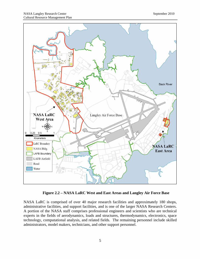
NASA LaRC currently occupies 807 acres of Government-owned land and is divided into two areas by the runway facilities of Langley Air Force Base (LAFB). The LaRC West Area consists of 787 acres, and the LaRC East Area comprises approximately 20 acres that are part of a land use agreement between NASA and the Air Force. NASA and LAFB operate as two separate Federal agencies that maintain a common property boundary (Figure 2.2).
4
NASA Langley Research Center September 2010 Cultural Resource Management Plan
Figure 2.2 – NASA LaRC West and East Areas and Langley Air Force Base
NASA LaRC is comprised of over 40 major research facilities and approximately 180 shops, administrative facilities, and support facilities, and is one of the larger NASA Research Centers. A portion of the NASA staff comprises professional engineers and scientists who are technical experts in the fields of aerodynamics, loads and structures, thermodynamics, electronics, space technology, computational analysis, and related fields. The remaining personnel include skilled administrators, model makers, technicians, and other support personnel.
5

NASA Langley Research Center September 2010 Cultural Resource Management Plan
Currently, the primary functions at the Center evolve around the science of aeronautics for military, commercial, and general aviation applications; space research and technology; space transportation; space science and exploration; and the study of atmospheric sciences and aeronautical impact on the environment. Center programs are focused to support NASA’s Mission “to pioneer the future in space exploration, scientific discovery, and aeronautics research.”
2.4 LaRC’s CRM Program Goals
The objective of historic preservation law is not to assign CRM a higher priority than the mission of federal agencies. Rather, historic preservation concerns should be integrated with agency goals so that an agency’s mission can accommodate preservation.
The purpose of LaRC’s CRM program is to achieve regulatory compliance and ensure that NASA’s historic preservation and stewardship responsibilities are met. The goals for LaRC’s CRM program include the following:
Incorporate CRM into real property management and planning, master planning, environmental and natural resource planning, and other planning efforts.
Identify historic properties and determine their eligibility for listing in the National Register
Implement protection and compliance actions for preservation of NASA LaRC’s historic properties.
Enhance NASA LaRC personnel awareness and appreciation for historic property management and preservation and improve effectiveness in management decision-making regarding projects potentially impacting historic properties.
Promote public outreach and education regarding NASA LaRC’s historic properties. Enhance working relationships with the State Historic Preservation Officer (SHPO) and
other interested parties and stakeholders to identify and protect NASA LaRC’s historic resources.
2.5 Integration of LaRC’s CRM Program with Master Planning
To efficiently manage CRM and historic preservation issues at LaRC, this CRMP is integrated into LaRC’s Center Master Plan (CMP) so that historic properties can be identified and accounted for during the early stages of project design. Early consideration of historic properties ensures that a wider range of alternatives will be available to planners. Moreover, integration of the CRMP into the CMP allows planners to more easily access, and implement guidance contained in the CRMP.
The CMP is a web-based tool that utilizes Geographic Information Systems (GIS) to provide comprehensive information about the Center. The CMP is continually updated by the LaRC GIS Team and contains detailed narrative descriptions and maps to include the following areas:
Mission and Capabilities Community Setting
6

NASA Langley Research Center September 2010 Cultural Resource Management Plan
Natural Features Cultural Resources Existing Infrastructure Future Concept and Strategy
The CMP is a vital management tool to be used by LaRC staff in all planning activities to ensure the efficient and effective use of real property resources supporting Center operations. Further, the CMP is a tool that enables LaRC program and project managers to develop plans that are safe, prudent, and cost-effective and reflect the Center's stewardship role towards its environmental and historic resources. The CMP is available at:
http://gis-www.larc.nasa.gov/masterplan/
2.6 Organizational Structure and CRM Responsibilities
NASA's overall CRM Program is managed by the agency's Federal Preservation Officer (FPO), Environmental Management Division, NASA Headquarters. The agency-wide program provides the policy and procedures to ensure NASA complies with applicable CRM regulations. NASA has ten Centers and three component facilities located throughout the United States. Every Center and component facility has a designated HPO who is responsible for implementing NASA’s CRM program, reporting to the FPO, and coordinating cultural resource activities at his/her facility. The following briefly describes LaRC’s team responsibilities as they generally relate to the Center’s CRM program. Depending on the specific CRM project or activity, additional responsibilities and the involvement of additional organizations and/or offices may be required.
Director’s Office - The Center Director at NASA LaRC has authority over all Center organizations and activities and is ultimately responsible for ensuring that the LaRC’s CRM program complies with applicable historic preservation laws and regulations. The Center Director and/or Deputy Director have authority to sign LaRC’s external CRM agreement documents, such as Memoranda of Agreements (MOAs) and Programmatic Agreements (PAs).
Center Operations Directorate –
Center Master Planner – The Center Master Planner recommends or concurs on projects and activities involving renovation and modification to existing LaRC infrastructure as well as new facility construction at the Center. The Master Planner is also responsible for working with the LaRC GIS Team in the development and maintenance of the Center Master Plan (CMP) which is a key tool used by LaRC organizations for program and project planning.
Environmental Management Branch – The LaRC Environmental Management Branch (EMB) assists the LaRC HPO in coordinating project and planning activities to ensure that CRM and historic preservation issues are properly addressed. The EMB is responsible for integrating historic property considerations into environmental activities, such as NEPA documentation and public meetings, as required.
7

NASA Langley Research Center September 2010 Cultural Resource Management Plan
Historic Preservation Officer – LaRC’s HPO is responsible for coordinating internal review of projects and activities that may affect the Center’s historic properties in accordance with the terms of the PA. Coordination may involve working with numerous LaRC organizations and personnel. The HPO is also responsible for consulting with external agencies regarding the identification, evaluation and treatment of LaRC’s historic properties. Examples include the Virginia State Historic Preservation Officer (Virginia SHPO), the Advisory Council, and the National Park Service (NPS). In addition to reporting to the NASA FPO, the LaRC HPO is responsible for ensuring that the Center Director and LaRC senior management are included, as appropriate, in project planning and decision-making regarding LaRC’s cultural resources. The HPO also is responsible for keeping the public informed of Center historic preservation activities and maintains web pages accessible to the public for this purpose. The HPO is responsible for ensuring that this CRMP is maintained and updated as necessary.
Logistics Management Team – The LaRC Logistics Management Team is responsible for coordinating with the HPO for projects and planning activities involving the loan or disposition of LaRC property that may have cultural or historic significance.
Geographic Information Systems - The LaRC GIS Team is responsible for coordinating with the HPO and Center Master Planner to maintain and update the Center’s Master Plan to ensure the most current CRM information is available to LaRC staff. In addition, the GIS Team assists the HPO in developing and maintaining web pages that allow public access and interpretation of LaRC’s history and preservation activities.
Project planners in various COD organizations (e.g. Facilities Project Offices; Facilities Engineering and Maintenance; and Projects and Capital Assets Branch) coordinate with the HPO to address cultural resource considerations and requirements during their pre-project planning activities.
Office of Chief Council – LaRC’s Office of Chief Council is responsible for reviewing and approving external agreement documents related to the Center’s CRM program to ensure the agreements comply with applicable historic preservation laws and regulations, as well as NASA’s policies and procedures.
Office of Strategic Communications and Education –
Public Affairs Office – The LaRC Public Affairs Office is responsible for interfacing with the public regarding CRM projects and activities at the Center. Office of Education – The LaRC Office of Education is responsible for public outreach and education initiatives related to the appreciation and preservation of LaRC’s history, to include collaborating with the Virginia Air and Space Center (NASA LaRC’s Official Visitor’s Center).
NASA LaRC periodically reorganizes staff and structure in order to align the appropriate resources to successfully carry out the Center’s projects and the Agency’s mission. The most
8

NASA Langley Research Center September 2010 Cultural Resource Management Plan
current organizational structure is maintained in LaRC’s CMP and can be accessed at: http://atlarc2.larc.nasa.gov/orgchart/larc_org.html
2.7 CRM Personnel Qualifications and Training
The HPO is responsible for ensuring that LaRC complies with all applicable laws and regulations pertaining to CRM at the Center. The HPO is responsible for coordinating internal review of historic property issues and for consulting with external agencies regarding the identification, evaluation and treatment of LaRC’s historic properties. At a minimum, required training for the HPO should include a course, or courses, focusing on legal requirements for federal projects under the NHPA with an emphasis on compliance with Section 106 and 36 CFR 800, as well as interpretation and application of the Secretary’s Standards.
Because of the variety of resources located at and managed by LaRC, the HPO should have access to either professional staff or contractors with demonstrated expertise in archaeology, architectural history or other related historic preservation profession. All contractors shall meet the professional qualifications prescribed in Secretary of the Interior’s Standards and Guidelines for Archaeology and Historic Preservation: Professional Qualification Standards (48 FR 44716, September 29,1983) and the requirements included in Virginia SHPO’s Guidelines for Conducting Cultural Resource Survey in Virginia (Rev. January 2004)
http://www.dhr.state.va.us/review/Survey_Manual_Web.pdf.
In addition, LaRC should provide historic preservation and CRM training to LaRC project and planning personnel who have approval authority for undertakings that may affect historic properties. The training increases awareness of and sensitivity to historic preservation, in general, and to the NHPA, the Advisory Council's regulations, NASA instructions and policy, and LaRC's PA and cultural resource inventory, in particular.
9

NASA Langley Research Center September 2010 Cultural Resource Management Plan
3 Regulations and NASA Policy and Procedures
Federal, state, and local laws and regulations dictate NASA LaRC’s responsibilities regarding the management of its historic properties. The NHPA of 1966, as amended is the primary piece of federal preservation legislation that guides LaRC’s CRM program. The NHPA also authorized State Historic Preservation Officers (SHPO) in every state to direct and coordinate the National Register program within their jurisdiction. In addition, federal agencies are directed to designate a FPO to coordinate and implement preservation-related activities within their respective agencies. As a result of the NHPA, federal agencies became active participants in national preservation efforts. The NHPA outlines policies and regulations to implement the program. Specifically, Sections 106 and 110 of the NHPA provide the requirements that NASA must follow in order to preserve and protect its historic resources. The complete NHPA is available at: http://www.achp.gov/NHPA.pdf. Brief descriptions of additional laws and NASA internal guidance documents and procedures related to CRM are included at the end of this section.
3.1 National Historic Preservation Act
In addition to Sections 106 and 110 of the NHPA, an important provision of the NHPA established the National Register and designated the NPS as administrator of the National Register program. This program forms the basis of all compliance activities since the requirements of Section 106 of the NHPA and its implementing regulations (36 CFR 800) pertain only to properties listed or considered eligible for listing in the National Register.
3.1.1 Types of Properties Eligible for the National Register
The National Register includes a diverse collection of properties that represent virtually all aspects of the built environment. The NHPA defines four kinds of properties that can be eligible for listing in the National Register. They include:
Building – an edifice created to shelter any form of human activity, such as a house, barn, church, hotel, or similar structure. The designation “building” may refer to a historically related complex such as a courthouse and jail, or a house and barn. A building can include grand, architect-designed residences, churches, schools, or stores, as well as modest, vernacular buildings.
Site – location of a significant event, a prehistoric or historic occupation or activity, or a building or structure, whether standing, ruined or vanished, where the location itself maintains historical or archaeological value regardless of the value of any existing structure. A site can mark the location of a battlefield, a Native American village, or an early milling operation.
Structure – a work made of interdependent and interrelated parts in a definite pattern of organization. Constructed by man, it is often an engineering project that is large in scale, such as a bridge or trestle.
10

NASA Langley Research Center September 2010 Cultural Resource Management Plan
Object – a material thing of functional, aesthetic, cultural, historical, or scientific value that may be, by nature or design, movable yet related to a specific setting or environment. An object can be public art, a mode of transportation, or infrastructural features.
Properties can be considered on an individual basis or grouped together as a historic district. If considered as a group within a historic district, the properties should share a common history and/or physical traits that collectively convey a sense of time and place. A district encompasses a well-defined area that is distinct from its surroundings and whose boundaries are logically established. Typically, the majority of the extant resources within a district must retain sufficient integrity to enhance the district’s historic character and are classified as contributing elements or resources. Severely altered historic or non-historic resources within a district are classified as noncontributing elements that slightly improve, do not improve at all, or detract from the district’s overall historic character.
Established by the NHPA, the National Register lists districts, sites, buildings, structures, and objects significant in American history, architecture, archaeology, engineering, and culture. The NHPA also established criteria for determining which properties may be included in the National Register.
3.1.2 National Register Criteria for Evaluation
To be eligible for listing in the National Register, a property or historic district must typically be at least 50 years old, must retain integrity, and meet at least one of the four following criteria:
(a) Be associated with events that have made a significant contribution to the broad patterns of our history.
(b) Be associated with the lives of persons significant in our past.
(c) Embody distinctive characteristics of a type, period, or method of construction, or that represent the work of a master, or that possess high artistic values, or that represent a significant and distinguishable entity whose components may lack individual distinction.
(d) Has yielded, or may be likely to yield, information important in prehistory or history.
Exceptions to the four criteria, known as Criteria Considerations, do exist. Ordinarily cemeteries, birthplaces or graves of historical figures, properties owned by religious institutions or used for religious purposes, structures that have been moved from their original locations, reconstructed historic buildings, properties primarily commemorative in nature, and properties that have achieved significance within the past 50 years shall not be considered eligible for the National Register. However, such properties will qualify if they are integral parts of districts that do meet the criteria or if they fall within the following categories:
(a) A religious property deriving primary significance from architectural or artistic distinction or historical importance.
11

NASA Langley Research Center September 2010 Cultural Resource Management Plan
(b) A building or structure removed from its original location but which is significant primarily for architectural value, or which is the surviving structure most importantly associated with a historic person or event.
(c) A birthplace or grave of a historical figure of outstanding importance if there is no appropriate site or building directly associated with his/her productive life.
(d) A cemetery which derives its primary significance from graves of persons of transcendent importance, from age, from distinctive design features, or from association with historic events.
(e) A reconstructed building when accurately executed in a suitable environment and presented in a dignified manner as part of a restoration master plan, and when no other building or structure with the same association has survived.
(f) A property primarily commemorative in intent if design, age, tradition, or symbolic value has invested it with its own exceptional significance.
(g) A property achieving significance within the past 50 years if it is of exceptional importance. [This exception is described further in “Guidelines for Evaluating and Nominating Properties that Have Achieved Historical Significance within the Past Fifty Years,” available at the NPS website, http://www.cr.nps.gov/nr/publications/bulletins/nrb22/ ]
3.1.3 Section 106 of the NHPA
Section 106 of the NHPA makes historic preservation a part of all federal agencies’ planning, decision-making, and project execution. It is action-driven, requiring the head of each federal agency to ensure that the provisions of the NHPA are administered and mandating consultation related to potential federal actions. It compels federal agencies to “take into account” the effect of their projects on historical and archaeological resources, even if the projects would not be located on their land. Thus, before approving an expenditure of federal funds on an undertaking or issuing a license, agencies must consider the effect of the undertaking or license on any district, site, building, structure, or object that is included in, or eligible for inclusion in the National Register. Section 106 also requires agencies to provide the Advisory Council a reasonable opportunity to comment on the potential effects so that impacts can be avoided or mitigated. However, the Advisory Council’s opinions on effect findings are advisory and do not require federal agencies to reverse their initial findings. The focus of Section 106 is the consultation process, which normally takes place between the federal agency, the SHPO, and the Advisory Council. The regulations emphasize open, good-faith consultation and the development of binding agreements as the best way to demonstrate that the “take into account” standard has been achieved. The Advisory Council’s implementing regulations (36 Code of Federal Regulations (CFR) Part 800, Protection of Historic Properties) are available at: http://www.achp.gov/regs-rev04.pdf. A more detailed description of the Section 106 consultation requirements as they relate to LaRC activities and projects is included in Section 5.
12
NASA Langley Research Center September 2010 Cultural Resource Management Plan
3.1.4 Section 110 of the NHPA
The intent of Section 110 of the NHPA is to ensure that historic preservation is fully integrated into the ongoing programs and missions of federal agencies. Section 110 requires federal agencies to provide leadership in preserving, restoring, and maintaining the historic and cultural environment of the Nation. It also directs federal agencies to establish preservation programs commensurate with their missions. Additional responsibilities for a federal agency under Section 110 include:
Assume responsibility for historic properties within its control; Undertake any necessary measure of preservation to comply with this section; Designate a qualified preservation officer to coordinate the agency’s activities under the
Act; Identify, evaluate and nominate to the National Register historic properties that are under
the control of the agency; Ensure that historic properties are not inadvertently transferred, sold, demolished,
substantially altered, or allowed to deteriorate significantly; Document any historic properties that must be damaged or destroyed; Use available historic properties for acceptable agency purposes when feasible; Include the costs of preservation activities as eligible project costs (which may include
amounts paid to a state government when carrying out preservation responsibilities); and, Impose reasonable charges to federal licensees and permittees.
Additional information regarding Section 110 requirements related to LaRC activities and projects is included in Section 7.
3.1.5 Relationship between Section 106 and Section 110
The overall intent of Sections 106 and 110 of the NHPA is to ensure that historic properties are appropriately considered during planning for federal initiatives and actions. Section 106 is a specific, issue-related mandate to which federal agencies must adhere; it is a reactive mechanism that is driven by a federal agency’s proposed undertaking. Section 110, in contrast, sets out broad federal agency responsibilities with respect to historic properties; it is a proactive mechanism that emphasizes ongoing management of historic sites and preservation activities at federal facilities. By using the principles and approaches set forth in the Section 110 guidelines, federal agencies can more easily fulfill their responsibilities under Section 106.
3.2 Preserve America
EO 13287 was signed on March 3, 2003 to reaffirm the administration’s commitment to the federal stewardship of historic properties, and to promote intergovernmental cooperation and partnerships for the preservation and use of historic properties. EO 13287 formalized “Preserve America” as an administration initiative intended to support the efforts of local communities to preserve and maintain our nation’s cultural and natural heritage.
13

NASA Langley Research Center September 2010 Cultural Resource Management Plan
EO 13287 includes a number of actions that are intended to encourage better accountability for the use of federally owned historic properties. Section 3, Improving Federal Agency Planning and Accountability, states “accurate information on the state of federally-owned historic properties is essential to achieving the goals of this order and to promoting community economic development through local partnerships” (Section 3(a)). Under Section 3(c), each federal agency with real property management responsibilities is required to submit reports to the Advisory Council on its “progress in identifying, protecting, and using historic properties in its ownership” on September 30, 2005, and every third year after. The Advisory Council is then required to submit a rollup report to the president by February 15th of the following year.
In addition to the Section 3 reporting requirements, EO 13287 includes the following:
Provides leadership in preserving America's heritage by actively advancing the protection, enhancement, and contemporary use of the historic properties owned by the federal government, and promotes intergovernmental cooperation and partnerships for the preservation and use of historic properties.
Directs federal agencies to increase their knowledge of historic resources in their care and to enhance the management of these assets.
Encourages agencies to seek partnerships with state, tribal, and local governments and the private sector to make more efficient and informed use of their resources for economic development and other recognized public benefits.
Better combines historic preservation and nature tourism by directing the agencies to assist in the development of local and regional nature tourism programs using the historic resources that are a significant feature of many state and local economies.
The complete text if EO 13287 is available at: http://www.preserveamerica.gov/EOtext.html
3.3 National Environmental Policy Act (NEPA)
The National Environmental Policy Act (NEPA) requires all federal agencies to give appropriate pre-decisional consideration to the environmental effects of proposed actions in their planning and decisions, and to prepare detailed analyses of the effects of major federal actions significantly affecting the quality of the human environment. Actions subject to review under NEPA include new and continuing projects ranging from the adoption of agency policies to the approval of particular projects.
The NEPA review process is designed to:
Determine whether a given action will significantly affect the environment; Analyze alternatives that may avoid, reduce, or mitigate adverse effects; Reveal impacts and alternatives to the public; and Place the results of this analysis and public disclosure before the agency decision-maker
for full consideration before a decision about the action is made.
The NEPA process does not fulfill either the procedural or substantive requirements of other environmental statutes and regulations including Section 106. NEPA does not dictate a course of
14

NASA Langley Research Center September 2010 Cultural Resource Management Plan
action, but simply ensures that decision-makers and the public are provided with relevant information about the environmental effects of a proposed action and its reasonable alternatives. The NEPA regulations are available at: http://ceq.eh.doe.gov/nepa/regs/nepa/nepaeqia.htm
Coordination of NEPA with Section 106 is specified in 36 CFR §800.8 of the Advisory Council’s regulations. Specifically, federal agencies are encouraged to coordinate compliance with Section 106 and any steps taken to meet the requirements of NEPA. Agencies should consider their Section 106 responsibilities as early as possible in the NEPA process. Additional guidance regarding LaRC’s PA compliance and NEPA is provided in Section 5.
3.4 Native American Graves Protection and Repatriation Act (NAGPRA)
For activities on federal lands, NAGPRA requires consultation with “appropriate” Indian tribes or Native Hawaiian organizations prior to the intentional excavation or removal after inadvertent discovery, of several kinds of cultural items, including human remains and objects of cultural patrimony. Native American cultural items include human remains, associated funerary objects, unassociated funerary objects, sacred objects, and cultural patrimony. Native American cultural items are the property of Native American groups.
For activities on Native American or Native Hawaiian lands, which are defined in the statute, NAGPRA requires the consent of the Indian tribe or Native Hawaiian organization prior to the removal of cultural items. The law also provides for the repatriation of such items from federal agencies and federally assisted museums and other repositories. Agencies must inventory Native American cultural items, repatriate Native American cultural items, and consult with Native American groups about permits to excavate. Detailed requirements of the Act can be accessed at: http://www.cr.nps.gov/local-law/FHPL_NAGPRA.pdf. Additional guidance regarding LaRC compliance with NAGPRA is provided in Section 6.
3.5 American Indian Religious Freedom Act (AIRFA)
This act affirms the right of Native Americans to have access to their sacred places. If a place of religious importance to American Indians may be affected by an undertaking, AIRFA promotes consultation with Indian religious practitioners, which may be coordinated with Section 106 consultation. More detail about the requirements of this Act is available at: http://www.cr.nps.gov/local-law/FHPL_IndianRelFreAct.pdf#search=%22American%20Indians%20Religious%20Freedom%20Act%22
3.6 Archaeological Resources Protection Act (ARPA)
This act preserves and protects resources and sites on federal and Indian lands by prohibiting the removal, sale, receipt, or interstate transportation of archaeological resources obtained illegally (i.e., without permits) from public or Indian lands. ARPA permits are not required for archaeological work conducted by or on behalf of LaRC; however, the specific requirements of ARPA may be addressed in contract documents or other documentation authorizing the work. The complete requirements of the Act are available at: http://www.cr.nps.gov/local-
15

NASA Langley Research Center September 2010 Cultural Resource Management Plan
law/FHPL_ArchRsrcsProt.pdf. Additional guidance regarding LaRC compliance with ARPA is provided in Section 5.
3.7 NASA CRM Policy and Guidance Documents
The following briefly describes the NASA Procedural Requirements (NPR), NASA Policy Directives (NPD) and agreement documents that relate to protection and preservation of LaRC’s historic properties. Links to the complete documents are included at the end of each section.
3.7.1 Identification and Disposition of NASA Artifacts, NPR 4310.1
This NPR provides procedures and guidance for the identification, reporting, transfer, or disposal of NASA articles, equipment and hardware of historical interest. The NPR is applicable to NASA HQ and all NASA Centers and component facilities. The NPR establishes the Smithsonian’s National Air and Space Museum as the repository for NASA artifacts, and includes the Memorandum of Understanding (MOU) as Appendix A, “Agreement Between the National Aeronautics and Space Administration and the Smithsonian Institution Concerning the Transfer and Management of NASA Historical Artifacts, dated May 28, 1998.” The NPR is available at: http://nodis3.gsfc.nasa.gov/npg_img/N_PR_4310_0001_/N_PR_4310_0001_.pdf
3.7.2 NASA Environmental Management, NPD 8500.1A
This NPD defines NASA policy on maintaining environmental stewardship of assets, controls over environmental responsibilities, and compliance with applicable law while carrying out the NASA mission. The NPD requires compliance with applicable environmental regulations to include protection of cultural resources. The NPD is available at: http://nodis3.gsfc.nasa.gov/displayDir.cfm?Internal_ID=N_PD_8500_001A_&page_name=main
3.7.3 Environmental Management Systems, NPR 8553.1A
This NPR describes NASA's Environmental Management System (EMS). An EMS is a system that (1) incorporates people, procedures, and work practices in a formal structure to ensure that the important environmental impacts of the organization are identified and addressed, (2) promotes continual improvement including periodically evaluating environmental performance, (3) involves all members of the organization as appropriate, and (4) actively involves senior management in support of the environmental management program. The purpose of the EMS is to have a single overall agency approach to managing environmental activities that allows for efficient, prioritized program execution. The NPR is available at: http://nodis3.gsfc.nasa.gov/displayDir.cfm?Internal_ID=N_PR_8553_001A_&page_name=main
3.7.4 Implementing the National Environmental Policy Act and Executive Order 12114, NPR 8580.1
This NPR establishes standard procedures for implementing NEPA and NASA's overall environmental planning process. This NPR establishes responsibilities, procedures, and guidelines for carrying out the requirements of NEPA, its implementing regulations, and
16

NASA Langley Research Center September 2010 Cultural Resource Management Plan
Executive Order (EO) 12114, Environmental Effects Abroad of Major Federal Actions. The requirements of NEPA and the EO must be satisfied before an action can be taken that would (a) have an adverse environmental impact, or (b) limit the choice of reasonable alternatives. In addition, the NPR requires that each NASA Center develop an Environmental Resource Document (ERD) to serve as a succinct baseline description of all environmental aspects of the operations of the facility at the time of the ERD’s preparation. In effect, the ERD forms a baseline environmental description against which the effects of subsequent proposed actions may be judged to determine significance. The NPR is available at: http://nodis3.gsfc.nasa.gov/displayDir.cfm?Internal_ID=N_PR_8580_0001_&page_name=main
3.7.5 Master Planning for Real Property, NPD 8800.2
This NPD requires that each Center prepares and maintains a Center Master Plan (CMP). A CMP is the Center's statement of its concept for the orderly management and future development of the Center's real property assets, including land, buildings, physical resources, and infrastructure. It is the overall plan for Center development. The CMP shall be prepared in accordance with applicable NASA implementing guidelines and other planning processes, including environmental planning. The NPD is available at: http://nodis3.gsfc.nasa.gov/displayDir.cfm?Internal_ID=N_PD_8810_0002_&page_name=main
3.7.6 Programmatic Agreement Among NASA, the NCSHPO, and the Advisory Council for Management of NHLs.
The agreement among NASA, the NCSHPO and the ACHP includes stipulations that detail the review and reporting processes for NASA’s operational use, management and undertakings that may affect its NHL properties. The PA establishes categories of activities, mitigation measures, and consultation requirements to ensure NASA compliance with Section 106 and 110 of the NHPA. The PA includes NASA LaRC’s five NHL properties (the Variable Density Tunnel, the 8-Foot High Speed Tunnel, the Full Scale Tunnel, the Rendezvous Docking Simulator, and the Lunar Lander Facility). A copy of the agreement is included in Appendix C.
3.7.7 Programmatic Agreement Among NASA LaRC, the Advisory Council, and the Virginia SHPO for Management of Facilities, Infrastructure, and Sites.
The PA among LaRC, the Advisory Council, and the Virginia SHPO establishes historic preservation priority categories and corresponding historic preservation treatment categories for identified historic properties. Procedures for coordination and review of undertakings as well as documentation standards are provided. In addition, the PA provides for public education and benefit opportunities. The PA is the principle compliance document for LaRC and when followed, meets the Center’s Section 106 requirements. A copy of the PA is included in Appendix F.
17

NASA Langley Research Center September 2010 Cultural Resource Management Plan
INTENTIONALLY LEFT BLANK
18

NASA Langley Research Center September 2010 Cultural Resource Management Plan
4 Existing LaRC Historic Property Management Policy and Procedures
As described in Section 2.5, LaRC has a CMP that incorporates the information contained in this CRMP to include the inventory and locations of LaRC’s historic properties. The incorporation of historic property data into the Center’s comprehensive plans assists LaRC in complying with the provisions of the PA, Section 110 of the NHPA, and meeting the accountability and reporting requirements of EO 13287, Preserve America. Additionally, it enables LaRC to recognize opportunities to use and preserve historic properties. It also helps LaRC to detect potential conflicts between historic preservation and NASA’s mission and to identify information gaps that may slow or impede planning decisions with regard to historic resources.
In addition to integrating CRM with the Center’s master planning, LaRC’s historic preservation principles and strategies include the following:
identify, evaluate and nominate to the National Register historic properties that are under LaRC’s jurisdiction or control;
perform surveys and prepare reports in accordance with the Secretary of the Interior's Standards and Guidelines for Archeology and Historic Preservation and the Virginia SHPO’s Guidelines for Conducting Cultural Resource Survey in Virginia (Rev. January 2004) http://www.dhr.state.va.us/review/Survey_Manual_Web.pdf
manage properties listed in or eligible for listing in the National Register in a way that considers the preservation of their historic, archaeological, architectural, and cultural values in compliance with Sections 106 and 110 of the NHPA and that special consideration will be given to preservation of LaRC’s National Historic Landmarks;
carry out preservation related activities in consultation with other federal, state, and local agencies, Indian Tribes;
update the Agency’s and LaRC’s GIS historic property database as new information becomes available;
continue to evaluate and enhance “public involvement” regarding LaRC’s history and CRM program;
prioritize, schedule and budget for historic property surveys and historic preservation initiatives during the earliest stages of project planning;
provide CRM training to LaRC management and project planning staff.
4.1 Environmental Project Planning Form
Under Section 106, the Center Director is ultimately responsible for all decisions and actions affecting cultural resources on the Center. The LaRC HPO has primary oversight authority for the Center’s compliance with Federal historic preservation laws. The LaRC HPO is responsible for coordinating specific projects in accordance with the provisions of applicable federal historic preservation legislation and the Center’s PA.
All actions that have the potential to affect historic property, whether such property currently exists or not, must be coordinated in accordance with LaRC’s PA for management of the built environment, and if appropriate with the Virginia SHPO, and the Advisory Council in
19

NASA Langley Research Center September 2010 Cultural Resource Management Plan
accordance with the provisions of 36 CFR Part 800. In order to ensure that Center actions are in compliance with Federal laws and regulations prior to implementation, it is essential that consideration of historic property take place early in the project-planning phase. LaRC’s Environmental Management Branch (EMB) and HPO review all projects to determine whether or not cultural resources need to be considered. This process is carried out through completion of Langley Form 461 titled Environmental Project Planning Form (checklist). A copy of the most recent version of the checklist is included in Appendix E. The checklist serves as the principle tool for gathering and reviewing key project data in an effort to determine applicable environmental and cultural requirements. Project managers and initiators are ultimately responsible for completing and submitting the checklist to the LaRC’s EMB and HPO for review.
The checklist is designed to ensure the appropriate and consistent application of environmental compliance criteria to design, construction, repair, and maintenance projects. The checklist is not intended to take the place of early planning and compliance, but rather is a mechanism for aiding project planners and designers in the early identification of natural and cultural resource management issues that may need to be addressed at various stages of a project from site selection to construction.
The checklist functions in an interview format with the user providing basic project and contact information then proceeding through a series of questions. The interview includes questions divided into eight categories: general project information, hazardous/regulated materials and/or waste, air emissions, water quality, natural resources, noise, utilities, and transportation/traffic systems. Examples of questions asked in the checklist that are relevant to cultural resource issues are listed in Figure 4-1.
SAMPLE CHECKLIST QUESTIONS RELEVANT TO CULTURAL RESOURCES
Project location and existing area conditions.
Construction, alteration, expansion, modification or demolition of any building, pavement or structure.
Any ground disturbance deeper than six inches (land clearing, grading, soil
excavation, trenching, fill, etc.).
Will the project modify the existing landscape?
Figure 4-1. – Sample Checklist Questions Relevant to Cultural Resource Issues
Once a Project Manager/Initiator has completed the checklist, it is forwarded to the EMB who reviews the checklist and provides a response generally within two weeks of receipt. As part of the review process, the EMB completes a response form identifying applicable environmental requirements that must be met before the project can proceed.
20

NASA Langley Research Center September 2010 Cultural Resource Management Plan
The HPO reviews the EMB checklist entries identifying proposed projects that have the potential to affect cultural resources listed or eligible for listing in the National Register. Example questions asked by the HPO in determining whether or not a proposed project has the potential to affect historic architectural and archaeological resources are listed in Figures 4-2 and 4-3.
EXAMPLE QUESTIONS ASKED TO DETERMINE WHETHER OR NOT A PROJECT HAS THE POTENTIAL TO AFFECT HISTORIC ARCHITECTURAL
RESOURCES
Does the project involve demolition of buildings or structures?
Does the project involve new construction?
Is the property a Historic Preservation Priority Category 1, 2, or 3 resource?
Does the project involve the alteration of major exterior or interior components?
Figure 4-2. – Example Questions Asked to Determine Whether or not a Project has the Potential to Affect Historic Architectural Resources.
EXAMPLE QUESTIONS ASKED TO DETERMINE WHETHER OR NOT PROPOSED PROJECT HAS THE POTENTIAL TO AFFECT ARCHAEOLOGICAL
RESOURCES
Where is the proposed excavation located?
What is the level and scope of the excavation?
What is the purpose of the excavation?
Has the area been surveyed where the excavation is proposed?
Is the proposed excavation within 100 feet of a recorded archaeological resource?
Figure 4-3. – Example Questions Asked to Determine Whether or not a Proposed Project has the Potential to Affect Archaeological Resources.
If the HPO determines that cultural resources need to be considered then the Project Manager/Initiator is notified and the HPO initiates coordination with the provisions of the PA and other applicable Federal historic preservation laws and regulations in accordance with the steps outlined below. Figure 4-4 outlines a decision framework for the EMB internal review.
Step 1—The HPO determines if the proposed activity is an undertaking for the purposes of review under the PA and under Section 106. If yes, the HPO initiates review and coordination of the project under the PA and Section 106 as appropriate. If no, the HPO
21

NASA Langley Research Center September 2010 Cultural Resource Management Plan
documents the determination and notifies the Project Manager/Initiator that the project may proceed without further consideration for cultural resources.
Figure 4-4. – Decision Framework for Environmental Management Branch Internal Review.
22

NASA Langley Research Center September 2010 Cultural Resource Management Plan
Step 2—If the proposed action is an undertaking for the purposes of the PA and Section 106, then the HPO defines and documents the Area of Potential Effect (APE) on installation maps, as appropriate relative to the scale of the proposed undertaking. This will define the area where historic property concerns need to be considered.
Step 3—The HPO reviews installation historic property maps to determine whether the APE has been previously surveyed or contains or has the potential to contain previously identified historic properties. If the APE has been previously surveyed and no historic properties are present or predicted, then the HPO documents the finding in accordance with the guidance provided in the PA and coordinates with the Virginia SHPO as appropriate. Once any required concurrence is received from the Virginia SHPO, the HPO notifies the Project Manager/Initiator that coordination regarding cultural resources has been completed.
If the APE for the proposed action has not been surveyed or previously identified historic properties are present; the HPO reviews previous survey data, assesses the archaeological potential of the APE, and seeks the opinion of the Virginia SHPO, regarding additional archaeological identification efforts.
Archaeological Site Assessments—This is an initial review comprised of documentary research designed to identify the potential for archaeological resources to be in the APE. Emphasis is placed on identifying historic land use patterns as well as historic and prehistoric cultural development of the project area. The product should identify zones of archaeological sensitivity, which will be useful when screening alternatives and determining the need for further survey.
If the HPO determines that historic property surveys are necessary, then Phase I identification surveys are implemented as appropriate.
Step 4—If historic properties are present or are identified as a result of Phase I identification survey, the HPO determines whether or not the project can avoid the historic properties. If it is determined that the project can avoid known historic properties, then the HPO prepares the required documentation per the PA and notifies the Project Manager/Initiator that the project may proceed subject to any required conditions.
Step 5—If historic properties are present that cannot be avoided, then the HPO identifies the properties Historic Preservation Priority Category or National Register status. If the property has not been previously categorized or evaluated for listing in the National Register, then the determination is made in consultation with the Virginia SHPO. Historic Preservation Priority Categories for buildings and structures and National Register status for identified archaeological sites are provided in Appendix G of the CRMP.
Step 6—If the HPO determines that there are properties within the APE that are Historic Preservation Priority Category 1, 2, or 3 or that are eligible for listing in the National
23

NASA Langley Research Center September 2010 Cultural Resource Management Plan
Register, then effects to those historic properties are evaluated in accordance with the terms of the PA and if applicable, in consultation with the Virginia SHPO and other interested parties in accordance with the provisions of 36 CFR 800.
In assessing effects, the HPO consults with the Project Manager/Initiator to determine if there are options for reducing or avoiding adverse effects through project design changes. If adverse effects can be avoided, then the HPO documents the actions to be taken to minimize or avoid adverse effects in accordance with the PA and coordinates with the Virginia SHPO in accordance with the provisions of the PA. Once concurrence is received from the Virginia SHPO, the HPO notifies the Project Manager/Initiator and provides any conditions agreed upon with Virginia SHPO to avoid, minimize, or mitigate adverse effects to significant historic property.
Step 7—If adverse effects to Historic Preservation Priority Category 1 or 2 properties and National Register listed or eligible archaeological sites cannot be avoided, then the HPO initiates consultation with the Virginia SHPO in accordance with the PA and the provisions of 36 CFR 800. Once mitigation measures have been agreed upon, the HPO provides copies of the mitigation to the Project Manager/Initiator and briefs them on its requirements.
4.2 Review and Distribution of NASA LaRC Agreement Documents
The HPO is responsible for overseeing the development and execution of agreement documents for undertakings affecting historic properties at LaRC. This includes ensuring that the appropriate LaRC personnel, organizations, and offices are involved in the development process to address specific terms to be included in the agreements. The HPO is responsible for obtaining signatures from either the LaRC Director or Deputy Director for all final agreement documents
For curatorial services, the HPO is responsible for completing the standard Curation Agreement form between LaRC and the Virginia SHPO prior to sending archaeological collections and/or artifacts for curation. Copies of the executed agreement must accompany the collection and the LaRC HPO must retain copies on file at LaRC. Currently, there is no NASA requirement for external distribution of LaRC’s curation agreements.
4.3 Recommendations for Enhancing the Internal Planning Process
The current cultural resource review procedures implemented by EMB and the HPO through the PA provide a comprehensive and balanced process for ensuring that significant historic property is taken into account during project planning. In addition to the current cultural resource review procedures, the following tools and processes are in place to enhance the existing procedures for reviewing proposed projects for potential effects to Historic Preservation Priority Category 1,2, and 3 properties, as well as archaeological sites that are listed or determined eligible for listing in the National Register.
Automated Environmental Project Planning Review – The Environmental Project Planning Review process has been automated to allow for electronic submission and review of the form to facilitate exchange of information between Project Initiators/Managers and the EMB and HPO. Forms that are submitted by Project Managers/Initiators are available for review by all EMB staff and the HPO to determine
24

NASA Langley Research Center September 2010 Cultural Resource Management Plan
environmental impacts and to provide comments and feedback on environmental requirements or issues related to the proposed project. Since historic property information is recorded during the internal EMB and HPO review of the form, the automated process allows for easier annual reporting for the PA.
Archaeological and architectural resource maps linked to the Environmental Project Planning Form – The form has links to map resources to allow Project Managers/Initiators to attach a project map to the form with applicable GIS data layers included.
Field Inspections of ongoing projects – EMB staff perform weekly inspections on new and on-going projects at the Center to ensure project specifications and any environmental requirements (e.g., permits, preservation treatments) are being carried out. The inspections include a checklist to document the project progress as well as to provide feedback to the Project Managers and contractors performing the work. In the event that a field inspection discovers that a project is not following the specifications or environmental requirements, the Project Manager is notified to ensure modifications are made to bring the project in to compliance. In the event of severe deficiencies or non-compliance, the Head of EMB has the authority to issue a cease and desist on a project until all problems are rectified.
4.3 Recommendations for Enhancing the Internal Project Planning and Review Process
The current internal project planning and review process implemented by the EMB and the HPO provides a comprehensive and balanced approach to project review. Below are actions recommended for consideration and implementation by LaRC to enhance the existing procedures for reviewing proposed projects for potential effects to Historic Preservation Priority Category 1, 2, and 3 properties as well as archaeological sites that are listed or determined eligible for listing in the National Register.
Develop historic preservation briefs or fact sheets for Project Managers and Initiators—Briefs or fact sheets should provide information on the Historic Preservation Priority Categories for buildings or groups of buildings, information on what are the significant aspects of those buildings, what types of undertakings are likely to have potential effects to those significant aspects, the treatment categories and associated treatments established in the PA, other Federal laws and regulations, and the HPO contact information. Briefs or fact sheets should be tailored to specific audiences and limited in length.
Institute annual historic preservation briefings for Project Managers and Initiators -Briefings should provide the audience with the status of the cultural resource inventory, changes in law or policy, and recent examples of types of projects that have the potential to affect Historic Preservation Priority Category 1, 2, and 3 properties, as well as archaeological sites listed or determined eligible for listing in the National Register. Historic preservation briefs or fact sheets should be handed out at each briefing. Regular briefings with targeted audiences will increase awareness and understanding of the importance and legal requirements of historic preservation mandates and policy.
Integrate preservation treatments and guidelines into job orders and project
25

NASA Langley Research Center September 2010 Cultural Resource Management Plan
specifications--Procedures should be developed that ensure all preservation treatments and guidance agreed to during consultation with the HPO and the Virginia SHPO under the PA and Section 106 are implemented during project construction. Standard protocol should provide for preservation treatments and guidance to be incorporated into construction plans and drawings ensuring that contractors are aware of special requirements and conditions.
26

NASA Langley Research Center September 2010 Cultural Resource Management Plan
5 Consultation Guidelines
Section 106 of the NHPA requires that LaRC consider effects on all kinds of cultural resources listed in or eligible for listing in the National Register, including buildings, sites, districts made up of multiple properties, objects, structures, landscapes, and traditional cultural properties and to consult with the Virginia SHPO and provide the Advisory Council with an opportunity to comment when appropriate. In Virginia, the SHPO is the Virginia Department of Historic Resources (VDHR). The Advisory Council’s regulations (36 CFR 800) outline the process that LaRC must follow to take into account the effects of its undertakings on properties listed or eligible for listing in the National Register.
LaRC currently has a PA for managing facilities, infrastructures, and sites through which it satisfies its responsibilities under Section 106 in accordance with 36 CFR § 800.14. The PA is summarized below along with the applicable steps required to ensure compliance.
5.1 Programmatic Agreement for Management of the Built Environment
LaRC carries out its Section 106 responsibilities for actions affecting the built environment through implementation of the terms of their PA for undertakings at LaRC. The PA was executed in 2010 among NASA, the Advisory Council, and the Virginia SHPO (Appendix F).
5.1.1 Categorization of Architecturally Significant Properties
The PA provides a system for categorizing buildings and structures and for assigning agreed upon treatments for each category of property. The historic preservation priority categories applicable to the built environment are divided into the following categories:
Historic Preservation Priority Category 1 – A building or structure that is either individually listed or considered individually eligible for listing in the National Register and possesses high integrity of (as applicable) location, design, setting, materials, workmanship, feeling, and association.
Historic Preservation Priority Category 2 – A building or structure that is either listed or considered eligible for listing in the National Register as a contributing resource to the LaRC Historic District (DHR ID# 114-5313). In addition to retaining physical integrity, Category 2 resources are directly associated with aeronautics and space exploration and/or possess architectural, engineering or aesthetic value and/or are rare examples of distinctive property types functionally related to the history of aeronautics and space exploration.
Historic Preservation Priority Category 3 – A building or structure that is either listed or considered eligible for listing in the National Register as a contributing resource to the LaRC historic district. Though contributing to the district, their removal or alteration will not compromise the significance or character of the LaRC Historic District as a whole. Resources in this category are of lesser significance due to diminished physical integrity, lack architectural,
27

NASA Langley Research Center September 2010 Cultural Resource Management Plan
engineering or aesthetic distinction and/or due to their ancillary relationship to projects directly associated with NASA’s significance related to aeronautics and space exploration.
Historic Preservation Priority Category 4 – A building or structure that has been evaluated in accordance with National Register criteria for evaluation (36 CFR Part 60) as set forth in the Advisory Council’s regulations (36 CFR Part 800.4) and found to be not eligible for inclusion in the National Register either individually or as a contributing resource to the LaRC Historic District, or that is less than forty-five years old at the time of evaluation; or is not included in the National Register.
5.1.2 Treatment of Architecturally Significant Historic or Contributing Properties
Each historic preservation priority category described above has an applicable treatment category, which outlines specific historic preservation treatment considerations for each category. These treatment categories along with corresponding coordination requirements are summarized below.
Historic Preservation Treatment Category 1 – These aspects of the built environment are treated, to the greatest extent possible, in accordance with the Secretary of the Interior’s Standards for the Treatment of Historic Properties with Guidelines for Preserving, Rehabilitating, Restoring, and Reconstructing Historic Buildings (Secretary’s Standards). LaRC shall consider the continued adaptive reuse of Historic Preservation Priority Category 1 properties in carrying out NASA’s mission. Attempts will be made to ensure that alterations do not radically change, obscure or destroy character-defining features, spaces, materials or finishes. If alterations are judged to be the only viable alternative, then they shall be designed in such a manner as to be visually differentiated from the historic building so that it does not destroy, obscure, change or damage character-defining features.
Historic Preservation Treatment Category 2 – These properties shall, to the greatest extent possible be treated in accordance with the Secretary’s Standards and LaRC shall actively encourage the continuing and adaptive use of Category 2 property in carrying out NASA’s mission and in assisting tenants in carrying out their missions. .
Nothing in the above shall require LaRC to restore rather than rehabilitate Historic Preservation Priority Category 1 and 2 buildings and structures. The HPO will review all projects for potential impacts to historic properties. The following provides coordination requirements depending on the historic preservation priority Category. Steps for coordinating Historic Preservation Priority Category 1 and 2 properties are summarized in Figure 5-1.
28

NASA Langley Research Center September 2010 Cultural Resource Management Plan
TREATMENT CATEGORY 1 AND 2 COORDINATION REQUIREMENTS
HPO determinations of no adverse effect are submitted to the Virginia SHPO for review and comment. Undertaking may proceed following Virginia SHPO concurrence.
Undertakings affecting Historic Preservation Priority Category 1 and 2 buildings and
structures that are not in accordance with the Secretary’s Standards will be submitted to the Virginia SHPO along with proposed mitigation measures and documentation outlined in 36 CFR §800.11(e) for review and comment.
If the Virginia SHPO objects to the proposed mitigation measures, LaRC will consult
with the Virginia SHPO and ACHP in accordance with 36 CFR §§800.5 and 6.
Figure 5-1. – Treatment Category 1 and 2 Coordination Requirements
Historic Preservation Treatment Category 3 – The exteriors of these buildings and structures shall be treated in accordance with the recommended procedures in the Secretary’s Standards to the extent they are consistent with needs of LaRC’s mission and availability of resources. Steps for coordinating Category 3 properties are summarized in Figure 5-2.
TREATMENT CATEGORY 3 COORDINATION REQUIREMENTS
LaRC need not consult with the Virginia SHPO or Advisory Council for projects that involve maintenance, repair, demolition, disposal or neglect of Historic Preservation Priority Category 3 property provided there are no effects to other historic property.
If Historic Preservation Priority Category 3 property is to be demolished, it will be
documented prior to demolition, in accordance with the Standard Documentation Measures outlined in the PA. Following documentation, no further review is required.
Figure 5-2. – Treatment Category 3 Coordination Requirements
Historic Preservation Treatment Category 4 – LaRC does not need to maintain or preserve Category 4 buildings or document such properties prior to demolition, alteration, or disposal. Steps for coordinating Category 4 properties are summarized in Figure 5-3.
29

NASA Langley Research Center September 2010 Cultural Resource Management Plan
TREATMENT CATEGORY 4 COORDINATION REQUIREMENTS
LaRC does not need to consult with the Virginia SHPO, the Advisory Council, or members of the public regarding actions affecting Historic Preservation Priority Category 4 property unless there is the potential for effects to other properties.
Consultation on Historic Preservation Priority Category 4 buildings may be
necessary under other laws other than Section 106 of the NHPA.
Figure 5-3. – Treatment Category 4 Coordination Requirements
Historic District Considerations – LaRC will attempt to avoid undertakings that may alter either directly or indirectly the character-defining features of the LaRC Historic District. Specifically, new construction within and immediately adjacent to the LaRC Historic District, shall to the greatest extent practicable be designed in a manner that takes into account the district’s overall character in terms of height, scale, massing, set-backs, color, materials, and detailing.
Building Interiors – Interior spaces and features that are identified as Unique Features or listed as significant by the HPO shall be treated in accordance with the treatment category measures stipulated for the Historic Preservation Priority Category assigned to the building containing the feature. If there are no identified significant interior features, the buildings interior features shall be treated in accordance with Treatment Category 4.
5.2 Compliance with the Programmatic Agreement
Compliance with the provisions of the PA is solely the responsibility of LaRC. It is not up to the Virginia SHPO or the Advisory Council, or any contractor to comply with the PA and to make the decisions and determinations required therein. Consideration of historic properties early in the project planning process will ensure that LaRC satisfies its legal requirements while implementing its mission. The following guidance is provided to the HPO and LaRC staff for implementation of the requirements of the PA. Figure 5-4 highlights specific points that LaRC should remember when complying with the PA.
5.2.1 Step 1—Is the Proposed Action an Undertaking for the Purposes of Programmatic Agreement?
Determine whether or not the proposed action is an undertaking for the purposes of compliance with the PA. Undertakings include both new and continuing projects, activities, and programs, and any of their elements that have not been previously reviewed under Section 106 or the PA. LaRC undertakings include, but are not limited to, new construction projects, training exercises, maintenance and rehabilitation of buildings or structures, and excessing or leasing of real property. The following is a brief summary of routine LaRC activities and projects that may affect historic properties and therefore be considered undertakings.
30

NASA Langley Research Center September 2010 Cultural Resource Management Plan
THINGS TO REMEMBER WHEN COMPLYING WITH THE PROGRAMMATIC AGREEMENT
Do consider cost factors and mission requirements. Neither the law nor the PA
require that we preserve all historic properties in place. Comply with the PA early in planning an undertaking. This maximizes the
alternatives LaRC can consider to integrate preservation with other mission activities.
NHPA provides authority (under Section 110(g) of the Act), but no appropriation, to
fund planning, management, and preservation of historic properties. LaRC must meet compliance needs through its normal planning, programming, budgeting, and execution processes.
Figure 5-4. -- Things to Remember When Complying With the Programmatic Agreement.
Construction of New Facilities -- This class of undertaking refers to the construction of new buildings or structures as discrete facilities or additions to existing facilities. The construction of new facilities can have an impact on historic properties through the disturbance of buried archaeological deposits or through the disturbance of the integrity of an existing historic building, district, or landscape. Earth-moving activities related to construction could impact the integrity of an archaeological site. For new construction projects, the APE generally includes the footprint of the new facilities and associated staging and storage areas. New structures or buildings with architectural design elements that are incompatible with surrounding historic properties would impact the integrity, character, and/or feeling of the historic property.
Renovation or Repair of Facilities -- Renovation or repair of facilities includes those activities that will upgrade or update facilities for any purpose. Activities associated with these undertakings may include painting, replacement of structural elements, replacement or upgrading of utility systems, exterior modifications, or construction of additions. Any activity that may physically alter a facility, introduce new visual elements into its viewshed, or cause subsurface ground disturbance will require cultural resources review.
Specific activities that may occur during process of renovation or repair include: modification, replacement, or addition of windows, storm windows, doors, floors and ceilings, siding, or other elements; sandblasting, high power washing, etc. of surfaces; installation or upgrading of fire protection systems, air conditioning ducts, pipes, conduits, fixtures, plates, or other utility system components; additions of structural elements including buildings, towers, generators, above-ground tanks, and excavation for foundation construction or repair or utility work.
For renovation or repair projects the APE will generally relate to the physical characteristics of the facility and/or limited ground disturbance. It may also include areas
31

NASA Langley Research Center September 2010 Cultural Resource Management Plan
within view of the subject facility because alteration of the facility could introduce incompatible elements into historic landscapes or the viewsheds of historic properties. Renovation and repair activities at LaRC involving historic properties must be consistent with the Secretary’s Standards.
Demolition of Facilities -- This class of undertaking involves the demolition and/or deconstruction of structures and facilities at LaRC that are underutilized, outdated, dilapidated or no longer needed. As demolition activities can have an adverse impact on a historic property, all reasonable measures should be explored to use the property (i.e., rehabilitation, adaptive reuse) prior to making the final decision of demolition. The APE for demolition activities typically involves the as-built structure or facility, although impacts to archaeological resources caused by ground-disturbing activities related to demolition and/or removal of underground utilities must be considered. Additionally, analysis of cumulative impacts of on-going demolition activities should be conducted to assess the effects on proposed historic districts.
Utility Systems Repair, Installation, or Upgrade -- Repair, installation, or upgrading of utilities at LaRC can involve specific facilities or an entire system. Further, undertakings that deal with utilities may include those that are part of long-range planning, routine maintenance, or emergency repair. Utility work may occur as part of discrete projects or in conjunction with other types of undertakings such as renovation and construction of facilities. All utility systems work may potentially affect cultural resources. For clarity, a list of the utilities that may involve ground disturbance or physical alterations to structures during repair, installation, or modification follows:
Air conditioning Communications (telecommunications, computing) Electrical Fire prevention (sprinkler systems) Fuel (storage tanks, distribution systems) Heat (Gas) High Pressure Air Potable water Steam Waster water and Sanitary water
Projects that involve utility work may present direct impacts to archaeological resources as well as direct or visual effects to architectural resources. Direct impacts to archaeological sites can occur through trenching to install, remove, or replace buried conduits or other utilities. Any utility that involves physical alterations to buildings or structures may have adverse effects on those facilities. Visual effects can be generated through the introduction of incompatible elements into the viewshed of an architectural, resource such as above-ground storage tanks or substations.
For underground utility projects, the APE typically includes the location or right-of-way of the specific facility along with staging and equipment storage areas. The APE of
32

NASA Langley Research Center September 2010 Cultural Resource Management Plan
utility projects at particular facilities may include all interior or exterior areas that will be disturbed or altered by the project.
Landscaping -- Landscaping may include both long-range plans and routine maintenance. All types of alterations or upkeep activities related to the landscape are included in this section. Thus, planting, grading, excavation, and clearing (especially removal of trees) come under this heading. In addition, other visual elements of the landscape, such as street lights and signage, are subsumed in this section.
Any landscaping activities that will involve ground disturbance may affect archaeological resources. Activities that alter historic landscapes through the introduction of incompatible elements may result in visual effects to architectural resources. Therefore, planners and persons overseeing landscape maintenance should consider the potential effects of these activities on cultural resources. For landscaping activities, the APE typically includes the area of the ground disturbance and associated staging and storage areas.
Hazardous Materials Cleanup/Remediation -- Remediation involves the cleanup of hazardous materials from soils, wetland or streamside areas, waste conduits, or other contexts. Because many of the associated tasks involve subsurface ground disturbance, these activities may affect archaeological resources. Tasks involved in remediation may include, but are not limited to: grading and excavation of contaminated soils, excavation and removal of contaminated tanks or other structures, construction of staging and equipment storage areas, and construction of monitoring stations and wells.
For this type of undertaking, the APE will typically encompass the cleanup site, associated staging areas where support structures and equipment storage will be placed, locations of monitoring wells and stations, and locations of access roads.
Property Transfer, Lease or Sale -- Undertakings involving the transfer, lease or sale of property at LaRC must be evaluated to determine if historic properties may be included in and affected by the transaction. Section 106 considers the transfer, lease, or sale of property out of federal ownership or control without adequate and legally enforceable restrictions or conditions to ensure long-term preservation of the property’s significance to be an adverse effect. Should land be transferred, leased or sold, restrictions to historic properties should be prepared with the assistance of the Virginia SHPO in accordance with the terms of the PA. LaRC is responsible for potential effects to historic properties represented by, or contained within, properties it may transfer, lease or sell to other agencies, organization, or individuals.
Traffic and Parking -- For the purpose of cultural resource management, traffic and parking-related undertakings relate to the construction of new roads and traffic facilities or modifications to existing structures. Modifications to gates at LaRC may also be included under this heading. These undertakings could affect archaeological or architectural resources by directly impacting the resources or by introducing incompatible elements into historic landscapes.
33

NASA Langley Research Center September 2010 Cultural Resource Management Plan
For this type of undertaking, the APE generally includes areas on which roads or parking lots will be constructed as well as associated staging and storage areas. These projects may also introduce incompatible elements into the viewsheds of architectural resources or landscapes.
While the above represent the types of activities most commonly undertaken at LaRC, it is important to remember that to be an undertaking, a project or program must have the potential to affect historic properties. You do not need to know whether any historic properties are indeed present in order to make a determination as to whether or not a proposed activity is an undertaking. The question that the HPO should ask is, is this the kind of activity that could affect historic properties either directly or indirectly? Generally speaking, an activity or action should be considered an undertaking if it can:
Change a building, structure, or landscape in any way;
Disturb the ground;
Alter noise levels in an area, or change its visual characteristics; or
Change traffic patterns, land use, or the socioeconomic character of an area.
If the HPO determines that a proposed action or activity is not an undertaking for the purposes of the PA or is identified in the PA as an activity not requiring review, then no further consideration of historic properties is required. Also incorporated in the PA is a list of activities not requiring review under the PA. If an action is not determined by the HPO to not be an undertaking or not require review under the PA, then the proposed action is reviewed in accordance with the standard review process outlined in the PA.
5.2.2 Step 2—Define the Area of Potential Effect for the Proposed Undertaking
The APE is defined as the area in which LaRC needs to consider the undertaking’s effects. It may be larger than the project footprint, since it includes all area where effects on historic properties, such as visual effects, are possible. The APE may include areas outside of LaRC.
Again, definition of the APE is made regardless of whether or not historic properties are known to be present. The APE is simply the area or areas where effects on historic properties may occur as LaRC proceeds with the undertaking. The APE of the project area should be clearly mapped on U.S.G.S. topographic maps or LaRC Geographic Information System (GIS) maps for consultation purposes.
5.2.3 Step 3—Identify and Evaluate Historic Properties
LaRC is required to make a reasonable and good faith effort to identify historic properties within the proposed project’s APE. Identifying historic properties for the most part is already complete as LaRC has completed a comprehensive survey of above ground resources and has significant documentation regarding the presence and potential for below ground resources (see Section 7). The following basic steps should be considered when identifying historic properties:
34

NASA Langley Research Center September 2010 Cultural Resource Management Plan
Review existing information – Review existing historic property inventory documentation for the APE. The HPO should consult installation maps with data on all previously identified historic properties; areas surveyed, and map predicted sites. Determine if Historic Preservation Priority Category 1, 2, or 3 buildings and structures exist or if archaeological resources exist or are anticipated within the APE. After determining what historic properties exist and what additional efforts need to be used to further identify historic property (archaeological resources), actual identification may begin. Identification may involve:
Field surveys to locate and describe archaeological sites;
Interviewing concerned parties such as Indian tribes and their traditional leaders, local governments, and adjacent property owners;
Historical research;
Geomorphologic studies; and
Other studies relevant to the kinds of historic properties expected to be present in the APE and the nature of the proposed undertaking.
If, after conducting appropriate identification and evaluation studies in accordance with Federal and state standards and guidelines, no historic properties are located within the APE, then the HPO should document the finding and notify the Project Manager/Initiator to proceed with the undertaking. Suggested documentation supporting a finding of no historic properties is outlined in Figure 5-5. This documentation will form the basis for LaRC’s annual report of activities conducted pursuant to the PA.
If Historic Preservation Priority Category 1, 2, or 3 buildings or structures or National Register eligible archaeological sites are identified within the APE, then the HPO must apply the criteria of adverse effect.
DOCUMENTATION FOR NO HISTORIC PROPERTIES AFFECTED
A description of the undertaking, specifying the area of potential effects, including photographs, maps, and drawings, as necessary;
A description of the steps taken to identify historic properties, including, as
appropriate, any previous surveys conducted and efforts to seek information; and
The basis for determining that no historic properties are present or affected.
Figure 5-5. – Documentation for No Historic Properties Affected.
35

NASA Langley Research Center September 2010 Cultural Resource Management Plan
5.2.4 Step 4—Assess Adverse Effects
The HPO determines the effect of a proposed undertaking on Historic Preservation Priority Category 1, 2, or 3 buildings and structures or National Register eligible archaeological sites by applying the criteria of adverse effect. An adverse effect is found when an undertaking may alter, directly or indirectly, any of the characteristics of a historic property that qualify the property for listing in the National Register in a manner that would diminish the integrity of the property’s location, design, setting, materials, workmanship, feeling or association. The HPO should consider reasonable foreseeable effects caused by the undertaking that may occur later in time, be farther removed in distance or be cumulative.
Examples of adverse effects include:
Physical destruction of or damage to all or part of a property;
Alteration of a property, including restoration, rehabilitation, repair, maintenance, stabilization, hazardous material remediation, and provision of handicap access that is not consistent with the Secretary of the Interior’s Standards for the Treatment of Historic Properties (36 CFR § 68);
Removal of the property from its historic location;
Change in the character of the property’s use or of physical features within the property’s setting that contribute to its historic significance;
Introduction of visual, atmospheric or audible elements that diminish the integrity of the property’s significant historic features;
Neglect of a property which causes its deterioration; or
Transfer, lease, or sale of property out of Federal ownership or control without adequate and legally enforceable restrictions or conditions to ensure long-term preservation of the property’s significant historic features [36 CFR §800.5(a)(2)(vii)].
If the HPO determines that the undertaking does not meet the criteria of adverse effect or the undertaking is modified or conditions are imposed or agreed upon that ensure that the project is carried out in accordance with the Secretary’s Standards then the HPO may propose a finding of no adverse effect.
If the HPO proposes a finding of no adverse effect Historic Preservation Priority Category 1 and 2 buildings or structures or National Register eligible archaeological sites, then the Virginia SHPO should be notified and provided the documentation outlined in Figure 5-6. If the HPO proposes a finding of no adverse effect for Historic Preservation Priority Category 3 buildings or structures then the finding is documented in accordance with the PA and the HPO notifies the Project Manager/Initiator that the project may proceed in accordance with any agreed upon conditions. No adverse effect findings for Historic Preservation Priority Category 3 buildings or structures do not require review by the Virginia SHPO or Advisory Council.
36

NASA Langley Research Center September 2010 Cultural Resource Management Plan
NO ADVERSE EFFECT DOCUMENTATION REQUIREMENTS
A description of the undertaking specifying the Federal involvement and the area of potential effect, including photographs, maps, and drawings as necessary;
A description of the steps taken to identify historic properties;
A description of the affected historic properties, including information on the
characteristic that qualify them for listing in the National Register;
A description of the undertaking’s effects on historic properties;
An explanation of why the criteria of adverse effect were found applicable or inapplicable, including any conditions or future actions to avoid, minimize, or mitigate adverse effects; and
Copies or summaries of any views provided by consulting parties and the public.
Figure 5-6. – No Adverse Effect Documentation Requirements.
5.2.5 Step 5—Resolving Adverse Effects
If the HPO determines that the proposed undertaking will have an adverse effect, or the Virginia SHPO objects to the HPO’s effect determination, then consultation with the Virginia SHPO, the Advisory Council, if participating, and others must take place to resolve adverse effects.
Consultation is a flexible process. It may only involve a few telephone calls and exchanges of correspondence and supporting documents or it may require extensive meetings, hearings, site visits, and investigations. The nature of the action and the level and amount of public interest will have the greatest impact in determining the nature and level of consultation. Resolution of an adverse effect may involve whatever LaRC, the Virginia SHPO, the Advisory Council if participating and the other consulting parties agree is appropriate. Resolution may be achieved by:
Eliminating the adverse effect through redesign or relocation of the project;
Reducing the adverse effect’s severity through redesign of the project;
Mitigating the adverse effect through Standard Documentation Measures outlined in the PA or data recovery (for archaeology sites); or
Accepting the adverse effect in the public interest.
During consultation to resolve adverse effects, LaRC must consider cost factors and mission requirements when making decisions regarding mitigation. Neither the PA nor the NHPA requires LaRC to preserve all historic properties, only that historic properties be properly considered in the project planning process and that decisions be made in the public interest.
37

NASA Langley Research Center September 2010 Cultural Resource Management Plan
5.2.6 Notifying the Advisory Council
If the Virginia SHPO objects to the HPO’s proposed mitigation to resolve adverse effects, then LaRC should consult with the Virginia SHPO in accordance with 36 CFR §§800.5 and 6 and notify the Advisory Council of the adverse effect finding and provide the documentation outlined in Figure 5-7. The purpose of this notification is to provide the Advisory Council with an opportunity to participate in the consultation process to resolve adverse effects if they feel it is appropriate. The Advisory Council will notify LaRC within 15 days of receipt of an adequately documented request if it intends to participate in consultation to resolve adverse effects.
Documentation to Accompany Advisory Council Notification of Adverse Effect
A description of the undertaking specifying the federal involvement and the APE, including photographs, maps and drawings as necessary;
A description of the steps taken to identify historic properties;
A description of the affected historic properties, including information on the
characteristic that qualify them for listing in the National Register;
A description of the undertaking’s effects on historic properties;
An explanation of why the criteria of adverse effect were found applicable or inapplicable, including conditions or future actions to avoid, minimize, or mitigate adverse effects; and
Copies or summaries of any views provided by consulting parties and the public.
Figure 5-7. – Documentation to Accompany Advisory Council Notification of Adverse Effect.
At a minimum, consultation with the Virginia SHPO is required. In addition, LaRC is required to provide other parties (Indian tribes, local governments, and the interested public) with an opportunity to participate in discussions on ways to avoid, minimize or mitigate adverse effects.
5.2.7 Demolition of Historic Preservation Priority Category 1, 2 and 3 Buildings and Structures
LaRC, in fulfillment of its affirmative responsibility under the NHPA, and the PA, to give priority to the use of historic properties to carry out its mission, will actively seek alternative uses for buildings and structures early in the planning process. Prior to reaching a final decision regarding demolition of Historic Preservation Priority Category 1 and 2 buildings and structures, LaRC will consider viable alternatives to demolition including, but not limited to, rehabilitation for adaptive reuse, placing the building(s) or structure(s) in caretaker status, and locating new or replacement facilities to avoid demolition.
38

NASA Langley Research Center September 2010 Cultural Resource Management Plan
For all Historic Preservation Priority Category 1 and 2 buildings and structures where demolition is the preferred alternative, LaRC will submit to the Virginia SHPO proposed mitigation consistent with the Standard Documentation Measures outlined in the PA. For Historic Preservation Priority Category 3 buildings and structures once the Standard Documentation Measures outlined in the PA are implemented and accepted by the HPO the project may proceed without further review. Documentation on all Historic Preservation Priority Category 3 buildings and structures is to be included in LaRC’s annual report prepared pursuant to the PA.
5.2.8 Resolving Adverse Effects through Data Recovery of Significant Information from Archaeological Sites
If the HPO determines that a proposed undertaking will have an adverse effect on a National Register eligible archaeological site and the effects cannot be avoided, then the Advisory Council recommends that the following issues be considered and addressed when data recovery is being proposed:
The archaeological site should be significant and of value chiefly for the information on prehistory or history they are likely to yield through archaeological, historical, and scientific methods of information recovery, including archaeological excavation.
The archaeological site should not contain or be likely to contain human remains, associated or unassociated funerary objects, sacred objects, or items of cultural patrimony as those terms are defined by the Native American Graves Protection and Repatriation Act (25 U.S.C. 3001).
The archaeological site should not have long-term preservation value, such as traditional cultural and religious importance to an Indian tribe.
The archaeological site should not possess special significance to another ethnic group or community that historically ascribes cultural symbolic value to the site and would object to the site’s excavation and removal of its contents.
The archaeological site should not be valuable for potential permanent in-situ display or public interpretation, although temporary public display and interpretation during the course of any excavations may be highly appropriate.
LaRC should have prepared a data recovery plan with a research design in consultation with Virginia SHPO and other stakeholders that is consistent with the Secretary of the Interior's Standards and Guidelines for Archaeological Documentation (48 FR 44734-37, September 29, 1983) and the Virginia SHPO’s Guidelines for Conducting Cultural Resource Survey in Virginia: Additional Guidance for the Implementation of the Federal Standards Entitled Archaeology and Historic Preservation: Secretary of the Interior’s Standards and Guidelines (48 FR 44742, September 29, 1983), and shall take into account the Advisory Council’s publications, Recommended Approach for Consultation on Recovery of Significant Information from Archeological Sites (1999; rev. 2003) or subsequent revisions or replacements to these documents and Section 106 Archaeology Guidance (June 2007). Any data recovery plan shall specify at a minimum, the following:
39

NASA Langley Research Center September 2010 Cultural Resource Management Plan
1. The property, properties, or portions of properties where site specific data recovery plans shall be carried out;
2. The portion(s) of the site(s) to be preserved in place, if any, as well as the measures to be taken to ensure continued preservation;
3. Any property, properties, or portions of properties that will be destroyed or altered without data recovery;
4. The research questions to be addressed through data recovery, with an explanation of their relevance and importance;
5. The methods to be used with an explanation of their relevance to the research questions;
6. The methods to be used in analysis, data management, and dissemination of data, including a schedule;
7. The proposed disposition of recovered materials and records;
8. Proposed methods of disseminating the results of the work to the interested public and/or organizations who have expressed an interest in the data recovery subject to revision based on the results of the data recovery proceeds; and
9. A schedule for the submission of progress reports to LaRC, the Virginia SHPO and other consulting parties.
The HPO should ensure that the data recovery plan is developed and will be implemented by or under the direct supervision of a person, or persons, meeting at a minimum the Secretary of the Interior’s Professional Qualifications Standards (48 FR 44738-44739).
In addition, it is recommended that the HPO consider the following guidance when overseeing archaeological data recovery efforts on National Register eligible archaeological sites:
LaRC should ensure that adequate time and money to carry out all aspects of the plan are provided, and should ensure that all parties consulted in the development of the plan are kept informed of the status of its implementation.
LaRC should ensure that a final archaeological report resulting from the data recovery is provided to the Virginia SHPO/Tribal Historic Preservation Officer (THPO). LaRC should ensure that the final report is responsive to professional standards, to the Secretary of the Interior’s Standards and Guidance for Archaeology and Historic Preservation (42 FR 5377-79), and to the Virginia SHPO’s Guidelines for Archeological Investigations in Virginia (rev. 2009).
Large, unusual, or complex projects should provide for special oversight, including professional peer review.
40

NASA Langley Research Center September 2010 Cultural Resource Management Plan
LaRC should determine that there are no unresolved issues concerning the recovery of significant information with any Indian tribe that may attach religious and cultural significance to the affected property.
5.3 Foreclosing the Advisory Council’s Opportunity to Comment
If a project is signed off on and implemented without complying with the PA, then LaRC may have foreclosed the Advisory Council’s opportunity to comment on the project. A foreclosure finding by the Advisory Council means that, in the Advisory Council’s opinion, LaRC has failed to comply with Section 106 and is therefore in violation of Federal law.
A foreclosure finding will place LaRC’s Director in a vulnerable position to citizen lawsuits. To minimize the risk of a foreclosure finding, LaRC should consider the following:
Initiate historic property review as early as possible in the project planning process;
Complete the PA review requirements before final decisions are made about whether or not to proceed with a project;
Complete the PA review requirements before funds are spent on advance design or purchase of materials; and
If possible complete the PA review requirements before LaRC’s management and other staff become committed to or fixed on a single preferred alternative.
5.4 Coordinating Section 106 Review with NEPA
NEPA and PA reviews can and should be coordinated. It is important to remember, however, that compliance with one statue does not constitute compliance with the other. PA review requirements should always be completed before a CX, EA/FONSI, or EIS/ROD is issued. Figure 5-8 compares the primary steps of PA and NEPA for review coordination purposes.
5.4.1 Categorical Exclusions (CX)
In order to ensure that a proposed action is a CX, the HPO must be sure that there are no historic properties that will be affected by the project. To accomplish this, the HPO must complete the initial steps of the PA: determining whether or not the action is an undertaking requiring review under the PA; defining the APE; and identifying and evaluating any properties in the APE.
5.4.2 Environmental Assessments (EA) and Environmental Impact Statements (EIS)
In preparing an EA or an EIS, NASA LaRC should begin identification of historic properties by assessing information needs when planning the EA or scoping for the EIS. The HPO should identify historic properties and determine whether the action will affect them by applying the criteria of Adverse Effect as part of preparing the EA or EIS.
Documentation prepared for the EA or EIS can then be used to support determinations of no historic properties present or affected, no adverse effect, or adverse effect submitted to the Virginia SHPO and the Advisory Council pursuant to the requirements of the PA.
41

NASA Langley Research Center September 2010 Cultural Resource Management Plan
Figure 5-8. – NEPA and PA Coordination.
42

NASA Langley Research Center September 2010 Cultural Resource Management Plan
If LaRC has to consult to resolve adverse effects, or negotiate to get acceptance of a no effect or no adverse effect determination, the results (e.g., proposed mitigation) should be documented in the final EIS, or in supplements to the EA.
5.5 Native American Graves Protection and Repatriation Act (NAGPRA)
In November 1990, NAGPRA was signed into law. The law sets forth a process for the return to American Indians, Native Hawaiians, and Native Alaskans, upon request, certain human remains and other items presently held by Federal agencies or federally assisted museums or institutions. NAGPRA also gives Native American individuals and groups a formal role in the decision making process for activities carried out on Federal and tribal lands that may affect archaeological resources of importance to Native Americans.
NAGPRA contains the following provisions:
Requirements for the intentional removal and inadvertent discovery of human remains and other cultural items from Federal and tribal lands;
Clarifies ownership of human remains and other cultural items recovered from Federal and tribal lands;
Sets forth a process for repatriation of human remains and other cultural items; and
Prescribes penalties for illegally trafficking human remains and cultural items.
NAGPRA defines cultural items as:
Human remains;
Funerary objects reasonably believed to have been associated with human remains, or by a preponderance of evidence, a specific burial site;
Sacred religious objects; and
Cultural patrimony, defined as material remains of historical, traditional, or cultural importance to the Native American group or culture itself… [emphasis added].
5.5.1 Relationship of NAGPRA to the LaRC PA
NAGPRA relates to and in turn will affect the PA review process in three primary ways.
Archaeological Investigations—LaRC and non-Federal users of LaRC managed lands must formally consult with the appropriate Native American groups regarding the treatment and disposition of human remains and other cultural items recovered during archaeological investigations conducted on LaRC lands.
Excavation, by or on behalf of LaRC, of human remains and other cultural items from LaRC lands must meet the requirements of the Archeological Resources Protection Act (ARPA).
43

NASA Langley Research Center September 2010 Cultural Resource Management Plan
Individuals conducting research independent of LaRC must receive an ARPA permit from the Center. In addition, evidence of consultation with the appropriate tribe regarding the treatment and disposition of any human remains and other cultural items that may be encountered is also required. These requirements must be met even though a plan for data recovery or other investigations is developed through the PA review process.
Discovery Situations—The inadvertent discovery of human remains and other cultural items during land-disturbing activity requires cessation of the activity. The person conducting the activity must take reasonable protection measures and notify the HPO and other appropriate LaRC personnel who will in turn contact the relevant Indian tribe that the discovery has occurred. Disposition of the newly discovered remains or other cultural items must be resolved in accordance with the ownership provisions of NAGPRA.
Curation of Archaeological Remains—In most cases, NAGPRA allows the affiliated Native American group to decide upon the appropriate treatment (analysis, curation, or reburial are three such treatments). Only those materials that are indispensable for completion of a specific scientific study, the outcome of which would be of major benefit to the United States, can be retained following a repatriation request for human remains and objects possessed or controlled by LaRC. Such remains, however, must be repatriated within 90 days of completion of the study if so requested.
A review of LaRC's collections has been conducted in compliance with Section 6 of NAGPRA. Since no human remains and/or funerary objects were identified as a result of archival and telephone interviews with repository personnel, no Section 5 inventory is required and LaRC is currently in compliance. In the event that potential Native American human remains or items subject to NAGPRA are discovered during the course of conducting LaRC's mission, Figure 5-9 outlines the steps that LaRC should take to comply with the provisions of the Act.
At present, there are no federally recognized Indian tribes in the Commonwealth of Virginia. Disposition of Native American human remains and associated cultural items related to Commonwealth recognized tribes should be determined as a result of discussions between the Virginia Council on Indians (VCI), LaRC, and the relevant tribe. Consultation should also occur with tribal groups and organizations located outside of the Commonwealth of Virginia, specifically the United Keetoowah Band of the Cherokee Indians in Oklahoma and the Catawba Indian Nation, in an effort to identify tribes who may have a cultural affiliation either with the region or site.
44

NASA Langley Research Center September 2010 Cultural Resource Management Plan
Figure 5-9. – LaRC’s Responsibilities under NAGPRA.
45

NASA Langley Research Center September 2010 Cultural Resource Management Plan
5.6 Archaeological Resource Protection Act (ARPA)
Under ARPA, Federal land managers are responsible for issuing permits, or otherwise ensuring that the provisions of ARPA are met, prior to the initiation of archaeological investigations on Federal property or property under Federal control. Figure 5-10 highlights the responsibilities of LaRC under ARPA.
Issuance of Permits—LaRC should only issue an ARPA permit for the excavation and removal of archaeological resources when the following conditions are met:
The applicant is qualified to carry out the permitted activity [qualifications are specified in 36 CFR 229, Subpart A, §7.8(a)(1)];
The activity is undertaken for the purpose of furthering archaeological knowledge in the public interest;
The resources removed from public land will remain the property of the United States, and be preserved by a suitable institution; and
The activity is not inconsistent with applicable management plans.
If an individual not associated with LaRC takes the initiative to undertake archaeological research on LaRC land, issuance of a permit to that individual is not considered an undertaking subject to Section 106 review. On the other hand, if LaRC initiates an excavation, the action becomes an undertaking subject to both the PA and ARPA.
LaRC is not required to formally issue ARPA permits for work conducted by or on its behalf; however, the requirements of ARPA must be incorporated into any contract or other documentation authorizing conduct of the work.
Confidentiality—Information on the location and nature of archaeological resources located on lands under LaRC’s management is:
Exempt from the Freedom of Information Act;
Need not be made available to the public under any other provision of law; and
May not be made public unless LaRC determines that disclosure of the information would further the purposes of ARPA or the Archaeological and Historic Preservation Act and not create a risk to the resource.
Information regarding resource locations, however, must be provided to the Governor of Virginia with specific safeguards.
46

NASA Langley Research Center September 2010 Cultural Resource Management Plan
NASA LaRC’s RESPONSIBILITIES UNDER ARPA INCLUDE
Issuance and administration of archaeological excavation permits to non-LaRC researchers;
Effective monitoring of the condition of archaeological resources;
Cooperation between law enforcement and cultural resource personnel on Federal lands
Ensuring that the consent of the Indian allottee or Indian tribe owning or having jurisdiction over lands where ARPA permits has been requested and obtained;
Setting forth the ARPA requirements for archaeological excavations;
Authority to initiate civil proceedings against violators;
Rewarding people who furnish information that leads to a conviction under either civil or criminal ARPA sanction provisions;
Participation and consultation in the development of NASA’s ARPA regulations;
Development of plans for surveying lands for archaeological resources;
Preparing a schedule for surveying those lands with the most scientifically valuable resources;
Development and implementation of systems for reporting and recording archaeological violations; and
Development and implementation of public awareness programs.
Figure 5-10. – LaRC’s Responsibilities under ARPA.
47

NASA Langley Research Center September 2010 Cultural Resource Management Plan
5.7 Public Participation Guidelines
Section 106 and the PA require LaRC to consider the public's views regarding historic properties when planning and implementing projects. Identifying and addressing public comments should be a regular part of LaRC's overall planning system whether the activities are specific projects or ongoing management activities. The following guidance outlines general public participation objectives, methods, and recommended documentation.
LaRC's public participation efforts should be designed to ensure good faith information sharing, open and constructive discussion of all viable treatment alternatives, and a respect for diverse points of view. Accordingly, public participation should be designed to support LaRC's preservation objectives, as well as its overall mission and program responsibilities. When designing public participation programs, LaRC should strive to ensure that the basic objectives outlined in Figure 5-11 are met.
PRACTICAL OBJECTIVES FOR PUBLIC PARTICIPATION
Obtain information from individuals who are likely to have information regarding historic properties potentially effected by the proposed undertaking
Seek knowledge and expertise of professional and avocational practitioners.
Involve property owners adjacent to the installation, local governments, Indian tribes, neighborhood associations, and other individuals or organizations whose immediate interests may be affected by the proposed action.
Consider views of all participants and incorporate them into the information gathering and decision-making process.
Inform the public of the proposed undertaking in a timely manner when the widest possible range or alternatives are still available for consideration.
Explicitly request the views of the public on historic preservation issues in public notices.
Ensure that project information is available to individuals and organizations that have expressed an interest in the project.
Figure 5-11. – Public Participation Objectives
5.7.1 Level and Type of Public Participation
LaRC should ensure that the public participation effort is appropriate for the size and scale of the project, the nature of the expected effects, the historic properties likely to be affected and the expected level of public interest. For example, installation of utilities within existing trenches will require no public notification beyond what may be required under other environmental requirements. Conversely, if installation of utilities will affect Native American burials, then the level of public notification should be sufficient to determine whether or not there are interested
48

NASA Langley Research Center September 2010 Cultural Resource Management Plan
Indian tribes and to meet other applicable requirements such as NAGPRA and Virginia burial laws. Typically, public notices placed in local newspapers, direct mailings, and public meetings are the most traditional forms of public notification.
For large-scale undertakings requiring environmental documents, LaRC is encouraged to utilize public notification and hearing processes established by NEPA to solicit public views regarding historic properties and potential effects. In such instances, it is important to ensure that notifications and hearings specifically address expected cultural resources, expected effects, and proposed alternatives to avoid, minimize, or mitigate adverse effects.
5.7.2 Making Documentation Available to the Public
When the public's views and/or participation are requested, what and how much information is provided for their consideration should be dependent upon the scale and nature of the proposed project. For routine or small-scale projects, maintaining project documentation in LaRC’s files for public inspection is sufficient. For projects requiring public review under NEPA, project and resource information can be included in the environmental document.
In some instances, the location of resources involved may be particularly sensitive due to vandalism and/or looting. In these cases, Section 304 of the NHPA directs federal agencies, after consultation with the Secretary of the Interior, to withhold from disclosure to the public, information relating to the character and location of historic resources. Deciding whether or not to withhold such information should be balanced with the proposed threat to the resource and the level of public input needed to make informed decisions. A practical solution frequently used by agencies is to place sensitive information regarding resource locations in confidential appendices that are available only to those with a need to know.
5.7.3 Documenting Public Participation Efforts
The primary purpose for documenting public participation efforts is to enable regulatory agency reviewers, including Federal courts in the event of litigation, to review the record and determine whether LaRC's efforts have been adequate and reasonable. In most cases, documentation of public comment and participation is best organized chronologically and includes, but is not limited to, reports, written comments, summaries of public meetings and telephone conversations. Generally speaking, LaRC's public participation documentation should be able to answer the basic questions outlined in Figure 5-12.
49
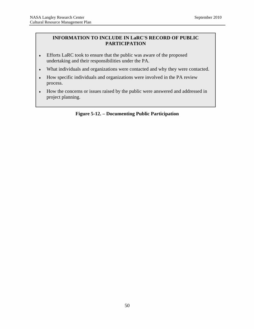
NASA Langley Research Center September 2010 Cultural Resource Management Plan
INFORMATION TO INCLUDE IN LaRC'S RECORD OF PUBLIC
PARTICIPATION
Efforts LaRC took to ensure that the public was aware of the proposed undertaking and their responsibilities under the PA.
What individuals and organizations were contacted and why they were contacted.
How specific individuals and organizations were involved in the PA review process.
How the concerns or issues raised by the public were answered and addressed in project planning.
Figure 5-12. – Documenting Public Participation
50

NASA Langley Research Center September 2010 Cultural Resource Management Plan
6 Standard Operating Procedures
Standard operating procedures (SOPs) are provided for frequently encountered events or situations where "standard" or prescribed responses are required. SOPs are not intended to replace compliance with applicable laws, regulations, or the requirements of the PA, rather their purpose is to provide LaRC and other involved personnel with pre-defined procedures for addressing specific situations.
SOPs are provided for the following activities:
Timbering actions including prescribed burns;
Soil erosion and control;
Unexpected discovery of archaeological resources;
Discovery of human remains; and
Leasing, Licensing, and/or disposal of property listed or eligible for listing in the National Register.
6.1 Procedures for Discovery of Human Remains
The discovery and/or disturbance of human remains is a sensitive issue that LaRC should address with care if the situation arises. Human remains discovered during implementation of an undertaking, which has already been reviewed under the PA, should be treated as an unexpected discovery. The HPO is responsible for ensuring that compliance with all relevant laws and regulations regarding human remains are carried out. These include Section 10.1-2305 of the Code of Virginia and NAGPRA in cases where Native American burials are concerned (see Section 5 for NAGPRA compliance guidance). Recommended procedures are provided below.
1. When major construction activity is scheduled on LaRC property, construction documents should list the HPO as a point of contact in the event that human remains or other artifacts are identified. Construction documents should also state that in the event of such finds, work in the area of the finds should cease.
2. The HPO should inspect the site immediately upon notification to ensure that work has
indeed stopped and to ensure that an adequate perimeter has been established. 3. The HPO will ensure that immediate steps are taken to secure and protect the discovered
human remains, and provide additional stabilization or covering as appropriate.
4. The HPO will ensure that no photos showing human remains are taken (by the press, for example). The HPO will provide guidance to the Public Relations staff regarding the sensitive nature of these types of finds.
5. Immediately following notification of a discovery, the HPO will notify the Virginia SHPO by telephone followed by written notification. Written notification shall include a
51

NASA Langley Research Center September 2010 Cultural Resource Management Plan
summary of the discovery and current conditions and a statement of the potential significance of the discovery.
6. The HPO will contract the services of an archaeologist who should immediately inspect
the work site and determine the area and nature of the human remains. Construction work may then continue in the area outside the discovery as defined by the HPO and the Virginia SHPO, or their designated representative.
7. If the remains are determined to be of Native American descent, the provisions of the
NAGPRA (see relevant guidance in Section 5). 8. If the Virginia SHPO determines that the remains are of historic significance and the
remains cannot be avoided, the HPO will complete the appropriate documentation per the PA and submit it to the Virginia SHPO.
9. Work in the affected area shall not proceed until either:
The development and implementation of appropriate data recovery or other recommended mitigation procedures;
A determination is made that the located remains are not eligible for inclusion in the National Register; or
The HPO determines that the finds are not eligible for inclusion in the National Register, in which case the HPO may authorize the work to continue.
10. In the event that data recovery or other mitigation measures are agreed upon by the HPO
and the Virginia SHPO, the plan shall be implemented. 11. The HPO shall ensure that all necessary work has been completed. Work shall not
proceed until the HPO provides a written determination that compliance with the plan has been completed.
6.2 Procedures Related to Consultation with Native Americans
6.2.1 Consultation
The federal government has a responsibility to consult with Native American tribes on a “Government-to-Government” basis. Federal agencies must treat federally-recognized Tribes as sovereign nations. While there are no federally recognized tribes in Virginia, there are several Tribes that consider Virginia to be part of their ancestral territory, and two tribes have expressed an interest in participating in the consultation process for projects at LaRC. In addition, the Virginia Council on Indians—an entity of the Commonwealth of Virginia that sometimes represents state-recognized Tribes in Virginia—has expressed interest in projects taking place at LaRC. As part of the Government-to-Government consultation process, LaRC contact with Tribes that wish to consult on projects should be initiated by the Center Director. If, after consultation has
52

NASA Langley Research Center September 2010 Cultural Resource Management Plan
begun, all parties agree that staff—in this case the HPO—may continue consultation directly with the Tribe (on behalf of the Director), this is also acceptable.
6.2.2 Inadvertent Discoveries of NAGPRA Remains or Cultural Items
The intent of the consultation process with Native American tribes during project planning is to ensure that significant cultural resources are not adversely affected by a project. In some cases, despite consultation inadvertent discoveries of Native American remains occurs. In those rare cases, it is extremely important to recognize the sensitive nature of these remains. There are also regulations that must be followed in these cases. NAGPRA and its implementing regulations (43 CFR 10) provide for the determination of custody, protection, and disposition of Native American human remains, associated and unassociated funerary objects, sacred objects, and objects of cultural patrimony. In order to fully comply with NAGPRA, if required, the HPO should consult the regulations and guidance provided in Section 5. Other useful guidance can be found at the following locations: http://www.nps.gov/nagpra/AGENCIES/INDEX.HTM http://www.nps.gov/nagpra/TRAINING/GLOSSARY.HTM http://www.achp.gov/docs/nafolder.pdf In compliance with NAGPRA, LaRC has completed an inventory of the archaeological collections in its control. Archaeological surveys at LaRC have also resulted in the identification of several sites with Native American contexts. Despite comprehensive archaeological surveys and the protection of known archaeological sites, there is always a possibility that Native American human remains, funerary objects, sacred objects, or objects of cultural patrimony may be inadvertently discovered in carrying out ground disturbing activities on the Center. Their identification, treatment, and disposition would be subject to NAGPRA. The following procedures are recommended to facilitate compliance with NAGPRA.
1. If an inadvertent discovery of Native American human remains, funerary objects, sacred
objects, or objects of cultural patrimony occurs at LaRC, any work (e.g. construction) in the area of the finds should cease immediately.
2. The HPO must be notified immediately when unexpected archaeological remains are
identified. 3. The HPO shall visit the site as soon as practical within twenty-four (24) hours of the
discovery. Upon examination, the HPO shall:
a. Notify the Virginia SHPO if the finds may consist of human remains, funerary objects, or any other resources subject to NAGPRA. The HPO should also have an archaeologist examine the finds. If, upon examination by an archaeologist, the remains are identified as non-human or not subject NAGPRA, the HPO must
53

NASA Langley Research Center September 2010 Cultural Resource Management Plan
determine if an archaeological site is present that needs to be evaluated pursuant to the PA or Section 110.
b. If the remains appear to be human and associated with a crime scene less than 75
years old, Security Personnel and the EMB should be notified immediately.
4. If after consultation with the Virginia SHPO and any other necessary professionals, the remains are determined to be Native American, removal of material shall not resume until compliance with NAGPRA is completed.
5. Once it has been determined that resources subject to NAGPRA have been identified, the
HPO should follow the requirements set forth in the implementing regulations found at 43 CFR 10.
6. The Center Director should be notified of the find and the procedures to comply with
NAGPRA within 48 hours of the discovery. 7. In developing the PA among NASA LaRC, the Virginia SHPO and the Advisory
Council, two Native American tribes expressed an interest in consulting on projects. Each tribe should be notified of the find by telephone and in writing. A copy of the field evaluation of the finds should be included. The notice should be sent by certified mail to the current tribal contacts.
8. Native American Tribes have sovereign status. Consultation between LaRC and a tribal
government is considered a Government to Government relationship. 9. The Center Director shall:
a. Notify Indian tribes by telephone and in writing. Include a copy of the field evaluation. The notice should be sent by certified mail to the lineal descendant or tribal government official with a copy furnished to the NAGPRA contact person designated by the tribe.
b. Make a follow-up phone call to the lineal descendants or NAGPRA coordinators
of the Indian tribes contacted to determine if written notification of the discovery was received and to ascertain how the tribe wishes to proceed in determining cultural affiliation, treatment, and disposition of the human remains or cultural objects.
10. Once a protocol for treatment and disposition of Native American human remains,
funerary objects, sacred objects, and objects of cultural patrimony has been established, LaRC is responsible for compliance. The requirements set forth in the implementing regulations for NAGPRA (43 CFR 10) must be followed.
54

NASA Langley Research Center September 2010 Cultural Resource Management Plan
6.3 Procedures for Post Review Discovery of Archaeological Resources
An unanticipated discovery is defined as the discovery of a significant archaeological resource during construction or maintenance activities. The process outlined below complies with the PA among LaRC, the Virginia SHPO, and the Advisory Council. In the event that any previously unrecorded archaeological resource, prehistoric or historic, is discovered during implementation of maintenance or construction activity, it will be the responsibility of LaRC, to report the discovery to the Virginia SHPO. The following notification and consultation procedures are recommended: 1. Prior to any construction activity on the property, the HPO should notify contractors and
LaRC personnel that may be involved in the construction or maintenance activity that in the event of an unexpected find, the HPO must be notified immediately. The contractor should also be made aware of the requirement to stop work in the area of the finds and in the surrounding 100 feet.
2. The HPO will inspect the area as soon as possible after notification to verify that an adequate
perimeter has been established around the find. This should include the area where further subsurface remains can reasonably be expected to occur.
3. Once the HPO has verified that work in the area of the find has stopped, the HPO will
immediately (preferably within 24 hours) have an archaeologist meeting the Secretary of the Interior’s Qualification Standards examine the site to (1) determine the extent of the find, (2) provide a recommendation regarding National Register eligibility, and (3) recommend treatment options. The HPO should confirm with the archaeologist that a summary report of the finds as well as recommendations must be forwarded to the HPO immediately.
4. The HPO will notify the Virginia SHPO of the find by telephone (followed by written
notification) within 48 hours of the find. Written notification shall be provided to the Virginia SHPO and other consulting parties, as appropriate, and should include a summary of the discovery and current conditions and a statement of the potential National Register significance of the discovery. This should be—in part—prepared by or informed by the archaeologist.
5. If the resource that is found unexpectedly is determined potentially eligible or eligible for the
National Register, the HPO shall prepare a plan for its avoidance, protection, recovery of information, or destruction without data recovery. This plan shall be approved by the HPO, in consultation with the Virginia SHPO, prior to implementation.
6. Under the PA, the Virginia SHPO is to reply within 48 hours of notification. The response
should include comments on the plan for managing the resources if there is one that has been recommended by the HPO.
7. Work in the affected area shall not proceed until either:
55

NASA Langley Research Center September 2010 Cultural Resource Management Plan
The development and implementation of appropriate data recovery or other recommended mitigation procedures; or
A determination is made that the located resource is not eligible for inclusion in the
National Register. 6.4 Permits for Archaeological Investigations
Under the Archaeological Resources Protection Act of 1979 (ARPA) and its implementing regulations at 32 CFR 229, archaeological resources and sites on public (federal) lands and Indian lands are protected. Among other things, ARPA governs proper curation of artifacts resulting from investigations and only allows archaeological investigations to take place after a proper procedure has been followed. Other provisions of ARPA govern penalties and fines for illegal removal of archaeological remains. The following procedures are recommended for permitting archaeological investigations authorized by LaRC.
Archaeological investigations on federal property require an ARPA permit. Permit applications should be submitted to the HPO and the HPO is responsible for
ensuring that proper permits or licenses are obtained prior to archeological investigations.
In order to issue a permit, the HPO shall require that the applicant provide the
required information.
Once the complete information has been received, the HPO should also notify the Virginia SHPO of the work.
The HPO shall ensure that the work carried out is consistent with the goals and
objectives of the LaRC CRMP and CRM program goals and all requirements related to curation are met.
6.5 Procedures for Wildlife Management Activities
The management of non-game species including rare, threatened, and endangered species, which may reside within or migrate through the LaRC property is aimed at maintaining or increasing species distribution and abundance. These activities generally are not ground disturbing and, therefore, pose no threat to archaeological resources. The possibility exists for wildlife to affect buildings and structures that have been mothballed without proper steps to keep wildlife out. Any property containing archaeological resources in areas that also contain old growth timber and/or ornamental vegetation may attract certain species of wildlife and thus enhance the Center’s ability to protect both cultural and natural resources in the same setting.
The HPO should work closely with EMB staff to ensure that wildlife management activities are carried out to avoid impacts to historic properties. The HPO should, as a part of ongoing training of these staff members, convey that in general, maintenance and non-ground-disturbing activities
56

NASA Langley Research Center September 2010 Cultural Resource Management Plan
will not require review by the Virginia SHPO. Ground disturbing activities and major alterations to the features of the property will require consultation.
Examples of activities that are exempt and non-exempt are:
Maintenance and repair of existing wetlands or stream channels is generally exempt from review. The HPO should provide guidance to EMB staff to ensure that no new ground disturbance should occur.
Wildlife management activities that involve ground disturbance (e.g., creating impoundments) in areas identified as having the potential to contain archaeological resources should be provided to the HPO during the earliest possible planning stage. The HPO may determine that archaeological testing is appropriate if potentially eligible resources are located within the area.
Consultation with the Virginia SHPO is required if new or expanded wetlands are proposed.
Enhancing existing wetlands for migratory waterfowl (e.g. by adding plant materials) does not need to be preceded by archaeological testing.
6.6 Procedures for Shoreline Stabilization and Soil Erosion Control
Impacts on historic properties with respect to shoreline stabilization activities and erosion/sediment control activities will vary depending on whether the undertaking involves: 1) repair/replacement/maintenance of an existing control area, without enlargement of that area; or 2) new installations, or expansion of existing ones, that involve ground disturbances on previously undisturbed space. "Undisturbed" should be taken to mean an area that has not been previously graded or otherwise cut deeply into subsoil. Typical agricultural disturbance such as plowing should be excluded from this definition, as potentially informative artifact distributions can often be derived from plowzone contexts, while shallow plow-truncated but otherwise intact cultural features can be present as subsoil intrusions below the plowzone. The following procedures are recommended for shorelines stabilization and erosion control projects.
Shoreline stabilization measures that involve filling or placement of rip rap, tidal breakwaters or other erosion control devices channel-ward have little potential to affect archaeological resources. Stabilization activities that involve cutting or sloping of shoreline embankments have the potential to affect archaeological deposits in varying degrees.
If minor bank cutting (five feet or less) is proposed in areas that have not had a Phase I identification survey, the HPO should ensure that the work is monitored by an archaeologist who meets the Secretary of the Interior's Professional Qualifications Standards.
In cases where bank cutting in excess of five feet is proposed and there has been no previous Phase I identification survey, the work should be preceded by a Phase I identification survey for archaeological resources.
57
NASA Langley Research Center September 2010 Cultural Resource Management Plan
Archaeological resources eligible for listing in the National Register that are adjacent, but not within, the area of the proposed stabilization project should be clearly marked on project plans and marked in the field with orange safety fencing. A buffer of at least 25 feet should be established around resources identified for avoidance.
Planting grasses and other vegetation for shoreline stabilization purposes has little potential to affect significant archaeological resources provided that excavation for planting purposes is limited to surface soils and does not change the contours of the landform.
Normally, repair/replacement of existing culverts and low water crossings should not impact archaeological resources, as the original installation of those facilities would have already significantly disturbed the ground, and the repairs or replacements would typically involve excavation into those previously disturbed soils. However, potential impacts on archaeological resources could result from repairs or replacements that involve an area greater than that of the previous disturbance. Accordingly, should it become necessary to broaden an area of earth-moving activities into previously undisturbed ground that has not been survey and also has potential for archaeological resources to be present, a survey to identify presence or absence of any sites should be conducted prior to enlarging that area.
Work on existing roadways or intersections should follow the same guidelines. Work within current right-of-way that has already been disturbed should not have the potential to impact archaeological resources; but widening, relocation and new drainage alterations do have the potential for impact, provided that these undertakings are in areas that have moderate to high potential for archaeological resources to be present.
Clearing of trees along road shoulders has potential for impacts if trees are completely taken out with heavy machinery rather than being trimmed, topped, or hand-cut to the stumps. When stumps are pushed out or pulled up and/or when root rakes are used, the ground disturbance is usually severe enough to impact archaeological resources, if present. Thus, locations of road work involving significant ground disturbance outside of currently graded or otherwise altered areas should be surveyed, provided that the area has potential for the presence of archaeological resources and has not already been surveyed at the Phase I identification level.
6.7 Procedures for Timbering Activities
At present, LaRC has developed a GIS database showing the locations of previously recorded sites and areas that have been surveyed. Nevertheless, timbering activities remain undertakings that have the potential to impact archaeological resources and therefore should be brought to the attention of the HPO for review and coordination with the Virginia SHPO as appropriate. The following are recommended procedures for timbering activities.
A buffer should be set aside around all significant and potentially significant archaeological sites before timbering takes place. A 25-foot buffer should be maintained around each such site, regardless of the type of timber harvest involved,
58

NASA Langley Research Center September 2010 Cultural Resource Management Plan
and a 25-foot buffer should be similarly maintained around significant or potentially significant sites when tree planting is to take place.
All sites that have been formally evaluated (Phase II significance evaluation as defined by the Virginia SHPO) and deemed eligible for listing in the National Register, with concurrence from the Virginia SHPO, should be buffered in this manner.
All archaeological sites that have been identified (Phase I level) but have not been evaluated for listing in the National Register should have a 25-foot buffer established around them and be considered potentially significant until demonstrated otherwise. Exceptions include cases in which the nature of the site and its conditions are such that Phase I information has provided all necessary information to determine that the site is badly disturbed or otherwise does not meet National Register eligibility criteria. In addition, a buffer would no longer need to be maintained if a site which initially appeared to have potential significance was later evaluated and found not eligible for the National Register.
The boundaries of all sites listed, or considered potentially eligible for listing in the National Register, should be established as firmly as is practical before a buffer is defined and established on the ground. Boundaries estimated from an initial walkover or a series of wide-interval or nonsystematic shovel test pits should not be considered accurate unless demonstrated by further testing. Typically, the boundaries should be defined with close-interval shovel testing. In some instances, a site that is visible in an open, plowed field may be defined by negative space around recorded finds, but in many cases sites will extend into adjacent wooded or grassy areas, and shovel testing will be necessary to define accurate boundaries. In some cases, however, a site is circumscribed by landform limits.
6.7.1 Recommended Emergency Procedures
It is recognized that there are times when an emergency harvest would be necessary due to an insect or disease infestation or in the aftermath of natural disasters such as floods, tornadoes, hurricanes, etc. Although conducting a Phase I study before any tree removal is an ideal alternative, there may be instances in which preventing further damage as quickly as possible in an infested or storm-ravaged area may not leave time to survey in advance. If a Phase I identification survey is deemed necessary and cannot be completed prior to cleanup activities, the following guidance should be followed:
No soil disturbing activity or removal of previously undisturbed soil should take place on significant or potentially significant sites except in areas where it is absolutely necessary from a public health and safety perspective;
When tree removal (i.e. stumps and roots) and earth-moving activities are necessary, the work should be monitored by an archaeologist while the cleanup takes place. Any significant or potentially significant sites encountered during this process should be brought to the attention of the HPO as soon as they are identified;
59

NASA Langley Research Center September 2010 Cultural Resource Management Plan
When tree removal is necessary to stop infestations from spreading, the trees should be carefully removed rather than being knocked down and pulled out with heavy machinery. If it is not necessary to remove stumps, they should be left in place. No stump removal should occur in areas of previously recorded sites. Only in log landing areas should stump removal possibly occur and these should not be placed in areas where previously recorded sites exist or are expected to exist; and
If stump removal is necessary, all stumps should be destroyed in-place with a stump grinder rather than being dug, dragged or pushed out with backhoes or other large excavation machines that tend to impact a wide radius of soil around a stump. This procedure should apply to areas where significant or potentially significant sites are known as well as areas lacking any archaeological survey coverage.
6.8 Procedures for Mothballing of Historic Buildings
Category 1, 2, and 3 properties for which there is no longer a use should be considered for mothballing if other options such as lease, sale, or transfer are not possible. The decision to mothball a building should not be considered a primary option, and should be done only after consultation with the Virginia SHPO and other consulting parties as appropriate. The process of mothballing buildings is relatively common in historic preservation. The NPS has prepared a Preservation Brief summarizing the steps that should be taken. The Brief can be found at: http://www.nps.gov/hps/tps/briefs/brief31.htm#MOTHBALLING In addition to the steps outlined in the Preservation Brief, the following procedures should be followed before and during “mothball” status.
The HPO should conduct a review of each building to be mothballed and ensure that any of the following items are corrected if necessary:
Moisture Review condition of roof; install temporary roofing material at all opening locations
to prevent water infiltration into the building interior. Clean all gutters and leaders and ensure that gutters and leaders are functioning
properly. Secure all doors and windows.
Pests
Use proper methods to remove all birds, droppings and carcasses from buildings’ interiors.
Housekeeping
Remove all debris from building interior. This includes furniture, office equipment, and kitchen appliances. Follow proper precautions of material removal in regards to
60

NASA Langley Research Center September 2010 Cultural Resource Management Plan
lead based paint and asbestos. Broom clean all floors. Document, catalog, and store for safekeeping historic elements that have been
removed from their original location. This includes trim, doors, and windows. Establish a building file. Record all activities pertaining to mothball plan and
maintain copies in building file. Security
Install smoke detectors in several locations throughout the buildings. Secure all doors and windows. A security guard will check the buildings once a week and maintain an inspection log.
Security will report any problems, and repairs will be made immediately. Notify police and fire department that the building is being mothballed.
Utilities
Ensure utilities remain off. (Currently all utilities are off.) Ventilation
Take current moisture content reading for interior wood elements. Record baseline moisture readings for use in future monitoring.
Maintain interior temperature above dew line.
During the time a building is mothballed, the following inspection schedule should be maintained:
Daily (Responsible Party: Security Personnel) Maintain security fence.
Weekly (Responsibly Party: maintenance and grounds staff)
Check the buildings for damage and maintain an inspection log. Report any problems.
Check all doors and windows. Repair vandalism damage as it occurs
Every 3 Months (Responsible Party: maintenance and grounds staff)
Walk through entire interior of each building, check for pest intrusion and other changed conditions.
Inspect vents in windows for proper function, clean screens. Take moisture reading of wood elements. Compare to baseline readings. Note
significant changes to moisture levels within the building. Every 6 Months (Responsible Party: maintenance and grounds staff)
Check condition of gutters and leaders and ensure proper function.
61
NASA Langley Research Center September 2010 Cultural Resource Management Plan
Annually (Responsible Party: HPO) Check condition of buildings and repair any damage.
6.9 Procedures for Leasing and/or Disposal of Historic Property
When considering leasing, licensing and/or disposal of all or portions of properties classified as Historic Preservation Priority Category 1, 2, or 3, LaRC should follow the procedures outlined below in order to ensure compliance with the PA. LaRC should not need to consult with the Virginia SHPO or other interested parties in connection with leasing, licensing and/or disposal of Historic Preservation Priority Category 4 properties or properties considered not eligible for listing in the National Register provided there is no potential for effect on other historic properties.
6.9.1 Licenses and Leases
Licenses or leases, to entities other than federal agencies, of historic property listed or eligible for listing in the National Register or properties classified as Historic Preservation Priority Category 1, 2, or 3 should include the following clause:
Building number(s) XXX is/are <eligible for inclusion in/listed in> the National Register of Historic Places. This/these buildings will be maintained by the Lessee <Licensee> in accordance with the recommended approaches in the Secretary of the Interior's Standards for the Treatment of Historic Properties with Guidelines for Preserving, Rehabilitating, Restoring, and Reconstructing Historic Buildings (U.S. Department of the Interior, National Park Service 1995 (Standards). The Lessee <Licensee> will notify NASA LaRC of any proposed rehabilitation or structural alteration to this/these building(s) or to the landscape/landscape features and will provide a detailed description of the undertaking prior to undertaking said rehabilitation/alterations. Within 30 days of receipt of such notification and adequate supporting documentation, NASA LaRC will notify the Lessee <Licensee> in writing that the undertaking conforms to the Standards and that the Lessee <Licensee> may proceed or that the undertaking does not conform to the Standards and that the Lessee <Licensee> may not proceed. If NASA LaRC determines that the undertaking does not meet the Standards, NASA LaRC will, with the assistance of the Lessee <Licensee>, fulfill the requirements of Section 106 of the National Historic Preservation Act and its implementing regulations, Protection of Historic Properties (36 CFR Part 800). The Lessee <Licensee> will not undertake the proposed action until NASA LaRC notifies the Lessee that the requirements of Section 106 have been fulfilled and the Lessee may proceed. If NASA LaRC objects to the Lessee’s <Licensee’s> proposed undertaking, NASA LaRC will notify the Lessee <Licensee> that the proposed action may not proceed.
62
NASA Langley Research Center September 2010 Cultural Resource Management Plan
6.9.2 Disposal of Properties
Transfer of Real Property that Does Not Contain Properties Listed or Eligible for Listing in the National Register of Historic Places or of Properties Classified as Historic Preservation Priority Category 4. In leasing or disposing of real property and improvements for which identification and evaluation have been completed in consultation with the Virginia SHPO and that do not contain properties, including archeological sites or any portion of an archeological site that is listed or determined eligible for listing in the National Register, then no further action with regard to compliance with the provisions of Section 106 or the PA is recommended. LaRC should, however, notify the SHPO that such a transfer has been completed via the annual report required by the PA. Assignments to Other Federal Agencies In assigning property directly to another federal agency by a transfer authority such as The Federal Property and Administrative Services Act of 1949, as amended (40 U.S.C. 471 et seq.), the receiving federal agency is deemed responsible for compliance with Section 106 and any other applicable state or federal laws and regulations with respect to the maintenance and disposal of these properties. The provisions of the LaRC PA do not transfer with the property. LaRC should notify the Virginia SHPO of each federal agency that has requested and been assigned such property via the annual report required by the PA. Public Benefit Conveyances to Non-Federal Recipients In disposing of property listed or eligible for listing in the National Register or that is classified as Historic Preservation Priority Category 1, 2, or 3 directly to a non-federal recipient at the request of a sponsoring federal agency, and pursuant to the Public Benefit Conveyance authorities contained in the Federal Property and Administrative Services Act of 1949, as amended (40 U.S.C. 471 et seq.), and other applicable authorities, LaRC should promptly notify and consult with the Virginia SHPO in writing conveyance language for each such transfer of historic and/or archaeological-site property. Such language should included at a minimum information about the properties historic significance and requirements to follow the provisions of 36 CFR 800, Protection of Historic Properties. Public Sales In disposing of property listed or eligible for listing in the National Register or Historic Preservation Priority Category 1, 2, or 3 property to the public via a competitive or negotiated sale transfer authority, LaRC should ensure that the instrument transferring the property will incorporate the appropriate covenant and that the covenant will be recorded in the real estate records of the city in which the property is located. LaRC should notify the Virginia SHPO in writing of each such transfer of historic and/or archaeological-site completed via the annual report required under the PA.
63

NASA Langley Research Center September 2010 Cultural Resource Management Plan
6.10 Hazardous Material Spill/Cleanup
As with any incident involving hazardous materials, the health and safety of Center employees and residents of the area is first and foremost. Responses to all hazardous materials and spills follow existing LaRC guidance. The Center’s Hazardous Materials Spill Contingency Plan, Oil Discharge Contingency Plan, and Oil Spill Prevention Control and Countermeasure (SPCC) Plan have been combined into one document called the NASA LaRC Integrated Spill Contingency Plan (ISCP), which is available in the LaRC LMS as LPR 8715.12 and is also available by contacting EMB. Consideration of historic properties during hazardous material and spill response is secondary to containment and health and human safety. The following procedures are recommended to addressing historic properties associated with hazardous materials and spill events (event).
Responding EMB personnel will notify the HPO of the event, its location, extent, and actions taken within 24 hours of the occurrence.
The HPO will determine if historic properties are present either within or immediately
adjacent to the event location and notify the responsible EMB personnel accordingly.
If historic properties are present within or immediately adjacent to the event location, the HPO will inspect the site within 12 hours of notification and will photo document site conditions and visible impacts to historic properties.
The HPO will identify and implement, as appropriate, steps to further minimize impacts
to affected or adjacent historic properties if present. Such actions should include marking and fencing with highly visible material boundaries of significant historic properties near but not directly within the area identified for clean up.
The HPO will notify responsible Center personnel of historic property issues and will
provide contractors responsible for the clean up with locational information on significant historic property and steps to avoid or minimize impacting historic property.
Within 72 hours of the event, the HPO will notify the SHPO and provide documentation
on the location, extent, nature of the event, and steps taken to avoid or minimize impacts to historic properties. Documentation shall include photographs, mapping as appropriate, and a description of the affected historic properties, nature and extent of effects to historic properties, and steps taken to minimize or mitigate further impacts to historic properties during clean up activities.
Following the cleanup, the HPO will update the Virginia SHPO’s DSS site forms for the
affected historic properties noting the nature and extent of the event and impacts to the historic property.
64

NASA Langley Research Center September 2010 Cultural Resource Management Plan
6.11 Building and Structure Demolition
Demolition of Center buildings and structures is planned years in advance and is necessitated by program and research and facility obsolescence. Steps for addressing demolition of historic properties are stipulated in the Center’s PA. Additional guidance regarding planning and coordination for demolition of buildings and structures is provided below.
The HPO will develop guidelines for distribution to the Center Operations Directorate, the Revitalization Office, and the office of Facilities Engineering and Maintenance regarding consideration of options for historic properties other than demolition. The guidance will recommend consideration of all viable options for the adaptive reuse or rehabilitation of historic properties prior to selecting demolition as the preferred alternative. Consideration of options should include leasing and transfer of property, as well as the financial requirements for mothballing.
The HPO will meet semi-annually with Revitalization Office personnel to review the
Center’s proposed property demolition list. The purpose of the meeting will be to identify historic properties slated for demolition, coordinate schedule needs for completion of documentation requirements stipulated in the Center’s PA.
The HPO will schedule historic property documentation annually to ensure overall Center
schedules are met and notify Revitalization Office personnel when historic property documentation is complete.
On an annual basis, the HPO and personnel from the Revitalization Office will conduct
walk through survey of historic property scheduled for demolition to identify unique or significant equipment, objects, or architectural features to be salvaged and retained by the Center for documentation or interpretive purposes. The Revitalization Office will include specific instructions in demolition contracts specifying coordination with the HPO for salvage actions.
6.12 Building and Structure Renovation and Additions
Renovations and additions to buildings and structures at LaRC is an ongoing activity as facilities are modified or upgraded to meet research and operation needs. The Center’s PA outlines the process for coordinating renovation and additions to historic property, as well as references the Secretary’s Standards as the desired benchmark for such work. Additional guidance regarding project coordination and consideration of historic features and elements is provided below.
The HPO will develop and distribute to project managers and initiators a process flow
diagram illustrating the PA review process for rehabilitations and additions to historic property. The diagram will identify key decision points and stress early consideration of the Secretary’s Standards in project planning and design.
The HPO will notify electronically all project managers and initiators on an annual basis
of the requirements of the PA for historic property rehabilitations and additions and
65

NASA Langley Research Center September 2010 Cultural Resource Management Plan
emphasize the importance of early consideration of the Secretary’s Standards in project planning and design.
66

NASA Langley Research Center September 2010 Cultural Resource Management Plan
7 LaRC Historic Property Inventory and Interpretation
This section provides information on CRM and resource management activities at LaRC. Section 110 of the NHPA and EO 13287 advocate proactive management of resources through the incorporation of historic preservation into federal agency comprehensive planning and encourage a comprehensive inventory and evaluation of an agency’s historic properties. This section includes a description of the cultural resource surveys that have been performed at LaRC and the inventory of surveyed and identified resources. This section also describes additional programs and procedures that LaRC has established to ensure proper preservation and management of its cultural resources.
7.1 Historic Property Surveys at NASA LaRC
LaRC has made a concerted effort to meet its obligations under Section 110 of the NHPA to identify and evaluate cultural resources. Since the early 1970’s, LaRC has completed numerous cultural resource surveys. The survey reports and more detailed information related to each of the surveys are maintained by the HPO. The historic contexts for LaRC that were developed to serve as the basis for evaluating a site’s significance are included in Appendix D.
7.1.1 Architecture Resources
Architectural resources at LaRC have been documented in a series of surveys. In 1985, the NPS performed a survey as part of the “Man in Space” theme study (http://www.cr.nps.gov/history/online_books/butowsky3/spacet.htm) which identified resources that significantly contributed to the Apollo Program. This project encompassed multiple NASA facilities and resulted in the listing of five LaRC properties on the National Register as NHLs. This survey was not a comprehensive inventory of all LaRC buildings and structures and excluded resources that might be significant under other themes or contexts.
In 1995, the NPS conducted a center-wide cultural resource study of LaRC’s West Area (Cultural Resources Survey Report for the West Area, Draft Report, February 1998, Jody Cook, Nation Park Service, National Register Programs Division). The main purpose of the study was to ensure LaRC’s compliance with Section 110 of the NHPA. The original scope of work included four goals; 1) intensive survey to gather information on the historic significance of properties in the West Area; 2) evaluation of historic significance for surveyed properties to determine eligibility for the National Register; 3) development of an inventory – properties evaluated as significant that meet NR criteria; 4) registration of properties evaluated as significant, e.g., formal recognition of significance by registration in the National Register. The draft report documents work completed by the NPS for the first three goals listed above. In 1997, NASA LaRC decided to terminate the project following completion of the draft report. Registration of properties evaluated as significant/listing in the National Register (goal 4) was never completed and the draft report never finalized.
In 2006, LaRC began a Phase I reconnaissance survey of selected architectural resources at the Center. The purpose of the survey was to update and supplement the previous work performed
67
NASA Langley Research Center September 2010 Cultural Resource Management Plan
by the NPS and to provide LaRC with comprehensive and reliable resource data to assist personnel with project planning and resource management. The Phase I reconnaissance survey was undertaken in accordance with Sections 106 and 110 of the NHPA and was designed and implemented in accordance with the Secretary of the Interior’s Standards and Guidelines for Archeology and Historic Preservation (Federal Register, Vol. 48, No. 190, 1983) and the Virginia SHPO’s Guidelines for Conducting Cultural Resource Survey in Virginia (rev. 2003). One hundred and sixty-four buildings and structures identified by LaRC staff were surveyed and documented during the survey. The completed survey was submitted to the Virginia SHPO in December 2007. In 2009, the survey was expanded to cover LaRC’s remaining buildings and structures. In 2010, a comprehensive report was created, combining the 2007 report, Phase I Reconnaissance Survey of Architectural Resources at the National Aeronautics and Space Administration Langley Research Center and the 2009 addendum report, Phase I Reconnaissance Survey of Architectural Resources at the National Aeronautics and Space Administration Langley Research Center, Addendum into a single 2010 report entitled, Phase I Reconnaissance Survey of Architectural Resources at the National Aeronautics and Space Administration, Langley Research Center [Comprehensive Report]. The comprehensive report serves to replace the 2008 report and the 2009 addendum. The 2010 comprehensive report not only combines the 2007 and 2009 reports, but provides updated site numbers, site eligibility status, and proposed historic district boundaries.
In 2007, in anticipation of the ending of the Space Shuttle Program (SSP) in 2010, NASA completed an agency-wide survey of facilities and assets that supported the SSP. In consultation with the NPS, NASA developed a set of evaluation criteria for the survey to determine if any of the facilities and assets that supported the SSP is eligible for listing in the National Register. Fourteen facilities at LaRC were evaluated as part of the survey. One facility, the Aircraft Landing Dynamics Facility (ALDF) was determined eligible for the National Register within the context of the SSP. The surveys from each of the NASA Centers were consolidated into a rollup report for submission to the Advisory Council and the NPS.
7.1.2 Archaeological Resources
As part of its stewardship of cultural resources under Section 110 of the NHPA, LaRC has performed numerous archaeological surveys throughout the Center. The first excavations were performed in the early 1970’s by the Langley Research Center Historical and Archaeological Society (LRCHAS). Formed in 1970, the LRCHAS was a group of NASA employees and their families who had a common interest in archaeology and history. The LRCHAS operated under the Langley Activities Association, but was primarily supported by membership dues. This group was responsible for the erection of historic markers around LaRC that told of the facility’s early history. In 1971, following archaeological excavations at the Chesterville plantation, the birthplace and home of George Wythe (located on the northern portion of LaRC property), the LRCHAS prepared the documentation that resulted in the site being listed on the National Register (#144-0098, Site 44HT1). The LRCHAS performed additional excavations around LaRC prior to disbanding in the early 1980’s. These excavations included the Cloverdale plantation (Site44HT45) and the King’s Highway site (Site 44HT82).
68

NASA Langley Research Center September 2010 Cultural Resource Management Plan
In the mid-1990’s, Phase I and II archaeological surveys were performed throughout LaRC by qualified archaeological firms. The surveys were performed to generate historic contexts for archaeological resources at the Center, to characterize the Center’s archaeological resource potential, and to locate and record historic and prehistoric sites. In order to verify these surveys, and in conjunction with several proposed construction and development projects, LaRC caused to be performed additional archaeological surveys which are summarized below.
In 1992, MAAR Associates performed a Phase I cultural resource survey of the proposed four acre location of the OSD Industrial Complex. The survey identified site 44HT0043, a multi-component site whose prehistoric component did not retain integrity, but whose historic component was an 18th century subsistence farm associated with the Ross family. The Phase I survey was reported on in Phase I Cultural Resource Survey of the Proposed OSD Industrial Complex Site, NASA Langley Research Center, Hampton, VA; Jerome D. Traver, Robert H. Hoffman, MAAR Associates, Williamsburg, VA, August 1992.
Supplemental testing was performed at the OSD Industrial Complex location in 1992 by
Karell Archaeological Services. The shovel test survey found disturbed portions of Site 44HT0043 and no new sites.
Subsequent to the 1992 Phase I survey of the proposed location of the OSD Industrial
Complex, MAAR performed a Phase II evaluation of Site 44HT0043. The evaluation found Site 44HT0043 to eligible for listing on the NATIONAL REGISTER. The results of the Phase II evaluation are reported on in Phase II Testing and Assessment Site 44HT43 – Ross Site at the Proposed OSD Industrial Complex, NASA Langley Research Center, Hampton, VA; Jerome D. Traver, MAAR Associates, Williamsburg, VA, July 1993.
The Center Master Plan put together by NASA Langley Research Center in 1994 shows
the map projected location of the Moorefield Plantation House Site and the Chesterville Road trace (44HT0081). The location of the Moorefield Plantation House Site is based on documents and/or surface features and collections, and no official Phase I survey has been performed on it. Site 44HT0081 which is the historic road trace of the “Chesterville Road” was map projected in the Center Master Plan, but formally identified in a Phase I survey in 1995 (Clarke et al. 1995).
Prior to 1995, a survey and excavation was performed on portions of King’s Highway
(44HT0082) by James W. Parker. This work was reported on in A Report of the Survey and Excavation of the King’s Road Project. Although excavations were performed on the road, the site was not formally registered until 1995 during a Phase I survey (Clarke et al. 1995).
In 1995, archaeological work was conducted by Gray & Pape for J.M. Waller on selected
proposed construction sites. The Phase I survey identified Sites 44HT0076, 44HT0077, 44HT0078, 44HT0079, and 44HT080. The Phase I also formally identified the Chesterville Road site (44HT0081) and the King’s Highway site (44HT0082). The results of this survey were reported on in Phase I and II Cultural Resource Investigation
69

NASA Langley Research Center September 2010 Cultural Resource Management Plan
of Selected Proposed Construction Sites, NASA Langley Research Center, Hampton, VA; Robert D. Clarke, Debra A. McClane, and Ashley M. Neville, Prepared for J.M. Waller, Burke, VA, December 1995.
Also in 1995, Gray & Pape performed a shovel test survey of select locations, and no archaeological resources were encountered.
Again in 1995, archaeological work was conducted by Gray and Pape for J.M. Waller on
selected proposed construction sites. The Phase I survey identified Sites 44HT0045, 44HT0046, 44HT0047, 44HT0048, 44HT0049, 44HT0050, 44HT44HT0070, 44HT0071, 44HT0072, 44HT0073, 44HT0074, and 44HT0075. The results of this survey were reported on in Phase I Archaeological Resource Survey of Selected Proposed Construction Sites, NASA Langley Research Center, Hampton, VA; Elizabeth V. Cassebeer, Robert D. Clarke, Debra A. McClane, and Ashley M. Neville, Prepared for J.M. Waller, Burke, VA, December 1995.
A Phase II evaluation was performed on Site 44HT0048 in 2002 by the James River Institute for Archaeology. This evaluation was done prior to the construction of a new badge and pass office at the main gate entrance. Site 44HT0048 was found to be not eligible for listing on the National Register.
In 2005, the James River Institute for Archaeology performed a Phase I of 3.5 acres in addition to Phase II evaluations of sites 44HT0045 and 44HT0076. The Phase II evaluations found Site 44HT0045 to be eligible for listing on the National Register. Site 44HT0045 contains a prehistoric component in addition to an 18th to 20th century historic component associated with the Cloverdale dwelling. Site 44HT0076, a prehistoric and early 19th to 20th century domestic site, was found not eligible for listing on the National Register. The results of this survey are reported on in Phase I Archaeological Survey of Approximately 3.5 Acres and Phase II Evaluations at Sites 44HT45 and 44HT76 at the New Town Tract, NASA Langley Research Center, Hampton, Virginia, James River Institute for Archaeology, Williamsburg, VA, March 2005.
In 2007, Circa~CRM performed a damage assessment and data recovery excavations at
select locations within the National Register-eligible site 44HT0045. Excavations were performed at locations where recreation facility lighting was proposed. The excavations were performed in accordance with an MOA and treatment plan. The results of the survey were reported on in Archaeological Excavations Prior to the Installation of Recreational Facility Lighting at 44HT45, the Cloverdale Plantation, Hampton, VA, Circa~ CRM, Williamsburg, VA, March 2007
In 2008, the James River Institute for Archaeology performed data recovery excavations
at select locations within the National Register-eligible site 44HT0045. Excavations were performed at proposed pole foundation locations in accordance with an MOA and treatment plan.
70

NASA Langley Research Center September 2010 Cultural Resource Management Plan
The complete list of cultural resource surveys that have been performed at LaRC is shown in Table 1 included in Appendix G.
7.2 Inventory of Cultural Resources at NASA LaRC
The architectural and archaeological surveys described in the previous section have resulted in a comprehensive inventory of buildings and structures and a substantially documented archaeological record at LaRC. The following provides a brief description of the survey results and inventory of resources.
The 1985 architectural survey performed by the NPS as part of the “Man in Space” theme study identified five NHLs at LaRC. Descriptions of the NHL properties can be found at http://www.nasa.gov/centers/langley/news/factsheets/Landmarks.html.
The 2010 Comprehensive Phase I Reconnaissance Survey of Architectural Resources at LaRC documented and evaluated 271 buildings and structures for National Register eligibility and identified a potential LaRC Historic District which is made up of three discontiguous elements; two in LaRC’s East Area, and one in the West Area. The survey identified 22 LaRC buildings and structures that are potentially eligible for listing in the National Register as both individual resources and as contributing elements to the proposed Historic District. An additional 136 facilities were identified as potentially eligible for listing in the National Register as contributing resources to the proposed Historic District. Ninety-nine (99) of the facilities surveyed were found to be non-contributing resources. Table 2 in Appendix G identifies the buildings and structures and results of the survey. Appendix G also includes Map 1 which shows the location of the buildings and structures and the proposed Historic District boundaries.
The inventory of archaeological sites resulting from the surveys described in the previous section is included in Table 3 located in Appendix G. The table provides information on previously identified or projected archaeological resources at LaRC. In addition, the table identifies the level of work completed on these resources and management recommendations as to whether the sites are eligible or potentially eligible for listing in the National Register. Appendix G also includes Map 2, which shows the areas at LaRC that have been surveyed, and Map 3 which shows the identified archaeological sites that correspond to the information in Table 1. With the exception of the Chesterville Site (44HT1) which is listed on the National Register, approximately half of the identified archaeological sites at LaRC are potentially eligible for the National Register and require further investigation. A brief description of 44HT1 can be found at http://www.nasa.gov/centers/langley/news/factsheets/Landmarks.html.
71
NASA Langley Research Center September 2010 Cultural Resource Management Plan
72
7.3 Public Education and Outreach
NASA recognizes that today’s mission and program rest on events dating back to the days of NACA and before. While many of these historic achievements are represented in the aircraft and equipment used by pilots and astronauts throughout the years, it is the physical environment, such as historic architectural and archaeological properties that provide a tangible context to remind us of our past. Prior to September 11, 2001, LaRC hosted regular public tours of the Center. Permanent markers were placed at each of LaRC’s five NHL properties to identify the property, NHL designation and year designated. In addition, the Variable Density Tunnel, and the Lunar Lander Facility had interpretive signs placed at them. Additional interpretive signs were placed at LaRC’s archaeological sites to include the Chesterville and Cloverdale Plantation Sites (44HT1 and 44HT45).
In the post September 11, 2001 environment, and as a secure federal facility, NASA LaRC does not allow public access to the Center and regular public tours have been discontinued. As such, public interpretation and appreciation of LaRC’s historic properties on site is very limited. The historic markers and interpretive signs still remain at the sites.
Despite the challenge of limited public interpretation on site at the Center, LaRC has an extremely active and successful program in place to educate the public about NASA’s history and legacy. The Virginia Air and Space Center (VASC), located in downtown Hampton, serves as LaRC’s official Visitors’ Center (http://www.vasc.org/index.html). Under a Memorandum of Agreement, and in partnership with LaRC, the VASC has permanent exhibits that include the Adventures in Flight Gallery, Air and Spacecraft, and the Space Gallery, all of which showcase LaRC’s contributions to aeronautics and the space program. NASA provides funding and grants annually to the VASC for permanent exhibits, educational resources, and traveling displays (e.g., the Virginia State Fair) to allow for public involvement in and interpretation of NASA’s history and legacy. Over the years, NASA’s partnership with the VASC has been extremely successful and operation of the visitors’ center off LaRC property allows the public a much greater opportunity to appreciate NASA’s history. LaRC’s Public Affairs and Education Offices are responsible for maintaining the successful partnership with the VASC.
Additional opportunities are available for public participation and interpretation of NASA’s history at the Smithsonian’s National Air and Space Museum (NASM). The NASM serves as the repository for NASA’s historically significant artifacts. LaRC coordinates salvage of its significant artifacts in accordance with the PA and an existing agreement between NASA and NASM. The NASM is the world’s most visited museum, with over 9 million visitors annually.
In addition to the public outreach opportunities at the VASC and the NASM, LaRC has developed a website that allows the public to access and experience the Center’s history and historic properties (http://gis.larc.nasa.gov/historic). The website includes history, virtual tours, photographs, interviews with researchers, film clips, historical documents and research papers for many of LaRC’s wind tunnels and research facilities, as well as historic properties and points of interest located throughout the Center.

NASA Langley Research Center September 2010 Cultural Resource Management Plan
NASA HQ also has a website that showcases the agency’s overall history program. The NASA History Program was first established in 1959 (a year after NASA itself was formed) and has continued to document and preserve the agency's remarkable history through a variety of products. The NASA History website provides a wealth of information to include recent history publications, NASA History News & Notes (a quarterly newsletter of the NASA History Program), NASA Historical Works Available On-Line (includes numerous book-length histories of NASA programs and field centers plus historical monographs, and includes currently out-of-print books), NASA History Series Publications (a comprehensive list of books published under the auspices of the NASA History Program since the creation of the agency, as well as many other books of space history). All of this information is available to the public at: http://history.nasa.gov/index.html
7.4 Recommendations for Historic Property Management and Interpretation
Effective management of historic properties should provide for an ongoing process of resource identification, evaluation, and treatment. Accurate and comprehensive data regarding historic property locations and Historic Preservation Priority Category and eligibility for listing in the National Register will enable LaRC to continue to make informed and balanced decisions in project planning regarding treatment and use of historic properties. Below are recommendations for establishing, maintaining, and enhancing LaRC’s historic property management program.
7.4.1 Archaeological Resource Management Strategies
By their very nature, archaeological resources are difficult to plan for and frequently require a greater investment of financial resources and lead time in Center project planning. Specific recommendations are made relative to existing data and the nature of the Center. The following recommended strategies will facilitate decisions regarding consideration of archaeological resources in project planning.
Periodic Monitoring of Archaeological Resources--Regularly monitoring the condition of an archaeological site can not be overlooked. Once an archaeological resource has been identified, a monitoring program needs to be designed that provides for periodic visits to check on site condition, perform routine maintenance or stabilization if necessary, and to determine if the resource or area is being damaged or is in imminent danger of damage or loss. The value and importance of regular human presence at a site or area serves as a remarkable deterrent to looting and vandalism and ensures that the resource's condition is regularly monitored.
If damage is observed, additional steps must be developed to correct, reduce, or eliminate the threat.
Intentional Site Burial
Intentionally covering or burying an archaeological resource can be an effective technique for resource stabilization and protection. Before deciding to protect an archaeological resource through site burial, it is important to fully consider the
73

NASA Langley Research Center September 2010 Cultural Resource Management Plan
site's characteristics (artifacts, features) and how they will react physically and chemically to burial. Special considerations of site burial include:
how will drainage patterns be affected;
will the material used for burial result in increased decay or introduce new destructive processes; and
after burial, will the site be accessible for future research.
Once site burial has been completed, the new land surface should be planted with a protective vegetative cover to ensure stability of the new surface. Specific guidelines for intentional site burial can be found in the U.S. Army Corps of Engineers publication entitled The Archaeological Sites Protection and Preservation Notebook.
Revegetation
An effective and low-cost strategy for protecting archaeological resources from erosion and excessive surface disturbance is the planting and maintenance of vegetation over the site. Several issues should be considered before deciding whether or not to employ vegetation as part of an overall site protection strategy. Such issues include how will the site area be used and how will this affect the plant species selected, as well as what level of public access is anticipated.
When selecting plant species for vegetative cover, consideration should be given to the following:
species that require little care or maintenance are ideal;
plant species native to the site will be the most effective and not draw attention to the area; and
large vegetation, especially trees with heavy crowns, large lateral root systems, or deep root systems should be avoided, as they will disturb intact cultural deposits.
Signage
Placement of signs identifying prohibited actions and warnings of penalties and violations can be effective tools for reducing looting, vandalism, and inadvertent site damage. Interpretive signage can also serve to increase the visitor's awareness of the significance and fragile nature of the resource. Signs can also be used to provide notice of a protected resource's boundaries, direct visitor traffic, and notify visitors of legal protections and penalties for violation. The regular placement of signs makes it easier to prosecute violators in court under the provisions of ARPA.
74

NASA Langley Research Center September 2010 Cultural Resource Management Plan
Signage is rarely used by itself as a protection strategy. More typically, it is a component of a broader site protection and management strategy involving law enforcement and regular site monitoring. Before deciding to place signage at a site, the following questions should be considered:
will the sign increase the threat to the resource;
what is the nature of the threat to the resource and is signage an appropriate response;
what is the visibility and accessibility of the resource; and
what is the purpose the sign is to serve.
As a general rule, archaeological resources that are not threatened and in remote areas should not be signed. Similarly, threatened resources in highly visible and accessible areas should have signs prominently displayed.
Establish a Priority List for Evaluating and Nominating Archaeological Resources to the National Register--For LaRC compliance purposes, whether or not an archaeological site is listed in the National Register is or just determined eligible for listing in the National Register, the outcome is the same. The benefits of formally nominating archaeological resources to the National Register should be considered. Not all archaeological sites warrant formal listing in the National Register; however, resources associated with specific events and developments of the area’s landscape are of greater importance than others and would benefit from increased recognition. Benefits of listing specific sites in the National Register include:
Greater public recognition of its historic importance; Creation of a permanent record of the site's significance;
Collection of data during the nomination process;
Inclusion of the property in a national data base; and
Enhanced recognition and protection if transferred out of Federal
ownership.
Priority lists should be generated after an analysis of existing resource data has been completed. Specific attention should be given to identifying those resources with established historical significance and for which public recognition would benefit LaRC and implementation of its mission.
75
NASA Langley Research Center September 2010 Cultural Resource Management Plan
7.4.2 Architectural Resource Management Strategies
The architectural resource inventory LaRC, while complete, should still be viewed as a dynamic inventory subject to change with the passage of time and changing perceptions of significance. Buildings and structures representing both administrative and research functions are present and reflect continued use and modification over time. Realizing that the identification, management, and treatment of significant architectural properties is ongoing, implementation of the following strategies is recommended
In accordance with the terms of the PA, develop and finalize a listing of LaRC’s highly technological and/or scientific facilities. This list should be evaluated annually and updated to reflect NASA’s changing role in the space program and aeronautics.
In accordance with the terms of the PA, LaRC should review all Historic Preservation
Priority Categorization ratings with particular attention to Historic Preservation Priority Category 1 and 2 buildings and structures that have been substantially altered since the execution of the PA and Historic Preservation Priority Category 4 buildings and structures that turned fifty (50) years old since the execution of the PA.
Continue to maintain and update LaRC’s historic property inventory (Appendix G) to
reflect changes in the inventory historic property as a result of demolition, or changes in significance.
Further, periodic consideration should be given to refinement of historic district
boundaries to ensure that they accurately reflect changes in the building inventory, as well as, knowledge of resource significance.
Develop and Disseminate Information on Critical Design Elements and Unique
Features of Buildings and Structures to LaRC Major Claimants--Distribution of information on the critical design elements and unique features of the identified districts and individual properties will provide project planners with advance knowledge of what aspects of the historic property are the most critical to maintain.
7.4.3 Monuments, Memorials, Historical Personal Property and Historic Document Management Strategies
NASA considers monuments, memorials, historical personal property, and historic documents as historic property to be managed by LaRC. In an effort to ensure that the full range of potential historic properties are inventoried the following recommended strategies should be implemented.
Consider Monuments and Memorials in Future Installation Surveys--All future surveys focusing on the built environment, including landscapes, should include consideration of monuments and memorials as a resource type.
76

NASA Langley Research Center September 2010 Cultural Resource Management Plan
Inventory Historic Personal Property—The HPO should become familiar with the Center’s inventory and types of historic personal property curated for record keeping and planning purposes.
Inventory Historic Records--Currently, records and documents pertaining to historic property management studies and decisions are on file at the Virginia SHPO and LaRC. To facilitate reference and management of historic property management documentation, LaRC should develop an inventory all documents relating to identified historic properties and compliance actions. The inventory should be updated annually, which at a minimum, should include review and inventory of the repositories of the Virginia SHPO. A completed copy of the inventory should be made available to the Virginia SHPO and maintained at LaRC.
77

NASA Langley Research Center September 2010 Cultural Resource Management Plan
INTENTIONALLY LEFT BLANK
78

NASA Langley Research Center September 2010 Cultural Resource Management Plan
Curation and Collections Management
As a federal agency, LaRC must comply with the regulations contained in 36 CFR Part 79, Curation Of Federally-Owned and Archaeological Collections. The regulation establishes procedures and guidelines for federal agencies “to preserve collections of prehistoric and historic material remains and associated records” that have been generated through investigations on federal land. It also sets forth qualifications and standards for repositories and long-term curation of artifacts and associated maps, excavations forms, photographs, and other paperwork.
LaRC is responsible for securing a qualified repository for artifacts. This repository may be federally owned, leased, or operated facility or NASA may enter into a cooperative agreement with another repository (state facility, university museum) to house the collections. 36 CFR Part 79.6 outlines “methods to secure curatorial services,” including guidelines for selecting a repository, and Part 79.9 lists the standards used to determine if a repository is capable of providing adequate long-term curation for the collections.
All of the artifacts and associated documentation generated from the archaeological surveys at LaRC have been properly catalogued by a qualified archaeologist and submitted to the Virginia SHPO for permanent curation. The HPO is responsible for ensuring proper curation of the Center’s artifacts. Any artifacts generated from future archaeological surveys shall be handled in the same manner.
To ensure proper preservation and curation of artifacts other than those generated from archaeological surveys, LaRC must comply with NASA Procedural Requirement (NPR) 4310.1, Identification and Disposition of NASA Artifacts. The NPR defines NASA artifacts and details the agreement between NASA and the Smithsonian’s National Air and Space Museum (NASM) for transfer and management of NASA’s artifacts. The NPR also defines responsibilities, procedures and guidelines for the transfer and management of NASA’s artifacts. The NPR includes the Agreement between the National Aeronautics and Space Administration and the Smithsonian Institution Concerning the Transfer and Management of NASA Historical Artifacts, May 28, 1998. The NPR is available at:
http://nodis3.gsfc.nasa.gov/displayDir.cfm?t=NPR&c=4310&s=1
7.5 Ownership of Archaeological Material
All archaeological material and records of excavations from LaRC managed lands are owned by the federal government. The only exception is when federally recognized Native American groups claim ownership of Native American cultural items pursuant to the provisions of NAGPRA. In such instances, the cultural items are to be repatriated to the appropriate group in accordance with the procedural requirements of NAGPRA.
Archaeological material recovered from lands owned by the Commonwealth of Virginia, including state-owned bottomlands, is the property of the Commonwealth of Virginia. Unless otherwise provided for by State or local law, all material on private land belongs to the landowner. An important note, however, is that all records of archaeological excavations carried
79

NASA Langley Research Center September 2010 Cultural Resource Management Plan
out on private or State-owned lands on behalf of LaRC in compliance with Section 106 of the NHPA, are the property of the federal government.
7.6 Curation Agreements
While curation of federally owned or administered collections is required by federal laws and regulations, it is not necessary for LaRC to establish its own curation facility. LaRC currently executes agreements on a case-by-case basis with the Virginia SHPO to curate project specific archeological collections and excavation records at the Virginia SHPO facilities located in Richmond, Virginia. A sample LaRC curation agreement is provided in Appendix H. The archaeological collections and associated records resulting from excavations conducted by or on behalf of LaRC are curated in accordance with the provisions of 36 CFR Part 79, and are available to the local research community for further study and analysis. Although the project specific agreements specify the terms of the curatorial arrangement with the Virginia SHPO, it does not transfer the ownership of the materials and associated records. LaRC cannot donate any material outright to another institution. The law requires that the collections and associated records remain the property of the federal government.
Should LaRC consider other curation facilities for its collections, the facility under consideration should be able to meet the following minimum requirements:
handle, store, and clean artifacts so they are not broken or continue to deteriorate; provide a stable and climate-controlled environment for sensitive artifacts and materials;
ensure that the structure housing the collections meets basic fire codes and has basic
security features such as locks on the doors and windows;
ability to store documents in fire proof cabinets;
is staffed by qualified personnel;
will make the collection available to LaRC for inspection to ensure that the collection is being cared for properly; and
provide access to religious and sacred objects for use by appropriate Native American
tribes. 7.7 What Should be Curated
Frequently during the conduct of archaeological investigations, a wide variety of material in various states of preservation will be encountered. Should all material recovered archaeologically be curated? The answer to this question will vary depending on the type of site and the nature and volume of the deposits encountered. Balancing the competing interests of collection's management with the practical constraints of NASA's mission and funding is difficult and should be accomplished in consultation with Virginia SHPO staff. The following
80

NASA Langley Research Center September 2010 Cultural Resource Management Plan
guidance is provided for establishing protocol regarding collection and curation of archaeological material recovered during LaRC funded excavations.
Brick, Shell--Brick and shell fragments, when present in quantity, should be measured by volume or weight and discarded in the field with only a representative sample retained. Whole bricks, brick bats, and shells with diagnostic elements should be retained. The measurement technique employed in the field, whether by volume or weight, should be used consistently for the remainder of the excavation.
Mortar--Mortar fragments, when present in quantity, should be measured by volume or weight and discarded in the field with only a representative sample retained. Mortar with decorative or diagnostic attributes should be retained. The measurement technique employed in the field, whether by volume or weight, should be used consistently.
Coal, coal clinker and slag--Coal, coal clinker and slag fragments, when present in quantity on historic period sites, should be measured by volume or weight and discarded in the field with only a representative sample retained.
Fire cracked rock--When present in quantity, fire cracked rock should be measured by volume or weight and discarded in the field with only a representative sample retained.
Material culture less than 50 years of age--Material culture less than 50 years of age should be noted and discarded in the field.
Soil samples--Soil samples for soil chemistry, pollen and phytolyth analysis, and other specialized studies, should only be collected during Phase III data recovery excavations. In such cases, the specific studies to be performed should be outlined in an approved data recovery plan and the samples should be promptly analyzed at the conclusion of the excavations. Soil samples should not be collected or curated unless specified in an approved data recovery plan. In no instances should soil samples be curated long term when there is no plan or provision for analysis.
In all instances, the measurement technique employed in the field for sampling, whether by volume or weight, should be used consistently for the remainder of the excavation.
7.8 Recommendations for Enhancing Curation and Collections Management
LaRC, in consultation with the Virginia SHPO, should formalize agreed upon methods and protocol for the collection of specific archaeological materials as highlighted above.
LaRC should incorporate the agreed upon methods and protocol for the collection of
specific archaeological materials into all future scopes of work for all levels archaeological investigation conducted by or on behalf of the Center.
LaRC should create an inventory of all its archaeological collections and excavation
records identifying the quantity of material, their location, and status of reporting.
81

NASA Langley Research Center September 2010 Cultural Resource Management Plan
82
8 CRMP Review and Updates
The LaRC will review the CRMP and its implementation annually in the context of its annual report to the Virginia SHPO required by the PA. During this review the HPO and LaRC management will determine if the processes outlined in the CRMP are consistent with NASA’s mission and effective in balancing historic preservation requirements with LaRC program and mission responsibilities. Every five (5) years LaRC will revise and update the CRMP to ensure that it is responsive to current NASA policy and LaRC historic property inventories. Specific issues to be addressed in the update include the following:
Changes in NASA historic preservation policy; Changes in LaRC organizational structure and personnel responsibilities; Amendments to the LaRC Center-wide PA; and Changes in LaRC’s inventory of historic properties (demolitions, changes in Historic
Preservation Priority Categorization, data recovery, etc.).

NASA Langley Research Center September 2010 Cultural Resource Management Plan
9 References
Advisory Council on Historic Preservation. 1991. Balancing Historic Preservation Needs with the Operation of Highly Technical or Scientific Facilities. Washington, D.C.
Advisory Council on Historic Preservation Implementing Regulations. 36 CFR Part 800. Protection of Historic Properties. http://www.achp.gov/regs-rev04.pdf
Advisory Council on Historic Preservation. 2001. Section 106 Regulations Flow Chart Explanatory Material. http://www.achp.gov/flowexplain.html
Advisory Council on Historic Preservation. 2002. Section 106 Consultation Involving National Historic Landmarks. http://www.achp.gov/regs-nhl.html
American Indian Religious Freedom Act (AIRFA). 1978. http://www.cr.nps.gov/local-law/FHPL_IndianRelFreAct.pdf#search=%22American%20Indians%20Religious%20Freedom%20Act%22
Archaeological Resources Protection Act (ARPA). 1979. http://www.cr.nps.gov/local-law/FHPL_ArchRsrcsProt.pdf
NASA Langley Research Center, 1992. Phase I Cultural Resource Survey of the Proposed OSD Industrial Complex Site, NASA Langley Research Center, Hampton, Virginia. Prepared by MAAR Associates, Inc., Williamsburg, Virginia.
NASA Langley Research Center, 1993. Phase II Testing and Assessment, Site 44HT43 – Ross Site at the Proposed OSD Industrial Complex, NASA Langley Research Center, Hampton, Virginia. Prepared by MAAR Associates, Inc., Williamsburg, Virginia.
NASA Langley Research Center, 1995. Draft Cultural Resource Management Plan. Prepared by Gray & Pape, Inc., Richmond Virginia.
NASA Langley Research Center, 1995. Phase I Archaeological Resource Survey of Selected Proposed Construction Sites, NASA Langley Research Center, City of Hampton, Virginia. Prepared by Gray & Pape, Inc., Richmond, VA.
NASA Langley Research Center, 1996. Phase I and II Archaeological Investigations of Selected Proposed Construction Sites, NASA Langley Research Center, City of Hampton, Virginia. Prepared by Gray & Pape, Inc., Richmond, VA.
NASA Langley Research Center, 2002. Phase II Evaluation of Site 44HT48, Hampton, Virginia. Prepared by James River Institute for Archaeology, Inc., Williamsburg, Virginia.
83

NASA Langley Research Center September 2010 Cultural Resource Management Plan
NASA Langley Research Center, 2005. Phase I and Phase II Evaluations of Site 44HT45and 44HT76, Hampton, Virginia. Prepared by James River Institute for Archaeology, Inc., Williamsburg, Virginia.
NASA Langley Research Center, 2006. Draft Phase I Reconnaissance Level Survey of NASA Langley Buildings 45 Years or Older. Prepared by Circa~, Cultural Resource Management, LLC, Williamsburg, Virginia.
NASA Langley Research Center, 2007. Space Shuttle Program Historic Eligibility Survey Report for NASA LaRC. Prepared by Science Applications International Corporation, Hampton, VA.
NASA Langley Research Center, 2008. Draft Phase I Reconnaissance Level Survey of Architectural Resources at the National Aeronautics and Space Administration, Langley Research Center. Prepared by Dutton + Associates, LLC, Richmond, VA.
NASA Langley Research Center, 2008. LaRC Center Master Plan. http://gis-www.larc.nasa.gov/masterplan/
NASA Procedural Requirements (NPR) 4310.1. Identification and Disposition of NASA Artifacts. http://nodis3.gsfc.nasa.gov/npg_img/N_PR_4310_0001_/N_PR_4310_0001_.pdf
NASA Procedural Requirement (NPR) 8580.1. Implementing the National Environmental Policy Act and Executive Order 12114. http://nodis3.gsfc.nasa.gov/displayDir.cfm?Internal_ID=N_PR_8580_0001_&page_name=main
NASA Policy Directive (NPD) 9900.2. Master Planning for Real Property. http://nodis3.gsfc.nasa.gov/displayDir.cfm?Internal_ID=N_PD_8810_0002_&page_name=main
NASA History Program, 2008. http://history.nasa.gov/index.html
National Park Service, 1983. Archaeology and Historic Preservation; Secretary of the Interior’s Standards and Guidelines (48 FR 44716-44742). http://www.nps.gov/history/local-law/arch_stnds_0.htm
National Environmental Protection Act, 1969. http://ceq.eh.doe.gov/nepa/regs/nepa/nepaeqia.htm
National Park Service, 1984. Man in Space Theme Study. Prepared by Harry Butowsky, National Park Service, U.S. Department of the Interior. http://www.cr.nps.gov/history/online_books/butowsky4/
National Park Service, 1998. Cultural Resources Survey Report for the West Area, Draft Report. Prepared by Jody Cook, National Park Service, U.S. Department of the Interior.
84

NASA Langley Research Center September 2010 Cultural Resource Management Plan
National Historic Preservation Act. 1966, as amended through 2000. http://www.achp.gov/NHPA.pdf
National Register of Historic Places, 2007. www.nationalregisterofhistoricplaces.com
Native American Graves Protection and Repatriation Act (NAGPRA). 1990. http://www.cr.nps.gov/nagpra/MANDATES/INDEX.HTM
Programmatic Agreement Among the National Aeronautics and Space Administration, the National Council of State Historic Preservation Officers, and the Advisory Council on Historic Preservation. 1989.
Virginia Air and Space Center, Hampton, Virginia. 2008. http://www.vasc.org/index.html
Virginia Department of Historic Resources. 1999. Guidelines for Conducting Cultural Resource Survey in Virginia. Rev. January 2003. Virginia Department of Historic Resources, Richmond, Virginia. http://www.dhr.state.va.us/review/Survey_Manual_Web.pdf
85

NASA Langley Research Center September 2010 Cultural Resource Management Plan
86
INTENTIONALLY LEFT BLANK

NASA Langley Research Center September 2010 Cultural Resource Management Plan
APPENDIX A
GLOSSARY AND ACRONYMS

NASA Langley Research Center September 2010 Cultural Resource Management Plan
INTENTIONALLY LEFT BLANK

NASA Langley Research Center September 2010 Cultural Resource Management Plan
GLOSSARY Adverse Effect: Harm to historic properties directly or indirectly caused by a federal agency’s action. The adverse effect may diminish the integrity of the property’s location, design, setting, materials, workmanship, feeling or association. The criteria of adverse effect are identified in 36 CFR 800.5(a)(1); examples of adverse effects are given in 36 CFR 800.5(a)(2). Advisory Council on Historic Preservation (ACHP): Congress established the ACHP as an independent federal agency composed of a twenty-member council that advises the President and Congress on historic preservation issues and administers the provisions of the National Historic Preservation Act (NHPA), including Section 106 and Section 110. The Council is responsible for reviewing the policies and programs of federal agencies and recommending to such agencies methods to improve the effectiveness, coordination, and consistency of those policies and programs. Archaeological Site: the physical remains of any area of human activity greater than 50 years of age for which a boundary can be established. Examples include: domestic/habitation sites, industrial sites, earthworks, mounds, quarries, canals, roads, shipwrecks, etc. Under this general definition, a broad range of site types would qualify as archaeological sites without the identification of any artifacts. To establish a boundary for archaeological sites manifested exclusively by artifacts, the recovery of a minimum of three items is needed, related either temporally or functionally and located within a spatially restricted area (300 square feet area is suggested).
Archaeological Survey: The process used to locate and record basic information about prehistoric and historic cultural resources in the field. Archaeological survey methods include walking over the project area, walking over and shovel testing the area, and walking over the area following plowing and disking. See Phase I, II, III Survey definitions. Also, reference Virginia Department of Historic Resources, Guidelines for Conducting Cultural Resource Survey in Virginia. Rev. January 2003. http://www.dhr.state.va.us/review/Survey_Manual_Web.pdf
Architectural Survey: The process used to collect maps, drawings, photographs, and written records that document historic buildings and structures, as well as objects such as equipment and apparatus. The data gathering techniques involved may include measured drawings required to meet the Historic American Buildings Survey or Historic American Engineering Record standards of the NPS. Also, reference Virginia Department of Historic Resources, Guidelines for Conducting Cultural Resource Survey in Virginia. Rev. January 2003. http://www.dhr.state.va.us/review/Survey_Manual_Web.pdf
Area of Potential Effect: “The geographic area or areas within which an undertaking may directly or indirectly cause alterations in the character or use of historic properties, if any such properties exist. The area of potential effects is influenced by the scale and nature of an undertaking and may be different for different kinds of effects caused by the undertaking.” [36 CFR Part 800, Protection of Historic Properties, Section 800.16(d)].

NASA Langley Research Center September 2010 Cultural Resource Management Plan
Artifact: An object made or modified by humans. Avoidance: Modification of a project or other undertaking so that effects on cultural resources that would have resulted from the originally proposed actions do not occur. Building: “A structure created to shelter any form of human activity, such as a house, barn, church, hotel, or similar structure. Building may refer to a historically related complex such as a courthouse and jail or a house and barn.” [36 CFR Part 60, National Register of Historic Places, Section 60.3(a)] Collection: “Material remains that are excavated or removed during a survey, excavation, or other study of a prehistoric or historic resource, and associated records that are prepared or assembled in connection with the survey, excavation, or other study.” [36 CFR Part 79, Curation of Federally-Owned and Administered Archeological Collections, Section 79.4(a)] Consultation: “The process of seeking, discussing, and considering the views of other participants, and, where feasible, seeking agreement with them regarding matters arising in the Section 106 process.” The Secretary’s ‘Standards and Guidelines for Federal Agency Preservation Programs pursuant to the National Historic Preservation Act’ provide further guidance on consultation.” [36 CFR Part 800, Protection of Historic Properties, Section 800.16(f)] Contributing: A building, site, structure, or object within a historic district which adds to the values or qualities of the district because it was present during the period of significance and possesses historic integrity. A contributing resource may also meet NATIONAL REGISTER criteria independently. Cultural Resources: Cultural resources include, but are not limited to, the following broad range of items and locations: (1) archeological materials (artifacts) and sites dating to the prehistoric, historic, and ethnohistoric periods that are currently located on the ground surface or are buried beneath it; (2) standing structures that are over 50 years of age or are important because they represent a major historical theme or era; (3) cultural and natural places, select natural resources, and sacred objects that have importance for [Native Americans and ethnic groups]; and (4) American folk-life traditions and arts. Cultural resources include anything that is an “historic property” as defined in 36 CFR Part 800, Protection of Historic Properties, Section 800.16(l)(1); an “archeological resource” as defined in Archeological Resources Protection Act, Section 3(1) and the Act’s Uniform Regulations, 43 CFR Part 7, Protection of Archaeological Resources, Section 7.3(a); a Native American “cultural item” as defined in Native American Graves Protection and Repatriation Act, Section 2(3); or part of a “collection” as defined in 36 CFR Part 79, Curation of Federally-Owned and Administered Archeological Collections, Section 79.4(a). Cultural Resource Management (CRM): Management of the cultural resources in accordance with applicable laws and regulations, NASA guidance, and professional scientific standards. The

NASA Langley Research Center September 2010 Cultural Resource Management Plan
overall goal of CRM is preservation of cultural resources, either in situ or through appropriate scientific recovery, and curation of the resources themselves or information about them. Cultural Resource Professional: Individuals who have training and experience qualifying them as professionals in fields related to the study and management of cultural resources, such as archaeology (prehistoric and historic), architectural history, conservation, cultural anthropology, curation, engineering, folklore, historic architecture, historic landscape architecture, historic preservation, historic preservation planning, and history. Their training and experience should be appropriate for the area and position in which they work. (62 Federal Register 37707, 6-20-97. The Secretary of the Interior’s Historic Preservation Professional Qualification Standards)
Cultural Resource Surveys: Inventories of sites, buildings, structures, or objects deemed to have local, regional, national, or international cultural significance. The purpose of such surveys is to have a record of what is significant in order to protect such resources from development or encroachment or to document the current appearance or condition for the record. Such surveys may lead to the nomination of properties to the National Register. Also, reference Virginia Department of Historic Resources, Guidelines for Conducting Cultural Resource Survey in Virginia. Rev. January 2003. http://www.dhr.state.va.us/review/Survey_Manual_Web.pdf
Curation: “The practice of documenting, managing, preserving, and interpreting museum collections according to professional museum and archival practices.” (62 Federal Register 33707, 6-20-97. Secretary of the Interior’s Historic Preservation Professional Qualification Standards: Curation). Curatorial Services: “Managing and preserving a collection according to professional museum and archival practices, including, but not limited to: (1) Inventorying, accessioning, labeling and cataloging a collection; (2) Identifying, evaluating and documenting a collection; (3) Storing and maintaining a collection using appropriate methods and containers, and under appropriate environmental conditions and physically secure controls; (4) Periodically inspecting a collection and taking such actions as may be necessary to preserve it; (5) Providing access and facilities to study a collection; and (6) Handling, cleaning, stabilizing and conserving a collection in such a manner to preserve it.” [36 CFR Part 79, Curation of Federally-Owned and Administered Archeological Collections, Section 79.4(b)] Damage Assessment: The procedures carried out by a professional archaeologist to identify and document the archaeological elements of the damage from a violation of laws or regulations protecting cultural resources. For example, the determination of disturbance caused by underground utility trenching to an archaeological site. Effect: The result produced by any federally sponsored activity, or undertaking, that has the potential to change the physical or associative qualities of a National Register-eligible property. Evaluation: Application of “. . . the National Register criteria 36 CFR Part 63 to properties identified within the area of potential effects that have not been previously evaluated for National Register eligibility.” [36 CFR Part 800, Protection of Historic Properties, Section 800.4(c).] Evaluation can also be defined as “the process of determining whether identified properties meet

NASA Langley Research Center September 2010 Cultural Resource Management Plan
defined criteria of significance and therefore should be included in an inventory of historic properties determined to meet the criteria. The criteria employed vary depending on the inventory’s use in resource management.” [48 Federal Register 44716, 9-29-83. Archeology and Historic Preservation; Secretary of the Interior’s Standards and Guidelines, Standards for Evaluation, 44723; (http://www.cr.nps.gov/local-law/arch_stnds_3.htm)] Federal Preservation Officer: “A qualified official [designated by the head of each federal agency] who shall be responsible for coordinating that agency’s activities under [the NHPA].” [National Historic Preservation Act, Section 110(c)] Geographic Information System (GIS): An organized collection of computer hardware, software, geographic data, and personnel designed to efficiently capture, store, update, manipulate, analyze, and display all forms of geographically referenced information. It incorporates the essential elements of computer cartography and relational databases into one system. The most important characteristic of this system is that every mapped feature is linked to a record in a tabular database and may be related to records in other databases as well. (http://gis-www.larc.nasa.gov/masterplan/) Historic American Buildings Survey (HABS) and Historic American Engineering Record (HAER): “The national historical architectural and engineering documentation programs of the National Park Service that promote documentation incorporated into the HABS/HAER collections in the Library of Congress . . . HABS/HAER documentation usually consists of measured drawings, photographs and written data that provide a detailed record which reflects a property’s significance.” [48 Federal Register 44716, 9-29-83. Archeology and Historic Preservation; Secretary of the Interior’s Standards and Guidelines: Guidelines for Architectural and Engineering Documentation, 44731 (http://www.cr.nps.gov/local-law/arch_stnds_6.htm)] Historic Context: A particular historic theme that is further delineated by era and a geographic area. A historic context describes one or more important aspects of the development of an area, relating to history, architecture, archaeology, engineering, and culture. VHDR has specific guidelines on the development of historic contexts for cultural resource surveys performed in Virginia (“How to Use Historic Contexts in Virginia A Guide for Survey, Registration, Protection and Treatment Projects”, 1992, Rev. 1998) Historic District: “A geographically definable area, urban or rural, possessing a significant concentration, linkage, or continuity of sites, buildings, structures, or objects united by past events or aesthetically by plan or physical development. A district may also comprise individual elements separated geographically but linked by association or history.” [36 CFR Part 60, National Register of Historic Places, Section 60.3(d)] Historic resources that add to the district’s overall sense of time and place are classified as contributing elements. Severely altered historic properties and resources of more recent construction are classified as noncontributing elements.
Historic Preservation Officer (HPO): Designated person at each NASA Center responsible for ensuring Center activities comply with CRM regulations. Consults with the SHPO, the ACHP and other interested parties on historic preservation issues related to NASA LaRC’s cultural resources. Provides support to the NASA FPO on agency CRM reporting and data calls.

NASA Langley Research Center September 2010 Cultural Resource Management Plan
Historic Property or Historic Resource: “Any prehistoric or historic district, site, building, structure, or object included in, or eligible for inclusion in, the National Register, including artifacts, records, and material remains related to such property or resource.” [36 CFR Part 800, Protection of Historic Properties, Section 800.16(l)(1)] Indian Lands: “Lands of Indian tribes, or Indian individuals, which are either held in trust by the United States or subject to a restriction against alienation imposed by the United States, except for subsurface interests not owned or controlled by an Indian tribe or Indian individual.” [43 CFR Part 7, Protection of Archaeological Resources, Section 7.3(e)] Indian Tribe: “Any tribe, band, nation, or other organized group or community of Indians, including any Alaska Native village (as defined in, or established pursuant to, the Alaska Native Claims Settlement Act), which is recognized as eligible for the special programs and services provided by the United States to Indians because of their status as Indians.” [Native American Graves Protection and Repatriation Act, Section 2(7)] Inventory: The process of locating cultural resources and gathering information about them through archeological surveys, ethnographic fieldwork, or archival searches. Memorandum of Agreement (MOA): A document prepared under Section 106 of the NHPA. A MOA is a legally binding agreement between a federal agency, the SHPO/THPO, the ACHP if participating and other interested parties detailing the steps to be taken to mitigate adverse impacts to National Register listed and eligible properties. Mitigation: Measures carried out to avoid or reduce the effects of undertakings on cultural resources. These measures may include relocation or other modifications of the undertaking itself or recovery of materials and data from the cultural resource site to be affected. National Historic Landmark (NHL): “A district, site, building, structure, or object, in public or private ownership, judged by the Secretary [of the Interior] to possess national significance in American history, archeology, architecture, engineering and culture, and so designated by him.” [36 CFR Part 65, National Historic Landmarks Program, Section 65.3(i)] National Historic Landmarks are automatically listed in the National Register of Historic Places. National Register of Historic Places (NATIONAL REGISTER): A list “composed of districts, sites, buildings, structures, and objects significant in American history, architecture, archeology, engineering, and culture.” Also referred to as “the National Register,” it is maintained by the NPS for the Secretary of the Interior [National Historic Preservation Act, Section 101(a)(1)(A)]. National Register Status: The status of a cultural resource with regard to eligibility for listing in the National Register of Historic Places. The status will be one of the following: not evaluated, evaluated and determined not eligible, evaluated and determined eligible (either individually or as a contributing resource to a district), nominated for listing in the NR, listed in the NR, or designated as a National Historic Landmark.
NASA Langley Research Center September 2010 Cultural Resource Management Plan
Native American: “Of, or relating to, a tribe, people, or culture that is indigenous to the United States.” [Native American Graves Protection and Repatriation Act, Section 2(9)] No Adverse Effect: The situation in which an undertaking involving a cultural resource will not “alter, directly or indirectly, any of the characteristics of a historic property that qualify the property for inclusion in the National Register.” [36 CFR Part 800, Protection of Historic Properties, Section 800.5(a)(1)] Noncontributing: A building, site, structure, or object within a historic district which does not add to the values or qualities of the district because it was not present during the period of significance or it no longer possesses historic integrity due to alterations, or it does not independently meet NATIONAL REGISTER criteria. Outreach: Activities designed to inform and educate the public about cultural resources and cultural resource management. These activities may be conducted at a NASA facility or at locations in the community.
Period of Significance: The span of time during which a property attained the significance that makes it eligible for the National Register of Historic Places.
Phase I Survey: Identification involves compiling all relevant background information, along with comprehensive recordation of all sites, buildings, structures, objects, and potential districts within the area of potential effect. This information is used in planning and making decisions about historic resource management needs. Phase II Survey: Evaluation of a resource’s significance entails assessing the characteristics of a property against a defined historic context and the National Register eligibility criteria. The evaluation shall result in a definition of those resources that are eligible or ineligible for listing in the NATIONAL REGISTER. For Section 106, evaluations must include a statement regarding the effect of the proposed undertaking on resources recommended as eligible for listing in the NATIONAL REGISTER. Phase III Survey: Once the significance of a historic property has been established, the appropriate treatment for the resource is implemented. Only after evaluations are completed are treatment plans and documents developed. Treatment can include a variety of measures such as avoidance, recordation, data recovery, development of an historic preservation plan, rehabilitation or restoration. Documentation requirements for treatment are determined on a case-by-case basis. Processing: The initial phase of laboratory treatment of cultural resources or data about them, including sorting, cleaning, numbering, cataloging, photographing, drawing, conserving, or restoring items. Programmatic Agreement (PA): “A document that records the terms and conditions agreed upon to resolve the potential adverse effects of a federal agency program, complex undertaking or other situation in accordance with §800.14(b).” [36 CFR Part 800, Protection of Historic

NASA Langley Research Center September 2010 Cultural Resource Management Plan
Properties, Section 800.16(t)] Typically used for complex federal undertakings that would otherwise require numerous individual requests for consultation from the SHPO and ACHP. Repository: “A facility such as a museum, archeological center, laboratory or storage facility managed by a university, college, museum, other educational or scientific institution, a Federal, State or local Government agency or Indian tribe that can provide professional, systematic and accountable curatorial services on a long term basis.” [36 CFR Part 79, Curation of Federally-Owned and Administered Archeological Collections, Section 79.4(j)] Research Design: “A statement of proposed identification, documentation, investigation, or other treatment of a historic property that identifies the project’s goals, methods and techniques, expected results, and the relationship of the expected results to other proposed activities or treatments.” [48 Federal Register 44716, 9-29-83. Archeology and Historic Preservation; Secretary of the Interior’s Standards and Guidelines, Preservation Terminology, 44739 (http://www.cr.nps.gov/local-law/arch_stnds_10.htm)]
Restoration: “The act or process of accurately depicting the form, features, and character of a property as it appeared at a particular period of time by means of the removal of features from other periods in its history and reconstruction of missing features from the restoration period. The limited and sensitive upgrading of mechanical, electrical, and plumbing systems and other code-required work to make properties functional is appropriate within a restoration project.” [36 CFR Part 68, The Secretary of the Interior’s Standards for the Treatment of Historic Properties, Section 68.2 (c)]
Shovel-Test Survey: A type of archeological survey in which buried cultural resources are located by small, shovel-size excavations at regular intervals. State Historic Preservation Officer: “The official appointed or designated pursuant to Section 101(b)(1) of the [NHPA] to administer the State historic preservation program or a representative designated to act for the State historic preservation officer.” [36 CFR Part 800, Protection of Historic Properties, Section 800.16(v)] Structure: “A work made up of interdependent and interrelated parts in a definite pattern of organization. Constructed by man, it is often an engineering project large in scale.” [36 CFR Part 60, National Register of Historic Places, Section 60.3(p)] Test Pit: A type of test excavation dug by hand that is usually relatively small. Units one meter square (1 m2) in surface area are commonly used for test pits. Tribal Historic Preservation Officer: “The tribal official appointed by the tribe’s chief governing authority or designated by a tribal ordinance or preservation program who has assumed the responsibilities of the SHPO for purposes of Section 106 compliance on tribal lands in accordance with Section 101(d)(2) of the [NHPA].” [36 CFR Part 800, Protection of Historic Properties, Section 800.16(w)]
NASA Langley Research Center September 2010 Cultural Resource Management Plan
Undertaking: “A project, activity, or program funded in whole or in part under the direct or indirect jurisdiction of a Federal agency.” Undertakings include “those carried out by or on behalf of a Federal agency; those carried out with Federal financial assistance; and those requiring a Federal permit, license or approval.” [36 CFR Part 800, Protection of Historic Properties, Section 800.16(y)]
ACRONYMS
ACHP Advisory Council on Historic Preservation AIRFA American Indian Religious Freedom Act APE Area of Potential Effect ARPA Archaeological Resources Protection Act CERCLA Comprehensive Environmental Response, Compensation, and Liability Act CFR Code of Federal Regulations CRM Cultural Resource Management CRMP Cultural Resource Management Plan EMS Environmental Management System E.O. Executive Order FPO Federal Preservation Officer GIS Geographic Information System HPO Historic Preservation Officer MOA Memorandum of Agreement MOU Memorandum of Understanding NAGPRA Native American Graves Protection and Repatriation Act NHL National Historic Landmark NEPA National Environmental Policy Act NHPA National Historic Preservation Act NPS National Park Service NATIONAL REGISTER National Register of Historic Places PA Programmatic Agreement RCRA Resource Conservation and Recovery Act SHPO State Historic Preservation Officer THPO Tribal Historic Preservation Officer

NASA Langley Research Center September 2010 Cultural Resource Management Plan
APPENDIX B
PREHISTORIC AND HISTORIC BACKGROUND OF NASA LANGLEY RESEARCH CENTER

NASA Langley Research Center September 2010 Cultural Resource Management Plan
INTENTIONALLY LEFT BLANK

NASA Langley Research Center September 2010 Cultural Resource Management Plan
PREHISTORIC AND HISTORIC BACKGROUND OF NASA LANGLEY RESEARCH CENTER
The background information contained in this section provides a basis for understanding prehistoric and historic cultural developments in the geographic region surrounding NASA LaRC. The information was originally prepared by Gray & Pape, Inc. in 1995 for several archaeological surveys that were performed at LaRC at that time, as well as for development of the Center’s original CRMP.
The information is organized to follow those time periods and themes included in Virginia Department of Historic Resource’s (VDHR) Guidelines for Conducting Cultural Resource Survey in Virginia, 1999 (Rev. Jan. 2003). http://www.dhr.state.va.us/review/Survey_Manual_Web.pdf
PREHISTORIC PERIOD
The following summary presents an overview of the known prehistoric cultural history of the Middle Atlantic region and the Eastern Piedmont and Coastal Plain of Virginia. Human occupations in the region during prehistoric times can be divided into several cultural-temporal periods, characterized by differing adaptations to changing climatic and environmental conditions. The VDHR divides the prehistory of Virginia into three principal periods: (1) Paleo-Indian, (2) Archaic, and (3) Woodland. The latter two periods are subdivided into early, middle, and alter subperiods. In addition, the later stages of the Late Woodland period are sometimes characterized as the Contact Period to denote the initial interaction between Native American and European populations. These periods and their defining characteristics are discussed below.
PALEOINDIAN PERIOD (12,000 - 8000 B.C.)
Paleo-Indians represent the earliest identified human populations in North America. These groups appear to have pursued a mobile lifestyle which emphasized the hunting and gathering of wild foods and other natural resources. Evidence of these groups consists of a series of distinctive fluted bifaces, most often fashioned from high quality cryptocrystalline lithic materials. In eastern North America, these artifact types include Clovis, Cumberland, Quad, Dalton, and Hardaway varieties.
Evidence of this cultural/chronological period in Virginia comes from the Thunderbird Site complex in the Valley and Ridge province of Virginia (Gardner 1974, 1989). Additional data comes from the sites located in the Nottoway River Valley of the Inner Coastal Plain (McAvoy 1992). Additional data related to this period has been recovered from other parts of the Middle Atlantic and eastern North America.
Settlement/subsistence data for the Paleo-Indian period suggest that populations of this period were grouped into nomadic familial bands that subsisted principally on hunted resources available during the late Pleistocene/early Holocene, such as deer, elk, moose, and caribou. Although in western North America, diagnostic artifacts of this period have been found in association with now extinct mega fauna, such as mammoth and mastodon, no such associations

NASA Langley Research Center September 2010 Cultural Resource Management Plan
have been documented in the east. Despite the emphasis which researchers have placed on hunting (e.g. Gardner 1989), data from the Delaware Valley suggests that these groups also exploited small mammals, fish, and plant foods made up in the diet is not clear at present.
Raw material analysis of fluted points and associated tools indicate the Paleoindian knappers had a proclivity for use of high-quality crypto crystalline lithic materials such as jasper, chert, and chalcedony (Goodyear 1979). The Paleoindian tool kit also includes scrapers (especially distal- and lateral-edge unifaces), spokeshaves (concave unifaces), hammerstones, abraders, gravers, wedges, as well as multi-use flakes and bifaces (Gardner 1989).
On the basis of data from the Shenandoah River drainage, Gardner (1974, 1989) suggested that Paleoindian settlement patterns in the Middle Atlantic region were tied to sources of these materials. Gardner suggests that Paleoindian groups followed an annual settlement cycle through a series of environments which enabled them to exploit specific resources. Sources of lithic raw material comprised the starting point for these annual rounds. Base camps, possibly encompassing several micro bands, may have been established near major streams or in large, open river valleys, but in proximity to these lithic sources. Once a sufficient supply of raw material blanks and tools had been obtained, groups would begin the annual sequence of settlement rounds, possibly focusing on predictable and necessary resources; less predictable resources were likely also exploited when encountered. These activities would have resulted in smaller sites that reflected specific tasks, such as procurement and/or processing of subsistence resources. Larger sites, however, would have formed through reoccupation of locations in proximity to predictable resources (McAvoy 1992:149, 152). Ultimately, the round would return to the lithic source to replenish supplies of raw materials.
Custer et al. (1982) have proposed a contrasting model of Paleoindian settlement for portions of the Middle Atlantic region in which large primary sources of lithic raw materials do not occur, such as the Coastal Plain. Custer et al. (1983) suggest that Paleoindian settlement followed an annual round to exploit particular resources. Lithic procurement and sources of these materials, however, did not figure into the annual cycle. Rather, lithic procurement occurred as a secondary activity to other subsistence tasks.
Childress and Vogt (1994) suggest another model of Paleoindian lithic use and settlement. In contrast to previous researchers, Childress and Vogt contend that Paleoindian use of noncryptocrystalline lithic materials may have been relatively frequent. They call into question the emphasis that earlier studies have placed on high quality, exotic lithic materials as characteristics of Paleoindian lithic use patterns. In contrast, Childress and Vogt (1994) argue that Paleoindian populations relied on locally available sources of lesser quality materials and supplemented these with exotic extra local materials. Further, they contend that these exotic lithic materials arrived at given locations through the movements of individuals, rather than through group settlement movements. They suggest that group mobility was less far reaching than other researchers have suggested, and that the annual settlement round would not have taken groups to sources of crypto crystalline raw materials. Data from the Coastal Plain of Maryland may support Childress and Vogt. Lowery (1989, 1990) reported an intensive utilization of locally available quartz cobbles at Site 18TA212 on Maryland’s Eastern Shore. Although Lowery (1989:161) suggests that these materials were utilized only en route to a source of better

NASA Langley Research Center September 2010 Cultural Resource Management Plan
materials, his data indicate that Paleoindians could have made use of lesser quality stone without relying on crypto-crystalline litchis.
The Paleoindian period terminates with the end of the Pleistocene and the beginning of a more stable, modern environment. The Clovis-type fluted point is replaced with the Hardaway blade toward the end of this period in this area.
ARCHAIC PERIOD (8000 - 1000 B.C.)
The early Holocene in Virginia continued on a developmental trajectory that had started at the end of the Pleistocene, i.e., and increase in temperatures, a continued rise in sea levels, and the full development of the post-glacial oak-hickory-pine forest. The boreal biota of the late Pleistocene were extirpated or were restricted to refuges in the highest elevations of the central Appalachian Mountains (Delcourt and Delcourt 1985). There also was an increased stability in the geomorphology of the post-glacial landscape (Conners 1986).
Early Archaic (8000 - 6500 B.C.)
Because of the climatic continuity from the Paleoindian period to the Early Archaic period, Gardner (1989) and Custer (1990) believe that Early Archaic period should be viewed as a sub stage of the Paleoindian period. However, while the environmental setting may have been similar, important changes occurred in settlement strategies (expansion into upland areas) and in lithic technology during the Early Archaic. These changes also may have precipitated important changes in the social systems of Early Archaic groups.
Although the preference for extra local, high quality lithic resources continued (Anderson 1991; Gardner 1989; Lowery and Custer 1990), the fluted points of the Paleoindian period were replaced with smaller, formed bifaces that were side notched or stemmed to facilitate hafting. Often the blades of these points exhibit serrated edges. These technological changes reflect the development of new adaptive/hunting strategies that were oriented toward the exploitation of smaller game animals and plants (McMillan and Klippel 1981) and also may reflect shifts in patterns of residential mobility (Odell 1994). Diagnostic hafted bifaces of the Early Archaic in bifurcated-base types (e.g. LeCroy). The bifurcated forms probably derived from the Kirk corner-notched type and then developed into or were replaced by stemmed forms (e.g. Stanly and Morrow Mountain) (Anderson 1991:94). This period also witnessed the introduction of a groundstone tool technology, necessary for the exploitation of a temperate woodland environment. Other tools incorporated into the Early Archaic tool kit include drills, adzes, numerous scraper forms, gravers, and chipped stone adzes (Gardner 1989; Lower and Custer 1990). The addition of plant food-processing implements, such as mortars and pestles and nutting stones, to the Archaic tool kit indicates the increased importance of floral resources in Early Archaic economies. A trend toward expedient technologies also began during the early Archaic (Blanton and Sassaman 1989).
In the eastern Piedmont, settlement patterns expanded beyond the quarry related, base camp system that characterized the Paleoindian period as groups occupied area along the major river drainages with extractive sites located in upland areas and in specific, localized environmental

NASA Langley Research Center September 2010 Cultural Resource Management Plan
settings (e.g., freshwater wetlands, springs, or bogs) (Custer 1990:27). In Delaware, it appears that Archaic groups moved into coastal zones to effectively utilize new environments (coastal swamps and marshes) created by rising sea levels (Custer 1990:32). The variety of site types and activities represented during this period reflect an adaptation to an increased variety of resources due to increases in diversity of environmental settings and seasonal fluctuations in climate. Base camps typically are situated at the confluence of a major streams and tributary, or on broad stretches of land protruding above a floodplains or marsh. These settings offered the greatest variety and quantity of exploitable resources within the smallest land area.
The appearance of bifurcated forms at the end of the Early Archaic period, and the distribution of these forms being limited to the interior of the southeast and the Mid-Atlantic, may represent changes in settlement-subsistence systems brought about by the onset of the Hypsithermal climatic interval and resultant expansion of pine forests in the Coastal Plain (Anderson 1991:96-97). Pine forests, actually many conifer forests, have low exploitable biomass for humans and their targeted prey species.
Middle Archaic (6500-3000 B.C.)
The settlement-subsistence system of the Middle Atlantic groups is characterized by the occurrence of larger base camps along major stream and river systems and smaller, short-term camps along smaller streams and upland ridges. The establishment of base camps at the confluence of a major stream and one of its tributaries, or on broad areas of land that protrude out above a floodplain or marsh, continued to allow the exploitation of a great variety and quantity of resources within a small area.
Innovations in lithic forms continued, and is reflected in the Middle Archaic material remains (e.g., the appearance of atlatl weights and grooved axes). The appearance of various types of atlatl weights indicates the landmark of development of the spear thrower. Hafted bifaces of this period are large, notched and stemmed forms such as the Morrow Mountain, Stanly, and Big Sandy types. The common occurrence of groundstone mortars, pestles, manos, metates, nutting stones, grooved axes, and celts in Middle Archaic occupations suggests a pronounced involvement in plant harvesting (Ford 1977). This groundstone technology serves as a distinctive hallmark between Early Archaic and Middle Archaic stone tool assemblages throughout the Middle Atlantic (e.g., Stewart and Cavallo 1991).
The earliest phases of the Middle Archaic are represented by the various bifurcate biface forms that were introduced during the previous cultural period. Stemmed, hafted biface forms dominated by the Morrow Mountain type are particularly diagnostic of the Middle Archaic in the Coastal Plain. These bifaces occur in Middle Archaic occupations located in many topographic settings within the region, including interior drainage areas as well as major river drainages. In keeping with the concept of primary forest efficiency, the spatial distribution of these artifacts are indicative of optimal adaptive patterns based on the exploitation of a broad spectrum of both plant and animal resources. The Guilford type, a lanceolate form, is a representative type that occurs in archaeological contexts that date to the latter part of the Middle Archaic period. The fish-tailed Halifax type is also found in Virginia during the latter portion of the Middle Archaic.
NASA Langley Research Center September 2010 Cultural Resource Management Plan
Gardner (1989) notes a shift toward quartz as a preferred raw material occurring in the Middle Atlantic.
Late Archaic (3000 - 1000 B.C.)
Lithic assemblages from this period are characterized by noticeable trends in regionalization of corner-notched and stemmed hafted biface forms. The “terminal” Late Archaic is marked by the introduction of an inorganic container technology and regional varieties of broad-bladed, parallel-stemmed hafted bifaces that belong - in Virginia - to the “Savannah River” complex (Coe 1964:123-124). In this cultural period, steatite bowls are an integral part of the Late Archaic artifact assemblage in the Middle Atlantic and Northeastern regions. In other areas of the eastern United States, Late Archaic groups were involved in interregional trade that included such items as copper (Great Lakes), marine shells (Gulf Coast), and imported exotic lithic raw material.
The subsistence economy of the Late Archaic groups within the Middle Atlantic regions evidenced a stronger orientation to riverine resources (Mouer 1991) and the cultivation of native plant taxa (Fritz and Smith 1988; Voigt and Pearsall 1989).This riverine orientation undoubtedly reflected an adaptation to local hydrologic changes that resulted in vast areas of mudflats, salt marshes, freshwater swamps, and other aquatic and semi-aquatic habitats. The spawning rounds of anadromous fish were expanded enormously, and vast fish runs that characterized the area historically began. Despite this focus, however, the continued presence of interior sites appears to offer evidence of a subsistence iconology that was based on the exploitation of a broad range of plant and animal species (i.e., subsistence strategies that were similar to those of the Middle Archaic).
The use of local lithic sources was intensified beginning with the Late Archaic period. Cobble sources from along the rivers and their tributary streams were utilized. Easily obtainable quartz, quartzite, and basalt were preferred for hafted bifaces and larger tools. However, nonlocal materials, E.g. rhyolite for Savannah River types and steatite for cooking vessels, also were used (Hodges et al. 1985).
WOODLAND PERIOD (1000 B.C. - A.D. 1600)
Adaptations that began to evolve during the Late Archaic persist into the Woodland period in Virginia. The Early and Middle Woodland periods are marked by continuity with the preceding era; the introduction of new storage technology and material culture comprise the principal distinctions of these periods. Settlement and subsistence patterns do not differ significantly from the Late Archaic, also is seen in the Early and Middle Woodland periods. The Late Woodland period encompasses the introduction of horticulture as an important subsistence strategy. The later portions of this period are marked by the development of complex, chiefdom-level societies in the Coastal Plain and finally by contact with European societies.

NASA Langley Research Center September 2010 Cultural Resource Management Plan
Early Woodland (1000 - 300 B.C.)
The Early Woodland, and its transition from the Late Archaic period, is the least understood of the Woodland phases. Early Woodland, however, is distinguished principally by the introduction of ceramic technology. A second marker of the Early Woodland includes the replacement of Late Archaic large stemmed hafted biface forms with small lanceolate, stemmed, and notched styles. These forms occur in a variety of raw material types, in contrast to the use of mainly coarse materials, such as quartzite, that characterized the Late Archaic period (McLearen 1991:113).
Early Woodland populations appear to have followed settlement-subsistence strategies similar to those of the Late Archaic period. Early Woodland groups coalesced into centralized settlements on a seasonal basis, and family of micro band groups dispersed to small habitation sites during other portions of the year. Although rudimentary horticulture may have occurred during the period, the basis of Early Woodland subsistence economy consisted of hunting, fishing, and gathering wild foods.
The continuity of the Early Woodland period with the preceding Late Archaic period is underscored by certain early ceramic types, such as Marcey Creek Plain, made with steatite temper and often in the forms of steatite vessels (McLearen 1991:124). In the James River Valley, Marcey Creek Plain ceramics were superseded by pottery types tempered with grog, clay, sand, grit, pebbles, fiber, shell, or combinations of these. Mouer (1991:52) groups these materials into a cultural complex that he terms the “McCary Complex,” which spanned the period between ca. 1200 to 900 B.C. This complex is characterized by Croaker Landing Ware, which appears to derive from Marcey Creek ceramics.
The McCary Complex was replaced by a second cultural manifestation termed the Elk Island Complex (ca.900 to 500 B.C.), which existed primarily in the northern and central Piedmont and adjacent inner Coastal Plain. Sand tempered Elk Island (or Accokeek) ceramics, small contracting stemmed and lanceolate point types, chipped and groundstone tools and ornaments, and large sites along river valley bottoms distinguish this complex (McLearen 1991:115-119; Mouer: 57).
Greater sedentism, which may have begun to evolve towards the end of the Archaic period, continued to develop during the Early Woodland. For the lower James Valley region Gardner (1982) suggested that settlement patterns during this period included two principal site types: macro band base camps and foray camps. The former site type represents sites occupied by large sedentary groups. These sites lay along estuaries, placing their inhabitants in close proximity to shellfish beds, which compromised a significant segment of the subsistence base, and other subsistence resources. Foray camps consisted of small, briefly occupied sites that lay in the hinterland of the base camps and were visited to obtain specific resources. Gardner (1982) did not observe evidence for seasonal congregations and dispersal of social groups during this period. Mouer (1991:54) asserts that no evidence has been collected for this period that suggests the presence of macro band camps in the Coastal Plain, save for those in the lower James Valley. He suggests that the small sites of this period which have been identified in the inner Coastal Plain may reflect forays from base camps situated at the lower portion of the valley.

NASA Langley Research Center September 2010 Cultural Resource Management Plan
Early Woodland subsistence strategies also may have continued a trend begun during the Late Archaic. Stevens (1991) suggests that Early Woodland populations focused on exploitation of a few specific, but plentiful food resources which became available at predictable times of the year and locations. Such resources may have included anadromous fish, which can be easily harvested in large amounts during annual runs. As evidence, Stevens cites the location of large sites in estuarine or riverine environments, as evidence for greater reliance on the resources offered by these habitats, tool kits that reflect woodworking and plant processing, improved storage technology, larger sites, and possible long term occupations of sites (Stevens 1991:208).
An increased emphasis on ceremonialism, particularly in association with burial of the dead, also appeared during the Early Woodland period in portions of the Middle Atlantic (Gluckman 1973:99-172). This circumstance could reflect changes in social relations and hierarchical social ranking. Such developments could reflect the influence of steatite and ceramic container technology and focal subsistence strategies (Stevens 1991:209). The enhanced storage capabilities afforded by these technologies enabled populations to intensify food production and to store surpluses more efficiently, thus allowing them to offset food deficiencies when they arose.
Middle Woodland (300 B.C.-A.D. 800)
Many of the settlement and subsistence strategies that developed during the Late Archaic and Early Woodland persisted into the Middle Woodland period. Distinguishing traits of the Middle Woodland consist principally of change in material culture. Characteristic artifact types include a series of hafted biface forms including Potts, Rossville, Fox Creek, and triangle points. In addition, new pottery types occur which are found throughout the Coastal Plain (Stewart 1992:2, 5).
The early part of the Middle Woodland is characterized by Popes Creek and related ceramics (McLearen 1991:41; Stewart 1991:2). These types include crushed rock temper, and frequently exhibit net impressed surface treatment (Stewart 1992:8). During the second half of the period, shell tempered Mockley ceramics became prevalent in the region. Examples of this ware commonly display net or cord impressions, or no surface treatment. Vessels of this type most often possess jar shapes with rounded or semi conical bases. They typically have strait rims which sometimes evidence incised decorations (Potter 1993:62, 66). In the Inner Coastal Plain, two other pottery types, Prince George and Varina, co-exist with Mockley. Both types are tempered with coarse sand and crushed rock. Prince George ceramics are cord or fabric marked, and Varina are net marked (McLearen 199:44).
Populations of the Middle Woodland emphasized the exploitation of wild food sources through gathering, hunting, and fishing. Although they may have possessed some cultigens, these formed an insignificant part of the total subsistence base (Stewart 1992:13). The trend toward a focused adaptation persisted into the Middle Woodland. A wide variety of foods were utilized, but groups may have scheduled subsistence activities to obtain specific resources at their peak of availability (Blanton 1992:68). Evidence for intensified food production during this period also exists. Again, this occurrence represents the persistence of trends begun earlier, and it implies a

NASA Langley Research Center September 2010 Cultural Resource Management Plan
degree of social complexity that would include some form of leadership to coordinate the harvesting, processing, storage, and distribution of resources (Stewart 1992:13, 19).
Middle Woodland settlement patterns appear similar to those of the Early Woodland and continue the trend toward greater sedentism (Blanton 1992:68). Settlement of the period is distinguished by lengthy occupations of base camps or hamlets. Such sites most often lie in settings which maximize access to a wide diversity of resources, such as along rivers at the interface between salt and fresh water (Stewart 1992:14). Smaller sites were occupied during forays from the larger camps to obtain resources. Potter’s data from Site 44NB185 and other sites in the Potomac Valley suggests that some of these smaller sites may reflect intensive occupation or frequent reuse over prolonged time spans (Potter 1993:76-77). Stewart (1992) notes a decrease in the size of group territories during the period. This reduction probably resulted in the creation and maintenance of regional networks of information and resource exchange.
Stewart (1992:15-16) cites widespread artifact styles and ceramic design, and regional trade as evidence of this phenomenon. Management of regional trade and information exchange, particularly on a large scale, might also indicate positions of leadership within social groups.
Late Woodland (A.D. 900 to 1600)
The trend toward sedentism culminated during the Late Woodland period with the establishment of permanently or semi-permanently occupied villages and hamlets. Populations in the regions grew during the period, and increasingly complex social systems developed. In addition, horticultural production emerged as a significant element of the subsistence base (Turner 1992:97).
Aspects of material culture that signal the period include distinctive pottery types. Early Late Woodland pottery types derive from late Middle Woodland types, and the Late Woodland varieties mirror the widespread homogeneity that existed earlier. Initially, the dominant Late Woodland ceramic consisted of shell tempered Townsend wares, which most frequently display fabric impressed and incised surface treatments. By the later portion of the period, the spatial range of this pottery type had become constrained to the margins of the Chesapeake. Along upper portions of the James River and the Appomattox River Townsend ware was replaced by sand and crushed quartz tempered Gaston ware. Other forms of material culture include triangular projectile hafted bifaces, other chipped stone implements, and ground axes and pipes (Turner 1992:103-104).
An important difference between the Late Woodland and earlier periods involved the greater reliance on horticultural production. By the early Late Woodland varieties of maize, beans, and squash had been introduced to the region, and local populations raised produce in fields prepared through slash and burn techniques (Potter 1993:101; Turner 1992). Due to a small body of data relating to these cultigens, the percentage of the Late Woodland diet that it made up can not be evaluated. Wild foods, however, appear to have continued to make up a significant proportion of the overall diet (Turner 1992).
NASA Langley Research Center September 2010 Cultural Resource Management Plan
Potter (1993:100-101) notes that Late Woodland settlement patterns varied over time. Potter’s data from the Potomac Valley suggest that by the late Middle Woodland period, populations occupied large residential villages. During the early Late Woodland, however, the population scattered into dispersed small settlements, possibly as a result of environmental changes and the introduction of horticulture, which permitted the region’s population to expand into new environments. Small resource procurement camps continued to occur in association with these settlements. By the second half of the Late Woodland period, populations began to coalesce into denser settlements, often encircled by palisades. These latter features, in combination with less dispersed settlement, could indicate increasing intergroup conflict (Potter 1993; Turner 1992:113). In addition, survey data from the James River valley suggest greatly reduced utilization of interior areas and secondary drainages than occurred during earlier periods. This shift probably reflects the introduction of cultivation, which was more suited to floodplain and terrace locations along major drainages (Turner 1992:114).
By the late Woodland, the Virginia Coastal Plain was populated by Algonquian speaking groups organized into a complex chiefdom level society. Information regarding the attributes of these societies comes primarily from ethno historical data; archaeological data do not clearly point to complex social organizations during this period (Turner 1986). Characteristics of the Powhatan chiefdom , encompassing most of the Chesapeake Bay shoreline, appears to have included social ranking, hierarchical settlement patterns, unequal access to resource surpluses and exotic goods (including European trade items after contact). And differential burial practices according to rank (Potter 1989; Rountree 1990; Turner 1992).
The Late Woodland period terminates with the Contact period, which refers to the interval during which Native American and European societies first encountered one another. In the Coastal Plain the period is characterized first by intermittent interaction between the two groups as a result of European exploration, trade, and dishing activities along the Atlantic Coast. Sustained direct contact between the two groups began after 1570 and consisted of a Spanish mission in Virginia, which operated only briefly, and the short English occupation of the Roanoke colony in North Carolina. In 1607 sustained intercultural contact commenced in the region with the English settlement of Jamestown. This subdivision of the Contact period extends to 1622 in which year the Powhatan attacked the English settlements in the James Valley. The final period ends in 1646, after a second series of conflicts between the English and the Natives resulted in the Powhatans relinquishing their remaining claims to the James Valley (Hodges 1993:13-14).
Native responses to the appearance and colonization by the English were relatively cooperative early on as the two groups engaged in frequent trade with only occasional small scale confrontations. Their relationship degenerated over the succeeding twenty years, however. Turner and Opperman (1993) suggest that a source of the friction between the groups lay in their competition for the same resources. Although the tidewater region comprises an extremely rich environment, resources are not distributed evenly across the landscape. In addition, Potter (1989) argues that conflict also grew from economic rivalry as each side attempted to control the trade between them. In the face of English competition, relations between the two groups grew confrontational, and culminated in the first mass attack by the Powhatans on the English settlers in 1622.

NASA Langley Research Center September 2010 Cultural Resource Management Plan
The effects of this interaction on both Native populations and European colonists in the region are not well understood. In general, it has been assumed that contact led to the disruption of traditional cultural systems (Hodges 1993; Potter 1989). In certain instances, moreover, interaction with Europeans resulted in changes to native material culture as well. Cultural influences flowed in both directions, however, as Europeans adopted elements of native material culture and agriculture (Mouer 1993).
HISTORIC PERIOD
NASA LaRC is located in Hampton, Virginia, formerly Elizabeth City County. Elizabeth City County was established in 1634 as one of the eight shires of the early colony. Hampton was established by an act of the assembly in 1680 and was designated as a port in 1708. It was first incorporated as a town in 1849, then again in 1852. The General Assembly again incorporated the town in 1887, and Hampton became a city in 1908. In 1952, the city incorporated Elizabeth City County and the town of Phoebus, both of which became extinct. Hampton is the oldest continually occupied English settlement in America.
SETTLEMENT TO SOCIETY (1600 - 1750)
In September 1570, a group of Spanish missionaries under the guidance of Father Juan Baptista de Segura traveled past the village of Kecoughtan into the James River and established a mission at Chiskiac, near the York River (Taylor 1960:5). The Spanish were in the area again in 1572, 1587, 1588, and even after the English had settled in the area (Taylor 1960:5). Before the English arrived in the Chesapeake Bay, the Kecoughtan Indians, part of the Algonquian race and Powhatan confederacy, inhabited the land at the mouth of the Hampton River on the east side (Tyler 1922:9-10). This tribe possessed 2,000 to 3,000 acres of cleared land at the time of English contact. One of the Spanish eyewitnesses reported that the Indians had vineyards, plum, cherry, and persimmon trees (Stensvaag 1985:11). In April 1607 when Captain Christopher Newport and hi men rowed ashore, the Kecoughtans entertained them with food and dancing, as conveyed by Captain George Percy;
…the chiefest of them sate all in rank; the meanest sort brought us such dainties as they had, and of their bread which they make of their Maiz or Gennea wheat…After we were well satisfied they gave us of their tobacco…After they had feasted us, they shewed us, in welcome, their manner of dancing…(Tyler 1907:12).
In December 1607, Captain John Smith visited the Kecoughtan village and returned to Jamestown with “fish, oysters, corn and deer meat” purchased from the tribe. Smith would have several more friendly visits with the tribe before his return to England in 1610 (Tyler 1922:12-13).
Traditional histories lead us to believe that the Kecoughtans were friendly towards the English throughout their first years at the Point Comfort, now known has Old Point Comfort. George Percy’s account of the tribe’s hospitality is repeated by John Smith’s accounts of his meetings with them. In 1607 when Captain Newport returned to England, he left behind about 104 men “with scanty supplies” Tyler 1907:20). Percy’s writings state that even though the men of the

NASA Langley Research Center September 2010 Cultural Resource Management Plan
settlement were sick and weak, they were not attacked by the Kecoughtan. Instead, the natives proved to be saviors of the English: “It pleased God after a while, to send those people which were oar mortal enemies to relieve us with victuals, as Bread, Corne, Fish, and Flesh in great plenty” (Tyler 1907:22).
Smith tells of similar hospitality when he was kept in the village due to extreme weather in 1608:
The next night, being lodged at Kecoughtan six or seven daies, the extreme wind, rain, forest and snow caused us to keep Christmas among the savages: where we were never more merrie, nor fedded in such plenty of good oysters, fish, flesh, wild fowl, and good bread nor never had better fires in England than in the drie, warm, smokie, houses at Kecoughtan (Heffelfinger 1921:4).
Despite this history of friendly cohabitation, Sir Thomas Gates led and attack on Kecoughtan in 1610. The impetus for the attack was murder of Humphrey Blount who had ventured out of the English Fort Algernoun, at Point Comfort, to retrieve a long boat that had blown ashore on the Nansemond side. Although avenging Blount’s death was the immediate excuse for the attack, the need for additional food was very likely another factor. The Kecoughtan had planted a crop of corn that spring, which fell to the English. Although only a few baskets of wheat, some peas, beans, and a little tobacco was left in the village, the Indian fields were greatly coveted by the English. Governor De La Warr reported just two days before the attack the “no countrie yielded goodlier corne or more manifold increase, large fields we saw as prospects hourly before us of the same, and those not many miles from our quarters, some whereof--our purpose is to be masters of ere long…” (Heffelfinger 1921:6). With the attack on the Kecoughtans, the English seized the Indian lands, which were already cleared and cultivated (Wheaton et al. 1991:19). It is believed that the Nansemond Indians, a tribe of approximately 150 warriors, murdered Blount and not the Kecoughtan, who numbered only about 20 (Heffelfinger 1921:6; Taylor 1960:8).
After the attack on the Kecoughtan village, the English immediately began fortifying the site. Fort Henry was built upon the site of the village and Cort Charles was built a mile further east on Mill Creek at what was known as Strawberry Banks (Tyler 1922:14-15). In 1611 these forts were abandoned in order to strengthen Fort Algernoun, which was built at Point Comfort (McKnight 1959b:192). Fort Algernoun burned in 1612, but was rebuilt in 1632. The fort was abandoned in 1655. Subsequent forts existed on this site, two of which were destroyed in hurricanes and in 1802 a lighthouse was constructed at the point (McKnight 1959b:193). The land upon which these fortifications stood was described by William Box, and early settler, as:
upon a pleasant plane, and neare a little Revilet they called Southhampton River, in a wolsome aire having plenty of Springs of sweet water; they command a great circuit of ground, containing wood, pasture and marsh, with apt places for vines, corne, and Gardens; in which Fort it is resolved, that all those that come out of England, shall be at their first landing quartered, that the wearisomenesse of the Sea may be refreshed in this pleasing part of the country (Tyler 1992:14).
In 1612 John Rolfe arrived in the colony, bringing with him a West Indian strain of tobacco that had become popular in Europe and England (Reps 1972:43). Thus began the development of the

NASA Langley Research Center September 2010 Cultural Resource Management Plan
tobacco commerce in the colony. In “A True Relation of the State of Virginia,: Rolfe wrote that Virginia tobacco would compare favorably with the West Indian tobacco, “after a little more trial, and experience in the curing thereof” (Rolfe 1971[1616]:5).
A Dutch ship put in at Old Point Comfort in 1617 with a cargo of 20 Africans who were traded for food and supplies (Reps 1972:45. It appears that these Africans were treated as indentured servants, but later their status declined into slavery. This institution made possible the development of the plantation economy which would play a key role in the location and growth of towns in the Tidewater region (Reps 1972:45).
In 1619 a general assembly was held in Jamestown where Kecoughtan was represented by Williams Tucker and William Capps (Tyler 1922:15). One of the representatives petitioned the assembly to change the name of the town to Elizabeth City, in honor of King James’ daughter (Salmon and Campbell 1994:164). This assembly also established four corporations in the colony, including Elizabeth City Corporation, which received an appropriation of 4,600 acres, 3,000 of which was reserved for the London Company (Tyler 1922:15). In 1624 the colony was divided into eight counties; Elizabeth City County extended into both sides of Hampton Roads. In 1637, the southern most part of the county was allocated to form New Norfolk County.
Tobacco was the major cash crop in the area and large tracts of land were cleared and planted as many Virginia planters made their fortunes (Traver and Hoffman 1992:I-26). The settlers also learned to grow grapes and make wine and planted mulberry trees to raise silkworms (Tyler 1922:16). Furthermore, situated at the mouth of the Hampton River, the settlement prospered as it was advantageously located for trade and commerce (Reps 1972:70).
In 1625, Elizabeth City was the largest community in the colony with 359 inhabitants and 89 structures (Traver and Hoffman 1992:21). By 1634 the population was 859 (Wheaton et al. 1992:21). During the last part of the seventeenth century and during the first part of the eighteenth century. Virginia experimented with town planning on a large scale in an effort to create an urban basis for colonial life. For several reasons, coerced town planning enjoyed little success in the new colony. The English wished to create towns to serves as centers for trade and government. By controlling the export trade through these port towns they could ensure that all duties were collected. Establishing these towns also provided the Crown with a strong presence in the colonies. A port was established in Elizabeth City County in 1680 on the west bank of the Hampton River on land acquired from Thomas Jarvis, which replaced Point Comfort as the point of debarkation for trade (Reps 1972:70; Wheaton et al. 1992:21). A fifty acre plot was laid out and divided into one half acre lots for a planned town, which in 1705 became Hampton, named for Hampton Creek, formerly known as the Southampton River (Wheaton et al. 1991:21).
Because of its excellent situation at the mouth of the river, Hampton continued to grow and by 1716 was well populated. A visitor to the area remarked that the town “contains one hundred houses, but few of them of any note and further complained that the site was “unpleasant and unhealthy because of the mud banks and marshes that surrounded it” (Maury 1907:293).
It is during the late seventeenth century that private acquisition of land near the Brick Kiln Creek and along the Back River began. The current research center and base encompass land that was

NASA Langley Research Center September 2010 Cultural Resource Management Plan
originally owned by the Moore, Layden, Thompson, Garnett, Christmas, and Syms families (Langley Research Center (LRC)1974:1). The largest land grants in the area were held by John Layden (Layden), 500 acres; George Hall, 340 acres; and John Moore, Thomas Garnett, and Benjamin Syms, each with 200 acres. Several of these families are distinct in colonial history.
John Layden was a carpenter who arrived in Jamestown with the first settlers on the Susan Constant with Captain Newport in 1607 (Whichard 1959:108; Nugent 1991[1934]:xxviii). Layden and Anne Burras were the first couple married at Jamestown in 1608 and the parents of the first child of English parentage born in Jamestown (Nigent 1991[1934]:xxviii; LRC 1974:I-2). Listed in land patent records as an Ancient Planter, Layden was living in Elizabeth City in 1625 and received a 500 acre grant in 1632 (Whichard 1959:108). Part of this land would become part of the land owned by Thomas Wythe in the late seventeenth century (LRC 1974:2).
Benjamin Syms, born in 1590, was living in what later became Isle of Wight County in 1623 (Armstrong n.d.:5). A widower, Syms left the first legacy for the promotion of education by deeding this land and eight cows for the establishment of a free school (Tyler 1922:22). The school seems to have gone into operation fairly quickly; in 1602 the Virginia Assembly confirmed the contribution of “the said will and testament with all donations therein contained concerning the free school” (Armstrong n.d.:6). The school is mentioned by an early writer in 1647 as “a free school, with two hundred acres of land, a fine house upon it, forty milche kine and other accommodations” (Tyler 1922:23). Syms benevolence inspired other Virginians to bequeath land for educational purposes, such as Thomas Eaton, who deeded 500 acres in 1659 for free education to children born in Elizabeth County, thus establishing the Eaton Charity School (Schlegel 1959:123). The two schools operated independently of each other until after the Revolution (Stensvaag 1985:92). Each had its own land and its own buildings, although they were probably on adjoining sites, occupying land where Langley Field was later located (Stensvaag 1985:92).
Perhaps the most direct relationship to the colonial past is represented by the fact that John Moore’s descendants were still living on his original patent over 250 years after it was granted (LRC 1974:2). Moore received 200 acres in 1635 which bordered on the little Poquoson Creek (Nugent 1991[1934]:24).
The Wythe family owned land in the area beginning in the 1670s (LRC 1974:2). In 1694, Thomas Wythe inherited the land that is most important historically since it is probably the birthplace of George Wythe, born 1726. Wythe’s property included 200 acres originally patented to Thomas Garnett and land along the Brick Kiln Creek, known as “Oares Plantation” (LRC 1974:3). During the time the Wythes owned the property, the land, was used for growing tobacco, corn, wheat, pears, and barley and raising cattle, sheep, horses, hogs and oxen (LRC 1974:4). This land, known now as Chesterville Plantation, consists of the following known archaeological sites: The brick ruins of the mansion, in some places four feet high, the ruins of a building with a ballast stone foundation, the foundation of a brick kiln, a cemetery, and scattered evidence of seventeenth century occupation (U.S. Department of the Interior, National Park Service [NPS] 1973:2). This site is listed on the Virginia Register (1972) and the National Register of Historic Places (1973) for its archaeological significance and association with a historic person.

NASA Langley Research Center September 2010 Cultural Resource Management Plan
COLONY TO NATION (1750-1789)
During the eighteenth century, Hampton proved to be a significant port. Exports included tobacco, wood products and deerskins (Traver and Hoffman 1992:I-29). Imports included clothing, molasses, sugar, rum, wine, flax, hemp, and cotton (Traver and Hoffman 1992:I-29). By 1796, however, it seems that Hampton had not yet become a major urban center. Isaac Weld, a visitor, declared the town “a dirty disagreeable place, always infested by a shocking stench from a muddy shore when the tide is out” (Reps 1972:70). Although a major port, the town lacked any notable architectural buildings. Thomas Jefferson in his Notes on Virginia, listed Hampton among the country’s “towns, but more properly our villages or hamlets” (Jefferson 1991[1787]).
In 1755 General Edward Braddock, Commander of the British forces during the French and Indian War, landed in Hampton seeking volunteers for this army. From here, he sailed to Alexandria where he and his troops disembarked for their march westward (Traver and Hoffman 1992:I-29; Taylor 1960:14).
It was also in 1755 that George Wythe, signer of the Constitution and first law professor at the College of William and Mary, inherited his father’s land, now 700 acre’s, when his older brother, Thomas, died. The Wythe property included land leased from the Syms Free School, the income of which went to maintain the school building and support the schoolmasters. Wythe maintained Chesterville as his primary residence until 1775 when he moved to Williamsburg (LRC 1974:3). Wythe served in the House of Burgesses from 1761 to 1766 and from 1768 to 1769 and served as acting attorney general under Governors Dinwiddie (1754-1755) and Fauquier (1766-1767) (Tyler 1922:38; Salmon and Campbell 1994:115). In 1771, Wythe built a two-story, three bay mansion of stuccoed brick set on a high basement. The house may have undergone more than one major remodeling, including one in the early nineteenth century (NPS 1973:2). The brick kiln remains that are located on this site are believed to be associated with the building of Wythe’s mansion. There is also a cemetery located to the southeast of the house site. Landowners in the area who were contemporaries of the Wythes included the Moore, Ross, Francis, Parsons, Tabb, Harwood, and Wallace families (LRC 1974:4).
At the time of the American Revolution, Hampton’s population was approximately 1,000 (Tyler 1991:39). In the build up to the war, a Committee of Safety for Elizabeth City County and the town of Hampton was established in 1775. The county was represented at the revolution conventions in 1775 and 1776 by Henry King, Worlich Westwood, and Wilson Miles Cary (Tyler 1992:39).
“Little action occluded in the vicinity of Hampton during the Revolution, except for occasional encounters between the local militia and the British forces “out on scouting or pillaging missions” (Taylor 1960:17). Early in the tensions, British sailors created disturbances in Hampton by landing ashore during the night and stealing livestock and other goods (Tyler 1922:39). In September 1775 the sloop of Captain Matthew Squires, and instigator of these robberies, was blown onto shore and subsequently burned (Taylor 1960:17). Restitution of all slaves, swine, and poultry stolen from Hampton residents was required from Squires. In October 1775, the Captain sent armed sloops to attack Hampton, but the troops from Williamsburg were

NASA Langley Research Center September 2010 Cultural Resource Management Plan
there to repeal the attack. Although none of the colonists were killed, two British were killed and two fires were started in town due to British cannon fire (Taylor 1960:17). A battle at Big Bethel took place on March 8, 1781 between British scouting troops and the county militia. The county militia lost the battle, but denied the British access to their supplies (Wheaton et al. 1991:23).
Hampton’s most important service during the Revolution was its contribution to the Virginia Navy as a shipbuilding center (Schlegel 1959:157). The largest of the vessels constructed at Hampton carried 32 guns. Of these, the Gloucester was converted into a prison ship and the Liberty was engaged in twenty battles throughout the war (Schlegel 1959:157).
EARLY NATIONAL PERIOD (1789-1830)
Like other seaports in the state, Hampton’s fortunes suffered from the results of the Revolution. English trade regulations barred American trade with the Indies and posed heavy and inconvenient restriction on trade to England (Wheaton et al. 1991:23). The emergence of other cities in the state also detracted from Hampton’s importance. Norfolk’s growth and the relocation of the state capital from Williamsburg to Richmond diverted trade and commerce from the port of Hampton to other transportation corridors. The port did remain active as it served pilots of the James River and Chesapeake Bay (Tyler 1922:34). In 1791 the population of Elizabeth City County was 3,450, but by 1800 the population had fallen to 2,778 (Wheaton et al. 1991:26).
The lack of transportation routes to the interior of the state made trade with Maryland and eastern Pennsylvania easier since these areas could be accessed by water. This fact, combined with the lack of roads inland, kept the peninsula relatively separated from the rest of the state.
The area on the Hampton peninsula remained rural and agrarian into the nineteenth century (Wheaton et al. 1991:26). During this time, three plantations covered the current area contained within the Langley Research Center: Chesterville (700acres), Cloverdale (600 acres), and Moorefield ((225 acres) (LRC 1974:4-5). In 1792 George Wythe, having moved to Richmond, sold Chesterville to Daniel L. Hylton of Richmond, who defaulted on his payment. In 1801 Wythe purchased the land at public auction and then sold it to Houlder Hudgins of Mathews County in 1802 (LRC 1974:3-4). Subsequent owners of Chesterville included the Haller, Winder, and Schmeltz families (LRC 1974:5).
The Cloverdale property consisted of the Ross and School lands, 100 acres of Chesterville, and 50 acres of Moorefield (LRC 1974:5). A four room house was built here about 1737 probably by William Wilson or his heirs (Jacobs 1937:1). From 1802 to 1815, the land was owned by Hudgins and then by James Vaughan from 1817-1850. About 1830, Vaughan built a two and a half story addition to the original plantation house at Cloverdale (Traver and Hoffman 1992:I-30). There is also a Vaughan-Smith cemetery in the area closes to the Syms School site.
The Syms School underwent major changes during this period. Both the Syms and Eaton schools had been neglected, and it seems, under attended by the citizens of the county (Schlegel 1959:163). In 1804 the residents of Hampton, desiring an academy of higher learning for their
NASA Langley Research Center September 2010 Cultural Resource Management Plan
children, made motion to use the endowments of the Syms Free School and the Eaton Charity School for this purpose (Schlegel 1959:162). Their proposal called for converting the endowments of the schools from land to cash, transferring them from their original intention of providing tuition-free education to operate a school where tuition would be charged, and transforming one elementary school into a secondary school. Most importantly, however, the proposal called for the relocation of the resulting school from the Black River to the town of Hampton. The Hampton citizens presented their proposal to the legislature. In reviewing the case against the schools, the General Assembly, noted
that for a number of years past, the schools, thereon established, have been most shamefully neglected, the buildings suffered to tumble into ruins and the land dismembered of nearly all its most valuable timber, and used for purposes not designed by the donors: That the magistrates of the said county…are unwilling to exercise any authority over the said property and schools…in consequence whereof, one school is totally discontinued, and the under no control, but in the most wretched and deplorable situation (Schlegel 1959:164).
The petitioners won their case and the two schools were closed, the land sold, and the Hampton Academy was in operation by 1810 (Schlegel 1959:164).
The War of 1812 left more physical destruction in Hampton than had the Revolutionary War. In 1813, a small force of 450 men under the command of Major Stapleton Crutchfield was stationed at the “Little England” estate just southwest of town and prepared to defend the town from attack (Taylor 1960:20; Schlegal 1959:165). In June Admiral Cockburn of British Navy sailed into the Bay and engaged the militia located in Carney Island. Repealed, Cockburn landed 2,500 men at Indian River in June 1813. Sailing in Hampton Creek, he bombarded and occupied the town (Tyler: 46). This occupation is reported to have been attended with “barbarous circumstances” and much pillaging, including the occupation of the parish church (Tyler 1922:46).
After the war, the federal government realized the strategic position of Old Point Comfort and proceeded with the construction of Fort Monroe. A previous fortification at this site, Fort George, had been destroyed in 1749 by a hurricane and had been left unrestored (Tyler 1922:48). The construction of Fort Monroe began in 1819 following plans drawn by Simon Bernard, French military engineer and former aide-de-camp to Napoleon (McKnight 1959b:194).
ANTEBELLUM PERIOD (1830-1860)
After the construction of Fort Monroe, subsequent fortifications were built beginning in 1830 about one mile off shore on an artificial island at the Rips Raps shoal (Taylor 1960:22). This fortification was named Fort Calhoun in honor of John C. Calhoun, the Secretary of War. While a second lieutenant in the Corps of Engineers, Robert E. Lee served as one o the officers supervising the construction at Fort Monroe (Taylor 1960:22). He and his wife, Mary Custis, were living at the fort when their first child was born (Taylor 1960:22). Another distinguished resident of Fort Monroe was Edgar Allen Poe, who served two years as an enlisted man form 1827 to 1829 (McKnight 1959b:195-196). Poe would return to the area as a guest at the Hygeia Hotel in September 1849 in route to New York. He never made his destination, however, but was found in the streets of Baltimore that October in a dying condition.
NASA Langley Research Center September 2010 Cultural Resource Management Plan
In 1830, the population of Elizabeth City County was 5,003 with 1,120 in Hampton. The population in the country decreased to 3,706 in 1840, but by 1860 the population in the county had increased to 5,768, 2,417of whom were slaves, and 1,848 were residents of Hampton (Tyler 1922:51). Hampton, the county seat of Elizabeth City County, was first incorporated as a town in 1849 and again incorporated in 1852. This incorporation was repealed in 1860 (Salmon and Campbell 1994:191).
Between 1850 and 1860 the agriculture of the area benefited from the soil enriching systems devised by Edmund Ruffin, which restored much of the land depleted by years of raising tobacco (Tyler 1922:50). Once again Elizabeth City County resembled the fruitful land first encountered by settlers. During this time, Old Point Comfort became known as a resort area and several hotels were built there.
Although the construction of Fort Calhoun dragged on for many years, and was actually suspended until 1858, Fort Monroe was declared “in a reasonable state of defense” at the outbreak of the Civil War (McKnight 1959b:194). Progress on the project, however, was slowed due to the difficulty in obtaining workmen and the outbreak of disease occasioned by the workman (McKnight 1959b:194). The fort is hexagonal in shape with three sides facing the waters of the Bay and the Hampton River. Its walls rise 25 feet and encompass approximately 80 acres. It was officially named on February 1, 1831 (McKnight 1959b:194-195). The Corps of Engineers reported the project largely completed in 1834.
CIVIL WAR (1860-1865)
During the Civil War, Hampton supplied two infantry troops Wythe’s Rifles and the Hampton Grays, the Washington Artillery unit, and a cavalry, The Old Dominion Dragoons (Taylor 1960:23). On June 10, 1861, the first ground battle of the Civil War occurred at Big Bethel, the same site as the Revolutionary War skirmish. Federal troops under General Butler were repulsed by Confederate troops led by General Magruder. In 1862 the town of Hampton was burned by members of the Dragoons by order of General Magruder who believed the homes, if left standing, would be used for military purposes (Tyler 1922:52). Several members of the Dragoons were homeowners in the town and willingly sacrificed their property. Of an approximate 100 homes, only five were left standing (Tyler 1922:52). Because most of the men had left for the war and since their homes had been lost, most of Hampton’s families fled the town. Not to return until the end of the war.
The Hampton militia units were integrated into the Provisional Army of the Confederacy and participated in the Peninsula Campaign up to Richmond (Taylor 1960:25). These units participated in the Battle of Williamsburg, the Seven Days’ battles around Richmond, the battle at Savage’s Station, and the charge on Malvern Hill. Others fought with Lee’s army in Maryland in the fall of 1862, including the battles of South Mountain and Sharpsburg (Taylor 1960:25). Hampton soldiers took part in many of major battles throughout the rest of the war including, Fredericksburg, Chancellorsville, Brandy Station, the Wilderness, Cold Harbor, and Petersburg (Taylor 1960:25).
NASA Langley Research Center September 2010 Cultural Resource Management Plan
Fort Monroe remained a Federal stronghold throughout the war. The fort served as a refuge for Union soldiers who had been cut off from their units and a goal for Union POWs who had escaped from Richmond (Taylor 1960:26). Confederate POWs were held here, as well, with the most famous being Jefferson Davis, President of the Confederate States of America, who was incarcerated here from 1865 to 1867 (Taylor 1960:26). Fort Monroe also served as a point of debarkation for Federal attacks on the South. In March 1862, Hampton Roads was the scene of the battle between the ironclad ships the Federal “Monitor” and the Confederate “Virginia,” which was built on the hull of the Federal frigate “Merrimac” (Traver and Hoffman 1992:I-31). Partly in response to this battle, President Lincoln visited Fort Monroe in 1862 and determined that the occupation of Norfolk was an absolute necessity in the war with the South (McKnight 1959b:205). Because of the importance of Fort Monroe, the union army sent 6,000 troops to defend it. Since only 1,400 could be housed at the fort, Camp Hamilton was established house the rest (Taylor 1960:52). A hospital was also set up in the old Chesapeake Female Institute (Tyler 1922:52). In 1870, the Institute was concerted in the National Asylum for Disabled Volunteer Soldiers and Seamen, commonly known as the Soldiers Home (Stensvaag 1985:40).
During the war, the main house at Chesterville was occupied and ransacked by Federal troops, leaving it badly damaged (LRC 1974:5). The Cloverdale property was for a time split between the Vaughan and the Smith families after 1850 (LRC 1974:5). Moorefield, which had been reduced from its original 285 acres to 225 acres, was further reduced by sale to 162 acres in 1853 (LRC 1974:5).
RECONSTRUCTION AND GROWTH (1865-1917)
In May 1865, Jefferson Davis was imprisoned in Fort Monroe, having been captured midway through his flight to Texas. Mrs. Davis was allowed to live at Fort Monroe near her husband beginning in 1866. Davis remained in custody at the Fort until 1867 when he was released on a bond signed by Horace Greeley, editor of the New York Tribune, Commodore Vanderbilt and others (McKnight 1959b:202).
After the war, the town of Hampton was little more than a charred shell of the formerly busy port, the church, courthouse, and school had been burnt, as well as most of the residences. St. John’s Church on King Street was restored in 1870, encased in the original walls left standing after the fire of 1861 (Taylor 1960:29). The courthouse was rebuilt in 1876 and a new brick schoolhouse was built in 1902 for the Academy. Among the returning Hampton residents, a group of Northern citizens moved to the town (Taylor 1960:27). In rebuilding, there were complications of clear title to land. Those returning often found that their lands had either been taken over by squatters, confiscated, or sold for taxes (Taylor 1960:29). The area known as Camp Hamilton became the town of Phoebus. Since this land was Federal property during the war, many of the homes found here predate the Civil War. The town was incorporated in April 1900 and named to honor Harrison Phoebus, owner of Hygeia, a resort hotel (Taylor 1960:34-35).
After the Civil War, training schools were set up to educate the recently freed slaves. In 1868 a new educational institution, the Hampton Normal and Agricultural Institute, was established, having been preceded by the Freedman’s Bureau. The Institute, established with the help of the

NASA Langley Research Center September 2010 Cultural Resource Management Plan
American Missionary Association, sought to aid former slaves who would “build up and industrial system for the sake, not only of self-support and intelligent labor, but also for the sake of character” (McKnight 1959a:185). From 1878 to 1912, a group of Indians was sent to Hampton Institute, sponsored by federal funds.
Hampton’s reputation as a resort grew during this period. Several boarding houses and hotels were established in the latter part of the nineteenth century. The Buckroe Hotel was first opened for summer guests in 1883, but was consumed by fire in 1912. The Buckroe Beach Hotel, an undertaking of the Chesapeake and Ohio Railroad, opened in June 1897, and enjoyed popularity as “a family hotel with excellent cuisine and dignified atmosphere” (Taylor 1960:35). A second Hygeia hotel was built in 1868 after the first hotel was torn down in 1862 during the war. The new hotel accommodated up to 1200 people, but was torn down in 1902. The Chamberlin Hotel, built in 1894, carried on the traditions of the Hygeia until it was destroyed by fire in 1920. The second Chamberlin began in 1928 (Taylor 1960:35). Hampton also profited from the building of eastern terminus of the Chesapeake and Ohio Railway in Newport News (McKnight 1959a:175).
Efforts at rebuilding were thwarted, however, when in 1884 the downtown area burned again, consuming both side of Queen Street (Taylor 1960:31). The Hampton Fire Department was born out of this disaster (Stensvaag 1985:187). By 1890, the population of Hampton was reportedly 3,000 (Taylor 1960:34). During the latter part of the nineteenth century, Hampton emerged as a great seafood center, “specializing in fish, crabs, oysters and clams” and was known for its crab canning process.
In 1887 the General Assembly incorporated Hampton as a town and in 1908 Hampton became a city by court order (Salmon and Campbell 1994:191). Outside the town, many farms continued to survive. Cloverdale plantation having been split between the Vaughan and Smith families was reunited by F.A. Schmeltz during 1875-1878 and bequeathed to his daughter, Nannie B. Collier (LRC 1974:5). This land would later become part of the NASA installation at Langley. The Collier family also owned the Moorefield plantation, which at the time consisted of only 100 acres; this land was part of the government’s 1916 purchase (LRC 1974:5). The manor house at Moorefield, constructed in 1750, served as residence for the Moore family until it burned in 1895.
With the onset of the Spanish-American War, Fort Monroe and Hampton were once again busy with military affairs. After the sinking of the Maine in Havana Harbor, the United States declared war on Spain on April 25, 1898. The reorganized Virginia militia, now known as the Peninsula Guards, was dispatched to Jacksonville, Florida for training. Although the war was won before the Virginian troops disembarked, they participated in the conflict as occupational forces in Cuba (Stensvaag 1985:42). Meanwhile, modernization of Fort Monroe progressed based on the fear that the Spanish fleet would attack defenseless forts (Stensvaag 1985:44). This modernization included installation of a battery of four rapid fire guns and an electrically-controlled mine field across the entrance to Hampton Roads (Stensvaag 1985:44). Hampton militiamen were again called to fight in Mexico during the Mexican Revolution of 1910 (Stensvaag 1985:47).

NASA Langley Research Center September 2010 Cultural Resource Management Plan
An outbreak of yellow fever at the Soldiers Home was cause for panic in the town in 1899. Guests at the resort hotels were taken out of Buckroe Beach on locked train cars (Taylor 1960:35). On July 30, Fort Monroe and the Soldiers Home were placed under quarantine until August 25 (Stensvaag 1985:44-46).
Between 1906 and 1912, a massive construction program was undertaken to enlarge the facilities for the Artillery School at Fort Monroe. The School had served as a training ground for the Virginia National |Guard and Navy and Army exercises (Stensvaag1985:46). In 1907, the school’s name changed to the Coast Artillery School. Fort Monroe became the heart of the Coast Artillery Crops as it served as home to the branch school, Coast Artillery Board, and headquarters of the Harbor Defense of Chesapeake Bay (Stensvaag 1985:46). In 1916, the Army Appropriation Act authorized the purchase of land for an aviation research and experimentation facility. Out of 15 tracts considered, a site of four miles north of Hampton was found to be suitable. As stated in the NACA’s 1916 Annual Report, the site near Hampton was chosen due in part to its “proximity to Washington, D.C. and shipbuilding industries in Newport News, Norfolk, and Portsmouth. Temperate but changeable climate, plus location alongside a tidal river, permitted experimental flying above both land and water and under nearly all conditions that aircraft would meet in service” (Stensvaag 1985:212).
Learning of the government’s interests in the area, a citizen’s committee proceeded to purchase 90 day options on the lands contained in the Moorefield, Bloomfield, Pools, Lamington, and Sherwood plantations, all north of the southwest branch of the Black River (Stensvaag 1985:47). The government purchased the 1,659 acres from the citizens committee for $290,000 in December 1916. Although a private endeavor, the committee believed that their real estate deal would boost the Hampton economy, which had lagged during Prohibition (Stensvaag 1985:184-196, 213).
WORLD WAR I TO WORLD WAR II (1917-1945)
Construction of the experimental station at Hampton began in 1917 under the supervision of the Air Service Section of the Signal Corps (McKnight 1959b:210). A channel was dredged in the Back River, vegetation was removed from the area and two dirt runways were constructed at the site (Traver and Hoffman 1992:I-34). This facility would be used jointly by the National Advisory Committee for Aeronautics (NACA), the aviation section of the Army Signal Corps, and the Navy (Stensvaag 1985:47). NACA was established in 1915 by an act of Congress “to supervise and direct the scientific study of the problems of flight, with a view to their practical solution [and] to direct and conduct research and experiments in aeronautics” (McKnight 1959b:215). On August 7, 1917, the field was officially named after the aviation pioneer, Samuel Pierpoint Langley (Stensvaag 1985:49).
The Air Service Section operated the facility for its first decade, “building it to a field strength of 475 officers and 4,700 troops in the later period of World War I” (McKnight 1959b:210). “Units assigned to duty included several Aero Squadrons, a Photo School Detachment, an Aerial Observer School, a Balloon Detachment, a Camouflage Detachment, an Air Service Flying School and several engineer construction companies” (McKnight 1959b:210-213). The facility was a proving ground for aircraft, including research into the use of dirigibles. A large hangar

NASA Langley Research Center September 2010 Cultural Resource Management Plan
was constructed at Langley Air Field to house the Italian zeppelin, Roma, which later struck high tension wires and burned (Taylor 1960:37). Flight training ended at Langley in 1919. Conditions during constructions of Langley were unhealthy. An influenza epidemic claimed 46 men from September 1918 to January 1919 (Stensvaag 1985:214). Socially, Hampton was considered “backwater” by many Langley professionals. The native Hamptonians considered the Langley employees outsiders well into the 1950s (Stensvaag 1985:218). Locating housing was also a problem for many of the NACA workers.
During World War I, the Newcomb Lifeboat Company operated on Sunset Creek in Hampton. The company built wooden submarine vessels for the government (Taylor`1960:41). In 1920, the Air Service Field Officers’ School (later, the Air Corps Tactical School) was started at Langley Field. This school trained officers to direct units in the air and provided training enabling students to teach technical staff officers (McKnight 1959b:212). At this time, the field also formed a Provisional Air Brigade to conduct bombing experiments under the direction of General Billy Mitchell. This practical experimentation helped to prove the vulnerability of shipping to air attack (McKnight 1959b:212-213).
Until 1922 the base’s construction was of a temporary nature, but by 1935 enough improvements had taken place so that the field was ready to house the General Headquarters Staff of the Army Air Corps (McKnight 1959b:213). In 1941 the headquarters was moved to Bolling Air Force Base outside of Washington, D.C. and Langley became an installation of the First Air Force. Routine training of bombardment groups, and observation and reconnaissance squadrons continued at Langley as the nation prepared for war.
During World War II Langley’s importance increased as a training ground in the use of tactical radar, which was widely used in the destruction of enemy shipping and navy vessels, especially in the Pacific (McKnight 1959b:213). Langley trained personnel in the use of such radar for bombing and navigational purposes.
As the preparations for war continued, so did the growth of Hampton. Surrounding farm land was concerted into housing projects for the newly arrived, such as Copeland Park, which opened in 1940 with 3,850 housing units (Stensvaag 1985:200). The war and the presence of the federal government assured the complete urbanization of what once was Native American farmland. It was assumed by the local population that the defense workers would leave Hampton after the war, but they remained and more came and “housing projects continued to mushroom all over the community. Shopping centers were built in once rural areas and Hampton seemed to have enough people to support them” (Taylor 1960:42).
In 1942 land was acquired west of the Air Force Base for Langley Research Center. The land known as Cloverdale was still in the possession of the Collier family when the government purchased it (LRC 1974:5). The house was demolished in the 1950s.
THE NEW DOMINION (1945 - Present)
In 1952, Elizabeth City County, the town of Phoebus and several other smaller communities consolidated with the City of Hampton to form a city of the first class, encompassing 52 square

NASA Langley Research Center September 2010 Cultural Resource Management Plan
miles (Taylor 1960:36; Salmon and Campbell 1994:1991). In 1960 the population of Hampton was 89,280 and by 1994 the population had increased to 133,793 (Taylor 1960:42; Salmon and Campbell 1994:191). Fishing has continued as an important industry with many seafood canning and packing houses located in and around Hampton. Additional industries include: lumber, radio and television parts manufacturing, furniture building, millwork, iron castings, and boat repair. Many local citizens are employed by the Newport News shipyard.
After World War II, activity at the base was greatly reduced. Langley Air Force Base became the headquarters of the Tactical Air Command in 1946. In 1948 the name Langley Field was changed to Langley Air Force Base. In 1958 NACA became the National Aeronautics and Space Administration (NASA). The new space organization consisted of a small headquarters staff that directed operations from Washington, D.C. and three major research laboratories, among them Langley Aeronautical Laboratory in Hampton (Launius 1994:32). It was at this Center that seven of the original astronauts were trained in the 1950s and 1960s.
In 1984 a National Register Thematic Nomination was prepared for five properties at the Langley Research Center under a “Man in Space” theme. The properties were the Eight-Foot High Speed Wind Tunnel (Eight-Foot Transonic Tunnel), the Lunar Landing Research Facility (Impact Dynamics Research Facility), the Rendezvous Docking Simulator (Real-Time Dynamic Simulator), the 30x60 Foot Tunnel (Full Scale Tunnel), and the Variable Density Tunnel. The period of significance for these properties ranges from 1921 to present. The facilities are significant in the areas of space exploration, aeronautical research, engineering, and transportation. The Lunar Landing Facility permitted NASA to train the Apollo astronauts in a simulated lunar environment while in a controlled research environment (NPS 1984:4). Among those astronauts who have trained at the facility are Neil Armstrong, Edwin Aldrin, Jr., James Lovell, Jr., Allen Shepard, Jr., and John Young (NPS 1984:Appendix A).
In its 75th anniversary year, NASA’s Langley Research Center was praised as having distinguished itself as “the most honored civilian aeronautical research facility in the U.S. it helped to usher in the jet age, was instrumental in solving the mysteries of supersonic flight and was primarily responsible for the success of Project Mercury, as well as other space programs” (Aviation Week and Space Technology 1992:9).
REFERENCES CITED
Anderson, Davis G.1991. The Bifurcate Tradition in the South Atlantic Region. Journal of Middles Atlantic Archaeology 7:91-106.
Armstrong, Mrs. Mary Frances Morgan.N.d. The Syms-Eaton Free School: Benjamin Syms, 1634, Thomas Eaton, 1659, Benefactors Deserving of Perpetual Mention: Men Worthy to be Chronicled. Published for the benefit the Daughters of the American Revolution and the Association for the Preservation of Virginia Antiquities.
Aviation Week & Space Technology. 1992. Testing Goldin’s Mettle. Editorial. July 27:9.

NASA Langley Research Center September 2010 Cultural Resource Management Plan
Blanton, Dennis B. 1991. Middle Woodland Settlement Systems in Virginia. In: Middle and Late Woodland Research in Virginia: A Synthesis, Theodore R. Reinhart and Mary Ellen N. Hodges, editors. Special Publication Number 29 of the Archaeological Society of Virginia, Dietz Press, Richmond.
Blanton, Dennis B. and Kenneth E. Sassaman.1989. Pattern and Process in the Middle Archaic Period of South Carolina. In Studies in South Carolina Archaeology: Papers in Honor of Dr. Robert L. Stephenson, edited by Glen T. Hanson and Albert C. Goodyear, III, pp. 53-72. Anthropological Studies No. 7 South Carolina Institute of Archaeology and Anthropology, University of South Carolina, Columbia.
Brennan, Louis A. 1982. A Compilation of Fluted Points of Eastern north America by Count and Distribution: An AENA Project. Archaeology of Eastern North America 10:27-46.
Childress, William, and Dan Vogt. 1994. Some Recent Observations and Comment of the Archaeological Record of Early Human Occupation of the Upper Roanoke Drainage. Quarterly Bulletin of the Archaeological Society of Virginia 49:121-147.
Coe, Joffre Lanning. 1964. The Formative Cultures of the Carolina Piedmont. Transitions of the American Philosophical Society 54:5 Philadelphia.
Custer, Jay F. 1990. Early and Middle Archaic Cultures of Virginia: Culture Change and Continuity In Early and Middle Archaic Research in Virginia, edited by Theodore R. Reinhart and Mary Ellen Hodges, pp. 1-60. Special Publication No.22 of the Archaeological Society of Virginia.
Custer, Jay F., John A. Cavallo, and R. Michael Stewart. 1983. Lithic Procurement and Paleo-Indian Settlement Patterns on the Middle Atlantic Coastal Plain. North American Archaeologist. 4.
Delcourt, H.R. and P.A. Delcourt. 1985. Quarternary Palynology and Vegetational History of the Southeastern United States. In Pollen of Late-Quarternary North American Sediments, edited by V.M. Bryant, Jr. and R.G. Holloway, pp. 1-37. American Association of Stratigraphic Palynologists Foundation, Dallas.
Dent, Richard J. 1981. Amerind Society and the Environmental Evidence from the Upper Delaware Valley. In: Anthropological Careers: Perspectives on Research, Employment, and Training. Ruth H. Landman, et al., editors. Anthropological Society of Washington, Washington, D.C.
1991. Archaeology in the Upper Delaware Valley: The Earliest Populations. The People of Minisink. Davis G. Orr and Douglas V. Campana, editors. National Park Service, Mid-Atlantic Region, Philadelphia.
Egloff, Keith T., and Stephen R. Potter. 1982. Indian Ceramics from the Coastal Plain of Virginia. Archaeology of Eastern North America 10:95-117.

NASA Langley Research Center September 2010 Cultural Resource Management Plan
Evans, Clifford. 1955. A Ceramic Study of Virginia Archaeology. Smithsonian Institution Bureau of American Ethnology Bulletin 160. Smithsonian Institution, Washington, D.C.
Fitting, James. 1965. Observations on Paleo-Indian Adaptive and Settlement Patterns. Michigan Archaeologist. 11(304):103-109.
Ford, Richard I. 1977. Evolutionary Ecology and the Evolution of Human Ecosystems: A Case Study from the Midwestern United States. Explanation of Prehistoric Change, edited by J.N. Hill, pp.153-184. University of New Mexico Press, Albuquerque.
Fritz, G.J., and Bruce D. Smith. 1988. Old Collections and New Technology: Documenting Domestication of Chenopodium in Eastern North America. Midcontinental Journal of Archaeology 13.
Gardner, William M. 1974. The Flint Run Complex: Pattern and Process during the Paleo-Indian to Early Archaic. The Flint Run Paleo-Indian Complex: A Preliminary Report 1971-1973 Seasons, edited by W.M. Gardner. Occasional Publication 1, Catholic University of America, Archaeology Library, Washington, D.C.
1982. Early and Middle Woodland in the Middle Atlantic: An Overview. Practicing Environmental Archaeology: Methods and Interpretations, edited by Roger Moeller, pp. 53-86. American Indian Archaeological Institute, Occasional Paper 3, Washington, Connecticut.
1985. A Preliminary Evaluation of the Significance of Archaeological Resources identified in Selected Survey Areas in Greenville, Buckingham, and Mecklenburg Counties, Virginia and Bertie County, North Carolina. Thunderbird Archeological Associates, Inc.
1989. An Examination of Cultural Change in the Late Pleistocene and Early Holocene (circa 9200 to 6800 B.C.). Paleoindian Research in Virginia: A Synthesis. J. Mark Wittkofski and Theodore R. Reinhart, editors. Special Publication No. 19 of Archaeological Society of Virginia. The Dietz Press, Richmond.
Gluckman, Stephen. 1973. Woodland in the Potomac Bain. Ph.D. dissertation, Catholic University of America, Washington, D.C.
Goodyear, Albert C., III. 1979. A Hypothesis for the Use of Cryptocrystalline Raw Materials Among Paleo-Indian Groups of North America. University of South Carolina Institute of Archaeology and Anthropology, Research Manuscript Series No. 156. Columbia, South Carolina.
Heffelfinger, Jacob. 1921. Kecoughtan Old and New or 300 Years of Elizabeth City Parish. Houston Printing and Publishing House, Hampton, Virginia.
Hodges, Mary Ellen N. 1993. The Archaeology of Native American Life in Virginia in the Context of European Contact: Review of Past Research. The Archaeology of 17th Century

NASA Langley Research Center September 2010 Cultural Resource Management Plan
Virginia, edited by Theodore R. Reinhart and Dennis J. Pogue, pp. 1-66. Special Publication No. 30 of the Archaeology Society of Virginia, Dietz Press, Richmond
Jacobs, Eleanor. Works Progress Administration of Virginia Historical Inventory, “Cloverdale”. Copy on file NASA Langley Archives, Hampton, Virginia.
Jefferson, Thomas. Notes on the State of Virginia. William Peden, ed. W. W. Norton, New York. Reprint of original published in 1787.
Kauffman, Barbara, and Joseph Dent. Preliminary Floral and Faunal Recovery and Analysis at the Shawnee-Minisink Site. Practicing Environmental Archaeology: Methods and Interpretations, Roger W. Moeller, editor. American Indian Archaeological Institute Occasional Paper No. 3. Washington, Connecticut.
Langley Research Center Historical and Archaeological Society. 1974. Historical Properties Now Included in the West Area of Langley Research Center, NASA. National Aeronautics and Space Administration, Langley Research Center, Hampton, Virginia.
Larson, Lewis H. Aboriginal Subsistence Technology on the Southeastern Coastal Plain during the Late Prehistoric Period. The University Presses of Florida, Gainesville.
Launius, Roger D. 1994.NASA: A History of the U.S. Civil Space Program. Krieger Publishing Company, Malabar, Florida.
Lowery, Darrin. The Paw Paw Cove Paleoindian Site Complex Site Complex, Talbot County, Maryland. Archaeology of Eastern North America 17:143-164.
Recent Excavation at the Paw Paw Cove Site: A Maryland Coastal Plain Paleoindian Habitation Locality. Current Research in the Pleistocene 7.
McAvoy, Joseph M. 1992. Nottoway River Survey, Part I, Clovis Settlement Patterns. Archaeological Society of Virginia Special Publication Number 28.
McCary, Ben C. and Glenn R. Bittner. 1978. Excavation at the Williamson Site, Dinwiddie County, Virginia. Archaeological Society of Virginia Quarterly Bulletin 33:45-60.
McKnight, Floyd M. 1959a. The Town and City of Hampton and Elizabeth City County. The History of Lower Tidewater Virginia. Roger Dey Whichard, editor. Lewis Historical Publishing Company, Inc., New York. 1959b. Fort Monroe and Langley Field, 1609-1957. The History of Lower Tidewater Virginia. Rogers Dey Whichard, editor Lewis Historical Publishing Company, Inc., New York.
McLearen, Douglas C. 1991. Late Archaic and Early Woodland Material Culture in Virginia. Late Archaic and Early Woodland Research in Virginia: A Synthesis, T.R. Reinhart and M.E.N. Hodges, editors. Archaeological Society of Virginia Special Publication, No. 23, Richmond.

NASA Langley Research Center September 2010 Cultural Resource Management Plan
1992. Virginia’s Middle Woodland Period: A Regional Perspective. Middle and Late Woodland Research in Virginia: A Synthesis, edited by Theodore R. Reinhart and Mary Ellen Hodges, pp. 39-63. Special Publication No. 29 of the Archaeological Society of Virginia, Dietz Press, Richmond.
McMillian, R.B., and W.E. Klippel. 1981. Post-Glacial Environmental Change and Hunting-Gathering Societies of the Southern Prairie Peninsula. Journal of Archaeological Science 8:215- 245.
Maury, Ann, editor. 1907. Memoirs of a Huguenot Family: Translated and Compiled from the Original Autobiography of the Reverend James Fontaine, and Other Family Manuscripts in 1715 and 1716. Putnam, New York. Reprint of original published in 1852.
Mouer, L. Daniel. 1991. The Formative Transition in Virginia. Late Archaic and Early Woodland Research in Virginia: A Synthesis, edited by J. Mark Wittkofski and Mary Ellen N. Hodges, pp. 1-88. Special Publication No. 23 of the Archaeological Society of Virginia, Richmond.
1993. Chesapeake Creoles: The Creation of Folk Culture in Colonial Virginia. The Archaeology of 17th Century Virginia, edited by Theodore R. Reinhart and Dennis J. Pogue, pp. 105-166. Special Publication No. 30 of the Archaeology Society of Virginia, Dietz Press, Richmond.
Nugent, Nell Marion. 1991. Cavaliers and Pioneers: Abstracts of Virginia Land Patents and Grants, 1623-1666, Volume 1. Genealogical Publishing Company, Baltimore, Maryland. Reprint of original published in 1934.
Odell, G.H. 1994. Prehistoric Hafting and Mobility in the Midcontinent: Examples from Illinois. Journal of Anthropological Archaeology 51-73.
Phelps, David S. 1975. The Archaeological Survey of the Stony Creek Watershed, Wayne County, North Carolina. Report on file, the Archaeological Research Laboratory, east Carolina University, Greenville.
1977. Recent Archaeological Research in Northeastern North Carolina. Eastern States Archaeological Federation Bulletin 35-36:19-20.
1983. Archaeology of the North Carolina Coast and Coastal Plain: Problems and Hypotheses. The Prehistory of North Carolina: An Archaeological Symposium. Mark A. Mathis and Jeffrey J. Crow, editors. North Carolina Division of Archives and History, Department of Cultural Resources, Raleigh.
Potter, Stephen R. 1989. Early English Effects on Virginia Algonquian Exchange and Tribute in the Tidewater Potomac. Powhatan’s Mantle, Indians in the Southeast, Peter H. Wood, Gregory A. Waselkov, and M. Thomas Hatley, editors. University of Nebraska Press, Lincoln.

NASA Langley Research Center September 2010 Cultural Resource Management Plan
1992. Commoners, Tribute, and Chiefs: The Development of Algonquian Culture in the Potomac Valley. The University Press of Virginia, Charlottesville.
Reps, John W. 1972. Tidewater Towns: City Planning in Colonial Virginia and Maryland. Published by the Colonial Williamsburg Foundation, Williamsburg, Virginia.
Ritchie, William A., and Robert E. Funk. 1973. Aboriginal Settlement Patterns in the Northeast. New York State Museum and Science Service Memoir 20, Albany.
Rolfe, John. 1971. A True Relation of the State of Virginia Lefte by Sir Thomas Dale Knight in May Last 1616. Henry C. Taylor, editor. Published for the Association for the Preservation of Virginia Antiquities by the University Press of Virginia, Charlottesville, Virginia.
Rountree, Helen C.1990. Pocahontas’s People: The Powhatan Indians of Virginia Through Four Centuries. The University of Oklahoma Press, Norman.
Salmon, Emily J. and Edward D. C. Campbell, Jr. editors. 1993. Hornbook of Virginia History: A Ready Reference Guide to the Old Dominion’s People, Places, and Past. Fourth edition. The Library of Virginia, Richmond, Virginia.
Schlegel, Marvin W. 1959. Elizabeth City County and the Town of Hampton, 1700-1814. The History of Lower Tidewater Virginia. Rogers Dey Whichard, editor. Lewis Historical Publishing Company, Inc., New York.
Stensvaag, James T., editor. 1985. Hampton: From the Sea to the Stars, 1610-1985. The Donning Company, Norfolk Virginia.
Stewart, R. Michael. 1992. Observations on the Middle Woodland Period of Virginia: A Middle Atlantic Region Perspective. Middle and Late Woodland Research in Virginia: A Synthesis, Theodore R. Reinhart and Mary Ellen N. Hodges, editors. Special Publication No. 29 of the Archaeological Society of Virginia, Dietz Press, Richmond.
Stewart, R. Michael, and John Cavallo. 1991. Delaware Valley Middle Archaic. Journal of Middle Atlantic Archaeology 7:19-42.
Taylor, Donald Ransone. 1960. Out of the Past—The Future: A History of Hampton, Virginia. Prestige Press, Inc., Hampton, Virginia.
Turner, E. Randoplh, III. 1986. Difficulties in the Archaeological Identification of Chiefdoms as Seen in the Virginia Coastal Plain During the Late Woodland and Early Historic Periods. Late Woodland Cultures of the Middle Atlantic Region, Jay F. Custer, editor. University of Delaware Press, Newark.
1992. The Virginia Coastal Plain During the Late Woodland Period. Middle and Late Woodland Research in Virginia: A Synthesis, Theodore R. Reinhart and Mary Ellen N. Hodges, editors. Special Publication No. 29 of the Archaeological Society of Virginia, Dietz Press, Richmond.

NASA Langley Research Center September 2010 Cultural Resource Management Plan
Turner E. Randoplh, III, and Antony F. Opperman. 1993. Archaeological Manifestations of the Virginia Company Period: A Summary of Surviving Powhatan and English Settlements in Tidewater Virginia, Circa 1607-1624. In: The Archaeology of 17th Century Virginia, Theodore R. Reinhart and Dennis J. Pogue, editors. Special Publication No. 30 of the Archaeology Society of Virginia, Dietz Press, Richmond.
Tyler, Lyon G. 1922. History of Hampton and Elizabeth City County, Virginia. Published by the Board of Supervisors of Elizabeth City County, Hampton, Virginia.
Tyler, Lyon Gardiner, editor. 1907. Narratives of Early Virginia, 1607-1625. Charles Scribner’s Sons, New York.
Wheaton, Thomas, Lawrence Abbott, Mary Beth Reed, Leslie Raymer, and Theresa Hamby. 1991. Archaeological Site Survey and Testing, Langley Air Force Base, Virginia. New South Associates, Stone Mountain, Georgia.
Whichard, Rogers Dey, editor. 1959. The History of Lower Tidewater Virginia. Lewis Historical Publishing Company, Inc., New York.

NASA Langley Research Center September 2010 Cultural Resource Management Plan
APPENDIX C
PROGRAMMATIC AGREEMENT AMONG THE NATIONAL AERONAUTICS AND SPACE ADMINISTRATION, THE NATIONAL CONFERENCE OF STATE HISTORIC
PRESERVATIONS OFFICERS, AND THE ADVISORY COUNCIL ON HISTORIC PRESERVATION

NASA Langley Research Center September 2010 Cultural Resource Management Plan
INTENTIONALLY LEFT BLANK

NASA Langley Research Center September 2010 Cultural Resource Management Plan

NASA Langley Research Center September 2010 Cultural Resource Management Plan

NASA Langley Research Center September 2010 Cultural Resource Management Plan

NASA Langley Research Center September 2010 Cultural Resource Management Plan

NASA Langley Research Center September 2010 Cultural Resource Management Plan

NASA Langley Research Center September 2010 Cultural Resource Management Plan
INTENTIONALLY LEFT BLANK

NASA Langley Research Center September 2010 Cultural Resource Management Plan
APPENDIX D
HISTORIC CONTEXTS FOR NASA LANGLEY RESEARCH CENTER

NASA Langley Research Center September 2010 Cultural Resource Management Plan
INTENTIONALLY LEFT BLANK
NASA Langley Research Center September 2010 Cultural Resource Management Plan
HISTORIC CONTEXTS FOR NASA LANGLEY RESEARCH CENTER
The Secretary of the Interior’s standards and guidelines for archaeology and historic preservation state that the development of historic contexts comprises the foundation of historic preservation planning. Historic contexts can be defined on many levels and for many purposes – to provide information for a site inventory, a National Register nomination, a compliance survey of a project area, a county or regional survey or a thematic study. Historic contexts serve as the basis for evaluating sites’ significance. They provide a background of time and space, and research topics that together furnish a mode for evaluating resources with reverence to wider cultural and historical developments. They also facilitate comparison and synthesis with other cultural resource studies (De Cunzo and Catts 1990:1).
The historic context for archaeological and architectural resources included in this section were developed following VDHR’s How to Use Historic Contexts in Virginia: A Guide for Survey, Registration, Protection and Treatment Projects (1992, Rev. 1998). The historic context for archaeological resources was developed by Gray & Pape as part of LaRC’s 1995 CRMP. The historic context for LaRC’s architectural resources was developed by Dutton & Associates as part of the 2007 Phase I Reconnaissance Survey of the Center’s architectural resources.
ARCHAEOLOGICAL RESOURCES
PREHISTORIC RESOURCES
Prehistoric archaeological resources at NASA LaRC chiefly consist of low to moderate density scatters of artifacts. Such sites most likely represent limited-activity camps. These types of occupation usually reflect brief encampments for the purpose of undertaking specific activities such as the acquisition and/or processing of particular subsistence resources. These sites would have been occupied by single individuals or small groups, and are distinguished not only by sparse scatters of artifacts, but also by limited intra-assemblage variability. The types of artifacts from given sites should indicate what activities occurred at those sites. It is important to note that these sites could have been repeatedly occupied, however, and separate occupations could have been made to pursue different activities. Thus, evidence of multiple activities could exist at these sites. Only careful excavation and analysis of such sites can delineate what tasks occurred and what cultural or chronological relationships they possess.
The prevalence of this site type within LaRC appears to correspond to settlement patterns defined by archaeologists for the Coastal Plain in this region. In general, residential sites for Archaic and Woodland period sites have been identified along major drainages or at the margins of large wetlands. These zones offer the greatest variety of resources, and the waterways provide means of transportation and communication. Previous research suggests that inland zones, areas along low-order streams, and positions adjacent to smaller inland swamps were more often visited briefly to obtain specific resources. Brick Kiln Creek and Tabbs Creek compromise the principal drainages in the LaRC vicinity. Both are middle-order streams flanked by marshes. Low-order tributaries of these streams drain LaRC. The areas adjacent to the larger watercourses could have supported relatively large residential sites. It is possible, however, that the north and

NASA Langley Research Center September 2010 Cultural Resource Management Plan
south branches of the Back River offered more attractive locales for residential activities; both comprise embayed drainages which would have supported rich estuarine habitats. Thus, the areas along Brick Kiln Creek and Tabbs Creek would not have contained large prehistoric settlements, but only small limited-activity camps as described above.
Although limited-activity sites appear to be well-understood, few such sites in the region have received intensive study. Knowledge of these sites comes primarily from regional surveys and surface collections. As a result, these sites and their positions in regional settlement and subsistence systems are understood. Their structure, functions, and chronology, however, have not been discerned within the context of their proximate environmental setting (LeeDecker et al. 1991:39).
Several researchers advocate more intensive study of these sites. Wall (1993:26) notes that excavated data from features and occupation surfaces at such sites can provide important contextual information which can greatly contribute to studies of prehistoric land use. Similarly, Sassaman (1993) has demonstrated the usefulness of controlled excavation of these sites. In upland Coastal Plain sites in South Carolina, Sassaman reconstructed habitation loci on the basis of spatial relationships.
Detailed examination of these sites can also provide significant information on site function, which has previously been interpreted on the basis of superficial data. Tainter (1979) has shown that detailed functional analysis of artifacts can suggest specific activities that occurred at these sites. Further, LeeDecker et al. (1991) recovered data on site function, subsistence, and paleoenvironments from Site 18PR94, in the Maryland Coastal Plain. Intensive excavations at this site provided a much greater understanding of the site’s functions within the specific environmental settings during which it was occupied. Clearly, then, intensive study of such sites can provide greater understandings of prehistoric lifeways than are possible through identification surveys and surface collections.
Brown et al. (1986) note that change in subsistence and settlement strategies comprise an important research issue in this region. Again, while developments have been discerned at a broad scale (e.g., the Middle Atlantic region), the nature of adaptations within smaller areas have not been well-established. Prehistoric adaptations to the new marine environments that emerged with stabilized sea levels between 3000 and 2000 BC are especially important to examine in this part of the Chesapeake area. Brown et al. (1986) also suggest that indigenous cultural development and diversity is an important topic to address.
The prehistoric sites identified at LaRC may provide data useful in addressing these issues. Their significance will depend on their research potential, which in turn requires that the sites possess integrity of spatial and stratigraphic relationships and/or cultural features. Additionally, the sites will ideally contain subsistence data (i.e., floral and faunal remains) that will provide information on the types of resources exploited in this area and the range of activities conducted. Finally, data useful for environmental reconstruction should be available. Several sites lie in the vicinity of wetlands, which may provide suitable loci for obtaining paleoenvironmental data.

NASA Langley Research Center September 2010 Cultural Resource Management Plan
HISTORIC RESOURCES
NASA LaRC contains historic archaeological sites that date between the mid-eighteenth century to the early twentieth century. In addition, evidence of seventeenth-century occupation at the present LaRC has been reported. The VDHR divides this time span into groupings that encompass specific sociocultural developments and historic events. These groupings include (along with their associated time periods): Colony to Nation (1750 to 1789); Early National Period (1789-1830); Antebellum Period (1830 to 1860; Civil War (1860 to 1865); and Reconstruction and Growth (1865 to 1917) (VDHR 1992). Cultural resources dating to a period or several periods may be significant by exemplifying trends or developments during these periods, or by providing information towards a better understanding of them.
Brown et al. (1986) provide different subdivisions of Virginia history that apply more specifically to the lower peninsula. Each “study unit” encompasses a major theme and several Differentiations of Colonial Society (1689 to 1783); The World the Slaves and Slaveholders Made (1783 to 1865); and Years of Isolation: James City County and York County in the Wake of the Civil War (1865 to 1907). Additionally, Brown et al. (1986) present study units concerned with African-American history and culture in the region. Relevant study units for the LaRC may include Plantation Slavery and he Development of Slave Communities (1705 to 1820); Final Years of Slavery and the Establishment of Free Black Communities (1820 to 1865); and Emancipation and Reconstruction (1865 to 1915). The VDHR (1992) time period headings present broad, state-wide contexts. Because Brown et al.’s (1986) historic contexts and research issues especially pertain to cultural resources in the lower peninsula, they will provide the basis for the following discussions.
Based on previous surveys and research, the historic sites at LaRC appear to represent domestic habitation sites with associated outbuildings, cemeteries, and other related features. These sites offer the opportunity to study several aspects of tidewater history and cultural development. Site types at the LaRC include relatively large plantation complexes (e.g. 44HT1) as well as small subsistence farms (e.g., 44HT43). The functions of the sites have not yet been identified, although based on Phase I data they appear to reflect domestic occupations. The only non-domestic sites identified thus far at LaRC include the brick making complex and the granary and wharf at Site 44HT1.
These sites have the potential to provide important data on the expansion of settlement in the tidewater region. Other issues involve the domestic economy of large wealthy households that included slaves and slaveholders, as well as that of lower socioeconomic households. In addition, questions regarding manufacturing and trade in the region (e.g., production at small and large farms; access to, and participation in intra- and interregional economic and trade networks). Finally, the presence of, for example, elite plantation owners and small farmers, slaves and slaveholders, and men and women on the sites at the LaRC may provide opportunities to explore social interaction from multiple perspectives. For example, group identity, behavior, and relationships may be examined (De Cunzo and Catts 1990). Brief summaries of the study units presented by Brown et al. (1986) follow below along with the types of sites required for study of

NASA Langley Research Center September 2010 Cultural Resource Management Plan
the issues each encompasses; Brown et al. (1986) contains more detailed information on each topic.
Expansion and Differentiation of Colonial Society (1689 to 1783)
Early urbanization and urban-rural relationships constitute the major themes of this study unit. Subthemes that may apply to LaRC sites include incipient industrialization and the development of local craft specialties, institutionalization of slavery, growth and solidification of the gentry class, development of a market economy, and diversification of agriculture (Brown et al. 1986:143).
As suggested by the subthemes, several cultural developments characterize this period. Economically, the region remained focused on agriculture. Production occurred on large plantations and the neighboring small farms and tenant farms. These smaller steads were worked by the farmer and his family, while at the large estates, gangs of slaves performed the agricultural work. Slaves also handled many craft and industrial duties on plantations and functioned as domestic servants. Although tobacco comprised the region’s dominant crop prior to 1700, by the early eighteenth century planters and farmers began raising a variety of grains, particularly wheat and livestock.
Craft specialization also emerged during this period. Tradesmen specializing in particular products began to become common. The majority of their business involved supplying specific needs to plantations. A related phenomenon consisted of increasing social stratification. The presence of craftsmen and other professionals led to the growth of a middle class. They, along with the wealthiest segments of society, attempted to distinguish themselves from the classes below them. This situation resulted in the advent of new social behaviors with correlated material culture and architectural forms.
The growth of a market economy during this period contributed to decreased self sufficiency on plantations and small farms. Developing urban centers served as hubs for the collection of local produce and for the redistribution of imported goods. As these distribution structures improved, greater numbers of rural residents participated in centralized systems of services, goods, and exchange. Brown et al. (1986:157) assert that in the lower tidewater area these networks remained under the control of wealthy planters who often acted as agents on behalf of local small farmers. This process enabled the planters to preserve their economic and political hegemony.
Brown et al. (1986:159) point out that this period has been extensively studied in the lower Tidewater area. Many of the representative site types of this era, however, have not been well documented. In particular, sites related to small farmers and tenants, early craftspeople, and slave quarters would benefit from greater study. These types of sites could exist at LaRC.
The World the Slaves and Slaveholders Made (1783 to 1865)
The major theme related to this period involves the expansion and decline of a bond-labor based economy and society. A subtheme that may apply to LaRC includes solidification of the ideals and economy of slave society (Brown et al. 1987:179).

NASA Langley Research Center September 2010 Cultural Resource Management Plan
Depopulation and economic decline distinguish this period. Past agricultural practices in the tidewater resulted in soil exhaustion, and residents began moving west into the Virginia Piedmont to clear fresh areas. The wealth and political influence that had marked the lower tidewater up to the late eighteenth century departed with the population. After about 1830, however, the use of new farming practices and diversified agriculture affected a stable and relatively prosperous economy. New techniques included the application of marl to improve soil fertility. Another development was the emergence of two kinds of farmer: those raising a diversified variety of crops, and those who specialized in specific crops for particular markets. Along with the shifts in agricultural practices, attitudes toward slavery changed. The new forms of farming were less labor intensive than tobacco cultivation and required fewer slaves. Also, slave prices rose as the demand for them on southern cotton plantations increased. Finally, the economic decline caused in part by tobacco production led tidewater farmers to reject the types of practices and systems associated with it, including slavery. Thus, the slave population of the tidewater region declined; the remaining slaves participated in the diversified agriculture that characterized the era prior to the Civil War.
Because agriculture remained the most significant activity in the region, sites related to this pursuit are common. Certain types are not well-represented in previous archaeological studies, however. Brown et al. (1986:217) note that among the types of people requiring further archaeological study, small farmers, tenant farmers, and slaves are prominent. Archaeological sites reflecting these categories of people could exist at LaRC.
Years of Isolation: James City County and York County in the Wake of the Civil War (1865 to 1907)
This period is embodied by external and internal influences on the region after the Civil War. Subthemes that could apply to LaRC include continuity and change in rural agriculture (Brown et al. 1986:241).
This period encompasses economic deterioration caused by the Civil War and declines in population, agriculture, and manufacturing. Following the war, the region remained rural and focused on agriculture. This characteristic persisted into the early twentieth century. Changes in agriculture included the loss of slavery (although freed black laborers continued working on area farms), decreased farm size, and lower yields. This slump only began to ameliorate at the end of the nineteenth century as transportation improvements and new agricultural practices opened larger markets to the region. By the 1880s railroads extended into the region, and cash crop farming became prevalent.
Sites which might yield important archeological information illustrative of this period include large farms that became subdivided after the Civil War, and farms which flourished by utilizing improved transportation (Brown et al. 1986:243). The Phase I archaeological results do not clearly indicate whether such site types may exist at LaRC. The presence of late nineteenth- to twentieth-century artifacts recovered from Sites 44HT45, 44HT48, 44HT70, and 44HT75, however, suggest that these sites could contain data related to this era.

NASA Langley Research Center September 2010 Cultural Resource Management Plan
African-American Culture
Brown et al. (1986) discuss several study units related to the development of African-American culture in the lower tidewater. Africans were imported to this region as slaves beginning in the seventeenth century. Archaeological resources at LaRC that could represent African-American activities and culture could date from the eighteenth century and extend through the early twentieth century. All the study related to African-American operate within the broader social cultural developments summarized above.
Plantation Slavery and the Development of Slave Communities (1705 to 1820)
This study unit encompasses a period during which African-Americans came to make up roughly half of the total tidewater population. During this era, a distinctive African-American culture also emerged, possibly as a result of the stabilization of black families. The extent to which this culture incorporated elements of African cultures is questionable. Different African cultural traits may have been combined with each other and with influences from European and Native American cultures to create new forms. Certain aspects of dance, music, folklore, religion, and material culture may preserve elements of African culture. The emerging African-American culture may also have been evident in housing on plantations, although the extent to which slaves exerted any control over their quarters as well as other aspects of their lives and material culture is undetermined.
Archaeological sites that might yield information about African-American lifeways and culture in the region would include remains of architecture, craft areas, or other activity loci which slaves or free black laborers would have occupied. The present data on the historic archaeological sites at the LaRC have not produced evidence that clearly point to the presence of African-Americans. Therefore, the extent to which the resources at the LaRC may contribute to studies of African-American culture in the tidewater is not clear.
Final Years of Slaver and Establishment of Free Black Communities (1820 to 1865) and Emancipation and Reconstruction (1865 to 1915)
As noted above, shifts in agricultural practices during the first half of the nineteenth century effected changes in the nature of slavery. The number of slaves decreased, and they were put to new kinds of work. Additionally, the numbers of free blacks in the region increased beginning in the late eighteenth to early nineteenth centuries, and this phenomenon would have caused changes in the social environment the region.
As a result of the Civil War, slavery was abolished and African-American began to adjust to new economic and social conditions. In the tidewater region, settlements and communities of free blacks became increasingly common, as did black owner- and tenant- operated farms.
Again, it is not clear whether any of the archaeological resources at LaRC contain data related to African-American occupations or activities. Presumably, the larger plantations, such as 44HT1

NASA Langley Research Center September 2010 Cultural Resource Management Plan
and 44HT45, would have utilized slave labor, and evidence of them may exist at these sites. For the post-Civil War era, no evidence of free black occupations has yet been identified.
REFERENCES
Advisory Council on Historic Preservation. 1991. Balancing Historic Preservation Needs with the Operation of Highly Technical or Scientific Facilities. Washington, D.C.
Advisory Council on Historic Preservation and GSA Interagency Training Center. 1994. Introduction to Federal Projects and Historic Preservation Law, Participant’s Desk Reference. Washington, D.C.
Brown, Marley R., III, Kathleen J. Bragdon, Gregory J. Brown, Linda K. Derry, Thomas F. Higgins, III, Robert R. Hunter, Jr., Craig Lukezic, Lisa Royse, Patricia Samford, and Ann Morgan Smart. 1986. Toward a Resource Protection Process, James City County, York County, City of Poquoson, and City of Williamsburg, Second Edition. Office of Archaeological Excavation, Department of Archaeology, the Colonial Williamsburg Foundation, Williamsburg.
De Cunzo, Lu Ann, and Wade P. Catts. 1990. Building a Framework for Research: Delaware’s Management Plan for Historical Archaeological Resources. Northeast Historical Archaeology 19:1-49
LeeDecker, Charles H., Brad Koldehoff, Cheryl A. Holt, Daniel P. Wagner, Grace S. Brush, and Margaret Newman. 1991. Excavation of the Indian Creek V Site, an Archaic Gathering Camp In the Maryland Coastal Plain.
Sassaman, Kenneth E. 1993. Hunter-Gatherer Site Structure at Upland Sites in the South Atlantic Coastal Plain. Southeastern Archaeology 12:117-136.
Tainter, Joseph A. 1979. The Mountantair Lithic Scatters: Settlement Patterns and Significant Evaluation of Low Density Surface Sites. Journal of Field Archaeology 6:463-469
Virginia Department of Historic Resources (VDHR).1992. How to Use Historic Contexts in Virginia: A Guide for Survey, Registration, Protection and Treatment Projects. (Rev. 1998). Richmond, Virginia.
Wall, Robert D. 1993. Phase III Archaeological Investigations, 18AG167 and 18AG168, and Supplemental Phase II Investigations, 18AG168, Federal Correctional Complex, Federal Bureau of Prisons, Cumberland, Allegany County, Maryland. Report prepared for the U.S. Department of Justice, Federal Bureau of Prisons, Washington, D.C., by Louis Berger & Associates, Inc., Washington, D.C.

NASA Langley Research Center September 2010 Cultural Resource Management Plan
ARCHITECTURAL RESOURCES
The architectural resources at LaRC date solely to the twentieth century and were built as part of the operation of the NACA and NASA LaRC. The VDHR historic contexts that are pertinent to this time span are the World War I to World War II Period (1917 to 1945) and the New Dominion (1945 to the present) (VDHR 1992, Rev. 1998).
The Beginnings of the National Advisory Committee for Aeronautics and Langley Field
When the National Advisory Committee for Aeronautics (NACA) was established on March 3, 1915, American aviation was still in its infancy. The Wright brothers had accomplished the first powered flight only a dozen years earlier, and it was not until their first well-publicized flights at Fort Myer, Virginia, that the potential of powered flight was accepted. Congress made the first appropriation for Army aeronautics in March 1911, and over the next several years the Army made rapid strides to incorporate the new technology. As the field of American aviation grew, NACA was directed to “supervise and direct the scientific study of the problems of flight, with a view to their practical solution." European aviation advances and the potential for U.S. involvement in the First World War were largely responsible for the creation of the NACA in 1915, as was the leadership provided by Charles Walcott, secretary of the Smithsonian Institution. An aeronautical research laboratory was the real goal of Walcott's group and its predecessors. They saw the establishment of this advisory committee as an important step to their goal, the best that could be accomplished under prevailing political circumstances. The NACA's enabling legislation was finally passed, but as a rider on the naval appropriations bill for 1916.
The NACA stated at one of its first meetings that "one of the first and most important steps. . . is the provision and equipment of a flying field," and it "expressed hope that land. . . could be found on an existing Government reservation.”i The NACA’s organic legislation provided no funds for this purpose, but it did allow for such a laboratory.
The NACA was appropriated $53,580 for lab construction on August 29, 1916, but no funds were provided for purchasing or developing a laboratory site. Committee members were well aware of the Army's $300,000 appropriation for a flying field, and apparently saw it as their best opportunity for a laboratory location. The NACA initiated specific actions to establish a joint civil-military experimental field with the Army, and efforts to advance civil and military aviation coincided at a site eventually known as Langley Field.
The NACA appointed a subcommittee to investigate and report on the suitability of sites under consideration by the War Department. The Chief Signal Officer, Brig. Gen. George P. Striven, officially invited the NACA to join the Signal Corps’ site search in a letter dated October 13, 1916. The NACA's subcommittee produced a site report noting that it "took advantage of
iJerold E. Brown, Where Eagles Land: Planning and Development of U.S. Army Airfields, 1910-1941 (Washington, D.C.: Office of Air Force History, 1985), 60.

NASA Langley Research Center September 2010 Cultural Resource Management Plan
examinations that already had been made under the direction of the Aviation Corps of the War Department, and thus narrowed the search very materially,” and the site “most nearly meeting all required conditions was situated about 4 miles north of Hampton, Virginia, on the flat lands facing the two branches of Back River, which opens out into Chesapeake Bay."ii The NACA pursued assignment of a portion of the Army's new field for its aeronautical laboratory before the Secretary of War had approved the land purchase. Permission was granted by the Acting Secretary of War on December 27, 1916, but it did not identify a specific plot. The Army Chief of Staff and the Secretary of War ultimately approved the $290,000 purchase on December 15, 1916, and the sale was finalized on December 30, 1916.
On August 7, 1917, the Army's Aeronautical Experimental Station and Proving Ground was officially named Langley Field in honor of Dr. Samuel Pierpont Langley, Secretary of the Smithsonian Institution (1887-1906), whom many at that time considered to be the true "father of aviation." The idea to name the field for Langley appears to have originated with Army air officers, either General Striven or Col. George O. Squier, then chief of the Signal Corps Aviation Section.iii
All or part of six farms and plantations, including Sherwood Plantation's 720 acres, became government land. On February 13, 1917, NACA requested assignment of specific space on the new aviation field "near the water front and preferably near the western end of the field."iv Brig. Gen. George O. Squier, Chief Signal Officer, responded on March 1, 1917 that "it will be agreeable and convenient to this Office to assign such space but not until the work of preparing Langley Field is in a more advanced state."v
The Army planned to use funds from its FY 1917 appropriation for construction at Langley Field, but the Comptroller of the Treasury would not allow it because the field was planned for aeronautical experimental activities rather than general military service.vi Funding for construction at the proving ground subsequently was included in the Army's 1918 deficiencies request, appropriated in June 1917.
The first military personnel arrived to man the field on April 18, 1917. Initially they were housed nearby at Fort Monroe, but soon were quartered at the Sherwood Plantation house on the flying field. The J.G. White Engineering Corporation of New York was selected as contractor,
ii NACA site report, November 23, 1916. iii Colonel Squier was promoted to Brigadier General and Chief Signal Officer in early 1917. iv James R. Hansen, Engineer in Charge: A History of the Langley Aeronautical Laboratory, 1917-1958 (Washington, D.C.: National Aeronautics and Space Administration, 1987), 11. v Ibid. vi Jerold E. Brown, “Where Eagles Roost: A History of Army Airfields Before World War II,” (Durham, North Carolina: Ph.D. Dissertation, Duke University, 1977), 75.

NASA Langley Research Center September 2010 Cultural Resource Management Plan
and surveys and land-clearing began in late April. Initial work included erecting temporary buildings, digging a subsoil drainage system to address the site's high water table and susceptibility to flooding, and dredging a channel in the Back River for access to planned wharves and boat houses, with the dredged material then used to fill marsh lands. In addition, trees and bushes were cleared for two dirt aircraft runways.
The architectural firm of Albert Kahn and Associates was employed to develop plans for the Aeronautical Experimental Station and Proving Ground. Professor Ernest Wilby headed Kahn's design team at the site. Kahn's first drawings were included in Specification No. 796, signed on August 2, 1917: "For Distributing System Consisting of the Construction of Primary, Secondary Service and Street Lighting Lines, and the Furnishing and Installation of Cut-Outs, Street Lights and Transformers."vii It detailed Kahn's original layout along the bank of the Back River with a main traffic circle, directing traffic northwest to the flight line and northeast to the residential area, headquarters, and docks. Two smaller circles were also part of the original design, as well as arced, interconnected streets in the adjacent area. The interior land was left open for the flying field.
At the outset, a small workforce was allocated to the experimental station, but this situation changed after the United States entered World War I in April 1917. New orders for accelerated construction and a larger workforce were issued in August, and again in October. Construction at the site progressed relatively slowly, partly because of funding issues, and later "due to the fine quality of the design of the buildings.”viii The buildings Albert Kahn designed for the Army's first aeronautical experimental station were of high quality, substantial, and permanent. In late 1917, urgent wartime requirements and slow progress at Langley Field led the Army Signal Corps to relocate its aeronautical experimental station to McCook Field, Dayton, Ohio, where operations began before any permanent buildings were completed at Langley.ix
On August 29, 1917, NACA wrote to General Squier again: "Independent of any further official action in the matter, this committee has been unofficially assigned a very satisfactory plot of ground on the Langley Field, and is now proceeding with the erection of its laboratory. It appears, therefore, as a matter of record, which it might be well for this office to receive from you some suitable statement designating specifically this plot of ground as the one assigned this committee for the purposes indicated." No reply to this request has been located. Specification No. 796-A for construction of the Army Aeronautical Laboratory (now Headquarters Air Combat Command, No. 693) was signed in August 1917.x By the following year, construction
vii Colonel Charles L. Weidinger, USAF (Ret.), “The People of Langley, A Historical Chronology of Residents in Officers Quarters Main Cantonment Area, 1983, revised 1986,” TMs [photocopy], 4, Office of History, 1st Tactical Fighter Wing, Langley Air Force Base, Virginia. viii “History of Langley Field, Virginia, Inception to 1 March 1935, First Period, 1944,” TMs, 4, Office of History, 1st Tactical Fighter Wing, Langley Air Force Base, Virginia. ix McCook Field was a leased property; operations and personnel were absorbed by Wright Field in 1927. x Weidinger,“People of Langley,” 3.
NASA Langley Research Center September 2010 Cultural Resource Management Plan
of a number of facilities, including quarters, hangars, and machine shop were underway.xi As of October 1918, the overall street layout was complete, while the Newport News Daily Press remarked that “Langley Field is to be made one of the prettiest, as well as best equipped, flying experimental stations in the country.”xii
The Establishment of the Langley Memorial Aeronautical Laboratory
The Armistice on November 11, 1918, brought Army airfield construction work around the country to an immediate halt. Almost all airfields developed for the war effort were leased properties. Some were immediately abandoned, while others were kept to be used as temporary storage depots during the period of demobilization. Large sums of money expended on military aviation during the war had resulted in large numbers of temporary buildings at most airfields, including wood frame buildings and steel frame hangars. Langley Field and Rockwell Field, site of the Signal Corps Aviation School in San Diego, were the only stations that could claim any permanent construction at the end of the war, and 90 percent of Rockwell's construction was temporary.xiii
After the Armistice, the NACA once again sought official sanction for locating its laboratory at Langley Field. The NACA Annual Report for 1918 noted that Langley Field's original purpose was “to provide an experimental flying field and proving ground for aircraft. During the war the field was used primarily as a training school for aviators, but it is contemplated that after the war it will be fully developed in accordance with the original plan."xiv The Aeronautical Experimental Station had been relocated to Ohio during the war years, however, and early Air Service development plans included Langley Field as a fully operational air station with coastal defense responsibilities.xv
NACA repeated its request for official assignment of space on Langley Field on December 17, 1918. Dr. Walcott wrote to the Secretary of War that the research laboratory was completed and that construction of the wind tunnel building was underway, but "no official assignment of such space has as yet been made by the War Department.” To prevent any possible misunderstanding in the future, Walcott requested that Plot 16 (the lot unofficially assigned in 1917) be “officially
xi Colonel Charles L. Weidinger, USAF (Ret.), “The Birth of Langley Field,” TMs [photocopy], 3, Office of History, 1st Tactical Fighter Wing, Langley Air Force Base, Virginia. xii Newport News (Virginia) Daily Press, 3 November 1918, quoted in Robert I. Curtis, John Mitchell, and Martin Cop, Langley Field, the Early Years, 1916-1946 (Hampton, Virginia: Langley Air Force Base, Office of History, 4500th Air Base Wing, 1977), 14. xiii Ibid, 106, 138. xiv Maurer Maurer, Aviation in the U.S. Army, 1919-1939 (Washington, D.C.: Office of Air Force History, 1987), 109. xv Ibid.

NASA Langley Research Center September 2010 Cultural Resource Management Plan
allotted to the National Advisory Committee for Aeronautics, for use as an experimental field station and for the conduct of scientific research in aeronautics." The Army's original plans for Lang1ey Field had changed, however, as had the organization of the Army air arm. Assignment of space on Langley Field for NACA's laboratory now became entangled in the larger question of how post-war Army aviation would be structured.
NACA's request brought out the ill will felt by some airmen towards NACA. In a January 15, 1919, letter to Maj. Gen. William L. Kenly, the Director of Military Aeronautics, Col. Thurman H. Bane, serving as Chief of the Technical Section at McCook Field, questioned the need for duplicate facilities "for carrying on experimental aeronautical research."xvi He strongly recommended that “the control of the field and all experimentation at the field remain with the Air Service. . . . Research and experimentation on questions of aeronautics,” he proposed, “must be controlled and done under the direct supervision of the personnel who are faced with the actual and practical service problems. Research carried on by any other type of organization is liable to beat about long lines that have no immediate practical application to the sacrifice of vitally important matters." Bane also feared "the dangers of dual control" at Langley Field. As a result, he proposed a conference of NACA members and Air Service representatives to discuss a "satisfactory means of co-operating in the work at Langley Field."
On January 25, 1919, Col. Bane received a short reply requesting that he drop the matter, as no final determination had yet been made concerning the control of Langley Field. Eventually a conference was called and an agreement was reached. On April 24, 1919, Acting Secretary of War Benedict Crowell approved a Memorandum from Maj. Gen. Charles T. Menoher, Director of the Air Service, recommending "that that portion of Langley Field known as Plot No. 16 be definitely set aside for use by the National-Advisory Committee for Aeronautics for their purposes in constructing laboratories or other utilities necessary in scientific research and experiments in the problems of flight." The issue of dual control was resolved by authorizing NACA to conduct its work independent of the Air Service, with the exception that NACA personnel would come under the control of the Post Commander in matters pertaining to discipline, fire, guard, police and sanitation.
In spite of the official assignment of Plot 16, the wartime relocation of Army experimental activities originally planned for Langley Field made the tenure of NACA's laboratory uncertain. For the next several years, a long-range plan for Army flying fields and depots was under development, and NACA's laboratory remained in limbo. In fact, the deficient working and living conditions at Langley Field caused some administrators to consider relocating it elsewhere. In the summer of 1919, the laboratory's engineer in charge of buildings and construction stated in a memorandum to Dr. Joseph S. Ames, chairman of the NACA's Committee on Personnel, Buildings, and Equipment, that “Langley Field can never be an
xvi McCook Field was the location of Army aeronautical experimental activities originally planned for Langley Field.

NASA Langley Research Center September 2010 Cultural Resource Management Plan
efficient or satisfactory place for the Committee to carry on research.”xvii One of the chief complaints was that proposed powerhouse had not been completed. Sufficient electrical power could not be obtained from the nearby city of Hampton to run the wind tunnel and engine dynamometer laboratory, so a temporary power source had to be supplied. In addition, the NACA was finding it difficult to find and retain “high-grade men” to staff the laboratory, and struggled with obtaining the necessary labor, supplies, and equipment in the local market.
To address some of NACA's concerns, Acting Secretary of War Crowell submitted a bill on December 8, 1919 to the Chairman, Senate Committee on Military Affairs, requesting that it be introduced in Congress and given special priority. The bill authorized the Secretary of War to furnish separate quarters at Langley Field to the NACA’s civilian employees, and to allow them to purchase “subsistence stores and commissarial supplies” at reasonable rates.
Meanwhile, however, the Army and the NACA continued to investigate the possible relocation of the NACA laboratory, and from the fall of 1919 until the early part of 1921, the Air Service pushed to transfer the lab to Bolling Field in Washington, D.C. Throughout 1920, relations between the military and civilian elements at Langley remained tense, with the Commanding Officer and General Billy Mitchell reportedly “anxious to have the Committee move from Langley Field.”xviii
Despite the Army’s reservations, the NACA's laboratory was officially dedicated in conjunction with completion of its first wind tunnel on June 11, 1920. NACA's laboratory was officially named the Langley Memorial Aeronautical Laboratory (LMAL) in honor of Samuel Pierpont Langley, the "father of aviation." The Air Service may have been concerned about the NACA's entrenchment at Langley Field, but airmen presented a spectacular flying circus for the formal dedication. Rear Adm. David W. Taylor, Director of Naval Aviation and a noted naval architect and aircraft designer, made the dedication's keynote speech.xix
On January 15, 1921, legislation authorizing occupancy of quarters by LMAL personnel passed the Senate and was favorably reported to the House. Later that year, a new—and more sympathetic—Commanding Officer arrived at Langley Field, which greatly improved military-civilian relations. From this point on, the NACA’s researchers were finally able to conduct their work in earnest.xx
The NACA and the LMAL in the 1920s
xvii John Victory, “The Langley Laboratory,” TMs (Rough Draft) [photocopy] (Hampton, Virginia: Langley Historical Archive, NASA Langley Research Center), 10. xviii Ibid., 16-17. xix Newport News (Virginia) Daily Press, June 21, 1920. xx Victory, “Langley Laboratory,” 19, citing Memorandum Griffith to Victory, January 5, 1922.

NASA Langley Research Center September 2010 Cultural Resource Management Plan
The NACA’s organic legislation had expressed no clear goal, as Committee efforts were initially channeled toward establishing a national aeronautical laboratory. With that goal finally accomplished, the NACA was able to begin developing an aeronautical research program for its laboratory to carry out. Proposed research programs included “experiments on airplanes in full flight, model wind tunnel experiments (i.e., experiments in wind tunnels with models), development of instruments for navigation and operation of aircraft, and determining performance and stresses of planes in flight.”xxi As Dr. Walcott expressed to President Woodrow Wilson in the spring of 1920, “the principal duty of the National Advisory Committee for Aeronautics is the conduct of scientific research in aeronautics,” and “the continuous scientific study of the problems of fl xxiiight.”
In this early period of American aviation, the field of aeronautic design was equated with bridge engineering, in the sense that bridges “were built by certain rules of thumb without any regard to or analysis of the stresses to which they would be subjected.”xxiii The LMAL introduced methodical and scientific investigation of aeronautical design problems to place “the design of an airplane on the same scientific basis as that which has been employed for a long time in bridge design, where it is possible to know beforehand the stresses to which not only the entire structure but every one of its members will be subjected.”xxiv Unknown factors in airplane design were identified in qualitative means used to determine performance characteristics of airplanes in flight.xxv The LMAL used empirical methods to solve aircraft design problems, and its reliance on experimental programs was in keeping with the state of American aeronautics in 1915-1930.xxvi
Wind tunnels had been used to study aerodynamics as early as the 1830’s. As explained by James Hansen, “a fundamental law of fluid dynamics is that a body immersed in a moving fluid experiences the same forces as if that body were moving and the fluid stationary, given that the relative speed of the fluid and the solid object is the same in both cases. This means that the conditions surrounding an airplane in flight can be replicated by holding the plane stationary and moving the air past it at a speed comparable to flight speeds.”xxvii Scientific methods and instruments make it possible to predict what forces an airplane in flight will probably encounter
xxi Ibid. xxii Ibid. xxiii Charles D. Walcott to President Woodrow Wilson. xxiv Making America Independent in the Air, Mechanical Engineering, September, 1923, Vol. 45, No. 9, 515. xxv Charles D. Walcott, “Aeronautics in the Government-The National Advisory Committee,” National Aeronautic Association Review, Vol. 3, No. 6, June 1925, 88. xxvi Ibid. xxvii Hansen, Engineer, xxix.

NASA Langley Research Center September 2010 Cultural Resource Management Plan
based on tests of an airplane, or an accurate model of it, in a wind tunnel.xxviii “Advantages of a wind tunnel over flight testing are economy, safety, and research versatility. A model airplane can be tested in a wind tunnel at a fraction of the cost of building and operating a full-scale prototype, and the airworthiness of new and experimental designs can be tested without risking a pilot’s life.”xxix Flight conditions simulated in wind tunnels can be varied, measured, and more closely controlled than possible in flight research.
When LMAL was officially dedicated in June 1920, the laboratory complex included three buildings. The “Research Laboratory” (No. 587), completed in 1918, included administrative offices, drafting, machine/woodworking shops, and photography and instrument labs, as well as a lunchroom on the second floor. The wind tunnel building (No. 580, 1920) which housed Tunnel No. 1 was described in the NACA’s 1921 semi-annual report: “The equipment at Langley Field is most satisfactory, especially the wind tunnel, which is considered the best for the particular type of work for which it is now being used. The wind tunnel is now capable of being operated at speeds in excess of 110 miles per hour and with the installation of a new propeller it is expected to obtain airspeed of 140 miles per hour. The air flow has been carefully checked and found to be very uniform.”xxx The third building was a temporary structure for the engine dynamometer lab equipment.
The LMAL was in full operation by April 1921. According to the LMAL’s chief physicist, by now the laboratory was stimulating a “decided change in the nature of the Committee’s activities. . . . Emphasis is now rapidly shifting and a constantly increasing portion of the time and money available is being devoted to the carrying on of research in the Committee’s own labs.”xxxi At that time, there were only 13 wind tunnels operating in the United States. These tunnels were occupied with routine testing of specific models, with “too little time to spare for real research.”xxxii NACA’s wind tunnel, however was “devoted entirely to the carrying out of a definite research program without being constantly burdened with tests on the balance and efficiency of new designs of aeroplanes.”xxxiii
In 1921, the NACA hired Dr. Max Munk to direct its growing aeronautical research program. A German theoretical aerodynamicist from the Zeppelin Company, Munk had abilities as a theoretician and generalist which the Committee expected would enable him to draw conclusions from LMAL’s research: “the scientist providing the conceptual framework on which the NACA
xxviii Alex Roland, Model Research: The National Advisory Committee for Aeronautics, 1915-1958 (Washington, D.C.: National Aeronautics and Space Administration, 1985), 508. xxix John F. Victory, “Foundations of Air Progress,” National Aeronautics, January 1940, 8-9. xxx NACA Minutes of Semiannual Meeting, April 21, 1921. xxxi Roland, Model Research, 508. xxxii Edward P. Warner, “Aeronautical Research in the U.S.A.,” Aeronautics 20 (May 19, 1921): 352-353. xxxiii Ibid., 353.

NASA Langley Research Center September 2010 Cultural Resource Management Plan
engineers would hang their researches.”xxxiv Munk soon set about designing the LMAL’s second wind tunnel to address the problem of “scale effect.” This phenomenon had posed a serious problem for wind tunnel research, as it skewed research results and required correction to accurately simulate conditions encountered by an actual airplane in flight. In response, Munk designed and built the Variable Density Tunnel (VDT), which could vary air density “so that almost any model of reasonable size could be tested under conditions comparable to those encountered by a full-scale aircraft in flight.”xxxv
Throughout this early period of aeronautical development, one of the most pressing areas of research concerned the design of airplane wings. The VDT was the first tunnel able to produce reliable measurements that could be used to develop a wing design based on scientific principles. Munk used the VDT to investigate a new airfoil theory he was developing; this research produced a major breakthrough in airfoil design, and his 1925 research report introduced the NACA’s first “family of wings.” Munk’s pressurized wind tunnel launched a worldwide revolution in aeronautical research, and represented “a technique that remains one of NACA’s greatest contributions to wind tunnel technology.”xxxvi In fact, the VDT has been described as the NACA’s “first bold step in the direction of novel research equipment,” winning it international acclaim as a “technologically outstanding research organization.”xxxvii
In 1924, the NACA Headquarters in Washington, D.C. gave up its six-year effort to find a scientist to direct aeronautical research, and the Committee’s executive officer, the engineer George Lewis, assumed the position. Charged with directing the NACA’s technical research program, the head position at LMAL was subsequently designated “engineer-in-charge.” Lewis established a research process to refine “flight as it then existed . . . based on the belief that a smoothly running research organization holds the greatest promise of technological progress.”xxxviii The NACA’s 1925 and 1926 annual reports aptly summarized Lewis’ vision of the research process:
There is nothing in sight at this time to indicate the probability of the discovery of a revolutionary principle contributing any great or sudden improvement in aircraft.xxxix
xxxiv Roland, Model Research, 92. xxxv Ibid., 93. xxxvi Ibid., 508. xxxvii Hansen, Engineer, 99. xxxviii Roland, Model Research, 97. xxxix Annual Report, 1925.

NASA Langley Research Center September 2010 Cultural Resource Management Plan
It is apparent that the time has now arrived when the main theoretical foundation has been laid and we may expect in the future to find extensions of and additions to existing theory rather than new fundamental conceptions. We are therefore entering into a phase of refined and applied theory.xl
Max Munk’s volatile genius was not in keeping with Lewis’ new, orderly research process, and he resigned early in 1927. The research priority of the LMAL’s was now to investigate aerodynamic principles basic to all aircraft, rather than testing for specific aircraft design problems. Opinions concerning this new strategy, which became the blueprint for the research approach for the next two decades—were understandably mixed. Supporters contended that, although it may have “lacked brilliance and inspiration,” the process worked “exceedingly well,” providing a rational and defensible system of research selection.”xli Detractors tended to point out the restrictions inherent in this approach. “For better or for worse,” Alex Roland noted, “the NACA by 1926 was committed to a research philosophy that valued process over prescience, the team over the individual, experiment over theory, engineering over science, incremental refinement of the existing paradigm over revolutionary creation of new paradigms.”xlii
Many LMAL veterans, however, expressed support for the approach:
In the early ‘20s no one knew for sure what the right problems for research were for an agency like NACA. . . . By 1926, experience was beginning to show that many of the most urgent problems in that period involved engineering questions like “is it worthwhile to retract landing gears,”’ or “can I reduce drag without degrading cooling”—questions which NACA could answer with the aid of large new facilities, affordable only by the government.xliii
Dr. Ames fostered and approved such work because it was urgently needed—not because NACA had decided to reject science or theory. As a Ph.D. in physics, Ames understood scientific research at least as well as Munk. Lewis also had a stronger than usual academic background. There was no rejection of individual research, or theory, or fresh ideas.xliv
xl Annual Report, 1926. xli Roland, Model Research, 106. xlii Ibid., 97-98. xliii Ibid., 346, Footnote 65, quoting John V. Becker, NACA veteran. xliv Ibid.
NASA Langley Research Center September 2010 Cultural Resource Management Plan
The formative years for NACA and LMAL were over by the mid-1920s. By this time, the NACA had “settled upon aerodynamics as its main field of interest,” an area of specialization that offered “real opportunity to advance aeronautical science.”xlv The NACA was also beginning to mature into a research agency and not simply an advisory committee. NACA Headquarters in Washington, D.C., may have “run the show,” securing funds and making sure the program satisfied NACA’s customers, primarily the military services and the aircraft industry. Yet, “the aeronautical research to which the NACA was dedicated was conducted at Langley.”xlvi The death of Charles Walcott in 1927, the NACA’s chairman since 1917, punctuated the end of this early phase.xlvii
The late 1920s was a boom period for aviation in America. The Federal government began regulating civil aviation under the Air Commerce Act of 1926, while the Army Air Corps Act of that same year expanded military aircraft building programs. Charles Lindbergh’s 1927 transatlantic flight from New York to Paris further contributed to a growing national awareness and support of aviation. The NACA had always recognized the importance of commercial aviation, declaring in 1927 that “civil aviation must in itself be regarded as one of the most important factors of civilization.”xlviii It was also an important player in the long debate over the place of civil aviation in the Federal government. In the early 1920s, LMAL research efforts had focused primarily on military requirements. But the growth of commercial aviation increasingly changed the direction of their efforts. In 1926, the NACA initiated an annual aircraft engineering conference to provide the aircraft industry better access to the NACA and the facilities of the LMAL.xlix Aviation leaders from government, educational institutions that taught aeronautical engineering and representatives of aeronautical trade journals were also invited. One result of this collaboration was that the NACA adapted its research priority for long-range fundamental investigations applicable to all flight to consider requests for short-term practical research.
NACA’s building program of the late 1920s was characterized by “daring and originality” in developing research equipment for the LMAL.l With the VDT, NACA became renowned for
xlv Ibid., 88-89. xlvi Ibid., 101. xlvii Walcott’s “genius had been political and organizational, consummating in the give and take of Washington politics the dream of establishing for the United States an aeronautical research organization rivaling those of Europe. He, more than any other individual, had guided the campaign through the frustrating years of failed commissions and stalled legislation, and had ensured for the nascent committee an acceptable status within the government hierarchy and the American aviation scene. Although he never mastered the technology of aviation, as a bureau-builder he was without peer.” Ibid., 100. xlviii Ibid., 109. xlix Industry representatives had never been permitted as members of NACA’s principal committees, only on technical subcommittees, because of potential conflict of interest. l Roland, Model Research, 106.

NASA Langley Research Center September 2010 Cultural Resource Management Plan
“innovative research techniques and tools,” and they translated this fame into “more funds from Congress for equally innovative facilities and equipment in the years to come.”li NACA director George Lewis requested $33,000 in the Fiscal Year (FY) 1927 budget to initiate construction of the LMAL’s third wind tunnel, the Propeller Research Tunnel (PRT). In May 1927, NACA received a research request at its second annual aircraft engineering conference for an aircraft engine cowling. This request was seen as an opportunity to address industry needs and to explore research applicable to all aviation. When the PRT was completed, it proved to be the ideal facility for the cowling investigation. The size of the PRT’s throat (20 feet) made it the largest in the world at the time, and it required a huge amount of power to operate.lii The PRT was big enough to allow testing of a real fuselage with its entire engine installation and full-size propeller, making correction for scale effects unnecessary. Test results for propellers were deemed “comparable to those obtained in the VDT for airfoil and airplane models.”liii The PRT “proved as revolutionary and effective” as the VDT, and brought three major findings in the course of a few years. It demonstrated that the exposed radial engine was a source of costly air resistance; it proved that a multi-engine airplane performs best when the engines are in line with the leading edge of the wing; and it indicated that landing gear exacted an enormous toll in drag. These findings resulted in major improvements to aircraft design, including improved cowlings, front-of-wing engine positions, and retractable landing gear.liv Manufacturers around the world adopted the NACA cowling almost universally in the 1930s and later, making it one of the most significant aeronautical advances of the 1920s.lv The NACA and the LMAL received their first Collier Trophy in 1929 for development of the aircraft engine cowling.”lvi
The next tunnel proposed by NACA was a full-scale wind tunnel, and funds for its construction were included in the FY 1928 budget. With a 30- by 60-foot throat, it was to be even larger than the PRT. The initial funding request was not approved, however. In the interim, the importance of NACA’s cowling had been demonstrated, and this accomplishment was exploited with the Bureau of Budget and Congress. The NACA emphasized that superior equipment had produced superior results, and that “the research facilities of the Committee had helped determine the quality of the product.”lvii The 1928 Annual Report noted that “this single contribution will
li Ibid., 93. lii Neither the Hampton nor the Newport News generating plant was powerful enough to supply the electricity needed to drive the Propeller Research Tunnel, so the NACA arranged to drive the horsepower diesel engines salvaged from a Navy T-2 submarine.” Ibid., 445. liii Roland, Model Research, 107. liv George W. Gray, Frontiers of Flight: The Story of NACA Research (New York: Alfred A. Knopf, 1948), 37. lv Roland, Model Research, 116. lvi The Collier Trophy is the nation’s highest aeronautical award, presented annually “for the greatest achievement in aviation in America, the value of which has been thoroughly demonstrated during the preceding year.” lvii Roland, Model Research, 117.

NASA Langley Research Center September 2010 Cultural Resource Management Plan
repay the cost of the propeller research tunnel many times and fully justifies the committee . . . in recommending that additional funds be provided next year for construction of a full-scale wind tunnel.”lviii Due in large part to the success of the PRT and its research, the Full-Scale Tunnel (FST) was subsequently authorized, despite its hefty $1 million cost. “With NACA’s reputation and boldness growing, the Committee was now trying to secure its newly won position as the best equipped and most productive aeronautical research establishment in the world.”lix
The NACA and the LMAL in the 1930s
The aeronautical research of the 1920’s resulted in a dramatic improvement in aerodynamic designs for engine cowlings, propellers, and wings in a short period of time. Yet, as they became more involved in the various problems of aircraft design and performance, Langley engineers found that they required “more sensitive, more powerful, more specialized laboratory equipment. They found the old tools of research crude, inadequate, and in some cases misleading. So they proceeded to improve the old tools and to invent new ones.”lx Scale measurements were required to achieve accurate research results because all wind tunnel research utilized models or specific parts of airplanes, with the exception of full-scale studies. There are three ways to make scale measurements of lift, drag, and other airflow effects approach those of actual flight. These three methods led to three broad lines of wind tunnel development during the 1930s: large scale, high-speed, and low turbulence.lxi
After the success of LMAL’s cowling research, Congress had authorized the construction of the FST, as well as a new maintenance building and a tow tank to study seaplanes. The FY 1930 budget included $525,000 in construction funds to begin work; another $375,000 was appropriated the following year.lxii When it was completed in May 1931, the FST cost nearly “three times as much as all the other buildings constructed at Langley in the laboratory’s first 12 years, including three laboratory buildings, the atmospheric tunnel, the VDT, hangars, and the propeller-research tunnel.”lxiii The world’s newest and largest wind tunnel had a price tag of just over $1 million, even with reduced Depression-era labor and material costs.lxiv Large enough to
lviii 1928 Annual Report, 80. lix Roland, Model Research, 108. lx Gray, Frontiers, 34. lxi “It is a principle of physics that the responses of an object to airflow depend on its size, the speed with which it (or the air) is moving, the density of the air, and the viscosity (or stickiness) of the air. The multiple of the first three factors divided by the fourth, viscosity, provides a scale index known as the Reynold’s number…. You can increase the Reynold’s number of an object by increasing its size, or by increasing its speed, or by increasing the density or decreasing the viscosity of the medium in which is operates.” Ibid., 35. lxii Ibid., 349. lxiii Roland, Model Research, 108. lxiv Hansen, Engineer, 101.

NASA Langley Research Center September 2010 Cultural Resource Management Plan
accommodate an entire aircraft, the FST (No. 643, NHL, 1985) was three times larger than any existing tunnel in the world. It was the first to be powered by two 4,000-hp propeller type fans placed side by side, and the first to include an oval throat, which measured 30 feet high by 60 feet wide. Some of its design elements were unprecedented: the permanent steel framework which supported the walls was located on the exterior “like scaffolding,” allowing interior room for tunnel space through which air could flow free of obstructive beams, ribs and bracing. Many
Aerial View of the East Area, 1932.
This 1932 aerial view shows the already extensive facilities of the Langley Memorial Aeronautical Laboratory and the adjoining Langley Field. The area in the background of the
photograph—the future West Area—still consisted of farms and undeveloped woodland.

NASA Langley Research Center September 2010 Cultural Resource Management Plan
structural problems had to be solved to build this tunnel, which was large enough for a single-engine airplane to be mounted and tested “in a stream of air hurtling past at 129 miles per hour.”lxv
The FY 1930 budget had also included $208,000 for a towing tank to study seaplanes. LMAL’s original research program was expanded to include airplane hydrodynamics in 1929. Research in the 1920s had focused on the “landplane,” but seaplanes had also benefited from general improvements in wings, propellers, engine cowlings, and other developments. Water resistance remained the primary problem for seaplane designers and operators when the tow tank was placed in service. As wind tunnels allowed for experimentation with airflow, the towing tank was designed to demonstrate “the laws of waterflow and provides a means for experimenting with various shapes and determining behavior when moving through water.”lxvi
The towing tank was large enough (2000 feet long by 24 feet wide and 12 feet deep) and had a carriage fast enough (tow speed 60 miles per hour) to simulate the actual take-off conditions of a seaplane. The basin was extended to 2,900 feet in 1937, and the carriage towing speed increased to 80 miles per hour. Part of the tank equipment included an apparatus for sending waves of various magnitudes over the surface, simulating rough-water conditions for studies of take-off and landing at sea in heavy weather. Special features were incorporated into the tank’s design by Starr Truscott, a naval architect formerly with the Navy Bureau of Aeronautics. In fact, the tank was so long that the curvature of the Earth had to be taken into account in its construction. Completed in 1931, the tank was used to study most of the flying boats and other seaplanes built in the U.S. through the late 1940s. As a result, LMAL’s “extensive series of researches placed the whole subject of water resistance on a firmer basis, and established fundamental data that could be applied in the design of a seaplane of any specified gross-load capacity or take-off speed.”lxvii
Wind speeds of LMAL tunnels in the late 1920s were representative of contemporary airplane cruising speeds, but they were not adequate for high-speed research. As airplane speeds increased, so did the need for a tunnel that operated at hundreds of miles per hour. LMAL’s first high speed tunnel (HST, 1927) was a tall, vertical, steel tube with a 12-Inch throat (1927), installed beside the VDT’s pressure tank. The VDT’s pressurized air, released every time a model was changed, was used to power the tunnel at speeds greater than 500 mph. The throat was narrowed to 11 inches in 1931, with a gain in speed to 765 mph. This tunnel, and the second vertical jet tunnel, the 24-Inch HST (24” HST, 1934), helped to improve airfoils and achieve higher flying speeds. lxviii High-speed tests in these tunnels were lacking, however, because they
lxv Gray, Frontiers, 37-39. lxvi Ibid., 65. lxvii Ibid., 65, 67. lxviii The 24-Inch HST had “Langley’s first schlieren photographic system to show compressibility burbles and shock waves in air at high speeds…. The complex phenomena of the compressibility burble were seen for the first time

NASA Langley Research Center September 2010 Cultural Resource Management Plan
were short (less than a minute in duration, as they used a sudden release of highly compressed air) and models were small. To address these deficiencies, the NACA pursued funding for a larger HST in the early 1930s. The required money and labor ultimately was provided by the Public Works Administration (PWA) as part of relief efforts to address Depression-era unemployment.
The 8-Foot HST (Facility No. 641), authorized in July 1933 and operational by March 1936, was a full-speed companion to the low-speed FST. It was constructed of reinforced concrete (12 inches thick and lined with steel) with a dome-shaped test chamber to withstand air pressures when operated at high speed. “Instead of being contained within a barn-like house, as were the propeller research and FST, the 8-Foot quite frankly and openly exposed its structure to the world: a closed tube of reinforced concrete, shaped into a hollow elongated ring, whose interior tapers from a maximum diameter of twenty-four feet to the minimum of eight feet at the test section.”lxix The “world’s first HST of large size” had an 8,000-horsepower motor driving an 18-blade propeller, 16 feet in diameter. It was designed to reach a speed of 500 mph, but “the engineers found they could get 550 mph.”lxx Later, in 1945, the speed was increased to 760 mph. An innovative cooling system was designed to address the heat from the energy of the 8,000 hp fan. A ventilating tower with “an ingenious system of trading hot air for cool” solved the problem, a system later applied to many more powerful tunnels.lxxi Complete airplane models with wingspans over six feet could be tested in the 8-Foot HST. In addition to construction of the 8-Foot HST, PWA funds also paid for the 24-Inch HST (1934, replaced by the 20-Inch Transonic Tunnel in 1953), the 15-Foot Spin Tunnel (Free Spinning Tunnel, Facility No. 646, 1935), and an Aircraft Engine Research Laboratory (1934).
During this period, LMAL also continued Max Munk’s VDT program to develop improved airfoils. The results of this research were published in 1933 as Characteristics of 78 Related Airfoil Sections from Tests in the Variable-Density Tunnel. This report introduced NACA’s second series of airfoils, the NACA 4-digit series. It provided aircraft designers with a whole range of wings from which to choose, “as one might select home-furnishings or automobile accessories from a catalogue.”lxxii The NACA 0230 family of wings, the “two-thirty” family, was the most famous of the 4-digit series, introduced in 1935.lxxiii
with the new schlieren system and correlated with the pressure distributions for various wing sections. This new understanding led quickly to the development of improved high-speed airfoils.” Hansen, Engineer, 52. lxix Gray, Frontiers, 42. lxx Ibid. lxxi Ibid., 43. lxxii Roland, Model Research, 540. lxxiii Ibid.

NASA Langley Research Center September 2010 Cultural Resource Management Plan
The great amount of airstream turbulence in the VDT gradually came to the attention of LMAL researchers. After the FST was completed in 1930, test results at full scale made it clear that FST tests were more accurate reflections of actual flight conditions than VDT tests. Competition between LMAL’s VDT and FST sections produced a tunnel turbulence factor to compensate for VDT turbulence, but this was seen only as a short-term solution. Eastman Jacobs, head of the VDT section, began to push for a new, larger VDT with airstream quality approaching that of the smooth air of free flight. Jacobs thought that a low-turbulence pressure tunnel “would greatly enhance the two related lines of research that the VDT team had long been pursuing: development of new airfoils, and better understanding of the basic aerodynamic relationship between airstream turbulence, boundary-layer flow, and wing performance.”lxxiv
Research in the area of boundary layer flow, led by Eastman Jacobs, was underway while funding for a low-turbulence tunnel was pursued between 1935 and 1937. The boundary layer adjacent to the wing, where smooth (laminar) airflow changes to turbulent flow, was recognized as the great source of parasitic drag. “As the air flowed over and under the leading edge of the wing, it moved at first in smooth and undisturbed streams of laminar flow adjacent to the wing surface. But . . . by the time it had traveled fifteen percent of the wing’s chord the flow was predominantly turbulent. The engineers knew that this turbulent flow was the enemy.”lxxv As LMAL researchers learned more about the boundary layer, they realized that they needed more than an improved tool (i.e. the proposed tunnel). The experimenters required “a new approach to the problem, some guiding theory that would point . . . to a practical way of prolonging laminar flow.”lxxvi The new approach they were seeking, an airfoil with progressively falling pressure across the chord, was the inspiration of Eastman Jacobs. “This concept changed the whole manner of thinking on the problem. Heretofore, engineers had thought in terms of the shape of the wing, but now it was the pressure distribution that came first. The idea was to plot a curve of pressure distribution that theoretically should promote laminar flow, and then design a wing section that would induce that sort of pressure distribution.”lxxvii Contemporary airplane wings were a long way from providing the pressure distribution envisioned by Jacobs. Existing theory allowed calculation of pressure distribution from a known airfoil shape, but it did not operate in reverse.lxxviii Jacobs and his team explored this idea while NACA efforts to secure funding for a low-turbulence pressure tunnel continued.
Two new tunnels had received funding while the laminar research program was underway: the 19-Foot Pressure Tunnel (a super PRT, authorized in 1936, operational 1939)lxxix and an icing
lxxiv Hansen, Engineer, 104. lxxv Gray, Frontiers, 104. lxxvi Ibid. lxxvii Ibid., 105. lxxviii Ibid. lxxix This tunnel combined large size and high pressure in a single facility for the first time. Its speed was too slow for high-speed propeller research, however, and it was converted to the Transonic Dynamics Tunnel, 1955-1959.
NASA Langley Research Center September 2010 Cultural Resource Management Plan
tunnel (authorized 1937, operational 1938). Both resulted from industry demands for specific research, which overpowered LMAL’s priority for a low-turbulence tunnel. Ice tunnel research was accomplished in a short period, however, and the ice tunnel was immediately converted to a low-turbulence tunnel. In the spring of 1938, Jacobs’ group had a breakthrough in their efforts to design an airfoil with progressively falling pressure across the chord. The new pressure distribution concept was verified theoretically, and manufacture of a wind tunnel model was rushed through the LMAL shop.lxxx Tests began in June 1938 as soon as the ice tunnel had been converted to a low-turbulence pressure tunnel.
According to the test results, the new airfoil “showed a drag on the order of one-half that of the conventional airfoil.”lxxxi The first airplane to utilize LMAL’s laminar-flow airfoil was North American Aviation’s P-51 Mustang. The Mustang’s subsequent war record “confirmed the expectations of appreciable improvements in speed and range as a result of the low-drag design. . . . The Mustang’s modified four-series section, with its pressure distributions and other features, proved an excellent high-speed airfoil.”lxxxii Eastman Jacobs, LMAL’s “leading experimentalist,” was “the inspiration and driving force behind the entire laminar-flow program.”lxxxiii In 1937, he received the Sylvanus Albert Reed Award “for his contribution to the aerodynamic improvements in military and commercial aircraft” from the Institute of the Aeronautical Sciences.lxxxiv “No one working in the U.S. in the 1930s, perhaps the world surpassed his ability to develop airfoils by a combination of theory and experiment.”lxxxv
The first low-turbulence tunnel, the Two-Dimensional Low-Turbulence Tunnel (Facility No. 583, 1938), used two devices to straighten the airflow and “strain out the eddies.” It was built as “an experimental model to try out the idea of radical correction and screening, to see if the combination really would lower the turbulence.” It proved successful, and the researchers then began to plan “a larger and still more radical tunnel.”lxxxvi The Low-Turbulence Pressure Tunnel, constructed 1939-1941 (Facility No. 582A) was larger, built of steel, and could
Donald D. Baals and William R. Corliss, Wind Tunnels of NASA (Washington, D.C.: National Aeronautics and Space Administration, 1981), 29. lxxx Hansen, Engineer, 114. lxxxi Ibid., quoting Jacobs, “Notes on the History of the Development of the Laminar-Flow Airfoils,” 27 December 1938, A173-1, LCF. lxxxii Ibid., 117-118. lxxxiii Ibid., 114. lxxxiv Significant American and International Awards in Aviation, 1954, 77. Established by Dr. Reed in 1933 “for a notable contribution to the aeronautical sciences resulting from experimental or theoretical investigations, the beneficial influence of which on the development of practical aeronautics is apparent.” lxxxv Hansen, Engineer, 108. lxxxvi Gray, Frontiers, 48.
NASA Langley Research Center September 2010 Cultural Resource Management Plan
compress air to ten atmospheres. Its turbulence was less than one-hundredth that of the original VDT.lxxxvii With the completion of the low-turbulence pressure tunnel in June 1941, the investigators now had “an incomparable tool”lxxxviii for developing airfoils. The first low-drag wings were the result of subsequent research. Overall, the experiments that produced the two low-turbulence tunnels also contributed to the design of later tunnels at La
lxxxixngley and other
laboratories.
The NACA and the LMAL in World War II
“that a crisis was in the making, a crisis requiring a crash program in aeronautical research.”xci
As early as March 1936, NACA’s “intelligence office,” established in Paris in the late 1910s to gather information on European aeronautical developments, reported great expansion of aeronautical research in Germany, England, France, and Italy. “The Germans, traditionally strong in applying the science of aerodynamics, were in the midst of what appeared to be a major revitalization of their country’s aeronautical resources. As a result of Nazi support, there would soon be five major regional stations for aeronautical research and development in Germany.”xc In response to these warnings, NACA formed a Special Committee on Aeronautical Research Facilities in March 1936, which produced a deficiency appropriation for 1936 and an increased budget for 1938. From 1935 on, NACA Annual Reports and American aeronautical journals warned of greatly accelerated European aeronautical research. Neither Congress nor the Bureau of the Budget recognized
In September 1936, George Lewis traveled to Europe specifically to investigate aeronautical research in Germany and Russia, touring “the vast facilities initiated or expanded under Hitler and… [noting] the unparalleled German commitment to aeronautical supremacy.”xcii He was particularly concerned about the large number of German personnel; 1,600-2,000 at one laboratory alone, compared to Langley’s 350. The German engineers also had special training, especially in comparison with the Langley practice of employing recent engineering graduates for on-the-job training.xciii In response to Lewis’ trip report, NACA formed another special committee in October 1936, the Special Committee on Relation of the National Advisory
lxxxvii Ibid. lxxxviii Ibid., 107. lxxxix Ibid., 48-49. xc Hansen, Engineer, 188. xci Roland, Model Research, 147. xcii Ibid. xciii Ibid., 149.

NASA Langley Research Center September 2010 Cultural Resource Management Plan
Committee on Aeronautics to National Defense in Time of War. This committee was unable or unwilling to formulate any recommendations until the summer of 1938.xciv The Special Committee’s report was finally issued in August 1938. It recommended establishment of a new aeronautical laboratory to relieve “the congested bottleneck of Langley Field. . . and to disperse the Committee’s research facilities so they would not be vulnerable to a single attack.” xcv Another committee recommendation was that NACA become an arm of the military services during wartime through the Aeronautical Board, a joint Army-Navy board that coordinated all military aeronautics. The Special Committee’s recommendations were incorporated into the Aeronautical Board’s mobilization plan, including an exemption for NACA personnel from military service in the event of war. President Roosevelt approved the Aeronautical Board’s mobilization plan on June 29, 1939.
rters and the Langley laboratory, and led to a radical change in the way the NACA operated.”xcvi
be specialized, and resulted in diverging NACA Laboratories that reflected the changed agenda.
In August 1939, the Federal government authorized unprecedented expansion of its aeronautical facilities in anticipation of war in a belated response to Germany’s aggression and unparalleled “commitment to aeronautical supremacy.” Plans included expansion of the NACA’s first and only laboratory at Langley, as well as a new aeronautical laboratory in Sunnyvale, California on part of the Army’s Moffett Field. Construction on the second lab began in 1940, which was named in honor of Dr. Joseph Ames, the NACA chairman from 1927 until 1939. A substantial part of the Ames research staff relocated from LMAL by the fall of 1940. A third NACA lab for aircraft engine research was authorized in June 1940 and was constructed in Cleveland, Ohio, and research began there in June 1942. As the United States prepared for war, LMAL served as a “mother” lab, providing key personnel for the two new laboratories. “NACA’s most important preparation for the impending war was its construction of two new research laboratories. These projects consumed vast amounts of time and material, distracted and in some cases completely occupied key members of the staffs at both headqua
In addition to efforts to establish the new research laboratories in California and Ohio, the priorities of the coming war also directed LMAL’s research program well before Pearl Harbor. Both military and commercial aviation benefited from aerodynamic design improvements in the 1920s and early 1930s. These initial developments enabled aircraft designs to
NACA was placed on a footing with President Roosevelt’s approval of the Aeronautical Board’s mobilization plan in June 1939. NACA “did everything it could to meet the requests of the services and to defer its own programs in the interest of national security.”xcvii For the duration of the war, LMAL essentially became an aeronautical engineering and research facility for the
xciv Ibid. xcv Ibid., 154. xcvi Roland, Model Research, 173. xcvii Ibid., 177.
NASA Langley Research Center September 2010 Cultural Resource Management Plan
armed services. NACA’s Technical Report and Technical Note, major publications which previously received wide distribution, were “virtually suspended. . . replaced by a series of wartime reports, all classified and with limited distribution, usually within the military services and among industry contractors having a need to know.”xcviii
lant (No. 1152, 1941), heating plant (No. 1153, 1941), and the West shop (No. 1194, 1942).
search, the “testing, cleanup and refinement of military prototypes of immediate use in war.”c
effort might often have made the difference between Allied victory and defeat in the air.”ci
In 1939, the Federal government authorized a War Department grant of property located several miles northwest of the original laboratory site. The new tract was referred to as the “West Area,” while the original location was now known as the “East Area.” The $8 million wartime expansion program at LMAL included the construction of a number of new facilities to investigate special characteristics and problems of military aircraft. The first technical facilities constructed in the West Area included the Structures Research Laboratory (No. 1148, 1940); 16-Foot High-Speed Tunnel (No. 1146, 1941); Stability Tunnel (No. 1149, 1941); and Seaplane Impact Basin (No. 1192, 1942). Initial construction in the West Area also included a substation (No. 1147, 1940), generating p
Priorities of the looming conflict had directed LMAL’s research program well before the U.S. declared war. Approximately 50 percent of LMAL’s fundamental research had been displaced by military requests by late 1940; military projects represented 71 percent of the research just before Pearl Harbor.xcix Even with LMAL’s substantial personnel increase (less than 500 pre-war to over 3,200), and multi-million-dollar construction program (primarily in the new West Area), the workload was overwhelming. NACA’s long-standing mission of basic scientific research was replaced with applied re
The LMAL conducted a wartime program of unprecedented proportions to refine military aircraft, primarily with its drag cleanup test. The test identified specific airplane design flaws resulting from faulty design or manufacturing process defects. Seemingly minor aerodynamic design improvements reduced drag and increased top speed, achieving dramatic improvements in performance for Army and Navy prototypes prior to production. The Brewster XF2A-1 Buffalo, an experimental Navy fighter, was the first prototype subjected to LMAL for drag cleanup. The program continued throughout the war, and was primarily carried out in the Full-Scale Tunnel. “Here again . . . NACA engineers were demonstrating how the correct design of small details improved the performance of an aircraft. The significance of this work should not be underestimated: by pointing out ways for these aircraft to gain a few extra miles per hour, the NACA
viii Ibid., 179.
ix Roland, Model Research, 178.
bid., 167.
Hansen, Engineer, 203.
xc
xc
c I ci

NASA Langley Research Center September 2010 Cultural Resource Management Plan
Overall, the wartime mission of the LMAL was “to find practical ways for American aircraft to achieve improved performance, i.e., higher speeds and altitudes, longer range, more maneuverability, and better handling characteristics. . . . Though all aircraft used by the United States in combat were designed to the same basic formula (internally braced, all metal monoplane, equipped with retractable landing gear, wing flaps, controllable pitch propeller, and enclosed compartment for the crew), they differed widely and significantly in terms of their aerodynamic details. It was thus essential to refine aircraft on a case-by-case basis as problems arose.”cii LMAL’s drag cleanup testing continued throughout the war and was primarily handled by the FST, although “this program of specific configuration tests was of unprecedented proportions for the NACA laboratory.”ciii It required “precisely the kind of systematic wind tunnel work that Langley did best.” The lab had derived its original family of airfoils in the VDT, and its first low-drag cowlings in the PRT, according to the method of experimental parameter variation; similarly, it cleaned up the drag problems of the American military aircraft that fought World War II. One of the clean-up test’s most dramatic improvements was achieved with the P-39 Airacobra, with its top speed increased from 340 to 392 mph.civ
In addition to drag clean-up, LMAL addressed a number of other military aircraft design problems during World War II. “In all, Langley tested 137 different airplane types between 1941 and 1945, representing more than half of all the types contracted for by the Army and Navy during the war and including virtually all types that actually saw combat service.”cv Langley’s solutions to specific problems included a wing flap that made recovery from a high-speed dive possible, and a modified tail arrangement and anti-spin device for the Vought F4U-1 Corsair. LMAL research in the towing tanks and seaplane impact basin produced a “hydroflap” that aided the emergency ditching of airplanes in water.cvi In September 1941, LMAL conducted one of NACA’s more extraordinary flight-research projects in cooperation with the Army, the only experimental full-scale ditching of an aircraft during the war.cvii A ditching test was needed to confirm test data derived from models. Col. Carl F. Greene had pushed the ditching test as a way to promote life safety of aircrews in planes forced down at sea, and he became one of two Army officers who flew a B-24 bomber into the James River for the test. Col. Greene, lauded as “one of the true pioneers of aviation engineering in the Army,” was awarded the Air Medal in 1945 for meritorious achievement in the ditching test. cviii
Ibid., 219.
i Ibid., 196.
v Gray, Frontiers, 123.
Hansen, Engineer, 219-220.
i Ibid., 219.
ii Ibid., 545.
iii LMAL Air Scoop, September 21, 1945, 2.
cii
cii
ci
cv
cv
cv
cv

NASA Langley Research Center September 2010 Cultural Resource Management Plan
Most of the NACA’s high-speed propeller research during the war was conducted at the Langley in the 8-Foot HST and in the 16-Foot HST (a new facility in the West Area). Propellers were generally held to be “the most efficient component of the airplane” at pre-war cruising speeds of 300-350 miles per hour. cix Yet the demand for higher speeds presented new problems for propellers. Experiments in 1938 using the laminar-flow airfoil theory had produced an entirely new family of propeller airfoils, designated the “16-Series.” Tests showed that propeller blades made in these shapes would retain their propulsive efficiency at exceptionally high speeds. As a result, the 16-Series became the “preferred pattern for high-speed propeller blades” during the war. cx
Instruments to measure and record wind tunnel and flight test data advanced rapidly during the war years. Prior to World War II, wind tunnel measurements were made almost exclusively with scales or balances, while self-recording instruments to measure and record flight research tests were first developed by NACA engineers in the early 1920s. Before the war, mechanical means such as photography were generally used to record measurements. With the onset of the war, however, Langley’s experience of more than “twenty years of invention” proved crucial in developing new means of measuring and recording, and adapting existing devices to new requirements. cxi
cix Gray, Frontiers, 208. cx Ibid., 211. cxi Ibid., 52-53.

NASA Langley Research Center September 2010 Cultural Resource Management Plan
East Area Facilities in 1945.
This 1945 diagram highlights the principal facilities in the original—and by now congested—East Area of the Langley Memorial Aeronautical Laboratory.
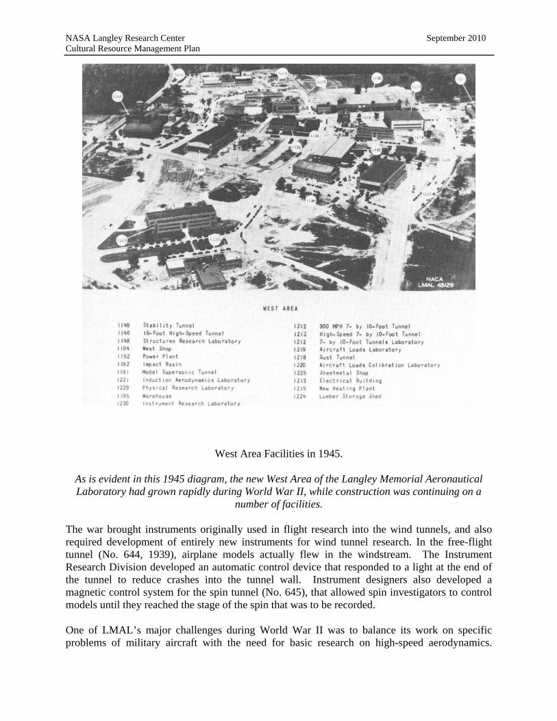
NASA Langley Research Center September 2010 Cultural Resource Management Plan
West Area Facilities in 1945.
As is evident in this 1945 diagram, the new West Area of the Langley Memorial Aeronautical Laboratory had grown rapidly during World War II, while construction was continuing on a
number of facilities.
The war brought instruments originally used in flight research into the wind tunnels, and also required development of entirely new instruments for wind tunnel research. In the free-flight tunnel (No. 644, 1939), airplane models actually flew in the windstream. The Instrument Research Division developed an automatic control device that responded to a light at the end of the tunnel to reduce crashes into the tunnel wall. Instrument designers also developed a magnetic control system for the spin tunnel (No. 645), that allowed spin investigators to control models until they reached the stage of the spin that was to be recorded.
One of LMAL’s major challenges during World War II was to balance its work on specific problems of military aircraft with the need for basic research on high-speed aerodynamics.

NASA Langley Research Center September 2010 Cultural Resource Management Plan
Diving aircraft, jet engines, and missiles presented new priorities for high-speed investigations, and research in the transonic range of flight proved to be extremely difficult. The transonic region of flight is an intermediate range from just below to just above the speed of sound (760 mph in the lower atmosphere). Airplanes approaching the speed of sound encounter shock waves and problems with stability and control due to sharp increases in drag and decreases in lift. These compressibility effects will cause an aircraft to go into an uncontrollable spin and crash. Successful passage through the transonic region was obviously necessary to achieve supersonic flight. In July 1943, Langley’s research program was reorganized to facilitate transonic investigations. The new Compressibility Research Division combined all ground-based high-speed research sections, including the 16-Foot HST Section, the 8-foot HST Section (East Area), and the first NACA and LMAL supersonic tunnel, a nine-inch pilot model completed in the West Area in 1942.
Shock waves occurring near the speed of sound caused wind tunnels to choke and produce questionable data, so ground-based transonic research was limited until the problem of wind tunnel choking was solved. Langley researchers invented unique types of flight research to gather transonic data until wind tunnels could operate in the transonic range (Mach 0.7 to Mach 1.3, or approximately 530 mph to 990 mph). New research methods included falling-body investigations, wing-flow tests, and rocket-model launching.
Langley researchers began the first alternative type of transonic research—the falling-body method—in the spring of 1943. The test object, which consisted of a model of a wing mounted on a missile, was dropped from a B-29 Superfortress at high altitude so that its speed, drag, and other forces could be measured by radar and recorded. The falling body provided data for a speed range from that of the B-29 (300 mph) to 1000 mph, the approximate speed of the falling body when it hit the ground. Another alternative type of flight research was the wing-flow technique. Air flow around a small model of an airfoil mounted on the upper surface of an airplane wing was measured and recorded when the Langley test pilot would dive the plane as rapidly as was safe. Even though the airplane’s speed was not supersonic, airflow over the wing was supersonic to about Mach 1.4. The first wing-flow test results “gave the most systematic and continuous plots of transonic data assembled by the NACA up to that time,” while helping to confirm the opinion of Langley researchers that supersonic flight required a thin wing.cxii
Transonic data was also collected with the aid of rockets. In the spring of 1945, Congress authorized expanded research on guided missiles at the LMAL. The NACA acquired a permanent rocket launching facility at Wallops Island on the coast of Virginia’s Eastern Shore, and soon began launching rocket-propelled research models. Initially known as the Auxiliary Flight Research Station, it was renamed the Pilotless Aircraft Research Division (PARD) in June 1946. PARD subsequently became one of Langley’s formal research divisions. In particular, the rocket-model test proved particularly challenging to LMAL flight researchers, as it required them to “acquire and apply new knowledge about how to measure, transmit, and record accurate
cxii Hansen, Engineer, 267.

NASA Langley Research Center September 2010 Cultural Resource Management Plan
test data during the few fleeting seconds of a flight which changed speed, altitude, and model attitude rapidly.”cxiii
In addition to its support of military guided missile projects, the NACA wanted the Wallops station to provide design data for high-speed airplanes to help define the basic airplane wing and fuselage configuration best able to fly in and through the transonic range.cxiv Researchers also wanted more than stop-gap types of transonic investigations. LMAL’s John Stack, head of the Compressibility Research Division, had envisioned a high-speed airplane for transonic research in the 1930s, but engines at that time could not provide the thrust necessary to reach high speeds (500+ mph.). In 1942, Stack received permission to proceed with the identification of general design requirements for a transonic research aircraft. The NACA was not currently able to support development projects, so a cooperative program with military support was necessary to procure such an airplane. The first formal discussion of the transonic research airplane project took place at LMAL in March 1944. A proposal for a joint NACA-military program was not successful because Army and Navy representatives had major differences of opinion over program goals for the research plane and its basic features. The Army had additional meetings at Langley in May 1944, and eventually contracted with Bell Aircraft Company to design and build a rocket plane that could reach Mach 1.2.
Stack and his associates believed rocket-powered airplanes were too dangerous. They wanted an airplane with a speed range from Mach 0.8 to Mach 1 that provides transonic research data as its primary purpose, rather than a prototype for an operational high-speed fighter. Stack pursued Navy support for a more conservative high-speed research aircraft with a turbo jet, and Douglas Aircraft Corporation was working on an experimental plane for the Navy by the end of 1944. For two years, Langley made key contributions to the design and development of both transonic research planes, the XS-1 sponsored by the Army Air Force and the Navy’s D-558.
In general, the LMAL made considerable progress in improving wind tunnels during the war years. Langley’s high-speed wind tunnels could not yet reach supersonic speeds, but they had achieved speeds right around Mach 1. With this background, researchers would soon be able to devise new ways to conduct wind tunnel testing that minimized choking by using smaller models and new support systems for models that allowed testing at higher Mach numbers.
The NACA in the Postwar Period
World War II changed the NACA forever. The wartime focus on practical applications and development was far removed from the NACA’s original priority of fundamental research. After the war, NACA chairman Jerome Hunsaker (served 1941-1956) attempted to return the NACA’s focus to basic aeronautical research. Yet his efforts were overridden by the increasing demands of military and commercial interests.
cxiii Ibid., 267-268. cxiv Ibid., 268.
NASA Langley Research Center September 2010 Cultural Resource Management Plan
The structure of the American aeronautical community changed dramatically as the result of the war. Aircraft manufacturing had become the country’s largest industry, and its power increased accordingly. The Army Air Force’s 40-year campaign for independence from the Army as a separate air arm was nearly won. Wartime developments also emphasized the importance of science and technology, and had provoked some criticism of the NACA, particularly its failure to keep up with German achievements in the field of jet propulsion. When the Allies captured Germany’s aeronautical center at Pennemunde in the summer of 1945, they found two “super-supersonic” wind tunnels, one capable of Mach 5 and another under construction planned for Mach 10. These facilities, which had supported the V-2 long-range ballistic missile program, were the only ones of their kind in the world. This recognition of German’s superiority in rocketry and jet propulsion would prompt a re-evaluation of the NACA and its role in the immediate postwar period. No longer could it maintain its monopoly on fundamental aeronautical research, or corner the market on large expensive research facilities. Yet the aeronautical community generally agreed that fundamental research was the NACA’s responsibility. Increasingly, it was felt that development should be conducted by industry, while the military would be responsible for evaluation. This arrangement was formalized in the National Aeronautical Research Policy adopted by the NACA in March 1946, although considerable “gray area” remained between these overlapping responsibilities.cxv The aircraft industry subsequently acquired three seats on the NACA in the 1940s, an illustration of its growing power and influence.cxvi
The NACA, the Army Air Force, and private industry agreed that it would be essential to develop a state-of-the-art supersonic research center, but the NACA and the military each had its plan for building what promised to be a costly facility. The National Unitary Wind Tunnel Plan Act of 1949 authorized three supersonic wind tunnels for the NACA. Even though the NACA was required to devote them to industry development work, the three new tunnels “represented a landmark in wind tunnel design by any criterion---size, cost, performance, or complexity.”cxvii The NACA’s position in the postwar aeronautical community, however, was clearly reflected in its loss of the Unitary Plan’s new supersonic research center. The Air Force was given the cornerstone facility to focus on military aeronautics, the Arnold Engineering and Development Center at Tullahoma, Tennessee, which opened in 1951. It was “a harbinger of the [NACA’s] diminished standing with agencies and individuals who would control its destiny.”cxviii
The great technological advances of World War II brought high-speed flight to the research forefront. New systems of propulsion had made supersonic flight foreseeable rather than academic. In the postwar period, the NACA focused on high-speed flight and conducted exceptional research in the transonic, supersonic, and hypersonic regions of flight. The agency
cxv Roland, Model Research, 205-206 cxvi Seats for industry representatives were prohibited previously due to conflict of interest concerns. cxvii Baals and Corliss, Wind Tunnels, 71. cxviii Roland, Model Research, 221.

NASA Langley Research Center September 2010 Cultural Resource Management Plan
consistently developed “the new scientific and technological concepts and the greater part of the detailed design data needed to produce generation after generation of advanced airplanes,” while leading the way in the field of guided missile technology, including aerodynamics, rocket propulsion, and guidance and control.cxix
In the postwar period, the NACA had 7,000 employees and three excellent research laboratories. The Langley Aeronautical Laboratory (LAL) in Hampton, Virginia was the oldest, largest, and most diversified. Its research programs included all phases of aerodynamics, hydrodynamics, aircraft structures, and aircraft loads. The Ames Aeronautical Laboratory, south of San Francisco, specialized in high-speed aerodynamics. The laboratory in Cleveland, Ohio investigated aircraft propulsion. Originally known as the Aircraft Engine Research Laboratory, it was renamed the Flight Propulsion Research Laboratory in 1947 and the Lewis Flight Propulsion Laboratory in 1948.cxx
Although the LMAL—renamed the Langley Aeronautical Laboratory (LAL) in 1948—was no longer the center of American aeronautical research after World War II, it remained the largest and most diversified of the three principal NACA research laboratories. Its research programs included all phases of aerodynamics, hydrodynamics, aircraft structures, and aircraft loads. The NACA annual conference for industry resumed in 1946, and Langley alternated with Ames Laboratory in hosting the event. During this period, LAL researchers continued to grapple with the problems characteristic of transonic speed ranges, in which shock waves occurring near the speed of sound caused airplanes to spin out of control and wind tunnels to “choke.” Any effort to achieve supersonic flight would thus require the solution of the “transonic problem.” The NACA devised unique research methods to gather transonic data until wind tunnel technology caught up, including falling-body investigations, wing-flow tests, and rocket-model launching. These types of flight research were considered only stop-gap or alternative methods, but they helped fill in the transonic blind spot in aeronautical research until large transonic tunnels were available.
Efforts to procure a high-speed research airplane led to cooperative programs with the Army, the Navy, and industry. The cooperative program with the AAF produced the XS-1 and the first manned supersonic flight. On 14 October 1947, AAF Capt. Charles E. “Chuck” Yeager flew the XS-1 to Mach 1.06 as part of flight tests at Muroc Army Airfield (later Edwards Air Force Base). This first manned supersonic flight was honored as the year’s greatest achievement in American aviation. The Collier Trophy for 1947 was awarded to the NACA’s John Stack, who conceived the research airplane project, Lawrence D. Bell, president of Bell Aircraft, and Capt. Charles E. Yeager, United States Air Force (USAF), for achieving human supersonic flight. “The cooperation between the NACA, the services, and the industry exemplified the seamless web of coordination that had evolved during World War II into an indispensable ingredient of radical
cxix Ira H. Abbott, “A Review and Commentary of a Thesis by Arthur L. Levine, Entitled ‘United States Aeronautical Research Policy, 1925-1958, A Study of the Major Policy Decisions of the National Advisory Committee for Aeronautics,’ Dated 1963.” (Washington, D.C.: typescript, NASA History Office, 1964), 175. cxx The laboratory was named for George W. Lewis after his death. He had worked for the NACA since 1919.

NASA Langley Research Center September 2010 Cultural Resource Management Plan
aircraft development. Military sponsorship was needed for money and raison d’etre; the NACA was needed for fundamental concepts of design and instrumentation; and industry was needed for design, development, and production facilities.”cxxi The supersonic prototypes were not designed for sustained supersonic flight, and the research airplane program continued into the 1950s to improve designs for high-speed aircraft. “Research aircraft operated by NACA and the military… supplied fundamental design data [for transonic and supersonic aircraft] for years to come.”cxxii
Wind tunnel choking in the transonic range was the initial impetus for the research airplane program. By the time Captain Yeager broke the so-called “sound barrier,” a number of innovations had already been made in wind tunnel technology. In 1946, Langley engineer Ray H. Wright’s concept of a partially open tunnel with ten narrow slots was first tested in a small, experimental tunnel off the 16-Foot HST. In 1947, it went up to and through the speed of sound. The “slotted-throat” or “slotted-wall” design, proved controversial. Power requirements for such a tunnel were enormous, as were costs for converting existing tunnels to the new design. Meanwhile, many NACA researchers and theorists remained skeptical that the new design concept could accommodate transonic research at large scale.
In late 1947, the NACA authorized the conversion of the 16-Foot HST to Wright’s slotted design. However, the 8-Foot HST (in the East Area) was converted first, as it proved quicker and cheaper, and in late 1948 it became the first large wind tunnel to go through the speed of sound with a slotted throat. The NACA’s first large wind tunnel converted to a slotted throat design, Langley’s 8-Foot HST, began regular operation for transonic research purposes in 1950. Slotted tunnels became ‘best practice’ in transonic research almost immediately, and the NACA claimed that Langley’s development of slotted-throat transonic tunnels gave the U.S. “a two-year lead over all other nations in the design of supersonic fighters and bombers.”cxxiii Large increases in drag from shock waves were the biggest problem for supersonic aircraft designers, and information on the transonic zone was critical to the supersonic fighters and bombers being planned in the postwar era.cxxiv The NACA received the 1951 Collier Trophy for its slotted-throat tunnel, which allowed laboratory testing in the transonic speed range.
Langley engineer Richard Whitcomb used the converted 8-Foot HST to conduct tests of new wing and fuselage combinations. His testing showed that transonic drag patterns were very different than those predicted by theory, while two new types of shock waves were also observed for the first time. In late 1951, Whitcomb revealed a new basic design concept for the shape of the high-speed aircraft, the “area rule,” which considered and airplane’s wings and body as an
cxxi Roland, Model Research, 247. cxxii David D. Anderton, Sixty Years of Aeronautical Research, 1917-1977. (Washington, D.C.: National Aeronautics and Space Administration, 1978), 27. cxxiii Hansen, Engineer, 329-331. cxxiv Baals and Corliss, Wind Tunnels, 61-62.

NASA Langley Research Center September 2010 Cultural Resource Management Plan
interactive aerodynamic system rather than separate components. Aircraft designed according to the area rule were pinched at the middle of the fuselage and known as “wasp-waisted.” At the time of Whitcomb’s discovery, it appeared that military fighters would not be able to surpass Mach 1, due to the inability of the current generation of jet engines to overcome the “tremendous drag rise.”cxxv The USAF halted production of its Convair F-102 when NACA testing showed the YF-102 prototype could not fly supersonically as planned. This fighter-interceptor was urgently needed to maintain air superiority in the Cold War, and when it was redesigned according to the area rule, its top speed increased by approximately 25 percent. Subsequently, Grumman’s F9F-9 Tiger (later the F11F-1), a carrier-based fighter for the Navy, was the first aircraft based on the area rule to fly supersonically in August 1954. The following year, Whitcomb won the Collier Trophy for his discovery of the area rule.
An LMAL supersonic tunnel (originally located in Facility No. 1191, was the first to test Langley researcher Robert T. Jones’ concept of using swept airplane wings to reduce supersonic drag. The swept-wing concept accelerated the development of large supersonic tunnels and began the race for supersonic aircraft supremacy.cxxvi Major new facilities in the early postwar period reflected the change from subsonic to supersonic flight. Construction began in 1945 on the first large supersonic wind tunnel, the Four-by-4-Foot Supersonic Pressure Tunnel. It was operational by 1948 and tested a number of important military aircraft and space vehicles before it was dismantled in 1977, including the Century Series fighters (F-102, F-105, etc.), the B-58 supersonic bomber, and the X-2 research aircraft. An additional large supersonic tunnel, the Unitary Plan Supersonic Tunnel, was authorized in 1949 and operational by 1955 (Facility No. 1251). Originally dedicated to missile development, it also was involved in testing a number of aircraft, including the McDonnell F-4 Phantom, the X-15, and the F-111, as well as models of space vehicles. cxxvii
cxxv Hansen, Engineer, 338. cxxvi Ibid., 472-475. cxxvii Ibid.

NASA Langley Research Center September 2010 Cultural Resource Management Plan
NACA Facilities and Langley Field, 1950.
By 1950, when this aerial photograph was taken, the newly renamed Langley Aeronautical Laboratory had grown considerably since the pre-World War II era. The original East Area
(lower center) was densely developed, while the newer West Area (upper center) was continuing to expand.
In November 1947, the first hypersonic tunnel in the United States was successfully run at the Langley Laboratory in the shop of the Propeller Research Tunnel (East Area, demolished in 1950). The division between supersonic and hypersonic flight occurs about Mach 5, where aerodynamic heating becomes a critical problem. This 11-inch pilot model operated satisfactorily up to Mach 6.9 and enabled researchers to study heat transfer, which was crucial in the design of supersonic aircraft and missiles. The hypersonic pilot tunnel showed that traditional wind tunnels could not be adapted for hypersonic testing at large scale, as hypersonic operations entailed formidable design problems that could not be encompassed in a single facility.
NASA Langley Research Center September 2010 Cultural Resource Management Plan
In the late 1940s, the NACA developed a new basic design concept for hypersonic wind tunnels to address their requirements for very high temperatures, very high speeds, large pressure ratios, and power. The NACA’s hypersonic investigations focused initially on long-range missile research. After the USAF contracted for the first intercontinental ballistic missile (ICBM) in 1951, the Atlas, American rocket projects soon became a top national priority. In Fiscal Year (FY) 1953, the Department of Defense first spent more than $1 million on missiles which grew to more than $1 billion by FY 1957. The ICBM program eventually dominated the aerospace industry. From 1955 to 1957, the NACA made major research contributions to military missile programs. These included materials research on ablation led by Robert R. Gilruth, H. Julian Allen’s blunt-nose cone shape for bodies reentering the Earth’s atmosphere, and Alfred J. Eggers’ simulation work on the mechanics of ballistic reentry. The NACA’s missile research, including facilities, budget, and personnel, grew in proportion to the national commitment in the mid- to- late 1950s, while aeronautical research decreased.
The Ames and Langley Laboratories expanded their hypersonic research in 1952 after requests from guided missile manufacturers and Bell Aircraft Corporation. This led the NACA to define requirements for a hypersonic research airplane in 1954, the X-15, and promote its development to the military. The X-15 made its first flight in 1959 and eventually became the first aircraft to fly into space. It held altitude and speed records for winged aircraft until the Space Shuttle Colombia’s first flight in 1981. The NACA’s fundamental research in hypersonic aerodynamics produced the X-15 program and laid the foundation for manned spaceflight.
Manned spaceflight was generally viewed as science fiction until the late 1950s. Even most aeronautical engineers believed hypersonic flight was probably restricted to missiles. In 1952, the Ames and Langley Laboratories expanded their hypersonic research and included limited study of speeds beyond Mach 10, the range of spaceflight. Key aspects of hypersonic flight at extremely high altitudes—such as stability and control problems, and distortion of aircraft structures by aerodynamic heating—could not be studied with wind tunnels or other equipment, and NACA installations were directed to identify requirements of a potential hypersonic research airplane in 1954. Design requirements for a hypersonic research aircraft were found to be radically different even from supersonic designs.
By the middle of 1954, Langley’s hypersonic aircraft study group conceived the basis of a Mach 7 research airplane and presented them to military representatives. A formal proposal followed for design and development of a research aircraft capable of Mach 7 and altitudes of several thousand feet, the X-15. The NACA, USAF, and Navy established a Research Airplane Committee for technical direction of the X-15 research airplane in December 1954, and the contract was awarded to North American Aviation in September 1955.
The Langley Laboratory supported the X-15’s development with extensive wind-tunnel testing and structure research during 1956, which enabled construction to begin in September 1957. The first non-powered glide flight was made in June 1959, and the X-15 made its first powered flight in September 1959. The world’s first “transatmospheric vehicle, the X-15 hypersonic research
NASA Langley Research Center September 2010 Cultural Resource Management Plan
airplane was considered to be “one of the most important and significant airplane designs of all time,” and was the only winged aircraft to fly 50 miles into space until the Space Shuttle in 1981.cxxviii In fact, the pioneering X-15 re-entry systems and flight experiences directly influenced those used successfully in the Space Shuttle.cxxix
Despite the rapid advances made by Langley scientists in hypersonic research, not all the research conducted during this era was geared toward extending the frontiers of flight. A significant example of a facility that made important, if less dramatic, contributions to basic aircraft design was the Landing Loads and Traction Facility for Increased Performance (Facility No. 1257). Built in 1953 at a cost of $1,249,000, the facility was the first in the world capable of studying full-size aircraft landing gear and tires on runway surfaces under closely controlled conditions of forward speed, sink speed, and vertical load to simulate actual aircraft landing, takeoff, and taxi operations. It consisted of a 2,200-foot track length, including a 400-foot carriage acceleration section, a 1,200-foot test section, and a 600-foot section for carriage arrestment. The Landing Loads track offered the only means of experimenting with tracking, braking, and directional control performance margins other than actual aircraft operations, which could be expensive and dangerous.cxxx
The Langley Research Center and Project Mercury
On October 4, 1957, the Soviet Union launched Sputnik, the first satellite to orbit the Earth. This achievement was downplayed by President Eisenhower, who thought the U.S.’s huge missile program adequately countered the Soviet threat to national security, and that the exorbitant cost of a space program would upset the American economy. Sputnik, however, caused widespread paranoia as it traveled overhead. Space was soon seen as the Cold War’s new battlefield and plans were underway for a major American space program by the end of 1957.
The NACA’s successful hypersonic research prepared the agency for a leading role in fundamental space flight research. The NACA saw development of space technology as “an evolution fully within the capacity of the established aeronautical research agency.”cxxxi The Department of Defense was its major rival for the position, but President Eisenhower accepted the recommendation of his Science Advisory Committee for a new civilian agency with the NACA as its nucleus.
cxxviii Anderson, Sixty Years, 39. cxxix Ibid., 377. cxxx Fred DeMeritte, et al., Report to Deputy Administrator and Associate Administrator for Center Operations, National Aeronautics and Space Administration on Office of Aeronautics and Space Technology Non-National Aeronautics and Space Facilities (Washington, D.C.: National Aeronautics and Space Administration, 1977), 122-23. cxxxi Hansen, Engineer, 376.

NASA Langley Research Center September 2010 Cultural Resource Management Plan
President Eisenhower signed the National Aeronautics and Space Act on July 29, 1958. As of October 1st, the National Aeronautics and Space Administration (NASA) became the successor to the NACA. NACA personnel and laboratories became the nucleus of NASA, which was soon known as the space agency, and the LAL was renamed the Langley Research Center (LaRC). These changes in nomenclature reflected a shift away from the field of aeronautical research in which the Langley Laboratory had been preeminent for 40 pivotal years in aviation history.
Notwithstanding these bureaucratic alterations, Langley was already in the midst of an “extensive shift in emphasis” towards the fields of hypersonic and space flight.cxxxii With its several hypersonic wind tunnels and wide experience with rocket testing, Langley quickly became a cornerstone of NASA’s space effort, and NASA drew heavily on Langley’s “expertise and facilities.”cxxxiii
The basic outline of the United States first manned spaceflight program, Project Mercury, was established by a special task force at NASA Headquarters in Washington in the summer of 1958. Langley engineer Robert R. Gilruth assembled a group of researchers from the Langley and Lewis Laboratories to plan the project. Known as the Space Task Group (STG), it was based at LaRC, with quarters initially in the Unitary Plan Wind Tunnels offices. Within a year, the STG grew to include more than three hundred staff, with more than half from Langley.cxxxiv A large number came from Langley’s PARD, where Gilruth had been a division chief. Their experience was particularly necessary because PARD engineers had “established launch procedures at Wallops Island, experimented with the principles of rocket staging, developed key technologies for missile guidance and control systems, and built or refined sensitive instrumentation for telemetry studies.”cxxxv
Between October 1958 and January 1959, the STG completed specifications for the Mercury capsule, solicited and evaluated proposals from the aerospace industry, and awarded the contract to build the capsule.cxxxvi As proposed by the STG, the Mercury spacecraft would be a ballistic capsule that would carry a man into orbit. With its blunt body, retrorockets, and parachutes, it has been described as “an elegant solution to the problem.”cxxxvii
In addition to its responsibility for the Mercury spacecraft, the STG was also in charge of astronaut selection and training. The “Mercury Seven” astronauts came from a pool of almost
cxxxii Ibid., 377. cxxxiii Baals and Corliss, Wind Tunnels, 94. cxxxiv Ibid., 60. cxxxv Ibid., 57. cxxxvi Ibid., 50. cxxxvii James R. Hansen, Spaceflight Revolution: NASA Langley Research Center from Sputnik to Apollo (Washington, D.C., National Aeronautics and Space Administration, 1995), 54.

NASA Langley Research Center September 2010 Cultural Resource Management Plan
600 military test pilots evaluated by criteria established by the STG. After selection in April 1959, training followed at LaRC under the supervision of the STG. The program included space science studies—including reentry physics, astronomy, celestial mechanics, and navigation—as well as demanding physical exercise. The STG also developed space flight simulator and procedure trainers for the astronauts.cxxxviii “Langley was the place where the stars of the space program—STG and its astronauts—were in training for the first U.S. manned space effort.”cxxxix
The STG recognized that ground control of some critical space flight decisions would be crucial, and so initiated plans for a Mercury Control Center at Cape Canaveral, Florida. The control center needed a global communication and tracking network to maintain and monitor communications with orbiting spacecraft. At that time global communications via satellite were not yet available and underwater cables provided the only long-range communications between continents. Creation of such a worldwide network was more than the STG could reasonably undertake. In February 1959, NASA Headquarters assigned LaRC full responsibility for planning and contracting the Mercury tracking network. Out of all the responsibilities Langley had in support of Project Mercury, the tracking range project was “by far the biggest, the most difficult to carry out logistically, and the most adventuresome.” When it was completed, the network “stretched from the new Mercury Control Center at Cape Canaveral to 18 relay stations spanning three continents, seven islands, and two ocean-bound radar picket ships. . . . The network utilized landlines, undersea cables and radio circuits, special computer programs, and digital data conversion and processing equipment, as well as other special communications equipment installed at commercial switching stations in both the Eastern and Western hemispheres.”cxl
LaRC efforts were crucial in creating this unprecedented and highly successful worldwide ground instrumentation and tracking network, which became operational in June 1961. Langley’s Instrument Research Division helped guide the design of the electronic systems, its Engineering Service Divisions assisted with the site selection and station constructions, and its Procurement Division negotiated the huge contract and maintained liaisons with the contractors.cxli
Langley also provided major support for Project Mercury with its wind tunnels and other facilities, conducting thousands of aerodynamic, component, materials, and structural tests. LaRC investigated the Mercury spacecraft’s performance in all phases of its flight, including launch, spaceflight, atmospheric reentry, and ocean recovery. The final shape and appearance of the Mercury capsule was based on these tests. Langley also did considerable work on “Big Joe” and “Little Joe.” Little Joe (50 feet tall, 28,000 pounds, eight solid propellant engines) was “an
cxxxviii Ibid., 41, 60. cxxxix Ibid., 33. cxl Ibid., 63, 66. cxli Ibid., 69.

NASA Langley Research Center September 2010 Cultural Resource Management Plan
innovative solid-fuel rocket, one of the earliest U.S. launch vehicles based on the principle of the clustered rocket engine.”cxlii Little Joe rockets were launched from Wallops Island and provided critical information for Project Mercury prior to more complicated and expensive tests at Cape Canaveral. Little Joe did not prove reliable enough to carry a man into space, however, and was abandoned for the Redstone and Atlas boosters. Big Joe, a one-ton, full-scale model of the Mercury spacecraft, was launched from Cape Canaveral on an Atlas booster and demonstrated the feasibility of Mercury’s design concepts.
Although Project Mercury continued until May 1963, LaRC’s association with Mercury declined after mid-1962. The manned space program required its own center, and NASA acquired land for a new installation just south of Houston, Texas. The STG’s relocation to Houston was announced in September 1961, and in November the STG was renamed the Manned Spacecraft Center (MSC). The MSC’s move to Houston from Langley was completed by June 1962.
The Echo and Scout Programs at the Langley Research Center
The LaRC was responsible for the world’s first communication satellite, Echo 1. Echo was a 100-foot inflatable balloon, described as “perhaps the most beautiful object ever to be put into space.” Weighing only 132 pounds, it consisted of a large sphere with a surface of Mylar plastic covered with vapor-deposited aluminum. cxliii This “satelloon” was folded in a canister, launched in the nose cone of a Thor-Delta rocket, and inflated when it reached orbit 1,000 miles above the earth. Echo acted as a passive reflector that relayed signals around the curvature of the earth, and provided instantaneous worldwide communications for the first time in August 1960.
The idea for Echo began as an experiment for the International Geophysical Year (IGY). In 1952, the International Council of Scientific Unions established the period spanning July 1, 1957 to December 31, 1958 as the IGY as it would be a period of high solar activity. This international event fostered a number of proposals for scientific experiments, including Sputnik, the first man-made satellite to orbit the earth. LaRC engineer William J. O’Sullivan conceived the inflatable balloon in January 1956 as a way to measure air density in the upper atmosphere. The satellite’s light weight and thin skin were required for it to be aerodynamically sensitive in the vacuum of the upper atmosphere. The purpose of the experiment was to provide aerodynamic information crucial to the design of new aircraft, missiles, satellites and other spacecraft. In October 1956, development at the LaRC was approved as an NACA contribution to the IGY.
O’Sullivan’s original experimental balloon was only 30 inches in diameter. Before it could be successfully launched, however, the Soviets had placed Sputnik in orbit and started the space race. A number of government agencies, including the State Department and the Central Intelligence Agency (CIA), were eager to orbit an American satellite that would be visible over
cxlii Ibid., 47. cxliii Ibid., 187.
NASA Langley Research Center September 2010 Cultural Resource Management Plan
Russia as well as the United States. What had begun as a “simple air-density experiment” was now becoming “an instrument of propaganda in the cold war.”cxliv Government officials were interested in the balloon’s second generation, a 12-foot sphere that would orbit the earth at 300 to 400 miles and appear as bright as the North Star to the naked eye. Before the 12-foot model could be successfully launched, it had been transformed into a 100-foot communications satellite (comsat). The new project was formally approved by the NACA in May 1958 and came to be known as Project Echo.
In October 1959, primary management of Project Echo was assigned to Goddard Space Flight Center in suburban Maryland, NASA’s new center for space projects. Even though Echo’s overall management became Goddard’s responsibility at that time, Echo was essentially a Langley project. The Echo concept originated at the LaRC, and Langley did virtually all of the preliminary design work, completed extensive ground tests, and assisted in all launches and test flights.cxlv
Echo 1 was launched successfully from Cape Canaveral on August 12, 1960 and orbited the earth until May 1968. Not only was it a “significant propaganda weapon” for the United States, but it also served as a “popular symbol of the peaceful and practical uses of space research.”cxlvi In many ways, the Echo project changed prevailing conceptions of the potential for satellite communication systems, and encouraged subsequent private sector initiatives that have since transformed the field of communications.cxlvii
Called the “the unsung hero of space” because it set a standard for reliability, simplicity, and economy, the relatively small rocket known as “Scout” was also conceived and developed at the LaRC. Although not widely known, Scout developed into “one of the finest pieces of technology in the history of space exploration, and became a “very reliable, consistent, performing warhorse.”cxlviii Scout provided access to space for more than 30 years and was one of the few programs “born of the spaceflight revolution [that] survived the spaceflight revolution.”cxlix
Scout was a four-stage, solid-fuel rocket capable of orbiting, sounding, and reentry flights with a large variety of payloads. It had three types of missions: placing small satellites in orbit; high-velocity reentry studies and testing of heat-resistant materials; and launching high-altitude and
cxliv Ibid., 172. cxlv Ibid. cxlvi Ibid., 189. cxlvii Ibid., 189. cxlviii Ibid., 217. cxlix Ibid., 219.

NASA Langley Research Center September 2010 Cultural Resource Management Plan
space probes. The original Scout was only 72 feet high and weighed only 37,000 pounds, while the total thrust of its four stages was just under 200,000 pounds. cl
In 1956, Langley engineers in PARD conceived this solid fuel launch vehicle as a means of putting light payloads into orbit. Technologically, it built upon the hypersonic solid-fuel rocket technologies that they had been developing at Wallops Island and Langley since the early 1950s. Initially ignored in favor of larger liquid-fueled rockets, Scout was authorized in May 1958 in direct response to Sputnik. PARD rocketeers planned to assemble an economical stack of rocket motors for its four-stage booster from off-the-shelf hardware developed for military ballistic missiles. Langley finalized the design by early 1959, and launched the first experimental Scout from Wallops Island in April 1960. Initially managed by PARD, Scout was transferred to the STG after its creation in 1958, and then to the Scout Project Group in February 1960. This became the first large NASA project that LaRC ran “in-house.” cli
Most of the early Scout launches were failures, and a comprehensive investigation of the program in 1963 included a three-month moratorium on the launch schedule. The first launch after recertification of the rocket occurred in December 1963, after which Scout’s performance was remarkable, with an overall success rate of 96 percent over a total of 113 launches.clii In addition to its launch reliability, Scout payloads were critical in the advancement of atmospheric and space science. Early Scout missions helped researchers study the density of the atmosphere at various altitudes, the properties of the Van Allen radiation belts, and the possible dangers of the micrometeoroid environment on spacecraft. Scouts in the 1970s tested Einstein’s theory of relativity by carrying an extremely accurate atomic clock in space, and they also helped to confirm the theory of the “black hole.”cliii Scouts also launched a number of satellites, including 23 for foreign countries. The series launched for the Center for Italian Aerospace Research gathered “valuable data about the ionosphere and the magnetosphere, about galactic sources of radiation and X-rays, and especially about the nature of the earth’s atmosphere in the region of the equator.”cliv In summary, Scout proved critical in the context of NASA’s early space program by providing important data on reentry dynamics. NASA researchers learned much about what materials best withstood the heat of reentry, allowing for the subsequent successes of the Mercury, Gemini, and Apollo projects.clv
The Langley Research Center and the Apollo Program
cl Ibid., 210. cli Ibid., 198. clii Ibid., 204. cliii Ibid., 213. cliv Ibid., 217. clv Ibid., 216.

NASA Langley Research Center September 2010 Cultural Resource Management Plan
When President John F. Kennedy confidently predicted in 1961 that the United States would land a man on the Moon by the end of the decade, the task of implementing what seemed to be a wildly ambitious goal fell to the engineers of NASA. Three different strategies for a Moon landing appeared possible: direct ascent, Earth-orbit rendezvous (EOR), or lunar-orbit rendezvous (LOR). A direct ascent to the Moon was ruled out due to the projected size of the launch vehicle, while the EOR concept would require two separate launch vehicles. NASA eventually settled on the LOR method, in which a single rocket would launch two spacecraft into lunar orbit. One would circle the Moon while the other descended to the lunar surface. The lander would then boost itself back into orbit, dock with the mother ship, and return to Earth.
The success of the LOR strategy ultimately depended on whether the astronauts could learn to safely land the Lunar Excursion Module (LEM) on the Moon’s surface and return into orbit to dock with the mother ship. A major obstacle in designing a training procedure, however, was that the LEM would handle far differently in the Moon’s atmosphere, with 1/6th the gravitational pull of Earth’s. The problem thus became how to replicate the operation of the LEM in a low gravitational environment. The solution came in the form of the Lunar Landing Research Facility (LLRF), a training simulator that allowed NASA engineers to study the complex lunar landing process, while giving the Apollo astronauts critical hands-on pilot training in the LEM.
The LLRF was completed in 1965 at a cost of $3.5 million. Located in the West Area of Langley Research Center, the most obvious feature of the LLRF was its enormous gantry, which became an unmistakable landmark on the horizon. The A-frame steel structure, measuring 400 feet long by 240 feet high, was composed of truss elements arranged with four sets of inclined legs that provided adequate clearance for any pendulous motion the vehicle might develop. An elevator shaft in the east end provided access to the overhead equipment, while catwalks allowed the inspection of all structural areas.
The LLRF simulated lunar gravity through an overhead partial-suspension system that provided lifting force through cables acting through the LEM’s center of gravity, counteracting all but 1/6th of the Earth’s gravitational force. Both the lifting force and vertical alignment of the cables was controlled automatically through servo-controlled hydraulic drive systems that powered an overhead traveling bridge crane and dolly unit mounted on the gantry. The cables were attached to the LEM with a gimbal system that allowed complete freedom of motion. Protected by automatic and manual braking equipment, the LEM could fly unobstructed within an area measuring approximately 360 feet long, 180 feet high, and 42 feet wide.
The operation of the facility was directed from a control room on the second floor of the 2-story office and shop building located near the southwest corner of the gantry structure. From here the movements of the LEM, bridge, and dolly could be viewed by the test director and facility operators through large observation windows. The control room was equipped with controls for the manual and automatic operation of the bridge crane drive system, while numerous instrument displays indicated the status and performance of the drive system and the LEM. Two-way communications throughout the facility allowed the test director to maintain constant voice contact with the pilot and operational crews. Sophisticated data, photographic, and voice recorders rounded out the facility’s technologically advanced features, providing a complete analytical framework for the testing process.

NASA Langley Research Center September 2010 Cultural Resource Management Plan
In addition to allowing flight testing of the LEM, the LLRF also was used as a lunar-walking simulator for the Apollo astronauts. This was accomplished by suspending the astronaut on his side with a system of slings and cables, allowing him to walk on a plane inclined to approximately 80.5 degrees relative to the vertical direction of Earth’s gravity. Other gravitational conditions, even weightlessness, could be created by varying the inclination of the walkway. Initially paved with a 30-foot wide strip of concrete to minimize jet-blast effects and fuel spillage problems, the base of the LLRF later was modeled with fill dirt to resemble the lunar surface, complete with the holes, pits, and craters the astronauts would encounter on the Moon.
From its inception in 1965 until the end of the Apollo program in 1972, the LLRF was used to train 24 astronauts for lunar missions, including Neil A. Armstrong and Edwin E. “Buzz” Aldrin, Jr., of Apollo 11, the first men to walk on the Moon. Armstrong offered what was perhaps the greatest tribute to the importance of the LLRF in the success of the Apollo program. When asked what it was like to land on the Moon, he replied: “Like Langley.”
Although its role in the Apollo program has tended to be overlooked, the LaRC contributed immeasurably to the technical achievements that made the Moon landing possible. Langley scientists conducted the basic rendezvous and docking studies, the wind-tunnel investigations of the aerodynamic integrity of the Saturn-Apollo launch combination, the work on reentry heating and its potentially fatal effects on the returning Apollo spacecraft, and the simulation training that helped prepare the astronauts not only for the rendezvous and docking in space but also for the actual landing of a manned spacecraft and for astronaut locomotion activities on the moon. “From launch to splashdown, there was no aspect of the Apollo mission that scientists, engineers, and technicians at Langley had not helped to develop in one way or another.”clvi
clvi Ibid., 356.

NASA Langley Research Center September 2010 Cultural Resource Management Plan
REFERENCES
Abbott, Ira H. “A Review and Commentary of a Thesis by Arthur L. Levine, Entitled ‘United States Aeronautical Research Policy, 1915-1958, A Study of the Major Policy Decisions of the National Advisory Committee for Aeronautics,’ Dated 1963,”, National Aeronautics and Space Administration History Office, Washington, D.C., 1964.
Anderton, David D. Sixty Years of Aeronautical Research, 1917-1977. National Aeronautics and Space Administration, Washington, D.C., 1978.
Baals, Donald D. and William R. Corliss. Wind Tunnels of NASA. National Aeronautics and Space Administration, Washington, D.C, 1981.
Bilstein, Roger E. Orders of Magnitude: A History of the NACA and NASA, 1915 - 1990. National Aeronautics and Space Administration, Washington, D.C., 1989.
Brown, Jerold E. Where Eagles Land: Planning and Development of U.S. Army Airfields, 1910-1941. Greenwood Press, New York, 1990.
_____. "Where Eagles Roost: A History of Army Airfields Before World War II." Ph.D. diss., Duke University, 1977.
Butowsky, Harry A. Man in Space: National Historic Landmark Theme Study. National Park Service, United States Department of the Interior, Washington, D.C., 1984.
______. National Register of Historic Places Inventory-Nomination Form, Lunar Landing Research Facility. National Park Service, Department of the Interior, Washington, D.C., 1984.
Curtis, Robert I., John Mitchell, and Martin Copp. Langley Field, The Early Years, 1916 1946. Langley Air Force Base Office of History, 4500th Air Base Wing, Hampton, Virginia, 1977.
Gray, George W. Frontiers of Flight: The Story of NACA Research. Alfred A. Knopf, New York, 1948.
Hansen, James R. Engineer in Charge: A History of the Langley Aeronautical Laboratory, 1917-1958. National Aeronautics and Space Administration, Washington, D.C., 1987.
_____. Spaceflight Revolution, NASA Langley Research Center from Sputnik to Apollo. National Aeronautics and Space Administration, Washington, D.C., 1995.
Maurer, Maurer. Aviation in the U.S. Army, 1919-1939. The United States Air Force General Histories. Office of Air Force History, Washington, D.C., 1987.

NASA Langley Research Center September 2010 Cultural Resource Management Plan
O’Bryan, Thomas C., and Donald E. Hewes. Operational Features of the Langley Lunar Landing Research Facility. NASA Technical Note D-3828, Washington, D.C., 1967.
Roland, Alex. Model Research: The National Advisory Committee for Aeronautics, 1915-1958. National Aeronautics and Space Administration, Washington, D.C., 1985.
Victory, John. “The Langley Laboratory,” TMs (Rough Draft) [photocopy]. Langley Historical Archive, NASA Langley Research Center, Hampton, Virginia, n.d.
Weidinger, Charles L. "The Birth of Langley Field." TMs [photocopy]. Office of History, 1st Tactical Fighter Wing, Langley Air Force Base, Hampton, Virginia, n.d.
_____. "The People of Langley, A Historical Chronology of Residents in Officers Quarters Main Cantonment Area, 1983, revised 1986." TMs [photocopy]. Office of History, 1st Tactical Fighter Wing, Langley Air Force Base, Hampton, Virginia, 1986.

NASA Langley Research Center September 2010 Cultural Resource Management Plan
APPENDIX E
ENVIRONMENTAL PROJECT PLANNING FORM

NASA Langley Research Center September 2010 Cultural Resource Management Plan
INTENTIONALLY LEFT BLANK

NASA Langley Research Center September 2010 Cultural Resource Management Plan

NASA Langley Research Center September 2010 Cultural Resource Management Plan

NASA Langley Research Center September 2010 Cultural Resource Management Plan
NASA Langley Research Center September 2010 Cultural Resource Management Plan

NASA Langley Research Center September 2010 Cultural Resource Management Plan
INTENTIONALLY LEFT BLANK

NASA Langley Research Center September 2010 Cultural Resource Management Plan
APPENDIX F
LaRC CENTER-WIDE PROGRAMMATIC AGREEMENT
(FULLY EXECUTED COPY ON FILE WITH HPO)

NASA Langley Research Center September 2010 Cultural Resource Management Plan
INTENTIONALLY LEFT BLANK

NASA Langley Research Center September 2010 Cultural Resource Management Plan
PROGRAMMATIC AGREEMENT
AMONG
THE NATIONAL AERONAUTICS AND SPACE ADMINISTRATION,
THE VIRGINIA STATE HISTORIC PRESERVATION OFFICE, AND
THE ADVISORY COUNCIL ON HISTORIC PRESERVATION
FOR
MANAGEMENT OF FACILITIES, INFRASTRUCTURE, AND SITES AT THE NATIONAL AERONAUTICS AND SPACE ADMINISTRATION’S LANGLEY
RESEARCH CENTER, HAMPTON, VIRGINIA
WHEREAS, The National Aeronautics and Space Administration (NASA) manages and operates the Langley Research Center (NASA LaRC), located in Hampton, Virginia; and
WHEREAS, NASA LaRC has determined that the operation, management, and administration of NASA LaRC entails undertakings that may affect properties included in or eligible for inclusion in the National Register of Historic Places (NRHP), including the proposed NASA LaRC Historic District (DHR ID# 114-5313), and National Historic Landmarks (NHL), and has consulted with the Advisory Council on Historic Preservation (ACHP) and the Virginia State Historic Preservation Office (SHPO) to develop this Programmatic Agreement (Agreement) pursuant to Section 800.14(b)(1) of the regulations (36 CFR Part 800) implementing Section 106 of the National Historic Preservation Act (NHPA) (16 U.S.C. 470f) and Section 110(f) of the same Act (16 U.S.C. 470h-2(f)); and
WHEREAS, NASA LaRC elected to fulfill its obligations under Section 106 of the NHPA through execution and implementation of this Agreement, as provided for in 36 CFR Part 800.14(b), and through development and implementation of a revised Cultural Resource Management Plan (CRMP) under the terms of this Agreement; and
WHEREAS, the purpose of this Agreement is to ensure that the historic, engineering, and architectural significance of the historic properties under the jurisdiction of NASA LaRC are recognized and considered in the course of ongoing NASA LaRC programs and to provide a protocol for the reuse, modification, replacement or removal of historic facilities associated with current and future programs; and

NASA Langley Research Center September 2010 Cultural Resource Management Plan
WHEREAS, this Agreement covers the management of existing and future historic, ground-based facilities and structures that are listed or determined eligible for listing in the NRHP that are owned by NASA LaRC; and
WHEREAS, this Agreement also covers the New Town Project, which NASA proposes in order to modernize the center core of its research campus, reduce infrastructure and operations and maintenance costs, and create green space, and which is described in the document titled Strategic Concept Plan for New Town, NASA Langley Research Center, Hampton VA (Leo Daly: 2005) and its subsequent modifications which may be proposed as a result of funding and other factors; and
WHEREAS, NASA LaRC proposes to phase implementation of the New Town Project consisting of the construction of new buildings, rehabilitation of existing buildings, and the demolition of buildings by implementing it in phases over at least fifteen years; and
WHEREAS, pursuant to Section 800.14(b)(1)(iii), NASA LaRC has consulted with the SHPO and has determined that the New Town Project may have an adverse effect on the NASA LaRC Historic District and may effect as yet unidentified archaeological resources, including the remains of Moorefield Plantation, a site predicted to exist within the project’s Area of Potential Effects (APE) based on documentary sources; and
WHEREAS, this Agreement does not apply to the listed NHLs covered under an existing agreement among the National Aeronautics and Space Administration, the National Conference of State Historic Preservation Officers, and the Advisory Council on Historic Preservation, dated October 1989, regarding NASA’s designated NHLs (Appendix A); and
WHEREAS, when a new facility, structure, district or archaeological site is listed or determined eligible for listing in the NRHP this Agreement will be applicable and the review process established herein will be implemented; and
WHEREAS, the purpose of this Agreement is to set forth a streamlined process for compliance with Section 106 of the NHPA, for NASA LaRC when agreed upon criteria are met and procedures contained in this Agreement are followed; and
WHEREAS, NASA LaRC in consultation with the SHPO has conducted a Phase I reconnaissance survey of all buildings structures, and districts titled Phase I Reconnaissance Survey of Architectural Resources at the National Aeronautics and Space Administration, Langley Research Center (Dutton + Associates 2008) and Phase I Reconnaissance Survey of Architectural Resources at the National Aeronautics and Space Administration, Langley Research Center, Addendum (Dutton + Associates 2009); and
WHEREAS, NASA has completed a survey at thirteen NASA Centers and field installations located throughout the United States titled NASA-Wide Survey and Evaluation of Historic Facilitates in the Context of the U.S. Space Shuttle Program: Roll-Up Report (Deming et all: 2008) to determine the NRHP eligibility of NASA resources and properties associated with
NASA Langley Research Center September 2010 Cultural Resource Management Plan
the U.S. Space Shuttle Program and the SHPO concurred with the results of survey for NASA LaRC’s eligible properties in a letter dated October 30, 2009; and
WHEREAS, Appendix B to this Agreement includes all buildings and structures surveyed at NASA LaRC listed by their eligibility for listing in the NRHP and their Historic Preservation Priority Category, together with a map identifying each building or structure by its facility number and Inventory Number in the SHPO’s Data Sharing System (DSS); and
WHEREAS, NASA LaRC in consultation with the SHPO has conducted certain Phase I identification and Phase II evaluation surveys for archaeological resources and Appendix C to this Agreement includes a list of all previously identified archaeological resources at NASA LaRC and their NRHP eligibility status and a locational map identifying the areas surveyed and each site by its trinomial number; and
WHEREAS, NASA LaRC has invited the Virginia Air & Space Center (VASC), located in Hampton Virginia, which serves as NASA LaRC’s official Visitor’s Center and, through a cooperative agreement, works together with NASA LaRC to promote the rich history and mission of NASA through a variety of interpretive media and programs, to participate in the development of this Agreement and sign the Agreement as a concurring party pursuant to 36 CFR Part 800.6(c)(3), and the VASC has elected to participate; and
WHEREAS, NASA LaRC contacted the United Keetoowah Band of the Cherokee Indians in Oklahoma (Band) and the Catawba Indian Nation (Catawba), based on their previous interest in Federal undertakings in Hampton Roads, to determine if they might attach religious and cultural significance to historic properties subject to this Agreement, and the Band and Catawba responded that they do wish to participate in the development of this Agreement and sign the Agreement as a concurring party pursuant to 36 CFR Part 800.6(c)(3); and
WHEREAS, NASA LaRC has consulted on a government-to-government basis with the Band and the Catawba and has coordinated consultation on this Agreement with other provisions of the NHPA; the Native American Graves Protection and Repatriation Act (NAGPRA), 25 U.S.C. Part 3001 et seq.; the American Indian Religious Freedom Act (AIRFA) as amended, 42 U.S.C. Part 1996 and 1996a; Executive Order 13007, Indian Sacred Sites (Federal Register/Vol. 61, No. 104/Wednesday, May 29, 1996); and 36 CFR Part 79, Curation of Federally-Owned and Administered Archeological Collections; and
WHEREAS, NASA LaRC has invited the Virginia Council on Indians (VCI) to participate in development of this Agreement and sign the Agreement as a concurring party pursuant to 36 CFR Part 800.6(c)(3), and the VCI has elected to participate; and
WHEREAS, NASA LaRC has invited the City of Hampton (City) to participate in the development of this Agreement and sign the Agreement as a concurring party pursuant to 36 CFR Part 800.2(c)(3), and the City has declined to participate; and

NASA Langley Research Center September 2010 Cultural Resource Management Plan
WHEREAS, NASA LaRC has invited the Hampton History Museum to participate in the development of this Agreement and sign the Agreement as a concurring party pursuant to 36 CFR Part 800.6(c)(3), and the Hampton History Museum has declined to participate; and
WHEREAS, NASA LaRC has provided the public an opportunity to express their views on this Agreement by means of a notice appearing in the Daily Press and postings at local libraries and on the NASA LaRC website; and
WHEREAS, NASA LaRC, the ACHP, SHPO and other consulting parties agree to consider options for alternate mitigation approaches to achieve a better preservation outcome than documentation alone when historic properties that are directly associated with aeronautics and space exploration and/or possess architectural, engineering or aesthetic value and/or are rare examples of distinctive property types functionally related to the history of aeronautics and space exploration are affected; and
WHEREAS, NASA has an existing Memorandum of Understanding (MOU) with the Smithsonian Institution (Smithsonian) regarding the transfer and management of artifacts having such historical and educational or other value which have emerged and will emerge from the aeronautical and space programs administered by NASA (Appendix D); and
WHEREAS, the terms defined in Appendix E are applicable throughout this Agreement; and
NOW THEREFORE, the Signatories to this Agreement agree that NASA LaRC can proceed with undertakings in accordance with the following stipulations in order to take into account the effects of its undertakings on historic properties, including historic buildings, structures, facilities, and archaeological sites, and that these stipulations shall satisfy NASA LaRC’s Section 106 responsibilities for all individual undertakings, until this Agreement expires or is terminated.
STIPULATIONS
NASA LaRC shall ensure that the following stipulations are implemented:
I. ROLES AND RESPONSIBILITES
A. NASA's overall Cultural Resource Management (CRM) Program is managed by the agency's Federal Preservation Officer (FPO), Environmental Management Division, NASA Headquarters. The FPO provides guidance to the Historic Preservation Officer (HPO) at each NASA Center. For the purposes of this Agreement, the NASA LaRC HPO’s responsibilities include, but are not limited to:
1. Serving as the point of contact with the ACHP and SHPO;
2. Coordinating the internal review of projects and activities that may affect historic properties and consulting with external agencies regarding the identification, evaluation and treatment of NASA LaRC’s historic properties;

NASA Langley Research Center September 2010 Cultural Resource Management Plan
3. Performing reviews, making determinations, and issuing approvals per the terms of this Agreement; and
4. Ensuring that the NASA LaRC Director and senior management are included, as appropriate, in project planning and decision-making regarding NASA LaRC’s historic properties; and
5. Reviewing the Area of Potential Effect (APE) to ensure that all types of historic properties are identified for each proposed undertaking.
B. The NASA LaRC HPO shall ensure that all identification and evaluation survey documentation and all resource treatment documentation carried out pursuant to the terms of this Agreement will be completed by or under the direct supervision of an individual or individuals who meet the Secretary of the Interior’s Professional Qualification Standards in their appropriate discipline (48 FR 44716-44742, September 29, 1983).
C. The NASA LaRC HPO shall distribute a copy of this Agreement and a copy of the Secretary's Standards for the Treatment of Historic Properties with Guidelines for Preserving, Rehabilitating, Restoring, and Reconstructing Historic Buildings (Weeks and Grimmer: 1995) to all appropriate NASA LaRC personnel involved with carrying out actions under this Agreement.
D. Within one (1) year of the last Signatories signature on this Agreement, the NASA LaRC HPO shall revise and update the NASA LaRC CRMP.
1. The terms, provisions, processes, and timetables contained in the CRMP shall be consistent with the terms and provisions contained in this Agreement as well as the guidelines prescribed by NASA HQ for development of CRMPs.
2. The draft CRMP shall be submitted to the SHPO and the ACHP for review and comment. NASA LaRC shall take into account any SHPO or ACHP comments received within thirty (30) days of confirmed receipt in its final revision of the CRMP. Copies of the final CRMP shall be provided to the ACHP, SHPO, the Band, the Catawba, and other consulting parties as appropriate in accordance with Stipulation XIA of this Agreement.
3. Once the CRMP has been revised, NASA LaRC shall implement it and comply with this Programmatic Agreement as the Section 106 compliance vehicles for NASA LaRC. Adherence to the terms of the CRMP and this Agreement shall evidence that NASA LaRC is meeting its responsibilities under the NHPA.
E. Within six (6) months of the last Signatory’s signature on this Agreement the NASA LaRC HPO shall ensure that the surveys titled Phase I Reconnaissance Survey of Architectural Resources at the National Aeronautics and Space Administration, Langley Research Center (Dutton + Associates 2008) and Phase I Reconnaissance Survey of Architectural Resources at the National Aeronautics and Space Administration, Langley

NASA Langley Research Center September 2010 Cultural Resource Management Plan
Research Center, Addendum (Dutton + Associates 2009) are combined into a single final document which takes into account all SHPO and other consulting parties comments in a timely manner. NASA LaRC shall and provide two (2) copies of the final survey document, approved by the NASA LaRC HPO, including DSS records and supporting materials, to the SHPO and other consulting parties, as appropriate.
II. CATEGORIZATION OF ARCHITECTURALLY SIGNIFICANT PROPOERTIES
A. Historic Preservation Priority Category definitions applicable to the buildings and structures listed in Appendix B are:
1. Category 1: A building or structure that is either individually listed or considered individually eligible for listing in the National Register and possesses high integrity of (as applicable) location, design, setting, materials, workmanship, feeling, and association.
2. Category 2: A building or structure that is either listed or considered eligible for listing in the National Register as a contributing resource to the NASA LaRC historic district. In addition to retaining physical integrity, Category 2 resources are directly associated with aeronautics and space exploration and/or possess architectural, engineering or aesthetic value and/or are rare examples of distinctive property types functionally related to the history of aeronautics and space exploration.
3. Category 3: A building or structure that is either listed or considered eligible for listing in the National Register as a contributing resource to the NASA LaRC historic district. Though contributing to the district, their removal or alteration will not compromise the significance or character of the NASA LaRC historic district as a whole. Resources in this category are of lesser significance due to diminished physical integrity, lack architectural, engineering or aesthetic distinction and/or due to their ancillary relationship to projects directly associated with NASA’s significance related to aeronautics and space exploration.
4. Category 4: A building or structure that has been evaluated in accordance with National Register criteria for evaluation (36 CFR Part 60) as set forth in the ACHP’s regulations (36 CFR Part 800.4) and found to be not eligible for inclusion in the National Register either individually or as a contributing resource to the NASA LaRC historic district, or that is less than forty-five years old at the time of evaluation; or is not included in the National Register.
B. NASA LaRC, in consultation with the SHPO, will reevaluate Appendix B and its findings between the eight (8th) and tenth (10th) year after the date of the last Signatory’s signature on the Agreement. Updated Inventories shall be included as Appendices B1, B2, et cetera as they are completed. The results of the reevaluations shall not be

NASA Langley Research Center September 2010 Cultural Resource Management Plan
incorporated into the inventory until NASA LaRC has received concurrence from the SHPO with regard to its findings.
III. IDENTIFICATION AND CATEGORIZATION OF HISTORIC TECHNOLOGICAL OR SCIENTIFIC FACILITIES
A. Within one year of execution of this Agreement NASA LaRC shall compile an inventory list of those highly technological or scientific facilities that are listed in or that it believes meet the criteria for listing in the NRHP (including future listed NHLs). This inventory list shall be provided to the signatories to this Agreement.
B. The inventory list shall include existing information and documentation on the facilities or equipment, including use, age, and contributions to NASA LaRC’s mission. Upon completion, the inventory list shall be added as Appendix I to this Agreement.
C. Modification, deactivation, or removal of NASA LaRC’s historic highly technological or scientific facilities to meet mission needs shall not require any further consultation with the SHPO, ACHP, or other consulting parties once the inventory list specified in stipulation III B above is completed.
IV ACTIVITIES NOT REQUIRING REVIEW UNDER THIS AGREEMENT
A. The activities identified in Appendix F have limited potential to affect historic properties and do not require review under this Agreement. The HPO shall determine whether the proposed undertaking requires review under this Agreement. If the HPO approves the undertaking as not requiring review, the undertaking may be executed by NASA LARC without further consultation with the SHPO, the ACHP, or other consulting parties as appropriate. If not approved by the HPO, the undertaking will follow the Standard Review Process as outlined in Stipulation V below.
B. NASA LaRC may propose additions or revisions to the list of activities not requiring review under this agreement by doing so in writing to the SHPO, ACHP and other consulting parties as appropriate. These undertakings will be added as a revised Appendix F upon receipt of written concurrence from SHPO and other consulting parties as appropriate.
C. NASA LaRC, in consultation with the SHPO, the ACHP and other consulting parties as appropriate, has determined that proposed undertakings comprising only those activities covered in Appendix F shall not be reviewed under this Agreement. It shall not be necessary to forward project documentation on any activity not requiring review under this Agreement to the SHPO, ACHP or any other consulting party as appropriate. Any rehabilitation of an historic property that includes activities other than those listed in Appendix F shall be reviewed in accordance with the provisions of the Standard Review Process outlined in Stipulation V below. NASA LaRC shall maintain appropriate files on all undertakings not reviewed under this Agreement. Such files may include, at a minimum: the facility inventory number, the DHR ID#, photographs of the property, a

NASA Langley Research Center September 2010 Cultural Resource Management Plan
site map of the property, a description of the proposed undertaking, and a determination that the project does not require review under this Agreement. The level and type of documentation maintained by NASA LaRC for non-review activities shall be appropriate to the nature of the undertaking and its potential to affect an historic property.
V. STANDARD REVIEW PROCESS
All undertakings that are not non-review activities under this Agreement will be reviewed according to the procedures outlined below.
A. Treatment of Architecturally Significant Historic or Contributing Properties
Buildings and structures identified in Appendix B will be treated in accordance with the following Historic Preservation Treatment Categories:
1. Category 1 buildings and structures shall to the greatest extent possible, be treated in accordance with the Secretary’s Standards for Rehabilitation; provided. However nothing contained in this Agreement shall require NASA LaRC to restore rather than rehabilitate Category 1 buildings and structures. Mitigation measures for adverse effects to Category 1 buildings and structures shall include but are not limited to, the standard documentation measures identified in Appendix G.
2. Category 2 buildings and structures shall to the greatest extent possible be treated in accordance with the Secretary’s Standards; provided, however, that nothing contained in this Agreement shall require NASA LaRC to restore rather than rehabilitate Category 2 properties. Mitigation measures for adverse effects to Category 2 buildings and structures shall include, but not be limited to the standard documentation measures identified in Appendix G.
3. Category 3 the exteriors of buildings and structures shall be treated in accordance with the recommended procedures in the Secretary’s Standards to the extent they are consistent with needs of NASA LaRC’s mission and availability of resources. Treatment of Category 3 buildings and structures shall not require review by the SHPO, ACHP or other consulting parties, provided there is no potential for effects on other historic properties.
4. Category 4 buildings and structures do not have to be maintained by NASA LaRC to preserve any historic, architectural, or cultural qualities, nor does NASA LaRC have to document such properties prior to their destruction, alteration or disposal. No review by the SHPO, ACHP or other consulting party is required for undertakings that will affect only Category 4 buildings or structures provided there is no potential for effects on other historic properties (e.g. archaeological resources).

NASA Langley Research Center September 2010 Cultural Resource Management Plan
Additional guidance regarding the Standard Review process for specific actions and their associated treatments is provided below.
B. Adaptive Reuse
Where feasible, NASA LaRC shall seek to reuse all Historic Preservation Priority Category 1 and 2 buildings and structures in a manner that supports NASA’s on-going programs and mission.
C. Rehabilitation
Rehabilitation of Historic Preservation Priority Category 1 and 2 buildings and structures shall be completed in accordance with the Secretary of the Interior’s Standards for the Treatment of Historic Properties (Secretary’s Standards) that are in effect at the time the plans are approved. To the extent practicable and consistent with the available resources and schedule, rehabilitation of Historic Preservation Priority Category 3 buildings and structures shall be completed in accordance with the Secretary’s Standards that are in effect at the time the plans are approved.
1. Pre-project documentation, which may include work write-ups, bid documents, architectural plans and photographs, shall be prepared by NASA LaRC staff with the responsibility for the project, and in consultation with the HPO and other qualified consultants.
2. The HPO shall review the rehabilitation plans for all buildings and structures. For Historic Preservation Priority Category 1 and 2 buildings and structures, if the HPO determines that the proposed rehabilitation will have no adverse effect, the NASA LaRC HPO shall submit a completed SHPO Project Review Application (Application), which is the information required in the ACHP regulations at 36 CFR Part 800.11(e), and as appropriate includes current photographs, maps, and project plans to the SHPO for review and comment. The SHPO and other consulting parties as appropriate agree to provide comments within thirty (30) calendar days of receipt of a complete Application. If the SHPO concurs with the determination of No Adverse Effect, the HPO will issue approval and work may proceed. Work may not begin until approval has been issued by the HPO.
3. All work shall conform to the approved proposal and to the conditions stated in the HPO’s approval. Rehabilitation of Historic Preservation Priority Category 1 and 2 buildings and structures accomplished in this manner will have no adverse effect on historic properties and no further compliance with the ACHP’s regulations will be necessary with regard to the subject undertaking. For Historic Preservation Priority Category 3 buildings and structures, if the HPO determines that the proposed rehabilitation will have no adverse effect on historic properties, no review by the SHPO or other consulting parties is required. Upon receiving approval from the HPO, the project may proceed and no further compliance with the ACHP’s regulations will be necessary with regard to the subject undertaking

NASA Langley Research Center September 2010 Cultural Resource Management Plan
4. If the SHPO does not concur with NASA LaRC’s determination of effect, or the HPO concludes that the Secretary’s Standards cannot be met for Historic Preservation Priority Category 1 and 2 buildings and structures or that the contemplated action is likely to have an adverse effect on Historic Preservation Priority Category 1 and 2 buildings and structures, then NASA LaRC shall forward proposed mitigation measures consistent with the Standard Documentation Measures outlined in Appendix G to this Agreement and the information required in the ACHP regulations at 36 CFR Part 800.11(e) to the SHPO.
If the SHPO concurs with NASA LaRC’s course of action and proposed mitigation measures, then they shall notify NASA LaRC in writing of their concurrence, after which NASA LaRC shall proceed with the proposed undertaking once the mitigation measures have been implemented. If the SHPO objects to the proposed mitigation measures within the timeframes established in stipulation XII(C) of this Agreement, then NASA LaRC shall consult with the SHPO and ACHP in accordance with the procedures set for in 36 CFR Part 800.5 and 6.
5. If the HPO determines that the Secretary’s Standards cannot be met for Historic Preservation Priority Category 3 buildings and structures or that the contemplated action is likely to have an adverse effect on Historic Preservation Priority Category 3 buildings and structures only, then NASA LaRC shall, at a minimum, implement the Standard Documentation Measures for Historic Preservation Priority Category 3 buildings and structures outlined in Appendix G. Following implementation of the Standard Documentation Measures and acceptance by the HPO, NASA LaRC shall proceed with the undertaking. No further review with the SHPO, ACHP, or other consulting parties is required. NASA LaRC shall include documentation on all adverse effect actions to Historic Preservation Priority Category 3 buildings and structures in its annual report pursuant to Stipulation XVII of this Agreement.
D. New Construction and Additions
1. New construction within or immediately adjacent to the NASA LaRC Historic District (DHR ID# 114-5313), shall be designed to take into account the Secretary’s Standards and be responsive to the overall character of the historic district in terms of height, scale, massing, set-backs, color, materials, and detailing. Preliminary plans shall be sent to the HPO for review and approval. If the HPO determines that the plans are compatible with the NASA LaRC Historic District (DHR ID# 114-5313), the HPO shall submit a completed Application, which is the information required in the ACHP regulations at 36 CFR Part 800.11(e), and as appropriate include current photographs and project plans, to the SHPO for review and comment. The SHPO and other consulting parties agree to provide comments within thirty (30) calendar days of receipt of a complete Application. If the SHPO concurs with NASA LaRC’s determination of effect the HPO will approve the project and work may proceed. Work may not begin until approval has been issued by the HPO. All work shall conform to the approved proposal and to the conditions stated in the approval. New construction and additions accomplished in this manner shall have no adverse effect

NASA Langley Research Center September 2010 Cultural Resource Management Plan
on historic properties and no further compliance with the ACHP’s regulations will be necessary with regard to the subject undertaking.
2. If the SHPO does not concur with NASA LaRC’s determination of effect or the HPO concludes that the Secretary’s Standards cannot be met, or the proposed action is likely to have an adverse effect on Historic Preservation Priority Category 1 or 2 buildings and structures, then prior to taking any action, NASA LaRC shall forward proposed mitigation measures consistent with the Standard Documentation Measures outlined in Appendix G to this Agreement and the information required in the ACHP regulations at 36 CFR Part 800.11(e) to the SHPO.
3. If the SHPO concurs with NASA LaRC’s course of action and proposed mitigation measures, then they shall notify NASA LaRC in writing of their concurrence, after which NASA LaRC shall proceed with the proposed undertaking once the mitigation measures have been implemented. If the SHPO objects to the proposed mitigation measures within the timeframes established in stipulation XII(C) of this Agreement, then NASA LaRC shall consult with the SHPO and ACHP in accordance with the procedures set for in 36 CFR Part 800.5 and 6.
4. Additions to Historic Preservation Priority Category 1 and 2 buildings and structures shall adhere to the Secretary’s Standards and be consistent with guidelines in National Park Service Brief #14, “New Exterior Additions to Historic Buildings: Preservation Concerns,” in effect at the time the plans are reviewed. Additions to Historic Preservation Priority Category 3 buildings and structures require review by the HPO only to establish that the undertaking does not require review under this Agreement.
5. If the HPO determines that the Secretary’s Standards cannot be met for Historic Preservation Priority Category 3 buildings and structures or that the contemplated action is likely to have an adverse effect on Historic Preservation Priority Category 3 buildings and structures, then NASA LaRC shall, at a minimum, implement the Standard Documentation Measures for Historic Preservation Priority Category 3 buildings and structures outlined in Appendix G. Following implementation of the Standard Documentation Measures and acceptance by the HPO, NASA LaRC shall proceed with the undertaking. No further review with the SHPO, ACHP, or other consulting parties is required. NASA LaRC shall include documentation on all adverse effect actions to Historic Preservation Priority Category 3 buildings and structures in its annual report pursuant to Stipulation XVII of this Agreement.
E. Disabled Accessibility
Disabled accessibility projects undertaken by NASA LaRC to comply with the Americans with Disabilities Act (ADA) and other local and federal requirements shall follow these guidelines:

NASA Langley Research Center September 2010 Cultural Resource Management Plan
1. NASA LaRC shall explore all alternative methods to provide disabled accessibility to Historic Preservation Priority Category 1 and 2 buildings and structures consistent with the Secretary’s Standards, the National Park Service’s Preservation Brief # 32 Making Historic Properties Accessible, and the Department of the Interior’s report Access to Historic Buildings for the Disabled: Suggestions for Planning and Implementation, in effect at the time the plans are reviewed.
2. To the extent feasible, disabled accessibility features (e.g. ramps, elevators, etc.) shall not result in the removal of significant historic or architectural features or materials.
3. The HPO shall review preliminary plans for disabled accessibility projects for Historic Preservation Priority Category 1 and 2 buildings and structures. If the HPO determines that the plans do not fall under the activities listed in Appendix F, then the HPO shall submit a completed Application, which is the information required in the ACHP regulations at 36 CFR Part 800.11(e), and as appropriate include current photographs and project plans, to the SHPO for review and comment. The SHPO and other consulting parties as appropriate agree to provide comments within thirty (30) calendar days of receipt of a complete Application. If the SHPO concurs with NASA LaRC’s determination of effect, the HPO will approve the project and work may proceed. Work may not begin until approval has been issued by the HPO. All work shall conform to the approved proposal and to the conditions stated in the approval. Disabled accessibility projects on Historic Preservation Priority Category 1 and 2 buildings and structures accomplished in this manner shall have no adverse effect on historic properties and no further compliance with the ACHP’s regulations will be necessary with regard to the subject project. Disabled accessibility projects on Historic Preservation Priority Category 3 buildings and structures do not need to be submitted to the SHPO for review and comment and no further compliance with the ACHP’s regulations will be necessary with regard to the subject undertaking.
4. If the SHPO does not concur with NASA LaRC’s determination of effect as submitted or the HPO concludes that the Secretary’s Standards cannot be met, or the proposed action is likely to have an adverse effect on Historic Preservation Priority Category 1or 2 buildings or structures, then prior to taking any action, NASA LaRC shall forward proposed mitigation measures consistent with the Standard Documentation Measures outlined in Appendix G to this Agreement and the information required in the ACHP regulations at 36 CFR Part 800.11(e) to the SHPO.
If the SHPO concurs with NASA LaRC’s course of action and the proposed mitigation measures, then they shall notify NASA LaRC in writing of their concurrence, after which NASA LaRC shall proceed with the proposed undertaking once the mitigation measures have been implemented. If the SHPO objects to the proposed mitigation measures within the timeframes established in stipulation XII(C) of this Agreement, then NASA LaRC shall consult with the SHPO and ACHP in accordance with the procedures set for in 36 CFR Part 800.5 and 6.

NASA Langley Research Center September 2010 Cultural Resource Management Plan
F. Sale, Transfer, or Lease of Property to a Non-Federal Agency
1. Prior to the sale, transfer or lease of Historic Preservation Priority Category 1, 2, and 3 buildings and structures included in Appendix B and potentially eligible property included in Appendix C out of federal ownership or control, NASA LaRC shall develop appropriate and enforceable historic preservation covenants to be attached to the deed or lease document.
2. NASA LaRC shall provide a copy of the draft covenant or easement language to the SHPO and other consulting parties as appropriate, for review and comment. The SHPO and other consulting parties as appropriate shall provide comments within thirty (30) calendar days of receipt of a complete Application.
3. Upon receipt of comments from the SHPO and other consulting parties if applicable, NASA LaRC shall attach the covenant or easement to the deed or lease agreement prior to the sale, transfer, or lease of property.
G. Demolition
Demolition of Historic Preservation Priority Category 1, 2, and 3 buildings and structures:
1. Prior to the demolition of Historic Preservation Priority Category 1 and 2 buildings and structures not covered under stipulation VIII of this agreement, the HPO shall forward proposed mitigation measures consistent with the Standard Documentation Measures outlined in Appendix G to this Agreement and the information required in the ACHP regulations at 36 CFR Part 800.11(e) to the SHPO.
2. If the SHPO concurs with NASA LaRC’s course of action and that the proposed mitigation measures, then they shall notify NASA LaRC in writing of their concurrence, after which NASA LaRC shall proceed with the proposed demolition once the mitigation measures have been implemented. If the SHPO objects to the demolition and the proposed standard documentation measures within the timeframes established in stipulation XII(C) of this Agreement, then NASA LaRC shall consult with the SHPO and ACHP in accordance with the procedures set for in 36 CFR Part 800.5 and 6.
3. For demolition of only Historic Preservation Priority Category 3 buildings and structures NASA LaRC shall, at a minimum, implement the Standard Documentation Measures for Historic Preservation Priority Category 3 buildings and structures outlined in Appendix G. Following implementation of the Standard Documentation Measures and acceptance by the HPO, NASA LaRC shall proceed with demolition. No further review with the SHPO, ACHP, or other consulting parties is required. NASA LaRC shall include documentation on all demolitions of Historic Preservation Priority Category 3 buildings and structures in its annual report pursuant to Stipulation XVII of this Agreement.

NASA Langley Research Center September 2010 Cultural Resource Management Plan
VI. ARCHAEOLOGY
A. In the event NASA LaRC plans ground disturbance as part of a rehabilitation, new construction, site improvement, or other project in an area with a previously identified archaeological property listed in Appendix C, and if the resource is eligible for or listed in the NRHP, NASA LaRC shall consult with the SHPO on ways to avoid, minimize, or mitigate potential effects to the identified property. All work in areas previously surveyed and where no resources are identified, may proceed following approval by the HPO and without further consultation with the SHPO.
B. For land disturbing activities in areas where no previous survey has occurred, NASA LaRC shall consult with the SHPO and determine whether further archaeological survey is warranted. If after consultation with the SHPO, NASA LaRC determines that further efforts are needed to identify archaeological sites, NASA LaRC shall ensure that an archaeological testing program is developed in consultation with the SHPO and implemented. The testing program shall be sufficient to identify any potentially eligible sites present within the APE and determine conclusively their eligibility for listing in the NRHP.
C. If NASA LaRC determines that it is not feasible to preserve or avoid a NRHP eligible or listed archaeological property, NASA LaRC shall consult with the SHPO to develop a data recovery plan. The data recovery plan shall be consistent with the Secretary of the Interior's Standards and Guidelines for Archaeological Documentation (48 FR 44734-37, September 29, 1983) and the SHPO’s Guidelines for Conducting Cultural Resource Survey in Virginia: Additional Guidance for the Implementation of the Federal Standards Entitled Archaeology and Historic Preservation: Secretary of the Interior’s Standards and Guidelines (48 FR 44742, September 29, 1983), and shall take into account the ACHP’s publications, Recommended Approach for Consultation on Recovery of Significant Information from Archeological Sites (1999; rev. 2003) or subsequent revisions or replacements to these documents and Section 106 Archaeology Guidance (June 2007). Any data recovery plan shall specify at a minimum, the following:
1. The property, properties, or portions of properties where site specific data recovery plans shall be carried out;
2. The portion(s) of the site(s) to be preserved in place, if any, as well as the measures to be taken to ensure continued preservation;
3. Any property, properties, or portions of properties that will be destroyed or altered without data recovery;
4. The research questions to be addressed through data recovery, with an explanation of their relevance and importance;

NASA Langley Research Center September 2010 Cultural Resource Management Plan
5. The methods to be used with an explanation of their relevance to the research questions;
6. The methods to be used in analysis, data management, and dissemination of data, including a schedule;
7. The proposed disposition of recovered materials and records;
8. proposed methods of disseminating the results of the work to the interested public and/or organizations who have expressed an interest in the data recovery subject to revision based on the results of the data recovery proceeds; and
9. A schedule for the submission of progress reports to NASA LaRC, the SHPO and other consulting parties.
D. NASA LaRC shall submit the data recovery plan to the SHPO and the other consulting parties as appropriate for review and comment. The SHPO and other consulting parties as appropriate agree to provide comments with thirty (30) days of confirmed receipt of the plan. NASA LaRC shall take any comments received into account and implement the data recovery plan.
E. If the SHPO or other consulting party objects to the proposed data recovery plan or its manner of implementation, NASA LaRC shall request the comments of the ACHP in accordance with 36 CFR Part 800.6(b)(1)(v).
VII. REVIEW AND COORDINATION
A. The HPO shall make the appropriate staff at NASA LaRC aware of this Agreement and its associated written guidance.
B. NASA LaRC staff with construction project planning responsibility shall consult with the HPO in accordance with Stipulations IV, V and VI.
1. The HPO shall review the project documentation as required by this Agreement and when appropriate in accordance with the terms of this Agreement issue approval for each undertaking. No work that precludes the requirements of this Agreement regarding consultation with the SHPO and other consulting parties as appropriate may begin until such approval has been issued.
2. If the HPO determines that the project does not meet the Secretary’s Standards or will have an adverse effect on historic properties, the HPO shall proceed in accordance with the terms of this Agreement and as required consult with SHPO and the other consulting parties as appropriate, and, if necessary, the ACHP in accordance with 36 CFR Part 800.6. Mitigation measures may include, but are not limited to, standard treatments such as documentation and data recovery. Dependent on the nature and extent of the project’s effects and the importance of the properties affected, mitigation measures may also include alternate mitigation

NASA Langley Research Center September 2010 Cultural Resource Management Plan
approaches, such as the public benefit and education approaches in accordance with Stipulation X. .
3. The project description for consultation with SHPO and ACHP shall include the information required in the ACHP regulations at 36 CFR Part 800.11(e), including a detailed description of all proposed activities, including those that may be implemented in phases, later in time or as funds become available, and all affected properties regardless of their historic preservation priority categorization.
4. Modification to undertakings that have already received approval by the HPO shall be provided to the HPO for review when appropriate under the terms of this Agreement. The HPO shall determine the need to continue consultation with the SHPO and other consulting parties as appropriate per Stipulation IV above.
C. To the greatest extent practicable, project review documentation prepared for SHPO review under this Agreement shall be submitted to the SHPO in hard copy (paper) format and an electronic format such as a .pdf file. This shall include photographs, maps, text, plans, and other data as required under this Agreement.
VIII. EMERGENCY ACTIONS
A. Emergency actions are those actions deemed necessary by NASA LaRC as an immediate and direct response to an emergency situation, which is a disaster or emergency declared by the President or the Governor of the Commonwealth of Virginia, or other immediate threats to life or property. Emergency actions under this Agreement are only those implemented within thirty (30) calendar days from the initiation of the emergency situation.
B. If the emergency action has the potential to affect Historic Preservation Priority Category 1, 2, or 3 buildings and structures, NASA LaRC shall notify the SHPO and other consulting parties as appropriate prior to undertaking the action, when feasible. As part of the notification, NASA LaRC shall provide a plan to address the emergency. The plan shall include the basis for the proposed action and photographs of the current building, facility, or area under consideration. The SHPO shall have seven (7) calendar days to review and comment on the plan to address the emergency. If the SHPO or other consulting parties fail to provide comments within the seven (7) calendar day review period, NASA LaRC may assume that the non-responding party has no comments. NASA LaRC shall take all comments received into consideration when preparing the final plan and then implement the plan.
C. If NASA LaRC is unable to consult with the SHPO prior to carrying out emergency actions NASA LaRC shall notify the SHPO and other parties as appropriate within five (5) calendar days after the initiation of the emergency action. This notification shall include a description of the emergency action taken, the effects of the action(s) to historic properties, and, where appropriate, any further proposed measures to avoid, minimize, or mitigate potential adverse effects to Historic Preservation Priority Category 1, 2, and 3

NASA Langley Research Center September 2010 Cultural Resource Management Plan
buildings and structures and archaeological sites listed or considered eligible for listing in the NRHP.
D. Where possible, such emergency actions shall be undertaken in a manner that does not foreclose future preservation or restoration of historic properties. Where possible, and where such emergency actions may affect Historic Preservation Priority Category 1, 2, and 3 buildings or structures, they shall be undertaken in a manner that is consistent with the Secretary’s Standards to the greatest extent practicable. In addition, where possible, such actions will be done with on-site monitoring by the appropriate preservation professional who meets, at a minimum, the Professional Qualifications Standards in his or her field or discipline.
E. Immediate rescue and salvage operations conducted to preserve life or property are exempt from these and all other provisions of this Agreement.
IX. PUBLIC BENEFIT AND EDUCATION
A. A variety of public interpretation initiatives may be undertaken by NASA LaRC for the purpose of historic preservation and as alternative mitigation measures. Such initiatives may include, but are not limited to:
1. Web-based products for children and adults featuring historic properties as part of the heritage of the National Advisory Committee for Aeronautics (NACA) and NASA LaRC. This product shall be accessed via NASA LaRC’s website for the public to experience;
2. Reports and pamphlets suitable for the general public describing the history of NASA LaRC and its role in aeronautics and space research;
3. Collection and assembling of documents including technical reports, public relations materials, historic photographs, maps, etc;
4. Identification, collection, preservation, and display of significant objects relating to the history of NASA LaRC, including tools, instruments, scale models, etc;
5. Collection of oral histories from long-term NASA LaRC employees, providing information on worker life and social history.
B. In keeping with the National Aeronautics and Space Act of 1958 which charges NASA with the widest practicable and appropriate dissemination of information concerning NASA’s activities and the results thereof, NASA LaRC may undertake its public interpretation initiatives through its cooperative agreement with the VASC, as well as other established partnerships.
C. NASA LaRC will provide a report summarizing public interpretation initiatives completed in the previous years and planned for the upcoming years to the SHPO for review and comment on a biennial basis in conjunction with the annual report provided for in Stipulation XVI of this Agreement.

NASA Langley Research Center September 2010 Cultural Resource Management Plan
D. NASA LaRC will provide the Band, the Catawba, and the SHPO an opportunity to comment on any archaeological displays or exhibits developed as a result of this Agreement prior to public display. All comments received within 30 days of the request will be taken into account in finalizing the archaeological display or exhibit.
X. MITIGATION MEASURES FOR THE NEW TOWN PROJECT
A. NASA LaRC shall prepare a history of the NASA LaRC Historic District conveying an historical perspective of the scientific accomplishments of the NASA activities there as well as the look and feel of the existing campus in a popular format. In addition to appropriate historic photographs and illustrations, the narrative description shall incorporate the results of oral history interviews.
B. The document will shall be disseminated to the public both in an electronic format on the NASA LaRC CRM Public Interpretation Website web and in a popular publication. NASA LaRC shall provide copies of the history to the VASC as well as to the public library systems on the Virginia Peninsula in an Adobe Acrobat .pdf format as well as hard copies. Two copies will be provided to the SHPO for its archives. Copies of the document shall also be provided to all NASA History Center and all NASA research facilities.
C. The publication will be completed and available to the public within three (3) years of the date of the last signatory party’s signature on this Agreement.
XI. PROFESSIONAL QUALIFICATIONS
All historical, architectural and/or archaeological work carried out pursuant to this Agreement shall be conducted by or under the direct supervision of an individual or individuals who meet, at a minimum, the qualifications set forth in the Secretary of Interior's Professional Qualifications Standards (62 FR 33707, June 20, 1997) (or Secretary’s Standards in effect at the time work is carried out) in the appropriate discipline.
XII. PREPARATION AND REVIEW OF DOCUMENTS
A. A draft of all final technical reports shall be submitted to the SHPO, the Band, the Catawba, and other consulting parties as appropriate for review and comment. NASA LaRC shall ensure that all comments received within thirty (30) days of report receipt shall be taken into account in the final technical report. Two (2) copies of all final reports bound and on acid-free paper, and one electronic copy on CD, shall be provided to the SHPO, and one (1) copy to other consulting parties as appropriate.
B. All technical reports prepared pursuant to this Agreement shall be consistent with the federal standards entitled Archeology and Historic Preservation: Secretary of the Interior's Standards and Guidelines (48 FR 44716-44742, September 29, 1983) and

NASA Langley Research Center September 2010 Cultural Resource Management Plan
SHPO’s Guidelines for Conducting Cultural Resource Survey in Virginia (rev. 2003) or subsequent revisions or replacements to these documents.
C. The SHPO and other consulting parties agree to provide comments on all technical reports, treatment plans, and other documentation arising from this Agreement within thirty (30) days of receipt unless otherwise specified in this Agreement. If no comments are received from the SHPO or other consulting parties, NASA LaRC may assume the non-responding party’s has no comments.
XIII. CURATION
NASA LaRC shall deposit archaeological materials and appropriate field and research notes, maps, drawing and photographic records collected as part of projects carried out under this Agreement) (with the exception of human skeletal remains and associated funerary objects which shall be treated in accordance with Stipulation XV) with a repository which meets the requirements in 36 CFR 79, Curation of Federally Owned and Administered Archeological Collections.
XIV. POST REVIEW DISCOVERIES
NASA LaRC shall ensure that all construction contractors involved in ground disturbing activities are aware of the provisions in Stipulation XIV A to E.
A. If previously unidentified historic properties or unanticipated effects to historic properties are discovered during construction, the construction contractor shall immediately halt all activity within a one hundred (100) foot radius of the discovery, notify NASA LaRC of the discovery, and implement interim measures to protect the discovery from looting and vandalism.
B. Immediately upon receipt of the notification required in Stipulation XIII. A., NASA LaRC shall
1. Inspect the construction site to determine the extent of the discovery and ensure that construction activities have halted;
2. Clearly mark the area of discovery;
3. Implement additional measures, as appropriate, to protect the discovery from looting and vandalism;
4. Have a professional archaeologist inspect the construction site to determine the extent of the discovery and provide recommendations regarding its NRHP eligibility and treatment; and
5. Notify the SHPO and other consulting parties, as appropriate, of the discovery describing the measures that have been implemented.

NASA Langley Research Center September 2010 Cultural Resource Management Plan
C. Within forty-eight (48) hours of receipt of the notification described in Stipulation XIV. B. 5. NASA LaRC shall provide the SHPO and other consulting parties, as appropriate, with its assessment of the NRHP eligibility of the discovery and the measures it proposes to take to resolve adverse effects. In making its official evaluation, NASA LaRC, in consultation with the SHPO, may assume the discovery to be NRHP eligible for the purposes of Section 106 pursuant to 36 CFR 800.13(c). NASA LaRC, SHPO, and other consulting parties, as appropriate, shall respond within forty-eight (48) hours of receipt
D. NASA LaRC, shall take into account SHPO recommendations on eligibility and treatment of the discovery, shall ensure that appropriate actions are carried out, and provide the SHPO and other consulting parties, as appropriate with a report on these actions when they have been implemented.
E. Construction activities may proceed in the area of the discovery, when NASA LaRC has determined that implementation of the actions undertaken to address the discovery pursuant to Stipulation XIV are complete.
F. Any disputes over the evaluation or treatment of previously unidentified resources will be resolved in accordance with Stipulation XVI (“Dispute Resolution”) of this Agreement.
XV. HUMAN REMAINS
NASA LaRC shall make all reasonable efforts to avoid disturbing gravesites, including those containing Native American human remains and associated funerary artifacts. NASA LaRC shall treat all human remains in a manner consistent with the ACHP “Policy Statement Regarding Treatment of Burial Sites, Human Remains and Funerary Objects” (February 23, 2007; http://www.achp.gov/docs/hrpolicy0207.pdf) or ACHP policy in effect at the time remains and funerary artifacts are handled.
1. If the remains are determined to be of Native American origin, NASA LaRC shall comply with the provisions of the Native American Graves Protection and Repatriation Act (NAGPRA) (25 U.S.C. Sec 3001 et seq.). If the remains are determined not to be of American Indian origin, NASA LaRC shall comply with the Virginia Antiquities Act, Section 10.1-2305 of the Code of Virginia, final regulations adopted by the Virginia Board of Historic Resources and published in the Virginia Register on July 15, 1991, or subsequent revisions.
2. NASA LaRC shall use reasonable efforts to ensure that the general public is excluded from viewing any burial site or associated funerary artifacts. The consulting parties to this agreement shall release no photographs of any burial site or associated funerary artifacts to the press or general public. NASA LaRC shall notify the appropriate Federally-recognized Tribe(s), Virginia Council on Indians, and/or individual Virginia tribes when burials, human skeletal remains, or funerary artifacts are encountered on the project, prior to any analysis or recovery. NASA LaRC shall

NASA Langley Research Center September 2010 Cultural Resource Management Plan
deliver any Native American human skeletal remains and associated funerary artifacts recovered pursuant to this agreement to the appropriate tribe to be reinterred. The disposition of any other human skeletal remains and associated funerary artifacts shall be governed as specified in any permit issued by the SHPO or any order of the local court authorizing their removal.
XVI. DISPUTE RESOLUTION
A. Should any Signatory to this Agreement object to any action carried out or proposed by NASA LaRC with respect to implementation of this Agreement, the objecting signatory shall consult with NASA LaRC to resolve the objection.
B. If after initiating such consultation NASA LaRC determines that the objection cannot be resolved through consultation, NASA LaRC shall forward all documentation relevant to the objection to the ACHP, including the proposed response to the objection.
C. Within forty-five (45) calendar days after receipt of all pertinent documentation, the ACHP shall exercise one of the following options:
1. Advise NASA LaRC that the ACHP concurs in the proposed response to the objection, whereupon NASA LaRC shall respond to the objection accordingly;
2. Provide NASA LaRC with recommendations, which NASA LaRC shall take into account in reaching a final decision regarding its response to the objections; or
3. Notify NASA LaRC that the objection will be referred for ACHP comment pursuant to 36 CFR Part 800.7(c), and proceed to refer the objection for comment. NASA LaRC shall take the resulting comment into account in accordance with 36 CFR 800.7(c)(4) and Section 110(l) of the NHPA.
D. Should the ACHP not exercise one of the above options within forty-five (45) calendar days after receipt of all pertinent documentation, NASA LaRC may assume the ACHP’s concurrence in its proposed response to the objection.
E. At any time during implementation of the measures stipulated in this Agreement, should an objection pertaining to this Agreement be raised by a member of the public, the party to this Agreement receiving the objection shall notify the other parties to this Agreement and NASA LaRC will take the objection into account, consulting with the objector and, should the objector so request, with any of the parties to this Agreement to resolve the objection.
XVII. ANNUAL REPORTING
A. NASA LaRC shall provide an annual status report on July 1st, to the SHPO and other Signatories to this Agreement to review implementation of the terms of this Agreement

NASA Langley Research Center September 2010 Cultural Resource Management Plan
and to determine whether amendments are needed. The annual status report shall address the following:
1. Problems with implementation of this Agreement or issues encountered during the year;
2. Changes NASA LaRC believes should be made in implementation of this Agreement;
3. A list of properties treated under this Agreement during the reporting period including activities not requiring review and activities resulting in no adverse and adverse effects to Historic Preservation Priority Category 3 buildings and structures; and
4. A list of all NASA LaRC professional training opportunities relative to this Agreement provided during the reporting period and number of participants and organizations.
B. The ACHP and the SHPO may monitor and review the activities carried out pursuant to this Agreement. NASA LaRC shall cooperate with the SHPO and the ACHP in their monitoring and review responsibilities.
XVIII. AMENDMENT AND TERMINATION
A. Any Signatory to the Agreement may request that this Agreement be amended, whereby the Signatory Parties shall consult to consider whether such amendment is necessary. All Signatories to the Agreement must agree to the proposed amendment in accordance with 36 CFR Part 800.6(c)(7).
B. If NASA LaRC determines that it cannot implement the terms of this Agreement, or if the ACHP or SHPO determines that the Agreement is not being properly implemented, NASA LaRC, the ACHP, or the SHPO may propose to the other parties to this Agreement that the Agreement be amended or terminated.
C. This Agreement may be terminated by any Signatory to the Agreement in accordance with the procedures described in 36 CFR Part 800.6(c)(8). During the period after notification and prior to termination of the Agreement, NASA LaRC and the other signatories shall consult to seek agreement on amendments or other actions that would avoid termination of the Agreement. In the event of termination of the Agreement, NASA LaRC shall negotiate a new Agreement per 36 CFR Part 800.14(b), or request, consider, and respond to ACHP formal comments per 36 CFR Part 800.7. Termination of the Agreement shall include the submission of any documentation or technical reports by NASA LaRC on any work done up to and including the date of termination.

NASA Langley Research Center September 2010 Cultural Resource Management Plan
XIX. ANTI-DEFICIENCY ACT
NASA LaRC’s future efforts to execute requirements arising from the stipulations of this Agreement are subject to the provisions of the Anti-Deficiency Act. If compliance with the Anti-Deficiency Act alters or impairs NASA LaRC’s ability to implement the stipulations of this Agreement, NASA LaRC shall consult in accordance with the amendment and termination procedures found at Stipulations XV of this Agreement. No provision of this Agreement shall be interpreted to require obligation or payment of funds in violation of the Anti-Deficiency Act, Title 31 U.S.C. Part 1341.
XX. HANDLING OF SENSITIVE BUT UNCLASSIFIED DATA
A. In the performance of this Agreement, the non-NASA Parties may have access to, be furnished with, or use U.S. Government data, the use and dissemination of which, the Government intends to control. With respect to data specifically marked with a restrictive notice, including but not limited to "Sensitive But Unclassified, (SBU)", the non-NASA Parties agree to:
1. Use, disclose, or reproduce such data only to the extent necessary to perform the work required under this Agreement;
2. Safeguard such data from unauthorized use or disclosure;
3. Allow access to such data only to its employees, contractors, or subcontractors that require access for their performance under this Agreement;
4. Except as provided in 1(c) above, preclude access and disclosure of such data outside the Parties' organizations;
5. Notify its employees who may require access to such data about the obligations under this clause and ensure that such employees comply with such obligations, and notify its contractors or subcontractors that may require access to such data about their obligations under this clause; and
6. Return or dispose of such data, as NASA may direct, when the data is no longer needed for performance under this Agreement.
B. In the event that data exchanged between NASA and the Parties include a legend that the non-NASA Parties deem to be ambiguous or unauthorized, the non-NASA Parties may inform NASA of such condition. Notwithstanding such a legend, as long as such legend provides an indication that a restriction on use or disclosure was intended the Party receiving such data shall treat such data pursuant to the requirements of this clause unless otherwise directed, in writing, by NASA.
C. Notwithstanding any restrictions on use, disclosure, or reproduction of data provided in this clause, the Parties will not be restricted in the use, disclosure, and

NASA Langley Research Center September 2010 Cultural Resource Management Plan
reproduction of any data that: (a) is publicly available at the time of disclosure or becomes publicly available without breach of this Agreement; (b) is known to, in the possession of, or developed by the receiving Party independent of carrying out the receiving Party's responsibilities under this Agreement and independent of any disclosure of, or without reference to, proprietary data or otherwise protectable data hereunder; (c) is received from a third Party having the right to disclose such information without restriction; or (d) is required to be produced by the receiving Party pursuant to a court order or other legal requirement. If a non-NASA Party believes that any of the events or conditions that remove restriction on the use, disclosure, and reproduction of the data apply the non-NASA Party will promptly notify NASA of such belief prior to acting on such belief, and, in any event, will notify NASA prior to an unrestricted use, disclosure, or reproduction of such data.
XXI. DURATION OF AGREEMENT
A. This Agreement shall remain in full force and effect for three (3) years after the date of the last Signatory’s signature, after which the Agreement will automatically renew for a period of seven (7) years unless a Signatory to this Agreement objects in writing to its renewal sixty (60) calendar days prior to the date this Agreement would otherwise expire. If an objection is received, NASA LaRC will consult with the Signatories to determine whether the Agreement needs to be extended, amended, or terminated and take such actions as appropriate.
B. If at the end of the ten (10) year period the Signatories agree to consult on an extension of this Agreement, the Signatories will execute a written modification, based on the template at Appendix H, extending the Agreement for an agreed upon period from the date the original Agreement would have expired absent the extension.
Execution of this Agreement by NASA LaRC, the SHPO and the ACHP, and implementation of its terms evidence that NASA LaRC has afforded the ACHP a reasonable opportunity to comment on NASA LaRC’s management of the facility and that NASA LaRC has taken into account the effects of its on-going management on historic properties and fully satisfies its Section 106 responsibilities for all individual undertakings subject to review under this Agreement.

NASA Langley Research Center September 2010 Cultural Resource Management Plan
SIGNATORIES TO THIS AGREEMENT:
National Aeronautics and Space Administration,
Langley Research Center
________________________________________________ Date:_________
Lesa B. Roe, Director
Advisory Council on Historic Preservation
________________________________________________ Date:_________
John M. Fowler, Executive Director
Virginia State Historic Preservation Officer
________________________________________________ Date:_________
Kathleen S. Kilpatrick, Director
NASA Langley Research Center September 2010 Cultural Resource Management Plan
PARTIES CONCURING IN THIS AGREEMENT:
Virginia Air and Space Center
________________________________________________ Date:_________
Todd Bridgford, Director
United Keetoowah Band of the Cherokee Indians in Oklahoma
________________________________________________ Date:_________
George G. Wickliffe, Chief
Catawba Indian Nation
________________________________________________ Date:_________
Name/Title
Virginia Council on Indians
________________________________________________ Date:_________
Name/Title

NASA Langley Research Center September 2010 Cultural Resource Management Plan
(SEE HPO FOR COPIES OF APPENDICES)
Appendix A – Programmatic Agreement among NASA, the ACHP and NCSHPO for Management of NASA’s NHL Properties (to be inserted)
Appendix B – Inventory of NASA LaRC’s Architectural Resources with Historic Preservation Priority Category status and a Map (to be inserted upon concurrence from SHPO)
Appendix C – Inventory of NASA LaRC’s Archaeological Resources with Eligibility Status and a Map (to be inserted)
Appendix D – MOU between NASA and the Smithsonian for Identification and Disposition of NASA’s Historic Artifacts (to be inserted)
Appendix E – List of Terms and Definitions
Appendix F – Activities Not Requiring Review under this Agreement
Appendix G – Standard Documentation Measures
Appendix H – Agreement Extension Template
Appendix I – List of Highly Scientific and Technological Buildings and Structures

NASA Langley Research Center September 2010 Cultural Resource Management Plan
INTENTIONALLY LEFT BLANK

NASA Langley Research Center September 2010 Cultural Resource Management Plan
APPENDIX G
INVENTORY AND MAPS OF NASA LARC’S CRM SURVEYS AND CULTURAL RESOURCES

NASA Langley Research Center September 2010 Cultural Resource Management Plan
INTENTIONALLY LEFT BLANK

NASA Langley Research Center September 2010 Cultural Resource Management Plan
Cultural Resource Surveys Completed at NASA Langley Research Center
SURVEY TYPE COMPLETED
BY DATE DESCRIPTION
Archaeological: Phase I
LRCHAS Mid 1970’s Prior to construction of the refuse-fired steam generating plant. Backhoe trenching identified shell-paved road bed, location of King’s Highway.
Archaeological: Phase I
LRCHAS, Hudgins and
Luccketti 1978
Prior to construction of the refuse-fired steam generating plant. 336 shovel tests at 20-foot intervals in 400x300- foot area. No cultural resources identified.
Architectural: Theme Study
National Park Service
1984
Part of NASA agency-wide survey to identify properties associated with a “Man in Space” theme. Identified five NHL properties at LaRC. Was not a comprehensive survey of the Center.
Archaeological: Phase I
MAAR 1992 Four-acre survey of the proposed OSD Industrial Complex. Shovel testing identified Site 44HT43 (Ross Site).
Archaeological: Phase I/II
KAS 1992
Supplemental shovel-test survey at proposed OSD Industrial Complex location to delineate areas for construction clearance. Identified disturbed portions of Site 44HT43 (not eligible for NR)
Archaeological: Phase II
MAAR 1992
Excavation of shovel tests and 5x5-foot units to assess NR eligibility of portions of Site 44HT43. Identified features and discrete cultural deposits. Recommended the site as eligible for the NR.
Archaeological: Phase I
Gray & Pape 1994-1995 Shovel test survey of selected “proposed construction sites” pursuant to Section 110. Identified 12 sites, recommended 11 as potentially eligible for the NR.
Archaeological: Phase I
Gray & Pape 1995 Shovel test survey of selected locations pursuant to Section 110. No archaeological resources identified.
Archaeological: Phase I/II
Gray & Pape 1995 Shovel test survey of selected locations pursuant to Section 110. Identified seven sites, recommend six as potentially eligible for the NR.
Architectural National Park
Service 1995
Cultural Resource Survey Report for the West Area; survey of select LaRC West Area buildings; draft document; final survey report never completed.
Archaeological Phase II
JRIA 2002 Phase II evaluation of Site 44HT48; prior to construction of new badge and pass office at main gate entrance. Site determined not eligible for the NR.
Archaeological Phase I and II
JRIA 2004
Phase I and II evaluation of Sites 44HT76 and 44HT45; original location of proposed New Town project. Location has since been moved to core area of LaRC. 44HT76 found not eligible; 44HT45 determined eligible for the NR.
Archaeological Circa~, CRM 2006-2007
Damage Assessment, Treatment Plan and Final Report at Site 44HT45 (LaRC picnic shelter) for repair and installation of outdoor lighting. All lightpost foundations were pre-dug by archaeologists according to MOA and Treatment Plan developed with SHPO. Final report included data recovered. Artifacts curated at VDRH
Architectural (NASA Space
Shuttle Program Assets)
NASA/SAIC 2007
NASA HQ agency wide survey of facilities and assets that supported the Space Shuttle Program (SSP). HQ established special eligibility criteria, in consultation with the NPS and ACHP for the survey to document the sun-setting of the SSP.
Fourteen NASA LaRC facilities were surveyed with ALDF being found potentially eligible within the context of the SSP.

NASA Langley Research Center September 2010 Cultural Resource Management Plan
SURVEY TYPE COMPLETED
BY DATE DESCRIPTION
Architectural Phase I
Circa~, CRM 2007 Phase I reconnaissance level survey of LaRC buildings 45 years or older (draft document only)
Architectural Phase I
Dutton + Associates
2007-2010
Phase I reconnaissance level survey of select LaRC buildings (revision and supplement to Circa draft) Evaluated NR eligibility of 164 buildings and identified a potentially eligible NASA LaRC Historic District. Comprehensive report created in 2010.
Archaeological JRIA 2008
Treatment Plan and Final Report at Site 44HT45 for upgrade and extension of the picnic shelter. Pole foundations were pre-dug by archaeologists according to MOA and Treatment Plan developed with SHPO. Final report included data recovered. Artifacts curated at VDHR
Langley Research Center Historical and Archaeological Society (LRCHAS); Mid-Atlantic Archaeological Research Associates, Inc. (MAAR); Karell Archaeological Services (KAS); Gray & Pape, Inc.; James River Institute for Archaeology, Inc. (JRIA); Circa~, CRM, LLC; Dutton + Associates (D+A)

NASA Langley Research Center September 2010 Cultural Resource Management Plan
Phase I Reconnaissance Survey of LaRC’s Architectural Resources

NASA Langley Research Center September 2010 Cultural Resource Management Plan

NASA Langley Research Center September 2010 Cultural Resource Management Plan

NASA Langley Research Center September 2010 Cultural Resource Management Plan

NASA Langley Research Center September 2010 Cultural Resource Management Plan

NASA Langley Research Center September 2010 Cultural Resource Management Plan

NASA Langley Research Center September 2010 Cultural Resource Management Plan

NASA Langley Research Center September 2010 Cultural Resource Management Plan

NASA Langley Research Center September 2010 Cultural Resource Management Plan
Architectural Resources and Historic District Boundaries

NASA Langley Research Center September 2010 Cultural Resource Management Plan
Archaeological Resources at NASA Langley Research Center
Site Number/
Name
Historic And Thematic Contexts *
Description SHPO/
Management Recommendations
44HT1
European Settlement to Society (1607-1750) through Reconstruction and Growth (1865-1917); Domestic
Plantation occupied beginning in 17th Century and burned in 1911. Known as “Chesterville.” Home of George Wythe, signer of the Declaration of Independence. Site includes remains of two dwellings (dating to 17th and 18th centuries), brick kiln, granary, and wharf. Archaeological surveys performed by LRCAHS in early 1970’s resulted in NR nomination and listing.
Listed in National Register; site is
preserved in place
44HT43
Prehistoric (unidentified); European Settlement to Society (1607-1750) through Early National Period (1789-1830); Domestic
Multicomponent site containing prehistoric and historic occupations. Prehistoric component consists of lithic scatter with no integrity. Historical occupation reflects 18th Century subsistence farm associated with the Ross family. Phase II testing revealed evidence of features that reflect structures and other activities.
Eligible for National Register; site is
preserved in place
44HT45
Prehistoric (unidentified); Colony to Nation (1750-1789) through Reconstruction and Growth (1865-1917); Undetermined
Multicomponent site with prehistoric and historic occupations. Prehistoric occupation is represented by unidentified projectile points, lithic debitage, and FCR. The historic component consists of an 18th- to 20th Century dwelling known as “Cloverdale.” Surveys produced ceramics, glass, architectural materials, clothing and furniture related objects, and pipe fragments.
Eligible for National Register; site is
preserved in place
44HT46
Prehistoric(unidentified); Domestic; Reconstruction and Growth (1865-1917); Undetermined
This site produced evidence of a prehistoric occupation and a possible 18th- to 20th- century domestic occupation. The prehistoric component appears to reflect a brief encampment. The historic component is reflected by ceramics, glass, architectural materials, miscellaneous items, bone and shell.
Potentially eligible for National Register; further evaluation
recommended, preserve until
evaluation completed
44HT47 Historic (unidentified); Unidentified function
Low density deposit of historic artifacts. Phase I survey did not produce any chronologically diagnostic items and the function of this site has not been determined.
Phase I completed, not eligible for the
National Register
44HT48
Prehistoric (unidentified); Colony to Nation (1750-1789) through Reconstruction and Growth (1865-1917); Domestic
Multicomponent site represented by low density scatter of prehistoric artifacts and higher numbers of historic materials. Historic artifacts include ceramics, glass, architectural materials, and miscellaneous activity related items. These materials suggest a mid-18th through 19th century domestic site.
Phase II completed, not eligible for the
National Register
44HT49
Colony to Nation (1750-1789) Through Reconstruction and Growth (1865-1917); Domestic
Historic site that probably dates between the 18th and 20th centuries. Phase I testing produced ceramics, glass, pipe fragments, brick, shell and bone. The site appears to represent a domestic occupation.
Potentially eligible for National Register; further evaluation
recommended, preserve until
evaluation completed

NASA Langley Research Center September 2010 Cultural Resource Management Plan
Archaeological Resources at NASA Langley Research Center (cont.)
Site Number/
Name
Historic And Thematic Contexts *
Description SHPO/
Management Recommendations
44HT50 Prehistoric (unidentified); Unidentified function
Low density scatter of prehistoric debitage and FCR. The site appears to reflect a brief encampment. The function and chronological/cultural period of the site are undetermined.
Phase II completed, not eligible for National
Register
44HT70
Prehistoric (unidentified); Domestic; Reconstruction and Growth (1865-1917) Through New Dominion (1945-Present); Domestic
Multicomponent site represented by sparse scatters of prehistoric and historic artifacts. Prehistoric materials represent a briefly occupied limited activity camp. Historic artifacts include ceramics, brick, oyster, and bone. These materials suggest a 19th- to 20th- century domestic occupation.
Phase I completed, not eligible for the
National register
44HT71
Prehistoric (unidentified); Domestic; Historic (unidentified); Undetermined function
Prehistoric and historic site. Phase I testing produced low numbers of prehistoric artifacts including a biface fragment and debitage. These probably reflect a limited activity camp. Historic items include one ceramic fragment. In addition, a low number of shell was found. This component appears to reflect casual discard rather than an occupation of the site.
Phase I completed, not eligible for the
National Register
44HT72 Prehistoric (unidentified); Domestic
Prehistoric site represented by low density scatter of lithic artifacts including debitage and FCR. This site probably reflects a limited activity camp. Its chronological/cultural associations have not been identified.
Potentially eligible for National Register; further evaluation
recommended, preserve until
evaluation completed
44HT73
Prehistoric (unidentified); Unidentified function
Historic (unidentified); Unidentified function
Multicomponent site reflected by a moderately dense scatter of prehistoric artifacts and a low numbers of historic items. The prehistoric occupation is represented by waste flakes and FCR. None of thee items suggest the site’s chronological/cultural affiliations. This occupation appears to represent a limited activity site. A sparse scatter of primary architectural items represent the historic component. Ceramics and nails from the site suggest a 19th- to 20th- century occupation. The function of this component is undetermined
Phase I completed, not eligible for the
National Register
44HT74
Woodland (1200 B.C.-A.D. 1600); Domestic
Colony to Nation (1750-1789) Through Reconstruction and Growth (1865-1917) Domestic
Multicomponent site containing prehistoric and historic artifacts. Prehistoric materials include low numbers of debitage, FCR, and a pottery sherd. The site probably reflects a limited activity camp. At least a Woodland component is represented. The historical component includes moderate quantities of ceramics, glass, architectural materials, and shell. This component could reflect an 18th to 20th century habitation.
Potentially eligible for National Register; further evaluation
recommended, preserve until
evaluation completed

NASA Langley Research Center September 2010 Cultural Resource Management Plan
Archaeological Resources at NASA Langley Research Center (cont.)
Site Number/
Name
Historic And Thematic Contexts *
Description SHPO/
Management Recommendations
44HT75
Colony to Nation (1750-1789) Through Reconstruction and Growth (1865-1917) Unidentified function
Sparse scatter of historic artifacts dating to 19th to 20th century. The low numbers of artifacts suggest that the site could represent occasional discard rather than an occupation.
Phase I completed, not eligible for the
National Register
44HT76
Prehistoric (unidentified); Domestic
Early National (1789-1830) Through Reconstruction and Growth (1865-1917) Domestic
Site consists of a sparse scatter of prehistoric and historic artifacts. The prehistoric artifacts include a low number of lithic waste flakes, a core, and a biface. The historic occupation is also represented by a low density scatter of artifacts that include brick, nails, ceramics, and bottle fragments. These materials suggest that the site could date to the early 19th- to early 20th-century. The function of both components is not clear, although the prehistoric component probably reflects a camp, and the historic occupation likely indicates a residential occupation.
Phase II completed, not eligible for the
National Register
44HT77 Prehistoric (unidentified); Domestic
Prehistoric site represented by a low density scatter of waste flakes and FCR. The site probably reflects a briefly occupied campsite. The chronological associations of the site are not evident.
Potentially eligible for National Register; further evaluation
recommended, preserve until
evaluation completed
44HT78
Early National (1789-1830) Through Reconstruction and Growth (1865-1917); Unidentified function
Low density scatter of historic and modern artifacts. The presence of pearlware, whiteware, and ironstone in the assemblage suggests that the site could date to the late 19th century. The low number of artifacts and location o the site on a rise within a poorly drained setting do not strongly suggest a date or function for the site.
Phase I completed; not eligible for National
Register
44HT79
Prehistoric (unidentified); Domestic Early National (1789-1830) Through Reconstruction and Growth (1865-1917) Unidentified function
Site represented by a single quartz flake and a low number of historic artifacts. The date and function of the prehistoric occupation cannot be evaluated. The historic component yielded 18th and 19th century ceramics, glass, and brick. The artifacts do not clearly indicate chronological or functional associations of this site.
Potentially eligible for National Register; further evaluation
recommended, preserve until
evaluation completed
44HT80 Prehistoric (unidentified); Domestic
Low density scatter of lithic waste flakes, a core, and an unidentified groundstone tool. The site probably represents a limited activity camp occupied to procure and/or process resources. The artifacts do not indicate a temporal affiliation for the site.
Potentially eligible for National Register; further evaluation
recommended, preserve until
evaluation completed

NASA Langley Research Center September 2010 Cultural Resource Management Plan
Archaeological Resources at NASA Langley Research Center (cont.)
Site Number/
Name
Historic And Thematic Contexts *
Description SHPO/
Management Recommendations
44HT81
European Settlement to Society (1607-1750) through New Dominion (1945-Present); Transportation
Historic road trace (“Chesterville Road”). Sources of historical information on this site are unclear. Phase I survey identified segments of the road in a traffic island adjacent to LaRC Building 1209 and in a wooded area in the western portion of the center.
Potentially eligible for National Register; further evaluation
recommended, preserve until
evaluation completed
44HT82
European Settlement to Society (1607-1750) through Colony to Nation (1750-1789); Transportation
Historic road trace (“King’s Highway”). Trenching at this site identified remains of a road way paved with shell and associated drainage ditches. Additional phase I testing located portions of the site in wooded areas within LaRC.
Potentially eligible for National Register; further evaluation
recommended, preserve until
evaluation completed
“Moorefield Plantation
House Site”
European Settlement to Society (1607-1750) Through Colony to Nation (1750-1789); Domestic
Site is map projected, included in older versions of the Center’s Master Plan. Site location is based on documents and/or surface features and collections. It has not been subjected to Phase I survey to confirm its location. Partially located under a parking lot
Protect location; Phase I archaeological survey
should site become threatened and Phase II evaluation if necessary

NASA Langley Research Center September 2010 Cultural Resource Management Plan
INTENTIONALLY LEFT BLANK

NASA Langley Research Center September 2010 Cultural Resource Management Plan
INTENTIONALLY LEFT BLANK

NASA Langley Research Center September 2010 Cultural Resource Management Plan
INTENTIONALLY LEFT BLANK

NASA Langley Research Center September 2010 Cultural Resource Management Plan
APPENDIX H
LaRC SAMPLE CURATION AGREEMENT

NASA Langley Research Center September 2010 Cultural Resource Management Plan
INTENTIONALLY LEFT BLANK

NASA Langley Research Center September 2010 Cultural Resource Management Plan
National Aeronautics and Space Administration Langley Research Center Hampton, VA 23681-2199
AGREEMENT FOR CURATION OF ARCHAEOLOGICAL COLLECTION Owner’s Name: National Aeronautics and Space Administration (NASA) Langley Research
Center Address: Building 1238, MS 300, Hampton, Virginia 23681-2199 Phone No: 757-864-6118 Site Number and Collection Name: Cloverdale, Site 44HT45, five (5) Holinger boxes
The repository, the Virginia Department of Historic Resources (DHR), meets the requirements of 36 CFR Part 79. Permission to process the materials for analysis. Processing may involve washing, labeling, mending and/or conserving and will follow DHR laboratory procedures. Granted (yes or no): YES The DHR will not alter or change the condition of the artifacts in any way, except with permission from the legal owner as granted above. The DHR may utilize, photograph, reproduce or loan the artifacts for any educational, cultural or research projects. The DHR shall, during the time the collections are in its possession take all reasonable precautions to protect the collection. The DHR shall have no financial responsibility or any obligation to insure the artifacts against damage, destruction or disappearance.

NASA Langley Research Center September 2010 Cultural Resource Management Plan
Title to the collections being cared for and maintained under this agreement lies with the owner. These collections may be retrieved by the owner with 30 days notice to the DHR. Owner: _________________________________________________________________ Print Sign Date Title: ___________________________________________________________________ Repository:______________________________________________________________ Print Sign Date
Title: __________________________________________________________________