cyclemate cyclemate is a global positioning system for bicyclists to easily find their way around...
Post on 18-Dec-2015
213 views
TRANSCRIPT
CycleCycleMateMate
CycleMate is a global positioning system for bicyclists to easily find their way around the University of Maryland, College Park campus and surrounding areas.
This is intended for any bicyclist that needs a fast and easy way to quickly navigate the University of Maryland campus.
Users can range from frequent or occasional bike riders.
Introduction
CycleCycleMateMate This system would be very beneficial towards those
who do not know their way around the areas very well, especially college freshman who are coming from different areas of the country and foreign countries.
Even those who know their way around very well may find this system useful by using other various features. We are targeting those who want a convenient and easy way to navigate around the College Park area.
This system will be catered towards those of various experience levels and knowledge of the overall area. The goal was to design a system that helps as many bicyclists as possible in the College Park area.
CycleCycleMateMate
These are several scenarios in which this device can be useful:
a business major student needs to go to the Engineering building for the first time
a student gets injured in the middle of the night, when there is no one around
a student wants to know the weather forecast to decide if an umbrella is necessary
a student’s bike is damaged and he/she needs to know the closest bicycle repair shop
Users
CycleCycleMateMateSystem Interaction
since this device is intended for use while riding a bike, the device will have a touch screen so that the buttons are easily accessible.
for safety purposes, the device would also have a shockproof system to prevent it from being damaged.
the device can be detachable from the bike, allowing the user to carry it with them, preventing it from getting stolen

CycleCycleMateMatePresentation of Design
there are four major functions: Map, there are four major functions: Map, Direction, Weather, EmergencyDirection, Weather, Emergency
there is also a Tutorial screen that guides the there is also a Tutorial screen that guides the first time user how to use the program, and first time user how to use the program, and provide answers to some common questions provide answers to some common questions users may haveusers may have

CycleCycleMateMateMain Screen
•This is the main screen where user can access the campus map, view directions, check the weather, call for an emergency, and read the tutorial
•The user can access each function via touch screen.
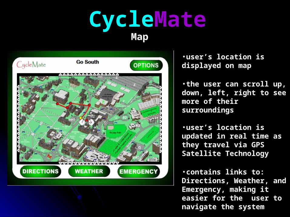
CycleCycleMateMateMap
•user’s location is displayed on map
•the user can scroll up, down, left, right to see more of their surroundings
•user’s location is updated in real time as they travel via GPS Satellite Technology
•contains links to: Directions, Weather, and Emergency, making it easier for the user to navigate the system

CycleCycleMateMate
•user chooses from a list of preloaded destinations in the College Park area
•when user presses the Calculate Route button, it will compute the shortest route from the user’s current location to the destination, and show it on the map.
Directions

CycleCycleMateMateWeatherWeather
•weather information is obtained from Yahoo’s XML weather RSS feed
•Shows the date, current temperature, and current weather conditions
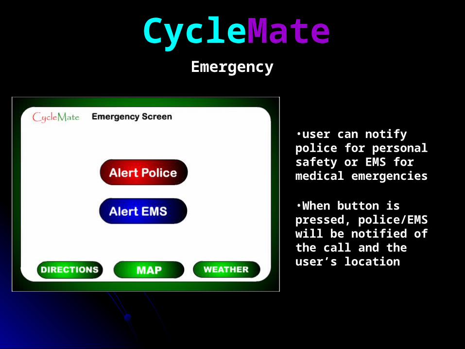
CycleCycleMateMateEmergencyEmergency
•user can notify police for personal safety or EMS for medical emergencies
•When button is pressed, police/EMS will be notified of the call and the user’s location
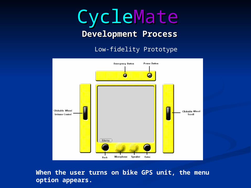
CycleCycleMateMateDevelopment ProcessDevelopment Process
When the user turns on bike GPS unit, the menu option appears.
Low-fidelity Prototype
CycleCycleMateMate
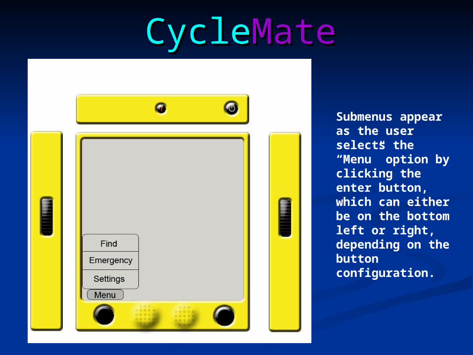
Submenus appear as the user selects the “Menu” option by clicking the enter button, which can either be on the bottom left or right, depending on the button configuration.
CycleCycleMateMate
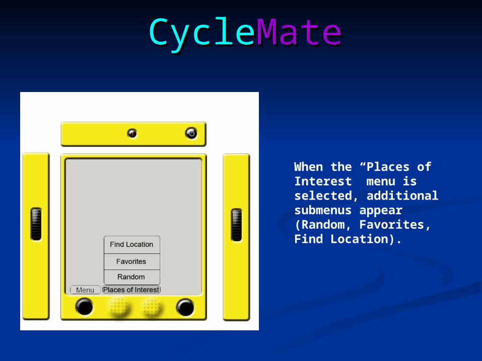
When the “Places of Interest” menu is selected, additional submenus appear (Random, Favorites, Find Location).
CycleCycleMateMate
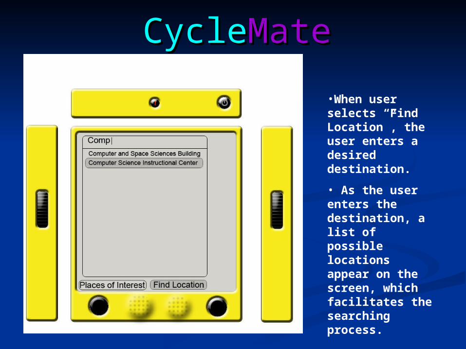
•When user selects “Find Location”, the user enters a desired destination.
• As the user enters the destination, a list of possible locations appear on the screen, which facilitates the searching process.

CycleCycleMateMateHi-Fidelity Prototype
Changes from low-fidelity prototype
•After a few tests, we realized that the previous menu was not efficient.
•We redesigned the main menu in a broad and shallow style, as opposed to a deep and narrow
•We also added “Map” and “Weather” options.
•We changed “Find” to “Directions” to make it more clear to the user
CycleCycleMateMate
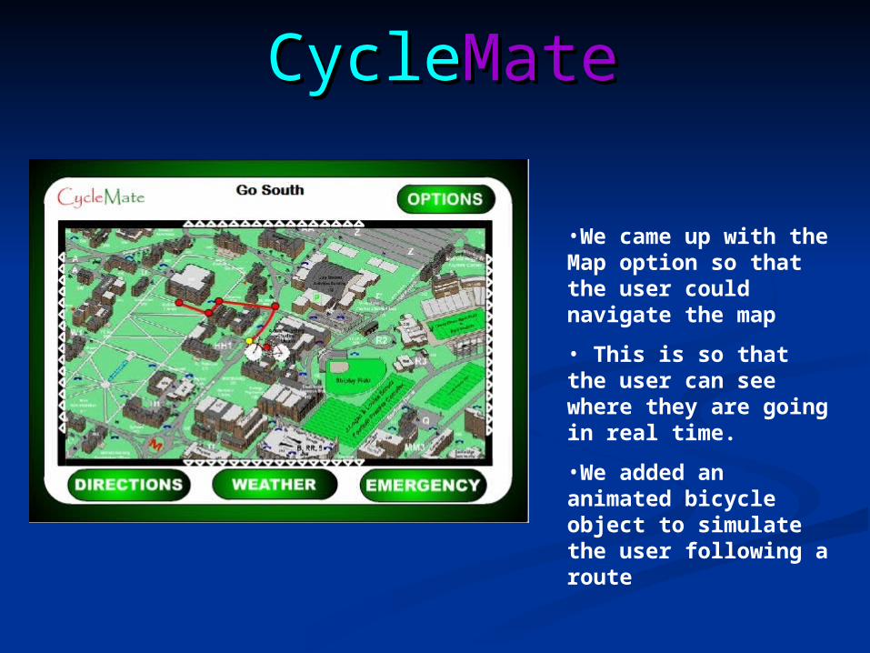
•We came up with the Map option so that the user could navigate the map
• This is so that the user can see where they are going in real time.
•We added an animated bicycle object to simulate the user following a route
CycleCycleMateMate
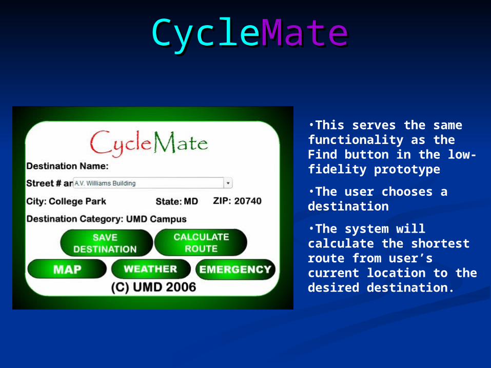
•This serves the same functionality as the Find button in the low-fidelity prototype
•The user chooses a destination
•The system will calculate the shortest route from user’s current location to the desired destination.

CycleCycleMateMate
We added a Weather screen so that the user could get up-to-date information on the weather, in terms of temperature and current weather conditions
CycleCycleMateMate
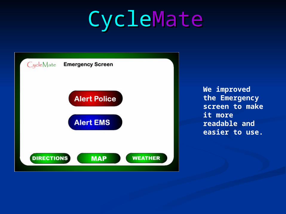
We improved the Emergency screen to make it more readable and easier to use.

CycleCycleMateMateDemo
GO

CycleCycleMateMateUsability Testing
•The subjects consisted of those who rode their bikes often on campus and those who rode only occasionally
•Before beginning each test, we informed each user about privacy and consent issues
•They had to sign a form indicating that they volunteered to be tested on their own free will, that they knew ahead of time which tasks to complete, and that they could withdraw from the usability test at any time
CycleCycleMateMate
•We gave users an introduction to our bike GPS system, giving an overview of what it does, what our intent was, and what tasks to complete.
•This was done so that the user knew ahead of time what to expect. Since this was not an actual, concrete device and there was no physical bike to test the system on, we had to use an alternative way to mimic an actual GPS system. We used random hypothetical starting points instead of using a GPS to pinpoint the user’s actual location.

CycleCycleMateMate
•The users were given a series of six questions to get an idea of the types of users testing our bike GPS system.
•We asked their gender, if they have a disability, how often they ride their bike, what they use their bicycle for, and which on-road factor is most important for bike riders.

CycleCycleMateMate
•The question “How often do you ride your bicycle in a week” helped us understand the needs of frequent bike riders. It also gives us insight on which functions certain users prefer
•We wanted a wide range of bicyclists so that we could the functionality of system was more universal. Those who rarely rode their bike would provide different suggestions than those who regularly rode their bike. This gives us a wider perspective on what users would like in the system.
•We had the same intention for the question “What do you mostly use bicycles for?” This helps us determine which types of users need certain functions. Those who ride their bikes to get from one class to another may desire capabilities different from those who ride their bike from campus and to the local stores.
CycleCycleMateMate
•The question asks “What do you think is the most important on-road factor for bicycle riders? Traffic information or weather information or emergency handling?”
•This question helps us determine which capability is most important and needs to be focused on the most.
CycleCycleMateMate
A University of Maryland student has a group meeting in the Engineering library at 4:00 PM. However, he has an English class in Susquehanna Hall that lets out at 3:50 PM. To arrive on time for his meeting, he would like to ride his bike across campus. Being an English major, he has never had a class near the Engineering building and thus has only a vague idea as to where it is located. He would like to obtain directions for the quickest route to his destination.
While riding along a path behind the University View apartment complex, a biker tries to avoid a pedestrian and, in the process, collides with a tree and slightly fractures his arm. As his injuries are not that severe, he does not wish to call for an ambulance but instead would like to bike to the nearest medical center or hospital. He would like to obtain directions to this
center.
Sample Tasks
CycleCycleMateMate
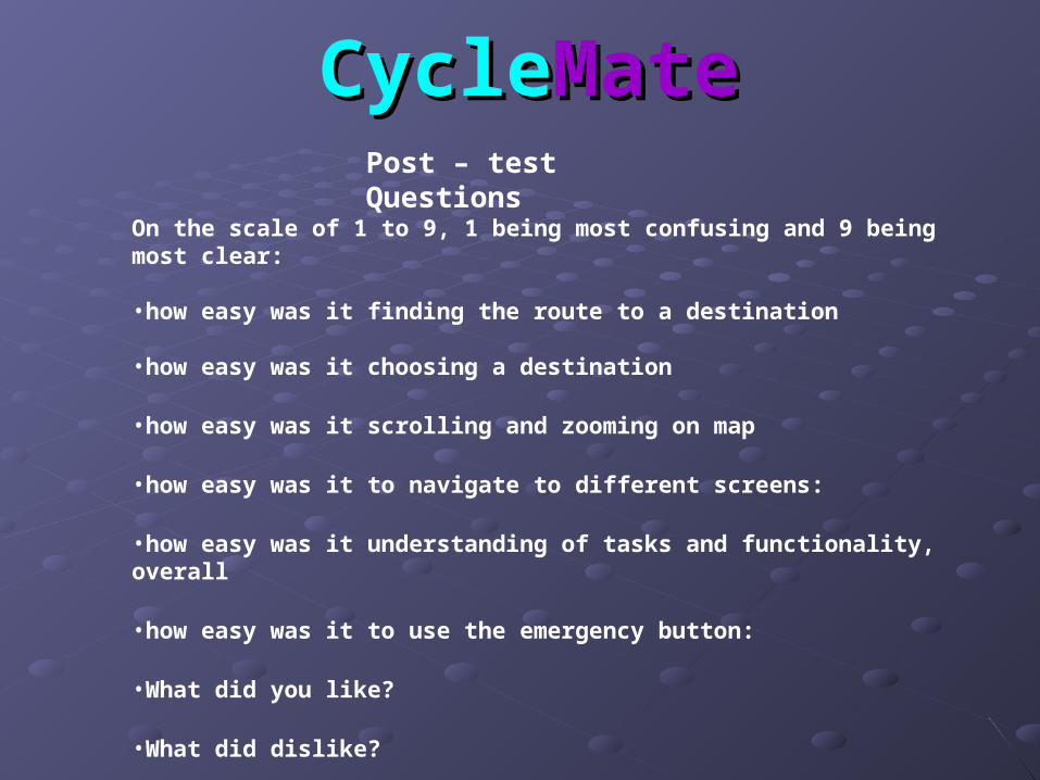
On the scale of 1 to 9, 1 being most confusing and 9 being most clear:
•how easy was it finding the route to a destination
•how easy was it choosing a destination
•how easy was it scrolling and zooming on map
•how easy was it to navigate to different screens:
•how easy was it understanding of tasks and functionality, overall
•how easy was it to use the emergency button:
•What did you like?
•What did dislike?
•What additional features would you like to see?
Post – test Questions
CycleCycleMateMateTest Subjects
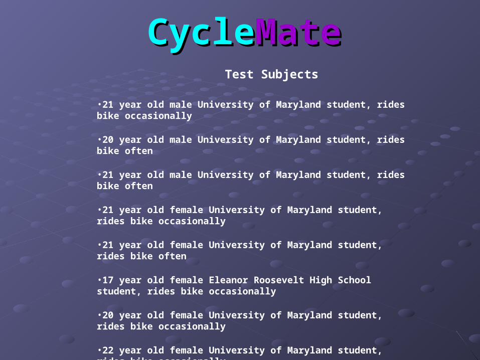
•21 year old male University of Maryland student, rides bike occasionally
•20 year old male University of Maryland student, rides bike often
•21 year old male University of Maryland student, rides bike often
•21 year old female University of Maryland student, rides bike occasionally
•21 year old female University of Maryland student, rides bike often
•17 year old female Eleanor Roosevelt High School student, rides bike occasionally
•20 year old female University of Maryland student, rides bike occasionally
•22 year old female University of Maryland student, rides bike occasionally
CycleCycleMateMate
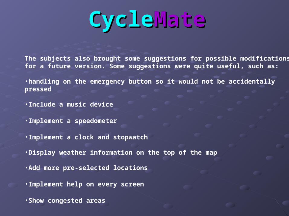
The subjects also brought some suggestions for possible modifications for a future version. Some suggestions were quite useful, such as:
•handling on the emergency button so it would not be accidentally pressed
•Include a music device
•Implement a speedometer
•Implement a clock and stopwatch
•Display weather information on the top of the map
•Add more pre-selected locations
•Implement help on every screen
•Show congested areas

CycleCycleMateMate
In addition to what was suggested, we want to:
•Expand the map to be nationwide
•Add a speaker so the GPS can provide audio instructions to the user
•Add Wi-Fi ability so it can access the Internet
Future Work