d4.7 – report on end user requirements - h2020 eu project. · kindra report on end user...
TRANSCRIPT

KINDRA REPORT ON END USER REQUIREMENTS Ref: KINDRA D4-7_vA
1 | P a g e
KINDRA DELIVERABLE 4.7
REPORT ON END USER REQUIREMENTS
Summary:
This deliverable summarises the needs and requirements of potential project end-
users. Task was carried out via an online survey and work also included the
identification of potential project stakeholders and the development of a
corresponding database that could be used later for making contacts. The survey,
realized by the Google Survey tool included five groups of questions; 161 responses
received, starting from a mailing list of about 650 contacts (obtaining about 25% of
replies). Results confirmed the interest on the activities previewed in the KINDRA
project, giving information useful for a fruitful development of the project, with
significant consequences on WP1, WP2 and WP3.
Author:
Isabel Fernandez, Executive Director, European Federation of Geologists
Project acronym: KINDRA
Project title: Knowledge Inventory for hydrogeology research
Grant Agreement number: 642047
Call identifier: H2020-WATER-2014-one-stage
Topic: WATER-4a-2014
Start date of the project: 01/01/2015
Duration: 36 months
Website: www.kindraproject.eu
This report has been produced with financial support from the European Union’s Horizon
2020 research and innovation programme under grant agreement No 642047”.
The contents of this report are the sole responsibility of the KINDRA Consortium and can
under no circumstances be regarded as reflecting the position of the European Union.
The Executive Agency for Small and Medium-sized Enterprises (EASME) is not
responsible for any use that may be made of the information it contains.
KINDRA REPORT ON END USER REQUIREMENTS Ref: KINDRA D4-7_vA
3 | P a g e
Table of content
Abbreviations page 4
1. Introduction page 5
2. Survey population page 6
3. KINDRA database improvement page 7
4. KINDRA end user questionnaire page 8
5. Conclusions page 19
Annex 1: List of organizations participating in the survey page 21
Annex 2: Classification system used by participants page 23
Annex 3: Survey on end-user requirements: screenshot page 25

KINDRA REPORT ON END USER REQUIREMENTS Ref: KINDRA D4-7_vA
4 | P a g e
Abbreviations
CIS WG-C CIS Working Group Groundwater DoW Description of Work ECHN Early Career Hydrogeologist Network EFG European Federation of Geologists EIP on Water European Innovation Partnership on Water GWP Global Water Partnership ICT4water Cluster of ICT and water management projects JPE Joint Panel of Experts IAH International Association of Hydrogeologists WSSTP Water supply and sanitation Technology Platform

KINDRA REPORT ON END USER REQUIREMENTS Ref: KINDRA D4-7_vA
5 | P a g e
1. Introduction
This deliverable, D4.7 assesses the needs and requirements of potential end-users of
KINDRA. The Grant Agreement requires this deliverable at the early phase of the project (M6)
in order to ensure an impact throughout the whole implementation.
The work under this task (Task 4.3 of WP4) included:
i) the identification of potential project stakeholders and the development of a
corresponding database that will be used later for project dissemination activities;
ii) creating a suitable method (a survey) to assess their requirements in the context of
KINDRA and
iii) compiling end-user requirements into a report with the objective to finalise the initial
approach.
The stakeholder groups initially included in the KINDRA contact database were as follows:
CIS-WG C Groundwater: the WG is a technical institution of the EC and its activity is relevant to professionals, public authorities and the academic world. EFG is member of this WG;
EuroGeoSurveys Water Resources Expert Group;
European Federation of Geologists Panel of Experts on Hydrogeology
Attendants of the Hydrogeology Workshop on European Water Policy: Challenges for Hydrogeologists, organized by EFG, 22-23 November 2013 in Brussels;
EFG’s contacts through geological associations;
IAH - International Association of Hydrogeologists: European National Chapter contacts and ECHN (Early Career Hydrogeologist Network);
National Association delegates of EFG;
EFG’s contacts through other National Associations;
KINDRA project network: relevant EU projects;
We reviewed the different contact lists to avoid double use of the same contact. In total, the
KINDRA database used for the survey included 644 contacts. The database could filter
information by country, stakeholder group and area of professional interest. This improves
communication and the data base; This function enables KINDRA to identify main groups of
interest and to establish regular communication via tailored messages during the project
period. All persons that responded to the questionnaire will receive a summary of the results
of the survey.
The main mean of communication to reach out potential stakeholders was via a google survey
link sent by a personalised email to each contact. The survey /calls for participation in the
survey were also made available via a serious of newsletters of relevant organisations and via
social media such as Twitter and Facebook (see Annex 3).
The survey started with the introduction of KINDRA’s project objectives followed by a short
description of the related task, the survey itself (Annex 3). The questionnaire included three
main set of questions as follows:

KINDRA REPORT ON END USER REQUIREMENTS Ref: KINDRA D4-7_vA
6 | P a g e
- three questions related to personal data to further refine the project contact
database;
- end users questionnaire: ten questions related to key project outputs (of WP1, WP2
and WP3);
- and communication information.
As a surveying platform Google Forms were used. The raw survey data and the automatically
generated summary can be found at the following links:
Survey Results:
https://docs.google.com/spreadsheets/d/1KZw0UF-
FslatRjx1gFXdjsFEuslFEmLq0noP3IOAtzU/edit?usp=sharing
Automatically generated summary of the responses:
https://docs.google.com/forms/d/1ToDcmZ_ZYKpjBNfr2zxvgHahI4L3Rcw0nPt5e77sokw/vie
wanalytics
This report compiles the end-user requirements based on the responses received. The
objective is to improve and finalise the initial approach of KINDRA WP2 and WP3.
2. Survey population
In total, we received 161 responses to the survey during the period 20th of May and 24th of
June .2015. Figure 1 shows the dynamics of the daily responses. The main peaks correspond
to the first deadline related to the first shipment sent via personal emails, while the second
peak corresponds to second shipping and second deadline, disseminated via newsletters.
Figure 1: Dynamics of daily responses (Number of responses for period: 20th of May to 24th
of June 2015).
Information on the survey/Call for participation in the survey was published in the following
newsletters:
EFG Newsletter: GeoNews, April? and June 2015;
IAH newsletter: May 2015;
EIP on Water Newsletter;
EFG National Association member’s newsletter.

KINDRA REPORT ON END USER REQUIREMENTS Ref: KINDRA D4-7_vA
7 | P a g e
3. KINDRA database improvement
The information collected at the end of the survey in a form of questions on personal data and
communication information will be used to improve and complete the KINDRA contact data
base. As a result, the project contact database has 644 members at the moment (as of end of
July 2015), from which 70 new members directly derives from the end-user survey.
We requested information about:
Organizations: 132 have participated in the survey (full list can be found in see Annex 1 of
the deliverable);
Country: the survey responses originate from 22 different countries. Figure 2 shows the
number of participants by country;
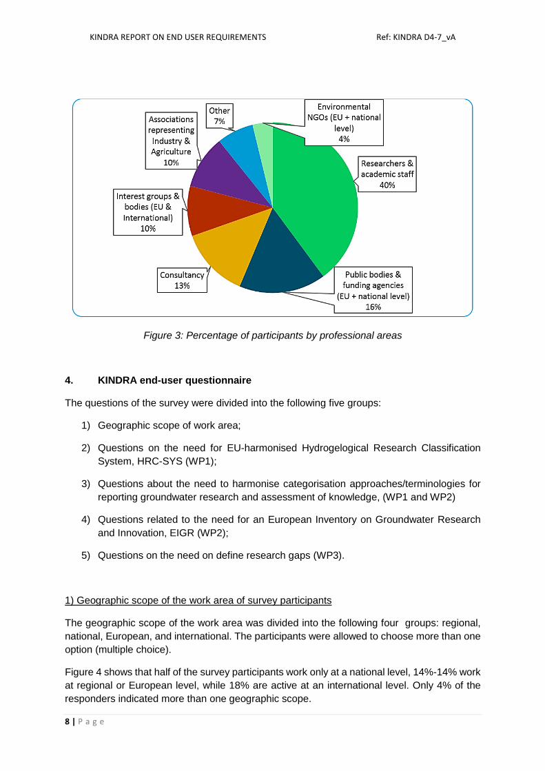
Professional area: this has been divided among the six main project stakeholder groups,
as identified by the DoW of KINDRA These are:
1. Interest groups & bodies (EU & International level)
2. Researchers & academic staff
3. Associations representing Industry & Agriculture
4. Environmental NGOs (EU + national level)
5. Public bodies & funding agencies (EU + national level)
6. Other (including Consultancy)
Figure 3 indicates the percentage of participants by professional areas.
Figure 2: Countries represented in the survey (received answers)
0 5 10 15 20 25 30 35 40 45 50 55
UKHungaryBelgium
SerbiaPoland
SpainFrance
DenmarkGreece
ItalySlovakiaSloveniaCanada
SwitzerlandAustria
BulgariaCroatia
GermanyNetherlands
PortugalUkraine
Czech RepublicEstoniaIcelandIrelandKosovo
LithuaniaMalta
SwedenTurkey
United States
KINDRA REPORT ON END USER REQUIREMENTS Ref: KINDRA D4-7_vA
8 | P a g e
Figure 3: Percentage of participants by professional areas
4. KINDRA end-user questionnaire
The questions of the survey were divided into the following five groups:
1) Geographic scope of work area;
2) Questions on the need for EU-harmonised Hydrogelogical Research Classification
System, HRC-SYS (WP1);
3) Questions about the need to harmonise categorisation approaches/terminologies for
reporting groundwater research and assessment of knowledge, (WP1 and WP2)
4) Questions related to the need for an European Inventory on Groundwater Research
and Innovation, EIGR (WP2);
5) Questions on the need on define research gaps (WP3).
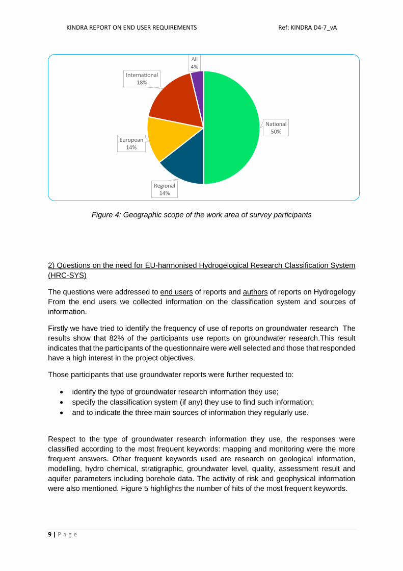
1) Geographic scope of the work area of survey participants
The geographic scope of the work area was divided into the following four groups: regional,
national, European, and international. The participants were allowed to choose more than one
option (multiple choice).
Figure 4 shows that half of the survey participants work only at a national level, 14%-14% work
at regional or European level, while 18% are active at an international level. Only 4% of the
responders indicated more than one geographic scope.
KINDRA REPORT ON END USER REQUIREMENTS Ref: KINDRA D4-7_vA
9 | P a g e
Figure 4: Geographic scope of the work area of survey participants
2) Questions on the need for EU-harmonised Hydrogelogical Research Classification System
(HRC-SYS)
The questions were addressed to end users of reports and authors of reports on Hydrogelogy
From the end users we collected information on the classification system and sources of
information.
Firstly we have tried to identify the frequency of use of reports on groundwater research The
results show that 82% of the participants use reports on groundwater research.This result
indicates that the participants of the questionnaire were well selected and those that responded
have a high interest in the project objectives.
Those participants that use groundwater reports were further requested to:
identify the type of groundwater research information they use;
specify the classification system (if any) they use to find such information;
and to indicate the three main sources of information they regularly use.
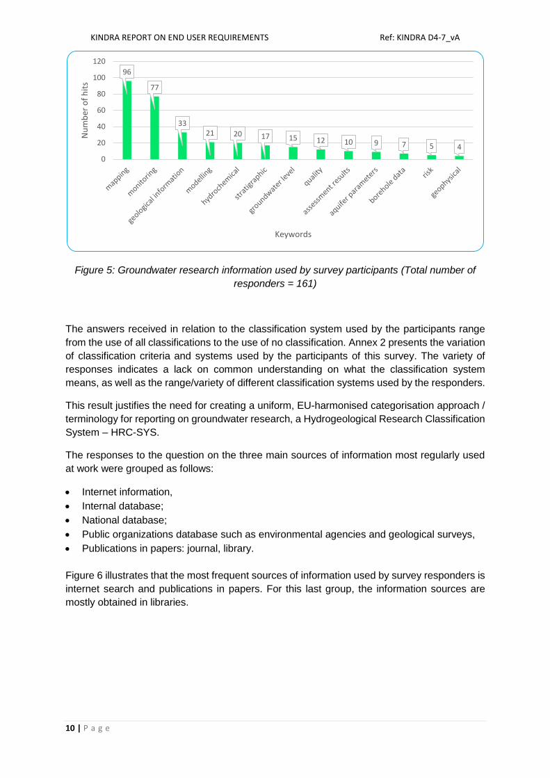
Respect to the type of groundwater research information they use, the responses were
classified according to the most frequent keywords: mapping and monitoring were the more
frequent answers. Other frequent keywords used are research on geological information,
modelling, hydro chemical, stratigraphic, groundwater level, quality, assessment result and
aquifer parameters including borehole data. The activity of risk and geophysical information
were also mentioned. Figure 5 highlights the number of hits of the most frequent keywords.
National50%
Regional14%
European14%
International18%
All4%
KINDRA REPORT ON END USER REQUIREMENTS Ref: KINDRA D4-7_vA
10 | P a g e
Figure 5: Groundwater research information used by survey participants (Total number of
responders = 161)
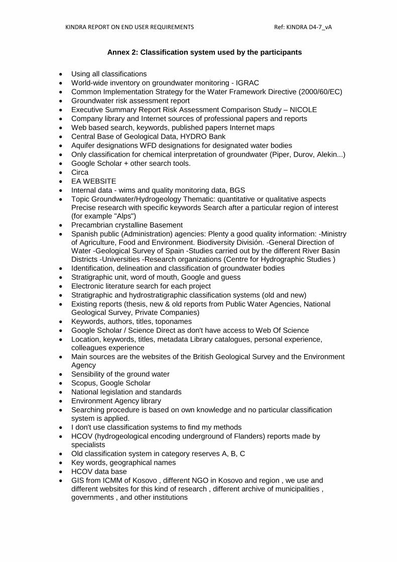
The answers received in relation to the classification system used by the participants range
from the use of all classifications to the use of no classification. Annex 2 presents the variation
of classification criteria and systems used by the participants of this survey. The variety of
responses indicates a lack on common understanding on what the classification system
means, as well as the range/variety of different classification systems used by the responders.
This result justifies the need for creating a uniform, EU-harmonised categorisation approach /
terminology for reporting on groundwater research, a Hydrogeological Research Classification
System – HRC-SYS.
The responses to the question on the three main sources of information most regularly used
at work were grouped as follows:
Internet information,
Internal database;
National database;
Public organizations database such as environmental agencies and geological surveys,
Publications in papers: journal, library.
Figure 6 illustrates that the most frequent sources of information used by survey responders is
internet search and publications in papers. For this last group, the information sources are
mostly obtained in libraries.
96
77
3321 20 17 15 12 10 9 7 5 4
0
20
40
60
80
100
120
Nu
mb
er o
f h
its
Keywords

KINDRA REPORT ON END USER REQUIREMENTS Ref: KINDRA D4-7_vA
11 | P a g e
Figure 6: Source of information used by survey participants
We asked if a more harmonised categorisation approach/terminology for reporting
groundwater research could improve the accessibility of this information at the work. The result
of the questionnaire illustrates that 88% of the participants are in favour to have a more
harmonised categorisation approach/terminology for reporting groundwater research.
It is important to draw the attention to the opinion of those, 12% of the survey responders, who
disagree with this approach. We find 6 groups of arguments, these arguments provide
important insights for the KINDRA project (WP1):
I. The main argument points against European classifications:
“It would also be useful to upgrade the EIP Water Thesaurus, based on the EEA Water
Thesaurus”;
“Working intensively in the field of hydrogeology for many years and for very different
topics and many clients state of the art based on the experiences is relatively clear and
topics needed as a background can be find relatively easily if data sources are
available, however this is not always the case. Such classification can be useful for
people not directly from the field of hydrogeology”;
“What we see as problem is hydrogeological terminology, at national level and also
internationally (English), not for the reporting research results but for the
communication between professionals”;
“In last ten years since the implementation of WFD intrusion of terminology from legal
acts change perception of certain basic hydrogeological terms and cause confusion to
professionals not directly involved into WFD activities. Recent discussions at national
level have shown that for certain important terms there is no agreement”.
II. Responses against based on existing national classifications:
“UK on-line information is compliant with the EU groundwater directive”;
“Currently the information in Spain has an acceptable degree of categorization”;

KINDRA REPORT ON END USER REQUIREMENTS Ref: KINDRA D4-7_vA
12 | P a g e
III. Responses highlighting the difficulty to harmonize classification on Hydrogeology:
“Uniformity will never exist, all sources are interesting and it is better to know from the
starting point of research which type of information we are looking for”;
“Artificial harmonisation would seriously impair the conceptual understanding of the
interaction of man, climate, surface water, soil, drift and rock that is hydrogeology”; The
natural environment does not comprise a number of pigeon holes.
“Not necessarily.Such a system relies on people committing to use the system in a
consistent manner. There may also be language barriers to overcome”.
IV. Potential problems stressed by the participants:
“Many of the hydrogeological terms are likewise weak or inherently contradictory”;
“Very much oriented to the academic sector and not the private sector”;
“The scope of the research is too wide to systematise in the way suggested”;
“Hydrogeological interpretation is an art and a science and it is very easy to draw
incorrect conclusions if the context is not evident. This applies to opening up access to
data it is very easy to misinterpret”.
V. Proposals made by participants on potential solutions:
“A central place on the internet, where one can expect to find relevant reports”;
“The status of knowledge in each country is very different. Most important is the easy
access to georeferenced data which can then be combined with Remote sensing data
and Digital Elevation models which are all freely available from Internet”;
“The most important factor is knowing where to find the information, and having a
summary in English”;
“Work on access to stratigraphic records has been great but our experience in other
areas has been less positive. One area we have great challenges with is the different
forms of reporting of water quality data. If the resource is put into uniformity and
standardisation and cleaning of historic data sets that would be great but it is the
context of the monitoring point that then has to be drilled into. The cross-linking of data
sets to sample point location - construction - sampling methodology - point usage is a
challenge and something we often have to unpick in order to evaluate the quality of the
data. Some gauge of database quality is always essential”.
VI. Finally, a limited number of participants doubt on the need a harmonization system in
the time of google search.
We also try to identify the % of producer of reports on groundwater research between the
respondent population. 62% are involved in the production of reports on groundwater research
Those participants who answer positively to the question were further interviewed to indicate
the kind of groundwater research information they produce (e.g. mapping, monitoring, etc.).
The responses are classified by the most frequent keywords used. The majority of the
responses mentioned monitoringmapping, reports and assessment, and modelling as a main
“product of their research”(Figure 7).

KINDRA REPORT ON END USER REQUIREMENTS Ref: KINDRA D4-7_vA
13 | P a g e
Figure 7: Type of groundwater research information produced by the survey participants
(Total number of responders = 161)
3) Questions about the need to harmonise categorisation approaches/terminologies for
reporting groundwater research and assessment of knowledge, (WP1 and WP2)
The participants were requested to assess how useful an EU-harmonised categorisation
approach/terminology would be for reporting on groundwater research. The responses were
graded on a scale 1-5, where 1 was = not at all and 5 was = absolutely. Figure 8 indicates the
positive interest on the EU harmonised approach.
Figure 8: Assessment in the value of EU-harmonised categorisation approach/terminology for reporting on groundwater research
Participants were further invited to provide a reason(s) for their choice. The answers can be grouped as follows:
I. Facilitate the comparability between Europe, countries, regions, and stakeholders:
50
38 38
16
74
0
10
20
30
40
50
60
monitoring mapping reports,assessments
modelling hydrochemical groundwaterlevel
Nu
mb
er o
f h
its
KINDRA REPORT ON END USER REQUIREMENTS Ref: KINDRA D4-7_vA
14 | P a g e
“As there is no uniform categorisation approach/ terminology for reporting groundwater
research, it is very difficult to report and compare ongoing research activities, agendas
and strategies. A more integrated community of researchers and users extending
across disciplines, countries, organisations and sectors is urgently needed;”
“Harmonisation helps as long as legal requirements of the Community legislation
require. But should give a space for its further development;”
“S&T cooperation is also easier if harmonization is at an advanced state”;
“A harmonisation approach will save me considerable time in the search for the
required information”;
“Allows consistent interpretation”;
“We are still far away of a common international terminology, even within one language,
thus I would like to suggest at least an English one”;
“Enables comparability with regions with similar conditions”;
“To compare the results of research in different countries”;
“Possibility and facilitation of Internacional cooperation”;
“Harmonisation is important for cross-border, continental and global applications”;
“It could be definitely useful to have harmonised terminology, mainly for international
and transboundary cooperation”;
“Having harmonised information all over Europe should be mandatory”;
“Due to common understanding of interpretations within the EU”;
II. Facilitate cooperation between professionals
“It facilitates the opportunity to make contacts and develop cooperation”;
“It is very important for as Geologist - Hydrogeologist to communicate with the same
language which is harmonised categorisation terminology for reporting groundwater
research in region, and especially in Europe”;
III. Improve quality: standardization arguments
“It could help greatly for systematisation of data and meta data research”;
“Should be the only standardized approaches for geological study of subsoil, including
underground water”;
“I supposing that after EU-harmonizing categorization will be much easier to provide
necessary data for reporting in groundwater researching”;
“If we wish to compare and contrast data across regions we need to be confident we
are doing it in the same way and to similar standards”;
“Standardized approach would help a strict protocol would not”;
“The water management is a major issue, it should be based on data”;
“Easier way to find the data you are looking for”;
IV. Reduce confusion:
“It would reduce confusion among experts and general public on results and time
needed to find relevant information”;
“Availability of data and avoidance of confusion and loos of Knowledge”;

KINDRA REPORT ON END USER REQUIREMENTS Ref: KINDRA D4-7_vA
15 | P a g e
“The other, even more important, fact is that it may give a geologist an opportunity to
introspect the wider area through the same level of information”;
“To better share the information”;
“Unique categorisation and terminology would help in better understanding of various
problems and their solutions could be suggested from different experts from different
countries”.
V. Quantitative status assessment, data assessment:
“EU-harmonised categorisation approach/terminology is important in groundwater
quantitative status assessment process on national and EU level”;
“A harmonisation system or categorisation will not solve all problems but it would be
extremely useful to know that when you search in a particular category you got
everything in that category and you knew that all who used that category knew what it
meant”;
“From the point of geometry and hydraulic properties of (hydro)geological units there is
a need to harmonize interpretations, maps and models along the border with
neighbouring countries. At this stage interpretation, maps and models differ between
neighbouring countries which causes problems for project carried out in the border
regions”;
“It could be relevant to find more easily information about unpublished reports (grey
data) but also at EU level thesis about hydrogeology”;
“Consistency when reviewing information before applying”;
“This could help to have a more concrete idea about the causes, problems, terminology,
methodology and possible solutions”;
“Free and easy access to high quality data, which means data which can easily be
introduced, analyzed and further developed in a GIS”;
“Specially in Greece a harmonised categorisation will ensure the quality of the offered
services as well as the participation of geology in ground water research”.
VI. Avoid double work:
“It would be great to be able to get info on hydrogeological works and research just by
entering keywords. Now, it is lots of work and lots of spared time”;
“It would enhance accessibility and avoid double work, it is easier to identify gaps for
further research”;
“Improved visibility in coherent, consistent format Confidence that search results would
deliver focussed outputs”.
VII. Problems encountered:
“Even between agencies in Scotland there are different terminologies used, this
becomes particularly difficult when discussing GWDTEs where ecologists have
completely different view on 'groundwater'. Scale that up to Europe and it is even more
challenging”;
“I am not sure what a harmonized terminology should be...terminology is different in
each language? Streamline terminology - results and reports from different sources
KINDRA REPORT ON END USER REQUIREMENTS Ref: KINDRA D4-7_vA
16 | P a g e
have to be compared and converted due to different standards and terminology. This
loss of time can be avoided”;
“I think that the most important issue is the categorisation concerning each country as
an independent state. The reason is that the EU directive gives some major guidelines
but each country has different needs and has to be taken seriously under
consideration”.
VIII. Proposals for improvement:
“To be efficient while researching ground water means following rules, general ones
and specific ones, like - up to a certain point- performing a cooking recipe. You have to
define hydrogeological conditions, type of equipment and material to be used, the way
of using, the results control and interpretation and also the maintenance and training
conditions”;
“The categorization should therefore help in 1) better recognizing what groundwater
research is all about, 2) why it is so relevant for society, and 3) who is responsible for
what in sustainable use and effective protection of groundwater resources. It is also
important to highlight the diversity of groundwater resource types across Europe,
suggesting that monitoring practices and protection strategies have to be adapted
according to the prevalent environment (for example, alpine aquifers vs. alluvial plain
aquifers”.
We also requested to the participants it an ‘EU-wide assessment of existing practical and
scientific knowledge from hydrogeology research and innovation in Europe’ be relevant to the
work. The vast majority, 89% of the participants considered that it would be relevant for the
professional activity
Those responders who answered positively to the question were required to identify the most
relevant geographical levels) to their work (it was a multiple choice question). Results (Figure
9) show that the national level is the most relevant when assessing existing practical and
scientific knowledge from hydrogeology research and innovation (around two-third of the
responders ticked this option as relevant). The second most relevant level according to the
participants is the European level. Regional and International levels are also considered
relevant.

KINDRA REPORT ON END USER REQUIREMENTS Ref: KINDRA D4-7_vA
17 | P a g e
Figure 9: Most relevant geographical level for assessing existing practical and scientific
knowledge from hydrogeology research and innovation (total number of responders = 161).
4) Questions on the need for an European Inventory on Groundwater Research and
Innovation (EIGR)
The participants were requested to answer how useful would the European Inventory of
Groundwater Research and Innovation (EIGR) be for they work. The answers to this question
(Figure 10) show a very relevant interest in the EIGR: 58% of the respondents considered
EIGR as relevant/very relevant (marked 4-5 on a scale), 27.4% as neutral (scale 3) and only
14.7% as not or less relevant (marked 1-2 on scale).
Figure 10: responders’ interest towards EIGR
75
64
101
54
0 20 40 60 80 100 120
EU
International
National
Regional
Number of hits

KINDRA REPORT ON END USER REQUIREMENTS Ref: KINDRA D4-7_vA
18 | P a g e
We also requested to the participants to indicate how they would like to access such
information. This aimed at identifying the most relevant ways to access the information in the
inventory, WP3 activity (Figure 11). It was a multiple choice question and the following pre-
defined options were provided: “Through a catalogue”; “Key word search”; “Via maps”; “By
geographical name”, and “Other”.
Figure 11: Preferred ways to access information in the EIGR (Total number of responders =
161)
Converting these responses into percentages, it reveals that the access “via maps” was
selected by more than 70% of the participants in this survey. “Using key words” is also very
important, 68.6%. 39% of the respondents stated that they accessed information “through a
catalogue”, while 33% used “geographical names”. Only 10% selected “Other” ways, meaning
that these four options cover the majority of the expectative for the inventory.
5) Questions on the need on define research gaps
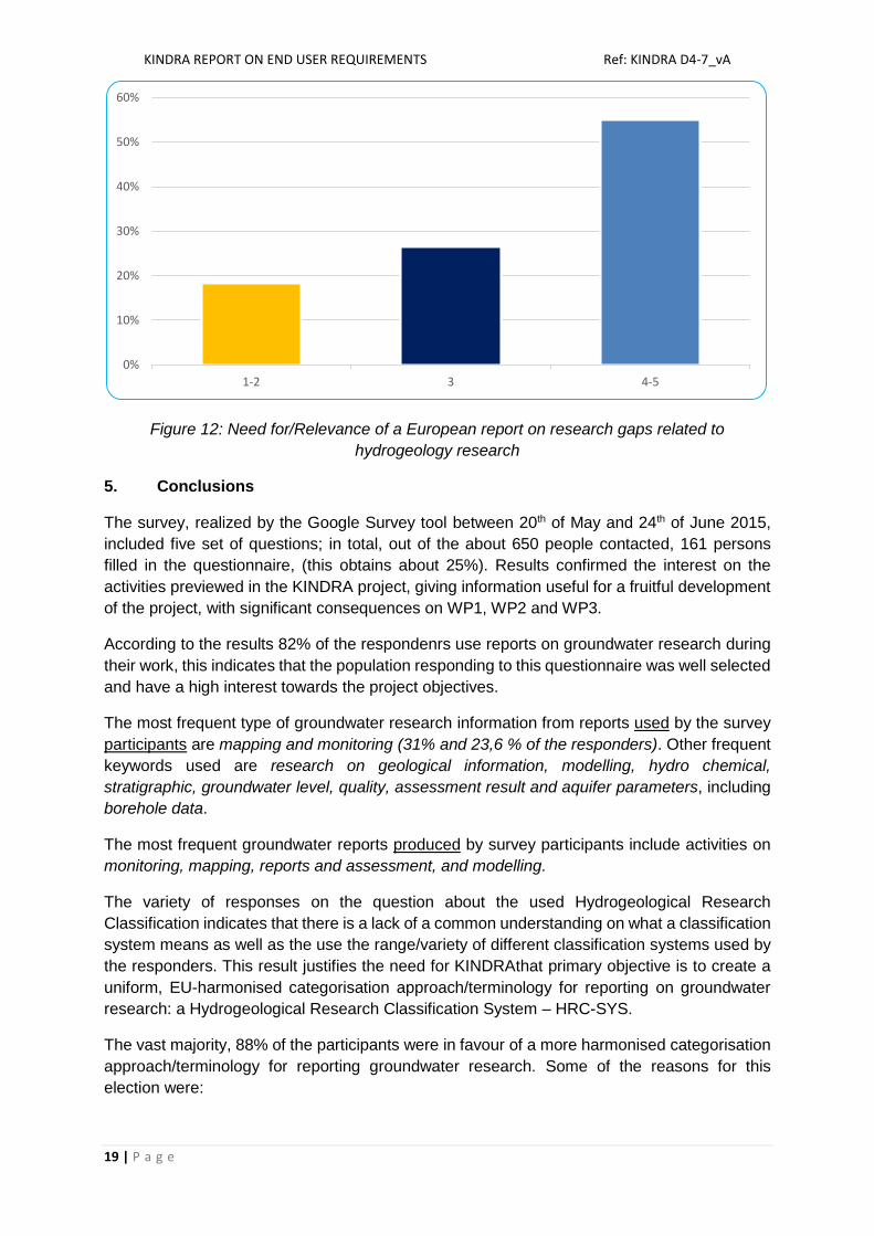
The participants were requested to answer how useful would a European report on research
gaps related to hydrogeology research be for they work, indicate on a scale 1-5, where 1 = not
at all and 5 = absolutely” (Figure 12). If we classify the answers 4 and 5 as positive replies,
55% of the participants considered that a report on research gaps is useful, while 26.6% gave
neutral reply (marked 3 on a scale), and only 18.4 % considered that such a report is not or
less needed (marked 1-2 on a scale)
17
107
110
52
61
0 20 40 60 80 100 120
Other
By key words
Via maps
By geographical names
Through a catalogue
Number of hits
KINDRA REPORT ON END USER REQUIREMENTS Ref: KINDRA D4-7_vA
19 | P a g e
Figure 12: Need for/Relevance of a European report on research gaps related to
hydrogeology research
5. Conclusions
The survey, realized by the Google Survey tool between 20th of May and 24th of June 2015,
included five set of questions; in total, out of the about 650 people contacted, 161 persons
filled in the questionnaire, (this obtains about 25%). Results confirmed the interest on the
activities previewed in the KINDRA project, giving information useful for a fruitful development
of the project, with significant consequences on WP1, WP2 and WP3.
According to the results 82% of the respondenrs use reports on groundwater research during
their work, this indicates that the population responding to this questionnaire was well selected
and have a high interest towards the project objectives.
The most frequent type of groundwater research information from reports used by the survey
participants are mapping and monitoring (31% and 23,6 % of the responders). Other frequent
keywords used are research on geological information, modelling, hydro chemical,
stratigraphic, groundwater level, quality, assessment result and aquifer parameters, including
borehole data.
The most frequent groundwater reports produced by survey participants include activities on
monitoring, mapping, reports and assessment, and modelling.
The variety of responses on the question about the used Hydrogeological Research
Classification indicates that there is a lack of a common understanding on what a classification
system means as well as the use the range/variety of different classification systems used by
the responders. This result justifies the need for KINDRAthat primary objective is to create a
uniform, EU-harmonised categorisation approach/terminology for reporting on groundwater
research: a Hydrogeological Research Classification System – HRC-SYS.
The vast majority, 88% of the participants were in favour of a more harmonised categorisation
approach/terminology for reporting groundwater research. Some of the reasons for this
election were:
0%
10%
20%
30%
40%
50%
60%
1-2 3 4-5

KINDRA REPORT ON END USER REQUIREMENTS Ref: KINDRA D4-7_vA
20 | P a g e
• Comparability between Europe, countries, regions, and different stakeholders groups; • Cooperation between professionals; • Standardisation arguments; • Reducing confusion; • Quantitative status assessment, data assess; • Avoiding double work;
Immense proportion, 89% of the respondents were convinced that the EU-wide assessment
of existing practical and scientific knowledge from hydrogeology research and innovation in
Europe’ would be relevant for their professional activity.
58% of the participants would consider a European Inventory of Groundwater Research and
Innovation (EIGR) useful for their work. As far as accessing information in the inventory more
than 70% of the participants selected “via maps”. “Using key words” is also very significant,
with 68.6%. 39% of the participants stated that they would like to access “through a catalogue”,
while 33% used “geographical names”. Only 10% selected “Others”, meaning that these four
options cover the majority of the expectations for the inventory.
55% of the survey responders consider a European report on research gaps related to
hydrogeology research (main outcome of WP3) relevant/useful for their work.
In order to improve & refine the communication towards the selected stakeholder groups,
participants of the survey were interviewed (asked to grade the main project results on a scale
1-5 (where 1 = not at all and 5 = absolutely) which outcome of KINDRA would be the most
relevant for them . As a result, the different stakeholder groups and individuals will be sent
tailored messages in the future. (Figure 13 shows the detailed analysis).
The information and knowledge obtained by this end-user's survey will influence the
implementation of all main technical WPs (such as as WP1 - see D1.2, WP2 and WP3) and
will be seriously taken into account in order to achieve the best results possible.
Figure 13: Information follow-up (% of the participants where Total = 161)
0%
10%
20%
30%
40%
50%
60%
70%
80%
1-2 3 4-5
The harmonised methodology for reporting groundwater research:
The assessment of knowledge – synthesis of country reports:
The inventory/EIGR:
Research gaps and recommendations:

KINDRA REPORT ON END USER REQUIREMENTS Ref: KINDRA D4-7_vA
21 | P a g e
Annex 1: Organisations participated in the survey
- AGG - Amec Foster Wheeler - Applied Geology - AQUASSISTANCE & GsF - AquaTerra.pl - Aristotle University of Thessaloniki - Associação Portuguesa de Geólogos - Atkins Ltd. - Atmos Consulting - BRGM - Imperial College, London - CEMEX - Citizen - City of Gothenburg, City planning
office - Comité Français d'Hydrogéologie - Consultant - CRIRSCO - Croatian Geological Survey - Czech Geological Survey - CSIC - Defra - DELTARES - Earth Science Partnership - EIP Water - EnviroCentre Ltd. - Environment Agency - Environment and Water Agency.
Regional Ministry of Environment and Spatial Planning
- Environmental Agency of Iceland - Environmental protection Agency
Canton Valais - Eötvös Loránd University - EREF - EurEau - European Federation of Geologists - Faculdade Ciências Lisboa - Faculty of Mining and Geology,
University of Belgrade - Fracture Systems Ltd - Geenwich University - Geological and Geophysical Institute
of Hungary - Geological Survey of Serbia - Geological Survey of Slovenia - Geologische Bundesanstalt - Geolys - Geotechnics Limited - Gesellschaft für Geologie mbHGmbH - GEUS - Ghent University
- Govermental - Graz University of Technology - Hungarian Geological Society - Hungarian Office for Mining and
Geology - I2M Associates LL - IAH Irish group - IGME, Geological Survey of Spain - Instit Géotechnique SA - Instituto Geológico y Minero de
España - Jagiellonian University - JH Groundwater Ltd - Klohn Crippen Berger - LLWR Ltd - Magnox - MEERI PAS - Mineral and Energy Economy
Research Institute of Polish Academy of Sciences
- Ministry of Environment and Water, Bulgaria
- Ministry of Interior, Hungary - Ministry of Mining and Energy,
Serbia - MIRO - Mission Risques Naturels - Mott MacDonald - MWH - National Research Council of Italy - Natural Resources Wales - Norfolk County Council - Nottingham Trent - OneGeology - Opus international - Orio consultancy - OVAM - Parsons Brinckerhoff - PAS MEERI - Polish Academy of Sciences - RSK - RWC "Hidromorava" JVC - Scharek and Co. - Serbian Geological Society - SEWCU - Skapto bvba - Slovak Water Research Institute - Slovenian Environment Agency - Spanish Ministry of Agriculture, Food
and Environment - Spanish Official Professional
Association of Geologists

KINDRA REPORT ON END USER REQUIREMENTS Ref: KINDRA D4-7_vA
2 | P a g e
- SPW - Geological Survey of Slovak Republic - Suleyman Demirel University - Swiss Humanitarian Aid - University of Szeged - SZIE UNIVERSITY - TerraConsult Ltd - TNO Geological Survey of the
Netherlands - UGent - Union geologists Ukraine - Università degli Studi di Milano - Università degli Studi Federico II di
Napoli - Université Lille1 - University of Ljubljana, Department of
Geology, Natural Sciences and Engineering Faculty
- University in Bratislava, Dept. of Hydrogeology, Faculty of Natural Sciences, Comenius.
- University of Belgrade, Faculty of Mining and Geology, Department of Hydrogeology
- University of Debrecen - University of Liege, Hydrogeology
and Environmental Geology - University of Mining and Geology "St.
Ivan Rilski" - University of Miskolc - University of Nottingham - University of West Hungary,
Szombathely Campus - VDC Milieu - Vrije Universiteit Brussem - Water company - Water Harmony: "Vandens
harmonija"
- Water research institute - WorleyParsons - Wroclaw University of Technology - WSP - WSP/PB
KINDRA REPORT ON END USER REQUIREMENTS Ref: KINDRA D4-7_vA
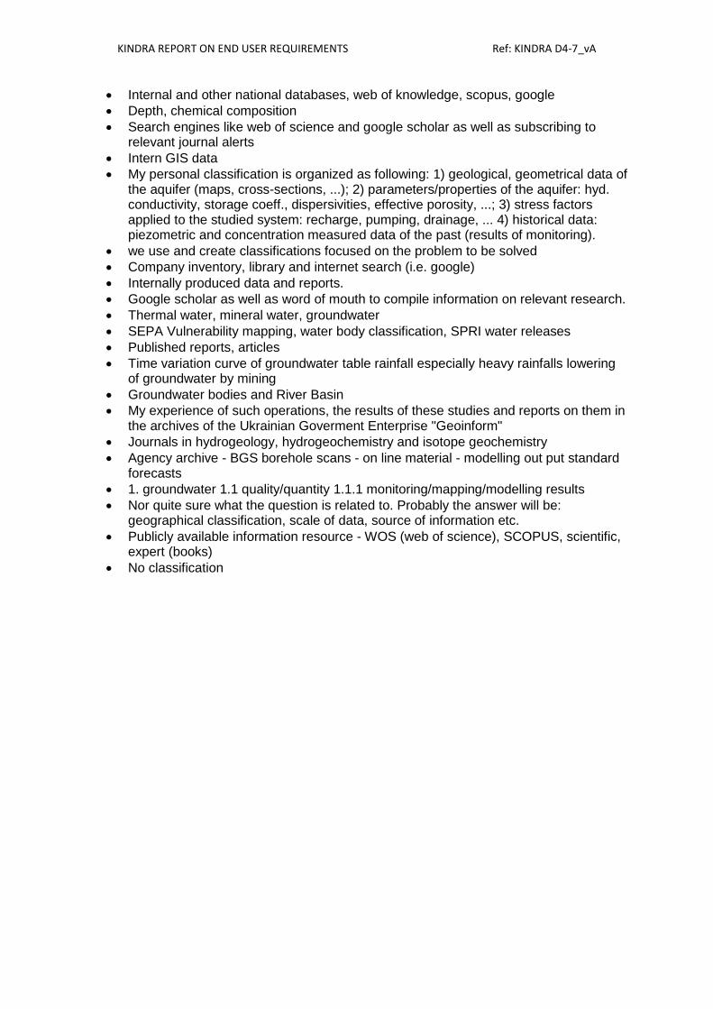
Annex 2: Classification system used by the participants
Using all classifications
World-wide inventory on groundwater monitoring - IGRAC
Common Implementation Strategy for the Water Framework Directive (2000/60/EC)
Groundwater risk assessment report
Executive Summary Report Risk Assessment Comparison Study – NICOLE
Company library and Internet sources of professional papers and reports
Web based search, keywords, published papers Internet maps
Central Base of Geological Data, HYDRO Bank
Aquifer designations WFD designations for designated water bodies
Only classification for chemical interpretation of groundwater (Piper, Durov, Alekin...)
Google Scholar + other search tools.
Circa
EA WEBSITE
Internal data - wims and quality monitoring data, BGS
Topic Groundwater/Hydrogeology Thematic: quantitative or qualitative aspects Precise research with specific keywords Search after a particular region of interest (for example "Alps")
Precambrian crystalline Basement
Spanish public (Administration) agencies: Plenty a good quality information: -Ministry of Agriculture, Food and Environment. Biodiversity División. -General Direction of Water -Geological Survey of Spain -Studies carried out by the different River Basin Districts -Universities -Research organizations (Centre for Hydrographic Studies )
Identification, delineation and classification of groundwater bodies
Stratigraphic unit, word of mouth, Google and guess
Electronic literature search for each project
Stratigraphic and hydrostratigraphic classification systems (old and new)
Existing reports (thesis, new & old reports from Public Water Agencies, National Geological Survey, Private Companies)
Keywords, authors, titles, toponames
Google Scholar / Science Direct as don't have access to Web Of Science
Location, keywords, titles, metadata Library catalogues, personal experience, colleagues experience
Main sources are the websites of the British Geological Survey and the Environment Agency
Sensibility of the ground water
Scopus, Google Scholar
National legislation and standards
Environment Agency library
Searching procedure is based on own knowledge and no particular classification system is applied.
I don't use classification systems to find my methods
HCOV (hydrogeological encoding underground of Flanders) reports made by specialists
Old classification system in category reserves A, B, C
Key words, geographical names
HCOV data base
GIS from ICMM of Kosovo , different NGO in Kosovo and region , we use and different websites for this kind of research , different archive of municipalities , governments , and other institutions
KINDRA REPORT ON END USER REQUIREMENTS Ref: KINDRA D4-7_vA
Internal and other national databases, web of knowledge, scopus, google
Depth, chemical composition
Search engines like web of science and google scholar as well as subscribing to relevant journal alerts
Intern GIS data
My personal classification is organized as following: 1) geological, geometrical data of the aquifer (maps, cross-sections, ...); 2) parameters/properties of the aquifer: hyd. conductivity, storage coeff., dispersivities, effective porosity, ...; 3) stress factors applied to the studied system: recharge, pumping, drainage, ... 4) historical data: piezometric and concentration measured data of the past (results of monitoring).
we use and create classifications focused on the problem to be solved
Company inventory, library and internet search (i.e. google)
Internally produced data and reports.
Google scholar as well as word of mouth to compile information on relevant research.
Thermal water, mineral water, groundwater
SEPA Vulnerability mapping, water body classification, SPRI water releases
Published reports, articles
Time variation curve of groundwater table rainfall especially heavy rainfalls lowering of groundwater by mining
Groundwater bodies and River Basin
My experience of such operations, the results of these studies and reports on them in the archives of the Ukrainian Goverment Enterprise "Geoinform"
Journals in hydrogeology, hydrogeochemistry and isotope geochemistry
Agency archive - BGS borehole scans - on line material - modelling out put standard forecasts
1. groundwater 1.1 quality/quantity 1.1.1 monitoring/mapping/modelling results
Nor quite sure what the question is related to. Probably the answer will be: geographical classification, scale of data, source of information etc.
Publicly available information resource - WOS (web of science), SCOPUS, scientific, expert (books)
No classification

KINDRA REPORT ON END USER REQUIREMENTS Ref: KINDRA D4-7_vA
Annex 3: Survey on end-user requirements screenshots
Subject line of the contact email: KINDRA H2020 project: end-user survey Introductory email text: Dear Sir/Madam, KINDRA (Knowledge Inventory for hydrogeology research, Grant Agreement No. 642047 – www.kindraproject.eu) is funded by the European Commission’s HORIZON2020 Framework Programme. Its overall objective is to take stock of Europe’s contemporary practical and scientific knowledge of hydrogeology research and innovation by taking an inventory of research results, activities, projects and programmes, and then using the inventory to identify critical research challenges and gaps. This approach takes into account the implementation of the Water Framework and Groundwater Directives, enabling future correct management and policy development of groundwater Europe wide. As part of our work, we are carrying out a survey to weigh up our potential end-users' needs and requirements in relation to our project outcome. You have been selected to take part in this survey as a member of the groundwater stakeholder group. Groundwater is the hidden component of the water cycle which is difficult to assess, evaluate and communicate. KINDRA seeks to help achieve a better understanding of the groundwater topic by providing an overall view of the scientific knowledge that exists across Europe. Your opinion as a potential end-user of the project is very important, your responses will help us to shape our work accordingly. In this link: http://goo.gl/forms/fSniqYDVb5 you will find a questionnaire of 10 questions, which will take 10 to 15 minutes to complete. If you have any questions, please do not hesitate to get in touch with us. Many thanks for your time!
KINDRA project – Survey on end-user requirements Knowledge Inventory for Hydrogeology Research, KINDRA, is a European project funded by the European Union’s Horizon 2020 research and innovation programme, under the call Water 2014, Coordination and Support Action. The call aims to ensure the wide applicability of research results, to facilitate the translation of knowledge into use by various stakeholders, to reduce unnecessary duplication of efforts and to raise public awareness of water-related issues as well as promote innovation & business development. The overall objective of our project is to create an inventory of this knowledge base and then use the inventory to identify critical research challenges in line with the implementation of the
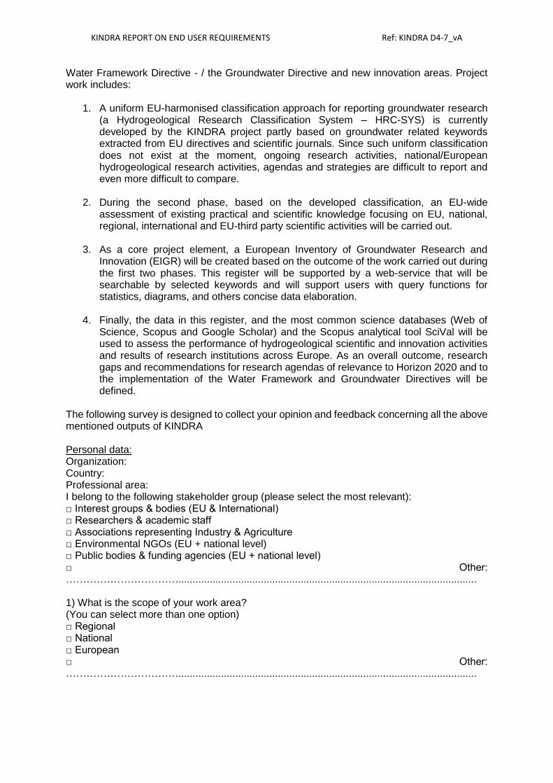
KINDRA REPORT ON END USER REQUIREMENTS Ref: KINDRA D4-7_vA
Water Framework Directive - / the Groundwater Directive and new innovation areas. Project work includes:
1. A uniform EU-harmonised classification approach for reporting groundwater research (a Hydrogeological Research Classification System – HRC-SYS) is currently developed by the KINDRA project partly based on groundwater related keywords extracted from EU directives and scientific journals. Since such uniform classification does not exist at the moment, ongoing research activities, national/European hydrogeological research activities, agendas and strategies are difficult to report and even more difficult to compare.
2. During the second phase, based on the developed classification, an EU-wide
assessment of existing practical and scientific knowledge focusing on EU, national, regional, international and EU-third party scientific activities will be carried out.
3. As a core project element, a European Inventory of Groundwater Research and
Innovation (EIGR) will be created based on the outcome of the work carried out during the first two phases. This register will be supported by a web-service that will be searchable by selected keywords and will support users with query functions for statistics, diagrams, and others concise data elaboration.
4. Finally, the data in this register, and the most common science databases (Web of
Science, Scopus and Google Scholar) and the Scopus analytical tool SciVal will be used to assess the performance of hydrogeological scientific and innovation activities and results of research institutions across Europe. As an overall outcome, research gaps and recommendations for research agendas of relevance to Horizon 2020 and to the implementation of the Water Framework and Groundwater Directives will be defined.
The following survey is designed to collect your opinion and feedback concerning all the above mentioned outputs of KINDRA Personal data: Organization: Country: Professional area: I belong to the following stakeholder group (please select the most relevant): □ Interest groups & bodies (EU & International) □ Researchers & academic staff □ Associations representing Industry & Agriculture □ Environmental NGOs (EU + national level) □ Public bodies & funding agencies (EU + national level) □ Other: ……………………………......................................................................................................... 1) What is the scope of your work area? (You can select more than one option) □ Regional □ National □ European □ Other: …………………………….........................................................................................................
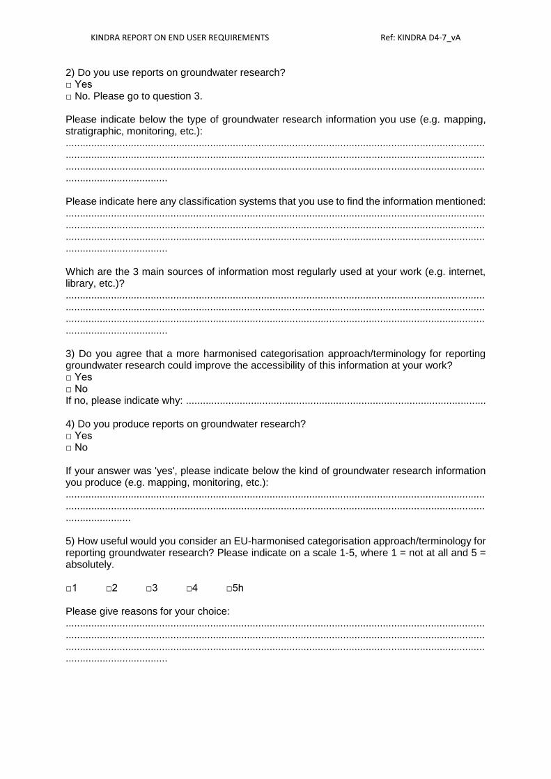
KINDRA REPORT ON END USER REQUIREMENTS Ref: KINDRA D4-7_vA
2) Do you use reports on groundwater research? □ Yes □ No. Please go to question 3. Please indicate below the type of groundwater research information you use (e.g. mapping, stratigraphic, monitoring, etc.): ................................................................................................................................................................................................................................................................................................................................................................................................................................................................................................ Please indicate here any classification systems that you use to find the information mentioned: ................................................................................................................................................................................................................................................................................................................................................................................................................................................................................................ Which are the 3 main sources of information most regularly used at your work (e.g. internet, library, etc.)? ................................................................................................................................................................................................................................................................................................................................................................................................................................................................................................ 3) Do you agree that a more harmonised categorisation approach/terminology for reporting groundwater research could improve the accessibility of this information at your work? □ Yes □ No If no, please indicate why: .......................................................................................................... 4) Do you produce reports on groundwater research? □ Yes □ No If your answer was 'yes', please indicate below the kind of groundwater research information you produce (e.g. mapping, monitoring, etc.): ............................................................................................................................................................................................................................................................................................................................... 5) How useful would you consider an EU-harmonised categorisation approach/terminology for reporting groundwater research? Please indicate on a scale 1-5, where 1 = not at all and 5 = absolutely. □1 □2 □3 □4 □5h Please give reasons for your choice: ................................................................................................................................................................................................................................................................................................................................................................................................................................................................................................

KINDRA REPORT ON END USER REQUIREMENTS Ref: KINDRA D4-7_vA
6) Would an ‘EU-wide assessment of existing practical and scientific knowledge from hydrogeology research and innovation in Europe’ be relevant to your work? □ Yes □ No If your answer was 'yes', please indicate below what level(s) would be the most relevant to your work (you can select more than one option): □ EU □ National □ Regional □ International 7) How useful would the European Inventory of Groundwater Research and Innovation (EIGR) be for your work? Please indicate on a scale 1-5, where 1 = not at all and 5 = absolutely. □1 □2 □3 □4 □5 8) Please indicate below how you would like to access such information: (You can select more than one option) □ Through a catalogue □ Key word search □ Via maps □ By geographical name □ Other: ……………………………………………………………………………………………………………….………………… 9) How useful would a European report on research gaps related to hydrogeology research be for your work? Please indicate on a scale 1-5, where 1 = not at all and 5 = absolutely. □1 □2 □3 □4 □5 10) Which part of our work would you like to receive more information on? Please indicate on a scale 1-5, where 1 = not at all and 5 = absolutely. The harmonised methodology for reporting groundwater research: □1 □2 □3 □4 □5 The assessment of knowledge – synthesis of country reports: □1 □2 □3 □4 □5 The inventory/EIGR: □1 □2 □3 □4 □5 Research gaps and recommendations: □1 □2 □3 □4 □5 Any comments ................................................................................................................................................................................................................................................................................................................................................................................................................................................................................................ If you would like to receive more information about KINDRA’s activities, please leave us your name and contact details (your data will only be used to send you information strictly related to KINDRA a few times/year):

KINDRA REPORT ON END USER REQUIREMENTS Ref: KINDRA D4-7_vA
Name: Email: Alternatively, you may follow us on:
- Facebook: KINDRA project - Twitter: @kindraproject.eu - Our join to our LinkedIN group: KINDRA project
Find more information on our project website: www.kindraproject.eu THANK YOU VERY MUCH FOR YOUR PARTICIPATION!