daily operations briefing - the disaster center - home …daily+ops+briefing+08-25...• isb:...
TRANSCRIPT

•Daily Operations Briefing•Friday, August 25, 2017
8:30 a.m. EDT
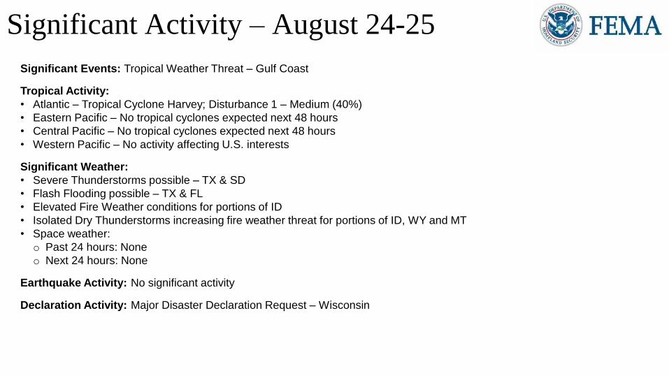
Significant Events: Tropical Weather Threat – Gulf Coast
Tropical Activity:
• Atlantic – Tropical Cyclone Harvey; Disturbance 1 – Medium (40%)
• Eastern Pacific – No tropical cyclones expected next 48 hours
• Central Pacific – No tropical cyclones expected next 48 hours
• Western Pacific – No activity affecting U.S. interests
Significant Weather:
• Severe Thunderstorms possible – TX & SD
• Flash Flooding possible – TX & FL
• Elevated Fire Weather conditions for portions of ID
• Isolated Dry Thunderstorms increasing fire weather threat for portions of ID, WY and MT
• Space weather:
o Past 24 hours: None
o Next 24 hours: None
Earthquake Activity: No significant activity
Declaration Activity: Major Disaster Declaration Request – Wisconsin
Significant Activity – August 24-25
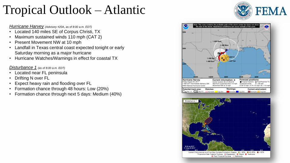
Tropical Outlook –AtlanticHurricane Harvey (Advisory #20A, as of 8:00 a.m. EDT)
• Located 140 miles SE of Corpus Christi, TX
• Maximum sustained winds 110 mph (CAT 2)
• Present Movement NW at 10 mph
• Landfall in Texas central coast expected tonight or early
Saturday morning as a major hurricane
• Hurricane Watches/Warnings in effect for coastal TX
Disturbance 1 (as of 8:00 a.m. EDT)
• Located near FL peninsula
• Drifting N over FL
• Expect heavy rain and flooding over FL
• Formation chance through 48 hours: Low (20%)
• Formation chance through next 5 days: Medium (40%)

Harvey Rainfall Forecast – Days 1-7
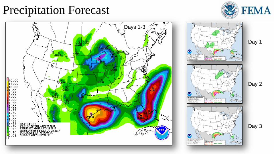
Precipitation Forecast
Day 1
Day 2
Day 3
Days 1-3
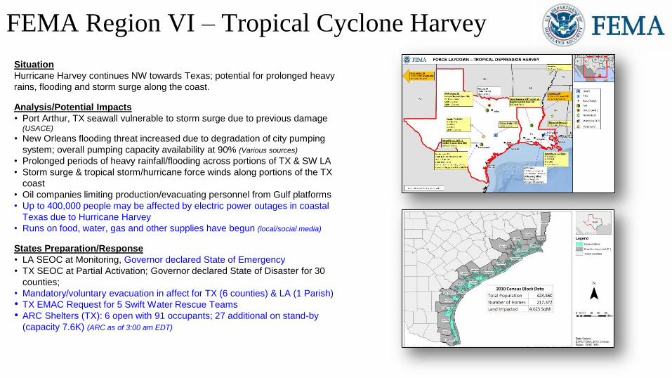
FEMA Region VI – Tropical Cyclone Harvey
Situation
Hurricane Harvey continues NW towards Texas; potential for prolonged heavy
rains, flooding and storm surge along the coast.
Analysis/Potential Impacts
• Port Arthur, TX seawall vulnerable to storm surge due to previous damage (USACE)
• New Orleans flooding threat increased due to degradation of city pumping
system; overall pumping capacity availability at 90% (Various sources)
• Prolonged periods of heavy rainfall/flooding across portions of TX & SW LA
• Storm surge & tropical storm/hurricane force winds along portions of the TX
coast
• Oil companies limiting production/evacuating personnel from Gulf platforms
• Up to 400,000 people may be affected by electric power outages in coastal
Texas due to Hurricane Harvey
• Runs on food, water, gas and other supplies have begun (local/social media)
States Preparation/Response
• LA SEOC at Monitoring, Governor declared State of Emergency
• TX SEOC at Partial Activation; Governor declared State of Disaster for 30
counties;
• Mandatory/voluntary evacuation in affect for TX (6 counties) & LA (1 Parish)
• TX EMAC Request for 5 Swift Water Rescue Teams
• ARC Shelters (TX): 6 open with 91 occupants; 27 additional on stand-by
(capacity 7.6K) (ARC as of 3:00 am EDT)
Provided by County EOC
Provided by County EOC
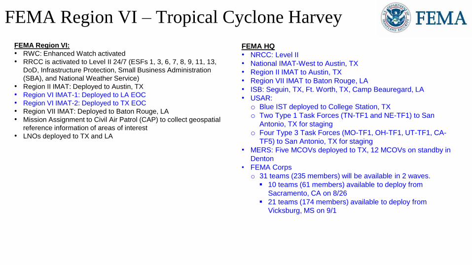
FEMA Region VI – Tropical Cyclone Harvey
FEMA Region VI:
• RWC: Enhanced Watch activated
• RRCC is activated to Level II 24/7 (ESFs 1, 3, 6, 7, 8, 9, 11, 13,
DoD, Infrastructure Protection, Small Business Administration
(SBA), and National Weather Service)
• Region II IMAT: Deployed to Austin, TX
• Region VI IMAT-1: Deployed to LA EOC
• Region VI IMAT-2: Deployed to TX EOC
• Region VII IMAT: Deployed to Baton Rouge, LA
• Mission Assignment to Civil Air Patrol (CAP) to collect geospatial
reference information of areas of interest
• LNOs deployed to TX and LA
FEMA HQ
• NRCC: Level II
• National IMAT-West to Austin, TX
• Region II IMAT to Austin, TX
• Region VII IMAT to Baton Rouge, LA
• ISB: Seguin, TX, Ft. Worth, TX, Camp Beauregard, LA
• USAR:
o Blue IST deployed to College Station, TX
o Two Type 1 Task Forces (TN-TF1 and NE-TF1) to San
Antonio, TX for staging
o Four Type 3 Task Forces (MO-TF1, OH-TF1, UT-TF1, CA-
TF5) to San Antonio, TX for staging
• MERS: Five MCOVs deployed to TX, 12 MCOVs on standby in
Denton
• FEMA Corps
o 31 teams (235 members) will be available in 2 waves.
10 teams (61 members) available to deploy from
Sacramento, CA on 8/26
21 teams (174 members) available to deploy from
Vicksburg, MS on 9/1

Tropical Outlook – Eastern Pacific
48-Hour Outlook 5 Day Outlook

Tropical Outlook – Central Pacific
48-Hour Outlook 5 Day Outlook

National Weather Forecast
Today Tomorrow
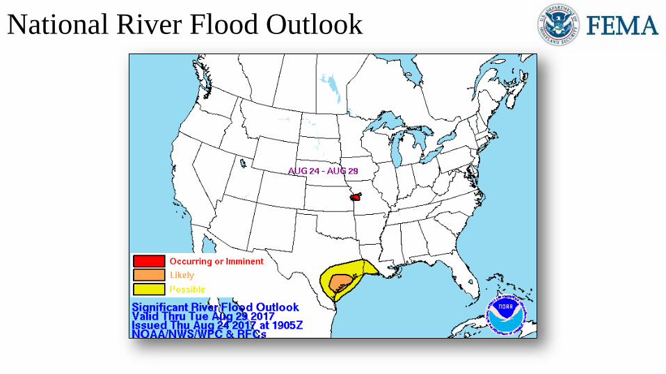
National River Flood Outlook
http://www.wpc.ncep.noaa.gov/nationalfloodoutlook/finalfop_nobo
unds.gif
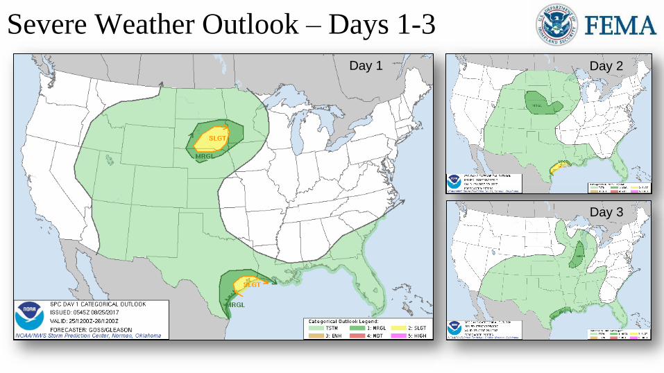
Severe Weather Outlook – Days 1-3
Day 1 Day 2
Day 3

Fire Weather Outlook
Today Tomorrow

Hazards Outlook – Aug 27-31
http://www.cpc.ncep.noaa.gov/products/predictions/threats/threats.php
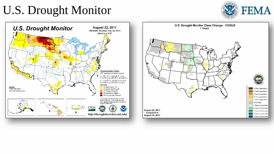
http://droughtmonitor.unl.edu/
U.S. Drought Monitor
http://droughtmonitor.unl.edu/MapsAndData/ChangeMaps.aspx

http://www.swpc.noaa.gov/communities/aviation-community-
dashboard
http://spaceweather.com/
Space WeatherSpace Weather
Activity
Geomagnetic
StormsSolar Radiation
Radio
Blackouts
Past 24 Hours None None None None
Next 24 Hours None None None None
For further information on NOAA Space Weather Scales refer to http://www.swpc.noaa.gov/noaa-scales-explanation
HF Communication Impact Sunspot Activity
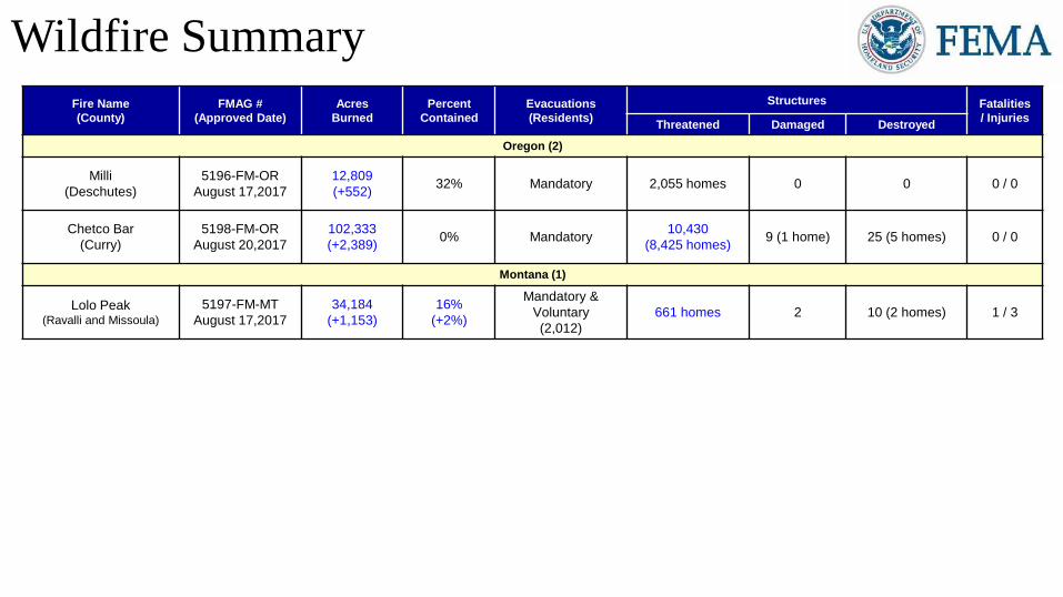
Wildfire Summary
Fire Name
(County)
FMAG #
(Approved Date)
Acres
Burned
Percent
Contained
Evacuations
(Residents)
Structures Fatalities
/ InjuriesThreatened Damaged Destroyed
Oregon (2)
Milli
(Deschutes)
5196-FM-OR
August 17,2017
12,809
(+552)32% Mandatory 2,055 homes 0 0 0 / 0
Chetco Bar
(Curry)
5198-FM-OR
August 20,2017
102,333
(+2,389)0% Mandatory
10,430
(8,425 homes)9 (1 home) 25 (5 homes) 0 / 0
Montana (1)
Lolo Peak(Ravalli and Missoula)
5197-FM-MT
August 17,2017
34,184
(+1,153)
16%
(+2%)
Mandatory &
Voluntary
(2,012)
661 homes 2 10 (2 homes) 1 / 3

Joint Preliminary Damage Assessments
RegionState /
LocationEvent IA/PA
Number of CountiesStart – End
Requested Completed
V ILSevere Storms and Flooding
July 11-27, 2017
IA 0 0 N/A
PA 4 0 Aug 28 – TBD
VIII NDSevere Summer Storm, High Winds, and Rain
July 20-21, 2017
IA 0 0 N/A
PA 3 3 Aug 21 – Aug 24
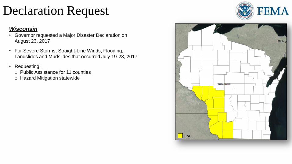
Wisconsin• Governor requested a Major Disaster Declaration on
August 23, 2017
• For Severe Storms, Straight-Line Winds, Flooding,
Landslides and Mudslides that occurred July 19-23, 2017
• Requesting:
o Public Assistance for 11 counties
o Hazard Mitigation statewide
Declaration Request
PA
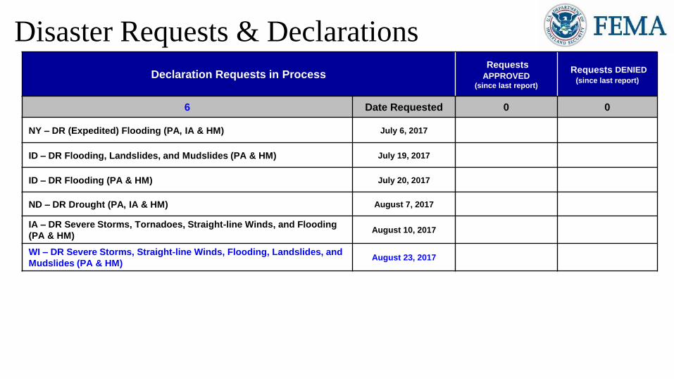
Declaration Requests in ProcessRequests
APPROVED(since last report)
Requests DENIED
(since last report)
6 Date Requested 0 0
NY – DR (Expedited) Flooding (PA, IA & HM) July 6, 2017
ID – DR Flooding, Landslides, and Mudslides (PA & HM) July 19, 2017
ID – DR Flooding (PA & HM) July 20, 2017
ND – DR Drought (PA, IA & HM) August 7, 2017
IA – DR Severe Storms, Tornadoes, Straight-line Winds, and Flooding
(PA & HM)August 10, 2017
WI – DR Severe Storms, Straight-line Winds, Flooding, Landslides, and
Mudslides (PA & HM)August 23, 2017
Disaster Requests & Declarations
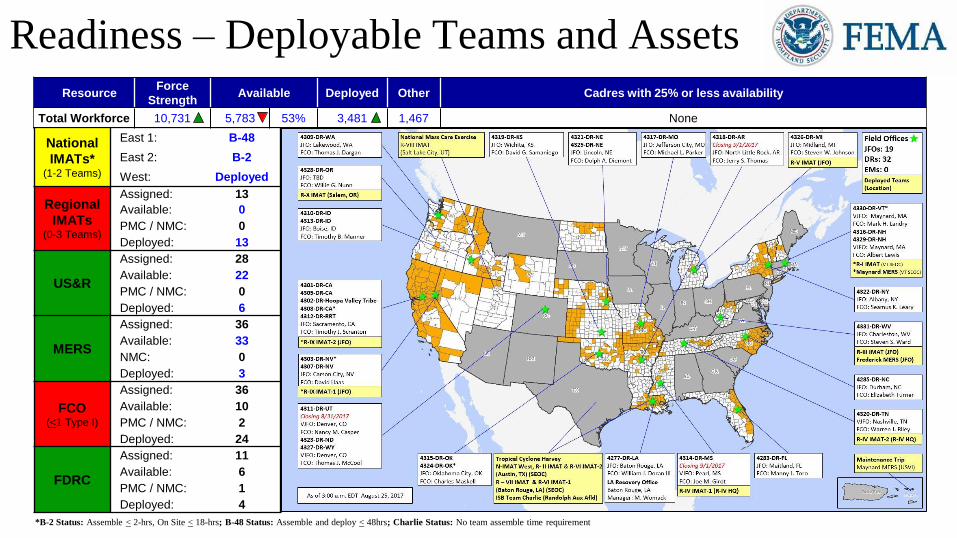
Readiness – Deployable Teams and Assets
National
IMATs*(1-2 Teams)
East 1: B-48
East 2: B-2
West: Deployed
Regional
IMATs(0-3 Teams)
Assigned: 13
Available: 0
PMC / NMC: 0
Deployed: 13
US&R
Assigned: 28
Available: 22
PMC / NMC: 0
Deployed: 6
MERS
Assigned: 36
Available: 33
NMC: 0
Deployed: 3
FCO(<1 Type I)
Assigned: 36
Available: 10
PMC / NMC: 2
Deployed: 24
FDRC
Assigned: 11
Available: 6
PMC / NMC: 1
Deployed: 4
ResourceForce
StrengthAvailable Deployed Other Cadres with 25% or less availability
Total Workforce 10,731 5,783 53% 3,481 1,467 None
*B-2 Status: Assemble < 2-hrs, On Site < 18-hrs; B-48 Status: Assemble and deploy < 48hrs; Charlie Status: No team assemble time requirement

FEMA Readiness – Activation Teams
Resource Status Total StatusActivated
Team
Activation
Level
Activation
TimesReason/Comments
NWC 5 Not Activated
NRCC 2 Activated Blue Level II 24/7 Hurricane Harvey
HLT 1 Activated Hurricane Season
RWCs/MOCs 10 Activated R-VI Enhanced Watch Hurricane Harvey
RRCCs 10 Activated R-VI Level II 24/7 Hurricane Harvey
Back-up Regions (August 21-28): II and VII