dairy creek restoration feasibility study · atr report/pre-decisional: do not distribute...
TRANSCRIPT

ATR Report/Pre-Decisional: Do Not Distribute
U.S. Army Corps of Engineers, Portland District (Contract No.W9127N-11-D-0011) Task Order No. 0029
Dairy Creek Restoration Feasibility Study Sauvie Island, OR
Prepared by:
HDR Engineering, Inc. 1001 SW 5th Ave., Suite 1800 Portland, OR 97204-1134 July 2013
Feasibility Study and Environmental Assessment Report

ATR Report/Pre-Decisional: Do Not Distribute
This page left intentionally blank
ATR Report/Pre-Decisional: Do Not Distribute
Feasibility Study and Environmental Assessment Report Page ES-1 Dairy Creek Restoration Feasibility Study July 2013
EXECUTIVE SUMMARY Under Section 1135 of the Water Resources Development Act (WRDA), the U.S. Army Corps of Engineers (USACE) has conducted a feasibility study for the Dairy Creek Restoration Project (Project). The West Multnomah Soil and Water Conservation District (WMSWCD) is the local sponsor. The 10,580-acre study area includes Sturgeon Lake and the surrounding lands on Sauvie Island, west of Portland, Oregon.
Sturgeon Lake and related hydrologic features including Dairy Creek provide important habitats for resident and migratory fish and wildlife species. Situated at the confluence of the Columbia and Willamette Rivers, the Project area is a foraging, rearing, and refuge resource for endangered salmonids. The Lake provides wintering habitat for approximately 150,000 ducks, geese, and swans annually and is a key stop on the Pacific flyway. Over the past 60 years, hydrologic modifications to the Lake and surrounding waters have resulted in a decrease in Lake size and a disconnection of Dairy Creek.
The goal of the Project is to restore long-term function of Sturgeon Lake and increase aquatic areas and habitat value for fish and wildlife. The Project is needed to remedy the degradation of these habitats as a result of hydrologic manipulation from Federal levees and Columbia River Power System Operations. Within the framework and constraints of the Section 1135 objectives, the following objectives were established:
§ To reestablish rearing juvenile salmonid (coho and Chinook) ingress and egress opportunities to Sturgeon Lake from Columbia River;
§ To maintain open water areas that support a diversity of wintering waterfowl to the extent practicable;
§ To restore off-channel habitat quality and quantity for rearing juvenile salmonids and flood refugia for juveniles and adults;
§ To reconnect and restore more natural hydrologic inputs between Sturgeon Lake and surrounding water bodies; and
§ To reconstruct Dairy Creek channel to improve habitat and riparian function, where feasible.
This Feasibility Study Report examines existing conditions at Dairy Creek and Sturgeon Lake and proposes alternatives for restoring important habitat functions.
Based on the results of the cost benefit evaluation, the USACE identified Dairy Creek (Alternative 3) as the recommended plan to meet Project goals and objectives. The proposed plan is to restore the current Dairy Creek channel between Sturgeon Lake and the Columbia River to increase hydrologic connection, increase circulation in Sturgeon Lake, and provide direct fish access from the Columbia River. The results of these actions will serve to improve Lake habitat function and quantity for fish and waterfowl.
The total Federal cost, including costs for operation and maintenance (O&M), and monitoring, but excluding feasibility study costs, is estimated at $7,506,000. The total annualized O&M cost is estimated at $32,000. WMSWCD is expected to pay for 25 percent of the Total Project Cost ($1,660,000).

ATR Report/Pre-Decisional: Do Not Distribute
Feasibility Study and Environmental Assessment Report Page ES-2 Dairy Creek Restoration Feasibility Study July 2013
This page left intentionally blank

ATR Report/Pre-Decisional: Do Not Distribute
Feasibility Study and Environmental Assessment Report Page i Dairy Creek Restoration Feasibility Study July 2013
TABLE OF CONTENTS EXECUTIVE SUMMARY ACRONYMS AND ABBREVIATIONS
1.0 INTRODUCTION ................................................................................................. 1
1.1 Study Authority ............................................................................................................... 1
1.2 Background .................................................................................................................... 3
1.3 Purpose and Need .......................................................................................................... 4
1.4 Study Area Description ................................................................................................... 4
1.5 Relationship to Regional Studies .................................................................................... 7
1.5.1 ODFW 2010 SIWA Management Plan ................................................................................................... 7
1.5.2 The Lower Columbia River Conservation and Recovery Plan for Oregon Populations of Salmon and Steelhead ................................................................................................................................................ 8
1.5.3 Federal Columbia River Power System Biological Opinions .................................................................. 8
1.6 Expected Success of the Project .................................................................................... 9
2.0 EXISTING AND FUTURE WITHOUT-PROJECT CONDITION .......................... 11
2.1 Existing Conditions ........................................................................................................11
2.1.1 Water Resources .................................................................................................................................. 11
2.1.2 Surface Water Hydrology ...................................................................................................................... 14
2.1.3 Lake Sediment Dynamics ..................................................................................................................... 18
2.1.4 Water Management and Uses .............................................................................................................. 22
2.1.5 Water Quality ........................................................................................................................................ 24
2.1.6 Geology and Soils ................................................................................................................................. 27
2.1.7 Wetlands ............................................................................................................................................... 29
2.1.8 Fish and Aquatic Resources ................................................................................................................. 33
2.1.9 Wildlife .................................................................................................................................................. 34
2.1.10 Vegetation ............................................................................................................................................. 36

ATR Report/Pre-Decisional: Do Not Distribute
Feasibility Study and Environmental Assessment Report Page ii Dairy Creek Restoration Feasibility Study July 2013
2.1.11 Special Status Species ......................................................................................................................... 37
2.1.12 Historical and Cultural Resources ........................................................................................................ 43
2.1.13 Socio-economic, Land Use, and Recreation ........................................................................................ 44
2.1.14 Air Quality and Noise ............................................................................................................................ 47
2.2 Future Without-Project Condition (No Action Alternative) and Cumulative Effects ........48
2.2.1 Water Resources .................................................................................................................................. 48
2.2.2 Lake Sediment Dynamics ..................................................................................................................... 48
2.2.3 Water Management and Uses .............................................................................................................. 51
2.2.4 Water Quality ........................................................................................................................................ 51
2.2.5 Geology and Soils ................................................................................................................................. 51
2.2.6 Wetlands ............................................................................................................................................... 51
2.2.7 Fish and Aquatic Resources and Wildlife ............................................................................................. 51
2.2.8 Vegetation ............................................................................................................................................. 52
2.2.9 Special Status Species ......................................................................................................................... 52
2.2.10 Historic and Cultural Resources ........................................................................................................... 53
2.2.11 Socio-economic, Land Use, and Recreation ........................................................................................ 53
2.2.12 Hazardous, Toxic, and Radioactive Waste ........................................................................................... 53
2.2.13 Air Quality and Noise ............................................................................................................................ 53
2.2.14 Cumulative Effects ................................................................................................................................ 53
3.0 ALTERNATIVES ............................................................................................... 59
3.1 Plan Formulation ...........................................................................................................59
3.1.1 Problems and Opportunities ................................................................................................................. 59
3.1.2 Project Goal .......................................................................................................................................... 61
3.1.3 Project Objectives ................................................................................................................................. 62
3.1.4 Project Constraints ............................................................................................................................... 62
3.1.5 Screening Criteria ................................................................................................................................. 63
3.1.6 Risk and Uncertainty ............................................................................................................................. 64
3.2 Formulation of Potential Restoration Measures .............................................................66

ATR Report/Pre-Decisional: Do Not Distribute
Feasibility Study and Environmental Assessment Report Page iii Dairy Creek Restoration Feasibility Study July 2013
3.3 Screening of Conceptual Restoration Measures............................................................67
3.4 Final List of Restoration Measures ................................................................................72
3.5 Final Array of Alternatives ..............................................................................................73
3.6 Evaluation of Restoration Benefits by Alternative ..........................................................74
3.6.1 Additional Benefits ................................................................................................................................ 77
3.7 Implementation Costs for Alternatives ...........................................................................79
3.8 Cost Effectiveness and Incremental Cost Analyses .......................................................82
3.9 Identification of Recommended Plan (Preferred Alternative) .........................................84
4.0 RECOMMENDED PLAN (PREFERRED ALTERNATIVE) ................................. 86
4.1 Plan Features ................................................................................................................86
4.1.1 Replace Debris Boom at Dairy Creek Mouth ........................................................................................ 86
4.1.2 Construct Eddy Control Structures in the Dairy Creek Mouth .............................................................. 86
4.1.3 Protect and Stabilize Banks .................................................................................................................. 88
4.1.4 Construct Sand Collection Basins ........................................................................................................ 88
4.1.5 Reconfigure Channel ............................................................................................................................ 88
4.1.6 Replant with Native Species ................................................................................................................. 91
4.1.7 Improve Hydrologic Connectivity under Reeder Road .......................................................................... 91
4.1.8 Construct Log Structure at Historic Dairy Creek ................................................................................... 92
4.1.9 Potential Plan Features ........................................................................................................................ 92
4.2 Design Considerations ...................................................................................................92
4.2.1 Modeling ............................................................................................................................................... 93
4.2.2 Data Collection ..................................................................................................................................... 93
4.2.3 Property Acquisition .............................................................................................................................. 93
4.2.4 Point of Diversion .................................................................................................................................. 93
4.2.5 Private Access Bridge ........................................................................................................................... 93
4.2.6 Safety .................................................................................................................................................... 93
4.3 Construction Overview ...................................................................................................94

ATR Report/Pre-Decisional: Do Not Distribute
Feasibility Study and Environmental Assessment Report Page iv Dairy Creek Restoration Feasibility Study July 2013
4.3.1 Channel Restoration ............................................................................................................................. 94
4.3.2 In-stream Structures ............................................................................................................................. 95
4.3.3 Reeder Road Crossing ......................................................................................................................... 95
4.3.4 Post-Construction Restoration and Plantings ....................................................................................... 95
4.3.5 Safety .................................................................................................................................................... 96
4.4 Operations and Maintenance .........................................................................................96
4.4.1 Channel Restoration ............................................................................................................................. 96
4.4.2 In-stream Structures ............................................................................................................................. 97
4.4.3 Reeder Road Crossing ......................................................................................................................... 97
4.4.4 Post-Construction Restoration and Plantings ....................................................................................... 97
4.5 Pre and Post Project Monitoring ....................................................................................97
4.5.1 Project Success Criteria ....................................................................................................................... 98
4.5.2 Monitoring Plan ..................................................................................................................................... 99
4.5.3 Hydrology .............................................................................................................................................. 99
4.5.4 Water Quality ........................................................................................................................................ 99
4.5.5 Habitat ................................................................................................................................................ 100
4.5.6 Vegetation ........................................................................................................................................... 100
4.5.7 Fish ..................................................................................................................................................... 100
4.5.8 Potential Monitoring with Additional Funding ...................................................................................... 101
4.5.9 Location .............................................................................................................................................. 101
4.5.10 Reporting ............................................................................................................................................ 101
4.5.11 Monitoring Cost Estimate .................................................................................................................... 102
4.6 Project Cost Estimate ..................................................................................................102
4.7 Design and Construction Schedule..............................................................................103
4.8 Sponsor Responsibilities .............................................................................................105
4.9 Real Estate ..................................................................................................................105
4.10 Risk Register ...............................................................................................................105

ATR Report/Pre-Decisional: Do Not Distribute
Feasibility Study and Environmental Assessment Report Page v Dairy Creek Restoration Feasibility Study July 2013
5.0 ENVIRONMENTAL CONSEQUENCES .......................................................... 107
5.1 Water Resources .........................................................................................................107
5.1.1 Spring Freshet; April- July .................................................................................................................. 108
5.1.2 Summer Period: August - October ...................................................................................................... 108
5.1.3 Winter Period; November-March ........................................................................................................ 108
5.1.4 Water Management and Uses ............................................................................................................ 109
5.2 Lake Sediment Dynamics ............................................................................................110
5.3 Water Quality ...............................................................................................................111
5.4 Geology and Soils .......................................................................................................113
5.5 Wetlands ......................................................................................................................114
5.6 Fish and Aquatic Resources and Wildlife ....................................................................114
5.7 Vegetation ...................................................................................................................116
5.8 Special Status Species ................................................................................................117
5.8.1 Fish ..................................................................................................................................................... 117
5.8.2 Mammals ............................................................................................................................................ 118
5.8.3 Birds .................................................................................................................................................... 118
5.8.4 Reptiles/Amphibians ........................................................................................................................... 118
5.8.5 Vegetation ........................................................................................................................................... 119
5.9 Historic and Cultural Resources ..................................................................................120
5.10 Socio-economic, Land Use, and Recreation ................................................................121
5.11 Hazardous, Toxic, and Radioactive Waste ..................................................................122
5.12 Air Quality and Noise ...................................................................................................122
5.13 Cumulative Effects .......................................................................................................122
5.13.1 Water Resources and Sediment Dynamics ........................................................................................ 123
5.13.2 Geology and Soils ............................................................................................................................... 124
5.13.3 Wetlands ............................................................................................................................................. 124
5.13.4 Fish and Aquatic Resources and Special Status Species .................................................................. 124

ATR Report/Pre-Decisional: Do Not Distribute
Feasibility Study and Environmental Assessment Report Page vi Dairy Creek Restoration Feasibility Study July 2013
5.13.5 Vegetation ........................................................................................................................................... 125
5.13.6 Historic and Cultural ........................................................................................................................... 126
5.13.7 Socio-economic, Land Use, and Recreation ...................................................................................... 126
5.13.8 Hazardous, Toxic, and Radioactive Waste ......................................................................................... 126
5.13.9 Air Quality and Noise .......................................................................................................................... 126
5.13.10 Conclusion .......................................................................................................................................... 126
6.0 COORDINATION AND LOCAL SUPPORT ..................................................... 131
6.1 Public and Agency Coordination ..................................................................................131
6.2 Views and Preferences of Project Partners .................................................................131
7.0 COMPLIANCE WITH APPLICABLE LAWS AND REGULATIONS ................. 133
7.1 Clean Air Act ................................................................................................................133
7.2 Marine Protection, Research, and Sanctuaries Act .....................................................133
7.3 Clean Water Act ..........................................................................................................133
7.4 Oregon Removal-Fill Law (DSL) ..................................................................................135
7.5 Oregon Fish Passage Law ..........................................................................................135
7.6 State Waterway Authorization .....................................................................................136
7.7 Multnomah County Requirements ...............................................................................136
7.8 Coastal Zone Management Act ...................................................................................137
7.9 Endangered Species Act .............................................................................................137
7.10 Fish and Wildlife Coordination Act ...............................................................................137
7.11 Magnuson-Stevens Fishery Conservation and Management Act ................................138
7.12 Marine Mammal Protection Act ....................................................................................138
7.13 Migratory Bird Treaty Act .............................................................................................138
7.14 Bald and Golden Eagle Protection Act .........................................................................139
7.15 National Environmental Policy Act ...............................................................................139
7.16 National Historic Preservation Act ...............................................................................139

ATR Report/Pre-Decisional: Do Not Distribute
Feasibility Study and Environmental Assessment Report Page vii Dairy Creek Restoration Feasibility Study July 2013
7.17 Archaeological and Historic Preservation Act ..............................................................139
7.18 American Indian Religious Freedom Act ......................................................................140
7.19 Archaeological Resources Protection Act ....................................................................140
7.20 Native American Graves Protection and Repatriation Act ...........................................140
7.21 Executive Order 13007-Indian Sacred Sites ................................................................140
7.22 Executive Order 13175 -Consultation and Coordination with Indian Tribal Governments ....................................................................................................................................141
7.23 Executive Order 13287 -Preserve America .................................................................141
7.24 Executive Order 12898-- Environmental Justice ..........................................................141
7.25 Executive Order 11988-- Floodplain Management ......................................................141
7.26 Executive Order 11990-- Protection of Wetlands .........................................................142
7.27 Prime and Unique Farmlands ......................................................................................142
7.28 Comprehensive Environmental Response, Compensation, and Liability Act and Resource Conservation and Recovery Act ..................................................................143
7.29 Wild and Scenic Rivers Act ..........................................................................................143
7.30 Executive Order 13514-- Federal Leadership in Environmental, Energy and Economic Performance ................................................................................................................143
8.0 CONCLUSIONS AND RECOMMENDATION .................................................. 145
8.1 Conclusions .................................................................................................................145
8.2 Recommendation ........................................................................................................145
List of Figures Figure 1-1. Vicinity Map .................................................................................................................................. 2
Figure 1-2. USGS 1915 Topographical Map .................................................................................................. 6
Figure 2-1. Representative River and Lake Stage ........................................................................................ 15
Figure 2-2. General Hydrology during the Spring Freshet ............................................................................ 16
Figure 2-3. General Hydrology during Summer and Early Fall. .................................................................... 17
Figure 2-4. General Hydrology during the Winter Season. ........................................................................... 18

ATR Report/Pre-Decisional: Do Not Distribute
Feasibility Study and Environmental Assessment Report Page viii Dairy Creek Restoration Feasibility Study July 2013
Figure 2-5. Suspended Sediment Rating Curve for the Columbia River, at Vancouver ................................ 19
Figure 2-6. Suspended Sediment Rating Curve for the Willamette River, at Portland .................................. 20
Figure 2-7. The Columbia River and the Willamette River (tributary on left) at Flood Stage on February 9, 1996. ........................................................................................................................... 21
Figure 2-8. Net Sediment Deposition in Sturgeon Lake. ............................................................................... 22
Figure 2-9. FEMA flood zones for the Entire Study Area .............................................................................. 23
Figure 2-10. Stream Temperature in Sturgeon Lake and Columbia River during Spring and Summer 2011 (WMSWCD, 2011) .................................................................................................. 26
Figure 2-11. Soil Types in Study Area. ......................................................................................................... 28
Figure 2-12. Wetlands and Waters .............................................................................................................. 31
Figure 2-13. Wetland Boundaries in the Dairy Creek Corridor ...................................................................... 32
Figure 2-14. Land Use and Ownership on Sauvie Island .............................................................................. 46
Figure 2-15. Potential Depths of Sturgeon Lake, 50 Years after this Study, under the No Action Alternative. ...................................................................................................................................... 50
Figure 3-1. Average Inundation Extent for the Month of June. ..................................................................... 60
Figure 3-2. Dairy Creek Restoration Project Proposed Measure Locations .................................................. 71
Figure 3-3. Annual Costs and Benefits ......................................................................................................... 83
Figure 3-4. Incremental Costs and Habitat Benefits ..................................................................................... 85
Figure 4-1. Plan View of Proposed Improvements at Dairy Creek ................................................................ 87
Figure 4-2. Plan View of Proposed Improvements at the Mouth of Dairy Creek ........................................... 89
Figure 4-3. Typical Section of Proposed Improvements at Dairy Creek ....................................................... 90
Figure 5-1. General Hydrology during the Summer and Early Fall after Construction of the Preferred Alternative. .....................................................................................................................108
Figure 5-2. General Hydrology during the Winter Season, after Construction of the Preferred Alternative. .....................................................................................................................................109
Figure 5-3. Current and Proposed Measure 14B Sturgeon Lake Water Temperatures Given Modeled Daily Columbia River Flow Inputs. ..................................................................................113
List of Tables Table 2-1. Special Status Species that May Occur in or near the Study Area .............................................. 38
Table 2-2. Summary of Cumulative Effects for the Without Project Condition .............................................. 55
Table 3-1. Potential Sources of Sand Deposition in Dairy Creek. ................................................................. 66
Table 3-2. Measures Retained and Dismissed from Further Consideration during Screening ..................... 69
Table 3-3. Retained Measures ...................................................................................................................... 72
Table 3-4. Retained Measures and their Interrelationships .......................................................................... 73
Table 3-5. Composition of Alternative Plans ................................................................................................. 74

ATR Report/Pre-Decisional: Do Not Distribute
Feasibility Study and Environmental Assessment Report Page ix Dairy Creek Restoration Feasibility Study July 2013
Table 3-6. Overall Net Change in Habitat Units from Combined Northern Pintail, Lesser Scaup, and Salmon Analyses. ........................................................................................................................... 76
Table 3-7. Overall Net Change in Average Annual Benefits for Restoration Alternative ............................... 76
Table 3-8. Additional Fish and Wildlife Benefits ............................................................................................ 79
Table 3-9. Alternative Plan Costs. ................................................................................................................ 81
Table 3-10. Cost Effectiveness of Plans – Average Benefit .......................................................................... 83
Table 3-11. Incremental Cost Analysis: Best Buy Plans ............................................................................... 84
Table 4-1. Monitoring Metrics, Method, Sampling Frequency, and Monitoring Period. ................................. 99
Table 4-2. Estimated Monitoring Cost. .........................................................................................................102
Table 4-3. Fully Funded Cost Estimate, Preferred Alternative (Alternative 3) ..............................................103
Table 4-4. Completion Dates for Selected Tasks for the Recommended Plan ............................................103
Table 5-1. Average Surface Water Elevations of the No Action and Preferred Alternatives. .......................107
Table 5-2. Potential Effects on Special Status Species that May Occur in or near the Study Area .............119
Table 5-3. Summary of Cumulative Effects for the Preferred Alternative .....................................................127

ATR Report/Pre-Decisional: Do Not Distribute
Feasibility Study and Environmental Assessment Report Page x Dairy Creek Restoration Feasibility Study July 2013
List of Appendices Appendix A. Habitat Benefits Model Appendix B. H&H Report Appendix C. Flux Report Appendix D. Concept Summary
Appendix E. Cost Estimate
Appendix F. Environmental Compliance
Appendix G. Reeder Road Fish Passage Evaluation
Appendix H. Real Estate
Appendix I. Risk Register

ATR Report/Pre-Decisional: Do Not Distribute
Feasibility Study and Environmental Assessment Report Page xi Dairy Creek Restoration Feasibility Study July 2013
This page left intentionally blank

ATR Report/Pre-Decisional: Do Not Distribute
Feasibility Study and Environmental Assessment Report Page xii Dairy Creek Restoration Feasibility Study July 2013
ACRONYMS AND ABBREVIATIONS AEMR Active Effectiveness Monitoring and Research APE Area of Potential Effects BiOp Biological Opinion BPA Bonneville Power Administration C Celsius CE/ICA Cost Effectiveness and Incremental Cost Analysis cfs cubic feet per second CO carbon monoxide dB Decibel DDT dichlorodiphenyltrichloroethane DO dissolved oxygen DPS Distinct Population Segment DSL Oregon Department of State Lands EA Environmental Assessment EFH Essential Fish Habitat EIS Environmental Impact Statement ER Engineering Regulation ESA Endangered Species Act ESU Evolutionarily Significant Unit F Fahrenheit FCRPS Federal Columbia River Power System FEMA Federal Emergency Management Agency GIS Geographic Information System GPS Global Positioning System H Horizontal HEP Habitat Evaluation Procedure HGM hydrogeomorphic HMU habitat management units HSI Habitat Suitability Index HTRW Hazardous, toxic, and radioactive waste ISAB Independent Scientific Advisory Board LCFRB Lower Columbia River Fish Recovery Board LCRBSWQP Lower Columbia River Bi-State Water Quality Program LCREP Lower Columbia River Estuary Partnership mg/L milligrams per liter MMPA Marine Mammal Protection Act msl mean sea level NAAQS National Ambient Air Quality Standards NAVD88 North American Vertical Datum of 1988 NEPA National Environmental Policy Act

ATR Report/Pre-Decisional: Do Not Distribute
Feasibility Study and Environmental Assessment Report Page xiii Dairy Creek Restoration Feasibility Study July 2013
NER National Ecosystem Restoration NHPA National Historic Preservation Act NMFS National Marine Fisheries Service NFCP Native Fish Conservation Policy NPDES National Pollutant Discharge Elimination System NRHP National Register of Historic Places O&M operation and maintenance OAR Oregon Administrative Rule ODEQ Oregon Department of Environmental Quality ODFW Oregon Department of Fish and Wildlife OHW Ordinary High Water ORBIC Oregon Biodiversity Information Center ORS Oregon Revised Statutes OWEB Oregon Watershed Enhancement Board OWRD Oregon Water Resources Department PAH polycyclic aromatic hydrocarbons PCB polychlorinated biphenyl PCP pentachlorophenol POD Points of Diversion POU Points of Use Reclamation Bureau of Reclamation RM river mile RPA Reasonable and Prudent Alternative SAAQS State Ambient Air Quality Standards SIDIC Sauvie Island Drainage Improvement Company SIP State Implementation Plan SIWA Sauvie Island Wildlife Area SSC suspended sediment concentration TCDD Tetrachlorodibenzo-p-dioxin TDG total dissolved gas TMDL total maximum daily loads TSS total suspended solids USACE United States Army Corps of Engineers USEPA United States Environmental Protection Agency USFWS United States Fish and Wildlife Service V Vertical WMSWCD West Multnomah Soil and Water Conservation District WRDA Water Resources Development Act

ATR Report/Pre-Decisional: Do Not Distribute
Feasibility Study and Environmental Assessment Report Page xiv Dairy Creek Restoration Feasibility Study July 2013
This page left intentionally blank

ATR Report/Pre-Decisional: Do Not Distribute
Feasibility Study and Environmental Assessment Report Page 1 Dairy Creek Restoration Feasibility Study July 2013
1.0 INTRODUCTION The proposed Dairy Creek Restoration Project (Project) is located on Sauvie Island in Oregon (Figure 1-1). Sauvie Island, located 10 miles west of Portland, is bordered by the Columbia River, Willamette River, and Multnomah Channel. It contains a series of lakes, including the 2,400-acre Sturgeon Lake (Lake).
Dairy Creek connects Sturgeon Lake to the Columbia River. Changes to the hydrologic regime of Sauvie Island and adjacent rivers have caused Surgeon Lake to decrease in area and depth. Increased sedimentation along portions of the shoreline has reduced the area of open water in Sturgeon Lake, thus, reducing habitat value and area for wintering waterfowl and juvenile salmonids. A debris and sand plug in Dairy Creek has reduced access to rearing opportunities for juvenile salmonids in Sturgeon Lake and hydraulic constriction that minimized flow into and circulation in the Lake.
This Feasibility Study and Environmental Assessment (EA) Report summarizes the planning process used to identify potential measures and alternatives to meet the restoration goals of the Project. The purpose of this report is to evaluate restoration opportunities to enhance fish and wildlife habitats in Sturgeon Lake and to document the six-step planning process followed in compliance with the USACE Engineering Regulation (ER) 1110-2-100.
1.1 Study Authority This Feasibility Study and Environmental Assessment Report has been prepared under the authority of Section 1135 of the Water Resources Development Act (WRDA) of 1986. Section 1135 of the WRDA of 1986, as amended by Section 204 of the WRDA of 1996, provides the USACE authority to modify existing USACE projects to restore the environment and construct new projects to restore areas degraded by USACE projects.
Implementation of the Project requires a non-Federal sponsor responsible for providing 25% of the cost of the Project, in accordance with Section 103 of the WRDA of 1986. The non-Federal sponsor of the Project is West Multnomah Soil and Water Conservation District (WMSWCD). The sponsor would also be responsible for Project operations and maintenance (O&M).
This Feasibility Study meets the requirements of the National Environmental Policy Act (NEPA) of 1969. The NEPA and subsequent implementing regulations promulgated by the Council on Environmental Quality require Federal agencies to evaluate the environmental impacts of proposed Federal actions and prepare written documentation of the analysis. This report documents whether the actions proposed by the USACE constitute a “… major Federal action significantly affecting the quality of the human environment …” and whether an environmental impact statement (EIS) is required.

S T U R G E O NL A K E
( S O U T H )
S T E E L M A NL A K E
Dairy Creek, 1989
North Gilbert River
Sauvie DrainageImprovement
CompanyPump House
The Wash
Coon Point
M C N A R YL A K E
COLUMBIA RIVER
M U L T N O M A H CH A N N E L
WILLAMETTE RIVER
Mud Slough
Mud Slough
Dairy Creek
Dairy Creek Tidegate
(No longerin use)
OakIsland
S T U R G E O NL A K E
( N O R T H )
RacetrackLake
A A R O NL A K E
Vancouver
PortlandODFW Levee
Federal Levee
South Gilbert River
South Gilbert River Int erior Drainage Ca na lReeder Rd
Crossing
Pile Dike
Figure 1-1. Vicinity Map
Federal Levee
ODFW Levee
Study Area
Streams
0 1 20.5 Miles
Historic
Dairy Cree
k
Pile Dike

ATR Report/Pre-Decisional: Do Not Distribute
Feasibility Study and Environmental Assessment Report Page 3 Dairy Creek Restoration Feasibility Study July 2013
1.2 Background The Gilbert River originally drained the interior of Sauvie Island, beginning as a spring-fed stream in the southern extents of the island, flowing into Sturgeon Lake, and then discharging into the Multnomah Channel (Figure 1-2). The USACE constructed a Federal levee in 1942 around the southern portion of Sauvie Island. Construction of this levee system resulted in the Gilbert River being diverted from Sturgeon Lake into the interior drainage canal and pumped into the Multnomah Channel. Construction of this levee reduced the influence that Willamette and Columbia Rivers and island interior wetland drainage had on Sturgeon Lake. These former hydrologic inputs were key factors in maintaining Lake size and depth. The northern portion of the Gilbert River was left to convey Multnomah Channel flows into and out of Sturgeon Lake as a result of tidal action and changes in river discharge.
Historical aerial photographs show that shoaling and vegetation encroachment has occurred in some Sturgeon Lake shoreline areas over the last 70 years. Anecdotal observations indicate that portions of the open water areas of Sturgeon Lake have become shallower.
Historically, Dairy Creek was approximately 3 miles long and connected Sturgeon Lake to the Columbia River. The Lake side outlet was almost directly across the Gilbert River outlet, separated by some open water and the Columbia River outlet is similar to its current location. Dairy Creek was partially fed by a drained, lacustrine wetland complex (i.e., Marquam Lake) on the southeast portion of the island.
In the 1960s and 1970s dredge material from the Federal Navigation Channel was placed in Dairy Creek near the confluence with the Columbia River. In 1986 under the USACE’s Navigation and Operation Maintenance Program, the USACE removed dredge material to re-create a channel in Dairy Creek, and placed the material in the Columbia River adjacent to the mouth of Dairy Creek. The USACE also placed rock along banks at the entrance to Dairy Creek.
In 1989, the Dairy Creek channel was shortened to 1 mile in order to convey more water to Sturgeon Lake and improve sediment outflow and water quality. This effort was a combined Local, State, and Federal initiative to restore Sturgeon Lake. The U.S. Environmental Protection Agency (USEPA) was the primary Federal funding via the Clean Lakes and Section 319 Grant Programs. Other participants included the Oregon Department of Fish and Wildlife, Oregon Department of Environmental Quality and Multnomah County. This effort included filling in a portion of the historic channel near Reeder Road; constructing about a ½ mile of new channel from Reeder Road to Sturgeon Lake and installation of culverts at Reeder Road. The USACE was not part of design, implementation or maintenance of the 1989 project work. There are no known records of operation and maintenance agreements or requirements between the sponsor and funding partners resulting from this work.
Shortening the channel required a new crossing at Reeder Road. Two, 12-foot-diameter culverts were installed under Reeder Road. The culverts were sized to provide roadway

ATR Report/Pre-Decisional: Do Not Distribute
Feasibility Study and Environmental Assessment Report Page 4 Dairy Creek Restoration Feasibility Study July 2013
protection; however, they were not designed to provide unimpeded fish passage or maximize flows through Dairy Creek.
The channel appeared to function as intended for the first several years. Anecdotal information notes that improvements to the Lake were observed which included higher spring water surface elevations. By 1994, sand shoaling in the mouth of Dairy Creek and February 1996 flood transported hundreds of logs and other debris into the channel, raising the elevation of the sand and debris plug by 6 feet higher than the 1989 construction elevation. The debris boom, installed in 1989, failed in the 1996 flood, and no longer provides exclusion of large debris from the channel. A majority of the debris was removed after the flood receded; however, a large wood debris pile remains. There has not been on-going removal of the sand at the mouth of Dairy Creek. Currently, water from the Columbia River can enter Dairy Creek only during high flow events.
Disconnecting Gilbert River and Dairy Creek, construction of the Federal levee, and reduced flooding from Columbia River Power System Operations has led to decreased circulation in Sturgeon Lake and related water courses. This in turn has led to reduced fish access to the Lake, increased sedimentation, and reduced Lake depth, all of which contributes to loss of open water and floodplain habitat.
1.3 Purpose and Need Sturgeon Lake and related hydrologic features provide important habitats for resident and migratory fish and wildlife species. Situated at the mouth of the Willamette River, the Project area is a foraging, rearing, and refuge resource for endangered salmonids as well as a key stop on the Pacific flyway for migratory birds accessing the Willamette Valley. The Project is needed to remedy the degradation of these habitats as a result of hydrologic manipulation from levees and Columbia River Power System Operations. Implementation of this Project would work to restore these habitats.
The purpose of the Project is to restore hydraulic connection to the Columbia River and improve function of Sturgeon Lake within the Lower Columbia River estuary, thereby improving fish and wildlife habitat.
1.4 Study Area Description Sturgeon Lake is located approximately 12 miles northwest of Portland, Oregon on Sauvie Island. Sturgeon Lake is a large water body located within the Sauvie Island Wildlife Area (SIWA), which is managed by the Oregon Department of Fish and Wildlife (ODFW). Sturgeon Lake is connected to the Columbia River at river mile (RM) 98.5 through the modified Dairy Creek channel. Dairy Creek is hydrologically connected to the Columbia River at higher stages, typically in the spring and early summer. Sturgeon Lake is hydrologically connected to the Multnomah Channel, a Columbia River tributary, through the Gilbert River.
The Project Study Area is defined as Sturgeon Lake and the surrounding area between the Multnomah Channel and Columbia River and between the Sauvie Island Federal levee and the mouth of the North Gilbert River. In all, the Study Area encompasses

ATR Report/Pre-Decisional: Do Not Distribute
Feasibility Study and Environmental Assessment Report Page 5 Dairy Creek Restoration Feasibility Study July 2013
approximately 10,580 acres. A majority of the Study Area consists of open water and wetland habitats. A smaller component of the Study Area includes croplands and very low density residences.

Figure 1-2. Sauvie Island USGS Topographic Map Source: USGS, circa 1915.

ATR Report/Pre-Decisional: Do Not Distribute
Feasibility Study and Environmental Assessment Report Page 7 Dairy Creek Restoration Feasibility Study July 2013
1.5 Relationship to Regional Studies Dairy Creek, Sturgeon Lake, and related hydrologic systems have been studied by a variety of agencies over the last 30 years. These studies were conducted as part of past restoration projects, monitoring, and baseline fisheries studies. The following summarizes historic documentation related to the Study Area:
§ Technical Reports 1 and 2, Sturgeon Lake Restoration, Phase I Diagnostic/Feasibility Study (Klingeman and Jarvis, 1982a; 1982b)
§ Occurrence of Juvenile Salmonids and Potential Predators in Sturgeon Lake, 1986, Progress Report (Elliott and Ward, 1986)
§ Sturgeon Lake Restoration Project, (Section 319 funding application; WMSWCD, 1987)
§ Tidally Influenced Discharge Characteristics for the Shortened Dairy Creek Connecting Sturgeon Lake and the Columbia River (Cronin, 1992)
§ Dairy Creek Status Report as part of Sturgeon Lake Sedimentation Monitoring Program (Klingeman and Jarvis, 1992)
§ Relative Abundance of Juvenile Salmonids in Sturgeon Lake Before and After Completion of the Dairy Creek Bypass Channel (Ward and Rein, 1992)
§ Predesign Analysis for the Restoration of Dairy Creek (Hendron and Klingeman, 1994)
§ Sturgeon Lake Sedimentation Monitoring Program Final Report, 1991-1993 (Klingeman and Jarvis, 1994)
§ Sturgeon Lake Clean Lakes Study Sampling Report and Data Summary (Oregon Department of Environmental Quality [ODEQ], 1994)
§ ODFW 2010 SIWA Management Plan (ODFW, 2010a)
Regional planning and regulatory documents that pertain to the development of this Project are described in the following sections.
1.5.1 ODFW 2010 SIWA Management Plan
The 2010 SIWA Management Plan was prepared in part to document the management challenges facing the SIWA, list and prioritize the main management goals in the SIWA, and outline specific strategies SIWA staff would use to achieve the objectives outlined in the plan (ODFW, 2010a). Addressing the “silting in” or on-going sedimentation in Sturgeon Lake was identified as an SIWA management priority in this plan. As discussed in ODFW (2010a), sedimentation in Sturgeon Lake has reduced lake depth. Reduced lake depth may reduce wetland functions that are important for foraging shorebirds, waterfowl, and juvenile salmonids. The SIWA management objectives are aligned with regional waterfowl conservation objectives, such as the Pacific Coast Joint Venture, Pacific Flyway Council, and Oregon Conservation Strategy management objectives (ODFW, 2010a).

ATR Report/Pre-Decisional: Do Not Distribute
Feasibility Study and Environmental Assessment Report Page 8 Dairy Creek Restoration Feasibility Study July 2013
1.5.2 The Lower Columbia River Conservation and Recovery Plan for Oregon Populations of Salmon and Steelhead
The Lower Columbia River Conservation and Recovery Plan for Oregon Populations of Salmon and Steelhead (Lower Columbia River Estuary Partnership [LCREP], 2010) was prepared as both a recovery plan under the ESA and a State of Oregon conservation plan under Oregon’s Native Fish Conservation Policy (NFCP). The purpose of this plan is to provide a framework and roadmap for the conservation and recovery of Lower Columbia River salmonids. In addition, the plan provides a list of recovery strategies and management actions needed to address limiting factors and threats and maintain or improve current population statuses. The plan acknowledges the hydrologic manipulations in southern Sauvie Island as a limitation to salmon recovery and specifies one restoration action to identify and implement flow improvements to provide better salmon migration into and out of Sturgeon Lake.
The plan was prepared to provide recovery actions for local, state and federal agencies that might undertake restoration activities. There is no single entity responsible for implementation of the outlined actions. The proposed Project is consistent with the intent of the recovery plan.
1.5.3 Federal Columbia River Power System Biological Opinions
The Federal Columbia River Power System (FCRPS) includes 14 major dams and reservoirs on the Columbia and Snake Rivers, which are operated as a coordinated system by the USACE and Bureau of Reclamation (Reclamation) to provide a major source of power in the region, and provide flood control, navigation, recreation, fish and wildlife habitat, municipal and industrial water supply, and irrigation benefits. The USACE and Reclamation operate all dams in the FCRPS, whose power is sold by the Bonneville Power Administration (BPA). The Endangered Species Act (ESA) requires the agencies that operate the FCRPS to ensure that their actions are not likely to jeopardize the continued existence of listed species or result in the destruction or adverse modification of habitat designated as critical to its conservation. National Marine Fisheries Service (NMFS) is required to issue a biological opinion (BiOp) on FCRPS operations. The first BiOp was issued in 1993. In 1994, a Federal court rejected the 1993 BiOp. In response to judicial decisions, NMFS issued new BiOps in 1995, 2000, 2004, and 2008.
The 2008 BiOp found that, without mitigation, operation of the FCRPS would jeopardize 13 listed species of salmon and steelhead. A package of measures to benefit listed species (the Reasonable and Prudent Alternative [RPA]) was proposed to avoid jeopardizing listed species. The RPA includes 73 detailed sets of additional mitigation actions (i.e., habitat, hatchery, predation management, and harvest actions) that are required to avoid jeopardy and adverse modification of critical habitat.
The RPA includes a habitat program to protect and improve tributary and estuary environments and reduce limiting factors to mitigate for the FCRPS operations. The actions within this program aim to protect and improve mainstem and side-channel habitat for fish migration, spawning and rearing, and to restore floodplain function in the Lower Columbia River.

ATR Report/Pre-Decisional: Do Not Distribute
Feasibility Study and Environmental Assessment Report Page 9 Dairy Creek Restoration Feasibility Study July 2013
The proposed Project is being authorized under Section 1135 and is not currently being evaluated for FCRPS mitigation. However, the Project has been developed to be consistent with the RPA to restore floodplain function and habitat for migrating fish within the Lower Columbia River.
1.6 Expected Success of the Project As a result of thorough planning and collaboration with stakeholders, the Project is anticipated to be successful in restoring hydrologic connectivity, revitalizing fish access between Sturgeon Lake and the Columbia River, and increasing lake depth and area relative to a no action scenario. Methods of combating the ecological degradation in the Study Area have been considered with regard to implementation, ecological benefit, and economic efficiency.

ATR Report/Pre-Decisional: Do Not Distribute
Feasibility Study and Environmental Assessment Report Page 10 Dairy Creek Restoration Feasibility Study July 2013
This page left intentionally blank

ATR Report/Pre-Decisional: Do Not Distribute
Feasibility Study and Environmental Assessment Report Page 11 Dairy Creek Restoration Feasibility Study July 2013
2.0 EXISTING AND FUTURE WITHOUT-PROJECT CONDITION
2.1 Existing Conditions The following sections describe existing and future Without-Project condition, which is the same as the “No Action Alternative.” Information on resources within the Study Area was collected from various sources including existing documentation, general investigation site visits, and input from local land managers, property owners and stakeholders. Resource specific investigations and studies, if completed, are discussed in each resource area.
2.1.1 Water Resources
Sauvie Island is characterized by a network of mainstem river channels, distributary channels, sloughs, backwaters, islands, and lakes (Figure 1-2). Sturgeon Lake is shaped and maintained by both the Columbia and Willamette Rivers. River levels (Multnomah Channel and Columbia River) and tidal influence of the Pacific Ocean directly affect water surface elevations in Sturgeon Lake. The combination of these influences creates a complicated system of hydrology and sediment dynamics within Sturgeon Lake. The high flow and flood events in the Willamette and Columbia Rivers often occur at different times and intensities. As a result, the features of the island (e.g., creeks, wetlands, vegetation) are in a state of continuous flux.
The following section summarizes the surface waters in, and adjacent to, the Study Area. These water bodies are described here because they influence or potentially influence lake hydrology, sediment dynamics, and habitat connectivity. An overview is provided, followed by additional discussion of hydrology, seasonality, and sediment dynamics.
Surface Water Overview The Study Area is on Sauvie Island and contains Sturgeon Lake, Dairy Creek, and the North Gilbert River (Figure 1-1). Dairy Creek is connected to the Columbia River at RM 98.5. The North Gilbert River is connected to the Multnomah Channel, which is a distributary of the Willamette River that branches to the west side of Sauvie Island, separating it from the Oregon mainland.
The North Gilbert River is the primary conveyance channel between Sturgeon Lake and the Multnomah Channel. The North Gilbert River flows in both directions, depending on the tides in the Multnomah Channel and water elevation in the Lake. Dairy Creek originates in the southeast portion of Sturgeon Lake, and connects to the Columbia River when the Columbia River stage is above 14 feet North American Vertical Datum of 1988 (NAVD 881). Dairy Creek also has the potential to flow both upstream and downstream following the Columbia River tidal patterns. 1All elevations are referenced in NAVD88.

ATR Report/Pre-Decisional: Do Not Distribute
Feasibility Study and Environmental Assessment Report Page 12 Dairy Creek Restoration Feasibility Study July 2013
Sturgeon Lake water elevations are not managed. Other wetlands and lakes adjacent to Sturgeon Lake (e.g., McNary, Aaron, and Steelman Lakes) are managed by the ODFW to maintain habitat for waterfowl and do not have surface water connections to Sturgeon Lake during average water levels. The ODFW manages water levels by pumping water into the wetlands and lakes and adjusting weirs at the downstream outlets to retain water for wintering waterfowl.
Sturgeon Lake Sturgeon Lake’s size during average annual water levels is 2,400 acres. During flood stage (50% annual exceedance probability) the Lake area increases to 3,200 acres. Flood stage typically occurs during the late winter and spring. The Lake is roughly divided into two lobes referred to as north and south. The north and south basins are bisected by natural levees deposited by the North Gilbert River (Figure 1-1). The average winter lake depth is 4 feet (Klingeman and Jarvis, 1982a) and varies by season, but can be as low as 1 foot in late summer. The shoreline perimeter of Sturgeon Lake has generally remained unchanged over time; although aerial imagery depicts the conversion of emergent wetlands to forested wetland in hydraulically-isolated areas in the southern end of Sturgeon Lake.
Multnomah Channel and the North Gilbert River The North Gilbert River connects Sturgeon Lake to the Multnomah Channel. Therefore, surface water quality and quantity in Sturgeon Lake are also influenced by the Willamette River, via the Multnomah Channel.
The North Gilbert River is approximately 250 feet wide, with depths ranging generally from 10 to 15 feet; however, the river is approximately 40 feet deep near its entrance to Sturgeon Lake at the Wash (the initial discharge location where the North Gilbert River has formed a delta). The North Gilbert River is open to Sturgeon Lake in three locations: North Sturgeon Lake via the Wash; South Sturgeon Lake through a bank opening similar to the Wash; and at the southern end of the Lake. The velocities and water surface elevation throughout the North Gilbert River are generally uniform along its length.
Signs of active erosion are present along the banks of the North Gilbert River, implying that the channel is widening. The location of the North Gilbert River is currently similar to that of historic records, indicating that bank erosion has occurred at slow rates. This is possibly due to erosion-resistant clay banks, the disconnection of the South Gilbert River, and the reduction in Columbia River flood flows, which limits erosive forces on the river banks.
The North Gilbert River is subject to other hydrologic demands from land management activities. Several pumps remove water from the North Gilbert River and release it in the adjacent impounded lakes and wetlands to manage water levels for waterfowl (ODFW, 2010a). These impoundments generally have a downstream water control structure, such as a weir, which limits return flow to Sturgeon Lake. Water rights regulate the amount of water that can be drawn from the river and Lake for these uses.

ATR Report/Pre-Decisional: Do Not Distribute
Feasibility Study and Environmental Assessment Report Page 13 Dairy Creek Restoration Feasibility Study July 2013
Dairy Creek Sturgeon Lake is influenced by the hydrology and water quality of the Columbia River via Dairy Creek. Dairy Creek conveys flow to Sturgeon Lake when the Columbia River is at or above stage 14 which typically occurs during spring freshet flows. According to observations after construction of the Dairy Creek by-pass channel in 1989, Dairy Creek aids in flushing sediments and sediment-laden water out of Sturgeon Lake when activated (Klingeman and Jarvis, 1994).
As discussed in Section 1.2, in 1989 Dairy Creek was modified to restore an open water connection between the Columbia River and Sturgeon Lake. However, post-construction sand and debris was deposited in Dairy Creek. These deposited materials have reduced the effectiveness of the channel modifications.
There is a private bridge crossing of Dairy Creek 1,100 feet upstream of the channel mouth. The bridge fully spans the channel at top of bank and does not impede the daily tidal flow of the channel. However, the bridge would be inundated at the 100-year event by approximately 4 feet of water according to the FEMA flood map for the Project area. The private bridge will be further evaluated during design and implementation.
Dairy Creek flows under Reeder Road through two, 12-foot corrugated metal pipe culverts. The culverts provide function for the road but the small size results in backwater (i.e., low velocity conditions) on the Columbia River side of the road crossing and high velocities through the culverts. The backwater creates a condition which promotes settling of sand and debris in the Dairy Creek channel. The high velocities in the culverts impede fish passage. Lastly, the culverts restrict the volume of water that can move into and out of the Lake, which minimizes lake circulation and sediment export.
Columbia River Columbia River hydrology is primarily governed by the operation of dams constructed between the 1930s and 1970s, which have modified the timing and volume of flows in the River. The system has reduced peak season discharges and increased low summer base flows in the Columbia River. Historic conditions promoted higher sediment transport and increased flooding of wetlands (Independent Scientific Advisory Board [ISAB], 2000). Flows in the Lower Columbia River are lowest during September and October due to low rainfall and highest from April to June as a result of snowmelt in the Cascade and Rocky Mountains (Lower Columbia River Bi-State Water Quality Program [LCRBSWQP], 1996).
Tidal Cycles The Columbia River experiences twice daily tidal pulses from its mouth at the ocean up to Bonneville Dam (RM 146.1). The brackish portion of the Columbia River estuary extends to approximately RM 23, which is downstream of the Project area (USACE, 1989). Sturgeon Lake, Dairy Creek, the Multnomah Channel, and the North Gilbert River are influenced by tidal fluctuations with water surface elevations varying diurnally by up to 3 feet. The Columbia River and Multnomah River stages vary by approximately 3 feet. Sturgeon Lake water surface elevations do not fluctuate much in response to tidal

ATR Report/Pre-Decisional: Do Not Distribute
Feasibility Study and Environmental Assessment Report Page 14 Dairy Creek Restoration Feasibility Study July 2013
cycles. The elevation difference at high and low tide is a maximum of 0.5 feet, often as low as 0.1 feet.
South Gilbert River The South Gilbert River is now enclosed in the Federal levee. The levee encircles the southern portion of Sauvie Island and is intended to exclude high water from the Willamette and Columbia Rivers from inundating the agricultural area. The northern portion of the levee is located along the southern edge of Sturgeon Lake and prevents surface drainage from inside the levee from draining into the Lake. Instead, the South Gilbert River is routed to the Multnomah Channel via an interior drainage channel and pump house. This drainage system is operated by the Sauvie Island Drainage Improvement Company (SIDIC). The pump house is operated to manage interior drainage channel water levels to allow for farming and other agricultural uses within the leveed area.
2.1.2 Surface Water Hydrology
Sturgeon Lake has an annual average surface elevation of 11.3 feet (the Lake bottom has a minimum elevation of approximately 5 feet and an average elevation of 8 feet), and is approximately 2,400 acres in size. The Lake’s water surface elevation fluctuates from approximately 7 to 18 feet. The water surface elevation is influenced by Willamette River flows via the Gilbert River, and Dairy Creek high flows; Columbia River at high flows; and tidal cycles in the Columbia River that move up the Multnomah Channel and into the Gilbert River. Figure 2-1 shows the stage in the Columbia River and Willamette River during the same period and the relative influence of Lake surface elevations.
The water surface fluctuation due to tidal cycles in Sturgeon Lake ranges from 0.1 to 0.5 feet. The effect of the tidal cycles is most pronounced in late summer when the Columbia and Willamette Rivers are at their lowest flows. Water velocities in the Gilbert River at flood tide are generally faster than the ebb tide because the hydraulic head (i.e., elevation) has a greater differential at this time.
The Lake water surface is also influenced by winter high flows in the Willamette River that convey through the Multnomah Channel, Gilbert River, and Dairy Creek via Columbia River. Willamette River discharge causes the Columbia River stage to overtop into Dairy Creek 1 or 2 times per year. Lastly, the Columbia River influences Sturgeon Lake at elevations above 15 feet which happens on average for 5 to 10 weeks per year.

ATR Report/Pre-Decisional: Do Not Distribute
Feasibility Study and Environmental Assessment Report Page 15 Dairy Creek Restoration Feasibility Study July 2013
Figure 2-1. Representative River and Lake Stage
As previously noted, the hydrology in Sturgeon Lake is complex with seasonal variations. For the purpose of this report, the annual year was divided into three seasons: spring (April-July), summer (August-October), and winter (November-March) periods. Additional detail is provided below that describes the hydrology and general sediment processes for each season. Section 2.1.3 provides additional detail on sediment accumulation in Sturgeon Lake.
Figure 2-2 through Figure 2-4 illustrate the difference in water surface elevation and direction of water exchange between the Columbia River, Sturgeon Lake, and the Multnomah Channel. These figures illustrate the relative ranges of water stages seen over one tidal period for a specific day, but were selected from periods of typical seasonal hydrologic patterns.
Spring Freshet; April- July Between April and June, surface water elevations in Sturgeon Lake are most influenced by high flows in the Columbia River. High Columbia River discharge during this time period is driven by snow-melt and riverine discharge mutes tidal influence. During the spring freshet, water surface elevations in the Columbia River and Sturgeon Lake are

ATR Report/Pre-Decisional: Do Not Distribute
Feasibility Study and Environmental Assessment Report Page 16 Dairy Creek Restoration Feasibility Study July 2013
generally between 9 and 18 feet. Rain-driven flow in the Willamette River is moderate during this time period, and does not govern surface water elevations.
Tides create a small variation in water level for the Columbia River, Multnomah Channel, and Sturgeon Lake (Figure 2-2). High tides drive river water in the Lake until the water levels have equilibrated to Multnomah Channel boundary conditions (and Columbia River, when above 14 feet). Sturgeon Lake empties once river levels have receded below lake stage. It is assumed that this period does not contribute a large amount of sediment to Sturgeon Lake because of the strong hydrologic influence of the low suspended sediment Columbia River, and the lower intensity of Willamette River flood flows (Figure 2-1). Suspended sediment concentrations increase with Columbia River flow, but even at very high flows, concentrations above 100 milligrams per liter (mg/L) of sediment are infrequent (Section 2.1.3).
Shoaling of sediment and woody debris in the mouth of Dairy Creek may occur during the spring freshet. The system of pile dikes along the Columbia River concentrate flow and scour in the thalweg, resulting in sediment and woody debris deposition along the shoreline, in general (USACE, 2011). In addition, with the high flow and elevated water surface elevations, sand along the Columbia River shoreline may be mobilized into the mouth of Dairy Creek as bedload.
Figure 2-2. General Hydrology during the Spring Freshet
Summer Period: August - October The spring freshet in the Columbia River typically recedes by the end of June, occasionally in July, with the bulk of the Columbia Basin snowpack having already worked its way to the Pacific Ocean. Between August and October, the Columbia Basin, including the Willamette River watershed, receives very little precipitation. The

ATR Report/Pre-Decisional: Do Not Distribute
Feasibility Study and Environmental Assessment Report Page 17 Dairy Creek Restoration Feasibility Study July 2013
Columbia and Willamette Rivers are in a base flow condition. The relatively low-flow conditions in the estuary allow for tidal influence to predominate, resulting in water surface elevations in the 5 to 10 feet range. Tides create a large variation in water level in the Columbia River, a moderate variation for the Multnomah Channel, and minor variation for Sturgeon Lake (Figure 2-3). High tides drive river water in the Lake. During the ebb tide, the Lake empties back to the rivers.
There is a potential mechanism for net sediment flux out of the Lake during this low-flow period. Water entering the Lake during a flood tide has relatively low suspended sediment concentrations. Wind stirs the Lake up and suspends sediment in the Lake water column (ODEQ, 1994), and the suspended sediment leaves the Lake on the outgoing tide. Incoming and outgoing tides occur twice a day, respectively.
During the low-flow period, sediment and woody debris are unlikely to shoal at the mouth of Dairy Creek because the channel mouth is higher than the adjacent water surface elevations at this time of year.
Figure 2-3. General Hydrology during Summer and Early Fall.
Winter Period; November- March Between November and March, surface water elevations in Sturgeon Lake are influenced most by the Willamette River when discharge is high and by the tide when Willamette River discharge is low. Willamette River flows fluctuate in the winter, making tidal hydrology prominent on an intermittent basis.
During these winter months, water surface elevation is between 6 and 15 feet. Willamette River flooding can cause large ephemeral variations in Lake surface water elevations. Tides create a moderate variation in water level for the Columbia River, a moderate variation in water level for the Multnomah Channel, and a minor variation in water level for Sturgeon Lake (Figure 2-4). The water surface increases during flood and

ATR Report/Pre-Decisional: Do Not Distribute
Feasibility Study and Environmental Assessment Report Page 18 Dairy Creek Restoration Feasibility Study July 2013
high tides cause water to flow into the Lake, especially from the Columbia River. The Lake empties on the ebb tide with flow back to the rivers.
Lake sediment flux varies during this time period, and is a function of two different mechanisms. When Willamette River flows are high, sediment generally enters and deposits in Sturgeon Lake. Very large suspended sediment concentrations can occur in the Willamette River when flows are near to or greater than 150,000 cubic feet per second (cfs; Waterways, 2013; Section 2.1.3). Willamette River flows above 150,000 cfs generally occur once every 1 to 2 years. These episodic high flows in the Willamette River deliver high sediment loads to the Multnomah Channel, North Gilbert River, and Sturgeon Lake. When the sediment laden water enters Sturgeon Lake, water velocity drops to near zero, and the sediment drops out of suspension. When the river recedes, water egresses from the Lake with much less suspended sediment, causing a net gain of sediment to the Lake.
When the Willamette and Columbia River flows are low, tidal influences are greater. These hydrologic conditions cause similar sediment dynamics as in the summer low-flow conditions. Water entering the Lake during a flood tide has relatively low suspended sediment concentrations. Wind stirs the Lake up and suspends sediment in the Lake water column. The suspended sediment leaves the Lake on the outgoing tide.
Figure 2-4. General Hydrology during the Winter Season.
2.1.3 Lake Sediment Dynamics
The two contributing sources of suspended sediment in the Lake are from the Willamette and Columbia Rivers. In both the Willamette and Columbia Rivers, moving water erodes and entrains sediment into suspension and enters the Lake suspended in the water column. During higher flow events the sediment laden water is pushed near or on the shoreline, where velocities are low. The sediment then drops out of the water column

ATR Report/Pre-Decisional: Do Not Distribute
Feasibility Study and Environmental Assessment Report Page 19 Dairy Creek Restoration Feasibility Study July 2013
and settles on the shoreline. This same sediment can, and will, re-suspend if water velocities increase along the shoreline.
The mass of sediment in a liter of water is termed the suspended sediment concentration (SSC). The size of sediment particles that can remain in suspension is a function of water velocity. Although sand may be transported as suspended sediment or as bedload, it does not readily stay in suspension. Silts and clays can remain in suspension for an extended period of time, before depositing in very low or zero water velocity environments. As a result, suspended sediment entering and circulating throughout Sturgeon Lake is primarily composed of silts and clays. Sediment core samples collected from Sturgeon Lake were composed of silts and clays (78%) and very fine sand (21%) (USACE, 2012).
The Columbia River basin does not regularly transport high suspended sediment loads to the estuary because much of the sediment drops out of suspension in the upstream reservoirs. The Columbia River in the Project reach tends to have a high volume of low SSC water that reaches Sturgeon Lake during the spring season. Figure 2-5 shows the total SSC for the Columbia River as a function of flows measured in cfs. Spring freshet flows range from 200,000 to 500,000 cfs, and at those flows, the SSCs are generally between 10 and 100 mg/L.
Figure 2-5. Suspended Sediment Rating Curve for the Columbia River, at Vancouver

ATR Report/Pre-Decisional: Do Not Distribute
Feasibility Study and Environmental Assessment Report Page 20 Dairy Creek Restoration Feasibility Study July 2013
Comparatively, the Willamette River (via the Multnomah Channel and Gilbert River) has a larger influence on sediment dynamics of the Lake due to the high sediment concentrations. Figure 2-6 shows the total SSC for the Willamette River as a function of flows measured in cfs. Winter flows range from 50,000 to 200,000 cfs and at those flows, the suspended sediment concentrations range from 10 to >300 mg/L.
Figure 2-6. Suspended Sediment Rating Curve for the Willamette River, at Portland
Willamette River flows enter Sturgeon Lake via Gilbert River and periodically carry high suspended sediment loads. In addition, the Willamette River can influence Sturgeon Lake by entering through Dairy Creek. The Willamette River joins the Columbia River at the southeast end of Sauvie Island. Willamette River water tends to follow the eastern shore of Sauvie Island, as it mixes with the Columbia River. When Willamette River flows are high, suspended sand has the potential to be deposited along this eastern shoreline, including the mouth of Dairy Creek (Figure 2-7). Suspended silts and clays could stay in suspension, transport through Dairy Creek, and into Sturgeon Lake. Currently, the Willamette River flow would overtop the sand plug in Dairy Creek on average of 1.5 times per year during the winter months.
150,000

ATR Report/Pre-Decisional: Do Not Distribute
Feasibility Study and Environmental Assessment Report Page 21 Dairy Creek Restoration Feasibility Study July 2013
Figure 2-7. The Columbia River and the Willamette River (tributary on left) at Flood Stage on February 9, 1996. Figure Notes: Sauvie Island and Sturgeon Lake are on the top left. Also note the relatively high sediment load carried by the Willamette River.
Sediment Budget A sediment budget was constructed to better understand recent sediment deposition in Sturgeon Lake. There were data limitations and assumptions made during development of the model and these are documented in the Sediment Flux Analysis (Appendix C).
The model treats Sturgeon Lake as a bucket (i.e., assumes uniform sediment aggradation or degradation) with inputs and outputs only through the Gilbert River and Dairy Creek. The model was built by developing sediment ratings curves for the Columbia River and the Multnomah Channel, which are discussed above. Annual sediment flux was calculated by applying the sediment rating curves to modeled Lake inflow and outflow. Inflow and outflow discharge data were generated from a hydrologic model (Appendix B).
There were 3 years used for detailed budget evaluation as these years had the most data available for the analysis. Using a conservative assumption that sediment enters but does not exit Sturgeon Lake, and the Willamette River is the source water; the average rate of accumulation is 0.1 inches per year, or 5 inches of sediment deposition over 50 years (Figure 2-8).
This model assumes a uniform settling of sediment over the Lake bottom. In actuality, localized deposition of sediment (shoaling) may occur in certain areas of the Lake. If the same sediment load was applied to half of the Lake because it had velocities that kept the sediment in suspension, the Lake bottom would be elevated about 1 foot in the area collecting sediment over the same 50 years.
Dairy Creek

ATR Report/Pre-Decisional: Do Not Distribute
Feasibility Study and Environmental Assessment Report Page 22 Dairy Creek Restoration Feasibility Study July 2013
Also, since spring freshet water surface elevations are much lower than historical conditions, vegetation is establishing in areas that were historically inundated for much longer periods of time. The vegetation adds local roughness and increases local shoaling in these areas.
Figure 2-8. Net Sediment Deposition in Sturgeon Lake.
2.1.4 Water Management and Uses
Flooding A portion of the Study Area is located within the mapped 100-year floodplain (Figure 2-9). Two levees are present on Sauvie Island: a Federal levee along the southern end of the Study Area maintained by SIDIC and a non-Federal levee maintained by ODFW to the east of Sturgeon Lake.
There is a private bridge crossing over Dairy Creek located approximately 1,100 feet upstream of the Columbia River. At the 100-year return event (i.e., 1 percent annual likelihood) the bridge would be inundated by approximately 4 feet of water according to the FEMA flood map for the Project area. Reeder Road would be inundated by 3 feet at the 100-year event.
The Federal levee is approximately 18 miles long and ties into the high ground at the west side of the island, creating a protective ring around approximately 12,000 acres of agricultural lands. The USACE constructed the levee in 1942 and it is currently maintained by the SIDIC. This levee was authorized by congress under the Federal government’s Flood Control Act of 1936. The top of levee elevation is 32 feet (USACE, 2010b). The levee is certified by Federal Emergency Management Act (FEMA) to provide flood protection.

The Wash
Coon Point
OakIsland
Gilbert River Dairy Creek, 1989
Federal Levee
ODFW Levee
Study Area
Zone A: 100-year Flooplain0 0.5 10.25
Miles ¯Figure 2-9. Federal Emergency Management Act (FEMA) Flood Zone for the Entire Study Area

ATR Report/Pre-Decisional: Do Not Distribute
Feasibility Study and Environmental Assessment Report Page 24 Dairy Creek Restoration Feasibility Study July 2013
Modifications to this levee system may require special authorization from the USACE to verify that any proposed modifications do not reduce the level of protection or authorized use. A reduction in the amount of land protected or level of protection would require a congressional authorization.
The ODFW levee on the east side of the island is a non-Federal levee that was originally authorized by the 1950 Flood Control Act and later deauthorized (USACE, 1988). The levee is 4.25 miles in length and protects approximately 1,600 acres of agricultural land (USACE, 1952). ODFW is the primary owner of the levee and interior land and operates and maintains the levee in cooperation with Columbia Drainage District No. 1. The current elevation of the levee provides 1 foot of freeboard above the 100-year flood elevation (USACE, 2010a). However, according to FEMA maps, the levee is not shown to protect against the 100-year flood (Figure 2-9). Modifications to this levee would require the approval of the Columbia Drainage District No. 1 and ODFW.
Water Rights Most of the water rights on Sauvie Island are located within the leveed area in the southern half of the island. These rights are primarily for agricultural uses and are sourced by springs, ponds, sumps, wells, ditches, creeks, and rivers. Numerous Points of Use (POUs) and Points of Diversion (PODs) are present on Sauvie Island. POUs indicate water rights within impoundments such as lakes and ponds; while PODs are water rights for creeks, rivers, and other flowing water bodies.
On the northern half of the island, ODFW holds several Oregon Water Resources Department (OWRD) water right certificates and permits in the SIWA to use water from the North Gilbert River and adjacent ponds to control water levels in the managed wetlands. The two major pumping stations (Aaron and Westside), both of which are located in the North Gilbert River, provide the bulk of the water to meet the water rights.
Along the Dairy Creek channel, one private landowner holds four water rights with single POD in the Dairy Creek channel. The water rights are for irrigation (1), pond maintenance (2), and wildlife uses (1). The POD is approximately 700 feet downstream of the Reeder Road crossing in Dairy Creek.
2.1.5 Water Quality
The ODEQ has developed water quality criteria designed to protect the designated uses of water bodies in Oregon. Sturgeon Lake and adjacent water bodies, including Dairy Creek, the Gilbert River, Multnomah Channel, and the Willamette and Columbia Rivers have numerous beneficial uses (Oregon Administrative Rule [OAR] 340-041-0340):
§ Public Domestic Water Supply § Private Domestic Water Supply § Industrial Water Supply § Irrigation § Livestock Watering § Fish and Aquatic Life § Wildlife and Hunting

ATR Report/Pre-Decisional: Do Not Distribute
Feasibility Study and Environmental Assessment Report Page 25 Dairy Creek Restoration Feasibility Study July 2013
§ Fishing § Boating § Water Contact Recreation § Aesthetic Quality § Hydropower § Commercial Navigation and Transportation (Columbia River only)
Because the Columbia and Willamette Rivers discharge to Sturgeon Lake via Dairy Creek and the Multnomah Channel/North Gilbert River, water quality in these watercourses is important for this study.
Water quality in the Lower Columbia River basin has become degraded due to population growth and resulting point and non-point source pollution (LCRBSWQP, 1996). Sturgeon Lake, Dairy Creek, and the Multnomah Channel are not on ODEQ’s 303(d) list of impaired water bodies/pollutants. The Columbia and Willamette Rivers are on the 303(d) list in the vicinity of the Project for elevated temperatures, arsenic, and human generated compounds (e.g., dichlorodiphenyltrichloroethane [DDT] and polychlorinated biphenyl [PCBs]).
ODEQ has prepared action plans to address pollutants that are on the 303(d) list, termed total maximum daily loads (TMDLs). TMDLs have been approved for the Columbia River in the vicinity of the Project for dioxin and total dissolved gas (TDG); for the Willamette River in the vicinity of the Project for temperature, E. coli, dioxin, and mercury; and for the Multnomah Channel for temperature.
Water temperature, suspended sediments, and dissolved oxygen (DO) have been monitored or evaluated in the Study Area. Water quality conditions related to these parameters are discussed below.
Temperature The temperature criteria for Study Area water bodies states that the 7-day-average maximum temperature may not exceed 18.0˚ Celsius (C) (64.4˚ F). Higher water temperatures contribute to impairment of fish and other resident aquatic life.
Recent water temperature data indicate that Sturgeon Lake water temperatures exceed this standard in the summer (ODEQ, 1994; WMSWCD, 2011). Temperatures in the Columbia River have been observed in excess of the standard as well, although water in Sturgeon Lake is typically warmer than in the Columbia River, likely as a result of long hydraulic residence time (WMSWCD, 2011). Figure 2-10 shows the trends in water temperature in the Columbia River and two locations in Sturgeon Lake (at the Wash and the mouth of Dairy Creek). Multnomah Channel temperatures also were recorded exceeding the standard in 2002 and 2006 (ODEQ, 2011).

ATR Report/Pre-Decisional: Do Not Distribute
Feasibility Study and Environmental Assessment Report Page 26 Dairy Creek Restoration Feasibility Study July 2013
Figure 2-10. Stream Temperature in Sturgeon Lake and Columbia River during Spring and Summer 2011 (WMSWCD, 2011)
Dissolved Oxygen Historical data collected by the ODEQ (1994 and 2011) indicate that DO concentrations in Sturgeon Lake, the Multnomah Channel, and the Gilbert River have fallen below the approximate standard of 8.0 mg/l when water temperatures rise. Low DO often correlates to warmer temperatures since the saturation potential decreases as water temperature increases. Low DO concentrations can cause mortality in fish and other aquatic life.
Suspended Sediments/Turbidity No state standard for total suspended solids (TSS) or turbidity currently exists. Data has been collected in the Project area since the 1980s and indicates that the Willamette River and Multnomah Channel are heavily sediment-laden, at times with concentrations over 950 mg/L. The Columbia River has lower levels of TSS and turbidity due to its snowmelt-based hydrology and retention of sediment behind the dams. The Willamette River directly influences sediment movement in Sturgeon Lake as it is the main tributary to the Lake through the Multnomah Channel and North Gilbert River.

ATR Report/Pre-Decisional: Do Not Distribute
Feasibility Study and Environmental Assessment Report Page 27 Dairy Creek Restoration Feasibility Study July 2013
Phytoplankton and Cyanobacteria Algal blooms are common in Sturgeon Lake in the summer and can result in decreased DO concentrations and increased turbidity. Aphanizomenon and Anabaena are common in Sturgeon Lake, both of which are of the phylum cyanobacteria, or blue-green algae (ODFW, 2010a). Cyanobacteria are aquatic and photosynthetic, but are bacteria and not algae. High concentrations of cyanobacteria and algae can indicate eutrophic conditions, which are typically caused by increased nutrient inputs. Eutrophication can decrease species diversity and DO, and increase biomass, turbidity, and sedimentation.
2.1.6 Geology and Soils
The Project is located within the Portland Basin, which consists of a broad alluvial valley constrained by the Portland Hills to the west and Cascade Range to the east. In this alluvial valley, the Columbia River floodplain is large relative to the size of the mainstem channel, and many floodplain lakes, including Sturgeon Lake, were created due to natural levee formation along the margins of the mainstem river channels. Sauvie Island was formed by the Missoula Floods approximately 14,000 year ago. Large, northwest-trending faults underlie northwest Oregon. These faults include the Portland Hills fault zone beneath Portland, the Gales Creek fault along the east flank of the Coast Range, and the Mount Angel fault zone in the northern Willamette Valley. Scattered earthquakes occur in the region.
Soils in the Study Area are comprised primarily of alluvial deposits from the Lower Columbia and Willamette Rivers. Sauvie-Rafton silt loams are the predominant soil types in the Study Area (Figure 2-11). The soils show medium clay content with characteristically high percolation. The soil types are generally very good for agricultural crop production, but have limited water holding capacity. The water table is highly dependent on the river levels adjacent to the wildlife area which vary greatly on a seasonal basis and from daily tidal changes as well.
Historically, Dairy Creek connected Sturgeon Lake to the Columbia River. In the 1960s and 1970s dredge material from the Federal Navigation Channel was placed in Dairy Creek near the confluence with the Columbia River. In 1986, the USACE removed dredge material to re-create a channel in Dairy Creek and placed the material in the Columbia River adjacent to the mouth of Dairy Creek.
Dredged material from the Columbia River has also been deposited for beach renourishment projects adjacent to the Columbia River. These projects add large quantities of sand to the shorelines. One of the projects placed dredged material along a long stretch of the Sauvie Island eastern shoreline, including the area where the Dairy Creek channel was excavated. The dredged material placement occurred in the 1960s and 1970s, prior to the excavation of Dairy Creek (Long, 2007).

Figure 2-11. Soil Types in Study Area.
Federal Levee
ODFW Levee
Study Area
Soil Names
Moag silty clay loam
Pilchuck sand
Pilchuck sand, protected
Rafton silt loam
Rafton silt loam, protected
Rafton-Sauvie-Moag complex
Sauvie silt loam
Sauvie silt loam, protected
Sauvie silty clay loam, protected
Sifton gravelly loam, occasionally flooded
Xeropsamments, nearly level
Xeropsamments, nearly level, protected
Dairy Creek, 1989
Soil Classification Source: Natural Resources Conservation Service
Historic
Dairy C
reek

ATR Report/Pre-Decisional: Do Not Distribute
Feasibility Study and Environmental Assessment Report Page 29 Dairy Creek Restoration Feasibility Study July 2013
2.1.7 Wetlands
A majority of the Study Area consists of wetlands associated with Sturgeon Lake and other water bodies in the northern portion of Sauvie Island. The hydroperiod of these wetlands are dependent on Columbia and Willamette River levels, making them subject to flooding and tidal influence. Wetlands in the Study Area can be categorized as Sturgeon Lake Associated Wetlands, wetlands outside of Sturgeon Lake, and delineated wetlands adjacent to Dairy Creek, as discussed below. Approximate wetland boundaries is the Study Area are shown in Figure 2-12.
Sturgeon Lake Associated Wetlands Sturgeon Lake wetlands are defined as the open water and low lying areas immediately adjacent to the Lake (i.e., shoreline). Wetland boundaries in this area were estimated from aerial photographs and field verification. Field verification consisted of comparing aerial photographs to on the ground indicators of hydrology and hydrophytic vegetation in select areas. Common hydrophytic vegetation observed adjacent to Sturgeon Lake wetlands includes red alder (Alnus rubra), willows (Salix spp.), red osier dogwood (Cornus sericea), Douglas spirea (Spiraea douglasii), wapato (Sagittaria latifolia), common spikerush (Eleocharis palustris), reed canarygrass (Phalaris arundinacea), skunk cabbage (Lysichiton americanum), and soft rush (Juncus effusus).
The lacustrine fringe wetlands along the shoreline of Sturgeon Lake provide a variety of functions. The major hydrologic source of these wetlands is the tidal surface water fluctuations associated with Sturgeon Lake and a high groundwater table in these areas. The surface water connection to these emergent, scrub-shrub, and forested fringe wetlands allows them to provide high sediment retention, nutrient removal, thermoregulation, and organic material transport functions. These water quality functions play an incremental role in the water quality of connected water bodies, including the Columbia River and Multnomah Channel. The surface water connection and dynamic hydroperiods of these wetlands promotes high habitat quality for anadromous and non-anadromous fish, amphibians, and waterfowl. Nearshore, emergent vegetation communities are requirements for various life-history stages of fish and wildlife in the Project area. The location of these wetlands in or near the SIWA also provides high opportunity for fish and wildlife habitat.
Wetlands Outside of Sturgeon Lake There are open lakes and wetlands within the Study Area, outside of Sturgeon Lake. A majority of the wetlands within the SIWA are managed by ODFW. ODFW manages systems to maximize open water (e.g., Aaron Lake) or to provide vegetation for waterfowl forage. The intensively-managed wetlands where water levels can be controlled by ODFW are located primarily in the Eastside, Westside and North habitat management units (HMUs). These HMUs are managed primarily for wintering waterfowl habitat. They are divided into 30 physically discrete sub-units which have independent water level management capabilities. The hydrology sources for wetlands in the HMUs include pumping from the Gilbert River, groundwater, winter rainfall, and flows from incoming waterways, primarily the Columbia River and Multnomah Channel. Water management in these wetlands is influenced by seasonally fluctuating flows. Some wetland cells in the HMUs are located in

ATR Report/Pre-Decisional: Do Not Distribute
Feasibility Study and Environmental Assessment Report Page 30 Dairy Creek Restoration Feasibility Study July 2013
a series such that one cell must be filled with water before water would enter another. In other cases, cells have independent in- and out-flow capability and may be managed with complete independence from adjacent cells within the same HMU. In addition, ODFW has restored several acres of wetlands in previously farmed areas of the SIWA. The objectives of these restoration projects were to enhance waterfowl habitat on Sauvie Island.
Unmanaged wetlands in the SIWA are high quality and relatively natural. These wetlands are located outside of the two levees are driven by river levels of the Columbia and Willamette Rivers and tidal fluctuations. Vegetation is predominately a mix of native emergent, shrubs, and trees. Non-native vegetation is present within the unmanaged wetlands; predominately reed canary grass and purple loosestrife.
Intermittent wetlands are present on private lands within the Study Area outside of the SIWA. These are generally palustrine depressions in the landscape and associated with agricultural lands. They are typically vegetated with emergent species and provide little habitat function.
Dairy Creek A delineation was completed to identify wetlands and waters adjacent to Dairy Creek that might be directly affected from implementation of the preferred alternative. The results of the wetland delineation are provided in Figure 2-13. The wetland delineation report is provided in Appendix F.
One wetland (Wetland A) was identified where Dairy Creek connects to Sturgeon Lake. Wetland A is a forested community dominated by Pacific willow (Salix lucida) and Oregon Ash (Fraxinus latifolia). The Cowardin classification of Wetland A is Palustrine Forested Broad-Leaved Deciduous Seasonal-Tidal (PFO1R) and the hydrogeomorphic (HGM) classification is Lacustrine Fringe. Hydrology is provided by the tidal influence of the Columbia River/Dairy Creek and Sturgeon Lake, and a high groundwater table.
Two water bodies were also identified: the Dairy Creek excavated channel and the historical Dairy Creek channel. These water bodies have a surface water connection to each other and are highly channelized. The Ordinary High Water (OHW) was identified using field indicators and elevations from model outputs. The excavated OHW for Dairy Creek channel ranges from 60 to 100 feet wide and the historical Dairy Creek channel ranges from 20 to 30 feet wide.
Portions of Dairy Creek below OHW provide a level of wetland function. These areas provide sediment and phosphorus removal function; low velocities allow suspended sediments and related nutrients to precipitate and settle to the bed of the creek. Vegetation below OHW accelerates the settlement of sediments from the water column. Although much of the vegetation in and surrounding Dairy Creek is composed of invasive Himalayan blackberry (Rubus armeniacus) and reed canarygrass, heavy vegetation in these areas provides shading and protection for fish and wildlife. The vegetation also slows runoff prior to entering the active channel, thus, reducing erosion and sedimentation, and encouraging infiltration.

S T U R G E O NL A K E
( S O U T H )
S T E E L M A NL A K E
North Gilbert
River
The Wash
Coon Point
M C N A R YL A K E
COLUMBIA RIVER
Mud Slough Dairy Creek
OakIsland
S T U R G E O NL A K E
( N O R T H )
RacetrackLake
A A R O NL A K E
Figure 2-12. Wetlands and Waters (Estimated Boundaries)
South Gilbert River In terior Drainage Control
Gilbert River
Study Area
Federal Levee
ODFW Levee
Wetlands and Waters
Streams0 0.5 10.25
Miles
Historic
Dairy C
reek
Dairy Creek, 1989
MU
L TN
OM
AH CH A N N E L

Wetland Boundary Follows Tree Line
Wetland Boundary Follows Tree Line
Figure 2-13. Delineated Wetlands and Waters
OHW
Wetland Boundary
Federal Levee
Delineation Study Limits
0 500 1,000250 Feet
Historic
Dairy Cree
k
Dairy Creek 1989
ATR Report/Pre-Decisional: Do Not Distribute
Feasibility Study and Environmental Assessment Report Page 33 Dairy Creek Restoration Feasibility Study July 2013
2.1.8 Fish and Aquatic Resources
The Lower Columbia River estuary is an important migration and rearing corridor for various anadromous fish species as well as resident fish. Many of these species are used for recreational and commercial fishing, as a food source for other species, and in traditional cultural practices. The adjacent waters including lakes, sloughs, and creeks are important for providing for all life stages of fish. The following section summarizes fish use in the Study Area and Project Vicinity.
Columbia River The Columbia River supports including several stock of anadromous fish including sockeye (Oncorhynchus nerka), coho (Oncorhynchus kisutch), chum (Oncorhynchus keta), Chinook (Oncorhynchus tshawytscha), and steelhead (Oncorhynchus mykiss). In addition to salmon, bull trout (Salvelinus confluentus), resident and anadromous cutthroat trout (Oncorhynchus clarki), sturgeon species, eulachon (Thaleichthys pacificus), and Pacific lamprey (Lampetra tridentata) are other species of note. Juvenile salmonids (Chinook, coho, chum, and steelhead) are known to rear in shallow off-channel and floodplain wetlands near the Study Area.
Johnson et al. (2011) reported on juvenile salmonid monitoring between RM 68 and 88 and RM 117 and 126 on the Columbia River (Dairy Creek is at RM 98), and found juvenile salmonids of multiple stocks and rearing types in shallow freshwater habitats year-round. The highest Chinook salmon densities and smallest average lengths were observed in spring. The second highest densities for Chinook were noted in winter.
The North Gilbert River and Multnomah Channel are also used by anadromous salmonids, including Chinook, coho, and steelhead. NMFS surveys in the upper and lower Multnomah Channel have yielded Chinook sub-yearlings and yearling coho (Bottom, 2011).
Sturgeon Lake and Dairy Creek Several native salmonids are known to use Sturgeon Lake, including:
§ Fall Chinook – rearing and migration § Coho – rearing and migration § Winter steelhead – rearing and migration (StreamNet, 2011; Ward and Rein,
1992)
Juvenile salmonids, primarily Chinook and coho, rear in shallow, off-channel and floodplain wetland habitat in the Lower Columbia River estuary during outmigration from their natal streams to the Pacific Ocean. Shallow rearing habitat with emergent wetland vegetation is particularly productive for juvenile salmonids, because of high prey productivity and refugia from predators. Sturgeon Lake contains an emergent wetland fringe along its extensive shoreline.
This habitat is only regularly connected to the Columbia River, Willamette River, and Multnomah Channel via the North Gilbert River. Sturgeon Lake was historically connected to these water bodies via multiple sloughs and overland flooding. As a result

ATR Report/Pre-Decisional: Do Not Distribute
Feasibility Study and Environmental Assessment Report Page 34 Dairy Creek Restoration Feasibility Study July 2013
of the reduced connectivity, juvenile salmonid use in Sturgeon Lake is very low (Ward and Rein, 1992). Altered hydrologic inputs and reduced riverine connectivity to Sturgeon Lake has degraded water quality and caused a trend of sediment infilling. These conditions limit juvenile salmonid productivity. Sturgeon Lake is likely to continue infilling with sediments, further reducing aquatic habitat area.
White sturgeon are known to feed in the Gilbert River and Sturgeon Lake (ODFW, 2011), although there is no published documentation of this use. Juvenile and sub-adult white sturgeon are known to use both main and off channel habitats in the Lower Columbia River in a variety of depth regimes (ODFW, 2010b).
Pacific Lamprey distribution and habitat use data is lacking in the Project area. The aquatic habitat present in the Project area is suitable for larval lamprey rearing. Distribution of larval lampreys is widespread in the mainstem Columbia and Willamette Rivers, and is not necessarily associated with proximity to spawning tributaries (U.S. Fish and Wildlife Service [USFWS], 2007). However, USFWS monitoring in the Multnomah Channel has not yielded any juvenile lamprey (USFWS, 2011).
Other native fish species that are likely present include largescale sucker (Catostomus macrocheilus), three-spine stickleback (Gasterosteus aculeatus), and northern pikeminnow (Ptychocheilus oregonensis) (Ward and Rein, 1992).
Habitat for anadromous salmonids in Dairy Creek is limited due to channelization, limited riparian cover, lack of native sediment, and infestation of invasive vegetation. Fish monitoring indicated that salmonids (Chinook) were present in Dairy Creek only after the 1989 modifications were complete (Ward and Rein, 1992). The mouth of Dairy Creek is currently plugged with sediment and debris, and is only available for salmonid use on an infrequent basis when river levels are above approximately 14 feet. When the Columbia River stage is above 14 feet, the Dairy Creek channel is available as high-flow refugia (i.e., a low-velocity off-channel area where fish can move out from the higher velocity main channel).
The shallow waters of Sturgeon Lake warm in the late summer and early fall and support naturally reproducing populations of introduced warmwater tolerant fish. Warmwater fishing is a popular recreational activity on Sturgeon Lake. Warmwater fish species likely present include bullhead (Ictaluridae), bluegill (Lepomis macrochirus), pumpkinseed (Lepomis gibbosus), goldfish (Carassius auratus), white crappie (Pomoxis annularis), black crappie (Pomoxis nigromaculatus), channel catfish (Ictalurus punctatus), blue catfish (Ictalurus furcatus), largemouth bass (Micropterus salmoides), smallmouth bass (Micropterus dolomieui), and walleye (Sander vitreus) (Ward and Rein, 1992). The extent of warmwater fish predation on native species, including salmonids, is unknown; however, some predation likely occurs in Sturgeon Lake (Ward and Rein, 1992; ODFW, 2010a).
2.1.9 Wildlife
Overwintering waterbirds consisting of ducks, geese, and swans are the primary avian species present in the Study Area. ODFW manages the land surrounding Sturgeon Lake

ATR Report/Pre-Decisional: Do Not Distribute
Feasibility Study and Environmental Assessment Report Page 35 Dairy Creek Restoration Feasibility Study July 2013
to maintain waterfowl use of the SIWA (ODFW, 2010a). Sturgeon Lake is regionally notable as an overwintering water body for migrating waterfowl and important component of the Pacific Flyway. Sturgeon Lake provides substantial high quality habitat, especially for wintering birds. Water management, wetland restoration, and agricultural plantings have been implemented in the SIWA to attract waterfowl.
Duck species wintering in the area include large concentrations of Mallard (Anas platyrhynchos), Green-Winged Teal (Anas crecca), Northern Shoveler (Anas clypeata), American Wigeon (Anas americana), Northern Pintail (Anas acuta), and lesser numbers of Gadwall (Anas strepera), Greater Scaup (Aythya marila), Lesser Scaup (Aythya affinis) Ring-Necked Duck (Aythya collaris), Bufflehead (Bucephala albeola), Wood Duck (Aix sponsa), Canvasback (Aythya valisineria), and Redhead (Aythya americana). Eight species of waterfowl breed on the wildlife area and seven subspecies of Canada Geese use habitats in or around Sturgeon Lake. In addition, several thousand Tundra Swans (Cygnus columbianus) spend part of the winter roosting and foraging in the Study Area.
Ten species of shorebirds are also abundant in the Study Area throughout the year, including Semipalmated Plover (Charadrius semipalmatus), Black-Bellied Plover (Pluvialis squatarola), Killdeer (Charadrius vociferous), Greater Yellowlegs (Tringa melanoleuca), Spotted Sandpiper (Actitis illiger), Western Sandpiper (Calidris mauri), Least Sandpiper (Calidris minutilla), Dunlin (Calidris alpina), Long-Billed Dowitcher (Limnodromus scolopaceus), and Wilson’s Snipe (Gallinago gallinago) (ODFW, 2010a).
The wetlands and associated riparian areas are important habitats meeting most of the life history needs of many of the waterbird species. Daily tidal influences and receding river levels in late July through October provide new habitat when mudflats are exposed, primarily in Sturgeon and Cunningham Lakes. These mudflats are vital for roosting Sandhill Cranes (Grus canadensis) during their spring and fall migrations. The mudflats of Sturgeon Lake provide seasonal habitat for large quantities of birds such as Killdeer, Long-Billed Dowitcher, Least Sandpiper, and tens of thousands of Dunlin during the fall. Greater Yellowlegs, Least Sandpiper, Dunlin, and Western Sandpiper are present, although in lesser concentrations, through the winter as well. Water bird habitat has declined with the accretion of sediment in Sturgeon Lake, as open water areas and mudflats have transformed.
Bald Eagles (Haliaeetus leucocephalus) are known to occur on Sauvie Island. Ten nests have been documented within 1 mile of the Study Area and four additional nests are present more than 2 miles outside of the Study Area (Oregon Biodiversity Information Center [ORBIC], 2010).
Avian species likely include American Goldfinch (Carduelis tristis), Ruby Crowned Kinglet (Regulus calendula), Marsh Wren (Cistothorus palustris), Red Winged Blackbird (Agelaius phoeniceus), various raptors, waterfowl previously mentioned, and other birds common to agricultural lands and wetlands in the region.

ATR Report/Pre-Decisional: Do Not Distribute
Feasibility Study and Environmental Assessment Report Page 36 Dairy Creek Restoration Feasibility Study July 2013
Terrestrial wildlife present in the Study Area may include species common to undeveloped and agricultural lands in the region. Mammals such as coyotes (Canis latrans), raccoons (Procyon lotor), and small rodents are likely present.
2.1.10 Vegetation
The Study Area is mostly undeveloped land vegetated with native plant communities. A large part of the Study Area is a managed wildlife area (the SIWA), with high quality, mature upland, wetland, and transitional plant communities. Most of the vegetation communities consist of native plants, although some invasive species, mainly reed canarygrass and Himalayan blackberry, and agricultural plant communities are also common. Vegetation in the Study Area has three broad classifications: Sturgeon Lake Shoreline, within SIWA, and Dairy Creek, as discussed below:
Sturgeon Lake Vegetation The upland vegetation surrounding the Lake is predominantly a mix of conifer and deciduous forest (e.g. black cottonwood [Populus balsamifera], bigleaf maple [Acer macrophyllum], western red cedar [Thuja plicata], Douglas fir [Pseudotsuga menziesii]) and herbaceous communities including native and non-native forbs and grasses and some agricultural crop communities. Due to varying groundwater levels in these areas, some communities not influenced by surface water from the Lake may include a predominance of hydrophytes.
Lacustrine fringe wetlands adjacent to the Lake vary from emergent-dominated vegetation to shrub- and tree-dominated vegetation. The shrub/forested communities include willows, red osier dogwood, and Douglas spirea, with varying levels of canopy cover. Emergent wetlands are vegetated with soft rush, common spikerush, reed canarygrass, skunk cabbage, bulrushes (Scirpus spp.), wapato, yellow iris (Iris pseudacorus), and other hydrophytic herbs. Because some plants are better-suited for long periods of inundation, habitats for lacustrine fringe species are, in part, dictated by the boundaries of tidal fluctuations of the Lake. The bounds of common spikerush and reed canarygrass were surveyed for the Project, with the spikerush communities occurring waterward of the reed canarygrass communities. A mixed stand of spikerush and reed canarygrass occurs on the Sturgeon Lake shoreline, between 8.5 and 9.5 feet. The vertical distribution of these emergent plants is generally governed by the percentage of time that they are inundated (Borde et al., 2012).
The aquatic vegetation in Sturgeon Lake includes floating-leaved plants (e.g., duck weed [Lemna minor], pond lilies [Nuphar spp.]) and submerged species (e.g. common bladderwort [Utricularia vulgaris], cattail [Typha latifolia]). These areas are permanently inundated, limiting the encroachment of plants that do not tolerate standing water.
SIWA Vegetation (non-Sturgeon Lake) There are a number of vegetation types within the SIWA, outside of Sturgeon Lake. Approximately 1/3 of the SIWA includes wetland areas that are predominately emergent wetlands which consist of emergent and sub-emergent plants. Species include plantain

ATR Report/Pre-Decisional: Do Not Distribute
Feasibility Study and Environmental Assessment Report Page 37 Dairy Creek Restoration Feasibility Study July 2013
(Plantago spp.), smartweed (Polygonum hydropiperoides), wapato (Sagittaria latifolia), and soft-stemmed bulrush (Scirpus tabernaemontani).
Approximately 1/3 of the SIWA includes upland and wetland forested areas. There are bottomland and forested wetlands as well that include a mix of deciduous and coniferous trees. Vegetation in these areas consists predominately of a black cottonwood, Oregon ash, Pacific willow, bigleaf maple, western red cedar, and Douglas fir. The understories are a mix of native and invasive plants.
These areas are predominantly vegetated with Oregon white oak (Quercus garryana) and are mostly present on Oak Island, areas south of Sturgeon Lake, and the eastern portion of the Study Area. Other vegetation includes Oregon ash, bigleaf maple, black cottonwood, willows, and Douglas fir trees. The understory is typically thick with snowberry (Symphoricarpos albus), forbs, and grasses.
The remaining 1/3 of the SIWA consists of pastureland and agricultural upland. Pastureland is grazed by livestock from March through September. Most of these lands are within the floodplain and the species composition may be altered frequently as a result of regular flooding. Agricultural lands are planted with food crops, mostly corn, millet, and buckwheat, solely to attract waterfowl to the SIWA.
Dairy Creek Vegetation Riparian vegetation in the vicinity of Dairy Creek is generally disturbed by agricultural practices, except for a thin strip of vegetation (approximately 20 feet wide outside of OHW) surrounding the channel. Vegetation in this area is predominantly Himalayan blackberry, Oregon ash, willows, snowberry, false indigo (Amorpha fruticosa), and reed canarygrass. Cultivated agricultural fields planted with various herbaceous crop species dominate the area outside of the riparian corridor. Remaining vegetated areas consist of disturbance-tolerant herbs and forbs established along roadsides, parking lots, and driveways.
2.1.11 Special Status Species
Species listed as “threatened” or “endangered” under the State or Federal Endangered Species Act (ESA) may be present in the vicinity of the proposed Project. In addition, several special status species observed by the State of Oregon are present in the Study Area. A review of existing information found the species listed in Table 2-1 to potentially use the Study Area or surrounding habitats. A further description of the federally threatened or endangered species likely to occur in the Study Area is provided below.

ATR Report/Pre-Decisional: Do Not Distribute
Feasibility Study and Environmental Assessment Report Page 38 Dairy Creek Restoration Feasibility Study July 2013
Table 2-1. Special Status Species that May Occur in or near the Study Area
Common Name Scientific Name
Status Critical Habitat in/near Study
Area
Presence in Study
Area1 Likelihood of
Presence Federal State
Fish
coho Oncorhynchus kisutch
Threatened Endangered Yes- Proposed D Likely: All Waters
Chinook Oncorhynchus tshawytscha
Threatened Endangered Yes - Designated D Likely: All Waters
chum Oncorhynchus keta
Threatened Sensitive - Critical
Yes - Designated D Likely: Columbia River
steelhead Oncorhynchus mykiss
Threatened Sensitive – Critical
Yes - Designated D Likely: All Waters
sockeye Oncorhynchus nerka
Endangered - No D Likely: Columbia River
bull trout Salvelinus confluentus
Threatened - Yes - Designated D Likely: Columbia River
eulachon Thaleichthys pacificus
Threatened - Yes - Designated D Likely: Columbia River
coastal cutthroat trout Oncorhynchus clarki clarki
Species of Concern
Sensitive - Vulnerable
N/A D Likely: Columbia River
Mammals
Steller sea lions Eumetopias jubatus
Threatened - No D Likely: Columbia River
Columbia white-tailed deer Odocoileus virginianus leucurus
Endangered Sensitive - Vulnerable
No H Likely: In Study Area
long-legged myotis Myotis volans
Species of Concern
- N/A S Likely: In Study Area
Yuma myotis Myotis yumanensis
Species of Concern
- N/A D Likely: In Study Area
Fringed myotis Myotis thysanodes
Species of Concern
- N/A S Likely: In Study Area
Birds
Yellow-Billed Cuckoo Coccyzus americanus
Candidate - N/A H Unlikely
Streaked Horned Lark Eremophila alpestris
Candidate - No D Likely: In Study Area2
Purple Martin Progne subis
Species of Concern
Sensitive - Critical
N/A D Likely: Nests near open water

ATR Report/Pre-Decisional: Do Not Distribute
Feasibility Study and Environmental Assessment Report Page 39 Dairy Creek Restoration Feasibility Study July 2013
Common Name Scientific Name
Status Critical Habitat in/near Study
Area
Presence in Study
Area1 Likelihood of
Presence Federal State
Yellow-Breasted Chat Icteria virens
Species of Concern
- N/A D Unlikely
Acorn Woodpecker Melanerpes formicivorus
Species of Concern
- N/A D Unlikely
Lewis’ Woodpecker Melanerpes lewis
Species of Concern
Sensitive - Critical
N/A H Unlikely
Oregon Vesper Sparrow Pooecetes gyramineus
Species of Concern
- N/A D Unlikely
Bandtailed Pigeon Columba fasciata
Species of Concern
- N/A D Likely: In Study Area
Olive-Sided Flycatcher Contopus borealis
Species of Concern
- N/A D Likely: In Study Area
Reptiles/Amphibians
northwestern pond turtle Actinemys marmorata
Species of Concern
Sensitive - Critical
N/A D Likely: In Study Area
western painted turtle Chrysemys picta
Species of Concern
Sensitive - Critical
N/A D Likely: In Study Area
northern red-legged frog Rana aurora
Species of Concern
Sensitive - Vulnerable
N/A S Likely: In Study Area
Plants
water howellia Howellia aquatilis
Threatened Threatened No H Unlikely
Willamette daisy Erigeron decumbens
Endangered - No S Unlikely
Nelson’s checkermallow Sidalcea nelsoniana
Threatened - No S Unlikely
Bradshaw’s desert parsley Lomatium bradshawii
Endangered - No S Unlikely
Oregon sullivantia Sullivantia oregana
Species of Concern
Candidate N/A H Unlikely
1 D = Documented Occurrence; S = Suspected Occurrence; H = Historic Occurrence (observations from 1991 and before) 2 Species reintroduction efforts have been occurring in the vicinity of the Project Source: ORBIC, 2011; ODFW, 2010a
Coho Salmon The Lower Columbia River Coho Salmon Evolutionarily Significant Unit (ESU), a federally-threatened species under the ESA, includes all naturally-spawned populations of coho salmon in the Columbia River and its tributaries in Washington and Oregon, up

ATR Report/Pre-Decisional: Do Not Distribute
Feasibility Study and Environmental Assessment Report Page 40 Dairy Creek Restoration Feasibility Study July 2013
to and including the Big White Salmon and Hood Rivers. Critical habitat for this ESU has been proposed, and includes the Project area.
Coho that use the Study Area are considered “late stock, Type N” (LCFRB, 2010b) due to their ocean distribution generally north of the Columbia River. Adults migrate up the Columbia River in the fall and typically spawn in small, low gradient streams from November through February. Juveniles emerge and spend one summer and one winter in freshwater systems, and migrate to the ocean in the spring (ODFW, 2005). Coho juveniles are present near the Project area year-round in shallow off-channel and floodplain wetland habitat (Johnson et al., 2011). In the Study Area, it is likely that juvenile coho would utilize these same habitat types, including the emergent wetland fringe, inundated floodplains, and off-channel areas with overhanging brush and cover. However, the limited access to Sturgeon Lake habitat would severely limit use of the Lake habitat by coho juveniles.
Chinook Salmon The Lower Columbia River Chinook Salmon ESU is listed as threatened under the ESA. Individuals of this ESU, along with other listed individuals from out-of-basin stocks (i.e., Upper Columbia River Spring-run ESU, Snake River Spring/Summer-run ESU, Snake River Fall-run ESU, and Upper Willamette River ESU) may occur within the Study Area. Critical habitat has been designated for the Lower Columbia River ESU and includes the Lower Columbia River in the vicinity of the Project, Sturgeon Lake, North Gilbert River, and the Multnomah Channel. Critical habitat for the other ESUs that may use Study Area waters includes the Columbia River in the vicinity of the Project.
Migration for the Lower Columbia River ESU occurs from mid-August to early September, depending partly on the presence of adequate attraction flow associated with early fall rain events. Natural spawning occurs between late September and mid-October, usually peaking in early October. Fry emerge around early April, depending on time of egg deposition and water temperature, and juvenile rearing occurs near and downstream of the spawning area. Fall Chinook fry spend the spring in freshwater, and emigrate downstream to the Pacific Ocean in the late spring and summer as sub-yearlings (LCFRB, 2010b). Multiple Chinook salmon stocks are present near the Project area year-round in shallow off-channel and floodplain wetland habitat, and are composed of primarily sub-yearlings (Johnson et al., 2011). In the Study Area, it is likely that juvenile Chinook would utilize these same habitat types, including the emergent wetland fringe, inundated floodplains, and off-channel areas with overhanging brush and cover. However, the limited access to Sturgeon Lake habitat would severely limit use of the Lake habitat by Chinook juveniles.
Chum Salmon The Columbia River Chum Salmon ESU, a federally-threatened species under the ESA, includes all naturally spawned populations of chum salmon in the tributaries of the Columbia River in Washington and Oregon downstream of the Bonneville Dam. Designated critical habitat for this ESU includes the Columbia River in the vicinity of the Study Area.

ATR Report/Pre-Decisional: Do Not Distribute
Feasibility Study and Environmental Assessment Report Page 41 Dairy Creek Restoration Feasibility Study July 2013
Lower Columbia River chum enter the Columbia River in October and November, spawning in smaller rivers and streams from mid-October through January. Adults typically enter the spawning stream, promptly spawn, and die within two weeks of arrival. Fry emerge in early spring and emigrate with little freshwater rearing time (LCFRB, 2010b). Juvenile chum migrate to brackish estuarine waters promptly after emergence. A brief residence in the freshwater environment and a longer residence in brackish estuarine habitat appear to be important for smoltification and for early feeding and growth (ODFW, 2005). Chum juveniles are present in shallow off-channel and floodplain wetland habitat near the Study Area, though in much lower densities than Chinook. In the Study Area, it is likely that juvenile Chum would utilize these same habitat types, including the emergent wetland fringe, inundated floodplains, and off-channel areas with overhanging brush and cover. However, their use of the habitat would likely be much briefer than for Chinook and coho. In addition, the limited access to Sturgeon Lake habitat would severely limit use of the Lake habitat by chum juveniles.
Steelhead The Lower Columbia River Steelhead Distinct Population Segment (DPS) is listed as threatened under the ESA. In addition to this stock, other out-of-basin listed steelhead stocks are present in the Study Area. These include the Upper Columbia River DPS, Snake River Basin DPS, Upper Willamette River DPS, and Middle Columbia River DPS. Designated critical habitat for the Lower Columbia River DPS includes the Lower Columbia River in the vicinity of the Project. Critical habitat for the other DPSs that may use the Study Area includes the Columbia River in the vicinity of the Project.
Adult migration timing for the Lower Columbia River winter steelhead DPS is from December through April, with spawning occurring from March through early June. Wild steelhead fry emerge from March through May and juvenile rearing occurs both downstream and upstream of the spawning areas. Juveniles are known to rear for a full year or more before migrating from the creeks. Juvenile emigration occurs from April to May, with peak migration in early May (LCFRB, 2010b). Steelhead juveniles do not use shallow estuarine wetlands as much as Chinook, coho, and chum salmon because of their prolonged rearing in their natal streams. Steelhead juveniles have been collected in these estuarine habitats, but in extremely infrequently and in low densities. By the time steelhead juveniles migrate through the estuary, they are relatively large and are less shoreline oriented.
Sockeye Salmon The Snake River Sockeye Salmon ESU is a federally-endangered species. Although this stock originates in the Snake River Basin, it uses habitat near the Project during its life history. Sockeye use near the Project is limited to migration in the mainstem Columbia River. Critical habitat has been designated for this ESU, although it is not present near the Study Area. Sockeye juveniles do not use shallow estuarine wetlands as much as Chinook, coho, and chum salmon because of their prolonged rearing in natal nursery lakes. By the time sockeye juveniles migrate through the estuary, they are relatively large and less shoreline oriented. Therefore, the Study Area is not expected to be utilized by sockeye juveniles.

ATR Report/Pre-Decisional: Do Not Distribute
Feasibility Study and Environmental Assessment Report Page 42 Dairy Creek Restoration Feasibility Study July 2013
Eulachon The Southern DPS of eulachon is listed as threatened under the ESA and may use portions of Study Area water bodies. Eulachon are an anadromous species, spending most of their lives in the marine environment, where they feed primarily on plankton, and return to natal streams to reproduce and die. Eulachon are broadcast spawners in river channels, spawning at night over primarily sandy substrates in waters that range from a few feet to more than 25 feet in depth (Willson et al., 2006). The eggs hatch after 20 to 40 days and the larvae are carried downstream to the estuary, where larval development occurs (Wydoski and Whitney, 2003). Records show that in the Columbia River, which is also designated critical habitat, the run of upriver migrants has begun as early as mid-December and as late as March 25, although 80 percent of the runs fall within the much narrower range of February 1 to February 15 (NMFS Biological Review Team, 2008). Shortly after hatching, the larvae are carried downstream and dispersed by estuarine, tidal, and ocean currents. Therefore, the Study Area is not expected to be utilized by eulachon.
Bull Trout Bull trout are a federally-threatened species known to use the Lower Columbia River for migration. In the Lower Columbia River, bull trout and/or bull trout critical habitat occur in the mainstem Columbia, North Fork Lewis, White Salmon, and Klickitat Rivers (USFWS, 2009). In these Lower Columbia River tributaries, bull trout may exhibit resident or freshwater migratory life history patterns. Bull trout in the Lower Columbia River do not currently have an estuarine rearing or ocean migration phase as part of their life cycle (LCFRB, 2010a). Anadromous life history strategies have not been observed in the Lower Columbia River bull trout populations, even though this life history pattern occurs in some Puget Sound and Olympic Peninsula populations (WDFW, 1997). Bull trout use in the Columbia River within the Study Area, Dairy Creek, and Sturgeon Lake is unlikely due to high temperatures and habitat conditions.
Steller Sea Lion Steller sea lions are listed as threatened under the ESA. In addition to the ESA listing, Steller sea lions are protected under the Marine Mammal Protection Act (MMPA), which prohibits the killing, harming, or harassing of any marine mammal. Stellar sea lions are present year-round in the Lower Columbia River, typically downstream of its confluence with the Cowlitz River. They are known to travel upstream to Bonneville Dam in search of prey; Steller sea lions may be present in the Lower Columbia River near the Study Area as they transit between the mouth and Bonneville Dam. Critical habitat for Steller sea lions has been designated in southern Oregon. No critical habitat occurs in the vicinity of the Project.
Columbia White-tailed Deer Although suitable habitat for federally-endangered Columbia white-tailed deer is available in the Study Area, the sub-species has not been observed regularly in the area since the early 1900s. Two adults were observed on Sauvie Island southeast of the Study Area in 1991 (ORBIC, 2011). USFWS and ODFW have held recent discussions on the possibility of re-introducing this subspecies to the SIWA (Paul Meyers, 2011). Thirty-

ATR Report/Pre-Decisional: Do Not Distribute
Feasibility Study and Environmental Assessment Report Page 43 Dairy Creek Restoration Feasibility Study July 2013
four Columbia white-tailed deer have been relocated to the Ridgefield National Wildlife Refuge, and some have swum across the Columbia River to Sauvie Island.
Streaked Horned Lark Suitable habitat for the Streaked horned lark, a federal candidate species, is available in the SIWA. Streaked horned larks are known to overwinter in the Project vicinity, using beaches and associated vegetation, as well as open pastures and grasslands (ODFW, 2010a). The sand plug in Dairy Creek near the confluence with the Columbia River may serve as suitable habitat for this species.
Water Howellia Water howellia, a federally-threatened species, has been observed in the Study Area; however, the last record was in 1886 (ORBIC, 2011). Water howellia is a small rooted/floating plant that occurs on the edges of lakes and ponds and requires seasonal inundation fluctuations for germination. The fluctuations of Sturgeon Lake water levels make it potential habitat for water howellia, but there have been no documented observations since 1886.
Willamette Daisy, Nelson’s Checkermallow, and Bradshaw's Desert-parsley The endangered Willamette Daisy, threatened Nelson’s checkermallow, and endangered Bradshaw's desert-parsley are associated with bottomland prairies and alluvial soils within the Willamette Basin. These species may potentially be located in remnant areas between active agriculture in the Study Area; however, there are no known occurrences on Sauvie Island.
2.1.12 Historical and Cultural Resources
A review of Oregon State Historic Preservation Office (SHPO) records determined only one previous cultural resource survey has been conducted in the Project vicinity. No previous recorded archaeological or historical resources have been identified in the Project vicinity.
A systematic pedestrian survey was conducted of the Project Area of Potential Effects (APE) from June 11 through June 13, 2013 by David Ellis (Willamette Cultural Resources Associates, LTD). The survey was supplemented by excavation of 64 subsurface exploratory probes on those portions of the APE on private lands. Field investigations identified two archaeological resources, both apparent precontact isolates consisting of less than 10 fragments of debris from the manufacture of stone tools. Isolates are artifacts occurring by themselves that are not associated with an archaeological site; isolates are generally thought to represent items lost or discarded by people as they moved through an area. Subsurface probes confirmed that one of the resources is an isolate. The second isolate is on land managed by the ODFW and subsurface probing to confirm the find as an isolate was not possible without obtaining a State of Oregon Archaeological Permit.

ATR Report/Pre-Decisional: Do Not Distribute
Feasibility Study and Environmental Assessment Report Page 44 Dairy Creek Restoration Feasibility Study July 2013
2.1.13 Socio-economic, Land Use, and Recreation
Socio-economics Sauvie Island is predominantly agricultural and rural, low density residential land. Most of Sauvie Island and a portion of rural land in mainland Oregon are contained within zip code 97231. Census data from 2010 indicates that the population within this zip code is 4,280. The median annual household income is $83,367, compared to the median income of $50,726 for Multnomah County. A portion of the population in zip code 97231 (6.1%) is below the poverty level, whereas 16.5% of Multnomah County is below the poverty level. The racial components of the population in the Project vicinity are as follows: 92.7% white; 3.8% African American; 2.6% American Indian or Alaska Native; 5.3% Asian or Pacific Islander; and 1.4% other. Comparatively, the racial components of Multnomah County’s population is 76.5% white, 5.6% African American, 1.1% American Indian or Alaska Native, 7.0% Asian or Pacific Islander, and 5.1% other. Medium- or high-density development is not present in the vicinity of the Project. The closest concentration of residential and commercial development is located in mainland Oregon in the Linnton neighborhood of Portland, across the Sauvie Island Bridge from the Project.
Private Lands Outside of the SIWA within the Study Area the land uses and density are considered rural. Private lands within the Study Area are primarily used for agricultural, residential purposes with some commercial (e.g., grocery store) intermixed. The southern portion of the Study Area is located in Multnomah County and is zoned Exclusive Farm Use and Multiple Use Agricultural District following zoning designations (Figure 2-14). The northern portion of the Study Area is located in Columbia County, and is zoned Community Service-Recreational, Primary Agriculture, and Existing Commercial.
Along the Dairy Creek corridor (not including the historical channel), there are seven different private parcels, with five different landowners. These private properties are along both sides of the channel, east of Reeder Road. West of Reeder Road, a private property is along the south of the Channel. The north side of the channel is owned by the ODFW.
SIWA Some agricultural, residential, and commercial uses are present in the eastern portion of the Study Area. As discussed in Section 2.1.7, the agricultural lands located within the ODFW levee are used to grow food crops to attract waterfowl to the SIWA. Agricultural lands south of the levee are privately owned and managed. Residences in the Study Area are very low density and located southeast of the SIWA.
Sturgeon Lake is owned and under the jurisdiction of the Oregon Department of State Lands (DSL); however, the Lake is managed by ODFW through a 99-year cooperative agreement with DSL.
The SIWA, which comprises a large majority of the Study Area, is a wildlife area managed by ODFW for the primary purpose of waterfowl management and to provide a

ATR Report/Pre-Decisional: Do Not Distribute
Feasibility Study and Environmental Assessment Report Page 45 Dairy Creek Restoration Feasibility Study July 2013
public hunting area. Major recreational activities in the Study Area include hunting, angling, and passive recreation including bird watching, hiking, and photography.
Transportation and Navigation Vehicle access to Sauvie Island is restricted to the Sauvie Island Bridge, located on the southwest side of the island, which spans the Multnomah Channel to connect US 30 with NW Sauvie Island Road. NW Reeder Road connects the southern portion of the island with the Study Area via the east side of the island; NW Sauvie Island Road leads to the Study Area via the west side of the island. Most of the Study Area is inaccessible to vehicles. Several dirt and gravel roads access the more remote areas of the Study Area; these roads are gated and locked by ODFW.
The North Gilbert River and Sturgeon Lake is accessible to boats, although access varies according to season and tides. A Multnomah County-owned boat dock is located at the confluence of the North Gilbert River and Multnomah Channel. There are other areas to put in smaller boats such as kayaks and canoes.
The Columbia River is heavily traveled by commercial vessels, including cargo, tank, and passenger ships. The USACE has maintained a navigational channel through the lower reaches of the Columbia River, downstream of Portland, Oregon, to assure a 40-foot-deep open river channel remains open throughout the year for ocean-going vessels. The Multnomah Channel is not a major cargo route, although it is used for recreational boating. The levees on Sauvie Island were not constructed to maintain navigational function of the major waterways in the Study Area.
During higher flows, it is possible that smaller, private boats may enter Dairy Creek from the Columbia River. Boat traffic would not be able to enter Sturgeon Lake via Dairy Creek due to the culverts at Reeder Road.

Figure 2-14. Land Use and Ownership on Sauvie Island
Federal Levee
ODFW Levee
Study Area
SIWA Boundary
Publicly-held Taxlots
0 0.5 10.25 Miles
Dairy Creek, 1989

ATR Report/Pre-Decisional: Do Not Distribute
Feasibility Study and Environmental Assessment Report Page 47 Dairy Creek Restoration Feasibility Study July 2013
Hazardous Toxic and Radioactive Waste The presence of Hazardous, Toxic, and Radioactive Waste (HTRW) was screened by conducting database searches and a windshield survey. Local, State, and Federal hazardous materials databases were queried on November 16, 2011. The database queries and windshield survey results did not present any Project constraints or liabilities with regard to property acquisition, worker safety, or releases to the environment. A Phase 1 hazardous materials assessment has been performed for the specific preferred alternative Project area. The Phase I assessment did not find any Recognized Environmental Conditions in the preferred alternative Project area (Appendix F). There were no identified hazardous materials constraints, in terms of property acquisition, worker safety, or materials disposal.
Contaminated sediments in the Willamette River occur upstream of the Project area, in the vicinity of Portland, Oregon. It is possible that contaminated sediments could be mobilized during high flow events and transported into Sturgeon Lake. Sediments in the North Gilbert River, Sturgeon Lake, and Dairy Creek were sampled in June 2012 (Appendix F) and analyzed for the following potential contaminants:
§ Total organic carbon § Metals (Ag, As, Cd, Cr, Cu, Ni, Pb, Sb, Zn & Hg) § Semi-volatile organic compounds § Pesticides § PCBs § Total petroleum hydrocarbons
Sediment sampling results in the Study Area did not contain contaminants at levels that would be harmful to aquatic life or preclude the construction of aquatic habitat features.
2.1.14 Air Quality and Noise
The ODEQ and USEPA regulate air quality in the Study Area. The USEPA has established the National Ambient Air Quality Standards (NAAQS) for six criteria air pollutants: carbon monoxide (CO), ozone, particulate matter, lead, sulfur dioxide, and nitrogen dioxide. ODEQ, which is responsible for maintaining compliance with the NAAQS in Oregon, has established State Ambient Air Quality Standards (SAAQS) that are at least as stringent as the NAAQS. For each of the six criteria pollutants, the NAAQS and SAAQS are defined as a maximum concentration above which adverse effects on human health may occur.
Geographic areas in which the ambient concentrations of a criteria pollutant exceed the NAAQS are classified as nonattainment areas. Federal regulations require States prepare statewide air quality planning documents called State Implementation Plans (SIPs) that establish methods to bring air quality in nonattainment areas into compliance with the NAAQS and to maintain compliance. Nonattainment areas that return to compliance are called maintenance areas. No part of the Study Area is a designated as a nonattainment or maintenance area for criteria pollutants (ODEQ, 2013).

ATR Report/Pre-Decisional: Do Not Distribute
Feasibility Study and Environmental Assessment Report Page 48 Dairy Creek Restoration Feasibility Study July 2013
Noise is generally defined as unwanted sound and is a fluctuating pressure wave. It is measured in terms of the sound pressure level expressed in decibels (dB). Existing sources of noise in the Study Area originate from vehicles travelling along Reeder Road, equipment use associated with farming activities on properties adjacent to Dairy Creek, and vessel traffic in the Columbia River. Receptors of this noise include residences adjacent to Dairy Creek and in the Project vicinity, and individuals using the Project area for recreational purposes.
2.2 Future Without-Project Condition (No Action Alternative) and Cumulative Effects
The Future Without-Project Condition, or No Action Alternative, would be the state of the Study Area under the anticipated future condition if no action was implemented. The Without-Project Condition would consist of the current state of the Study Area and the conditions that would develop over the next 50 years. The following sections describe effects the Without-Project Condition would have on elements of the natural and built environments.
2.2.1 Water Resources
Water resources in the Study Area would continue along the same trajectory that they have been on for the last few decades. Sturgeon Lake would continue to slowly aggrade with sediment (See Section 2.2.2). The North Gilbert River has retained the same general morphology and functions over the past 100 years, and is expected to remain in this same general state for the next 50 years. Existing evidence of bank erosion may indicate future widening of the channel. The ODFW is expected to continue pumping water from the North Gilbert River to their managed wetlands and lakes, per their management plan. Dairy Creek is expected to continue wracking woody debris and trapping sand. The existing debris jam and vegetation that has grown into the channel has dramatically increased local channel roughness, making it prone to increased debris and sand deposition. The culverts under Reeder Road would continue to be undersized, resulting in increased hydrological and biological isolation of the Dairy Creek channel. Tidal dynamics are expected to remain unchanged in resources that are open to tidal influence. The South Gilbert River is expected to be managed in much the same way by the SIDIC as it is today. It would continue to be isolated from Sturgeon Lake and pumped into the Multnomah Channel.
2.2.2 Lake Sediment Dynamics
If no restoration actions were implemented, Sturgeon Lake would continue to slowly fill in with sediment (Section 2.2.2). The North Gilbert River would likely remain an open channel, but would convey less water, commensurate with the capacity of the Lake.
Based on the sediment flux analysis, the infilling of Sturgeon Lake is estimated to be 0.1 inch per year over the entire Lake bed assuming uniform infilling. This would result in 5 inches of sediment accumulation over the next 50 years. In actuality, sediment would likely fill in the low velocity, vegetated areas near the shoreline. As a result some areas

ATR Report/Pre-Decisional: Do Not Distribute
Feasibility Study and Environmental Assessment Report Page 49 Dairy Creek Restoration Feasibility Study July 2013
could have more than 1 foot of filling, and there would be no filling in the deeper parts of the Lake where the area is scoured by Gilbert River flows and water velocities. Figure 2-15 shows the relative changes to Lake depth between existing and figure conditions assuming that sediment accumulates over one half the Lake area (i.e., shorelines), infilling 10 inches.
Open water areas would be reduced from 2,518 to 2,379 acres in the waterfowl overwintering period (December- February) and from 2,415 to 2,285 acres, on an annual average basis.
Reduced peak flood levels, associated with contemporary Columbia River management, may exacerbate this effect, by allowing vegetation to grow in areas of the Lake that were historically inundated for longer periods of time. This effect was not modeled, but could result in more dramatic decreases of open water areas in the Study Area.
§ Dairy Creek would continue to have a sediment and woody debris plug at its present location, and may continue to accumulate sediment and debris.
§ The woody debris plug would be persistent because there would not be a hydraulic mechanism to remove such a large and interlocked log jam.
§ The conveyance capacity in Dairy Creek would also be limited by the failing culverts under Reeder Road which would further degrade over time, and may become more plugged with sediment.
§ The wetlands and lakes adjacent to Sturgeon Lake (e.g., Steelman, McNary, and Aaron Lakes) would continue to be managed by the ODFW with water control structures for waterfowl overwintering habitat. No changes to these managed areas are anticipated.

S T U R G E O NL A K E
( S O U T H )
S T E E L M A NL A K E
COLU
MBIA
RIVER
S T U R G E O NL A K E
( N O R T H )
RacetrackLake
Existing
Figure 2-15. Potential Depths of Sturgeon Lake 50 years after this Study under the No-Action Alternative.
S T U R G E O NL A K E
( S O U T H )
S T E E L M A NL A K E
COLU
MBIA
RIVER
S T U R G E O NL A K E
( N O R T H )
RacetrackLake
Future Without ProjectFuture Without Project
Lake Depth
0 (ft)
25.5 (ft)
Study Area(WSEL = 10 ft NAVD88)
Lake Depth
0 (ft)
26.0 (ft)
Study Area(WSEL = 10 ft NAVD88)

ATR Report/Pre-Decisional: Do Not Distribute
Feasibility Study and Environmental Assessment Report Page 51 Dairy Creek Restoration Feasibility Study July 2013
2.2.3 Water Management and Uses
Water Management and uses are not expected to change under a No Action Alternative. According to the SIWA Management Plan (ODFW, 2010a), Sturgeon Lake would continue to have natural hydrology with no active manipulation (i.e., water control structures). Other lakes in the SIWA, such as Steelman Lake, McNary Lake, and Aaron Lake would continue to be managed for waterfowl habitat, using water control structures and pumping between water bodies. No changes to water rights are necessarily anticipated, under a No Action Alternative scenario. Management of the Willamette River, Multnomah Channel, and Columbia Rivers may or may not change, but are independent of the outcome of this Project.
2.2.4 Water Quality
Water temperature is not expected to change, relative to existing conditions in Sturgeon Lake. Under both existing and without-Project condition, water temperature in Sturgeon Lake would be unsuitable for juvenile salmonid rearing, by mid-June, on average. As the Lake continues to fill in with sediment, the Lake may become more eutrophic (i.e., more variable DO and pH), because of more shallow water and the commensurate increased aquatic plant distribution.
Low DO and high pH are less suitable for juvenile salmonids, and would favor some invasive fishes, such as carp and centrarchids. Each fish species has an optimal range of temperature, DO, and pH for metabolism and physiological fitness. Deviations from these ranges can lead to sub-lethal or lethal conditions.
2.2.5 Geology and Soils
Under the Without-Project Condition, geology and soils in the Study Area would remain unchanged.
2.2.6 Wetlands
Sedimentation in Sturgeon Lake would result in loss of lacustrine fringe wetland area along the perimeter of the Lake. Sediments may continue settling in the fringes, accreting to a point of transforming wetlands into uplands. Similarly, the deeper water areas currently waterward of the lacustrine fringe wetlands would likely transform into wetlands. Over the next 50 years, the Without-Project Condition could result in an overall conversion of over 100 acres of lacustrine wetlands to uplands.
2.2.7 Fish and Aquatic Resources and Wildlife
Juvenile salmon would continue to use Sturgeon Lake at a very low level, because the North Gilbert River would be the only regular surface water connection. Dairy Creek would continue to be inaccessible to fish from the Columbia River, except when river water surface elevations are above 14 feet (water stages exceed 14 feet less than 20 percent of the year). When water stage is above 14 feet, fish passage between the Columbia River and Sturgeon Lake would continue to be poor, because the damaged culverts under Reeder Road are undersized and would continue to have velocities which

ATR Report/Pre-Decisional: Do Not Distribute
Feasibility Study and Environmental Assessment Report Page 52 Dairy Creek Restoration Feasibility Study July 2013
exceed fish passage requirements during stage changes. For juvenile salmon that access Sturgeon Lake, however, the Lake would continue to provide high flow refugia for fish. Sedimentation in Sturgeon Lake would reduce aquatic habitat for aquatic species. Reduced aquatic habitat may cause reduced use of these habitats by aquatic species, including fish, reptiles and amphibians.
Similarly, wildlife dependent on the open water and nearshore environment would be affected by a reduction of habitat availability. Assuming that the existing modeled rate of 0.1 inches per year of sediment aggradation occurs over the next 50 years (Section 2.2.2), open water overwintering habitat is expected to be reduced from 2,518 to 2,379 acres. Shallow (<0.5 meter) open water forage habitat along the fringes of Sturgeon Lake for dabbling ducks would be reduced from 1,107 to 809 acres during the overwintering period. According to ODFW, a loss of open water at Sturgeon Lake would result in a substantial loss of wintering habitat for migrating ducks. Sturgeon Lake is the primary stop over for migrating waterfowl that move down the Pacific flyway. A reduction in this habitat could affect the overwintering capacity of this Lake, reducing individual viability and/or cause the individual to use entirely different flyway routes.
The conversion of open water to saturated lacustrine wetland communities may encourage establishment of invasive species, mainly reed canarygrass. Reed canarygrass can be aggressive in unvegetated areas that are not flooded for extended periods. Assuming a sediment aggradation rate of 6 inches over 50 years, approximately 159 acres would be converted to reed canarygrass stands. Colonization of these areas with reed canarygrass would result in loss of habitat function for wildlife.
Conversely, terrestrial wildlife may benefit from the conversion of aquatic to terrestrial habitat due to increased habitat area. Upland grasses and forested systems could benefit a number of species such as deer, fox, coyote, and upland birds.
2.2.8 Vegetation
Under the Without-Project Condition, existing vegetation would not be directly affected. Due to the current presence of invasive species in the Study Area and the likely transformation of open water habitat to saturated wetland along the fringe of Sturgeon Lake, invasive plants may colonize these areas. Reed canarygrass would continue to challenge native species throughout the Study Area, and would particularly spread into these newly exposed, lacustrine fringe wetlands. Future conditions may benefit plants that are dependent on upland/drier conditions.
Density of Himalayan blackberry also would likely increase, resulting in a decline in native species. Other invasive species may also populate the Study Area.
2.2.9 Special Status Species
As discussed in Section 2.2.7, the Without-Project Condition may reduce aquatic habitat availability in Sturgeon Lake. These effects would apply to special status species that use the habitats, particularly listed salmonid species that use these areas for rearing.

ATR Report/Pre-Decisional: Do Not Distribute
Feasibility Study and Environmental Assessment Report Page 53 Dairy Creek Restoration Feasibility Study July 2013
Similarly, species dependent on the habitats created by the Without-Project Condition, such as upland dependent terrestrial species, would benefit.
2.2.10 Historic and Cultural Resources
The Without-Project Condition would not result in a measureable change to historic and cultural resources.
2.2.11 Socio-economic, Land Use, and Recreation
The Without-Project Condition would affect some of the primary recreation uses. Lake sediment aggradation may affect the presence/abundance of wintering waterfowl and associated hunting uses. Sturgeon Lake is also used for fishing and boating (e.g., kayak) and these opportunities may be reduced. Passive recreation elements such as hiking, bird watching, and photography would continue, although the visual aesthetic would change.
Transportation facilities in the Study Area would not be affected by the Without-Project Condition. No road improvements are planned for NW Reeder Road in the vicinity of the Project and the existing culverts are not planned for improvement. The Without-Project Condition would not modify current land use or socio-economic conditions in the Study Area or vicinity.
2.2.12 Hazardous, Toxic, and Radioactive Waste
Without implementation of Project actions, there would not be any additional risk of HTRW releases. Sediment aggradation in Sturgeon Lake may include contaminated sediments from the Portland Harbor area, but this risk is no greater than in recent and current conditions.
2.2.13 Air Quality and Noise
The Without-Project Condition would not involve any construction activity. Any degraded air quality or increased noise levels caused by construction would not occur.
2.2.14 Cumulative Effects
Cumulative effects are the evaluation of effects if the action when added to other past, present, and reasonably foreseeable future Federal and non Federal actions. Cumulative effects are evaluated within a broader geographic and temporal study area than direct and indirect effects.
The geographic boundaries for this analysis were determined based on the physical limits of environmental effects of the preferred alternative, as well as the boundaries of other activities that also may contribute to these effects. For purposes of this analysis, the geographic study area includes the Project Study Area and the Lower Columbia River from the mouth to Bonneville Dam. The temporal limits of this analysis began in 1940s, when the Federal levee on Sauvie Island was constructed and many of the Columbia River Dams began to go into operation.

ATR Report/Pre-Decisional: Do Not Distribute
Feasibility Study and Environmental Assessment Report Page 54 Dairy Creek Restoration Feasibility Study July 2013
The recent past and present actions have been described as part of the background in Section 1.2 as well as the previous existing conditions description, Section 2.1. The reasonably foreseeable future actions under consideration in this analysis are identified below. The list includes relevant foreseeable actions in and near Sturgeon Lake and in this reach of the Columbia River, including those by the USACE, other Federal agencies, State and Local agencies, and private/commercial entities. Foreseeable actions include:
§ The potential plan features for this Project that may be implemented if monitoring indicates they are necessary for Project success (see Section 4.1):
o 50-foot groins on either side of Dairy Creek extending into the mouth of the Columbia River
o Removal or relocation of pile dikes o Dredging at or near the Sturgeon Lake and Dairy Creek interface to direct
velocities and encourage circulation in South Sturgeon Lake. § Operation and maintenance of the Federal navigational channel for authorized
Project purposes. § Additional protection and restoration of existing natural areas and potential
acquisition, restoration and protection of natural areas proximal to the Columbia River by Federal, State, and Local agencies. These actions could include future environmental restoration actions implemented by the USACE under WRDA Section 1135 or 536 authorities. Examples include Post Office Lake, which is across the Columbia River from the Dairy Creek Study Area, and restoration of Cunningham Slough, on the north end of Sauvie Island.
§ Restoration and mitigation efforts stemming from the Portland Harbor clean up in the Willamette River. A current project includes wetland restoration on the south end of Sauvie Island, river side of the Federal levee.
§ Continued operation and maintenance in the SIWA in accordance with ODFW management goals.
§ Continued use and development along the eastern shore and within the Federal levee for residential, commercial and agricultural use by adjacent private landowners.
§ Various independent commercial, residential, and industrial developments within the Lower Columbia River Basin.
The actions listed above would occur with or without the Project. Table 2-2. below provides a summary of the current resource trend and cumulative effects resulting from the Without-Project Condition on environmental resources.
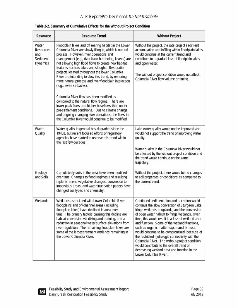
ATR Report/Pre-Decisional: Do Not Distribute
Feasibility Study and Environmental Assessment Report Page 55 Dairy Creek Restoration Feasibility Study July 2013
Table 2-2. Summary of Cumulative Effects for the Without Project Condition
Resource Resource Trend Without Project
Water Resources and Sediment Dynamics
Floodplain lakes and off rearing habitat in the Lower Columbia River are slowly filing in, which is natural process. However, river operations and management (e.g., river bank hardening, levees) are not allowing high flood flows to create new habitat features such as lakes and sloughs. Restoration projects located throughout the lower Columbia River are intending to slow this trend, by restoring more natural process and river/floodplain interaction (e.g., levee setbacks). Columbia River flow has been modified as compared to the natural flow regime. There are lower peak flows and higher baseflows than under pre-settlement conditions. Due to climate change and ongoing changing river operations, the flows in the Columbia River would continue to be modified.
Without the project, the rate project sediment accumulation and infilling within floodplain lakes would continue at the current trend and contribute to a gradual loss of floodplain lakes and open water. The without project condition would not affect Columbia River flow volume or timing.
Water Quality
Water quality in general has degraded since the 1940s, but recent focused efforts of regulatory agencies have started to reverse this trend within the last few decades.
Lake water quality would not be improved and would not support the trend of improving water quality. Water quality in the Columbia River would not be affected by the without project condition and the trend would continue on the same trajectory.
Geology and Soils
Cumulatively soils in the area have been modified over time. Changes to flood regimes and resulting replenishment, vegetative changes, conversion to impervious areas, and water inundation patters have changed soil types and chemistry.
Without the project, there would be no changes to soil properties or conditions as compared to the current trend.
Wetlands Wetlands associated with Lower Columbia River floodplains and off-channel areas (including floodplain lakes) have declined in area over time. The primary factors causing this decline are habitat conversion via diking and draining, and a reduction in seasonal water surface elevations from river regulation. The remaining floodplain lakes are some of the largest remnant wetlands remaining in the Lower Columbia River.
Continued sedimentation and accretion would continue the slow conversion of Sturgeon Lake fringe wetlands to uplands, and the conversion of open water habitat to fringe wetlands. Over time, this would result in a loss of wetland area and function. Some of the wetland functions, such as organic matter export and fish use, would continue to be compromised, because of the restricted hydrologic connectivity with the Columbia River. The without-project condition would contribute to the overall trend of decreasing wetland area and function in the Lower Columbia River.

ATR Report/Pre-Decisional: Do Not Distribute
Feasibility Study and Environmental Assessment Report Page 56 Dairy Creek Restoration Feasibility Study July 2013
Resource Resource Trend Without Project
Fish and Aquatic Resources and Special Status Species
Floodplain lakes within the Lower Columbia River have historically been important habitat for juvenile salmon, white sturgeon, and possibly other species, such as the pacific lamprey. The ability for these and other species to use lakes has been severely limited by modified water surface elevations during the spring freshet, and because of diking and development along historical surface water connection pathways.
Similarly, open water habitat which supports nesting and migrating waterfowl is an important resource for waterfowl and associated waterbirds. Waterfowl habitat in the Lower Columbia River corridor has decreased dramatically.
Special status species have declined in numbers and overall population viability over time. Habitat loss is a major factor in this decline. Conservation measures and restoration projects employed throughout the Lower Columbia River have attempted to stabilize and increase available habitat, in order to increase the viability of these populations.
Without the project, he limited amount of fish access to Sturgeon Lake would continue, and would contribute to the overall trend of decreasing habitat availability in the Lower Columbia River.
Waterfowl would continue to heavily use Sturgeon Lake; however, sedimentation in Sturgeon Lake would continue, slowly reducing open-water habitat suitability and availability for waterfowl contributing to the overall decline of habitat.
Sedimentation in Sturgeon Lake would reduce habitat suitability and availability for some special status species that rely on open water and surface water access from the Columbia River other species.
Vegetation Native vegetation has been modified for human uses including, forestry, farming, and conversion to development. Invasive and non-native species have become more prevalent, often creating monocultures, and reducing ecosystem function and support. There has generally been a loss in native vegetation diversity and resilience.
As the lake fills in, vegetation communities would transition from wetland emergent, to upland vegetation. Diversity would likely be maintained, although individual species may change. Along the current lake edge, there would continue to be a persistence and expansion of invasive species such as false indigo and reed canary grass into the lake fringe as sediment fills in, replacing in part, the native vegetation. The effect of the without condition would contribute to cumulative trend of a loss of vegetation function.
Historic and Cultural
Since the 1940s, cultural resources have been trending toward improved identification, preservation. There has been increasing coordination with Tribal entities and support of traditional cultural practices and places.
The without project would not contribute to the historic and cultural resources trends.

ATR Report/Pre-Decisional: Do Not Distribute
Feasibility Study and Environmental Assessment Report Page 57 Dairy Creek Restoration Feasibility Study July 2013
Resource Resource Trend Without Project
Socio-economic, Land Use, and Recreation
Socio-economics, land use modification and recreational uses have been altered substantially throughout the Lower Columbia River since the 1940s.
Without the project, there would be no expected changes to the socio-economic and land use development patterns. As the lake fills, in there would likely be a reduction in recreational uses such as canoeing/kayaking, fishing and possibly waterfowl hunting. These activities would likely be displaced to other areas and would have a minor incremental reduction on water related recreation activities.
Hazardous, Toxic, and Radioactive Waste
Releases and spills from hazardous waste and petroleum hydrocarbons have increased with the continued development of the Lower Columbia River. However, efforts to identify and clean up these releases have created a positive improvement to this resource.
The without-project condition would not change the trend of hazardous materials use and releases near the project area or in the Lower Columbia River drainage.
Air Quality and Noise
Air quality has improved since the 1940s, due to regulation and improvement in emission quality. Noise has generally increased over ambient levels since the 1950s. Generally increased have occurred most in the populated and urbanized areas.
The without project would not affect air quality or noise levels of the Lower Columbia River.

ATR Report/Pre-Decisional: Do Not Distribute
Feasibility Study and Environmental Assessment Report Page 58 Dairy Creek Restoration Feasibility Study July 2013
This page left intentionally blank

ATR Report/Pre-Decisional: Do Not Distribute
Feasibility Study and Environmental Assessment Report Page 59 Dairy Creek Restoration Feasibility Study July 2013
3.0 ALTERNATIVES 3.1 Plan Formulation
The following section discusses the process used to develop and screen Project measures and formulate alternatives, a description of each alternative, an environmental benefits evaluation, a comparison of alternatives using cost-effectiveness and incremental cost analyses, and a plan selection.
3.1.1 Problems and Opportunities
Sturgeon Lake is located within a major flyway corridor for migrating waterfowl. The SIWA and refuge was created in 1947 with the primary objectives of protecting and improving waterfowl habitat and providing a public hunting area. The SIWA provides wintering habitat for approximately 150,000 ducks, geese and swans annually. The Lake is a primary stopover for waterfowl moving up and down the Willamette Valley. Loss of the Lake habitat would be a substantial reduction of overwintering habitat along the flyway and would be contrary to waterfowl conservation efforts, such as the Pacific Coast Joint Venture, Pacific Flyway Council, and Oregon Conservation Strategy management objectives (ODFW, 2010a). Various avian species protected under the Migratory Bird Treaty Act are present in the Study Area; habitat improvement opportunities would benefit species protected by this act.
Columbia River stocks of salmon and steelhead are currently the focus of recovery efforts and are protected under the Endangered Species Act. Juvenile salmon historically used Sturgeon Lake to rear while outmigrating to the ocean. Adults used the Lake and floodplain fringe for refugia during high flows. There has been a dramatic loss of floodplain habitat in the estuary from Bonneville Dam to the mouth of the Columbia River. Therefore, restoring the access to, and quality of, this floodplain fringe and off-channel habitat is one element of salmon and steelhead recovery.
Sauvie Island Sturgeon Lake is also an important natural resource for Portlanders due to its close proximity to a large urban area. At a distance of 10 miles, Sauvie Island draws over 1 million visitors annually (SICA, 2013). In 2008, ODFW estimated 800,000 people had visited the SIWA (ODFW, 2010a).
Overall, waterfowl and fisheries resources are of regional importance not only due to their state and federal protected status, but also because of their contributions to recreational and fishing economies: commercial and Tribal fisheries, as well as Tribal trust resources. Identifying and addressing problems described in the following discussion have important impacts on the preservation of these regional resources.
Problems Hydrologic changes have resulted in decreased surface water inputs to the Lake which has limited connectivity to surrounding rivers and associated wetlands and floodplains. Changed hydrology has also reduced Lake water surface reductions and water circulation which has resulted in sub-optimal water quality, decreased aquatic habitat quality access

ATR Report/Pre-Decisional: Do Not Distribute
Feasibility Study and Environmental Assessment Report Page 60 Dairy Creek Restoration Feasibility Study July 2013
and filling, and sediment infilling at an estimated rate of 0.1 inches per year. The amount of infilling is variable over Lake area, meaning that some areas are not aggrading and other areas, such as the shorelines are aggrading at a greater rate. The sand shoaling in the mouth of Dairy Creek has restricted juvenile fish access direct from the Columbia River. The reasons for the lack of water and circulation include:
§ Regulation of Columbia River flows that has reduced the volume of water that enters Sturgeon Lake. The Columbia River has been altered such that there is a 50% decrease in peak discharge of snowmelt driven floods since 1969. This hydrologic change has reduced spring water surface elevations and habitat inundation in the Project area (Figure 3-1).
§ Completion of the Federal levee on south Sauvie Island. The levee limits the connectivity of the Lake from the Willamette and Columbia Rivers, and re-routes surface water drainage of the south Gilbert River from Sturgeon Lake to the Multnomah Channel. Levee construction has disconnected Sauvie Island’s floodplain from the rivers, no longer allowing natural processes that occur at high flows, such as sediment deposition and channel flushing.
§ Sand and debris accumulation in Dairy Creek which has disconnected flow input from the Columbia River, except for high flows. Dredge material was placed at the Columbia River outlet to Dairy Creek and it is likely that this is the primary source of sand that has aggraded in the channel.
§ An undersized crossing of Reeder Road restricts flows in and out of Sturgeon Lake (i.e., tidal exchange) and has created a backwater condition which allowed for debris and sand to deposit in Dairy Creek during flood events. The Reeder Road culverts also do not meet fish passage criteria and limit juvenile salmon access to the Lake.
Figure 3-1. Average Inundation Extent for the Month of June.
1887 - 1934 1970-2009

ATR Report/Pre-Decisional: Do Not Distribute
Feasibility Study and Environmental Assessment Report Page 61 Dairy Creek Restoration Feasibility Study July 2013
These changes in river hydrology, in combination with construction of the Federal levee, and the plugging of Dairy Creek with sediment and woody debris, has changed Sturgeon Lake hydrology into a backwater rather than flow-through condition. This has resulted in the following conditions:
§ decreased depth and area of Sturgeon Lake as silts and sands have accumulated in the shallow fringes converting open water to shallow vegetated fringes;
§ restricted direct salmon access from the Columbia River, except during higher flows, via the Dairy Creek channel;
§ shortened the amount of time fish are able to use the Lake due to sub-optimal habitat conditions;
§ decreased the daily effect of the tidal prism in the Lake which may have affected the distribution of the emergent marsh zone and tidal channels;
§ fringe wetland vegetation shifts (i.e., open-water emergent plants shifting to willows as the water becomes shallower);
§ reduced the food web interaction and inputs from the associated floodplains and wetlands;
§ degraded water quality such as increased temperature and fecal coliform concentrations; and
§ presence and spread of invasive aquatic and terrestrial plant, fish, and wildlife species from the reduction of flood magnitude and duration.
Opportunities Salmon, waterfowl, and other wildlife that use the Study Area would benefit directly from the following available restoration actions:
§ maintain or increase available waterfowl overwintering habitat (i.e., open water areas);
§ increase the capacity of Sturgeon Lake juvenile salmonid rearing habitat through improved quality, food web/prey based interaction, and area;
§ increase the frequency and duration (i.e., provide access at lower Columbia River flows) of juvenile salmonid access to aquatic habitats including Sturgeon Lake;
§ increase the hydraulic flow in, out, and through Sturgeon Lake to improve circulation, sediment export, and water quality; and
§ reduce invasive plant distribution and replace with native species to benefit wildlife.
3.1.2 Project Goal
The goal of this Section 1135 Project is to restore long-term natural function of Sturgeon Lake and increase availability of aquatic areas and habitat value for fish and wildlife. It is an ecosystem restoration Project to restore ecosystem function and area to benefit fish and wildlife in the Study Area. Specifically, the intent is to increase hydrologic inputs to increase circulation within Sturgeon Lake, which would help to maintain open water areas and improve habitat quality; and providing a direct connection between Sturgeon Lake and the Columbia River.
ATR Report/Pre-Decisional: Do Not Distribute
Feasibility Study and Environmental Assessment Report Page 62 Dairy Creek Restoration Feasibility Study July 2013
3.1.3 Project Objectives
Within the framework and constraints of the Section 1135 Program, and relative to a no action alternative over a 50-year time horizon, the following objectives were established:
§ To reestablish rearing juvenile salmonid (coho and Chinook) ingress and egress opportunities to Sturgeon Lake from Columbia River;
§ To maintain open water areas that support a diversity of wintering waterfowl to the extent practicable;
§ To restore off-channel habitat quality and quantity for rearing juvenile salmonids and flood refugia for juveniles and adults;
§ To restore more natural hydrologic inputs and connectivity between Sturgeon Lake and surrounding water bodies; and
§ To reconstruct Dairy Creek channel to improve habitat and riparian function, where feasible.
3.1.4 Project Constraints
Project actions are limited by existing features in the Study Area and current land uses. The goal of the Project cannot be achieved without accounting for these constraints. Constraints were identified early in the planning process to optimize the feasibility of each identified Project measure and subsequent alternatives. The constraints of the Project are:
§ Adherence to the SIWA planning goals and refuge intent as outlined in the Sauvie Island Wildlife Area Management Plan (ODFW, 2010a). Specifically:
o ODFW must be able to maintain water control structures around lakes and ponds surrounding Sturgeon Lake for the purposes of managing water levels for waterfowl and irrigation.
o ODFW must maintain current recreational access and allowances. This primarily includes waterfowl hunting (during fall and winter), fishing, and boating.
§ A large portion of the South Sauvie Island is protected by a Federal levee which was constructed by the USACE in 1942 and is maintained by the Sauvie Island Drainage Irrigation Company (SIDIC). This levee was authorized by congress under the Federal government’s Flood Control Act of 1936 and any reduction in levels of protection would require congressional approval.
§ SIDIC operational constraints were also considered in development of the Project alternatives. The SIDIC has an existing level of service that includes providing water to, and collecting drainage from, properties within the drainage company extents. The SIDIC maintains canal elevations within specific ranges by using the pump house which discharges into the Multnomah Channel. Deviations from these operational ranges that would interfere with property owner uses would not be allowed.
§ Private property consisting of homes and commercial agricultural production are within the Study Area. Hydrologic modifications resulting from the Project must not adversely affect these properties.

ATR Report/Pre-Decisional: Do Not Distribute
Feasibility Study and Environmental Assessment Report Page 63 Dairy Creek Restoration Feasibility Study July 2013
3.1.5 Screening Criteria
The following planning criteria were used to formulate and evaluate restoration measures (i.e., a specific action) and alternatives (i.e., one or more measures combined). The criteria below were used to screen out (i.e., remove for further consideration) a measure, or as a basis for combining measures into alternatives. The screening criteria is a completion of Project objectives and constraints as outlined above, USACE policy and procedure requirements (e.g., aligned with funding source), and considerations related to an acceptable and implementable project.
General Criteria § The Recommended Plan is consistent with the stated Project goal and objectives. § The Recommended Plan is compatible with the SIWA management goals. § The Recommended Plan is affordable for the local sponsors given the cost share
requirements of the Section 1135 Program. § The Recommended Plan protects public health and safety.
Technical Criteria § Restoration measures must not reduce the level of flood protection to existing
structures and properties. § New or restored channels must have an open connection with the Columbia River
and be self maintained during most flow regimes. § Contribute a rate of hydrologic mixing or contribution of flow to Sturgeon Lake at
a scale that is commensurate with the Lake volume, in order to affect the Lake’s ecological processes.
§ Project would not affect current operations of SIDIC which would affect property owner uses.
Environmental Criteria § Maximize open water habitat for migrating winter waterfowl which include
dabbling and diving duck guilds, along with geese and swans. Meet SIWA operational goals which include production of forage/pasture and maintenance of small lakes and ponds within the SIWA, adjacent to Sturgeon Lake (e.g., McNary Lake, Steelman Lake).
§ Maximize duration of open surface water connection between Columbia River and Sturgeon Lake floodplain to allow fish ingress and egress. Minimize the risk of predation and stranding of juvenile salmonids.
§ Restore and improve existing channel habitat and riparian function by adding new riparian plantings and in-stream wood structures, where applicable.
Social Criteria § Does not adversely affect the current public uses of the SIWA which include
hunting, wildlife observation, hiking, and water sports such as kayaking. § Project would only occur on lands where real estate acquisitions (e.g., easements)
are obtained from willing sellers. § The Project is generally acceptable to the partners, and larger community
stakeholders.

ATR Report/Pre-Decisional: Do Not Distribute
Feasibility Study and Environmental Assessment Report Page 64 Dairy Creek Restoration Feasibility Study July 2013
3.1.6 Risk and Uncertainty
Uncertainty is defined as limited knowledge to describe an existing state or predict a future one. Risk is the likelihood that uncertainty would result in adverse desired outcomes. The following section describes Project-related components, which have uncertainty and discuss the associated level of risk.
Project risks have been identified at a coarse level with the collection of potential measures that have been identified to date. Uncertainties and potential risks are listed below and further expanded in the paragraphs following:
§ Private property acquisition due to unwilling sellers; § Data gaps and hydraulic model limitations; § Rate of Lake infilling; § Sand aggradation in Dairy Creek related source supply and aggradation rate; and § Difficulties establishing riparian plantings.
Property Acquisitions Private land occurs on the eastern side of the Study Area adjacent to Dairy Creek. DSL may own submerged and submersible lands of Dairy Creek (i.e., below ordinary high water). This will be further evaluated as the Project progresses. Property acquisition is needed for construction and long term maintenance. At this time, properties have not been acquired. Therefore, there is uncertainty regarding the completion of the acquisition process. However, the risk of not acquiring property because of unwilling sellers is low for the following reasons:
· The local sponsors and USACE have been conducting owner outreach with individuals that might be directly affected by the Project. Property owners have indicated that they are willing to proceed with acquisition discussions.
· There are multiple routes available for temporary construction access, which lowers the risk of implementation.
· DSL would likely be amenable to the Project as it serves to improve the condition and use of State-owned lands.
Data and Hydraulic Model Limitations There are data limitations that limit understanding of existing and future hydraulic, geomorphic (sediment), and water quality dynamics. Specifically, there are data gaps for suspended solids concentrations, Lake bathymetry, and water level data. Historical data that had been collected within the Study Area and adjacent water bodies, serving as model boundary conditions, (e.g., Willamette River and Sturgeon Lake) have limited temporal overlap. These data gaps limit understanding of hydraulic and sediment exchange between water bodies. As a result, anecdotal observations, correlations, and trends cannot be quantified with a high degree of certainty.
These data are the basis for estimates of sediment dynamics and hydraulic modeling. In turn, the modeling and sediment estimates would be used to evaluate Project benefits.

ATR Report/Pre-Decisional: Do Not Distribute
Feasibility Study and Environmental Assessment Report Page 65 Dairy Creek Restoration Feasibility Study July 2013
Therefore a number of assumptions were needed to estimate the potential effects (i.e., benefits) of each alternative. Assumptions used to estimate benefits and results are further discussed in the attached Habitat Benefits report (Appendix A) and Hydrologic and Hydraulic report (Appendix B).
The assumptions were kept consistent between alternatives, and the Project team felt the costs and benefits of each alternative were relative to each other. Therefore, while the results have uncertain accuracy, a sensitivity analysis conducted on the habitat benefits demonstrated that the analysis allowed for comparisons between alternatives. The risk that this limited data would affect the outcome of the study is low because the level of uncertainty was equivalent and did not affect the overall relative ranking order. Additional modeling would be completed for the recommended plan during plans and specifications development to improve certainty and minimize risk.
Past and Future Rate of Lake Sedimentation At a conceptual level, sediment accretion in the Lake is understood:
§ Gradual filling of floodplain lakes in general is a natural process that occurs over a long time scale (i.e., hundreds or thousands of years).
§ The rate of sediment accumulation in Sturgeon Lake unknown, but likely increasing at a rate faster over the last 70 years due to hydrologic modifications.
§ Increasing hydrologic inputs and water circulation in the Lake may not prevent additional accumulation; but would slow the rate of accumulation as compared to the no action alternative.
Although, the rate of past and future sedimentation is uncertain, the Project team concluded that the selected plan would reduce the rate of sedimentation to the benefit of the Lake system as compared to the no action alternative. The risk of the Project meeting the stated benefits is low.
Sand Accumulation in Dairy Creek The exact source, mechanism, and future rate of sand accumulation in the Dairy Creek channel are unknown. Most likely, the source of the sand is from 1989 excavated material, which was placed just outside the mouth of Dairy Creek. This material along with the undersized culverts at Reeder Road and the wide mouth at the confluence with the Columbia River created conditions that allowed the sand to deposit.
The recommended plan is expected to be more-sustainable over the long term as the primary contribution of sand has been exhausted; a debris boom would be designed to account for extreme high flows; and, more is understood about the design needed to create a more self maintaining channel.
A HEC-RAS model was completed that shows that a 2-stage channel, as proposed, would result in velocities of 3 feet/second. This velocity is high enough to transport sand through the channel. The USACE conducted a design meeting to discuss causes and solutions to reduce the potential for the accumulation of sand and debris after Project implementation. Numerous USACE and USFWS staff with river restoration experience contributed to the meeting. Table 3-1 summarizes potential sources and design options

ATR Report/Pre-Decisional: Do Not Distribute
Feasibility Study and Environmental Assessment Report Page 66 Dairy Creek Restoration Feasibility Study July 2013
discussed which would minimize the potential for sand and debris accumulation and possible design considerations.
Table 3-1. Potential Sources of Sand Deposition in Dairy Creek.
Potential Sources/Causes Design Solution Local spoil deposits or historic dredging moving and depositing into the mouth (i.e., finite source)
This would be a finite source, monitor results.
Sand moving up or down the Columbia River and being moved around as a result of current operations (e.g., tide, boat, etc.)
Construct channel (e.g., 2 stage) to design low channel for critical velocities that would keep channel clear.
Design in a stilling basin (e.g., the backwater area of the creek) area is small and might only be able to settle out bigger materials. Allow for periodic removal as part of ongoing maintenance.
Create design element at mouth to minimize eddies, which drop out sand.
Material from banks and embankment fill Grade and vegetate slopes; design of new culverts would have less abutment fill.
Sand and debris accumulation may be exacerbated due to pile dikes and Reeder Road culverts.
Design opening at Reeder Road to allow for critical velocities.
Develop 2-D model during design to evaluate effects of pile dikes.
Accumulating debris during flood flows exacerbating sand retention.
Install debris boom at mouth to prevent large materials from migrating into channel.
Riparian Plantings Establishment of riparian plantings has inherent risk because of uncertain soil conditions, competition from invasive species (e.g., Himalayan blackberry) and beaver browsing. Unfavorable soil conditions can be mitigated by properly characterizing soils, selecting appropriate plants, and watering the plants as appropriate, until they are established. Competition from invasive species can be mitigated by regular monitoring and maintenance of plantings, until they become established and have effectively out-competed the weeds. Beaver occur in the Project area, and have the potential to damage new trees before they are large enough to collectively withstand regular browsing. Impacts from browsing can be minimized by protecting new woody plantings, but this risk cannot be completely mitigated.
3.2 Formulation of Potential Restoration Measures Conceptual measures were developed and evaluated through a variety of avenues from individuals with diverse backgrounds. Measure identification stemmed from a specific measure workshop; comments and suggestions from the general public and landowners; and feedback from regulatory agency personnel.

ATR Report/Pre-Decisional: Do Not Distribute
Feasibility Study and Environmental Assessment Report Page 67 Dairy Creek Restoration Feasibility Study July 2013
A series of initial measures were formulated during a team workshop conducted on 12 January 2012. The team consisted of personnel from the USACE, consultant team, and multiple stakeholders including ODFW, SIDIC, WMSWCD, and Multnomah County. The premise of this workshop was to identify any measure that might meet Project criteria, regardless of feasibility. The measures were later screened against criteria listed in Section 3.1.5. Additional input was received from the Sturgeon Lake Planning Working Group, public meetings, and agency coordination, which is summarized in Section 6.0.
3.3 Screening of Conceptual Restoration Measures A total of 19 conceptual restoration measures were identified (Table 3-2). These measures consisted of new channels, sediment traps, in-Lake work, and improvements to the existing and historic Dairy Creek channel, tide gates and pumps, and changes to levees. A general overview of the measure concepts are provided below. More detailed descriptions of each of the conceptual measures are presented in Appendix D.
The new channels had common objectives of increasing surface water exchange and fish access between the Lake and surrounding riverine water bodies. Increased surface water exchange could also allow for an increased volume of water to enter Sturgeon Lake, providing circulation and reducing sediment aggradation in the Lake. New channels between the Columbia River and Sturgeon Lake would provide much more direct fish access to the Lake for juvenile salmonids outmigrating along the Columbia River shoreline. Concepts to improve Dairy Creek (i.e., the 1989 modified channel) were also considered to meet these same objectives.
Sediment traps were proposed at the mouths of the North Gilbert River and Dairy Creek in order to reduce sediment inputs into the Lake. Sediment traps consist of large tanks either above or underground. The intent is to divert a certain amount of flow from the creek into the holding tank. The tank slows the water, and the suspended sediments “drop” out of the water column and accumulate in the tank. The water would then be diverted back to the primary creek channel. The Project team hypothesized that sediment traps would directly reduce sediment aggradation in the Lake, making the Lake deeper with more open water, relative to a no action scenario.
In-Lake restoration concepts were proposed to directly improve habitat features for fish and wildlife. Concepts included breaching portions of the Gilbert River similar to the existing breaches (e.g., the wash) and dredging Sturgeon Lake. Breaching portions of the Gilbert River could alter local hydraulics, and potentially result in local scour that could deepen the Lake in specific localized areas. Dredging Sturgeon Lake would cause a direct and immediate change to Lake depth, by removing accumulated silts and sands, respectively. This concept was not intended to fundamentally change Lake hydrologic processes.
Measures to re-connect hydrologic inputs from south Sauvie Island (i.e., the area within the Federal levee) were considered because restoring historical hydrologic inputs into the Lake may partially restore natural hydrologic processes in Sturgeon Lake. Since these hydrologic inputs would be directed into the southern portion of the Lake, the Project

ATR Report/Pre-Decisional: Do Not Distribute
Feasibility Study and Environmental Assessment Report Page 68 Dairy Creek Restoration Feasibility Study July 2013
team hypothesized that these inputs may increase Lake surface water elevations during certain times of the year, and help scour and flush fine sediments out of the Lake. Measures which included tide gates and pumps were proposed to convey flow over the levee into the Lake. Changes to the Federal levee were also proposed in order to allow for more passive flooding in and around the Project area.
These measures were compared against the Project goal, objectives and planning criteria. Measures were retained or dismissed based on these screening elements. Measures were retained if they met only a portion of the Project objectives, so they could be later combined with other measures to form an Alternative which met all Project objectives. Measures were dismissed if they did not meet planning criteria, or a single Project objective, or were contrary to the Project goal. Table 3-2 summarizes the identified conceptual measures, if they were retained or dismissed and reason for that outcome.

ATR Report/Pre-Decisional: Do Not Distribute
Feasibility Study and Environmental Assessment Report Page 69 Dairy Creek Restoration Feasibility Study July 2013
Table 3-2. Measures Retained and Dismissed from Further Consideration during Screening
Measure Retained or Dismissed from Further Consideration upon First Level Screening
No. Name Reason for Retention or Dismissal 1 Connect N. Gilbert River to Columbia River via McNary Lake Dismissed: Measure is not compatible with SIWA management goals for managing adjacent lake water
surface elevations for recreational hunting. 2 Connect McNary Lake to the Columbia River; Connect McNary
Lake and Aaron Lake to Sturgeon Lake Dismissed: Measure is not compatible with SIWA management goals for managing adjacent lake water surface elevations for recreational hunting. McNary and Aaron Lake currently have water control structures which are maintained to increase surface water in late fall and winter for waterfowl.
3 Connect McNary Lake to the Multnomah Channel; Connect McNary Lake and Aaron Lake to Sturgeon Lake
Dismissed: Measure is not compatible with SIWA management goals for managing adjacent lake water surface elevations for recreational hunting. McNary and Aaron Lake currently have water control structures which are maintained to increase surface water in late fall and winter for waterfowl.
4 Connect Steelman Lake to the Multnomah Channel Dismissed: There is a lack of hydraulic head between Multnomah Channel and Steelman Lake; therefore, the measure would not contribute a meaningful amount of flow to Sturgeon Lake. The measure would also require a tide gate which is not self-maintaining.
5 Connect Sturgeon Lake to the Columbia River with an excavated channel starting at Sauvie Cove
Dismissed: Not affordable for the local sponsors given the cost share requirements of the Section 1135 Program.
6 Connect the Historic Dairy Creek channel to Sturgeon Lake close to the terminus of current north Gilbert River
Retained. Dependent on Measure 14a; this measure may increase fish ingress/ egress and hydrologic exchange between Sturgeon Lake and the Columbia River.
7 Connect south Gilbert River to the Willamette River with an excavated channel and tide gate. Install tide gate between excavated channel and Sturgeon Lake (through the Federal levee) to convey flows from Willamette River to Lake.
Dismissed: This measure would require that the interior leveed area canals operate at a higher water level in order to increase positive flow into Sturgeon Lake. The measure would affect current operations of SIDIC which would affect property owner uses as properties would not drain as they do currently.
8 Install sediment trap near the mouth of the north Gilbert River Dismissed: Measure would require a diversion structure in Gilbert River which would affect fish and recreational access. The measure would not be self-maintaining. Did not meet Project goal.
9 Install managed water control structures in the N. Gilbert River and the Dairy Creek channels. Pump water to increase hydrologic inputs to the lake, but manage sediment.
Dismissed: Measure would restrict fish access, which is contrary to the Project objectives, and would not be self-maintaining.
10 Remove portions of north Gilbert River Peninsula (i.e., breach many locations along Gilbert River Levee)
Dismissed: Measure would not contribute a rate of hydrologic mixing or contribution of flow to Sturgeon at a scale that is commensurate with the Lake volume, in order to affect the Lake’s ecological processes. Did not meet Project objective.
11 Dredge sediment in Sturgeon Lake in order to improve habitat quality and hydraulics
Dismissed: Measure would not contribute a rate of hydrologic mixing or contribution of flow to Sturgeon Lake, in order to affect the lake’s ecological processes. This measure would not be self maintaining and does not meet Project goal.
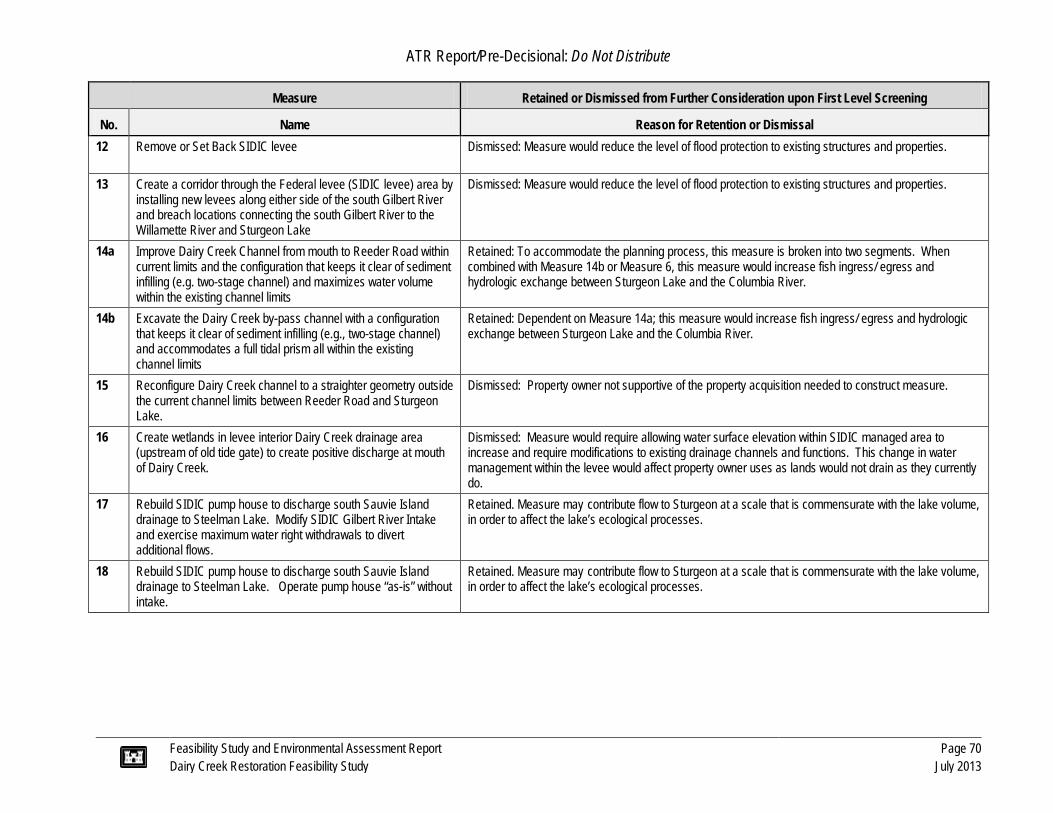
ATR Report/Pre-Decisional: Do Not Distribute
Feasibility Study and Environmental Assessment Report Page 70 Dairy Creek Restoration Feasibility Study July 2013
Measure Retained or Dismissed from Further Consideration upon First Level Screening
No. Name Reason for Retention or Dismissal 12 Remove or Set Back SIDIC levee Dismissed: Measure would reduce the level of flood protection to existing structures and properties.
13 Create a corridor through the Federal levee (SIDIC levee) area by installing new levees along either side of the south Gilbert River and breach locations connecting the south Gilbert River to the Willamette River and Sturgeon Lake
Dismissed: Measure would reduce the level of flood protection to existing structures and properties.
14a Improve Dairy Creek Channel from mouth to Reeder Road within current limits and the configuration that keeps it clear of sediment infilling (e.g. two-stage channel) and maximizes water volume within the existing channel limits
Retained: To accommodate the planning process, this measure is broken into two segments. When combined with Measure 14b or Measure 6, this measure would increase fish ingress/ egress and hydrologic exchange between Sturgeon Lake and the Columbia River.
14b Excavate the Dairy Creek by-pass channel with a configuration that keeps it clear of sediment infilling (e.g., two-stage channel) and accommodates a full tidal prism all within the existing channel limits
Retained: Dependent on Measure 14a; this measure would increase fish ingress/ egress and hydrologic exchange between Sturgeon Lake and the Columbia River.
15 Reconfigure Dairy Creek channel to a straighter geometry outside the current channel limits between Reeder Road and Sturgeon Lake.
Dismissed: Property owner not supportive of the property acquisition needed to construct measure.
16 Create wetlands in levee interior Dairy Creek drainage area (upstream of old tide gate) to create positive discharge at mouth of Dairy Creek.
Dismissed: Measure would require allowing water surface elevation within SIDIC managed area to increase and require modifications to existing drainage channels and functions. This change in water management within the levee would affect property owner uses as lands would not drain as they currently do.
17 Rebuild SIDIC pump house to discharge south Sauvie Island drainage to Steelman Lake. Modify SIDIC Gilbert River Intake and exercise maximum water right withdrawals to divert additional flows.
Retained. Measure may contribute flow to Sturgeon at a scale that is commensurate with the lake volume, in order to affect the lake’s ecological processes.
18 Rebuild SIDIC pump house to discharge south Sauvie Island drainage to Steelman Lake. Operate pump house “as-is” without intake.
Retained. Measure may contribute flow to Sturgeon at a scale that is commensurate with the lake volume, in order to affect the lake’s ecological processes.

S T U R G E O NL A K E
( N O R T H )
389
1
2
46
16
13
7
17
5
914a
15
S T U R G E O NL A K E
( S O U T H )
S T E E L M A NL A K E
Dairy Creek, 1989
North Gilbert River
Sauvie DrainageImprovement
CompanyPump House
The Wash
Coon Point
M C N A R YL A K E
COLUMBIA RIVERM U L T N O M A H C
H A N N E L
WILLAMETTE RIVER
Mud Slough
Mud Slough
Dairy CreekDairy Creek
Tidegate(No longer
in use)
OakIsland
RacetrackLake
A A R O NL A K E
ODFW Levee
Sauvie Island Drainage Improvement
Company Levee
South Gilbert River In ter ior Drainage Ca na l
South Gilbert River
Reeder Rd Crossing
Pile Dike
Pile Dike
11
12
14b
1018
Historic
Dairy C
reek
Vancouver
Portland
Federal LeveeODFW LeveeStudy AreaStreams
0 0.8 1.60.4 Miles
Figure 3-2. Dairy Creek Restoration Project Proposed Measure Locations
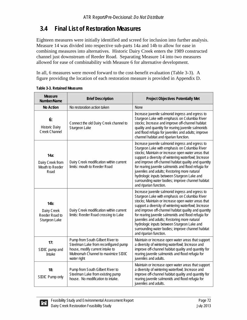
ATR Report/Pre-Decisional: Do Not Distribute
Feasibility Study and Environmental Assessment Report Page 72 Dairy Creek Restoration Feasibility Study July 2013
3.4 Final List of Restoration Measures Eighteen measures were initially identified and screed for inclusion into further analysis. Measure 14 was divided into respective sub-parts 14a and 14b to allow for ease in combining measures into alternatives. Historic Dairy Creek enters the 1989 constructed channel just downstream of Reeder Road. Separating Measure 14 into two measures allowed for ease of combinability with Measure 6 for alternative development.
In all, 6 measures were moved forward to the cost-benefit evaluation (Table 3-3). A figure providing the location of each restoration measure is provided in Appendix D.
Table 3-3. Retained Measures
Measure Number/Name Brief Description Project Objectives Potentially Met
No Action No restoration action taken None
6: Historic Dairy
Creek Channel
Connect the old Dairy Creek channel to Sturgeon Lake
Increase juvenile salmonid ingress and egress to Sturgeon Lake with emphasis on Columbia River stocks; Increase and improve off-channel habitat quality and quantity for rearing juvenile salmonids and flood refugia for juveniles and adults; improve channel habitat and riparian function.
14a: Dairy Creek from Mouth to Reeder
Road
Dairy Creek modification within current limits: mouth to Reeder Road
Increase juvenile salmonid ingress and egress to Sturgeon Lake with emphasis on Columbia River stocks; Maintain or increase open water areas that support a diversity of wintering waterfowl; Increase and improve off-channel habitat quality and quantity for rearing juvenile salmonids and flood refugia for juveniles and adults; Restoring more natural hydrologic inputs between Sturgeon Lake and surrounding water bodies; improve channel habitat and riparian function.
14b: Dairy Creek
Reeder Road to Sturgeon Lake
Dairy Creek modification within current limits: Reeder Road crossing to Lake
Increase juvenile salmonid ingress and egress to Sturgeon Lake with emphasis on Columbia River stocks; Maintain or increase open water areas that support a diversity of wintering waterfowl; Increase and improve off-channel habitat quality and quantity for rearing juvenile salmonids and flood refugia for juveniles and adults; Restoring more natural hydrologic inputs between Sturgeon Lake and surrounding water bodies; improve channel habitat and riparian function.
17: SIDIC pump and
Intake
Pump from South Gilbert River to Steelman Lake from reconfigured pump house, modify current intake to Multnomah Channel to maximize SIDIC water right
Maintain or increase open water areas that support a diversity of wintering waterfowl; Increase and improve off-channel habitat quality and quantity for rearing juvenile salmonids and flood refugia for juveniles and adults.
18: SIDIC Pump only
Pump from South Gilbert River to Steelman Lake from existing pump house. No modification to intake.
Maintain or increase open water areas that support a diversity of wintering waterfowl; Increase and improve off-channel habitat quality and quantity for rearing juvenile salmonids and flood refugia for juveniles and adults.

ATR Report/Pre-Decisional: Do Not Distribute
Feasibility Study and Environmental Assessment Report Page 73 Dairy Creek Restoration Feasibility Study July 2013
3.5 Final Array of Alternatives Measures were combined into alternatives based on whether or not they were mutually exclusive, combinable, or dependent on other measures (Table 3-4). Based on these interrelationships, 12 design alternative combinations, including the “No Action” alternative were advanced to the economic analysis. Table 3-5 defines these alternatives.
Table 3-4. Retained Measures and their Interrelationships
Measure No Action
6 Historic Dairy
Creek Channel
14a Dairy Creek
from Mouth to Reeder Rd
14b Dairy Creek
Reeder Rd to Sturgeon
Lake
17 SIDIC Pump and Intake
18 SIDIC
Pump only
No Action -
6* Historic Dairy
Creek Channel M -
14a Dairy Creek
from Mouth to Reeder Rd
M D -
14b* Dairy Creek
Reeder Rd to Sturgeon Lake
M C D -
17 SIDIC Pump and Intake
M C C C -
18 SIDIC
Pump only M C C C M -
Notes: D = dependent (must be combined); C = combinable; M = mutually exclusive; *Measures must be paired with Measure 14a

ATR Report/Pre-Decisional: Do Not Distribute
Feasibility Study and Environmental Assessment Report Page 74 Dairy Creek Restoration Feasibility Study July 2013
Table 3-5. Composition of Alternative Plans
Plan Number No Action
6 Historic Dairy
Creek Channel
14a Dairy Creek
from Mouth to Reeder Rd
14b Dairy Creek
Reeder Rd to Sturgeon
Lake
17 SIDIC Pump and Intake
18 SIDIC Pump
only
1 ü
2 ü ü
3 ü ü
4 ü ü ü
5 ü
6 ü ü ü
7 ü ü ü
8 ü ü ü ü
9 ü
10 ü ü ü
11 ü ü ü
12 ü ü ü ü
3.6 Evaluation of Restoration Benefits by Alternative Habitat benefits for each measure and the No Action alternative were modeled with a Habitat Evaluation Procedure (HEP). Habitat benefits were calculated for measures, because their benefits would be additive for any combination leading to an alternative plan. For each measure and the No Action alternative, the Study Area was weighted by its suitability for target species. For each target species, habitat suitability was assessed with published Habitat Suitability Indexes (HSIs), and modified based on specific Project conditions. During the subsequent economic analysis, restoration measures were combined in pre-determined ways to form candidate restoration alternatives, with associated habitat benefits and cost.
The Study Area is important for multiple wildlife uses, but was represented by waterfowl overwintering and juvenile salmonid rearing. These specific wildlife uses were selected because of resource importance, study relevance, and HSI model availability. The northern pintail, lesser scaup, coho salmon, and Chinook salmon were selected to represent these specific wildlife uses. Habitat suitability for the northern pintail was determined by the availability of shallow open water and emergent vegetation that

ATR Report/Pre-Decisional: Do Not Distribute
Feasibility Study and Environmental Assessment Report Page 75 Dairy Creek Restoration Feasibility Study July 2013
provided food resources. Lesser scaup habitat suitability was determined by the presence of pelecypod food resources, and relatively undisturbed, open, and deep water.
Benefits to coho and Chinook salmon were considered together. Salmon habitat suitability was determined by water temperature, riparian function, and the presence of both winter refugia and rearing habitat. For each restoration measure and species group, habitat benefits were calculated by aggregating the overall habitat suitability and multiplying that 0-1 score by the 2-year flood inundation area. The frequency of new access between the Columbia River and Sturgeon Lake was used to weight the salmon habitat area and habitat benefits.
HUNorthern pintail = HSI northern pintail* Area2-year (acres)
HUlesser scaup = HSI lesser scaup * Area 2-year (acres)
HUSalmon = HSI Salmon * [( ∑ 𝒏𝒊=𝟏 Passagei * Rearing Areai) + Riparian Area]
Where there are i…n channels or access points from the Columbia River to Sturgeon Lake; Passage is the percentage of time that the maximum elevation of the channel is inundated; Rearing Area is the Lake and channel area inundated at a 2-year flood elevation; and Riparian Area is the area of functional riparian habitat within 200 feet of the channel bank.
Since waterfowl and fish uses are both recognized and valued on an institutional, public, and scientific basis, they were allocated an equivalent weighting for the HEP model. After iteratively summing and averaging annual benefit units, the following equation was used to determine habitat units (HUs) for the “without-Project” and proposed measures:
HUmeasure= ∑ 𝟓𝟎𝒊=𝟏 (iHUPintail + iHUscaup + iHUSalmon)]*1/50
In terms of the six measures considered, the restoration of the Dairy Creek channel (Measures 14a and 14b) provided the most new habitat benefits (Table 3-6). This channel would provide high-frequency access between the Columbia River and Sturgeon Lake, new off-channel habitat with riparian function, and would moderate Lake water temperatures during the late spring and early summer. Therefore, alternatives that included Measures 14a and 14b had the greatest amount of benefit (Table 3-7). Measure 14a yielded a very small amount of habitat units, because it is intended to be combined with Measure 14b or Measure 6 during formation of alternatives, and provides very little habitat as a stand-alone measure.
Alternatives containing the restoration of the old Dairy Creek channel (Measure 6) would added an intermediate quantity of habitat benefits, by providing fish access to the Lake during high river stages. Alternatives that included pumping water from the southern Sauvie Island drainage to Sturgeon Lake (Measures 17 and 18) did not yield any additional habitat units, because these measures did not substantively change Lake hydrology, Lake vegetation, or provide fish access.

ATR Report/Pre-Decisional: Do Not Distribute
Feasibility Study and Environmental Assessment Report Page 76 Dairy Creek Restoration Feasibility Study July 2013
Since none of the alternatives substantively affected Lake hydrology or the distribution of emergent vegetation, habitat suitability for the northern pintail and lesser scaup was unchanged from the No Action alternative. Therefore, the overall benefits were determined by changes in salmon habitat units (Table 3-6). Since the habitat benefits were additive in nature, the restoration alternative benefits were determined by summing the benefits for each component restoration measure (Table 3-7).
Table 3-6. Overall Net Change in Habitat Units from Combined Northern Pintail, Lesser Scaup, and Salmon Analyses.
Summary of Species Benefits as Average Annual Habitat Units
Change in AA benefits Alt 1-No Action Measure 6 Measure
14a Measure
14b Measures 17 and 18
Northern Pintail 0 0 0 0 0
Lesser Scaup 0 0 0 0 0
Salmon 0 630 4 1,668 0
Overall Net Change in Benefits 0 630 4 1,668 0
Table 3-7. Overall Net Change in Average Annual Benefits for Restoration Alternative
Plan Number No Action
6 Historic Dairy
Creek Channel
14a Dairy Creek from Mouth to Reeder
Rd
14b Dairy Creek
Reeder Rd to Sturgeon Lake
17 SIDIC Pump
and Intake
18 SIDIC
Pump only
Net Change in Overall AA
Benefits (HU)
1 ü 0
2 ü ü 634
3 ü ü 1,671
4 ü ü ü 2,301
5 ü 0
6 ü ü ü 634
7 ü ü ü 1,671
8 ü ü ü ü 2,301
9 ü 0
10 ü ü ü 634
11 ü ü ü 1,671
12 ü ü ü ü 2,301

ATR Report/Pre-Decisional: Do Not Distribute
Feasibility Study and Environmental Assessment Report Page 77 Dairy Creek Restoration Feasibility Study July 2013
3.6.1 Additional Benefits
The HEP analysis was based on habitat suitability of four species that are intended to be representative of all fish and wildlife in the Study area that would be affected by the possible measures. Although there are implied benefits to the larger fish and wildlife community, the following benefits for the alternative plans are expected to occur, but may not have been reflected in the HEP model.
Fish Passage and Off-Channel Refugia Several alternative plans would benefit all native fishes that use off-channel habitat in the Lower Columbia River Estuary (LCRE; Table 3-8). These plans would increase access to Sturgeon Lake via the 1989 Dairy Creek channel and/ or via the historical Dairy Creek channel. Many native fish species that are not included in the HEP analysis could use utilize this off-channel habitat. These species include, but are not limited to, steelhead, chum, northern pike minnow, pacific lamprey, and white sturgeon.
Mudflats and Open-Water for Waterfowl None of the alternative plans increased habitat suitability for waterfowl in the HEP analysis, because no single measure or combination thereof was expected to create a sizeable change lake stage, bathymetry, or morphology. Habitat is currently suitable for waterfowl in the Study Area, and at the predicted rate of sediment aggradation, would continue to be suitable throughout the 50-year Project horizon. Sturgeon Lake is likely suitable for many other species of waterfowl. These species include several species of diving ducks, dabbling ducks, geese, and swans.
The alternative plans that involve restoring the 1989 Dairy Creek channel may result in a reduction in the rate sediment aggradation in the Lake, although this effect cannot be estimated with available hydraulic and sediment flux models. Though the model was effective at discerning variations in benefits between plans, it was not able to fully capture all waterfowl benefits. This is due in part to the fact that waterfowl habitat quality is already high. Maintaining existing conditions over time would be a positive reflection of habitat maintenance (as opposed to continued sediment aggradation). Coarse level data, assumptions, and limitations of HEP/HSI may not fully capture the overall sediment aggradation effects on waterfowl habitat under the No Action alternative that have and would be expected to occur based on anecdotal evidence and best professional judgment.
If these alternative plans did reduce sediment aggradation in Sturgeon Lake, there may be a waterfowl benefit, in terms of reducing the loss of open water area that is expected to occur with the no action alternative (Table 3-8). The predicted rate of sediment aggradation for the No Action and restoration alternatives slightly reduced habitat suitability for both modeled waterfowl species over the 50-year planning horizon. However, since none of the restoration alternatives altered the sediment aggradation rate, there was no net difference in waterfowl (i.e., Lesser Scaup, Northern Pintail) habitat suitability over time, relative to the No Action alternative. The open water habitat also functions as open mudflats during the late summer and early fall. These mudflats are vital for roosting sandhill cranes during their spring and fall migrations. During the fall,

ATR Report/Pre-Decisional: Do Not Distribute
Feasibility Study and Environmental Assessment Report Page 78 Dairy Creek Restoration Feasibility Study July 2013
Sturgeon Lake mudflats provide habitat for several bird species including killdeer, long-billed dowitcher, least sandpiper, and tens of thousands of dunlin (ODFW, 2010a).
Off-Channel Habitat for Reptiles and Amphibians Although not a specific objective of the Project, the alternative plans that involve the addition of large woody debris in the floodplain would benefit reptiles and amphibians (Table 3-8). For example, the western painted turtle (Chrysemys picta) and the northwestern pond turtle (Clemmys marmorata) would benefit from the addition of large woody debris, because they would function as basking structures and disturbance refugia. The northern red-legged from (Rana aurora) breed and spend a portion of their time in aquatic areas, but they also use upland habitats for dispersal and other functions (Leonard et al., 1993). Therefore, this species would benefit from the riparian restoration and protection along the historical channel. In general, off-channel features of Sturgeon Lake provide important habitat for migrating and rearing juvenile salmonids, wintering waterfowl, sandhill cranes, shorebirds, songbirds and turtles (ODFW, 2010a).
Riparian and Floodplain Corridor Riparian restoration would provide adjacent terrestrial habitat for these semi-aquatic animals, and would provide a buffer from human disturbance. Riparian corridors and their associated water bodies are important habitats meeting most of the life history needs of many of the water bird species (ODFW, 2010a). Waterbirds which use the wildlife area for breeding include great blue heron (Ardea Herodias), pied-billed grebe (Podilymbus podiceps) and two species of rail. The riparian forests provide excellent habitat for nesting species such as mourning dove (Zenaida macroura), willow flycatcher (Empidonax traillii), black-headed grosbeak (Pheucticus melanocephalus), rufous hummingbird (Selasphorus rufus) and Bullock‟s oriole (Icterus bullockii).
A variety of mammals inhabit the riparian corridors, including the red fox (Vulpes vulpes), gray fox (Urocyon cinereoargenteus), bobcat (Lynx rufus), mink (Mustela vison), muskrat (Ondatra zibethicus), American beaver (Castor canadensis), river otter (Lutra canadensis) and raccoon (Procyon lotor). Other mammals include brush rabbits (Sylvilagus bachmani), western gray squirrel (Sciurus griseus), coyote (Canis latrans), striped skunk (Memphitis memphitis), western spotted skunk (Spilogale gracilis), and various shrews, voles, moles, gophers, chipmunks, and ground squirrels.
These restoration alternative plans are intended to restore natural hydrological processes. Natural process would foster formation of native habitat that should exist in the Study Area. Aquatic habitat quantity, riparian quality, and water quality are expected to be improved in the Study Area. The influence of daily tidal flows and natural disturbance regimes may increase the formation of microhabitats, such and dendritic channel formation in the floodplain. Increased surface water connectivity may result in increased allochthonous inputs to Sturgeon Lake from the peripheral floodplain and emergent marsh zone and increased detrital exports to the larger estuary. These processes would benefit the greater LCRE food web. These wetland and floodplain exports were the basis of the historical LCRE food web, but have been greatly reduced with river regulation and habitat floodplain disconnection. The proposed restoration alternatives will not impact habitat features, except for temporary construction impacts.

ATR Report/Pre-Decisional: Do Not Distribute
Feasibility Study and Environmental Assessment Report Page 79 Dairy Creek Restoration Feasibility Study July 2013
Table 3-8. Additional Fish and Wildlife Benefits
Plan Number No Action Fish Passage
and Off-Channel Refugia
Mudflats and Open-Water for
Waterfowl
Off-Channel Habitat for Reptiles and Amphibian
Riparian Corridor
1 ü
2 ü ü ü
3 ü ü ü ü
4 ü ü ü ü
5 ü
6 ü ü ü
7 ü ü ü ü
8 ü ü ü ü
9 ü
10 ü ü ü
11 ü ü ü ü
12 ü ü ü ü
3.7 Implementation Costs for Alternatives The feasibility cost estimate was prepared using the concept designs for each measure described above (Appendix E). This is a Class 5 estimate, per the AACE cost estimate classification system. A typical Class 5 estimate may have an accuracy range as broad as -50% to +100%, or as narrow as -20% to +30%. Attachment A in Appendix E includes figures showing each of the measures and the cost estimates.
The construction cost estimate for the cost benefit analysis was prepared using the concept designs for each measure with a 30 percent contingency on unit costs. Sources of information for the unit prices were quotes from vendors, local department of transportation bid tables, past project bid tables, and professional judgment of experienced engineers. Quantities were measured off of LiDAR and using field observations. Some of the assumptions used in developing the estimate include: local disposal of sand and debris, local sources of topsoil and plants, and straight percentage estimates for traffic control and erosional control plans.
In addition to the construction cost, each design measure’s estimate includes supervision and administration (S&A) of construction; preconstruction, engineering and design (PED); real estate acquisition; monitoring; and O&M. Costs for these items, excluding real estate and O&M, were developed using primarily using generally accepted percentages of the project total. The percentages for each item were adjusted either up or down to account for the complexity of the measure and the need to permit, complete

ATR Report/Pre-Decisional: Do Not Distribute
Feasibility Study and Environmental Assessment Report Page 80 Dairy Creek Restoration Feasibility Study July 2013
analysis design, manage construction, and perform O&M activities. The estimate assumes a 5-year monitoring period and 50-year O&M period. The ranges were as follows:
· Engineering and Design ranged from 5 to 9 percent of project based on complexity and size of the project. Additional preconstruction efforts (e.g., permitting, survey, geotechnical) were added independently and estimated based on the perceived needs and costs for each measure. Estimates were derived from the estimators past knowledge and consultation with other professionals.
· S&A ranged from 5 to 9 percent depending upon complexity.
· Monitoring was held at 1 percent for of the total estimated construction cost.
· O&M costs for vegetation management, pumping, and general infrastructure was estimated primarily based on input from local operators (e.g., SIDIC, ODFW). Sand removal for measure 14a, was estimated based on periodic removal (i.e., 2 times over the last 50 years) of sand equal to the volume which has accumulated over the last 25 years.
· Real estate costs were developed by researching recently sold tax lots to develop an estimate of the land value per square foot. This was done for several tax lots in the project area and the maximum values were near $1 per square foot, which is a conservative approximation to use for the initial cost analyses.

ATR Report/Pre-Decisional: Do Not Distribute
Feasibility Study and Environmental Assessment Report Page 81 Dairy Creek Restoration Feasibility Study July 2013
Table 3-9. Alternative Plan Costs.
Plan Number Plan
Description (Measures included)
Total Capital Cost
Supervision & Administration (of
Construction)1
Preliminary Engineering and Design2
Real Estate Monitoring O &M Total Cost3
1 No Action Plan 0 0 0 0 0 0 0
2 6, 14a 5,950,000 420,000 460,000 1,010,000 70,000 320,000 8,230,000
3 14a, 14b 4,800,000 460,000 520,000 880,000 60,000 320,000 7,040,000
4 6, 14a, 14b 8,590,000 680,000 750,000 1,320,000 100,000 330,000 11,770,000
5 17 9,490,000 920,000 900,000 460,000 100,000 10,000 11,880,000
6 6, 14a, 17 15,440,000 1,340,000 1,360,000 1,470,000 170,000 330,000 20,110,000
7 14a, 14b, 17 14,290,000 1,380,000 1,420,000 1,340,000 160,000 330,000 18,920,000
8 6, 14a, 14b, 17 18,080,000 1,600,000 1,650,000 1,780,000 200,000 340,000 23,650,000
9 18 7,870,000 770,000 750,000 440,000 80,000 10,000 9,920,000
10 6, 14a, 18 13,820,000 1,190,000 1,210,000 1,450,000 150,000 330,000 18,150,000
11 14a, 14b, 18 12,670,000 1,230,000 1,270,000 1,320,000 140,000 330,000 16,960,000
12 6, 14a, 14b, 18 16,460,000 1,450,000 1,500,000 1,760,000 180,000 340,000 21,690,000 1. Supervision and Administration of Construction includes costs of permits 2. Preliminary Engineering and Design includes survey, geotechnical investigation, and floodplain analysis 3. Interest during construction (assuming a two-year construction period) is included at a rate of 0.0375
ATR Report/Pre-Decisional: Do Not Distribute
Feasibility Study and Environmental Assessment Report Page 82 Dairy Creek Restoration Feasibility Study July 2013
3.8 Cost Effectiveness and Incremental Cost Analyses A Cost Effectiveness and Incremental Cost Analysis (CE/ICA) was conducted to select and identify the National Ecosystem Restoration (NER) plan. The NER plan is the alternative plan that reasonably maximizes benefits over costs. The NER plan is utilized as the Federal interest plan and is set for cost sharing purposes of the USACE.
This analysis was performed in the Institute for Water Resources Planning Suite (IWR-Plan). Cost effectiveness (CE) analysis was used to identify the subset of plans which are implementable. Then incremental cost analysis (ICA) was used on all cost effective plans to identify the best plans. IWR-Plan involves the following steps:
1. Identification of cost effective plans (CE). Cost effective plans are those defined as those that: for a given level of benefit, no other plan costs less; and no other plan yields more benefit for a lesser cost.
2. Identification of best buy plans (ICA), which are a subset of cost effective plans. Best buy plans are defined as those which have the lowest incremental costs per unit of benefit.
3. Best buy plans are then evaluated to identity the National Ecosystem Restoration (NER) plan, which is the plan that reasonably maximizes benefit compared to the cost.
Benefits considered in the CE/ICA were the total average annual habitat units net of the existing and proposed conditions for each alternative as outlined in Section 3.6. Planning level cost estimates for each measure were converted to annual equivalent (AEC) for comparison to the net average annual habitat units. Costs were converted to AEC using a discount rate of 3.75% and a 50-year analysis period as shown in Section 3.7 (USACE, 2013). The results of the CE are shown below both graphically in Figure 3-3 and in tabular form in Table 3-10. The results shows there are three cost effective plans including the No Action.

ATR Report/Pre-Decisional: Do Not Distribute
Feasibility Study and Environmental Assessment Report Page 83 Dairy Creek Restoration Feasibility Study July 2013
Figure 3-3. Annual Costs and Benefits
Table 3-10. Cost Effectiveness of Plans – Average Benefit
Plan Number
Plan Description (Measures included) AEC Total Benefits
(Habitat Units) Average Cost per
Unit of Benefit Best Buy?
1 No Action Plan $0 0 $0 Yes
2 14a, 6 $509,170 634 $803 No
3 14a, 14b $446,957 1671 $267 Yes
4 14a, 6, 14b $699,335 2301 $304 Yes
5 17a $615,696 0 $0 No
6 14a, 6, 17 $1,124,866 634 $1,774 No
7 14a, 14b, 17 $1,062,653 1671 $636 No
8 14a, 6, 14b, 17 $1,315,031 2301 $572 No
9 18 $515,180 0 $0 No
10 14a, 6, 18 $1,024,350 634 $1,616 No
11 14a, 14b, 18 $962,137 1671 $576 No
12 14a, 6, 14b, 18 $1,214,515 2301 $528 No

ATR Report/Pre-Decisional: Do Not Distribute
Feasibility Study and Environmental Assessment Report Page 84 Dairy Creek Restoration Feasibility Study July 2013
The cost effective plans are progressed to the ICA where the best buy plans are identified based on incremental benefit and incremental cost. As Table 3-11 shows, Plans 1 (No Action), 3, and 4 are best buy plans. The Best Buy plans are the most efficient in benefit as it relates to of successively higher cost plans. The two Best Buy plans (in addition to Plan 1: No Action) are:
§ Plan 3 which include Measures 14a, Dairy Creek at the mouth and 14b, Dairy Creek to Reeder Road.
§ Plan 4 which adds Measure 6, Historic Dairy Creek onto 14a at the mouth and 14b, Dairy Creek to Reeder Road.
Table 3-11. Incremental Cost Analysis: Best Buy Plans
Plan Number Average Cost per
Unit of Benefit Incremental
Cost Incremental
Benefit Incremental Cost/
Incremental Benefit 1 $0 $0 - $0
3 $267 $446,957 1671 $267 4 $304 $252,378 630 $401
A sensitivity analysis was performed on the model results to evaluate the varying effects of sediment on habitat units provided by Measure 17 and 18. Varying the habitat generation within reasonable levels (0-659) for Measures 17 and 18 had no impact on the outcome of the best buy plan combinations. The results from this sensitivity analysis gives the Project delivery team assurance these formulated plans are the most economically efficient.
3.9 Identification of Recommended Plan (Preferred Alternative) Plan selection is based on multiple criteria. First, the NER plan is identified based on results from the CE/ICA analysis. The local sponsor may select an alternative plan from the suite of cost effective plans to implement in order to meet additional criteria such as affordability of operations and maintenance costs. This plan is known as the Locally Preferred Plan (LPP)
Based on the results of the CE/ICA the USACE identified Plan 3 (Dairy Creek) as the NER Plan for Dairy Creek. Plan 3 represents a point where benefits and costs are reasonably maximized. Plan 3 provides a sizeable increase of habitat units compared to the No Action. Plan 4 has a sizeable cost increase per unit of benefit for a smaller gain in incremental benefit. The total first cost of the NER Plan is $7,040,000 (March 2013 price level).

ATR Report/Pre-Decisional: Do Not Distribute
Feasibility Study and Environmental Assessment Report Page 85 Dairy Creek Restoration Feasibility Study July 2013
In discussions between the USACE and local sponsors, the best alternative for consideration as the LPP would be the NER Plan 3, which is comprised of Measures 14a and 14b.
§ The NER plan would be advantageous as it would keep the Project below the 1135 program cap reducing the local sponsors cost share requirement; and
§ It would also maintain a lower O&M cost required of the local sponsor thereby increasing the Project affordability over the life of the Project.
For these reasons the NER plan has been tentatively selected as the selected plan and would be moved forward for implementation pending approval.
Figure 3-4. Incremental Costs and Habitat Benefits

ATR Report/Pre-Decisional: Do Not Distribute
Feasibility Study and Environmental Assessment Report Page 86 Dairy Creek Restoration Feasibility Study July 2013
4.0 RECOMMENDED PLAN (PREFERRED ALTERNATIVE)
4.1 Plan Features The recommended plan (or preferred alternative for NEPA purposes) is Plan 3, the restoration of Dairy Creek. This plan includes restoring Dairy Creek between the Columbia River and Sturgeon Lake within the current alignment. After identification of the recommended plan, the USACE completed additional investigations and slight design modifications. Additional hydraulic modeling and an on-site meeting with local resource agency experts, all contributed ideas for refining the recommended plan in order to best meet Project objectives. Figure 4-1 provides an overview of the recommended plan. Plan details are as follows:
4.1.1 Replace Debris Boom at Dairy Creek Mouth
The debris boom would be replaced at the mouth of the creek with a modern structure to keep large wood and manmade debris from entering the channel. If the existing piles are structurally sound, the boom would be affixed to the existing piles and adjacent banks. If they are found to be insufficient, the piles would be replaced in the existing location with the addition of pile caps. The boom would be anchored to the new piles and adjacent banks to retain it in place during high flow events. The debris boom would be installed to function at flood events similar to that of the 1996 event.
4.1.2 Construct Eddy Control Structures in the Dairy Creek Mouth
Eddy control structures would be installed at the mouth of Dairy Creek. The structures would be constructed of rock and positioned parallel to Dairy Creek flow within the mouth of Dairy Creek. They are perpendicular to Columbia River flows. The intent of the structures is to prevent eddies from developing in the mouth of the creek and focus currents to efficiently move flow into the throat of the channel. Eddies are secondary currents created as the Columbia River flows past the Dairy Creek mouth which slows velocities and creates a condition for sand deposition. By maximizing the flow velocities at the mouth and throat of the channel, the eddy control structures prevent sand accumulation. The structures would not extend into the Columbia River.
Two-dimensional modeling would be completed to show the velocity vectors in the channel and be the basis of design for the depth and height of the weirs. An embedment depth equal to the exposed height has been estimated to date. The eddy control structures disrupt eddies and focus currents even when the structures are submerged. For the purpose of this analysis, a top elevation of one-third of the water depth at the 50%-AEP (structures extending to elevation 11.5 feet) would be used. The tops of the structures would be exposed during most flows and submerged approximately 30% of the year.

north
ORDINARY HIGH WATER MARK/WETLAND BOUNDARY
STURGEON LAKE
CO
LUM
BIA
RIV
ER
NOT TO SCALE
SAND COLLECTION BASIN, TYP
NW GILLIHAN RD.
NW
REE
DER
RD.
NW
REE
DER
RD
.
DAIRY CREEK
DAIRY CREEK LOW FLOW CHANNEL
PROJECT STAGING AREA
REPLACE ROCK STABILIZATIONAT MOUTH OF CREEK
REMOVE EXISTINGDEBRIS AND SAND PLUG
SAND COLLECTIONBASIN
EDDY CONTROLSTRUCTURES
PROJECT STAGING AREA
PROJECT STAGING AREA
REPLACE CULVERTS
LIMITS OF CONSTRUCTION
LOG JAM IN INLET
MAINTAIN EXISTING CROSSING
Figure 4.1-Plan View of Proposed Improvements at Dairy Creek
ORDINARY HIGH WATER MARK

ATR Report/Pre-Decisional: Do Not Distribute
Feasibility Study and Environmental Assessment Report Page 88 Dairy Creek Restoration Feasibility Study July 2013
4.1.3 Protect and Stabilize Banks
Construction of the eddy control structures may change the velocity and sheer stresses along the banks at the mouth of Dairy Creek. The existing rock slopes at the mouth would be evaluated with the eddy control structures in place. If needed, the rock would be removed and reconstructed or replaced with larger material up to an elevation of the 50% AEP (elevation 18.5 feet). Other slope erosion methods such as bioengineering or turf reinforcement mats will be evaluated during design. A hydraulic model will be used to evaluate velocities and stresses along the bank which will influence material selection. Above an elevation of 18.5 feet, native plants would be used to stabilize the banks.
4.1.4 Construct Sand Collection Basins
To assist with sand management, areas in and near the channel would be designated for sand collection. The inlet for the Dairy Creek tidegate/freshwater intake, currently a remnant backwater channel, would likely be used for this purpose (Figure 4-2).
The dimensions of the inlet are 200 feet by 50 feet and would be excavated to an elevation of 4 feet. Assuming the available area collects sand to a height of 10 feet (elevation 14 feet NAVD88), the basin could potentially hold up to 3,700 cubic yards of material. Considering that current sand accumulated in the channel is believed to be from previously placed (not naturally accumulated) material, and that this potential collection volume equates to 44% of the large debris/sand plug at the mouth of Dairy Creek, this sand collection basin would allow for intermittent maintenance and sand removal.
The basin would be used to collect sand due to its location on the outside bend of the channel and also for ease of access for periodic sand removal. Additional sand collection basins would be designed into the floodplain bench in strategic situations to provide locations to sequester sand and would be further refined during modeling and design. These basins would include log structures. The logs present in the channel are not suitable to use in this structure. They are too degraded from the cyclic wetting and drying to be structurally sufficient.
4.1.5 Reconfigure Channel
The existing channel would be modified within its existing limits by excavating a low flow channel in the currently flat-bottomed channel to creating a two-stage channel configuration. The low flow channel elevation is set to 8 feet to provide a connection between the Lake and Columbia River for the winter and spring seasons. Channel modifications are illustrated in Figure 4-3.
During late summer and early fall, the channel bottom would go dry on the outgoing tide. The invert elevation of the low flow channel would be at a higher elevation than surrounding water bodies at this time, which is typical of tidal channels. The long stream profile of the low flow channel is flat as flow would originate from both the Lake and the Columbia River. Preliminary modeling supports a low flow channel of 10 feet in bottom width; a pilot channel would be excavated to the proposed depth and the final channel width and side slopes would be developed by the hydraulic forces in the channel.

north
CO
LUM
BIA
RIV
ER
NOT TO SCALE
DAIRY CREEK
DAIRY CREEK LOW FLOW CHANNEL
ORDINARY HIGHWATER MARK
REPLACE ROCK STABILIZATION AT MOUTH OF CREEK
REMOVE EXISTINGDEBRIS AND SAND PLUG
EDDY CONTROLSTRUCTURES
LIMITS OF CONSTRUCTION
MAINTAIN EXISTING CROSSING
ACCESS RAMP (10h:1v )TO SAND COLLECTIONBASIN FOR CLEAN-OUT
SAND COLLECTION BASIN
Figure 4-2. Plan View of Proposed Improvements at the Mouth of Dairy Creek

LOW FLOW CHANNEL
(10’)
EL. 24’
EL. 16’
EL. 10’EL. 8’
2h:1v LOW FLOW CHANNEL SIDE SLOPES
HIGH FLOW CHANNEL (80’)
EMERGENTS SCRUB SHRUBSCRUB SHRUBUPLAND
Farewell to springYarrow
Western columbineOregon sunshine
Small-flowered lupine
Blue wildryeSlender wheatgrass
California fescueMeadow barley
Columbia bromeCalifornia brome
FORBS & GRASSESCreeping foxtail
Soft rushSpreading rush
SHRUBSRed osier dogwood
Nootka roseDouglas spirea
SMALL TREESPacific willowSitka willow
FORBS & GRASSESCreeping foxtail
Soft rushSpreading rush
SHRUBSRed osier dogwood
Nootka roseDouglas spirea
SMALL TREESPacific willowSitka willow
FORBS & GRASSES FORBS & GRASSESWestern mannagrass
Creeping spikerushSawbeaked sedge
Spreading rushCommon camas
UPLAND
Figure 4-3. Typical Section of Proposed Improvements at Dairy Creek
1
2
MODIFIED CREEKCROSS SECTION SAND COLLECTION
BASIN
TREESRed alder
Black cottonwoodOregon white oak
Douglas fir
Farewell to springYarrow
Western columbineOregon sunshine
Small-flowered lupine
Blue wildryeSlender wheatgrass
California fescueMeadow barleyColumbia bromeCalifornia brome
TREESRed alder
Black cottonwoodOregon white oak
Douglas fir
FORBS & GRASSES

ATR Report/Pre-Decisional: Do Not Distribute
Feasibility Study and Environmental Assessment Report Page 91 Dairy Creek Restoration Feasibility Study July 2013
To conserve hydraulic energy in the system and reduce the potential for sand deposition, the layout of the low flow channel would be optimized to smooth or minimize curves as much as possible. Obstructions in the channel would be removed; especially the large debris jams near the channel mouth and the accumulated debris on the river side of the Reeder Road culverts.
Surrounding the low flow channel, the high flow channel would be improved with minor grading and native plantings. The bottom elevation of the high flow channel is approximately 10 feet, the annual average water surface elevation. Channel side slopes would be graded to 1 Vertical (V): 2 Horizontal (H) during this work.
4.1.6 Replant with Native Species
Areas disturbed by construction would be replanted with native plants. Invasive plants in the construction zone would be removed to the greatest extent practicable. This would involve removing vegetation from larger areas where these invasive plants dominate the vegetation cover. Not all invasive species along the channel would be eradicated as part of the Project. Invasive plants in the channel and banks include Himalayan blackberry, indigo bush, and others in lesser density.
Herbicides may be used as part of invasive vegetation removal. For example, blackberries may require the application of glyphosate directly after mechanical removal in the fall. If the use of herbicides is anticipated, the USACE or the Project sponsor would obtain a permit through ODEQ. Maintenance of Project plantings, such as use of herbicides or manual removal methods, may be needed to minimize competition with invasive species.
The native plant palette selected includes trees, small trees, shrubs, grasses, and forbs. Representative species are listed in the channel cross-section (Figure 4-3).
4.1.7 Improve Hydrologic Connectivity under Reeder Road
Reeder Road is the solitary road access to the north portion of the island. The current crossing which consists of two, 12-foot diameter corrugated metal pipe culverts would be replaced with larger culverts. The proposed culverts are two, 42-foot concrete arch spans that would be 100 feet in length. The two larger culverts would be an improvement to existing conditions allowing velocities to be maintained through the crossing and providing a larger opening to pass the daily tidal prism. The new culverts would likely meet the ODFW/NMFS fish passage guidelines for velocity and depth. Several crossings were evaluated and further discussion of the crossing is provided in the Reeder Road Fish Passage Memo (Appendix G).
Multnomah County lists Reeder Road as a rural collector (David Evans and Associates, Inc., 2003). The road appears to currently meet the standards as pertains to lane number, lane width, and shoulder width. This project will not result in any changes, or improvements, to the road (e.g., wider lanes).

ATR Report/Pre-Decisional: Do Not Distribute
Feasibility Study and Environmental Assessment Report Page 92 Dairy Creek Restoration Feasibility Study July 2013
4.1.8 Construct Log Structure at Historic Dairy Creek
To conserve momentum in the channel and maximize velocities around the bends near the Reeder Road culverts, the connection to the historic Dairy Creek channel would be modified to increase its roughness. This pushes the thalweg of the channel out from the outside edge of the bend and straight to the culverts. The materials used to roughen the connection point would be porous, likely a combination of anchored large wood and ballast boulders, allowing for inundation of the historic Dairy Creek channel and providing refuge for fish. Design of the jam at the connection would occur once two-dimensional model results are available to simulate the effect of the roughness on the channel thalweg and use the velocity vectors to calculate the drag forces that are part of the anchor calculations for the jam. The logs present in the channel are not suitable to use in this structure. They are too degraded from the cyclic wetting and drying to be structurally sufficient.
4.1.9 Potential Plan Features
The following design and construction actions were also considered for incorporation in the recommended plan. At this time the Project team feels they are not necessary to implement for a successful project. However, there are some uncertainties and these actions are being discussed in the event that initial actions in the preferred alternative do not lead to sustainable channel function. These elements are discussed in the cumulative impacts section in Chapter 5.0.
§ Modify Columbia River Pile Dikes. Monitoring of the sand in the Dairy Creek channel mouth may lead to actions modifying or removing the pile dike structures upstream and downstream of the Project area. This would be evaluated during the development of the two-dimensional model during plans and specification development.
§ Groins at the Mouth of Dairy Creek. If eddy control structures are not proven to disrupt eddies and focus currents, the alternative is large groins that point from the banks of Dairy Creek into the Columbia River to address the same issues. These would be modeled in the two-dimensional model to optimize their location, orientation, and height.
§ Excavate Additional Channel Areas in Lake. After construction, if monitoring reveals no evidence of velocity disturbances in the southern portion of the Lake, dredging the connection between the Dairy Creek channel and Sturgeon Lake at the forested wetland fringe would be evaluated.
4.2 Design Considerations More detailed design leading to preparation of plans and specifications would be required for Project construction. Design would comply with Engineer Regulations (ER) 1110-2-1150 Engineering and Design for Civil Works Projects. The following section outlines specific design components of the recommended plan which would be considered as the Project advances.

ATR Report/Pre-Decisional: Do Not Distribute
Feasibility Study and Environmental Assessment Report Page 93 Dairy Creek Restoration Feasibility Study July 2013
4.2.1 Modeling
During the design phase, a two-dimensional model of Dairy Creek from Sturgeon Lake to the Columbia River would be assembled to evaluate the location and size of the channel. A two-dimensional model is necessary to fully evaluate velocities at the Columbia River confluence and along the channel as this is the primary driver of sand transport. The two-dimensional model would be the basis for the primary design. This model would also include some areas of the Columbia River to evaluate eddies and currents near the mouth of Dairy Creek. The model would run short periods of unsteady flow to evaluate features at a range of flow conditions.
4.2.2 Data Collection
Additional data would be needed both to support design and modeling. Primary data collection would include a survey of the channel and Reeder Road. Geotechnical borings would also be needed to assess the soils for culvert foundation design. Structural analyses would be needed of the existing piles to determine if they are suitable for use as a part of the debris boom.
4.2.3 Property Acquisition
Implementation of the Project is contingent upon the acquisition agreements with property owners that are adjacent to the channel. As property discussions unfold, slight design modifications may be needed to accommodate property owner requirements.
4.2.4 Point of Diversion
There is an existing POD and pump located 700 feet west of Reeder Road in Dairy Creek. The design would have to account for the pump placement and work with the water right holder so that the ability to withdraw water remains unchanged.
4.2.5 Private Access Bridge
An existing private bridge across Dairy Creek is the only access for one property landowner. The bridge would be evaluated for scour conditions that may require modification of the bridge supports. USACE would require a structural analysis in its current configuration if the contractor desires to use it for access to the channel. The private crossing is 1,100 feet west of the channel mouth. The bridge fully spans the channel and does not influence channel hydraulics at normal flows.
4.2.6 Safety
The public safety issues of the existing channel would be slightly improved with the Project. Existing issues include steep banks, exposed metal culverts, and large patches of blackberry. Channel banks would be regraded to a slightly less steep slope. The Project would abut a public parking area and configuration of the bank slope and set-backs would be evaluated. Configuration of the structures and/or signage at the mouth of Dairy Creek would be given consideration as well.

ATR Report/Pre-Decisional: Do Not Distribute
Feasibility Study and Environmental Assessment Report Page 94 Dairy Creek Restoration Feasibility Study July 2013
At this time, there are no changes that are anticipated to alter navigability of the Columbia River. USACE would consult with the U.S. Coast Guard related to structures that may be in, or affect, public safety or pose a navigation hazard.
4.3 Construction Overview The construction work would consist of channel restoration; placement of in-stream structures (e.g., eddy control structures); construction of new culverts at Reeder Road; and post construction restoration and plantings. A majority of the work occurs within an environmentally-sensitive area and near designated wetlands. Careful attention to construction periods, access and onsite monitoring are part of the implementation process. Construction timing is discussed in Section 4.7. The sections below summarize key construction components.
4.3.1 Channel Restoration
Channel excavation would include re-grading of the channel bottom to define the high and low flow channels, excavation of sand collection basins, and laying back side slopes. This work would expose soils in a large area and require considerable equipment traffic. None of the proposed work is within the wetland area.
The earthwork for the channel would be performed during dry weather (i.e., late summer/early fall) to minimize the adverse environmental effects caused by construction activities and minimize Project costs associated with temporary Project impacts. The work in Dairy Creek would be isolated from that of the Columbia River via a coffer dam to the extent practicable to prevent release of higher than normal turbidity-laden downstream flows. Dewatering, re-watering and fish salvage would follow protocols considered acceptable to NMFS (e.g., as outlined in NMFS Programmatic BiOp entitled, Revisions to Standard Local Operating Procedures for Endangered Species to Administer Actions Authorized or Carried Out by the U.S. Army Corps of Engineers in Oregon [SLOPES V]) and USFWS if applicable. Some dewatering in the excavated area may be needed and pumped water would be managed to minimize the potential for increased downstream turbidity.
Possible methods of re-grading the channel include excavation from banks/uplands, in channel equipment, or in-water pontoon-mounted excavator for work at the mouth of Dairy Creek. Excavated materials may be stockpiled, spread in land application, or hauled off-site for disposal. ODFW has identified a 52.5-acre upland disposal area just north of the Project area/ parking lot on ODFW property that could receive 21,030 cubic yards of material from the Project. This location is upland, non-forested grassy area. If excavated materials exceed the volume, then fill materials would be taken to the nearest acceptable location.
Construction access would be primarily from the ODFW parking lot adjacent to Reeder Road with hauling primarily along the top of bank. Temporary staging areas would be developed adjacent to the channel in several locations. Access routes would be approximately 20 feet wide and have the ability to handle a relatively large tracked excavator (an approximately 40,000-pound trackhoe), tracked or off-road trucks, and fuel

ATR Report/Pre-Decisional: Do Not Distribute
Feasibility Study and Environmental Assessment Report Page 95 Dairy Creek Restoration Feasibility Study July 2013
trucks. Gravel would be used to supplement the access roads where needed to provide stability and minimize erosion and fugitive dust.
4.3.2 In-stream Structures
Work on the eddy control structures near the mouth of Dairy Creek would occur during the summer, during the in-water work window, at low tide so groundwater/shallow subsurface water flows are as limited as possible. Dewatering would likely be needed to keep the eddy control trenches relatively dry. Dewatering efforts would require water quality management before the pumped flows would be returned with the Columbia River. Weir rock would be sourced from nearby quarries to obtain basalt boulders typical of the Columbia Basin rock material. Material would be likely delivered via barge and timed to correspond with log removal in the mouth of the creek.
Construction during the summer low flows would also reduce the scale of instream structures needed for in-water work area isolation, and reduce the potential risk involved with high water events overtopping these structures during construction in winter and spring seasons. Construction methods for structure installation would comply with measures agreed to as part consultation under the ESA.
Debris boom piles would be installed if the existing piles are not structurally sufficient. The boom and piles, if needed, would be barged to the site and installed from land-based equipment (vibratory hammer if feasible considering subsurface conditions) during the summer when the mouth of Dairy Creek is dry. New piles would include pile caps. The boom would be permanently fixed to the piles and the shore and all materials would be barged to the site.
4.3.3 Reeder Road Crossing
Traffic would need to be managed during the construction of the new culverts at Reeder Road. Likely, temporary detour structures would be installed adjacent to the existing structure during construction. The temporary structure would be removed once the new culverts are complete. There are adjacent power poles, which may have to be relocated during construction and coordination with the power utilities would be necessary. Construction may cause a temporary power interruption to services on the north end of the island.
Cofferdams or other in-channel structures would provide protection for unexpected high water levels during removal of the existing culverts and construction of the new culverts. Dewatering and re-watering would follow protocols described in the SLOPES V (NMFS, 2013), and a fish salvage and work area isolation plan would be developed during development of plans and specifications. Some dewatering in the excavated area may be needed to reduce turbidity in the discharged water.
4.3.4 Post-Construction Restoration and Plantings
Post-construction restoration would occur in conjunction with the proposed 2-year construction phase and staging of the Project. Once bank work is complete, the channel

ATR Report/Pre-Decisional: Do Not Distribute
Feasibility Study and Environmental Assessment Report Page 96 Dairy Creek Restoration Feasibility Study July 2013
would be ready for seeding and planting. Seeding would occur after year one in October and would include soil preparation such as mulching and fertilizing. Hydroseeding with a tackifier in the mix is recommended; otherwise a tackifier could be applied after mechanically broadcasting seed. Rock stabilization, re-seeding disturbed areas and planting would occur in the second year. Planting in late October should minimize the need for irrigation. Seeding would be competed after each construction season to stabilize slopes during the winter.
Planting would occur during the dormant season to minimize irrigation requirements. It is likely that irrigation would be needed for a year or two of establishment. The first year establishment would be the responsibility of the contractor, who may use a temporary irrigation system (unlikely) or a water truck.
4.3.5 Safety
Since the ODFW public parking area would likely be used as an equipment staging area, safety precautions would be taken to separate equipment staging and operation from the general public. Traffic from local residents, businesses, and recreation area users are likely to be traveling across Reeder Road during construction. If equipment staging and public parking are to be shared uses of the parking area, then the two uses would be clearly delineated and separated. When construction operations are occurring, traffic control would be in place to keep the public at a safe distance, while allowing for traffic flow to the northeast end of the island.
4.4 Operations and Maintenance O&M of the restored ecosystem as a result of the Dairy Creek, Section 1135 Project would be the responsibility of WMSWCD. There are several Project features that would introduce additional O&M activities as a result of the proposed ecosystem restoration activities. These Project features are described below. The total annualized O&M cost for these Project features is estimated at $17,000.
4.4.1 Channel Restoration
When the channel work is complete and hydraulic reconnection is made, the Dairy Creek channel bottom would adjust to an equilibrium state and some local sand accumulation may result. The sand collection basins would require observation and maintenance actions to remove accumulated sand. The preliminary O&M cost for this activity is estimated at $7,000/year.
Reconfiguring the Dairy Creek channel may result in recruitment of large woody debris from the Columbia River on the debris boom, which would require removal and disposal. Smaller debris may become impinged on the woody component of the sand collection basins. This material would also require removal and disposal. The preliminary O&M cost for handling debris is estimated at $3,000/year.

ATR Report/Pre-Decisional: Do Not Distribute
Feasibility Study and Environmental Assessment Report Page 97 Dairy Creek Restoration Feasibility Study July 2013
4.4.2 In-stream Structures
Structural components of the sand collection basins, log structure at the historic Dairy Creek, and the weirs would require inspection and maintenance. Possible removal collected debris would be necessary to maintain the structures. A visual structural assessment of these components should occur annually, with deficiencies corrected prior to spring freshets. The preliminary O&M cost is estimated at $4,000/year.
4.4.3 Reeder Road Crossing
After installation, the new culverts under Reeder Road would be inspected, operated, and maintained by Multnomah County under agreement with the local sponsor. Normal practice anticipates the culverts would require periodic inspections, including inspections of the embankments, possible occasional removal of dirt and debris as a result of high freshet flows, and the repair, replacement and/or restoration of the road surface. The O&M cost is estimated to be the same, or less, than the current O&M and is not considered a Project cost.
4.4.4 Post-Construction Restoration and Plantings
The construction of a riparian buffer within the Dairy Creek channel would require occasional removal of invasive vegetative species, presumably through spot spraying, mechanical removal, and other methods. If use of pesticides and herbicides is required, USACE would obtain a permit from ODEQ to be in compliance with provisions of the Clean Water Act during construction activities.
Beavers live in the area and some effort may be required to ensure that they do not adversely impact the development of the riparian buffer. It is anticipated that WMSWCD staff would annually perform necessary removal of invasive species and perform low level mitigation for beaver activity affecting riparian vegetation development. The preliminary O&M cost for the native plantings is estimated at $3,000/year.
4.5 Pre and Post Project Monitoring As part of Project implementation and agreements, either the USACE or WMSWCD would monitor ecosystem habitat changes and species response during the transition from the current disconnected condition of Dairy Creek, to the proposed condition of regular connectivity and Columbia River surface water conveyance to Sturgeon Lake. The duration of monitoring would be for 3 years after constructing the Project features described in Section 4.1. Subsequent to this initial monitoring period, any continued monitoring would be conducted by the WMSWCD. Details of the final monitoring plan would be finalized and codified in the associated Operations and Maintenance Manual for the Project, which would be developed in cooperation with the USACE and WMSWCD.
The following sections describe the initial plans for baseline, construction, and post-Project data collection. Monitoring results would be used to determine success at the Project scale and also contribute to effectiveness monitoring at the broader landscape and estuary scales (Johnson, et al., 2013). Monitoring for this study would include a subset of

ATR Report/Pre-Decisional: Do Not Distribute
Feasibility Study and Environmental Assessment Report Page 98 Dairy Creek Restoration Feasibility Study July 2013
the “Extensive Monitored Indicators,” corresponding to Level 2 Active Effectiveness Monitoring and Research (AEMR). These indicators are also the “core metrics” defined by Roegner, et al. (2009), and would be monitored for up to 3 years after Project implementation.
4.5.1 Project Success Criteria
Monitoring criteria were selected to determine whether or not the Project objectives have been met. The Project objectives, as stated in Section 3.1.3 and their corresponding success criteria are as follows:
Objective 1: To restore more natural hydrologic connectivity between Sturgeon Lake and surrounding water bodies
Success Criteria 1: Dairy Creek would be inundated when the Columbia River and Sturgeon lake stages are greater than 8 feet.
Objective 2: To increase fish ingress and egress through Dairy Creek, between Sturgeon Lake and the Columbia River;
Success Criteria 2: Dairy Creek would be free of obstructions and allow for fish ingress and egress, when the channel is inundated.
Objective 3: To maintain open water areas in Sturgeon Lake that support a diversity of wintering waterfowl to the extent practicable.
Success Criteria 3: Open water (water ward of reed canary grass) would remain the same or increase in size.
Objective 4: To improve off-channel habitat quality for rearing juvenile salmonids and flood refugia for juveniles and adults.
Success Criteria 4: Sturgeon Lake water temperature should fall within scientifically established and acceptable criteria for coho and Chinook juvenile salmonids during the spring freshet and winter periods (when the highest density of juvenile salmonids are expected to be present in the Study Area).
Objective 5: To increase and improve Dairy Creek channel habitat and riparian function, where feasible.
Success Criteria 5.1: Dairy Creek low flow channel would have an 8-foot (+/- 1 foot) thalweg elevation.
Success Criteria 5.2: Dairy Creek channel riparian plantings would achieve a minimum density of 4 trees per 100 square feet and 10 shrubs per 100 square feet after year 3; Invasive species would be less than 30% areal cover after year 3.

ATR Report/Pre-Decisional: Do Not Distribute
Feasibility Study and Environmental Assessment Report Page 99 Dairy Creek Restoration Feasibility Study July 2013
4.5.2 Monitoring Plan
The proposed monitoring plan would evaluate potential changes in hydrology, physical habitat, and biological responses in Sturgeon Lake in order to measure attainment of the success criteria (Table 4-1). These data would be collected during years 1 and 3 with a combination of data logging instruments, on-site survey and sampling methods, and remote sensing techniques. All metrics were developed to help evaluate if Project objectives are being met. Not all metrics are associated with success criteria, because a larger time scale would be required to detect a change, or because a change in the metric is uncertain.
Table 4-1. Monitoring Metrics, Method, Sampling Frequency, and Monitoring Period.
Indicator Category Monitored Metric Success
Criteria Collection Method Sampling Frequency
Hydrology Surface water elevation 1 Data-logging Instrument Hourly4
Water Quality Surface water temperature 4 Data-logging Instrument
Habitat Open Water Area 3 Aerial Photo Interpretation
Annually
Dairy Creek Thalweg Profile 2, 5.1
Ground Survey Lake bed Elevation NA1
Plants Species composition 5.2 Percent cover 5.2 Emergent Vegetation Elevation NA2
Fish Presence/ Absence NA3 Beach Seining 1 Associated with Project Objective 1 2 Associated with Project Objective 4 3 Associated with Project Objective 2 4 Automated hourly sampling would occur only during years 1 and 3
4.5.3 Hydrology
Measuring water level variation would determine if the restoration Project changed Lake hydrology (from tidal or riverine influences). Tidal forcing determines such processes as sedimentation and erosion, tidal channel development, and inundation periods. The use of automated data-logging pressure sensors would record tidal, event scale, and seasonal water elevation variation. Data-loggers would be deployed in the same locations where baseline data have already been collected; in the Columbia River near Dairy Creek, Dairy Creek, and Sturgeon Lake. These data would measure whether or not Dairy Creek is inundated when the Columbia River and Sturgeon Lake stages are greater than 8 feet (Success Criterion #1).
4.5.4 Water Quality
Water temperature is a good predictor of juvenile salmon abundance and condition (Oregon Watershed Enhancement Board [OWEB], 1999). Other water quality constituents, such as DO and pH could provide valuable information on habitat suitability. However, since temperature likely governs juvenile salmonid use in the Lake,

ATR Report/Pre-Decisional: Do Not Distribute
Feasibility Study and Environmental Assessment Report Page 100 Dairy Creek Restoration Feasibility Study July 2013
and it is the only water quality variable recently measured in the Lake, it would be the only water quality parameter measured for effectiveness monitoring. Water temperature would be collected in the same locations and time series as the pressure sensor data-logger instruments. These data would determine how long surface water temperatures are suitable for juvenile salmonid rearing (Success Criterion #4).
4.5.5 Habitat
Open-water habitat (Success Criterion #3) would be delineated by taking high-resolution aerial photographs of Sturgeon Lake. The photos would be georeferenced and analyzed in Geographic Information Systems (GIS) by delineating the reed canarygrass boundary and calculating the waterward area. The emergent marsh zone (spikerush, wapato) would also be delineated with the aerial photographs.
Sediment aggradation or degradation in Dairy Creek (Success Criterion #2 and 5.1) would be measured by conducting a thalweg profile from the confluence of Sturgeon Lake to the confluence with the Columbia River. Depth measurements would be taken at regular intervals and associated with a Global Positioning System (GPS) location and time. Depths would be related to water surface elevations that are being recorded at both ends of Dairy creek, so thalweg bed elevations could be calculated.
Sediment accretion stakes would be installed in key locations in Dairy Creek that are historically prone to sand accumulation (Success Criteria #2, 5.1), and in representative locations in Sturgeon Lake. Elevations would be determined by measuring water depth and subtracting it from surface water elevation to yield bed elevation depth. Alternatively, the stakes could be graduated and surveyed with a reference elevation.
4.5.6 Vegetation
Plant species composition may change if conveyance through the Dairy Creek channel results in different inundation patterns. The emergent vegetation distribution is important to waterfowl foraging and salmonids (Sommer et al., 2001; Tanner et al., 2002). Changes in vegetation community structure would be measured at a landscape scale with aerial photograph interpretation as described above.
Riparian restoration actions have the objectives of reestablishing native plants, suppressing invasive plants, and increasing riparian habitat functions (shade, fish cover, and invertebrate production). Success of representative riparian plantings (Success Criterion 5.2) would be measured in the field with vegetation survey transects and plots.
4.5.7 Fish
Fish sampling must be a modest level of effort and qualitative, in order to stay within the Project budget and scope. Because of the limited scope of fish sampling, the results of fish sampling is not robust enough to indicate Project success or failure. The proposed monitoring would be a “snap-shot” in time, potentially indicating post-Project change in fish presence and community composition. Fish sampling would occur once annually

ATR Report/Pre-Decisional: Do Not Distribute
Feasibility Study and Environmental Assessment Report Page 101 Dairy Creek Restoration Feasibility Study July 2013
during the spring freshet with beach seines. Fish would be identified, measured, and enumerated.
4.5.8 Potential Monitoring with Additional Funding
Although not needed to evaluate Project success, an increased level of monitoring effort and the complexity of the monitoring objectives may occur with other funding sources, and would provide benefit for future evaluation and consideration of similar projects. With additional funding, more detailed information on juvenile salmonid use, such as residence time, growth, and survival, could be collected. This information could involve the measurement of metrics such as prey availability, prey consumption, age assessment, genetic stock identification, parasite load, and mark-recovery data (e.g., Roegner et al. 2005). Additional water quality parameters, such as DO, pH, and turbidity, could be monitored. Monitoring these water quality parameters in a meaningful way would require the deployment and periodic retrieval, downloading, and calibration of multi-probe data loggers.
4.5.9 Location
Monitoring locations and access points would be further refined as plans and specifications are developed in greater detail. Monitoring sites in both Sturgeon Lake and Dairy Creek are proposed for obtaining data to determine Project success. Monitoring would be located where the WMSWCD has collected surface water elevation and temperature data at these locations since 2011; at the Wash, the gap between the north and south Lake basins, Dairy Creek (Lake-side of Reeder Road), and the Columbia River, near the mouth of Dairy Creek.
Water surface elevation (pressure transducers) and water temperature data loggers would be installed in deep locations, to maximize data collection. Fish would be collected near these locations with a uniform sampling area, or level of effort. Dairy Creek thalweg profile would occur from the Project limits on the Sturgeon Lake side, to the Columbia River. Sediment accretion stakes would be placed in a few representative locations in Dairy Creek that are prone to sand deposition, and at a few representative locations in Sturgeon Lake.
4.5.10 Reporting
During each monitoring year, an annual report would be produced. The annual report would include: Project summary; monitoring dates, times, and field observations (transect elevations, plant survey data, fish survey data), and downloaded data (water surface elevations, water temperature). Data would be referenced to GPS coordinates, maps, and photographs at each sampling location. The annual report results would indicate whether or not the data supports the monitoring success criteria and it would discuss the relationship between monitoring results, success criteria, and Project objectives.
The attainment of success criteria would be used to guide site management activities during the monitoring period and to help evaluate Project success and compliance with

ATR Report/Pre-Decisional: Do Not Distribute
Feasibility Study and Environmental Assessment Report Page 102 Dairy Creek Restoration Feasibility Study July 2013
regulatory requirements. The monitoring would provide evaluation of habitat conditions over time to determine if the expectations as described in this feasibility report are coming to fruition. This initial monitoring plan would also serve to identify areas where management actions may be necessary. In the event that expectations were not met and indicated non-attainment of Project goals and objectives, then the Project partner, stakeholders, and the USACE would evaluate the cause of the issue and determine the path forward to address any potential concern.
4.5.11 Monitoring Cost Estimate
As noted earlier in Section 4.4, the total monitoring cost may not exceed 1% of the total Project cost. The cost estimate for the selected preferred alternative is $7,040,000. Therefore, it is anticipated that the monitoring cost would be capped at $70,040. The monitoring program has been scaled to meet this monitoring cost cap (Table 4-2).
Table 4-2. Estimated Monitoring Cost.
Indicator Category Year 1 ($) Year 3 ($) Category Total
Hydrology $5,000 $5,000 $10,000
Water Quality
Habitat $5,000 $5,000 $10,000
Plants
Fish $10,000 $10,000 $20,000
Reporting $5,000 $5,000 $10,000
Equipment $10,000 $10,000 $20,000
Total Estimated Cost $35,000 $35,000 $70,000
4.6 Project Cost Estimate A conceptual cost estimate for the preferred plan was prepared for the economic analysis and evaluation (Section 3.7). The estimate included construction costs, engineering and design, real estate acquisition, monitoring, and O&M. The estimate assumes a 5-year monitoring period and 50-year O&M period.
An advanced cost estimate was prepared for the prepared plan using second generation Micro-Computer Aided Cost Estimating System (MCACES MII). This advanced estimate is being developed based on a more refined design and reflects the current design approach.
For implementation, the USACE considers the fully-funded cost estimate. This cost estimate reflects expected inflation midway through Project construction. The fully-funded cost estimate for the recommended plan (the preferred alternative) is shown in Table 4-3. The overall estimated cost of the Preferred Alternative, including the feasibility study cost, is $7,506,000. The cost estimate is broken down in greater detail in Appendix E.

ATR Report/Pre-Decisional: Do Not Distribute
Feasibility Study and Environmental Assessment Report Page 103 Dairy Creek Restoration Feasibility Study July 2013
The results of the MII analysis are shown in Table 4-3. Using a spreadsheet as an estimating tool, with detailed assumptions, total construction cost was derived.
Table 4-3. Fully Funded Cost Estimate, Preferred Alternative (Alternative 3)
Cost Category Estimated Costs($1,000) Total Construction Cost 5,703
Planning, Engineering and Design 371
Construction Management 482
Feasibility Study Cost 867
Lands and Damages 83
Total Project Cost 7,506 Note: Costs include contingency (~27%) derived from the feasibility study abbreviated risk analysis; PED (10%); construction management (2%); and price escalation (104.92%) for Project elements completed in fiscal year 2015.
The fully funded cost does not include recurring O&M costs or costs associated with monitoring the ecosystem restoration project.
4.7 Design and Construction Schedule Two summer/fall construction periods is proposed to for construction. Table 4-4 includes the Project schedule from public notice through construction completion. Two seasons are proposed to allow one winter/spring season to pass after opening up the culvert, and removing the sand and debris plug. This would allow the water to possibly do some “work” in the channel and allowing for adjustments based on channel response.
Table 4-4. Completion Dates for Selected Tasks for the Recommended Plan
Task Start Date End Date Public Notice, Draft Implementation Document and Environmental Assessment
21 October 2013 January 2014
Plans and Specifications February 2014 July 2014 Biddability, Constructability, Operability, and Environmental Review
August 2014 September 2014
Incorporate BCOE Review Comments September 2014 September 2014 Plans and Specifications to Contracting October 2014 November 2014 Contract Advertisement December 2014 January 2015 Bid Opening January 2015 February 2015 Contract Award March 2015 April 2015 Notice to Proceed April 2015 April 2015 Construction (mobilization to demobilization) June 2015 February 2017 Year 1 July 2015 October 2015 § Install eddy control structures July 2015 September 2015 § Install debris boom and piers July 2015 August 2015 § Reeder Rd culverts install July 2015 September 2015

ATR Report/Pre-Decisional: Do Not Distribute
Feasibility Study and Environmental Assessment Report Page 104 Dairy Creek Restoration Feasibility Study July 2013
Task Start Date End Date § Reopen Reeder Road October 2015 October 2015 § Seeding October 2015 October 2015
Year 2 July 2016 September 2016 § Low flow channel July 2016 August 2016 § Sand collection basins July 2015 September 2016 § Bank stabilization August 2016 September 2016 § Seeding October 2016 October 2016 § Planting October 2016 February 2017
Construction would occur over two seasons. Year 1 would include the following activities:
§ Pull log jam at Dairy Creek mouth (remove for disposal) § Install debris boom (replace piles if needed) during the summer when the mouth
of Dairy Creek is dryEddy control structures – pilot channels on each side to convey flow into the throat of Dairy Creek
§ Install temporary structure to maintain traffic on Reeder Road § Install permanent Reeder Road culverts and open to traffic § Winter of observation, especially of channel conditions near Dairy Creek mouth § Observe and adjust eddy control structures to best interrupt eddies and focus
currents, observation of channel conditions after the first winter and spring season
Year 2 would include the following activities:
§ Earthwork for sand collection basins and low flow channel § Bank work and channel mouth stabilization § Installation of log structures for sand collection basins § Plantings § Further observation and minor work to fine tune the design to the observed
conditions
The Construction of the main Project elements (culverts and channel structures) is currently planned to be implemented during the July through October time period. The in-water work window for Dairy Creek and Sturgeon Lake is July 15 through August 31. All efforts will be made to complete the work during this in-water work period; however, an extension may be needed to facilitate Project completion.
The preferred in-water work window for the Columbia River is November 1 to February 28, and a variance may be needed to work in the Columbia, should the debris boom location be determined to be within the Columbia River instead of in Dairy Creek. Placement of barges at the Dairy Creek mouth may also require a variance to the

ATR Report/Pre-Decisional: Do Not Distribute
Feasibility Study and Environmental Assessment Report Page 105 Dairy Creek Restoration Feasibility Study July 2013
Columbia River in-water work window. A variance should be obtainable during these periods. The schedule would be finalized by the time of Project implementation.
4.8 Sponsor Responsibilities The Section 1135 authority requires that projects occur on Sponsor-owned property. The feasibility and implementation phases of the Project are included in the Total Project Cost, of which 25 percent is the Sponsor cost share. All future O&M and monitoring costs are the sole responsibility of the Sponsor, as defined in the pending Project Partnership Agreement.
4.9 Real Estate Permanent land acquisition from private property owners and State of Oregon would be required to implement and maintain the proposed Project. Permanent acquisition would be requested for Dairy Creek from 50 feet from top of bank to the other top of bank plus 50 feet. There are four private property owners who own two or more tax lots each and an acquisition would be required for each tax lot. The DSL may own the submerged and submersible lands below the ordinary high water mark. This will be further evaluated as the Project progresses.
At this time, potential access areas have been identified. Temporary easements from these same owners will be requested for construction access. The USACE will work with the property owners related to these access points and they can be modified in cooperation with the landowners.
This Real Estate Plan describes the minimum real property interests required to implement the Project (Appendix H). The purpose of the Real Estate Plan is to:
1. identify the lands, easements, rights-of-way, relocations, and disposal sites (LERRD) necessary to support construction, operation, and maintenance of the proposed Project;
2. outline the costs and real estate considerations associated with Project implementation; and
3. assess the Non-Federal Sponsor’s capability for LERRD acquisition.
The plan is tentative in nature; it is for planning purposes only and both the final real property acquisitions are subject to change, even after approval of the Final Feasibility Design Report and the EA. No previous Real Estate Plan has been written in support of the proposed Project.
4.10 Risk Register The risk register provides an assessment of risks that may affect the Project. The risk register is a table that summarizes the risks associated with the study outputs and Project outcomes. It identifies the item or action that may present a risk to the Project. The negative effects of the item are summarized and a ranking of its likelihood, impact, and

ATR Report/Pre-Decisional: Do Not Distribute
Feasibility Study and Environmental Assessment Report Page 106 Dairy Creek Restoration Feasibility Study July 2013
risk level are provided for both Project cost and schedule. Discussion or recommendations are also included as well as a summary of the impact that item may have on the proposed restoration Project. The risk register is included in Appendix I.

ATR Report/Pre-Decisional: Do Not Distribute
Feasibility Study and Environmental Assessment Report Page 107 Dairy Creek Restoration Feasibility Study July 2013
5.0 ENVIRONMENTAL CONSEQUENCES This section evaluates the projected effects on environmental resources resulting from construction, operation, and maintenance of the preferred alternative. Direct, indirect, and cumulative effects are evaluated. This section is a component of the EA under NEPA, which is integrated into this feasibility study. Environmental resources evaluated are consistent with those discussed in Section 0.
5.1 Water Resources Water resources refers to the overall distribution and types of surface water associated with the preferred alternative. A change to the distribution or a conversion of water body types would constitute an effect.
During construction, there would be direct effects on Dairy Creek, because it would need to be de-watered with coffer dams on either side of the construction area. After construction, the coffer dams would be removed, and the channel is expected to be inundated more often and for a longer duration, because of the lower elevation of the low flow channel. The Dairy Creek low flow channel inundation is estimated to increase from 19% to 85% of the time.
The surrounding water resources in the Study Area would not be directly affected by the construction of the preferred alternative. Construction of the preferred alternative would occur when Columbia River surface water elevations are lower than the existing 14-foot sediment plug. Therefore, the coffer dams would not be disrupting any hydrologic exchange with Sturgeon Lake that would otherwise be occurring.
Construction of the preferred alternative may result in beneficial effects on Sturgeon Lake. Changes to Lake stage and duration when evaluated over the entire 2,400-acre Lake would be nearly identical (Table 5-1). The percentage of time that any given surface water elevation is inundated (i.e., the stage-duration relationship) would also be nearly identical to the no action alternative. However, there would be changes to the relative hydrologic contribution of water from the Columbia River versus the Multnomah Channel. Also, there would be local hydraulic effects, near the Dairy Creek outlet. These changes are discussed by season, since the hydrology is distinctly different during these different times of the year below.
Table 5-1. Average Surface Water Elevations of the No Action and Preferred Alternatives.
Alternative
Overwintering Period (Dec- Feb) Annual
Average WSEL (feet)
Average Lake Area (acres)
Average WSEL (feet)
Average Lake Area (acres)
No Action 11.64 2,518 11.27 2,415 Preferred Alternative 11.65 2,521 11.27 2,415

ATR Report/Pre-Decisional: Do Not Distribute
Feasibility Study and Environmental Assessment Report Page 108 Dairy Creek Restoration Feasibility Study July 2013
5.1.1 Spring Freshet; April- July
During the spring freshet, water would continue to enter Sturgeon Lake via Dairy Creek as it does today. However, with the sediment plug removed and the failing culverts replaced with larger culverts, a much larger quantity of flow would be able to move in and out of the lake, as the river elevation fluctuates. As in the without-Project condition, high tides would drive river water into the Lake until the water levels have equilibrated to both Columbia River and Multnomah Channel conditions.
5.1.2 Summer Period: August - October
During the summer period, water levels are lower than the existing sand plug. After implementation of the preferred alternative, surface water would be able to reach Sturgeon Lake from the Columbia River, via Dairy Creek, on a tidal basis. On the example day in Figure 5-1, the water would be flowing from the Columbia River into the Lake during the high tide, and leaving the Lake during the outgoing tide. However, since the Dairy Creek channel would have an invert elevation of 8 feet, the channel would not be wetted during the lower tidal stage. When the tide is high, the channel would only be 0.6 foot deep. The North Gilbert River would continue to convey more water, because it is deeper.
Figure 5-1. General Hydrology during the Summer and Early Fall after Construction of the Preferred Alternative.
5.1.3 Winter Period; November-March
Following construction of the preferred alternative, a large change in hydrology would happen in the winter season. Prior to Project implementation, the hydrologic exchange between the Columbia River and Sturgeon Lake is very limited, because the water surface elevations on the Columbia River are generally below the 14-foot elevation of the sand plug. With the sand plug removed, culverts replaced, and channel re-contoured to

ATR Report/Pre-Decisional: Do Not Distribute
Feasibility Study and Environmental Assessment Report Page 109 Dairy Creek Restoration Feasibility Study July 2013
an 8-foot invert elevation, hydrologic exchange would occur nearly all of the time. On a typical day, both the Columbia River and Multnomah Channel would be flowing into and out of Sturgeon Lake (Figure 5-2). During the receding tide, flow would be leaving Sturgeon Lake, back to the Columbia River and Multnomah Channel, respectively. The relative contribution of flow from the Columbia River and the Multnomah Channel would vary, and would mostly be a function of the fluctuating flow in the Willamette River/Multnomah Channel.
Figure 5-2. General Hydrology during the Winter Season, after Construction of the Preferred Alternative.
Climate change would have an effect on the water resources in the Project area,. Higher tides from climate change would increase hydrological connectivity between the Columbia River and Sturgeon Lake, by increasing the inundation frequency and duration of Dairy Creek and Sturgeon Lake. Likewise lower tides would reduce connectivity. Changes to Willamette and Columbia River discharges, in response to climate change, may affect the Project area if the changes result in altered water levels and inundation frequency.
5.1.4 Water Management and Uses
Flooding The preferred alternative is located within the mapped 100-year floodplain (Figure 2-9). Because the Project would excavate materials from the Dairy Creek Channel and improve the hydraulic connection between the Columbia River and Sturgeon Lake, it would not affect flooding or floodplain elevations within the Study Area or surrounding vicinity. A no net rise analysis would be prepared and assessed in conjunction with the Multnomah County permitting process. Levees would not be altered by the preferred alternative.

ATR Report/Pre-Decisional: Do Not Distribute
Feasibility Study and Environmental Assessment Report Page 110 Dairy Creek Restoration Feasibility Study July 2013
Water Rights One private landowner holds four water rights with single POD in the Dairy Creek channel. Water in the Dairy Creek channel is provided by the Columbia River and Sturgeon Lake, and the amount of water available is determined by the water levels in these two water bodies. The preferred alternative would improve connectivity between Dairy Creek and the Columbia River, thus, not negatively affecting water availability in Dairy Creek. Any effects to the water right would be beneficial.
5.2 Lake Sediment Dynamics There may be some direct effects from the construction of the preferred alternative. Excavating the sand and debris, re-contouring the Dairy Creek channel, and replacing the failing culverts with larger culverts would produce some loose sediment and soils that would be susceptible for scour and transport, once the coffer dams are removed. Sediment in the lake directly adjacent to the channel limits of construction may also be susceptible to scour and transport, because of the new channel elevation. These effects are expected to be short-term and would reach an equilibrium point.
The additional volume inputs from the Columbia River would have little effect on the Sturgeon Lake water surface elevation and sediment transport out of the system, when evaluated and averaged on a Lake scale (2,400-3,200 acres). This is because the Lake is large in comparison to the flow inputs that would be provided by the Columbia River via Dairy Creek. However, it is likely that the water surface elevation and water velocities, which would be able to transport sediment would improve at the outlet of Dairy Creek and in the south lobe of Sturgeon Lake as the water drains towards North Gilbert River during winter ebb tides. As compared to the no action alternative, this option would increase open water areas in the southern part of the Lake.
During the spring freshet, there would not be a large amount of sediment to Sturgeon Lake because of the strong hydrologic influence of the low suspended sediment Columbia River, and the lower intensity of Willamette River flood flows. Shoaling of sand and woody debris in the mouth of Dairy Creek could occur during the spring freshet, but this chance would be lowered due to the debris rack and new channel features described in Section 4.1. Also, when the water surface elevation recedes, the low-flow channel would continue to mobilize sediments back out to the Columbia River.
During the late summer and early fall, a net sediment flux out of the Lake is expected, with and without the Project. Because the Dairy Creek channel invert elevation would now be at an elevation of 8 feet, some sediment flux would be expected to exit Sturgeon Lake, through Dairy Creek, but only until the water surface elevations fell below 8 feet. During this summer low-flow period, sand and woody debris are unlikely to shoal at the mouth of Dairy Creek, even though the channel now accommodates flow to Sturgeon Lake. The low-flow channel design would concentrate flow and its erosive power to prevent sediment deposition.
As discussed in Section 2.1.2, there is net sediment deposition into Sturgeon Lake, when the Willamette River is flooding. The new contribution of flow from the Columbia River

ATR Report/Pre-Decisional: Do Not Distribute
Feasibility Study and Environmental Assessment Report Page 111 Dairy Creek Restoration Feasibility Study July 2013
to Sturgeon Lake, via Dairy Creek, would not change that deposition pattern. However, when the Willamette River is not flooding, flow to and from Dairy Creek could slowly remove sediment from the Lake, and cause local hydraulic changes, such as localized scour, where Dairy Creek enters Sturgeon Lake. When the Willamette River is flooding, the flow, including suspended sediment and debris, would periodically wrap around the southeastern portion of Sauvie Island, and contribute flow to Dairy Creek. In these instances, sand could drop out of suspension, or be mobilized as bedload, into Dairy Creek. The channel would be designed to either transport the sand through the channel, and/or deposit the sand in a backwater, where it could be cleaned out as part of Project O&M. A debris boom would deflect woody debris that would otherwise accumulate in the channel.
5.3 Water Quality Direct impacts to water quality from soil erosion could result from construction activities associated with the preferred alternative, in terms of clearing, grading, excavation, and channel re-working. The effects on turbidity would be avoided and minimized through construction timing and minimization measures. In order to reduce sediment suspension where excavation or culvert removal/replacement are required, plans would call for installing interior and exterior coffer dams and the use of pumps to maintain a dry environment in the Dairy Creek channel area. Construction in the dry would minimize sediments from entering Sturgeon Lake or the Columbia River. Construction elements at the mouth of Dairy Creek would occur during low tide, when the Columbia River stage is lower than the work zone, in order to minimize sediment discharge into waters of the Columbia River. Turbidity monitoring and appropriate best management practices would be implemented to avoid and minimize erosion and discharge.
Some sediment discharge from Dairy Creek would be expected once tidal flows are restored to the area. These discharges would decrease over time, as the erodible materials in the channel dissipate, and the channel bed reaches an equilibrium state with the tidally-forced water velocities. Riparian and emergent vegetation plantings should minimize the potential for sediment runoff and channel erosion. Slow re-watering would also reduce turbidity. If feasible, a turbidity curtain may also be deployed to minimize sediment leaving the channel.
Fuel and other hydrocarbon contaminants could be released into surface waters during construction. This risk would be minimized by dewatering the channel with coffer dams during construction, maintaining equipment, relegating fueling and maintenance activities to designated areas with spill containment, and practicing other appropriate best management practices.
Herbicides may be used for weed management and riparian restoration activities. For example, blackberries may require the application of glyphosate directly after mechanical removal in the fall. If the use of herbicides is anticipated, the USACE or Project sponsor would obtain a permit through ODEQ.
Sturgeon Lake water temperature would still exceed suitable conditions for juvenile salmonids rearing during the late summer. However, with implementation of the

ATR Report/Pre-Decisional: Do Not Distribute
Feasibility Study and Environmental Assessment Report Page 112 Dairy Creek Restoration Feasibility Study July 2013
preferred alternative, these temperatures would not be as high, and they would not rise as quickly in the summer season. The preferred alternative had modeled flow inputs into the Lake from the Columbia River during this time period, and these cooler water inputs would extend the suitable rearing period. In 2012, Sturgeon Lake water temperatures reached 19.8 degrees C by the end of June (Figure 5-3). The preferred alternative is expected to reduce this temperature by 1.2 degrees, to 18.6. As discussed in section 2.1.5, these late summer conditions do not preclude rearing during the periods of highest juvenile salmonid presence in the LCRE, in the spring and early summer. The preferred alternative would extend this suitable rearing period.
The preferred alternative is expected to improve circulation, thereby improving DO and pH conditions. Increased circulation would limit the extent that algae would be able to drawdown DO at night and affect the carbon balance (thereby reducing pH fluctuation). This effect has not been quantified, because of a paucity of data and water quality models specific to this system.
Since the Project will temporarily disturb impervious surfaces associated with Reeder Road, a post-construction Stormwater Management Plan will need to be submitted to ODEQ. This plan will prioritize discharge prevention with on-site stormwater management and identify acceptable post-construction stormwater management practices based on project type and location variables.

ATR Report/Pre-Decisional: Do Not Distribute
Feasibility Study and Environmental Assessment Report Page 113 Dairy Creek Restoration Feasibility Study July 2013
Figure 5-3. Current and Proposed Measure 14B Sturgeon Lake Water Temperatures Given Modeled Daily Columbia River Flow Inputs.
5.4 Geology and Soils Direct impacts to soils would result from construction activities associated with the preferred alternative, including vegetation clearing, grading, and compaction of soils by use of heavy equipment during construction. Clearing and grubbing would occur to remove invasive plants along the banks of Dairy Creek. These activities remove both vegetation and the uppermost biologically active portion of the soil. Compaction from heavy equipment degrades soil structure, reducing pore space needed to retain moisture and promote gas exchange. Excavation would occur to create the two-stage channel, realign a portion of the creek, create a sand collection basin, and remove sediment and debris within the existing channel.
Permanent grading would not occur outside of the Dairy Creek channel; thus, not substantially altering the soil elevations in upland areas. Any temporary grading would be

ATR Report/Pre-Decisional: Do Not Distribute
Feasibility Study and Environmental Assessment Report Page 114 Dairy Creek Restoration Feasibility Study July 2013
restored to the existing conditions present prior to construction. The preferred alternative would not measurably affect the geology and soils within the Study Area.
Potential indirect impacts on soils would be associated with soil erosion associated with ground disturbance and temporary vegetation removal. In-water work would also suspend sediments within Dairy Creek, potentially resulting in increased turbidity in Sturgeon Lake or the Columbia River. These effects would be temporary and localized, and minimized by the implementation of best management practices (BMPs). The completed Project would not affect faults or the probability of earthquakes.
During operation of the preferred alternative, accumulated sand within the excavated high flow areas would need to be intermittently removed. The removed sediment would be disposed of offsite.
5.5 Wetlands The preferred alternative would temporarily directly affect regulated waters in the Study Area. Excavation would occur below the OHW of Dairy Creek to construct the two-stage channel, regrade the banks, create sedimentation basins, and to realign the channel. Dairy Creek would be restored following construction to result in no net loss of function.
Wetlands would not be impacted by temporary or permanent storage, staging, stockpiling, or construction or maintenance access roads. Wetlands and waters have been surveyed within the proposed areas to be used for these activities and would be avoided.
There are wetlands at the outlet of Dairy Creek associated with Sturgeon Lake. Construction activities would avoid these wetlands. BMP measures would be installed as needed to protective wetlands and waterways from disturbance, where feasible.
The function of Dairy Creek would be improved by operation of the preferred alternative. The two-stage channel would include a vegetated bench that would encourage suspended sediment removal during high flows. Native plantings would be installed throughout the vegetated bench and in the riparian corridor. Plantings would increase habitat value and species diversity.
Relative to the No Action Alternative, the preferred alternative would indirectly affect lacustrine fringe wetlands surrounding Sturgeon Lake. The preferred alternative may reduce the rate of sedimentation and aggradation in the Lake, ideally, to the point of equilibrium. The water level in the Lake is expected to be maintained. As a result, Project operations would maintain the area and function of wetlands influenced by lake water and sediment levels.
5.6 Fish and Aquatic Resources and Wildlife Construction activities would include vegetation removal and soil disturbance, which temporarily expose soils that can be susceptible to erosion. Sedimentation may potentially affect fish and their habitat by interfering with foraging, causing breakdown of social organization, and by reducing primary and secondary productivity. Effects of

ATR Report/Pre-Decisional: Do Not Distribute
Feasibility Study and Environmental Assessment Report Page 115 Dairy Creek Restoration Feasibility Study July 2013
sedimentation would be minimized by implementing erosion and sediment control measures to contain the areas of ground disturbance and reduce the migration of soils downslope.
In-water construction activities associated will be isolated from flowing water minimize adverse effects to aquatic habitat (e.g., minimizes turbidity, lowers risk of hazardous material spill). Construction would occur during the summer and early fall months, when Dairy Creek is expected to be dry. Fish passage would not be provided during construction and the channel would not be accessible to fish. Dewatering of isolated in-water work areas would also temporary effect small areas of waterfowl habitat.
After Dairy Creek is isolated from Sturgeon Lake and Columbia River, fish and other native aquatic species (such as frogs and turtles) within the isolated work area would be captured and then moved to appropriate habitats outside of the work area. Salvage efforts would comply with a NMFS-approved protocol; however, construction isolation may directly harm, injure, or kill fish and aquatic species as they are removed from the isolated work area.
Construction effects on fish and wildlife could result from noise and visibility of construction activities, such as clearing and grading, and noise and visual disturbance associated with construction equipment moving to and from the Project site. Noise levels from construction equipment during certain activities would exceed ambient conditions and noise may cause temporary, short-term, or localized increases in airborne sound. Increased sound may cause harassment or avoidance of the Project area by local fish and wildlife species. Noise impacts would be minimized to the extent practicable; for example, if pile driving is required, vibratory installation would be used.
Long-term, the Project would result in an overall benefit to fish and aquatic resources. The riparian habitat associated with Dairy Creek would be enhanced to provide better cover and shading than under the existing condition. Improved riparian habitat would benefit aquatic species by increasing terrestrial invertebrate availability as a food source, increasing refugia, and reducing local stream temperatures. The replacement of the existing undersized culverts under Reeder Road with larger culverts would improve fish passage through the crossing and make velocities on either side of the crossing more amenable for aquatic species. Improved passage beneath Reeder Road will allow fish to access habitats that are presently inaccessible to some individuals.
The Project effects on Sturgeon Lake habitat would be beneficial for aquatic species. Many types of native fish, such as juvenile salmonids, white sturgeon, juvenile pacific lamprey, depend on habitat connectivity between the mainstem Columbia River, off-channel, and floodplain habitat.
With the preferred alternative, Dairy Creek would increase fish passage between the Columbia River and Sturgeon Lake from 19 to 85% of the year. Sturgeon lake aquatic habitat is suitable for these species from November through July. Juvenile salmonids would be able to access Dairy Creek and Sturgeon Lake, during their downstream migration to the Pacific Ocean. The emergent marsh wetlands in Sturgeon Lake would

ATR Report/Pre-Decisional: Do Not Distribute
Feasibility Study and Environmental Assessment Report Page 116 Dairy Creek Restoration Feasibility Study July 2013
provide shallow, low velocity rearing areas where they can easily hold their position, feed on prey items, and avoid predation from larger fish.
White Sturgeon utilize a variety of habitat types during their early life history for feeding, including lacustrine wetlands, like Sturgeon Lake. Juvenile pacific lamprey would benefit from increased surface water connectivity, because they rear in quiet, off-channel areas like Sturgeon Lake, but eventually they need to move into the Columbia River, and continue their migration to the Pacific Ocean. The Dairy Creek channel would provide rearing habitat for juvenile lamprey, but also provide a migratory corridor between Sturgeon lake and the Columbia River.
Enhancement of the existing, disturbed riparian vegetation in Dairy Creek would also benefit listed fish over the long-term. Improved riparian vegetation would increase stream shading, providing cooler microhabitats and cover from predators. In addition, overhanging vegetation would provide refugia and increase prey availability by introducing more terrestrial insects to the aquatic environment.
The Dairy Creek channel would also improve export of particulate organic matter to the Columbia River. Particulate organic matter is produced in emergent marshes and floodplain habitat, and is a foundational element of the LCRE food web, and would benefit the general LCRE fish community.
Lacustrine fringe, limnetic, and littoral habitats would be maintained under the preferred alternative. The preferred alternative may reduce sediment aggradation in Sturgeon Lake, thus reducing the ongoing transformation of open-water habitats to lacustrine fringe wetlands. This potential change in sedimentation would improve the area of open water and nearshore habitat available for fish, amphibians, reptiles, waterfowl, and other wildlife. The preferred alternative would also reduce surface water temperatures in Sturgeon Lake, as discussed in Section 5.4. These decreased temperatures are small, but would extend suitable juvenile salmonid rearing conditions by a few weeks.
5.7 Vegetation The preferred alternative would involve measures to remove invasive species, such as Himalayan blackberry and reed canarygrass, from the banks and riparian corridor of Dairy Creek. Work to remove these communities would temporarily impact the vegetation adjacent to the Dairy Creek channel from the Columbia River to Sturgeon Lake. Invasive species clearing may also result in the temporary removal of native vegetation, although efforts would be made to protect established native plant communities, particularly trees and shrubs that currently provide high riparian function. Cleared areas would be replanted after invasive species are removed, resulting in a net benefit to vegetation in the Study Area.
Vegetation would also be temporarily disturbed by use of construction access roads, staging areas, temporary stockpiling, and other ancillary features. The areas proposed for these activities are presently disturbed. Access would likely be provided by existing private roads that are surrounded by grasses and forbs and are easily restored. Staging

ATR Report/Pre-Decisional: Do Not Distribute
Feasibility Study and Environmental Assessment Report Page 117 Dairy Creek Restoration Feasibility Study July 2013
may occur on an existing gravel parking lot, which would minimize effects on vegetation. Vegetation affected by these actions would be restored following construction.
Riparian habitat along Dairy Creek would be increased and improved by the preferred alternative since native plantings would replace invasive species and supplement the current vegetation community in these areas. With proper maintenance, planting of native shrubs would help to shade out weedy herbs, add to the riparian complexity, and promote new recruitment and re-establishment potential to the currently disturbed community. The function and quality of the restored areas would increase since there would be greater likelihood of return to a more native and diverse vegetation community. An increase in the level of canopy cover and large wood recruitment is expected in the long term.
Construction access and staging would temporarily impact vegetation in the Study Area; however, the areas likely to be used for staging an access are currently vegetated with reed canarygrass, Himalayan blackberry, and various herbaceous crop plants. These disturbed areas would be replanted; native plantings would permanently replace the existing non-native communities.
The water levels and hydroperiod of lacustrine fringe wetlands around the Lake are expected to be maintained by the preferred alternative, thus, not substantially modifying the existing conditions of these vegetation communities (see Section 5.5 Wetlands for additional information).
5.8 Special Status Species As mentioned in Section 2.1.11, several threatened or endangered species and their critical habitat may be present in the vicinity of the Project. Effects to plants, fish, and wildlife that may result from construction would be minimized by implementing BMPs to reduce environmental impacts. Following construction, disturbed areas would be restored or enhanced to benefit listed species. The following sections discuss the likelihood of the preferred alternative impacting individuals or their habitat. Table 5-2 provides a list of species potentially present in the Project area and the potential for Project impacts on them.
5.8.1 Fish
Special status fish species that may be present in Sturgeon Lake include coho, Chinook, chum, and steelhead. These species use Sturgeon Lake primarily during their juvenile life stage for rearing in the nearshore environment. These species, especially Chinook salmon, utilize shallow aquatic habitat in the LCRE during their downstream migration to the Pacific Ocean. As discussed in Section 5.6, impacts to individuals are very unlikely, because of construction timing, and work area isolation (Table 5-2). Implementation of the preferred alternative would improve habitat quality for these species, because of increased habitat connectivity and capacity, as described in Section 5.6. Increased riparian function in Dairy Creek would benefit these species, as described in Sections 5.6 and 5.7.

ATR Report/Pre-Decisional: Do Not Distribute
Feasibility Study and Environmental Assessment Report Page 118 Dairy Creek Restoration Feasibility Study July 2013
Sockeye, bull trout, eulachon, and coastal cutthroat trout are present in the Columbia River but are very unlikely to use habitats in the Project area. Therefore, the risk of direct impacts to individuals is very low, and there would not be any permanent effect on their habitat.
5.8.2 Mammals
Direct and indirect effects to Steller sea lions are unlikely (Table 5-2). This species is in the mainstem Columbia River, and would be very unlikely to be encountered during the minor work that would occur at the mouth of Dairy Creek.
Although there is suitable habitat on SIWA, the federally-endangered Columbian white tailed deer (Odocoileus virginanus leucurus) has not been observed regularly in the vicinity of the SIWA since the early 1900s. There have been a few individuals relocated to the SIWA North Unit in recent years (ODFW [M. Nebeker], pers. comm., 2013); however, they are not likely to be present in the Project area. Direct and indirect effects to the Columbian white tailed deer are unlikely, because the Project area is several miles away from the north unit, and the restoration actions would not affect their habitat.
Direct and indirect effects to Myotis spp. are unlikely, because areas to be cleared and excavated are not typical of bat roosting habitat. Bat boxes to support roosting Myotis species will be added to the Project in coordination with ODFW and local property owners.
5.8.3 Birds
Federal candidate species known to occur in the wildlife area include yellow-billed cuckoo (Coccyzus americanus) and streaked horned lark (Eremophila alpestris). There were historical records of yellow billed cuckoo on SIWA, but the breeding population likely has been extirpated from Oregon. It is unlikely that this species would be found within the Study Area (Table 5-2). The streaked horned lark, another candidate species, overwinters on SIWA. Horned larks use the beaches and associated vegetation, as well as open pastures and grasslands. Direct and indirect impacts are unlikely, because the habitat types used by these bird species are not going to be disturbed. The vegetation to be cleared consists mostly of blackberries, shrubs, and reed canarygrass. Construction access would occur through existing roads, where feasible, to reduce the potential for impact. The sand plug would be examined for Streak Horned Lark habitat and individuals, prior to excavation.
5.8.4 Reptiles/Amphibians
The northwestern pond turtle and western painted turtle may occur in the Project area, although it is unlikely, given the lack of current in the Dairy Creek channel. Therefore, direct effects from Project construction are unlikely (Table 5-2). Indirect effects on these turtles would be beneficial because of the additional flow that would occur in the Dairy Creek channel.

ATR Report/Pre-Decisional: Do Not Distribute
Feasibility Study and Environmental Assessment Report Page 119 Dairy Creek Restoration Feasibility Study July 2013
5.8.5 Vegetation
As discussed in Sections 5.6 and 5.7, the Project would result in short-term effects to riparian and emergent vegetation. After implementation of the preferred alternative, native cover and diversity of vegetation would improve (Table 5-2). Special status plant species are not known to occur in the Project area. Therefore, there would not be any direct and indirect effects to these species. Water howellia has been found within the SIWA, however, the last record was in 1886 (ORBIC, 2011). The endangered Willamette Daisy, threatened Nelson’s checkermallow, and endangered Bradshaw's desert-parsley are associated with bottomland prairies and alluvial soils within the Willamette Basin. These species have the potential to be located in remnant areas between active agriculture, but there are no known occurrences on Sauvie Island.
Table 5-2. Potential Effects on Special Status Species that May Occur in or near the Study Area
Common Name Effects on Habitat Effects on Individuals
Fish
Coho · Temporary disturbance during construction
· Long-term access to habitat increased; habitat quality and availability improved.
· Short-term effects during in-water construction
· Long-term benefit due to habitat improvements
Chinook
Steelhead
Chum · None. Species use and habitat limited to the Columbia River.
· Construction effects not likely to disturb water quality or habitats in the Columbia River
· No long-term effect
Sockeye
bull trout
Eulachon
coastal cutthroat trout
Mammals
Steller sea lions Eumetopias jubatus
· None, species use is unlikely and habitat for special status mammals not present in the Project area.
· Although unlikely, individuals may be present during construction. Individuals would likely abandon the area, which is not high quality habitat for these species.
Columbia white-tailed deer Odocoileus virginianus leucurus
long-legged myotis Myotis volans · Installation of bat boxes near
Dairy Creek would improve habitat quality and availability.
· Although unlikely, individuals may be present during construction. Individuals would likely abandon the area, which is not high quality habitat for these species.
· Long-term benefit due to habitat improvements (i.e., bat boxes)
Yuma myotis Myotis yumanensis
Fringed myotis Myotis thysanodes

ATR Report/Pre-Decisional: Do Not Distribute
Feasibility Study and Environmental Assessment Report Page 120 Dairy Creek Restoration Feasibility Study July 2013
Common Name Effects on Habitat Effects on Individuals
Birds
Streaked Horned Lark Eremophila alpestris · None, species use unlikely and
habitat not present in the Project area.
· Although unlikely, individuals may be present during construction. Individuals would likely abandon the area, which is not high quality habitat for these species.
Purple Martin Progne subis · The Project would have a long-
term benefit on habitat by enhancing the riparian corridor with trees and shrubs.
· Habitat enhancement would benefit species.
· Construction activities may startle and flush species moving through the area.
Oregon Vesper Sparrow Pooecetes gyramineus
Bandtailed Pigeon Columba fasciata
Olive-Sided Flycatcher Contopus borealis
Reptiles/Amphibians
northwestern pond turtle Actinemys marmorata · The Project would have a long-
term benefit on these species by providing additional flow in the Dairy Creek channel.
· Habitat enhancement would benefit species.
· Individuals within the project area may become startled and abandon the project vicinity during construction.
western painted turtle Chrysemys picta
northern red-legged frog Rana aurora
5.9 Historic and Cultural Resources As previously discussed, a review of Oregon SHPO records and a systematic pedestrian survey determined only one cultural resource potentially eligible for listing on the NRHP was present in the Project area. This potential resource is likely a precontact isolate consisting of less than 10 fragments of debris from the manufacture of stone tools. It is located on land managed by the ODFW and subsurface probing to confirm the find as an isolate was not possible without obtaining a State of Oregon Archaeological Permit. It is located on the proposed Project alignment of an access road. Realignment of the access road would avoid Project effects on the isolate. Effects would be minimized if no excavation occurs to support use of the access road during construction. Other areas where excavation would occur were surveyed and no resources were identified. The full results of the surveys will be coordinated with the Oregon SHPO and interested Native American Tribes; additional stipulations that require construction monitoring by a professional archaeologist during ground disturbing activities and development of an approved, long-term monitoring plan may be issued.
ATR Report/Pre-Decisional: Do Not Distribute
Feasibility Study and Environmental Assessment Report Page 121 Dairy Creek Restoration Feasibility Study July 2013
5.10 Socio-economic, Land Use, and Recreation Land in the vicinity of the preferred alternative is a mix of privately-owned land and land owned and managed by ODFW. ODFW’s land is located west of Reeder Road and encompasses this reach of Dairy Creek to its confluence with Sturgeon Lake. This land includes Dairy Creek, a gravel parking lot, a maintained crop field, and the fringe of Sturgeon Lake; these features are used primarily for recreation, including recreational access (e.g., boating, fishing) and for fish and wildlife habitat. Private land west of Reeder is located along the south side of Dairy Creek and is used for crop production.
Within the Project area, land east of Reeder Road is privately-owned. These lands have multiple owners and are primarily used for agriculture (crop production and cattle grazing). Two residences are present near the Dairy Creek confluence with the Columbia River, one on each side.
Project construction would temporarily affect small areas of agricultural and recreational uses. To allow for construction access, some of the lands currently used for crop production and managed wildlife habitat would be temporarily transformed into low-impact construction roads and staging areas. USACE would work with ODFW and willing landowners to obtain temporary construction easements, once these areas have been defined.
Permanent access would be required to allow construction vehicles (e.g. backhoe and dump truck) to maintain the proposed sand collection basin on the south side of Dairy Creek, east of Reeder Road. Maintenance of the sand collection basin would occur as needed to allow for continued success of the Project. Due to the intermittent nature of this maintenance, the equipment access road would likely consist of a low-impact easement through the private agricultural land; agricultural use in this area would be maintained. Land in this area is zoned for exclusive farm use; additional coordination with Multnomah County Land Use Planning would be required.
Project operation would maintain the current uses surrounding Dairy Creek, Sturgeon Lake, and other affected water bodies. The preferred alternative would maintain hydrologic conditions surrounding Sturgeon Lake; land uses and recreational opportunities will not be affected. The Project does not involve any elements that would encourage or otherwise influence land use changes in the area.
Long-term effects to recreation may result from the Project. Because the Project would benefit fish, waterfowl, and other recreationally-managed species, it would indirectly benefit hunting and fishing opportunities on Sauvie Island. In addition, removal of sand and other debris currently blocking a surface water connection between Dairy Creek and the Columbia River would allow recreational boating access to the Columbia River from the Project area.

ATR Report/Pre-Decisional: Do Not Distribute
Feasibility Study and Environmental Assessment Report Page 122 Dairy Creek Restoration Feasibility Study July 2013
5.11 Hazardous, Toxic, and Radioactive Waste A Phase I Environmental Site Assessment conducted for the preferred alternative confirmed the absence of any contaminated sites in or near the Project area. A site visit conducted on May 30, 2013 did not find any indications of contaminated media in the Project area.
As discussed previously, sediment sampling did not detect any organochlorine pesticides, PCBs, and metals above the Sediment Evaluation Framework screening limits. All sediments were determined to be suitable for unconfined, in-water disposal, or could be exposed to water after excavation without further characterization. The USACE is not proposing any actions that are expected to measurably affect sediment quality.
5.12 Air Quality and Noise Construction of the preferred alternative would result in an intermittent, short-term, localized reduction in air quality due to construction equipment emissions. Any emissions that occur during construction from motor vehicles are expected to be minor and temporary. After construction, emissions from activities would be unchanged from existing conditions. Construction would also result in intermittent noise level increases. Local receptors may experience temporary increases in the noise levels during periods of construction that would be in excess of the ambient conditions. The Project would not result in any long-term effects to ambient noise levels during operation. Requirements to minimize these effects would be considered during the development of construction specifications.
5.13 Cumulative Effects Cumulative effects are defined as, “The impact on the environment which results from the incremental impact of an action when added to other past, present, and reasonably foreseeable future actions regardless of what agency (Federal or non-Federal) or person undertakes such other actions” (40 C.F.R. § 1508.7) . Cumulative effects can result from individually minor, but collectively substantial actions taking place over a period of time. They must be evaluated within a broader geographic and temporal study area than direct and indirect effects. The geographic boundaries for this analysis were determined based on the physical limits of environmental effects of the preferred alternative, as well as the boundaries of other activities that also may contribute to these effects. For purposes of this analysis, the geographic study area includes the Project Study Area and the Lower Columbia River from the mouth to Bonneville Dam. The temporal limits of this analysis began in 1940s, when the Federal levee on Sauvie Island was constructed and many of the Columbia River Dams went into operational.
The past and present actions have been described as part of the problem statement. The reasonably foreseeable future actions under consideration in this analysis are identified below. The list includes relevant foreseeable actions in and near Sturgeon Lake and in this reach of the Columbia River, including those by the USACE, other Federal agencies, State and Local agencies, and private/commercial entities. Foreseeable actions include:
ATR Report/Pre-Decisional: Do Not Distribute
Feasibility Study and Environmental Assessment Report Page 123 Dairy Creek Restoration Feasibility Study July 2013
§ The potential plan features for this Project that may be implemented if monitoring indicates they are necessary for Project success (see Section 4.1):
o 50-foot groins on either side of Dairy Creek extending into the mouth of the Columbia River
o Removal or relocation of pile dikes o Dredging at or near the Sturgeon Lake and Dairy Creek interface to direct
velocities and encourage circulation in South Sturgeon Lake. § Operation and maintenance of the Federal navigational channel for authorized
Project purposes. § Dam operations on the Columbia River system § Additional protection and restoration of existing natural areas and potential
acquisition, restoration and protection of natural areas proximal to the Columbia River by Federal, State, and Local agencies. These actions could include future environmental restoration actions implemented by the USACE under WRDA Section 1135 or 536 authorities. Examples include Post Office Lake, which is across the Columbia River from the Dairy Creek Study Area, and restoration of Cunningham Slough, on the north end of Sauvie Island.
§ Restoration and mitigation efforts stemming from the Portland Harbor clean up in the Willamette River. A current project includes wetland restoration on the south end of Sauvie Island, river side of the Federal levee.
§ Continued operation and maintenance in the SIWA in accordance with ODFW management goals.
§ Continued use and development along the eastern shore and within the Federal levee for residential, commercial and agricultural use by adjacent private landowners.
§ Various independent commercial, residential, and industrial developments within the Lower Columbia River Basin.
The following analysis evaluates the incremental contribution of the Project to cumulative effects in conjunction with past, present, and reasonably foreseeable actions. Each environmental resource evaluated in this EA is assessed with regard to cumulative effects. The cumulative effects of each environmental resource under the Preferred Alternative and No Action Alternative are summarized in Table 5-3.
5.13.1 Water Resources and Sediment Dynamics
The Project would result in beneficial effects to hydrology, water quality, and sediment dynamics within the Study Area and the Lower Columbia River. Improved circulation and connectivity between the Columbia River and Sturgeon Lake would result in a lower rate of sedimentation and an improvement in water temperature and other water quality parameters. The beneficial effect to these resources would not result in a contribution to any negative effects resulting from past, present, or reasonably foreseeable actions.
The potential plan features identified in Section 4.1 would also benefit water resources and sediment dynamics. Operation of groins, modification of pile dikes, and/or excavating Dairy Creek near Sturgeon Lake would intend to improve hydrologic conditions, sediment flux, and water quality. Temporary adverse effects to these resources may occur during construction, but the minor nature of these effects would not

ATR Report/Pre-Decisional: Do Not Distribute
Feasibility Study and Environmental Assessment Report Page 124 Dairy Creek Restoration Feasibility Study July 2013
noticeably contribute to changes in water resources or sediment dynamics in the Lower Columbia River.
According to the USEPA, “… it is increasingly clear that climate change may have impacts on water resources and affect the programs designed to protect the quality of these resources ... Some of the primary consequences of climate change for water resources include rising sea levels, warming water temperatures, and changes in the amounts and location of rain and snow.” (USEPA, 2008).
Long term effects of climate change may increase open water in the Project area due to modifications in the timing of Columbia River hydrology. Over time, higher winter flows are expected in the Lower Columbia River, resulting in increased winter flooding. Drier, hotter summers would reduce summer flows and result in higher water temperatures. Overall, future flows in the Columbia River would be more variable because of changes in climate. Because the Lower Columbia River is influenced by tidal action, sea level changes may also modify the future condition of water resources in the Study Area. Higher water levels in the Columbia River likely would result in higher water levels in Sturgeon Lake and hydrologically-connected water bodies. Increased water levels may counter the effects of increased sedimentation in Sturgeon Lake. Sedimentation would raise bed elevations and sea level rise would raise water levels, resulting in increased Lake area. In a similar manner, lower water levels in both the Columbia River and sea levels would reduce the water depth in Sturgeon Lake and encourage sedimentation in the Lake. Current estimates of sea level change at Astoria, Oregon, appear to show a reduction of 0.10 feet over 100 years (NOAA, 2013b). This change is minor and would not affect the design of the Project.
5.13.2 Geology and Soils
The Project and potential plan features would not adversely affect geology or soils; as such, no contributions to cumulative effects on this resource would occur.
5.13.3 Wetlands
The Project and potential plan features would result in beneficial effects to wetlands in the Study Area. USACE would temporarily affect Dairy Creek during construction to remove sand deposits and recontour portions of the channel. However, the long-term effect on Dairy Creek would be an improvement in wetland function. Project operation could also maintain wetland area along the fringe of Sturgeon Lake if the Project reduces the rate of sedimentation. Because the Project and potential plan features would benefit wetlands, no cumulative negative effects would result. No measureable effects to wetlands associated with the Lower Columbia River would occur.
5.13.4 Fish and Aquatic Resources and Special Status Species
The LCRE provides important habitat for many species of fish, including the recovery of the 13 populations of ESA-listed salmon and steelhead. Widespread removal of wetland and shallow-water habitat, conversion of wetlands and floodplains to other land uses, combined with the changes in river stages from upstream river regulation has resulted in

ATR Report/Pre-Decisional: Do Not Distribute
Feasibility Study and Environmental Assessment Report Page 125 Dairy Creek Restoration Feasibility Study July 2013
the loss of 77% of these habitats (Fresh et al., 2005). These changes in the historical habitat of the estuary had particularly reduced estuarine rearing opportunities for subyearling Chinook salmon (Bottom et al., 2005). Recent research has documented the importance of the remaining intertidal wetlands and floodplains in the LCRE in supporting juvenile wild salmon (Bottom et al., 2011) and the paucity of these habitats along the river corridor is now identified as a major limiting factor in salmon population recovery (NOAA, 2011).
In response to these habitat impacts, there are a number of actions that are ongoing or planned that would provide a cumulative, long-term improvement to fish resources and habitat, especially for ESA-listed salmonid species. The conservation recommendations and reasonable and prudent measures specified in the 2008 FCRPS BiOp provide a standing mandate and funding to restore fish habitat in the LCRE. This also includes future WRDA Section 536 environmental restoration projects in the vicinity and greater LCRE that may be implemented. The preferred alternative would provide the benefits previously described, including increased floodplain connectivity and fisheries access to off-channel, wetland, and floodplain habitat. The preferred alternative would improve important habitat and ecosystem function in a key location in the LCRE. It would benefit multiple fish and wildlife species by improving and restoring surface water access between the Columbia River and Sturgeon Lake, improving Lake water temperature, restoring riparian plant communities, improving floodplain and tidal function, and potentially reducing sediment aggradation in the Lake. Cumulatively, the intention of this preferred alternative and associated future restoration actions is to improve salmonid habitat and survival. The combination of such projects facilitates the USACE and its partners’ efforts to conserve and improve LCRE habitat for the benefit of fish and wildlife.
The preferred alternative would not cause any additional commercial or residential development in the area. However, any wetland and habitat mitigation projects, associated with future development in the area, would be reviewed by the USACE, USFWS, and/or the NMFS. This oversight would direct mitigation projects to provide synergistic benefits to the preferred alternative and other restoration actions already implemented in the region.
The potential plan features (operation of groins, modification of pile dikes, and/or excavating Dairy Creek near Sturgeon Lake) would benefit fish and aquatic resources by improving the quality and quantity of habitat in Dairy Creek and Sturgeon Lake. Temporary adverse effects may occur during construction of these features, but the minor nature of these effects would not noticeably contribute to cumulative effects on fish and aquatic resources.
5.13.5 Vegetation
Temporary effects to vegetation during Project construction would be mitigated by replanting of disturbed areas. Plantings would improve plant diversity and reduce the presence of invasive species in the Project area. Operation of the Project would also maintain vegetation communities along the fringe of Sturgeon Lake. Effects to vegetation

ATR Report/Pre-Decisional: Do Not Distribute
Feasibility Study and Environmental Assessment Report Page 126 Dairy Creek Restoration Feasibility Study July 2013
would be beneficial and no contribution to negative cumulative effects would result from the Project.
5.13.6 Historic and Cultural
No cultural and historic resources are expected to be impacted by the preferred alternative. Construction monitoring may occur to minimize the potential for disturbance to cultural resources. Reasonably foreseeable future actions would be subject to review and approval by the Oregon SHPO. Because the Project is not likely to affect historic or cultural resources, no contribution to cumulative effects would occur to this resource.
5.13.7 Socio-economic, Land Use, and Recreation
Effects to land use and recreation would be temporary as a result of construction. Long-term land use effects would occur during Project operation to allow maintenance equipment access to the sand collection basin; however, these effects would be intermittent and minor. The Project would not result in a measureable contribution to negative cumulative effects on land use or recreation.
The preferred alternative and future activities are not expected to cause a cumulative, adverse change to population or other indicators of social well being, and should not result in a disproportionately high or adverse effect on minority populations or low-income populations.
5.13.8 Hazardous, Toxic, and Radioactive Waste
Construction equipment containing fuel, oil, hydraulic fluid, and other hazardous materials would be brought onsite during Project construction. Best management practice implementation and appropriate handling of any hazardous material would minimize the possibility of exposure, a spill, or a release. Operation of the Project and potential plan features would not have a measureable contribution to cumulative effects on hazardous, toxic, and radioactive waste.
5.13.9 Air Quality and Noise
Effects to air quality and noise would be localized and temporary as a result of Project construction. No measureable contribution to cumulative effects would occur.
5.13.10 Conclusion
In conclusion, the cumulative effects analysis considered the effects of implementing the preferred alternative in association with past, present, and reasonably foreseeable future USACE and other parties’ actions in and near the Project Area. The potential cumulative effects associated with the preferred alternative were evaluated with resource evaluation category and no cumulative, adverse effects were identified. Future restoration actions that are being planned would provide a cumulative, long-term improvement to fish and wildlife resources and habitat in the Lower Columbia River.

ATR Report/Pre-Decisional: Do Not Distribute
Feasibility Study and Environmental Assessment Report Page 127 Dairy Creek Restoration Feasibility Study July 2013
Table 5-3. Summary of Cumulative Effects for the Preferred Alternative
Resource Resource Trend Preferred Alternative Water Resources and Sediment Dynamics
Floodplain lakes and off rearing habitat in the Lower Columbia River are slowly filing in, which is natural process. However, river operations and management (e.g., river bank hardening, levees) are accelerating this process and not allowing high flood flows to create new habitat features such as lakes and sloughs. Restoration projects located throughout the lower Columbia River are intending to slow this trend, by restoring more natural process and river/floodplain interaction (e.g., levee setbacks). Columbia River flow has been modified as compared to the natural flow regime. There are lower peak flows and higher baseflows than under pre-settlement conditions. Due to climate change and ongoing changing river operations, the flows in the Columbia River would continue to be modified.
Improved circulation and connectivity between the Columbia River and Sturgeon Lake would result in a lower rate of sedimentation and an improvement in floodplain lake function. This project would incrementally slow the trend of floodplain lake loss within the Lower Columbia River. Implementation of the preferred alternative would not affect Columbia River volume or timing.
Water Quality Water quality in general has degraded since the 1940s, but recent focused efforts of regulatory agencies has started to reverse this trend within the last few decades.
Water quality would be improved within the Lake due to improved circulation and flushing which would serve to continue the trend of improved water quality.
Geology and Soils Cumulatively, soils in the area have been modified over time. Changes to flood regimes and resulting replenishment, vegetative changes, conversion to impervious areas, and water inundation patterns have changed soil types and chemistry.
The project would be working in previously disturbed areas and there would be no soil conversions. Some material would be imported in (e.g., rock) from allowed sources. Overall, this would not contribute to a change in soil properties.
Wetlands Wetlands associated with Lower Columbia River floodplains and off-channel areas (including floodplain lakes) have declined in area over time. The primary factors causing this decline are habitat conversion via diking and draining, and a reduction in seasonal water surface elevations from river regulation. The remaining floodplain lakes are some of the largest remnant wetlands remaining in the Lower Columbia River.
Reduction in sedimentation rate trends in Sturgeon Lake would maintain wetland area and function. Implementation of this project would serve to incrementally benefit wetland resource are and function within the Lower Columbia River.

ATR Report/Pre-Decisional: Do Not Distribute
Feasibility Study and Environmental Assessment Report Page 128 Dairy Creek Restoration Feasibility Study July 2013
Resource Resource Trend Preferred Alternative Fish and Aquatic Resources and Special Status Species
Floodplain lakes within the Lower Columbia River have historically been important habitat for juvenile salmon, white sturgeon, and possibly other species, such as the pacific lamprey. The ability for these and other species to use lakes has been severely limited by modified water surface elevations during the spring freshet, and because of diking and development along historical surface water connection pathways.
Similarly, open water habitat that supports nesting and migrating waterfowl is an important resource for waterfowl and associated waterbirds. Waterfowl habitat in the Lower Columbia River corridor has decreased dramatically from historic levels.
Special status species have declined in numbers and overall population viability over time. Habitat loss is a major factor in this decline. Conservation measures and restoration projects employed throughout the Lower Columbia River have attempted to stabilize and increase available habitat, in order to increase the viability of these populations.
Sedimentation rates would decline, maintaining habitat availability for fish, waterfowl, and other wildlife along the Sturgeon Lake fringe. The Project would increase floodplain connectivity and fish habitat access. Improving lake function and fish access would benefit and support the recovery of listed salmonids. Maintaining or restoring open water habitat wouldserve to reduce the loss of waterfowl habitat and provide improved habitats of special status species which are aquatic dependent.
Vegetation Native vegetation has been modified for human uses including forestry, farming, and conversion to development. Invasive and non-native species have become more prevalent, often creating monocultures, and reducing ecosystem function and support. There has generally been a loss in native vegetation diversity and resilience.
The Sturgeon Lake shoreline would be maintained and vegetation communities would not be altered. This would serve to maintain vegetation diversity of native plant species.
Historic and Cultural
Since the 1940s, cultural resources have been trending toward improved identification, preservation. There has been increasing coordination with Tribal entities and support of traditional cultural practices and places.
Eligible, or potentially eligible, archeological resources found on site would be avoided. The without project would not contribute to the historic and cultural trends.
Socio-economic, Land Use, and Recreation
Socio-economics, land use modification and recreational uses have been altered substantially throughout the Lower Columbia River since the 1940s.
There would be no expected changes to the socio-economic and land use development patterns as a result of the project. Aquatic based recreation (e.g., canoeing, fishing) would benefit from the project and there would be an incremental improvement to water related recreation activities.

ATR Report/Pre-Decisional: Do Not Distribute
Feasibility Study and Environmental Assessment Report Page 129 Dairy Creek Restoration Feasibility Study July 2013
Resource Resource Trend Preferred Alternative Hazardous, Toxic, and Radioactive Waste
Releases and spills from hazardous waste and petroleum hydrocarbons have increased with the continued development of the Lower Columbia River. However, efforts to identify and clean up these releases have created a positive improvement to this resource.
The project would not change the trend of hazardous materials use, releases, or clean up near the project area or in the Lower Columbia River drainage.
Air Quality and Noise
Air quality has improved since the 1940s, due to regulation and improvement in emission quality. Noise has generally increased over ambient levels since the 1950s. Generally increased have occurred most in the populated and urbanized areas.
The without project would not affect air quality or noise levels of the Lower Columbia River.

ATR Report/Pre-Decisional: Do Not Distribute
Feasibility Study and Environmental Assessment Report Page 130 Dairy Creek Restoration Feasibility Study July 2013
This page left intentionally blank
ATR Report/Pre-Decisional: Do Not Distribute
Feasibility Study and Environmental Assessment Report Page 131 Dairy Creek Restoration Feasibility Study July 2013
6.0 COORDINATION AND LOCAL SUPPORT 6.1 Public and Agency Coordination
The USACE has completed public and agency coordination in development of this Project. As part of the NEPA process, the restoration plan will receive further public and agency review during the public comment period prior to approval of the recommended plan (preferred alternative).
The USACE and local sponsors have been coordinating with stakeholders including State and Federal regulatory agencies, landowners, and interested parties over the last three years. There is currently a Sturgeon Lake Planning Working Group, which formed prior to the USACE involvement, to work towards a Sturgeon Lake solution. Members of the working group include local residents, ODEQ, ODFW, USFWS, NMFS, Multnomah County, Ducks Unlimited, Confederated Tribes of the Grande Ronde, and LCREP. WMSWCD has been interfacing with the working group to keep them abreast of the Project and solicit input at key decision points. In addition to the Project Team meetings which include the local sponsors, the following meetings have been held:
§ 10 May 2010: Presented USACE Planning Process and Continuing Authorities Program at Sturgeon Lake Restoration Planning Group meeting.
§ 23 February 2012: Presented data collection and gap memorandum and solicited input on potential measures at Sturgeon Lake Planning Working Group meeting.
§ 17 May 2012: Presented USACE process, reviewed data collection and gap memorandum and solicited input on potential measures at Sauvie Island Community Association meeting
§ 5 March 2013: Reviewed measure screening criteria and alternatives that were moving forward into evaluation and solicited input and information from adjacent landowners at Sturgeon Lake Planning Working Group meeting.
6.2 Views and Preferences of Project Partners The ODFW, DEQ, NMFS, USFWS, and other resource agencies, including non-governmental organizations, are supportive of the restoration of floodplain lakes and riparian forest habitat along the lower Columbia River. These habitat elements have incurred substantial historic losses due to diking and conversion of lands to urban and agricultural development.
The preferences of Project partners regarding the nature and extent of Dairy Creek modifications to improve fish access and help to maintain Sturgeon Lake have been discussed during interagency meetings and site visits. Project partners were open to a variety of potential solutions to address the Project goal, and agree that the preferred plan is the best option given the overall benefits and costs. Costs and incremental gain in habitat and/or value to species groups were considered in the restoration analysis and were the basis for modification of some restoration actions proposed by participants. Overall, the proposed Section 1135 ecosystem restoration Project at Dairy Creek attains the general preferences of the Project partners.

ATR Report/Pre-Decisional: Do Not Distribute
Feasibility Study and Environmental Assessment Report Page 132 Dairy Creek Restoration Feasibility Study July 2013
This page left intentionally blank

ATR Report/Pre-Decisional: Do Not Distribute
Feasibility Study and Environmental Assessment Report Page 133 Dairy Creek Restoration Feasibility Study July 2013
7.0 COMPLIANCE WITH APPLICABLE LAWS AND REGULATIONS
7.1 Clean Air Act The Clean Air Act provides a framework for permitting of stationary sources, restricting the emission of toxic substances from stationary and mobile sources, and establishing National Ambient Air Quality Standards. Title IV of the Act includes provisions for complying with noise pollution standards. The preferred alternative is not located in a nonattainment area, which means it is located in an area that meets the National Ambient Air Quality Standards.
Construction of the preferred alternative would result in an intermittent, short-term, localized reduction in air quality during due to construction equipment emissions. Any emissions that do occur during construction from motor vehicles are expected to be de minimus. After construction, emissions from activities would be unchanged from existing conditions. Construction would also result in intermittent noise level increases. Requirements to minimize these effects would be considered during the development of construction specifications.
7.2 Marine Protection, Research, and Sanctuaries Act The USACE would place dredged or excavated materials in an appropriately authorized upland site. Therefore, there is no proposed transportation of dredged material for placement or disposal in ocean waters. For this reason, this Act is not applicable to the proposed Project.
7.3 Clean Water Act The USACE must comply with various sections of the Clean Water Act (CWA). Different Federal agencies are responsible for implementation of different sections of the CWA. These sections include:
Section 404. Section 404 authorizes the Secretary of the Army to permit the discharge of dredged or fill material into waters of the United States. Disposal sites are evaluated and authorized through the application of the Section 404(b) (1) guidelines further described in 40 C.F.R. § 230. Although USACE Civil Works does not permit itself through Section 404, per 33 C.F.R. § 336.1(a) it complies with all applicable legal requirements, including application of section 404(b)(1) guidelines to evaluate compliance with the CWA.
If this Project does not fit under Nationwide Permit (NWP) #27 (Aquatic Habitat Restoration, Establishment, and Enhancement Activities), then a 404(b) (1) Evaluation would be prepared for this Project and submitted in conjunction with the Draft Environmental Assessment for Public Notice comments. NWP #27 authorizes activities in waters of the United States associated with the restoration, enhancement, and
ATR Report/Pre-Decisional: Do Not Distribute
Feasibility Study and Environmental Assessment Report Page 134 Dairy Creek Restoration Feasibility Study July 2013
establishment of tidal and non-tidal wetlands and riparian areas and the restoration and enhancement of nontidal streams and other non-tidal open waters, provided those activities result in net increases in aquatic resource functions and services. Activities authorized by this NWP include:
§ Removal of accumulated sediments § Installation, removal, and maintenance of small water control structures, dikes,
and berms § Installation of current deflectors § Enhancement, restoration, or establishment of riffle and pool stream structure § Placement of in-stream habitat structures § Modifications of the stream bed and/or banks to restore or establish stream
meanders § Removal of existing drainage structures; § Activities needed to reestablish vegetation, including plowing or discing for seed
bed preparation and the planting of appropriate wetland species § Mechanized land clearing to remove non-native invasive, exotic, or nuisance
vegetation.
Since the preferred alternatives meets the activities authorized by NWP #27, it is anticipated to meet the NWP 27 criteria, in which case the 404(b) (1) Evaluation covering the NWP would be considered sufficient to meet Civil Works requirements.
Section 401. Under Section 401, the state must certify that the discharge would not violate water quality standards and is in compliance with established Federal and State effluent limitations. NWP 27 is precertified for Section 401 Water Quality Certification, and a certification would not be required if the criteria of NWP are met. If the Project is found to not meet this NWP or NWP 14 (Linear Transportation Projects) is used, an individual 401 certification will be requested.
Although the USACE does not permit itself, the USACE seeks a State Water Quality Certification per 33 C.F.R. § 336.l (a)(l) when its activities result in a discharge. The wetland delineation and any additional necessary information, such as a Joint Permit Application (JPA), would be submitted to the ODEQ. The 401 Water Quality Certificate, which would likely include terms and conditions to avoid and/or ameliorate impacts from the preferred alternative including BMPs and turbidity monitoring requirements. The certification would also address the potential for fuel releases during construction, the use of pesticides and herbicides, and weed maintenance activities. The possibility of using certification under the existing NWP #27 is likely, as explained above, in which case the USACE would submit a letter detailing compliance along with the JPA and would then receive positive confirmation from ODEQ for use of the certification. Nationwide Permit and Water Quality Certification conditions can be found in the User's Guide (USACE 2012) and at:
http://www.usace.army.mil/Portals/2/docs/civilworks/nwp/2012/NWP_27_2012.pdr; and

ATR Report/Pre-Decisional: Do Not Distribute
Feasibility Study and Environmental Assessment Report Page 135 Dairy Creek Restoration Feasibility Study July 2013
http://www.nws.usace.army.mil/Portals/27/docs/regulatory/NWPs/2012%20NWP%20Users%20Guide.pdf
Otherwise, the USACE would pursue individual State 401 Water Quality Certifications prior to any in-water work or wetland fill.
Section 402. Section 402(a)(l) of the CWA authorizes ODEQ, through delegation by the EPA, to issue permits for the discharge of any pollutant or combination of pollutants under established procedures. Regulated categories of discharges generally include point-source discharges and storm-water runoff, and permit conditions are usually required to ensure compliance with all applicable effluent and water quality standards.
The USACE has a general 1200-CA permit (#14926) through ODEQ that, though expired, has been administratively extended indefinitely by ODEQ and remains in effect. The USACE would comply with the terms and conditions of the permit, including development of an Erosion and Sediment Control Plan (ESCP) prior to disturbance. Once the USACE has determined the Project is complete and stabilized according the 1200-CA permit, the USACE would complete a notice of termination.
A Pesticide General Permit (2300-A) from ODEQ would be needed if pesticides are used for invasive species control within 3 feet of water. The pesticide general permit is an National Pollutant Discharge Elimination System (NPDES) general water quality permit for certain pesticide applications that result in a discharge in, over, or near surface water. The USACE would apply for the permit for use during construction and the local sponsor would be required to obtain a permit for pesticide use during maintenance activities.
7.4 Oregon Removal-Fill Law (DSL) Oregon´s Removal-Fill Law (Oregon Revised Statutes [ORS] 196.795-990) was enacted in 1967 to protect public navigation, fishery, and recreational uses of the waters. "Waters of the State" are defined as "natural waterways including all tidal and nontidal bays, intermittent streams, constantly flowing streams, lakes, wetlands and other bodies of water in this state, navigable and nonnavigable, including that portion of the Pacific Ocean that is in the boundaries of this state." The Removal-Fill law requires a permit from the DSL for projects that require the removal or fill of 50 cubic yards or more of material in waters of the state; the removal or fill of any material regardless of the number of cubic yards affected in a stream designated as essential salmon habitat; or the removal or fill of any material from the bed and banks of scenic waterways regardless of the number of cubic yards affected.
A removal-fill permit would be required for this Project because work would involve grading of 50 cubic yards or more in Waters of the State.
7.5 Oregon Fish Passage Law The Oregon Fish Passage Law (ORS 509.580 through 910 and OAR 635, Division 412) requires owners or operators of an artificial obstruction located in waters in which native

ATR Report/Pre-Decisional: Do Not Distribute
Feasibility Study and Environmental Assessment Report Page 136 Dairy Creek Restoration Feasibility Study July 2013
migratory fish are currently or were historically present to address fish passage requirements prior to installation, major replacement, a fundamental change in permit status (e.g., new water right, renewed hydroelectric license), or abandonment of the artificial obstruction. Compliance with the law is achieved by constructing an approved fish passable structure or obtaining a Waiver or Exemption. Fish passage designs should be prepared based on ODFW Guidelines and Criteria for Stream-Road Crossings.
The fish passage law is applicable to the project because a new crossing of Dairy Creek is proposed. The new crossing will be designed to meet the ODFW guidelines. ODFW will review the Project through the JPA for consistency with the law and provide comments to DSL.
7.6 State Waterway Authorization The State of Oregon owns all submerged and submersible land underlying navigable waterways, waterways affected by tidal action, and the Territorial Sea. The State also owns the submerged and submersible land underlying numerous lakes within its borders. The State Land Board is charged with managing this land, and DSL is responsible for the day-to-day management of these resources. Use of State-owned submerged and submersible lands is authorized for activities that require a lease, license, easement, or registration of these waterways. An authorization would be needed from DSL for the Project since affected waterways are tidally influenced.
7.7 Multnomah County Requirements Development within Multnomah County is regulated by provisions outlined in the Multnomah County Code. The County has developed procedures to review and decide upon applications for development actions. These procedures for land use permits are governed by Chapter 37 – Administration and Procedures of the Code and the Multnomah County Comprehensive Framework Plan.
To comply with Chapter 29 (Building Regulations) of the Multnomah County Code, the USACE would need to obtain a Grading and Erosion Control Permit. This permit is required for all activities that disturb more than 10,000 square feet of surface area or disturb ground within 200 feet of the top of bank of a water body. Approval of development plans subject to a grading and erosion control permit would be based on findings by the County that the proposal adequately addresses the standards outlined in § 29.345 of the Code.
Chapter 29 of the Code also requires a Floodplain Development Permit from the County for the Project since it would require alterations, modifications, or relocations to a watercourse. Standards for development within floodplains are outlined in § 29.606 of the Code. The Project would also be subject to the Watercourse Relocation and Alteration standards of § 29.609 of the Code.
Chapter 34 (Sauvie Island/Multnomah Channel Rural Area Plan) of the Code specifies land use policies specific to the Project area.

ATR Report/Pre-Decisional: Do Not Distribute
Feasibility Study and Environmental Assessment Report Page 137 Dairy Creek Restoration Feasibility Study July 2013
7.8 Coastal Zone Management Act This Act requires Federal agencies to comply with the Federal consistency requirement of the Coastal Zone Management Act. The proposed activities on Sauvie Island do not occur within the regulatory boundaries of this Act and therefore, are not pertinent to this evaluation.
7.9 Endangered Species Act In accordance with Section 7(a) (2) of this Act, federally-funded, constructed, permitted, or licensed projects must take into consideration impacts to federally-listed or proposed threatened or endangered species. Information on federally-listed species and designated critical habitat is presented in this Feasibility Study Report.
The Project is not anticipated to affect ESA-listed plants or terrestrial animals; however, ESA consultation would be required for aquatic species, as discussed below.
If feasible, the USACE would tailor the Project to meet the criteria of the NMFS Programmatic Biological Opinion (BiOp) entitled, Revisions to Standard Local Operating Procedures for Endangered Species to Administer Actions Authorized or Carried Out by the U.S. Army Corps of Engineers in Oregon (SLOPES V). Approval of compliance with the SLOPES V BiOp would be determined through consultation with the NMFS. The USACE would incorporate measures described in SLOPES V into the construction contract specifications for the Project. If coverage under the SLOPES V BiOp is not attainable, an individual biological assessment would be prepared to consult on listed species under the authority of NMFS.
The potential presence of federally-threatened bull trout and designated critical habitat for bull trout (protected under the authority of USFWS) may warrant the preparation of a biological assessment. Bull trout critical habitat extends from the mouth of the Columbia River upstream to the John Day Dam, including the reach adjacent to Dairy Creek. Critical habitat is comprised of primary constituent elements (PCEs) required for the primary biological needs of needs of foraging, reproducing, rearing of young, dispersal, genetic exchange, or sheltering. Due the low likelihood of species presence during construction, the absence of PCEs in the Project area, a lack of operational effects, and the implementation of BMPs, the Project is anticipated to result in an informal consultation with USFWS for bull trout and their critical habitat.
7.10 Fish and Wildlife Coordination Act The Fish and Wildlife Coordination Act of 1934 states that Federal agencies involved in water resource development are to consult with the USFWS and state agencies administering wildlife resources concerning proposed actions or plans. Any coordination under the Act would be in accordance with the 2003 Agreement between the US Fish and Wildlife Service and the USACE for Conducting Fish and Wildlife Coordination Act Activities.
ATR Report/Pre-Decisional: Do Not Distribute
Feasibility Study and Environmental Assessment Report Page 138 Dairy Creek Restoration Feasibility Study July 2013
The proposed action has been coordinated with the USFWS in accordance with the Act.
7.11 Magnuson-Stevens Fishery Conservation and Management Act
The Magnuson-Stevens Fishery Conservation and Management Act, Public Law 94-265 as amended by the Sustainable Fisheries Act of 1996, established procedures designed to identify, conserve, and enhance Essential Fish Habitat (EFH) for fisheries regulated under a Federal fisheries management plan. The amended Magnuson-Stevens Act establishes requirements for EFH for commercially important fish. Federal agencies must consult with NMFS on all proposed actions authorized, funded, or carried out by the agency that may adversely affect EFH.
Pursuant to the Magnuson-Stevens Act, an EFH consultation is necessary for the proposed action. Essential fish habitat is defined by the Act as "those waters and substrate necessary to fish for spawning, breeding, feeding, or growth to maturity." The Columbia River, Dairy Creek, and Sturgeon Lake are designated as EFH for salmon species. The proposed actions would directly affect EFH for Chinook and coho salmon, though any negative effects are expected to be short-term, followed by permanent beneficial effects.
As stated in Section 7.9, the USACE would attempt to design the Project to meet the standards specified in SLOPES V, which also provides coverage for EFH consultation. If the USACE is unable to meet the design requirements of SLOPES V, an individual EFH assessment would be prepared and submitted as part of the individual biological assessment for the Project.
7.12 Marine Mammal Protection Act The 1972 Marine Mammal Protection Act established a Federal responsibility to conserve marine mammals. With certain specified exceptions, the Act establishes a moratorium on the taking and importation of marine mammals, as well as products taken from them, and establishes procedures for waiving the moratorium and transferring management responsibility to the states. This Act prohibits the take or harassment of marine mammals. The location of the proposed action is not within the vicinity of marine mammals or their critical habitat; therefore, this Act is not pertinent to this evaluation. Although sea lions may transit through the Columbia River past the Project area, the Project does not provide habitat for nor would proposed actions have any impact on transiting sea lions.
7.13 Migratory Bird Treaty Act The Migratory Bird Treaty Act makes it illegal to hunt, capture, or kill migratory birds and/or nests and eggs of migratory birds, unless authorized by a separate law. Under this Act, "migratory birds" essentially includes all birds native to the U.S. and the Act pertains to any time of the year, not just during migration. Vegetation would be cleared during construction of the Dairy Creek channel and there is the potential or disturbance of

ATR Report/Pre-Decisional: Do Not Distribute
Feasibility Study and Environmental Assessment Report Page 139 Dairy Creek Restoration Feasibility Study July 2013
nests or birds during that time. Construction specifications would be added to the contract to avoid harming migratory birds.
7.14 Bald and Golden Eagle Protection Act This law provides for the protection of the bald eagle and the golden eagle by prohibiting, except under certain specified conditions, the taking, possession and commerce of such birds. Although eagles fly over the Project area, eagle nests have not been observed in the vicinity of the proposed action. The proposed action would not result in an adverse effect on eagles and would be in compliance with this act.
7.15 National Environmental Policy Act The Feasibility Study Report would receive a 30-day public and agency review comment period. Prior to finalization of the document, any comments received from this review would be considered and incorporated into the proposed Project, as appropriate. After such time, the USACE would determine if the effects of the preferred alternative would reach a threshold that could measurably affect the quality of the human environment, and whether or not an Environmental Impact Statement is required, or conversely, if the analyses results in a Finding of No Significant Impact (FONSI).
7.16 National Historic Preservation Act Section 106 of this Act requires that federally-assisted or federally-permitted projects account for the potential effects on "historic properties" such as prehistoric or historic sites, districts, buildings, structures, traditional cultural properties, historic landscapes, national historic landmarks or objects that are included in or eligible for inclusion in the National Register of Historic Places, as defined by 36 C.F.R. § 60, 63 and 65. Architectural and archaeological resources that are at least 50 years old, or those that have achieved significance within the past 50 years, may be viewed as potential historic properties where such properties meet the criteria of eligibility. Traditional cultural properties, places of traditional religious and/or cultural importance to Indian tribes or Native Hawaiian organizations, may also be eligible for inclusion on the National Register. The Project's proposed actions are being coordinated with the Oregon SHPO. Consultation with Section 106 of the Act would occur in conjunction with the NEPA process. Results of cultural resources surveys and consultations conducted to date have revealed that the Project could avoid impacts to eligible cultural resources within the Project area and support a determination of no effect on historic properties.
7.17 Archaeological and Historic Preservation Act This Act directs the preservation of historic and archaeological data in Federal construction projects. The Act authorizes Federal agencies to seek future appropriations, to obligate available funding, or to reprogram existing appropriations to provide for the identification and preservation of data. Agencies may elect to undertake the necessary recovery, protection and preservation themselves, or may transfer up to one percent of total Project funds to the National Park Service for assistance in recovering data. This

ATR Report/Pre-Decisional: Do Not Distribute
Feasibility Study and Environmental Assessment Report Page 140 Dairy Creek Restoration Feasibility Study July 2013
one percent limit does not apply to projects of $50,000 or less. Historic or archaeological resources would be avoided by the Project.
7.18 American Indian Religious Freedom Act This law establishes as the policy of the United States the protection and preservation for American Indians of their inherent right of freedom to believe, express, and practice their traditional religions. 42 U.S.C. § 1996. The Act directs agencies to consult with interested or affected Native American Tribes to determine appropriate policy changes necessary to protect and preserve Native American religious cultural rights and practices. No religious cultural rights or practices are expected to be affected by the proposed Project.
7.19 Archaeological Resources Protection Act This Act protects materials of archaeological interest that are greater than 100 years old on public and Indian lands from unauthorized removal or destruction. It allows the Federal land management agency to issue permits for the excavation or recovery of archaeological resources. Individuals who destroy, deface or remove archaeological resources from public lands are subject to penalties and fines under the Act's provisions.
7.20 Native American Graves Protection and Repatriation Act This Act, passed in 1990, provides for the protection, inventory and return of certain Native American cultural items- human remains, funerary objects, sacred objects and objects of cultural patrimony-to lineal descendants and culturally affiliated Indian tribes and Native Hawaiian organizations. This Act also includes provisions for unclaimed and culturally unidentifiable Native American cultural items, intentional and inadvertent discovery of Native American cultural items on Federal and Tribal lands, and penalties for noncompliance and illegal trafficking. There are no documented historic properties and/or burials in the immediate Project area and the probability of locating human remains during the restoration work is low. However, if human remains are discovered during construction, all work in the immediate vicinity of the discovery would cease, and appropriate cultural resources staff would be contacted to initiate requirements of the Act.
7.21 Executive Order 13007-Indian Sacred Sites This executive order charges Federal agencies to: (1) accommodate access to and ceremonial use of Indian sacred sites by Indian religious practitioners; and (2) avoid adversely-affecting the physical integrity of such sites. Where appropriate, agencies shall maintain the confidentiality of sacred sites. To date, the USACE has no knowledge of sacred sites in or near the Project area.

ATR Report/Pre-Decisional: Do Not Distribute
Feasibility Study and Environmental Assessment Report Page 141 Dairy Creek Restoration Feasibility Study July 2013
7.22 Executive Order 13175 -Consultation and Coordination with Indian Tribal Governments
Executive Order 13175 directs Federal agencies to coordinate and consult with Indian Tribal governments whose interests might be directly or substantially affected by activities on federally-administered lands. The directive reiterates the unique legal relationship the United States Government has with Native American Tribal governments as set forth in the Constitution of the United States, treaties, statutes and court decisions. As executive departments and agencies undertake activities affecting Native American Tribal rights or trust resources, such activities should be implemented in a knowledgeable, sensitive manner respectfully of Tribal sovereignty. The executive order outlines principles that executive departments and Federal agencies, including all component bureaus and offices, are to follow in interactions with Native American Tribal governments. The purpose of these principles is to clarify the United States Government's responsibility to ensure that it operates within a government-to-government relationship with federally-recognized Native American tribes.
7.23 Executive Order 13287 -Preserve America Executive Order 13287 directs Federal agencies to: (1) actively advance the protection, enhancement and contemporary use of the historic properties owned by the Federal Government; (2) promote partnerships and cooperation with state, Tribal and local governments and the private sector for the preservation and use of historic properties; (3) recognize and manage historic properties in its ownership as assets that can support department and agency missions while contributing to the vitality and economic well-being of the Nation's communities and other public benefits; and (4) better combine historic preservation and nature tourism by directing the agencies to assist in the development of local and regional nature tourism programs using the historic resources that are an important feature of many state and local economies.
The USACE is working to ensure that provisions of this executive order are appropriately carried out.
7.24 Executive Order 12898-- Environmental Justice Executive Order 12898 requires Federal agencies to consider and minimize potential impacts on subsistence, low-income, or minority communities. The goal is to ensure that no person or group of people shoulder a disproportionate share of any negative environmental impacts resulting from programs. There would be no "takings" associated with this Project. Any property acquisition would occur in conjunction with willing sellers. The Project is not expected to disproportionately affect low income and/or minority populations and is in compliance with this Executive Order.
7.25 Executive Order 11988-- Floodplain Management Executive Order 11988, regarding floodplain management, was signed May, 24, 1977. The order requires Federal agencies to recognize the value of floodplains and consider

ATR Report/Pre-Decisional: Do Not Distribute
Feasibility Study and Environmental Assessment Report Page 142 Dairy Creek Restoration Feasibility Study July 2013
the public benefits from their restoration and preservation. The objective is to avoid long and short-term adverse impacts to the base floodplain (100-year flood interval), and to avoid direct and indirect support of development in the base floodplain when there is a practicable alternative. This order directs Federal agencies to evaluate the potential effects of proposed actions on floodplains and to avoid undertaking actions that directly or indirectly induce growth in the floodplain or adversely affect natural floodplain values.
Although the Project is located in the floodplain, the proposed action would not further encourage development in, or measurably alter any floodplain areas in a negative manner. In their restored condition, these areas may provide some floodplain storage or peak attenuation capacity.
Additionally, the construction activities and fill would not be affecting important structures within the vicinity of the proposed action. The Project would increase the hydrologic capacity of Dairy Creek, and thus potentially reduce the risk of flooding frequencies to adjacent landowners. As the design progresses, any necessary flowage easements, agreements, or similar real estate instruments would be acquired from affected entities.
Finally, the USACE does not expect any loss of beneficial values in the floodplain and would be conducting some actions that would improve wetland and riparian floodplain functions. In order to inform the public of the proposed action, this Feasibility Study Report would be widely distributed and public comments solicited.
7.26 Executive Order 11990-- Protection of Wetlands Executive Order 11990 regarding protection of wetlands was signed May, 24, 1977. The order requires Federal agencies to minimize the destruction, loss or degradation of wetlands. Wetlands and open water may be converted and expanded due to the proposed action. A loss of wetlands is not expected to result from the proposed action.
7.27 Prime and Unique Farmlands As a result of a substantial decrease in the amount of open farmland, the Farmland Protection Policy Act was put forth by Congress. In the statement of purpose, Federal programs which contribute to the unnecessary and irreversible conversion of farmland to nonagricultural uses would be minimized. It follows that Federal programs shall be administered in a manner that, as practicable, would be compatible with state and local government and private programs and policies to protect farmland.
The southern portion of the preferred alternative is zoned Exclusive Farm Use (EFU). Construction work on these lands would be temporary (one summer/fall construction season expected) and restored to previous conditions following Project construction. A portion of the EFU-zoned land would be used during operation to access and clean the sand collection basin; however, a road would not be constructed and the use of the EFU land would be maintained. Access to the sand collection basin would be infrequent. Conversion of existing land uses or zoning designations, including EFU land, would not

ATR Report/Pre-Decisional: Do Not Distribute
Feasibility Study and Environmental Assessment Report Page 143 Dairy Creek Restoration Feasibility Study July 2013
result from the Project. High-value, prime, and unique farmlands would not be permanently affected by the proposed action.
7.28 Comprehensive Environmental Response, Compensation, and Liability Act and Resource Conservation and Recovery Act
The location of the proposed action is not within the boundaries of a site designated by the USEPA or State of Oregon for a response action under Comprehensive and Environmental Response, Compensation and Liability Act, nor is it a part of a National Priority List site.
There is no indication that any hazardous, toxic, and radioactive wastes are in the vicinity of the proposed action. Any presence of these types of wastes would be responded to within the requirements of the law and USACE's regulations and guidelines.
7.29 Wild and Scenic Rivers Act Under this Act, a Federal agency may not assist the construction of a water resources project that would have a direct and adverse effect on a federally-designated wild or scenic river. There are no designated wild or scenic rivers in the Project area.
7.30 Executive Order 13514-- Federal Leadership in Environmental, Energy and Economic Performance
Executive Order 13514 requires Federal agencies to increase energy efficiency; measure, report, conserve and reduce their greenhouse gas emissions from direct and indirect activities; conserve and protect water resources through efficiency, reuse, and stormwater management; eliminate waste, recycle, and prevent pollution; leverage agency acquisitions to foster markets for sustainable technologies and environmentally preferable materials, products, and services; design, construct, maintain, and operate high performance sustainable buildings in sustainable locations; strengthen the vitality and livability of the communities in which Federal facilities are located; and inform Federal employees about and involve them in the achievement of these goals.
The preferred alternative is in compliance with this Executive Order because no development would occur and actions would be conducted in a manner as to prevent pollution and chemical spills. Sand and soil material would be reused by ODFW to the extent possible. The Project would not result in changes in pre-Project hydrology from additional impervious surfaces or changes in stormwater drainage and/or runoff patterns at the Project.

ATR Report/Pre-Decisional: Do Not Distribute
Feasibility Study and Environmental Assessment Report Page 144 Dairy Creek Restoration Feasibility Study July 2013
This page left intentionally blank

ATR Report/Pre-Decisional: Do Not Distribute
Feasibility Study and Environmental Assessment Report Page 145 Dairy Creek Restoration Feasibility Study July 2013
8.0 CONCLUSIONS AND RECOMMENDATION 8.1 Conclusions
This integrated Draft Implementation Report and Environmental Assessment has included an examination of all practicable alternatives for meeting the study purpose of restore hydrologic connection to the Columbia River and improving function of Sturgeon Lake within the Lower Columbia River estuary. The need for habitat restoration is predicated on the loss of open water in Sturgeon Lake and Columbia River floodplain lakes, which is occurring at a rate faster than that expected under pre-settlement conditions.
Restoration of habitat for juvenile salmonids migrating through the lower Columbia River estuary is an important component of regional recovery plans. Restoration of Sturgeon Lake is consistent with waterfowl conservation efforts, such as the Pacific Coast Joint Venture, Pacific Flyway Council, and Oregon Conservation Strategy management objectives.
The recommended plan (Alternative 3) is to restores Dairy Creek channel and construct a new, larger culverts at Reeder Road to allow hydraulic exchange with the Columbia River from approximately November though July. The recommended plan is incrementally justified and cost-effective alternative which provides 1,671 annual average habitat units at a Project cost of $7,506,000. Project partners include the West Multnomah Soil and Water Conservation District, who would be responsible for 25 percent cost share of the total Project cost.
The recommended plan has been reviewed in light of the overall public interest, which includes views from the sponsor and interested agencies. The Portland District has concluded that the total Federal and public interest would be served by implementation of the recommended plan for habitat restoration in Sturgeon Lake.
8.2 Recommendation Careful consideration has been given to the overall public interest, including the environmental, social, economic, engineering, and the requirements of the partner, WMSWCD. The recommended plan described in this integrated Draft Implementation Report and Environmental Assessment for Dairy Creek provides the optimum solution for restoring habitat in, and access to Sturgeon Lake.
I recommend implementing the recommended plan for the Dairy Creek Habitat Restoration Project under Section 1135 of the Water Resources Development Act of 1986 (Public Law 95-91). The fully funded Project cost estimate for the recommended plan including monitoring and O&M is $7,506,000.

ATR Report/Pre-Decisional: Do Not Distribute
Feasibility Study and Environmental Assessment Report Page 146 Dairy Creek Restoration Feasibility Study July 2013
The recommendations contained herein reflect the information available at this time and current Department of Army policies governing formulation of projects. They do not reflect program and budging priorities inherent in the formulation of national Civil Works construction program nor the perspective of higher review levels within the Executive Branch.
Date:
John W. Eisenhauer, P.E. COL, EN Commanding

ATR Report/Pre-Decisional: Do Not Distribute
Feasibility Study and Environmental Assessment Report Page 147 Dairy Creek Restoration Feasibility Study July 2013
REFERENCES
Borde, AB, VI Cullinan, HL Diefenderfer, RM Thom, RM Kaufmann, SA Zimmerman, J Sagar, KE Buenau, C Corbett.
2012. Lower Columbia River and Estuary Ecosystem Restoration Program Reference Site Study: 2011 Restoration Analysis. PNNL-21433, Pacific Northwest National Laboratory, Richland, WA.
Bottom, Daniel. 2011. Personal Communication on November 1, 2011.
Bottom, D.L., C. A . Simenstad, J. Burke, A. M. Baptista, D. A. Jay, K. K. Jones, E. Casillas, and M. H. Schiewe.
2005 Salmon at river's end: the role of the estuary in the decline and recovery of Columbia River salmon. U.S. Department of Commerce NOAA Technical Memorandum NMFS-NWFSC-68.
Bottom, D.L., A. Baptista, J. Burke, L. Campbell, E. Casillas, S. Hinton, D.A. Jay, M.A. Lott, G. McCabe, R. McNatt, M. Ramirez, G.C. Roegner, C.A. Simenstad, S. Spilseth, L. Stamatiou, D. Teel, and J.E. Zamon,
2011 Estuarine Habitat and Juvenile Salmon: Current and Historical Linkages in the Lower Columbia River and Estuary. Final Report 2002-2008. Prepared for USACE.
Cronin, William E. 1992 Tidally Influenced Discharge Characteristics for the Shortened Dairy Creek
Connecting Sturgeon Lake and the Columbia River. Oregon State University, December 1992.
David Evans and Associates, Inc. 2003 Functional Classification of Trafficways Findings and Recommendations
Technical Report. Prepared for Multnomah County. October 2003.
Elliott, John C. and David L. Ward 1986 Occurrence of Juvenile Salmonids and Potential Predators in Sturgeon
Lake, 1986, Progress Report. Oregon Department of Fish and Wildlife, October 1986.
Fresh, K.L., E. Casillas, L.L. Johnson, and D.L. Bottom, 2005 Role of the estuary in the recovery of Columbia River basin salmon and
steelhead: an evaluation of the effects of selected factors on salmonid population viability. U.S. Dept. Commer., NOAA Tech. Memo. NMFS-NWFSC-69, 105 p.
Hendron, John D. and Peter C. Klingeman 1994 Predesign Analysis for the Restoration of Dairy Creek. Prepared for the
Oregon Department of Environmental Quality Surface Water Division. Oregon State University, April 1994.
ATR Report/Pre-Decisional: Do Not Distribute
Feasibility Study and Environmental Assessment Report Page 148 Dairy Creek Restoration Feasibility Study July 2013
Independent Scientific Advisory Board (ISAB) 2000 The Columbia River Estuary and the Columbia River Basin Fish and
Wildlife Program. A Review of the Impacts of the Columbia River’s Hydroelectric System on Estuarine Conditions. Conducted for the Northwest Power Planning Council in conjunction with studies by NOAA Fisheries.
Johnson, G.E., A.J. Storch, J.R. Skalski, A.J. Bryson, C. Mallette, A.B. Borde, E.S. Van Dyk, K.L. Sobocinski, N.K. Sather, D.J. Teel, E.M. Dawley, G.R. Ploskey, T.A. Jones, S.A. Zimmerman, and D.R. Kuligowski.
2011 Ecology of Juvenile Salmon in Shallow Tidal Freshwater Habitats in the Lower Columbia River, 2007- 2010. PNNL-20083.
Johnson, G., C. Corbett, J. Doumbia, M. Schwartz, R. Scranton, and C. Studebaker. 2013 A Programmatic Plan for Restoration Action Effectiveness Monitoring and
Research in the Lower Columbia River and Estuary. AEMR Plan, version January 29, 2013.
Klingeman, Peter C and Robert L Jarvis 1982a Physical, Chemical, and Biological Description of Sturgeon Lake:
Technical Report 1, as part of Sturgeon Lake Restoration: Phase I Diagnostic/Feasibility Study Under 314 Clean Lakes Grant Program. In six parts, with Appendices A through P. Water Resources Institute, Oregon State University, August 1982.
1982b Sturgeon Lake Problem Diagnosis, Options for Restoration, and Recommendations: Technical Report 2, as part of Sturgeon Lake Restoration: Phase I Diagnostic/Feasibility Study Under 314 Clean Lakes Grant Program. Water Resources Institute, Oregon State University, August 1982.
1992 Dairy Creek Status Report November 19, 1992 as part of Sturgeon Lake Sedimentation Monitoring Program, July 1991 – February 1993. Oregon State University, November 1992.
1994 Sturgeon Lake Sedimentation Monitoring Program, 1991-1993. Oregon State University, May 1994.
Leonard, W.P., H.A. Brown, L.C. Jones, K.R. McAllister, and R.M. Storm. 1993 Amphibians of Washington and Oregon. Seattle, Washington: Seattle
Audubon Society, 1993.
Long, Season 2007 Shoreline Erosion on Sauvie Island, Oregon: Perceptions and Management
Practices. College of Oceanic and Atmospheric Science. Oregon State University.
Lower Columbia River Bi-State Water Quality Program (LCRBSWQP) 1996 The Health of the River 1990-1996, Integrated Technical Report. Prepared
by Tetra Tech.
ATR Report/Pre-Decisional: Do Not Distribute
Feasibility Study and Environmental Assessment Report Page 149 Dairy Creek Restoration Feasibility Study July 2013
Lower Columbia Fish Recovery Board (LCFRB) 2010a Lower Columbia Salmon Recovery and Fish & Wildlife Subbasin Plan.
Appendix A: Focal Fish. 2010b Lower Columbia Salmon Recovery and Fish & Wildlife Subbasin Plan.
Appendix D: Elochoman, Skamakowa, Mill, Abernathy and Germany.
Lower Columbia River Estuary Partnership (LCREP) 2010 Lower Columbia River Conservation and Recovery Plan for Oregon
Populations of Salmon and Steelhead.
Meyers, Paul 2011 Personal Communication with Paul Meyers, Julia Butler Hansen Refuge for
the Columbian White-Tailed Deer. Phone conversation on November 9, 2011.
National Marine Fisheries Service (NMFS) Biological Review Team. 2008 Summary of Scientific Conclusions of the Review of the Status of Eulachon
(Thaleichthys pacificus) in Washington, Oregon, and California. Seattle, WA. Northwest Fisheries Science Center. December. 229pp
2013 SLOPES V. This document is not yet published, but expected to be released
in August. Need to update citation upon release of SLOPES V.
2013b Sea Level Trends for Coastal Areas. NOAA website. http://tidesandcurrents.noaa.gov/sltrends/index.shtml
National Oceanic and Atmospheric Administration 2011 NOAA, 2011. Columbia River Estuary ESA Recovery Plan Module for
Salmon and Steelhead. Prepared for NOAA Fisheries by the Lower Columbia River Estuary Partnership and PC Trask & Associates.
Oregon Biodiversity Information Center (ORBIC) 2011 Database output: USACE Dairy Creek Restoration Project in T02N R01W,
Section 2-4; T03N R01W, Section 2-4, 9-11, 14-17, 21-23, 26-29, and 33-35; and T04N R01W, Section 27 and 33-35, WM.
Oregon Department of Environmental Quality (ODEQ). 1994 Sturgeon Lake Clean Lakes Study Sampling Report and Data Summary. 2011 Laboratory Analytical Storage and Retrieval (LASAR). Queried in
September and October, 2011. 2013 Air Quality Maintenance and Nonattainment Areas. Available:
<http://www.deq.state.or.us/aq/planning/index.htm>. Accessed: June 17, 2013.
Oregon Department of Fish and Wildlife (ODFW) 2005 Oregon Native Fish Status Report 2010a. Sauvie Island Wildlife Area Management Plan, Revised Draft. June, 2010.

ATR Report/Pre-Decisional: Do Not Distribute
Feasibility Study and Environmental Assessment Report Page 150 Dairy Creek Restoration Feasibility Study July 2013
2010b. Lower Columbia River and Oregon Coast White Sturgeon Conservation Plan.
2011 Lower Columbia River and Oregon Coast White Sturgeon Conservation Plan
2013 Personal Communication with Mark Nebeker on June 18, 2013.
Oregon Watershed Enhancement Board (OWEB) 1999 Water Quality Monitoring: Technical Guide Book.
Roegner, G. C., A. Baptista, D. L. Bottom, J. Burke, L. Campbell, C. Elliot, S. Hinton, D. Jay, M. A. Lott, T. Lundrigan, R. McNatt, P. Moran, C. A. Simenstad, D. Teel, E. Volk, J. Zamon, and E. Casillas.
2005. Estuarine habitat and juvenile salmon–Current and historical linkages in the lower Columbia River and estuary, 2002–2004. Research rep., NWFSC, Fish Ecology Division, to U.S. Army Corps of Engineers, Portland District, OR.
Roegner GC, HL Diefenderfer, AB Borde, RM Thom, EM Dawley, AH Whiting, SA Zimmerman, and GE Johnson.
2009. Protocols for Monitoring Habitat Restoration Projects in the Lower Columbia River and Estuary. U.S. Department of Commerce, National Oceanic and Atmospheric Administration Technical Memorandum NMFS-NWFSC-97, Northwest Fisheries Science Center, Seattle, Washington.
Sauvie Island Community Association (SICA) 2013 SICA general facts http://sauvieisland.org/visitor-information/island-
general-facts/. Accessed July 2013.
StreamNet 2011 StreamNet URL:
http://map.streamnet.org/website/bluesnetmapper/viewer.htm. Accessed December 2011.
Tanner, C. D., J. R. Cordell, J. Rubey, L. M. Tear. 2002 Restoration of freshwater intertidal habitat functions at Spencer Island,
Everett, Washington. Restoration Ecology 10:564-576.
United States Army Corps of Engineers (USACE) 1952 Letter Report on Authorized Projects: Lower Columbia River and
Tributaries, Washington and Oregon, Volume 1. 1988 Columbia River and Tributaries Study; Oregon and Washington. Lower
Columbia River Flood Control Study (River Miles 0 to 145) Summary Report Volume 1.
1989 Columbia River and Tributaries Review Study. Project Data and Operating Limits, North Pacific Division, CRT 69. http://www.nwd-wc.usace.army.mil/TMT/basin.html, Accessed February 7, 2011.
2010a Levee Inventory, Inspection, and Condition Assessment for the Columbia River Treaty: Columbia Drainage District No. 1. Levee System Report. Prepared by HDR.

ATR Report/Pre-Decisional: Do Not Distribute
Feasibility Study and Environmental Assessment Report Page 151 Dairy Creek Restoration Feasibility Study July 2013
2010b Sauvie Island Drainage Improvement Company; Lower Columbia River, Multnomah and Columbia Counties, Oregon. Embankment, Interior Drainage, and Pump Station Periodic Inspection No. 1. Prepared by HDR.
2011 Structural and Hydraulic Analysis of Columbia River Pile Dikes Final Report (W9127N-10-D-0002, Task Order No. 02), October 3, 2011
2011b. Sea Level Change Considerations for Civil Works Program. EC 1165-2-212.October 2011
2012 Portland District Sediment Quality Program (SQP) sediment suitability determination for the Dairy Creek-Sturgeon Lake (DCSL), Section 1135 planning study, sampled June 14 and 22, 2012.
2013 EGM 13-01: Federal Discount Rates for Fiscal Year 2013. http://planning.usace.army.mil/toolbox/library/EGMs/EGM13-01.pdf
United States Environmental Protection Agency (USEPA) 2008 National Water Program Strategy, Response to Climate Change.
http://www.epa.gov/water/climatechange/docs/TO5_DRAFT_CCR_Revised_10-16.pdf
United States Fish and Wildlife Service (USFWS) 2007 Investigation of larval Pacific lamprey occupancy of the mainstem
Columbia River and Willamette River. 2007 Annual Report. 2009 Bull Trout Proposed Critical Habitat Justification: Rationale for Why
Habitat is Essential, and Documentation of Occupancy. 2011 Personal communication with Kathy Roberts (USFWS) on
November 21, 2011).
Ward, David L. and Thomas A. Rien 1992 Relative Abundance of Juvenile Salmonids in Sturgeon Lake Before and
After Completion of the Dairy Creek Bypass Channel. Oregon Department of Fish and Wildlife, November 1992.
Washington Department of Fish and Wildlife (WDFW) 1997 Final Environmental Impact Statement for the Wild Salmonid Policy.
Washington Department of Fish and Wildlife, Olympia.
West Multnomah Soil and Water Conservation District (WMSWCD) 1987 Sturgeon Lake Restoration Project, Section 319 Implementation Funding:
1987 Clean Water Act, Oregon State Soil and Water Conservation Commission. December 3, 1987.
2011 Unpublished Sturgeon Lake Water Quality Data, 2011
Willson, M.F., R.H. Armstrong, M.C. Hermans, and K. Koski. 2006 Eulachon: a review of biology and an annotated bibliography. AFSC
Processed Report 2006-12. U.S. Department of Commerce, National Marine Fisheries Service, Alaska Fisheries Science Center. August. 243pp.
Wydoski, R.S. and R.R. Whitney. 2003 Inland Fishes of Washington. Seattle: University of Washington Press.

ATR Report/Pre-Decisional: Do Not Distribute
Feasibility Study and Environmental Assessment Report Page 152 Dairy Creek Restoration Feasibility Study July 2013

ATR Report/Pre-Decisional: Do Not Distribute
Feasibility Study and Environmental Assessment Report Page 153 Dairy Creek Restoration Feasibility Study July 2013
This page left intentionally blank

ATR Report/Pre-Decisional: Do Not Distribute
Appendix A. Habitat Benefits Model

ATR Report/Pre-Decisional: Do Not Distribute
Appendix B. H&H Report

ATR Report/Pre-Decisional: Do Not Distribute
Appendix C. Flux Report

ATR Report/Pre-Decisional: Do Not Distribute
Appendix D. Concept Summary

ATR Report/Pre-Decisional: Do Not Distribute
Appendix E. Cost Estimate

ATR Report/Pre-Decisional: Do Not Distribute
Appendix F. Environmental Compliance
ü Sediment Suitability Determination Memo
ü Phase I Environmental Site Assessment
ü Wetlands and Other Waters Delineation Report
ü Cultural Resources Survey Report

ATR Report/Pre-Decisional: Do Not Distribute
Appendix G. Reeder Road Fish Passage Evaluation

ATR Report/Pre-Decisional: Do Not Distribute
Appendix H. Real Estate

ATR Report/Pre-Decisional: Do Not Distribute
Appendix I. Risk Register