hudson-raritan estuary ecosystem restoration feasibility study
TRANSCRIPT
Hudson-Raritan Estuary Ecosystem Restoration Feasibility Study
Appendix F Essential Fish Habitat
Draft Integrated Feasibility Report & Environmental Assessment
January 2017
Prepared by the New York District, North Atlantic Division, U.S. Army Corps of Engineers
A partnership for the future


page F-iii
Hudson-Raritan Estuary Ecosystem Restoration Feasibility Study Draft Integrated Feasibility Report & Environmental Assessment
Hudson-Raritan Estuary Ecosystem Restoration Feasibility Study Appendix F: Essential Fish Habitat
Table of Contents
Chapter 1: Introduction ....................................................................................................................... 1
1.1 Hudson-Raritan Estuary Ecosystem Restoration Feasibility Study ............................................ 1
1.2 Essential Fish Habitat ................................................................................................................. 3
Chapter 2: Purpose and Need ............................................................................................................. 4
Chapter 3: Description of the Proposed Action ................................................................................ 5
3.1 Jamaica Bay Planning Region .................................................................................................... 5
Brant Point........................................................................................................................... 5 3.1.1 Bayswater Point State Park ................................................................................................. 5 3.1.2 Dubos Point ......................................................................................................................... 6 3.1.3 Hawtree Point ...................................................................................................................... 6 3.1.4 Fresh Creek......................................................................................................................... 6 3.1.5 Dead Horse Bay .................................................................................................................. 6 3.1.6 Jamaica Bay Marsh Islands ................................................................................................ 6 3.1.7 Jamaica Bay, Head of Bay .................................................................................................. 7 3.1.8
3.2 Harlem River, East River, and Western Long Island Sound Planning Region ........................... 7
Flushing Creek .................................................................................................................... 8 3.2.1 Shoelace Park ..................................................................................................................... 8 3.2.2 Bronxville Lake .................................................................................................................... 8 3.2.3 Crestwood Lake .................................................................................................................. 8 3.2.4 Westchester County Center ................................................................................................ 8 3.2.5 River Park/West Farm Rapids Park .................................................................................... 9 3.2.6 Muskrat Cove ...................................................................................................................... 9 3.2.7 Garth Woods/Harney Road ................................................................................................. 9 3.2.8 Bronx Zoo and Dam ............................................................................................................ 9 3.2.9
Stone Mill Dam .................................................................................................................... 9 3.2.10 Soundview Park ................................................................................................................ 10 3.2.11
3.3 Newark Bay, Hackensack River, and Passaic River Planning Region ..................................... 10
Meadowlark Marsh ............................................................................................................ 10 3.3.1 Metromedia Tract .............................................................................................................. 10 3.3.2 Kearny Point, Tier 2 ........................................................................................................... 10 3.3.3 Oak Island Yards, Tier 2 .................................................................................................... 10 3.3.4 Essex County Branch Brook Park ..................................................................................... 11 3.3.5

page X-iv
February 2017
Dundee Island Park ........................................................................................................... 11 3.3.6 Clifton Dundee Canal Green Acres ................................................................................... 11 3.3.7
3.4 Upper Bay Planning Region ..................................................................................................... 11
Bush Terminal ................................................................................................................... 11 3.4.1 Governors Island ............................................................................................................... 11 3.4.2
3.5 Lower Bay Planning Region ..................................................................................................... 11
Naval Weapons Station Earle ........................................................................................... 12 3.5.1Chapter 4: Hudson-Raritan Estuary Aquatic Habitat ...................................................................... 12
4.1 Jamaica Bay Planning Region .................................................................................................. 12
4.2 Harlem River, East River, Long Island Sound Planning Region ............................................... 12
4.3 Newark Bay, Passaic River, and Hackensack River Planning Region ..................................... 13
4.4 Upper Bay Planning Region ..................................................................................................... 14
4.5 Lower Bay Planning Region ..................................................................................................... 15
Chapter 5: General Distribution and Life History of Managed Fish Species ................................ 15
5.1 Managed Fish Species ............................................................................................................. 20
Atlantic Butterfish .............................................................................................................. 20 5.1.1 Atlantic Cod ....................................................................................................................... 20 5.1.2 Atlantic Mackerel ............................................................................................................... 21 5.1.3 Atlantic Salmon ................................................................................................................. 21 5.1.4 Atlantic Sea Herring .......................................................................................................... 21 5.1.5 Black Sea Bass ................................................................................................................. 21 5.1.6 Bluefish.............................................................................................................................. 22 5.1.7 Blue Shark ......................................................................................................................... 22 5.1.8 Cobia ................................................................................................................................. 22 5.1.9
Dusky Shark ...................................................................................................................... 22 5.1.10 King Mackerel.................................................................................................................... 23 5.1.11 Monkfish ............................................................................................................................ 23 5.1.12 Pollock ............................................................................................................................... 23 5.1.13 Red Hake .......................................................................................................................... 23 5.1.14 Sandbar Shark .................................................................................................................. 23 5.1.15 Sand Tiger Shark .............................................................................................................. 24 5.1.16 Scup .................................................................................................................................. 24 5.1.17 Silver Hake ........................................................................................................................ 24 5.1.18 Spanish Mackerel .............................................................................................................. 24 5.1.19 Summer Flounder .............................................................................................................. 25 5.1.20 Tiger Shark ........................................................................................................................ 25 5.1.21

page F-v
Hudson-Raritan Estuary Ecosystem Restoration Feasibility Study Draft Integrated Feasibility Report & Environmental Assessment
Winter Flounder ................................................................................................................. 25 5.1.22 Windowpane Flounder ...................................................................................................... 25 5.1.23
5.2 Threatened and Endangered Species ...................................................................................... 26
Jamaica Bay ...................................................................................................................... 26 5.2.1 Harlem River, East River, and Western Long Island Sound Planning Region .................. 26 5.2.2 Newark Bay, Hackensack, and Passaic River Planning Region ....................................... 26 5.2.3 Upper Bay Planning Region .............................................................................................. 26 5.2.4 Lower Bay ......................................................................................................................... 27 5.2.5
Chapter 6: Analysis of Potential Effects .......................................................................................... 27
6.1 Sedimentation and Burial ......................................................................................................... 27
Sedimentation ................................................................................................................... 27 6.1.1 Burial ................................................................................................................................. 28 6.1.2
6.2 Hydroacoustics ......................................................................................................................... 28
6.3 Habitat Loss and Alteration ...................................................................................................... 29
Chapter 7: Analysis of Short-term and Long-term Impacts of the TSP ........................................ 29
7.1 EFH Species............................................................................................................................. 30
7.2 No Action Alternative ................................................................................................................ 30
7.3 Short Term Impacts .................................................................................................................. 30
Water Quality..................................................................................................................... 30 7.3.1 Shellfish and Benthic Habitat ............................................................................................ 31 7.3.2 Fish.................................................................................................................................... 31 7.3.3 Threatened and Endangered Species ............................................................................... 31 7.3.4
7.4 Long Term Impacts ................................................................................................................... 32
Water Quality..................................................................................................................... 32 7.4.1 Shellfish and Benthic Habitat ............................................................................................ 32 7.4.2 Fish.................................................................................................................................... 33 7.4.3 Threatened and Endangered Species ............................................................................... 33 7.4.4
7.5 Conclusions – Analysis of Effects – EFH ................................................................................. 33
Chapter 8: Cumulative Impacts ........................................................................................................ 35

page X-vi
February 2017
List of Figures
Figure 1-1: HRE Planning Regions. .......................................................................................................... 1
Figure 1-2: Location of HRE Restoration Sites. ........................................................................................ 3
List of Tables
Table 1-1: Recommended Restoration at HRE Sites. .............................................................................. 2
Table 5-1: Summary of EFH Designations for Jamaica Bay Planning Region. ...................................... 15
Table 5-2: Summary of EFH Designations for Harlem River, East River, and Western Long Island Sound Planning Region. ......................................................................................................................... 17
Table 5-3: Summary of EFH Designations for Newark Bay, Hackensack River, and Passaic River Planning Region. .................................................................................................................................... 18
Table 5-4: Summary of EFH Designations for Upper Bay Planning Region. .......................................... 19
Table 5-5: Summary of EFH Designations for Lower Bay Planning Region. .......................................... 20
Table 7-1: Short-term and Long-term Impacts of the TSP ...................................................................... 34

page F-1
Hudson-Raritan Estuary Ecosystem Restoration Feasibility Study Draft Integrated Feasibility Report & Environmental Assessment
Introduction Chapter 1:
1.1 Hudson-Raritan Estuary Ecosystem Restoration Feasibility Study
The Hudson-Raritan Estuary (HRE) Ecosystem Restoration Feasibility Study (HRE Feasibility Study) is an effort to develop a long-term strategy to restore and enhance degraded environments within the estuary in partnership with regional stakeholders. The HRE study area (Figure 1-1) is within the boundaries of the Port District of New York and New Jersey, and, as identified in the United States Army Corps of Engineers (USACE) study authorization, is approximately defined by a 25-mile radius from the Statue of Liberty (shown as star in Figure 1-1). The study area includes all tidally influenced portions of rivers flowing into New York and New Jersey Harbor, including the Hudson, Raritan, Hackensack, Passaic, Shrewsbury, and Navesink Rivers and the East River from the Battery to Hell Gate (USFWS, 1997). Located within the most densely populated area of the country and including the largest port on the east coast, the HRE has tremendous ecological, historical, cultural, and recreational significance. A total of 296 restoration sites were identified for investigation in the HRE within eight (8) planning regions. These sites were evaluated and screened, resulting in a subset of sites to be recommended for construction. A total of 33 restoration sites are recommended in the following five (5) planning regions: Jamaica Bay, Harlem River, East River, and Western Long Island Sound; Newark Bay, Hackensack River, and Passaic River; Upper Bay; and Lower Bay. The recommended restoration sites reflect the highest priorities of local sponsors, and comprise 31 sites for near-term construction and two (2) sites for construction following United States Environmental Protection Agency (USEPA) remedial action, termed Tier 2 sites. Table 1-1 enumerates the recommended sites and Figure 1-2 identifies the locations of the sites. The Lower Raritan River, Arthur Kill/Kill Van Kull, and Lower Hudson River planning regions do not contain restoration sites selected for construction at this time. Figure 1-1: HRE Planning Regions.

page X-2
February 2017
Table 1-1: Recommended Restoration at HRE Sites.
Location Recommended Restoration Site Jamaica Bay Planning Region
Jamaica Bay
Estuarine Habitat Restoration
• Brant Point • Bayswater Point State Park • Dubos Point • Hawtree Point • Fresh Creek • Dead Horse Bay
Jamaica Bay Marsh Island Restoration
• Duck Point • Pumpkin Patch East • Pumpkin Patch West • Stony Creek • Elders Center
Small-Scale Oyster Restoration • Jamaica Bay, Head of Bay Lower Bay Planning Region Sandy Hook Bay Small-Scale Oyster Restoration • Naval Weapons Station Earle Newark Bay, Hackensack River, and Passaic River Planning Region
Hackensack River Estuarine Habitat Restoration • Meadowlark Marsh • Metromedia Tract
Lower Passaic River
Tier 2 Estuarine Habitat Restoration
• Kearny Point • Oak Island Yards
Freshwater Riverine Habitat Restoration
• Essex County Branch Brook Park
• Dundee Island Park • Clifton Dundee Canal Green
Acres Harlem River, East River, and Western Long Island Sound Planning Region Flushing Creek Estuarine Habitat Restoration • Flushing Creek
Bronx River Freshwater Riverine Habitat Restoration
• Shoelace Park • Bronxville Lake • Crestwood Lake • Westchester County Center • River Park/West Farm Rapids
Park • Muskrat Cove • Garth Woods/Harney Road • Bronx Zoo and Dam • Stone Mill Dam
Small-Scale Oyster Restoration • Soundview Park Upper Bay Planning Region Upper New York Bay Small-Scale Oyster Restoration • Bush Terminal
• Governors Island

page F-3
Hudson-Raritan Estuary Ecosystem Restoration Feasibility Study Draft Integrated Feasibility Report & Environmental Assessment
1.2 Essential Fish Habitat
This essential fish habitat (EFH) assessment has been prepared to demonstrate that the proposed project would be in compliance with the requirements of 50 Code of Federal Regulations Part 660.920 implementing the Magnuson-Stevens Fishery Conservation and Management Act (Magnuson-Stevens Act), as amended by the Sustainable Fisheries Act of 1996 (Public Law 104-267). This assessment is applicable to the proposed work within the HRE.
Figure 1-2: Locations of HRE Restoration Sites.

page X-4
February 2017
EFH is defined in the Magnuson-Stevens Act as those waters and substrates necessary for spawning, breeding, or growth to maturity of managed fish species. As required by the Magnuson-Stevens Act, the National Marine Fisheries Service (NMFS) promulgated regulations to provide guidance to the regional fishery management councils for EFH designation. The regulations further clarify EFH by defining waters, to include aquatic areas and their associated physical, chemical, and biological properties that are used by fish, which may encompass a substrate to include sediment, hard bottom, structures underlying the waters, and associated biological contribution to a healthy ecosystem; and areas used for spawning, breeding, feeding, or growth to maturity to cover a species’ full life cycle. In accordance with the EFH designation made by NMFS, this assessment has been prepared to address potential impacts to the following 23 species for which EFH has been designated in the HRE: Atlantic butterfish; Atlantic cod; Atlantic mackerel; Atlantic salmon; Atlantic sea herring; black sea bass; bluefish; blue shark; cobia; dusky shark; king mackerel; monkfish; pollock; red hake; sandbar shark; sand tiger shark; scup; silver hake; Spanish mackerel; summer flounder; tiger shark; winter flounder; and windowpane flounder. The required contents of an EFH assessment are stipulated in the Magnuson-Stevens Act. An EFH assessment form is provided at the end of this document as an attachment. Of the 33 recommended restoration sites, Westchester County Center, Crestwood Lake, Bronxville Lake, Garth Woods/Harney Road, Bronx Zoo and Dam and Stone Mill Dam are located upstream of a dam or impoundment. All other sites are adjacent to tidal waterbodies.
Purpose and Need Chapter 2:
The purpose of the proposed actions is to restore and sustain a regionally- and nationally-important mosaic of habitats within the human-dominated landscape, in a cost-effective and socially feasible manner, with minimal risks, and supported by monitoring and adaptive management to ensure the success of the restoration objectives. The need for the proposed actions comes from recognizing that valuable natural resources in the HRE have declined to a point that the ecosystem may no longer be self-sustaining without immediate intervention to curtail significant ecological degradation. As identified in the HRE Comprehensive Restoration Plan (USACE and Port Authority of New York and New Jersey, 2009a, 2009b, 2014, 2016), the HRE study area has suffered extensive losses in wetland habitat and aquatic vegetation communities such as eelgrass beds. Approximately 300,000 acres of tidal wetlands and sub-tidal waters were filled in the study area and only about 20 percent (15,500 acres) of historic tidal wetlands remain. Without wetlands, which function as storage areas for flood runoff, most of the current overland runoff and leachate enters directly into open water. The losses of shoreline vegetation have resulted in increased turbidity, shoreline erosion, and reductions in wildlife breeding and wintering grounds. Moreover, alterations in tidal exchange have transformed much of the remaining shallow water and salt marsh habitat from the originally diverse wetland plant assemblages to monocultures of invasive species. Almost all of the approximately 224,000 acres of freshwater wetlands that existed in New York City prior to the American Revolution were filled or otherwise eliminated. In addition to eliminating much of the HRE study area’s aquatic habitat, the construction of bulkheads and piers, and placement of shoreline fill have greatly reduced the physically diverse near-shore zone of shallow, soft-bottom habitats, rocky outcroppings, wetlands, and sand beaches. The littoral zone historically found in the estuary was structurally complex with diverse physical characteristics,

page F-5
Hudson-Raritan Estuary Ecosystem Restoration Feasibility Study Draft Integrated Feasibility Report & Environmental Assessment
supporting resident fish populations as well as attracting large populations of migratory and transient fish for spawning and feeding. These complex and productive waters were ideal nursery areas for young fish, particularly where benthic structure and/or plant communities existed. The construction of piers slowed near-shore waters and promoted extensive sediment accumulation, which in concert with other forms of shoreline hardening, contributed to the loss of physically complex habitat, greatly reducing the quality of spawning and nursery areas. Because of the inherent complexities associated with the near shore zone (varied ownership, mixed land use, etc.), restoration solutions within the HRE need to be coordinated and integrated and resources leveraged with existing state, local government, non-governmental organization, or private entity programs. As ecosystem restoration is one of the primary missions of the USACE Civil Works, the USACE is well suited to take the lead on this large-scale restoration effort and has the ability to use expertise in water-related resource problems to seek ecosystem construction authority within the HRE.
Description of the Proposed Actions Chapter 3:
Near-term construction under the proposed actions are to occur in five (5) planning regions. They are as follows: 3.1 Jamaica Bay Planning Region
For the sites within the Jamaica Bay Planning Region, the tentatively selected plan (TSP) would restore or create low and high marsh, implement erosion control and shoreline stabilization methods, and reduce the sediment load at each site. The restoration and creation of wetlands would improve the overall water quality of the sites due to the ability of wetlands to naturally filter water. Wetlands remove sediments suspended in the water column as water passes through them, which would not only improve water quality, but also would improve the benthic habitat for shellfish species and the fluvial habitat for fish living in the water system. Also, the creation of wetlands would increase the acreage for species living within the existing wetlands. Implementing shoreline stabilization and erosion control methods at the Jamaica Bay restoration sites would prevent and slow natural erosion and maintain acreage within each of the sites. The primary negative impacts of implementing most of the restoration actions include the temporary resuspension of sediments, as well as short-term increased rates of erosion. The following are the specific plans for each restoration site within the Jamaica Bay Planning Region:
Brant Point 3.1.1
Restoration at the Brant Point site would target the preservation and restoration of wetlands and combat erosion with offshore breakwaters at the site. The TSP would restore 1.9 acres of low marsh and 0.7 acres of high marsh and associated habitats, as well as approximately 2.4 acres of coastal and maritime forest. This plan would also create approximately 2.5 acres of meadow (grasslands) and protect already existing marsh habitat present at the site. The installation of three (3) rock mounds would protect the point from the ongoing erosion and can be used as refugia by various species.
Bayswater Point State Park 3.1.2
Restoration at Bayswater Point State Park would remove invasive-dominated communities by regrading and creating a tidal channel and associated salt marsh. It would also protect the eroding point with the construction of hard structures. The restoration would total 5.0 acres, including 2.5 acres of low marsh,

page X-6
February 2017
0.4 acres of high marsh, 0.8 acres of creek/pool (habitat for fish, crab, and lobster), and 0.7 acres of beach/dune. Hard structures would cover approximately 0.6 acres, including armoring of the point and training structures at the mouth of the channel.
Dubos Point 3.1.3
Restoration would maximize marsh habitat protection by implementing a training structure along the entire western and north shores. These shorelines are currently exposed to high wave forces from Jamaica Bay and existing protective measures are beginning to fail. This alternative also would restore approximately 2.0 acres of coastal and maritime forest, 3.3 acres of low marsh, and 0.9 acres of high marsh, by creating 0.7 acres of tidal channels (habitat for fish, crab, and lobster) in existing uplands currently dominated by common reed and by regrading the area to elevations suitable for tidal salt marsh establishment.
Hawtree Point 3.1.4
Under the TSP, the restoration measures at Hawtree Point entail restoring 1.7 acres of coastal scrub/shrub and grassland habitat in the existing invasive vegetation dominated areas. Regrading and grubbing would remove the invasive species, native grasses and shrubs would be planted, and an existing patch of salt marsh hay (0.07 acres) would be excavated and replaced. Restoration also would include the creation of a barrier to motorized vehicles. By placing boulders along the boundary of the restoration area, the newly created habitats, as well as the preserved existing marshes, would be protected from vehicle access but would still be accessible to pedestrians.
Fresh Creek 3.1.5
The restoration measures that would be implemented under the TSP at Fresh Creek include basin filling and re-contouring. The head of the basin would be filled to create tidal marshes and creeks, and the basin would be re-contoured to the mouth of Fresh Creek. Re-contouring the basin would decrease water residence time, thus improving dissolved oxygen levels and water quality. A tidal marsh system with protective buffers would be created, including 13.6 acres of low marsh, 2.5 acres of high marsh, 43.9 acres of creek/pool, and 11.3 acres of maritime forest.
Dead Horse Bay 3.1.6
The restoration measures for Dead Horse Bay would modify and realign channels, stabilize riverbanks, shorelines, and landfills, create wetlands, reduce sediment load, and restore stream geomorphology. This alternative would remove landfill and create dunes on approximately 28 acres of the site and would restore 61 acres of maritime forest on the southern parcel of the site. Roughly 9.0 acres of existing beach would be preserved in the northern parcel. The area would be stabilized with geotubes beneath the dunes to preclude erosion of the site into the remaining landfill. To stabilize the tidal creek and protect the existing beach habitat, training structures would be created on the banks at the mouth of the creek. A tidal channel of approximately 4.0 acres would be built in the northern parcel and approximately 31 acres of low marsh and 7.0 acres of high marsh would be restored.
Jamaica Bay Marsh Islands 3.1.7
Selected restoration measures for the Jamaica Bay marsh islands would expand rapidly eroding low and high marsh land by depositing sand fill to the dimensions of the 1974 footprint, thereby

page F-7
Hudson-Raritan Estuary Ecosystem Restoration Feasibility Study Draft Integrated Feasibility Report & Environmental Assessment
reestablishing a system of marsh islands and reinforcing the sustainability of the individual islands. A description of the restoration at each marsh island site is provided below. 3.1.7.1 Duck Point
Installation of an atoll terrace at Duck Point would harness natural processes of sediment transport to promote wave and turbidity attenuation, sediment accretion, and sustainability. The TSP also restores 15.4 acres of low marsh and 12.5 acres of high marsh. Construction on the atoll terrace would take place offshore of the Duck Point marsh island.
3.1.7.2 Pumpkin Patch East
Restoration measures included in the TSP would increase land above mean tide level (-0.27 feet North American Vertical Datum of 1988) from the existing less than 5.0 acres to 35.3 acres. Also included is the restoration of 18.5 acres of low marsh and 16.8 acres of high marsh. Tidal channels will also be restored. 3.1.7.3 Pumpkin Patch West
The restoration of 10.8 acres of low marsh and 5.5 acres of high marsh is proposed for Pumpkin Patch West. The TSP will also restore tidal channels within the marsh. 3.1.7.4 Stony Creek
The TSP at Stony Creek includes the restoration of 26 acres of low marsh and 25.3 acres of high marsh. The restoration will also include tidal channels throughout the marsh. 3.1.7.5 Elders Center
Restoration at Elders Center would establish a potential area for natural sediment deposition and accretion and restore 8.5 aces low marsh and 7.5 acres of high marsh. The TSP would connect two prior restoration areas.
Jamaica Bay, Head of Bay 3.1.8
At the Head of Bay restoration site, the TSP would restore oysters and oyster habitat by installing super trays on 0.5 acres and constructing 0.5 acres of oyster beds. Successful oyster restoration is expected to improve water quality through filtration, improve marine habitat quality, stabilize the shoreline, and sequester carbon. 3.2 Harlem River, East River, and Western Long Island Sound Planning Region
In the Harlem River, East River, and Western Long Island Sound Planning Region, the TSP would restore riverbeds, soften shorelines, create wetlands, remove invasive species, install fish ladders, sediment traps, and riprap forebays, and modify weirs for fish passage. The creation of sediment traps would help deposit sediment that has been suspended in the water column. This would improve the water quality of the system, thus promoting more benthic and aquatic life. Fish ladder installation and weir modifications would promote fish mobility within the river. The creation of wetlands would improve water quality and wildlife habitat within the planning region. Construction done in the rivers or channels

page X-8
February 2017
could disturb and, over a short period of time, reduce the water quality of the river and result in changes to existing depositional features.
Flushing Creek 3.2.1
At the Flushing Creek restoration site, the TSP would restore low marsh and preserve existing upland forest. Approximately 2.4 acres would be regraded and planted to restore low marsh and 6.6 acres of upland forest would be preserved.
Shoelace Park 3.2.2
Restoration measures proposed for this site include: realignment of the channel with natural meanders and restoration of large tracts of forested wetlands along the banks, channel modification with instream structures for 1.3 miles resulting in a substantial increase of aquatic habitat value, bank stabilization with environmental engineering techniques that provide vegetation coverage along the banks (greater than 1.1 miles on both sides), sediment load reduction with bank stabilization and installation of rain gardens and bioretention basins, and invasive species removal and replacement with native plantings over approximately 6.5 acres. Public access to the river would be maintained in the post-construction condition.
Bronxville Lake 3.2.3
The TSP would construct a riprap forebay upstream of the lake, restore approximately 1.3 acres of the bed of the river, and modify the existing rock weir at the lake outlet to promote fish passage. Invasive vegetation would be removed, native wetland vegetation and upland shrubs and trees would be planted, and 0.6 acres of emergent wetland, and 2.9 acres of forested and scrub/shrub wetlands would be created. Sediment control and water quality best management practices (BMPs) and public access improvements would be installed.
Crestwood Lake 3.2.4
The TSP for Crestwood Lake includes the construction of two (2) riprap forebays with access roads, channel realignment, replacement of bed material, construction of 11 instream cross vanes (1.24 acres), and the modification of the existing rock weir. The riprap forebays would be constructed at the upstream end of the lake and at the Troublesome Creek tributary confluence. Modification of the existing rock weir at the southern end of the lake would create slopes and pools in order to promote fish passage. Approximately 1.3 acres of invasive species would be removed and replaced with native plantings.
Westchester County Center 3.2.5
Restoration measures proposed for Westchester County Center include approximately 0.8 acres of channel modifications and 2.6 acres of emergent wetland creation along both shores of the Bronx River and along Manhattan Brook. In-stream sediment basins are proposed in Manhattan Brook and at the Fulton Brook confluence with the Bronx River. Channel realignment is proposed through installation of channel plugs at the upstream and downstream ends of the channel on the west side of the island, thereby shifting the Fulton Brook confluence to the east. Additionally, removal of approximately 0.3 acres of invasive vegetation along the eastern boundary of site and along Manhattan Brook and replacement with native plantings is proposed. Approximately 3.4 acres of native upland plantings would occur along the western side of the Bronx River Parkway northbound lands. Bank stabilization,

page F-9
Hudson-Raritan Estuary Ecosystem Restoration Feasibility Study Draft Integrated Feasibility Report & Environmental Assessment
totaling 285 linear feet, is proposed on the west bank with a tiered rock slope and on the east bank with a stacked rock wall). Emergent wetland creation is proposed along the east and west banks of the Bronx River and construction of a 500-foot-long paved path would divert pedestrian traffic away from emergent wetland creation areas.
River Park/West Farm Rapids Park 3.2.6
At the Bronx West Farm Rapids Park site, the TSP would soften shorelines, restore riverbeds, remove debris from the river, and create emergent wetlands. Boulders and facultative plants between the dam and 180th Street, stacked rock walls with brush layers along the east bank, and drilling with native plant materials along the west bank downstream of 180th Street would be used to soften the banks of the east and west channels (0.31 acres). Riverbed substrate would be excavated and replaced with bedding stone (0.36 acres) and bed restoration would occur between the dam and 180th Street (0.47 acres). Also, debris would be removed from the river bottom downstream of 180th Street (0.36 acres).
Muskrat Cove 3.2.7
Muskrat Cove restoration includes approximately 0.5 acres of invasive species removal with native plantings on the upland slopes and along both banks throughout the length of the site, river bank stabilization between Nereid Avenue and the rail line bridge over the river, construction of vegetated cribwalls, softening using drilling with native plant materials (1,350 linear feet), removal of debris and log jams from the river (1.2 acres), channel modification along two (2) segments (1.2 acres), and installation of a sediment basin at an existing outfall to reduce sediment loads reaching the river.
Garth Woods/Harney Road 3.2.8
For the Garth Woods and Harney Road site, the TSP would include the modification of the existing weir, modification of approximately 0.8 acres of the river channel by replacing bed material and constructing 15 instream cross vanes, creation of 0.8 acres of emergent wetland along both shores, installation of native upland plantings, construction of three (3) culverts, removal of invasive vegetation and replacement with native wetland or upland vegetation, installation of bioretention area, and shoreline softening along a 190-linear foot segment of the west bank.
Bronx Zoo and Dam 3.2.9
Restoration for the Bronx Zoo and Dam site includes installing a fish ladder (0.04 acres) to link the excavated channel area upstream of the dams to the river channel below the dams, installing a sediment trap to reduce sediment loads reaching the river, and removing debris between the dams (0.09 acres). Approximately 0.6 acres of invasive species would be removed and replaced with native plantings.
Stone Mill Dam 3.2.10
Restoration at the Stone Mill Dam site would include installation of a fish ladder to link the slow-flowing pool upstream of the dam and the faster-flowing channel downstream of the dam. Additionally, placement of clay-pipe fish attractors at both the upstream and downstream ends of the fish ladder would function as refuge habitats for fish. Planting of native vegetation is proposed along the east bank of the river, abutting the fish ladder, and removal of invasive vegetation and replacement with native vegetation from a small area along the west bank, immediately downstream of the dam, is also proposed.

page X-10
February 2017
Soundview Park 3.2.11
Oyster restoration methods for the Soundview Park site include installing approximately 0.8 acres of spat on shell and 0.1 acres of wire cages/gabions substrate. The restoration is designed to build on past successes and provide significant research opportunities. 3.3 Newark Bay, Hackensack River, and Passaic River Planning Region
In the Newark Bay, Hackensack River, and Passaic River Planning Region, the TSP would restore high marsh, low marsh, scrub/shrub wetland, tidal channels, and maritime forest, and would remove invasive species and plant native vegetation. Additionally, freshwater stream channels would be dredged, riparian forest would be restored, banks would be stabilized, and native vegetation would be planted. The restoration and creation of wetlands would improve the overall water quality of the sites, due to the ability of wetlands to naturally filter water, and would improve the benthic habitat for shellfish species and the fluvial habitat for fish living in the water system. The primary negative impacts of implementing most of the restoration actions include the resuspension of sediments and short-term increased rates of erosion.
Meadowlark Marsh 3.3.1
At the Meadowlark Marsh restoration site, the TSP would remove invasive vegetation and plant native marsh, scrub/shrub, and forest vegetation. Approximately 12.7 acres of tidal channels and mudflats, 60.2 acres of low marsh, and 4.6 acres of high marsh would be restored, and 3.2 acres of maritime forest habitat would be created. Two (2) open-span bridges and a culvert would be installed to maintain gas pipeline access.
Metromedia Tract 3.3.2
To reconnect fragmented habitats on the restoration site, the TSP would create and restore tidal channels. Approximately 50.6 acres of low marsh and 4.1 acres of high marsh, 3.5 acres of scrub/shrub wetland, and 1.1 acres of maritime forest habitat would be created or restored.
Kearny Point, Tier 2 3.3.3
The TSP would remove debris, fill, and invasive vegetation, and plant native marsh, scrub/shrub, and forest vegetation. Approximately 0.5 acres of tidal channels would be created, 8.8 acres of low marsh would be restored, an elevated path system would be constructed, and a portion of the shoreline along Newark Bay would be stabilized. USEPA remedial action would be required prior to restoration.
Oak Island Yards, Tier 2 3.3.4
The TSP would remove debris, fill, and invasive vegetation, and plant native marsh, scrub/shrub, and riparian forest vegetation. Approximately 1,820 linear feet of tidal channels would be created, 7.1 acres of low marsh would be restored, an existing path would be upgraded, an overlook pier and dock would be constructed, and portions of the shoreline along Newark Bay would be stabilized. USEPA remedial action would be required prior to restoration.

page F-11
Hudson-Raritan Estuary Ecosystem Restoration Feasibility Study Draft Integrated Feasibility Report & Environmental Assessment
Essex County Branch Brook Park 3.3.5
At the Essex County Branch Brook Park site, the TSP would remove debris and invasive vegetation, plant native upland vegetation, dredge approximately 23.5 acres of the existing stream channel, and soften the stream shoreline. Approximately 10,320 linear feet of bank would be stabilized. Interpretive signs would be installed to support ongoing public access improvements.
Dundee Island Park 3.3.6
The TSP would stabilize the bank and soften the shoreline of the river at the site, remove debris and invasive vegetation, and plant approximately 1.2 acres of native shrubs and trees. An existing trail would be enhanced and extended to support planned public access improvements.
Clifton Dundee Canal Green Acres 3.3.7
The TSP would remove debris and invasive vegetation, plant approximately 2.8 acres of native shrubs and trees, restore and stabilize 5.5 acres of riparian forest, install cobble and riffle structures to restore shallow water habitat, and install a sediment basin to treat stormwater runoff. Trails, an overlook, and a boat launch with access road would be constructed to support plans to improve public access. 3.4 Upper Bay Planning Region
Proposed restoration measures in the Upper Bay Planning Region consist of oyster habitat creation at the Governors Island and Bush Terminal restoration sites. The proposed oyster restoration measures would build upon other restoration activities conducted in the area, which together would provide incremental improvements to shoreline stabilization, water quality, and aquatic habitat.
Bush Terminal 3.4.1
Restoration at Bush Terminal would include installation of approximately 31.7 acres of spat on shell habitat. Approximately 0.1 acres of super trays would be installed as a source of oyster larvae that would settle on the adjacent new hard substrate, comprising 8.5 acres of wire cages/gabions and 3.5 acres of oyster condos.
Governors Island 3.4.2
Oyster restoration at the site would include installation of 0.7 acres of super trays suspended from a float or pier to serve as a larval source for settlement on adjacent new hard substrate, comprising 1.7 acres of wire cages/gabions and 1.8 acres of oyster condos. 3.5 Lower Bay Planning Region
Proposed restoration measures in the Lower Bay Planning Region consist of oyster habitat creation at the Naval Weapons Station Earle site. The proposed oyster restoration measures would build upon other restoration activities conducted in the area and together would provide incremental improvements to shoreline stabilization, water quality, and aquatic habitat.
page X-12
February 2017
Naval Weapons Station Earle 3.5.1
At Naval Weapons Station Earle, oyster restoration methods would include installing 3.10 acres of spat on shell, 3.20 acres of wire cages/gabions substrate, and reef balls over 1.30 acres.
Hudson-Raritan Estuary Aquatic Habitat Chapter 4:
The HRE is composed of numerous waterways and waterbodies that ultimately drain into the estuary. These waterways and waterbodies are estuarine in nature, and the waters rarely drop below 20 parts per thousand in salinity. Many of the waterbodies within the New York Harbor are referred to as rivers (e.g., East River, Kill Van Kull) but are more correctly identified as tidal straits. A tidal strait is a narrow waterbody that connects two larger tidal waterbodies. The main freshwater riverine input into New York Harbor is the Hudson River. The Hudson River flows from north to south along the west side of Manhattan. The river empties into the Upper Bay at the southern tip of Manhattan, where it meets the East River and the Kill Van Kull. At the northern tip of Manhattan, the Harlem River connects the Hudson River to the East River. 4.1 Jamaica Bay Planning Region
Jamaica Bay is in the Coastal Plain physiographic province. The center of the bay is dominated by subtidal open water and extensive low-lying islands with areas of salt marsh, intertidal flats, and uplands. Tributaries include Thurston Basin, Bergen Basin, Shellbank Basin, Spring Creek, Hendrix Creek, Paerdegat Basin, and Mill Basin. Jamaica Bay encompasses approximately 39 square miles and lies within Kings, Queens, and Nassau Counties in New York. The USACE maintains navigation depths between 18 and 33 feet. The bay is in the Southern Long Island watershed (United States Geological Survey Hydrologic Unit 2030202). Today, because of landfilling and sewer diversions, the freshwater wetlands of Jamaica Bay comprise less than 1.0 percent of their historic coverage (New York City Department of Environmental Protection, 2016). The bay’s original network of freshwater and brackish creeks has been shortened, straightened, bulkheaded, and channelized, with two-thirds of the freshwater runoff diverted through four (4) water pollution control plants. The bay and barrier beach sediments are composed predominantly of sand and gravel derived from glacial outwash and marine sources. Surficial deposits on Long Island are glacial in origin with morainal deposits to the north and outwash deposits to the south. 4.2 Harlem River, East River, Long Island Sound Planning Region
The Harlem River, East River, and Long Island Sound Planning Region comprises a series of tidal straits and bays in the northeastern portion of the HRE. The planning region is fed by several small freshwater rivers and tidal inlets (e.g., Bronx River, Hutchison River). First settled in the 1600s, the shorelines and waterbodies within the planning region have undergone considerable development and alteration, often with sparse remnants of tidal wetlands, sandy/gravelly beaches, and upland habitats (Regional Plan Association, 2003; USACE, 2004) that were once commonplace. Most shorelines in the planning region consist of bulkheads and riprap. Moreover, the rivers that flow into the planning region are urban rivers that were rechanneled and whose shorelines were altered through the centuries. Both the freshwater and tidal waters have perturbations to water quality resulting from combined sewer overflows, erosion and sedimentation, and other impacts. In addition, many of the rivers were once

page F-13
Hudson-Raritan Estuary Ecosystem Restoration Feasibility Study Draft Integrated Feasibility Report & Environmental Assessment
used by anadromous fish as spawning grounds; however, development and damming have limited the upstream movement of these species. Sediments vary depending upon location as a result of the complex flow patterns existing in Long Island Sound and in the overall HRE. Surficial sediments include both glacial and postglacial deposits, with the most recent glaciation period ending about 21,000 years ago. Surficial glacial deposits include till and stratified drift. Postglacial deposits consist of sand, marsh deposits, and estuarine silt. The main bodies of water in the planning area are the East River, the Harlem River, and Western Long Island Sound. East River – The East River is a tidal strait driven by the differences in tide between its two ends, and tidal currents are strong throughout most of the East River, with maximum current exceeding 5.0 knots. From the western boundary of Long Island Sound (i.e., Throgs Neck and Hunts Point), the East River travels approximately 8.0 miles to the west, until reaching an area referred to as Hell Gate. At Hell Gate, the river turns south and travels about 8.0 miles until it joins the upper reaches of the New York Harbor near the Battery. The river varies in width from approximately 0.5 miles to 2.0 miles and is bounded to the north by the Bronx and to the south by the northwestern portion of Long Island. The deepest point of the East River is 115 feet, located between Long Island (Queens) and Wards Island. Generally, maximum bottom depths in the various reaches of the East River vary between 39 and 69 feet. Harlem River – The Harlem River is also a tidal strait. The river is approximately 8.0 miles long and acts as the border between Manhattan (to the south) and the Bronx (to the north). The river connects the Hudson River at the northwestern-most tip of Manhattan Island to the East River at the northeastern-most tip of Manhattan Island. With the exception of Tibbets Brook and Little Hell Gate, the Harlem River tributaries are completely enclosed in culverts and often were redirected several city blocks from their historic route to allow for building or road construction. Western Long Island Sound – The western section of Long Island Sound, between Queens and the Bronx, is where the sound narrows and connects to Upper New York Bay through the East River. Adult species with EFH listing, Atlantic herring and winter flounder, are known to utilize western Long Island Sound. However, since no restoration actions are proposed in Long Island Sound at this time, assessment of potential impacts will not be addressed in this appendix. 4.3 Newark Bay, Passaic River, and Hackensack River Planning Region
The Newark Bay, Hackensack River, and Passaic River Planning Region is composed of two (2) major rivers, a bay, and their tributaries in the northwestern portion of the HRE. The region is in the Piedmont Lowlands physiographic province, a low-lying area of wide valleys and small hills. The region also has numerous wetlands and floodplains. The Hackensack and Passaic Rivers receive water from tributaries in Bergen, Passaic, Hudson, Essex, and Union Counties and discharge to Newark Bay. The Hackensack and Passaic River Basins and Newark Bay have been a center of industrial activity since the Industrial Revolution. As a result, hundreds of chemical, paint, and pigment manufacturing plants, petroleum refineries, and other large industrial facilities were located along their banks. Newark Bay is used by many fish as nursery habitat, although its shorelines and river channels were greatly modified by bulkheads and riprap.

page X-14
February 2017
The region is also characterized by ridges of igneous rock and traprock interrupting the rolling sedimentary sandstones, shales, and deep red soils (USFWS, 1997). Newark Bay sediments tend to be a fine-grained combination of silts, clays, and sands, reflecting the deposition of sediments from river input at the northern end and tidal input at the southern end (USACE, 1999). The main bodies of water in the area are Newark Bay, the Hackensack River, and the Passaic River.
Newark Bay – Newark Bay is a tidal bay in northeastern New Jersey that forms at the junction of the Hackensack and Passaic Rivers. The bay is approximately 5.6 miles long, varies in width between 0.6 and 1.2 miles, and ranges in depth between 30 and 50 feet. The Hackensack and Passaic Rivers empty into the bay from the north. The bay is connected to the Upper New York Bay by the Kill Van Kull and to Raritan Bay by the Arthur Kill. To the east is Bergen Neck, a heavily urbanized peninsula, home to the cities of Jersey City and Bayonne. To the west are the cities of Newark (New Jersey’s most populous city) and Elizabeth, which compose a highly urban and heavily populated area, as well as a transportation hub. To the south is the northern coast of Staten Island. Shooters Island, the only island in the bay, is an uninhabited bird sanctuary off the northern shore of Staten Island. The bay is home to the Port Newark–Elizabeth Marine Terminal, the largest port in the eastern United States and one of the busiest ports in the world. Hackensack River – The Hackensack River is approximately 45 miles long, varies in width between approximately 150 and 160 yards, and varies in depth between 10 and 30 feet. The river originates in New York State, near the northeastern border of New York and New Jersey, less than three (3) miles west of the Hudson River. The river has been dammed and impounded at several points for the creation of reservoirs (Oradell Reservoir, Lake DeForest, Lake Tappan) before it reaches its mouth at Newark Bay. The river also runs through the New Jersey Meadowlands (also known as the Hackensack Meadowlands). Passaic River – The Passaic River is 80 miles long and generally less than 100 yards wide and 30 feet deep. The river has several tributaries, including Rockaway River, Pompton River, Saddle River, and Dead River. It flows through developed suburban and urban New Jersey. Much industry developed along the river, leading to large amounts of pollution in the lower river. 4.4 Upper Bay Planning Region
The Upper Bay is surrounded by New Jersey and Staten Island to the west, Manhattan to the north, and Brooklyn to the east. Land in the Upper Bay Planning Region is almost entirely developed. Unhardened shoreline habitat and valuable aquatic habitat in the Upper Bay are limited. The Upper Bay perimeter is heavily urbanized, dominated by bulkheads, piers, and shoreline fill that have greatly reduced the abundance of natural nearshore habitats, such as rocky outcroppings, wetlands, and sand beaches (Sanderson, 2005). Most of the shorefront land use within the Upper Bay is commercial and industrial, with a few public parks and open spaces (such as the recreational grasslands in Liberty State Park, which includes 40 acres of salt marsh). Flora and fauna include many species that tolerate the wide range of conditions and disturbances in their physical environment, allowing them to utilize urban and developed areas for shelter and forage. Three (3) islands are in the upper part of the bay, close to Manhattan: Liberty Island, Ellis Island, and Governors Island. This area has the most complex distribution of sediments. The Upper Bay sediment varies from coarse sands and gravels in high-energy areas to fine-grained silts and clays in low energy areas.

page F-15
Hudson-Raritan Estuary Ecosystem Restoration Feasibility Study Draft Integrated Feasibility Report & Environmental Assessment
Aside from the Upper Bay, the other main water bodies in the planning area are the East River (described previously), the Gowanus Canal, and Kill Van Kull. Gowanus Canal – The Gowanus Canal is in Brooklyn. It is 1.8 miles long and 100 feet wide. The canal is infamous for being one of the most polluted waterbodies in the country. Seven (7) bridges span the canal, which is bulkheaded on both sides. The area around the canal is highly urbanized due to the years of industry that historically dominated the Gowanus area of Brooklyn. 4.5 Lower Bay Planning Region
The Lower Bay Planning Region contains both deep and shallow water, including Lower New York Bay and Raritan Bay, as well as Sandy Hook Bay. The region is bordered to the north by Staten Island and Brooklyn and on the south by Monmouth County. Lower New York Bay is influenced by Jamaica Bay, Upper New York Bay, the Atlantic Ocean, and dozens of freshwater tributaries. Raritan Bay receives inputs from the Raritan River and Newark Bay and its tributaries via the Arthur Kill. Sandy Hook Bay receives inputs from the Navesink and Shrewsbury Rivers, which are wide tidal rivers with a few dredged material and salt marsh islands at the confluence of the two rivers, surrounded by mostly residential development and separated from the Atlantic Ocean by developed barrier beaches. Major waterbodies in the Lower Bay Planning Region provide a combination of marine and estuarine habitats that support diverse ecological communities (USACE, 2004). Of the major waterbodies within the planning region, Lower New York Bay generally provides deeper, marine habitat, while the Raritan Bay-Sandy Hook Bay complex encompasses shallower waters. Most of the sediments in this area are marine deposited sedimentary sands, gravels, and clays. The Lower Bay area of the HRE has sediments made up mostly of sand, varying in grain size. Lower New York Bay sediments in the area just south of the Narrows are characterized by gravelly sands underlying the main channel, with finer-grained sands, clays, and silts to the east and west of it. Extensive deposits of sand characterize the northern part of the Lower New York Bay. Sediment contamination in Raritan Bay is generally the result of the outflow from the Arthur Kill and the Raritan River. The highest toxicity levels are found in western Raritan Bay.
General Distribution and Life History of Managed Fish Species Chapter 5:
This assessment has been prepared to address the potential impacts of the proposed action on the habitat of the 23 managed species for which EFH has been designated in the HRE. Tables 2 through 6 identify the EFH species in all planning regions. Section 5.A provides further detail on each species.
Table 5-1: Summary of EFH Designations for Jamaica Bay Planning Region.
Managed Species Eggs Larvae Juveniles Adults Atlantic salmon (Salmo salar) X Pollock (Pollachius virens) X Silver hake (Merluccius bilinearis) X X X Red hake (Urophycis chuss) X X X Winter flounder (Pseudopleuronectes americanus) X X X X
page X-16
February 2017
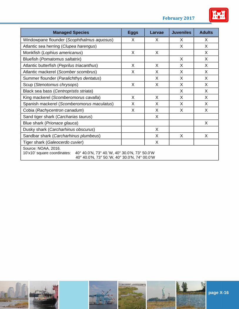
Managed Species Eggs Larvae Juveniles Adults Windowpane flounder (Scophthalmus aquosus) X X X X Atlantic sea herring (Clupea harengus) X X Monkfish (Lophius americanus) X X X Bluefish (Pomatomus saltatrix) X X Atlantic butterfish (Peprilus triacanthus) X X X X Atlantic mackerel (Scomber scombrus) X X X X Summer flounder (Paralichthys dentatus) X X X Scup (Stenotomus chrysops) X X X X Black sea bass (Centropristis striata) X X King mackerel (Scomberomorus cavalla) X X X X Spanish mackerel (Scomberomorus maculatus) X X X X Cobia (Rachycentron canadum) X X X X Sand tiger shark (Carcharias taurus) X Blue shark (Prionace glauca) X Dusky shark (Carcharhinus obscurus) X Sandbar shark (Carcharhinus plumbeus) X X X Tiger shark (Galeocerdo cuvier) X Source: NOAA, 2016. 10’x10’ square coordinates: 40° 40.0’N, 73° 40.’W, 40° 30.0’N, 73° 50.0’W 40° 40.0’N, 73° 50.’W, 40° 30.0’N, 74° 00.0’W

page F-17
Hudson-Raritan Estuary Ecosystem Restoration Feasibility Study Draft Integrated Feasibility Report & Environmental Assessment
Table 5-2: Summary of EFH Designations for Harlem River, East River, and Western Long Island
Sound Planning Region.
Managed Species Eggs Larvae Juveniles Adults Atlantic cod (Gadus morhua) X X Pollock (Pollachius virens) X X Red hake (Urophycis chuss) X X X Winter flounder (Pseudopleuronectes americanus) X X X X Windowpane flounder (Scophthalmus aquosus) X X X X Atlantic sea herring (Clupea harengus) X X X Bluefish (Pomatomus saltatrix) X X Atlantic butterfish (Peprilus triacanthus) X X X Atlantic mackerel (Scomber scombrus) X X Summer flounder (Paralichthys dentatus) X X X Scup (Stenotomus chrysops) X X X X Black sea bass (Centropristis striata) X X King mackerel (Scomberomorus cavalla) X X X X Spanish mackerel (Scomberomorus maculatus) X X X X Cobia (Rachycentron canadum) X X X X Sand tiger shark (Carcharhias taurus) X Dusky shark (Carcharhinus obscurus) X Sandbar shark (Carcharhinus plumbeus) X X X Source: NOAA, 2016. 10’x10’ square coordinates: 40° 50.0’N, 73° 50.’W, 40° 40.0’N, 74° 00.0’W 40° 50.0’N, 73° 40.’W, 40° 40.0’N, 73° 50.0’W 41° 00.0’N, 73° 40.’W, 40° 50.0’N, 73° 50.0’W

page X-18
February 2017
Table 5-3: Summary of EFH Designations for Newark Bay, Hackensack River, and Passaic River Planning Region.
Managed Species Eggs Larvae Juveniles Adults Spawning Adults
Red hake (Urophycis chuss) M,S M,S M,S Winter flounder (Pseudopleuronectes americanus) M,S M,S M,S M,S M,S
Windowpane flounder (Scophthalmus aquosus) M,S M,S M,S M,S M,S
Atlantic sea herring (Clupea harengus) M,S M,S M,S Bluefish (Pomatomus saltatrix) M,S M,S Atlantic butterfish (Peprilus triacanthus) M M,S M,S Atlantic mackerel (Scomber scombrus) S S Summer flounder (Paralichthys dentatus) F,M,S M,S M,S Scup (Stenotomus chrysops) S S S S Black sea bass (Centropristis striata) M,S M,S King mackerel (Scomberomorus cavalla) X X X X Spanish mackerel (Scomberomorus maculatus) X X X X
Cobia (Rachycentron canadum) X X X X Source: NOAA, 2016. S = includes the seawater salinity zone; M = includes the mixing water/brackish salinity zone; F = includes the tidal freshwater salinity zone 10’x10’ square southeast corner boundary: 4040/7350; 4040/7400; 4030/7350; 4030/7400; 4030/7410;
4020/7350; 4020/7400; 4020/7410; 4010/7420

page F-19
Hudson-Raritan Estuary Ecosystem Restoration Feasibility Study Draft Integrated Feasibility Report & Environmental Assessment
Table 5-4: Summary of EFH Designations for Upper Bay Planning Region.
Managed Species Eggs Larvae Juveniles Adults Red hake (Urophycis chuss) X X X X Winter flounder (Pseudopleuronectes americanus) X X X X Windowpane flounder (Scophthalmus aquosus) X X X X Atlantic sea herring (Clupea harengus) X X X Bluefish (Pomatomus saltatrix) X X Atlantic butterfish (Peprilus triacanthus) X X X Atlantic mackerel (Scomber scombrus) X X Summer flounder (Paralichthys dentatus) X X X Scup (Stenotomus chrysops) X X X X Black sea bass (Centropristis striata) X X King mackerel (Scomberomorus cavalla) X X X X Spanish mackerel (Scomberomorus maculatus) X X X X Cobia (Rachycentron canadum) X X X X Sand tiger shark (Carcharias taurus) X Dusky shark (Carcharhinus obscurus) X X Sandbar shark (Carcharhinus plumbeus) X X Source: NOAA, 2016. 10’x10’ square coordinates: 40° 50.0’N, 74° 00.’W, 40° 40.0’N, 74° 10.0’W 40° 40.0’N, 74° 00.’W, 40° 30.0’N, 74° 10.0’W

page X-20
February 2017
Table 5-5: Summary of EFH Designations for Lower Bay Planning Region.
Managed Species Eggs Larvae Juveniles Adults Red hake (Urophycis chuss) X X X Winter flounder (Pseudopleuronectes americanus) X X X X
Windowpane flounder (Scophthalmus aquosus) X X X X Atlantic sea herring (Clupea harengus) X X X Bluefish (Pomatomus saltatrix) X X Atlantic butterfish (Peprilus triacanthus) X X X Atlantic mackerel (Scomber scombrus) X X Summer flounder (Paralichthys dentatus) X X X Scup (Stenotomus chrysops) X X Black sea bass (Centropristis striata) X X King mackerel (Scomberomorus cavalla) X X X X Spanish mackerel (Scomberomorus maculatus) X X X X Cobia (Rachycentron canadum) X X X X Sand tiger shark (Carcharias taurus) Dusky shark (Carcharhinus obscurus) X X Sandbar shark (Carcharhinus plumbeus) X X X Source: NOAA, 2016. 10’x10’ square coordinates: 40° 30.0’N, 74° 00.’W, 40° 20.0’N, 74° 10.0’W 40° 40.0’N, 74° 00.’W, 40° 30.0’N, 74° 10.0’W
5.1 Managed Fish Species
The majority of the general distribution and life history information presented in this assessment is based upon Status of the Fishery Resources off the Northeastern United States (NOAA, 1998). Where additional references were used, they are cited as appropriate.
Atlantic Butterfish 5.1.1
The Atlantic butterfish (Peprilus tricanthus) ranges from Newfoundland to Florida, but is primarily found from the Gulf of Maine to Cape Hatteras. Butterfish migrate in response to seasonal changes in water temperature. During summer, butterfish move northward and inshore to feed and spawn. Spawning occurs during June to August and peaks progressively later at higher latitudes. During winter, butterfish move southward and offshore to avoid cool waters. Butterfish are primarily pelagic and form loose schools that feed upon small fish, squid, and crustaceans. Butterfish have a high natural mortality rate and are preyed upon by many species, including silver hake, bluefish, swordfish, and long-finned squid (Cross et al., 1999).
Atlantic Cod 5.1.2
Atlantic cod (Gadus morhua) are found in the northwest Atlantic Ocean from Greenland to Cape Hatteras (North Carolina). Those distributed in United States waters are found in rough bottom waters

page F-21
Hudson-Raritan Estuary Ecosystem Restoration Feasibility Study Draft Integrated Feasibility Report & Environmental Assessment
between 32.8 and 492.1 feet and at temperatures between 32 and 50 degrees Fahrenheit (F). Juveniles begin their descent from the water column to the bottom habitats at sizes between 1.0 and 2.4 inches, and tend to remain on the bottom for the rest of their lives. They tend to move in schools, usually on the bottom, although they may also occur in the water column (NOAA, 1999a).
Atlantic Mackerel 5.1.3
The Atlantic mackerel (Scomber scombrus) is a fast-swimming, pelagic, schooling species distributed in the northwest Atlantic between Labrador and North Carolina. This population has two (2) major spawning components: a southern group that spawns primarily in the Middle Atlantic Bight during April and May, and a northern group that spawns in the Gulf of St. Lawrence in June and July. Both groups winter between Sable Island (off Nova Scotia) and Cape Hatteras in waters generally warmer than 44.6 degrees F, with extensive northerly (spring) and southerly (autumn) migrations to and from spawning and summering grounds. Mackerel feed upon small fish (Studholme et al., 1999).
Atlantic Salmon 5.1.4
Atlantic salmon (Salmo salar) are anadromous fish. They spend their lives in both freshwater and the open ocean. Atlantic salmon distribution ranges from northern Quebec southeast to Newfoundland and southwest to Long Island Sound (NOAA, 2016). Spawning occurs in late October to early November in Maine. In the spring, eggs will hatch and juveniles will spend about one (1) to two (2) years in bottom habitats of shallow gravelly pools in river and estuaries. Once reared, the salmon will migrate out to sea during the spring. Adults are primarily pelagic and will return to spawn in freshwater after spending one (1) to four (4) years at sea (NatureServe, 2015).
Atlantic Sea Herring 5.1.5
The Atlantic sea herring (Clupea harengus) is widely distributed in continental shelf waters from Labrador to Cape Hatteras. It is a migratory, schooling species that consumes plankton. Atlantic herring are usually seen swimming in vast schools offshore (Geiser, 1984). Primary spawning locations off the northeastern United States are located on the Maine coast, Jeffreys Ledge, Nantucket Shoals, and Georges Bank. Spawning occurs during late August to October. Eggs are demersal and are typically deposited on gravelly substrates (Reid et al., 1999).
Black Sea Bass 5.1.6
The NMFS has designated the East River as EFH for black sea bass (Centropristus striata) juveniles and adults. Black sea bass are strictly confined to salt water, appearing inshore during the first or second week in May and withdrawing again late in October or early in November. The substrate preferred by the black sea bass generally consists of shellfish and eelgrass beds, man-made structures in sandy-shelly areas, and offshore clam beds. During the part of the year when the black sea bass are inshore they are most plentiful on hard bottom, in water less than 115 feet, often around submerged wrecks. They are bottom feeders, subsisting chiefly on crabs, lobsters, shrimp, and various mollusks (Bigelow and Schroeder, 1953). Juvenile and adult black sea bass occur in the demersal waters over the Continental Shelf from the Gulf of Maine to Cape Hatteras, North Carolina. Juvenile and adult black sea bass are found in the estuaries in the summer and spring in water warmer than 42.8 degrees F with salinities greater than 18 parts per thousand, but winter offshore from south of New York to North Carolina (Steimle et al., 1999a).

page X-22
February 2017
Bluefish 5.1.7
Bluefish are common inshore inhabitants of the New York Bight, arriving in May and usually departing by November. Two (2) major spawning aggregations are in the Mid-Atlantic – a spring spawning stock and a summer spawning stock. Most of the bluefish population in the New York Bight probably originates from the spring spawning stock. The spring spawners move into the waters where the Gulf Stream and the continental shelf waters meet between northern Florida and Cape Hatteras. Bluefish spawn as they migrate northward. North of Cape Hatteras, the adults move shoreward. The smaller, post-spawned bluefish may spend summers in the Chesapeake and Delaware Bays and Albemarle Sound. Larger fish move north for a longer period than the smaller bluefish, and thus migrate farther. Some move into Long Island Sound and more northern areas. In autumn, bluefish migrate back to the wintering areas off south Florida and the South Atlantic Ocean. Bluefish eggs are buoyant and pelagic and hatch in about two (2) days. The newly hatched larvae are also pelagic and remain in offshore waters for one (1) to two (2) months before migrating shoreward toward shallow-water nursery areas. Young-of-year bluefish typically first enter areas north of the George Washington Bridge in early June and remain there until at least early October. They are most common in more saline areas of the estuary. Salinity intrusions into the estuary appear to be a major determinant of geographic distribution within the estuary. Young-of-year bluefish are also abundant in areas of the estuary south of the George Washington Bridge and adjacent waterways, which are part of the larger, coastal distribution (Applied Science Associates, 2006).
Blue Shark 5.1.8
Blue sharks (Prionace glauca) are a highly migratory species and one of the widest-ranging sharks. They can be found in tropical, subtropical, and temperate pelagic waters. In the north Atlantic, blue shark can be found from Cape Hatteras, North Carolina to the Gulf of Maine. Blue shark is a viviparous species, and gives birth to live young. Litter sizes range from four (4) to 135 pups. Adult males typically are about five (5) to six (6) feet in length, whereas females are about seven (7) to eight (8) feet in length (NOAA, 2006).
Cobia 5.1.9
The cobia (Rachycentron canadum) is a fast swimming fish that can be found near shore or inshore inhabiting inlets, bays, mangrove swamps and is often seen around buoys, pilings, and wrecks. Cobia is distributed from Massachusetts to Argentina. Cobia primarily feed on crabs, squid, and small fish and can reach a size of up to 6.6 feet and 330.7 pounds, although they more commonly reach a size 22.0 to 110.2 pounds (Robbins et al., 1986).
Dusky Shark 5.1.10
The NMFS has designated Jamaica Bay, Hudson River Estuary, and the Raritan Bay including Sand Hook Bay around Sandy Hook as EFH for dusky shark (Carcharhinus obscurus) larvae. Neonate/early juveniles of the dusky shark are found in shallow coastal waters, inlets, and estuaries to the depth of 75.5 feet from the eastern end of Long Island to Cape Lookout, North Carolina. The dusky shark is viviparous. Its diet consists of flounder, flatfish, starfish, and squid (McCandless et al., 2014).

page F-23
Hudson-Raritan Estuary Ecosystem Restoration Feasibility Study Draft Integrated Feasibility Report & Environmental Assessment
King Mackerel 5.1.11
The king mackerel (Scomberomorus cavalla) is a fast swimming fish that roams in schools. Their distribution ranges along the western coast of the Atlantic Ocean from North Carolina to Massachusetts and also in the Gulf of Mexico (Beaumariage, 1973). They prefer warm waters and are found along reefs and in coastal waters. Peak spawning occurs from May to early July and in late July to early August. King mackerel primarily feed on other fish and reach a size of up to 5.6 feet and 99.2 pounds (NMFS, 2017).
Monkfish 5.1.12
Monkfish (Lophius americanus), also known as goosefish, is found from the southern and eastern parts of the Grand Banks, Newfoundland, and the northern side of the Gulf of St. Lawrence, to the Atlantic coast of Florida, although it is most commonly found north of Cape Hatteras, North Carolina. Spawning occurs from spring through early fall with a peak in May-June. Males typically reach sexual maturity after four (4) years and females after five (5) years. Their eggs float freely at the surface and are subject to actions of wind, currents, and waves. Time to hatching ranges from six (6) to seven (7) days at 59 degrees F to approximately 100 days at 41 degrees F. Monkfish are a common component of the ichthyoplankton community in the Middle Atlantic. Adults spend most of their time on the bottom, usually in a depression or partially covered in sediment, but they have been reported at the surface. They are found in bottom water temperatures ranging between 32 and 75.2 degrees F (NOAA, 1999b).
Pollock 5.1.13
Pollock (Pollachius virens) occur in the Northwest Atlantic where they are most abundant on the western Scotian Shelf, and in the Gulf of Maine. Spawning occurs in winter. Sexual maturation is essentially complete by age six (6), although more than 50 percent of fish are mature by age three (3). Juvenile pollock are common in inshore areas, but move offshore as they grow older. Generally, pollock adults are found in waters below 57.2 degrees F and from depths of 147.6 to 656.2 feet with salinities over 30 parts per thousand (Cargnelli et al., 1999).
Red Hake 5.1.14
Red hake (Urophycis chuss) are distributed from the Gulf of St. Lawrence to North Carolina, but are most abundant between Georges Bank and New Jersey. Red hake undergo extensive seasonal migrations, moving into shallow waters to spawn in spring and summer and offshore to deep waters in the winter. Spawning occurs from May through November. The eggs are buoyant (Geiser, 1984) and are generally found in water temperatures below 50.0 degrees F. The first months of a red hake’s life are spent drifting at or near the surface and fry of 0.5 to 3.9 inches have been observed in summer under floating eelgrass or rockweed. Juvenile red hake are often found near benthic habitats with abundant shell fragments, including areas with abundant sea scallops. Adult red hake are often found in water temperatures below 53.6 degrees F from depths of 32.8 to 98.4 feet with a salinity range of 33 to 34 parts per thousand (Steimle et al., 1999b). The red hake’s diet consists primarily of shrimp, squid, bergalls, small eels, spearing, sand eels, and the young of other species (Geiser, 1984).
Sandbar Shark 5.1.15
The sandbar shark (Carcharhinus plumbeus) can be found from Cape Cod, Massachusetts to Florida, including the Gulf of Mexico and Caribbean Sea (NOAA, 2016). It is a migratory species, spending winters in southern waters and summers in northern waters. Sandbar sharks are found near shore at

page X-24
February 2017
depths of 65.6 to 213.3 feet. In the northern hemisphere, mating occurs from May to June. Average length of gestation range from eight (8) to 12 months and is dependent on geological location. Litter size ranges from six (6) to 13 pups. In the western Atlantic, pups are born from June to August. Sandbar shark diet consists of bottom fish, shellfish, skates, stingrays, squid, shrimp, crabs, mollusks, and other smaller sharks (Florida Museum of Natural History, 2016).
Sand Tiger Shark 5.1.16
Sand tiger sharks (Carcharias taurus) are coastal sharks that inhabit warm and temperate waters excluding the eastern Pacific (Compagno, 1984). The Long Island Sound and Jamaica Bay were identified as EFH habitat for neonate/early juvenile sand tiger sharks (NOAA, 2016). Their habitat ranges from the surf zone, in shallow bays, and around rocky coral reefs. Sand tiger sharks are an ovoviviparous species. Mating occurs between March and April and the average litter size is about one (1) to two (2) pups. Their diet consists of other small sharks, rays, squid, crab, and lobster (NOAA, 2010).
Scup 5.1.17
Scup (Stenotomus chrysops) occur primarily in the Middle Atlantic Bight from Cape Cod to Cape Hatteras. Seasonal migrations occur during spring and autumn. In summer, scup are common in inshore waters from Massachusetts to Virginia, while in winter, scup are found in offshore waters between Hudson Canyon and Cape Hatteras. Spawning occurs during summer months (Steimle et al., 1999c).
Silver Hake 5.1.18
Silver Hake (Merluccius bilinearis) are demersal fish and are found in waters of the Gulf of Maine, Georges Bank, the continental shelf off southern New England, and the Middle Atlantic south to Cape Hatteras. Eggs are pelagic and are about 0.88 to 0.95 millimeters in diameter. Eggs hatch in about two (2) days at 68 degrees F. Larvae are pelagic and are about 0.1 to 0.13 inches long. Juveniles and adult silver hake migrate to deeper waters off the continental self when water temperatures begin to decline in the autumn. Adults will return to shallow waters in the spring and summer to spawn. Spawning begins in January in the Middle Atlantic Bight and then, during May, spawning will occur off the coast of the Gulf of Maine, southern and southeastern Georges Bank, and the south of New England. Known as an important predator species, Silver Hake feed on a diet of fish, crustaceans, and squid. Young will feed on euphausiids, shrimp, amphipods, and decapods (Morse et al., 1999).
Spanish Mackerel 5.1.19
The Spanish mackerel (Scomberomorus maculatus) is a fast swimming fish that roams in large schools. Spanish mackerel can be found near shore congregating around channels and bays. Spanish mackerel are distributed from Cape Cod to South Florida, although they are rarely found north of the Chesapeake Bay (Robbins et al., 1986). Spawning occurs from July to August and as late as September. Larvae can be found within inshore waters at temperatures of about 68 to 86 degrees F. Juveniles prefer estuarine and coastal waters. Adult habitat ranges from tidal estuaries to open water and adults prefer water temperatures of 69.8 to 80.6 degrees F (ASMFC, 2016).

page F-25
Hudson-Raritan Estuary Ecosystem Restoration Feasibility Study Draft Integrated Feasibility Report & Environmental Assessment
Summer Flounder 5.1.20
Summer flounder (Paralichthys dentatus), or fluke, occur from the southern Gulf of Maine to South Carolina. Summer flounder are concentrated in bays and estuaries from late spring through early autumn, when an offshore migration to the outer continental shelf is undertaken. On the outer shelf they are found at depths up to 147.6 feet. Many summer flounder come close inshore when the waters are warm, but the great majority of the population, especially larger fish, lies farther offshore at that time of year (Bigelow and Schroeder, 1953). Spawning occurs offshore during autumn and early winter and the larvae are transported toward coastal areas by prevailing water currents.
Development of post-larvae and juveniles occurs primarily within bays and estuarine areas. Summer flounder often bury themselves in the soft bottom of the ocean or river. They consume small fish, most notably small mossbunker, squid, mackerel, sea robins, sand eels, killifish, and spearing (NOAA, 1999c).
Tiger Shark 5.1.21
Tiger sharks (Galeocerdo cuvier) are found in warm waters in both deep oceanic and shallow coastal regions. They occur in the North Atlantic Ocean off the coast at approximately 40 degrees north to 0 degrees north. On rare occasions, tiger shark may be encountered north of the Middle Atlantic Bight. They reach reproductive maturity at approximately 9.5 feet total length. Litters consist of approximately 35 to 55 pups (NOAA, 2006).
Winter Flounder 5.1.22
Winter flounder (Pleuronectes americanus) are distributed in the northwest Atlantic from Labrador to Georgia. The species is found in brackish and salt water habitats. Abundance is highest from the Gulf of St. Lawrence to Chesapeake Bay. Optimum substrate for adults and juveniles is silty sand. The diet consists primarily of benthic invertebrates. Movement patterns are generally localized. Winter flounder undertake small-scale migrations into estuaries, embayments, and saltwater ponds in winter to spawn, subsequently moving to deeper water during summer. Winter flounder tend to return to the same spawning locations in consecutive years. Optimum water temperature for spawning is 33.8 to 41 degrees F. Females usually produce between 500,000 to 1.5 million eggs. Eggs are adhesive and settle to the bottom (New England Fishery Management Council, 1998).
Generally, winter flounder release their eggs within areas that are less than 50 degrees F, with salinities from 10 to 30 parts per thousand, and in depths of less than 16.4 feet. Larval winter flounder are often found in shallow water between depths less than 19.7 feet (New England Fishery Management Council, 1998). Juvenile and adult flounder can be found in waters up to 164.0 to 328.0 feet in depth, respectively. The NMFS has designated the East River as EFH for winter flounder eggs, larvae, juveniles, and adults.
Windowpane Flounder 5.1.23
Windowpane flounder (Scopthalmus aquosus), also known as sand flounder, are distributed on the northwest Atlantic continental shelf from the Gulf of St. Lawrence to Florida. This species inhabits large estuaries and is a shoal water benthic species that prefers sandy bottoms. However, it also frequents softer and muddier grounds (Bigelow and Schroeder, 1953). Peak spawning activity occurs in Middle Atlantic Bight waters (which extend from Montauk, New York to the Virginia/North Carolina border), in May and October (New England Fishery Management Council, 1998).

page X-26
February 2017
5.2 Threatened and Endangered Species
The United States Fish and Wildlife Service (USFWS), NMFS, and New York State Department of Environmental Conservation (NYSDEC) were consulted regarding the occurrence of rare, threatened, and endangered species and species of special concern in the vicinity of the project sites in each planning region. The aquatic species that were identified for each region are provided in the following sections.
Jamaica Bay 5.2.1
Four (4) species of sea turtles listed under the Endangered Species Act are seasonally present in the bay:
• Threatened Northwest Atlantic Ocean distinct population segment (DPS) of loggerhead (Caretta caretta).
• Threatened North Atlantic DPS of green (Chelonia mydas). • Endangered Kemp’s ridley (Lepidochelys kempii). • Endangered leatherback sea turtle (Dermochelys coriacea).
These threatened and endangered sea turtles can be present in the Jamaica Bay area from May to mid-November. Adult and subadult Atlantic sturgeon (Acipenser oxyrinchus oxyrinchus) can be found in the Jamaica Bay Planning Area. The New York Bight, Chesapeake Bay, South Atlantic, and Carolina DPS are endangered, and the Gulf of Maine DPS is threatened in the area. Atlantic sturgeon eggs, larvae, or juvenile life stages will not be found in the waters of the Jamaica Bay Planning Area. Additionally, the shortnose sturgeon (Acipenser brevirostrum), of the adult and subadult life stages, is also present in these waters. The shortnose sturgeon is endangered throughout its range.
Harlem River, East River, and Western Long Island Sound Planning Region 5.2.2
Four (4) species of sea turtles listed by NMFS are seasonally present in the East River and adjacent bays:
• Threatened Northwest Atlantic Ocean DPS of loggerhead. • Threatened North Atlantic DPS of green. • Endangered Kemp’s ridley. • Endangered leatherback sea turtle.
Two (2) protected fish species, Atlantic sturgeon and shortnose sturgeon, were also identified by NMFS as being potentially present in the East River and adjacent bays.
Newark Bay, Hackensack, and Passaic River Planning Region 5.2.3
No threatened and/or endangered marine species were identified in this planning region.
Upper Bay Planning Region 5.2.4
Four (4) species of sea turtles listed by NMFS are seasonally present in the bay: • Threatened Northwest Atlantic Ocean DPS of loggerhead. • Threatened North Atlantic DPS of green.

page F-27
Hudson-Raritan Estuary Ecosystem Restoration Feasibility Study Draft Integrated Feasibility Report & Environmental Assessment
• Endangered Kemp’s ridley. • Endangered leatherback sea turtle.
These threatened and endangered sea turtles can be present in the Upper Bay area from May to mid-November. Adult and subadult Atlantic sturgeon can be found in the Upper Bay Planning Area. The New York Bight, Chesapeake Bay, South Atlantic, and Carolina DPS are endangered, and the Gulf of Maine DPS is threatened in the area. Atlantic sturgeon eggs, larvae, or juvenile life stages will not be found in the waters of the Upper Bay Planning Area. Additionally, the shortnose sturgeon, of the adult and subadult life stages, is also present in these waters. The shortnose sturgeon is endangered throughout its range.
Lower Bay 5.2.5
Raritan Bay and Sandy Hook Bay support the greatest variety of state- and federally-listed threatened and endangered species (USFWS, 1997). Listed by the NMFS, four (4) species of sea turtles listed under the Endangered Species Act are seasonally present in the Lower Bay Planning Region:
• Threatened Northwest Atlantic Ocean DPS of loggerhead. • Threatened North Atlantic DPS of green. • Endangered Kemp’s ridley. • Endangered leatherback sea turtle.
These threatened and endangered sea turtles can be present in the Lower Bay area from May to mid-November. Adult and subadult Atlantic sturgeon can be found in the Lower Bay Planning Area. The New York Bight, Chesapeake Bay, South Atlantic, and Carolina DPS are endangered, and the Gulf of Maine DPS is threatened in the area. Atlantic sturgeon eggs, larvae, or juvenile life stages will not be found in the waters of the Lower Bay Planning Area. Additionally, the shortnose sturgeon (Acipenser brevirostrum), of the adult and subadult life stages, is also present in these waters. The shortnose sturgeon is endangered throughout its range.
Analysis of Potential Effects Chapter 6:
Impacts from the TSP to EFH and managed species in every planning area can largely be grouped under three (3) different types of impacts: sedimentation and burial, hydroacoustics, and habitat loss and alteration. 6.1 Sedimentation and Burial
Numerous species occur in the HRE. The aquatic fauna vary from motile and sessile benthic organisms to resident and early life stages of numerous fish species. These organisms could be impacted by sediment resuspension that may interfere with their methods of feeding (e.g., filter feeding) and/or impair their habitat due to an increase in suspended sediments or burial by deposited sediments.
Sedimentation 6.1.1
Benthic habitats can vary from densely vegetated beds of submerged aquatic vegetation to habitats with high rugosity (e.g., reefs, large boulders) to relatively flat, featureless sediment-dominated habitats. Although devoid of vegetation or lacking dramatic topographical variability, benthic sediments provide valuable habitat for numerous benthic invertebrates (e.g., worms, clams). Moreover, these interstitial organisms serve as prey species for fish, crabs, and other fauna. Submerged aquatic vegetation could be impacted by increased total suspended solids levels. The attenuation effects of high turbidity levels
page X-28
February 2017
would reduce a plant’s ability to utilize sunlight. Impacts to submerged aquatic vegetation are especially acute during the growing season, from April to October. Resuspension of estuarine sediments will have variable impacts on fish depending on species and life stage. Lethal levels of water column solids vary widely among species; one study found that the tolerance of adult fish for suspended sediment ranged from 580 milligrams per liter (mg/L) to 24,500 mg/L (Shrek et al., 1975 as cited in NMFS, 2003). Common impacts to fish are the abrasion of gill membranes (resulting in inability to collect oxygen), impairment of feeding, reduction in dissolved oxygen, and fatal impacts to early life stages. Increased total suspended solids can inhibit migratory movements as well. A study conducted in 1976 determined that total suspended solids concentrations as low as 350 mg/L blocked upstream migrations (NOAA, 2001). Larval stage fish also have wide suspended sediment tolerance ranges; however, the reported data is generally thought to represent tolerance levels for only relatively short exposure periods (e.g., less than 24 hours) (Morgan and Levings, 1989). Beyond that timeframe, mortality can occur at concentrations as low as 1,300 mg/L (Morgan et al., 1983). Kiorboe et al., 1981, (as cited in Clarke and Wilber, 2000) indicate that hatching of striped bass and white perch can be delayed if daily sediment concentrations reach 100 mg/L. Wilbur and Clarke, 2001 (as cited in NMFS, 2003), indicate that hatching is delayed for striped bass and white perch at concentrations of 800 and 100 mg/L, respectively. In a 2003 biological opinion, the NMFS indicated that total suspended solids concentrations below 100 mg/L are not likely to affect eggs and larvae, at least over short durations (NMFS, 2003).
Burial 6.1.2
Benthic habitats can be buried by excessive sediment deposition. The burial would disrupt the physiological functions of plants and result in injury or mortality. Given the extremely limited amount of potential sediment deposition, it is anticipated that sediment deposition would not bury existing submerged aquatic vegetation beds in the project area and would result in minimal, if any, impacts to submerged aquatic vegetation. Other dredging activities throughout the world have resulted in a buildup of organic matter within a dredged area that affected water quality (Szymelfenig and Kotwicki, 2006). Often, the organic matter accumulation leads to anaerobic conditions and hydrogen sulfide formation. The strong tidal action of most project areas, as well as the likely prop wash from vessel traffic, would result in a near daily flushing of any buildup of organic matter during the construction period. When sediments are resuspended, they disperse throughout the water column and also settle to the bed of the waterway within which construction is occurring. Impacts from deposited sediments can pose significant threats to aquatic organisms. For fish species, burial of eggs can result in mortality. Winter flounder eggs were observed to be affected by thin layers of deposited sediments in laboratory conditions (Germano and Cary, 2005). Also, sediment deposits of 2.0 millimeters or greater over white perch eggs resulted in 100 percent mortality. Sediment deposition may have negative short-term impacts to adult and juvenile fish due to benthic habitat alterations and as a result of reduced foraging opportunities. 6.2 Hydroacoustics
Sound in water follows the same physical principles as sound in air. The major difference is that, due to the density of water, sound in water travels about 4.3 times faster than in air (approximately 4,900 feet per second versus 1,100 feet per second, respectively), and attenuates much less rapidly than in air.

page F-29
Hudson-Raritan Estuary Ecosystem Restoration Feasibility Study Draft Integrated Feasibility Report & Environmental Assessment
Sound is a very critical source of environmental information for most vertebrates (e.g., Fay and Popper, 2000). While we most often think in terms of sound for communication (e.g., speech), perhaps the most important use of sound is to learn about one’s environment. Indeed, humans and all other vertebrates have auditory systems that listen to the “acoustic scene” and can, from this, learn a great deal about the environment and the things in it (Bass and Ladich, 2008). And, whereas the “visual scene” is restricted by the field of view of the eyes and light level, the acoustic scene provides a three-dimensional, long distance sense that works under almost all environmental conditions. It is therefore likely that hearing evolved for detection of the acoustic scene (Fay and Popper, 2000) and that fish use sound to learn about their general environment, the presence of predators and prey, and, in many species, for acoustic communication. As a consequence, sound is important for fish survival, and anything that significantly impedes the ability of fish to detect a biologically relevant sound could decrease survival. Intense sound can result in mortality, injury, and/or behavioral response. Generally, sounds in exceedance of 206 dB re 1 µPa (sound, expressed in decibels relative to one (1) micro-Pascal) are considered to be fatal to most fish species. This level of sound is rare and often required larger diameter steel piles, use of an impact hammer, and no sound attenuating devices (e.g., bubble curtains) to be produced. Of much greater concern from effects of pile driving and other intense sound sources with regard to fish is the potential for physiological effects that are not immediately lethal, but could ultimately lead to mortality. The potential physiological effects of pile driving on fish are highly diverse, and range from very small ruptures of capillaries in fins, which are not likely to have any impact on survival, to severe hemorrhaging of major organ systems, which could ultimately lead to death. Other potential effects include rupture of the swim bladder (the bubble of air in the abdominal cavity of most fish species that is involved in maintenance of buoyancy), barotraumas, and oscillations of the swim bladder (leading to nearby organ damage). In other words, an animal that has had physical or physiological damage may be less likely than an animal without damage to avoid a predator or find food. Sounds above RMS 150 dB are often associated with behavioral impacts. These impacts could range from a fish altering its course of travel to avoiding an area during construction. 6.3 Habitat Loss and Alteration
After construction activities cease, there would be some alterations to the benthic and open water column habitats of the planning regions. The impacted habitats are common in the HRE. Also, within the HRE, the impacted habitats do not contain spawning grounds, critical habitats, or important overwintering areas for endangered species. Many of the species that comprise a significant percent of the biomass of the lower Hudson estuary neither use the dredge footprint as a spawning ground or foraging areas. Finally, the TSP would actually result in positive effects to the benthic habit and open water column, primarily from increased acreage of oyster reefs and improved water quality through reduction of sedimentation and increase in wetlands.
Analysis of Short-term and Long-term Impacts of the TSP Chapter 7:
The expected environmental effects of implementing the TSP would be overwhelmingly beneficial to the flora, fauna, and public living within the HRE. Implementation of the TSP would result in a substantial first step to large-scale ecosystem restoration in the HRE. Also realized would be immediate positive benefits to water quality; habitat restoration and availability for a host of fauna, including anadromous

page X-30
February 2017
and catadromous species; and significant attempts to restore the eastern oyster (Crassostrea virginica), a once omnipresent keystone species in the HRE.
The restoration activities would result in some negative impacts to the environment. However, it is anticipated these impacts would be short-term and localized. All restoration activities would be performed in accordance with regulatory agency stipulations and contractors would employ BMPs at all times (e.g., use of silt curtains, adherence to sediment, and erosion control plans). Short-and long-term impacts are shown in Table 7-1.
7.1 EFH Species
The identified EFH species potentially could occur in the various planning areas. However, Atlantic cod, Atlantic salmon, blue shark, cobia, monkfish, and tiger shark are oceanic or deeper water species and likely would not be present. The other species could be present in the estuary and potentially in great numbers, especially during the warmer months of the year. All of the 23 managed species identified in this assessment are highly motile species. It is anticipated that, during construction activities, if these species are present they would relocate to other habitats and/or be agile enough to avoid a deleterious interaction with construction-related equipment and vessels. For fish that have designated EFH for eggs, the species with the greatest potential for impact is winter flounder, as this species, unlike the other species with designated EFH, have non-buoyant demersal eggs. This species also spawns in the shallow shoals where restoration work may occur. Winter flounder eggs were observed to be affected by thin layers of deposited sediments in laboratory conditions (Germano and Cary, 2005). Also, sediment deposits of 2.0 millimeters or greater over white perch eggs resulted in 100 percent mortality. Sediment deposition may have negative short-term impacts to adult and juvenile fish, due to benthic habitat alterations and as a result of reduced foraging opportunities. Given the discrete portion of benthic habitat that may be disturbed, when compared to available habitat in the HRE, and coupled with the positive impacts of the TSP, direct physical impacts to the EFH designated species are anticipated to be very minor. 7.2 No Action Alternative
It is anticipated that under the no action alternative, water quality in the HRE, as well as finfish and shellfish habitats and nursery grounds, would continue to degrade and worsen. This outcome would result from hydrologic impairments, invasive species expansion, and continued compromised water quality, due to sediment suspension from shoreline erosion and stormwater runoff, and anthropogenic inputs, such as landfill leachate and illegal dumping. 7.3 Short Term Impacts
Water Quality 7.3.1
Under the TSP, habitat restoration and associated construction activities would cause short-term release or resuspension of sediments and a concomitant short-term increase in turbidity in waters near the restoration sites. Construction-related transport, storage, and handling of hydrocarbon fuels potentially could result in accidental spills and typically short-term, local water quality deterioration.

page F-31
Hudson-Raritan Estuary Ecosystem Restoration Feasibility Study Draft Integrated Feasibility Report & Environmental Assessment
Shellfish and Benthic Habitat 7.3.2
The projects may have temporary impacts on local shellfish and benthic macroinvertebrate populations during construction, principally through an increase in sedimentation and turbidity. The filling of Fresh Creek will be timed to minimize impacts. By completing the filling of the basin during the summer, when dissolved oxygen levels are lowest, the number of motile species should be diminished as they would have migrated to better quality habitat. However, due to the poor habitat quality that exists and the low species numbers found at the sites during sampling, the impact is not expected to result in a significant loss of species and re-colonization is expected to begin quickly after completion of the construction and flourish under improved sediment and water quality. Construction associated with in-water and onshore restoration would result in short-term, negative impacts on shellfish, especially in aquatic areas designated for habitat conversion. Bivalves are slow-moving or sessile and would experience some degree of mortality or removal during construction in intertidal waters and subtidal shallows, and crab mortality and displacement likely would also occur during construction. Mortality of sessile and less motile species is expected on shellfish beds and habitats targeted for shoreline stabilization, filling for the expansion of wetlands or marsh island habitat, dredging, construction of instream structures, regrading, removal of remnant shoreline structures and debris, and oyster habitat creation or restoration. Likewise, areas designated for tidal channel and basin creation, bed restoration, or channel modification that would undergo dredging, filling, or regrading likely would experience some shellfish mortality. Onshore and in-water construction activities and dredging and soil deposition would cause short-term release or resuspension of sediments in nearby waters and a concomitant short-term increase in turbidity. This increase in turbidity and resuspension of sediments could have a short-term negative impact on shellfish (Wilber and Clarke, 2001; Knott et al., 2009). However, where benthic habitats suitable for shellfish are created or restored, and where existing shellfish habitat is not substantively changed or is restored, recovery of shellfish populations to levels that occurred prior to construction is expected to occur relatively rapidly.
Fish 7.3.3
Construction associated with in-water and onshore restoration would result in short-term, negative impacts to fish. Fish may be displaced due to noise, changes in currents or stream flow, and changes in water quality, including increases in turbidity from construction activities, in-water vessel movements and prop wash, and dredging. Suspension or resuspension of sediments or other materials may be injurious to fish, provide less suitable nursery habitats, or reduce hatching success and larvae development (Auld and Schubel, 1978; Wilber and Clarke, 2001; Bilkovic, 2011). Reduced water clarity can also affect fish by interfering with their ability to feed or by changing the composition of prey species (Newcombe and MacDonald, 1991). Short-term, negative impacts to fish and fish populations also would occur if construction activities deterred fish from using essential migratory pathways, breeding, foraging, or seeking shelter from predators. However, under the TSP, construction effects would have only short-term, localized influence and fish and managed EFH species would return to the area shortly after the cessation of construction activities. These short-term adverse effects would be outweighed by substantive long-term benefits.
Threatened and Endangered Species 7.3.4
In the short term, construction associated with implementation of the TSP potentially could displace or disturb rare, threatened, and endangered species on or in the vicinity of the restoration sites. Such effects would result from changes in currents or stream flow, changes in water quality, including

page X-32
February 2017
increases in turbidity, and construction-related noise Disruptions to marine wildlife are expected to be insignificant and short-term during construction, and BMPs would be employed to minimize impacts from suspended sediments. If construction activities are determined to make the water habitat unsuitable for wildlife, the use of timing restrictions or noise attenuating tools will be implemented. No threatened and/or endangered marine species were identified in the Newark Bay, Hackensack River, and Passaic River Planning Region.
7.4 Long Term Impacts
Water Quality 7.4.1
In the long term, creating or restoring wetlands and maritime or riparian forest, armoring and stabilizing shorelines, and establishing oyster habitat would improve water quality and provide nutrient removal and denitrification services. The restored habitats would reduce long-term turbidity by filtering and retaining stormwater runoff, providing storm surge and flood buffering, attenuating waves, and thereby reducing shoreline erosion. Improved tidal flushing and reduced water residency time, due to creating or restoring tidal channels and basins, would increase dissolved oxygen levels and reduce fecal coliform levels (Portnoy and Allen, 2006). Restored wetlands likewise would improve tidal flushing and increase dissolved oxygen levels. Groundwater resources may also benefit from restored wetlands, as wetlands filter pollutants moving between surface water and groundwater. Establishing oyster habitat would improve water quality and provide nutrient removal and denitrification services. As filter feeders, oysters filter large quantities of organic particulates, including phytoplankton, from the water column. At high densities, oysters can filter large volumes of water, which can modify biogeochemical cycles and improve water quality in the surrounding environment. Filtered seston is digested and utilized for growth and maintenance of the organism, or is deposited by the organism on the sediment surface as feces (Dame and Patten, 1981; Bayne and Newell, 2013; Hadley et al., 2005; Kellogg et al., 2013). This removal and deposition of organic material can act as a buffer against eutrophication by removing nitrogen, carbon, and phosphorous from the water column, and depositing it in the sediment, where it becomes buried. Removal of seston reduces water turbidity, and reduces water concentrations of nitrogen, phosphorous, and organic carbon. Each of these factors is often elevated in waters adjacent to urban areas, such as the HRE. The organic molecules are digested and deposited, rather than settling to decay, which can cause oxygen debt and, in extreme conditions, anoxia. Removal of seston and nutrients from the water column eases the oxygen debt of the water.
Oyster habitat established under the TSP also would reduce turbidity, by mitigating shoreline erosion and filtering suspended solids and phytoplankton (Meyer et al., 1997; Coen et al., 2007; Scypher et al., 2011). The resulting reduction in turbidity under the TSP would provide long-term habitat enhancement for shellfish and fish communities, and aquatic vegetation (Cahoon et al., 1999; Paul and Meyer, 2001; Steinberg et al., 2004).
Shellfish and Benthic Habitat 7.4.2
Wetlands restoration would improve long-term water quality in the bays and rivers and, therefore, would provide enhanced environments for shellfish and fish communities. Tidal channel and basin creation or restoration would improve tidal flushing, and bed restoration and channel modification, by restoring river and stream channels, pools, and riffles, would help reestablish beneficial flow regimes. These improvements would contribute to improved habitat for shellfish (Portnoy and Allen, 2006). Also in the long term, oyster restoration would provide suitable habitat for other shellfish species (Steimle and Zetlin, 2000; Peterson et al., 2003; Scyphers et al., 2011). Increases in intertidal and subtidal habitat

page F-33
Hudson-Raritan Estuary Ecosystem Restoration Feasibility Study Draft Integrated Feasibility Report & Environmental Assessment
acreage, establishment of native tidal wetland vegetation, improved tidal connectivity and flushing, and improved sediment and water quality would result in a more diverse and abundant shellfish resource.
Fish 7.4.3
Wetland habitat restoration in HRE would directly benefit multiple life stages of resident, transient, and migratory fish species, by providing foraging, spawning, nursery, and refuge habitat. Creation of tidal channels and basin re-contouring would improve tidal flushing and restore natural salinity regimes, and bed restoration and channel modificationwould help reestablish beneficial flow regimes, which would contribute to an improved habitat for fish (Dibble and Meyerson, 2012). Shoreline stabilization would reduce long-term turbidity levels by reducing shoreline erosion. In the Bronx River, installing fish ladders and modifying weirs for fish passage would enhance the connectivity of the waterway and enable fish migration. Oyster restoration would provide beneficial fish habitat (Grabowski and Peterson, 2007; Peterson et al., 2003; Scyphers et al., 2011). Oyster establishment and growth creates three-dimensional reefs, providing habitat for large numbers of species, including fish (Kellogg et al., 2013). Additionally, establishment of oyster reefs would provide water filtration and an attendant reduction in turbidity (Coen et al., 2007) and larval, juvenile, and adult oysters would provide a prey resource for many fish species, which would provide long-term benefits to fish.
Threatened and Endangered Species 7.4.4
In the long term, implementation of the TSP would benefit rare, threatened, and endangered species, as the restoration measures would provide substantial improvement to estuarine, near-shore, and terrestrial habitats for marine threatened and endangered species in the HRE.
7.5 Conclusions – Analysis of Effects – EFH
With respect to EFH, construction activities under the TSP would employ BMPs to reduce construction impacts. A minor increase in turbidity and sedimentation would be generated by the proposed construction activities. If eggs and larvae are present during construction, they could be affected. During the construction period, adult and juvenile fish would leave the area of construction and move to nearby suitable locations outside the area of disturbance. Also, for a short period of time after construction, there would be a reduction in benthic organisms immediately adjacent to the in-water construction footprint; however, this area would be recolonized quickly. In the long term, due to marsh island and tidal channel restoration, and shoreline armoring, adverse effects would result from the removal of water column and benthic EFH. These impacts would occur over comparatively small, discrete areas and would not adversely impact local water flow and circulation. Therefore, implementation of the TSP may adversely affect EFH, but likely would result in minimal adverse effects as the resulting changes to EFH and its ecological functions would be relatively small and insignificant. On balance, however, it is anticipated that ecosystem restoration would result in long-term, net benefits to managed species (all life stages), associated species, and EFH. Moreover, removal of barriers to fish passage, through installing fish ladders and modifying weirs, would increase the habitat available to diadromous fish that use the Bronx River.

page X-34
February 2017
Table 7-1: Short-term and Long-term Impacts of the TSP
Planning Regions: Jamaica Bay
Harlem River, East River, and Western Long
Island
Newark Bay, Hackensack River, and Passaic
River
Upper and
Lower Bays
Restoration Type: E
stua
rine
Hab
itat
Mar
sh Is
land
Sm
all S
cale
O
yste
r
Est
uarin
e H
abita
t
Fres
hwat
er
Riv
erin
e H
abita
t
Sm
all S
cale
O
yste
r
Est
uarin
e H
abita
t
Fres
hwat
er
Riv
erin
e H
abita
t
Sm
all S
cale
O
yste
r
Short-Term Impacts: Release or resuspension of sediments X X X X X X X X X
Increase in turbidity X X X X X X X X X Potential accidental spill of construction-related fuels X X X X X X X X X
Fish displacement from noise or water quality due to construction activities
X X X X X X X X X
Shellfish or benthic mortality during construction X X X X X X X X X
Long-Term Impacts: Improved water quality through nutrient removal and denitrification services
X X X X X X X X X
Filtering and retention of stormwater runoff X X X X X X
Buffering of storm surge and flood waters X X X X X X X X X
Wave attenuation X X X X X X X Reduced shoreline erosion X X X X X X X X X Improved tidal flushing and reduced residency time X X X X
Increased dissolved oxygen levels X X X X X X
Reduced fecal coliform levels X X X X X X Additional forage, spawning, nursery and refuge habitat X X X X X X X X X
Reduced turbidity by filtering suspended solids and phytoplankton
X X X
Improved fish migration with fish ladders and modified weirs
X

page F-35
Hudson-Raritan Estuary Ecosystem Restoration Feasibility Study Draft Integrated Feasibility Report & Environmental Assessment
Cumulative Impacts Chapter 8:
For the purpose of this analysis, only actions with potential effects on the environment that are fundamentally similar to the anticipated effects of the TSP, in terms of the nature of the effects, the geographical area affected, and the timing of the effects were evaluated. This cumulative effects analysis covers actions from the recent past through the 50-year planning period; assuming the proposed project is expected to be operational in 2020, the planning period of analysis is 2020 to 2070. The geographical action area, or region of influence, for this analysis comprises the Hudson-Raritan Estuary (HRE), including the following five (5) planning regions in which the TSP restoration sites are located:
• Jamaica Bay; • Lower Bay; • Newark Bay, Hackensack River, and Passaic River; • Harlem River, East River, and Western Long Island Sound; and • Upper Bay.
In review of known literature and government agency documents and websites, no known large-scale harbor wide developments were identified. Several actions are occurring along the coast, namely recovery projects developed in the aftermath of hurricane Sandy, waterfront revitalization plans, and continued improvements in sewer and waste water infrastructure. The improvements brought about by these actions would work in synergy with the proposed restoration in the HRE to uplift its ecology and the EFH in the region.

page X-36
February 2017
References
Applied Science Associates (ASA), Inc. 2006. Year Class Report for the Hudson River estuary
monitoring program. Prepared for Dynegy Roseton L.L.C., Entergy Nuclear Indian Point L.L.C., Entergy Nuclear Indian Point L.L.C., and Mirant Bowline L.L.C.
Auld, A.H., and J.R. Schubel. 1978. “Effects of Suspended Sediment on Fish Eggs and Larvae: A
Laboratory Assessment.” Estuarine and Coastal Marine Science February 1978, 6(2):153-164. ASMFC. 2016. Spanish Mackerel, Scomberomorus maculatus fact sheet. Website:
http://asmfc.org/uploads/file/mackerelhabitatFactsheet.pdf [Accessed January 22, 2016]. Bass, A.H. and F. Ladich. 2008. Vocal-acoustic communication: from neurons to behavior. pp. 253–
278. In: J.F. Webb, R.R. Fay and A.N. Popper (eds.). Fish Bioacoustics. Springer Science & Business Media, LLC, New York.
Bayne, B.L., and R.C. Newll. 1983 Physiological Energetics of Marine Molluscs. The Mollusca, Volume
4: Physiology, edited by S.M. Saleuddin and K. M. Wilbur, Elsevier, pages 407-515. Beaumariage, DS. 1973. Age growth and reproduction of king mackerel, Scomberomorus cavalla, in
Florida. Bigelow, H.B., and W.C. Schroeder. 1953. Fishes of the Gulf of Maine. Fish. Bull. Fish.Wildl. Serv.
53(74):1-577. Bilkovic, D. M. 2011 Response of Tidal Creek Fish Communities to Dredging and Coastal
Development Pressures in a Shallow-Water Estuary. Estuaries and Coasts, 34(1):129-147. Electronic.
Cahoon, L.B., J.E. Nearhoof, and C.L. Tilton.1999 Sediment Grain Size Effect on Benthic Microalgal Biomass in Shallow Aquatic Ecosystems. Estuaries, 22(3B):735-741. Electronic. Cargnelli, L.M., S.J. Griesbach, D.B. Packer, P.L. Berrien, D.L. Johnson, and W.W. Morse. 1999.
Essential Fish Habitat Source Document: Pollock, Pollachius virens, Life History and Habitat Characteristics. NOAA Technical Memorandum NMFS-NE-131. National Marine Fisheries Service, Northeast Fisheries Science Center, Woods Hole, Massachusetts. September 1999.
Clarke, D. G., and Wilber, D. H. 2000. “Assessment of potential impacts of dredging operations due to
sediment resuspension,” DOER Technical Notes Collection (ERDC TN-DOER-E9), United States Army Engineer Research and Development Center, Vicksburg, MS. www.wes.army.mil/el/dots/doer.
Coen, L. D., R. D. Brumbaugh, D. Bushek, R. Grizzle, M.W. Luckenbach, M.H. Posey, S.P. Powers,
and S. G. Tolley. 4 2007 Ecosystem Services Related to Oyster Restoration. Marine Ecology Progress Series, 341:303-307. Electronic.
Compagno, L.J.V. 1984. FAO Species Catalog Vol.4, Part 1 and 2: Sharks of the world: An annotated
and illustrated catalogue of shark species known to date. FAO Fish. Synop. 125. FAO, Rome, Italy.

page F-37
Hudson-Raritan Estuary Ecosystem Restoration Feasibility Study Draft Integrated Feasibility Report & Environmental Assessment
Cross JN, Zetlin CA, Berrien PL, Johnson DL, McBride C. 1999. Essential Fish Habitat Source
Document: Butterfish, Peprilus triacanthus, Life History and Habitat Characteristics. NOAA Tech Memo NMFS-NE-145; 42 p.
Dame, R. F., and B. C. Patten.1981 Analysis of Energy Flows in an Intertidal Oyster Reef. Marine
Ecology Progress Series, 5:115-124. Electronic. Dibble, K. L., and L. A. Meyerson. 2012 Tidal Flushing Restores the Physiological Condition of Fish
Residing in Degraded Salt Marshes. PLoS ONE, 7(9):1-16. Electronic. Fay, R.R., and Popper, A.N. 2000. Evolution of hearing in vertebrates: The inner ears and processing.
Hear. Res. 149:1-10. Florida Museum of Natural History internet site January 6, 2016. http://www.flmnh.ufl.edu/fish/Gallery/Descript/Sandbarshark/sandbarshark.htm Geiser, John. 1984. A Comprehensive Guide to Saltwater Fishing Along the Northeast Coast (The
Shore Catch). The Asbury Park Press, Inc., Neptune, NJ. Germano, J. D., and D. Cary. 2005. “Rates and effects of sedimentation in the context of dredging and
dredged material placement,” DOER Technical Notes Collection (ERDC TN-DOER-E19), United States Army Engineer Research and Development Center, Vicksburg, MS. http://el.erdc.usace.army.mil/dots/doer/doer.html.
Grabowski, J. H., and C. H. Peterson. 2007 Restoring Oyster Reefs to Recover Ecosystem Services.
Ecosystem Engineers, Theoretical Ecology Series Volume 4, edited by K. Cuddington, J. E. Byers, W. G. Wilson, and A. Hastings, Elsevier, pages 281-298. Electronic.
Hadley, N., A. Hollis, L. Coen, and W. Anderson. 2005 Murrells Inlet Special Area Management Plan. Final Report. Columbia: South Carolina Department of Natural Resources. Electronic. Kellogg, M. L., J. C. Cornwell, M. S. Owens, and K. T. Paynter. 2013 Denitrification and Nutrient
Assimilation on a Restored Oyster Reef. Marine Ecology Progress Series, 480:1-19. Electronic. Kiorboe, T., Frantsen, E., Jensen, C., and Nohr, O. 1981. “Effects of suspended-sediment on
development and hatching of herring (Clupea harengus) eggs,” Estuarine, Coastal and Shelf Science 13, 107-111.
Knott, Nathan A., Joel P. Aulbury, Trevor H. Brown, and Emma L. Johnston. 2009. “Contemporary
Ecological Threats from Historical Pollution Sources: Impacts of Large-Scale Resuspension of Contaminated Sediments on Sessile Invertebrate Recruitment.” Journal of Applied Ecology August 2009, 46(4):770-781.
McCandless, CT., P. Conn , P. Cooper, E. Cortés, SW. Laporte, M. Nammack. 2014. Status review report: northwest Atlantic dusky shark (Carcharhinus obscurus). Report to National Marine Fisheries Service, Office of Protected Resources. 72 pp.

page X-38
February 2017
Meyer, M., Fay, R. R., and Popper, A. N. 2010. “Frequency tuning and intensity coding of sound in the auditory periphery of the lake sturgeon, Acipenser fulvescens.” J. Exp. Biol., 213:1567-1578.
Morgan, J. D., and Levings, C. D. 1989. “Effects of suspended sediments on eggs and larvae of
lingcod, Pacific herring, and surf smelt,” Canadian Technical Report Fisheries and Aquatic Sciences 1729:I-VII; 1-31.
Morgan, Raymond P., II, V. James Rasin, Jr., and Linda A. Noe. 1983. “Sediment Effects on Eggs and
Larvae of Striped Bass and White Perch.” Transactions of the American Fisheries Society 1983; 112: 220-224
Morse, W.W., D.L. Johnson, P.L. Berrien, and S.J. Wilk. 1999. Essential Fish Habitat Source
Document: Silver Hake, Merluccius bilinearis, Life History and Habitat Characteristics. NOAA Tech Memo NMFS-NE-135.
National Marine Fisheries Service (NMFS). 2003. Endangered Species Act Biological Opinion for the
National Pollutant Discharge Permit of the Washington Aqueduct F/NER/2003/00600. National Marine Fisheries Service (NMFS). 2017. National Marine Fisheries Website Accessed January
2017 for information on the king mackerel. http://www.fishwatch.gov/profiles/king-mackerel. National Oceanic and Atmospheric Administration (NOAA). 1998. Status of the Fishery Resources off
the Northeastern United States. Technical Memorandum NMFS-NE. Resource Evaluation and Assessment Division, Northeast Fisheries Science Center. Stephen H. Clark, Editor.
National Oceanic and Atmospheric Administration (NOAA). 1999a. Essential Fish Habitat Source
Document: Atlantic Cod, Gadus morhua, Life History and Habitat Characteristics. NOAA Technical Memorandum NMFS-NE-124. National Marine Fisheries Service, Northeast Fisheries Science Center, Woods Hole, Massachusetts. September 1999.
National Oceanic and Atmospheric Administration (NOAA). 1999b. Essential Fish Habitat Source
Document: Goosefish, Lophius americanus, Life History and Habitat Characteristics. NOAA Technical Memorandum NMFS-NE-127. National Marine Fisheries Service, Northeast Fisheries Science Center, Woods Hole, Massachusetts. September 1999.
National Oceanic and Atmospheric Administration (NOAA). 1999c. Essential Fish Habitat Source
Document: Summer Flounder, Paralichthys dentatus, Life History and Habitat Characteristics. NOAA Technical Memorandum NMFS-NE-151. National Marine Fisheries Service, Northeast Fisheries Science Center, Woods Hole, Massachusetts. September 1999.
National Oceanic and Atmospheric Administration (NOAA). 2001. United States Department of
Commerce. National Oceanic and Atmospheric Administration. National Marine Fisheries Service, Northeast Region, One Blackburn Drive, Gloucester, MA 01930. September 4, 2001, letter regarding NMFS’ biological opinion regarding FERC’s issuance of a permit for Millennium pipeline.
National Oceanic and Atmospheric Administration (NOAA). 2006. Final Consolidated Atlantic Highly
Migratory Species Fishery Management Plan. National Oceanic and Atmospheric Administration, National Marine Fisheries Service, Office of Sustainable Fisheries, Highly Migratory Species Management Division, Silver Spring, MD. Public Document. pp. 1600.
page F-39
Hudson-Raritan Estuary Ecosystem Restoration Feasibility Study Draft Integrated Feasibility Report & Environmental Assessment
National Oceanic and Atmospheric Administration (NOAA). 2010. Species of Concern, NOAA NMFS,
Sand tiger shark (Carcharius taurus) detailed factsheet. Site visited: http://www.nmfs.noaa.gov/pr/pdfs/species/sandtigershark_detailed.pdf [Accessed: January 22, 2016]
National Oceanic and Atmospheric Administration (NOAA). 2016. Guide to Essential Fish Habitat
Designations in the Northeastern United States. NOAA Northeast Regional Office. Website accessed September 2016. http://www.nero.noaa.gov/hcd/webintro.html.
National Oceanic and Atmospheric Administration (NOAA). Undated. Is the East River, New York, A
River or Long Island an Island? Technical Report NOS 93. NOAA, Office of Oceanography. NatureServe, 2015. NatureServe Explorer: An online encyclopedia of life [Salmo salar]. Version 7.1.
NatureServe, Arlington, Virginia. Available http://explorer.natureserve.org. [Accessed: 1/20/16]. New England Fisheries Management Council. 1998. Amendment #11 to the Northeast Multispecies
Fishery Management Plan for Essential Fish Habitat. Final, October 7, 1998. New York/New Jersey Harbor Estuary Program. 2010.
http://www.harborestuary.org/TEautumn03.htm. New York City Department of Environmental Protection, 2016. Information accessed August 3, 2016 to
obtain information on wetlands in Jamaica Bay. Retrieved from http://www.nyc.gov/html/dep/pdf/jamaica_bay/volume-1_3-1-07_part-2.pdf
New York State Department of Environmental Conservation. 2003. 6 NYCRR Part 701. Newcombe, C.P., and D.D. Macdonald. 1991. “Effects of Suspended Sediments on Aquatic
Ecosystems.” North American Journal of Fisheries Management 1991, 11(1):72-82. Paul, M. J., and J. L. Meyer.2001 Streams in the Urban Landscape. Annual Review of Ecology and Systematics, 32:333-365. Electronic. Peterson, C. H., J. H. Grabowski, and S. P. Powers. 2003 Estimated enhancement of Fish Production
Resulting from Restoring Oyster Reef Habitat: Quantitative Valuation. Marine Ecology Progress Series, 264:249-264. Electronic.
Portnoy, J. W., and J. R. Allen. 2006 Effects of Tidal Restrictions and Potential Benefits of Tidal
Restoration on Fecal Coliform and Shellfish-Water Quality. Journal of Shellfish Research, 25(2):609-617.
Regional Plan Association. 2003. Needs and Opportunities for Environmental Restoration in the
Hudson-Raritan Estuary. New York: United States Army Corps of Engineers (USACE), New York District.
Reid, R.N., L.M. Cargnelli, S.J. Griesbach, D.B. Packer, D.L. Johnson, C.A. Zetlin, W.W. Morse, P.L.
Berrien. 1999. Essential Fish Habitat Source Document: Atlantic Herring, Clupea harengus, Life
page X-40
February 2017
History and Habitat Characteristics. National Marine Fisheries Service. NOAA Technical Memorandum NMFS-NE 126.
Robbins, C.G., C.G. Ray and J. Douglass. 1986. A field guide to Atlantic Coast fishes, North America.
Houghton Mifflin Company, Boston, MA, 354p. Sanderson, E. W. 2005. “Urban Legend: Discovering Manhattan’s Wetlands.” National Wetlands
Newsletter January-February 2005, 27(1):14-17. Scyphers, S. B., S. P. Powers, K. L. Heck, Jr., and D. Byron. 2011 Oyster Reefs as Natural
Breakwaters Mitigate Shoreline Loss and Facilitate Fisheries. PLoS ONE, 6(8):1-12. Electronic. Shrek, J. A., J. M. O’Connor, and D. A. Neumann. 1975. “Effects of suspended and deposited
sediments on estuarine environments.” Estuarine Research 2. L. E. Cronin, ed., Academic Press, New York, 541-558.
Steimle, F.W., C.A. Zetlin, P.L. Berrien, and S. Chang. 1999a. Essential Fish Habitat Source
Document: Black Sea Bass, Centropristis striata, Life History and Habitat Characteristics. National Marine Fisheries Service. NOAA Technical Memorandum NMFS-NE 143.
Steimle, F.W., W.W. Morse, P.L. Berrien, and D.L. Johnson. 1999b. Essential Fish Habitat Source
Document: Red Hake, Urophycis chuss, Life History and Habitat Characteristics. National Marine Fisheries Service. NOAA Technical Memorandum NMFS-NE 133.
Steimle, F.W., C.A. Zetlin, P.L. Berrien, D.L. Johnson, and S. Chang. 1999c. Essential Fish Habitat
Source Document: Scup, Stenotomus chrysops, Life History and Habitat Characteristics. National Marine Fisheries Service. NOAA Technical Memorandum NMFS-NE 149.
Steimle, F. W., and C. Zetlin. 2000 Reef Habitats in the Middle Atlantic Bight: Abundance, Distribution, Associated Biological Communities, and Fishery Resource Use. Marine Fisheries Review, 62(2):24-42. Electronic. Steinberg, N., D. J. Suszkowski, L. Clark, and J. Way. 2004 Health of the Harbor: The First
Comprehensive Look at the State of the NY/NJ Harbor Estuary. A report to the New York/New Jersey Harbor Estuary Program. New York: Hudson River Foundation. Electronic.
Studholme, A.L., D.B. Packer, P.L. Berrien, D.L. Johnson, C.A. Zetlin, and W.W. Morse. 1999.
Essential Fish Habitat Source Document: Atlantic Mackerel, Scomber scombrus, Life History and Habitat Characteristics. National Marine Fisheries Service. NOAA Technical Memorandum NMFS-NE 141.
Szymelfenig, M., L., and B. Graca Kotwicki. 2006. “Benthic re-colonization in post-dredging pits in the
Puck Bay (Southern Baltic Sea).” Estuarine, Coastal and Shelf Science 68(3-4):489- Stepien 498. United States Army Corps of Engineers (USACE). 1999. Environmental Impact Statement for the New
York and New Jersey Harbor Navigation Study, Final Report. USACE, New York District United States Army Corps of Engineers (USACE). 2004. Hudson-Raritan Estuary Environmental
Restoration Feasibility Study, Study Area Reports. USACE, New York District.

page F-41
Hudson-Raritan Estuary Ecosystem Restoration Feasibility Study Draft Integrated Feasibility Report & Environmental Assessment
United States Army Corps of Engineers (USACE) and Port Authority of New York and New Jersey.
2009a. Hudson-Raritan Estuary Comprehensive Restoration Plan, Draft, Volume I. USACE, New York District.
United States Army Corps of Engineers (USACE) and Port Authority of New York and New Jersey.
2009b. Hudson-Raritan Estuary Comprehensive Restoration Plan, Draft, Volume II. USACE, New York District.
United States Army Corps of Engineers (USACE) and Port Authority of New York and New Jersey.
2014. Hudson-Raritan Estuary Comprehensive Restoration Plan, Executive Summary. USACE, New York District.
United States Army Corps of Engineers (USACE) and Port Authority of New York and New Jersey.
2016. Hudson-Raritan Estuary Comprehensive Restoration Plan, Version 1.0, Volume I. USACE, New York District.
United States Fish and Wildlife Service (USFWS). 1997. Significant Habitats and Habitat Complexes of
the New York Bight Watershed. Southern New England - New York Bight Coastal Ecosystem Program. Web. April 28, 2016 from http://nctc.fws.gov/resources/knowledge-resources/pubs5/begin.htm.
Wilber, D.H., and Clarke, D.G. 2001. "Biological effects of suspended sediments: A review of
suspended sediment impacts on fish and shellfish with relation to dredging activities in estuaries." North American Journal of Fisheries Management 21(4):855-875.