deglaciation pattern and ice-dammed lakes along the saariselkä mountain range in northeastern...
TRANSCRIPT
Deglaciation pattern and ice-dammed lakes along the Saariselka mountain range in northeastern Finland PETER JOHANSSON
Johansson, Peter 1988 12 01: Deglaciation pattern and ice-dammed lakes along the Saariselka mountain range in northeastern Finland. Boreas, Vol. 17, pp. 541-552. Oslo. ISSN 0300-9483.
Traces of ice-dammed lakes are found along the southern part of the Saariselka mountain range. Various shore marks, outlet channels and tinegrained sediments are indications of open water. The shallow basins were more or less filled by dead ice. At the beginning of deglaciation the meltwaters discharged over the mountain ridge to the north. As the ice margin receded toward the southwest new outlets were opened and the meltwaters discharged to the east and southeast. The ice-dammed lakes existed and the deglaciation took place during the period 9,500-9,300 B.P. The annual rate of retreat of the ice margin averaged 130- 170 m per year.
Peter Johansson, Geological Survey of Finland, PB 77, SF-96101 Rovaniemi, Finland; 24th January, 1988.
B o r n
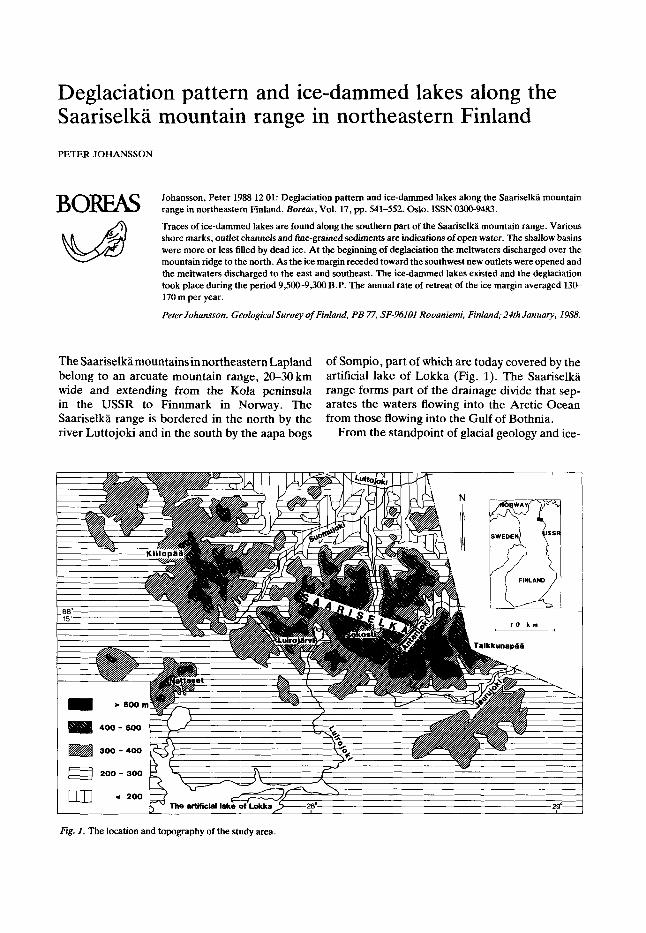
The Saariselkamountainsinnortheastern Lapland of Sompio, part of which are today covered by the belong to an arcuate mountain range, 20-30 km artificial lake of Lokka (Fig. 1). The Saanselka wide and extending from the Kola peninsula range forms part of the drainage divide that sep- in the USSR to Finnmark in Norway. The arates the waters flowing into the Arctic Ocean Saariselka range is bordered in the north by the from those flowing into the Gulf of Bothnia. river Luttojoki and in the south by the aapa bogs From the standpoint of glacial geology and ice-
'ig. 1. The location and topography of the study area.
542 Peter Johansson BOREAS 17 (1988)
sent-day form as far back as preglacial times, because the glacial and glaciofluvial erosion affec- ted only the minor topography of the landscape, except for some meltwater channels (Mikkola 1932; Penttila 1963; Kaitanen 1969). The river val- leys divide the mountain region into different parts. The main Saariselka area is located between the rivers Suomujoki and Jaurujoki (Fig. 1). There, the highest mountain summits rise above the 600 m level (e.g. Ukselmapaa 698 m, Vuoma- pal 689 m and Talkkunapaa 632 m). The highest mountain in all of eastern Lapland is the steeply cone-shaped Sokosti (718 m), whose top is 430 m above the surface of the adjacent lake Luirojarvi. The relative level variations in the area are between 300 and 400 m (Fig. 1).
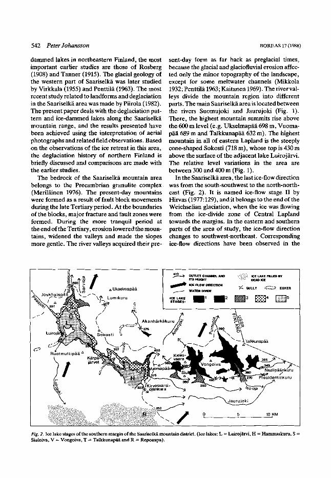
In the Saariselka area, the last ice-flow direction was from the south-southwest to the north-north- east (Fig. 2). It is named ice-flow stage I1 by Hirvas (1977:129), and it belongs to the end of the Weichselian glaciation, when the ice was flowing from the ice-divide zone of Central Lapland towards the margins. In the eastern and southern parts of the area of study, the ice-flow direction changes to southwest-northeast. Corresponding ice-flow directions have been observed in the
dammed lakes in northeastern Finland, the most important earlier studies are those of Rosberg (1908) and Tanner (1915). The glacial geology of the western part of Saariselka was later studied by Virkkala (1955) and Penttila (1963). The most recent study related to landforms and deglaciation in the Saariselka area was made by Piirola (1982). The present paper deals with the deglaciation pat- tern and ice-dammed lakes along the Saariselka mountain range, and the results presented have been achieved using the interpretation of aerial photographs and related field observations. Based on the observations of the ice retreat in this area, the deglaciation history of northern Finland is briefly discussed and comparisons are made with the earlier studies.
The bedrock of the Saariselka mountain area belongs to the Precambrian granulite complex (Meriltiinen 1976). The present-day mountains were formed as a result of fault block movements during the late Tertiary period. At the boundaries of the blocks, major fracture and fault zones were formed. During the more tranquil period at the end of the Tertiary, erosion lowered the moun- tains, widened the valleys and made the slopes more gentle. The river valleys acquired their pre-
Fig. 2. Ice lake stages of the southern margin of the SaariseM mountain district. (Ice lakes: L = Luirojihi, H = Hammaskurn, S = Siuloiva, V = Vongoiva, T = Takkunapa and R = Repoaapa).

BOREAS 17 (1988) Deglaciation and ice-dammed lakes, NE Finland 543
USSR as well (Tanner 1915:116-117; Legkova et al. 1981).
The abundant traces of glaciofluvial action are mostly erosional features such as overflow chan- nels, lateral drainage channels and subglacial drainage channels. The vicinity of the ice divide and the strong relief were not a favourable en- vironment for the formation of long continuous eskers (cf. Penttila 1963: 50). Therefore theeskers are few, they are low and discontinuous, and their material is often poorly sorted. Near the lake Luirojarvi there are two broken, segmented eskers running along the valley floors towards the north- northeast (Fig. 2). These were deposited in sub- or englacial tunnels which followed the fracture zones in the bedrock. The eskers cross the mountain ridges quite randomly. At the crossing places, there are visible channels in the bedrock formed by subglacial erosion.
Identification of ice-dammed lakes During deglaciation, the Saariselka region was favourable for the formation of ice-dammed lakes. The great variationsin altitude, thedrainage divide running across the area, and the ice margin that had receded towards the south-southwest from high to low elevations caused the meltwaters to be dammed between the ice margin and the mountain slopes. The glacier itself must have been active, since a passive and broken, dead glacier would not have been able to dam large masses of meltwater (Glen 1954). The extent of the ice-dam- med lakes may have been overestimated by earlier workers (e.g. Rosberg 1908, Tanner 1915). In the present study open lakes were established in the deep valleys, but the shallow basins were probably fields filled with blocks of dead ice, where the meltwater played a minor part. The actual size of theicelakescanonlybeestirnated. Evenifthelirnit against the slope could be accurately defined, there is no information on the extension of the lake towards the glacier. In the extreme case the ice lake was a narrow, marginal ice-dammed lake along the ice margin (cf. Penttila 1963 and Bjornsson 1976).
In the region of Saariselka, the existence and size of ice-dammed lakes were defined on the basis of shore marks, outlet channels and fine-grained sediments. Although various shore marks, such as washing lines and erosion terraces, are generally indications of open water, the ice lakes of the
region were usually short-lived, so there was no time for distinct shore marks to form, except in favourable places. Outlet channels, where the threshold elevation regulates the water level, gen- erally indicate the existence of an ice lake, unless the channel in question was formed earlier, as a result of subglacial meltwater erosion. Varved or homogeneous fine-grained sediments deposited on the bottom of the ice lake indicate that the depth of the water has been several tens of metres. They are usually considered the strongest proof of the existence of an ice-dammed lake (cf. G. Lundqvist 1942; J. Lundqvist 1972; Theakstone 1976; Strom- qvist 1983).
Deglaciation and stages of ice- dammed lakes Judging from the most recent ice-flow direction and late glacial hydrography, the ice margin receded across the mountain region from the north-northeast to the south-southwest. The highest mountains of the northern part were the first to emerge from the ice as isolated nunataks. On the basis of the lateral drainage channels the ice was sloping gently to the northeast, but due to the varied topography of the landscape the edge of the glacier ran in a winding line. The gradient also vaned, being about 1.5-2.5:lOO on the main ice fields(cf. Penttila 1963:59) andaboutG10:lOOand even more in the lobes. When the summits of the mountain range at the southern edge of the Saa- riselka mountain region were emerging, there were still thick lobes of ice on the floors of the valleys facing north and northeast. In the tributary valleys these ice lobes dammed small ice lakes. Gullies with bedrock walls can be observed at their outlets, as for example the gully Akanharkakuru.
When the ice margin had receded to the south- western side of the mountain range on the southern fringe of the Saariselka region, great masses of meltwater were dammed at the north and north- eastern ends of the valleys. The earliest ice lakes were formed in the northeastern part of the study area, around the mountain Talkkunapaa. As the water level in them lowered, resulting from the opening of new outlet channels, new ice lake basins formed to the west of them. The eastern ice-lake basins of Talkkunapaa, Vongoiva and Siuloiva were already empty at the stage when the western ice lake basins of Luirojarvi and Ham- maskuru were reaching their greatest extension

544 Peter Johansson BOREAS 17 (1988)
(ice lake stages in Fig. 2). At the initial stage the glacier surrounded the ice lake and the meltwaters discharged to the north over the mountain ridge acting as a water divide. As the ice margin receded, outlet channels opened between it and the moun- tain slope on a lower level than the earlier channel. Along them, the meltwaters flowed to the east and southeast, either to another lake basin on a lower level or along extra-marginal drainage channels across the present eastern border of Finland (Fig. 2).
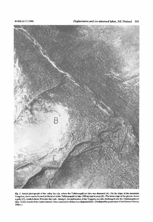
The ice-dammed lake of Talkkunapaa The oldest of the ice-dammed lakes formed south of the mountain range was dammed in the long valley of the Iso-oja brook west of the mountain Talkkunapaa. On the eastern slope of the moun- tain Vongoiva there is a distinct raised shoreline at an altitude of 390m (Fig. 3). This equals the altitude of the threshold of the channel at the north- western end of the valley, which regulated the water level during the first stage of the ice-dammed lake of Talkkunapaa (cf. Tanner 1915:448). From the threshold point the meltwaters discharged to the north, along Purnuoja to the river Anterijoki and on to the east across the present border of Finland. The first stage of the ice-dammed lake apparently lasted for tens of years, since the elon- gated and closed form of the valley prevented the sinking of the water level. Not until the ice margin receded from the slope of the mountain that had formed the eastern rim did the meltwaters dis- charge to the east between the edge of the glacier and the slope. Between the mountains southeast of Talkkunapaa there are abundant channels and gullies formed by the discharges of water. These indicate that the waters of the Talkkunapaa ice lake discharged along the edge of the receding gla- cier across the border to the Jaurujoki river valley.
Many of the meltwater channels, including those shown in Fig. 2, are erosional features of such dimensions that they cannot be the result just of the discharges of the Talkkunapaa ice lake, e.g. the gullies of Presidentinkuru (70 m deep) and Naalipaankuru (40 m deep). These gullies were old fracture zones of the bedrock filled with broken rock, possibly by frost action, and widened by gla- cial erosion. Then the meltwaters washed their walls and floors. When the glacier had disappeared from the valley floor of the Iso-oja brook the last meltwaters discharged to the southeast emptying the ice lake.
The ice-dammed lakes of Vongoiva and Siuloiva In the valleys west of the Talkkunapaa ice lake, two more ice-dammed lakes, those of Vongoiva and Siuloiva, formed almost simultaneously (Figs. 2 and 4). Their development has been outlined by Tanner (1915A48-456). Their growth, their changes in outlet channels and finally their emptying happened nearly in the same way. Initially, both ice lakes discharged to the north, to the Anterijoki river along their own outlet channels. The outlet channels crossed the moun- tain ridge that functioned as a water divide. Because the meltwater channels formed mainly on the slopes of the valley and not on its floor, the Anterijoki valley north of the ridge was covered by a tongue of dead ice.
When the ice margin receded to the south of the mountain Siuloiva, the direction of discharge of the waters from the Siuloiva ice lake changed towards the Vongoiva ice lake, following the edge of the glacier that rested against the southeastern slope of the mountain Kielisvaara. This change in direction of discharge can be seen as a washed barren zone of bedrock on the upper slope of Kie- lisvaara (Fig. 4). At the second stage, the waters of the Siuloiva ice lake discharged over a threshold point at an altitude of 505 m into the Vongoiva ice lake, and on over a threshold point at 445 m, down to the river Anterijoki (Fig. 2).
When the ice margin receded further to the south of the mountain Vongoiva, a series of consecutive outlet channels opened. Through them the waters of both ice lakes discharged to the east, to the Talk- kunapaa ice lake. Four consecutive deltas (Fig. 3) formed from the loose material transported by the discharging waters. The levels of the deltas (270, 260,255 and 240 m) reflect the systematic sinking of the water level during the final stage of the Talk- kunapaa ice lake, caused by the opening of new outlet channels at lower and lower elevations. At the final stage, the waters from the Vongoiva and Siuloiva ice lakes eroded a series of marginal and extra-marginal drainage channels, one below the other, on the lower slopes of the mountains leading eastward to the Jaurujoki river valley (Figs. 4, 5 and 6). The Jaurujoki valley itself is also an extra- marginal drainage channel, nearly 50m deep, which collected the waters discharged from the ice- dammed lakes, leading them to the east, to the Tuloma river, nowadays belonging to the USSR, and on to the Arctic Ocean.
BOREAS 17 (1988) Deglaciation and ice-dammed lakes, NE Finland 545
Fig. 3. Aerial photograph of the valley Iso-oja, where the Talkkunapa ice lake was dammed (A). On the slope of the mountain Vongoiva, shore marks formed at the level of the TalkkunapHa ice lake (390 m) can be seen (B). The lower edge of the picture shows a gully (C), eroded about 50 m into the rock. Along it, the meltwaters of the Vongoiva ice lake discharged into the Takkunapaa ice lake. At the mouth of the outlet channel, four consecutive deltas were deposited (D). (Published by permission of the General Survey Office.)

546 Peter Johansson BOREAS 17 (1988)
Fig. 4. Aerial photograph of a valley bottom between the mountains (showing in the picture as light areas) where the Siuloiva ice lake (A) was dammed. The picture shows the outlet channel that led to the river Anterijoki (B) and the outlet channel (D) that led to the Vongoiva ice lake (C) with its continuation, a zone of washed barren rock on the slope of the mountain (E). The lower edge of the picture shows lateral drainage channels (F), and extra-marginal drainage channels (G) eroded by the meltwater discharge of the Hammaskuru ice lake. (Published by permission of the General Survey Office.)

BOREAS 17 (1988) Deglaciation and ice-dammed lakes, N E Finland 547
Fig. 5. Extra-marginal outlet channel on the southern slope of the mountain Vongoiva.
The ice-dammed lakes of Luirojarvi and Hammaskuru
The largest of the ice lake basins formed on the southern fringe of the Saariselka mountain range was dammed in the present-day valley of the lake Luirojarvi (see Fig. 1). In the west, north and east it was surrounded by mountain slopes and in the south by the receding ice margin. Overflow chan- nels between the summits, such as Lumikuru (Fig. 2), are the oldest traces of meltwater action. The meltwaters flowed directly from the top and sides of the glacier over the bedrock ridge onto the gla- cier on the other side. Thus the meltwater erosion was concentrated only to the top and distal side of the ridge, where the loose material was washed onto the glacier of the adjacent valley (6. Penttila 1963:21 and Kujansuu 196753). The structure of the rock type and the fractures in the bedrock favoured the formation of gullies with steep walls and stepped floors.
The meltwaters discharging from the glacier concentrated after the initial stage to the northern slope of the Lu i ro jW valley. Judging from the
erosional features the waters initially discharged over the mountain range into the Sarvioja valley. From there the outlet channel moved to Maantie- kuru, where the lowest point of the mountain rangewassituated(Fig. 2). InthevalleyofMaantie- kuru there is today a stretch of bare outcrop, exposed as a result of meltwater action. Initially, when there was still a thick ice lobe in the valley, the erosion was subglacial. South of the threshold point of the Maantiekuru valley the Luirojarvi esker, mentioned before, was deposited, because at the base of the glacier there was a meltwater tunnel. The subglacial erosion was followed by lateral and marginal meltwater erosion at the edges of glacier lobe when it had receded, and later by the water masses discharged from the Luirojarvi ice lake, which washed the valley floor of loose material. At the threshold point the subglacial stream followed the eastern side of the valley, eroding in it a gully with rock walls. During the succeeding ice lake stage, the meltwater followed the western side of the valley, where the lowest point of the valley is situated. There, an extra-mar- ginal drainage channel with a smooth bottom was

548 Peter Johansson BOREAS 17 (1988)
Fig. 6. Marginal outlet channels and a delta (D) in front of them on the southern slope of the mountain Siuloiva.
formed, which becomes a deep rock gully at lower elevations. Between the subglacialchannel and the extra-marginal one, a hill of moraine was left, which apparently was not touched at all by the meltwater action.
In the valley of Luirojarvi, the first ice lake stage began when the ice margin receded to the south from the mouth of the Maantiekuru valley. The water level was regulated by the threshold point of Maantiekuru (390 m), over which the meltwater discharged to the north. The shore level of the first stage of the ice lake can be observed for example as washing lines on the slopes of the surrounding mountains. The meltwater channels on the slopes, too, end at this altitude, which shows that the meltwaters flowing between the glacier and the slope discharged into the ice-dammed lake.
At the second stage, the waters of the ice lake discharged to the northwest along the gully south of the mountain Joukhaispaa (Fig. 2). From there they sought their way to the Paasjoki valley and on to the river Suomujoki (see Fig. 1). The outlet channel follows the western slope of Joukhaispaa, where gullies tens of metres deep with rock walls
formed, and where discharge gravel was deposited at their mouths. The channel does not follow the bottom of the Paasjoki river valley, whichindicates that there was still ice in the valley at that time. The threshold point of the second ice-lake stage is at an altitude of 357m. The same level appears as washedoutcrops, e.g. on theslopesof Sokosti, and as a shore boulder field on the southern slope of Joukhaispaa. The most distinct shorelines seem to have been formed quite near the supposed ice margin.
From the third stage of the Luirojarvi ice lake there are shore marks at an altitude of 330 m. This level is in accordance with the level of the valley bottom between Sokosti and Ruotmuttipaa. How- ever, there are no signs in the valley of the melt- water discharge, which should have been caused by a lowering of the water level by nearly 30 m. Tanner (1915:459) did not find the outlet channel at all possible. He stated that so much ice would have been left on the valley floor that the discharge would have moved to the south side of Ruotmuttipaa. However, it is unlikely that ice would have been preserved in the valley between

BOREAS 17 (1988) Deglaciation and ice-dammed lakes, N E Finland 549
Sokosti and Ruotmuttipaa long enough to block the streaming of water in the valley. Nor can traces of water discharges be found south of Ruotmuttipaa. The explanation of the missing out- let channel appears when studying the devel- opment .of ice-dammed lakes in the valleys east of Luirojarvi, where meltwater had been dammed simultaneously in the Hammaskuru ice lake (Fig. 2). Initially this ice lake discharged into the river Anterijoki along the Hammaskuru valley. The water level of the lake was at 403 m. When the ice margin receded the Hammaskuru ice lake grew larger, covering the Karpaoja valley, which was situated to the west of it. On the southern slope of the mountain Vuomapaa a series of new outlet channels opened, lowering the level of the ice lake stepwise to the levels of 387,375 and finally 362 m. Apparently at this stage the ice lobe reaching from the Kaitmitoja valley to the Karpajarvi lakes receded so far to the southwest that the waters of Hammaskuru and Luirojarvi joined along the Val- ley of Sokosti and Ruotmuttipaa to form a single, ribbon-like lake (stage 4 in Fig. 2). The altitude of its water level was still regulated by the outlet channel on the southern slope of Joukhaispaa. Some meltwater channels ending at this level have been found in the Karpaoja valley and on the northeastern slope of Ruotmuttipaa, indicating the existence of a ribbon-like ice lake.
The lowering of level of the Luirojarvi ice lake did not begin until the valley of Kirvesvarsiojan- kuru appeared from under the ice margin. In this valley an outlet channel was formed, over 50m deep and with rock walls. According to the altitude of its threshold point, the water level of the Ham- maskuru ice lake lowered to the 323 m level. The lowering of the water level can be observed at the Karpajarvi lakes, too, since on the southwest side there are lateral drainage channels which end at this level. The Luirojarvi ice lake was isolated behind the threshold point (330 m) of the Sokosti and Ruotmuttipaa valley. This was the end of the short stage of the ribbon-like ice lake. The third stage of the Luirojarvi ice lake began with the meltwaters flowing southeast through the Ham- maskuru ice-lake basin (stage 5 in Fig. 2). The flow of water from one basin to the other was so uniform that in the valley between Sokosti and Ruot- muttipaa no rock-walled gully, typical of sudden meltwater discharges, was formed, as stated before. From the third stage of the Luirojarvi ice lake a weak erosion line developed on the slope west of the present-day lake Luirojarvi, approxi-
mately on the 330 m level. At the same time the ice lake modified the esker hills north of the lake Luirojarvi into sand fields with even tops.
During the later stages of the Luirojarvi and Hammaskuru ice lakes the meltwaters were still flowing southeast toward the river Jaurujoki. After the ice margin had receded to the southwest, Lui- rojarvi was isolated as a lake basin of its own, and the river Luirojoki, which today flows southward from it, started developing. The outlet channels of the Hammaskuru ice lake formed a network of marginal and extra-marginal channels on the southern slope of Vuomapaa. On the basis of these channels (Fig. 4) it is possible to study the de- glaciation and recession of the ice margin in this region in considerable detail. When the Ham- maskuru ice lake emptied, a field of dead ice was left in the basin, and meltwater streams from it eroded indistinct channels on the valley floor. South of the mountain range the direction in which the ice margin of the continental ice sheet receded turned to the southwest and in places to the west- southwest. The present-day aapa-bog areas of Repoaapa, Lamminaapa and Pajuaapa, and the aapa bogs at the upper course of the river Pihtijoki were filled with meltwater and dead ice, because the ice margin still covered their present outlet, the Luirojoki river. Jaurujoki acted as their outlet channel and the threshold point (252 m) was at the northeast edge of Repoaapa (Fig. 2).
In the valleys of Luirojarvi, Hammaskuru, Kar- pajarvet and Siuloiva, and in the aapa-bog areas in the southern part, impulse radar soundings and sample drilling have been used to study the fine- grained sediments deposited on the bottom of the ice lake and to establish their thickness. In the Lui- rojarvivalley sediments were encountered in many depressions. On the bottom of a pond there was a layer of silt and clay with a thickness of 15-30 cm. Series of samples taken there show a maximum of eight thin, clayey laminae, which do not however represent yearly sedimentation. During the depo- sition of the sediments the lake was at its deepest 110 m. The fine-grained sediments were covered by gyttja, deposited during a shallow-lake stage (cf. Andersen 1969; Alstadsaeter 1982). Fine sand containing abundant organic material was deposited on top of these during the shore stage, and it has been overgrown by a 3.4 m thick deposit of Carex peat. The glacial stream in the tunnel, which had deposited the esker on the valley floor, was of crucial importance for the deposition of the Luirojarvi sediments. The meltwater emerging

550 Peter Johamson BOREAS 17 (1988)
from it also carried fine clay material, which was later deposited on the bottom of the ice lake. In the other valleys (e.g. Hammaskuru, Siuloiva and Karpajarvet) no eskers were deposited, so the fine- grained sediments are absent, too. On the bottom of the aapa-bogs thin deposits of sediments (less than 5 cm) with no visible structures wer- found.
The rate of deglaciation as determined from glacial lake channels and from a broader regional context The margin of the ice sheet receded in the north- ernmost part of Finland toward the south and southwest. In the ice-divide zone the deglaciation went on toward the west (Fig. 7). The beginning of the deglaciation history of northern Finland can be correlated with ice-marginal formations of the Younger Dryas on the coast of northern Norway, the so-called Troms6-Lyngen end moraines (Mar- thinussen 1962; Andersen 1968). The continental
\ F I N L A N D
\
Fig. 7. Most recent ice-flow direction aceording to Hirvas (1977) and Legkova e:aL (1981) and some ice-marginal positions (Mar- thinussen 1962; Kujansuu 1%7; Hyviirinen 1973).
ice sheet began to recede from the marginal for- mation at the end of the Dryas period, c. 10,200- 10,300 B.P. During the following 1,200-1,500 years the ice margin withdrew across northern and central Lapland. According to Kujansuu (1967:92-93) the last Finnish areas to emerge from the ice were Pello and Kolari near the border between Finland and Sweden, about 8,800-9,OOO B.P. From there the deglaciation went on to the west, toward the Scandinavian mountain range.
It is not known exactly when the Saariselka region was deglaciated. According to the results of Nikonov (1964) the surroundings of the Luttojoki river on Soviet territory would have been degla- ciatedc. 9,500-9,800B.P. In thelake basinofInari deglaciation took place almost simultaneously (Seppala 1980). According to Saarnisto (1973) the upper course of the Luttojoki river on Finnish ter- ritory emerged from the ice c. 9,000 B.P. Radio- carbon datings of organic sediments from the floor of the Luttojoki river valley gave the maximal age of 8,160,& 190, but it shows that on the floor of the valley there was dead ice, which had been pre- served for hundreds of years and slowed down the spreading of vegetation into the area (Saarnisto 1973:18). The maximum radiocarbon age from Virtaniemi, 50 km to the north of the Luttojoki river,is8,900 200(Sorsa1965:367). Onthebasis of the previous results Hyvarinen (1973) has con- cluded that the ice margin 9,500 B.P. was situated between the lake Inarinjarvi and the river Lutto- job, i.e. at the northern fringe of the Saariselka mountain range (Fig. 7). Accordingly, the de- glaciation of the Saariselka region may be esti- mated to have occurred during the period 9,500- 9,300 B.P., which was followed by a stage of recession of the ice margin, when central Lapland was freed from the ice sheet.
In the Saariselka region, the recession of the ice margin and its rate were studied with the aid of lateral drainage channels. On the mountain slopes there are usually lateral drainage channels in series, one below the other (Fig. 8). The vertical distance between them is 1-2.5 m, depending on the steepness of the slope. Lateral drainage chan- nels cannot be assumed to have formed every spring when the ice melted. On the basis of series of channels it is possible, however, to estimate the rate of downwastage of the glacier and the gradient of its surface. According to measurements made in the vicinity of the ice-dammed lakes in the Saa- riselka region, the gradient of the glacier was 1.5- 2.5 m:100 m. Regarding the vertical interval and

BOREAS 17 (1988) Deglaciation and ice-dammed lakes, N E Finland 551
Fig. 8. Lateral drainage channels on the slope of the mountain Vongoiva.
the gradient of the channels, the annual retreat of the ice margin on a horizontal plane would have been 130-170 m in the Saariselka region. Penttila (1963:65) estimates the annual retreat in the vicin- ity of Laanila at 70 m. In the deglaciation model presented by Piirola (1982), the rate of ice recession was only 40m a year. According to Piirola’s model the deglaciation of the Saariselka region would have lasted over 1,000 years. Such a long period of time is by no means in accordance with results obtained from other parts of northern Finland. On the basis of the horizontal and the vertical components of the lateral drainage chan- nels, Kujansuu (1967:8&88) estimatesthat thegla- cier in western and northwestern Lapland receded from Enontekio to Kolari in 800 years, and that the annual retreat averaged 170 m.
The annual retreat of the ice margin in the Saa- riselka region should still numerically have been nearly doubled in order for the results to be con- vergent with the deglaciation history of northern Finland. However, the rate of deglaciation was not constant at all times. Obviously the deglaciation
was slow in the beginning. On the basis of the fore- going estimation it took c. 700 years for the ice margin to withdraw from the end moraines of the Younger Dryas some 140-150 km to the Saariselka region. This would imply an average annual retreat of c. 200 m, which agrees considerably better with the results represented in this paper. When the ice masses covering Scandinavia decreased and the cli- mate became warmer, the rate of recession of the ice margin increased. The rest of central Lapland that had been ice-covered was deglaciated in less than 700 years, which corresponds to a rate of approximately 250-350 m per year.
Acknowledgements. - I acknowledge the staff of the Department of Quaternary Geology of the Geological Survey in Northern Finland for their valuable work during the various stages of the study. I thank Dr. Lynda Dredge from the Geological Survey of Canada, Professor Sylvi Haldorsen from the Agricultural Uni- versity of Norway, Professor Raimo Kujansuu and Kalevi M a n e n from the Geological Survey of Finland for their critical reading of the manuscript and for suggesting many improvements. The English translation was done by Mrs. Carola Eklundh, to whom I am gateful for her careful work.

552 Peter Johansson BOREAS 17 (1988)
References
Alstadsaeter, I. 1982 The deglaciation and vegetational history of a former icedammed lake area at SkAbu, Nord-Fron, southern Norway. NorgesgeologirkeundersQkeke373,3%43.
Andersen, B. C. 1968: Glacial chronology of western Trom, North Norway. Norges geologiske unders9keke 256.160 pp.
Andersen, B. C. 1%9: Bresjsavsetninger ved Tynset i Osterdalen. Norsk Geologisk Tihskrifi 49,289-311.
BjSrnsson, H. 1976 Marginal and supraglacial lakes in Iceland. Jokull26,40-51.
Hirvas, H. 1977: Glacial transport in Finnish Lapland. In Pros- pectingin Areasof Glaciated Terrain, 128-137. TheInstitution of Mining and Metallurgy.
Glen, J. W. 1954: The stability of ice-dammed lakes and other water-filled holes in glaciers. Journalof Glaciology 2,316-318.
Holdar, C.-G. 1957: Deglaciationsforloppet i Tornetrisk- omradet. Geologiska foreningens i Stockholm f6rhadlingar 79,291-528.
Hyvarinen, H. 1973: The deglaciation history of eastern Fen- noscandia - recent data from Finland. Boreas 2,85102.
Kaitanen, V. 1969 A geographical study of the morphogenesis of Northern Lapland. Fennia 99.85 pp.
Kujansuu, R. 1967: On the deglaciation of western Finnish Lapland. Bulletin de la Commission GI?oologique de Finlande 232.98 pp.
Legkova, V. G., Korovkin, V. A. & Shchukin, L. A. 1981: Pleistocene movement of the ice sheet over the Kola-Karelian region. In Puustinen, K. (ed.): Geological, Geochemical and Geophysical lnuestigatiom in the Eartern Part of the Baltic Shield, 15S168. Helsinki.
Lundqvist, G. 1942: Var &o issjoarnas sediment? Geologiska foreningens i Stockholm forhandlingor 64,16&162.
Lundqvist, J. 1972: Ice-lake types and deglaciation pattern along the Scandinavian mountain range. Boreas I, 27-54.
Marthinussen, M. 1%2: C-14 datings referring to shorelines, transgressions and glacial substages in northern Norway. Nor- ges geologiske unders9keke 215,3747.
Meril3inen. K. 1976: The granulite complex and adjacent rocks
in Lapland, northern Finland. Geological Survey of Finland Bulletin 281. 129 pp.
Mikkola, E. 1932: On the physiography and late-glacial d e p i t s in northern Lapland. Bulletin de la Commission Gkologiqw de Finlande %. 88 pp.
Nikonov, A. 1964: Razvitije reliefa i paleogeogr4ja antro- pogena M zap& Kokkogo poluostrova. (Development of relief and anthropogene palamgeography of the western Kola Peninsula.) 184 pp. Izvestie Nauka, Moskva, Leningrad.
Penttila, S. 1%3 The deglaciation of the Laanila area, Finnish Lapland. Bulletin de la Commkswn Gt?ologique de Finlande 203.68 pp.
Piirola, J. 1982: Deglaciation of the main water divide, Saari- selka, North-Fennoscandia. Zeitschrift fiir Geomorphologie 26,265-282.
Rosberg, J. 1908: Studien iiber Talbildungen im finnischenlapp- IandunddessenUmgebungenl. DasTaldesTulomjok. Fennia 24:4. 38 pp.
Saamisto, M. 1973: Contributions to the late-Quaternary his- tory of the Luff0 river valley, Finnish Lapland. Com- mentationes Physico-Mathematicue 43,ll-20.
Seppaa, M. 1980: Deglaciation and glacial lake development in the Kaamasjoki river basin, Finnish Lapland. Boreas 9,311- 319.
Sorsa, V. 1965: Pollenanalytische Untersuchungen mrsp8tquar- tken Vegetations- und Klimaentwicklung im ostlichen Nordfinnland. A& Botanici Fennici 2,301-413.
StrGmquist, L. 1983: Glacial clay at Katterjakka and the ques- tion of the Vassijaure ice lake, Swedish Lapland. Geologiska fiireningens i Srockholm forhandlingor 104, 247-250.
Tamer, V. 1915: Studier 6her kvartiksystemet i Fennoskandias nordliga delar 111. Bulletin de la Commission G.4ologique de Finlande 38. 800 pp.
Theakstone, W. 1976: Glacial lake sedimentation, Austerdals- isen, Norway. Sedimentology 23, 671-688.
Tunberg, T. 1957 Landii-issj6n i mellersta Jgmtland. Geo- graphica 31,261-288.
Virkkala, K. 1955: On the glacifluvial erosion and accumulation in Tankavaara area, Finnish Lapland. Acta Geographica 14, 393-412.