dekstop review bmk pt
DESCRIPTION
Desktop ReviewsTRANSCRIPT

Brief Concession Review PT Bara Mulia Kalimantan
Page 1 of 17
(BRIEF REPORT)
AUGUST 2015
LIST OF CONTENTS
LIST OF CONTENTS
PT Britmindo Graha Britmindo Jl. Taman Margasatwa Raya No. 14 Ragunan, Jakarta Selatan 12550 www.britmindo.com
COAL CONCESSION REVIEW PT BARA MULIA KALIMANTAN
KOTABARU REGENCY SOUTH KALIMANTAN PROVINCE
Brief Concession Review PT Bara Mulia Kalimantan
Page 2 of 17
LIST OF CONTENT
1 INTRODUCTION.................................................................................................................... 3 2 TOPOGRAPHY AND LAND USE .............................................................................................. 8 3 GEOLOGY OVERVIEW ......................................................................................................... 11
3.1 Regional Geology Overview ............................................................................................................. 12 4 ADJACENT CONCESSIONS ................................................................................................... 14 5 POTENTIAL OVERLAP OF FORESTRY WITH CONCESSION ...................................................... 16 6 OBSERVATION AND COMMENTS ........................................................................................ 17
LIST OF TABLES & FIGURES
Table 1-1 Coordinate Location of BMK Concession Area ................................................................ 3 Figure 1-1 Project location map of BMK Concession area ............................................................... 4 Figure 1-2 Location Map of BMK Concession area ......................................................................... 5 Figure 1-3 Situation Map of BMK Concession area ........................................................................ 6 Figure 1-4 Situation Map 1B of BMK Concession area .................................................................... 7 Figure 2-1 Topography Map of BMK Concession area .................................................................... 9 Figure 2-2 Satellite Imaginary of BMK Concession area................................................................ 10 Figure 3-1 Sedimentary and Basin Map of BMK Concession area ................................................. 11 Figure 3-2 Regional Geology of BMK Concession area .................................................................. 13 Figure 4-1 Table of Clear and Clean of BMK (The Announcement of Reconciliation of IUP ESDM) . 14 Figure 4-2 Situation Map (1A) of BMK Concession area ............................................................... 15 Figure 5-1 Forestry map of BMK Concession area ........................................................................ 16
IMPORTANT NOTICE
This Brief Report has been prepared by Britmindo for the sole use PT Bara Mulia Kalimantan. The assessments and assumptions stated in this Report have been prepared in a professional manner and comply with accepted mining, engineering and cost evaluations of Coal deposits. The assumptions in respect of the Concession are based solely on data provided by PT Bara Mulia Kalimantan. No physical verification of the data supplied has been undertaken. It is therefore acknowledged by the reader that, at best, this is a high level review and is not intended to represent the long term performance or commercial potential of the Concession. Consequently, any commercial decision to invest in this Concession should not be made solely on the content of this Report and should be fully supported by additional practical verification of the Concession potential in order to considerably increase confidence in the potential of the Concession. This Report should also not be considered as an express or implied inducement or recommendation to buy or not to buy the shares or equity in this PT Bara Mulia Kalimantan. Britmindo, its Directors, Officers and Employees shall not be liable for any loss suffered as a consequence of any reliance on any information contained in this Report.
Brief Concession Review PT Bara Mulia Kalimantan
Page 3 of 17
1 INTRODUCTION
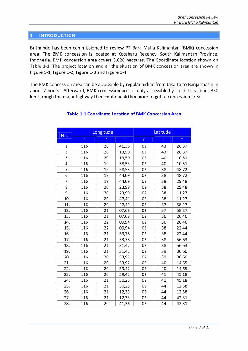
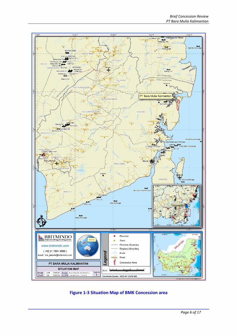
Britmindo has been commissioned to review PT Bara Mulia Kalimantan (BMK) concession area. The BMK concession is located at Kotabaru Regency, South Kalimantan Province, Indonesia. BMK concession area covers 3.026 hectares. The Coordinate location shown on Table 1-1. The project location and all the situation of BMK concession area are shown in Figure 1-1, Figure 1-2, Figure 1-3 and Figure 1-4. The BMK concession area can be accessible by regular airline from Jakarta to Banjarmasin in about 2 hours. Afterward, BMK concession area is only accessible by a car. It is about 350 km through the major highway then continue 40 km more to get to concession area.
Table 1-1 Coordinate Location of BMK Concession Area
No. Longitude Latitude
0 ‘ “ 0 ‘ “ 1. 116 20 41,36 02 43 26,37
2. 116 20 13,50 02 43 26,37
3. 116 20 13,50 02 40 10,51
4. 116 19 58,53 02 40 10,51
5. 116 19 58,53 02 38 48,72
6. 116 19 44,09 02 38 48,72
7. 116 19 44,09 02 38 29,48
8. 116 20 23,99 02 38 29,48
9. 116 20 23,99 02 38 11,27
10. 116 20 47,41 02 38 11,27
11. 116 20 47,41 02 37 58,27
12. 116 21 07,68 02 37 58,27
13. 116 21 07,68 02 36 26,46
14. 116 22 09,94 02 36 26,46
15. 116 22 09,94 02 38 22,44
16. 116 21 53,78 02 38 22,44
17. 116 21 53,78 02 38 56,63
18. 116 21 31,42 02 38 56,63
19. 116 21 31,42 02 39 06,60
20. 116 20 53,92 02 39 06,60
21. 116 20 53,92 02 40 14,65
22. 116 20 59,42 02 40 14,65
23. 116 20 59,42 02 41 45,18
24. 116 21 30,25 02 41 45,18
25. 116 21 30,25 02 44 12,58
26. 116 21 12,33 02 44 12,58
27. 116 21 12,33 02 44 42,31
28. 116 20 41,36 02 44 42,31

Brief Concession Review PT Bara Mulia Kalimantan
Page 4 of 17
Figure 1-1 Project location map of BMK Concession area

Brief Concession Review PT Bara Mulia Kalimantan
Page 5 of 17
Figure 1-2 Location Map of BMK Concession area
Brief Concession Review PT Bara Mulia Kalimantan
Page 6 of 17
Figure 1-3 Situation Map of BMK Concession area

Brief Concession Review PT Bara Mulia Kalimantan
Page 7 of 17
Figure 1-4 Situation Map 1B of BMK Concession area
Brief Concession Review PT Bara Mulia Kalimantan
Page 8 of 17
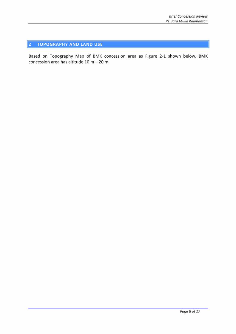
2 TOPOGRAPHY AND LAND USE
Based on Topography Map of BMK concession area as Figure 2-1 shown below, BMK concession area has altitude 10 m – 20 m.

Brief Concession Review PT Bara Mulia Kalimantan
Page 9 of 17
Figure 2-1 Topography Map of BMK Concession area

Brief Concession Review PT Bara Mulia Kalimantan
Page 10 of 17
Based on the satellite imagery interpretation, physical condition the land of BMK concession area is not on forestry area and located in coastal area, as Figure 2-2 shown below.
Figure 2-2 Satellite Imaginary of BMK Concession area
Brief Concession Review PT Bara Mulia Kalimantan
Page 11 of 17
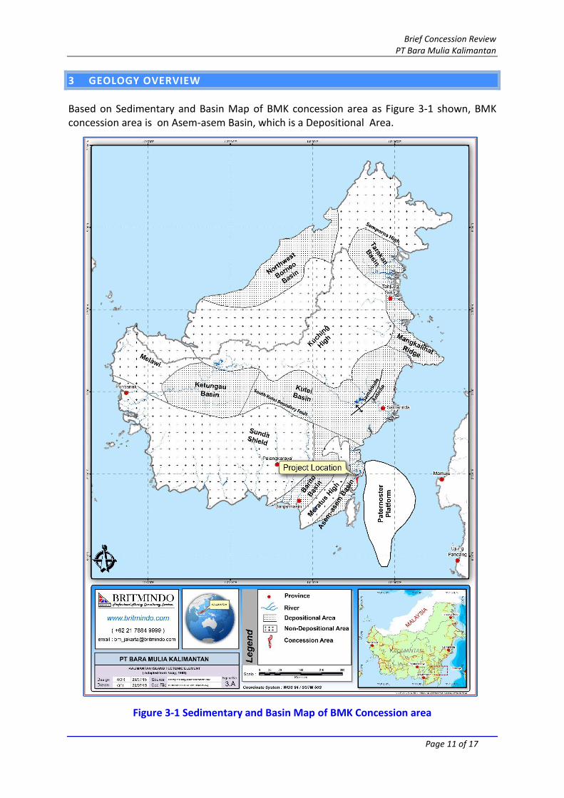
3 GEOLOGY OVERVIEW
Based on Sedimentary and Basin Map of BMK concession area as Figure 3-1 shown, BMK concession area is on Asem-asem Basin, which is a Depositional Area.
Figure 3-1 Sedimentary and Basin Map of BMK Concession area

Brief Concession Review PT Bara Mulia Kalimantan
Page 12 of 17
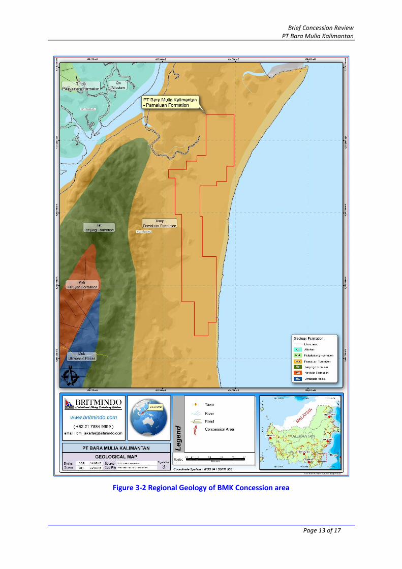
3.1 REGIONAL GEOLOGY OVERVIEW
Based on Sampanahan sheet regional geology map (R. Heryanto, S. Supriatna, E. Rustandi and Baharuddin, 1994) published by the Directorate General of Mineral and Coal resources, BMK concession area is consist 100% of Pamaluan Formation. The explanation is as follows:
Pamaluan Formation (Tmo): Claystone with intercalation of sandstone, marl and limestone, maximum thickness of bed is 2 meters. Marls rich in forams such as Cycloclypeus sp., and Amphistegina sp., which are indicated Oligonese-Lower Miocene age. Thickness of the Pamaluan Formation is 2500 meters.
From the explanations above tells that Pamaluan Formation is considered as a coal bearing formation. The regional geology map of BMK area is shown on Figure 3-2 below.
Brief Concession Review PT Bara Mulia Kalimantan
Page 13 of 17
Figure 3-2 Regional Geology of BMK Concession area

Brief Concession Review PT Bara Mulia Kalimantan
Page 14 of 17
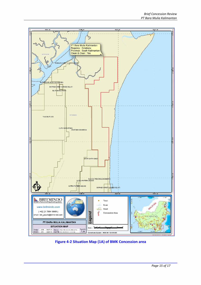
4 ADJACENT CONCESSIONS
Using information derived from the database of Indonesian Mining Concessions, provided by the Indonesia Mining Department – Energy and Mineral Resources, the coal concession of BMK area is not overlapping with others as Figure 4-2 shown below. The Indonesian Mining Department, MINERBA, through the Director General of Mineral and Coal have issued a list of “Clean and Clear” that have been cleared of overlapping and licensing issues. It should be noted that PT BMK is noted on this " Clean and Clear” as shown on Figure 4-1.
Figure 4-1 Table of Clear and Clean of BMK (The Announcement of Reconciliation of IUP
ESDM)
Brief Concession Review PT Bara Mulia Kalimantan
Page 15 of 17
Figure 4-2 Situation Map (1A) of BMK Concession area

Brief Concession Review PT Bara Mulia Kalimantan
Page 16 of 17
5 POTENTIAL OVERLAP OF FORESTRY WITH CONCESSION
Based on the forestry map of BMK concession area that is held in Britmindo database, BMK concession area is located on 100% of Area of Other Use – APL. The Figure 5-1 below shows the relation of the concession area to the forestry area.
Figure 5-1 Forestry map of BMK Concession area

Brief Concession Review PT Bara Mulia Kalimantan
Page 17 of 17
6 OBSERVATION AND COMMENTS
1. Based on Sampanahan sheet regional geology map (R. Heryanto, S. Supriatna, E. Rustandi and Baharuddin, 1994) published by the Directorate General of Mineral and Coal resources, BMK concession area is consist 100% of Pamaluan Formation. Pamaluan Formation is considered as a coal bearing formation.
2. The coal concession of BMK area is not overlapping with others. 3. It should be noted that PT BMK is noted on “Clean and Clear” list as issued by
MINERBA. 4. BMK concession area is located on 100% of Area of Other Use – APL.
Should the project be considered viable the following action is recommended;
Further exploration activities such as detailed mapping, drilling program, Geophysical logging and topography survey must be undertaken to determine coal seam consistency with high level confidence. And then recalculate resource and reserves based on international standard.