department of geoinformation science technische universität berlin 2009/05/19 introduction to...
TRANSCRIPT

Department of Geoinformation Science
Technische Universität Berlin
2009/05/19
Introduction to CityGML
Thomas H. KolbeAlexandra Stadler
Chair of Geoinformation MethodologyInstitute for Geodesy and Geoinformation ScienceBerlin University of Technology
{ kolbe | stadler }@igg.tu-berlin.de
19th of May, 2009
EduServ7 Pre-Course Seminar in Ås

2009/05/192 T. H. Kolbe, A. Stadler – CityGML Tutorial
Department of Geoinformation Science
Copyright notice:
This is copyrighted material. It is not allowed to distribute copies or parts of these slides and the video clips without the written consent of the author.
Please note, that the presentation also contains third-party copyrighted material used with permission.

2009/05/193 T. H. Kolbe, A. Stadler – CityGML Tutorial
Department of Geoinformation Science
Overview
Introduction: Urban Information Modelling
CityGML overview and status
CityGML details
Extending CityGML
Application examples
Summary

2009/05/194 T. H. Kolbe, A. Stadler – CityGML Tutorial
Department of Geoinformation Science
Urban InformationModelling

2009/05/195 T. H. Kolbe, A. Stadler – CityGML Tutorial
Department of Geoinformation Science
Applications of Virtual 3D City Models

2009/05/196 T. H. Kolbe, A. Stadler – CityGML Tutorial
Department of Geoinformation Science
3D City Modelling
… is far more thanthe 3D visualizationof reality
In fact, the geometryand its appearanceare only one aspectof an entity!
Key issue: Semantic Modelling

2009/05/197 T. H. Kolbe, A. Stadler – CityGML Tutorial
Department of Geoinformation Science
Prospects of Semantic 3D City Models (I)
Query your 3D city model! (Possibly even without 3D visualization)
From which windows in which rooms of which buildings do I have visible coverage of a certain place, road, or monument?
What is the best position for a new transmitter station such that the propagation of the radio signal is optimal?
To what floors have all buildings in a flooded area been affected?
Where are audience halls in a specific area of the town (or on the campus) with more than 500 seats, 3D projection capabilities and less than 15min to walk from a public transport stop?
Urban Data Mining, 3D cartography
2009/05/198 T. H. Kolbe, A. Stadler – CityGML Tutorial
Department of Geoinformation Science
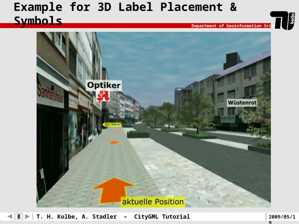
Example for 3D Label Placement & Symbols
2009/05/199 T. H. Kolbe, A. Stadler – CityGML Tutorial
Department of Geoinformation Science
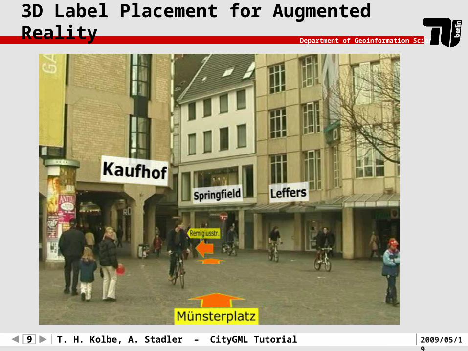
3D Label Placement for Augmented Reality

2009/05/1910 T. H. Kolbe, A. Stadler – CityGML Tutorial
Department of Geoinformation Science
Information Hub
Ongoing virtualisationof our environment
Semantic models of all relevant
objects in urban space
Base models include most
important feature classes and
attributes
Objects may have several
geometrical representations
Spatial reference links data of
different disciplines, since they
refer to the same physical space
base model entities

2009/05/1911 T. H. Kolbe, A. Stadler – CityGML Tutorial
Department of Geoinformation Science
Prospects of a Common Ontology
Data providers (e.g. municipalities) create 3D models with a defined information level, which they can be sure will be required or useful for a wide range of applications
this in turn makes it feasible / profitable for companies to create
more advanced applications that exploit semantic information
Applications can rely on a specific data quality
thematic and spatial structure and
(a minimal set of thematic) properties of the geo-objects

2009/05/1912 T. H. Kolbe, A. Stadler – CityGML Tutorial
Department of Geoinformation Science
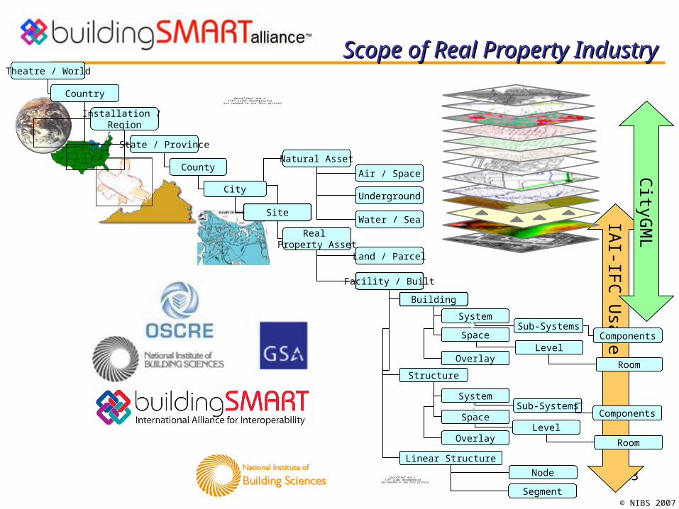
Information Modelling at Different Scales
Model content, structure, and employed modelling principles depend on
ScaleScope (application contexts)
Taken from the Homepage of the Helmholtz Research Center Karlsruhe, © Karl-Heinz-Häfele
13
© NIBS 2007
QuickTime™ and aTIFF (LZW) decompressor
are needed to see this picture.
Scope of Real Property Industry Scope of Real Property Industry IA
I-IFC
Usage
Space
Natural Asset
Linear Structure
Structure
Building
Facility / Built
Theatre / World
Sub-SystemsSystem
Level
Site
Real Property Asset
Country
State / Province
County
Installation / Region
Node
Segment
Room
Space
System
Level
Sub-Systems
Room
Water / Sea
Land / Parcel
Underground
Air / Space
Overlay
Overlay
Components
Components
City
QuickTime™ and aTIFF (LZW) decompressor
are needed to see this picture.
CityG
ML

2009/05/1914 T. H. Kolbe, A. Stadler – CityGML Tutorial
Department of Geoinformation Science
Overview & Status

2009/05/1915 T. H. Kolbe, A. Stadler – CityGML Tutorial
Department of Geoinformation Science
Requirements for 3D City Modeling
Geometric and radiometric modeling
3D Coord. Reference Systems (3D or 2D+1D / geo. or proj.)
Topology
Semantic modeling / Object classificationDistinct thematic models / feature types with thematic attributes
(DTM, Buildings, Transportation, Water bodies, Vegetation, etc.)
Common information model / standardized data model
Different but well-defined granularities / abstraction levelsMulti-scale modeling; support for generalisation
Support for the integration of different datasets

2009/05/1916 T. H. Kolbe, A. Stadler – CityGML Tutorial
Department of Geoinformation Science
Requirements for 3D City Modeling
Geometric and radiometric modeling
3D Coord. Reference Systems (3D or 2D+1D / geo. or proj.)
Topology
Semantic modeling / Object classificationDistinct thematic models / feature types with thematic attributes
(DTM, Buildings, Transportation, Water bodies, Vegetation, etc.)
Common information model / standardized data model
Different but well-defined granularities / abstraction levelsMulti-scale modeling; support for generalisation
Support for the integration of different datasets

2009/05/1917 T. H. Kolbe, A. Stadler – CityGML Tutorial
Department of Geoinformation Science
CityGML – Modelling Urban Spaces
Content Data model and exchange format for virtual 3d city models GML 3 application schema Modelling of all relevant parts of the virtual city according to their
semantics, geometry, topology and appearance
XML
ALKIS ATKIS[NAS] ...CityGML
GML
ISO
191
xx

2009/05/1918 T. H. Kolbe, A. Stadler – CityGML Tutorial
Department of Geoinformation Science
CityGML Development
Developed since 2002 by the Special Interest Group 3D (NorthRhine Westphalia, Germany)
Members from >70 companies, municipalities and research institutes Adopted as international OGC standard since 08/2008
Application backgrounds of the participants Cadastre and Topographic Mapping Urban Planning Building Information Modelling, AEC/FM Mobile Telecommunication Environmental Simulation Training Simulation and Car Navigation Tourism and City Business Development Geoinformation and Computer Science (at its beginning) Real Estate Management
Broad spectrum of differentmodeling
requirements
Good basefor a multi-
functionalstandard

2009/05/1919 T. H. Kolbe, A. Stadler – CityGML Tutorial
Department of Geoinformation Science
Details

2009/05/1920 T. H. Kolbe, A. Stadler – CityGML Tutorial
Department of Geoinformation Science
Modularisation
CityGML consists of a core module several extension modules vertical subdivision
CityGML Core
GML 3.1.1
Bui
ldin
g
City
Fur
nitu
re
City
Obj
ectG
roup
Land
Use
Rel
ief
Tra
nspo
rtat
ion
Veg
etat
ion
Wat
erB
ody
Appearance
Generics
…

2009/05/1921 T. H. Kolbe, A. Stadler – CityGML Tutorial
Department of Geoinformation Science
Coherence of semantics and geometry
…
Semantic objecte.g. Building
Associated geometrye.g. Solid
…
Use of Boundary Representation (B-Rep) for geometry modelling
Explicit relations between semantic objects and their geometrical representations
* *

2009/05/1922 T. H. Kolbe, A. Stadler – CityGML Tutorial
Department of Geoinformation Science
„Availability“ of semantics
CityGML: (Up to) Complex objects with structured geometry
Semantics Geometry
Geometric entities know WHAT they are Semantic entities know WHERE they are and what their
spatial extents are

2009/05/1923 T. H. Kolbe, A. Stadler – CityGML Tutorial
Department of Geoinformation Science
Thematic Modelling in CityGML
ExternalReference - informationSystem: anyURI - externalReference: ExternalObjectReferenceType
ReliefFeature loD1Geometry
loD3Geometry
loD2GeometryGeometry
<<FeatureCollection>>
CityModel
_Vegetation
<<Feature>>
_CityObject
_Site_Water Bodies
_City Furniture
_Transpor-tation
Objects
CityObjectGroup
***

2009/05/1924 T. H. Kolbe, A. Stadler – CityGML Tutorial
Department of Geoinformation Science
Multi-scale modelling: 5 levels of details
LOD 4 – Interior model„Walkable“ architectural models
LOD 3 – City / Site modelDetailed architectural model
LOD 2 – City / Site modelExplicit roof structures
LOD 1 – City / Site model„Block model“ without roof structures
LOD 0 – Regional model2.5d Digital Terrain Model

2009/05/1925 T. H. Kolbe, A. Stadler – CityGML Tutorial
Department of Geoinformation Science
Digital Terrain Models
DTM for each Level of Detail can be composed of TINs (Triangulated Irregular Network), Grids,
3D Breaklines, and 3D Mass Points Each DTM component may be restricted to be valid in a
specific region by providing a validity extent polygon
Validity extentpolygon can have holeswhich allownested DTMs!
coarseGrid
detailedTIN

2009/05/1926 T. H. Kolbe, A. Stadler – CityGML Tutorial
Department of Geoinformation Science
Digital Terrain Model: UML Diagram
MassPointReliefBreaklineRelief
CityObject
gml:TriangulatedSurface
_ReliefComponent+ lod: integer [1]
gml:MultiPoint
gml:MultiCurve
gml:Polygon
TINRelief
ReliefFeature+ lod: integer [1]
extent
1
1 10..1
gml:GridCoverage
1
*
RasterRelief

2009/05/1927 T. H. Kolbe, A. Stadler – CityGML Tutorial
Department of Geoinformation Science
Example for a Nested DTM
Image: PhD work of G. Agugiaro, TU Berlin
Embedding of a high resolution DTM from Archeological Excavation
Hole within the validity extent polygon of the low
resolution surrounding DTM
Hole within the validity extent polygon of the low
resolution surrounding DTM

2009/05/1928 T. H. Kolbe, A. Stadler – CityGML Tutorial
Department of Geoinformation Science
Example for a Nested DTM
Image: PhD work of G. Agugiaro, TU Berlin
Embedding of a high resolution DTM from Archeological Excavation

2009/05/1929 T. H. Kolbe, A. Stadler – CityGML Tutorial
Department of Geoinformation Science
Building Model
Coherent aggregation of spatial and semantical components
(recursive) composition of building parts thematic surfaces (roof surface,
wall surface, etc.) [from LOD2]building installations like dormers, stairs, balconies [from LOD2]openings like doors and windows [from LOD3] rooms and furniture [in LOD4]
Components contain relevant thematic attributesname, class, function, usage, construction and demolition date,
roof type, addressno. of storeys above / below ground, storey heights

2009/05/1930 T. H. Kolbe, A. Stadler – CityGML Tutorial
Department of Geoinformation Science
Building Model in LoD1: UML Diagram
loD1SolidSolid
Geometry
Address+ zipCode: int+ city: String+ street: String+ houseNumber: String
0..*
1
BuildingPart
_AbstractBuilding
+ function: BuildingFunction[0..*]+ yearOfConstruction:integer[0..1]+ roofType: RoofType[0..1]+ measuredHeigth: LengthType[0..1]+ …
Building
0..*
0..1
Implemented in CityGML using the xNAL standard from OASIS
Implemented in CityGML using the xNAL standard from OASIS

2009/05/1931 T. H. Kolbe, A. Stadler – CityGML Tutorial
Department of Geoinformation Science
Building Model in LoD2
loD1Solid
loD2MultiSurface
loD2MultiCurve
SurfaceGeometry
LineGeometry
loD2MultiSurface
_CityObject
_BoundarySurface
RoofS. WallS. GroundS. ClosureSurface
loD2SolidSolid
Geometry_AbstractBuilding
+ function: BuildingFunction[0..*]+ yearOfConstruction:integer[0..1]+ roofType: RoofType[0..1]+ measuredHeigth: LengthType[0..1]
loD2TerrainIntersectionCurve
LoD1 LoD2
exterior
BuildingInstallation
2009/05/1932 T. H. Kolbe, A. Stadler – CityGML Tutorial
Department of Geoinformation Science
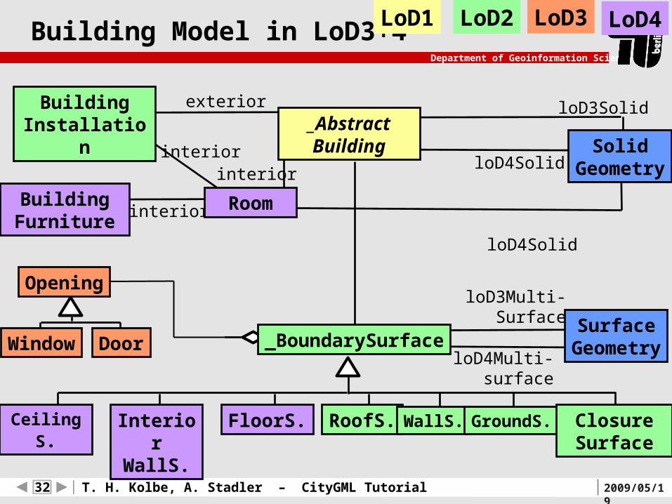
Building Model in LoD3+4
loD4Multi-surface
loD4Solid
loD4Solid
interiorBuildingFurniture
interiorinterior
Room
LoD4
CeilingS. InteriorWallS.
FloorS. RoofS. WallS. GroundS. ClosureSurface
loD3Multi-Surface
LoD3
Window Door
Opening
exteriorBuildingInstallation
loD3Solid
SolidGeometry
_AbstractBuilding
LoD1 LoD2
_BoundarySurfaceSurface
Geometry

2009/05/1933 T. H. Kolbe, A. Stadler – CityGML Tutorial
Department of Geoinformation Science
Building in LoD4 – Interior Model
Entrance door
„Hallway“
„Back room“
„Living room“
Doorway(with door)
Passage(w/o door)
Topology implies Accessibility Graph !
Rooms
Can be used e.g. for escape route
planning in disaster management or
for mobile robotics

2009/05/1934 T. H. Kolbe, A. Stadler – CityGML Tutorial
Department of Geoinformation Science
Spatio-semantical Composition
Building
BuildingInstallation (Dormer)
BuildingPart
BuildingPart
Building
Building surface (WallSurface)
3D-Modell: Stadt Coburg

2009/05/1935 T. H. Kolbe, A. Stadler – CityGML Tutorial
Department of Geoinformation Science
Spatio-semantical Coherence (I)
MultiSurface(„MultiPatch“)
SurfaceSurface
Geometry Semantics
1st case: structured / unstructured geometry only, possibly along with appearance properties
typical models based on 3D graphics formats like VRML, X3D, KML, U3D or legacy CAD geometry formats
usable (in fact tailored) for visualizations; simple visibility computations

2009/05/1936 T. H. Kolbe, A. Stadler – CityGML Tutorial
Department of Geoinformation Science
Spatio-semantical Coherence (II)
MultiSurface(„MultiPatch“)
SurfaceSurface
Building
Geometry Semantics
2nd case: simple object with unstructured geometry identifiable objects with a set of simple thematic properties
(this is the modeling capability level of e.g. Shapefiles) typical result of (current) photogrammetrical registration systemsusable für visualizations & simple thematic queries; simple visibility
computations

2009/05/1937 T. H. Kolbe, A. Stadler – CityGML Tutorial
Department of Geoinformation Science
Spatio-semantical Coherence (III)
Geometry Semantics
Composite-Solid
Solid Solid
Surface Surface
Building
3rd case: simple object with structured geometry typical result of 3D modelling tools, but also from (a few)
photogrammetrical registration systems

2009/05/1938 T. H. Kolbe, A. Stadler – CityGML Tutorial
Department of Geoinformation Science
Spatio-semantical Coherence (IV)
MultiSurface(„MultiPatch“)
SurfaceSurface
Geometry Semantics
Building
House Garage
Stairs
WallSurfaceRoofSurface
4th case: complex object with unstructured geometry
Data is typically derived from
Building Information Models like
IFC or retrieved from Facility
Management
2009/05/1939 T. H. Kolbe, A. Stadler – CityGML Tutorial
Department of Geoinformation Science
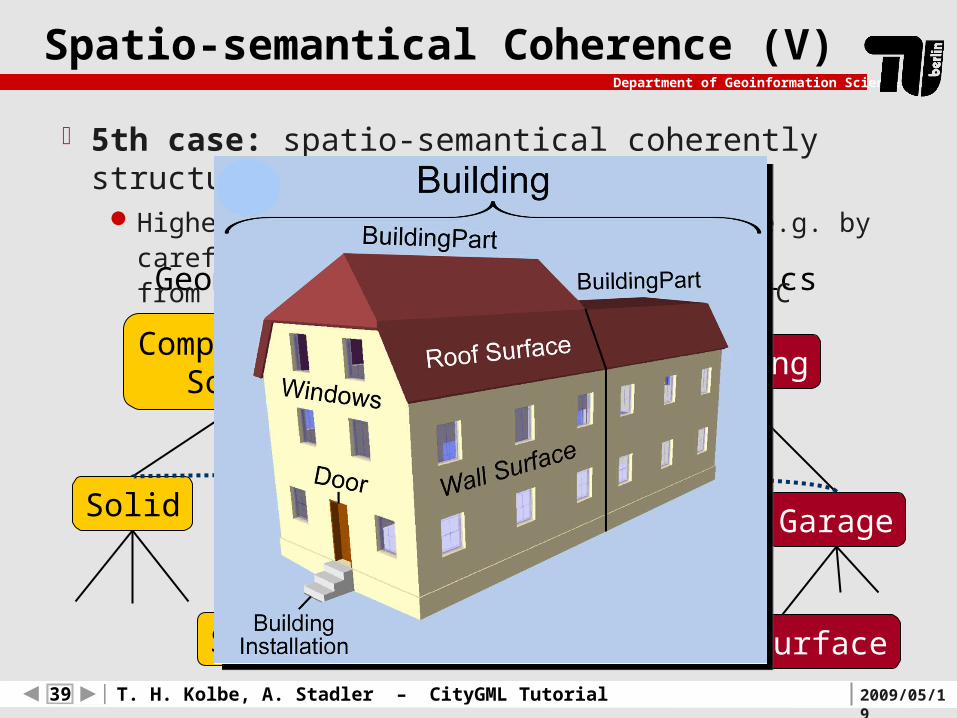
Spatio-semantical Coherence (V)
Composite-Solid
Solid Solid
Surface Surface
Building
House Garage
Geometry Semantics
RoofSurface
5th case: spatio-semantical coherently structured objectHighest quality level; can be obtained e.g. by careful derivation
from Building Information Models like IFC

2009/05/1940 T. H. Kolbe, A. Stadler – CityGML Tutorial
Department of Geoinformation Science
External references
Objects may Refer to their original data sources Refer to other external data sources containing additional data,
e.g.Building: Link to cadastre, information about ownersDoor: Link to facility management systemsAntenna: Link to mobile communication databases

2009/05/1941 T. H. Kolbe, A. Stadler – CityGML Tutorial
Department of Geoinformation Science
Appearances
Materials (similar to X3D) Textures
Standard textures (explicit texture coordinates)
Aerial images (georeferenced)
Projected photos
Multiple appearances (themes) per object

2009/05/1942 T. H. Kolbe, A. Stadler – CityGML Tutorial
Department of Geoinformation Science
Georeferenced Textures

2009/05/1943 T. H. Kolbe, A. Stadler – CityGML Tutorial
Department of Geoinformation Science
Further CityGML Concepts
Support for TopologyShared geometric primitives can be referenced using XLinks
Support for generalization of 3D dataGeneralized objects are linked to the original objects on the
larger scale
Support for spatial homogenization / integratione.g. Terrain Intersection Curves (for integration of 3D
objects with the terrain)

2009/05/1944 T. H. Kolbe, A. Stadler – CityGML Tutorial
Department of Geoinformation Science
ExtendingCityGML

2009/05/1945 T. H. Kolbe, A. Stadler – CityGML Tutorial
Department of Geoinformation Science
Application Specific Extensions to CityGML
CityGML is considered a base or core information model for virtual 3D city models
But: Specific applications need specific extra information typically in close interaction with CityGML base information
ExamplesEnvironmental simulations like noise immission mapping need
information about noise absorption of surfaces
Cultural heritage needs to augment objects by their heritage and
history, and has to consider the development along time
Utility networks need to represent pipes, pipe tunnels,
connectors, transforming devices

2009/05/1946 T. H. Kolbe, A. Stadler – CityGML Tutorial
Department of Geoinformation Science
Extending CityGML
1. Generic Attributes & GenericCityObjects every CityObject can have an arbitrary number of
extra attributes allows to augment objects like Buildings, Roads, etc.
without the need of new application schemas
GenericCityObjects can have arbitrary geometries (and generic attributes) for every LOD
“extension during runtime“
2. Application Domain Extensions (ADE) extra XML schemas referring to the CityGML
XML schema (defined by information communities) extensions to be formally specified in XML schema

2009/05/1947 T. H. Kolbe, A. Stadler – CityGML Tutorial
Department of Geoinformation Science
Generic Objects and Attributes
Simple to use extension mechanism GenericCityObject is used as proxy to model and
exchange features which are not provided by CityGML Generic Attributes can be used to establish (informal)
application specific property sets for feature types
Some disadvantagesNo further semantic structuring of generic objects and
attributesPossible naming conflictsLimited number of predefined attribute types:
integer, double, string, date, URI

2009/05/1948 T. H. Kolbe, A. Stadler – CityGML Tutorial
Department of Geoinformation Science
<Building gml:id=“Building0815">
<!-- generic attributes -->
<stringAttribute name=“BuildingOwner">
<value>Mr. Smith</value>
</stringAttribute>
<doubleAttribute name=“Value">
<value>3500000.0</value>
</doubleAttribute>
<!-- specified properties of feature type “Building” -->
<lod2Solid> ... </lod2Solid>
</Building>
Example for Generic Attributes

2009/05/1949 T. H. Kolbe, A. Stadler – CityGML Tutorial
Department of Geoinformation Science
Application Domain Extensions (ADE)
Information Communities should be able to define extensions on their own
they must be able to associate new attributes to concrete
CityGML feature types
formal definition of new properties / feature types in XML schema
similar situation to the specification of GML application schemas
Different extensions should be usable simultaneouslye.g. CityGML Building features augmented both by properties
from real estate and noise pollution simulation
Requires combinable application schemas

2009/05/1950 T. H. Kolbe, A. Stadler – CityGML Tutorial
Department of Geoinformation Science
Example of application specific attributes
Example for a CityGML Building feature with application specific extra information (qualified by extra namespaces):
<Building>
<function>1000</function>
<lod2Solid> ... </lod2Solid>
...
<noise:immissionPoints> <gml:MultiPoint> ... </gml:MultiPoint></noise:immissionPoints>
<noise:buildingHabitants>8</noise:buildingHabitants>
<realEstate:value currency=“EUR“>400000</realEstate:value>
</Building>

2009/05/1951 T. H. Kolbe, A. Stadler – CityGML Tutorial
Department of Geoinformation Science
Application Domain Extensions (ADE)
Well-defined mechanism to extend CityGML with application specific information
Additional spatial and non-spatial properties, relations, associations, new feature types
Semantic and geometric structuring follows the data needsADE hooks allow for augmenting the predefined CityGML featuresNo formal standardization process needed
Specification within their own XML SchemaAllows for XML validation of ADE enriched documentsEnsures semantic and syntactic interoperabilityGlobally unique XML namespace prevents naming conflictsADEs can be used simultaneously within one instance documents
2009/05/1952 T. H. Kolbe, A. Stadler – CityGML Tutorial
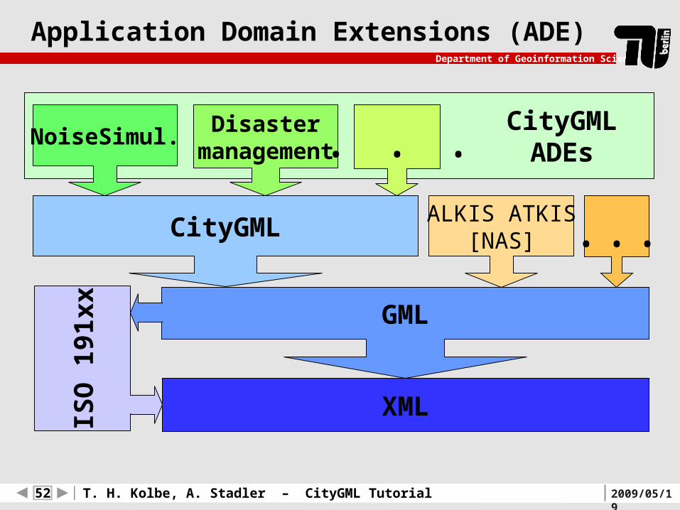
Department of Geoinformation Science
CityGMLADEs
Application Domain Extensions (ADE)
XML
NoiseSimul. Disastermanagement
ALKIS ATKIS[NAS] ...
. . .
CityGML
GML
ISO
191
xx

2009/05/1953 T. H. Kolbe, A. Stadler – CityGML Tutorial
Department of Geoinformation Science
ADE implementations
ADE Application domain Proposed by
NoiseADE Noise pollution simulation
SIG 3D
SubsurfaceADE Underground features, e.g. tunnels
SIG 3D
CAFM-ADE Computer Aided Facility Management
TU München
HydroADE 3D flood simulation HFT Stuttgart
BridgeADE(under development)
Comprehensive model for bridges
SIG 3D
UtilityNetworkADE(under development)
Utility networks, e.g. water, electricity
SIG 3D
Available CityGML ADEs (excerpt)

2009/05/1954 T. H. Kolbe, A. Stadler – CityGML Tutorial
Department of Geoinformation Science
Application Examples
2009/05/1955 T. H. Kolbe, A. Stadler – CityGML Tutorial
Department of Geoinformation Science
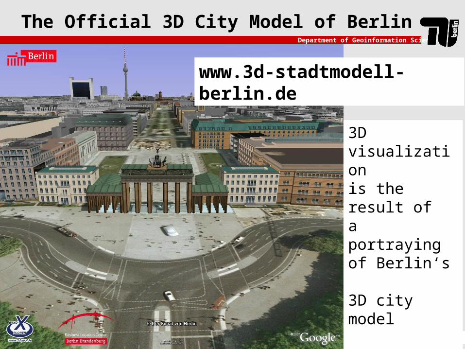
The Official 3D City Model of Berlin
www.3d-stadtmodell-berlin.de
3D visualization
is the result of a portraying of Berlin‘s 3D city model
(modeled according toCityGML)

2009/05/1956 T. H. Kolbe, A. Stadler – CityGML Tutorial
Department of Geoinformation Science
Noise immision mapping
EU Directive: Minimisation of noise immissions
Calculation of noise immission maps for whole North Rhine-Westphalia
Data provision and exchange via CityGML using web services (WFS, WCS, WMS):
8.4 million 3d buildings in LOD 1
3d street network in LOD 0, with additional noise related attributes
3d rail network in LOD 0
3d noise barriers in LOD 1
Digital terrain model (10 meter resolution)

2009/05/1957 T. H. Kolbe, A. Stadler – CityGML Tutorial
Department of Geoinformation Science
Noise immision mapping
Noise immsion mapsreported to EU (via WMS service)
Noise immision simulation
3d geodata in CityGML as input for the calculation of noise immision maps

2009/05/1958 T. H. Kolbe, A. Stadler – CityGML Tutorial
Department of Geoinformation Science
Homeland security
Testbed OWS-4 of the Open Geospatial Consortium (OGC)
Setting: Explosion of a „dirty bomb“ in the New York harbour
Task:Support the planning committee in the construction of an emergency hospital
Find the appropriate location
Identify best fitting existing building (size, room layout, air
conditioning for decontaminations, etc.)
Thematic queries & visual inspections
Link different web services and client applicationsData formats: CityGML and IFC

2009/05/1959 T. H. Kolbe, A. Stadler – CityGML Tutorial
Department of Geoinformation Science
Homeland Security
CityGML building visualised using LandExplorer from outside (left)
room-based representation of the security level (right)

2009/05/1960 T. H. Kolbe, A. Stadler – CityGML Tutorial
Department of Geoinformation Science
http://www.opengeospatial.org/pub/www/ows4/index.html
Homeland Security

2009/05/1961 T. H. Kolbe, A. Stadler – CityGML Tutorial
Department of Geoinformation Science
Coming to the end…

2009/05/1962 T. H. Kolbe, A. Stadler – CityGML Tutorial
Department of Geoinformation Science
Summary
CityGML is a Geospatial Information Model (based on ISO 191xx) and Exchange Format for virtual 3D city and regional
models (implemented as GML3 Application Schema)
CityGML represents Geometry, Topology, Semantics, and Appearance
esp. semantic / structural information is needed for a range of applications
gives city model data enough space to „grow“ with respect to geometric, radiometric, and semantic contents & complexity
to semantic qualification / interpretation
to geometric / topological correctness

2009/05/1963 T. H. Kolbe, A. Stadler – CityGML Tutorial
Department of Geoinformation Science
What is CityGML‘s Use for Research?
Base model / base ontology forgeodatabase developmentsproject specific extensions (like relations or new feature types)
Could be target model of 3D extraction methodsconcerning feature types, aggregation structures5 discrete scales usable for 3D generalisation
Exchange format lossless information exchange between subsystems / GeoDB increasing number of available implementations / 3D-GeoDB
Good amounts of real testdata availableBerlin, Bonn, Bochum, Hamburg, Stuttgart, Recklinghausen, …also 3 freely accessible Web Feature Services delivering CityGML

Department of Geoinformation Science
Technische Universität Berlin
2009/05/19
Introduction to CityGML
Thomas H. KolbeAlexandra Stadler
Chair of Geoinformation MethodologyInstitute for Geodesy and Geoinformation ScienceBerlin University of Technology
{ kolbe | stadler }@igg.tu-berlin.de
19th of May, 2009
EduServ7 Pre-Course Seminar in Ås