design concept for streambank and shoreline … the site investigation and review of applicable...
TRANSCRIPT

Design Concept
for
Streambank and Shoreline Protection
for the Meander Way bend of the
Mendenhall River
near
Juneau, Alaska
Prepared by the Natural Resources Conservation Service
US Department of Agriculture Palmer, Alaska
July 2015

i
Table of Contents Page Table of Contents ............................................................................................................................. i Introduction ..................................................................................................................................... 1 History............................................................................................................................................. 1 Field Investigation .......................................................................................................................... 2 Conditions affecting design alternatives ......................................................................................... 6 Design Alternatives ......................................................................................................................... 8
1. Bioengineered streambank – log crib ................................................................................. 8 2. Bioengineered streambank – mechanically stabilized earth (MSE) wall ........................... 9 3. Sheet pile wall ................................................................................................................... 10 4. Riprap Revetment ............................................................................................................. 11 5. Sheet pile wall/riprap revetment combination .................................................................. 13 6. No action ........................................................................................................................... 14
Conclusions ................................................................................................................................... 14 References ..................................................................................................................................... 16 ATTACHMENT A – Conceptual Design Drawing and Cost Estimates ...................................... 17

1
UNITED STATES DEPARTMENT OF AGRICULTURE NATURAL RESOURCES CONSERVATION SERVICE
Palmer, Alaska July 2015
CONCEPTUAL DESIGN REPORT
Job: Juneau Streambank and Shoreline Protection Location: Juneau, Alaska Phase: Conceptual Design Introduction In the winter of 2015, the City and Borough of Juneau contacted NRCS regarding flooding and streambank erosion on the Mendenhall River caused by high flows during the past few years. At the current rate of erosion, at least several homes will be at imminent risk with only a few more flood events. A site investigation and survey was conducted in early March 2015, as soon as winter conditions thawed enough to allow adequate inspection and surveying. The city requested that NRCS provide assistance with a conceptual design, cost estimates, and potential funding opportunities. This report attempts to evaluate alternatives for remedies to streambank erosion. It does not address flooding concerns. History In 2011, significant glacial outburst flooding (or Jökulhlaup) began to impact the Mendenhall River and Juneau residents. Glacier retreat has progressed to the point where glacial meltwater from Suicide Glacier is continually dammed up behind the Mendenhall Glacier (see Figure 1). When adequate head is developed in Suicide Basin, meltwater is forced under and through the Mendenhall Glacier, and released into Mendenhall Lake and the Mendenhall River. Agencies including the University of Alaska, National Weather Service, and US Geological Survey have cooperated with the City and Borough to install instrumentation to monitor Suicide Basin water levels, in order to provide warning of impending flooding once lake levels begin to drop. Glacial outbursts since 2011 have typically occurred in July. Stream gauging has shown that outburst flows can increase river flows from a July monthly mean of approximately 3,000 cfs, to flows exceeding 16,000 cfs. These flow increases occur in a matter of hours, with a duration of several days. Such magnitude of flows, combined with their rapid rate of rise and fall, have caused significant bank erosion in some areas.

2
Figure 1: Mendenhall River Overview (Google Earth Image)
Field Investigation Field activities were conducted from March 3-4, 2015. City and Borough employees, as well as some affected residents, showed NRCS personnel the sites where significant erosion occurred, as well as areas of past inundation. High water lines were noted, at flooding areas as well as streambank erosion sites.
3
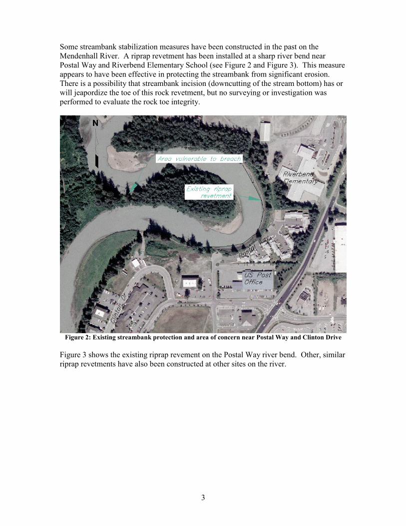
Some streambank stabilization measures have been constructed in the past on the Mendenhall River. A riprap revetment has been installed at a sharp river bend near Postal Way and Riverbend Elementary School (see Figure 2 and Figure 3). This measure appears to have been effective in protecting the streambank from significant erosion. There is a possibility that streambank incision (downcutting of the stream bottom) has or will jeapordize the toe of this rock revetment, but no surveying or investigation was performed to evaluate the rock toe integrity.
Figure 2: Existing streambank protection and area of concern near Postal Way and Clinton Drive
Figure 3 shows the existing riprap revement on the Postal Way river bend. Other, similar riprap revetments have also been constructed at other sites on the river.

4
Figure 3: Existing riprap near Postal Way
Also shown in Figure 2 is a narrow area vulnerable to breaching. This area is as narrow as 12’ wide at one location, and is expected to breach in the very near future. Such breach could allow river flows to bypass the river bend adjacent to Postal Way, creating a new flow path with a steeper grade. Such breach would likely also cause river flows to then be directed toward the streambank adjacent to Clinton Drive. This could potentially result in bank erosion near Clinton Drive, and also initiate further incision of the river bed due to the loss of stream length. Over time, the incision would travel upstream, with the potential to jeopardize upstream sites. However, this erosion has progressed to the point where it may be difficult to prevent the eventual meander breach. At this point in time, the only real option may be to address the effects of the breach after it occurs. There is a possibility that, with quick action, sheet pile and riprap could be installed at the point of impending breach to prevent or forestall the breach. Such action would be best suited for a design-build situation, in order to facilitate the required timeframe. It may prove to be far less costly to prevent the meander breach that it would be to address upstream and downstream erosion that could result from the breach. However, with shrinking budgets at all levels of government, it can be difficult to convince budget managers to allocate funds to prevent future problems, when even immediate needs cannot be met. Upstream, the river bend near Meander Way has suffered significant erosion. Some limited areas of riprap protection have been constructed at this location (see Figure 4). This riprap has slowed erosion, but as it is installed in very limited sections to provide protection for a specific home or homes, the rock riprap has been subject to some

5
degradation/dislodging near the beginning and end of the riprap extents. Streambank protection measures can prove difficult to maintain on such a small scale, and projects typically need to span at least several hundred feet to be effective. Still, the localized treatment appears to have provided a good degree of streambank protection for specific homes. Nevertheless, a significant section of the river bend streambank has been eroded, and the majority of the Meander Way bend is extremely vulnerable to further erosion. After evaluating damage and threatened infrastructure, NRCS immediately assessed how the situation fit with existing NRCS programs and funding opportunities. While many sites have legitimate flooding and erosion concerns, there are nevertheless limitations to what NRCS has the authority and programs to address. One site, namely the outer bank of the Mendenhall River adjacent to Meander Way, was determined to be potentially eligible for NRCS assistance, based on the proximity to homes, erosion rate, and funding criteria. While there is no guarantee of funds availability, the City and NRCS are taking prudent steps to seek solutions to the erosion, before streambank loss has progressed to the point where homes, infrastructure, and properties are considered a total loss.
Figure 4: Streambank erosion of the Meander Way bend of the Mendenhall River, March 2015
NRCS conducted a topographic survey of the Meander Way bend of the Mendenhall River (Figure 5). The site was surveyed using survey-grade GPS equipment. Survey points were collected of the eroded bank, river bottom, and structure locations. Using this data, topography was determined for use in evaluating alternatives. Two samples of bank materials were collected for potential analysis of geotechnical/engineering properties, in determining slope stability, compaction, unit weights, etc.

6
Figure 5: Plan view of Meander Way bend of the Mendenhall River streambank erosion site
Conditions affecting design alternatives From the site investigation and review of applicable literature, the following points were important considerations affecting design alternatives:
1. Comparing past aerial photography to current photos, the planform or lateral stability of the river appears to be relatively static. This is a positive trend from an erosion treatment standpoint. However, this trend may not continue with further changes in glacier conditions and peak flows, incision, and the potential of meander cutoff near Postal Way.
2. Channel incision on the Mendenhall River is occurring, as a result of land surface uplift due to deglaciation and/or tectonics, as well as the removal of sediment from flows by Mendenhall Lake (Neal 2009). Incision rates of 0.1 feet per year have been estimated (Neal 2007). In addition, the recent hydrologic changes brought about by glacial outbursts is likely accelerating the channel incision.
3. A mat of peat with roots and tree trunks is present near the stream bottom (see Figure 6). This layer has been eroded downstream of the Meander Way bend, but is still mostly intact upstream, covered with alluvial gravels and boulders. In the Meander Way area, this peat layer is exposed, and is decomposing and eroding, resulting in channel incision. A significant 6.5’ head cut exists where this mat is

7
exposed, as shown in Figure 6. This head cut is likely to continue upstream as the peat degrades and erodes.
Figure 6: Peat mat at Meander Way bend of Mendenhall River
4. As the channel incision progresses, from uplift, moss mat deterioration, glacial
outbursts, or other causes, erosion at the toe of the streambank will continue. Without the implementation of some type of streambank protection measures, property and infrastructure near specific portions of the river will eventually be threatened or destroyed. The Meander Way bend appears to be the area with the most immediate need of attention.
5. There is a practical limit to the amount of overall channel incision that will occur, as the base level of the river, which is sea level, limits the elevation to which the river may incise. Nevertheless, the limit of incision, as well as vertical channel stability, has apparently not yet been reached.
6. Further incision combined with surrounding uplift will serve to further disconnect the river from its floodplain, likely exacerbating streambank erosion.
7. Topographic survey and assessment of 800 feet of streambank near Meander Way was completed. Approximately 300 feet of streambank was badly eroded and in need of immediate protection. In order to effectively install measures that would address the erosion, at least an additional 350 feet of streambank would likely need to be included, for a total of 650 feet of treatment. These are preliminary estimates, and would likely need to be adjusted as additional data collection and design work is completed.
8. There are up to 8 homes that could be affected by the erosion on the outer streambank of the Meander Way bend of the Mendenhall River. A cursory review of Borough assessment records show that individual residential property values along Meander Way likely exceed $300,000. Therefore, there is conservatively $2.4 million worth of property at risk, not including the
Peat mat
8
infrastructure beyond the homes that could eventually be compromised, such as streets, water, sewer, etc.
The recent glacial outbursts, and the likelihood of further changes to Mendenhall River hydrology have created a very dynamic situation in the river. This supports the adoption of a “do-nothing” alternative. Until some equilibrium and stability is observed in the system, there are many unknowns. Treatment designs will require estimations regarding flow rates, flood levels, incision, etc. Design and construction based on unpredicted or under-predicted changes in stream conditions could result in inadequate treatment or failure of installed practices. Nevertheless, a number of homes, and if left untreated, other critical infrastructure and businesses, are currently threatened. As such, a do-nothing alternative, while possibly a prudent option, will not be a “no cost” alternative. Therefore, information shown below attempts to explain some erosion treatment alternatives, and analyze the merits, shortcomings, and cost of each. Design Alternatives The following design concepts were considered as alternatives to address the erosion at the Meander Way site:
1. Bioengineered streambank 2. Sheet pile wall 3. Riprap revetment 4. Sheet pile wall/riprap revetment combination 5. No action
Each alternative is discussed below.
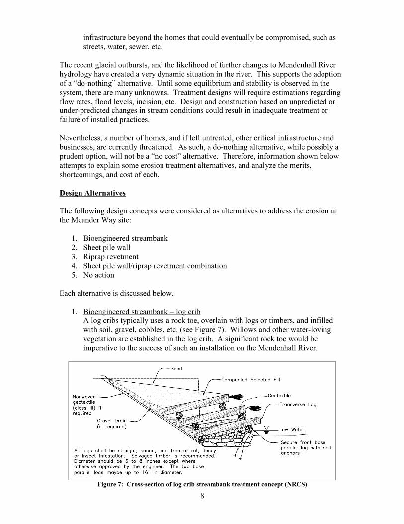
1. Bioengineered streambank – log crib A log cribs typically uses a rock toe, overlain with logs or timbers, and infilled with soil, gravel, cobbles, etc. (see Figure 7). Willows and other water-loving vegetation are established in the log crib. A significant rock toe would be imperative to the success of such an installation on the Mendenhall River.
Figure 7: Cross-section of log crib streambank treatment concept (NRCS)

9
Advantages:
• habitat provided is usually fish-friendly • treatment can be more natural-like in appearance and aesthetically
pleasing
Disadvantages: • treatment is not as resistant to high flow velocities as other treatment
techniques • practice lifespan can be relatively short when timber or woody debris or
rootwads are incorporated
Recommendation: This option is not recommended, as the nearly annual occurrence of extreme flows due to glacial outbursts since 2011 would subject the treatment to high velocities and shears. Such treatment would not likely survive recurrence of such conditions on an annual basis. This treatment approach is also not commonly used with bank heights of 25’ or more that exist in the Meander Way bend. The treatment method typically require flatter bank slopes than could be tolerated, given the limited distance between the eroded streambank and the existing homes. This treatment option, however, may have merit at other sites on the Mendenhall River. Cost Estimate: Costs can vary widely depending on the exact type of bioengineered treatment installed. Material would be relatively inexpensive, but labor costs would be significant. As the treatment option is not recommended, no cost estimate for this option was developed.
2. Bioengineered streambank – mechanically stabilized earth (MSE) wall This alternative would consist of layers of polyethylene geogrid overlain with compacted soil backfill. Each layer is wrapped at the slope edge to retain the soil. A wall face of hard material such as rock is required to protect the soil and geogrid from damage and erosion by debris impact and river flow. Due to their short lifespan in flowing water, gabions is not recommended as a facing material.
Figure 8: Cross-section of MSE streambank treatment concept (NRCS)

10
Advantages:
• Treatment is resistant to high flow velocities • Steep streambank slopes are possible, conserving lot space • Life-span of practice is usually significant, and can be prolonged with
proper maintenance
Disadvantages: • Though stability of the bank is achieved with stabilized earthfill, some
type of hard facing would be necessary to protect the soil from debris and erosion. Such facing alone can be as expensive as other treatment methods, even without considering the cost of installing the mechanically stabilized earthfill.
• Installation of the mechanically stabilized earthfill could prove difficult near the toe, as river levels and saturated conditions could be problematic. Scheduling and completion of work would be critical. Though these challenges can also exist with other alternatives, they are somewhat more critical with this alternative.
• Treatment is often not viewed as aesthetically pleasing, due to the hard facing
• The hard facing typically has a lower habitat value for desired species such as salmon
Recommendation: This option is not recommended, due to its high relative cost. The annual high water levels experienced since glacial outbursts began would require the facing of the MSE wall to be extended to nearly the top of the streambank. This would likely increase costs above other acceptable alternatives. Cost Estimate: As the treatment option is not recommended, no cost estimate for this option was developed.
3. Sheet pile wall
This alternative consists of driving steel sheet pile at the bank toe. Piles would be driven to a depth well below the stream bottom, and would act as a cantilever retaining wall. Due to the relatively high stream bank, two offset cantilever sheet pile walls would likely be necessary, with considerable distance between the walls (see Figure 9). Riprap would be placed on the portion of streambank between the two walls to prevent erosion. With proper placement and sheet pile selection, tie-back anchors could possibly be avoided, to achieve lower costs. Further investigation of subsurface conditions would be necessary in order to determine the potential presence of large rocks and boulders that could prevent or hinder pile driving. In addition, some existing rock on the stream bank and/or stream bed would likely need to be removed and/or relocated to allow pile driving.

11
Figure 9: Cross-section of sheet pile wall streambank treatment concept
Advantages:
• Treatment is resistant to high flow velocities • Vertical walls conserve lot/property space • Life-span of practice is usually significant, and can be prolonged with
proper maintenance
Disadvantages: • Vibration or driving of piles can be a nuisance to neighboring properties • Treatment is often not viewed as aesthetically pleasing • The sheet pile typically has a lower habitat value for desired species such
as salmon • Two sheet pile walls plus riprap would be quite costly, in comparison to
other alternatives.
Recommendation: This option is not recommended, due to its high relative cost. Cost Estimate: This treatment option, though not recommended, is estimated to cost $3.0 million.
4. Riprap Revetment This alternative would consist of grading the streambank to a stable slope, and placing geotextile, bedding, and rock riprap on the bank. The lower extents of the rock placement would need to be to at least the stream bottom, and likely lower to account for potential scour (see Figure 10). This is a proven method of streambank protection, and has been used in many instances in Alaska, as well as on the Mendenhall River both upstream and downstream of the Meander Way site.

12
Figure 10: Cross-section of riprap streambank treatment concept (NRCS)
Advantages: • Proven, effective method for addressing streambank erosion, and has been
utilized on other reaches of the Mendenhall River • With proper rock sizing, riprap can withstand extreme flow velocities and
high shear stress • Life-span of rock riprap is usually significant, and can be prolonged with
proper maintenance
Disadvantages: • High cost of hauling and placing rock, considering the bank geometry and
scour hole present • In order to achieve a stable slope on which to place rock, additional
property will be impacted (loss of portions of back yards), which will likely be viewed as a negative by property owners. Near the deepest scour hole, the top of riprap placement will likely be extremely close to a few homes.
• Treatment is often not viewed as aesthetically pleasing• Riprap typically has a lower habitat value for desired species such as
salmon
Cost Estimate: Assuming there are local quarries that can provide adequately sized rock, a total project cost of $1.5 million could be expected.
Recommendation: Due to the steepness of the eroded bank, close proximity to existing homes, and significant scour at the streambank toe, a considerable volume of rock will be required with this option. The volume of rock placed in the streambed, to protect from scour and provide a launchable toe, may be problematic regarding fish habitat permitting. Several homes in the treatment area would have rock riprap placed very near to their foundations. While the option is potentially feasible, a riprap/sheet pile combination as discussed below

13
may be a better alternative, though at a somewhat higher cost. Nevertheless, the riprap alternative appears to be a viable option.
5. Sheet pile wall/riprap revetment combination This alternative could consist of a combination of the riprap and sheet pile alternatives. A steel sheet pile wall would be placed at the toe of the bank, followed by placing rock riprap protection on the slope. This option requires significantly less rock than the riprap-only option, and possibly avoids the use of a costly tie-back system in the sheet pile wall.
Figure 11: Cross-section of sheet pile/riprap combination treatment concept
Advantages:
• Proven, effective method for addressing streambank erosion • With proper rock sizing, sheet pile and riprap can withstand extreme flow
velocities and high shear stress • Life-span of treatment is usually significant, and can be prolonged with
proper maintenance • Somewhat less property is likely impacted with this method versus using
riprap alone
Disadvantages: • High cost of driving piles and hauling and placing rock • Vibration or driving of piles can be a nuisance to neighboring properties • Treatment is often not viewed as aesthetically pleasing • Riprap typically has a lower habitat value for desired species such as
salmon

14
Cost Estimate: This treatment option is estimated to cost $2.1 million. Recommendation: This option appears to be one of the most promising treatment methods to address the erosion on the Meander Way river bend of the Mendenhall River. The cost would be somewhat higher than the riprap-only option, but by placing sheet pile rather than riprap at the toe, there may be less chance of erosion and maintenance needs at the toe. In addition, there is less impact to the adjacent homes, with respect to placement of riprap near house foundations.
6. No action
This alternative would leave the streambank in its current condition, with no additional treatment installed. Continued erosion would almost certainly occur. Eventually, erosion would progress to the point where at least some homes on Meander Way would become unsafe for occupancy, and would need to be moved or condemned. While the rate of erosion is uncertain, it is conceivable that erosion could progress to such a point within 5 years. Given the nature of sharp outside river bends, the hydraulic energy present in glacial outburst flows, and the erodible insitu materials present in the streambank, the erosion in the Meander Way bend could progress to the point where even the street and municipal utilities are in jeopardy.
Conclusions To protect homes and infrastructure near Meander Way, a combination system of sheet pile and rock riprap are suggested to address streambank erosion. There is admittedly some degree of risk associated with applying any type treatment to the streambank, given the apparent instability and continued evolution of the river. Such risk can be somewhat reduced by applying more conservative design assumptions. Conservative design assumptions typically result in increased project costs. While fish-friendly alternatives were considered, the high shear stress that is likely experienced on this river bend warrants the installation of more traditional hardened treatment methods. Softer treatments could be considered and incorporated in other areas of the river with lower shear stresses, in order to continue to provide adequate habitat for important aquatic species. The occurrence of glacial outbursts since 2011 has subjected the river banks to an unprecedented frequency of high water levels, to the extent that at least the historic 50-year flood flow has been experienced on nearly an annual basis since 2011. Many soft bank treatments can withstand short intervals of high water if they are of low frequency, say five or ten years apart. However, given the recent hydrologic changes, the increased flood frequency is likely to be too severe to allow soft treatments to be effective against erosion, especially for high bank stress areas such as outer river bends. Habitat permitting will be an important part of any proposed on the Mendenhall River, and buy-in from the Alaska Department of Fish and Game will be important to pursue during the planning stages of any project. Input from ADF&G regarding the permitting of any selected alternative should be sought before significant effort and expense is incurred developing proposals and designs. Should the city choose to pursue streambank stabilization suggested herein, this report could be provided to ADF&G to begin a dialogue regarding allowable approaches to addressing the erosion.

15
Cost estimates and values of affected infrastructure presented herein are admittedly of very preliminary nature, and were not analyzed in great detail. Nevertheless, at first glance, installation of streambank protection for a small group of homes appears to be only marginally justifiable from an economic standpoint. However, if left untreated, continued migration of the erosion, both laterally and longitudinally, could have much larger long-term economic impacts that could justify pursuit of the suggested alternative. Through leveraging of potential funding sources for the project, the City and Borough could potentially implement a project that would provide adequate protection to homes and infrastructure along Meander Way. The Emergency Watershed Protection (EWP) program, which is a federal program managed by NRCS, is potentially applicable to the Meander Way erosion. The program provides both financial and technical assistance in design and construction of projects that reduce watershed impairment. There are a number of criteria that must be met in order to be eligible for the EWP program, but the information gathered in preparation of this report shows that that the Meander Way site would likely fit the program. Funding is not guaranteed, and is typically more common for Presidentially-declared disasters. Nevertheless, projects similar in nature have been implemented in the past using the EWP program. Should the City and Borough of Juneau wish to pursue EWP funding in addressing the erosion problem, a request of that nature should be submitted in writing to NRCS, within 60 days after the next significant flood event or glacial outburst.
16
References
1. U.S. Department of Agriculture-Natural Resources Conservation Service, August 2007, Stream Restoration Design Handbook, National Engineering Handbook, Part 654, Washington, DC
2. U.S. Department of Agriculture-Natural Resources Conservation Service, April 2009, Stream Restoration Planning and Design, Fluvial System Stabilization and Restoration – Field Guide, Washington, D.C.
3. Neal, Edward G, 2009, Channel Incision and Water-Table Decline Along a Recently Formed Proglacial Stream, Mendenhall Valley, Southeastern Alaska, Studies by the US Geological Survey in Alaska, 2007: US Department of Interior-US Geological Survey, Professional Paper 1760-E
4. Neal, Edward G and Host, Randy H, Hydrology, 1999, Geomorphology, and Flood Profiles of the Mendenhall River, Juneau, Alaska, US Department of Interior-US Geological Survey, Water-Resources Investigations Report 99-4150, Anchorage, AK
5. Alaska Department of Fish and Game – Habitat and Restoration Division, September 1999, Guidelines for Bank Stabilization on the Mendenhall River, Technical Report No. 99-3, Douglas, AK

17
ATTACHMENT A – Conceptual Design Drawing and Cost Estimates


Quantity Unit Cost Total Cost Quantity Unit Cost Total Cost Quantity Unit Cost Total Cost1 Mobilization/Demobilization each 1.0 100,000.00$ 100,000$ 1.0 100,000.00$ 100,000$ 1.0 100,000.00$ 100,000$ 2 Pollution Control lump sum 1.0 30,000.00$ 30,000$ 1.0 30,000.00$ 30,000$ 1.0 30,000.00$ 30,000$ 3 Critical Path Scheduling lump sum 1.0 10,000.00$ 10,000$ 1.0 10,000.00$ 10,000$ 1.0 10,000.00$ 10,000$ 4 Contractor Quality Control lump sum 1.0 15,000.00$ 15,000$ 1.0 15,000.00$ 15,000$ 1.0 15,000.00$ 15,000$ 5 Construction Surveys lump sum 1.0 50,000.00$ 50,000$ 1.0 50,000.00$ 50,000$ 1.0 50,000.00$ 50,000$ 6 Clearing (existing rock and vegetation) lump sum 1.0 25,000.00$ 25,000$ 1.0 25,000.00$ 25,000$ 1.0 25,000.00$ 25,000$ 7 Excavation, Unclassified cubic yards 2,000.0 30.00$ 60,000$ 1,200.0 30.00$ 36,000$ 800.0 30.00$ 24,000$ 8 Earthfill, compacted cubic yards 500.0 50.00$ 25,000$ 500.0 50.00$ 25,000$ 1,000.0 50.00$ 50,000$ 9 Sheet Piling square feet 40,414.0 50.00$ 2,020,700$ 0.0 -$ -$ 24,200.0 50.00$ 1,210,000$
10 Riprap with Bedding and Geotextile cubic yards 1,750.0 200.00$ 350,000$ 5,000.0 200.00$ 1,000,000$ 2,000.0 200.00$ 400,000$ 11 Testing, Rock Riprap and Bedding each 4.0 4,000.00$ 16,000$ 8.0 4,000.00$ 32,000$ 4.0 4,000.00$ 16,000$ 12 Seeding lump sum 1.0 10,000.00$ 10,000$ 1.0 10,000.00$ 10,000$ 1.0 10,000.00$ 10,000$
-$ -$ -$ Subtotal: 2,711,700$ Subtotal: 1,333,000$ Subtotal: 1,940,000$ Contingency: 271,170$ Contingency: 133,300$ Contingency: 194,000$ Grand Total: 2,982,870$ Grand Total: 1,466,300$ Grand Total: 2,134,000$
Stepped Sheet Piling with Riprap Riprap Sheet Piling/Riprap Combination
Juneau/Mendenhall River Meander Way Streambank Protection Cost Estimates (from conceptual design)
Bid Item UnitsDescription