design with water in dutch low land cities
TRANSCRIPT
The 4th International Conference of the International Forum on Urbanism (IFoU)
2009 Amsterdam/Delft The New Urban Question – Urbanism beyond Neo-Liberalism
767
DESIGN WITH WATER IN DUTCH LOW LAND CITIES
I. Bobbink TU Delft, The Postbox 5043, 2600 GA Delft, Netherlands, Email: [email protected]
ABSTRACT: Amsterdam has a long tradition in which battling against the water has become integrated in the city’s design. But fast growth, pressures of urbanisation and far-reaching climate change have made matters more complex. A new plan of attack is required formulated by water managers, political administrators and designers. The pilot project ‘Water in Amsterdam’s South-East District’ assessed to which degree ‘designing research’ can help to solve this complex issue. KEYWORDS : local identity, water form, urban-rural, urban landscape, culture, public life
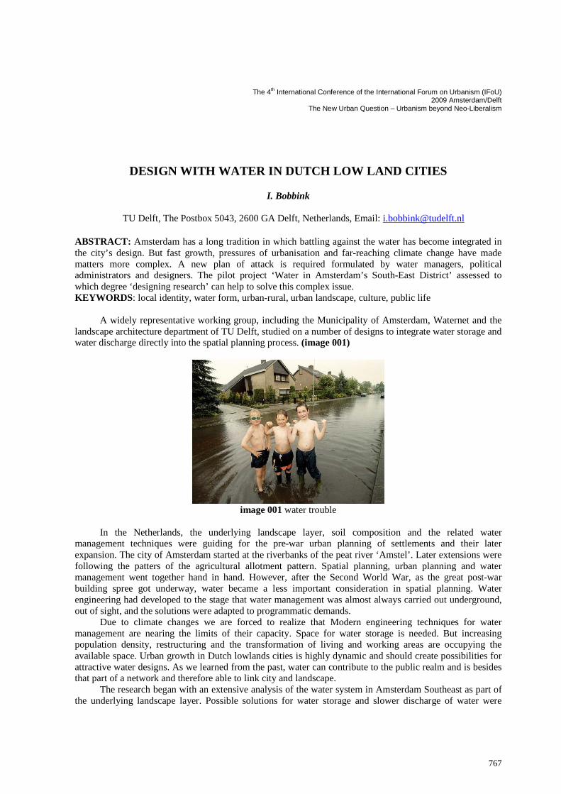
A widely representative working group, including the Municipality of Amsterdam, Waternet and the landscape architecture department of TU Delft, studied on a number of designs to integrate water storage and water discharge directly into the spatial planning process. (image 001)
image 001 water trouble
In the Netherlands, the underlying landscape layer, soil composition and the related water
management techniques were guiding for the pre-war urban planning of settlements and their later expansion. The city of Amsterdam started at the riverbanks of the peat river ‘Amstel’. Later extensions were following the patters of the agricultural allotment pattern. Spatial planning, urban planning and water management went together hand in hand. However, after the Second World War, as the great post-war building spree got underway, water became a less important consideration in spatial planning. Water engineering had developed to the stage that water management was almost always carried out underground, out of sight, and the solutions were adapted to programmatic demands.
Due to climate changes we are forced to realize that Modern engineering techniques for water management are nearing the limits of their capacity. Space for water storage is needed. But increasing population density, restructuring and the transformation of living and working areas are occupying the available space. Urban growth in Dutch lowlands cities is highly dynamic and should create possibilities for attractive water designs. As we learned from the past, water can contribute to the public realm and is besides that part of a network and therefore able to link city and landscape.
The research began with an extensive analysis of the water system in Amsterdam Southeast as part of the underlying landscape layer. Possible solutions for water storage and slower discharge of water were
768
visualised in drawings. These prototypical drawings were categorized in a toolbox. It illustrates how design principles for designing with water can be applied at various scales, depending on the underlying landscape.
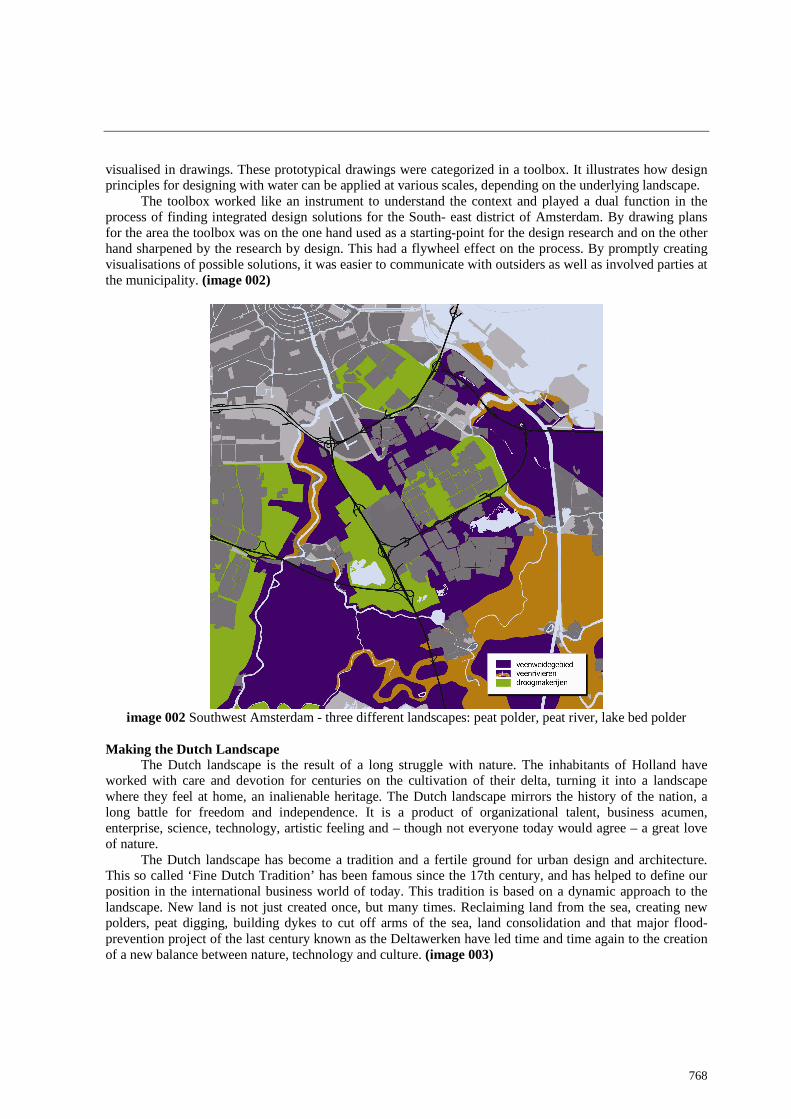
The toolbox worked like an instrument to understand the context and played a dual function in the process of finding integrated design solutions for the South- east district of Amsterdam. By drawing plans for the area the toolbox was on the one hand used as a starting-point for the design research and on the other hand sharpened by the research by design. This had a flywheel effect on the process. By promptly creating visualisations of possible solutions, it was easier to communicate with outsiders as well as involved parties at the municipality. (image 002)
image 002 Southwest Amsterdam - three different landscapes: peat polder, peat river, lake bed polder
Making the Dutch Landscape
The Dutch landscape is the result of a long struggle with nature. The inhabitants of Holland have worked with care and devotion for centuries on the cultivation of their delta, turning it into a landscape where they feel at home, an inalienable heritage. The Dutch landscape mirrors the history of the nation, a long battle for freedom and independence. It is a product of organizational talent, business acumen, enterprise, science, technology, artistic feeling and – though not everyone today would agree – a great love of nature.
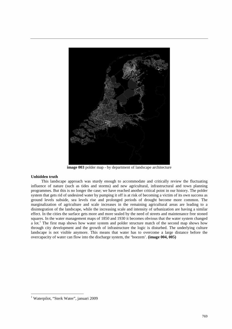
The Dutch landscape has become a tradition and a fertile ground for urban design and architecture. This so called ‘Fine Dutch Tradition’ has been famous since the 17th century, and has helped to define our position in the international business world of today. This tradition is based on a dynamic approach to the landscape. New land is not just created once, but many times. Reclaiming land from the sea, creating new polders, peat digging, building dykes to cut off arms of the sea, land consolidation and that major flood-prevention project of the last century known as the Deltawerken have led time and time again to the creation of a new balance between nature, technology and culture. (image 003)
769
image 003 polder map - by department of landscape architecture
Unhidden truth
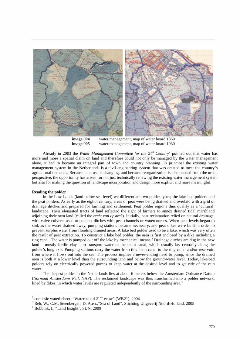
This landscape approach was sturdy enough to accommodate and critically review the fluctuating influence of nature (such as tides and storms) and new agricultural, infrastructural and town planning programmes. But this is no longer the case; we have reached another critical point in our history. The polder system that gets rid of undesired water by pumping it off is at risk of becoming a victim of its own success as ground levels subside, sea levels rise and prolonged periods of drought become more common. The marginalization of agriculture and scale increases in the remaining agricultural areas are leading to a disintegration of the landscape, while the increasing scale and intensity of urbanization are having a similar effect. In the cities the surface gets more and more sealed by the need of streets and maintenance free stoned squares. In the water management maps of 1850 and 1930 it becomes obvious that the water system changed a lot.1 The first map shows how water system and polder structure match of the second map shows how through city development and the growth of infrastructure the logic is disturbed. The underlying culture landscape is not visible anymore. This means that water has to overcome a large distance before the overcapacity of water can flow into the discharge system, the ‘boezem’. (image 004, 005)
1 Waterpilot, “Sterk Water”, januari 2009
770
image 004 water management, map of water board 1850 image 005 water management, map of water board 1930
Already in 2003 the Water Management Committee for the 21st Century2 pointed out that water has
more and more a spatial claim on land and therefore could not only be managed by the water management alone, it had to become an integral part of town and country planning. In principal the existing water management system in the Netherlands is a civil engineering system that was created to meet the country’s agricultural demands. Because land use is changing, and because reorganization is also needed from the urban perspective, the opportunity has arisen for not just technically renewing the existing water management system but also for making the question of landscape incorporation and design more explicit and more meaningful. Reading the polder
In the Low Lands (land below sea level) we differentiate two polder types; the lake-bed polders and the peat polders. As early as the eighth century, areas of peat were being drained and overlaid with a grid of drainage ditches and prepared for farming and settlement. Peat polder regions thus qualify as a ‘cultural’ landscape. Their elongated tracts of land reflected the right of farmers to annex drained tidal marshland adjoining their own land (called the recht van opstrek). Initially, peat reclamation relied on natural drainage, with valve culverts used to connect ditches with peat channels or watercourses. When peat levels began to sink as the water drained away, pumping stations became necessary, and peat dikes were built in order to prevent surplus water from flooding drained areas. A lake bed polder used to be a lake, which was very often the result of peat extraction. To construct a lake bed polder, the area is first enclosed by a dike including a ring canal. The water is pumped out off the lake by mechanical means.3 Drainage ditches are dug in the new land – mostly fertile clay – to transport water to the main canal, which usually lay centrally along the polder’s long axis. Pumping stations carry the water from this main canal to the ring canal and/or reservoir, from where it flows out into the sea. The process implies a never-ending need to pump, since the drained area is both at a lower level than the surrounding land and below the ground-water level. Today, lake-bed polders rely on electrically powered pumps to keep water at the desired level and to get ride of the rain water.
The deepest polder in the Netherlands lies at about 6 meters below the Amsterdam Ordnance Datum (Normaal Amsterdams Peil, NAP). The reclaimed landscape was thus transformed into a polder network, lined by dikes, in which water levels are regulated independently of the surrounding area.4 2 comissie waterbeheer, “Waterbeleid 21ste eeuw” (WB21), 2004 3 Reh, W., C.M. Steenbergen, D. Aten.‚“Sea of Land”, Stichting Uitgeverij Noord-Holland, 2005 4 Bobbink, I., “Land Insight”, SUN, 2009

771
Investigation of locus Within the Zuidoostlob we are dealing with two different types of polder landscape: the peat polder and
the lake bed polders. Next to that the peat river, as part of the outlet system is taken as a separate category. This is done to make the toolbox easy in use. The water system itself in a polder consists of different water elements, like ditches, a channel, dams ad pumps. Each polder is divided into several parts with slight differences in water level (peilvakken). The difference in water level echo the relief in the polder and are articulated by a water stair. Again on the water management maps it becomes clear that the water structure in the cultural landscape is more dense and at least on the map much more visible with lot of dams. In de Watergraafsemeer and the Bijlermeer, two lake bed polders the main waterlines play a structuring role in the city layout. Large sand addition erased the old ditches. The hierarchy and the form of water elements in a lake bed polder is different than in a peat polder. The lake bed polder is drawn on paper and performed as an collective project, whereby the exploitation of the peat polder happens after deliberation on site, first on an individual base. In that sense one could say that the peat landscape is a medieval landscape.
To use the genesis of each polder in the transformation of the waterscape makes each site more specific, flexible and sustainable. To reach this goal the arrangement of functions need to be integrated. One could say from a landscape architectonic point of view; water can become (again) the visual carrier of the Delta identity.
Waterpilot ‘Zuidoostlob’
The Southeastlobe of Amsterdam is one of the five other lobes in the lay-out of the city plan of Amsterdam, the so called finger city. The area is in terms of the landscape layer, urbanisation and administrative vey complex. Boarded by the peat river he Amstel and the Diemer and a beautiful landscape, which is already quite intensively used for recreation. As part of a dynamic urban field the open space within the lobe is under pressure. Densefying, reconstructing, transformation of living – and working areas makes the planning process very complex. This asks more and more from the water management. The municipality initiated the water pilot as a way to make all parties, also the private investors aware of the possibilities and advantages of the integrated water design. (image 006)
image 006 map of high differences - by S. Nijhuis
Methode: the toolbox
The water system is as explained before for city directors and citizens and even designers an unknown terrain. After the analysis of the location, possible solutions for water retention and water discharge system
772
were listed and put into relation to the polder types or the peat river area. Lots of studies and there knowledge is used, were already performed but never were related to soil types and existing water forms as part of an identity.
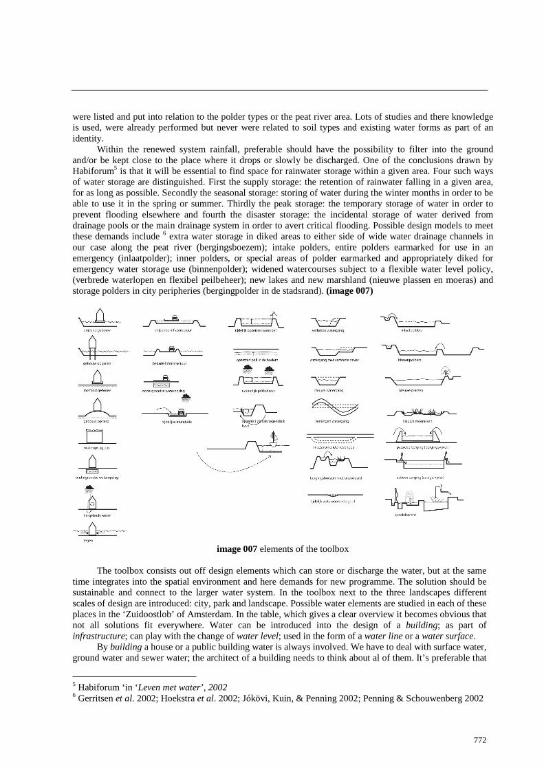
Within the renewed system rainfall, preferable should have the possibility to filter into the ground and/or be kept close to the place where it drops or slowly be discharged. One of the conclusions drawn by Habiforum5 is that it will be essential to find space for rainwater storage within a given area. Four such ways of water storage are distinguished. First the supply storage: the retention of rainwater falling in a given area, for as long as possible. Secondly the seasonal storage: storing of water during the winter months in order to be able to use it in the spring or summer. Thirdly the peak storage: the temporary storage of water in order to prevent flooding elsewhere and fourth the disaster storage: the incidental storage of water derived from drainage pools or the main drainage system in order to avert critical flooding. Possible design models to meet these demands include 6 extra water storage in diked areas to either side of wide water drainage channels in our case along the peat river (bergingsboezem); intake polders, entire polders earmarked for use in an emergency (inlaatpolder); inner polders, or special areas of polder earmarked and appropriately diked for emergency water storage use (binnenpolder); widened watercourses subject to a flexible water level policy, (verbrede waterlopen en flexibel peilbeheer); new lakes and new marshland (nieuwe plassen en moeras) and storage polders in city peripheries (bergingpolder in de stadsrand). (image 007)
image 007 elements of the toolbox
The toolbox consists out off design elements which can store or discharge the water, but at the same
time integrates into the spatial environment and here demands for new programme. The solution should be sustainable and connect to the larger water system. In the toolbox next to the three landscapes different scales of design are introduced: city, park and landscape. Possible water elements are studied in each of these places in the ‘Zuidoostlob’ of Amsterdam. In the table, which gives a clear overview it becomes obvious that not all solutions fit everywhere. Water can be introduced into the design of a building; as part of infrastructure; can play with the change of water level; used in the form of a water line or a water surface.
By building a house or a public building water is always involved. We have to deal with surface water, ground water and sewer water; the architect of a building needs to think about al of them. It’s preferable that
5 Habiforum ‘in ‘Leven met water’, 2002 6 Gerritsen et al. 2002; Hoekstra et al. 2002; Jókövi, Kuin, & Penning 2002; Penning & Schouwenberg 2002
773
the rainwater is disconnected from the sewer, lucky enough already quite common in the municipality of Amsterdam. Regrettable this is not part of the architectonic expression. Streets, bike lanes, walking path, sidewalks and squares are part of infrastructure and cover a great amount of the public space. Here the new water management can gain a lot. Rainwater should be captured on the surface and become part of an integrated design. For example water on highways can be collected and then filtered along the road in reed purification before it is release into the ground water.
Manipulation of the water level or playing with the fluctuation of the seasonal water has a strong effect on the space. It directly influences the growth of crops. At the same time it’s a way to substitute dryness in the summer. Within the build area fluctuation of the water level is undesirable. A lot of buildings are built on wooden piles; they have to be conserved in the ground water level, if not the piles will rotten away, the houses will break.
Gutters, trenches, ditches, channels, canals and rivers are crucial to the water system. These water lines fulfil the important job of draining, irrigating and storing water in the landscape. Made water lines and Holland is full of them are mostly designed in a very technical and pragmatic way. Despite of that they play an important role in the attractiveness of a space. By being aware of this designers can take advantage. Due to the form the visible waterline can show the working of the water system and is able to connect different scales.
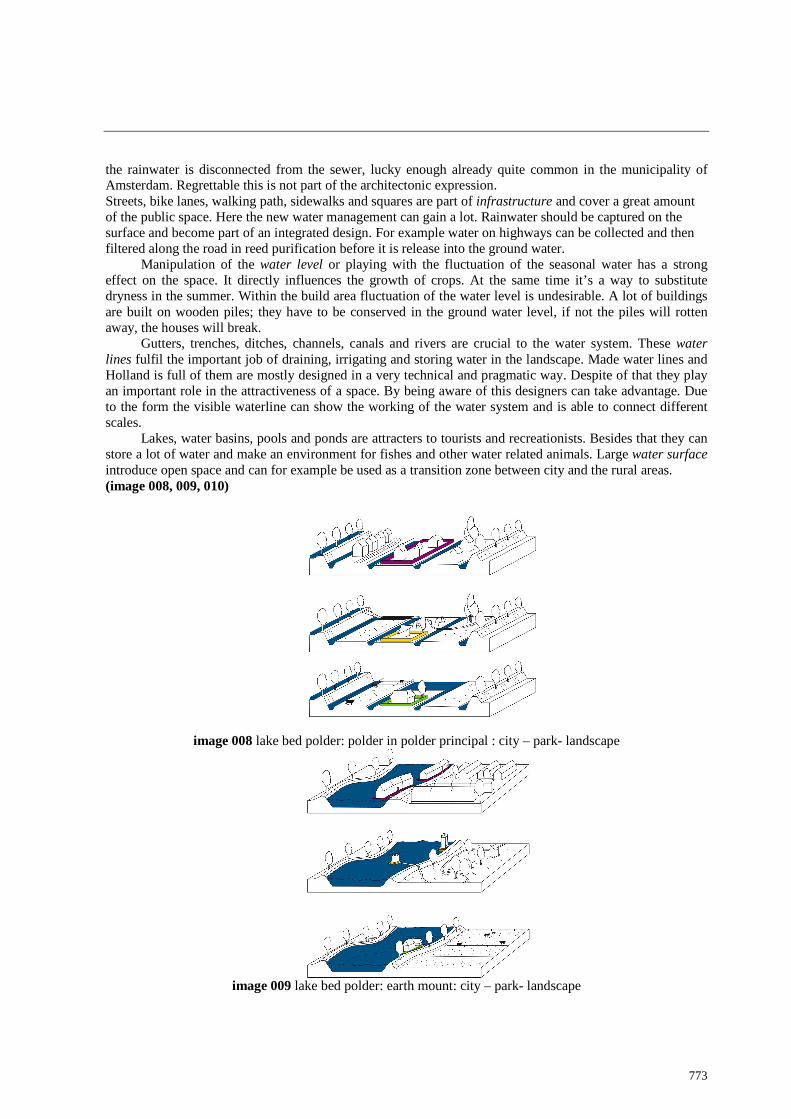
Lakes, water basins, pools and ponds are attracters to tourists and recreationists. Besides that they can store a lot of water and make an environment for fishes and other water related animals. Large water surface introduce open space and can for example be used as a transition zone between city and the rural areas. (image 008, 009, 010)
image 008 lake bed polder: polder in polder principal : city – park- landscape
image 009 lake bed polder: earth mount: city – park- landscape

774
image 010 peatriver: floating: city – park- landscape
In the toolbox different design principles of water design, depending on the landscape layer, are listed
on different scales. Some of the solutions are obviously not suitable in every landscape type. Aspects of the urban regulation as a municipal boarder are not taken care off. They don’t fit in the concept whereby the underlying layer of the polder landscape forms the point of departure for durable water designs. (image 011)
image 011 overview of the toolbox
Conclusion
The toolbox had during the design process several functions. Students made with the help of the toolbox plans for a given location in the area without knowing all the technical backgrounds and demands of
775
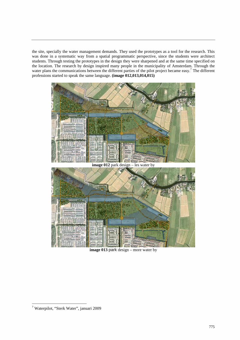
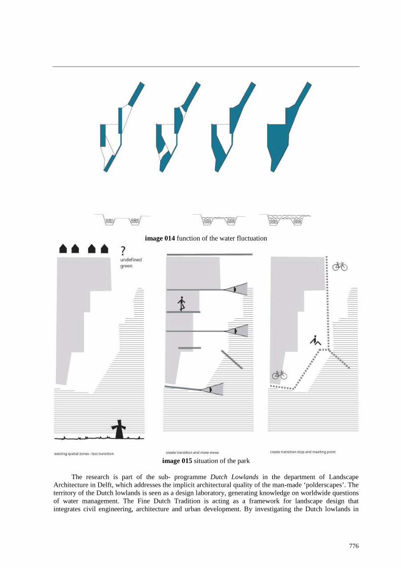
the site, specially the water management demands. They used the prototypes as a tool for the research. This was done in a systematic way from a spatial programmatic perspective, since the students were architect students. Through testing the prototypes in the design they were sharpened and at the same time specified on the location. The research by design inspired many people in the municipality of Amsterdam. Through the water plans the communications between the different parties of the pilot project became easy.7 The different professions started to speak the same language. (image 012,013,014,015)
image 012 park design – les water by
image 013 park design – more water by
7 Waterpilot, “Sterk Water”, januari 2009
776
image 014 function of the water fluctuation
image 015 situation of the park
The research is part of the sub- programme Dutch Lowlands in the department of Landscape
Architecture in Delft, which addresses the implicit architectural quality of the man-made ‘polderscapes’. The territory of the Dutch lowlands is seen as a design laboratory, generating knowledge on worldwide questions of water management. The Fine Dutch Tradition is acting as a framework for landscape design that integrates civil engineering, architecture and urban development. By investigating the Dutch lowlands in

777
their specific geographic and cultural context we can recover spatial knowledge and approaches to deal with contemporary design issues. Dealing with the water and the transformation of valuable landscapes as part of the city.
Water in the Lowlands is an essential part of the landscape; keeps it dry, in summertime wet, structures the land and connects al the polders. The ‘boezem’ (outlet system) could become the connector of city and landscape, waterways could function (again) as infrastructure and could easily be transformed into a green- blue network. This approach will surely contribute to a rise of spatial quality. Further research is necessary and as experienced in the pilot project cooperation inevitable.

778