determining factors affecting production of suspended · pdf filedetermining factors affecting...
TRANSCRIPT
www.scholarsresearchlibrary.com tAvailable online a
Scholars Research Library
Archives of Applied Science Research, 2014, 6 (5):101-103
(http://scholarsresearchlibrary.com/archive.html)
ISSN 0975-508X
CODEN (USA) AASRC9
101 Scholars Research Library
Determining factors affecting production of suspended load and determining sediment yield homogenous regions (Case Study: Dez River)
Seyedehnesaseyedolama1*, Parisa Danyaei2 and Atoosa Danyaei3
1Faculty of Agricultural Sciences, University of Guilan Rasht
2Faculty of Agricultural Sciences, Islamic Azad University of Tehran 3Drshariaty Faculty‚ Technical & Vocational University‚ Tehran‚ Iran
_____________________________________________________________________________________________ ABSTRACT Dez Dam as one of the largest dams of the Middle East has strategic role in development of Khuzestan Plain. Considering dry and semidry climate and subdesert climate of some cities of Khuzestan Province and also due to location of this dam in downstream of sub basins with relatively high sediment yield which caused loss of some useful capacity of tank in years following construction,importance of the present study increases. The present study has been conducted in upstream drainage basin of Dez Dam with area GagingStations for regional analysis of the suspended load and also determination of the sediment yield homogenous regions. In this study, base maps and physiographical, climatic and hydrological characteristics affecting production and carriage of sediment relating to each one of the subbasins were prepared with GIS techniques. Then, relationship between production of special daily suspended load and independent variables with statistical analyses, clustering and multivariate regression. Results showed that Vanaee, Afravandeh(Biatoon), Dokhaharan, Darehtakht, Drorood, Chamchit and Keshvar sub basins were included in the first homogenous group and SepidDasht, Tang Panj(Sezar), Tang Panj(Bakhtiari) and Telezang were included in the second homogenous group. Regression results showed the precipitation factor as the most important factor in production of suspended load of sub basins. To study priority of specific sediment yield for making decisions about prevention of water and soil, sub basins ending to Darehtakht, Dorood and Afravandeh stations had the highest sediment yield intensity in surface area. Key words: suspended load, homogenous region, prioritization, Dez Drainage Basin _____________________________________________________________________________________________
INTRODUCTION
Sediment in drainage basins is affected by different factors such as climate, ups and downs and human activities. Changes of sediment yield in drainage basins, time and space changes, size and granulation of sediment are of the most important sediment yield variables in drainage basins. Determination and estimation of sediment yield are one of the necessarywatershed management and soil protection science [1 ] That used for identification of critical regions of a drainage basin[4 ] . One of the most important ways of preventing sediments into reservoirs is execution of watershed management operations. Since area of rivers is extensive and watershed management of the entire basin is not cost effective, it is important to determine critical sub basins in terms of sediment yield (prioritization of sub basins)[3]. Increasing trend of lands destruction and extensive human manipulations in different parts of nature particularly water and soil increase erosion rate and sediment rate and damages resulting from it. For this purpose, determination of the most effective factors in this process can allow access to optimal models and methods of controlling and reducing erosion and sediment yield. Goal of this research is to identity and gain access to the most important factors affecting emergence and intensification of sediment, determination of sediment yield homogenous regions and also identification of critical regions in terms of production of sediment in Dez Dam drainage basin(Sezar River).
MATERIALS AND METHODS Study area is a part of Dez river basin in upstream of Dez Dam as Dez Dam drainage basin which is known as drainage basin of Sezar River. Area of this basin is 16213 km2and is located between 10̍' and 48 o and 21' and 50 o
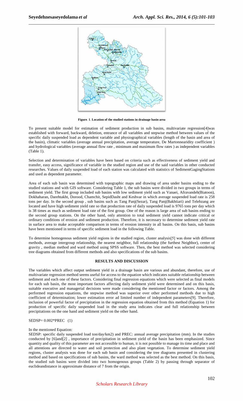
aslongitude and 31' and 34 o and 7' and 34 o as latitude.Annual mean precipitation in the studied area has been estimated from 150 mm peryear in the plain lowlands to 1800 mm per year in highlands adjacent to Koohrang. Production of sediment in Dez Basin has been estimated between 300 and 3000 ton/km2. In other words, averagely 1.5 mm of soil is eroded every year. InDez Drainage Basin, there are 36 hydrometric stations and 11 SedimentGagingStations were selected in Drainage basin by referring to Iran Water ResourcesResearch Organization and Regional Water Organization (Figure 1).
Seyedehnesaseyedolama______________________________________________________________________________
To present suitable model for estimation of sediment production in sub basins, multivariate regressioestablished with forward, backward, specific daily suspended load as dependent variable and physiographical variables (length of the basin and area of the basin), climatic variables (average annual and hydrological variables (average annual flow rate , minimum and maximum flow rates ) as independent variables (Table 1). Selection and determination of variables have been based on criteria such as transfer, easy access, significance of variable in the studied region and use of the said variables in other conducted researches. Values of daily suspended load of each station was calculated with statistics of and used as dependent parameter. Area of each sub basin was determined with topographic maps and drawing of area under basins ending to the studied stations and with GIS software. Considering Table 1, the sub basins were divided in two groups in terms of sediment yield. The first group inDokhaharan, Darehtakht, Dorood, Chamchit, SepidDasht and Keshvar in which average suspended load rate is 258 tons per day. In the second group , sub basins such as Tang Panj(Sezlocated and have high sediment yield rate so that production rate of daily suspended load is 9765 tons per day which is 38 times as much as sediment load rate of the first group. One of the reason is large area othe second group stations. On the other hand, only attention to total sediment yield cannot indicate critical or ordinary conditions of erosion and sediment production. Therefore, it is necessary to determine sediment yield rate in surface area to make acceptable comparison in terms of erosion intensity in all basins. On this basis, sub basins have been mentioned in terms of specific sediment load in the following Table. To determine homogenous sediment yield regions in the studied methods, average intergroup relationship, the nearest neighbor, full relationship (the gravity , median method and ward method using SPSS software. Then, the best method was selected considering tree diagrams obtained from different methods and also specifications of the sub basins.
The variables which affect output sediment yield in a drainage basin are various and abundant, therefore, use of multivariate regression method seems useful for access to the equation which indicates suitable relationship between sediment and each one of thesfor each sub basin, the most important factors affecting daily sediment yield were determined and on this basis, suitable executive and managerial decisions were made conperformed regression equations, the stepwise method was superior over other performed methods due to high coefficient of determination; lower estimation error ad limited number of independent parametersinclusion of powerful factor of precipitation in the regression equation obtained from this method (Equation 1) for production of specific daily suspended load in the study area indicates clear and full relationship between precipitations on the one hand and sediment yield on the other hand. SEDSP= 0.002*PREC (1)
In the mentioned Equation:SEDSP: specific daily suspended load ton/day/km2) and PREC: annual average precipitation (mm). In the studies conducted by [6]and[2] , importance of prquantity and quality of this parameter are not accessible to human, it is not possible to manage its time and place and all attentions are directed to water and soil protection and also regions, cluster analysis was done for each sub basin and considering the tree diagrams presented in clustering method and based on specifications of sub basins, the ward method was selected as the best method.the studied sub basins were divided into two homogenous groups (Table 2) by passing through separator of euclideandistance in approximate distance of 7 from the origin.
Seyedehnesaseyedolama et al Arch. ______________________________________________________________________________
Scholars Research Library
Figure. 1. Location of the studied stations in drainage basin area
To present suitable model for estimation of sediment production in sub basins, multivariate regressioestablished with forward, backward, deletion, entrance of all variables and stepwise method between values of the specific daily suspended load as dependent variable and physiographical variables (length of the basin and area of the basin), climatic variables (average annual precipitation, average temperature, and hydrological variables (average annual flow rate , minimum and maximum flow rates ) as independent variables
Selection and determination of variables have been based on criteria such as transfer, easy access, significance of variable in the studied region and use of the said variables in other conducted researches. Values of daily suspended load of each station was calculated with statistics of and used as dependent parameter.
Area of each sub basin was determined with topographic maps and drawing of area under basins ending to the studied stations and with GIS software. Considering Table 1, the sub basins were divided in two groups in terms of sediment yield. The first group included sub basins with low sediment yield such as Vanaei, Afravandeh(Biatoon), Dokhaharan, Darehtakht, Dorood, Chamchit, SepidDasht and Keshvar in which average suspended load rate is 258 tons per day. In the second group , sub basins such as Tang Panj(Sezar), Tang Panj(Bakhtiari) and Telehzang are located and have high sediment yield rate so that production rate of daily suspended load is 9765 tons per day which is 38 times as much as sediment load rate of the first group. One of the reason is large area othe second group stations. On the other hand, only attention to total sediment yield cannot indicate critical or ordinary conditions of erosion and sediment production. Therefore, it is necessary to determine sediment yield rate
urface area to make acceptable comparison in terms of erosion intensity in all basins. On this basis, sub basins have been mentioned in terms of specific sediment load in the following Table.
To determine homogenous sediment yield regions in the studied region, cluster analysismethods, average intergroup relationship, the nearest neighbor, full relationship (the gravity , median method and ward method using SPSS software. Then, the best method was selected considering tree diagrams obtained from different methods and also specifications of the sub basins.
RESULTS AND DISCUSSION
variables which affect output sediment yield in a drainage basin are various and abundant, therefore, use of multivariate regression method seems useful for access to the equation which indicates suitable relationship between sediment and each one of these factors. Considering final regression equations which were selected as final models for each sub basin, the most important factors affecting daily sediment yield were determined and on this basis, suitable executive and managerial decisions were made considering the mentioned factor or factors. Among the performed regression equations, the stepwise method was superior over other performed methods due to high coefficient of determination; lower estimation error ad limited number of independent parametersinclusion of powerful factor of precipitation in the regression equation obtained from this method (Equation 1) for production of specific daily suspended load in the study area indicates clear and full relationship between
the one hand and sediment yield on the other hand.
SEDSP= 0.002*PREC (1)
In the mentioned Equation: SEDSP: specific daily suspended load ton/day/km2) and PREC: annual average precipitation (mm). In the studies
2] , importance of precipitation in sediment yield of the basin has been emphasized. Since quantity and quality of this parameter are not accessible to human, it is not possible to manage its time and place and all attentions are directed to water and soil protection and also plant vegetation. To determine sediment yield regions, cluster analysis was done for each sub basin and considering the tree diagrams presented in clustering method and based on specifications of sub basins, the ward method was selected as the best method.the studied sub basins were divided into two homogenous groups (Table 2) by passing through separator of euclideandistance in approximate distance of 7 from the origin.
Arch. Appl. Sci. Res., 2014, 6 (5):101-103______________________________________________________________________________
102 Scholars Research Library
Location of the studied stations in drainage basin area
To present suitable model for estimation of sediment production in sub basins, multivariate regression[4]was deletion, entrance of all variables and stepwise method between values of the
specific daily suspended load as dependent variable and physiographical variables (length of the basin and area of verage temperature, De Martonnearidity coefficient )
and hydrological variables (average annual flow rate , minimum and maximum flow rates ) as independent variables
Selection and determination of variables have been based on criteria such as effectiveness of sediment yield and transfer, easy access, significance of variable in the studied region and use of the said variables in other conducted researches. Values of daily suspended load of each station was calculated with statistics of SedimentGagingStations
Area of each sub basin was determined with topographic maps and drawing of area under basins ending to the studied stations and with GIS software. Considering Table 1, the sub basins were divided in two groups in terms of
cluded sub basins with low sediment yield such as Vanaei, Afravandeh(Biatoon), Dokhaharan, Darehtakht, Dorood, Chamchit, SepidDasht and Keshvar in which average suspended load rate is 258
ar), Tang Panj(Bakhtiari) and Telehzang are located and have high sediment yield rate so that production rate of daily suspended load is 9765 tons per day which is 38 times as much as sediment load rate of the first group. One of the reason is large area of sub basins ending to the second group stations. On the other hand, only attention to total sediment yield cannot indicate critical or ordinary conditions of erosion and sediment production. Therefore, it is necessary to determine sediment yield rate
urface area to make acceptable comparison in terms of erosion intensity in all basins. On this basis, sub basins have been mentioned in terms of specific sediment load in the following Table.
region, cluster analysis]5[ was done with different methods, average intergroup relationship, the nearest neighbor, full relationship (the furthest Neighbor), center of gravity , median method and ward method using SPSS software. Then, the best method was selected considering tree diagrams obtained from different methods and also specifications of the sub basins.
RESULTS AND DISCUSSION
variables which affect output sediment yield in a drainage basin are various and abundant, therefore, use of multivariate regression method seems useful for access to the equation which indicates suitable relationship between
e factors. Considering final regression equations which were selected as final models for each sub basin, the most important factors affecting daily sediment yield were determined and on this basis,
sidering the mentioned factor or factors. Among the performed regression equations, the stepwise method was superior over other performed methods due to high coefficient of determination; lower estimation error ad limited number of independent parameters[9]. Therefore, inclusion of powerful factor of precipitation in the regression equation obtained from this method (Equation 1) for production of specific daily suspended load in the study area indicates clear and full relationship between
SEDSP: specific daily suspended load ton/day/km2) and PREC: annual average precipitation (mm). In the studies ecipitation in sediment yield of the basin has been emphasized. Since
quantity and quality of this parameter are not accessible to human, it is not possible to manage its time and place and plant vegetation. To determine sediment yield
regions, cluster analysis was done for each sub basin and considering the tree diagrams presented in clustering method and based on specifications of sub basins, the ward method was selected as the best method. On this basis, the studied sub basins were divided into two homogenous groups (Table 2) by passing through separator of
103 ______________________________________________________________________________
102
was deletion, entrance of all variables and stepwise method between values of the
specific daily suspended load as dependent variable and physiographical variables (length of the basin and area of De Martonnearidity coefficient )
and hydrological variables (average annual flow rate , minimum and maximum flow rates ) as independent variables
effectiveness of sediment yield and transfer, easy access, significance of variable in the studied region and use of the said variables in other conducted
Stations
Area of each sub basin was determined with topographic maps and drawing of area under basins ending to the studied stations and with GIS software. Considering Table 1, the sub basins were divided in two groups in terms of
cluded sub basins with low sediment yield such as Vanaei, Afravandeh(Biatoon), Dokhaharan, Darehtakht, Dorood, Chamchit, SepidDasht and Keshvar in which average suspended load rate is 258
ar), Tang Panj(Bakhtiari) and Telehzang are located and have high sediment yield rate so that production rate of daily suspended load is 9765 tons per day which
f sub basins ending to the second group stations. On the other hand, only attention to total sediment yield cannot indicate critical or ordinary conditions of erosion and sediment production. Therefore, it is necessary to determine sediment yield rate
urface area to make acceptable comparison in terms of erosion intensity in all basins. On this basis, sub basins
was done with different furthest Neighbor), center of
gravity , median method and ward method using SPSS software. Then, the best method was selected considering
variables which affect output sediment yield in a drainage basin are various and abundant, therefore, use of multivariate regression method seems useful for access to the equation which indicates suitable relationship between
e factors. Considering final regression equations which were selected as final models for each sub basin, the most important factors affecting daily sediment yield were determined and on this basis,
sidering the mentioned factor or factors. Among the performed regression equations, the stepwise method was superior over other performed methods due to high
. Therefore, inclusion of powerful factor of precipitation in the regression equation obtained from this method (Equation 1) for production of specific daily suspended load in the study area indicates clear and full relationship between
SEDSP: specific daily suspended load ton/day/km2) and PREC: annual average precipitation (mm). In the studies ecipitation in sediment yield of the basin has been emphasized. Since
quantity and quality of this parameter are not accessible to human, it is not possible to manage its time and place and plant vegetation. To determine sediment yield
regions, cluster analysis was done for each sub basin and considering the tree diagrams presented in clustering On this basis,
the studied sub basins were divided into two homogenous groups (Table 2) by passing through separator of
Seyedehnesaseyedolama et al Arch. Appl. Sci. Res., 2014, 6 (5):101-103 ______________________________________________________________________________
103 Scholars Research Library
Table 1- Condition of Independent and dependent parameters in sediment gaging stations: prioritization of suspended load production in
the studied sub basins of Dez Dam
Station Daily
suspended load ton/day
Specific daily suspended load
ton/day/km2
Area km2
Length of
basin km
annual average
precipitation mm
Maximum flow
ratem3/s
Minimum flow rate
m3/s
Average flow rate
m3/s
Vanaei 6.46 0.108 60 12 900 2.34 1.18 1.67 Afravandeh(Biaton) 9.71 0.081 120 24 380 0.96 0.14 0.42 Dokhaharan 86.80 0.089 973 46 425 13.71 1.27 4.73 Darehtakht 83.30 0.038 2185 55 630 2.3 0.85 1.46 Dorood 147.60 0.056 2655 83 550 30.56 3.83 10.47 Chamchit 99.80 0.289 345 32 650 14.67 4.06 7.31 SepidDasht 1193.40 0.166 7174 101 780 102.58 19.4 46.9 Keshvar 434.60 1.293 336 24 750 11.26 2.05 5.75 Tang Panj(Sezar) 6877 0.731 9410 151 900 243.11 25.74 104.15 Tang Panj(Bakhtiari) 9685 1.506 6432 144 1050 321.23 80.53 150.17 TelehZang 12733 0.785 16213 142 875 572.37 127.54 269.27
Table 2- Prioritization of suspended load production in the studied sub basins of Dez Dam
Necessity of actions for water and soil
protection
membership in homogenous
group
Rank of specific sediment
production from low to high
Rank of total sediment
production from low to high
Specific suspended load
ton/day/km2
Suspended load ton/day
Station
Ordinary 1 5 1 0.108 6.46 Vanaei Ordinary 1 3 2 0.081 9.71 Afravandeh(Biaton) Ordinary 1 4 4 0.089 80.86 Dokhaharan Ordinary 1 1 3 0.038 83.30 Darehtakht Ordinary 1 2 6 0.056 147.60 Dorood Ordinary 1 7 5 0.289 99.80 Chamchit Ordinary 2 6 8 0.166 1193.40 SepidDasht Very necessary 1 10 7 1.293 434.60 Keshvar Necessary 2 8 9 0.731 6877 Tang Panj(Sezar) Very necessary 2 11 10 1.506 9685 Tang Panj(Bakhtiari) Necessary 2 9 11 0.785 12733 TelehZang
Homogenous region is the region which has considerable similarities in terms of hydrological, geological, topographical characteristics and plant vegetation [7]. There are significant differences between two separating homogenous groups in terms of parameters such as area , length of basin , annual average flow rate and daily suspended load and this difference is clearly larger than difference of these factors between sub basins and inside the homogenous groups. Two types of prioritization have been done for the studied sub basins based on total sediment and specific sediment (Table 2) and one or both methods can be used dependent on goal, time and capital equipment, human force and other effective factors. If control and reduction of the sediment to the dam or other reservoirs of hydraulic structures are considered in any form and material and human resources allow manager and planner to do so, it is more proper to prioritize use of suspended load production criterion. But in case operational preferences are considered for allocation of financial and human credits to control and reduce erosion and sediment yield in sub basins, specific sediment production should be used because this criterion shows the most critical conditions of sediment yield of sub basins separately from its volume and quantity. In this way, watershed management operations and other actions for reduction of erosion and sediment can be performed considering prioritization. Arab Khadari and Zargar(1995) in a study mentioned sediment yield rate of drainage basin as an accessible and acceptable criterion for gradation of sub basins. Najafi (2003) prioritized drainage sub basins of Isfahan and Sirjan considering annual sediment factor.
REFERENCES
[1]HAhmadi, Applied geomorphology(1st volume), 2nd,Tehran university publication , 1999. [2]M Alizadeh, practical hydrology, AstanQodseRazavi publication, Tehran, 2002,634. [3]MArab Khadari, A Zargar, Research and Construction Journal, 1995, 29. [4]A Brooshkeh,R Sokooti, M Arab Khadari, The first conference on Watershed management and Water and Soil Resources Management.University of Kerman,2004. [5]A FotoohiArdakani, Textbook of SPSS 10,.Shayegan Publication, 2002, 448. [6]M Mahdavi, practical hydrology (2nd volume), Tehran university publication, 1999,401. [7]M Mazin, M.S. thesis of Watershed management Department, TarbiatModarres University, 2003, 81. [8]D Najafi, M.S. thesis of watershed managementDepartment.TarbiatModarres University, 2003, 75. [9]M Vafakhah, M.S. thesis of watershed managementDepartment TarbiatModarres University, 1998. 145.