development plan- planning intervention (critical analysis of master plan case study – indore...
TRANSCRIPT

DEVELOPMENT PLAN: ACCESSIBILITY TO PERI-URBAN AREAS CRITICAL ANALYSIS OF MASTER PLAN
CASE STUDY – INDORE MASTER PLAN 2021BY

THEME – ACCESSIBILITY IN PERI-URBAN AREAS
CRITICAL ANALYSIS OF MASTER PLAN CASE STUDY – INDORE MASTER PLAN 2021

INTRODUCTION TO THE EXERCISEo Master Plan
o Peri Urban Areas
o City For All
INTRODUCTION TO STUDY AREA - INDORE o City Profile
o Reasons For Selection
DEFINING PERI URBAN AREAS OF INDOREo GROWTH
o DENSITY
o BUILT UP
ACCESSIBILITYo DEFINING Accessibility
o ACCESSIBILITY IN PERI URBAN AREAS OF INDORE
BEST PRACTICES CITY FOR ALL CRITICISM RECOMMENDATIONS
STRUCTURE OF PRESENTATION

Source – UDPFI Guidelines, 2Punjab Private Housing Scheme And Land Use Rules 2010, Global Age-friendly Cities
INTRODUCTION
PERI URBAN AREA –An area between contiguous urban dev. and rural countryside with low
population density which is :
o Predominantly being used for agricultural activity
o Likely to be urbanized in next 20 years
o Lack access to municipality services such as water supply, sewage and
Solid Waste Management.
CITY FOR ALL –o The city which adapts its structures and services to be accessible and inclusive of everyone with varying needs
and capacities.
Perspective Plan
Regional Plan MASTER PLAN
Local Area Plan Spl. Purpose Plan
Annual Plan
Municipal Boundary
Planning Boundary
PERI URBAN AREA
MASTER PLAN
o Master Plan is the long term perspective plan for guiding the
sustainable planned development of the city.
o It lays down the planning guidelines, policies, development
code and space requirements for various socio-economic
activities.1

INTRODUCTION TO STUDY AREA - INDORE CITY PROFILE – (In 2001)o Geomorphological Location – 22043’N and 76042’E
o Population - 1506062
o Area - 13017 Ha
o Density - 116 Persons/Ha
REASONS –o Rapid Industrialization
o Rapid Population, Spatial and Economic Growth
o Cultural Centre
o Huge influx of Migrants
District Map Of Indore
Source – Indore Master Plan 2021, http://www.mptourism.com/web/explore/destinations/indore.aspx

DEFINING PERI URBAN AREAS OF INDORE PARAMETERS UNDERTAKEN –
o Growth of the city – Current and future growth direction
o Population density and municipal boundary
o Spatial Growth – determined by Shannon’s entropy
Super
Corridor
Towards Dewas
due to great
connectivity
By- pass and
well
interconnected
roads
Ecologically
Sensitive Zone
Airport & large
institutional
area Linear
growth
along NH 3
Source – Indore Master Plan 2021, LISS III Satellite Imagery Obtained From Bhuvan.in
GROWTH DENSITY SPATIAL GROWTH

ACCESSIBILITY IN PERI URBAN AREASo Accessibility refers to the ability to reach desired goods, services, activities and destinations. It is the generalized
cost (in terms of time, money, discomfort and risk) needed to reach a particular activity.
o Given enough time and money every location on earth is accessible but the degree of accessibility varies widely
depending constraints above.
Source – www.vtpi.org/accessibility
PARAMETERS
OF ACCESSIBILITY
MobilityLand
Use
Network
Choice Of
Mode
Speed
Affordabi
lity
safety
Demand for
mobility
Geo.
Features
Spatial
Distribution
Residential & job
density
Integration of
modes
Road
Density
LOS
(Level Of
Service)
Walking/Cyc
ling/NMT
Private
Mode
Public
Mode
Distanc
e
Cost
Safety
Time
Ease
Of Use

PROPOSED ROAD NETWORK AND ROAD DENSITY
Crossroads with Connections
ROAD NETWORK -o Framework – Crossroads with interlinked connection
o Backbone – Concentric ring roads and radial roads
MASTER PLAN PROVISION -o LOS A for new roads
o LOS B for existing roads
o Setting up of unified transportation authority
SOURCE – Indore Master Plan 2021
Road Density is measured as KM of roads
per KM2 of area.
Low road density (>1.5 Km/Km2)
Medium road density (1.5-2.5 Km/Km2)
High road density (<2.5 Km/Km2)
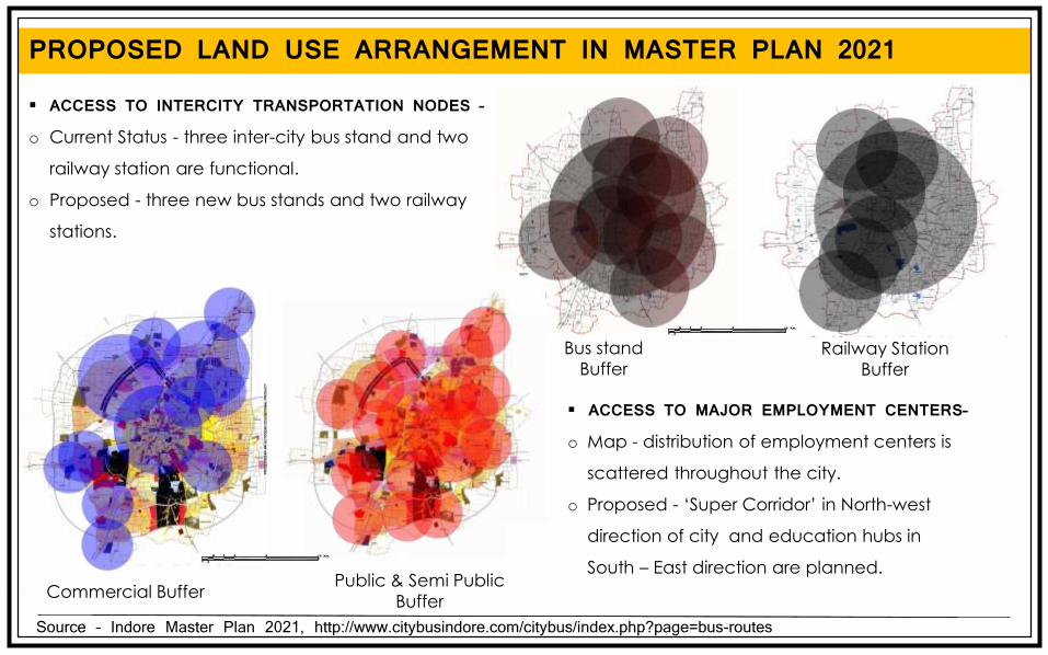
PROPOSED LAND USE ARRANGEMENT IN MASTER PLAN 2021
Source – Indore Master Plan 2021, http://www.citybusindore.com/citybus/index.php?page=bus-routes
ACCESS TO INTERCITY TRANSPORTATION NODES –o Current Status - three inter-city bus stand and two
railway station are functional.
o Proposed - three new bus stands and two railway
stations.
ACCESS TO MAJOR EMPLOYMENT CENTERS–o Map - distribution of employment centers is
scattered throughout the city.
o Proposed - ‘Super Corridor’ in North-west
direction of city and education hubs in
South – East direction are planned.
Bus stand
BufferRailway Station
Buffer
Commercial BufferPublic & Semi Public
Buffer

Source – DPR of Indore BRTS System, Mehta and Associates, http://www.citybusindore.com/citybus/index.php?page=bus-routes
MODAL SHARE AND PUBLIC TRANSPORTATION INDORE PUBLIC TRANSPORTATION -o comprises of Bus network feeded by Para Transit network
of Magic and Vans.
o caters to the 22% of the trip generated in the city.
MASTER PLAN PROVISION -o 55% trips by public transport in line with vision of National
Urban Transportation Policy, 2006.
FARE LIST -
Current - 2005 Proposed - 2021
Public Transport &
Intermediate Public Transport
Personalized Vehicle (Two
Wheelers)
Personalized Vehicle (Cars)
Cycles
LEGEND
Distance(Km)
Fare(INR)
Distance(Km)
Fare(INR)
BUS
0-3 5
MAGICANDVAN
0-2 5
3-7 7 2-6 8
7-10 9 6-10 10
10-13 12 >10 15
>13 16
MODAL SHARE

ACCESS TO NEARBY SATELLITE TOWNS
Source – Indore Master Plan 2021 and City Mobility Plan (Draft)
INDORE PUBLIC TRANSPORTATION -o Indore due to its proximity to tier III and IV cities,
population of which often travels to Indore for
various purpose such as employment and
education act as an interlace of urban and Peri-
urban areas.
REASONS FOR TRAVELLING TO INDORE -
38%
38%
18%
6%
Work/Business
Education
Shopping
Others
Fig. Peak Hour Traffic Volume Between Cities in Metropolitan Region
1 mm = 1000 PCU per hour per direction

BEST PRACTICES – TOWN PLANNING SCHEME
Source – The Town Planning Mechanism In Gujarat., India , Shirley Ballaney
CURRENT LAND ACQUISITION -o Bulk Land Acquisition - IMP 2012 suggests setting up land
bank office to coordinate it.
o 15400 Ha of land to be acquired in phase I.
o Enactment of LARR, 2013 has made acquisition difficult
and costly. TP SCHEME -o Refer to pooling together the land under different
ownership and redistribution after deducing land for
development purpose.
ADVANTAGES –o All the land except what needed for infrastructure
and social amenities remains with the original
owner.
o Increment in land value due to urbanization stay in
the hand of farmer.
o The farmers are not displaced in the process.
Acquisition
TP scheme
Agriculture land
Conversion process
Suitable urban land
Pvt. Agriculture Land
Government Acquired Land
Pvt. Urban Land
TRANSFORMATION TO URBAN LAND
Regular Plot Size
Access to each plot
Laying of infrastructure
Land for social amenities

INTEGRATION OF LAND USE AND TRANSPORTATION PLANNING
o Master Plan is primarily prepared to accommodate future growth of the city
o Focuses on – Zoning of compatible land uses
o Only spatial planning document with statutory power
INTEGRATED TRANSPORT AND LAND USE PLANS o Necessary as transportation planning and land use development affect each other
INTERDEPENDENCE OF EACH FIELD -
Land Use Mix
Centeredness
Density
Regional Connectivity
Congestion Reduction
Zoning
Habitat Protection
Accommodate Future Growth
Trip Length
Modal Distribution
Public Transit
Vehicle Ownership
Land Use
SOURCE – Indore Master Plan 2021

CITY FOR ALL
Source – Indore Master Plan 2021, Global Age-friendly Cities: A Guide by WHO
PARAMETERS UNDERTAKEN -
Provisions in Master Plan Recommendations
FACILITIES Amenities No mention of facilities required by women
Gender neutral distribution of amenities and services.
Mobility New Railway and Intercity Bus Stands proposed in Peri urban areas. Absence of focus on NMT.
Safe Public Transportation within the walking distance with well lit footpath and cycling tracks.
Education At present 1808 educational institutions are there in the area. M.P proposed setting up of education cluster in South West part of city
Distribution of education facilities through out city instead of clustering them.
GENDER
Provisions in Master Plan Recommendations
SOCIALEQUITY
Societal N.A The develop the social network to strengthen the neighbourhood system that supports social integration.
Accessibility Common facility for which each stratacompetes.
Assistance for marginalized section of society so that they can get equitable access to welfare programs.
SOCIAL EQUITY

LIVABILITY
CITY FOR ALL PARAMETERS UNDERTAKEN -
Provisions in Master Plan Recommendations
ECONOMYEQUITY
Spatial Distribution of Services
Only projected requirement and possible sources are given.
Need for equitable distribution of these resources to each part of city irrelevant of its residents’ socio-economic strata.
EconomyGeneration within vicinity
Proposed economic centres are well distributed through out the city.
Provisions to ensure for economical marginalized classes to have better access to the economic centers
ECONOMIC EQUITY
Provisions in Master Plan Recommendations
LIVABILITY Housing Only housing shortage and area requirements are calculated.
Housing for all sections of society can be achieved by enforcing certain minimum EWS/LIG in each real estate project.
Barrier FreeEnvironment
N.A Compulsory Adoption of Barrier Free Guide lines for any new project.
Public & Open Spaces
Minimum requirement of open space for any given development is mentioned.
Minimum quality aspect of public and open space need to specified.
Source – Indore Master Plan 2021, Global Age-friendly Cities: A Guide by WHO
o Population projection through Geometric Projection - tends to give over estimate.
o Promotes sprawl to accommodate growth through decongestion of core area and density aim of 100 person
/hectare - unfeasible and if some how become reality would create another Detroit.
o Envisioned development over a period of 20-25 years, which is too long a duration considering the fast pace of
development.
o Presence of villages under the planning area whose Land Use has not been specified, as a result of which they
are not coming under the umbrella of the of region specific government schemes.
o Many proposed roads such as MR 4 passes through already developed area (in this case Swadeshi mill).
o Phasing is done in arbitrary manner. The development had occurred beyond the planned phase and due to
inherited rigidity of Master plan, it has not been amended to accommodate the changing scenario.
o Most of the Peri Urban Areas are served by intermediate para transit which is poorly integrated with public
transportation system of Indore.
CRITICISM
Source – Times Of India, Hindustan Times

RECOMMENDATION
Source – Indore Master Plan 2021 and City Mobility Plan (Drafted)
o Need to adopt Town Planning Schemes as wide spread alternative to Land acquisition which will ensure the
fruits of urbanization will reach in the hands of marginalized farmers.
o The need to plan land use and transportation together is eminent. Master Plan for Indore had been enforced
since 2006 while it CMP is still in draft stage.
o Phasing of master plan need to be flexible in nature to accommodate unforeseen changes in developmental
forces.
o The time bound plan for the delivery of infrastructure services and public transportation modes need to be
prepared before the development of peri urban area starts.

THANK YOU
SCHOOL OF PLANNING AND ARCHITECTURE, BHOPAL
16TH ANNUAL NOSPLAN CONVENTION, 2014
COMPILED BY :PARTH BANSAL
SWARNALI DIHINGIA
HIMANI TIWARI
AMAN SINGH RAJPUT
JYOTHI
VIJAY MEENA