devens open space and recreation plan 2008 – 2013 · devens open space and recreation plan 2008...
TRANSCRIPT

Devens
Open Space and Recreation Plan
2008 – 2013
Prepared by:
Nashua River Watershed Association
And
Montachusett Regional Planning Commission
And
Massachusetts Development Finance Agency
January 23, 2008


Table of Contents SECTION 1- EXECUTIVE SUMMARY 1 A. PURPOSE 1 B. SCOPE 1 C. SUMMARY OF KEY CONCLUSSIONS 1 SECTION 2- COMMUNITY SETTING 3 A. REGIONAL CONTEXT 3 B. HISTORY OF DEVENS 3 C. REGULATORY CONTEXT 3 1. Regulatory History and Roles 3 2. History of Open Space and Recreation Planning at Devens 5 3. Current Status of Recreation Planning 7 D. POPULATION CHARACTERISTICS 8 E. GROWTH AND DEVELOPMENT PATTERNS 8 1. Patterns and Trends 8 2 Infrastructure 9
SECTION 3 - ENVIRONMENTAL INVENTORY & ANALYSIS 13 A. GEOLOGY, SOILS AND TOPOGRAPHY 13 1. Geology 13 2. Soils 13 3. Topography 14 B. LANDSCAPE CHARACTER 14 C. WATER RESOURCES 15 1. Nashua River Watershed and its Sub-basins 15 2. Surface Water 16 3. Groundwater, Aquifers and Recharge Areas 18 4. Flood Hazard Areas 19 5. Wetlands 20 D. VEGETATION 24 1. General Inventory 24 2. Wetlands 24 3. Grassland 24 4. Forest Land 25 5. Rare, Threatened and Endangered Species 25 E. FISHERIES AND WILDLIFE 26 1. Inventory 26 2. Vernal Pools 28 3. Corridors for Wildlife Migration 29 F. SCENIC RESOURCES & UNIQUE ENVIRONMENTS 30 1. State Designated Scenic Landscapes 30 2. Cultural, Archeological and Historic Areas 31 3. Unique Environmental & Recreational Assets 31 G. ENVIRONMENTAL CHALLENGES 32 1. Areas of Contamination and Superfund Sites 32 2. Non-point Source Pollution 32 SECTION 4 - INVENTORY OF LANDS OF CONSERVATION AND RECREATION INTEREST 34 A. PRIORITY AREAS FOR CONSERVATION AND/OR PRESERVATION 34 B. CONSERVATION RESTRICTIONS 40 C. AREAS RECOMMENDED FOR ADDITIONAL PROTECTION 41 D. LANDS OF RECREATION INTEREST 48 SECTION 5 - COMMUNITY GOALS 53

A. DESCRIPTION OF PLANNING PROCESS AND PUBLIC PARTICIPATION 53 B. STATEMENT OF OPEN SPACE AND RECREATION GOALS 53 SECTION 6 - ANALYSIS OF NEEDS 54 A. SUMMARY OF RESOURCE PROTECTION NEEDS 54 B. SUMMARY OF RECREATION NEEDS 54 1. Recreation Needs 54 2. Compliance with Americans with Disabilities Act 55 3. Management Needs/Potential Change of Use 56 SECTION 7 - GOALS & OBJECTIVES 57 SECTION 8 - 5-YEAR ACTION STRATEGY 60 SECTION 9 - PUBLIC PARTICIPATION 62 A. DEVENS OPEN SPACE AND RECREATION ADVISORY COMMITTEE MEETINGS 62 B. FIRST PUBLIC FORUM 62 C. SECOND PUBLIC FORUM 66 B. DEVENS OPEN SPACE AND RECREATION ADVISORY COMMITTEE FOLLOW UP MEETING 68 REFERENCES APPENDICES A. MAPS A-1 Devens Action Plan A-2 Devens Groundwater Resources A-3 Devens Open Space A-4 Devens Surface Water Features A-5 Devens Unique Features A-6 Devens Zoning A-7 Devens Open Space Protection Plan B. SUSTAINABLE DEVELOPMENT PRINCIPLES FROM MASSACHUSETTS OFFICE FOR COMMON-
WEALTH DEVELOPMENT C. PUBLIC COMMENTS TABLES AND FIGURES Figure 3-1 Wetland Resource Areas 23 Figure 4-1 Resource & Conservation Areas 39 Table 4-1 Invetory of Resource Areas and Recommended Protections 34 Figure 4-2 Additional Protections Plan 47 Figure 4-3 Mirror Lake Trails 48 Figure 4-4 Devens Multi-use Trail Network Plan 50

Devens Open Space and Recreation Plan 2008 1/23/08
Page 1
SECTION 1 - EXECUTIVE SUMMARY A. PURPOSE The Devens Open Space and Recreation Plan 2008-2013 has been prepared as a guide for the preservation of critical envi-ronmental resources and management of open space and recreational resources within the area of the former Fort Devens designated as the Devens Regional Enterprise Zone (Devens). It provides an overview of progress to date in light of the primary Goals and Objectives of the ReUse Plan (as they relate to open space and recreation planning), updates the inven-tory of environmental and recreational resources, and can be used as an additional guidance document for the continued redevelopment of the former Army Base. B. SCOPE OF THE PLAN This Plan updates and expands on the original Devens Open Space and Recreation Plan of 1996 (“1996 Plan”). The 1996 Plan articulated guidelines and management approaches for land identified as Open Space and Recreation areas under the Devens ReUse Plan adopted by the host communities and MassDevelopment. The 2008 plan expands the focus to all lands within the Devens Regional Enterprise Zone with the exception of areas administered by the Job Corps, the Federal prison, U.S. Fish and Wildlife Service, the Massachusetts Army National Guard, and the U. S. Army. The 2008 Open Space and Recreation Plan is the latest step in MassDevelopment’s ongoing open space and recreation land use planning. Preparation of the Plan incorporated the following objectives:
• Assess compatibility of land resources with planned uses; • Assess existing passive and active recreation resources and provide recommendations related to needs and oppor-
tunities; • Update the “Inventories of Environmental Resources” and “Lands of Conservation and Recreation Interest”; • Review and revise the Goals and Objectives of the 1996 Plan, and assess progress to date.
The report and mapping products are prepared in the framework of the Open Space Planners’ Handbook and meet the re-quirements of the Commonwealth of Massachusetts Division of Conservation Services. C. SUMMARY OF KEY CONCLUSIONS Based upon a review of development to date, on-going planning of recreation facilities and programs, public input and a general assessment of the natural resources at Devens, the 2008 plan identifies the following five open space and recreation goals:
• Preserve and protect important land resources. • Preserve and protect important water resources. • Provide connections between open space areas within and beyond Devens to facilitate movement and access by
humans and/or wildlife. • Meet the diverse recreational needs of Devens and the region. • Manage, maintain and operate active recreation facilities and open space districts.
Some of the key conclusions reached through the preparation of the 2008 plan include: • Two of the four areas identified in the Final Environmental Impact Report (FEIR) have been permanently pro-
tected through the recording of a Conservation Restriction1. Additional work needs to take place to determine what is-
1 The one CR established to date as recommended by the 1996 Plan consists of two parcels: 1) a system of glacially-formed ridges called “eskers” located near Queenstown Road and including the Patton Road wetlands, and 2) the Mirror Lake area including a black spruce bog. These are 39 acres (+/-) and 146 acres (+/-) respectively. The CR has been conveyed to The Trustees of Reservations (TTOR).

Devens Open Space and Recreation Plan 2008 1/23/08
Page2
sues need to be resolved in order to complete CR’s on the remaining two areas.
• The recreation resources at Devens have undergone significant changes over the past several years. Continued planning needs to take place to make most effective use of the resources and funding available to meet the recreation needs of Devens and the region to the greatest extent possible.
• Additional environmental resources have been identified in the North Post area, which needs to be further evalu-
ated to determine the impact of / on potential development and the possible need for additional levels of protection. • In general, MassDevelopment and the Devens Enterprise Commission have been diligent in the protection of
groundwater and surface water resources within Devens. Continued efforts are still needed to address areas of un-treated storm water and possible non-point source pollution both on MassDevelopment lands and especially Army lands.
One of the major accomplishments realized during preparation of the 2008 plan was development of consensus regarding specific areas of Devens which will be provided permanent protection. Each of the resource areas identified in the 1996 Plan was reviewed to identify current levels of protection and consensus was reached on additional protections that will be pursued for each area. Several areas not included in the 1996 inventory were also added to the matrix (Refer to Table 4-1 and figures 4-1 & Appendix A. “Devens Open Space Protection Plan Map”). One such area is the Environmental Business Zone. While not included in the original resource inventory, this area has long been projected to contain a diversity of envi-ronmental resources. On going studies will help determine the appropriate balance of development and preservation in this area.

Devens Open Space and Recreation Plan 2008 1/23/08
Page3
SECTION 2 - COMMUNITY SETTING
A. REGIONAL CONTEXT Devens is a 4,400-acre former Army base located in the towns of Ayer, Harvard, and Shirley in north-central Massachu-setts, on the border of Worcester and Middlesex Counties, approximately 30 miles northwest of Boston near the Nashua River. It is located in the transitional area between the coastal lowland and centeral uplands regions of Massachuestts.
B. HISTORY OF DEVENS Camp Devens was established in 1917 as a temporary training camp for soldiers from the New England area. It was named in honor of Civil War hero General Charles Devens. Peak military strength during the World War I era was 38,000. In 1922, Camp Devens was designated a summer training camp for several military groups. By 1931, Camp Devens became a permanent post and was renamed Fort Devens. Between 1931 and 1940, Fort Devens functioned as a training installation. From November 1940 until May 1946, Fort Devens provided an induction center for an estimated 650,000 people in re-sponse to World War II. At the close of World War II, Fort Devens served as a demobilization center and was subsequently placed on caretaker status. It was again used as an induction and training center during the Korean and Vietnam conflicts. In 1917, approximately 11,000 acres was leased to establish Camp Devens. Between 1919 and 1923, approximately 4,900 acres were purchased. In June 1940, Fort Devens received permission to acquire more land, and by 1941, the total land area had increased to 10,163 acres. In 1985, in connection with an application for a Resource Conservation and Recovery Act (RCRA) Part B Permit for haz-ardous waste storage, Fort Devens inventoried waste management areas with potential for release of hazardous materials to the environment. The RCRA permit, issued in 1986, listed 40 sites requiring action. Six sites were added soon thereafter. In 1988, an environmental assessment was conducted of the initial 40 sites. In 1989, Fort Devens was designated a Superfund Site, and in 1991 a plan was released that identified 58 sites for response action. Ongoing investigations and response ac-tions now include 76 sites, and additional base-wide investigations for occurrences of lead paint, asbestos, underground storage tanks and the like. Since 1955, various land parcels, ranging in size from 1 to 662 acres, have been excessed by Fort Devens. The more recent transactions included the 662 acres for the Oxbow National Wildlife Refuge, excessed in 1972 to the Department of the Interior; 76.5 acres deeded to the Town of Ayer in 1978; and an additional 57.26 acres excessed in 1988. (FEIS, P. 4-68) The Defense Base Realignment and Closure Commission's 1991 recommendations for base realignments and closures (commonly referred to as BRAC 91) required the closure of Fort Devens, with the retention of the South Post and those facilities essential to support Reserve Component training requirements.
C. REGULATORY CONTEXT
1. Regulatory History and Roles Prior to the closing of Fort Devens as an active duty base, the Devens Regional Enterprise Zone was created by Chapter 498 of the Acts of 1993, the boundaries of which include all the land area of Fort Devens, except the South Post. Under Chapter 498 of the Acts of 1993 (“the Act”), MDFA (formerly the Massachusetts Government Land Bank) was directed to work with the towns of Ayer, Harvard, Lancaster, and Shirley to formulate a ReUse Plan and By-Laws for the redevelopment of Fort Devens. The ReUse Plan and By-Laws were approved by Town Meetings in Ayer, Harvard and Shirley, by the Commonwealth of Massachusetts Division of Capital Planning and Operations, and the MassDevelopment Board of Directors. Pursuant to the Act, MassDevelopment is now responsible for overseeing implementation of the ReUse Plan and providing all municipal services to the development. The ReUse Plan established a framework for sustainable development of a diversity of uses that demonstrate the interde-

Devens Open Space and Recreation Plan 2008 1/23/08
Page4
pendence of economic development and environmental protection and that balance local, regional, and state interests. It outlined the environmental and economic opportunities and constraints presented by the site, defined a range of develop-ment patterns, established zoning and resource protection overlay districts, identified a number of Federal property transfers between agencies of the federal government, addressed the infrastructure needs and requirements, and established the opera-tion and management structure for the life of the project. The planning process provided an extensive format for public participation in the redevelopment of Devens. Primary in the “building of the ReUse Plan” is the open space network that includes critical natural environmental resources as well as other recreational facilities and lands to provide a coordinated, systems approach to environmental protection, open space and recreation at Devens. Unlike typical development planning that considers open space to be land left over after all the development is located, the Devens ReUse Plan started with the definition of the open space and environmental network as the basis for the Plan2. The Plan states, “More than one third of the land area of Fort Devens will be devoted to open space and recreation use. While over 1,300 acres of the site are designated as a permanent open space network, more than another 1,500 acres will stand as open space within the developed portions of the site”3. Role of MassDevelopment As the successor to the Massachusetts Government Land Bank, MassDevelopment, pursuant to Chapter 498, is designated as the exclusive public agency authorized and empowered to maintain, operate, administer, manage and oversee the rede-velopment of Devens. MassDevelopment provides all governmental/municipal services at Devens in addition to serving the role of Board of Selectmen. Role of Devens Enterprise Commission Chapter 498 established the Devens Enterprise Commission (DEC) to serve as a regulatory body governing the develop-ment process at Devens. The DEC acts as a local planning board, conservation commission for wetlands protection, board of health, zoning board of appeals, and historic district commission. It carries out these duties in the context of a unique and innovative one-stop permitting system, which greatly streamlines the local regulatory process. The DEC consists of 12 gu-bernatorial appointees, six of whom are nominated by the host communities of Ayer, Harvard and Shirley. Each host com-munity also nominates an alternate member. Inspectional services, legal and engineering assistance required by the DEC are covered by contractual relationships with consultants. As part of its responsibilities, the DEC prepared landscape and open space guidelines and regulations for uses within devel-opment zones. The Devens By-Laws provide for Level One and Level Two permits, which further facilitates the permitting process. Level One actions allow rapid approval at the administrative level, and involve relatively minor adjustments to site plans, lot lines, and architectural modifications in historic areas, as well as wetland certificate of compliance. Level Two actions require a full public hearing and an open review process and generally involve larger scale undertakings. Since 1999, the DEC has issued 77 Level Two permits and 549 Level One permits (including over 100 permits for housing units in 2001).
1999 2000 2001 2002 2003 2004 2005 2006 Total Level 1 23 142 183 50 37 28 46 40 549 Level 2 15 15 14 4 6 12 5 6 77 Total 38 15 197 54 43 40 51 46 484 The Rules and Regulations of the Devens Enterprise Commission require implementation of sustainability principles in development projects. In an effort to achieve its sustainability mission, the Devens Enterprise Commission uses sustainabil-ity criteria in its decisions, focussing on the areas of transportation, environmental protection, and ecological industrial de-velopment.
2 These first two sentences are taken verbatim from the Land Bank’s Draft EIR, pgs.3-4. 3 Devens ReUse Plan, pg. 8.
Devens Open Space and Recreation Plan 2008 1/23/08
Page5
Role of JBoS In order to respond proactively to the closure of Fort Devens, MassDevelopment (then the Massachusetts Government Land Bank) and the Joint Boards of Selectmen (JBoS) of the four host communities (Lancaster later dropped out of the group when it was determined that no land within that Town was to be surplused by the Army) worked cooperatively on planning the reuse of the base. The JBoS provided the local leadership in overseeing policies for development and implementation of the comprehensive ReUse plan, as well as generating strategies to be used in the conversion of facilities and land from mili-tary to civilian uses. Role of Open Space Recreation Advisory Committee The open space framework was formulated as part of the larger ReUse Plan drafting process which included broad public participation as well as official Town Meeting approval. The final MEPA Certificate specified the development of a com-prehensive plan for management of the open space designated in the ReUse Plan and identified “Open Space/Recreation” as one of three task forces to be created to provide input to MassDevelopment during the redevelopment of Devens. The Open Space Recreation Advisory Committee (DOSRAC) was created by the JBOS to advise them on ongoing issues related to management of the open space designated in the ReUse Plan. The DOSRAC has existed continuously since the mid-1990s.
2. Historical Review of Open Space and Recreation Planning at Devens The ReUse Plan requires MassDevelopment to prepare a comprehensive Open Space and Recreation Plan that established a management plan for the Open Space and Recreation Zoning District. The Plan was prepared for MassDevelpment in 1996 by Cicil and Rizvi, Inc., EarthTech, Dodson Associates and Numeric Environmental Modeling. Working in partnership with the Open Space Recreation Advisory Committee, the Joint Boards of Selectmen (JBoS) and the Devens Enterprise Commission, MassDevelopment developed a collaborative planning process, to ensure the sustainability of future uses of the former base, while preserving and protecting valued natural and cultural resources. The 1996 Open Space and Recreation Plan defined open space uses, landscape and environmental characteristics, and man-agement and design guidelines to help guide the management of this landscape4. The Plan classified the land into four sub-areas defined under the Land Stewardship Classification system employed by the former MA Department of Environmental Management in its Guidelines for Operation and Land Stewardship (GOALS): “Environmental Preservation,” “Conserva-tion,” “Intensive Use,” or “Linkage.” The plan recommended high standards of preservation for a system of eskers located near Queenstown Road, wetlands along Cold Spring Brook, a wetland area near Patch Road, and a bog near the center of the former Ammunition Supply Point (ASP), the Mirror Lake area, and a black spruce bog. In the deed transferring the property from the Army to MassDe-velopment a restrictive covenant was included to ensure that these lands would be protected in perpetuity. The intention was for each parcel to be placed under the protection of a Conservation Restriction (CR) that would supercede the deed restriction. To date, half of these sensitive areas -- the Mirror Lake area, black spruce bog, a system of eskers of located near Queenstown Road, and a wetland area near Patch Road -- have been placed under a Conservation Restriction held by The Trustees of Reservations. While the wetlands along Cold Spring Brook and a bog near the center of the former ASP are currently protected by the deed restriction, efforts will continue to place these areas under a CR in the future. Among the areas considered for conservation and passive recreation in the ReUse Plan are several open space buffer corri-dors at the perimeter and internally within Devens, Shepley’s Hill and the adjacent land, areas of steep slopes, the western side of Mirror Lake, areas to be used for storm water detention, much of the area along Cold Spring Brook, and the Robbins Pond area5.
4 Devens 1996 Open Space and Recreation Plan (Chap. 1, pg. 1). 5 “Much of the land within the open space and recreation zone should be designated for conservation where there are envi-ronments of moderate sensitivity, or where physical constraints make intensive use impractical. Among the areas designated for conservation are several open space buffer corridors at the perimeter and internally within Devens. This designation would also apply to Shepley’s Hill and the adjacent landfill. Conservation designations would apply to areas of steep slopes, the western side of Mirror Lake, areas to be used for storm water detention, much of the areas along Cold Spring Brook, and

Devens Open Space and Recreation Plan 2008 1/23/08
Page6
Intensive uses included recreation fields (soccer and softball), golf, tennis, swimming and boating support areas, mainly on land previously designated for these uses in the 1996 Open Space and Recreation Plan. The ReUse Plan identifies the im-portance of maintaining green corridors along principal roadways. These linkage areas are to serve as important connectors between open spaces while preserving open space qualities along the roads. These roadway linkages may include walk-ways, bicycling, hiking, and equestrian trails.6 The Fort Devens Regional Recreation Management Plan, Final Report, for the Fort Devens ReUse Center, Open Space and Recreation Task Force, Ayer, Harvard, Lancaster, and Shirley, published in January 1995, established a framework for ad-dressing internal and regional open space and recreation as part of the ReUse Plan’s sustainable development objective. The Recreation Management Plan identified areas appropriate for specific recreational uses, focusing on lands within the Open Space and Recreation Zone as designated by the Devens ReUse Plan, based on an understanding of the environmental structure of these lands. The Recreation Management Plan suggested several master planning options that grouped recrea-tion facilities into clusters and recommended existing facilities for reuse. Some facilities were located within development zones, most were located within the Open Space and Recreation Zone. Since the 1996 transfer of property from the Army to MassDevelopement all recreational facilities at Devens have been inventoried, the physical condition of the facilities as-sessed and, based upon the capital investment and return on that investment for each facility, recommendations have been made for the future. Devens Recreation Department As recommended in the Regional Recreation Management Plan, Final Report, in 1996 a Memorandum of Understanding (MOU) was negotiated between MassDevelopment and the host towns of Ayer, Harvard and Shirley (JBoS) to establish a recreational authority, define recreational management responsibilities and document the recreational inventory to be main-tained at Devens. MassDevelopment created the Devens Recreation Department. Regional Recreation Committee MassDevelopment formed a Regional Recreation Committee to provide input to the Recreation Department7 regarding the long-term management of the Regional Recreation Program. This group consisted of Parks and Recreation representatives from Harvard, Shirley, Ayer and Lancaster. The function of the Regional Recreation Committee was to act as an advisory board to the Devens Recreation Division regarding scheduling, fees and setting policy. Open Space Advisory Committee The Open Space Advisory Committee consists of two appointed members from Ayer, Harvard and Shirley (appointments are made by the Board of Selectmen from each town) and a representative from US Fish and Wildlife, MA Division of Fisheries and Wildlife, Department of Environmental Protection, Department of Conservation and Recreation, Nashua River Watershed Association, and a Devens resident. The Advisory Committee meets once a month to review issues im-pacting Devens open space and then reports back to the JBoS with its recommendations. In a 1996 Memorandum of Understanding (MOU) between MassDevelopment and the Joint Boards of Selectmen, Mass-Development expressed a committment to maintain existing recreation facilities to the extent possible while recognizing that these efforts would be contingent upon the facility’s financial sustainability and avaible capital funding. In 2002, discussions between MassDevelopment and the Open Space Advisory Committee revealed lack of agreement over what the ReUse Plan meant by “permanent protection” of the areas designated as open space in the ReUse Plan. In order to resolve this, the JBOS and MassDevelopment agreed that an updated Open Space and Recreation Plan would be prepared which would identify specific protection mechanisms appropriate for various parcels. This current plan includes those rec-ommendations.
the Robbins Pond area. Passive recreational uses have generally been programmed for these areas.” (1996 Plan, Chapter 1, pgs. 2-3). 6 Devens 1996 Open Space and Recreation Plan (Chap. 6, pg.2). 7 The Recreation Department falls under the umbrella of the Devens Operations Division of MassDevelopment.

Devens Open Space and Recreation Plan 2008 1/23/08
Page7
3. Current Status of Recreation Planning The Devens Recreation Division was created as a result of the 1994 Devens ReUse Plan and the 1995 Regional Recreation Management Plan. In 1996 an Memorandum of Understanding (MOU) was negotiated between MassDevelopment and the host towns of Ayer, Harvard and Shirley (JBoS) to establish a recreational authority, define recreational management re-sponsibilities and document the recreational inventory to be maintained at Devens. In general, the facilities left by the Army were in disrepair and in some cases inoperable. Since the 1995 Regional Recrea-tion Management Plan was published all existing recreation facilities have been evaluated and assessed. Some facilities that were in disrepair have been demolished while others have been improved and /or are the subjects of long-range master planning strategies. As an outcome of the recreation planning already undertaken, a number of facilities were deemed non-operational or are no longer maintained:
• An analysis of Buker Pool was conducted in 1996. Serious concerns existed regarding the integrity of the pool en-closure, the efficiency of the filter system and the soundness of the concrete. An independent consultant recom-mended demolition and the pool was subsequently torn down in 1998.
• The Sports Arena was used as a community recreation center from 1996 through April 2003. Three independent
design studies were conducted during this time with the purpose of bringing the building up to code, to address building shortcomings and to meet ADA requirements. Cost estimates from the three studies ranged from $3 mil-lion to $5 million. Efforts were made to justify the significant capital investment required to rehabilitate the Arena but were not successful. The building suffered major structural damage from snow loading in March 2003. The building was subsequently demolished in November 2003.
• The former Army Riggs Gymnasium was converted to a public membership fitness center in 1997. The brick
building contained a 12,000-square-foor gymnasium, a 10,000 square–foot fitness center, four racquetball courts, locker rooms, offices and storage. The Fitness Center received modest renovations in 2000 and significant HVAC were completed in 2003. Despite these capital improvements, the Fitness Center lagged behind other commercial fitness clubs in design, amenities and condition. The number of Fitness Center memberships ranged between 300 to 400, which was well below the 700 members needed to support staffing costs and building expenses. The De-vens Fitness and Wellness Center was closed on April 1, 2004 and remains vacant.
Recreation Strategic Plan June 2003 The 2003 Recreation Strategic Plan was an effort to evaluate the active recreational facilities, redefine them in a way that maximizes their potential, and propose a strategy for recreational growth for the future. The primary goal of the Strategic Plan was to develop a pro forma and long-term financial plan for the Devens Recreation Division. The Strategic Plan is based upon the following objectives:
• Meet the diverse recreational needs of the region and the residents of Devens. • Generate revenue to support recreation facilities and activities. • Plan for capital improvement projects and seek funding sources. • Be fiscally responsible and financially solvent.
As a part of this process, the following general assumptions were made:
• The recreation inventory, as defined in the 1996 MOU between MassDevelopment and the JBoS, is not guaran-teed but is contingent upon an in-depth assessment of each facility.
• Devens Recreation is operated under its current format as a division of MassDevelopment.
MassDevelopment is attempting to meet the needs of the present charter school and any future school as well as the Devens community by developing a school recreation plan that will include a gymnasium. This idea is in its infancy and an in-depth financial analysis must be conducted before any commitments are made.

Devens Open Space and Recreation Plan 2008 1/23/08
Page8
D. POPULATION CHARACTERISTICS Over the last three decades, the Montachusett Region and several communities on its borders have grown significantly, in-creasing by nearly 23 percent at an average rate of 6 percent per decade for the past 20 years. The population of the 22-town region increased by 25,036, from 202,969 to 228,005. Much growth has occurred outside of the urban areas as new homebuyers move to the area from the east, west, and south in search of reasonably priced housing. Expansion of the metropolitan Boston employment centers beyond Interstate 495, easy highway access, and an over-heated housing market in the greater Boston region have spurred westward movement of the labor force in search of land and lower housing prices. Locations on the perimeter of the Boston “commutershed” make housing in this region’s towns more af-fordable than in communities further east. The rapid regional growth sometimes occurred in the rural areas in a pattern of sprawl, affecting air and water quality, exacerbating traffic problems and supplanting the agrarian roots in dairy and orchard farming with large-lot residential development. The growth trend is expected to continue, according to the Massachusetts Institute for Social and Economic Research of the University of Massachusetts at Amherst.8 The Montachusett region is projected to grow by 8 percent from 2004 to 2010 and at a rate of 3 percent every five years following 2010. Increased populations will bring increased pressures and de-mands for municipal services and on natural resources such as water and open space. Devens provides a unique opportunity for responsible planning of additional housing needed to meet the regions future growth.
E. GROWTH AND DEVELOPMENT PATTERNS
1. Patterns and Trends The Towns of Ayer, Harvard, Lancaster and Shirley, located in northeastern Massachusetts at the western edge of Middle-sex County and the eastern edge of Worcester County, border each other on the Main Stem of the Nashua River, the site of former Fort Devens, a federal military installation that served Massachusetts and the nation for nearly 80 years. The indus-trial village around which the town of Shirley grew is located on the lowlands along the narrow valley of the Catacunemaug River, which meets the Nashua River at the Shirley entrance to the base. The River is nestled at the bottom of an extensive ridgeline, which runs from Littleton through Harvard and provides many excellent vistas of the river valley.9 Drumlin hills and outwash plains, reforested former agricultural lands, and wetlands characterize the undeveloped areas in the region. For more than 70 years, Fort Devens played a significant role in the local and regional economies, and large sections of Ayer, Harvard, Lancaster, and Shirley were occupied by Fort Devens. At one time, the Base employed almost 8,000 peo-ple. Convenient highway access to Devens and the three host communities afforded by Route 2 (the main east-west corri-dor for northern Massachusetts), Interstate 495, and Interstate 190, fueled industrial development in the region until the 1980s. Suburban growth was spurred by the construction of Route 2 in 1950, Interstate 495 in the 1960s, and the commuter rail service connecting Fitchburg, Shirley, Ayer and Boston. Between 1940 and 2000, the population of the four communities (excluding Devens) increased by 147 percent, and the population of Harvard alone increased by more than 230 percent. As people move out from the greater Boston region and as employment increases along Interstate 495, these towns are faced with increasing growth pressure and the constant threat of losing open space. Traffic management in these communities has become a major issue. Population growth has also caused increases in land values, which, combined with tax increases and increased agricultural competition from other states and countries, is putting pressure on farm and orchard owners to sell their land. In the mid- to late-20th century, this region was a prime growth area for both residential and commercial development. Yet, by 1990, shifts in the Massachusetts economy led to a decline in the manufacturing industry as companies relocated out of
8 MISER Population Projections for Massachusetts, 2000–2020, Stefan Rayer, Ph.D., July 17, 2003. 9 The Massachusetts Department of Environmental Management Landscape Inventory refers to this area as the Upper Nashua Valley-Shrewsbury Ridge Unit of the Massachusetts Central Upland.

Devens Open Space and Recreation Plan 2008 1/23/08
Page9
state or overseas. The service sector has supplanted the manufacturing industry, followed closely by retail trade employ-ment. Commercial and retail activity has expanded in Ayer and Shirley, and Ayer is actively working to establish itself as a center for business development. In the face of this changing economy, the closure of Fort Devens had a profound impact on the host communities, and caused significant change in the local region such as loss of population, fluctuations in real estate values, and loss of employment. The closure of Fort Devens in 1996 was ultimately viewed as a unique and significant opportunity to stimulate development and enhance the quality of life in this region. Recreational facilities, trail linkages, mixed income housing and commercial and manufacturing businesses are potential benefits for the host communities. The resources of the Nashua River basin, including an extensive groundwater system, critical wildlife habitat, and recreational opportunities, sparked a concerted effort on the part of the four towns to ensure the protection of the Nashua River and its watershed, establish linkages to con-nect protected resources for a regional greenway, and mitigate the potential impacts as Devens is redeveloped in accordance with the ReUse Plan. The Towns of Ayer and Shirley both maintain water supply wells served by aquifer resources associated with Devens.
2. Infrastructure
a) Wastewater Management Wastewater generated by Devens and the host communities is treated and disposed of either through centralized community sewage systems and associated wastewater treatment facilities or by means of individual on-site subsurface sewage disposal systems. The town of Harvard relies exclusively on individual septic systems, but may construct or connect to some type of centralized wastewater treatment facility – e.g.; at the neighborhood level -- in the future. Two municipal wastewater treat-ment facilities serve Devens, Shirley, and Ayer: the Devens WWTF (serving Devens, MCI Shirley, the sewered sections of Shirley, and a portion of Ayer’s flows); and, the Town of Ayer WWTF (serving the town of Ayer). The Devens WWTF is a state-of-the-art plant built in 1998 and capable of treating up to 3.0 Millions of Gallons per Day (mgd), and has the capacity to expand to treat an additional 1.5 mgd. The Devens WWTF receives an average daily flow of approximately 0.425 mgd from Devens based facilities, 0.250 mgd from MCI-Shirley, 0.125 from Town of Shirley, and 0.100 from the Town of Ayer. Under current contract, MCI Shirley can send up to 0.600 mgd. The Town of Shirley can send 0.300 mgd, and the Town of Ayer can send up to 0.800 mgd. The Town of Shirley, under an Intermunicipal Agreement, has tied into the Devens system to serve the Village Area, Shirley Center, and along Route 2A to mitigate failures of septic systems and to accommodate the expansion of the Massa-chusetts Correctional Institution (MCI-Shirley). The Shirley village area was in particular need of sewage treatment. The Devens WWTF had excess capacity due to the base closure. In 1998, the Hospital Road interceptor pipeline was upgraded, the MCI-Shirley WWTF was closed, and the flows from MCI-Shirley were routed to the Devens WWTF. The average daily flow of wastewater from the expanded MCI-Shirley to the Devens WWTF is approximately 0.125 mgd. The pipeline between MCI-Shirley and the Devens WWTF, however, was sized to accommodate future flows from Shirley Village and Shirley Center areas and excess capacity was provided for additional future connections (Woodard & Curran Facilities Plan, 1999). The Ayer Wastewater Treatment Facility (WWTF), located on Brook Street, serves an estimated 85 to 90 percent of Ayer's residential population, five large industrial dischargers, and numerous smaller commercial and municipal facilities. The treated effluent is discharged to the Nashua River. The existing average daily flow is reported as 1.54 or approximately 86 percent of the design flow mgd. Projected average daily flows to the Ayer WWTF could approach 2.37 mgd by the year 2020. 10 Flows to the Ayer WWTF are approaching the design capacity of the facility. All new sewer connections and extensions to the system are required to make improvements to the system to correct infiltration into the sewer lines that adds groundwa-ter and stormwater to the flows entering the wastewater treatment plant. Construction of a pipeline allows routing of excess 10 Town of Ayer – Draft Wastewater Treatment Facility Alternatives Analysis, 1999.

Devens Open Space and Recreation Plan 2008 1/23/08
Page10
flows to the Devens WWTF. Under an Intermunicipal Agreement with Devens, the town of Ayer can send up to 0.800 mgd to Devens. b) Transportation System The principal highway serving Devens and the host communities is Route 2, an east/west highway linking Boston with northwestern Massachusetts, which passes through Harvard and separates the Main and South Posts. Interstate 495 also serves the region, passing through the southeast portion of Harvard to intersect with Route 2 in Littleton, east of Ayer. This highway links the region with the Turnpike, southeastern Massachusetts, Cape Cod and Rhode Island. To the west, Route 2 intersects Interstate 190 in Leominster, connecting the region to Worcester and points southwest. Other highways serving these communities include Routes 2A, 110, 111, and 119 which provide local circulation between communities in the re-gion. The Route 2 Interchange at Jackson Road is being reconstructed to improve access to Devens and add an acceleration lane. Completion of the project is anticipated for 2006. One airport exists in the region: Fitchburg Municipal Airport. Conrail and the Springfield Terminal Railway (STRR) offer freight service through Ayer, which is the site of an intermodal facility opened by the STRR in 1993. The Springfield Terminal Railway line (the former Boston and Maine Railroad) par-allels Route 2 and provides access to the network of intermodal facilities serving central and eastern Massachusetts. The Springfield Terminal Railway has a track running through Harvard to Ayer. Conrail operates an auto trans-loading facility for newly manufactured motor vehicles in Ayer. The MBTA provides commuter rail service to North Station, Boston via the Fitchburg Line. The line serves stations in Shirley and Ayer. Each of the host communities is a member of the Montachusett Regional Transit Authority (MRTA), which provides paratransit services to the elderly and disabled through the Councils on Aging.
c) Water Supplies Infrastructure Devens11 The water supply system at Devens, designed to serve a population of 30,000 people, includes approximately 50 miles of distribution mains and two 1 million gallon storage tanks.12 MassDevelopment contracts the operations and maintenance of the water system to EarthTech. The system is supplied by one tubular well field and three gravel-packed wells: Grove Pond wellfield (1.1 mgd safe yield), Patton Well (1.4 mgd safe yield), MacPherson Well (1.4 mgd safe yield) and Sheboken Well (1.4 mgd safe yield). The Grove Pond wellfield lies within the DEP approved Zone II delineation for the Grove Pond Wells owned by the Town of Ayer. Under the state Water Management Act, Devens is registered to withdraw 1.35 mgd. However, a prior study indicated a safe yield in excess of 5 mgd. The Water Management Act (WMA) permit issued in April 1999 allowed a maximum of 2.95 mgd in total from the four Devens Wells in addition to the previously registered 1.35 mgd.13 Recently, MassDevelop-ment renewed a WMA permit to use up to 4.8 million gallons of water per day. The average daily demand at Devens is less than 500,000 gpd (0.322 mgd) (2004). Water use is expected to increase as industry grows at Devens to a projected demand at full development of 3 mgd.14 Emergency water is provided to the Massachusetts Correctional Institute at Shirley, and there are connections with Ayer and Shirley for emergency service, as well. The MacPherson Well withdrawal amount was conditionally approved pending relocation of an abandoned military landfill (Area of Containment 9 [AOC9]) and completion of new source approval by the Shirley Water District for its proposed Walker Well. The AOC9 excavation and relocation has been completed. 11 Updated per. comm. with James Moore of the Devens Utilities Department. 12 Communities Connected by Water, 1995. 13 ENSR – per. comm.; A. Aglington, MADEP, 2001. 14 Devens ReUse Plan, Nov. 1994

Devens Open Space and Recreation Plan 2008 1/23/08
Page11
The Red Tail Golf Course uses 175,000 to 225,000 gpd at peak times (maximum authorized daily withdrawal is 0.300 mgd) and MassDevelopment applied for an amendment to the Devens WMA permit to accommodate the golf course irrigation well. The golf course irrigation well is now included on MassDevelopment WMA permit. This amendment provides for a fifth withdrawal location and reallocates the total permitted amounts among the Devens Wells.15 The use of potable water for irrigation purposes was a concern, while use of process water (gray water or treated effluent) could have been appropri-ate to preserve future potable water for potential domestic needs. The golf course is too far away from the Devens wastewa-ter treatment plant to economically take advantage of using gray water from the plant. Shirley16 The Shirley Water District operates two wells that supply potable water to 50 percent of the town’s population (3,900 peo-ple in 2004), to the southern portion of the town extending from Patterson Road up to Route 2A (Great Road). The remain-der of town is served by private well water. Patterson Well has a safe yield of 450 gpm and provides 80 percent of the pub-lic water supply. Catacunemaug Well has a safe yield of 250 gpm. Together they provide a total supply of 1.0 mgd. The Patterson Road Well shares the aquifer with the MacPherson Well, one of the Devens water supply wells. The Water Dis-trict owns 75 percent of the W1 (Zone I) areas around the wells and considerable recharge in Zone II. The water distribution system consists of a network of six inch and twelve-inch diameter water pipes and is supplied from two groundwater wells, two reservoirs and one standpipe. The Town completed construction of two 750,000-gallon hydropillar storage tanks in the summer of 2004. The existing standpipe will be dismantled upon completion of the new tanks. Annual consumption in 2003 totaled 123.14 million gallons of water at a rate of 0.33 million gallons per day, and the Maximum Daily Demand (MDD) in 2003 was 0.53 mgd. The Massachusett Department of Environmental Management (now the Department of Conservation and Recreation) predicted the Average Daily Demand (ADD) for the town of Shirley to be 0.32 mgd in 2015, which is less than the current ADD.17 Residential use accounts for 91 percent of the total usage (97.58 annual million gallons) serving 1,160 connections. Commercial and industrial uses (32 and 10 connections respec-tively) consumed 6 percent of the annual demand (7.46 million gallons) and Municipal, Institutional, and other uses con-sumed 2.10 million gallons (24 connections). As of yet, 16 million gallons annually remain unaccounted for in the system. The Shirley Water District does not plan significant expansion in the near term, although the District has been expanded to include all of Shirley and a portion of Lancaster. In order to meet current and future demand, the water district is developing a supplemental third well off Walker Road, near the Patterson Road Well. Ayer The Town of Ayer operates two sets of wells with a total yield of 4.3 mgd, supplying 95 percent of the required water needs for the town residents and businesses as of 1996. The Grove Pond Wells #1 and #2 have a maximum safe yield of 694 gpm (1.0 mgd) and 780 gpm (1.12 mgd) respectively.18 The Spectacle Pond Wells #1 and #2 have a maximum safe yield of 791 gpm (1.14 mgd) and 730 gpm (1.05 mgd) respectively.19 The system also has a 1.5 million gallon storage tank. Additional water supply (primarily for emergency situations) is available via interconnections with Devens (0.54 mgd) and the town of Littleton (1.2 mgd). The Grove Pond Wells share the aquifer with the Grove Pond wellfield on the Devens property. A Zone II delineation was developed for the Grove Pond Wells in 1993 and for the Spectacle Pond Wells in 1999. Ayer owns the entire Zone I de-lineated aquifer protection areas, and much of the Zone II areas. Thirty percent of the Spectacle Pond Zone II area lies in the town of Littleton within a designated aquifer protection area. 15 ENSR - pers. comm.., A. Eglington, MADEP, 2001 16 Updated per conversations with Brian Goodman of the Shirley Water Department (winter 2005). 17 NWRA, 1995. 18 B. Bouck, pers. comm. 19 Town of Ayer – Draft Wastewater Treatment Facility Alternatives Analysis, 1999.

Devens Open Space and Recreation Plan 2008 1/23/08
Page12
The Average Daily Demand (ADD) in 1992 for the town of Ayer was 1.79 mgd, and the Maximum Daily Demand (MDD) in 1996 was 2.1 mgd (Tata & Howard, 1999). Water usage is divided between residential (34 percent), commercial (23 percent), industrial (28 percent) and municipal (9 percent) uses20. The former Massachusetts Department of Environmental Management (now the Department of Conservation and Recrea-tion) has projected the average daily demand (ADD) for Ayer to be 3.0 mgd in 2010. In a recent study, Tata and Howard (1999) projected the ADD to be 4.14 mgd in 2020. In either case, the present water supply appears to be adequate to meet the future projected demand. The Ayer Water department plans to expand the present distribution system to include the remaining 5 percent of population and to provide increased water supply for fire fighting capacity. Since 1999, there have been several proposals for housing developments in Ayer. Combined, these developments would add 300 units of housing to the total housing stock, 16 light industrial properties to the commercial/industrial base, and in-crease water consumption by an estimated 145,000 gallons per day.
• Rocky Hill And Stratton Hill Development (84 units and 25 units, respectively) • Pond View Acres (39 units) • Sandy Pond Subdivision (25 units) • Snake Hill Ridge Subdivision (127 units)
Harvard Harvard has two town bedrock public wells, located off Pond Road, that supply water to approximately 200 residents, the public schools, and buildings in the town center. The primary well has a maximum pumping rate of 22 gallons per minute (gpm). The second well, located 100 feet west of the first Pond Street Well, has a maximum pumping rate of 17 gpm. A 340,000-gallon storage tank aids in water distribution. The average daily demand (ADD) on this system is 0.02 million gallons per day (mgd). An emergency backup well on Bolton Road has a maximum pumping rate of 20 gpm, but it pro-duces water high in iron and manganese. A town Ground Water Study Committee established in 1982 found that no major bedrock fractures and corresponding pri-mary groundwater recharge areas exist in town. Minor fractures in the bedrock throughout town return surface waters to groundwater. This means that there are no good sites in town for high yield wells for public use. The Massachusetts Department of Environmental Management (now the Department of Conservation and Recreation) has projected a future ADD of 0.38 mgd for Harvard in the year 201521. Many exploratory test wells have been developed to identify feasible locations for additional wells. In the mid-70s an exploratory drilling study located a viable shallow aquifer located near the Boxborough town line22. Pump tests indicated that wells in this aquifer could yield approximately 175 gpm. However, the infrastructure required to move this water from its source, over two ridges and into the center of town to tie in with the current distribution system makes this an unfeasible source at the present time. Other preliminary studies have turned up no new, feasible locations in which to install additional wells. Additional future water supplies might be secured from a regionalized water supply system, with sources in Littleton or Devens though such may prove to be infrastructurally unfeasible.
20 NRWA, 1995. 21 Ibid. 22 Ted Morine, pers. comm.

Devens Open Space and Recreation Plan 2008 1/23/08
Page13
SECTION 3 - ENVIRONMENTAL INVENTORY & ANALYSIS The information presented in this section was derived from a variety of published and unpublished sources notably the 1996 Devens Open Space and Recreation Inventory, the 1994 Final Environmental Impact Statement, and the 1993 Biological and Endangered Species Baseline Study of Fort Devens (ABB Environmental Services). Additionally, information was gathered by personal communications with local and regional experts, and limited field investigations conducted in the win-ter of 2003 and spring of 2004. The Main Post encompasses approximately 3,520 acres. The most intensely developed of the three posts, Main Post, con-tains housing, commercial/industrial areas (maintenance, administrative, warehousing), recreational facilities, a landfill and other facilities. North Post, located to the north of Main Post, encompasses approximately 900 acres. North Post contains the former Moore Army Airfield, Devens wastewater treatment facilities, 124 acres of the Oxbow National Wildlife Refuge, and a currently undeveloped Environmental Business Zone
A. GEOLOGY, SOILS AND TOPOGRAPHY 1. Geology The geology of Devens consists of glacial, alluvium, and swamp deposits overlying bedrock. The glacial deposits include intermingled masses of poorly sorted clay, silt, sand, gravel and boulders (till); layers of well sorted fine to coarse sand, fine gravel and boulders (glacial stream deposits); and layers of fine sand and silt (glacial lake deposits). Till deposits account for approximately 250 acres of the Main and North Posts: they are typically loose, poorly compacted, permeable, uncon-solidated and thin. Till is typically exposed at Devens as drumlins, which are smoothly shaped elongate hills, or as ground moraine, which are poorly drained, low-lying, smoothly undulating plains. The glacial stream outwash material is more rounded and better sorted than the till and ranges from 40 feet thick in kettles, which are circular depressions filled with water, to 100 feet thick in deltas, which are fan-shaped deposits. The glacial lake outwash deposits are also more rounded and better sorted than the till and are, on average, 30 feet thick. Groundwater exists in both the glacial stream and glacial lake outwash deposits at Devens. Alluvium and swamp deposits at Devens overlie the glacial deposits. Alluvium is light gray to white fine sand and silt with minor gravel and primarily found underlying the modern floodplains of the Nashua River Valley. Swamp deposits are composed of muck, peat, silt, and sand, and are found overlying or mixed in with the alluvium. Areas on Devens exhibit characteristics of both ice-contact and post-glacial geology. The surficial topography exhibits typi-cal kame-kettle features, namely various kame formations, deposits of sands and gravels deposited during periods of glacial retreat and heavily influenced by contact with the retreating glaciers, and kettles, depressions in the topography resulting from the void left by melting blocks of ice left by the retreating glaciers among deposited kame gravels. Eskers are bands of steeply sloped sand/gravel materials deposited by streams and torrents from the melting glaciers often associated with kames, kame terraces or other features formed in retreating glacial lakes. Kames and eskers may have considerable relief, 35 to 70 feet in height. Eskers are often sinuous, but may be straight; some are continuous, some are segmented or bifurcated. The “Eskers” conservation restriction area is a fine example of this. The bedrock of Devens consists of five major units of meta-sedimentary and igneous stratigraphic rocks. The five units are composed of two facies of the Ayer Granite, the Berwick Formation, the Oakdale Formation, the Worcester Formation, and the Tower Hill Quartzite. In most areas of Devens a thick mantle of surficial deposits covers bedrock. Visible bedrock at Devens is limited to various outcrops, primarily on hills such as Shepley’s where there is evidence of past rock blasting. The exposed bedrock has been eroded and is of moderate relief, but still exhibits greater relief than the overall topography of the installation. The major bedrock surface feature is the bedrock valley of the ancestral Nashua River. 2. Soils Heavily developed areas of the installation that have been subject to extensive regrading or impervious cover (e.g., former Moore Army Airfield, Superfund sites and Areas of Concern or AOCs) have been mapped by the Natural Resources Con-

Devens Open Space and Recreation Plan 2008 1/23/08
Page14
servation Services (NRCS) as urban land complex soils. This designation indicates soils so altered by urban activity that they are not readily identifiable. Many soil series were mapped by NRCS throughout less intensively developed and unde-veloped portions of the installation. The more abundant soils series include Quonset loamy sand, Windsor loamy fine sand, Hinckley sandy loam, Chatfield-Hollis-Rock Outcrop association, Hinesburg loamy sand, and Freetown muck. Although soil types and topography are diverse on Devens, moderately level sandy uplands with steep side slopes ending at lowland wetlands are a common landscape feature. The level upper portions of many such areas have been developed for military housing and other uses on Main Post. Soil features found at Devens -- and infrequently found elsewhere in north-central Massachusetts – include exposed sandy soils of glacial origin, river mudflats (associated with the Nashua River), kettleholes, oxbow ponds, fens and bogs23. Several areas mapped by the Natural Resources Conservation Services as prime farmland (approximately 160 acres total) and as soils of state or local importance to agriculture (approximately 225 acres total) occur on the Main and North Posts. Many of the attributes that render land prime or important for agriculture (e.g., level terrain, good drainage) also render the land highly attractive for development. This has led to a pervasive trend of irreversible loss of prime and important farm-land in urbanizing areas, such as Devens. In sum, the existing prime and important agricultural soils at Devens are in iso-lated parcels too small (of these two dozen separate parcels the mean is less than 9 acres) for most commercial agricultural uses. An overlay of the GIS soils data with recent aerial photographs reveals that a great many of these prime and important soils polygons have been replaced by development of one form or another. Consequently, these lands require further re-view. 3. Topography Devens is characterized by rolling, undulating terrain with rounded, wooded hills separated by the Nashua River and several smaller stream valleys. Main and North Post have approximately 140 feet of elevation change, ranging from elevation 220 feet along the Nashua River as it leaves the North Post, to 360 feet in the vicinity of Cutler Army Hospital and also at Shepley's Hill. The central portion of the Main Post occupies a plateau at approximate 300 to 330 feet, with the site gently sloping to the north, and rolling off to the Nashua River on the west and to Cold Spring Brook/Bowers Brook tributaries to the east. The North Post consists of two plateaus at approximately 260 feet elevation, bisected by the Nashua River as it flows north. A portion of the eastern plateau is the former Moore Army Airfield, level and man-made at 270 feet. A generalized slope analysis shows areas greater than 15 percent slope occur in three main areas: 1) along the Nashua River corridor, 2) on Shepley's Hill, and 3) in the southeastern portion of the Main Post, south of Cutler Army Hospital and in the Mirror Lake/Robbins Pond corridor. Detailed topography (hypsography datalayer) demonstrates numerous areas of local-ized steep slopes.
B. LANDSCAPE CHARACTER The Devens landscape has been transformed from its early twentieth century agricultural use through its military use to its current developed land areas and successional forest cover types resulting from land and forest management practices. Developed land use types associated with past military occupancy dominate the Main and North Posts. On the Main Post approximately 50 percent and on North Post approximately 28 percent is developed or in urban cover type land use. Major open areas include the Red Tail Golf Course, Rogers Field parade grounds, and “urban open” areas in the industrial pre-cinct. The sandy, rolling "karne and kettle" ecology of this portion of the Nashua River valley bears similarities to Cape Cod and other glacial terrace and outwash areas of New England. The underlying geology influences Devens’s vegetation: the pre-dominance of pines and oaks on the site reflects the underlying sand/gravel soils in most parts of the former base. The ex-
23 Biological and Endangered Species Baseline Study of Fort Devens (ABB Environmental Services, 1993, pgs. 10-13)
Devens Open Space and Recreation Plan 2008 1/23/08
Page15
tensive groundwater resources of the Devens aquifer are also directly linked to the area's glacial geology and are reflected in the shape of the landscape. The groundwater of the Devens aquifer is frequently visible in the form of the numerous "kettle hole" ponds that occur in the central and eastern portions of the site. Similar in ecology to Walden, the most famous of all kettle hole ponds, Devens’s ponds and lakes are an important visual landscape resource. Humans have modified the Devens visual landscape over centuries and the underlying natural landscape has been modified by human alteration. Some cultural alterations such as fields, meadows, recreational facilities, attractively designed build-ings and roads have enhanced the scenic character of the landscape. Other human alterations have damaged the underlying natural landscape character of the site. The Native Americans burned the forests to create meadows for hunting and farming. For over 250 years, New Englanders farmed in the Devens area, which was mostly cleared of trees to create fields, pastures and orchards. The abandonment of farming occurred early in the Devens area due to the poor, dry agricultural soils in many areas, though farming continues to a small extent to this day in the richer floodplain and bottomland soils of the Nashua River valley. Native American and colonial agricultural use of the land generally increased the variety and openness of the landscape, enhancing its visual char-acter. Construction of Fort Devens beginning in World War One greatly altered the visual character of the site. The construction of roads, barracks and administration buildings created a campus-like environment on the former farm and woodland site. Land uses within one mile east of North Post, northeast of Main Post in Ayer, include high- and medium-density residential, downtown business and commerce, and light industrial areas. Land uses within one mile east of Main and South Posts in Harvard include agricultural, rural residential, a small commercial area, the town center, the Oxbow National Wildlife Ref-uge and various smaller Harvard Conservation Lands. Fruitlands Museums, a National Register historic site, is located off Prospect Hill Road. West of Main and North Posts within one mile in Shirley are residential and agricultural land uses, MCI Shirley, and several open space areas (Holden Road Conservation Area, Spruce Swamp Conservation Area, and the Rich Tree Farm). Almost immediately north of the Moore Airfield, at the confluence of the Squannacook and Nashua Riv-ers, are the protected Groton Town Forest, Ayer State Game Farm, Sabine Woods, and Groton Place lands (approximately 680 acres in total).
C. WATER RESOURCES 1. Nashua River Watershed and its Sub-basins The main stem of the Nashua River slowly flows in a meandering course from south to north along the western portion of Main Post and the center of the North Post. The main stem is formed by two branches: the North Nashua River, which originates in West Fitchburg, and the South Branch, which flows out of the Wachusett Reservoir. From the confluence of these branches in Lancaster, the Nashua River flows 35 miles northward to the Merrimack River in Nashua, NH. The Nashua River has been classified by Massachusetts Department of Environmental Protection (DEP) as a Class B waterway, suitable for swimming and fishing. This is dependent on weather conditions and seasonal variations24. Despite improve-ments in water quality over the decades, excess levels of nutrients and biological oxygen demand frequently result in lower water quality and algal blooms in summer. Several sub-basins, or "sub-watersheds", cover portions of Devens, as well as the surrounding towns. On Main and North Posts25, the Bowers Brook/Nonacoicus Brook sub-basin covers the largest area, accepting surface water drainage flow from Bowers Brook, Cold Spring Brook, Sandy Pond, Flannagan Pond, Grove Pond, Plow Shop Pond, Robbins Pond, and Wil-
24 It is reported by the NRWA’s Water Resources Advisor that more than 50% of the Nashua’s waters are treated effluent – that is, that amount of the total water in the river has recently passed through a wastewater treatment facility -- and that per-centage increases sharply during low flow periods such as the summer. 25 Devens Main and North Posts occupy 7 square miles of the 538-square-mile Nashua River Basin, representing approxi-mately 1.3 percent of the total basin area.

Devens Open Space and Recreation Plan 2008 1/23/08
Page16
low Brook.26 Bowers Brook originates in an extensive wetland area along the Bolton/Harvard town line. From this point, it flows northward into Bare Hill Pond, an impounded area, and then continues northward to Grove Pond. At the Devens boundary, Cold Spring Brook (a stream which originates in wetlands north of Mirror Lake) joins Bowers Brook. Also, Waker Brook in Shirley crosses the North Post on its way to its confluence with the mainstem Nashua River. Grove Pond also receives flow from the stream draining Flannagan Pond and Sandy Pond and is connected to Plow Shop Pond via a culvert under the B&M Railroad line. Plow Shop Pond empties over a spillway into Nonacoicus Brook, which flows westward to the Nashua River. Prior to discharging to the Nashua, Nonacoicus Brook is joined by Willow Brook, which drains the central portion of Main Post, including Robbins Pond. The substrate in Willow Brook consists primarily of sand and gravel. Willow Brook is a channelized brook approximately three to four feet wide that is piped underground in some locations and which warrants consideration for “daylighting”. Some water bodies within the boundaries of Devens have no surface water drainage (that is, inlet or outlet). As such, these are vulnerable to degradation from surface water runoff, since no surface dilution or flushing occurs under natural condi-tions. These water bodies, known as kettles, include Mirror Lake and Little Mirror Lake on Main Post, and were formed by glaciers. When the glaciers retreated, blocks of ice were left, around which sediments accumulated. The ice blocks melted, leaving depressions that intersect the water table, creating lakes and ponds that drain directly to the underlying aquifer. Wa-ter levels in these water bodies are generally controlled by fluctuations in the groundwater table. Some, which have become bogs, are relatively isolated by groundwater and depend upon surface water flows. 2. Surface Water In addition to the eight miles of rivers and streams that flow through Devens, there are approximately 100 acres of open waters, including Robbins Pond, Mirror Lake, and Little Mirror Lake (See Appendix A. “Surface Water Features Map”). There are also several certified and potential vernal pools, isolated depressions that are wet only a portion of the year but which may have important ecological roles for amphibians, turtles, and other wildlife. (For more on vernal pools, see below Section 3.F.2.) Robbins Pond and its Sub-watershed Robbins Pond is a very shallow (less than six feet average depth) pond, which was used in the past for bathing, picnicking, sports, and other recreational activities. A thick mat of floating and benthic algae blanketing most of the shoreline area cov-ers approximately 70 percent of the pond’s 15-acre surface area. Fecal deposits, presumably from Canada Geese or other waterfowl, are visible throughout the grass lawns. These deposits likely result in significant loadings of nutrients (nitrogen and phosphorus) to the pond during and after rainfall events. In contrast to the lawns found along the northern and north-western shores of the pond, forests surround the eastern and southern shorelines. Water within the pond is apparently slightly clouded, due to significant phytoplankton levels. A sandy beach area is located along the eastern corner of the pond. Although this beach may have been used for bathing in the past, the extensive floating algae found throughout the remainder of the lake renders it unsafe and unsuitable for swim-ming, in its present state. A ten to fifteen foot wide, rocky stream drains into Robbins Pond at its extreme western end. This stream drains approxi-mately 339 acres of land area. Large paved parking areas, lawns, roadways and buildings characterize approximately 80 percent of this area and 20 percent is forested, which accounts for the origin of non-point sources of pollution (see below Section G. “Environmental Challenges Sub-section 2. Non-point Source Pollution”). A very shallow (less than three feet average depth) pond is located approximately 2,000 feet upstream of Robbins Pond. This pond, which is partially surrounded on its western and southern sides by woods and a swampy area with many fallen and standing dead trees, appeared to have very little algal growth and its water was clear. A gated paved roadway is located adjacent to the eastern shoreline of this pond. This roadway turns to dirt, curves towards the southeast and terminates at the golf course greens. A large, roughly circular, floating bog (approximately 1,000 feet in diameter) is located nearby. Upstream of the narrow woodland pond located near Robbins Pond, the watershed consists of a heavily wooded, narrow 26 Additionally, the Catacunemaug and Mulpus Brooks sub-watersheds each account for a very small area of Devens.
Devens Open Space and Recreation Plan 2008 1/23/08
Page17
valley (the “Eskers” Conservation Restriction area), surrounded by steep slopes on both sides. Upstream from this location, the valley curves towards the west and climbs in elevation rapidly. The western side of the stream valley is a steep slope that forms a ridge, which is a classical glacial esker formation of significant proportions. Previous development of land surfaces, such as grading of natural land surface irregularities, creating large impervious areas for use as parking lots, roads and walkways, constructing buildings, and associated human activities have significantly al-tered and impacted the natural flow hydrology of Robbins Pond, its tributary stream and woodland pond. A large washout and other significant stormwater-induced erosional features, such as braided scour channels and thick sediment deposits, are located near the steep upper portions of this valley. This erosion is apparently due to several large (approximately 2 foot diameter) stormwater culverts draining into the valley from large paved parking lots, roadways and lawns located on U.S. Army property along its western margins. The erosion is visible leading from the pipes through the dense forest and down to the narrow woodland pond.27 Land surface development has decreased the amount of rainfall that is stored in natural depressions and/or directly infiltrates into the ground, which is later slowly discharged into tributary surface waters via the regional groundwater. As a result, lar-ger volumes of runoff are transported more rapidly than under natural conditions, with little storage or attenuation, through the stormwater drainage piping networks. These piping networks discharge runoff directly off the steep side slopes of the tributary stream valley. Runoff then rushes downhill through the numerous braided erosion channels observed within this forested area and enters the woodland pond. The relatively narrow and very shallow woodland pond serves to attenuate runoff hydrographs somewhat. However, excess runoff then quickly propagates downstream through the narrow, rocky stream channel and into Robbins Pond. Increased runoff has likely resulted in additional erosion and sediment deposition within the surface waters of the Robbins Pond watershed. Based on the thick sediment deposits on its bottom, the woodland pond tributary to Robbins Pond appears to serve as a trap for a large portion of the sediments eroded from its tributary watershed during rainfall events. However, it is likely that development of this watershed has also increased sediment loads reaching Robbins Pond. The high organic silt fractions of these sediment loads also likely contain high levels of algal nutrients. These slowly settling, relatively small particle fractions are easily transported with runoff to Robbins Pond and likely have contributed to the eutrophication of this surface water. The Robbins Pond watershed consists of approximately 70 percent urbanized and 30 percent forested land surfaces. This urbanized land consists of a combination of housing, offices and administrative buildings, military equipment service and storage areas, paved and dirt parking lots, grass lawns, a golf course and a network of paved roadways. Due to normal day-to-day activities within these land areas, numerous potential sources of conventional pollutants and toxics exist. These pol-lutants may include: human and animal waste, detergents, oil and grease, fertilizers, hydrocarbons, heavy metals and pesti-cides. If inadequately controlled and/or disposed of, these pollutants may be transported via runoff and/or groundwater to surface waters within the watershed. Due to alteration of the hydrologic regime and enhancement of pollutant transport pathways described above, the impacts of these new pollutant sources on surface waters of the Robbins Pond watershed have likely been magnified. Mirror Lake and its Sub-watershed Mirror Lake, located approximately one mile south-southwest of Robbins Pond, is accessible by a paved and dirt road, which travels near its western shoreline. In contrast to Robbins Pond, Mirror Lake, with a surface area of approximately 29.6 acres, is apparently minimally impacted by algal nutrient loadings from its approximately 220 acre watershed area. Mirror Lake is a through-flow lake, in that it has no outlet. As such, it is vulnerable to degradation from surface water run-off, since no surface dilution or flushing occurs under natural conditions. Water enters via groundwater inputs and surface runoff from its primarily undeveloped watershed and exits through evaporation and down-gradient groundwater transport. Mirror Lake, according to former residents, was highly utilized for bathing, picnics, sports and other recreational activity in the past. Due to its clear and relatively deep (maximum depth of 80 feet) waters and clean sandy beach, it constitutes a valu-able surface water resource to be protected and possibly enhanced. A MassDevelopment commissioned study, Mirror Lake 27 The Mirror Lake and Eskers Conservation Restriction between MassDevelopment and TTOR states that “when past ero-sion problems have been rectified; [this] will contribute to the improvement of water quality in nearby Robbins Pond.” (CR, September 16, 2003, pg. 2).

Devens Open Space and Recreation Plan 2008 1/23/08
Page18
Recreation Area Improvements, (June 2002) addressed and proposed measures at the Mirror Lakes area that would “reduce and limit [human] intrusions into the [natural] landscape, while providing safety and comfort facilities for the visitor”(pg. 3). The lake’s watershed consists of approximately 70 percent steep to moderately sloping, undeveloped and forested land. Approximately 25 percent of the watershed consists of open meadows and grass, much of which is now or formerly was golf course. The remaining 5 percent of the watershed consists of paved and unpaved roadways, parking areas and build-ings28. Water clarity is very good and no floating or phytoplanktonic algae were observed in a 2004 field visit. However, slight benthic algal deposits are visible around its southern-most end. This may be due to buildup of decaying detritus, such as dead leaves, within this corner due to winds and subsequent bacterial decomposition into algal nutrients. Previous monitor-ing of water quality during the Comprehensive Environmental Response, Compensation, and Liability Act Study (Arthur D. Little, Inc., 1995) suggested that decomposing leaf detritus may have resulted in elevated nutrient and metals levels found within the northeastern corner of Mirror Lake. Mirror Lake meets Massachusetts Class B surface water standards, supporting the following uses: fish and aquatic wildlife habitat, primary and secondary contact recreation (swimming and boating) and a source of public water supply with appro-priate treatment (EarthTech within Devens Open Space and Recreation Plan, Cecil & Rizvi, Inc., 1996). Mirror Lake is underlain by and communicates with the high-yield aquifer tapped by the Shebokan Well and Patton Road Well, and, downgradient, the Grove Pond Wells. It therefore requires and has received exceptional protection. Based on 1994 water quality data (Arthur D. Little, Inc., 1995), Mirror Lake is mesotrophic, with an in-lake average nitrogen to phosphorus ratio (N:P) of 12:1, suggesting that phosphorus is the nutrient which limits algal productivity, and hence, the level of eutrophica-tion within Mirror Lake (Numeric Environmental Modeling within Devens Open Space and Recreation Plan, Cecil & Rizvi, Inc., 1996). Little Mirror Lake andits Sub-watershed Along the southeastern shoreline of Mirror Lake is a ridge, which varies in height between approximately 10 and 40 feet. This ridge separates Mirror Lake from Little Mirror Lake to its east. Little Mirror Lake is also a through-flow lake. Little Mirror Lake has a surface area of approximately 7.4 acres and drains a predominantly forested, relatively steeply slop-ing watershed of approximately 89 acres. The northern end of this lake drains an extensive marsh area extending towards the northeast. In contrast to Mirror Lake, Little Mirror Lake was found to have a dark brown color, probably due to load-ings of decomposed plant matter and tannins entering from adjacent woodlands and the extensive marsh area at its northern end. No floating or planktonic algal growths were observed. The strong discoloration of its waters and large concentrations of leaf detritus and other decomposing organic matter along its littoral region would tend to detract from this lake's quality as a surface water recreational resource 3. Groundwater, Aquifers and Recharge Areas Significant areas of Devens are on unconsolidated glacial outwash deposits that are highly productive aquifers. The aquifer is located approximately 30 to 100 feet below the ground surface. The eastern portion of the Main Post and much of the North Post is underlain by medium- and high-yield aquifers that provide potable water for Devens, the town of Shirley and back-up water supply to the town of Ayer. Just over 475 acres of the North Post and just under 500 acres of the Main Post are underlain by the high yield aquifer: more than 300 gallons per minute (gpm). Additionally, 160 acres of the North Post and 1,210 acres of the Main Post are underlain by the medium yield aquifer: 100 to 300 gallons per minute. This groundwater is designated as a Class I potable water source and meets all DEP water qual-ity standards, with the exception of sodium, at times. (See Appendix A. Figure A-2 “Groundwater Resources Map”). Stud-ies conducted for the Devens Environmental Impact Report (EIR) and ReUse Plan estimated the safe yield from the aquifer underlying Devens at approximately 5 Million Gallons per Day (mgd). These aquifers are important groundwater resources for Devens and surrounding towns; thus, water quality protection for these wells is of high importance as reuse and devel-opment at Devens continues. Indeed, lack of a confining layer above the aquifers makes them vulnerable to contamina- 28 The Mirror Lake Conservation Restriction permanently limits the amount of impervious surface and other types of de-velopment that may be allowed in the area.

Devens Open Space and Recreation Plan 2008 1/23/08
Page19
tion.29 The Devens ReUse Bylaws establish a Water Resources Protection Overlay District (WRPOD) that is superimposed on all zoning districts. Tiered requirements are established addressing Zone I areas, Aquifer Districts (over the aquifer but outside Zone II) and Watershed Districts (remaining areas of Devens outside Aquifer District, Zone I and Zone II). The Bylaws further contain special integrated design requirements and performance standards for development in the Rail, Industrial, Trade-Related zoning district, and define General Design/Planning Provisions, including Best Management Practices (BMPs), Construction Requirements, Water Conservation Measures, and Stormwater Management Requirements, for each of the above districts. In addition, the Bylaws contain special provisions related to Operational Activities, including such matters as transportation of materials, storage tanks, floor drains, and pesticides/herbicides. The DEC Regulations require compliance with the Bylaws as well as the Water Resources Protection Plan, and impose further design requirements as set forth in the Site Plan Rules and Regulations, including a Groundwater Quality Monitoring Plan for certain uses. Integral to the Bylaws, the Water Resources Protection Plan and the DEC Regulations is the concept that exacting requirements set forth therein govern all activities at Devens, and that those requirements are designed to pro-tect the groundwater resources underlying Devens within development zones. This Plan includes some action items in-tended to provide further protection, notably best management practices. Water resources required for full build-out were estimated at approximately 3 mgd. Average current use is estimated at 0.7 mgd. The Devens water supply system consists of three gravel-packed supply wells and one tubular wellfield, serving the Main and North Posts. Four public water supply wells are currently permitted at Devens in addition to an irrigation well for the Red Tail Golf Course. The total permitted withdrawal amount (for all wells combined) is 4.2 mgd (1999-2004). That amount will increase to 4.6 mgd for 2004-2009 and 4.8 mgd for 2009-2014. The four groundwater sources on the Main and North Post are operated on a rotating basis and are as follows: The Devens Grove Pond wellfield is comprised of twelve eight-inch wells ranging in depth from 35 to 43 feet. It is located immediately south of Grove Pond. The wells were installed in 1986 to replace an existing, outdated wellfield. Permitted yield is about 1 million gallons per day (mgd). Current average pumping rate is 500 gallons per minute (GPM). The Shebokan Well is located south of Mirror Lake along Sheridan Road. It is 76 feet deep. Permitted yield is about 1,000 GPM (1.4 mgd), based on the capacity of the pump in place. A 1994 70-hour pump test and yield calculations projected safe yield at 1,071 GPM (1.54 mgd). Current average pumping rate is 900 GPM. The Patton Well is located near Patton Road north of Mirror Lake. It is 67 feet deep. Permitted yield is about 1,000 GPM (1.4 mgd). On the basis of 1993 pump tests, safe yield has been calculated to be 1,241 GPM (1.8 mgd). Current average pumpage is 500 GPM. The MacPherson Well is located on the southern portion of the North Post near MacPherson Road. It is 93 feet deep. Per-mitted yield is about 1,000 GPM (1.4 mgd). Based on the 1993 pump test data, safe yield has been calculated at 1,286 GPM (1.85 mgd). Current average pumpage is 850 GPM. 4. Flood Hazard Areas The 100-year floodplain, as delineated by the Federal Emergency Management Agency (FEMA), is most extensive along the Nashua River, reaching its greatest width in the Oxbow National Wildlife Refuge near Route 2. The floodplain is also fairly wide along the stretch of the Nashua River near the wastewater treatment facility on North Post with nearly 300 acres (or 3/5 of the total wetlands on the Main and North Posts combined). Cold Spring Brook on Main Post also has a distinct floodplain of approximately 65 acres. The Devens Bylaws establish a floodplain overlay district that includes all floodplains shown on the flood insurance rate maps covering Devens, including all areas at or below 10 feet mean sea level (MSL) and all special flood hazard areas des-ignated on the flood insurance rate maps. Subdivision Plans and Site Plans will identify the floodplains. Regulation of any 29 In the past, occasional traces of Trichloroethylene (TCE) detected in the Grove and MacPherson Wells confirm that ground water contamination is possible unless stringent protective measures are taken. Note: The US Army has initiated clean-up of the identified TCE plume on the North Post area.

Devens Open Space and Recreation Plan 2008 1/23/08
Page20
activity proposed in the floodplain will be carried out by the DEC under the Massachusetts Wetlands Protection Act and also under Section V, Wetlands, of the DEC Site Plan Rules and Regulations. 5. Wetlands The Nashua River and its tributary system is the major water feature in the vicinity of Devens, and many wetlands on De-vens are associated with the river and its tributaries. Based on aerial identification by MassGIS, there are approximately 115 acres of wetland and water bodies on Devens, and additional 500 acres of FEMA mapped floodplain that is not included within the wetland or water body acreages of these acreages. To be consistent with the 1996 Plan, wetland areas are re-ferred to as Wetland Resource Areas A through J. These wetlands are described below. Refer to Figure 3-1 at end of sec-tion for wetland area locations. Wetland Area A includes an area of approximately 47 acres in size encompassing Mirror Lake and Little Mirror Lake. Im-mediately south of Mirror and Little Mirror Lakes is a black spruce bog. Mirror Lake, as reported in An Inventory of the Ponds, Lakes, and Reservoirs of Massachusetts, Worcester County has mean depth of 40 feet with a maximum depth of 58 feet. It has been classified as being mesotrophic and stratified. The water color is clear and the bottom type appears to be sand and gravel. Land use in and around the lake is primarily forest and the sur-rounding area is relatively steep. One intermittent stream flows into the lake from the west. Little Mirror Lake is located immediately east of Mirror Lake. Between Mirror Lake and Little Mirror Lake is a steep wooded ridge apparently comprised of sand and gravel. A footpath proceeds along this ridge. As with Mirror Lake, the sur-rounding area is steep and forested. At the northern end of Little Mirror Lake is an adjoining wetland system consisting pri-marily of forested and scrub/shrub components. At its southern end, there is a small scrub/shrub wetland that appears to be connected to Mirror Lake via a culvert, which passes through the ridge separating the two waterbodies. The water within Little Mirror Lake, while clear, is stained with tannins. The substrate appears to be comprised of sand and gravel, but or-ganic sediment is also apparent. Immediately south of Mirror Lake is a classic black spruce bog, which appears to be a kettle, and is recognized as a unique feature at Devens. It is permanently protected as part of the “Mirror Lake” Conservation Restriction and identified therein as “containing uncommon and sensitive wetland habitat meriting special attention”.30 It seems that the bog consists of a vege-tated floating mat surrounded by a moat. The area immediately surrounding the bog is wooded, steep, and probably consists of sand and gravel. Wetland Area B is an isolated wetland located by the Ammunition Supply Point (ASP) north of Patton Road. It is estimated that the total area is approximately 8 acres in size. The wetland consists primarily of scrub/shrub and emergent components. One area of open water occurs within the northeast quadrant of the wetland. It has been reported that portions of the wetland consist of a floating vegetated mat similar to that found in bogs. It has also been reported that carnivorous plants (typical of bogs) and an uncommon turtle species (not identified) may occur within this area. Immediately adjacent to the north and east sides of the wetland are steep, sandy slopes. While these steep slopes are vege-tated with trees (primarily oaks), the understory is sparse, a direct result of the former use of goat herds by the Army to con-trol vegetation within the ASP. With the exception of the area immediately south of the ASP, ammunition bunkers are situ-ated in a band encircling nearly three-quarters of the wetland perimeter. Wetland Area C, an area estimated to be approximately 6.5 acres in size, is located northwest of the ASP. It consists of for-ested, scrub/shrub emergent and open water wetland components. Wetland Area C is directly connected to Area D (Robbins Pond) to the northeast via an intermittent stream. To the east, west, and south, steep forested slopes surround the wetland system. Inspection of forested areas west and south of Wetland C reveals that a significant amount of stormwater runoff flows into and through this area from adjacent developed land to the west. This runoff has resulted in scour, erosion, and deposition of sediment in several areas. Based on the location of these areas, some of the scour patterns may be interpreted as intermittent streams. 30 CR, September 16, 2003, pg. 2.

Devens Open Space and Recreation Plan 2008 1/23/08
Page21
Wetland Area D is an open body of water known as Robbins Pond. It is approximately 12.5 acres in size and is situated south of Barnum Road. Robbins Pond has one inflow originating from Wetland Area C described above. This inflow is situated at the southwest corner of Robbins Pond. Robbins Pond also has one outflow (Willow Brook) situated at the north-west corner of the pond. This appears to flow seasonally. Willow Brook flows in a northerly direction to Wetland Area J and ultimately into Nonacoicus Brook. In general, Robbins Pond appears relatively shallow. Based on the presence of an abundance of aquatic vascular plants and algae, it is eutrophic. The substrate of Robbins Pond appears to be primarily sand and gravel near the edges but silt may be accumulating in deeper parts. The south and eastern perimeter of the pond consists primarily of steep sided forests. West and north of the pond are developed areas. Indications are that the pond has received significant historic recreational use. In addition, an excessive number of waterfowl may be utilizing the pond, contributing to nutrient inputs. Wetlands E, F, G, and I together comprises a wetland system contributing to Cold Spring Brook. In general, these areas all contain streams or open water which flow in an easterly direction. The most easterly of these wetlands is Wetland Area G an area approximately 6 acres in size containing forested and scrub/shrub components at its western limits and scrub/shrub and open water components east to Marne Street. At Marne Street, water probably flows east to Wetland Area F via a culvert beneath the road. Following extensive dredging of Area of Concern 40 in 2002 to remove hazardous materials at a historic dumpsite, Wetland Resource Area G was expanded by several acres. Wetland Area E has been estimated (from aerial interpretation) at approximately 2 acres in size, but its extent may be larger. It is located immediately southwest of the intersection of Barnum and Marne Streets. It is primarily composed of scrub/shrub and forested wetland components. A significant portion of this area is inundated with water estimated to be at least one foot deep. North and east of this wetland are Barnum Road and Marne Street, respectively. Near the edge of the wetland in this area there is indication of earth moving in the past. West and south of Wetland E are dry, steep-sided, for-ested slopes. Above these slopes is a developed area: the former Davao Army Housing area. Between the developed area and the wetland is an access road. In one location, several stormwater outfalls can be seen pro-jecting from the slope immediately downgradient of the roadway. At the southeast corner of this wetland, a stream channel of approximately 2 to 3 feet in width flows into the stream channel originating from Wetland Area F. The substrate in this stream is primarily sand. Wetland Area F is a primarily forested area, approximately 6 acres in size, containing a small perennial stream, which flows to the northeast. This stream crosses beneath Marne Street via a culvert, and flows in a northeasterly direction to the conflu-ence with a stream flowing from Wetland E. The stream flowing through Wetland Area F is approximately 2 to 3 feet wide and contains a substrate of sand. Wetland Area F is bordered by a railroad to the east, Marne Street to the immediate north, and relatively small bands of forest to the west and south. West and south of the forested areas are Marne and Patton Roads, respectively. North of Wetland Area G, the adjacent area is primarily forested with moderately steep slopes. At its western end is the Ammunition Supply Point (ASP). South and east of the wetland is Marne Street. The substrate of the open water compo-nents of the resource area consists primarily of silt and muck. Floating aquatic vascular plants are relatively abundant and are, for the most part, concentrated near the edges. Wetland Area H is an isolated forested wetland approximately 2 acres in size, located in land zoned for development. To the west is Jackson Road and to the north, east, and south are forested slopes. Indications are that water ponds in this wetland at some point during the year, probably early spring. This appears to have resulted from a berm constructed to control drain-age. Wetland Area I is a wetland complex estimated to be at least 23 acres in size. It is composed of forested, scrub/shrub, emer-gent and open water components. It is located in an area beginning near the intersection of Barnum Road and the Boston and Maine Railroad track, and proceeding east and northeast to the town line between Ayer and Harvard. This wetland complex includes Cold Spring Brook. Bowers Brook, located to the east, is a tributary to this system. North and west of Wetland Area I are Barnum Road, numerous buildings and parking lots, and construction associated with Superfund cleanup activity nearing completion. From these developed areas, the wetland system appears to receive signifi-cant quantities of stormwater runoff: this concern is being addressed by engineering BMPs as suggested in the Barnum
Devens Open Space and Recreation Plan 2008 1/23/08
Page22
Road Master Plan. South and west of this wetland system, outside the boundary of Devens, are forested areas of slight to moderate slopes and additional wetlands associated with Bowers Brook. Waterfowl and other wildlife species extensively utilize the area. Wetland Area J located southwest of Shepley's Hill and south of the Job Corps area is estimated at approximately 3 acres in size. Immediately south and west of the wetland are roadways. From the south, flowing in a northerly direction, Willow Brook flows through Wetland J from Robbins Pond and flows through what appears to be a modified channel. It leaves the northernmost point of the wetland and continues flowing north to Nonacoicus Brook, which ultimately flows into the Nashua River. Wetland J consists primarily of scrub/shrub and emergent wetland components. (Also, see Section E. 2 “Vernal Pools”, pg. 28)
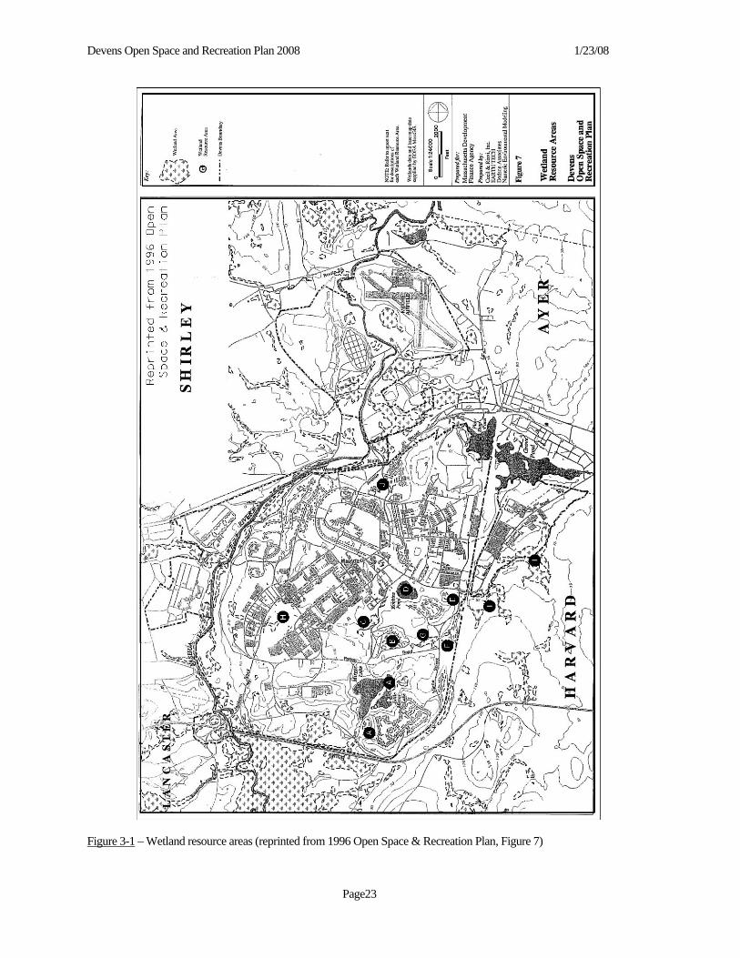
Devens Open Space and Recreation Plan 2008 1/23/08
Page23
Figure 3-1 – Wetland resource areas (reprinted from 1996 Open Space & Recreation Plan, Figure 7)

Devens Open Space and Recreation Plan 2008 1/23/08
Page24
D. VEGETATION 1. General Inventory The transformation of the Devens landscape from its early twentieth century agricultural use through its military use to its current developed land areas and forest cover types is the result of land stewardship (i.e.; intensive development) and man-agement practices. Much of Devens was formerly farmland, with an interspersion of pasture, woodlots, orchards, and some cropped fields, as was typical of New England. Much of Devens is basically old fields farmed until about 1940, now in various stages of re-growth. The diversity of habitat types in existence today reflects various successional stages of aban-doned agricultural land reverting back toward a forested state. A 1991 Floristic Study of Fort Devens by Hunt and Zaremba (in Survey and Evaluation of Wetlands and Wildlife Habitat, Fort Devens, MA, 1992) concluded that the high species diver-sity on the base, as compared to the north-central Massachusetts region was attributable to the range of soil types which correlate with habitat diversity. The existing vegetation at Devens can be roughly divided into plant communities based on elevation, orientation, and groundwater supply of the land on which the plants are growing. Developed land use types associated with past military occupancy dominate the Main and North Posts. The general land-scape character at Devens is aesthetically pleasing and diverse, affording opportunities for long views, enclosures, buffering, maintained landscape and natural character. Current land use and vegetation patterns convey a sense of open space and low density despite the presence of over seven million square feet of former U.S. Army buildings on the Main and North Posts. The vegetation patterns are typically campus-like with open lawns and specimen trees associated with various building complexes, interspersed with forest areas in varying stages of succession. 2. Wetlands Specialized wetland vegetation maintained by environmental conditions includes the black spruce bog south of Mirror Lake, which is contained in what appears to be a glacial kettle. A bog is a peat-accumulating wetland without a significant inflow or outflow. The plants able to exist in this environment have adapted to waterlogged conditions, highly acidic waters, low nutrient levels and extreme temperatures. Plants can include stunted examples of black spruce and larch that may be very small while at the same time very old, sphagnum, sedges, blueberry, leatherleaf and Labrador tea. Another significant wet-land type is the scrub-shrub swamp at the Ammunition Supply Point. This feature has some characteristics in common with a moated bog with emergent components such as winterberry.
3. Grassland The short grass community on the Shepley’s Hill landfill is prevented from succeeding to woody shrubs and then pioneer tree species by the landfill capping process which creates a thin, droughty soil on top of a layer of impervious material. The landfill’s vegetation needs to be managed if it is to continue to provide benefit to the rare grassland birds31 as grassland-dependent birds require fairly large, minimum contiguous acreage or they will not nest. According to Mr. Thomas Poole, former Natural Resources Officer at Devens RFTA, Spotted Knapweed introduced by vehicles crossing the site and wind-blown seed from adjacent disturbed construction areas threatens the site. The overgrazed character of the land immediately surrounding the Ammunition Supply Post and the nearly complete lack of an understory in the area is due to previous uses. The Consolidated Landfill is a third area on Devens that will develop into a short grass community once an annual mowing regime is established. This area should be monitored given the possibility that its vegetation supports nesting habitat for rare grassland birds. In the area of the former Moore Army Airfield (on the eastern half of the North Post) a short grass community has devel-oped on lands surrounding the old runways and tarmacs. When the Army ceased airfield operations the Massachusetts State Police began using the facility for maintenance, storage and driver training operations. To prevent plants from encroaching on the paved areas and for general safety concerns the army began a biannual mowing operation which MassDevelopment continued after taking ownership of the property. The mowing operations have prevented the area from naturally succeed-ing to woody shrubs and then pioneer tree species. Field observations conducted in the spring of 2007 confirmed the pre-liminary observation made by Hyla Associates, and documented that grasshopper sparrows occur and are presumed to be
31 See below Section 3 E. “Fisheries and Wildlife” for more.

Devens Open Space and Recreation Plan 2008 1/23/08
Page25
breeding on portions of the fromer Moore Army Airfield. 4. Forest Land To the extent that it has not been affected by recent human activity, the existing forest cover over much of Devens is charac-teristic of maturing upland oak-chestnut forest, which is the climax community on the New England coastal plain. There are over 1,500 acres of forestland: 1, 095 acres on the Main Post and 541 acres on the North Post (Fort Devens Disposal and ReUse Environmental Impact Statement, 1994, pg. 4-185 and MassGIS land use datalayer32 1999). Since Devens passed from US Army administration there has been no active forestry management and this hands-off approach is likely for the foreseeable future. The Main and North Posts contain a variety of vegetation types. The US Fish and Wildlife Service (USFWS) has mapped and identified vegetation and cover types on former Fort Devens property33. The USFWS indicates that approximately 36 percent of the area was devoted to forest cover in 1992. Much of the forest cover coincides with the Nashua River floodplain forest and the various stream corridors that course through the site. Approximately 836 acres of this land was transferred to the USFWS for increase of the total acreage of the Oxbow National Wildlife Refuge because it contains habitat and natural resources that have “particular value in carrying out the national migratory bird program.” These areas also provide valuable habitat for area wildlife. Two additional signifi-cant locations of sizeable forest are on a portion of the North Post and the area generally circumscribed from Robbins Pond south to Route 2 and east to the Jackson Road interchange which incorporates the Oxbow Refuge additional acreage and the above noted Nashua River Greenway. Warm, south and west-facing upland forests are dominated by oaks, maples, and limited stands of white pine. The moder-ately dense understory is made up largely of young of the species. This type of community characterizes much of the land surrounding the Ammunition Supply Point except for the bog. On north-facing slopes where the lower sun angle and in-creased exposure to cold winds creates the equivalent of a more northern climate the plant community slowly turns to a maple-beech-birch forest with white and red pines and then a pine-hemlock forest such as on the slopes facing Robbins Pond, the Mirror Lakes Slopes and in the frost pockets on Patch Road Hollow and in the Cold Spring Book System. 5. Rare, Threatened and Endangered Species Approximately 430 acres of the Main and North Posts are designated as “priority habitat for rare and endangered flora and fauna” under the Commonwealth of Massachusetts Endangered Species Act (MESA) (See Appendix A. Figure A-5 “Unique Features Map”). Much of this land is within the Nashua River floodplain and has been transferred to USFWS. The most notable exception is an area of approximately 160 acres in the Environmental Business Zone on the west half of the North Post. Massachusetts protected species are found in five discrete locations on Devens. The largest of these is Mas-sachusetts Natural Heritage and Endangered Species Program (NHESP) Priority Habitat Identification #269 (PH 269), which encompasses nearly the entirety of the North Post minus the Moore Airfield and includes the Nashua River flood-plain south to Hospital Road. A fraction of PH 269 extends beyond the Devens boundary into other parts of Ayer and Shirley. Separate from MESA and the NHESP, in 1993 the U.S. Army Corps of Engineers hired ABB Environmental Services to prepare a Biological and Endangered Species Baseline Study of Fort Devens in order to satisfy a U.S. Army need for sum-marized information on the base’s ecological resources. The 1993 report included mapping of “observed and potential habi-tat of rare and endangered flora and fauna.” There is no known occurrence of federally listed threatened or endangered plant species on the North or Main Posts. There are also no known permanent occupations by federally listed threatened or endangered animal species on the base. There are 11 sites totaling 355 acres identified as flora areas and four sites totaling 285 acres identified as fauna areas. The largest of these ABB Environmental Services identified fauna areas --123 acres -- is on the North Post along the Nashua River within the Oxbow National Wildlife Refuge and also within PH 269 (see above). 32 “Land Use” description at http://www.state.ma.us/mgis/lus.htm 33 Survey and Evaluation of Wetlands & Wildlife Habitat, Fort Devens, MA (Bill Zinni, US Fish & Wildlife Service, 1992).

Devens Open Space and Recreation Plan 2008 1/23/08
Page26
The second largest site ABB Environmental Services identified potential site of rare and endangered flora and fauna habitat (note both flora and fauna) is located on the eastern side of North Post centered along Nonacoicus Brook. It too overlaps with NHESP PH 269. Another ABB Environmental Services identified potential site of rare and endangered flora habitat is also located on the North Post and partially overlaps NHESP PH 284, which is a smaller 31-acre site sandwiched between the eastern boundary of Moore Airfield and the “Greenville” branch rail line. There are three other small and discrete ABB Environmental Services flora sites that overlap with NHESP PH 269 (referred to above) located in the Oxbow NWR on the river’s east side north of Hospital Road. There is yet another such ABB Environmental Services flora site in that area that is centered on the Catecunemaug Brook nears its intersection with the Nashua River. Under contract to MassDevelopment, Hyla Ecological Services, Inc. conducted a Rare Species Survey and Habitat Assessment during 2005 and 2006 for the Environmental Business Zone (EBZ), the MacPherson Road corridor, and Moore Airfield. Hyla conducted surveys for four state-listed rare animal and plant species identified by the Di-vision of Fisheries and Wildlife Natural Heritage and Endangered Species Program (NHESP) as being known from the vicinity of the study areas: Blanding’s turtles (Emydoidea blandingii), wood turtles (Glyptemys insculpta), blue-spotted salamanders (Ambystoma laterale), and wild senna (Senna hebecarpa). Hyla also conducted a survey for the presence of state-listed mussels within the Nashua River and Nonacoicus Brook, a survey for American eels (not state-listed) in the Nashua River, and any additional rare plants that may be present but not previously documented (see Inventory section, below, for summary of findings).
The NHESP Priority Habitat Identification #300 (PH 300) is a 150-acre polygon centered on the former Shepley’s Hill landfill. A small portion of the southeastern section of this Priority Habitat area coincides with an area identified as an ABB Environmental Services flora site. Also on the former Shepley’s Hill landfill and NHESP PH 300 is another ABB Envi-ronmental Services fauna site. The only other ABB Environmental Services fauna site exactly corresponds with the 17-acre NHESP PH 334. Of the last three ABB Environmental Services flora sites, one has been made obsolete given that the site has been built on34; another is the Black Spruce Bog that is encompassed by the Mirror Lake/Eskers Conservation Restric-tion; and, the third site is one which links the Mirror Lake and the “Eskers” areas.
E. FISHERIES AND WILDLIFE 1. Inventory Due to the complexity of habitat types in various successional stages, its location adjacent to the Nashua River and the un-broken-undeveloped South Post, and the amount and distribution of wetland present, Devens supports a high diversity of wildlife and fish species. Virtually all of the common species occurring in north-central Massachusetts are permanent or occasional residents of De-vens. In recent years, due to population trends and movements in New England, some species of wildlife have become more commonly seen and some are taking up residence in the area. It is likely that in addition to the usual species -- such as whitetail deer, turkey, raccoon, porcupine, skunk, red and gray fox, coyote, cottontail, woodchuck, weasel, beaver, fisher, otter, mink, muskrat, opossum, bats, and other smaller creatures35 -- the occasional bobcat, black bear and moose may wan-der through Devens. Young males of both bear and moose in search of new territory to occupy come primarily from the north and west via suit-able habitat on protected public and private lands that serve as open space corridors, and they often travel along power lines. There have been sightings of such “charismatic megafauna” in all the Devens host towns.
34 Though this is an ABB Environmental Services identified site and not a NHESP habitat site, it might be noted that if it were a habitat site, MA NHESP should have been notified of any development activities prior to their commencement in areas identified as potential habitat for protected species. 35 All of these animals (including bobcat, but not bear and moose) were photo-documented on the Oxbow NWR by Ron McAdow. His “Wildlife Trails Education Project” publishes photographs taken with automatically triggered weatherproof cameras positioned along wildlife trails at several locations in the Oxbow NWR (see the photos on-line at http://wtep.org/ WTEPdata/Frames/ND/Oxbow.frames.htm).

Devens Open Space and Recreation Plan 2008 1/23/08
Page27
Deer populations are known to be on the rise throughout the Commonwealth, and there is concern that there will be a possi-ble overpopulation problem in the next few years. The USFWS-administered Oxbow Refuge is the home to scores of bea-ver colonies. Beavers deserve special mention for their ability to modify habitat and increase diversity in the form of shal-low open water ponds and marsh, thus creating habitat for many other species. Signs of beaver – riverbank and freestanding lodges and gnawed trees and branches -- are located throughout Devens, notably near the various ponds, streams and wet-lands. The MassWildlife’s Department of Fish and Game annually stocks Mirror Lake with trout. The Main Stem Nashua River supports an abundance of fish species associated with warm water fisheries such as largemouth bass, smallmouth bass, chain pickerel, golden shiner, white sucker, bullhead, and perch. Large woody debris is common in the river and forms im-portant habitat features that provide shade for fish, perching places for birds, and resting areas for turtles. Several oxbows on the Main Stem offer habitat for waterfowl and mammals. Kingfishers, great blue and green-backed herons, beavers, and muskrat are common along the waterway; mink and river otter have also been seen. Waterfowl such as Canada geese, teal, merganser, wood duck, black duck, and mallard are evident. According to the Survey and Evaluation of Wetlands and Wildlife Habitat, Fort Devens, MA (Bill Zinni, US Fish & Wild-life Service, 1992), the Fort Devens Disposal and ReUse Environmental Impact Statement (U.S. Department of the Army, 1994), and Biological and Endangered Species Baseline Study of Fort Devens (ABB Environmental Services, 1993) ap-proximately 18 species of reptiles and 13 species of amphibians are said to utilize upland and wetland habitats at Devens (including South Post). Although many of these species are generally associated with wetlands, one should note that most require both wetland and surrounding upland habitats for various parts of their life-cycles. According to BioMap: Guiding land conservation for biodiversity in Massachusetts (Commonwealth of Massachusetts Division of Fisheries & Wildlife Natural Heritage and Endangered Species Program Species, 2001) and Vernal Pool Habi-tat Survey Jackson Technology Park and North Post, Devens, MA (Oxbow Associates Inc., May 2001) examples of species that depend on Devens’s wetlands to breed, but inhabit the undeveloped surrounding upland habitats for part of the year, are spotted and blue-spotted salamanders (a state species of special concern), American toads, wood frogs and pickerel frogs. Examples of species that inhabit open water bodies or wetlands (particularly in river or streamside habitats), but require the use of undeveloped surrounding upland habitat for nesting activities, are snapping, spotted (a state species of special concern as of April 2006), painted and Blanding’s turtles (a threatened species protected by the state). Spotted and Blandings turtles also utilize vernal pool habitats. Wood turtles (a state species of special concern) are found in fields, forests and alongside roads during daylight hours, returning to slow moving streams in late summer to mate and overwinter. Blanding’s turtles are of particular importance at Devens36. The Blanding’s turtle almost invariably nests from 300 to 3,000 feet (over 1 kilometer) from their home marsh in well-drained, open sandy upland. Oxbow Associates Inc.’s May 25, 2001 Vernal Pool Habitat Survey, Devens, MA identified the ASP Bog as “potential Blanding’s and spotted turtle habitat” (pg. 11) as well as three potential vernal pools with blue-spotted salamanders. Oxbow Associates has previously documented37 Blanding’s turtles in the Sewage Treatment Plant pond on the North Post adjacent to the Nashua River. Investigations are ongoing to identify and certify vernal pools on Devens. 38 Shepley's Hill is a closed solid waste landfill that was part of the "Superfund" process at Fort Devens. It has been capped with an impermeable liner and the area is vegetated with short grasses. Two species of note have been seen in the grassy area: the Grasshopper Sparrow and the Savannah Sparrow. The Grasshopper Sparrow is a threatened species and numbers of the Savannah Sparrow, a species of special concern, have been reported to be in decline. Also, Upland Sandpipers,
36 There is a Blanding’s turtle breeding area on the Oxbow National Wildlife Refuge south of Route 2. 37 per. comm.., May 18, 2005. 38 The MA Natural Heritage and Endangered Species Program generally protects breeding habitat (emergent marshes, shrub swamps, flood plain wetlands, and vernal pools) as well as a 1,000-foot radius from the edge of the breeding habitat. As with many species, for the species long-term protection (that is to maintain the longevity of any breeding population) the value of large unfragmented undeveloped areas contiguous with the breeding habitat outweighs exponentially that of an equal area of disjunct refugia spread among suburban environs.

Devens Open Space and Recreation Plan 2008 1/23/08
Page28
which are listed as endangered by the MA NHESP, have in the past been observed on the landfill during their nesting sea-son. The landfill should be managed according to the Superfund Record of Decision. It is recommended that MassDevel-opment work with the Army's Natural Resources Officer to determine appropriate mowing schedules -- specifics to be de-terminded -- however, the Army has ultimate jurisdiction over the area. It may be noted that Jeff Collins at Massachusetts Audubon Society’s Ecological Extension Service believes that Moore Airfield on the North Post may also offer habitat for grassland nesting birds and small prey species. Additionally, the wide, low area southwest of the Moore Army airfield is also identified as a MA NHESP Priority Habitat site (PH 284) for four listed species. Under contract to MassDevelopment, Hyla Ecological Services, Inc. conducted a Rare Species Survey and Habitat Assessment during 2005 and 2006 for the Environmental Business Zone (EBZ), the MacPherson Road corridor, and Moore Airfield.
Hyla conducted surveys for four state-listed rare animal and plant species identified by the Division of Fisheries and Wildlife Natural Heritage and Endangered Species Program (NHESP) as being known from the vicinity of the study areas: Blanding’s turtles (Emydoidea blandingii), wood turtles (Glyptemys insculpta), blue-spotted salamanders (Ambystoma laterale), and wild senna (Senna hebecarpa). Hyla also conducted a survey for the presence of state-listed mussels within the Nashua River and Nonacoicus Brook, a survey for American eels (not state-listed) in the Nashua River, and any additional rare plants that may be present but not previously documented.
Hyla captured nine Blanding’s turtles and three wood turtles. Two Blanding’s turtles that were captured in a previ-ous survey were included, bringing the total number of Blanding’s turtles surveyed to eleven. Hyla captured adult blue-spotted salamanders in twelve pools within and in proximity to the MacPherson Road Corridor and in four pools in the EBZ. Hyla documented almost 400 amphibians of nine species crossing or road-killed along MacPher-son Road, 40 of which (10 percent) were blue-spotted salamanders.
In the Nashua River alongside MacPherson Road, mussel surveys yielded one state-listed mussel, the triangle floater (Alasmidonta undulata), and the American eel was detected. Hyla discovered a new population and confirmed the continued existence of a previously known population of wild senna in two areas of the MacPherson Road Corridor. A small population of a previously unknown rare plant, Houghton’s flatsedge (Cyperus houghtonii), was discovered in the EBZ.
During the course of the survey Hyla encountered four state-listed wildlife species not previously known from the area including one bird: the grasshopper sparrow (Ammodramus savannarum) in Moore Airfield, and two dragon-flies: zebra clubtail (Stylurus scudderi) and arrow clubtail (Stylurus spiniceps) along the Nashua River. Hyla identi-fied five new vernal pools which meet the criteria for certification by the Natural Heritage & Endangered Species Program (NHESP).
2. Vernal Pools39 Vernal pools, under Massachusetts regulations, are defined as confined basin depressions which in most years hold water for a minimum of two continuous months during spring and/or summer and are free of fish populations. These areas are essential breeding habitat, and provide other important habitat functions during non-breeding seasons, for a variety of am-phibian species, including wood frog, and a number of salamanders. Known potential and certified vernal pools are shown on Figure A-5, “Surface Water Features Map”. In addition to the potential vernal pools noted above, two other areas were seen during field visits in 2004 that might poten-tially be classified as vernal pools. The first area is immediately south of the access road surrounding the Ammunition Sup-ply Point. This area appears to be small and isolated. It is vegetated primarily with shrubs and herbaceous growth. The second area is immediately north of Patton Road and appears to be isolated. This area is primarily vegetated with shrubs and is surrounded by upland forest. Indications are that the area does pond water for some period of time. It is uncertain whether water ponds in either area for the required duration to be considered a vernal pool.
39 Also see related information on vernal pools in above Section 3. C. “Water Resources”.

Devens Open Space and Recreation Plan 2008 1/23/08
Page29
Oxbow Associates Inc. conducted a vernal pool habitat evaluation of a portion of Jackson Technology Park and approxi-mately 100 acres of the North Post (Vernal Pool Habitat Survey, Devens, MA, May 25, 2001). The objectives of the evalua-tion were to determine the locations and status of vernal pools and to record the presence/abundance of obligate and faculta-tive vernal pool species a well as noting specific habitat features within the survey area that were suggestive of the presence of state listed rare and endangered wildlife (pg.1). See Section 3 E. “Fisheries & Wildlife” regarding Survey findings. Since this was not a definitive study it is possible that not every North Post vernal pool was identified. The Hyla Ecological Services study referenced above identified twelve (12) vernal pools in the Environmental Business Zone (5 of the pools met the criteria for certification by NHESP). Valuable areas for nesting, foraging and over-wintering were also identified in the report. Additional studies are to be completed over the next couple of years as part of the project to re-construct MacPherson Road in Ayer and as part of on-going discussions regarding appropriate levels of development off Walker Road in Shirley. Three other vernal pools on Devens have also been certified by NHESP – one north of Barnum Road on the east side of the railroad tracks (CVP #3568) and a small grouping of pools near the top of Sheply’s Hill (CVP #3569) and a group of pools in the Environmental Business Zone. 3. Corridors for Wildlife Migration "Landscape Ecology" is a relatively new scientific field that provides useful ways to understand how different parts of a town or region, built and not built, are related to one another. In the framework of landscape ecology, a landscape is a mo-saic of repeating land uses, spatial elements, or local ecosystems. The landscape mosaic is made up of natural systems and human land uses and is entirely composed of three types of elements: 1) Patch - a relatively homogeneous area, such as a woodlot or a subdivision; 2) Corridor - a strip of land that differs from the land on both sides and links patches, such as a road or a stream; 3) Matrix - the background ecosystem or land use type in a landscape, such as suburban development or forest. Areas of Critical Environmental Concern (ACEC) are places in Massachusetts that receive special recognition because of the quality, uniqueness, and significance of their natural and cultural resources. The recently designated Squannassit and Petapawag40 ACECs documented wildlife corridors in the 11-town focus area of Ashby, Ayer, Dunstable, Groton, Harvard, Lancaster, Lunenburg, Pepperell, Shirley, Townsend, and Tyngsboro. The central themes for the Squannassit ACEC are its noteworthy high quality water resources, the protection of its basic ecological system, and the creation of wildlife corridors to link fragmented habitats. It was demonstrated that one of the region’s most significant wildlife corridors is the entire 63,000-acre Nashua River greenway41. Indeed, the 36,480 acres Squannassit ACEC -- which includes the Devens North Post area (with the exception of the Moore Airfield) and the area on Devens administered by USFWS as part of the Oxbow Refuge -- was so defined in order to pro-vide a boundary connection to the Central Nashua River Valley ACEC. The Central Nashua River Valley ACEC -- desig-nated on January 29, 1996 -- is approximately 12,900 acres in size and is located in Bolton, Harvard, Leominster, and Lan-caster (in which lies the vast majority of the acreage). The 4,830 acres of the South Post of former Fort Devens is its single greatest open space resource (though it is not open to the public). Adjacent to the South Post is the 711 acres of the Oxbow National Wildlife Refuge (not including the more recent addition of 836 acres on the North and Main Posts) composed of freshwater wetlands and associated uplands located along the Nashua River floodplain. The Refuge is managed primarily for migratory bird, and the wetlands and tributaries are federally listed as priority wetlands due to their importance to the Atlantic Flyway for migrating birds42. The heart and central resource feature of both the Central Nashua River Valley and the Squannassit ACECs is the Nashua 40 On December 24, 2002, the Commonwealth’s Department of Environmental Management -- since renamed Department of Conservation and Recreation -- officially designated these ACECs. ACEC designation requires greater environmental review of certain kinds of proposed development that meet thresholds for state jurisdiction. 41 It might be noted that given their linear character, river “greenway” corridors lack interior forest characteristics. 42 Federal listing as a priority for protection is also under the North American Waterfowl Management Plan and the Emer-gency Wetlands Resources Act of 1986.

Devens Open Space and Recreation Plan 2008 1/23/08
Page30
River riparian corridor. The connectivity of the two ACECs via the Nashua River provides significant linkages between important wildlife areas. Indeed, when one includes MassWildlife’s Bolton Flats Wildlife Management Area (923 acres located in Lancaster, Harvard, and Bolton) the amount of open space along the Nashua River creates what could be the larg-est, least human-impacted habitat in the entire 530 square mile watershed43. According to a report by Mass Audubon Soci-ety’s Ecological Extension Service entitled Focus Areas for Wildlife Habitat Protection in the Nashua River Watershed44: “Even with military training in the South Post, the lack of buildings, low traffic, and periodic nature of human presence on the property mean that animals move relatively unmolested across this landscape. Tracks of bobcat, black bear, and moose have been recorded within this focus area. Bobcats are particularly sensitive to human disturbance and their presence in an area is a very strong indicator of high quality habitat.” (2000, pg. 15) There are several precise locations on Devens where wildlife migration is critical. At Devens’s south boundary, Route 2 creates a barrier to wildlife passage. Below the bridge carrying Route 2 over the Nashua River, just east of the Jackson Road interchange, is one of the few locations for wildlife to cross the barrier created by the highway. Tim Prior, former Oxbow Refuge Manager, indicated that most species, great and small, are indeed utilizing this key passageway. A second, possibly equally important passage is by the railroad underpass just east of the Nashua River bridge at the northern end of the Oxbow NWR tank road. In addition, the land off Walker Road in Shirley known as the Environmental Business Zone (EBZ) also provides a wildlife corridor from Shirley Town Land to the Oxbow NWR, including lands along the Nashua River. Additionally, wildlife (particularly salamanders and turtles) utilize migration corridors within the property. Bishop and MacPherson Roads lie within wildlife movement corridors and present a hazard to wildlife including salamanders, frogs, and turtles. Potential upgrade of these roads could include designs that could help reduce this hazard while providing safe means for small animals to cross under the roads. MassDevelopment is working with representatives of MA Fish and Wildlife, U.S. Fish and Wildlife Service and MA NHESP to conduct extensive investigations to gather information which will be used in preparing design alternatives for this road upgrade project. There are many intact chain link fences on Devens, most often at its perimeter. These fences are definite barriers to unim-peded larger wildlife movement45 and, consequently, they ought to be considered for removal where feasible. One example of such fencing is at the Nonacoicus Brook wetland on the North Post south of and adjacent to the Ayer Wastewater Treat-ment Plant and north of the rail line: here the upland forest is fenced off from the wetlands. A GIS datalayer of fences avail-able from MassDevelopment’s Engineering Department can be effectively utilized to identify the longest stretches of fenc-ing on Devens.
F. SCENIC RESOURCES & UNIQUE ENVIRONMENTS 1. State Designated Scenic Landscapes Devens is located in the eastern portion of the Central Upgrade region of Massachusetts. This region is characterized by numerous, irregularly shaped granite hills, plains, and glacial features known as monadnocks. Post-agricultural forests are interspersed with wetland areas, lakes, ponds, rivers, and streams in the region. Many of the larger population centers are 19th century mill towns built on the rivers. While some villages have retained their pre-industrial character, many scenic areas have been affected by unplanned development. During the past one hundred years as land use in the basin has shifted
43 The Nashua River Watershed Association has long described Devens as the heart of the extensive Nashua River Green-way or conservation corridor. 44 This purpose of this 2000Massachusetts Audubon Society report was to identify a framework for the Nashua River wa-tershed that will provide reserve areas for wildlife and corridors or connectors that allow wildlife to travel safely between the reserve areas. The report identified three categories of habitat: 1) Large Focus Areas (or habitat patches) that have over 7,000 acres with a large amount of "interior" habitat, that is, lands with very few or no roads that have experienced very little human impact, provide habitat for species that are very sensitive to human contact, and provide a diversity of plant habitats; 2) Medium-Sized Focus Areas that have less interior habitat but still offer conditions for a broad range of plants and animals and natural communities; and, 3) Small Focus Areas and Connectors that provide habitat for smaller animals and allow ani-mals to travel between the Large and Medium Focus Areas. 45 Creatures smaller than a turtle such as snakes, frogs and salamanders could pass through.

Devens Open Space and Recreation Plan 2008 1/23/08
Page31
from agriculturally based activities to residential and industrial uses the landscape and ecology of Devens has changed dra-matically. The area surrounding Devens includes orchards, farmland, and open, rolling scenery. Higher ground provides vistas to the west and the northwest. The visual resources of Massachusetts have been analyzed in the "Massachusetts Landscape Inven-tory, A Survey of the Commonwealth's Scenic Areas" published in 1983 (MA Department of Environmental Management, 1983). The survey is based on the subjective opinions of professionals guided by a series of objective factors. The entire Commonwealth was subject to the study, which identified the best landscapes greater than one square mile in area. Two classes of particular scenic quality were developed: "distinctive" and "noteworthy." Distinctive landscapes, the areas of highest visual quality, make up about 4 percent of the Commonwealth. Noteworthy landscapes (about 5 percent of the Commonwealth) are areas of lesser, but nevertheless important, visual quality. Scenic landscapes of distinctive and note-worthy visual quality make up a relatively high proportion of the area around Devens particularly in Harvard -- compared to the average distribution of scenic areas within the Commonwealth -- but within Devens itself, the survey identified just two areas. One of these is in the southeastern most section and the other is in the eastern half of the Barnum Road area. Representative of the visual environment is the view from Prospect Hill in Harvard, near the Fruitlands Museums, a Na-tional Historic Site. Extending to the north from approximately one mile north of the installation, a series of scenic areas are identified both surrounding and to the south of Groton town center. Immediately to the east and south of the installation, a number of scenic areas are identified, primarily centered on Harvard but also extending into Littleton and Boxborough. The scenic areas continue to the southwest into Lancaster and Sterling, and a small section on the southeastern perimeter of South Post is itself delineated as a scenic area. Additional scenic areas are found to the south in Bolton and Berlin. To the northwest of Devens, the area around the Shirley town center is designated as scenic, as are areas farther to the west in Lu-nenburg and Leominster. 2. Cultural, Archeological and Historic Areas As part of the Base Closure and Disposition environmental review, the Army conducted an investigation of potential his-toric and archaeological resources at Devens. This established that, in addition to the Fort Devens Historic District, which is listed on the National Register and includes the Parade Ground and surrounding properties, the areas and structures de-scribed below on the Main and North Posts were eligible for listing on the National Register of Historic Places. The former Civilian Military Training Camp consisted of 33 structures and was located north of Robbins Pond. In 2000, MassDevelopment petitioned Massachusetts Historical Commission to demolish all but 3 of the buildings to allow redevel-opment of the site. The three buildings retained have been set aside for use by the Devens Historic Museum. The Red Cross Building and Garage are two structures located to the southeast of the Parade Ground that contribute to the Fort De-vens Historic District, which is located on the National Register of Historic Places. The cemetery is located in part on the Patton Road corridor on land retained by the Army. For a complete listing of areas eligible for National Historic Status, please see the Historic and Prehistoric Reconnaissance Survey of Fort Devens (Main Post, North Post, South Post) Massa-chusetts submitted to the Dept. of the Army by The Public Archaeology Laboratory Inc. dated August 1989. 3. Unique Environments and Recreational Assets Unique environments and other important resource areas include the Shepley’s Hill, Shepley's Hill landfill and the North Post. The landfill has been capped with an impermeable liner and the area is vegetated with short grasses. Note: The land-fill is Army property, owned and operated now and for the foreseeable future under guidance from MA DEP and US EPA. The North Post contains several apparent areas of significant sensitivity. These sites include a number of areas that are sus-pected to include potential vernal pools as yet to be certified. Of particular note are areas immediately south of the wastewa-ter treatment plant, areas west of the Nashua River near the bridge that accesses the treatment plant, an area south of the airfield immediately north of Bishop Road, and an area east of the airfield near the Boston and Maine Railroad. Other areas of note are significant wetlands south of Bishop Road and south of the treatment plant, wetlands and floodplains associated with the Nashua River east and west of the treatment plant and airfield, respectively, and rare plant species and significant plant communities east and southeast of the airfield. Mirror Lake is a popular destination for swimming, fishing, non-motorized boating and hiking. Due to its clear and rela-tively deep (maximum depth of 80 feet) waters, clean sandy beach, forested shoreline, trail system, and permanently pro-

Devens Open Space and Recreation Plan 2008 1/23/08
Page32
tected natural setting, it offers unique recreational opportunities. Rogers Field -- considered the “crown jewel” of Devens and located in the center of the Historic District -- offers unique opportunities for large open playing fields that are difficult to replace elsewhere. More can be found about the above areas in other sections of this Plan.
G. ENVIRONMENTAL CHALLENGES The underlying natural landscape has been modified over centuries by human alteration. Natural resources at Devens are being managed under the Devens bylaws and regulations; a water resources protection plan; a stormwater management plan; an open space and recreation plan; a trails plan; spill prevention, control, and countermeasures plans; Zone II delinea-tions and protection measures; wetland protection measures; and conservation restrictions. 1. Areas of Contamination and Superfund Sites In 1985, in connection with an application for a Resource Conservation and Recovery Act Part B Permit for hazardous waste storage, Fort Devens inventoried waste management areas with potential for release of hazardous materials to the environment. The RCRA permit, issued in 1986, listed 40 sites requiring action. Six sites were added soon thereafter. In 1988, an environmental assessment was conducted of the initial 40 sites. In 1989, Fort Devens was designated a Superfund Site, meaning that under the federal Comprehensive Environmental Response, Compensation, and Liability Act (CERCLA) it is required to clean up contaminated sites that pose threats to human health and the environment. A team that includes representatives of the Army, the U.S. Environmental Protection Agency, and the Massachusetts Department of Environ-mental Protection (DEP) manages CERCLA remediation efforts. MassDevelopment also works closely with the team. A 1991 U.S. Army plan was released that identified 58 sites for response action. Ongoing investigations and response ac-tions now include 76 sites, and additional base-wide investigations for occurrences of lead paint, asbestos, underground storage tanks and the like. MassDevelopment under the Massachusetts Contingency Plan (MCP), also known as DEP’s 21E Program, is cleaning up additional sites containing petroleum-contaminated soils. Many of the clean-up goals have been achieved. Three hundred and twenty-four (324) CERCLA sites had been identified for environmental investigation at Devens. Of these, over 90 percent have been recommended for No Further Action status. Remediation efforts are still ongoing at several sites, including the former Moore Army Airfield, Shepley’s Hill Landfill, Barnum Road, and at sites containing pesticide-contaminated soils. Investigations were recently completed at Grove Pond, and plans are being developed for investigations in the vicinity of Plow Shop Pond.46 Elevated levels of metals within Grove Pond and Plow Shop Pond have resulted in restrictions on fishing and other uses. Contamination has been found in Cold Spring Brook, presumably from leachate from a former adjacent landfill. The Consolidation Landfill was completed in December 2002. More than 340,000 tons of construction and demolition debris from six not permitted historical Devens landfills were excavated and removed to this site. The landfill was con-structed as a CERCLA remedy for Devens’s historical solid waste but was sited and permitted using DEP solid waste regu-lations. The cost of the remedy was in excess of $24 million. Long-term monitoring plans (LTMPs) for groundwater are in effect or are under development for the following sites: She-pley’s Hill Landfill; West Rail Area; South Post Impact Area; Army Enclave property; Parker Charter School site; Barnum Road; and the former Moore Airfield-North Post. An LTMP has not yet been developed for the Airfield but will be pre-pared at a later stage in the remediation process. A monitoring plan also will be developed for the Consolidation Landfill. The Army holds monthly Restoration Advisory Board meetings for public participation in CERCLA clean-up activities, and MassDevelopment holds bi-annual public meetings to discuss MCP clean-up activities. 2. Non-point Source Pollution
46 A list of active Superfund clean-up sites can be found on the Internet at www.devens.army.mil/staff/brac/site_status.htm.

Devens Open Space and Recreation Plan 2008 1/23/08
Page33
Non-point source pollution, also known as polluted runoff, is the single largest source of water pollution nationwide. Pol-luted runoff is the result of rain or melting snow carrying pollutants or sediments from the land to the water. Polluted runoff results in water pollution from land-disturbing activities including agriculture, forestry, mining and urban-type development. According to the Center for Watershed Protection’s Rapid Watershed Assessment Handbook protocol, an area with less than 10 percent (8 – 12 percent) impervious surfaces is considered “partially threatened; less than 8 percent is considered “sensitive” or what one would say is a “relatively pristine environment;” 12 – 20 percent is considered “threatened”; and more than 20 percent is considered “non-supporting” or urbanized. Surface waters within the Main Post of Devens have been impacted to different degrees and in different ways by human activity. Impacts are manifested primarily as increased levels of eutrophication -- that is the process of lake aging often in-volving an overgrowth of algae and weeds -- within impoundments and secondarily as increased sedimentation rates and possible bacterial and toxics contamination of streams and impoundments. These impacts are due to alteration of natural hydrologic regimes, enhancement of pathways for the transport of pollutants to surface waters and addition of new pollutant sources. In this way, additional unmanaged development of Devens lands could have potential negative impacts to water quality. Urbanized land on Devens consists of a combination of housing, offices and administrative buildings, military equipment service and storage areas, paved and dirt parking lots, grass lawns, a golf course and a network of paved roadways. Due to normal day-to-day activities within these land areas, numerous potential sources of conventional pollutants and toxics exist. These pollutants may include: human and animal waste, detergents, oil and grease, fertilizers, hydrocarbons, heavy metals and pesticides. Metals, hydrocarbons, salts, and sediments are the contaminants most commonly transported in stormwater runoff from roads. If inadequately controlled and/or disposed of, these pollutants may be transported via runoff and/or groundwater to surface waters within the watershed. Erosion of sediments from exposed soil surfaces and the siltation of downgradient water bodies may potentially result in short-term or cumulative water quality impacts. The transport of sedi-ments to water bodies results in increased suspended solid concentrations within the water column of receiving waters.47 The primary impact of past development within the Main Post of Devens has been the eutrophication of surface waters to varying degrees. For example, Robbins Pond has been significantly impacted by algal nutrient inputs from its urbanized watershed. In contrast, Mirror Lake and Little Mirror Lake, which drain primarily forested and lightly developed water-sheds, appear to have been only slightly impacted. Levels of eutrophication within lakes and other fresh surface waters are controlled primarily by the availability of phosphorus for algal growth. Development regulations at Devens require all sites to be considered ‘Green Field” sites for the purposes of calculating the impact of development and designing stormwater management systems. MassDevelopment has been implementing a stormwater management program to address the impacts of runoff from roads. Unfortunately, large developed areas of Army lands continue to discharge untreated stormwater runoff into sensitive areas exacerbating pond eutrophication and scouring of land surfaces. Immediately to the north of the North Post is a large automobile recycling business or “auto graveyard” which is less than a 1,000 feet from a highly sensitive environmentasl areas, a high yield aquifer and the Nashua River. While this operation has been in business for many years and there have been no known documented environmental consequences, it is nonetheless worth noting as an area of concern.
47 Impervious land surface development has decreased the amount of rainfall that is stored in natural depressions and/or directly infiltrates into the ground, which is later slowly discharged into tributary surface waters via the regional groundwa-ter. As a result, larger volumes of runoff are transported more rapidly than under natural conditions, with little storage or attenuation, through the stormwater drainage piping networks. Generally, filtration, biological uptake, and biochemical degradation in on-site wetlands -- and increasingly in newly engineered stormwater detention basins -- provides the majority of stormwater treatment and protection of existing surface waters.
Devens Open Space and Recreation Plan 2008 1/23/08
Page34
SECTION 4 - INVENTORY OF LANDS OF CONSERVATION AND RECREATION INTEREST
A. PRIORITY AREAS FOR CONSERVATION Listed below are some of Devens’s existing areas of particular interest to local citizens and stakeholders (see figure 4-1 and table 4-1). Following the lead set in the 1996 Plan these areas are designated as preservation or conservation areas. Preser-vation designation denotes "Highly Sensitive Areas requiring a high degree of protection." For the Devens Open Space and Recreation Plan, Preservation areas constitute unique or unusual environments that would be subject to fundamental change or degradation if not protected. This may include steep and fragile land features such as intact glacial eskers, and geological and biological environments such as special wetlands, bogs, or other features. While not precluding some recreation in these areas, such recreation would be generally limited and designed to be passive and without impact on the health of the envi-ronment. Conservation designates areas that are "moderately sensitive, and may include those with managed woodlands, water resources, wildlife habitat, and agricultural resources. Opportunities for dispersed recreation are provided within this zone." For the Devens Open Space and Recreation Plan, Conservation areas constitute environments that should retain a natural condition, whether it be wetland, woodland, or grassland. Active and passive recreation may be planned in such an area. Typical uses appropriate for areas classified under this category include hiking trails, biking trails, swimming, boating, canoeing, picnicking, and other activities related to the natural attributes of the area. These areas include: PRESERVATION AREAS: Lower Cold Spring Brook Wetlands (P-1) Location: This area consists of the wetlands within the far eastern portions of the Open Space and Recreation Zone bordered on the east by the town of Harvard and buffered to the west by Open Space and Recreation Zone woodlands and sloped edges. Description: This area is part of the wetland system connected to the Cold Spring Brook. The area is low-lying and thickly vegetated with plant material adapted to the seasonal variations of surface water. It has been noted as a high quality wetland wildlife habitat, and is extensive in both length and width. This area is situated above a protected aquifer, and the adjacent development areas are subject to a ground water runoff control system and other restrictions and improvements consistent with its Zone II designation as a water resource. There have been some incursions into the wetland with fill and causeways in the past, which now offer potential opportunities for the location of trails and viewpoints. Patch Road Wetlands (P-2) Location: This area is a wetland system in the semi-circular valley that runs between the ammunition supply point (ASP) and Robbins Pond. It is bounded on the west by Innovation and Technology Business zone and other Open Space and Rec-reation Zone land to the east. Description: The area consists of a narrow woodland pond and associated wetlands located in a valley surrounded by steep edges. The watershed from this area contributes to the supply of water to Robbins Pond. Much of this area contains open water which appears as a pond, except for periods of low rain fall. Run-off from the surrounding steep landforms and the hollow enclosed by the eskers to the west contribute to this wetland and may play a marginal role in protecting the water quality of Robbins Pond. Ammunition Supply Point (ASP) and Wetlands (P-3) Location: This wetland area lies entirely within the ammunition supply point (ASP); Patton Road abuts the area on the south. Description: The Ammunition Supply Point (or ASP) features an open emergent wetland (also variously described as a bog) of nearly ten acres surrounded on three sides by the Red Tail Golf Course. The ASP is within an open space matrix of high conservation interest, as it is located north of a potential vernal pool and the Mirror Lakes area and east of the Patch Road ekers/ hollow/ wetlands complex and a portion of the ecologically-certified Red Tail Golf Course. It is also located just west of the wetland off Patton Road, which is the headwaters of Cold Spring Brook. Oxbow Associates Inc. identified the ASP Bog as “potential Blanding’s and spotted turtle habitat”48 and this is very likely given the proximity of open wet-
48 Vernal Pool Habitat Survey – Devens, MA, May 25, 2001, pg. 11.

Devens Open Space and Recreation Plan 2008 1/23/08
Page35
land and abundant nearby sandy areas providing nesting habitat. There is bird and wildlife activity in and around this bog. The deed transferring the property from the Army to MassDevelopment identified this area as one of the four areas to be protected by a Conservation Restriction. A deed restriction was placed on the area until a CR could be established. The Eskers (P-4) Location: This upland feature may be a continuation of a larger esker landform to the north and is bounded on the east and south by an Intensive Use recreation zone (I-5) and on the west by an Innovation and Business Technology Development Zone. The distinct esker lies within the Development Zone. Description: Eskers are steeply sloped land formations created as stream beds which ran within ancient glaciers. The esker is densely vegetated with trees and understory vegetation; this cover is important to prevent the slopes from eroding. Eskers are not protected resources under MGL CH 31540. Upper Cold Spring Brook Wetlands (P-5) Location: This area consists of several wetlands south of the intersection of Barnum Road and Patton Road, near the Har-vard border. It is divided by Patton Road. It should be noted that the Cold Spring Brook System is a Study Area under CERCLA. Description: This area consists of the upper reaches of the Cold Spring Brook and its associated wetlands. The two wetland bodies are divided by Patton Road and lie in the flat portion between steeper heavily vegetated adjacent land forms. Mirror Lakes (P-6) Location: This area consists of Mirror Lake, Little Mirror Lake, associated wetlands and the land connecting between the two lakes. This area is surrounded by other open space areas. Abutting the area on the west is the Federal Prison enclave, and to the east is a Special Use Development zone. Mirror Lake is accessed by Mirror Lake Road. Description: Mirror Lake has good water quality which supports a diverse aquatic habitat and shows few signs of environ-mental degradation. Mirror Lake has been operated as a swimming beach on an unrestricted basis for the past 50 years. Mo-torized boats were not permitted on the lake. Parking was accommodated on an open unpaved lot. The Massachusetts De-partment of Environmental Protection recently conducted a tissue study of Mirror Lake fish. They found that all Large-mouth Bass samples contained mercury concentrations exceeding accepted Massachusetts health standards. Therefore, a limited fish advisory regarding consumption of Mirror Lake bass will be issued. The placement of Mirror Lake on the advi-sory list should not be construed as a prohibition against recreational activities on the lake. However, it requires a "good faith" effort to notify the public of the dangers of eating contaminated fish. Between Mirror Lake and Little Mirror Lake is a fairly steep wooded ridge, traversed by a wide unpaved road. Little Mirror Lake has generally good water quality, although there are indications that tannins are accumulating, suggesting its evolution into a future bog. The wetland to the north of Little Mirror Lake is a small scrub/shrub wetland. The Black Spruce Bog (P-7) Location: This area consists of an isolated wetland to the southeast of Mirror Lake surrounded by steeply sloped terrain. It is surrounded by Open Space and Recreation Zone land; a Special Use Development Zone lies to the east. Description: The bog is an ecological formation composed of a vegetated floating mat surrounded by a moat. The edges around the bog are wooded and steep. This environmental feature is very uncommon in the region. CONSERVATION AREAS: Shepley’s Hill (C-1) Location: This area lies along the northern boundary of Devens. The Job Corp center at the site of the former Verbeck Housing Area forms the western boundary and to the east is the Sanitary Landfill. The site is accessed from Antietam Street and Cook Street. Description: The area is a steeply sloped, wooded hill formation ascending approximately 125 feet. This area is of both conservation and recreation interest. It consists of a densely wooded hill with steep slopes abutting densely developed areas and the former Fort Devens landfill. Older oak/hickory forest on dry, sand/gravel soils creates attractive forest understory. Successful land reclamation has turned the former landfill into one of the more scenic areas of the Devens landscape. Winter
Devens Open Space and Recreation Plan 2008 1/23/08
Page36
views are available over surrounding landscape. Views of Shepley's Hill and Plow Shop Pond from the open meadows of the site are restful and attractive. The open, rolling grassy field landscape is reminiscent of the site's historic agricultural use. Shepley’s Hill is zoned open space and is identified as the location of trails that would connect the center of Devens to downtown Ayer and specifically the Nashua River Rail Trail. There is evidence of historic quarrying on the hill as well as a certified vernal pool. Shepley's Hill Landfill (C-2) Location: This area is bordered to the north by the Town of Ayer, to the east by Plow Shop Pond, to the east by the Boston and Maine Railroad Line and to the south by the Rail, Industrial and Trade Related Development zone. Shepley’s Hill is to the west. It is accessed by Cook Street. This area is included in the ongoing Superfund investigation. Description: The site is a flat, capped-over sanitary landfill. Vegetation has started to re-establish itself throughout the area, and low grass and shrub growth in part of the cap has fostered a habitat that is especially suited to several rare bird species. The former landfill land remains under U.S. Army management and the MEPA documents that address its future use call for the site’s vegetation to be managed for the continued benefit of the rare grassland birds that nest there. Grove Pond Area (C-3) Location: This area consists of an isolated Conservation Area bordered on the north by Grove Pond, to the east by a road leading to the Grove Pond Well and to the north and east by the Town of Ayer. Description: This area is vegetated buffer along Grove Pond and the industrial rail section of Devens. This area contains the Grove Pond wellfield, a series of relatively shallow well points along the shore of Grove Pond, which is pumped intermit-tently. Cold Spring Brook System (C-4) Location: This area consists of a connected system of open spaces along Cold Spring Brook. It is bordered on the long northwestern slope by Barnum Road and the Rail, Industrial and Trade Related Development Zone. To the southeast is the Town of Harvard. The southern portions of the system occur in the area of Patton Road and Marne Street. It also extends as a buffer around two wetlands protected under a P-5 Classification. Description: Long noted as a sensitive environmental area, the Cold Spring Brook area encompasses some 65 acres of adja-cent floodplain and flows through and around Devens on to the Town of Ayer property. The brook’s centerline is the boundary between Harvard and the Harvard section of Devens. This riparian zone is seemingly ecologically intact -- de-spite its being adjacent and in close proximity to AOCs #40 and 57 (a former debris dump site and a motor vehicle mainatenace contaminated site) -- given the Army’s remediation of these two AOC’s through debris/contamination excava-tion resulting in the source removal of contaminants. According to MassDevelopment’s Environmental Engineer and the BRAC Environmental Officer (as of April 2006), the Base Closure Team is in the process of defining any requirements that may be necessary to agree to “No Further Action” status at Cold Spring Brook. Although the brook and associated floodplains are bordered to the north by development along Barnum Road and to the south by residential development in Harvard it is extensive enough in itself to function as a wildlife corridor. Indeed, Cold Spring Brook (and Bowers Brook which flows into it) is a BioMap Core area. It might be noted here that the 2001 Barnum Road Master Plan recommended widening the protective buffer zone adjacent to Cold Spring Brook. Buena Vista Area (C-5) Location: This area is in the vicinity of the Buena Vista Housing Area running north to Antietam Street. Description: This area is currently occupied by mixed use structures, parking lots and roads that will be removed. The area will be regraded and redeveloped for use as stormwater detention/retention area. Housing Buffer (C-6) Location: This area consists of a strip of land that forms the southern border of two Residential Development zones and the northern border of two Innovation and Technology Business Development zones. The border runs roughly along El Caney Street, south and then west towards the Nashua River. Description: This area cuts a zig-zag pattern alongside existing roads and across open areas between these new Develop-

Devens Open Space and Recreation Plan 2008 1/23/08
Page37
ment zones. It incorporates existing vegetation. Robbins Pond (C-7) Location: This area is located to the south of Dakota Street and to the west of Patch Road. To the east is an Innovation and Technology Business Development zone. Description: Robbins Pond is a shallow pond experiencing eutrophication. The southern edge of the pond lying within this area is sloped and densely wooded. This pond seems to have no active outlet, and the combined stress of runoff-borne mate-rial contained in runoff and the impact of a substantial population of waterfowl may have contributed to its generally poor water quality. Patch Road Hollow (C-8) Location: This area is situated along the bottoms of a short valley located near Robbins Pond. The area is located in the vicinity of two wetland bodies to the south (P-3) and the point near where the tributary stream enters a culvert in the vicinity of the western edge of Robbins Pond. Patch Road runs through this area. Description: The area is densely vegetated with steep slopes to the east and west. Ammunition Supply Point (ASP) Ridge (C-9) Location: This area extends along the northern ridge of the ASP area and continues as a buffer around the western and southern edge of the bog and wetland. It is bordered by a Development Zone to the north. Description: This area is comprised of a steep slope into which the bunkers for storing munitions have been constructed. The slopes are vegetated with mature trees, however, the understory and ground cover layers have largely been eliminated by grazing goats. Programmed Uses: The area is a fragile environment which has experienced negative impacts. Due to the steepness and the fragility of this area, it is not recommended for any type of recreational uses along the steep edges leading to the wetland area in the flatlands below. Golf cart links and hiking trails could be located along the northern edge of the ridge. Mirror Lakes Slopes (C-10) Location: This area circles around Mirror and Little Mirror Lakes on all sides except for a portion on the western edge of Mirror Lake. It is bordered on the east by a Special Use Development zone. Description: The area contains moderately and steeply sloped landscape that is thickly vegetated. Mirror Lake Beach (C-11) Location: This area is bounded to the west by Mirror Lake Road, to the east by Mirror Lake and to the south by Conserva-tion Area C-10 Mirror Lake Slopes. Description: The area is relatively flat and vegetated, with some clearings that have been used for a swimming beach and for camping. Southeast Buffer (C-12) Location: This is a linear buffer forming the southeastern border with the Town of Harvard running parallel to the Boston and Maine Railroad. Description: The area is a forested, vegetated buffer strip bordering Devens and the Town of Harvard. The strip is steeply sloped along the Special Use Development zone, and then flattens out to the north. Oak Hill Area (C-13) Location: This area is at an intersection of roads including Hospital Road in the Oak Hill Housing Area. Description: The area is a traffic island large enough in proportion to include vegetation and trail linkages. North Post Buffer Area (C-14) Location: This is a series of buffers around the North Post that form borders with the Towns of Shirley and Ayer.

Devens Open Space and Recreation Plan 2008 1/23/08
Page38
Description: These areas are narrow, isolated vegetated buffer strips bordering between the Town of Ayer and Shirley and the North Post of Devens. The area to the west is currently undeveloped. The two areas to the east are adjacent to the airfield. It is possible, though not yet confirmed, that rare plant species occur in the airfield buffer area.
North Post The largest contiguous area of undeveloped land of interest is the western portion of the North Post: effectively 160 acres excluding the wastewater treatment plant, the land administered by the US Fish and Wildlife Service, and the Moore Air-field. Due to the presence of several rare and threatened wildlife species the North Post is identified as a MA BioMap49 core area; it is also within a more than 1,000-acre MA Natural Heritage and Endangered Species Program Priority Habitat area (PH #269) that stretches the length of the Nashua River from Mulpus Brook to the north to Catacunemaug Brook to the south. There are several vernal pools (either certified or identified and pending certification). Additionally, the Focus Areas for Wildlife Habitat Protection in the Nashua River Watershed (MAS, 2000) identified this same area as a “Habitat Core”. Indeed, the western half of the North Post provides an ecological connection between the Shirley Town Forest and the Oxbow National Wildlife Refuge. Other key natural features are the high and medium yield aquifers that lie beneath the North Post. For all of the above reasons and more, the North Post (with the exception of the Moore Airfield) was nominated and designated as part of the Squannassit Area of Critical Environmental Concern. The Rare Species Survey and Habitat Assessment conducted during 2005 and 2006 (referenced above) documented a number of rare species and vernal pools in the area. Final disposition of this area is to be determined through a cooperative planning process between MassDevelopment and the underlying towns. Surface waters of significance which to date have provisions for permanent protection include the following:
a. Plow Shop Pond Shoreline -- a wooded area providing a buffer between the pond and the adjacent meadows of the former landfill. Trees frame views over the water to Ayer's historic mill buildings. A di-verse pond edge environment provides opportunities for observing wildlife.
b. Robbins Pond -- a small eutrophic pond surrounded by a recreational landscape of lawns, fields, shade trees, roads and buildings.
c. Grove Pond Shoreline -- a wooded area providing a buffer between the pond and the adjacent industrial area. Dense woods with water views create an attractive setting. It might be noted here that the 2001 Barnum Road Master Plan recommended adding more land as open space zoned in order to afford greater protection to Grove Pond and its associated water supply wells.
d. Willow Brook -- an intermittent brook running from Robbins Pond through Devens to Nonacoicus Brook. It is part of the ReUse Plan open space network, and is valuable to wildlife as well as view corri-dor along exit road to Verbeck.
The Mirror Lake area (146 acres including Mirror and Little Mirror Lakes, and a black spruce bog containing uncommon and sensitive wetland habitat meriting special attention) is permanently protected through a Conservation Restriction held by The Trustees of Reservations (TTOR). This same CR also permanently protects 39 acres of glacially-formed ridges known as “The Eskers” located near Queenstown Road and including a portion of the Patton Road wetlands. It has been determined that both these parcels -- as they are referred to in the CR – “contain unusual, unique and outstanding qualities and recreational activities the protection of which will be in the public interest” (pg. 2). These qualities include wildlife, geologic, cultural, educational, wetlands (including vernal pools), water quality (including aquifer and watershed protec-tion), aesthetic, and recreational benefits (such as hiking, biking and swimming). There are several miles of trails on the Mirror Lake parcel, with the potential for more trails in the Eskers parcel. The latter is a likely deeryard and also home to otter and all manner of herpatafauna. Additionally, the Mirror Lake parcel abuts the US Fish and Wildlife Service Oxbow National Wildlife Refuge and serves as an intergral link for the north-south wildlife corridor
49 BioMap: Guiding land conservation for biodiversity in Massachusetts, Commonwealth of Massachusetts Division of Fisheries & Wildlife Natural Heritage and Endangered Species Program Species, 2001.

Devens Open Space and Recreation Plan 2008 1/23/08
Page39
Figure 4-1 Resource & Conservation Areas (Map recompiled based on information provided in 1996 Plan)

Devens Open Space and Recreation Plan 2008 1/23/08
Page40
B. CONSERVATION RESTRICTIONS The deed transferring the property from the Army to MassDevelopment identified four areas to be permanently protected by Conservation Restrictions. A deed restriction was placed on the areas until CR’s could be established (see excerpt be-low).
“C. Conservation Restriction Benefiting the Public 1. The Grantee covenants for itself, its successors, and assigns that it will conserve in perpetuity the natural and
open qualities of those four ( 4 ) portions of the Property described in Exhibit D herein (hereinafter the "Parcels"). The Grantee, its successors, or assigns will not undertake or allow any activity on or use of the Parcels that may adversely affect or detract from the conservation of the natural and open qualities of the Parcels, including, but not limited to, the construction of buildings and structures or significant alteration of the vegetation or hydrology of the Parcels. This re-striction shall run with the land. The parties agree that the Army's ongoing training activities on and the recreational use of Mirror Lake are consistent with the purposes of this conservation restriction.
2. The Grantor, through the U.S. Army Corps of Engineers, New England Division, will release this conservation restriction upon the recordation of a conservation restriction for the Parcels granted by the Grantee in accordance with Sections 31, 32, and 33 of Chapter 184 of the General Laws of Massachusetts, with the written consent of DEP.”
The Mirror Lake Conservation Area (Parcel 2) includes approximately 146 acres encompassing Mirror and Little Mirror Lakes, and a black spruce bog containing uncommon and sensitive wetland habitat meriting special attention). The Conser-vation Restriction is held by The Trustees of Reservations (TTOR). This same CR also permanently protects 39 acres of glacially-formed ridges known as “The Eskers” located near Queenstown Road and including a portion of the Patton Road wetlands (the Esker Conservation Area – Parcel 4). It has been determined that both these parcels -- as they are referred to in the CR – “contain unusual, unique and outstanding qualities and recreational activities the protection of which will be in the public interest” (pg. 2). These qualities include wildlife, geologic, cultural, educational, wetlands (including vernal

Devens Open Space and Recreation Plan 2008 1/23/08
Page41
pools), water quality (including aquifer and watershed protection), aesthetic, and recreational benefits (such as hiking, bik-ing and swimming). There are several miles of trails on the Mirror Lake parcel, with the potential for more trails in the Es-kers parcel. The latter is a likely deeryard and also home to otter and all manner of herpatafauna. Additionally, the Mirror Lake parcel abuts the US Fish and Wildlife Service Oxbow National Wildlife Refuge and serves as an intergral link for the north-south wildlife corridor The area surrounding the ASP Bog (Parcel 3) and Lower Cold Spring Brook (Parcel 1) were also identified in the deed for protection through a CR. One of the major hurdles in finding a CR holder for these parcels has been their history of known and/or suspected contamination. The ASP Bog has subsequently been identified as an area requiring “No Further Action.” There is still an area along Lower Cold Spring Brook which the Army is continuing to monitor and has not yet been trans-ferred to MassDevelopment.
C. AREAS RECOMMENDED FOR PERMANENT PROTECTION
In the years following the adoption of the re-use plan there was significant disagreement surrounding the level of protection that would be placed on various areas which had either been zoned as open space or had been identified as having signifi-cant resource value (see preservation & conservation areas above). Members of the Open Space & Recreation Advisory Committee and other individuals felt that the intent of the reuse plan was that all lands zoned open space should be perma-nently protected as conservation lands subject to Article 97 of the State Constitution. MassDevelopment maintained the opinion that only the most valuable resource areas were intended for permanent protection, that the specific mechanism for protection was not assumed to be "Article 97" and that the remainder of the open space area was to be regulated by zoning and any applicable state environmental regulations . After much discussion it was agreed that, as part of the current Open Space Plan update, MassDevelopment and the DOS-RAC would come to consensus on lands at Devens that would be placed under permanent protection by adoption of conser-vation restrictions, transfer of ownership or some other means that would provide permanent protection consistent with that of “Article 97”. Table 4-1 lists all of the parcels reviewed and the recommended additional levels of protection to be pur-sued. Figure 4-2 shows the relation of the parcels recommended for additional protection versus the preservation & conser-vation areas identified in the 1996 Open Space Plan. The most appropriate mechanism for each area will be determined on a case by case basis. The timetable for protection is dependent upon ability to find suitable mechanism/willing CR holder and availablility of any necessary funds. In the meantime, MassDevelopment does not intend to develop any of these par-cels and will manage the parcels in a manner consistent with their resource value and recommended protection levels. MassDevelopment will consult with the DOSRAC before implementing any significant adjustment of the parcels or revi-sions to the plan.
Final disposition of the North Post area is to be determined through a cooperative planning process between Mass-Development and the underlying towns.

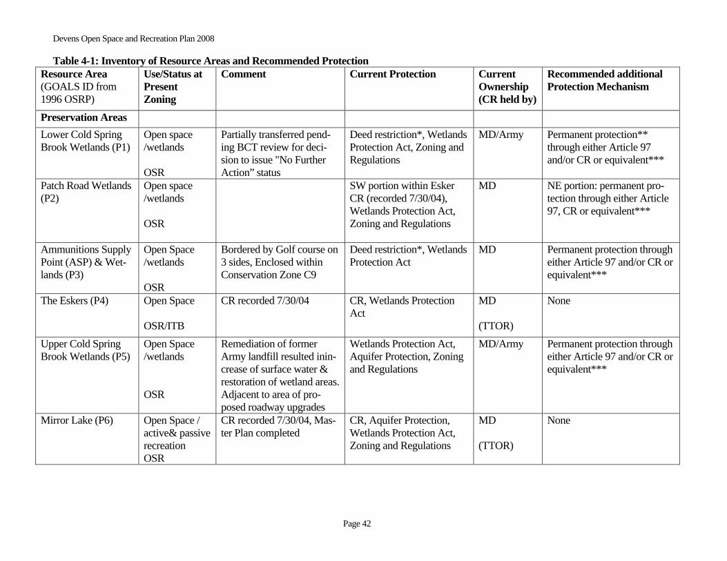
Devens Open Space and Recreation Plan 2008 Table 4-1: Inventory of Resource Areas and Recommended Protection
Page 42
Resource Area (GOALS ID from 1996 OSRP)
Use/Status at Present Zoning
Comment Current Protection Current Ownership (CR held by)
Recommended additional Protection Mechanism
Preservation Areas Lower Cold Spring Brook Wetlands (P1)
Open space /wetlands OSR
Partially transferred pend-ing BCT review for deci-sion to issue "No Further Action” status
Deed restriction*, Wetlands Protection Act, Zoning and Regulations
MD/Army Permanent protection** through either Article 97 and/or CR or equivalent***
Patch Road Wetlands (P2)
Open space /wetlands OSR
SW portion within Esker CR (recorded 7/30/04), Wetlands Protection Act, Zoning and Regulations
MD NE portion: permanent pro-tection through either Article 97, CR or equivalent***
Ammunitions Supply Point (ASP) & Wet-lands (P3)
Open Space /wetlands OSR
Bordered by Golf course on 3 sides, Enclosed within Conservation Zone C9
Deed restriction*, Wetlands Protection Act
MD Permanent protection through either Article 97 and/or CR or equivalent***
The Eskers (P4) Open Space OSR/ITB
CR recorded 7/30/04 CR, Wetlands Protection Act
MD (TTOR)
None
Upper Cold Spring Brook Wetlands (P5)
Open Space /wetlands OSR
Remediation of former Army landfill resulted inin-crease of surface water & restoration of wetland areas. Adjacent to area of pro-posed roadway upgrades
Wetlands Protection Act, Aquifer Protection, Zoning and Regulations
MD/Army Permanent protection through either Article 97 and/or CR or equivalent***
Mirror Lake (P6)
Open Space / active& passive recreation OSR
CR recorded 7/30/04, Mas-ter Plan completed
CR, Aquifer Protection, Wetlands Protection Act, Zoning and Regulations
MD (TTOR)
None

Devens Open Space and Recreation Plan 2008 Table 4-1: Inventory of Resource Areas and Recommended Protection
Page43
Black Spruce Bog (P7)
Open Space / passive recrea-tion OSR
CR recorded 7/30/04 CR, Aquifer Protection, Wetlands Protection Act, Zoning and Regulations
MD (TTOR)
None
Conservation Areas Shepley’s Hill (C1) Open Space /
passive recrea-tion OSR
Potential vernal pool certi-fied 11/28/04
Wetlands Protection Act, Zoning and Regulations
MD Permanent protection through either Article 97 and consider CR or equivalent***
Shepley’s Hill Land-fill (C2)
Open Space OSR
Leased parcel. Landfill originally capped between 1986 & 1992. Pending ad-ditional environmental remediation
N.A. Army If and when remediation ever completed, should be pro-tected and maintained for grassland habitat
Grove Pond Area (C3)
Open Space OSR
Over/adjacent to Ayer/Devens wells
Zone I and II areas, Aquifer Protection, Wetlands Pro-tection Act, Zoning and Regulations
MD Permanent protection through either Article 97 and/or CR or equivalent***
Cold Spring Brook System (C4)
Open Space OSR
Partially transferred pend-ing BCT review for deci-sion to issue "No Further Action” status. Consider joining this polygon with P5 (P1 is within existing DR/proposed CR area)
East of Railroad under deed restriction*, Wetlands Pro-tection Act, Zoning and Regulations, partially in Zone II
MD/Army Permanent protection through either Article 97 and/or CR or equivalent***
Buena Vista Area (C5) Buena Vista Area
Open Space / active & pas-sive recreation
Possible active rec, open space buffer, consider rede-fining/realigning C5 poly-gon boundary and possible
Zoning and Regulations MD None
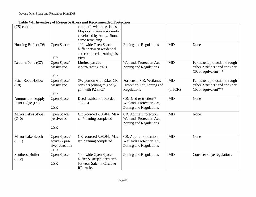
Devens Open Space and Recreation Plan 2008 Table 4-1: Inventory of Resource Areas and Recommended Protection
Page44
(C5) cont’d trade-offs with other lands. Majority of area was densly developed by Army. Some demo remaining
Housing Buffer (C6) Open Space OSR
100’ wide Open Space buffer between residential and commercial zoning dis-tricts
Zoning and Regulations MD None
Robbins Pond (C7) Open Space/ passive rec OSR
Limited passive rec/interactive trails.
Wetlands Protection Act, Zoning and Regulations
MD Permanent protection through either Article 97 and consider CR or equivalent***
Patch Road Hollow (C8)
Open Space/ passive rec OSR
SW portion with Esker CR, consider joining this poly-gon with P2 & C7
Portions in CR, Wetlands Protection Act, Zoning and Regulations
MD (TTOR)
Permanent protection through either Article 97 and consider CR or equivalent***
Ammunition Supply Point Ridge (C9)
Open Space OSR
Deed restriction recorded 7/30/04
CR/Deed restriction**, Wetlands Protection Act, Zoning and Regulations
MD None
Mirror Lakes Slopes (C10)
Open Space/ passive rec OSR
CR recorded 7/30/04. Mas-ter Planning completed
CR, Aquifer Protection, Wetlands Protection Act, Zoning and Regulations
MD None
Mirror Lake Beach (C11)
Open Space / active & pas-sive recreation OSR
CR recorded 7/30/04. Mas-ter Planning completed
CR, Aquifer Protection, Wetlands Protection Act, Zoning and Regulations
MD None
Southeast Buffer (C12)
Open Space OSR
100’ wide Open Space buffer & steep sloped area between Salerno Circle & RR tracks
Zoning and Regulations MD Consider slope regulations

Devens Open Space and Recreation Plan 2008 Table 4-1: Inventory of Resource Areas and Recommended Protection
Page45
Oak Hill Area (C13) Open Space OSR
Additional review antici-pated, buffer to USFWS refuge
Zoning and Regulations MD Consider slope regulations
North Post Buffer Area (C14)
Open Space OSR
100’ wide Open Space buffer between Ayer/Shirley land & devel-opment areas. Pending fu-ture master planning
Zoning and Regulations MD TBD
EBZ (C15) WWTP / Un-developed EBZ
Environmental review in progress (including VP & rare species impact). Pend-ing future master planning
Zoning and Regulations MD Additional levels of protec-tion to be recommended pending completion of envi-ronmental analysis
Grant Road Slopes (C16)
Open Space Residential
Steeply sloped areas along the northwest boundary of the Grant Housing Area have been identified as a significant resource area;
Zoning and Regulations MD Consider for additional levels of protection or restricted use
Road Corridors/ Buffer Areas (C17)
Open Space Continued zoning as open space will create title issues for adjacent property own-ers
Zoning and Regulations
Various Consider overlay district or some other type of protection
Willow Brook (C18) Open Space Wildlife corridor connect-ing Robbins Pond Area with Nonacoicus Brook Area/Recommend daylight-ing of culverted sections as possible.
Zoning and Regulations
MD Permanent protection through either Article 97 and consider CR or equivalent***
Catacumenaug Brook Slopes (C19)
Open Space Steeply sloped areas along Hospital & Lovell Roads
Zoning and Regulations MD Permanent protection through either Article 97 and consider CR or equivalent***

Devens Open Space and Recreation Plan 2008 Table 4-1: Inventory of Resource Areas and Recommended Protection
Page46
* In the deed transferring Devens from the Army to MassDevelopment a restrictive covenant was included (section XI.c) providing intermediate protection of the four areas recom-mended for Conservation Restriction until final transfer of the parcels could be completed and a holder of the CR could be identified. ** CR to be pursued pending final clean up and transfer of the property. *** “Equivalent” here may refer to transfer in fee to a MA Division of Conservation Services approved conservation organization or like entity. Note: The Rivers Protection Act does not apply to Devens because an Environmental Impact Report was unde taken prior to the RPA legislation thus exempting future Devens pro-
jects from regulation. Note: Article 97 protection equates to “municipal conservation area” status. The most appropriate mechanism for each area will be determined on a case by case basis. Timetable for protection is dependent upon ability to find suitable mechanism/willing CR holder and availablility of necessary funds.


Devens Open Space and Recreation Plan 2008 1/23/08
Page 47
Figure 4-2 Recommended Areas for Additional Protection
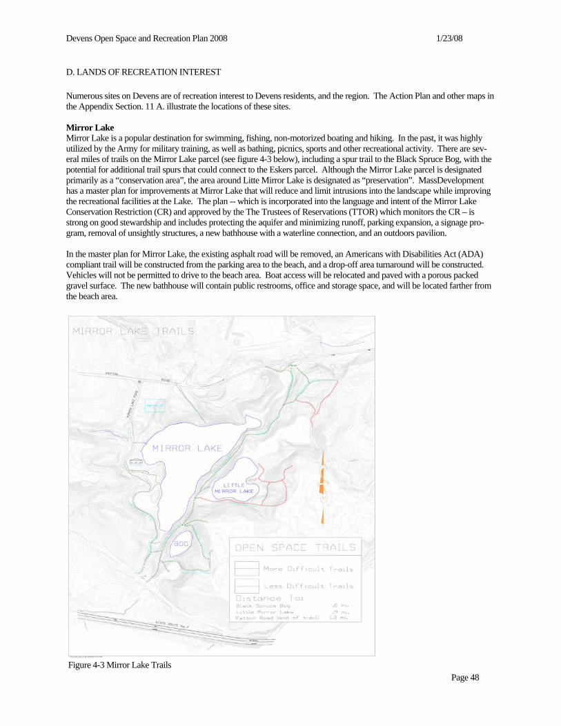
Devens Open Space and Recreation Plan 2008 1/23/08
Page 48
D. LANDS OF RECREATION INTEREST Numerous sites on Devens are of recreation interest to Devens residents, and the region. The Action Plan and other maps in the Appendix Section. 11 A. illustrate the locations of these sites. Mirror Lake Mirror Lake is a popular destination for swimming, fishing, non-motorized boating and hiking. In the past, it was highly utilized by the Army for military training, as well as bathing, picnics, sports and other recreational activity. There are sev-eral miles of trails on the Mirror Lake parcel (see figure 4-3 below), including a spur trail to the Black Spruce Bog, with the potential for additional trail spurs that could connect to the Eskers parcel. Although the Mirror Lake parcel is designated primarily as a “conservation area”, the area around Litte Mirror Lake is designated as “preservation”. MassDevelopment has a master plan for improvements at Mirror Lake that will reduce and limit intrusions into the landscape while improving the recreational facilities at the Lake. The plan -- which is incorporated into the language and intent of the Mirror Lake Conservation Restriction (CR) and approved by the The Trustees of Reservations (TTOR) which monitors the CR – is strong on good stewardship and includes protecting the aquifer and minimizing runoff, parking expansion, a signage pro-gram, removal of unsightly structures, a new bathhouse with a waterline connection, and an outdoors pavilion. In the master plan for Mirror Lake, the existing asphalt road will be removed, an Americans with Disabilities Act (ADA) compliant trail will be constructed from the parking area to the beach, and a drop-off area turnaround will be constructed. Vehicles will not be permitted to drive to the beach area. Boat access will be relocated and paved with a porous packed gravel surface. The new bathhouse will contain public restrooms, office and storage space, and will be located farther from the beach area.
Figure 4-3 Mirror Lake Trails

Devens Open Space and Recreation Plan 2008 1/23/08
Page 49
Robbins Pond This small pond was once the center of attraction for overnight camping facilities offered to Devens Army Personnel. The pond is encircled by a dirt road that has the potential to serve as a passive recreation trail and will be accessible to those with disabilities. An octagonal picnic pavilion provides shelter from the sun and rain. Robbins Pond was listed as a site for a nature park in the Fort Devens Regional Recreation Management Plan (1995). A master plan for Robbins Pond and its surrounding landscape will be created prior to designing Phase III of the Devens Multi-Use Trail Network Plan (see below). Red Tail Golf Course Since the publication of the 1996 Open Space and Recreation Plan, the 18-hole Red Tail Golf Course was developed by private developers opened in the spring of 2002. The 194 acre Golf Course is located on 53 acres of open space and 141 acres of land zoned for development under the ReUse Plan. Development plans were based on compatibility with envi-ronmental factors and landscape. Red Tail Golf Course is an award winning championship course offering the public a 7,400-yard, par 72 course. It flows over rolling wooded hills and meanders among numerous streams and ponds. The golf course architect, Brian Silva, was recently named “Architect of the Year” by Golf World magazine. Red Tail Golf Club is a registered member of the Audubon International Signature Cooperative Sanctuary Program as required by MassDevelop-ment and has received designation as the first Audubon Signature Sanctuary golf course in New England. Multi-Use Trail Network The Devens ReUse Plan and the 1996 Devens Open Space and Recreation Plan both included provisions for a multi-use trail network. The network will provide connections to the regional open space assets and and act as a link between residen-tial neighborhoods, commercial, civic, recreational areas, and open space resources within Devens. The proposed trail sys-tem is designed as a series of expanding loops, intended for use by walkers, bicyclists, joggers, and strollers. Phase I of the trails plan, as currently proposed, will create a continuous loop within the core of Devens connecting existing and proposed housing to the historic district, the downtown business area and active recreation fields. Design of the first phase is compliant with the Americans with Disabilities Act standards for a barrier free environment. The planned align-ment will follow the perimeter of Rogers Field along Buena Vista Street to the Phase II Grant Road housing development. It will then follow West Main Street to Willard Park and Verbeck Gate and from there to the new soccer fields west and south of the Devens Public Works Building, and back to the parking area near the fire station. Phase II, as proposed, will create an outer loop connecting Mirror Lake, the Golf Course, and Robbins Pond to the inner loop of Phase I. The trail will cross Jackson Road and follow Givry Road to Queenstown Street, skirt the landfill and con-tinue along Patton Road towards Mirror Lake. From there it will follow the contour past the old Ammunition Depot and

Devens Open Space and Recreation Plan 2008 1/23/08
Page 50
Figure 4-4 Devens Multi-Use Trail Network Plan (http://www.devensec.com/images/map-openspacetrails.jpg)

Devens Open Space and Recreation Plan 2008 1/23/08
Page 51
continue through the woods past the wetlands and the golf course. Following Patton Road briefly, the trail will then follow an existing wooded trail past wetlands to Robbins Pond, and will finish near the fire station parking lot. Links to the host communties are included in Phase II. A connection to Shirley will be achieved along West Main Street from the corner of Willard Park. A Harvard trail connection is proposed for the railroad underpass between the Red Tail Golf Course and the end of Old Mill Road. An Ayer connection proposal recommends following the fence line on Devens property from Verbeck Gate, east to where West Main Street crosses the railroad. From there a bike lane would need to share the road until it meets the end of the Nashua River Rail Trail in Ayer. Phase III, as proposed, will add additional trail links within Devens. A second connection to Shirley Gate will follow Hos-pital Road. A trail loop through Shepley's Hill landfill will provide views of Plow Shop Pond and its wetlands. An off-road trail loop could be created along Barnum Road and wetlands to the east. The trail could have two alternative routes. Trail routes could provide a link through the natural setting of the southern side of Mirror Lake and the edge of the Oxbow Wild-life Refuge, providing links to existing trails at Mirror Lake. An existing sidewalk along MacArthur Road could be ex-tended to create a trail connection alomg Jackson Road over to Lake George Street and the future parking area adjacent to the US Fish and Wildlife Service property. Finally, Saratoga Boulevard can provide a link between the Phase I inner loop and Barnum Road. Rogers Field Rogers Field is considered the “crown jewel” of Devens and is located in the center of the Historic District. The Rogers Field District is a 44-acre parcel that is bordered by Sherman Avenue, Buena Vista Street, MacArthur Avenue and Elm Road. The Historic Designation provides a secondary level of protection to Rogers Field50. Rogers Field is the primary location for sporting events, community activities and concerts. Phase 1A of the proposed Trails Plan describes a pedes-trian link from Devens Commons (Downtown Devens) to Rogers Field, Hornet Field and Phase 2 housing on Grant Road. Accessibility: Twenty-eight handicapped parking spaces are provided on Buena Vista Street adjacent to Rogers Field. Additional ADA parking is available at Vicksburg Square. Willard Park Willard Park is located at the northern end of Devens and is bordered by Sherman Avenue, Antietam Street, Balls Bluff Road and West Main Street in Ayer. Beginning in 1996 a number of improvements were made to Willard Park including:
• replaced 3 softball backstops • dugout fencing added to 3 fields • upgraded the electrical box servicing the lights for softball field #1 • removed the concrete berm around the football field • removed the football goal posts • eliminated the cinder running track • added softball infield material and “soft touch” softball bases • installed swing gates on Sherman Avenue and Balls Bluff Road to prevent vehicular traffic within Willard Park • erected storage shed for equipment and supplies
Willard Park has no irrigation, and no rest rooms. One ADA portable toilet and a standard unit are provided from April 1 through November 1. Presently, parking is limited to 25 spaces on Antietam Street above the Willard soccer field. Over-flow parking is directed to the P5 parking lot just on the other side of Sherman Ave. A dedicated 100 space parking lot for Willard Park is planned on the former tennis court site on Sherman Avenue. Handicapped parking will be available in the new parking lot.
Fields • Multi-use field. The soccer/multi-use field was formerly an Army football field. In order to increase the length and
width of the field, the old football goal posts were removed along with a dangerous concrete berm that encircled the field. The field now measures 120 yards by 70 yards and has neither lights nor bleachers.
50 per comm. with Peter Lowitt, May 19, 2005.
Devens Open Space and Recreation Plan 2008 1/23/08
Page 52
Note: The slope on the Antietam Street side of the field forms a natural amphitheater and allows for a wonderful view of the field during games.
• Softball Fields. Game/Practice fields:
Field #1: 300 ft outfield fence, no lights, no irrigation. Bleacher seating for 30. During the fall the outfield dou-bles as a flag football field. Field #2: 300 ft outfield fence, lights, no irrigation. Bleacher seating for 30. During the fall the outfield doubles as a flag football field Field #3: 200 ft temporary outfield fence, no lights, no irrigation, no bleachers. During the fall the outfield dou-bles as a flag football field.
Accessibility: ADA parking is addressed in the Willard Master Plan. Temporary ADA parking is permitted within the Park off Sherman Avenue. • Antietam Fields - The Antietam Fields were completed in the fall of 2002 and act as an open space buffer between
the West Rail Industrial Area and the housing district on Auman Street. The fields are irrigated, no lights, no bleachers. Adequate parking is available at the Municipal Services Center. Handicapped parking is available and the fields are accessible from the parking lot.
Devens Open Space and Recreation Plan 2008 1/23/08
Page 53
SECTION 5 - COMMUNITY GOALS
A. DESCRIPTION OF PLANNING PROCESS AND PUBLIC PARTICIPATION Public input has provided important information used to understand the environmental and recreational complexities at De-vens. Development of this Open Space and Recreation Plan was the result of combined efforts of MassDevelopment, the JBoS, the DEC, the Devens Open Space Recreation Advisory Committee (DOSRAC), as well as the Montachusett Re-gional Planning Commission and the Nashua River Watershed Association who were jointly contracted for technical assis-tance and development of the Plan by MassDevelopment. The formal planning process began in October 2003. Meetings were essentially held on a monthly basis. During the first months of the process many comments were solicited and to the best extent possible the spirit of these remarks has been incorpo-rated and reflected in the writing of this Plan, notably its goals, objectives and "five-year action matrix" sections. Public participation was achieved through two public forums held at the Devens Conference Center. Early in the process of creating the 2008 Open Space and Recreation Plan the team conducted public outreach and invited the public-at-large to an initial public forum/ informational session held on December 4, 2003. MassDevelopment officially hosted the first forum in cooperation with the DOSRAC and JBoS. The press plan for the public forums (see Section 9) focused on reaching resi-dents of Devens, Ayer, Harvard and Shirley, recreational users, interested business and environmental organizations, town and state officials. There were four main divisions of publicity work: select and bulk mailings, newspaper press releases, cable Public Service Announcements and electronic media listings (websites, listserves). Color flyers were also distributed to public libraries, town halls, Post Offices, and in public places, i.e. general stores, coffee shops, grocery stores, etc. More than 35 people indicating considerable community interest attended the December 4, 2003 public forum/informational session. There was an interactive GIS presentation of existing conditions and an explanation of work done to date on the Plan update. Following "break out group" discussion on draft goals, the participants suggested a compilation of objectives (see Section 9). A second final public forum to discuss the preliminary recommendations and to solicit input on the draft Plan was held on June 1, 2005.
B. STATEMENT OF OPEN SPACE AND RECREATION GOALS Devens is a planned community that has been able to balance commercial and industrial development with housing oppor-tunities while retaining a rich natural environment replete with scenic beauty, water resources and wildlife habitat. Providing and maintaining diverse passive and active recreational opportunities for Devens and the region is a challenge for the future. The goals in this plan were arrived at by reviewing previous documents, consideration of existing facility conditions, GIS anlaysis, and by utilizing extensisve input from MassDevelopment, the Devens Open Space and Recreation Advisory Com-mittee, and the consultant team headed by NRWA. Additionally, stakeholders and the public at large were involved via two public forums described in greater depth above. Based on input received to date, on-going planning of recreation facilities and programs, public input and a general assess-ment of the natural resources at Devens, the following five open space and recreation goals have been identified:
• Preserve and protect important land resources. • Preserve and protect important water resources. • Provide connections between open space areas within and beyond Devens to facilitate movement and access by
humans and/or wildlife. • Meet the diverse recreational needs of Devens and the region. • Manage, maintain and operate active recreation facilities and open space districts.

Devens Open Space and Recreation Plan 2008 1/23/08
Page 54
SECTION 6 - ANALYSIS OF NEEDS
A. SUMMARY OF RESOURCE PROTECTION NEEDS It is essential that Devens continue to view the protection of its natural resources as a major priority for the near future. Re-sources of particular concern are: • the floodplains of the Nashua River and its tributaries • surface waters including ponds, lakes, vernal pools and wetlands • groundwater resources, and • areas that link existing conservation resources and those that serve as wildlife corridors. Many of the above-mentioned resources would serve the dual purpose of protecting key ecological processes and serving the recreation needs of Devens’s local and regional population. The inclusion of a portion of Devens in the state-designated Squannassit Area of Critical Environmental Concern underscores the regional importance of some of Devens’s natural re-sources.
B. SUMMARY OF RECREATION NEEDS 1. Recreation Needs
a) Development of Multi-Use Trail Network Plan The ReUse Plan and the 1996 Devens Open Space and Recreation Plan identified an opportunity to develop and enhance connections for hikers, bicyclists, joggers, and equestrians linking Devens to surrounding communities utilizing roads from the Towns of Ayer, Shirley and Harvard, which lead into Devens and new links to Devens. In fulfillment of recommenda-tions from the Devens ReUse Plan, MassDevelopment commissioned a plan for a Multi-Use Trail Network to establish design guidelines for trails to connect the downtown trail loops to the surrounding communities. The proposed trail system consists of a series of expanding off and on-road loops, intended to be shared by walkers, bicyclists, joggers and strollers. The Trails Plan is consistent with the 1996 Devens Open Space and Recreation Plan, which called for a variety of trails along the open space buffers and within road setbacks. Facets of the plan include: • connections within Devens linking the residential areas to commercial, civic and recreational locations • connections between Devens and regional bicycle routes • connections to Points of Regional Recreation and Open Space Interest such as the Oxbow National Wildlife Ref
uge (connections to trails within the NWR will be coordinated with USFWS and will identify use restrictions, i.e. foot traffic only); the Nashua River; the Shaker Village and Fruitlands Museums in Harvard; the Ayer State Game Farm in Ayer; and the Squannacook State Wildlife Management Area in Shirley
• connections to the Nashua River Corridor.
b) Implement the Mirror Lake Master Plan MassDevelopment has a plan for improvements at Mirror Lake that will reduce and limit intrusions into the landscape while improving the recreational facilities at the lake. The plan includes a signage program, removal of unsightly structures, a new bathhouse with a waterline connection, and a classroom sized outdoor pavilion. The existing asphalt road will be removed, an ADA compliant trail will be constructed from the parking area to the beach, and a drop-off area turnaround will be constructed. Vehicles will not be permitted to drive to the beach area and parking spaces will be limited to 125 to stay within carrying capcity of the pond. Boat access will be relocated and paved with a porous packed gravel surface. The new bathhouse will contain public restrooms, office and storage space, and will be lo-cated further from the beach area.

Devens Open Space and Recreation Plan 2008 1/23/08
Page 55
2. Compliance with Americans with Disabilities Act Accessibility means more than ramps for wheelchair access. People with all types of physical, sensory, cognitive or other disabilities must be ensured equal access to facilities, services and programs. People with disabilities must not be discrimi-nated against through structural barriers, unequal policies or practices, or inaccessible means of communication and dis-semination of information. People with disabilities need a fair and adequate system for providing community supports that allow them to live independently.
a) Develop an ADA transition plan for those sites deemed lacking.
MassDevelopment has attempted to identify regional recreation needs and plan improvements in the Devens redevelop-ment to accommodate these needs51. The Willard Park Master Plan, the Mirror Lake Recreation Area Improvements plan-and the Mult-Use Trail Network Plan include improvements that will make the recreation facilities at Devens compliant with ADA standards. In particular, the Mirror Lake plan and the Multi-Use Trail Network Plan (Trails Plan) include fea-tures such as level trails with minimal grades, proper path width, bathroom facilities, and drop-off facilities Under the Mirror Lake plan a number of improvements will meet ADA standards: Signage will be installed for lakes, trails, open space and facilities • The existing parking area will be expanded to 125 spaces with 7 HP spaces and stormwater management features. • A drop-off area will be built an ADA compliant trail will be build between the parking area and the beach, with
switchbacks to address steep grades. • A bathhouse facility will be built with restrooms and shower facilities, 2 handicap toilets per gender, one each of
handicap shower, service sink, and water fountain, and connections to the water and sewer infrastructure. Remaining Needs While these items are recognized as appropriate to meeting ADA standards and guidelines, a timeframe for completion of these elements has not been established. Implementation of the Willard Park, Mirror Lake and Trails Master Plans is, at the time of writing this Open Space Plan, dependant upon grant funding. Rogers Field • Pavement markings at the 30 HP spaces should conform to ADA standards. Willard Park Complex • Determine appropriate siting for HP spaces. • Provide a path of travel from the HP spaces to the active recreation fields. Provide handicapped accessible drink-
ing water fountains. Mirror Lake • Provide an ADA compliant path between the proposed bathhouse and the proposed pavilion. • Passive hiking trails. Robbins Pond (pending Master Plan completion) • Provide a drop-off area for handicap van access to the picnic ground.
b) Incorporate ADA compliance measures as part of future planning proposals.
Future planning proposals for both active and passive recreational opportunites should follow guidelines for compliance with the Americans with Disabilities Act. The Open Space Planner’s Handbook, available through the Division of Conser- 51 Notably, in June 2000 a survey was conducted for lake/pool access fees. Respondents included Ayer, Shirley, Harvard, Groton, Lunenburg, Lancaster and State Parks and Pools/DCR. Then, in February 2003 a fee survey for fields, gymna-sium/community center was conducted. Respondents included Littleton, Acton, Groton, Clinton, Shrewsbury, Holden, Ayer, Harvard and Shirley. Finally, in February 2003 a survey was sent to the Recreation Departments in Ayer, Shirley and Harvard. Shirley and Harvard responded; Ayer did not. The survey also included a synopsis of Devens Recreation includ-ing how it is structured, maintenance, fees and facilities.

Devens Open Space and Recreation Plan 2008 1/23/08
Page 56
vation Services, provides a useful guideline for developing facilities that comply with the Americans with Disabilities Act. 3. Management Needs, Potential Change of Use In an economy of fiscal austerity, recreation needs of the communities have changed since 1996. Evaluate the physical, operational and financial condition of each facility. • Update the comprehensive analysis of the current state of Devens active and passive recreation facilities. • Determine return-on-investment for existing recreation facilities. • Identify the financial and operational needs for a given activity and project the level of subsidy/profit required to
support it. • Determine competitive market rates for similar facilities in the region • Establish charges for the use of recreation facilities taking into consideration maintenance and operating costs and
competitive market rates. • Establish an operating budget and maintenance policy for the Trail Plan. • Continue grant-writing efforts and seek funding to supplement capital requirements.
Devens Open Space and Recreation Plan 2008 1/23/08
Page 57
SECTION 7 - GOALS & OBJECTIVES GOAL I52 Preserve Important Land Resources:
Objective A - Protect sensitive environmental ecosystems, wildlife habitat, scenic views and significant landscape fea-tures.
Actions: 1. Assess the impact of existing or planned zoning and/or land use decisions on all sensitive environ-
mental ecosystems, wildlife habitat, and significant landscape features and recommend the appropriate level of protection. Completed during OSP update/Disposition.
2. Assure that assessment of vernal pools, rare and endangered species, and wildlife corridors is incorpo-rated into the new Master Plan for North Post53 in accordance with applicable regulatory procedures.
3. Continue to evaluate the resource value of steep slopes and eskers at Devens. 4. Follow through with Conservation Restrictions (CR’s) previously defined. Reinitiate two outstanding
CRs – ASP Bog and Cold Spring Brook -- starting with identifying issues that may need resolution (e.g.: sufficient Army clean-up).
a. Manage lands under MassDevelopment control, especially sensitive habitats, to protect or enhance their natural resource values, and encourage such on lands not under MassDevlop-ment control (e.g.: Army’s Shepley’s Hill landfill).
5. Survey areas of special environmental significance and unique areas and delineate their extent as part of planning and development process.
6. Determine specific protection mechanisms for parcels agreed to be protected and continue working to complete.
7. Manage the parcels in a manner consistent with their resource value and recommended protection lev-els.
8. Continue cooperative planning to determine final disposition of North Post Areas. GOAL II Preserve Important Water Resources:
Objective A – Preserve and protect important groundwater resources within and around Devens.
Actions: 1. Maintain and periodically review the existing Devens Water Supply Protection Overlay District regulation
against current DEP datalayers, which includes protecting delineated aquifers in surrounding communi-ties.
2. Periodically review regulations and actions of surrounding communities to insure that they are honoring the reciprocity agreement and are maintaining updated maps and records.
3. Identify undeveloped lands adjacent to wells and provide adequate protection.
Objective B – Protect surface waters, wetlands and vernal pools while permitting compatible activities.
Actions: 1. Identify areas exhibiting erosion, sedimentation, and poor water quality (e.g. due to uncontrolled stormwater
runoff and/or poor road management). 2. Continue to develop plans to remediate existing problems and improve water quality using BMPs as redevel-
opment proceeds. Develop public education program. 3. Monitor water quality at Mirror Lake and Robbins Pond for baseline environmental indicators (temperature,
dissolved oxygen, turbidity, pH, connectivity, bacteria and pathogens, nutrients, etc.). 4. Identify potential vernal pools and determine whether any are eligible to be certified. 5. Support the certification of all potentially eligible vernal pools. Support protection of sufficient upland habi-
52 No prioritizing, nor ordering of importance is implied in the numbering schema. 53 Ft. Devens Disposal and ReUse EIR, Sept. 1994, pg. 40.

Devens Open Space and Recreation Plan 2008 1/23/08
Page 58
tat to preserve rare turtle nesting habitat as well as the integrity of the vernal pools and the local populations of vernal pool dependent species.
Objective C – Restore surface waters and wetlands while permitting compatible activities.
Actions: 1. Support the restoration of Willow Brook to natural channel where presently culverted under lawn. 2. Conduct watershed analysis and prepare restoration-management plan for Robbins Pond. 3. Remediate cultural eutrophication of Robbins Pond through BMPs (e.g.: adequate shoreline vegetated buffer;
no feeding of waterfowl). GOAL III Provide connections between conservation areas within and beyond Devens to facilitate movement and access by wildlife:
Objective A - Coordinate with US Fish &Wildlife Service regarding the Oxbow Wildlife Refuge Comprehensive Con-servation Plan preferred options having to do with access and uses that impact all Devens planning. Objective B – Avoid creating new barriers to wildlife movements; remove or reduce existing barriers where possible.
Actions: 1. Identify where fencing and/or other barriers are prohibiting significant wildlife movement between sufficient
supporting habitats, notably at and around Verbeck Gate. 2. Remove fencing and/or barriers to create small gaps on a demonstration basis at key points (such as Nashua
River and West Main Street). 3. Include improvements to facilitate movement in McPherson/Bishop Road upgrade project.
Objective C – Assess need for additional support for on-going and new scientific and environmental study.
Actions: 1. Identify what research is needed and where; (e.g., further refine understanding of east/west wildlife corridor
to Shirley's Rich Tree Farm and town water supply lands); coordinate with research needs identified in con-junction with North Post Master Plan effort; prioritize.
2. Support the Squannassit-Petapawag ACEC Stewardship Committee and/or Nashua River Watershed Asso-ciation, US Fish &Wildlife Service or other environmental non-profits in applying for funding to do research.
3. Consider participation in the Squannassit-Petapawag Areas of Critical Environmental Concern (ACEC) Stewardship Committee.
4. Consider helping to support the initiation of a Central Nashua River Valley ACEC Stewardship Committee. GOAL IV Meet the diverse recreational needs of Devens and the region:
Objective A – Provide year-round and seasonal recreational facilities for the Devens community and the region.
Actions: 1. Continue the on-going comprehensive analysis of the current state of Devens active and passive recreation
facilities. 2. Evaluate the physical, operational and financial condition of each facility. 3. Determine the potential market for future facilities and programs based upon quantified data. 4. Identify ways to best meet needs within available fundiung constraints. 5. Identify appropriate sites for supplementary recreational activities (i.e.: playgrounds, etc.). 6. Advocate for the construction of a gymnasium that will, in turn, support school and community programs.
Objective B - Create a multi-purpose trail network to include passive hiking trails, within Devens, to connect the resi-dential areas to commercial, civic and recreational areas and provide a connection to surrounding communities.
Actions: 1. Implement the Devens Multi-Use Trail Network Plan.

Devens Open Space and Recreation Plan 2008 1/23/08
Page 59
2. Determine design criteria and allowed uses for each phase of the Trail Network (examples: pedestrian, horses, bikes, inline skating, etc.).
3. Construct the phased loops and links in sub-phases as funds allow. 4. Work with all parties involved in infrastructure and private property development toward the implementation
of the Trail Network Plan. 5. Where appropriate, identify existing informal and less intensively managed passive use trails.
Objective C – Support opportunities for interpretive and educational programming.
Actions: 1. Develop a science-based interpretive education program utilizing input from the Devens school(s) and
schools in the greater region, the NRWA, the USFWS and other environmental educational non-profit groups.
2. Integrate the education program utilizing environmental resources i.e. multi-use trails, Mirror Lake, black spruce bog, ASP bog, Robbins Pond, Cold Spring Brook, the eskers etc.
Objective D – Provide adequate and reasonable access to recreational facilities compliant with specifications of the Americans with Disabilities Act.
Actions: 1. Conduct recreation facilities ADA compliance audits. 2. Develop an ADA transition plan for those sites deemed lacking. 3. Incorporate ADA compliance measures as part of future planning proposals.
GOAL V Manage, maintain and operate active recreation facilities and open space districts:
Objective A – Establish long-term sustainable financial goals for recreation facilities and open space.
Actions: 1. Determine return-on-investment for existing recreation facilities. 2. Identify the financial and operational needs for a given activity and project the level of subsidy/ profit re-
quired to support it. 3. Establish charges for the use of recreation facilities taking into consideration maintenance and operating costs
and competitive market rates. 4. Establish an operating budget and maintenance policy for the Trail Plan. 5. Continue grant-writing efforts and seek funding to supplement capital requirements.
Objective B – Incorporate a Resource Management Plan that emphasizes best management practices for natural sys-tems and environmental issues within Open Space Zones.
Actions: 1. Adhere to restrictions within Mirror Lake and Esker conservation areas. 2. Implement the Mirror Lake Guidelines and develop the phases as funds allow. 3. Develop additional management plans as needed.

Devens Open Space and Recreation Plan 2008 1/23/08
Page 60
SECTION 8 - 5-YEAR ACTION STRATEGY Years 1 and 2
• Goal 1, Obj. A, Action 2: Assure that assessment of vernal pools, rare and endangered species, and wild-life corridors is incorporated into the new Master Plan for North Post. Eligible pools have been certified.
• Goal 1, Obj. A, Action 3: Continue to evaluate the resource value of steep slopes and eskers. • Goal 1, Obj. A, Action 8. Continue cooperative planning to determine final disposition of North Post areas. • Goal 2, Obj. A, Action 3: Identify undeveloped lands adjacent to wells and provide adequate protection. • Goal 2, Obj. B, Action 1: Identify areas exhibiting erosion, sedimentation, and poor water quality (e.g. due to un-
controlled stormwater runoff and/or poor road management). • Goal 2, Obj. B, Action 4: Identify potential vernal pools and support the certification of all potentially eligible ver-
nal pools. • Goal 2, Obj. B, Action 5: Support the certification of all eligible vernal pools. • Goal 3, Obj. C, Action 1: Coordinate with research needs identified in conjunction with North Post Master Plan ef-
fort; prioritize. • Goal 4, Obj. A, Action 6: Advocate for the construction of a gymnasium that will, in turn, support school and
community programs. • Goal 4, Obj. B, Action 2: Determine design criteria and allowed uses for each phase of the Trail Network (exam-
ples: horses, bikes, inline skating, motorized vehicles, etc.). • Goal 4, Obj. B, Action 4: Work with all parties involved in infrastructure and private property development toward
the implementation of the Trail Network Plan. Determine design criteria and allowed uses for each phase of the Trail Network. Also, establish an operating budget and maintenance policy for the Trail Plan.
• Goal 5, Obj. A, Action 1: Determine return-on-investment for existing recreation facilities. • Goal 5, Obj. A, Action 4: Establish an operating budget and maintenance policy for the Trail Plan.
Years 3 and 4
• Goal 1, Obj. A, Action 3: Continue to evaluate the resource value of slopes and eskers. • Goal 2, Obj. C, Actions 1: Support the restoration of Willow Brook to natural channel where presently culverted
under lawn. • Goal 2, Obj. C, Action 3: Remediate cultural eutrophication of Robbins Pond through BMPs. • Goal 3, Obj. B, Action 1: Identify where fencing is prohibiting significant wildlife movement between sufficient
supporting habitats. Remove fencing and/or barriers to create small gaps on a demonstration basis at key points. Identify what scientific and environmental research is needed and where; prioritize.
• Goal 4, Obj. D, Action 1: Conduct recreation facilities ADA compliance audits. • Goal 5, Obj. B, Action 2: Implement the Mirror Lake Master Plan and develop the phases as funds allow. • Goal 5, Obj. B, Action 3: Develop additional management plans as needed.
Year 5
• Goal 2, Obj. C, Action 2: Conduct watershed analysis and prepare restoration/management plan for Robbins Pond. • Goal 3, Obj. B, Action 2: Remove fencing and/or barriers to create small gaps on a demonstration basis at key
points (such as Nashua River and West Main Street). • Goal 3, Obj. B, Action 3: Include improvements to facilitate movement in MacPherson/Bishop Road upgrade pro-
ject. • Goal 4, Obj. C, Action 1: Develop a science-based interpretive education program utilizing input from the Devens
school(s) and schools in the greater region, the NRWA, and other environmental educational non-profit groups. • Goal 4, Obj. C, Action 2: Integrate the education program utilizing environmental resources. • Begin work on new Five Year Open Space Plan.

Devens Open Space and Recreation Plan 2008 1/23/08
Page 61
Ongoing • Goal 1, Obj. A, Action 1: Assess the impact of existing or planned zoning and/or land use decisions on all
sensitive environmental ecosystems, wildlife habitat, and significant landscape features and recommend the appropriate level of protection. Review zoning. Majority of work completed as part of Open Space Plan preparation and disposition process. Continue to evaluate any future proposals as needed.
• Goal 1, Obj.A, Action 4: Follow through with Conservation Restrictions (CRs) previously defined. Follow up on the status and progress of existing CR to ensure they are secure. Reinitiate two outstanding CRs – ASP Bog and Cold Spring Brook -- starting with identifying issues that may need resolution.
• Goal 1, Obj. A, Action 5. Survey areas of special environmental significance and unique areas and delineate their extent prior to initiating development.
• Goal 1, Obj. A, Action 6. Determine specific protection mechanisms for parcels agreed to be protected and con-tinue working to complete.
• Goal 1, Obj. A, Action 7. Manage parcels in a manner consistent with their resource value and recommended pro-tection levels.
• Goal 2, Obj. A, Action 1: Maintain and periodically review the existing Devens Water Supply Protection Overlay District regulation against current DEP datalayers, which includes protecting delineated aquifers in surrounding communities.
• Goal 2, Obj. A, Action 2: Periodically review regulations and actions of surrounding communities to insure that they are honoring the reciprocity agreement and are maintaining updated maps and records.
• Goal 2, Obj. B, Action 2: Develop public education program. • Goal 2, Obj. B, Action 3: Monitor water quality at Mirror Lake, Little Mirror Lake, Robbins Pond, and Cold
Spring Brook at Barnum Gate for baseline environmental indicators. • Goal 4, Obj. A, Action 1: Continue the on-going comprehensive analysis of the current state of Devens active and
passive recreation facilities. Evaluate the physical, operational and financial condition of each facility. Identify appropriate sites for supplementary recreational activities (i.e.: playgrounds, etc.).
• Goal 4, Obj. A, Action 2: Evaluate the physical, operational and financial condition of each facility. • Goal 4, Obj. A, Action 3: Determine the potential market for future facilities and programs based upon quantified
data. • Goal 4, Obj. A, Action 4: Determine if proposed facilities and programs have an acceptable return-on-investment. • Goal 4, Obj. A, Action 5: Identify appropriate sites for supplementary recreational activities (i.e.: playgrounds,
etc.). • Goal 4, Obj. B, Action 1: Implement the Devens Multi-Use Trail Network Plan. • Goal 4, Obj. B, Action 3: Construct the phased loops and links of the Devens Multi-Use Trail Network Plan in
sub-phases as funds allow. • Goal 4, Obj. D, Action 2: Develop an ADA transition plan for those sites deemed lacking. • Goal 4, Obj. D, Action 3: Incorporate ADA compliance measures as part of future planning proposals. • Goal 5, Obj. A, Action 2: Identify the financial and operational needs for a given activity and project the level of
subsidy/ profit required to support it. • Goal 5, Obj. A, Action 3: Establish charges for the use of recreation facilities taking into consideration mainte-
nance and operating costs and competitive market rates. • Goal 5, Obj. A, Action 5: Continue recreation-focused grant-writing efforts and seek funding to supplement capital
requirements. • Goal 5, Obj. B, Action 1: Adhere to restrictions within Mirror Lake and Esker conservation areas.

Devens Open Space and Recreation Plan 2008 1/23/08
Page 62
SECTION 9 - PUBLIC PARTICIPATION A. DEVENS OPEN SPACE AND RECREATION ADVISORY COMMITTEE MEETINGS Public meetings of the Devens Open Space and Recreation Advisory Committee were regularly held throughout the devel-opment of the updated Devens Open Space and Recreation Plan. Meetings were held at the Devens MassDevelopment Offices and at the Devens Public Works Facility. All meetings were open to the public. B. FIRST PUBLIC FORUM 1. Devens Open Space Press Plan November 6, 2003 The press plan for the Devens Open Space Plan Public Forum (Dec. 4, 2003)54 focused on reaching residents of the “De-vens towns” (Devens itself, Ayer, Harvard and Shirley), recreational users, interested business and environmental organiza-tions, town and state officials. There were four main divisions of publicity work: bulk and select mailings, newspaper press releases, cable PSAs, and electronic media listings (websites, listserves). Bulk and Select Mailings Select Mailings (M) and/or E-mail Notification (E): Mailed week of 11/10-11/14
(M) Devens businesses - list from Kathy Wieberg (E) Devens EcoStar Committee - list from Peter Lowitt (M) Devens Enterprise Commission - list from Peter Lowitt (E) Devens Open Space and Recreation Committee (M) Devens recreational renters - list from Kathy Wieberg (M) Devens residents Devens residents group- advice from Kathy Wieberg (M) Devens Restoration Advisory Board - c/o Ben Goff (M & E) Local land trusts- Harvard Conservation Trust, North County Land Trust (M) Military based at Devens- c/o Ben Goff (M & E) Nashoba Valley Chamber of Commerce (M) Special interest groups- US Fish and Wildlife, Friends of the Oxbow, Freedom’s Way, PACE (M) State legislators- senators and representatives (M) State officials- Becky DeSilva (DEP), Leslie Luchonek (EOEA) (M) Town officials (chairs and possibly individual board members) in Ayer, Harvard
and Shirley- conservation commissions, selectmen, planning boards, recreation commissions, open space committees, DPWs, Shirley Greenway Committee
Newspapers The following hard print media sources received an initial press release for publication Friday Nov. 14th (Sun. Globe Nov. 16). A Calendar Listing was sent for publication Friday Nov. 21 and 28 (Sun. Globe Nov. 30). Weekly Publications Nashoba Publishing The Public Spirit, Ayer Ayer Harvard Hillside Harvard Shirley Oracle Shirley Harvard Post Harvard, Still River
54 An essentially identical Press Plan was implemented for the second Public Forum.

Devens Open Space and Recreation Plan 2008 1/23/08
Page 63
Shirley Volunteer Shirley Action Unlimited Westford Edition Harvard, Still River Boston Globe-NorthWest NW Boston suburbs Cable TV- PSA Began running week of 11/10 through 12/4 Ayer- channel 8 Harvard- channel 12 Shirley- info. being obtained Electronic Media Websites Nashua River Watershed Association - www.NashuaRiverWatershed.org Mass Development - www.massdevelopment.com Montachusett Regional Planning Commission - www.mrpc.org Town of Harvard - www.harvard.ma.us devenscommunity.com Email (listserves or listserve-like) First notice was sent week of 11/10, second notice was sent week of 12/1 Post to NRWA email Invite list Post to Mass Watershed Coalition listserve Post to Nashoba Valley Chamber of Commerce - Chamber News E-mail and Newsletter Flyers Color flyers were distributed week of 11/17. 3 public libraries- Ayer, Harvard and Shirley 3 town halls- Ayer, Harvard and Shirley 5 town Post Offices (if allowed)- Ayer, Devens, Harvard, Shirley, Still River Postings in public places in towns, i.e. general stores, coffee shops, grocery stores, etc.

Devens Open Space and Recreation Plan 2008 1/23/08
Page 64
2. Public Forum December 4, 2003
Devens Open Space and Recreation Plan Public Forum December 4, 2003
The December 4th Public Forum was hosted by MassDevelopment in cooperation with the Open Space and Recreation Advisory Committee of the Joint Boards of Selectmen of Ayer, Harvard, and Shirley. The Forum was widely publicized and attended by about 35 people. Below is a compilation of comments made by the public during an interactive GIS pres-entation of existing conditions, and, a compilation of objectives suggested by the public during "break out group" discussion on draft goals. Participants were polled at the end of the Forum regarding their highest priorities, which they reflected through distributing three 'dots' or votes among the various suggested objectives or comments -- the number of 'dots' re-ceived is reflected in the left hand column below. The polling and comments offered at the Public Forum was used along with other data being gathered to inform the consultant team. The consultant team for the Devens Open Space and Recreation Plan was the Nashua River Watershed Association and the Montachusett Regional Planning Commission. For more information contact Al Futterman at the NRWA (978) 448-0299 or Kathy Wiberg at MassDevelopment, (978) 772-8875 ext. 122. Draft Open Space and Resource Protection Goals Goal 1: Preserve important water resources. Comments made by the public during the GIS presentation. Replies in bold added as part of the review process.
2 Add new data from GPS mapping and sources other than MassGIS. “What is the plan for amending these maps?” Answer: In process
Is the National Wetlands Inventory datalayer included? Yes, as of now.
Can you show wetlands delineated that are in the OS zones? (Four Designated categories in the original open space plan) Yes
1 It is important to include field investigations of potential North Post vernal pools GPSed. Certified vernal pool datalayer provided by MassGIS. See “Surface Water Resource” Map in Appendix A for GPSed sites.
Brainstorm which datalayers need to be included and updated for accurate representation of resources. In process.
Rail industrial zone goes all the way to the Grove Pond Shores? It doesn’t. There is a buffer; zoomed in map which reveals this can be made available. (Also see Barnum Road Master Plan)
Draft Objectives suggested by the public during Break Out Group discussions
2 Ensure that important resource areas receive permanent protection. 1 Expand some of the buffer areas. (?) Establish necessary bylaws for protection (?) (See DEC Bylaws; add link here)
Goal 2: Preserve important land resources. Comments made by the public during the GIS presentation: Open Space layer should include USFW parcel Wetland - Done Rogers Field – will it always remain historic? (Yes – its federally designated National Register) What was the source of soils data? MassDevelopment via USGS & Natural Resources Conservation Service? Draft Objectives suggested by the public during Break Out Group discussions:
3 Ensure accuracy in mapping and permanent designation of open space. 6 Address Ecological Integrity of Habitats.
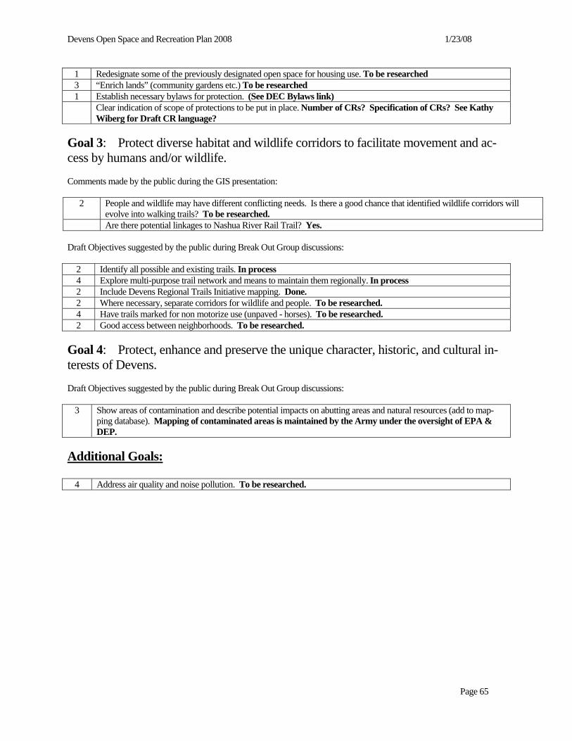
Devens Open Space and Recreation Plan 2008 1/23/08
Page 65
1 Redesignate some of the previously designated open space for housing use. To be researched 3 “Enrich lands” (community gardens etc.) To be researched 1 Establish necessary bylaws for protection. (See DEC Bylaws link) Clear indication of scope of protections to be put in place. Number of CRs? Specification of CRs? See Kathy
Wiberg for Draft CR language? Goal 3: Protect diverse habitat and wildlife corridors to facilitate movement and ac-cess by humans and/or wildlife. Comments made by the public during the GIS presentation:
2 People and wildlife may have different conflicting needs. Is there a good chance that identified wildlife corridors will evolve into walking trails? To be researched.
Are there potential linkages to Nashua River Rail Trail? Yes. Draft Objectives suggested by the public during Break Out Group discussions:
2 Identify all possible and existing trails. In process 4 Explore multi-purpose trail network and means to maintain them regionally. In process 2 Include Devens Regional Trails Initiative mapping. Done. 2 Where necessary, separate corridors for wildlife and people. To be researched. 4 Have trails marked for non motorize use (unpaved - horses). To be researched. 2 Good access between neighborhoods. To be researched.
Goal 4: Protect, enhance and preserve the unique character, historic, and cultural in-terests of Devens. Draft Objectives suggested by the public during Break Out Group discussions:
3 Show areas of contamination and describe potential impacts on abutting areas and natural resources (add to map-ping database). Mapping of contaminated areas is maintained by the Army under the oversight of EPA & DEP.
Additional Goals:
4 Address air quality and noise pollution. To be researched.

Devens Open Space and Recreation Plan 2008 1/23/08
Page 66
Draft Recreational Goals Goal 1: Provide a broad recreational base, offering opportunities for all ages, for all residents, employees and the region. Comments made by the public during the GIS presentation:
Including both passive and active recreation? To be done. Draft Objectives:
11 Autocross on Moore Airfield. To be researched. 1 Permanent protection of recreational areas. To be researched. 9 Trails to surrounding communities. To be researched. 3 Permanent protection of recreational areas. To be researched.
Goal 2: Manage and maintain recreation and open space areas of Devens.
Physical Fitness PAR course ~5+ miles. To be researched.
10 Provide unpaved trails for non motorized uses to accommodate Horses (with plan to include ecological resource perspective). To be researched.
2 Connections between residential areas. Already defined. 3 No Net Loss of recreation facilities (ie: indoor gym, pool). To be researched.
Goal 3: Recreational activities should be sustainable to the extent possible.
1 Charges for use of recreational resources should be financially reasonable (not “above and beyond”). To be researched.
C. SECOND PUBLIC FORUM 1. Devens Open Space Press Plan April 29, 2005 The press plan for the Devens Open Space Plan Public Forum (June 1, 2005) focuses on reaching residents of the “Devens towns” (Devens itself, Ayer, Harvard and Shirley), recreational users, interested business and environmental organizations, town and state officials. There will be four main divisions of publicity work: bulk and select mailings, newspaper press releases, cable PSAs, and electronic media listings (websites, listserves). Bulk and Select Mailings Select Mailings (M) and/or E-mail Notification (E): To be mailed week of May 9th (no later than week of May 16th)
(M) Devens businesses - have list from Kathy Wieberg, needs update (E) Devens EcoStar Committee - have list from Peter Lowitt, needs update (M) Devens Enterprise Commission - have list from Peter Lowitt (E) Devens Open Space and Recreation Committee (M) Devens recreational renters - have list from Kathy Wieberg, needs update (M) Devens residents Devens residents group- advice from Kathy Wieberg (M) Devens Restoration Advisory Board - c/o Ben Goff (M & E) Local land trusts- Harvard Conservation Trust, North County Land Trust

Devens Open Space and Recreation Plan 2008 1/23/08
Page 67
(M) Military based at Devens- c/o Ben Goff (M & E) Nashoba Valley Chamber of Commerce (M) Special interest groups- US Fish and Wildlife, Friends of the Oxbow, Freedom’s Way, PACE (M) State legislators- senators and representatives (M) State officials- Becky DeSilva (DEP) (M) Town officials (chairs of boards) in Ayer, Harvard and Shirley- conservation
commissions, selectmen, planning boards, recreation commissions, open space committees, DPWs, Shirley Greenway Committee
Newspapers The following hard print media sources will receive an initial press release for publication Friday May 13th (Sun. Globe May 15th or 22nd). A second press release will be sent for publication Friday, May 27th. Weekly Publications Nashoba Publishing The Public Spirit, Ayer Ayer Harvard Hillside Harvard Shirley Oracle Shirley Harvard Post Harvard, Still River Shirley Volunteer Shirley Action Unlimited Westford Edition Harvard, Still River Boston Globe- NorthWest NW Boston suburbs Cable TV- PSA To begin running week of May 9th Ayer- channel 8 Harvard- channel 12 Shirley- ? Electronic Media
Websites To be posted as soon as possible Nashua River Watershed Association - www.NashuaRiverWatershed.org Mass Development - www.massdevelopment.com Montachusett Regional Planning Commission - www.mrpc.org Town of Harvard - www.harvard.ma.us devenscommunity.com Email (listserves or listserve-like) First notice to be sent week of 5/13, second notice to be sent week of 5/23 Post to NRWA email Invite list Post to Mass Watershed Coalition listserve Post to Nashoba Valley Chamber of Commerce - Chamber News E-mail and Newsletter

Devens Open Space and Recreation Plan 2008 1/23/08
Page 68
Flyers Color flyers will be distributed week of May 16th. 3 public libraries- Ayer, Harvard and Shirley 3 town halls- Ayer, Harvard and Shirley 5 town Post Offices (if allowed)- Ayer, Devens, Harvard, Shirley, Still River Postings in public places in towns, i.e. general stores, coffee shops, grocery stores, etc. 2. Public Forum June 1, 2005
Public Forum Devens Open Space and Recreation Plan
June 1, 2005 7:00 – 9:00 p.m.
Devens Community Center 100 Sherman Avenue, Devens
Agenda 1. Introductions & Overview [15 mins]
2. Presentation of Draft Final Plan
Goals and Objectives [10 mins] Five-Year Action Plan [10 mins]
3. Public Discussion
Goals and Objectives [15 mins] Five-Year Action Plan [20 mins] Other [20 mins]
4. Next steps & conclusion [5 mins]
The Forum is hosted by MassDevelopment in cooperation with the Open Space and Recreation Advisory Committee of the
Joint Boards of Selectmen of Ayer, Harvard, and Shirley.
The consultant team is represented by Nashua River Watershed Association (NRWA). D. DEVENS OPEN SPACE AND RECREATION ADVISORY COMMITTEE FOLLOW UP MEETING A public meeting of the Devens Open Space and Recreation Advisory Committee was held on June 12th 2007 to identify any outstanding issues and determine a course of action for finalizing the plan. Since the previous “final draft” version of the plan had included several items that were directly connected to the Devens Disposition Process and since the proposed disposition scenario had subsequently been voted down, it was decided that the committee would be given an additional two (2) weeks to submit any final comments on the plan. As of October 16, 2007 only 2 comments have been received – these have been included in Appendix C.

Devens Open Space and Recreation Plan 2008 1/23/08
REFERENCES An Inventory of the Ponds, Lakes, and Reservoirs of Massachusetts, Worcester County, McCann, Covey, Corrinet, and Os-trowski, 1972 Ayer Open Space and Recreation Plan, May, 1997 Barnum Road Master Plan, Gale Associates, October 25, 2001 Base Realignment and Closure Environmental Evaluation (BRAC EE) Fort Devens, Massachusetts, Arthur D. Little, Inc. 1994 Biological and Endangered Species Baseline Study of Fort Devens, ABB Environmental Services, 1993 BioMap: Guiding land conservation for biodiversity in Massachusetts, Commonwealth of Massachusetts Division of Fish-eries & Wildlife Natural Heritage and Endangered Species Program Species, 2001 Build-out Analyses for Ayer, Harvard, Lancaster and Shirley, EOEA – MRPC, 1999-2004 Department of Environmental Management, Guidelines for Operation and Land Stewardship, MA DEM, 1984 Devens Area Regional Plan, Communities Connected by Water: Ayer, Harvard, Lancaster and Shirley, Looking Beyond Devens-Planning for the Future in the Nashua River Watershed Area, ENSR, 2001 Devens By-Laws, Vanasse Hangen Brustlin Inc., 1994 Devens Multi-Use Trail Network Design Guidelines, Icon Architecture Inc., 2002 Devens Open Space and Recreation Plan, Cecil & Rizvi, Inc., 1996 Devens Regional Trails Initiative: Draft Report on Trail Connections Between Devens and Surrounding Towns, Devens Enterprise Commission, 2000 Devens ReUse Plan, Vanasse Hangen Brustlin Inc., 1994 Devens Stormwater Pollution Prevention Plan, Vanasse Hangen Brustlin Inc., 1995 Devens Water Resources Protection Plan, Vanasse Hangen Brustlin Inc., 1994 Focus Areas for Wildlife Habitat Protection in the Nashua River Watershed, Jeff Collins, Massachusetts Audubon Society Ecological Extension Service, 2000 Fort Devens Disposal and ReUse Environmental Impact Statement, U.S. Department of the Army, 1994 Fort Devens Regional Recreation Management Plan, Final Report, for the Fort Devens ReUse Center, Open Space and Recreation Task Force, Ayer, Harvard, Lancaster, and Shirley, January 1995 Harvard Open Space and Recreation Plan, 2004 – 2009, draft May 2004 Historic and Prehistoric Reconnaissance Survey of Fort Devens (Main Post, North Post, South Post) Massachusetts, Public Archaeology Laboratory Inc., August 1989 http://commpres.env.state.ma.us/content/buildout.asp http://www.devens.army.mil/staff/brac/site_status.htm.

Devens Open Space and Recreation Plan 2008 1/23/08
http://www.state.ma.us/mgis/lus.htm Hyla Ecological Services, Draft Rare Species Habitat Assessment and Vernal Pool Survey, MassDevelopment North Post Parcel Shirley, MA, NHESP File: 00-7674, August 2005 Integrated Natural Resources Management Plan for Devens Reserve Forces Training Area, MA 1998-2002, U.S. Army Corps of Engineers, New England District, Gene Stout and Associates, 1999 Massachusetts Department of Environmental Management, Scenic Landscape Inventory, 1983 Massachusetts Natural Heritage and Endangered Species Program, species lists, continually updated on website Mirror Lake Conservation Restriction, September 2003 Mirror Lake Recreation Area Improvements, Icon Architecture, Inc., 2002 MISER Population Projections for Massachusetts, 2000–2020, Stefan Rayer, Ph.D., July 17, 2003 Nashua River Watershed Association, 1995 to 2020 Vision for the Nashua River Watershed, 1995 Nashua River Watershed Five Year Action Plan, 2002-2007, Massachusetts Watershed Initiative Nashua River Watershed Team, 2002 Recreation Strategic Plan for Devens, MA, June 2003 Survey and Evaluation of Wetlands and Wildlife Habitat, Fort Devens, MA, Bill Zinni, U.S. Fish & Wildlife Service, 1992 Town of Ayer – Draft Wastewater Treatment Facility Alternatives Analysis, Tata and Howard, Inc., 1999 U.S. Fish and Wildlife Service. Oxbow NWR Draft Comprehensive Conservation Plan, July 2003. Oxbow NWR Final Comprehensive Conservation Plan, January 2005.
Vernal Pool Habitat Survey Jackson Technology Park and North Post, Devens, MA, Oxbow Associates, Inc., May 2001 Willard Field Master Plan, Icon Architecture, Inc., 2002

Devens Open Space and Recreation Plan 2008 1/23/08
APPENDIX A
MAPS
A-1 Devens Action Plan A-2 Devns Groundwater Resources A-3 Devens Open Space A-4 Devens SurfaceWater Resources A-5 Devens Unique Features A-6 Devens Zoning A-7 DevensOpen Space Protection Plan


Devens Open Space and Recreation Plan 2008 1/23/08
Figure A-1

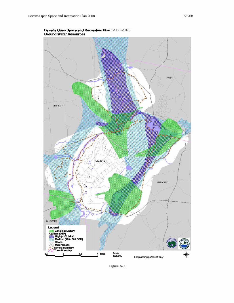
Devens Open Space and Recreation Plan 2008 1/23/08
Figure A-2


Devens Open Space and Recreation Plan 2008 1/23/08
Figure A-3


Devens Open Space and Recreation Plan 2008 1/23/08
Figure A-4


Devens Open Space and Recreation Plan 2008 1/23/08
Figure A-5

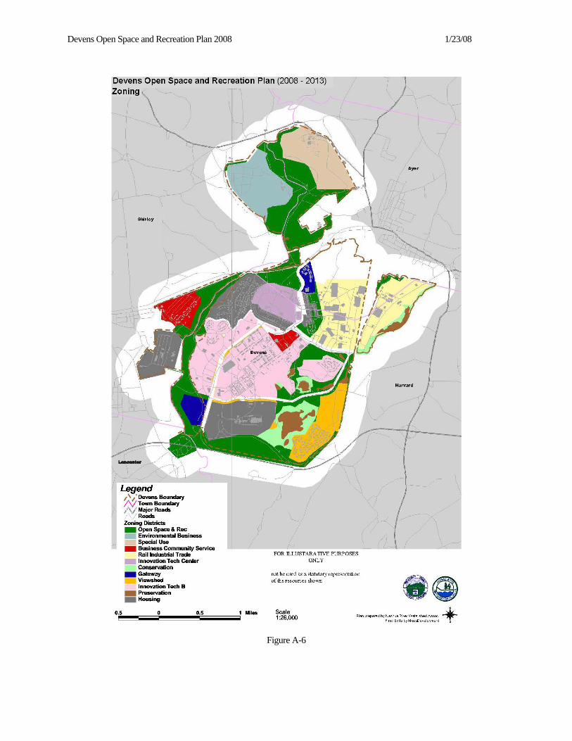
Devens Open Space and Recreation Plan 2008 1/23/08
Figure A-6


Devens Open Space and Recreation Plan 2008 1/23/08
Figure A-7


Devens Open Space and Recreation Plan 2008 1/23/08
APPENDIX B
SUSTAINABLE DEVELOPMENT PRINCIPLES FROM MASSACHUSETTS OFFICE
FOR COMMONWEALTH DEVELOPMENT

Devens Open Space and Recreation Plan 2008 1/23/08
SUSTAINABLE DEVELOPMENT PRINCIPLES FROM MASSACHUSETTS OFFICE FOR COMMONWEALTH DEVELOPMENT
The mission of the Massachusetts Office for Commonwealth Development (OCD) is to care for the built and natural envi-ronment by promoting sustainable development through the integration of energy, environmental, housing, and transporta-tion agencies’ policies, programs and regulations. OCD will encourage the coordination and cooperation of all agencies, invest public funds wisely in smart growth and equitable development, give priority to investments that will deliver living wage jobs, transit access, housing, open space, and community-serving enterprises, and be guided by a set of sustainable development principles. For additional information, contact the Massachusetts Office for Commonwealth Development at (617) 573-1380. 1. REDEVELOP FIRST. Support the revitalization of community centers and neighborhoods. Encourage reuse and
rehabilitation of existing infrastructure rather than the construction of new infrastructure in undeveloped areas. Give preference to redevelopment of brownfields, preservation and reuse of historic structures and rehabilitation of existing housing and schools.
2. CONCENTRATE DEVELOPMENT. Support development that is compact, conserves land, integrates uses, and fosters a sense of place. Create walkable districts mixing commercial, civic, cultural, educational and recreational ac-tivities with open space and housing for diverse communities.
3. BE FAIR. Promote equitable sharing of the benefits and burdens of development. Provide technical and strategic sup-
port for inclusive community planning to ensure social, economic, and environmental justice. Make regulatory and permitting processes for development clear, transparent, cost-effective, and oriented to encourage smart growth and re-gional equity.
4. RESTORE AND ENHANCE THE ENVIRONMENT. Expand land and water conservation. Protect and restore
environmentally sensitive lands, natural resources, wildlife habitats, and cultural and historic landscapes. Increase the quantity, quality and accessibility of open space. Preserve critical habitat and biodiversity. Promote developments that respect and enhance the state’s natural resources.
5. CONSERVE NATURAL RESOURCES. Increase our supply of renewable energy and reduce waste of water, en-
ergy and materials. Lead by example and support conservation strategies, clean power and innovative industries. Con-struct and promote buildings and infrastructure that use land, energy, water and materials efficiently.
6. EXPAND HOUSING OPPORTUNITIES. Support the construction and rehabilitation of housing to meet the needs
of people of all abilities, income levels and household types. Coordinate the provision of housing with the location of jobs, transit and services. Foster the development of housing, particularly multifamily, that is compatible with a com-munity’s character and vision.
7. PROVIDE TRANSPORTATION CHOICE. Increase access to transportation options, in all communities, including
land- and water-based public transit, bicycling, and walking. Invest strategically in transportation infrastructure to en-courage smart growth. Locate new development where a variety of transportation modes can be made available.
8. INCREASE JOB OPPORTUNITIES. Attract businesses with good jobs to locations near housing, infrastructure,
water, and transportation options. Expand access to educational and entrepreneurial opportunities. Support the growth of new and existing local businesses.
9. FOSTER SUSTAINABLE BUSINESSES. Strengthen sustainable natural resource-based businesses, including agri-
culture, forestry and fisheries. Strengthen sustainable businesses. Support economic development in industry clusters consistent with regional and local character. Maintain reliable and affordable energy sources and reduce dependence on imported fossil fuels.
10. PLAN REGIONALLY. Support the development and implementation of local and regional plans that have broad
public support and are consistent with these principles. Foster development projects, land and water conservation, transportation and housing that have a regional or multi-community benefit. Consider the long-term costs and benefits to the larger Commonwealth.


Devens Open Space and Recreation Plan 2008 1/23/08
APPENDIX C
PUBLIC COMMENTS


Devens Open Space and Recreation Plan 2008 1/23/08
PUBLIC COMMENTS Public Forum December 4, 2003 MassDevelopment hosted the December 4th Public Forum in cooperation with the Open Space and Recreation Advisory Committee of the Joint Boards of Selectmen of Ayer, Harvard, and Shirley. The Forum was widely publicized and attended by about 35 people. Below is a compilation of comments made by the public during an interactive GIS presentation of ex-isting conditions, and, a compilation of objectives suggested by the public during "break out group" discussion on draft goals. Participants were polled at the end of the Forum regarding their highest priorities, which they reflected through dis-tributing three 'dots' or votes among the various suggested objectives or comments -- the number of 'dots' received is re-flected in the left hand column below. The polling and comments offered at the Public Forum will be used along with other data being gathered to inform the consultant team. Based on the poll results the highest priorities of those attending the public forum are as follows:
1. Autocross on Moore Airfield (11/105 votes) 2. Provide un-paved trails for non-motorized uses to accommodate Horses (10/105 votes) 3. Trails to surrounding communities (9/105 votes) 4. Address ecological Integrity of Habitats (6/105 votes) 5. Explore multi-purpose trail network & means to maintain them regionally (4/105 votes)
Have trails marked for non-motorized use (unpaved – horses) (4/105 votes) Address air quality & noise pollution (4/105 votes)
Draft Open Space and Resource Protection Goals Goal 1: Preserve important water resources. Ensure that important resource areas receive permanent protection. Expand some of the buffer areas (i.e.: where rail industrial zone goes nearly all the way to the Grove Pond shoreline.)
Goal 2: Preserve important land resources. Address Ecological Integrity of Habitats (i.e.: protect western half of North Post. Redesignate some of the previously designated open space for housing use. “Enrich lands” (community gardens etc.) Establish necessary bylaws for protection. Clear indication of scope of protections to be put in place. Goal 3: Protect diverse habitat and wildlife corridors to facilitate movement and access by humans and/or wildlife. People and wildlife may have different conflicting needs. Where necessary, separate corridors for wildlife and people. Is there a good chance that identified wildlife corridors will evolve into walking trails? Are there potential linkages to Nashua River Rail Trail? Identify all possible and existing trails. Have trails marked for non motorize use (unpaved - horses). Explore multi-purpose trail network and means to maintain them regionally. Good access between neighborhoods. Goal 4: Protect, enhance and preserve the unique character, historic, and cultural interests of Devens. Show areas of contamination and describe potential impacts on abutting areas and natural resources (add to mapping data-base). Additional Goals: Address air quality and noise pollution.

Devens Open Space and Recreation Plan 2008 1/23/08
Draft Recreational Goals Goal 1: Provide a broad recreational base, offering opportunities for all ages, for all residents, employees and the region. Autocross on Moore Airfield. Permanent protection of recreational areas. Trails to surrounding communities. Permanent protection of recreational areas. Goal 2: Manage and maintain recreation and open space areas of Devens. Physical Fitness PAR course ~5+ miles. Provide unpaved trails for non-motorized uses to accommodate Horses (with plan to include ecological resource perspective). Connections between residential areas. No Net Loss of recreation facilities (i.e.: indoor gym, pool). Goal 3: Recreational activities should be sustainable to the extent possible. Charges for use of recreational resources should be financially reasonable (not “above and beyond”).

Devens Open Space and Recreation Plan 2008 1/23/08
Spoken and Written Comments noted and submitted at
2nd Public Forum
June 1, 2005
On the Draft Final
Devens Open Space and Recreation Plan
[NOTE: Spoken comments were handwritten by Peter Lowitt at the Forum and retyped by NRWA.]
Spoken Comments: Goal I:
• A.1.: what is the intent regarding identifying open space resources worthy of preservation/protection
o [PF-1] To “protect land and water resources” as per stated goals and objectives. MassDevelop-ment has reviewed the matrix with the OSRC and agreed on recommended additional levels of protection for other areas not already protected by CR/DR.
• who decides the “appropriate level of protection?(LW)
o [PF-2] MassDevelopment will continue to work with the DOSRAC and the DEC to evaluate the resources at Devens. It is also anticipated that the LUOS committee will include recommendations on protection levels in their report to the DDEB.
• Make comment column in matrix clearer and justify any deviations from it (HR)
o [PF-3] The Matrix has been revised. Recommended levels of protection have been put in a sepa-rate column to clarify intended actions. The action plan will also be revised to clearly identify the recommended actions in the matrix.
• Is it possible to develop criteria to help make preservation decisions more objective, for example, Con-servation Restriction criteria? (LF)
o [PF-4] DOSRAC has carefully reviewed the characteristics of each parcel in developing the ma-trix and that reflects the different protections appropriate to different types of resources/open spaces. Development of additional preservation criteria will require substantial input & discus-sion by all parties involved. Criteria can vary widely (as evidenced by samples of various selection procedures provided by NRWA) depending on the particular type of resource and the method of protection to be used. This task should be added to the action plan and may involve a multi-step process. To be prepared by MassDevelopment, the DEC and the DOSRAC.
• The adoption of this plan will make it a valuable tool for use in such criteria (PH) [PF-5] Agreed
• RA. 4 – Management responsibility rests with whom? (LW)
o [PF-6] Management responsibility ultimately rests with the party having jurisdiction over the in-dividual parcel (i.e., MassDevelopment & the DEC manage non-federal lands within Devens. Where there are CR’s in place, the CR holder would also have monitoring and/or oversight re-sponsibilities, etc). Future management and jurisdiction of individual parcels to be determined via the disposition process.
Devens Open Space and Recreation Plan 2008 1/23/08
• MD shows respect for managing resources – continue JBoS involvement (HR) [PF-7] No Response Required
Goal II:
• Fluoride in public H2O?
o [PF-8] Not within the scope of this plan.
• A. 3 – How large an area adjacent to Grove Pond wells needs to be protected (LW)
o [PF-9] The Zone I & Zone II areas “needed” for the wells have been established by MADEP and are published as part of the DEC’s Water Resource Protection regulations. Very stringent aquifer protection regulations are in place to limit/restrict development within these areas. These areas extend beyond the current limits of Open Space into lands not owned by MassDevelopment. It would be beneficial to extend the open space area around the wells and MassDevelopment has in-corporated this into the Barnum Road Master Plan in the area currently operated by the MA – ANG.
• Buffer for Grove Pond well is important (CL)
o [PF-10] See PF-9
• B. Recognize that to protect vernal pools you need to protect upland habitat (HR)
o [PF-11] This fact is recognized. However, the extent & location of upland habitat contributing to the value of the vernal pool can only be determined on a case by case basis.
• B. Compatible activities is questioned; define criteria - add onto matrix (LW) [PF-12] Activities which are compatible will vary in different areas and need to be evaluated on case by case basis to determine site specific activities that will be allowed. The Matrix shows which areas have different levels of sensitivity and identifies which areas will be protected. Specific pro-tection mechanism will address allowable activities.
• Education about surface water protection/ signage is important; monitor water bodies for invasive spe-cies (PCL)
[PF-13] Add action item under Goal II, Objective B – “Develop public education program”.
The Devens Enterprise Commission development rules and regulations provide extensive re-quirements for planting of native/non-invasive species. Active monitoring of existing water bodies for invasive species is a labor intensive activity that cannot be undertaken with existing staffing levels. Effective monitoring would require the involvement of trained and knowledgeable volun-teer groups.
• Willow Brook daylighting where culverted under lawn is encouraged [& Gillette Corp is on board with MA Wetlands Restoration Program, thus possible funder?] (HR);
o [PF-14] Already discussed in the plan. See Objective C, Action item 1. Goal III:
• A. Good to tie in with USFWS (LW)
o [PF-15] Additional language will be added to plan which more clearly describes the lands under the jurisdiction of USFWS and emphasizes the need for coordination of access and uses along common boundaries.
• C. Wildlife corridors crossing town/USFWS/DREZ boundaries have great value (HR, PH)
o [PF-16] Issue is addressed throughout the plan. Goal III provides several objectives and action items related to this issue.

Devens Open Space and Recreation Plan 2008 1/23/08
• Were host communities consulted and their Open Space Rec Plans reviewed in light of above? (LW)
o [PF-17] Yes. Since the establishment of the DOSRAC, representatives of the host communities Recreation departments and conservation committees have been invited to participate. The draft Plan was provided to host community officials and they were invited to comment on such and to participate in the review of the plan.
Goal IV:
• A.5. Frisbee disc golf opportunity at Devens (play anywhere; investigating use of Shepley Hill 25acres +/-; can be woods; NWFDA willing to build course
o [PF-18] Individual activities such as this will be considered by the Devens recreation department on a case by case basis.
• A.6. Wonderful objective – meet surrounding towns needs (CL)
o [PF-19] No Response required.
• B.2. Trail plan implementation is important; Identify natural informal trail system – map it and let people use it without $ improvements
o [PF-20] Natural/informal trail system has been identified around Mirror Lake and is available for use. Trail maps are available. Add action item 5 under Goal IV. Obj. B. “Where appropriate, identify existing informal and less intensively managed passive use trails.”
• Connect to rail trail. Regional connectivity is important (LF) [PF-21] Existing trail plan identifies linkages to surrounding communities. Connection from De-vens to the Rail trail will need to be coordinated with the adjacent communities as Devens & the communities identify funding sources.
• Any restrictions on trail use to protect resources? (JB); o [PF-22] Yes; as recommended in Regional Trail Plan, Devens Multi-Use Trail Network Design
Guidelines, Icon Architecture, Inc, 2002.
• Clarify “passive”
o [PF-23] Non-consumptive uses which provide access to resources but have minimal impact on the ecosystem.
• Any canoeing? – Nashua River in Oxbow; its CCP may include access; parking areas within Devens for canoe launch encouraged (JB)
o [PF-24] All Nashua River frontage and access is through Oxbow NWR; therefore, this comment needs to be addressed to USFWS. Refer to USFWS Final Comprehensive Conservation Plan for the Eastern MA Complex for decisions regarding access and approved uses and for proposed im-plementation schedule.
• Support creation of Oxbow Visitor Center at Jackson Road (LW)
o [PF-25] Contingent on Oxbow NWR CCP and receipt of sufficient funding by USFWS. Goal V:
• Outreach to communities is needed to integrate efforts (PH)
o [PF-26] There has been extensive outreach to the communities during development of the plan to promote involvement, request information and provide feedback. Additional outreach to various town boards and officials is provided by reporting of the DOSRAC back through the JBoS.

Devens Open Space and Recreation Plan 2008 1/23/08
• Add an Action “B.3” - appropriate management plans for other open spaces
o [PF-27] Add the following action item: “Develop additional management plans as needed”.
• Playground is needed, combine with DEAC School
o [PF-28] Edit Goal IV, A.5 to include “(i.e., playgrounds, etc)”
• Recycling center is needed
o [PF-29] Not within scope of this plan. Refer to DEC/DPW.
• Community garden is needed; but test for arsenic (LW)
o [PF-30] Will be addressed with residents as requested. Could be considered as part of future housing development.
General Comments:
• Concern about limited input because of shadow of disposition process; concern that housing may go in open space; it’s important that the process be open and fair with participation opportunities. Contribute to the criteria is important and valuable.
o [PF-31] This Plan process was begun well before the initiation of disposition process. There were discussions on the possibility of pre-empting the completion of the plan pending the outcome of current disposition efforts. However, it was agreed that this document should be completed. Be-tween this process and the DDEB process there have been extensive opportunities for participation and expression of opinions and desires.
• Who evaluates open space in Goal I? – Answer from MassDevelopment: so far it’s been a joint effort MD/JBoS
o [PF-32] See response to PF-2
• Regional legacy (HR)
o [PF-33] Agreed
[NOTE: Submitted handwritten, and retyped by NRWA.]
Written Comments (verbatim):
Anon. Enlarge buffer zone for Grove Pond beyond Ayer’s buffer. To not only preserve water protection for Ayer’s drinking water but the wildlife that exist in and around that pond. Has endangered wildlife been noted? Also would keep the beautiful viewshed Ayer residents and Ayer’s park has. [PF-34] See response to PF-9
a) Heidi Ricci Overall comments: Plan should more clearly state genesis of open space network at Devens i.e.: regional inter-connected matrix approved by the 3 towns and entrusted to ND for implementation of the ReUse Plan. [PF-35] Item is sufficiently addressed under Section 2.B.1 “Historical Review of Open Space and Recreation Planning at Devens”. Executive summary refers to CRs and FEIR – MEPA process actually covered all the open space at Devens,

Devens Open Space and Recreation Plan 2008 1/23/08
which was promised to be permanent open space. [PF-36] This is not a general statement on the overall protec-tion of open space at Devens. The reference in the executive summary specifically relates to the four (4) areas men-tioned in the FEIR which had previously been identified for adoption of Conservation Restrictions. As indicated in the FEIR, the Section 61 findings of the MEPA certificate and the ReUse Plan, MassDevelopment will work with the JBoS & DEC to identify additional “important wetlands” and establish permanent protection mechanisms. This effort is summarized in the revised matrix which identifies areas other than the four (4) original CR locations which there is consensus on the need for additional protection. Goal I. Need to clarify actions in relation to goals and lands of conservation interest matrix – on matrix the “comments” column ID’s recommended protection measures and this should be made clearer. [PF-37] See re-sponse to PF-3 . On matrix “North Post buffer” should be broadened to cover entire North Post EBZ and relate to additional Mas-ter Planning presently underway. [PF-38] “North Post Buffer” referred to specific areas identified in the 1996 Plan. The Matrix has been revised to incorporate additional areas (labeled “NEW”) such as the EBZ area, and oth-ers. Section 2. Regional Context. Devens is not a “community” at least not yet. Call it a special enterprise zone or former Army Base but not a community. [PF-39] As “community” is not a term synonymous with “municipality” there would be many people who would be offended by this remark. However, to prevent confusion between “community” & “municipality” alternate wording will be proposed for this section Goal II: Relate more clearly to matrix recommendations for protection of waters and associated lands. We know for a fact there are vernal pools in North Post/EBZ that are being used by rare species. Need to protect not just vernal pools but also adequate surrounding upland to ensure habitat viability and sustainable vernal pool de-pendent wildlife. Object to fact that MD removed factual info re: reptiles and amphibians and their habitat needs form fisheries and wildlife section of this plan. [PF-40] See response to PF-3 and PF-11 Goal III: Broaden in regard to regional corridor perspectives e.g.: not just Oxbow-No. Post or No. Post-Shirley Town Forest but this entire corridor. Similarly, larger regional open space connections (see communities con-nected by water report). [PF-41] The Goals, Objectives and action items cited in this section sufficiently address the connectivity of Devens to the region. Goal IV: Ensure that trails on MD lands don’t create conflicts with Oxbow allowed vs. prohibited uses. [PF-42] See response to PF-15 Obj. B. add action to identify existing woods trails especially on open space parcels, map them and allow use. Connect to rail trail. [PF-43] See response to PF-20 & PF-21 Obj. C. support development of visitor center at Jackson Gate. [PF-44] See response to PF-25 Goal V: Add another action step under Goal V Obj B that addresses management of all other open spaces (not just Mirror Lake and Eskers). [PF-45] See response to PF-27 Integrate management with adjoining Oxbow and other open spaces are compatible/ have minimal impacts on open space resource values. [PF-46] See response to PF-15

Devens Open Space and Recreation Plan 2008 1/23/08
TOWN OF SHIRLEY CONSERVATION COMMISSION 7 KEADY WAY • SHIRLEY, MASSACHUSETTS 01464 (978) 425-2600 ext. 245 FAX (978) 425-2627
June 16, 2005 Mr. Al Futterman Nashua River Watershed Association 592 Main Street Groton, MA 01450 Dear Mr. Futterman:
RE: Final Draft Devens Open Space and Recreation Plan
I apologize for not getting these comments to you last week. I had a family emergency that took precedence, but I feel these comments are important enough to submit even if they are late.
The Shirley Conservation Commission's first comment is that the Devens
Open Space and Recreation Plan (OS&RP) should be substantially different from most town and city Open Space and Recreation Plans in one important regard.
Most towns and cities know the status of their open space upon the update of
a plan, whether permanently protected or not. If land is not permanently protected, the OS&RP is used to prioritize which parcels are deemed worthy of protection if the opportunity to protect those parcels (through either fee simple purchase or a conserva-tion restriction) arises and if funds are available.
The major difference with the Devens OS&RP is that much of the land that
was originally delineated as protected open space was not actually afforded the per-manent protection of Article 97 land.
In this update, MassDevelopment has the opportunity to correct this situation and permanently protect these important parcels since it currently controls them. Unlike most towns which must wait for privately owned parcels to come up for sale and then scurry to find the funds to purchase, MassDevelopment can protect these parcels immediately by granting conservation restrictions on priority sites immediately, yet this action is not proposed. [SCC-1] MassDe-velopment maintains its commitment to protect valuable resources at Devens. Addi-tional protection of agreed upon areas is incorporated in the plan. The specific mecha-nism of protection needs to be determined on a case by case basis. The specific mecha-nism to be utilized will impact the time it takes to put in place. CR’s can not just be

Devens Open Space and Recreation Plan 2008 1/23/08
“granted”. Individual organizations will only agree to hold CR’s for lands with very specific value”. There is often a lengthy process to determine if a parcel fits with the or-ganizations Mission and to determine the specific conditions under which they will agree to hold the restriction. It is clear that a variety of protection mechanisms will need to be used for the parcels at Devens. [See also, response to PF-3]. This lack of commitment is particularly concerning since the literature distributed to surrounding communities prior to the Devens Reuse Plan vote years ago noted that land designated as open space would be pro-tected in perpetuity. [SCC-2] Unfortunately the referenced literature was not incorpo-rated into the published Reuse Plan & By-laws. The Re-use plan clearly differentiates between the “Open Space Network” and specific areas within the network to be perma-nently protected. MassDevelopment staff has been working with the DOSRAC to iden-tify these areas and has identified the parcels where there was consensus on the need for additional protection in the revised matrix. Some of this land was subsequently sold for development, thereby precluding access linking open space parcels with green corridors along roadways. [SCC-3] Providing public access to land is not the same as protecting or pre-serving it as “open space”. All of the 22.3 Acres of land zoned “open space/recreation” that was sold was within the roadway or buffer corridors and is still protected from de-velopment under existing zoning. The revised matrix identifies the need to revise zoning within these areas at disposition and also identifies the need to find some other mecha-nism to keep these areas as “green corridors”. Maps of the locations of all parcels listed in the Reuse Plan as needing permanent protection should indicate their current status, [SCC-4] Maps from the 1996 plan corresponding to the parcels identified in the matrix will be added to the plan.… and vital linkages should be immediately protected in the Action Plan [SCC-5] The matrix identifies the parcels where there was consensus on the need for ad-ditional protection. The Action plan will be updated to incorporate those recommenda-tions. See also PF-2 & PF-3.
This update of the 1996 Devens Open Space and Recreation Plan is to be a
step backwards in regards to protection of open space and its management. More specific protection measures should be added to the Five-Year Action Plan, particu-larly for evaluation and protection of the Environmental Business Zone of the North Post. [SCC-6] A supplemental environmental study of the North Post Environ-mental Business Zone is being conducted by the Land Use & Open Space com-mittee of the DDEB. If the study is completed prior to this plan being finalized, it will be added as an appendix. [See also, response to PF-3] Sincerely, Anne Gagnon Conservation Administrator rapt cc Jennifer Soper, Division of Conservation Services

Devens Open Space and Recreation Plan 2008 1/23/08
Written Comments regarding the Draft Final Devens Open Space and Recreation Plan
Response from: Bill Ashe [NOTE: Submitted handwritten, and retyped by NRWA staff.] [NOTE: Cover letter not considered part of the comments and therefore not included.]
June 9, 2005
To: Al Futterman, NRWA From: Bill Ashe Re: Devens Open Space/Recreation Plan Update Review of Final Draft of Devens OSR Plan Page 3- Executive Summary Several minor word changes in the Purpose Section. For example, I would substitute “important environmental areas and management…” in the first sentence instead of “critical environmental re-sources and management…” Most of us know what is important, but, really, what does critical define. [BA-1] The current language is consistent with terminology used in the re-use plan and will be retained. [See also, response to PF-4] Under the Scope of the Plan section, second paragraph, it says the 2004 Plan expands the focus to all lands in the Devens REZ except for areas administered by the U.S. Fish and Wildlife Service (Ox-bow NWR), MA National Guard and the U.S. Army. This listing should also include, as exceptions, the Job Corps and Federal Prison areas. Why is the South Post mentioned? Isn’t it outside the Devens RE Zone altogether? [BA-2 Paragraph will be re-worded to include reference to Job Corps & Federal prison, and to take out reference to South Post. In the Summary of Key Conclusions section, I would suggest saying “Preserve and protect im-portant land resources” and “ Preserve and protect important water resources”. Preservation and pro-tection go together in effective conservation land management in a vitally important way; however, the distinction is not grasped by many people and organizations - and, especially, lawyers. [BA-3] The recommended changes are consistent with the wording in the Goals and Objectives section and will be made. On page 4 of the Executive Summary, I would add a statement on Salerno Circle, given it’s loca-tion and importance to Harvard. It lies astride the high yield aquifer and adjoins the undisturbed wa-tershed along and above Mirror Lake. Concurrently, it is beset with a host of deteriorating pesticide contaminated Army barracks. It is in close proximity to the Oxbow National Wildlife Refuge. What-ever happens to Salerno Circle will have, for good or bad, a decided impact upon the water quality at Devens, the Oxbow National Wildlife Refuge and the visual landscape of Fruitlands Museum, a Na-tional Historic Site. [BA-4] Salerno Circle is an area of significant previous disturbance that lies within an approved development zone. The concern for Salerno is primarily focused around its appropriate remediation and redevelopment – not preservation as open space. Aquifer issues are addressed in other sections of the plan. No changes proposed Page 7- Role of Devens Disposition Executive Board The wording in this section does not comport with the direction of Chapter 498, but that is the story for another day. Page 10- Growth Development Patterns

Devens Open Space and Recreation Plan 2008 1/23/08
The first paragraph of this section, while accurate, is awkwardly constructed. Should be rewritten in my view. [BA-5] A significant amount of time & effort has already been spent re-writing this section a number of times. While the wording may be awkward it is accurate and does not have a major impact on the rest of the document. No changes proposed. Pages 17 to 23 – Water Resources This section – on the Nashua River watershed and it’s sub-basins, on surface waters like Mirror Lake, on ground water and aquifers, on wetlands and flood zones, etc., etc. – is well developed in my view. [BA-6] No response required Pages 27-29 – Fisheries & Wildlife My recollection of reviewing previous drafts, under the Inventory section, is that this so-called Final Draft has deleted some important information. The first paragraph, in my opinion, should be presented as an originally written-not as MA DEV has changed. [BA-7] The statements deleted from this paragraph were not accurate and will remain as revised. The 2nd paragraph on page 27 is o.k. The 3rd, 4th and 5th paragraphs are o.k. However, this Final Draft does not include appropriate data on reptiles, amphibians and other wildlife that are indigenous to the Devens landscape. Deleted from prior draft (by the MA DEV re-viewer(s)) are the facts that not only are vernal pools and other wetlands important to many of these critters, but that surrounding uplands are also vital to the sustainability and survival of many of these species. It is interesting to note that information on the Blandings turtle - which nests from 300’ to 5,000’ from it’s home marsh in well drained, sandy upland - has been taken out of this Final Draft by MA DEV. Remember, we are talking about a number of “state species of special concern” here. [BA-8] The section on the various species believed to utilize lands at Devens is being reworded and will be re-inserted with minor modifications and/or references. It is not difficult to discern the intent of MA DEV’s real estate and legal people in making these changes and deletions in the Final Draft of the Open Space and Recreation Plan. Wetlands and wild-life protection could alter their future development plans. And we must remember, they are first and foremost a REAL ESTATE DEVELOPER. Page 31- Unique Environments and Recreational Assets In the 2nd paragraph in this paragraph, after the wording, “it (Mirror Lake) offers unique recrea-tional opportunities” add: However, given the direct connection to the high yield aquifer, there must be controls and restrictions on any proposed increase in recreational activities. [BA-9] This comment is adequately addressed in other sections of the report. No changes proposed. Page 31 – Environmental Challenges This section describes what has been done vis-à-vis areas of contamination, but it does not ade-quately portray what is being done and what needs to be done in the future to assure a clean environ-ment for the involved towns and region. Areas of contamination keep popping up as development progresses. As we move toward disposition what entity will be responsible for future contamination clean up costs? Will it be the Army, the Commonwealth, or the town(s)? The towns did not create this “Super Fund” condition, but will they, in the future, assume some liability in whole or in part? Prior to disposition, the towns must insist that it (they) be indemnified from any liability or clean up responsibilities and costs by both the Federal government and the Commonwealth. In particular, Shepley’s Hill Landfill, Moore Air Field, and the Consolidated Landfill pose poten-

Devens Open Space and Recreation Plan 2008 1/23/08
tially serious problems in the future. This issue is being glossed over in both the Open Space and Rec-reation Plan and in the Disposition Process. [BA-10] Matters of on-going remediation are issues for the BCT & disposition and are outside of the scope of this report.
II. Page 33 – Priority Areas for Conservation Re: Cold Spring Brook, a minor point to check. The draft report states “ previously detected contamination found in Cold Spring Brook, presumably from leachate from a former adjacent landfill (AOC 57), this riparian zone is seemingly intact and ecologically uncompro-mised…” My recollection is that AOC 57 resulted from years of use by an Army service and mainte-nance vehicle shop, not leachate from an adjacent landfill. Also, I doubt that this area is “ecologically uncompromised”. [BA-11] The following update was provided by MassDevelopments Environ-mental Engineer and the BRAC Environmental officer: {Cold Spring Brook (CSB) flows through and around Devens on to the town of Ayer property. CSB is adjacent and in close prox-imity to AOC’s 40 and 57,a former debris dump site and a motor vehicle maintenance contami-nated site. These two AOC’s have been remediated by the Army where debris/contamination have been excavated resulting in the source removal of contaminants. CSB historically has been the outfall of stormwater discharge for Devens and this run off has affected the Brook also. The BCT is now in the process of defining any requirements that may be necessary to agree to No Further Action at CSB.} This section of the Plan will be reworded to reflect the actual condi-tions.
III. Page 41 – Statement of Open Space and Recreation Goals Once again, I suggest adding protect to the first two goals in the third paragraph. That is:
• Preserve and protect important land resources • Preserve and protect important water resources
[BA-12] See Response to BA-3 Pages 45 – 47 Goals and Objective Section I note that many of the habitat/wildlife protective recommendations contained in previous drafts have been removed in the “final draft”. For example, the following sound, appropriate, necessary rec-ommendations have been removed in the final draft: a) that the area between the esker and the ASP Bog, along with the Patch Road corridor, with
it’s chain of wetlands, be given added protection; [BA-13] See response to PF-3 b) that upper and lower Cold Spring Brook be given added conservation protection; [BA-
14] See response to PF-3 c) that new roads between vernal pools and larger wetland systems be avoided so as not to
adversely affect migrating amphibians [BA-15] Particular issues related to specific projects will need to be evaluated on a case by case basis in accordance with appli-cable regulatory processes. See also response to PF-11.
Pages 48 – 51 Five Year Action Strategy Likewise, as above, objectives in years 1 through 5, to protect upland habitat for rare turtle upland nesting habitat as well as vernal pools, should be restored in the final draft. Also, there needs to be a strong statement re: the protection of steep slopes and eskers. [BA-16] See responses to PF-11& USFW-7 I WOULD STRONGLY SUGGEST A REWRITE OF PAGES 45 – 51.
Bill Ashe

Devens Open Space and Recreation Plan 2008 1/23/08
Written Comments regarding the Draft Final
Devens Open Space and Recreation Plan Response from: Kathleen Bourassa
June 13, 2005 Al Futterman Nashua River Watershed Association 592 Main St. Groton, MA 01450 Re: Final Draft Devens Open Space and Recreation Plan Dear Al, The following are my comments regarding the Final Draft Open Space and Recreation Plan. It is my opinion that the Final Draft Open Space and Recreation Plan misses the point. One intent of the Plan was to deter-mine when the lands designated under the Reuse Plan for permanent protection will have the appropriate levels of protection applied to them. The Draft Final Plan Executive Summary references four parcels that require permanent protection, this is incorrect. The Reuse Plan, which is the document which allowed MassDevelopment to be stewards of this land, clearly states that all Open Space was to be permanently protected. This has been the subject of many long meetings and indeed the reason behind this Plan. The Draft Plan needs to accurately report this. In the Part 2 Community Setting Section C which references ‘Role of the Open Space Committee’, the Draft Plan refer-ences the Devens Community. Please amend this to the Devens Enterprise Zone. There is currently no legal Devens Community and the future is not yet decided. [KB-1] See response to PF-39 Part 3 Environmental Inventory and Analysis: In Section E part 2: referencing Vernal Pools Habitat Survey for Jackson Gate and the North Post, please include that this was not a definitive study. The study missed key vernal pools on the North Post and may have missed others. [KB-2] Will revise wording to more clearly define scope and/or results of survey. Under Section F Scenic Areas and Unique Environments part 2. Cultural, Archeological, and Historic Areas: the areas eligible for National Historic Status, please see the Historic and Prehistoric Reconnaissance Survey of Fort Devens ( Main Post, North Post, South Post) Massachusetts submitted to the Dept of the Army by The Public Archaeology Laboratory Inc (387 Lonsdale Ave, Pawtucket, RI 02860 / 401-728-8780) dated August 1989. There are many more eligible sites than are represented in the Draft Plan [KB-3] Add the following after the second paragraph: “For a complete listing of areas eligible for National Historic Status, please see the Historic and Prehistoric Reconnaissance Survey of Fort Devens ( Main Post, North Post, South Post) Massachusetts submitted to the Dept of the Army by The Public Archaeology Laboratory Inc dated August 1989.” In the Matrix please amend ‘North Post Buffer Zone’ to the entire North Post. [KB-4] See response to PF-38 Based on the above comments and the changes made to the Plan by MDFA after the DOSRAC had painstakingly reviewed the Draft, I cannot support the Plan as currently written. It is imperative as we move forward towards disposition that the OSR Plan is accurate and includes all information. I believe that NRWA and MDFA have worked hard to provide this draft, that this draft provides important information, and that we can all work together to accomplish a Plan which not only furthers the development of Devens but also furthers the protection of key sensitive areas. Thank you for allowing me to comment on this. Kathleen J Bourassa
122 Hazen Rd. Shirley, MA 01464 978-425-4988 [email protected]

Devens Open Space and Recreation Plan 2008 1/23/08
Written Comments regarding the Draft Final Devens Open Space and Recreation Plan
Comments from Debra Kimbrell-Anderson, U.S. Fish and Wildlife Service [NOTE: Submitted as email on 6-13-05 from Debra Kimbrell-Anderson, and retyped by NRWA staff.] I'm not sure the plan adequately addresses the presence of Oxbow National Wildlife Refuge (Oxbow NWR) and the impor-tance of continued coordination during the early planning phases of development at Devens. There have been numerous references to coordinating recreational opportunities between lands within Devens and Oxbow NWR. It is important that we continue to provide protection of refuge lands and wildlife corridors while planning for visitor use including the proposed network of trails. Recreational planning incorporated in typical development plans may not be the same as that used at Oxbow NWR. Items of concern regarding wildlife or habitat protection may not be readily appar-ent to the lay person. A recent discussion comes to mind regarding general access to the refuge from numerous points along the refuge boundary. Our planning is focusing on providing a few specific access points and not casual access along our boundaries. Coordination for example, of trails leading to the proposed Oxbow NWR Visitor Contact Station from points off refuge would be desirable while numerous trails or access points from nonspecific, undesignated points of entry would not. [USFW-1] See response to PF-15 Some discussion on the definition of Open Space and "permanently protected" along with a final statement of meaning and what it would take to effect a change property under either of these labels, would also be very helpful. I would like to know we are all thinking along the same lines. [USFW-2] “Open Space” is all land not designated for development. “Permanently protected” means preventing changes in current allowed uses for an extended period of time through one or a combination of conservation re-striction, deed restriction, Article 97 protection, etc. The actual mechanism used for protection would determine the effective time and the process needed to change the status. The change below from the original draft to this statement changes the context of the statement. It removes the reference to further evaluate land/habitat protection needs. 1. Additional environmental resources have been identified in the North Post area, which needs to be further evaluated to determine the impact on potential development. [USFW-3] See response to SCC-6 2. "WWTF" - identified as a state of the art facility as of 1998. I thought a good portion of the facility still relies on an older, previously built facility/structure?? (pg 12) [USFW-4] Although the new treatment facility does utilize the old plant’s Imhoff tank for storage and filter beds for the final effluent polishing, over $14 million of new plant was added. Two new sequencing batch reactors (SBRs) were built along with a state-of-the-art lab, grit removal system, ultra-violet disinfection system, sludge drying facility, and all of the associated meters, pumps, piping, controls, etc. Since the SBRs process the wastewater in a batch process with various biodegradation occurring in the same tank, it requires less land space than the traditional plants of the past. 3. We should retain the paragraph on general wildlife species that are dependent on habitat within the Devens area. (pgs 29-30) [USFW-5] See Response to BA-8 4. Restore: Goal I, #5 to "Survey areas of special environmental .....................prior to initiating development." [USFW-6] No Change proposed. 5. In a couple of places there were changes incorporating language similar to: "continuing to evaluate the resource value of slopes and eskers." This changes the intent of the original language which was to protect resources rather than evaluate their value. [USFW-7] An area of land characterized by a certain slope does not give that land intrinsic resource value. To fully evaluate the value of slope areas it is necessary to look at many factors such as the contiguous area it encompasses, it’s vicinity to other resource areas, the type and maturity of vegetation and potential impacts if the area is altered. It is recommended that an overlay map of specific areas be created to identify slopes to be protected and to evaluate specific forms of protection that would be used.

Devens Open Space and Recreation Plan 2008 1/23/08
6. Restore original language in the 5 Year Action Strategy Matrix (pg 53) [USFW-8] Action plan matrix will be up-dated to reflect final content of the plan. 7. There was no reference to the FWS Final CCP for Oxbow. Information in the document would be useful in Devens planning and I expect would have been referred to for some of the information in this draft plan. [USFW-9] Final CCP was not issued until well into the preparation of this plan. Will identify that draft CCP was referenced in prepara-tion of this plan and that Final CCP should be referenced for future coordination efforts. _______________ Debra Kimbrell-Anderson, Refuge Manager, Assabet River & Oxbow NWR's Eastern Massachusetts Refuge Complex Additional Comments received via email after initial comment period: John, As promised.......... I can provide more specifics, but in general: Please change the references to acreage to reflect the correct acreage of 836 not 662 [USFW-10] This reference is to the portion of South post that was transferred to USFW. Page 8: U.S. Fish and Wildlife Service [USFW-11] All references will be changed to U.S. Fish and Wildlife Service or USFWS. Page 31: Please remove the reference to "largely trail less" Please remove all references to the refuge as the USFWS Greenway buffer Zone [USFW-12] Will remove (Page 45, B.1.a - last bullet). Page 49: Please change the references of "preferred alternative." The CCP was final in January 2005. [USFW-13] See Response to USFW-9. Pages 60/61: Please check - was the final CCP actually used in the development of the plan? If so, reference the final CCP rather than the draft. [USFW-14] See Response to USFW-9. Page 27: Could you explain/clarify what the "Oxbow NWR expansion area is? Not in the plan--for us. I'm not sure what this is. [USFW-15] “Oxbow NWR expansion area” is a term used in the Re-use plan describing lands on the Main & North Posts that were transferred from the Army to the USFWS. If you have any questions I will be back 9/6. I may be in the office for awhile tomorrow if you need to get ahold of me right away. Debra

Devens Open Space and Recreation Plan 2008 1/23/08
Written Comments regarding the Draft Final Devens Open Space and Recreation Plan
Responses from: Heidi Ricci
June 13, 2005 Al Futterman Nashua River Watershed Association 592 Main St. Groton, MA 01450 Re: Final Draft Devens Open Space and Recreation Plan Dear Al: The following are my comments on the Final Draft Devens Open Space and Recreation (OSR) Plan. This Plan is the culmination of several years of work by the Nashua River Watershed Association (NRWA) under a contract with MassDevelopment, in consultation with the DOSRAC. Some of the work subcontracted to Montachusett Regional Planning Commission. I appreciate all the work you and the other involved parties have put into developing this Plan. The local MassDevelopment staff have been cooperative and we have had many useful discussions. Changes to the docu-ment were made by MassDevelopment real estate development and legal staff who did not attend the DOSRAC meetings. I respectfully suggest that MassDevelopment develop internal procedures to make certain that staff involved in planning ef-forts with local committees are adequately supported in their efforts to develop consensus-based plans. This will be vital to a successful outcome for the disposition planning process presently underway. It is extremely frustrating to put innumerable volunteer hours into a planning effort and then be told that changes or key decisions were made by individuals who were not involved in the discussions and are not willing to meet directly with the committee to address their concerns or explain why changes were made. My comments focus on several key items that have been discussed numerous times at DOSRAC and other public meetings, but which remain unresolved in spite of these numerous efforts at reaching understanding and consensus among the host communities and MassDevelopment. I firmly believe it is possible to resolve these issues, but it will require MassDevel-opment acknowledging what is stated very clearly in the Reuse Plan and not further obscuring the Devens planning history. Clarifications have been sought for years, and repeatedly put off to some future planning effort. This OSR Plan now pro-poses once again to delay many important decisions until some poorly defined point in the disposition planning process presently underway. While some things will have to wait until disposition consensus can be reached, there should be no further delays in linking the community goals expressed in this new OSR Plan to firm commitments to corresponding ac-tions by MassDevelopment. The matrix of land protection recommendations so painstakingly developed by the DOSRAC should be used to provide the foundation for land protection recommendations in this OSR Plan. There is a lot of good information in the Plan, but there are also some key items missing. Several of these concerns relate to selective deletion by MassDevelopment of key statements from the previous draft of the Plan. Other comments relate to lack of clarity on crucial items including the history of the open space network at Devens, the purpose of this Plan, and en-suring that the key recommendations and Action Plan adequately address and are specifically linked to the communities’ goals and objectives enumerated in the Plan. Until these items are addressed through redrafting, I cannot support final ap-proval of the Plan. The JBOS asked, and MassDevelopment agreed, to update the Devens OSR Plan for the purpose of clarifying which lands deserve truly permanent protection and via what mechanisms. The Plan needs to be amended to achieve this goal with the necessary clarity. The Plan does accurately reflect the community input regarding key goals and objectives. However, the Plan does not clearly describe:
- the history of the establishment of the open space network at Devens in the Devens Reuse Plan, and the commitment made by the 3 towns and MassDevelopment, through the Reuse Plan, to permanently protect this open space network. The context and purpose(s) for development of this OSR Plan update need to be

Devens Open Space and Recreation Plan 2008 1/23/08
clarified. [HR-1] Section 2.B.1 of the plan discusses the history of Open Space and Recreation Plan-ning at Devens. While there was some reorganization of this section in the current version, the word-ing has remained relatively unchanged since the December 2004 draft was released for review and comment. Please provide specific comments regarding recommended changes to this section. See also response to SCC-2
- links between the stated goals and objectives and actions proposed in the action plan. The Action Plan is lacking key actions needed to achieve the goals and objectives. [HR-2] See Response to PF-3. For exam-ple, the previous draft of this Plan stated, in regards to the North Post, Assure that the Master Plan includes sufficient upland habitat to preserve the integrity of vernal pools and protect rare species. MassDevelopment has substituted this language in the present draft with a statement, in accordance with applicable regulatory procedures. Thus, instead of recommending land protection as necessary to achieve the communities’ goals for protecting wildlife habitat and corridors, MassDevelopment merely references existing regulatory provi-sions. Such reliance on regulations is contrary to a fundamental purpose of an Open Space and Recreation Plan, which is to identify lands, which due to their characteristics, need permanent protection above and be-yond state regulations such as the Wetlands Protection Act or the Massachusetts Endangered Species Act.
- recommendations by the DOSRAC regarding permanent protection mechanisms for all lands needing such protection. The Inventory of Lands of Conservation and Recreation Interest contains a limited list of “Priority Areas for Conservation.” This section of the document also includes a matrix with a more extensive list of parcels identified in the Reuse Plan and subsequent to that plan as lands needing permanent protection. This matrix is a major part of the Devens OSR Plan, and its purpose and relationship to goals, objectives, and the Action Plan need to be clarified. The Plan also should include maps showing the locations of each of these parcels, with the Preservation and Conservation zones indicated as per the 1996 OSR Plan. The Linkage lands along the major boulevards also need to be identified as components of the open space network estab-lished in the Reuse Plan. The OSR Plan should include recommendations for permanently protecting these linkages consistent with the communities’ ongoing priority goal of providing connections between open space parcels. The action plan should be revised to clearly link the DOSRAC recommendations in the matrix of lands of conservation interest to action steps in implementing the overall goals and objectives. [HR-3] See Response to PF-3
- the background sections of the document describing this Plan’s relationship to the Reuse Plan and the roles of the DOSRAC and Joint Boards of Selectment (JBOS) in the Plan, present Devens jurisdiction and open space protections, and the Devens disposition planning process need to be clarified in several respects. These con-cerns are described further below under General Comments. It is vital that these descriptions be absolutely accurate and reflect the process that led to the development of this Plan. [HR-4] See responses to HR-13 & HR-14 below.
The matrix in Section 4 – Inventory of Lands of Conservation and Recreation Interest and the Action Strategy/Plan are par-ticularly important sections of the Plan. The DOSRAC spent a great deal of time reviewing each parcel within the Open Space and Recreation District and making recommendations for the appropriate protection levels for each parcel. The de-velopment of these recommendations was, in fact, a primary driver behind the development of this Plan, per agreement be-tween the JBOS and MassDevelopment as a means to resolve ongoing differences of opinion regarding the meaning of the “permanent protection” provisions of the Reuse Plan. The DOSRAC also identified several additional parcels of land out-side of the existing Open Space District warranting further study for potential protection, including steep slopes between the Grant Housing area and the Oxbow Wildlife Refuge, and the Environmental Business Zone in the Shirley half of the North Post.
I strongly recommend that the Final Plan make it clear that the column presently labeled “comment” in the matrix reflects the DOSRAC’s recommendations for permanent protection measures, and that the area on the North Post needing further study and master planning for potential designation of additional open space is the entire EBZ, not just the “North Post Buffer Area.” as presently stated. [HR-5] See response to PF-3 & PF-38
IV. General Comments The Executive Summary and Community Setting sections need to be revised to more clearly and accurately explain the history of Devens, the Reuse Plan, and this OSR Plan. (See also related comments below on Section 2 – Community Set-ting.) [HR-6] See responses to HR-1 and HR-13 & HR-14 below.

Devens Open Space and Recreation Plan 2008 1/23/08
A major component of Reuse Plan was an interconnected permanently protected network open space encompassing about 1/3 of the Devens Enterprise Zone. The commitment to this permanent open space network was a key part of the communi-ties’ drafting and approval of the Reuse Plan. This open space network was also a commitment within the MEPA docu-ments for Devens redevelopment. Through approval of the Reuse Plan at Town Meetings, the host communities authorized MassDevelopment to serve as the community redevelopment authority pursuant to the federal base closure process. The Executive Summary incorrectly states that the FEIR (MEPA documents) only identified 4 areas to be permanently pro-tected. The Reuse Plan is what was reviewed under MEPA and that document clearly states that the entire open space dis-trict was to be permanently protected. [HR-7] See response to PF-36. While I am open to minor boundary adjustments of already developed open space zone lands on the Main Post, the review the DOSRAC conducted for this plan reaffirmed the overall validity of the permanent open space network approved in the Reuse Plan. It is time for MassDevelopment to clearly acknowledge this and the fact that MassDevelopment serves as the redevelopment authority only because the towns authorized the agency to implement the Reuse Plan including the perma-nently protected open space network. The 1996 OSR Plan was prepared to fulfill the requirements of the MEPA Certificates regarding development of a man-agement plan for the open space at Devens. The 1996 OSR Plan categorized the various parcels within the Open Space District into various zones: Preservation, Conservation, Intensive Recreation, and Linkages. This open space “zoning” (not to be confused with regulatory zoning enforced by the Devens Enterprise Commission) was prepared consistent with the state’s Guidelines for Operations and Land Stewardship, or GOALS program applied to management of state forests and parks. This should be made clear in the new Plan, especially in regards to the fact that the 1996 Plan was focused on how the open space lands designated for permanent protection in the Reuse Plan would be managed. [HR-8] This is clearly stated in the Section 2.B.1 of the new plan, “Historical Review of Open Space & Recreation Planning at Devens.” The current Plan update was prepared for 2 reasons:
1. Several years ago, the DOSRAC became aware of the fact that MassDevelopment had sold several parcels of open space land in the Linkage zones. The committee brought this to the attention of the JBOS because of concerns that such sales might conflict with the Reuse Plan commitment to permanently protect lands in the open space district. MassDevelopment argued that the land was still open space, and was protected from development by zoning. However, they were not able to resolve the fact that public access to these parcels no longer existed because they had been sold to private parties. MassDevelopment did offer that in future sales of Linkage lands an easement would be provided for a public trail across the land. This did not address remaining concerns regarding the im-permanency of zoning as a protective measure and the fact that these green corridors were intended in the Reuse Plan to be public parkways along the main Boulevards. More significantly, this entire debate opened up the fact that there was a fundamental disagreement between MassDevelopment and the JBOS over what was meant by the term “permanently protected open space” in the Reuse Plan. The JBOS believed the open space district was simi-lar to municipal open space, which could not be sold or used for other purposes. This was based on the fact that the communities had relied on statements in the Reuse Plan that the open space district would be “permanently protected,” and that these promises had contributed significantly to the favorable Town Meeting votes authorizing MassDevelopment to act on behalf of the communities in redeveloping Devens in accordance with the Reuse Plan. MassDevelopment, on the other hand, relied on zoning and DEC regulations (never explaining how this com-ported with the term “permanent protection”) and claimed they had the right to sell open spaces to private parties. The JBOS indicated they would approach the Attorney General’s office and seek an opinion to clarify the matter. MassDevelopment was concerned such an approach might negatively impact their marketing of lands to private companies. Therefore, MassDevelopment offered, and JBOS agreed, to an alterative approach to resolving this is-sue. MassDevelopment agreed to work with the DOSRAC to develop an updated OSR Plan that would identify the appropriate level of protection for each parcel of open space at Devens.
2. MassDevelopment also recognized that an updated OSR Plan was needed to fulfill the requirements of the Divi-
sion of Conservation Services (DCS) in order to qualify for certain state grants such as self-help or recreational fa-cility development grants. The current OSR Plan is intended to follow the content requirements of the DCS guide-lines, which includes identification of all lands of Conservation Interest regardless of whether or not those lands were presently designated as open space.
The matrix in Section 4 – Inventory of Lands of Conservation and Recreation Interest and the Action Strategy/Plan need to be revised to fulfill these commitments. The Plan needs to be amended to make it clear that the list of “comments” in the matrix are the recommended protection measures suggested by the DOSRAC pursuant to the agreement between the JBOS

Devens Open Space and Recreation Plan 2008 1/23/08
and MassDevelopment. The Action Plan should clearly state that all of the lands of conservation interest should be pro-tected through one mechanism or another. Zoning and other state and local land use regulations are not permanent protec-tion and should not be relied upon to achieve such protection for purposes of an OSR Plan. [HR-9] See response to PF-3. Specific Comments:
Section 1 Executive Summary The Scope and Purpose of Plan are not clear in relation to original Reuse Plan and the agreement between JBOS and Mass-Development regarding this OSR Plan update as described above. Key recommendations/conclusions need to be more tightly linked to the community objectives and the parcel matrix rec-ommendations. Key conclusions:
− Reference to two of the four areas proposed for Conservation Restrictions in the FEIR is inaccurate and mislead-ing. The MEPA review encompassed the entire Reuse Plan, which stated that there would be a 1,400 acre net-work of permanently protected open space. MEPA never endorsed having only 4 specific areas protected by Con-servation Restrictions. While the 2 additional Conservation Restrictions are important, they are not the only areas needing permanent protection to meet the longstanding community goals, either as expressed in the Reuse Plan, or in this OSR Plan update. [HR-10] See Response to PF-36.
− The bullet point reading, Additional environmental resources have been identified in the North Post area, which needs to be further evaluated to determine the impact on potential development was amended by MassDevelop-ment from the previous draft, which included the words, and the possible need for additional levels of protection. I strenuously object to the removal of this phrase as it waters down a key recommendation of the committee and MassDevelopment’s commitments to Ayer and Shirley that a new Master Plan will be developed for the North Post, to address planning deficiencies in the original Reuse Plan and the subsequent identification of important re-sources on the Shirley half of the North Post. Furthermore, this sentence should refer to the impact “of” potential development, not the impact on potential development. The whole point of this recommendation is that develop-ment on the Shirley half of the North Post may have serious impacts on sensitive rare species habitat and other re-sources. The impact of resource protection on development does need to be evaluated in the North Post Master Plan and disposition planning processes but it is not a proper key recommendation for this Plan, which is supposed to be focused on identifying resource protection priorities. [HR-11] Removed wording to be re-inserted.
Section 2 Community Setting, Regional Context: The sections describing the roles of MassDevelopment, the JBOS, and the DOSRAC, and the history of planning at Devens, lack clarity and accuracy in regards to the process that led to the adoption of the Reuse Plan and the host communities’ en-trusting MassDevelopment with implementation. This section incorrectly refers to Devens as a “community.” It is not a legally constituted community. It is a former Army Base located within 3 communities (Ayer, Harvard and Shirley). It was designated as a special Enterprise Zone through state law, and MassDevelopment was entrusted by the communities in implementing the Reuse Plan the communities ap-proved. Through approval of the Reuse Plan at Town Meeting, the host communities authorized MassDevelopment to serve as the community redevelopment authority pursuant to the federal base closure process. No decision has been made on whether or not Devens will become a separate community, and the towns have never approved anything that designates Devens as a community. That term is purely a construct of MassDevelopment, with no current legal status. I recognize and respect that residents of Devens functionally relate to each other in a community context and this is not surprising given the arrangement of housing and downtown Devens within the central part of the Main Post. An analogy might be a village center within a larger municipality. The current disposition planning process may or may not lead to creation of a new community of Devens. The outcome in that regard is not yet known. All parties have agreed to work together in good faith without making premature presumptions. As part of this cooperative consensus building effort MassDevelopment should avoid any language that appears to indicate fore drawn conclusions. [HR-12] See Response to PF-39. For purposes of describing the Community Setting and Regional Context of this Plan, it is crucial that the document clearly

Devens Open Space and Recreation Plan 2008 1/23/08
and accurately represent the actual history and status of Devens, not MassDevelopment’s future intents. From a legal per-spective, Devens residents are in fact residents of Ayer or Harvard. It is true that the communities of Ayer, Harvard, and Shirley granted voluntarily to MassDevelopment some aspects of legal jurisdiction for purposes of redeveloping this Army base. The Devens Enterprise Commission has certain other jurisidicational authorities on Devens. The host communities retain some authority as well. It is incorrect for the Plan to claim that the 3 communities voted jurisdiction over Devens to the Commonwealth of Massachusetts as stated in the second paragraph of the “Regulatory Context” section. They ceded some jurisdiction, but not all, and they did not vote to create a new community, even though MassDevelopment has been marketing Devens as such to homebuyers and businesses. This Plan should stick to the facts in describing the regional con-text and history of Devens. [HR-13] Unless specific suggestion for alternate wording is proposed, the introductory paragraphs under “Regulatory Context” will be replaced with the following:
Prior to the closing of Fort Devens as an active duty base, the Devens Regional Enterprise Zone was created by Chapter 498 of the Acts of 1993, the boundaries of which include all the land area of Fort Devens, except the South Post. Under Chapter 498 of the Acts of 1993 ("the Act"), MDFA (formerly the Massachusetts Government Land Bank) was directed to work with the towns of Ayer, Harvard and Shirley to formulate a Reuse Plan and By-Laws for the redevelopment of Fort Devens.
The Reuse Plan and By-Laws were approved by Town Meetings in Ayer, Harvard and Shirley, by the Commonwealth of Massachusetts' Division of Capital Planning and Opera-tions, and the MassDevelopment Board of Directors. Pursuant to the Act, MassDevelop-ment is now responsible for overseeing implementation of the Reuse Plan and providing all municipal services to the development.
The Re-use Plan established a framework for sustainable development of a diversity of uses that demonstrate the interdependence of economic development and environmental protection and that balances local, regional, and state interests. It outlined the environmental and economic op-portunities and constraints presented by the site, defined a range of development patterns, estab-lished zoning and resource protection overlay districts, identified a number of Federal property transfers between agencies of the federal government, addressed the infrastructure needs and re-quirements, and established the operation and management structure for the life of the project. The planning process provided an extensive format for public participation in the redevelopment of Devens.
The section entitled “Role of the Open Space Committee is incorrect in several respects. The DOSRAC did not formulate the Reuse Plan open space framework. That was done through the larger Reuse Plan drafting process that included much broader public participation as well as official Town Meeting approval. The final MEPA Certificate required the develop-ment of a comprehensive plan for management of the open space designated in the Reuse Plan. It called for the DOSRAC to be involved in the development of that plan. The DOSRAC was created by the JBOS to advise them on ongoing issues related to management of the open space designated in the Reuse Plan. The DOSRAC has existed continuously since the mid-1990s. The Final MEPA Certificate notes that MassDevelopment (then known as the Land Bank) had established task forces with representation from the host communities on Transportation, Water Resources, and Open Space/Recreation. This Certificate stated that the Land Bank would continue to maintain these task forces “as advisory groups to provide pub-lic input for future decisions.” The fact that the other two groups disbanded and did not fulfill the intended ongoing role is of concern in regard to compliance with MEPA mitigation commitments (although that is not necessarily an issue for this particular Plan document). [HR-14] Unless specific suggestion for alternate wording is proposed, this section will be revised as follows based on information provided:
The open space framework was formulated as part of the larger Reuse Plan drafting process which in-cluded broad public participation as well as official Town Meeting approval. The final MEPA Certificate specified the development of a comprehensive plan for management of the open space designated in the Reuse Plan and identified “Open Space/Recreation” as one of three task forces to be created to provide in-put to MassDevelopment during the redevelopment of Devens. The DOSRAC was created by the JBOS to advise them on ongoing issues related to management of the open space designated in the Reuse Plan. The DOSRAC has existed continuously since the mid-1990s.
Devens Open Space and Recreation Plan 2008 1/23/08
Section 3. E. (mislabeled F in the Plan) Fisheries and Wildlife: This section describes the habitat context of Devens within the Nashua River valley. This is important, and relates closely to one of the key community goals calling for protection of corridors that wildlife can use to travel throughout the region. Devens lands provide critical linkages to open spaces in the host communities and beyond. The Oxbow Wildlife Refuge lies along the Nashua River corridor and provides vital linkages between Devens open space lands and other lands such as the Shirley Town Forest and Water Supply lands, state fish and game lands in Ayer, and the Groton Town Forest, etc. This OSR Plan does not directly address management of the Oxbow National Wildlife Refuge; that occurs through federal implementation of a Comprehensive Conservation Plan (CCP) prepared through a separate process. Nevertheless, the De-vens OSR Plan should consider the impacts of development and recreational activities on Devens upon wildlife habitat functions and values in the Oxbow and beyond. For example, habitat and connective corridors for rare turtles and many other species is connected among the Oxbow, the North Post Environmental Business Zone (EBZ), and Town of Shirley lands west of Walker Road. Development in the EBZ may not only directly impact on rare species within that parcels, but could also functionally disconnect the Oxbow lands from the Town of Shirley lands. While I do not expect this OSR Plan to comprehensively address such issues, this section of the Plan should acknowledge that wildlife habitat and corridors do not respect ownership or jurisdictional boundaries. The Action Plan should specify steps to be taken by MassDevelopment in cooperation with the U.S. Fish and Wildlife Refuge and the host communities to maintain and improve wildlife corridors consistent with the community goals. For example, when the Grant Road housing area and/or Shirley housing area are re-developed, it will be important to provide appropriate buffers/setbacks within those parcels to buffer between the develop-ment and the Oxbow and associated rare turtle habitat. Development of any trails or neighborhood shared open spaces within these parcels needs to be planned in a manner that will not encourage inappropriate recreational uses or unauthorized access points to the Oxbow in conflict with the CCP. I object strenuously to removal of the following paragraphs from the previous draft of the Fisheries and Wildlife section: Approximately 18 species of reptiles and 13 species of amphibians are believed to utilize upland and wetland habitats at Devens (including South Post). Although many of these species are generally associated with wetlands, it is important to note that most require both wetland and surrounding upland habitats for various parts of their life-cycles. Examples of species that depend on Deven’s wetlands to breed, but inhabit the undeveloped surrounding upland habitats for part of the year, are spotted and blue-spotted salamanders (a state species of special concern), American toads, wood frogs and pickerel frogs. Examples of species that inhabit open water bodies or wetlands (particularly in river or streamside habitats), but require the use of undeveloped sur-rounding upland habitat for nesting activities, are snapping, spotted (a state species of special concern), painted and Blanding’s
turtles (a threatened species protected by the state). Spotted turtles also utilize vernal pool habitats. Wood turtles (a state species of special concern) are found in fields, forests and alongside roads during daylight hours, returning to slow moving streams in late summer to mate and overwinter. Blanding’s turtles are of particular importance at Devens. The Blanding’s turtle is similarly protected in all other states where they occur, and it is worth noting that this species almost invariably nests from 300 to 3,000 feet (over 1 kilometer) from their home marsh in well-drained, open sandy upland. This is vital, factual information regarding the habitat needs of rare species that live at Devens. MassDevelopment provided no explanation to the DOSRAC as to why they asked NRWA to delete this information. [HR-15] See Response to BA-8. Section 4 – Inventory of Lands of Conservation and Recreation Interest: See comments elsewhere in this letter regarding the land protection promises in the Reuse Plan, the need to clarify that the matrix of parcels contained in this section reflects the recommendations of the DOSRAC, and consistency among all parts of this Plan, specifically better links between the community goals/objectives and specific land protection measures to en-sure that all important lands are truly permanently protected and appropriately managed. A map needs to be included showing the locations of all the parcels in the matrix, coded according to the system used in the 1996 OSR Plan. [HR-16] The Map from the original Open Space Plan will be modified and included in the revised plan. The section of the matrix entitled “North Post Buffer” should be revised to indicate this applies to the entire EBZ on the North Post, not just a 100’ wide strip along Walker Road.

Devens Open Space and Recreation Plan 2008 1/23/08
Section 7 – Goals and Objectives, and Section 9, 5-year Action Strategy: The goals and objectives are well stated and reflect the priorities expressed by the communities through the DOSRAC and the public fora. The recommended action steps are generally fine so far as they go. As noted above, there needs to be a clearer link to the permanent protection of all priority lands of conservation and recreation interest, including the land pro-tection measures recommended by the DOSRAC in the matrix in section 4. Several area residents expressed strong interest in preservation and use of existing woods trails at Devens as a major way of achieving their stated goals of trails for public use. The final Action Plan should better distinguish between the role of engi-neered multi-use trails vs. more informal and less intensively managed passive use trails for hiking and nature observation. [HR-17] See response to PF-21. Also, there should be more emphasis on linkages to the host communities as much of MassDevelopment’s focus on trail planning over the past several years has shifted toward internal trails within Devens. Both are important and need to be addressed. Cost has been a major barrier to the development of multi-use trails. Mass-Development needs to reevaluate the possibility of doing more with less money by utilizing existing or new less formal unpaved trails as an alternative to highly engineered multi-use trails. [HR-18] This is adequately addressed in section 4 under the “Multi-Use Trail Network” section. “Implementation of the trail plan” is sufficient reference in the Goals & Objectives section. There is no need to re-iterate every aspect of the plan. The final Action Plan should be more closely integrated with other existing open space plans in the region, including the OSR Plans of Ayer, Harvard, and Shirley, and the Communities Connected by Water report prepared by NRWA on behalf of the JBOS. [HR-19] All of the host communities were contacted during the preparation of the plan. Members of the DOSRAC representing these communities were also asked to provide information and input regarding their Open Space Plans. None of the communities responded and no information was provided. I also submitted handwritten comments at the second public forum, and I request that those comments be considered in ad-dition to this letter. In conclusion I thank NRWA, MRPC, and MassDevelopment staff for their efforts in preparing this plan. While some of my comments may seem harsh, I believe these issues need to be addressed directly, and could find no other way to do so than to honestly express my concerns and explain the history of how we got to where we are today. Pretending these con-cerns did not exist would not help move toward resolution. As we move forward, a key to reaching lasting consensus will be for MassDevelopment to ensure that decisions at high levels in that agency are made with full information from and on-going coordination with staff involved at the local level. If higher level management sees any need to contravene under-standings developed through the local cooperative planning process, then the higher level staff need to engage directly with local officials and the public in general to ensure final decisions are fully informed and understood by all parties. Sincerely, E. Heidi Ricci 7 Hill Lane Shirley, MA 01464 cc: DOSRAC JBOS Rich Montouri, MassDevelopment

Devens Open Space and Recreation Plan 2008 1/23/08
United States Department of the Interior
FISH AND WILDLIFE SERVICE
Eastern Massachusetts National Wildlife Refuge Complex
73 Weir Hill Road Sudbury, MA 01776-1420
April 24, 2006
Mr. Rich Montouri Sr. Vice President, Devens Operations MassDevelopment 33 Andrews Parkway Devens, MA 01434 Dear Mr. Montuori, Thank you for providing the opportunity to submit comments on the April 12, 2006 Final Draft Devens Open Space and Recreation Plan. I found the document to be very well written and informative. I offer a few comments for consideration as your staff completes work on this plan. A few of these comments are similar to those sent by email on April 13, 2006 by Debra Kimbrell-Anderson of my staff. If there is any instance in which our comments conflict, then my comments will prevail. Page 5: Section 2.A. History of Devens. I believe the third paragraph about the base closure should be moved to the end of this section. As I re-read this section, particularly the last paragraph, I was struck that the text did not continue with the transfer in 1999 of the additional 836 acres from the former Fort Devens Main and North Posts to the U.S. Fish and Wildlife Service. I understand that this transfer occurred as part of the base closure, and it appears that the intent of this section is to address the history of Camp/Fort Devens while it was active. However, if this section ended with the closure of the base and the subsequent transfer of additional lands to the U.S. Fish and Wildlife Service, it will help readers understand subse-quent sections of the plan that reference the Oxbow National Wildlife Refuge. [USFW-16] – 3rd para. moved to end. Pages 7-8: Section 2. It is not clear to me what entity will have responsibility for implementation of the Open Space and Recreation Plan. Somewhere in this plan, perhaps in this section, the role of committees and departments that will have advisory responsibility or legal authority should be identified. It would also helpful to identify where the ultimate authority for implementation of this plan will lie if the DDEB’s recommendations on governance and jurisdiction of Devens are ap-proved and adopted by the Massachusetts State Legislature. [USFW-17] It is specified within the plan the MassDevel-opment and the DEC provide municipal and regulatory functions with Devens. As stated, the plan was prepared for MassDevelopment. Page 21: Section 3.C.5. I apologize for not being familiar with the maps that have been prepared for this plan. I suspect that the wetlands identified in this section, Wetlands A – J, are included in the “Devens Surface Water Resources” map listed in Section 11 – Appendices. If so, a reference to the map in the text would be helpful. If not, then I suggest these wetlands be added to the map. It will be very helpful for readers to see where these wetlands are located, even though the text describes their location very well. [USFW-18] The surface water resource map is a compilation of data from MassGIS & surveyed wetlands shown on the Devens basemapping. All of the wetland areas referenced are included on the map but are not called out by letter reference. The descriptions provided are sufficient to locate each area on the map. Page 25: Section 3.D.4. The plan indicates that 836 acres was transferred to the U.S. Fish and Wildlife Service to increase the acreage in the Oxbow National Wildlife Refuge “for the purpose of protecting the Nashua River Greenway”. This is not correct and needs to be changed. The land was transferred to the U.S. Fish and Wildlife Service because it contains

Devens Open Space and Recreation Plan 2008 1/23/08
habitat and natural resources that have “particular value in carrying out the national migratory bird program”. Protection of these lands for wildlife also contributed to the Nashua River Greenway. Since this is the first mention of the Greenway in the plan, I also recommend it be defined. [USFW-19] Paragraph revised to remove reference to Nashua River Greenway & insert description provided. Page 25: Section 3.D.5. As currently written, I cannot tell if the section is focusing on Federally listed endangered and threatened plants and animals or just rare, threatened and endangered plants, as indicated in the title. Given that this section is located in the “Vegetation” part of the report, I recommend all references to fauna be moved to Section E. Fisheries and Wildlife. [USFW-20] Heading changed to “Rare, Threatened and endangered species” Page 28: Section 3.E.1 and 3.E.2. In 2005, Hyla Ecological Services conducted a “Rare Species Habitat Assessment and Vernal Pool Survey” on the 204-acre parcel known as the Economic Business Zone in Shirley. They also conducted a “Pre-liminary Rare Species Impact Assessment” for the MacPherson Road corridor in Ayer, MA. I suggest that key findings from these documents be included in these sections. [USFW-21] – References to the HYLA study added to both sec-tions and to the reference section. Noted that the studies completed are part of on-going work. Page 29: Section 3.E.3. This section refers to the portion of the Oxbow NWR adjacent to the South Post as “largely trail-less”. I request that the adjective “largely trail-less” be removed from the text. There are several miles of trails in this sec-tion of the refuge, and they are heavily used by visitors. [USFW-22] – adjective removed Page 30: Section 3.E.3. The land off Walker Road in Shirley known as the EBZ also provides a wildlife corridor from Shirley Town Land to the Oxbow NWR, including our lands along the Nashua River. Additionally, wildlife (particularly salamanders and turtles) utilize Bishop and MacPherson Roads as movement corridors. The text in this section can be strengthened to specifically refer to these areas in addition to the other sites already highlighted. [USFW-23] Text added Page 34: Section 4. This section, including the table, would be strengthened if the categories of “preservation ” and “con-servation” (the GOALS from the 1996 Open Space and Recreation Plan) were defined. I find the table to be confusing, as there is no reference to it in the text. I suggest the table be oriented in landscape mode or be printed in a smaller font so that the entire table is readable on the page. It is only completely readable on a computer. Thank you for including the EBZ in this table. While I am disappointed that there are no specific preservation/conservation actions recommended at this time, I am pleased to see a recognition that additional levels of protection will be recom-mended pending completion of environmental analysis, which I assume includes the studies currently underway. My last comment on this table is that I rarely have found that zoning and regulations are adequate protection methods, and I would recommend that reference to these be dropped from the “Current Protection” column. Zoning and regulations, in general, are easily changed by legislative authorities or variances given by municipal boards. Even State and Federal wet-land laws are not as protective as one might think. The only true forms of permanent protection are conservation easements or restrictions or acquisition by an organization such as the U.S. Fish and Wildlife Service. [USFW-24] – The table has been one of the most discussed items in the plan and consensus on the current format has been reached after years of discussion. Page 43: Section 6.B.1.a., Page 47, Section 7, Goal IV, Objective B, and Page 49, Section 8. We support development of a multi-use trail network in the Devens area and will be happy to work with a future committee on appropriate connections to the Oxbow NWR. It must be noted, however, that connections to existing trails on the refuge will be limited to foot traf-fic only. Bicycles, horses and dogs are not allowed on the Oxbow NWR. Our trails will remain graveled and are designed to facilitate wildlife observation, wildlife photography, environmental education and interpretation, hunting and fishing. [USFW-25] NOTED Please remove the reference on page 43 to the “US Fish and Wildlife Greenway Buffer Zone” – last bullet in this section. There is no such designation on the refuge. [USFW-26] OK Page 48: Section 7, Goal IV, Objective C and Page 49, Section 8: The U.S. Fish and Wildlife Service is another potential environmental education partner that could be listed in this section. [USFW-27] OK Page 59: Section 10: The reference to the Oxbow National Wildlife Refuge Comprehensive Conservation Plan is inaccu-rate. The reference should read: U.S. Fish and Wildlife Service. Oxbow NWR Draft Comprehensive Conservation Plan,

Devens Open Space and Recreation Plan 2008 1/23/08
July 2003. Oxbow NWR Final Comprehensive Conservation Plan, January 2005. [USFW-28] OK Open Space map (sent separately via email by John Marc-Aurele): The acreage for the Oxbow NWR shown in the legend needs to be corrected to indicate it is 836 acres in size. [USFW-29] OK The map shows blue lines which are not defined in the legend. We believe these are meant to depict MassDevelopment redevelopment parcels. If so, there is a registration problem with several of the lines abutting the refuge. Specifically, these areas are 1) along the Walker Road access to the wastewater treatment facility; 2) around the easterly side of the WWTF; 3) around the former Moore Army Airfield; 4) between Hospital Road and West Main Street; 5) just south of Hospital Road on the east side of the Nashua River; 6) along the boundary of the Shirley Growth Area in the vicinity of Shirley Road; 7) easterly of Jackson Road and the informational kiosk on the boundary of the refuge; and 8) westerly of Jackson Road and south of Lake George Street. It doesn’t appear to me that these lines are needed on this map, and it might be easier just to delete that data layer instead of trying to correct the registration problem. [USFW-30] These lines are the Reuse plan zoning districts. The zoning districts overlay lands owned by USFWS and are not coincidental with the USFWS parcel boundaries. They will be turned off. The light purple color depicted in the legend as “currently zoned open space/recreation” does not show up well on the com-puter on in print. [USFW-31] Color to be darkened on final plan I recommend that the streets where “green corridors” will be promoted or zoned along major boulevards be shown on the map as well. [USFW-32] These areas will remain “Open Space/Recreation until disposition is complete. As part of the revised zoning plan to be prepared during disposition these areas will be protected through implementation of an overlay district. Thank you so much for providing the U.S. Fish and Wildlife Service the opportunity to submit comments at this late date. It is greatly appreciated. I look forward to working with you and your staff on the implementation of the plan. Sincerely, /signed/ Elizabeth A. Herland Refuge Complex Manager

Devens Open Space and Recreation Plan 2008 1/23/08
Comments submitted following the June 12, 2007 public meeting: Received via email Tuesday June 26, 2007: Dear John Marc-Aurele My while thoughts on the open space plan is that MassDevelopment should be a steward for the lands acting as if they were protected under Article 97 until the time when the final disposition of Devens is settled. Any change in use should be under the same auspices as needed to remove a public owned property from Article 97 protection including a require-ment to present the reason before the legislature. It should be difficult but not impossible, as there may be good reasons for removing this protection. My personal concern is the letters already commenting on the plan and the authors' need to set the record straight on exactly what is Devens. The Random House Webster Dictionary, defines community as: A social group of any size whose members reside in a specific locality, share government and often have a com-mon cultural or historical heritage. Merriam Webster, 10th edition defines community as:
A unified body of individuals; people with common interests living in a particular area. The American Heritage Dictionary, 4th Edition defines community as: A group of people living in the same locality and under the same government. The New Oxford American Dictionary 2nd edition defines community as: A group of people living together in one place or especially all the people in a particular area or place. According to all of these definitions Devens qualifies as a community. I find the arrogance of the towns needing to assert their historic rights repeatedly in this instance unbelievable. I can’t comprehend why the towns are so threaten by a population of 200 persons that are beyond their control. We are more affected by all actions and inactions surrounding us, than any other people or town. We are a com-munity and we deserve to be treated like one. Each town should be doing more to welcome the Devens Residents instead of working harder to alienate them. Thanks Rick Bernklow Received via email Tuesday June 26, 2007: Dear Rich, John, and Ed As you requested, here are some comments on the draft Devens Open Space and Recreation Plan and the 2006 ecological study. I am also willing to provide a more detailed mark up to suggest specific edits if that would be useful.

Devens Open Space and Recreation Plan 2008 1/23/08
These are my comments as an individual. The Shirley Conservation Commission may want to submit comments too. Based on my conversation with Rich the other day, I understand that you will consider other comments from DOSRAC committee members over the next couple of weeks if people want to submit editing suggestions but have not completed their review yet. The main comment I have on the OSRP is that Table 3-1 needs to be clearly referenced and inte-grated into the rest of the document. This table needs to be made fully consistent with the map entitled "Open Space Protection Plan," as well as other sections of the plan. Referenes to Table 3-1 need to be added in the executive summary, Section 4 Inventory of Lands of Conservation and Recrea-tion Interest, Section 5 Community Goals, Section 6 Analysis of Needs, Section 7 Goals and Objec-tives, and Section 8 5-year Action Strategy. The purpose of Table 3-1 in the document is unclear. It and the accompanying map need to be clearly linked to specific implementation steps. For example, I sug-gest that at the beginning of Section 4 there be something to the effect of: Table 3-1 and Map #X "Open Space and Recreation Plan" identify all of the parcels that should be per-manently protected as conservation lands subject to Article 97 of the State Constitution and/or through Conservation Restrictions (CR). MassDevelopment intends to manage those of these parcels which it presently owns in accordance with their conservation purpose and value, and to work with the Devens Open Space and Recreation Committee and others to identify appropriate permanent owners of these parcels (fee ownership and/or CR), such as municipal conservation commissions, state or federal land conservation agencies, or land trusts. In the meantime, MassDevelopment does not intend to convey these parcels to any non-conservation entity without first imposing permanent CRs, and does not intend to develop any of these parcels. Exceptions may be considered on a case by case basis only for utility easements that are essential, which cannot be accommodated through alternative routes following rigor-ous analysis, and where the impacts on resources will be minimal and fully mitigated; or for other excep-tional or unforeseen circumstances (e.g. clean up of environmental contamination not presently known). MassDevelopment will consult with the DOSRAC and the towns of Ayer, Harvard, and Shirley before im-plementing any such exceptions. The notation "for planning purposes only" on the map needs explanation. North Post: The 2006 ecological studies further confirm the extent and sensitivity of resources on both halves of the North Post. Minor language changes should be made to incorporate newly documented resources (e.g. additional vernal pools, additional confirmed rare species). The open space map identifies the Shirley half of the North Post as an area needing further study. The 2006 study indicates that lands within 1000 feet of the vernal pools confirmed to support Blue-Spotted Salamanders needs to be protected. This area should be mapped as an area that will be permanently protected. The final OSRP should describe the process by which MassDevelopment will complete the planning process with the towns on the remainder of this parcel, the MacPherson Corridor upgrade, and plans for the Airfield. The final plan should also acknowledge the rare species habitat resources on the Airfield and call for appropriate protection of those habitats. Thank you for considering these comments. Let's schedule another meeting of the committee for late July to proceed with clarifying and implementing next steps toward finalizing the plan. Heidi Ricci 7 Hill Lane Shirley, MA 01464