di: - geoinormatics geostatistics: an overview · di: - geoinormatics geostatistics: an overview...
TRANSCRIPT
Research Article a S c i T e c h n o l j o u r n a l
International Publisher of Science, Technology and Medicine
Akoachere R.A and Ngwese Y.M, An Overview 2017, 5:2DOI: 10.4172/2327-4581.1000167 Geoinformatics &
Geostatistics: An Overview
All articles published in Geoinformatics & Geostatistics: An Overview are the property of SciTechnol, and is protected by copyright laws. Copyright © 2017, SciTechnol, All Rights Reserved.
Dug-Well Biological Water Quality in Kumba-Cameroon: GIS Evaluation and Seasonal Variation of a Pollution-IndicatorAkoachere Richard Ayuk* and Ngwese Yolande Mesode
AbstractKumba (latitudes: 4°36‟- 4°40‟, longitudes: 9°23‟- 9°29‟), the economic capital of the Southwest Region - Cameroon, is located along the Cameroon Line at the northwestern edge of the Douala Basin. Dug well water is the major source of water in Kumba. Consumption of water contaminated by human and animal excreta is the greatest risk to public health from microbes that cause waterborne diseases and having the capacity to cause simultaneous infections on a large number of people. Safe drinking water is required for the development of any country. Field tests for physical parameters in ten dug wells was carried out for; total dissolved solids, electrical conductivity, pH, depth to water levels measured and forty (ten per hydrogeological season) water samples collected. Coliform in forty well water samples was enumerated by presumptive laboratory tests to assess biological water quality. Seasonal field and laboratory test results were mounted on GIS platforms and the spatial variations determined. The ‟Most Probable” Number of coliform per 100 ml in all the dug well water samples is far above the WHO standards for drinking water. 10-20% of the wells are suitable only for primary contact and 80-90% are grossly polluted by potentially harmful microorganisms with relatively greater pollution indicated in the wet seasons than the dry seasons. This is probably due to: a) The wet seasons: Shallow water levels, poor well construction, dumpsite leachates, septic tanks, animal feedlots, contaminated streamlets and surface run-off flow into wells. b) Dry seasons: Water stress and scarcity leading to increased frequency and number of users of non-dry dug wells‟ abstraction and increase of poor sanitary conditions (unclean abstraction utensils) in/around wells.
Keywords
GIS; Biological quality; Pollution-indicator; Dug-wells; Kumba-Cameroon
*Corresponding author: Akoachere Richard Ayuk II, Faculty of Science, Department of Geology, University of Buea, P.O. Box 63. Buea, South West Region – Cameroon, Tel: +2376 797 621 51; E-mail: [email protected], [email protected].
Received: December 12, 2017 Accepted: March 10, 2017 Published: March 15, 2017
IntroductionKumba is the administrative headquarters of Meme Division and
economic capital of Southwest Region of Cameroon. It is at the center of one of the largest cocoa cash crop producing areas in the country.
Population
The population of Kumba is about 144,268 [1] mostly farmers and business people from almost every ethnic group in Cameroon including: the Hausas (at Hausa Quarters), the Bamilekes (at Bamileke Quarters), the Bakossis (around Krammar and Anglican), the Metas at Meta quarters) and foreign nationals (especially neighboring Nigeria, like the Igbos at Igbo Quarters). The indigenes are the Bafaws at Kumba Town and the Balondos at Kake. The indigenous tribes constitute only a small percentage of the entire population. The main languages spoken are English, French with pidgin and other dialects among the various ethnic groups.
Climate
Kumba generally has a hot and humid equatorial climate with two seasons: a short dry season of about 4 months (December to March) and a long rainy season (April to November). Annual rainfall ranges from 2298 mm to 3400 mm. The average annual temperature is approximately 27°C [1].
Vegetation
Kumba is located in the tropical rainforest with vegetation that varies from savannah to forest (around Lake Barombi Mbo). The evergreen and semi-deciduous forests contain economically important tree species (iroko, mahogany, obeche, ebony, padouk, tiama, framire, sapelline, makore and bobinga, etc.). The herbaceous layer is dominated by Pennisetum purpureum and Imperata cylindrica with a ligneous cover that is heavily affected by human activity. The river valleys are covered with Indian bamboo (Bambousa species) whose stems are used for handicraft activities [1]. Deforestation is the main cause of environmental degradation in Kumba. It arises from human activities, especially inappropriate farming practices (shifting cultivation), overgrazing, bush fires, poaching and illegal logging [1].
Soils
A wide variety of soils exist in Kumba including: clayey soils (earthy) around Kake, Mbonge Road, Kumba Town, Krammer and Anglican; gravelly soils (brick red) around Buea Road; sandy soils (pale yellow to earthy) around Kossala; and laterites (brick red) in almost every part of the town.
Surface water
Kumba has numerous streams of small discharge (Kumba water, Kake water, Mbanga water), springs (Cold spring and Mother Spring) and the crater Lake Barombi Mbo which constitutes a huge water reserve (642 m radius and 86 m deep, giving a volume of 1.11E+08 m3 averagely).
Due to its importance in the prevention of water related diseases, safe drinking-water is required for all domestic purposes (drinking, food preparation and personal hygiene). Thus good biological water quality is essential not only for human, animal and plant health but also for sustainable development [2-5]. Water is considered unsafe or polluted when its composition (biological and chemical) renders it unfit for its intended uses. Direct or indirect discharge of contaminants without adequate treatment into water bodies causes

Citation: Akoachere R.A. and Ngwese Y.M. (2017) Dug-Well Biological Water Quality in Kumba-Cameroon: GIS Evaluation and Seasonal Variation of a Pollution-Indicator. Geoinfor Geostat: An Overview 5:2.
• Page 2 of 13 •Volume 5 • Issue 2 • 1000167
doi: 10.4172/2327-4581.1000167
Geology
Kumba is located in the Kumba Plain, a graben intercalated between the strato-volcanoes of Mount Cameroon and Rumpi Mountains [10] at the northwestern edge of the Douala Basin (Figure 1). The Cameroon Line (CL) is an alignment of Tertiary-to-Recent alkaline volcanoes, plutons and grabens extending over more than 1600 km stretching from the Atlantic oceanic island of Annobon through the Gulf of Guinea and within the African continent [11].
The Douala basin probably formed from a Precambrian cratonisation, granitisation and sedimentation phase followed by the Pan-African orogenesis, the Afro-Brazilian depression (the site of the future Cameroon Atlantic basin) with epi-continental sedimentation which may have begun during the lower Cretaceous, discordant Cretaceous to Pliocene sediments on the Precambrian Pan-African basement and covered in some areas by Miocene sedimentation and volcanism [12].
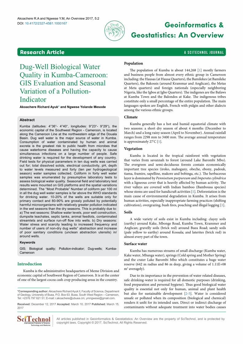
The geology of the Kumba Plain (Kumba Volcanic Field) is controlled by three main volcanic activities (which probably occurred between the Eocene and 1Ma ago). These include: old basaltic lavas covering the entire plain; cinder cones and phreatomagmatic units; and short vesicular basaltic lava flow [13].
There are four maars in the Kumba Plain. These include: the Barombi Mbo, Barombi Koto, Mbwadong and Dissoni Maars, with the first two occupied by Lakes Barombi Mbo and Lake Barombi Koto. Based on the composite fragments contained in the Barombi Mbo Maar (BMM) pyroclastic deposits, it is likely that the maar cuts through a geological succession composed by granite gneissic formations, sandstones, and basaltic lava flows; the same formations that make up the Kumba volcanic field [14] (Figures 2 and 3).
Volcanic formations of the plain have been emplaced over Panafrican metamorphic formations intruded by granitoids and locally covered by Cretaceous continental sandstones [15]. They commonly enclose mantle peridotite xenoliths [15].
Conglomerates outcrop at the Buea Road area. They are poorly sorted; containing grains ranging from clays to boulders, with intense
pollution which can be indicated by alterations in its physicochemical properties (temperature, pH, and electrical conductivity) or biological properties (microorganisms especially pathogens) [6,7].
Biological water quality is very important because it is directly related to the presence and concentration of disease causing microorganisms (pathogens) which include some bacteria, fungi, archaea or protists and viruses. The greatest risk to public health from microbes in water is associated with consumption of water contaminated with human and animal excreta, although other sources of exposure may also be significant. This is because outbreaks of waterborne disease have the capacity to cause simultaneous infection of a large number of people [8]. Thus rating the quality of any water source therefore must involve the identification and enumeration of all such organisms, which is very expensive and time consuming. However, indicator microbes like coliform bacteria are widely used to validate the integrity of distribution systems, cleanliness, detect and estimate levels of contamination, and the potential presence of pathogens. This is because these organisms, though not all harmful, are fecal indicator microorganisms that can survive and grow in both sewage and natural waters; are excreted in the feces of humans and animals, but many are heterotrophic and able to multiply in water and soil environments and can survive and grow in water distribution systems, particularly in the presence of biofilms [9]. High values (Most Probable Number) of coliform in water indicate high risk of fecal contamination.
In Kumba, whose population is made up of mostly low income subsistence farmers who are very dependent on groundwater for drinking and domestic activities, there is currently limited information and understanding of the importance of protection of groundwater from anthropogenic pollution. Also, the breakout of an epidemic in Kumba might spread rapidly, given that the population is made up of people from almost every ethnic group in Cameroon and neighboring countries. A seasonal monitoring of the variation of groundwater biological quality is necessary in the practice of groundwater quality assessment and resource management in Kumba.
Figure 1: 3-D model of the Kumba plain in the northwestern edge of the Douala Basin, Lake Barombi Mbo: Note the scar of an ancient BMM maar and Rumpi Hills to the northwest (Adapted from [13]).
Citation: Akoachere R.A. and Ngwese Y.M. (2017) Dug-Well Biological Water Quality in Kumba-Cameroon: GIS Evaluation and Seasonal Variation of a Pollution-Indicator. Geoinfor Geostat: An Overview 5:2.
• Page 3 of 13 •Volume 5 • Issue 2 • 1000167
doi: 10.4172/2327-4581.1000167
Figure 2: Geology of Kumba and environs (Adapted after [13]).
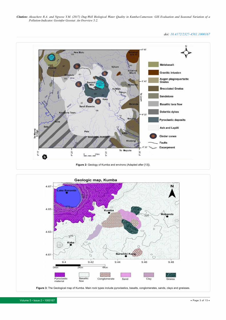
Figure 3: The Geological map of Kumba. Main rock types include pyroclastics, basalts, conglomerates, sands, clays and gneisses.
Citation: Akoachere R.A. and Ngwese Y.M. (2017) Dug-Well Biological Water Quality in Kumba-Cameroon: GIS Evaluation and Seasonal Variation of a Pollution-Indicator. Geoinfor Geostat: An Overview 5:2.
• Page 4 of 13 •Volume 5 • Issue 2 • 1000167
doi: 10.4172/2327-4581.1000167
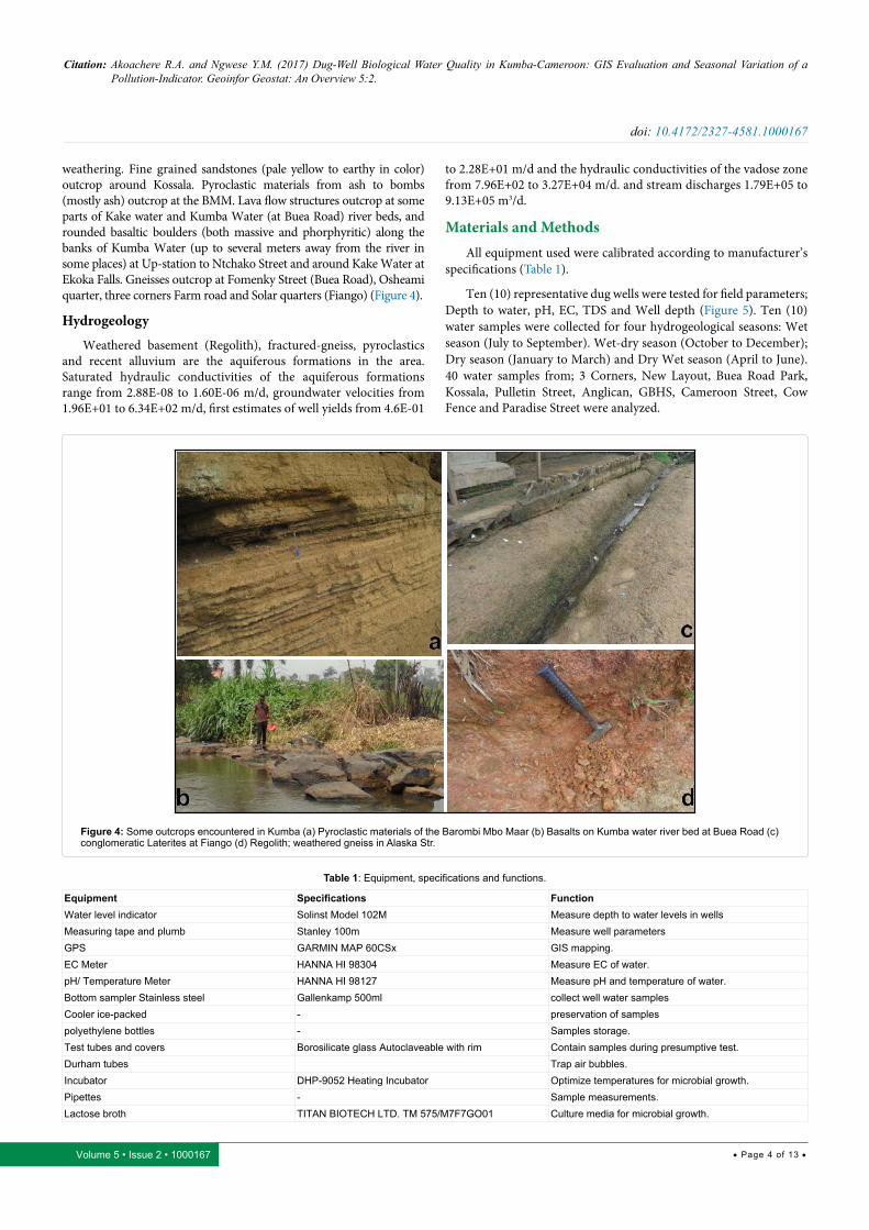
weathering. Fine grained sandstones (pale yellow to earthy in color) outcrop around Kossala. Pyroclastic materials from ash to bombs (mostly ash) outcrop at the BMM. Lava flow structures outcrop at some parts of Kake water and Kumba Water (at Buea Road) river beds, and rounded basaltic boulders (both massive and phorphyritic) along the banks of Kumba Water (up to several meters away from the river in some places) at Up-station to Ntchako Street and around Kake Water at Ekoka Falls. Gneisses outcrop at Fomenky Street (Buea Road), Osheami quarter, three corners Farm road and Solar quarters (Fiango) (Figure 4).
Hydrogeology
Weathered basement (Regolith), fractured-gneiss, pyroclastics and recent alluvium are the aquiferous formations in the area. Saturated hydraulic conductivities of the aquiferous formations range from 2.88E-08 to 1.60E-06 m/d, groundwater velocities from 1.96E+01 to 6.34E+02 m/d, first estimates of well yields from 4.6E-01
to 2.28E+01 m/d and the hydraulic conductivities of the vadose zone from 7.96E+02 to 3.27E+04 m/d. and stream discharges 1.79E+05 to 9.13E+05 m3/d.
Materials and MethodsAll equipment used were calibrated according to manufacturer’s
specifications (Table 1).
Ten (10) representative dug wells were tested for field parameters; Depth to water, pH, EC, TDS and Well depth (Figure 5). Ten (10) water samples were collected for four hydrogeological seasons: Wet season (July to September). Wet-dry season (October to December); Dry season (January to March) and Dry Wet season (April to June). 40 water samples from; 3 Corners, New Layout, Buea Road Park, Kossala, Pulletin Street, Anglican, GBHS, Cameroon Street, Cow Fence and Paradise Street were analyzed.
Figure 4: Some outcrops encountered in Kumba (a) Pyroclastic materials of the Barombi Mbo Maar (b) Basalts on Kumba water river bed at Buea Road (c) conglomeratic Laterites at Fiango (d) Regolith; weathered gneiss in Alaska Str.
Equipment Specifications FunctionWater level indicator Solinst Model 102M Measure depth to water levels in wellsMeasuring tape and plumb Stanley 100m Measure well parametersGPS GARMIN MAP 60CSx GIS mapping.EC Meter HANNA HI 98304 Measure EC of water.pH/ Temperature Meter HANNA HI 98127 Measure pH and temperature of water.Bottom sampler Stainless steel Gallenkamp 500ml collect well water samplesCooler ice-packed - preservation of samplespolyethylene bottles - Samples storage.Test tubes and covers Borosilicate glass Autoclaveable with rim Contain samples during presumptive test.Durham tubes Trap air bubbles.Incubator DHP-9052 Heating Incubator Optimize temperatures for microbial growth.Pipettes - Sample measurements.Lactose broth TITAN BIOTECH LTD. TM 575/M7F7GO01 Culture media for microbial growth.
Table 1: Equipment, specifications and functions.

Citation: Akoachere R.A. and Ngwese Y.M. (2017) Dug-Well Biological Water Quality in Kumba-Cameroon: GIS Evaluation and Seasonal Variation of a Pollution-Indicator. Geoinfor Geostat: An Overview 5:2.
• Page 5 of 13 •Volume 5 • Issue 2 • 1000167
doi: 10.4172/2327-4581.1000167
Dug wells in Kumba vary in construction from; no collar open pits at ground level, to wells aproned with various objects placed over the mouth; old car tires, concrete, to metal collars. Wells had covers that ranged from metal sheets to sheets of plywood and even PVC basins. Many wells had no covers. Very few owners keep their wells under lock and key and some installed submersible pumps and mechanical simple pulley systems to ease the water-withdrawal process. Most of these wells are located only a few meters away from latrines, graves and dump sites. Some wells have plants growing in them and two wells had bats living in them. None of the recommendations for construction of Dug wells by WHO in Figure 6 is respected in Kumba in spite of the existing legislation.
At each dug well, a clean polyethylene bottle was rinsed thrice with well water and filled two thirds its capacity, to ensure the survival of microorganisms and sent to the Life Science Laboratory of the University of Buea. Presumptive tests were carried out following standard procedures [16]. For each sample, 3 DSLB (double strength lactose broth) and 6 SSLB (single strength lactose broth), tube sets were labeled according to amount of water dispensed (10 mL, 1.0 mL, 0.1 mL respectively) (Figure 7). MPN (Most Probable Number) of coliform per 100 ml of water samples was determined from tables (Table 2) [17]. The results were mounted on various GIS platforms; Enviroinsite, Global Mapper and Surfer V12 to obtain spatial variations of MPN of coliform per 100 ml of water in dug wells in Kumba.
Figure 5: Loci of the 10 hand-dug wells in Kumba from which 40 water samples were collected for microbial analyses.
Figure 6: Presumptive Coliform test procedure (A) sample preparation process; (B) test set-up before incubation; (C) test tubes in the incubator and (D) samples after 24hours with air bubbles in the Durham tubes.
Citation: Akoachere R.A. and Ngwese Y.M. (2017) Dug-Well Biological Water Quality in Kumba-Cameroon: GIS Evaluation and Seasonal Variation of a Pollution-Indicator. Geoinfor Geostat: An Overview 5:2.
• Page 6 of 13 •Volume 5 • Issue 2 • 1000167
doi: 10.4172/2327-4581.1000167
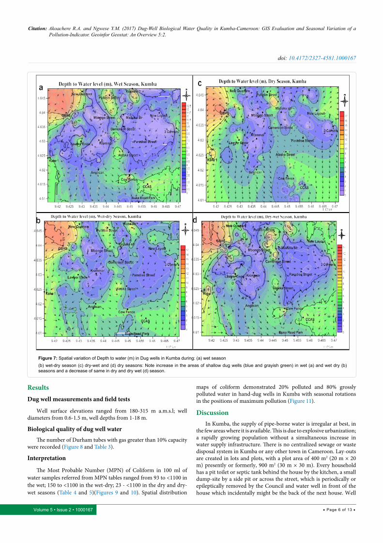
Figure 7: Spatial variation of Depth to water (m) in Dug wells in Kumba during: (a) wet season(b) wet-dry season (c) dry-wet and (d) dry seasons: Note increase in the areas of shallow dug wells (blue and grayish green) in wet (a) and wet dry (b) seasons and a decrease of same in dry and dry wet (d) season.
ResultsDug well measurements and field tests
Well surface elevations ranged from 180-315 m a.m.s.l; well diameters from 0.6-1.5 m, well depths from 1-18 m.
Biological quality of dug well water
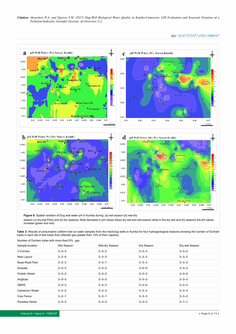
The number of Durham tubes with gas greater than 10% capacity were recorded (Figure 8 and Table 3).
Interpretation
The Most Probable Number (MPN) of Coliform in 100 ml of water samples referred from MPN tables ranged from 93 to <1100 in the wet; 150 to <1100 in the wet-dry; 23 - <1100 in the dry and dry-wet seasons (Table 4 and 5)(Figures 9 and 10). Spatial distribution
maps of coliform demonstrated 20% polluted and 80% grossly polluted water in hand-dug wells in Kumba with seasonal rotations in the positions of maximum pollution (Figure 11).
DiscussionIn Kumba, the supply of pipe-borne water is irregular at best, in
the few areas where it is available. This is due to explosive urbanization; a rapidly growing population without a simultaneous increase in water supply infrastructure. There is no centralized sewage or waste disposal system in Kumba or any other town in Cameroon. Lay-outs are created in lots and plots, with a plot area of 400 m2 (20 m × 20 m) presently or formerly, 900 m2 (30 m × 30 m). Every household has a pit toilet or septic tank behind the house by the kitchen, a small dump-site by a side pit or across the street, which is periodically or epileptically removed by the Council and water well in front of the house which incidentally might be the back of the next house. Well
Citation: Akoachere R.A. and Ngwese Y.M. (2017) Dug-Well Biological Water Quality in Kumba-Cameroon: GIS Evaluation and Seasonal Variation of a Pollution-Indicator. Geoinfor Geostat: An Overview 5:2.
• Page 7 of 13 •Volume 5 • Issue 2 • 1000167
doi: 10.4172/2327-4581.1000167
T(°C) pH EC (µS)
Place names W WD D DW W WD D DW W WD D DW
3 Corners 26.70 26.60 26.60 28.10 5.90 9.10 6.80 6.10 36.00 287.00 215.00 308.00
New Layout 25.50 26.90 27.10 27.00 5.60 7.50 8.10 5.40 21.00 362.00 161.00 248.00
Buea Road Park 27.30 25.00 26.50 26.70 5.40 6.80 7.40 5.40 6.00 73.00 138.00 57.00
Kossala 25.70 25.60 27.20 28.40 5.50 6.50 7.60 5.30 8.00 128.00 256.00 539.00
Pulletin Str. 26.80 25.60 27.20 27.30 5.60 8.80 7.80 5.30 5.00 56.00 201.00 104.00
Anglican 26.30 26.50 26.60 27.30 5.00 8.70 6.70 5.20 10.00 96.00 90.00 75.00
GBHS 26.00 27.20 26.60 27.50 5.60 7.20 7.20 6.30 1.00 13.00 19.00 6.00
Cameroon Str. 26.80 27.00 27.10 27.30 5.60 7.20 6.80 5.70 20.00 242.00 268.00 417.00
Cow Fence 26.80 27.40 27.40 27.50 5.10 8.00 6.90 5.10 7.00 78.00 208.00 93.00
Paradise Str. 25.90 27.00 27.20 27.60 5.40 7.00 7.10 5.20 10.00 134.00 118.00 238.00
W=Wet Season WD=Wet Dry Season D=Dry Season DW=Dry Wet Season
TDS (mg/l) Depth to water (m)
Place names W WD D DW W WD D DW
3 Corners 24.48 195.20 146.20 209.40 4.77 5.57 4.97 5.39
New Layout 14.28 246.20 109.50 168.60 1.95 3.44 6.92 2.61
Buea Road Park 4.08 49.64 93.84 38.76 2.06 4.30 4.13 2.88
Kossala 5.44 87.04 174.10 366.50 3.06 4.29 4.13 4.12
Pulletin Str. 3.40 38.08 136.70 70.72 9.58 10.39 6.73 3.22
Anglican 6.80 65.28 61.20 51,00 3.70 5.98 6.41 3.13
GBHS 0.68 8.84 12.92 4.08 11.40 14.89 15.90 13.28
Cameroon Str. 13.60 164.60 182.20 283.60 2.33 3.26 4.15 3.04
Cow Fence 4.76 53.04 141.40 63.24 5.93 6.44 4.62 4.88
Paradise Str. 6.80 91.12 80.24 161.80 1.71 2.15 5.28 1.57
Table 2: Field tests range from; Depth to water levels 0-16 m; pH 3.9-11.7, EC 1–1900 µS; temperatures 23.3 – 30.7°C and TDS 3.40-366.5 mg/l.
water is the main water source for most households in Kumba. Water wells are shallow and some wells get dry during the drier seasons.
The MPN of coliform per 100 ml of well water samples was far above the standard limit set by [18,19] for drinking water. Only 20% of the samples were suitable for primary contact like bathing. By Cheesbrough classification, 80-90% of the samples were grossly polluted by potentially harmful microorganisms. These pathogens may be of fecal origin and water that contains them is not suitable for drinking and/or cleaning purposes [20,21].
MPN of coliform per 100 ml of well water samples indicate relatively greater MPN counts in the wet and Wet-dry season than the dry and Dry-wet season. This is probably due to:
Wet and Wet-dry seasons
The shallow depth to water levels which in some areas Dug well water is at the surface.
The increase in surface runoff into wells in the rainy season due to badly constructed wells.
i) & ii) above increase the direct contamination of well water by feces from the land surface, dump site leachates from domestic dump sites behind each house and other wastes especially from communal rubbish dump sites or the already very contaminated surface water from streamlets which overflow their banks during the rainy season.
Dry and dry wet seasonsDirty Buckets.Water stress and Scarcity.The multiple dipping of buckets and other receptacles into
dug wells during the drier seasons. During the drier seasons, Rain harvesting stops, dug well water levels drop, some shallow wells get dry, leaving fewer deeper wells with water and a consequent higher number of people dipping buckets of dubious cleanliness into the fewer non-dry wells, especially wells without aprons, collar and covers. In some areas, water is so scarce that one cannot afford to have a bit, not to think about wasting it washing the abstraction bucket.
In developing and underdeveloped countries, disease spread by fecal contamination of water is a common phenomenon [22,23]. Large amounts of Coliform have been found in Dug well water in Kumba, consumed by a huge number of people. This is a serious challenge which could result in possible future outbreaks of waterborne epidemics like cholera, dysentery and typhoid fever spreading to other areas of Cameroon and neighboring countries. Also the existence of bats in dug wells is alarming knowing they are vectors of rabies and Ebola viruses!
ConclusionVery high concentrations of potentially harmful microorganisms
are in Dug well water in Kumba representing a high potential for contamination of dug well water by pathogenic organisms which
Citation: Akoachere R.A. and Ngwese Y.M. (2017) Dug-Well Biological Water Quality in Kumba-Cameroon: GIS Evaluation and Seasonal Variation of a Pollution-Indicator. Geoinfor Geostat: An Overview 5:2.
• Page 8 of 13 •Volume 5 • Issue 2 • 1000167
doi: 10.4172/2327-4581.1000167
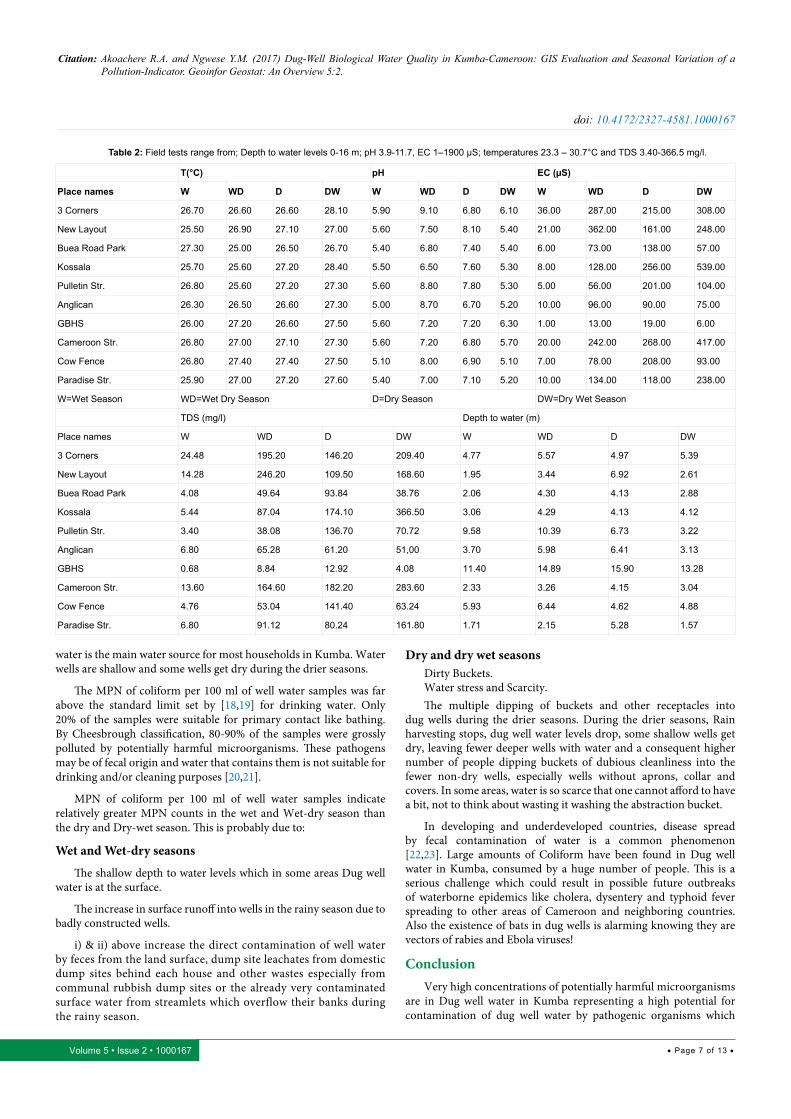
Figure 8: Spatial variation of Dug well water pH in Kumba during: (a) wet season (b) wet-dryseason (c) dry-wet Park) and (d) dry seasons. Note decrease in pH values (blue) dry wet and wet season while in the dry wet and dry seasons the pH values increase (green and red).
Number of Durham tubes with more than10% gas
Sample location Wet Season Wet-dry Season Dry Season Dry-wet Season
3 Corners 3--3--3 3--3--2 3--3--3 3--3--2
New Layout 3--2--0 3--3--3 3--3--3 3--3--2
Buea Road Park 3--3--3 3--3--1 3--3--3 3--3--2
Kossala 3--3--3 3--3--2 3--0--0 3--3--3
Pulletin Street 3--3--2 3--3--2 3--3--2 3--0--0
Anglican 3--3--3 3--3--3 3--3--3 3--3--3
GBHS 3--3--3 3--3--3 3--3--0 3--3--3
Cameroon Street 3--3--2 3--3--3 3--3--3 3--3--3
Cow Fence 3--2--1 3--3--1 3--3--3 3--3--2
Paradise Street 3--3--3 3--3--3 3--3--3 3--1--1
Table 3: Results of presumptive coliform test on water samples from the hand-dug wells in Kumba for four hydrogeological seasons showing the number of Durham tubes in each set of test tubes that collected gas greater than 10% of their capacity.
Citation: Akoachere R.A. and Ngwese Y.M. (2017) Dug-Well Biological Water Quality in Kumba-Cameroon: GIS Evaluation and Seasonal Variation of a Pollution-Indicator. Geoinfor Geostat: An Overview 5:2.
• Page 9 of 13 •Volume 5 • Issue 2 • 1000167
doi: 10.4172/2327-4581.1000167
Sample location Wet Season Wet-Dry Season Dry Season Dry-Wet Season
MPN CB MPN CB MPN CB MPN CB
3 Corners >1100 GP >1100 GP >1100 GP >1100 GP
New Layout 93 U >1100 GP >1100 GP >1100 GP
Buea Road Park >1100 GP 150 GP >1100 GP >1100 GP
Kossala >1100 GP >1100 GP 23 U >1100 GP
Pulletin Street >1100 GP >1100 GP >1100 GP 23 U
Anglican >1100 GP >1100 GP >1100 GP >1100 GP
GBHS >1100 GP >1100 GP 240 GP >1100 GP
Cameroon Street >1100 GP >1100 GP >1100 GP >1100 GP
Cow Fence 150 U 150 GP >1100 GP >1100 GP
Paradise Street >1100 GP >1100 GP >1100 GP 75 U
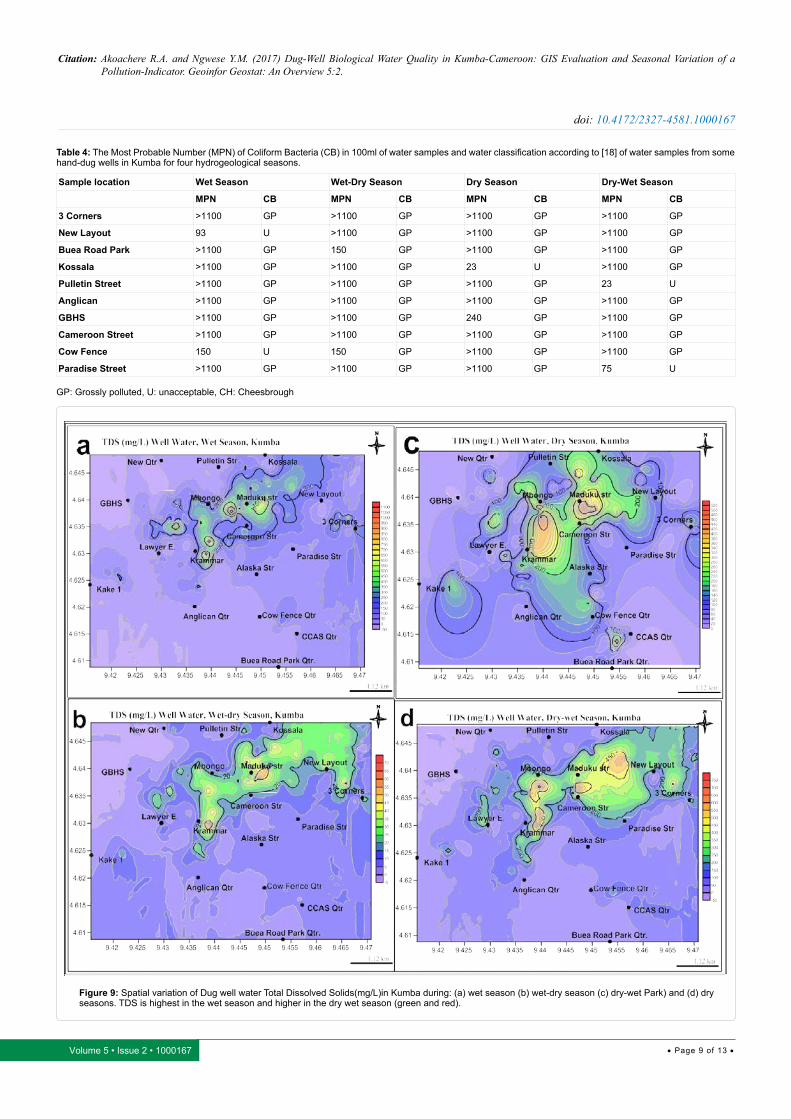
Table 4: The Most Probable Number (MPN) of Coliform Bacteria (CB) in 100ml of water samples and water classification according to [18] of water samples from some hand-dug wells in Kumba for four hydrogeological seasons.
GP: Grossly polluted, U: unacceptable, CH: Cheesbrough
Figure 9: Spatial variation of Dug well water Total Dissolved Solids(mg/L)in Kumba during: (a) wet season (b) wet-dry season (c) dry-wet Park) and (d) dry seasons. TDS is highest in the wet season and higher in the dry wet season (green and red).
Citation: Akoachere R.A. and Ngwese Y.M. (2017) Dug-Well Biological Water Quality in Kumba-Cameroon: GIS Evaluation and Seasonal Variation of a Pollution-Indicator. Geoinfor Geostat: An Overview 5:2.
• Page 10 of 13 •Volume 5 • Issue 2 • 1000167
doi: 10.4172/2327-4581.1000167
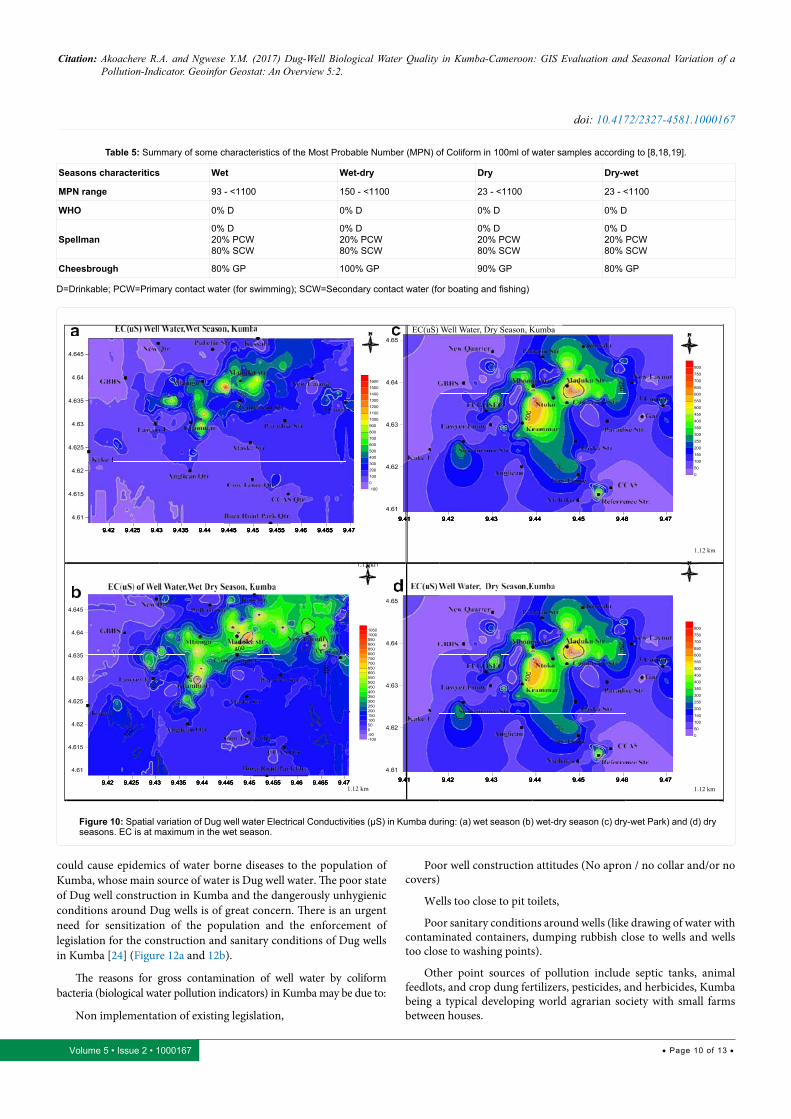
Seasons characteritics Wet Wet-dry Dry Dry-wet
MPN range 93 - <1100 150 - <1100 23 - <1100 23 - <1100
WHO 0% D 0% D 0% D 0% D
Spellman0% D20% PCW80% SCW
0% D20% PCW80% SCW
0% D20% PCW80% SCW
0% D20% PCW80% SCW
Cheesbrough 80% GP 100% GP 90% GP 80% GP
Table 5: Summary of some characteristics of the Most Probable Number (MPN) of Coliform in 100ml of water samples according to [8,18,19].
D=Drinkable; PCW=Primary contact water (for swimming); SCW=Secondary contact water (for boating and fishing)
EC(uS) Well Water, Dry Season, Kumba
Figure 10: Spatial variation of Dug well water Electrical Conductivities (µS) in Kumba during: (a) wet season (b) wet-dry season (c) dry-wet Park) and (d) dry seasons. EC is at maximum in the wet season.
could cause epidemics of water borne diseases to the population of Kumba, whose main source of water is Dug well water. The poor state of Dug well construction in Kumba and the dangerously unhygienic conditions around Dug wells is of great concern. There is an urgent need for sensitization of the population and the enforcement of legislation for the construction and sanitary conditions of Dug wells in Kumba [24] (Figure 12a and 12b).
The reasons for gross contamination of well water by coliform bacteria (biological water pollution indicators) in Kumba may be due to:
Non implementation of existing legislation,
Poor well construction attitudes (No apron / no collar and/or no covers)
Wells too close to pit toilets,
Poor sanitary conditions around wells (like drawing of water with contaminated containers, dumping rubbish close to wells and wells too close to washing points).
Other point sources of pollution include septic tanks, animal feedlots, and crop dung fertilizers, pesticides, and herbicides, Kumba being a typical developing world agrarian society with small farms between houses.

Citation: Akoachere R.A. and Ngwese Y.M. (2017) Dug-Well Biological Water Quality in Kumba-Cameroon: GIS Evaluation and Seasonal Variation of a Pollution-Indicator. Geoinfor Geostat: An Overview 5:2.
• Page 11 of 13 •Volume 5 • Issue 2 • 1000167
doi: 10.4172/2327-4581.1000167
Figure 11: Spatial variation of coliform (MPN per 100ml) in Dug well water in Kumba during:(a) Wet season (Cameroon Str., New layout) (b) Wet-dry season (Kossala, Anglican Str.) (c) Dry-wet (Cameroon Qtr., Buea Rd Park) and (d) Dry seasons (Pulletin Str., Paradise Str.) showing the size and spatial seasonal disposition of the low pollution areas. Note the relative increase in areas with high MPN (red) during the wet and dry wet seasons.
Figure 12a: Dug wells in Kumba. Most fall short of the [24] specifications for the completion and protection of dug well; i) no cover,growing grass visible ,ii) no concrete apron, used car tire as collar, stores water which is potential breeding ground for mosquitoes, no cover, vulcanizing activities too close to well is a potential source of pollution, iii) no gate, inappropriate cover, danger to children (cases have been reported of children drowning in wells in Kumba, iv) no concrete apron, used car tire collar, no cover, v) no cover, broken collar, too close to pit latrine, vi) inappropriate cover, used car tire collar, poor care of well rope and bucket, vii) inappropriate cover, viii) no cover, no collar, no concrete apron, really shallow and open: possible breeding ground for mosquitoes, very susceptible to direct pollution, ix) broken collar, no cover, x) no cover, xi) no cover, broken apron, badly in need of rehabilitation, xii)no cover, broken collar and apron.
Citation: Akoachere R.A. and Ngwese Y.M. (2017) Dug-Well Biological Water Quality in Kumba-Cameroon: GIS Evaluation and Seasonal Variation of a Pollution-Indicator. Geoinfor Geostat: An Overview 5:2.
• Page 12 of 13 •Volume 5 • Issue 2 • 1000167
doi: 10.4172/2327-4581.1000167
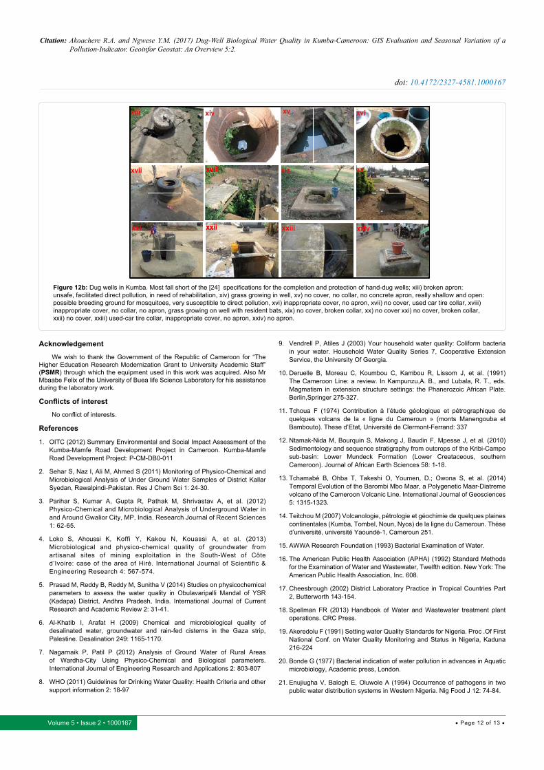
Figure 12b: Dug wells in Kumba. Most fall short of the [24] specifications for the completion and protection of hand-dug wells; xiii) broken apron: unsafe, facilitated direct pollution, in need of rehabilitation, xiv) grass growing in well, xv) no cover, no collar, no concrete apron, really shallow and open: possible breeding ground for mosquitoes, very susceptible to direct pollution, xvi) inappropriate cover, no apron, xvii) no cover, used car tire collar, xviii) inappropriate cover, no collar, no apron, grass growing on well with resident bats, xix) no cover, broken collar, xx) no cover xxi) no cover, broken collar, xxii) no cover, xxiii) used-car tire collar, inappropriate cover, no apron, xxiv) no apron.
Acknowledgement
We wish to thank the Government of the Republic of Cameroon for “The Higher Education Research Modernization Grant to University Academic Staff” (PSMR) through which the equipment used in this work was acquired. Also Mr Mbaabe Felix of the University of Buea life Science Laboratory for his assistance during the laboratory work.
Conflicts of interest
No conflict of interests.
References
1. OITC (2012) Summary Environmental and Social Impact Assessment of the Kumba-Mamfe Road Development Project in Cameroon. Kumba-Mamfe Road Development Project: P-CM-DB0-011
2. Sehar S, Naz I, Ali M, Ahmed S (2011) Monitoring of Physico-Chemical and Microbiological Analysis of Under Ground Water Samples of District Kallar Syedan, Rawalpindi-Pakistan. Res J Chem Sci 1: 24-30.
3. Parihar S, Kumar A, Gupta R, Pathak M, Shrivastav A, et al. (2012) Physico-Chemical and Microbiological Analysis of Underground Water in and Around Gwalior City, MP, India. Research Journal of Recent Sciences 1: 62-65.
4. Loko S, Ahoussi K, Koffi Y, Kakou N, Kouassi A, et al. (2013) Microbiological and physico-chemical quality of groundwater from artisanal sites of mining exploitation in the South-West of Côte d’Ivoire: case of the area of Hiré. International Journal of Scientific & Engineering Research 4: 567-574.
5. Prasad M, Reddy B, Reddy M, Sunitha V (2014) Studies on physicochemical parameters to assess the water quality in Obulavaripalli Mandal of YSR (Kadapa) District, Andhra Pradesh, India. International Journal of Current Research and Academic Review 2: 31-41.
6. Al-Khatib I, Arafat H (2009) Chemical and microbiological quality of desalinated water, groundwater and rain-fed cisterns in the Gaza strip, Palestine. Desalination 249: 1165-1170.
7. Nagarnaik P, Patil P (2012) Analysis of Ground Water of Rural Areas of Wardha-City Using Physico-Chemical and Biological parameters. International Journal of Engineering Research and Applications 2: 803-807
8. WHO (2011) Guidelines for Drinking Water Quality: Health Criteria and other support information 2: 18-97
9. Vendrell P, Atiles J (2003) Your household water quality: Coliform bacteria in your water. Household Water Quality Series 7, Cooperative Extension Service, the University Of Georgia.
10. Deruelle B, Moreau C, Koumbou C, Kambou R, Lissom J, et al. (1991) The Cameroon Line: a review. In Kampunzu,A. B., and Lubala, R. T., eds. Magmatism in extension structure settings: the Phanerozoic African Plate. Berlin,Springer 275-327.
11. Tchoua F (1974) Contribution à l’étude géologique et pétrographique de quelques volcans de la « ligne du Cameroun » (monts Manengouba et Bambouto). These d’Etat, Université de Clermont-Ferrand: 337
12. Ntamak-Nida M, Bourquin S, Makong J, Baudin F, Mpesse J, et al. (2010) Sedimentology and sequence stratigraphy from outcrops of the Kribi-Campo sub-basin: Lower Mundeck Formation (Lower Creataceous, southern Cameroon). Journal of African Earth Sciences 58: 1-18.
13. Tchamabé B, Ohba T, Takeshi O, Youmen, D.; Owona S, et al. (2014) Temporal Evolution of the Barombi Mbo Maar, a Polygenetic Maar-Diatreme volcano of the Cameroon Volcanic Line. International Journal of Geosciences 5: 1315-1323.
14. Teitchou M (2007) Volcanologie, pétrologie et géochimie de quelques plaines continentales (Kumba, Tombel, Noun, Nyos) de la ligne du Cameroun. Thése d’université, université Yaoundé-1, Cameroun 251.
15. AWWA Research Foundation (1993) Bacterial Examination of Water.
16. The American Public Health Association (APHA) (1992) Standard Methods for the Examination of Water and Wastewater, Twelfth edition. New York: The American Public Health Association, Inc. 608.
17. Cheesbrough (2002) District Laboratory Practice in Tropical Countries Part 2, Butterworth 143-154.
18. Spellman FR (2013) Handbook of Water and Wastewater treatment plant operations. CRC Press.
19. Akeredolu F (1991) Setting water Quality Standards for Nigeria. Proc .Of First National Conf. on Water Quality Monitoring and Status in Nigeria, Kaduna 216-224
20. Bonde G (1977) Bacterial indication of water pollution in advances in Aquatic microbiology, Academic press, London.
21. Enujiugha V, Balogh E, Oluwole A (1994) Occurrence of pathogens in two public water distribution systems in Western Nigeria. Nig Food J 12: 74-84.
Citation: Akoachere R.A. and Ngwese Y.M. (2017) Dug-Well Biological Water Quality in Kumba-Cameroon: GIS Evaluation and Seasonal Variation of a Pollution-Indicator. Geoinfor Geostat: An Overview 5:2.
• Page 13 of 13 •Volume 5 • Issue 2 • 1000167
doi: 10.4172/2327-4581.1000167
22. Le-chevalier M, Cawthon C, Lee R (1987) Factors promoting survival of bacteria in chlorinated water supplies Applied Environmental Microbiol 88: 649-554.
23. WHO (2016) Fact Sheet 2.2: Dug wells.
24. Laver S (1980) Well Digging: A guide to the construction and protection of Dug wells, GTZ, Blair Research Laboratory. Harare, Zimbabwe.
Author Affiliation Top
Faculty of Science, Department of Geology, University of Buea, P.O. Box 63. Buea, South West Region, Cameron
Submit your next manuscript and get advantages of SciTechnol submissions
� 80 Journals � 21 Day rapid review process � 3000 Editorial team � 5 Million readers � More than 5000 � Quality and quick review processing through Editorial Manager System
Submit your next manuscript at ● www.scitechnol.com/submission