digital transformation in new zealand - gis professional · 2019-01-28 · digital transformation...
TRANSCRIPT

JUNE 2017
Issue No 76
WWW.GIS-PROFESSIONAL.COM
...joining the geospatial jigsaw
Digital Transformation in New Zealand
GIS: Challenges and trends in 2017
Creative Traps
Driving the Global Geospatial Agenda
Joining up the Dots
Geospatial, IoT and the ‘Digital Twin’
01_cover.indd 3 31-05-17 13:05

The ZenoCollector combines the hardware excellence of Leica Geosystems with the world’s leading GIS software from Esri to deliver high accuracy data collection in ArcGIS.
The solution delivers sub-metre or centimetre survey grade position accuracy into Esri’s industry leading Collector for ArcGIS app. This uses the Leica Zeno 20, the world’s first handheld with Android operating system, enabling field data collection and editing in a simple, user-friendly interface on an ultra-rugged device.
To find out more information about the ZenoCollector, please contact:
Or visit:
www.esri.com/zenocollector
The ZenoCollector
Ready to work when you are
Leica Geosystems Ltd Hexagon House, Michigan Drive, Tongwell, Milton Keynes, MK15 8HT
Tel:01908 513464 [email protected] www.leica-geosystems.co.uk
Simplifying high accuracy data collection
_Leica_3-2017.indd 4 30-05-17 09:03

June 2017 3
CONTENTS
P. 10 GIS: CHALLENGES AND TRENDS IN 2017 GIS Professional conducted a market and
applications survey. With over 200 responses, we gained an interesting insight into the current GIS landscape.
P. 14 GEOPLACE CONFERENCE REPORT The GeoPlace Annual Conference took place
on 11 May 2017 at the grounds of the Leeds United Football Club with over 350 people attending. Joost Boers reports.
P. 16 CREATIVE TRAPS To help stop copyright infringement,
Cartographers have laid copyright traps in their work to catch people out. We look at some of the strangest cases.
P. 18 THE GLOBAL GEOSPATIAL AGENDA We take a look at the three international bodies
which are driving the global geospatial agenda which underpins the need for smart and sustainable growth: OGC, GEO and UN-GGIM.
P. 22 JOINING UP THE DOTS The use of administrative data for purposes
other than those it was collected for has become an essential data resource for health and social science research.
P. 24 DIGITAL TRANSFORMATION IN NZ New Zealand’s Department of Conservation
P. 05 Editorial NotesP. 06 NewsP. 13 Adena Schutzberg ColumnP. 15 Elevator Pitch: PowerScout
P. 28 AGI’s Chair ReportsP. 29 Products & ServicesP. 30 CalendarP. 31 Classifi ed
Next Issue: August 2017Copy Dates Editorial: 10 JulyAdvertising: 20 July
COVER STORYNew Zealand’s Department
of Conservation (DOC) out in
the fi eld monitoring vegetation
the old fashion way with
paper-based methods. A
pilot programme was recently
initiated to expose the staff to GIS software.
JUNE 2017
Issue No 76
WWW.GIS-PROFESSIONAL.COM
...joining the geospatial jigsaw
Digital Transformation in New Zealand
GIS: Challenges and trends in 2017
Creative Traps
Driving the Global Geospatial Agenda
Joining up the Dots
Geospatial, IoT and the ‘Digital Twin’
01_cover.indd 3 31-05-17 13:05
GiS Professional is published bi-monthly by Geomares Publishing UK Ltd and endorsed by the UK’s Association for Geographical Information. Our mission is to help grow the business for the whole GIS community by providing an effective, reliable and timely medium for news, information and comment.
Publisher: Durk HaarsmaContent manager: Joost BoersAdvertising: Sharon [email protected]: Jason [email protected]
EDITORIAL ADVISORY BOARDJames KavanaghDr Muki HaklayAdena SchutzbergDr Suchith AnandChris HolcroftSteven Ramage
CONTRIBUTING EDITORSNiall ConwaySteven EglintonSabine de Milliano
CONTACT DETAILSGeomares Publishing UK LtdUnit 2A Mindenhall Court, High StreetStevenage, Hertfordshire, SG1 3BG, UKTel: +44 (0)1438 352617e-mail: [email protected]: www.gis-professional.com
MATERIAL TO BE PUBLISHEDAll submissions will be handled with reasonable care, but the publishers assume no responsibilityfor safety of photographs or manuscripts. Every precaution is taken to ensure accuracy, but publishers cannot accept responsibility for the accuracy of information published or for any opinion expressed.
Reprints: Reprints of all articles are available.Call +44 (0) 1438 352617 for details.
Advertising: Information about advertisement rates, schedules etc. are available in a media pack. Go to www.gis-professional.com/advertise or email Sharon Robson ([email protected])
Subscriptions: Yearly subscriptions (six issues) are £34.95 (UK) or £37.50 (worldwide). For more information visit www.gis-professional.com or email [email protected]
Publishers: Geomares Publishing UK LtdNo material may be reproduced in whole or in part without the written permission of Geomares Publishing UK Ltd. © 2017 ISSN 1748-3646
Printing: The Manson Group, St Albans
Design: ZeeDesign, Witmarsum, www.zeedesign.nl
P. 14 SMARTPHONE SURVEYING ON SITE Photogrammetry is on the increase, thanks to
better software and smartphones. So just what is it capable of? Costain’s Richard Bath reports.
P. 18 GEOSPATIAL AND THE RIGHT TO LIGHT Andrew D. Thompson explains how geomatics
measurement techniques are being used in rights to light cases.
P. 20 RIGHTS OF LIGHT ILLUMINATED Andrew Maltby gives a Geomatics perspective
on the RICS Professional Guidance on Rights of Light published in March 2016.
P. 24 KOREC’S TECHNOLOGY AT SILVERSTONE No track action and drizzly rain, but interesting
presentations and technologies. But what’s happened to the telescope? GW reports.
P. 26 UAVS IN THE VINEYARD A low-cost and small-scale remote sensing
platform for aerial monitoring and survey applications and precision agriculture is presented by the authors.
P. 30 TOPCON’S ELITE AT OLYMPIC PARK How Topcon’s Elite software suite integrates
with the company’s latest hardware. GW reports.
P. 32 LEICA’S MOBILE MAPPING DAY Two new models and a refresh of others. The
day at Milton Keynes was a mix of indoor presentations and outdoor demos, reports Richard Groom.
To subscribe to GIS Professional go to www.gis-professional.com/magazine/subscribe
(DOC) have been supplied with tablets and smartphones equipped with Survey123 for ArcGIS.
P. 26 GEOSPATIAL, IOT AND THE ‘DIGITAL TWIN’ The IoT phenomenon, has revolutionised almost
every sector in today’s world. Among the many buzzwords associated with the fi eld is ‘Digital Twin’.
03_contents.indd 3 31-05-17 13:15

2017-May GIS Pro.indd 1 18/05/2017 10:09:30_Korec_3-2017.indd 4 30-05-17 09:05

>
Views of the Contributing Editors
EDITORIAL NOTES
June 2017 5
Starting with this issue, this page is dedicated
to notes from members of our editorial
board or authors, refl ecting on the issue, the
profession or an article they’ve been working
on, giving an insight ‘behind the scenes’. I
hope you enjoy it and I’m looking forward to
hearing your thoughts and suggestions.
Joost Boers, content [email protected]
As head of stakeholder engagement at one of the world’s largest intergovernmental organisations focused on geospatial topics, I spend most of my time meeting parties investing in and using Earth observations.
Almost half way into 2017, this year is shaping up to be one of the most exciting in the geospatial industry’s history. Highlights so far include the recent Google Earth upgrade, Planet’s miniature satellite launches, Amazon’s free satellite imagery offering on AWS, while the forthcoming release of QGIS 3.0 is likely to excite many in the open-source community.
On the topic of GIS, one of the big discussions among the geospatial community in 2017 concerns the changing nature of the GiS Professional’s role. Augmented reality and machine learning are already having a massive impact on the industry while advances in the data science fi eld (thanks to the growing popularity of tools like Tableau and statistical programming languages such as R) suggests that geospatialists should redefi ne their unique value. Finally, the two fi elds which are likely to see an increased demand for geospatial skills this year are transportation and cybersecurity.
Niall Conway, contributing editor
“Maps keep fascinating me. Not just because they provide a visual way of communicating complex information, but also because maps can be full of surprises. Read all about trap streets and phantom settlements in this issue’s big maps story.”
Sabine de Milliano,
contributing editor
I travel a fair amount and have a privileged position of seeing trends across organisations, sectors and even continents. The image above was part of my plenary talk at the recent ISRSE37 conference in Tschwane, South Africa in May. It was created as a result of input from the commercial sector organisations participating who told me what they thought was important in the short to medium-term. Organisations including ISRSE exhibitors: Airbus, CloudEO, Deimos Imaging, DigitalGlobe, Esri, Hexagon, PCI Geomatics, Planet and others.
This – and more events like SatSummit in January and DisruptSpace in March talked about going from data to decisions via insight and intelligence. This is where GEO sits; we convene the global EO community to offer insight for policy development and decision making. www.earthobservations.org
Steven Ramage,
contributing editor
05_editorial.indd 5 31-05-17 13:16

June 2017 6
NEWS
Risk Modeller for Fire and Rescue Services
Geographic Information Systems (GIS) software devel-oper Cadcorp has released a new application to help fi re services determine aggregate risk. Risk Modeller provides analytical functionality for determining risk by combining the effects of spatial and attribute data from a range of different layers.• bit.ly/
2qvtmtb
Harvard Seeks Submissions for Map of the Month Contest
The Innovations in Government Program at the Harvard Kennedy School’s Ash Center for Democratic Governance and Innovation has announce that they
are seeking applications for the Map of the Month contest, a new initiative dedicated to recognising highlighting the impactful work being done in the area of data visualisation and mapping.• bit.ly/2qvfnDr
The First Global Data Driven 3D Ocean Map
With only roughly 10% of oceans having been explored in any detail, the Group
on Earth Observations (GEO), an intergovernmental partnership that seeks innovative solutions to global challenges, commissioned a global map of Ecological Marine Units (EMUs). This map will support the wise use of ocean resources and the preservation of environmental resilience by providing a framework for understanding processes and detecting change.• bit.ly/2qvqOLA
Free Access to Software for UAV Mapping
UAV and data company PrecisionHawk has opened access to its professional mapping and analytics software, PrecisionMapper, for free. By eliminating the cost barrier, the company gives operators the fl exibility to bring their own drone and consistently generate value from aerial information.• bit.ly/2qvcNxk
Imajing Provides Esri Users with Online 3D Enabled Images
Developed by Imajing. Imajnet enables transportation infrastructure managers to host and share, within their organisation, geo-referenced 3D images surveyed with Imajbox mobile mapping system. Imajing has devel-oped extensions to enable Imajnet integration in ArcMap with a plug-in, and ArcGis Online with a widget.• bit.ly/2qv3ayv
Innovation for Ireland All Mapped Out
Ordnance Survey Ireland (OSi) is in the midst of a cartographic automation project that’s transforming its product offerings and service capabilities. In partnership with Esri Ireland, OSi has developed the multiresolution data store (MRDS), an advanced cartographic solution based on the ArcGIS platform that enables OSi to automatically generate and update map products and services quickly, with minimal human intervention.• bit.ly/2qv4cL0
Imajnet Integration in ArcMap
Staff at OSi
PrecisionMapper software
Harvard aims to make the work of
visualisation and mapping more visible
Risk Modeller screenshot
2017 PlanetSAT Global Imagery Basemap
French company PlanetObserver, supplier of geospatial data for all civil and military visualisation and simulation applications, and GIS solutions has announced the release of PlanetSAT Global #2017, the unique seamless and global imagery basemap processed with fresh and cloud-free satellite images. Processed with current Landsat 8 source data for 40% of the global and more than 300 major urban areas across the world, PlanetSAT Global version #2017 is the high quality natural colour imagery basemap that offers detailed and up-to-date geographic information, perfect for 1:50,000 scale mapping.• bit.ly/2qvi8ot
06-07-08-09_news.indd 6 31-05-17 13:20

June 2017 7
NEWSNEWS
Risk Modeller for Fire and Rescue Services
Geographic Information Systems (GIS) software devel-oper Cadcorp has released a new application to help fi re services determine aggregate risk. Risk Modeller provides analytical functionality for determining risk by combining the effects of spatial and attribute data from a range of different layers.• bit.ly/
2qvtmtb
Harvard Seeks Submissions for Map of the Month Contest
The Innovations in Government Program at the Harvard Kennedy School’s Ash Center for Democratic Governance and Innovation has announce that they
are seeking applications for the Map of the Month contest, a new initiative dedicated to recognising highlighting the impactful work being done in the area of data visualisation and mapping.• bit.ly/2qvfnDr
The First Global Data Driven 3D Ocean Map
With only roughly 10% of oceans having been explored in any detail, the Group
on Earth Observations (GEO), an intergovernmental partnership that seeks innovative solutions to global challenges, commissioned a global map of Ecological Marine Units (EMUs). This map will support the wise use of ocean resources and the preservation of environmental resilience by providing a framework for understanding processes and detecting change.• bit.ly/2qvqOLA
Risk Modeller screenshot
2017 PlanetSAT Global Imagery Basemap
French company PlanetObserver, supplier of geospatial data for all civil and military visualisation and simulation applications, and GIS solutions has announced the release of PlanetSAT Global #2017, the unique seamless and global imagery basemap processed with fresh and cloud-free satellite images. Processed with current Landsat 8 source data for 40% of the global and more than 300 major urban areas across the world, PlanetSAT Global version #2017 is the high quality natural colour imagery basemap that offers detailed and up-to-date geographic information, perfect for 1:50,000 scale mapping.• bit.ly/2qvi8ot
Project X Labs’ GeoDash 4
Project X Labs’ GeoDash 4 is a location intelligence tool that is once again redefi ning the standard for affordable geographic information systems (GIS). GeoDash is a lightweight MicroStrategy extension for map-based analysis that has been overhauled with new features including an optimised UI, the ability to perform aggregate operations on point clusters, and the introduction of dynamic zoom, allowing users to streamline their analysis by toggling layers to only display at custom zoom levels.• bit.ly/2qvndgq
GeoDash 4 software
06-07-08-09_news.indd 7 31-05-17 13:20

June 2017 8
NEWS
Construction Verifi cation Software
ClearEdge3D has released its newest software solution, Verity 1.0, which verifi es the accuracy of new construction against design/fabrication models, giving general contractors unprecedented insight into their construction projects. The software analyses laser scan point cloud data of the as-built construction against the design/fabrication models, identifying variances, missing elements or other potentially costly construction errors. The variance data and corrected model can be exported to Navisworks for as-built clash detection and further analysis.• bit.ly/2qvEOVq
TomTom and Maplink Cover Global Logistics Business
TomTom has been selected to power Maplink’s logistics and enterprise geolocation solutions. Maplink will leverage TomTom
global map and traffi c data in its API’s and logistics platform which hosts hundreds of thousands of assets worldwide. TomTom data will also be used in Maplink logistics software which can be installed on premise or on mobile driver terminals.• bit.ly/2qvnFuY3D Repo Cloud Platform adds Integrated
Virtual Reality Functionality
The new version of 3D Repo cloud-based building information modelling (BIM) software offers integrated virtual reality (VR) functionality using existing 3D models and project data. 3D Repo’s multi-award-winning solution for those managing construction and civil engineering
projects already used the latest cloud technology for wider access, easier collaboration and open-source application development. With the addition of VR capability, users can now deploy VR simulations for applications such as training, safety and project consultation.• bit.ly/2qv2Tfi
Top 5The Future of Geospatial Education bit.ly/2qvic7C
TanDEM-X 3D World Map Completed bit.ly/2qviA64
Online GIS and a Perfect Storm for Local Government
bit.ly/2qvk93Q
When the GNSS Mapping App you want doesn’t Exist. . . Make One!
bit.ly/2qvsaFO
The Role of Geological Data in the SMART City Agenda
bit.ly/2qvic7J
ClearEdge Verity 1.0
New Versions of Vulcan and Eureka
Mining technology developer Maptek has delivered Vulcan version 10.1, together with Eureka
version 4.0, to customers globally. Vulcan and Eureka are both accessed and operated through the Maptek Workbench, offering users the fi rst instalment of a continuum of integrated technical software applications, data and workfl ows dedicated to mine planning, measurement and operations.• bit.ly/2qNjF9p
National Tree Map Helps UK Authority Plan Ground Maintenance
English local authority Daventry District Council is using a detailed 3D map of trees from Bluesky to prepare for a new grounds maintenance contract. The National Tree Map (NTM) data, which identifi es the location, height and canopy cover of more than 280 million trees nationwide, is being used within Daventry Council’s GIS, enabling offi cers to identify all trees that fall within areas that will be the subject of a new grounds maintenance contract.• bit.ly/2qNgj69
PostCoder Strengthened with AddressBase Islands
Allies has incorpo-rated Ad-dressBase Islands into its web API, PostCoder Web. Islands is a new data product
from Ordnance Survey which provides information regarding addresses and properties in Northern Ireland, Isle of Man and the Channel Islands. The dataset describes over 1.1 million postal addresses and complements similar information which is already available for England, Scotland and Wales within AddressBase Premium. Between them, the two datasets reveal over 40 million records complete with UPRN identifi ers and property-level coordinate positions.• bit.ly/2qNADEz
06-07-08-09_news.indd 8 31-05-17 13:20

June 2017 9
NEWS
TomTom and Maplink Cover Global Logistics Business
TomTom has been selected to power Maplink’s logistics and enterprise geolocation solutions. Maplink will leverage TomTom
global map and traffi c data in its API’s and logistics platform which hosts hundreds of thousands of assets worldwide. TomTom data will also be used in Maplink logistics software which can be installed on premise or on mobile driver terminals.• bit.ly/2qvnFuY
NEWS
New Versions of Vulcan and Eureka
Mining technology developer Maptek has delivered Vulcan version 10.1, together with Eureka
version 4.0, to customers globally. Vulcan and Eureka are both accessed and operated through the Maptek Workbench, offering users the fi rst instalment of a continuum of integrated technical software applications, data and workfl ows dedicated to mine planning, measurement and operations.• bit.ly/2qNjF9p
National Tree Map Helps UK Authority Plan Ground Maintenance
English local authority Daventry District Council is using a detailed 3D map of trees from Bluesky to prepare for a new grounds maintenance contract. The National Tree Map (NTM) data, which identifi es the location, height and canopy cover of more than 280 million trees nationwide, is being used within Daventry Council’s GIS, enabling offi cers to identify all trees that fall within areas that will be the subject of a new grounds maintenance contract.• bit.ly/2qNgj69
PostCoder Strengthened with AddressBase Islands
Allies has incorpo-rated Ad-dressBase Islands into its web API, PostCoder Web. Islands is a new data product
from Ordnance Survey which provides information regarding addresses and properties in Northern Ireland, Isle of Man and the Channel Islands. The dataset describes over 1.1 million postal addresses and complements similar information which is already available for England, Scotland and Wales within AddressBase Premium. Between them, the two datasets reveal over 40 million records complete with UPRN identifi ers and property-level coordinate positions.• bit.ly/2qNADEz
Beta Version of Global Mapper Mobile
Blue Marble Geographics has issued a beta release of the Android version of its popular Global Mapper Mobile app. Mirroring the capabilities of the iOS version released in June 2016, the Android app offers powerful GIS data viewing and fi eld data collection functionality utilising the mobile device’s GPS capability to provide situational awareness and locational intelligence for remote mapping projects.• bit.ly/2qNdmCE
Screenshots of the iOS version of Global Mapper Mobile.
06-07-08-09_news.indd 9 31-05-17 13:20
June 2017 10
SURVEY RESULTS BY SABINE DE MILLIANO
GIS: challenges and trends in 2017Recently, GIS Professional conducted a market and applications survey. With over 200 responses received we have gained an interesting insight into the current GIS landscape, its trends, challenges and applications. This article presents the results of the survey and shows that a large majority of the respondents is very positive about the future of GIS, which will be driven by technological advancements that will infl uence their organisation in the future.
Of the respondents of the GIS Survey, 21% work at the government, followed by academia, education and research (20%), and civil engineering, construction and architecture (11%). Several domains such as mining and surveying were not listed, so this accounts for the large percentage of category ‘other’ (19%). Interestingly, some of the domains for which one would expect GIS to play a major role, i.e. agriculture, military, sustainable development and logistics, each had less than 2% of responses.
The company size the respondents work in shows only little variation, with 19% of responses from small
open data and open source are both seen as a trend as well as a challenge. Location privacy is seen as much less of a challenge to market growth (8%). The additional responses revealed two additional concerns: the cost of proprietary software, and the fact that the impression is that people use GIS without properly understanding it. Given the increasing availability of open source software and data it is indeed no surprise that a new group of users is emerging that see the benefi ts of GIS, but lack professional knowledge. In other words, GIS is getting more mainstream than ever before. Professional GIS software suppliers will have to face the challenge of selling their high-quality software to this new user group, as well as to companies that see free alternatives as a way to reduce costs.
IMPORTANCE OF GIS TO ORGANISATIONSOut of all respondents, 87% think that GIS is important to very important for their businesses, meaning that GIS plays a major role in their business processes. As little as 2% of respondents indicate that GIS is only a ‘nice to have’. Some bias should be considered here, as we expect the readers of this magazine to already be aware of the many applications for GIS in
. . . 87% think that GIS is important to very important for their businesses. . .
companies to 25% working in a large company with more than 1000 people. It suggests that GIS is widely available to anyone who sees a benefi t from it.
MARKET GROWTHOverall, the future appears bright: 70% of respondents expect their company to grow in 2020, and
30% of responses even anticipate a growth of at least 5% in 2020. Only 8% expects a decline and
24% expects no change in 2020. From a geographical perspective, respondents consider North America as the most important growth area (28%), followed by Southern and Eastern Asia (16%), Western and Northern Europe (13%) and Africa (13%).
KEY MARKET TRENDS AND CHALLENGESThe distribution of responses for key market trends in GIS was quite even, with mobile GIS and visualisation being the most important trends. While ‘open data’ was selected by 37% of respondents, a number of respondents also mentioned
open source applications and interoperability, which means that ‘openness’ as a whole is seen as a market trend. This could also explain the fact that small companies make extensive use of GIS as well, because of the accessibility of open source GIS software and the increasing availability of open data. Finally, BIM was mentioned specifi cally by a number of people as a key market trend.
The main challenges respondents report are market demands with respect to data accuracy (32%) and effi cient data management (31%). Interestingly, open data and open source GIS were both selected by 12%, indicating that
10-11-12_gissurvey.indd 10 31-05-17 13:24

June 2017 11
SURVEY RESULTSSURVEY RESULTS BY SABINE DE MILLIANO
GIS: challenges and trends in 2017
open data and open source are both seen as a trend as well as a challenge. Location privacy is seen as much less of a challenge to market growth (8%). The additional responses revealed two additional concerns: the cost of proprietary software, and the fact that the impression is that people use GIS without properly understanding it. Given the increasing availability of open source software and data it is indeed no surprise that a new group of users is emerging that see the benefi ts of GIS, but lack professional knowledge. In other words, GIS is getting more mainstream than ever before. Professional GIS software suppliers will have to face the challenge of selling their high-quality software to this new user group, as well as to companies that see free alternatives as a way to reduce costs.
IMPORTANCE OF GIS TO ORGANISATIONSOut of all respondents, 87% think that GIS is important to very important for their businesses, meaning that GIS plays a major role in their business processes. As little as 2% of respondents indicate that GIS is only a ‘nice to have’. Some bias should be considered here, as we expect the readers of this magazine to already be aware of the many applications for GIS in
many different domains and how to use it.
Interestingly, 30% of the respondents indicated that just 0-5% of people in the organisation use GIS. When combined with the analysis that 87% of the respondents state that GIS is very important for primary or secondary business processes, this means that a signifi cant number of organisations rely on just a few employees for their operations. One could ask the question whether this is because of the cost that some people have indicated as a challenge that limits market growth? On the other part of the spectrum, 20% of people work in a GIS-heavy organisation where
more than 50% of the employees use GIS on a regular basis.
PLATFORMS AND STANDARDS61% of respondents use open source GIS in combination with proprietary GIS. A wide range of platforms, software packages and libraries have been mentioned in the GIS survey, however, ArcGIS and QGIS were most popular. They are followed in the list by MapInfo, GeoMedia, GeoServer, FME and OpenLayers. A few respondents are using other products like gvSIG and Google Earth.
The most popular GIS standards are KML (62% fi nds this useful) and WMS (52%). Other useful standards are the ISO metadata standards (44%), GML (35%), and WFS (41%). An answer that was clearly missing was Esri’s shapefi le, which is apparently seen as de facto standard by several respondents. GeoJSON is considered to be a useful standard as well.
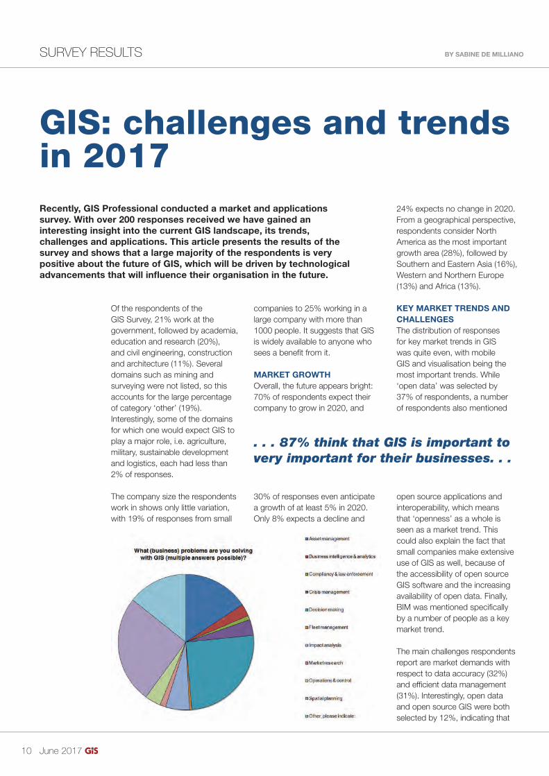
APPLICATIONS OF GISWhen asked which business problems are solved by GIS (and after correcting for the manually entered multiple answers due to a minor error in the survey), three business problems clearly emerge as main applications for GIS: spatial planning (31%), >
. . . 87% think that GIS is important to very important for their businesses. . .
24% expects no change in 2020. From a geographical perspective, respondents consider North America as the most important growth area (28%), followed by Southern and Eastern Asia (16%), Western and Northern Europe (13%) and Africa (13%).
KEY MARKET TRENDS AND CHALLENGESThe distribution of responses for key market trends in GIS was quite even, with mobile GIS and visualisation being the most important trends. While ‘open data’ was selected by 37% of respondents, a number of respondents also mentioned
open source applications and interoperability, which means that ‘openness’ as a whole is seen as a market trend. This could also explain the fact that small companies make extensive use of GIS as well, because of the accessibility of open source GIS software and the increasing availability of open data. Finally, BIM was mentioned specifi cally by a number of people as a key market trend.
The main challenges respondents report are market demands with respect to data accuracy (32%) and effi cient data management (31%). Interestingly, open data and open source GIS were both selected by 12%, indicating that
10-11-12_gissurvey.indd 11 31-05-17 13:24

June 2017 12
decision making (30%) and asset management (23%). Compliancy & law enforcement and fl eet management (both 2%) are the least used applications for GIS by our group of respondents.
FUTURE DEVELOPMENTSWith the integration of BIM and GIS being a hot topic at the moment, GIS Professional asked readers about the relevance of BIM to their work and their expectations of future BIM-GIS integration. 30% of all respondents indicate that BIM is relevant to their work. With respect to BIM-GIS integration, expectations vary, but standards such as CityGML are mentioned as important drivers for successful integration of both worlds. Some consider BIM as being a ‘specialised GIS’, while others believe that BIM will help the future development of 3D GIS in terms of modeling and visualisation.
BIM is defi nitely not the only trend in the GIS world. Readers consider
cloud technology, open data and software, high-resolution (satellite) imagery and remote sensing, the Internet of Things (IoT) and UAVs as the main drivers for the GIS industry.
Finally, bringing everything down to an organisational level, respondents were asked which technological advancements they expect to become key to their organisation in the near future. We received a variety of answers, but cloud technology, real-time data, IoT, 3D GIS, mobile GIS and UAVs clearly stand out from the crowd. Our readers thus show that many of the new technological advancements will become important for their organisation in the future.
SURVEY RESULTS
Web Map Layers from CadcorpSharing Local Knowledge™
Available on desktop, tablet and mobile devices Discover more at cadcorp.com
ABOUT THE AUTHORSabine de Milliano is an entrepreneur and consultant specialised in developing user-friendly IT applications of geospatial data. She holds an M.Sc. in Geomatics from Delft University of Technology and combines her engineering background with technical communication and business expertise to bridge the gap between users and engineers. She is also a contributing editor of GIS Professional and GIM International (email: [email protected]).
10-11-12_gissurvey.indd 12 31-05-17 13:24

>
A Look at Low-Code and No-Code Platforms in GIS
I moderated a panel on GIS careers recently. All six of the panelists, representatives from both academia and industry, agreed that everyone in the fi eld should be able to program and use the concepts of computational thinking. What actually constitutes programming, however, is changing. I’m seeing more and more references to “low-code” and “no-code” development options. What are these tools and platforms? How are they being integrated into GIS software and solutions?
LOW-CODE AND NO-CODEForrester, coined the term “low code” back in June 2014, but some suggest implementations date back to 2011. Low-code refers to “platforms that enable rapid application delivery with a minimum of hand-coding, and quick setup and deployment, for systems of engagement.” Its sibling, no-code, requires no hand-coding.
The basic ideas is that low-code platforms enable those familiar with programming to put apps together more quickly than they can from scratch. No-code platforms enable those with no programming experience at all to create useable, if not elegant, apps.
THE REALITY OF LOW-CODE AND NO-CODE PLATFORMSAs is true with any development tool or platform, low- and no-code offerings are not silver bullets. While low-code platforms minimize the amount of hand coding needed, the app creator must have some familiarity with programming and the goal of the app to be created. Low-code does not eliminate programming, it just speeds it up.
These environments can introduce more players into app development. The visual environment of the platforms means that the app’s end users might design the interface they’d like with drag and drop tools. That interface can then be passed to the programming team to add the needed functionality.
No-code environments are ideal for non-programmers or organizations that want to avoid hiring or outsourcing a programmer for a quick, basic app. Because the app creator does not have the time, skills or resources to devote to develop an application from scratch, no-code platforms and the apps built from them are simple. The tradeoffs for the extreme ease of use are limitations in functionality and
user interface design. Still, the best platforms can create sold, working applications.
How far can you go with low- and no-code apps? It depends on the platform and the creator’s ingenuity. Some platforms support uploading to and optimization for Apple and Google’s marketplaces. Some do not. There is still discussion among industry leaders about the apps’ “enterprise readiness” and security.
LOW-CODE, NO-CODE AND GISI fi rst saw the term “zero code” applied to GIS in a marketing effort from TerraGO last August. The company platform, called Magic, promises “custom mobile apps in minutes without code” and 90% cost reduction, “without hiring more developers or writing a single line of code.” It can create apps for Apple’s App Store, Google Play and cloud deployment.
A recent FedTech article reports “The U.S. Geological Survey... has relied on open-source platforms for 30 years and started using low-code software on select projects in 2014.” Among other things, the Survey taps TrackVia, a low-code management workfl ow platform from Apiant, to enable app connectivity to the National Water Information System.
Esri’s templates for story maps and its AppStudio for ArcGIS fall into the low and no-code arena. Map makers including elementary school students and data visualization professional have built story maps to share data, video, photos and more. AppStudio enables non-programmers to confi gure mobile apps for Android, iOS, Windows, Mac OS X and Linux.
FURTHER DEMOCRATIZING GISThe availability of low- and no-code platforms means GIS end users and busy programmers can create apps more quickly and easily. It’s up to organizations and their staff members to explore and evaluate if and how low- and no-code tools and platforms can best serve the bottom line.
COLUMNIST BY ADENA SCHUTZBERG
With over 25 years experience, Adena
Schutzberg helps organisations use
geospatial technologies through
the ABS Consulting Group. She is a
member of the Esri Education Team.
June 2017 13
A pipeline inspection
app built from
TerraGo’s Magic no-
code platform.
13_adenaschutzbergcolumn.indd 13 31-05-17 13:27

June 2017 14
GEOPLACE CONFERENCE BY JOOST BOERS
GeoPlace Conference: Connecting Data for Better OutcomesThe GeoPlace Annual Conference, attended by over 350 people, took place on 11 May 2017 at the grounds of the Leeds United Football Club. The programme included networking, roundtable discussion sessions and speakers like Eddie Copeland (director of Government Innovation at the Nesta Innovation Lab), council offi cers, the Valuation Offi ce Agency, the Land Registry and the Chartered Institute of Public Finance & Accountancy (CIPFA). And of course, the stage was for the award winners!
The Exemplar Award is awarded to a council for the best example or demonstration of local address and/or street datasets providing quantifi able benefi ts. This year, the winner was Northumberland County Council for its pilot project rolling out 30 hours’ free childcare a year in advance of full availability nationally, doubling the existing free childcare for 3-4 year olds. Using the Unique Property Reference Number (UPRN) from its local address data, the council developed an up-to-date, digital solution to reduce the administration processes needed
with Awards for those at ‘Gold’ Standard.
The Most Improved Address Data Award is given to the authority which has shown the most improvement over the last year in England and Wales. In presenting the Award to Mole Valley, Jason Houghton, Deputy National Address Data Manager, mentioned that Mole Valley has achieved the greatest improvement in data quality which demonstrates excellence and commitment to a process that brings local and national benefi ts.
Royal Borough of Greenwich went home with the Data Quality & Improvement Award in recognition of the management of its street information database. Street data is used within councils and incorporated into a national Highways dataset – Ordnance Survey’s Highways Network. The resulting data is a combination of data from local highway authorities via the National Street Gazetteer, Highways England data from the Trunk Road Street Gazetteer and accurate detailed geometry and additional road content from OS. This is why the Data Quality & Improvement Award is important. It is testament to the hard work and skill that goes into maintaining a constantly changing dataset. The Award is given to the authority which has shown the most improvement over the last year in England and Wales.
For more Information go to www.geoplace.co.uk or if you would like to see more images go to www.fl ickr.com/photos/geoplacellp/with/34698434795/
>
to secure effi cient implementation of this new statutory duty and respond to parents’ applications swiftly. As a result, over 675 families have been able to access additional childcare support, with the average saving of £2,131.80 per household.
The winner of the Peer Award is Rachel Antcliffe from Leeds City Council. Rachel has been an LLPG Custodian for many years, always achieving ‘Gold’ status and Best in Region for several years. She is an active member of the addressing community – being deputy chair for many years and working on the Improvement Schedule working group. She is always willing to share best practise, offer advice and guidance to anyone who may need it.
DATA QUALITY AND IMPROVEMENT AWARDSA key focus of the 2017 Exemplar Awards is on those Custodians who have invested time in creating and continually improving their processes and who have made and achieved a real commitment to improving both the accuracy and quality of the data submitted to the GeoPlace hubs. These authorities are recognised within the Data Quality and Improvement Awards.South Mole Valley District Council and the Royal Borough of Greenwich were announced as winners of the Data Quality and Improvement Award for Addresses 2017 and the Data Quality and Improvement Award for Streets 2017 respectively. Awards were also presented for Best Address Data in Region and Best Street Data in Region together
Presentation of the
Exemplar Award
to Northumberland
Country Council.
14_geoplaceconferencereport.indd 14 31-05-17 13:28

>
Have you or your company developed a novel product or app that you’d like to tell readers about? Remember, it must be something truly new and not just an extension of an existing product line or service. Drop a line to [email protected]
ABOUT THE AUTHORKurt Daradics Manager, Esri Startup ProgramEsri | 604 Arizona Ave | Santa Monica, CA 90401P: +1 [email protected]
Advanced Analytics Solves the Solar Power Conundrum
PowerScout is an online, data-driven marketplace for smart home improvements that allows consumers to enter their address and get an assessment of whether their homes are suitable for solar power. Once homeowners have made this determination, they can calculate how much solar power will save them on their electric bills.
In addition, the online marketplace saves potential solar power customers money on sales and marketing. Most importantly, consumers are spared the time-consuming cost of a site survey, which is the current industry-standard practice before installation can even begin. Even after accounting for government subsidies, the overhead costs of selling solar power can well exceed the hardware cost of the panels. PowerScout can let consumers skip these expenses and processes by using artifi cial intelligence to understand behavior in the context of location.
SMART, PREDICTIVE SALES STRATEGYMachine learning is an artifi cial intelligence technique, which is at the heart of PowerScout’s software. This technology involves using information from commercial databases and Lidar imaging to predict which households are most likely to be interested in solar power, and why. For instance, families with hybrid vehicles and high education are likely to purchase solar panels for prestige reasons. Lower income families are most likely to switch to solar power to save money. Digital surface models of roof facets, orientation and slope inform the user on how many panels can fi t on top of a house. It then feeds this data into algorithms that identify patterns and perform predictive analytics that determine how much energy can be harvested from which house, and which of the houses in a neighborhood is likely to contain an interested homeowner. The process of connecting potential customers with the industry is simplifi ed and reduced to an instantaneous calculation.
ONLINE MARKETPLACE DRIVEN BY DATAFor homeowners interested in solar power, the interface makes it easy to fi nd out whether solar power is right for them and how to go about purchasing it. All a person needs to do is enter their address, and they are given a curated list of certifi ed local installers as well as a quote for the costs.
The problem inherent with solar power isn’t the technology itself but rather the process of system integration. This process involves making sure the existing infrastructure of an institution can handle, or is updated for, new forms of technology. Much like solar power, data itself can be daunting when we don’t have the systems to understand it and unlock its full potential. Using machine learning and spatial analytics can allow not only better understanding of data but also more powerful predictive models. This advanced analytics connects new technologies like solar power with the people who benefi t from them. Smart, predictive analytics will also push down the cost of new alternative energy technologies to make them even more competitive with traditional forms of power. That’s good for consumers and the planet.
ELEVATOR PITCH BY KURT DARADICS
June 2017 15
PowerScout is a marketplace for smart home improvement
projects.
Reports identify how much a homeowner can save from solar
power.
Lidar-Based Analysis of a Neighborhood in
San Francisco.
15_elavatorpitch_powerscout.indd 15 31-05-17 13:44

June 2017 16
COPYRIGHT TRAPS BY SABINE DE MILLIANO
Creative TrapsMaps undoubtedly play an important role in society. From use in daily life to professional applications, maps help us navigate, plan activities and gain insight into our surrounding environment. Although we know that all maps have a certain accuracy, we rarely question the existence of streets and places we fi nd on a map. Throughout time, however, various cartographers have used our good faith in maps to protect their work from being stolen. Their creative ways to trap copyright violators has led to a variety of map ‘mistakes’, some of which have survived for years before being discovered. This article presents some of the strangest copyright traps to date.
Known typically as ‘trap streets’, map makers have been deliberately adding minor errors to maps for ages. A fake street, dead end,
suspected copyright infringement. These trap streets are usually subtle, innocent alterations that do not interfere with navigation and generally go unnoticed. However, some map makers seem to have pushed the boundaries of cartographic freedom and have created entire villages that do not exist.
TURNING FICTION INTO REALITYOne of the strangest examples of a phantom settlement probably
is Agloe, ‘located’ roughly 200 kilometres northwest of New York City. The settlement was added to the map sometime in the 1920s or 1930s by Otto G. Lindberg and Ernest Alpers of the General Drafting Company (GDC). The name of the town – which was nothing more than an intersection of two gravel roads – is the anagram of their initials and was meant to catch an unsuspecting copier red-handed. A couple of years after Agloe was made up it appeared on another map, of Rand
McNally, one of GDC’s competitors. GDC believed to have a strong case against Rand McNally for violation of copyright. What they did not know, however, is that a real Agloe had been founded in the meantime: a store was now located in the phantom settlement, the Agloe General Store. The store had taken its name from a map of one of GDC’s clients, so Rand McNally could prove Agloe actually existed. An illustrative example of fi ction turned into reality.
ARGLETONAnother famous example is Argleton, located in Lancashire, UK. The settlement Argleton appeared on Google Maps and Google Earth for years, but is nothing more than an empty meadow in reality. Since Google’s services are used by many other information services, Argleton was also included in various real-world listings, ranging from weather services to real estate agencies. After the phantom settlement was discovered in the autumn of 2008 it gained a lot of media attention in the years to follow; funny websites were launched and companies even started selling merchandise
. . . A real Agloe had been founded in the meantime. . .
View looking north from Bold Lane in Aughton, West Lancashire, towards empty fi elds. This is the supposed location of Argleton, a settlement shown on Google Maps
which doesn’t actually exist. Image courtesy: Small-town hero (Own work), via Wikimedia Commons.
additional river bend or altered mountain summit altitude; all are examples of Easter eggs that can prove the origin of a map in case of
16-17_creativetraps.indd 16 31-05-17 13:45

June 2017 17
COPYRIGHT TRAPSCOPYRIGHT TRAPS BY SABINE DE MILLIANO
Creative Trapssuspected copyright infringement. These trap streets are usually subtle, innocent alterations that do not interfere with navigation and generally go unnoticed. However, some map makers seem to have pushed the boundaries of cartographic freedom and have created entire villages that do not exist.
TURNING FICTION INTO REALITYOne of the strangest examples of a phantom settlement probably
is Agloe, ‘located’ roughly 200 kilometres northwest of New York City. The settlement was added to the map sometime in the 1920s or 1930s by Otto G. Lindberg and Ernest Alpers of the General Drafting Company (GDC). The name of the town – which was nothing more than an intersection of two gravel roads – is the anagram of their initials and was meant to catch an unsuspecting copier red-handed. A couple of years after Agloe was made up it appeared on another map, of Rand
McNally, one of GDC’s competitors. GDC believed to have a strong case against Rand McNally for violation of copyright. What they did not know, however, is that a real Agloe had been founded in the meantime: a store was now located in the phantom settlement, the Agloe General Store. The store had taken its name from a map of one of GDC’s clients, so Rand McNally could prove Agloe actually existed. An illustrative example of fi ction turned into reality.
ARGLETONAnother famous example is Argleton, located in Lancashire, UK. The settlement Argleton appeared on Google Maps and Google Earth for years, but is nothing more than an empty meadow in reality. Since Google’s services are used by many other information services, Argleton was also included in various real-world listings, ranging from weather services to real estate agencies. After the phantom settlement was discovered in the autumn of 2008 it gained a lot of media attention in the years to follow; funny websites were launched and companies even started selling merchandise
related to Argleton. Many people believe Argleton to be a trap street, but some think it was just an error. Map makers often deny the fact that they alter maps to prevent them from being copied. But whether or not Argleton was a mistake, it defi nitely got more attention than the average meadow out there.
PERSONAL INVOLVEMENTSettlements and various other landmarks have been made up in the past – and not only for the
sake of copyright protection. In the 1970s a map of Boulder County (Colorado) showed a non-existing summit known as ‘Mount Richard’ for a few years, although it is doubted whether this imaginary peak was meant as a real copyright trap. Some believe it was just a simple joke of the drafter, whose fi rst name was also Richard. Another example of two phantom settlements that were put on the map as a personal statement are Beatosu and Goblu in Ohio, which were two fake towns put on a map of Michigan in the 1970s by Peter Fletcher, an alumnus of the University of Michigan. The names of those towns were inspired by the slogan of the University of Michigan (‘Go Blue’) and their rivals from the Ohio State University (‘Beat OSU’).
SKI SLOPEMost trap streets are far more subtle than complete phantom settlements, and it is assumed many are still out there. London, for example, once had streets like Moat Lane on Google Maps, which do not exist in reality and have now disappeared from the map again. The London A-Z indicates there is an imaginary ski slope in the middle
of Haggerston Park – and some claim this street atlas contains at least 100 trap streets although that number is diffi cult to confi rm. Small lanes and dead ends are less likely to be discovered as trap streets than entire villages that are made up, which is why there are probably many more Easter eggs than we currently know.
REAL MISTAKES?Strange street names or phantom settlements are not always put on a map on purpose. So-called ‘paper streets’, for example, are streets that are planned by city planners and included in blueprints, but not built eventually. Misspellings can fi nd their way onto maps as well, and there are many other data errors that can become visible on a map. Since trap streets usually are only minor ‘errors’, it is not always clear whether a map error is an innocent mistake, or a real copyright trap. In addition, trap streets vanish from maps quickly after they are discovered, especially in the digital era with many online map suppliers that can be used to cross-validate such fi ndings. Nevertheless, it goes without saying one should always be aware that maps refl ect the real world only to a certain degree – there is always a chance to come across some artistic input of a cartographer.
ABOUT THE AUTHORSabine de Milliano is an entrepreneur and consultant specialised in developing user-friendly IT applications of geospatial data. She holds an M.Sc. in Geomatics from Delft University of Technology and combines her engineering background with technical communication and business expertise to bridge the gap between users and engineers. She is also a contributing editor of GIS Professional and GIM International (email: [email protected]).
>
. . . A real Agloe had been founded in the meantime. . .
View looking north from Bold Lane in Aughton, West Lancashire, towards empty fi elds. This is the supposed location of Argleton, a settlement shown on Google Maps
which doesn’t actually exist. Image courtesy: Small-town hero (Own work), via Wikimedia Commons.
16-17_creativetraps.indd 17 31-05-17 13:45

June 2017 18
GLOBAL GEOSPATIAL ORGANISATIONS BY NIALL CONWAY & STEVEN RAMAGE
OGC, GEO & UN-GGIMDriving the Global Geospatial AgendaThis article sets out to explain the distinct but interrelated roles of the three international bodies which are driving the global geospatial agenda which underpins the need for smart and sustainable growth in the 21st century: the Open Geospatial Consortium (OGC), the Group on Earth Observations (GEO), and the United Nations Committee of Experts on Global Geospatial Information Management (UN-GGIM).
If you are interested in how the geospatial industry and associated policy supports government and broader commercial sector activities, then it is important to understand the global infl uences which are shaping these sectors. You need to look at the world from the perspective of policy-
Before explaining the synergy which has been achieved between these three bodies, we fi rst need to briefl y distinguish the role and background of each of the organisations.
UNITED NATIONS ON GLOBAL GEOSPATIAL INFORMATION MANAGEMENTThe UN-GGIM Secretariat is headquartered in New York where the intergovernmental Committee of Experts meets annually and reports to UN’s Economic and
A meeting in progress at the UN-GGIM headquarters in New York.
makers who set the agenda for how geospatial tools, technologies, data, and information will be used to solve real-world problems; from the perspective of the people who want to help us to better understand our planet; and from the perspective of the people who wish to ensure that we manage
information about our planet to the very highest of standards.
It is important to mention that these bodies have been around for some time. Each has established foundations and are led by an international network of authoritative members. However, unlike many other industry representative bodies which are fi ghting off the ‘legacy’ label which is commonly used in today’s disruptive world, the partnership between these organisations is undoubtedly among the most dynamic and forward thinking out there.
18-19-20-21_ggim-geo-ogc.indd 18 31-05-17 13:50

June 2017 19
GLOBAL GEOSPATIAL ORGANISATIONSGLOBAL GEOSPATIAL ORGANISATIONS BY NIALL CONWAY & STEVEN RAMAGE
OGC, GEO & UN-GGIMDriving the Global Geospatial Agenda
Before explaining the synergy which has been achieved between these three bodies, we fi rst need to briefl y distinguish the role and background of each of the organisations.
UNITED NATIONS ON GLOBAL GEOSPATIAL INFORMATION MANAGEMENTThe UN-GGIM Secretariat is headquartered in New York where the intergovernmental Committee of Experts meets annually and reports to UN’s Economic and
Social Council (ECOSOC). UN-GGIM’s objective is to promote
through policy-making the use of geospatial technology among the global decision-making community and it provides a forum to liaise and coordinate among and between UN Member States and international organizations (including GEO and OGC). The Committee of Experts often provides a futuristic vision of the
opportunities facing governments worldwide and the challenges to
the industry in one of its regular publications.
GROUP ON EARTH OBSERVATIONSThe geospatial industry would be nothing if it were not for our >
. . . the partnership between these organisations is undoubtedly among the most dynamic and forward thinking out there.information about our planet to the
very highest of standards.
It is important to mention that these bodies have been around for some time. Each has established foundations and are led by an international network of authoritative members. However, unlike many other industry representative bodies which are fi ghting off the ‘legacy’ label which is commonly used in today’s disruptive world, the partnership between these organisations is undoubtedly among the most dynamic and forward thinking out there.
18-19-20-21_ggim-geo-ogc.indd 19 31-05-17 13:50

June 2017 20
N ati o n a l i m a gery co
ve
rag
eH i gh est d
eta
il
W irefra me
BS0163AD/GISPR
O/0617
D i r e c t f r o m t h e U K ’ s l e a d i n g a e r i a l s u r v e y c o m p a n y
T h i n k
T h i n k
www.bluesky-world.com/3d
“The need for speedy, accurate and affordable 3D information led us to Bluesky.”
Derived photogrammetrically from our high resolution stereo aerial photography, our 3D building models are specifically designed to support developers, architects and urban planners in making efficient, cost effective and informed decisions about the urban environment.
We produce our models at three distinct levels of detail, from our Level of Detail 1 (LOD1) simple block buildings, through to our LOD3 models containing fully modelled roof structures, dormer windows and chimneys.
+44 (0)1530 518518 [email protected]
ability to collect and reference information about our planet. This is the primary purpose of GEO, a body which is focused on advocating the benefi ts of coordinated, comprehensive and sustained Earth observations to inform decisions and actions for the benefi t of humankind. GEO, which is headquartered in Geneva, Switzerland is a partnership of governments and international organizations which works to Ministerial guidance from national government members (there are 105 today), and it has many relationships with international and multilateral organisations. It is worth mentioning that GEO’s profi le is likely to grow signifi cantly over the coming years. It currently operates the largest open Earth observations portal in the world, geoportal.
org, which, with in excess of 200,000,000 open data and information resources, is already playing a leading and essential EO data provision role.
OPEN GEOSPATIAL CONSORTIUMThe OGC has been developing open geospatial standards for about as long as the web has existed and is much of the reason why geographic information about our world is easy to share and compatible with the systems we use. UN-GGIM and GEO are more focused on policy and decision making, while the OGC
provides the technical interfaces and specifi cations that they use and promote, as well as cross domain and industry communication. In particular, the OGC can be credited with opening up well-known data formats like KML, WFS, WMS and GeoPackage.
The OGC is a consensus-based voluntary standards development organization which is focused on developing quality open standards for the global geospatial community and it has a particular focus on interoperability and compliance. It has developed longstanding partnerships with other standards organizations such as ISO TC211 and ITU that see a number of OGC standards also co-published in other SDOs. Perhaps the reason why the OGC
is so innovative is that it boasts an active membership from organisations in the business, government, academic and NGO sectors. If you don’t believe this, then just attend one its quarterly technical meeting gatherings or check out its scenario focused ‘Testbed’ initiatives which are well represented by the likes of Google, Ordnance Survey, Esri, NASA, and the NGA. OGC views its openness and equality of access to all sectors of the industry as being of key
importance to developing quality standards to benefi t the world’s entire population.
INTERDEPENDANT RELATIONSHIPAlthough each of these bodies serve distinct roles, the trio has a strong alliance and interdependent
GLOBAL GEOSPATIAL ORGANISATIONS
SEDAS is an online datahub providing all businesses, researchers and students free access to Sentinel 1 & 2 Earth Observation data.
To download data, or to find out more, visit: sedas.satapps.org
An online datahub
SeD AS
Data © ESA. image © Satellite Applications Catapult Ltd.
One of the main reasons why this relationship ‘clicks’ is because the bodies have a shared focus. . .
18-19-20-21_ggim-geo-ogc.indd 20 31-05-17 13:50

June 2017 21
N ati o n a l i m a gery co
ve
rag
e
H i gh est det
ail
W irefra me
BS0163AD/GISPR
O/0617
D i r e c t f r o m t h e U K ’ s l e a d i n g a e r i a l s u r v e y c o m p a n y
T h i n k
T h i n k
www.bluesky-world.com/3d
“The need for speedy, accurate and affordable 3D information led us to Bluesky.”
Derived photogrammetrically from our high resolution stereo aerial photography, our 3D building models are specifically designed to support developers, architects and urban planners in making efficient, cost effective and informed decisions about the urban environment.
We produce our models at three distinct levels of detail, from our Level of Detail 1 (LOD1) simple block buildings, through to our LOD3 models containing fully modelled roof structures, dormer windows and chimneys.
+44 (0)1530 518518 [email protected]
GLOBAL GEOSPATIAL ORGANISATIONS
is so innovative is that it boasts an active membership from organisations in the business, government, academic and NGO sectors. If you don’t believe this, then just attend one its quarterly technical meeting gatherings or check out its scenario focused ‘Testbed’ initiatives which are well represented by the likes of Google, Ordnance Survey, Esri, NASA, and the NGA. OGC views its openness and equality of access to all sectors of the industry as being of key
importance to developing quality standards to benefi t the world’s entire population.
INTERDEPENDANT RELATIONSHIPAlthough each of these bodies serve distinct roles, the trio has a strong alliance and interdependent
relationship with one another. The OGC is the only non-governmental member which interfaces with UN-GGIM along with IHO and ISO; GEO is a UN-GGIM Observer and vice versa; OGC is also represented across the GEO Work Programme. One of the main reasons why this relationship ‘clicks’ is because the bodies have a shared focus on advancing the geospatial industry for long-term purposes, in particular for achieving the UN’s Sustainable Development Goals (SDGs). The second reason for the success of
this partnership is that in an age of social and political instability, the existence of stable intergovernmental international bodies which facilitate collaboration is considered to be of critical importance.
The OGC-GEO-UN-GGIM alliance is necessary because the world
is entering into an exciting age of technology which requires strong leadership from the geospatial community. Smart Cities, IoT, Machine Learning, AI, and even Augmented Reality are underpinned by locational information and an established global network of Spatial Data Infrastructure (SDI). However, it is becoming clear that if people are going to pass control of cars, utilities and devices to computers then, fi rst, the right systems to oversee this need to be in place.
In the age of mass proliferation of maps, data, and geospatial tools, there is growing recognition of the role of leading authorities such as the OGC, GEO and the UN-GGIM. When ripples in one part of the world can be felt far away, we need to be more aware of and adaptable to potential change. Ultimately, in the information age this comes down having relevant policy, having well designed standards, and having high quality, timely information about our planet. This is exactly what these bodies are providing.
GLOBAL GEOSPATIAL ORGANISATIONS
One of the main reasons why this relationship ‘clicks’ is because the bodies have a shared focus. . .
18-19-20-21_ggim-geo-ogc.indd 21 31-05-17 13:50

June 2017 22
DATA COLLECTION BY RICHARD FRY
Joining up the DotsRealising the potential of routinely collected administrative dataThe use of routinely collected administrative data for purposes other than those it was collected for has become an essential data resource for approved health and social science research.
Initiatives such as the Data.gov.uk and the Open Government Licence underpinned by the Freedom of Information Act, has meant that publicly funded bodies have made their data available to researchers and the public. This shift has led to a number of data focussed research centres across the UK including the Farr Institute
CHALICE, a recently published piece of research, examined the impacts of spatio-temporal alcohol availability on crime and health, utilised routinely collected alcohol outlet licence data collated from the 22 Unitary Authorities in Wales for a fi ve-year period (2006-2011). Our research team assumed that this would be a relatively straightforward process as there is a legal obligation to keep a register of licensed premises within each authority as detailed by the Licensing Act 2003 (Part 2 - 8).
We found that, on average, only 51% of licence addresses could be precisely located using the address supplied. Although most Unitary Authorities could provide a list of outlets over the study period, despite a standard licence application form, the quality and details contained within each record varied greatly. None of the premise address details supplied had been verifi ed against the Local Land and Property Gazetteer, thus licence data needed to be geocoded using the unverifi ed address details supplied in the licence register. This resulted in a wide range of match rates (28% - 72%) of alcohol outlets successfully geocoded against AddressBase Premium.
Through innovative data linkage techniques developed at these centres, it is now common practice to link disparate data together, down to individual levels, in secure research platforms such as the Secure Anonymised
Information Linkage (SAIL) platform housed at the Swansea University Medical School. Data linkage requires a common reference framework to be successful. The Local and National Land and Property Gazetteer (LLPG and NPLG) and related Ordnance Survey AddressBase products provide a common reference framework for address level data, in the form of the Unique Property Reference Number (UPRN) but in our experience, it is being underutilised in all levels of administrative data.
Currently government and academic researchers alike are missing out on valuable insights into society and health through linked data research because of
(www.farrinstitute.org), Administrative Data Research Network (www.adrn.ac.uk) and the Consumer Data Research Centre (www.cdrc.ac.uk) focusing research attention on facilitating and conducting approved research using health informatics, administrative data and consumer generated data respectively.
High Precision GNSS Receiversfor every mobile device.
Compatible with iOS/Android/Windows40-60cm with WAAS and all SBAS
1cm with any RTK NetworkUses GPS/GLONASS/Galileo/BeiDou
Tel: +1 (450) 824-3325 email: [email protected]
www.eos-gnss.com
22-23_joiningupthedots.indd 22 31-05-17 13:51

June 2017 23
DATA COLLECTIONDATA COLLECTION BY RICHARD FRY
Joining up the DotsRealising the potential of routinely collected administrative data
CHALICE, a recently published piece of research, examined the impacts of spatio-temporal alcohol availability on crime and health, utilised routinely collected alcohol outlet licence data collated from the 22 Unitary Authorities in Wales for a fi ve-year period (2006-2011). Our research team assumed that this would be a relatively straightforward process as there is a legal obligation to keep a register of licensed premises within each authority as detailed by the Licensing Act 2003 (Part 2 - 8).
We found that, on average, only 51% of licence addresses could be precisely located using the address supplied. Although most Unitary Authorities could provide a list of outlets over the study period, despite a standard licence application form, the quality and details contained within each record varied greatly. None of the premise address details supplied had been verifi ed against the Local Land and Property Gazetteer, thus licence data needed to be geocoded using the unverifi ed address details supplied in the licence register. This resulted in a wide range of match rates (28% - 72%) of alcohol outlets successfully geocoded against AddressBase Premium.
Through innovative data linkage techniques developed at these centres, it is now common practice to link disparate data together, down to individual levels, in secure research platforms such as the Secure Anonymised
Information Linkage (SAIL) platform housed at the Swansea University Medical School. Data linkage requires a common reference framework to be successful. The Local and National Land and Property Gazetteer (LLPG and NPLG) and related Ordnance Survey AddressBase products provide a common reference framework for address level data, in the form of the Unique Property Reference Number (UPRN) but in our experience, it is being underutilised in all levels of administrative data.
Currently government and academic researchers alike are missing out on valuable insights into society and health through linked data research because of
data collection issues. The use of a standardised method for collecting and verifying address data against LLPG and NLPG registers has the potential to facilitate world leading longitudinal research in local and national government departments and UK research institutes. As GIS professionals, we must encourage best practice and use of geographic information across all levels of government, business, education and research so that the wider societal benefi ts can be realised.
A more in depth analysis of this work has recently been published in an open access journal Applied Spatial Analysis and Policy (link.springer.com/article/10.1007/s12061-016-9184-4).
ABOUT THE AUTHORRichard Fry is a Senior Research Fellow based at the Health Informatics Group at Swansea University Medical School working in the SAIL databank to provide environmental context to linked health data. [email protected]
>High Precision GNSS Receiversfor every mobile device.
Compatible with iOS/Android/Windows40-60cm with WAAS and all SBAS
1cm with any RTK NetworkUses GPS/GLONASS/Galileo/BeiDou
Tel: +1 (450) 824-3325 email: [email protected]
www.eos-gnss.com
22-23_joiningupthedots.indd 23 31-05-17 13:51

June 2017 24
GIS WORKFLOW BY ISMAEL CHIVITE
Digital Transformation in New ZealandIn January 2016, staff from New Zealand’s Department of Conservation (DOC) were supplied with tablets and smartphones equipped with Survey123 for ArcGIS, a form-centric mobile data collection application. The Hokitika township biodiversity monitoring fi eld team used this mobile app as well as their current paper-based capture methods to evaluate the potential of digital data collection technologies in their workfl ows. This undertaking showed that not only can Survey123 improve effi ciency and reduce fi eld data capture operational costs, but it can also make captured data available easily and instantly for visualisation and analysis.
Like many other government departments, the New Zealand DOC is going through a digital transformation, replacing paper-based workfl ows with end-to-end business processes in which information fl ows instantly across staff teams, departments and – when appropriate – the public. Modern enterprise geographic information system (GIS) technology allows everyone in an organisation to create, access and share information anywhere, anytime and from any device, making their work more effi cient and meaningful.
At the New Zealand DOC, wildlife surveys are typically conducted using paper booklets. “The paper-based methodology that we use
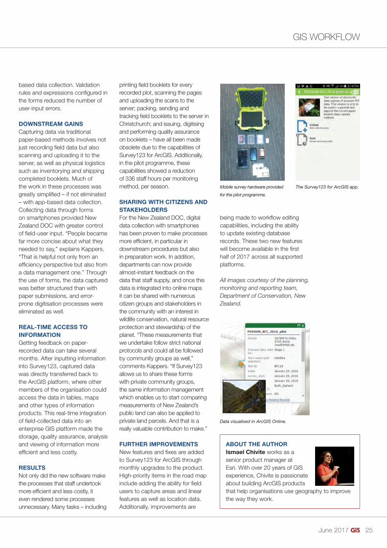
both the electronic and traditional paper-based collection methods. Field crews were provided with Android smartphones and tablets. The software on these devices was Esri’s Survey123 for ArcGIS, a data gathering mobile app that speeds up the collection process using simple forms. The programme’s team visited three remote locations on New Zealand’s South Island to survey possum crossings along fi xed transects (paths).
EFFICIENCY IN THE FIELDUsing a simple spreadsheet and the mobile app’s desktop companion tool, Survey123 Connect for ArcGIS, customised forms were created and published in the ArcGIS platform. These forms were then downloaded to the mobile devices to facilitate the collection of information in the fi eld.
Survey123 provided a simple, intuitive interface for users to input fi eld data, which enabled staff to concentrate on making observations rather than on the process of recording them, which was one of the issues with paper-
based data collection. Validation rules and expressions confi gured in the forms reduced the number of user-input errors.
DOWNSTREAM GAINSCapturing data via traditional paper-based methods involves not just recording fi eld data but also scanning and uploading it to the server, as well as physical logistics such as inventorying and shipping completed booklets. Much of the work in these processes was greatly simplifi ed – if not eliminated – with app-based data collection.Collecting data through forms on smartphones provided New Zealand DOC with greater control of fi eld-user input. “People became far more concise about what they needed to say,” explains Kappers. “That is helpful not only from an effi ciency perspective but also from a data management one.” Through the use of forms, the data captured was better structured than with paper submissions, and error-prone digitisation processes were eliminated as well.
REAL-TIME ACCESS TO INFORMATIONGetting feedback on paper-recorded data can take several months. After inputting information into Survey123, captured data was directly transferred back to the ArcGIS platform, where other members of the organisation could access the data in tables, maps and other types of information products. This real-time integration of fi eld-collected data into an enterprise GIS platform made the storage, quality assurance, analysis and viewing of information more effi cient and less costly.
RESULTSNot only did the new software make the processes that staff undertook more effi cient and less costly, it even rendered some processes unnecessary. Many tasks – including
at the moment is functional, but it requires a massive downstream team to digitise that information. It’s sometimes even necessary to go back to the fi eld team to confi rm the data because it’s unreadable due to smudging or rain,” says Benno Kappers, DOC natural heritage information project leader. “Real-time mobile data collection can signifi cantly reduce downstream efforts.”
SMARTPHONES INSTEAD OF PAPERA pilot programme was initiated to expose the New Zealand DOC staff to using mobile devices for in-fi eld data capture as well as to compare the end-to-end system and organisational processes of
Vegetation monitoring using standard methods. Field staff surveying transects.
24-25_digitaltransformation.indd 24 31-05-17 13:46
June 2017 25
GIS WORKFLOWGIS WORKFLOW BY ISMAEL CHIVITE
Digital Transformation in New Zealand
both the electronic and traditional paper-based collection methods. Field crews were provided with Android smartphones and tablets. The software on these devices was Esri’s Survey123 for ArcGIS, a data gathering mobile app that speeds up the collection process using simple forms. The programme’s team visited three remote locations on New Zealand’s South Island to survey possum crossings along fi xed transects (paths).
EFFICIENCY IN THE FIELDUsing a simple spreadsheet and the mobile app’s desktop companion tool, Survey123 Connect for ArcGIS, customised forms were created and published in the ArcGIS platform. These forms were then downloaded to the mobile devices to facilitate the collection of information in the fi eld.
Survey123 provided a simple, intuitive interface for users to input fi eld data, which enabled staff to concentrate on making observations rather than on the process of recording them, which was one of the issues with paper-
based data collection. Validation rules and expressions confi gured in the forms reduced the number of user-input errors.
DOWNSTREAM GAINSCapturing data via traditional paper-based methods involves not just recording fi eld data but also scanning and uploading it to the server, as well as physical logistics such as inventorying and shipping completed booklets. Much of the work in these processes was greatly simplifi ed – if not eliminated – with app-based data collection.Collecting data through forms on smartphones provided New Zealand DOC with greater control of fi eld-user input. “People became far more concise about what they needed to say,” explains Kappers. “That is helpful not only from an effi ciency perspective but also from a data management one.” Through the use of forms, the data captured was better structured than with paper submissions, and error-prone digitisation processes were eliminated as well.
REAL-TIME ACCESS TO INFORMATIONGetting feedback on paper-recorded data can take several months. After inputting information into Survey123, captured data was directly transferred back to the ArcGIS platform, where other members of the organisation could access the data in tables, maps and other types of information products. This real-time integration of fi eld-collected data into an enterprise GIS platform made the storage, quality assurance, analysis and viewing of information more effi cient and less costly.
RESULTSNot only did the new software make the processes that staff undertook more effi cient and less costly, it even rendered some processes unnecessary. Many tasks – including
printing fi eld booklets for every recorded plot, scanning the pages and uploading the scans to the server; packing, sending and tracking fi eld booklets to the server in Christchurch; and issuing, digitising and performing quality assurance on booklets – have all been made obsolete due to the capabilities of Survey123 for ArcGIS. Additionally, in the pilot programme, these capabilities showed a reduction of 336 staff hours per monitoring method, per season.
SHARING WITH CITIZENS AND STAKEHOLDERSFor the New Zealand DOC, digital data collection with smartphones has been proven to make processes more effi cient, in particular in downstream procedures but also in preparation work. In addition, departments can now provide almost-instant feedback on the data that staff supply, and once this data is integrated into online maps it can be shared with numerous citizen groups and stakeholders in the community with an interest in wildlife conservation, natural resource protection and stewardship of the planet. “These measurements that we undertake follow strict national protocols and could all be followed by community groups as well,” comments Kappers. “If Survey123 allows us to share these forms with private community groups, the same information management which enables us to start comparing measurements of New Zealand’s public land can also be applied to private land parcels. And that is a really valuable contribution to make.”
FURTHER IMPROVEMENTSNew features and fi xes are added to Survey123 for ArcGIS through monthly upgrades to the product. High-priority items in the road map include adding the ability for fi eld users to capture areas and linear features as well as location data. Additionally, improvements are
being made to workfl ow editing capabilities, including the ability to update existing database records. These two new features will become available in the fi rst half of 2017 across all supported platforms.
All images courtesy of the planning, monitoring and reporting team, Department of Conservation, New Zealand.
ABOUT THE AUTHORIsmael Chivite works as a senior product manager at Esri. With over 20 years of GIS experience, Chivite is passionate about building ArcGIS products that help organisations use geography to improve the way they work.
>
Mobile survey hardware provided
for the pilot programme.
The Survey123 for ArcGIS app.
Data visualised in ArcGIS Online.
24-25_digitaltransformation.indd 25 31-05-17 13:46

June 2017 26
DIGITAL TWIN BY NIALL CONWAY
Geospatial, IoT and the ‘Digital Twin’The IoT phenomenon, although still in its infancy, has revolutionised almost every sector in today’s world. Among the many buzzwords associated with the fi eld is one known as the ‘Digital Twin’.
The Digital Twin concept refers to a means by which industrial machinery, buildings, devices and their component parts are designed, engineered, monitored and maintained both physically and digitally. Essentially, the Digital Twin is a virtual representation of an asset, and it’s based on the rationale that one can better understand how it operates and interacts with the surrounding world through designing an exact replica.
THE BENEFIT OF DIGITAL TWINSThe Digital Twin is revolutionising many industries across the world - especially the utilities sector - and the industrial internet is being embraced by service engineer managers because of the benefi ts it provides. From the perspective of engineering, maintenance and management of utility assets, the Digital Twin allows engineers to gain a better insight into the operational
performance of the asset in real-time. The key benefi ts of the above being that Digital Twins help to improve operational reliability and availability, minimise costs, reduce unscheduled downtime, and reduce operational risk. By 2021, digital grid technology is expected to deliver almost US$19b in cost savings worldwide - mostly through reduced energy use and avoided emission costs. (‘Smart cities – on the faster track to success’, Juniper Research, 2016.)
A MAP ISN’T A DIGITAL TWINA typical GIS map of a utility network is not a Digital Twin. Although it may consist of accurate locations and attributes of the network features, it’s still merely a representation of the network. The data used in the GIS system is very often out of date moments after it is captured, meaning that it is not a true refl ection of reality. As a result, asset managers are unable to make defi nitive assessments and informed decisions without fi rst consulting site-based inspectors and relevant blueprints or scans.
That said, providing locational context is where the geospatial world is beginning to augment the world of IoT. Geospatial information helps the
Digital Twin to become aware of both the actual and relative position of its real world counterpart - i.e. where the asset was/is in relation to its surroundings and the environmental conditions (e.g. fl at or hilly terrain, hot or cold climates, safe or dangerous locations) in which it lives.
Naturally, this is where GIS is beginning to converge with systems such as Building Information Management Systems (BIM) software. While one is generally focused on what is inside and the other on what is outside, both systems are becoming inextricably linked throughout the industrial internet lifecycle. Government driven mandates, requiring the capture of asset data also require that certain materials and assets be restricted to specifi c geographic locations. Geospatial data, such as boundaries, land parcels, built surroundings and environmental data help to provide a digital context into which an asset’s Digital Twin can be born.
Creating Digital Twins would be impossible if it were not for the increasing availability of sensors, image capture and analysis technology, as well as powerful data transfer and cloud-based
processing capabilities. As an example, some utility network Digital Twins can be continually updated and refreshed with data from LiDAR and other sources, while in cities such as Singapore and Manchester, Smart City initiatives are helping to create real-time urban digital representations.
NEXT PHASES OF THE DIGITAL TWINEven at this early stage, the Digital Twin technological era is advancing rapidly. The OGC’s OpenSensorWeb, open source software platform for location-aware sensors is helping IoT innovators to augment their technologies with real-time location information. Meanwhile, other powerful technologies such as
Offshore Renewables
Hydrography
Cadastre Cultural Heritage
Forestry
Habitat Mapping
Oil & Gas Land Surveying
Precision Agriculture
Mining Infrastructure Construction
The world’s largest product database for surveying, navigation and machine guidance
Add your products to Geo-matching.com by registering online today!www.Geo-matching.com
JOIN US!
Utility map vs
digital twin.
26-27_geospatialtwins.indd 26 31-05-17 13:06

June 2017 27
DIGITAL TWINDIGITAL TWIN BY NIALL CONWAY
Geospatial, IoT and the ‘Digital Twin’
Digital Twin to become aware of both the actual and relative position of its real world counterpart - i.e. where the asset was/is in relation to its surroundings and the environmental conditions (e.g. fl at or hilly terrain, hot or cold climates, safe or dangerous locations) in which it lives.
Naturally, this is where GIS is beginning to converge with systems such as Building Information Management Systems (BIM) software. While one is generally focused on what is inside and the other on what is outside, both systems are becoming inextricably linked throughout the industrial internet lifecycle. Government driven mandates, requiring the capture of asset data also require that certain materials and assets be restricted to specifi c geographic locations. Geospatial data, such as boundaries, land parcels, built surroundings and environmental data help to provide a digital context into which an asset’s Digital Twin can be born.
Creating Digital Twins would be impossible if it were not for the increasing availability of sensors, image capture and analysis technology, as well as powerful data transfer and cloud-based
processing capabilities. As an example, some utility network Digital Twins can be continually updated and refreshed with data from LiDAR and other sources, while in cities such as Singapore and Manchester, Smart City initiatives are helping to create real-time urban digital representations.
NEXT PHASES OF THE DIGITAL TWINEven at this early stage, the Digital Twin technological era is advancing rapidly. The OGC’s OpenSensorWeb, open source software platform for location-aware sensors is helping IoT innovators to augment their technologies with real-time location information. Meanwhile, other powerful technologies such as
GeoMesa (described on its website as “an open-source, distributed, spatio-temporal database built on a number of distributed cloud data storage systems”) is allowing users to combine sensors and systems, such as GeoServer and Google Cloud Big Table, to powerful effect.
THE COGNITIVE DIGITAL TWINPerhaps the most exciting phase in the Digital Twin IoT era however is the Cognitive Digital Twin concept. Essentially, this is an artifi cially intelligent Digital Twin which serves as an ‘autonomous maintenance engineer’. Perhaps due to a feeling of sibling rivalry, the Cognitive Digital Twin is highly self-conscious - it ‘thinks’ about the information which it receives, it makes its own performance-focused decisions,
it learns from past errors, and it is therefore continuously self-improving. Welcome to the Geospatial IoT era.
• This article was published at http://www.geobreadbox.com/blog-1/2017/3/20/74-name
>
Offshore Renewables
Hydrography
Cadastre Cultural Heritage
Forestry
Habitat Mapping
Oil & Gas Land Surveying
Precision Agriculture
Mining Infrastructure Construction
The world’s largest product database for surveying, navigation and machine guidance
Add your products to Geo-matching.com by registering online today!www.Geo-matching.com
JOIN US!
26-27_geospatialtwins.indd 27 31-05-17 13:06

June 2017 28
>
It’s not about Education, but Shared Learning
The pre-summer conference season is in full swing. It’s a great opportunity for me and others on AGI Council, to meet AGI Members and the wider geo and data driven communities while learning about the latest innovations and discovering industry issues and challenges.
Certainly the sheer volume and number of events happening with a relevance to geospatial illustrate the breath of what’s happening on the UK geo scene. Let’s take some space here to share some highlights of recent events that I or
fellow members of AGI Council have attended recently, broadly split into three types of event. Firstly, fantastic events that are sharing the research and developments in our fi eld. In April, AGI supported GISRUK (Geographic Information Science UK) again this year, held at the University of Manchester. Covering a wider range of disciplines (including Geography, Computer Science, Philosophy, Planning, Archaeology, Geology, Geomatics and Engineering), the programme this year was particularly strong. The AGI Early Career Network ran a workshop and AGI were delighted to support the GIRSUK Award for Best Conference Paper, which was presented by Council Member Elizabeth Stutchbury. I’m told that there were some particularly inspiring plenary sessions, including Professor Andrew Hudson-Smith (CASA) talking about Bluetooth gnomes!
I was able to attend an event of MSc GIS presentations held by one of our members, The University of Edinburgh. A much smaller affair, showing the range of interests and work being undertaken – from 3D visualisations to location related data privacy issues. Secondly, AGI Council members have been out at a range of user focussed events. We’ve seen members presenting at user conferences and our members
continue to share relevant case studies and inspiration at local meetings. AGI Cymru hosted an event in May highlighting the increasing availability of free satellite data and the growth in services to support this data in Wales. Finally, it’s true that geo has relevance everywhere. The recent Data Festival event in Scotland, was a lot of fun. With an emphasis on data science, presentations were wide ranging including analytics from mobile phone data, developing user focussed approaches in health care and approaches for data to drive incremental improvements in F1. There was a lot to take from the event – and so much implicit geo.
Of course, it’s useful to think about how to increase the value of days out - and how we can engage in our profession to create these opportunities. In that last category of “non-geo” events, I was privileged to hear Simon King talk about his experiences as a wildlife fi lm maker in recent weeks. What came through from hearing Simon speak was that the future of conservation whether in Africa or closer to home to protect our UK landscapes cannot be based on education but on shared learning. Moving forward together.
This message can be equally translated into our mission as AGI to see geospatial information being well used. It’s about education and opportunities to share and learn together. Would you be able to commit to sharing back at the offi ce, writing a blog post or even tweeting your own interpretation of what you’ve been listening to in recent weeks? We’d love to share some event reviews with our members - so even better why not write something and email it to me! The highlight in my year for shared learning is the AGI annual GeoCommunity event on 26 October at the Royal Geographical Society in London with a range of speakers with insightful answers (and questions) about the use of geospatial in a ‘smarter’ and more connected world. You’ll meet people who are already working with emerging geospatial technologies, and we’ll hear who’s leading the way with responses to policies and key geospatial strategies. Bookings are now open and I look forward to seeing you there!
AGI COLUMN BY ABIGAIL PAGE
Abigail Page is Chair of the AGI’s
Council which is formed from elected
members of the AGI. Its main role is
to set the strategic direction for the
organisation. www.agi.org.uk
28_agicolumn.indd 28 31-05-17 13:10

June 2017 29
PRODUCTS & SERVICES
TERRAGO RELEASES NEW VERSION OF ZERO CODE PLATFORMTerraGo, a pioneer of geospatial collaboration, fi eld data collection and enterprise mobility software, has announced the availability of TerraGo Magic version 2.0. With TerraGo Magic, an organization’s end users can rapidly build cloud-enabled iOS, Android and web apps, customized with their unique branding, workfl ow and features, without the expense of mobile software development, maintenance and operations.• bit.ly/2rckKYx
MAPSPACER FOR ATLAS3D INTERACTIVE MAP PLATFORMconcept3D, the leader in location-based software and 3D services, has announced the launch of MapSpacer, a space selection and event planning application that takes advantage of the detailed 3D models and fl oorplans of the company’s atlas3D interactive mapping platform.• bit.ly/2rcdYlu
The screen of TerraGo.
MapSpacer Interactive Map.
ALLERGENIC POLLEN PRODUCING PLANTS MAPA map of over 280 million trees nationwide has been used to create the fi rst high resolution maps of allergenic plants and trees of Great Britain. Detailing the location of key plants and trees known to produce pollen
that can trigger allergies and asthma, the maps were produced, using Bluesky’s National Tree Map data at the University of Exeter in collaboration with the Met Offi ce. The maps are designed to help acute hay fever or asthma suffers make informed decisions regarding their condition and give medics a greater insight into the impact of air pollution on asthma and other conditions.• bit.ly/2rcwOcu
TICKETS NOW ON SALE FOR AGI ANNUAL CONFERENCE 2017The Association for Geographic Information (AGI) is holding its Annual Conference on 26th October 2017 called #GeoCom17 Smart Geospatial and it will again take place at the Royal Geographical Society’s headquarters at 1 Kensington Gore in London. Continuing with the streamlined one-day format, it will feature key presenters, guests, and lightning sessions by members.• bit.ly/2rcoIR3
POINTSENSE UPDATE WITH ADDED FEATURESFARO has released the PointSense 18.0 update. The software now allows Autodesk customers to utilize the point cloud processing tools with the latest Autodesk 2018 design tools, released in March and April 2017.• bit.ly/2rcdlbK
Bluesky’s Tree Map Mapping Birch
in England and Wales.
Last year’s AGI Annual Conference.
FARO’s PointSense v18.0.
29_productsservices.indd 29 31-05-17 13:11

June 2017 30
EVENTS CALENDAR
Got an event to list? Go to www.gis-professional.com/events
EARTH OBSERVATION SUMMIT 201720-22nd June 2017, Montreal, Canadahttps://crss-sct.ca/conferences/csrs2017
COMMERCIAL UAV EXPO EUROPE 201720-22nd June 2017, Brussels, Belgiumhttp://www.expouav.com/europe/
GI_FORUM 20174-7th July 2017, Salzburg, Austriahttp://www.gi-forum.org/
ESRI USER CONFERENCE 201710-14th July 2017, San Diego, USAhttp://www.esri.com/events/user-conference
GEO4AFRICA SUMMIT 201711-14th July 2017, Kampala, Ugandahttp://geo4africa.com
>
FOSS4G 201714-19th August 2017, Boston, USAhttp://2017.foss4g.org
GEOSMART ASIA 201722-24th August 2017, Putrajaya, Malaysiahttp://geosmartasia.org
BIG DATA SERIES 2017 - DOHA18-19th September 2017, Doha, Qatarhttps://www.tresconglobal.com/bigdata/#home
INTERGEO 201726-28th September 2017, Berlin, Germanyhttp://www.intergeo.de/intergeo-en/index.php
2ND INT’L CONFERENCE ON GIS & REMOTE SENSING2-3rd October 2017, Vienna, Austriahttp://gis-remotesensing.conferenceseries.com/europe
30_calendar.indd 30 31-05-17 13:11

DISTANCE LEARNING GIS PROGRAMMES
MSc/PgDip/PgCertcourses in GIS bydistance learningJointly delivered by ManchesterMetropolitan University and theUniversity of Salford
New Masters in• GIS• Applied GIS• GI Technologies
Designed to meet the needs of GIS professionals and those newto the industry.
See our website for further details:www.unigis.org
+44 (0)161 247 [email protected]
Educating tomorrow’s GIS professionals
>
CLASSIFIED
June 2017 31
Want to advertise with us?Call +44 (0)1438 352617 or email [email protected]
Next issue: August 2017Copy date: 20th July
One of the UK’s leadinggeospatial consultancies
www.thinkwhere.com
MAPublisher & Geographic Imager + TrainingMapInfo Pro Software and Training
[email protected] 454 0426
[email protected] 454 0426
Xtreme Accuracy Postcode BoundariesRoyal Mail Postcode PAF Data
Higher Ground: Learning from the East Japan Tsunami and Meltdown at Fukushima NPS“In this remarkable book Professor Murai brings to bear not only his professional expertise but also his compassion for those who suffered.”
dedneppa era ,htaed dna rorret ,gnireffus ,lavivrus dna msioreh fo stnuocca ssentiw -eye yranidroartxEbij ‘Memos’ listing the relevant statistics and ‘Lessons’ in which the author distils the cardinal mistakes and ways of correcting them for the future.
About the author:Shunji Murai, professor emeritus at Tokyo University, current president of the Japanese Association of Surveyors and chairman of the editing committee of a book on Human Beings and Disaster.
Order your own copy now at:
Simply enter the coupon code: HGR20 (discount will be deducted automatically)
Special
offer 20% discount!*
hcaorppa evitarran siH “is deeply human”
*valid until June 1, 2014
No M
G00
1
www.geomares.nl/product/www.gim-international.com
Naamloos-57 1 04-04-2014 12:18:52
e21,90
Order your own copy now at:
http://bit.ly/murai
ADVERTISERS’ INDEXAGI P. 30Bluesky P. 21Cadcorp P. 12Cadline P. 07Caledonian P. 29Catapult P. 20Geo-matching P. 27Korec P. 04Leica Geosystems Inside front coverMGISS P. 23Trimble Back coverUlster University P. 09UNIGIS P. 19
M
31_classified.indd 31 31-05-17 13:12

TRANSFORMING THE WAY THE WORLD WORKS
Trimble TDC100 Series Handheld.Are you still juggling multiple devices on the job?
With the Trimble® TDC100 series handheld you get the convenience of a smartphone and the precision of Trimble GNSS data collection technology. All in one rugged professional-grade device.
Find out more at Trimble.com/TDC100©
2017. Trim
ble Inc. All rights reserved. P
N G
EO-112A
(03/17)
A smart choice for GIS professionals.
_Trimble_3-2017.indd 4 30-05-17 09:06