direktorat inventarisasi dan pemantauan sumber daya...
TRANSCRIPT

DIREKTORAT INVENTARISASI DAN PEMANTAUAN SUMBER DAYA HUTAN
WorkshopNasional "Menterjemahkan TransparencyFrameworkPersetujuan Parisdalam Konteks Nasional"
Jakarta,26Januari 2017
NFMS‐PA 26/01/2017
DITJEN PKTL 1
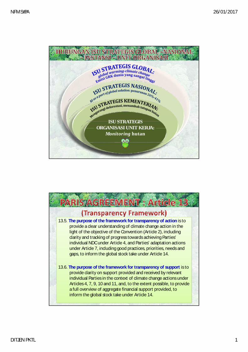
ISU STRATEGISISUSTRATEGISORGANISASIUNITKERJA:
Monitoring hutan
13.5. The purpose of the framework for transparency of action is to provide a clear understanding of climate change action in the li h f h bj i f h C i ( i l 2) i l dilight of the objective of the Convention (Article 2), including clarity and tracking of progress towards achieving Parties’ individual NDC under Article 4, and Parties’ adaptation actions under Article 7, including good practices, priorities, needs and gaps, to inform the global stock take under Article 14.
13 6 The purpose of the framework for transparency of support is to13.6. The purpose of the framework for transparency of support is to provide clarity on support provided and received by relevant individual Parties in the context of climate change actions under Articles 4, 7, 9, 10 and 11, and, to the extent possible, to provide a full overview of aggregate financial support provided, to inform the global stock take under Article 14.

NFMS‐PA 26/01/2017
DITJEN PKTL 2
‐ DATA UMUM‐ DATA TEKNIS
AKTIFITAS
NFMS
REGISTRASI
MRV
‐ CAPAIAN AKSI MITIGASI (PENURUNAN EMISI GRK)
‐ CAPAIAN AKSI ADAPTASI ‐ PROKLIM‐ REALISASI SUMBER DAYA
NFMS MRV
BASELINE AKTIFITAS NASIONAL RESULT
• Penginderaan jauh• Penutupan hutan• Pemantauan
perubahan tutupanhutan
• TSP/PSP‐ DataPotensi SDH
• NSDH• DatadanInformasi
Sosbud
PemantauanInventarisasihutan
PemantauanSumber
Daya Hutan
Pemetaandan
DokumentasiJaringan
Data Spasial
Faktoremisi
Dataaktivitas
Analisai l
Berbagipakai&
pertukaran
• DataRekalkulasiPenutupan Lahan
• DataDeforestasi• PIPPIB
• Simpul Jaringan InformasiGeospasial Nasional
• UnitKliringDataSpasialKehutanan
• Aksesdataspasialkehutananuntukpublik
DokumentasiTematik
Kehutanan
DataSpasialKehutanan spasialpertukaran
data
PERATURAN MENLHK No. P.18/MENLHK‐II/2015 tentang Organisasi dan Tata Kerja Kementerian Lingkungan Hidup dan Kehutanan

NFMS‐PA 26/01/2017
DITJEN PKTL 3
Title Indonesia’s National Forest Title Indonesia’s National Forest Monitoring SystemMonitoring System
MinistryofForestry
Decision1/CP.16TheCancunAgreements:OutcomeoftheworkoftheAdHocWorkingGrouponLong‐termCooperativeActionundertheConvention
• Anationalstrategy oractionplan;• Anationalforestreferenceemissionlevel
and/orforestreferencelevel;• Arobustandtransparentnationalforest
monitoring system for the monitoring andmonitoringsystem forthemonitoringandreportingofREDD+activities;
• AsystemforprovidinginformationonREDD+safeguards.
Report of the Conference of the Parties on its sixteenth session, held in Cancun from 29 November to 10 December 2010Addendum Part Two: Action taken by the Conference of the Parties at its sixteenth session

NFMS‐PA 26/01/2017
DITJEN PKTL 4
A. Pemantauan Perubahan Penutupan Lahan danPotensi Hutan (Deforestasi dan DegradasiPotensi Hutan (Deforestasi dan DegradasiHutan)
B. Pemantauan dan Pemetaan LuasIndikatifKebakaran Hutan dan Lahan
C. Mendukung Penyusunan ForestReferenceEmissionLevel(FREL)
D. Mendukung Pelaksanaan KegiatanInventarisasi GasRumah Kaca
E. Mendukung Kegiatan MRV
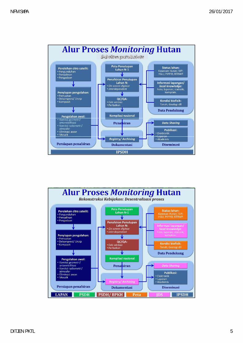
Proses Perubahan:Reliableandtimelymanner
ForestReport
MONITORINGHUTANTIGA
TAHUNAN
MONITORINGHUTANTIAP
TAHUN
p(menjadihandal,terpercaya
serta tepat waktu)
1.Rekonstruksi Kebijakan2.Penggunaan ICT3.Penerapan TQM SDM4.Revisi Anggaran5.StakeholderNetworking
transparansi, akuntabilitas dan partisipasi ~goodgovernance
NFMS‐PA 26/01/2017
DITJEN PKTL 5
ALUR MONITORING SAAT INI
ALUR MONITORING REKONSTRUKSI
NFMS‐PA 26/01/2017
DITJEN PKTL 6
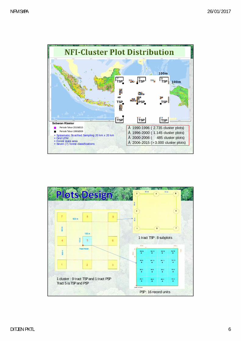
100
100m
TSPTSPTSP 100m
PSP TSP
TSPTSPTSP
TSP
Periode Tahun 2010‐2015
Periode Tahun 1990‐2009
• 1990-1996 ( 2.735 cluster plots)• 1996-2000 ( 1.145 cluster plots)• 2000-2006 ( 485 cluster plots)• 2006-2015 (>3.000 cluster plots)
TSPTSPTSP
Systematic Stratified Sampling 20 km x 20 kmGrid UTMForest state areaSeven (7) forest classifications
1 tract TSP : 8 subplots
PSP : 16 record units
1 cluster : 9 tract TSP and 1 tract PSPTract 5 is TSP and PSP

NFMS‐PA 26/01/2017
DITJEN PKTL 7
TSP over Citra

NFMS‐PA 26/01/2017
DITJEN PKTL 8
Land Cover Data – Activity Data• Period : 1990 – 2015• 23 land cover classes (6 natural forest classes ; 1 plantation forest; 16 non
forest classes) – MoEF on the SNI 7645-2010
Carbon Stock Data – Emission Factor for Forest Classes• Data generated from 4,450 Permanent Sample Plot (PSP) of the NFI year
1989-2013 for dry land forest & swamp forest (primary &secondary)• Carbon stock of Mangrove Forest (primary & secondary) taken from
available researches(e.g. Krisnawati et al,2012; Donato, eat al, 2011; Murdiyarso et al, 2009)
Peat Spatial Data – Emission Factor for Peat• Adopted from IPCC Supplement, 2013• Peat Spatial Data produced by the Ministry of Agriculture based on several
related maps, field survey and verified by ground check (Ritung et al, 2011)