discussion papers - webdoc.sub.gwdg.dewebdoc.sub.gwdg.de/ebook/serien/qg/rkk/44.pdfb. 1940, p. 3.)...
TRANSCRIPT
CENTRE FOR REGIONAL STUDIES OF HUNGARIAN ACADEMY OF SCIENCES
DISCUSSION PAPERS
No. 44 Carpathian Basin and the
Development of the Hungarian Landscape Theory Until 1948
by
Zoltán Hajdú
Series editor
Zoltán GÁL
Pécs 2004

2
ISSN 0238–2008
2004 by Centre for Regional Studies of the Hungarian Academy of Sciences. Technical editor: Ilona Csapó. Printed in Hungary by Sümegi Nyomdaipari, Kereskedelmi és Szolgáltató Ltd., Pécs.
3
CONTENTS
Introduction ............................................................................................................. 5
1 The „Carpathian Basin” issue in Hungarian geographical science ................... 6
2 The historic features of the territorial development of the Hungarian state .... 10
3 The shaping of the Hungarian landscape approach in the last third of the 19th century ................................................................................................. 13
4 The trends during the turn of the 19–20th century ............................................ 16
5 The lost war – geographical science – landscape theory (1918–1920) ........... 20
6 The trends during the 1920–1944 .................................................................... 25
6.1 Pál Teleki and his school of landscape geography ................................... 26
6.2 Jenı Cholnoky .......................................................................................... 31
6.3 Gyula Prinz’s activity in landscape geography ......................................... 32
6.4. Károly Kogutowicz.................................................................................... 32
7 Territorial growth and its consequences on landscape geography (1938–1945)...................................................................................................... 34
8 Problems of landscape research between 1945–1948 ...................................... 41
9 Summary .......................................................................................................... 42
References ............................................................................................................. 44

4

5
Introduction
The emphasis between theoretical, global and regional geography, proportion from research to publication has changed several times during the history of Hungarian geography. Certain scholars of Hungarian geography (geo-philosophers, and some theorists) were explicitly attached to theoretical issues of geographic science, yet the majority of geographers advantaged the concrete territorial descriptions and analysis.
The regional approach appeared in the Hungarian geography much earlier than the demand on clarification of the theoretic issues of landscape. The first attempt to divide the country into macro landscapes was carried out in the first half of the 1500’s. From this time on the geographic science formulated a demand to analyse the internal structure of the country within the frameworks of public administra-tion or in the framework of some other way delimited geographic macro-regions. The administrative space enjoyed for centuries a favoured role, yet the demand for analyses based on the macro regional delimitation was always represented too.
On general level the issues of landscape have already been present in Hungar-ian geographic science (the formulation of concepts, categories, border marking theories etc.), but Hungarian geographic science – concerning the territorial re-search of Hungary – has achieved the greatest results mostly in the fields of ana-lytical landscape research, and evaluation
All these issues have been formulated in special historical and politically de-termined periods (before 1918, 1918–1920, 1920–1938, 1938–1945, 1945–1948). Significant changes have taken places not only within these periods but also for-mulated the opinion of the general public in wider sense, and were present in pub-lic education and school textbooks as well.
The problem how to call the area bordered by the Alps, the Carpathians, the Dinári mountains in cartography and geography was not merely an issue of terminology. Different names were in use for this territorial unit both in different periods and simultaneously. (Hungarian Basin, Pannon Basin, Central Danubian Basin, Danubian Basin, Carpath Basin, Carpathian Basin etc.). The names were reflecting some kind of spatial community sense, a general responsibility and attitude as well. This is the reason why both in international and Hungarian geographic science the notion and synthesis category of ‘Carpathian Basin’ was introduced with great difficulty only. The Hungarian naming process was also influenced by German, Italian, Russian, English and French spatial orientations and naming practices.
6
1 The „Carpathian Basin” issue in Hungarian geographical science
After the settlement of the ‘magyars’ in year 895 the shaping Hungarian geo-graphical mind and spatial orientation was a rather long process. It was mostly small landscapes and partly medium landscapes reflecting in their names their relationship to Danube and Tisza rivers that were recognised and named as inde-pendent units by the general public. For a long time the names of macro landscapes and the country’s natural environment were shaped by scientific mapping and naming practices.
The notion of ‘Carpathian Basin’ is a result of a long evolution process both in the history of international and Hungarian geographic science. The ‘sensing’ of the Carpathians and river Danube appeared in a natural way at an early time in the European geographical mind (Hungary’s territory was almost always covered by comprehensive European geographic analyses, and since the 18th century several cartographers were carrying out country assessments) and at the same time in Hungarian name catasters the rather the country’s ‘valley’ than basin features were emphasized for a long time. This ‘valley approach’ mostly resulted from the Da-nube’s natural geographical role and predominance in Hungarian geographical mind. This general ‘valley-oriented approach’ may be the explanation for the fact that both international and Hungarian maps showed the territory of Hungary stretched in Northwest-Southeast bound direction.
The language of Hungarian geographical literature was dominated by Latin at first and by German at a later period. The ‘adaptation’ of spatial categories into different languages made continuously a big headache for geographers. (György Szaller wrote his book first in German in 1796 and later on he translated it into Hungarian. The two variations of the book significantly differ from each other in the use of names, spatial approach, spatial categories etc. It is an eye-catching phe-nomenon that in natural geographical studies the author used the German, while during the overview of political structures he used the Hungarian spatial ap-proach.)
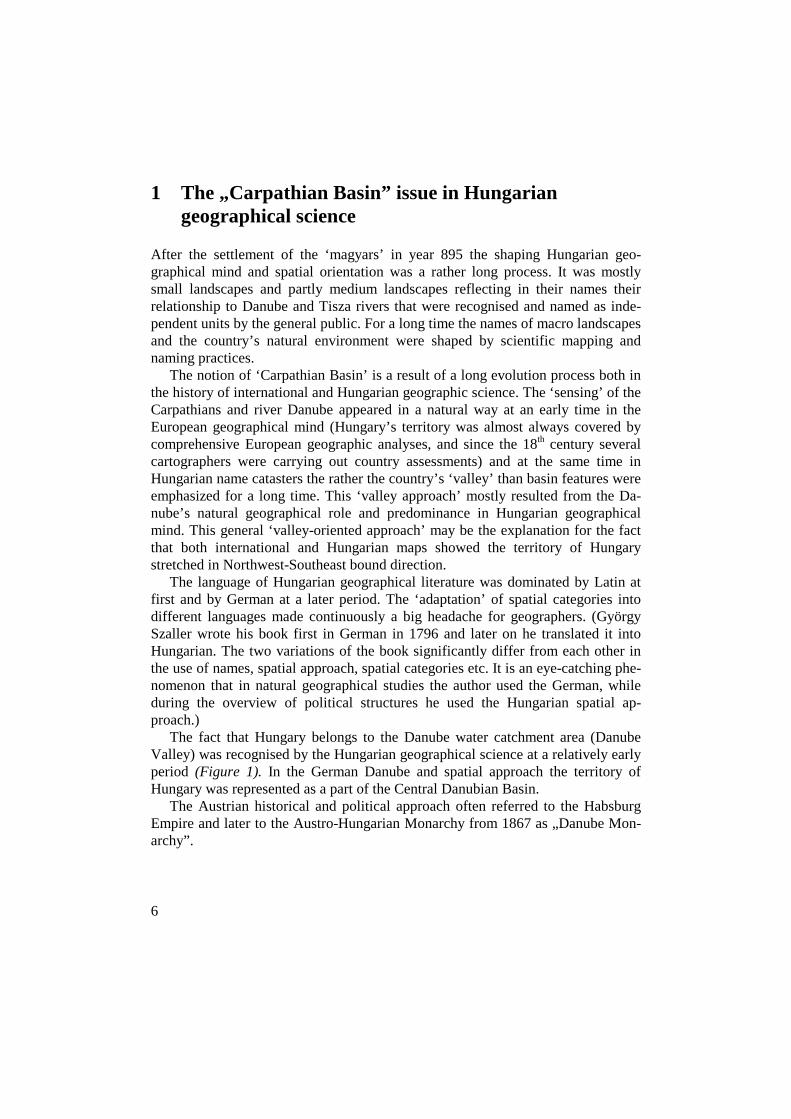
The fact that Hungary belongs to the Danube water catchment area (Danube Valley) was recognised by the Hungarian geographical science at a relatively early period (Figure 1). In the German Danube and spatial approach the territory of Hungary was represented as a part of the Central Danubian Basin.
The Austrian historical and political approach often referred to the Habsburg Empire and later to the Austro-Hungarian Monarchy from 1867 as „Danube Mon-archy”.
7
Figure 1 Hidrological and morphological structure of Danube Valley
8
During the 19th and 20th centuries after the “inside members of the Carpathian Basin” (Germans, Hungarians, Slovaks, Romanians, Serbs etc.) the “external na-tions” (English, French, Russians, Italians etc.) also formed their opinion on the naming of the geographic space during the marking and naming of geographic territories in the natural geographical division of Europe. We can see here a special ‘naming competition’ which cannot be considered as a uniqe or peculiar phenome-non through the area in wider sense.
In the second half of the 19th century the notion ‘Central Danube Basin’ was acknowledged in hydrological research only, the country’s geographical macro-space was rather referred to as ‘Hungarian Basin’. In archaeology and history the notion ‘Pannon Basin’ was also in use. The name of ‘Carpathian Basin’ was used by foreigners only.
After the turn of the 19th and 20th centuries the majority of Hungarian geo-graphical papers, textbooks and maps labelled the area as ‘Hungarian Basin’. Be-tween World War I and II both scientific literature and education used mostly the notion of ‘Hungarian Basin’ but the terms ‘Carpat or Carpathian Basin’ were also present in the wider public.
Béla Bulla in 1940 clearly pointed out that geographical names were not merely names but they represented ideas as well: ‘Foreign literature tends to hide the original right of Magyars for this area by naming it Danube Basin instead of Hun-garian Basin – though its geographic unity should be regarded as evidence.’ (Bulla, B. 1940, p. 3.)
In 1941-ben a scientific journal was founded under the title “Kárpát-medence” (Carpathian Basin) regarding the popularization of the notion and the area’s scien-tific analysis its prime mission. The names (Carpathian Basin, Hungarian Basin) started to be sinonyms in fact.
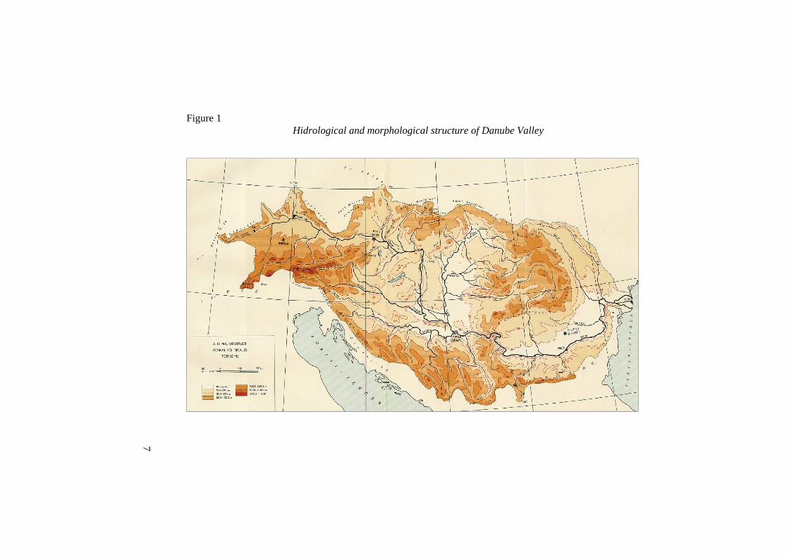
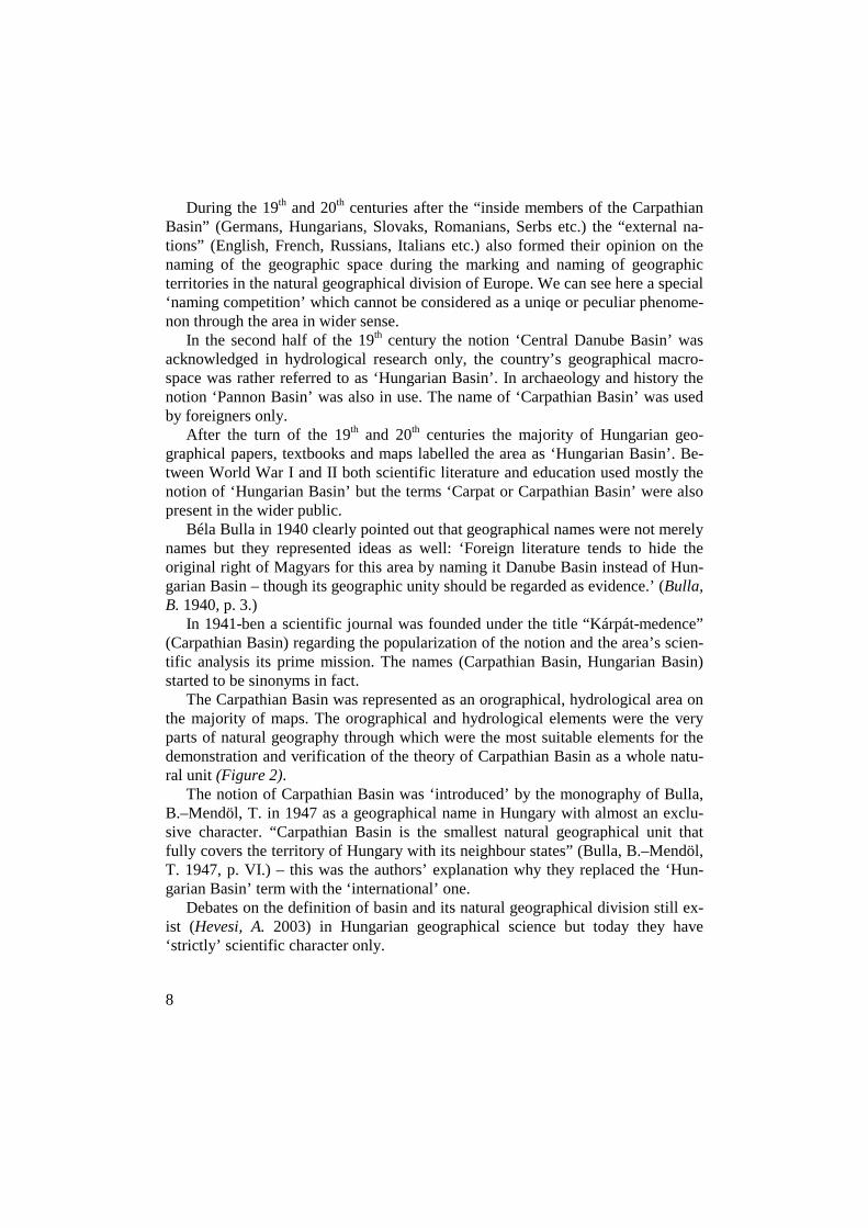
The Carpathian Basin was represented as an orographical, hydrological area on the majority of maps. The orographical and hydrological elements were the very parts of natural geography through which were the most suitable elements for the demonstration and verification of the theory of Carpathian Basin as a whole natu-ral unit (Figure 2).
The notion of Carpathian Basin was ‘introduced’ by the monography of Bulla, B.–Mendöl, T. in 1947 as a geographical name in Hungary with almost an exclu-sive character. “Carpathian Basin is the smallest natural geographical unit that fully covers the territory of Hungary with its neighbour states” (Bulla, B.–Mendöl, T. 1947, p. VI.) – this was the authors’ explanation why they replaced the ‘Hun-garian Basin’ term with the ‘international’ one.
Debates on the definition of basin and its natural geographical division still ex-ist (Hevesi, A. 2003) in Hungarian geographical science but today they have ‘strictly’ scientific character only.
9
Figure 2 Orographical structure of historical Hungary and Carpathian Basin, 1921
10
2 The historic features of the territorial development of the Hungarian state
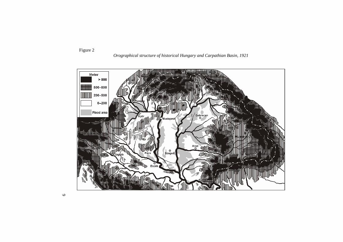
It can be stated as a general historical feature of Central Europe that it’s the major features of its political territorial development were the fundamental changes in its political power zones and state borders (Figure 3). Almost every parts of the area were subordinated to several state formations. The territories of state in this large area were flexible from historical point of view.
Stability and instability were both present during the long-term development of the Hungarian state. Between the settlement of the Magyars in 895 and year 1526 Hungarian political power space was undergoing an expansive period and showed the features of an empire. Between 1526–1686 the central core of the Hungarian state was ruled by the Turkish Empire. The Royal Hungary could preserve its legal continuity only on a small area. Transylvania – under the supervision of the Turk-ish Empire – was starting to build an autonomous state.
The historic development of the Hungarian state had fundamental role and out-comes in the formation of the Hungarian spatial approach. During the marking of the border of certain geographical areas the existing at that time political, territo-rial systems (e.g. Transylvania, Slavonia, Croatia etc.) and macroregional identities (Transylvanism) always had to be taken into account.
During the history of the Hungarian state, in the definition of the country’s in-ternal macro structure, historical, political, public law, natural geographical etc. elements were equally taken into account and when dividing the county into dif-ferent landscapes the final outcome was always different. For a long time the ele-ments of historical-public law and public administration were dominating the ap-proaches to the elements of the Hungarian state. The aspects of natural geography in the division of Hungarian landscapes had a marginal, ‘to be discussed by scientists’ role only.
When studying the interrelationship of the territorial units of the Hungarian state with natural geography, since the 18th century it was gradually recognised that Hungary and the Carpathian Basin form a kind of organic unit. The concept of Hungary’s natural geographical integration was established by a generation of geographers.
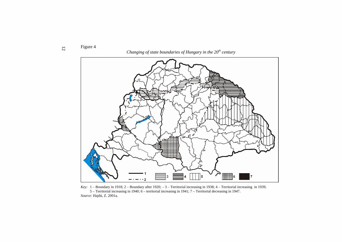
The change in the territory of the state was extremely radical in the 20th century (Figure 4). This was the age, when territorial structures were transformed by the process of global modernisation at a relatively fast speed, and when the modern geographical concept of landscapes and space was established and evolving. These large-scale transformations in the 20th century were great challenges for the theo-retical, research, individual and scientific levels of Hungarian geography.
11
Figure 3 Stability of state boundaries in Central Europe
Source: Rónai, A. ed. 1940.
12
Figure 4 Changing of state boundaries of Hungary in the 20th century
Key: 1 – Boundary in 1918; 2 – Boundary after 1920; – 3 – Territorial increasing in 1938; 4 – Territorial increasing in 1939;
5 – Territorial increasing in 1940; 6 – territorial increasing in 1941; 7 – Territorial decreasing in 1947. Source: Hajdú, Z. 2001a.
13
During the changes in the territory of state in the 20th century the fundamental concepts on the basic natural features of Hungary were also in a constant change: 1918 – basin-state, 1920–1937 basin-bottom state, 1938–1941 a partial-basin state “growing out” from the basin-bottom situation, after 1945 basin-bottom state again. The way, how to adapt to the changing demands of the changing borders and what territorial configuration is the best suited to the landscape structure of the current territory of state, were the fundamental issues of geographical science (Hajdú, Z.–Hajdú, Zs. 1997).
3 The shaping of the Hungarian landscape approach in the last third of the 19th century
The notion of „táj” (landscape, Landschaft) was not shaped first by geographic science but rather by the public opinion in Hungary. According to Hungarian lin-guistic and etymological research the expression of „landscape” belongs to the most ancient (Ugrian) layer of Hungarian language, it was first used in written form in a document by 1435.
The Hungarian political, historical and geographical literature (Oláh, M. 1536/1985) evolving by the 16th century described this natural unit considered as unique, particular and characteristic not only by this category, but several other expressions like tract, area, neighbourhood, rural area, region etc., yet without clear conceptual or volume distinction between the notions and categories.
Szepsi Csombor Márton who travelled to most parts of Europe, tried to explain the continent’s peculiar natural and environmental categories in Hungarian lan-guage on the basis of direct natural approach (Szepsi Csombor, M. 1620).
In the 18th century state theoretical elaboration became the dominating field of Hungarian geographic science. Natural geographic description was also present in these works but the primary spatial framework of geographic research became the administrative units. The authors described the territorial structure of the counties and they did not attach great importance to the issue of natural geographic units (Bél, M. 1735, 1792a, 1792b; Szászky Tomka, J. 1777; Szaller, Gy. 1796).
The landscape poetry in the 19th century (Sándor Petıfi and János Arany) ap-prehended the natural, social and economic features of Hungarian landscapes (es-pecially Alföld) in several aspects earlier than geographic science. The aesthetic quality of Hungarian landscape, the issue of the soul and character of landscape was fist addressed by Hungarian poetry. The landscape poesy played a significant role in the evolution of the landscape identity. In the case of the Great Hungarian
14
Plain we can even talk about some macro-regional identity, which actually sur-passes the scale of Hungarian counties.
The category of „régió” (region) was historically used by Hungarian Latin (which the official language in Hungary until 1844). The notion of region first appeared in written Hungarian text in 1806, and from than on it was used in the everyday language too, yet with a different content. By the 19th century the notion was not yet filled with political content.
At the beginning of the 1860’s The Hungarian Academy of Sciences considered as its preliminary task to prepare and publish the fundamental works of different disciplines in Hungarian language. János Hunfalvy (1820–1888) was assigned by the Hungarian Academy of Sciences to write a monograph entitled „The natural circumstances of the Hungarian Empire” which was published by the Academy in three parts as the basic manual of Hungarian geographic science. (Hunfalvy had his basic education in law, and he was strongly interested in history, economy, social, ethnic and political sciences yet is natural scientific and within this field natural geographic knowledge was rather poor.)
Finally Hunfalvy completed the monograph summing up the history and find-ings of the geographic research on Hungary. Hunfalvy comprehensively pointed out that besides the Hungarians, Germans, English and the French have contrib-uted to the know-how on the country.
Hunfalvy grants an important role to the scientific activity of the French Beu-dant, F. S. (1787–1852). Beudant made in 1818 a nine-month scientific study trip in Hungary. In his three volume work he was among the first to make an attempt to draw the geological map of Hungary and to assort the Hungarian mountains (Beu-dant, F. S. 1822). The monograph of Beudant is a very important work also from the aspect that it contributed to the creation of the professional terminology of Hungarian geography. Alongside his work the terms like relief and plateau have been naturalised in Hungarian. Hunfalvy considered the monograph by Beudant as the closing of the epoch: „His work finishes in some respects the first epoch in terms of the development of Hungarian geology.” (Hunfalvy, J. 1863, I. pp. 25–26.)
The approach of the monograph by Hunfalvy was in comparison with the pre-vious more up to date, yet it was marked by the characteristic feature of the era that a synthesis was written without a serious preparatory work. Hunfalvy consid-ered as the most important result of the work, that the geographic data of certain settlements were listed pages long.
For Hunfalvy: „the Hungarian Empire was in terms of its general natural cir-cumstances a geographic unity with a clearly expressed character; i.e. its borders are with some exceptions natural borders, delimited by mountains and rivers” (Hunfalvy, J. 1863, p. 112). Hunfalvy treated the proper natural geographic unity
15
of Hungary in all of his geographic analyses as evidence, it was only varied based on the newer research results or with some new aspects.
For Hunfalvy it was a problem, how to elaborate the internal landscape delimi-tation based on the previously declared natural geographic unity of the country and how to formulate its scientific foundations. In the course of the description of the terrain and especially of the mountains instead of the genetic principle he focused on the coexistence of certain formations.
Hunfalvy often used the term landscape, region and main landscape in his de-scriptions on natural circumstances but without defining their systematic content as scientific categories. His approach was determined by the Hungarian Empire as one natural unit and in comparison to this the internal configuration was rather an inferior issue.
Hungarian geographic science was institutionalised by the beginning of the 1870’s (establishment of University department, foundation of the Hungarian Geographic Society, the publication of first scientific geographical periodical – Földrajzi Közlemények) and became a modern discipline. The dominating person-ality of geography was until his death Hunfalvy, going in for geographic science in the spirit of Ritter, Carl. In the last third of the century Hungarian geography can be defined as encyclopaedic, comparative, historic discipline.
Hunfalvy continuously followed new theories, changing concepts and tenden-cies in international geographical science. Almost every year, in the ‘Földrajzi Közlemények’ journal, he summarized the latest research results of international geography. In his summaries he always called the reader’s attention for the most discussed points, for the reasons of different approaches and opinions. He almost always discussed landscape research issues.
The image of Hunfalvy as a man and professor in geographical science re-mained positive even after his death, but his favoured geographical approach was going out of use from the mainstream of geographical science at a relatively short time. After Hunfalvy’s death new processes, discussions and trends were starting in Hungarian geography.
The ‘Földrajzi Közlemények’ focused ever since its first publication in 1873 until the end of the 19th century on the geographic issues of the country, yet even the larger regions appeared as the topic of comprehensive analyses only from time to time. The settlements and the micro regions were not subject to natural geo-graphic but rather social analyses (Mendöl, T. 1947).
16
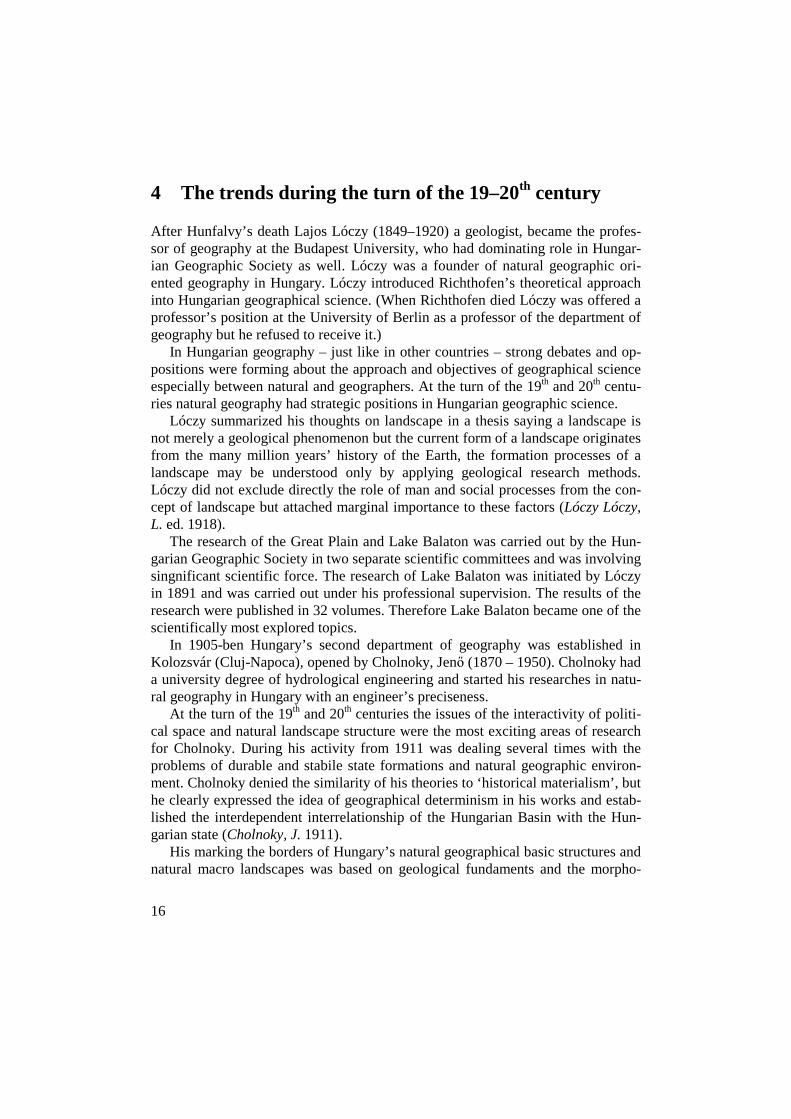
4 The trends during the turn of the 19–20th century
After Hunfalvy’s death Lajos Lóczy (1849–1920) a geologist, became the profes-sor of geography at the Budapest University, who had dominating role in Hungar-ian Geographic Society as well. Lóczy was a founder of natural geographic ori-ented geography in Hungary. Lóczy introduced Richthofen’s theoretical approach into Hungarian geographical science. (When Richthofen died Lóczy was offered a professor’s position at the University of Berlin as a professor of the department of geography but he refused to receive it.)
In Hungarian geography – just like in other countries – strong debates and op-positions were forming about the approach and objectives of geographical science especially between natural and geographers. At the turn of the 19th and 20th centu-ries natural geography had strategic positions in Hungarian geographic science.
Lóczy summarized his thoughts on landscape in a thesis saying a landscape is not merely a geological phenomenon but the current form of a landscape originates from the many million years’ history of the Earth, the formation processes of a landscape may be understood only by applying geological research methods. Lóczy did not exclude directly the role of man and social processes from the con-cept of landscape but attached marginal importance to these factors (Lóczy Lóczy, L. ed. 1918).
The research of the Great Plain and Lake Balaton was carried out by the Hun-garian Geographic Society in two separate scientific committees and was involving singnificant scientific force. The research of Lake Balaton was initiated by Lóczy in 1891 and was carried out under his professional supervision. The results of the research were published in 32 volumes. Therefore Lake Balaton became one of the scientifically most explored topics.
In 1905-ben Hungary’s second department of geography was established in Kolozsvár (Cluj-Napoca), opened by Cholnoky, Jenı (1870 – 1950). Cholnoky had a university degree of hydrological engineering and started his researches in natu-ral geography in Hungary with an engineer’s preciseness.
At the turn of the 19th and 20th centuries the issues of the interactivity of politi-cal space and natural landscape structure were the most exciting areas of research for Cholnoky. During his activity from 1911 was dealing several times with the problems of durable and stabile state formations and natural geographic environ-ment. Cholnoky denied the similarity of his theories to ‘historical materialism’, but he clearly expressed the idea of geographical determinism in his works and estab-lished the interdependent interrelationship of the Hungarian Basin with the Hun-garian state (Cholnoky, J. 1911).
His marking the borders of Hungary’s natural geographical basic structures and natural macro landscapes was based on geological fundaments and the morpho-
17
logical elements of physical surface. Cholnoky considered the marking of territo-rial borders important but in his opinion it could never have an exclusive and ab-solute character.
The unique atmosphere of the turn of the 19th and 20th century encouraged the Hungarian geography to reckon and to reconsider the past era. Géza Czibusz (1853–1920) published his work on Hungary’s Geography (Czirbusz, G. 1902) with the intention to surpass Hunfalvy”s completely outdated summary. Czirbusz applied the category of landscape in several different contexts (large landscapes of Europe, the dunes landscape along the Danube, landscape with short grass etc.), yet he has never elaborated the essential elements and systematic content of the category. The landscape remained for Czirbusz an open category as regards its internal content.
Czirbusz defined the geographical macro-structures of Hungary on genetic foundations. He strongly relied on the work of Suess, E. and Penck, A. Czirbusz believed that the main courses of the geologic structure of the country can only be defined and understood in the wider, at least European scale context.
Czirbusz elaborated the internal territorial structures based on natural geo-graphic large landscapes. In the course of the elaboration he defined the hierarchi-cal relationships of landscapes: he divided the large landscape of the Small Plain into micro landscapes, which were preliminarily bordered by streams. The identi-fication of the micro landscapes preliminarily focused on their relationship to the large geographic regions and their topographical location. The second aspect of analysis was the structure of the surface of the micro landscape. In the course of the description of the character of the micro landscape the „scenic view” appeared. Czirbusz has drawn a kind of development process of the micro regions and ana-lysed the human interventions (e.g. the river control) and evaluated the economic usefulness (wheat production and grazing). The last element of the portrait was the description of the settlement structure.
Czirbusz introduced and analysed the Great Plain in his work entitled „Reclus Nouvelle geographie de l’Europe central”. This is an important aspect, since as already Hunfalvy admitted it, in the geographc exploration and description of the Hungarian land. Besides the German also the French and English geographic sci-ence played an important role in his work. Czirbusz – resulting from his French and German education – was strongly bound to both the French and German geog-raphy. He was familiar with both great national geographic sciences and partially adapted their results, yet some other approaches of them he also argued. Czirbusz played a significant role in dissemination of the results of the French (Reclus) and German (Ratzel) geography in Hungary.
In the course of the analysis of the internal structures of the Great Plain Czir-busz formulated that the geographic division of the soil „lends some characteristics

18
to the different soils of the Great Plain…” and he talked within the territory of the Great Plain about „seven main landscapes”. The expression of the conscious un-derstanding of his own significance was that Czirbusz attributed the delimitation of the seven „main landscapes” of the Great Plain „which is completely new in our geography” to himself. The so-called „main landscape” was actually applied func-tionally as a medium size region within the large region.
While Czirbusz operated and analysed in the course of his natural geographic analysis more or less consequently with the system of landscapes and regions, in the social geographic part he chose as the framework of the chorografia a quite peculiar (partially natural geographic and partially public administrative) solution. He divided the country into two macro regions (the first was the ring of Carpa-tians: the historical Upper-Northern Hungary, Transylvania, South Hungary, Cen-tral Hungary and the second the Hilly Landscape of the Danube, i.e.: Small Plain, Great Plain, Croatia). Within these two macro regions he applied merely the public administrative division (counties, towns) as the framework of the analysis.
Czirbusz had an important role in the history of Hungarian geography from theoretical aspects as well. In his book on the history and philosophy of geography (Czirbusz, G. 1912) introduced the most important historical processes of the de-velopment of international geographical science, the fundamental interrelations of the sharp debates of his age. Czirbusz denied both geographical determinism and geographical nihilism, and sharply committed himself to geographical possibilism.
In 1906 Hungary’s first big scientific atlas was published, in which the Euro-pean overview map page labelled the area as ‘Hungarian Plain’, without using the term ‘Carpathian Basin’. Even within the territory of Hungary every landscape bears the expression ‘Magyar’ (Hungarian) in it (Kis-Magyar Alföld [Small Hun-garian Plain], Nagy-Magyar Alföld [Great Hungarian Plain] etc.)
The use of names on the school wall maps of Europe published at the turn of the 19th and 20th were similar. Neither school atlases used the Carpathian Basin term. The forced giving Hungarian names to ‘pure’ natural geographical forma-tions was a dominating trend both in science and education at the turn of the 19th and 20th centuries.
Since the beginning of the 1900’s – besides the impact of Ratzel – the influence of the French and English landscape geography was rapidly increasing in the Hun-garian geography. Reclus, Brunhes and Vidal de la Blache became indirect actors of Hungarian geographic debates. The great work of Reclus (The Earth) was pub-lished in Hungarian language. Bunches rather impacted the human geography and the outset of the process in Hungarian geography in which the term of landscape received a social character (too). (Brunhes’ work entitled “La Géographie hu-maine” was translated into Hungarian language, but due to the lack of financal re-sourcs it was never published).
19
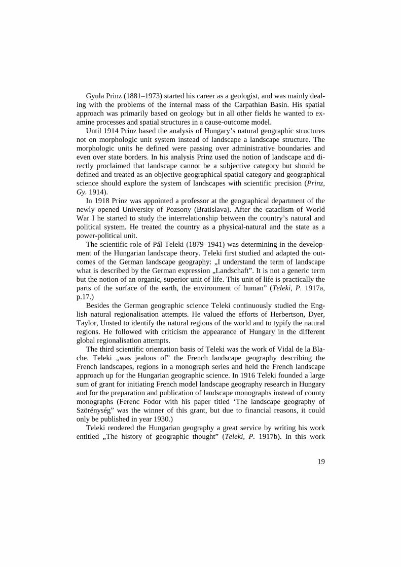
Gyula Prinz (1881–1973) started his career as a geologist, and was mainly deal-ing with the problems of the internal mass of the Carpathian Basin. His spatial approach was primarily based on geology but in all other fields he wanted to ex-amine processes and spatial structures in a cause-outcome model.
Until 1914 Prinz based the analysis of Hungary’s natural geographic structures not on morphologic unit system instead of landscape a landscape structure. The morphologic units he defined were passing over administrative boundaries and even over state borders. In his analysis Prinz used the notion of landscape and di-rectly proclaimed that landscape cannot be a subjective category but should be defined and treated as an objective geographical spatial category and geographical science should explore the system of landscapes with scientific precision (Prinz, Gy. 1914).
In 1918 Prinz was appointed a professor at the geographical department of the newly opened University of Pozsony (Bratislava). After the cataclism of World War I he started to study the interrelationship between the country’s natural and political system. He treated the country as a physical-natural and the state as a power-political unit.
The scientific role of Pál Teleki (1879–1941) was determining in the develop-ment of the Hungarian landscape theory. Teleki first studied and adapted the out-comes of the German landscape geography: „I understand the term of landscape what is described by the German expression „Landschaft”. It is not a generic term but the notion of an organic, superior unit of life. This unit of life is practically the parts of the surface of the earth, the environment of human” (Teleki, P. 1917a, p.17.)
Besides the German geographic science Teleki continuously studied the Eng-lish natural regionalisation attempts. He valued the efforts of Herbertson, Dyer, Taylor, Unsted to identify the natural regions of the world and to typify the natural regions. He followed with criticism the appearance of Hungary in the different global regionalisation attempts.
The third scientific orientation basis of Teleki was the work of Vidal de la Bla-che. Teleki „was jealous of” the French landscape geography describing the French landscapes, regions in a monograph series and held the French landscape approach up for the Hungarian geographic science. In 1916 Teleki founded a large sum of grant for initiating French model landscape geography research in Hungary and for the preparation and publication of landscape monographs instead of county monographs (Ferenc Fodor with his paper titled ‘The landscape geography of Szörénység” was the winner of this grant, but due to financial reasons, it could only be published in year 1930.)
Teleki rendered the Hungarian geography a great service by writing his work entitled „The history of geographic thought” (Teleki, P. 1917b). In this work

20
Teleki introduced the history of the geographic idea and science from the very beginnings until the centenary, the backgrounds of scientific debates the outcomes of turning points and he has drawn the final theoretic conclusion that a modern geography can not be anything else but landscape geography. He elaborated and considered the landscape as the most important and at the same time individual scientific category of geography.
Before 1918:
• the category of landscape maintained its terminological dominance yet the term of region was integrated in the approach of Hungarian geography too. The problems of landscapes and the country’s territorial division and analy-sis were mostly scientific issues for geography but also everybody was aware of the fact that within the Austro-Hungarian Monarchy and the multi-ethnical territory of Hungary any border marking actions were necessarily having po-litical impacts as well,
• the notion of landscape had cross-sectoral and analytical meanings in Hungarian geography, as it had physical, natural, nature geographical, eco-nomic, political, agricultural, demographical etc. sub-headings but on the other hand, it also had synthetical and grouping functions as well,
• a geographical deterministic approach to the organic unit and integration of the Hungarian Basin with Hungary had already evolved, which was standing on the assumption that nature geographical unity will automatically create political unity as well.
5 The lost war – geographical science – landscape theory (1918–1920)
In the autumn of 1918 Teleki founded the Hungarian Peace Preparation Office serving as a scientific workshop for the preparation of the Trianon Peace Talks. Never before had been such comprehensive and intensive researches been carried out on Hungary’s geographical structures (Edvi Illés, A.–Halász, A. eds. 1921; Bátky, Zs.–Kogutowicz, K. eds. 1921) as during this short period. This was the time when Hungarian geographical science was formulated into its full integrity, a fun-damental change had taken place in the orientation of human landscape theory (the so far dominating German orientation was replaced by English and French), the features of the country’s landscape system was explored and the borders of land-scapes were marked in their totality.
21
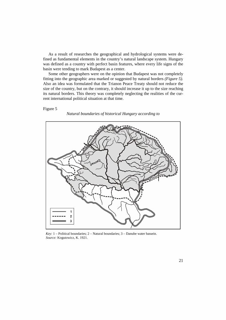
As a result of researches the geographical and hydrological systems were de-fined as fundamental elements in the country’s natural landscape system. Hungary was defined as a country with perfect basin features, where every life signs of the basin were tending to mark Budapest as a center.
Some other geographers were on the opinion that Budapest was not completely fitting into the geographic area marked or suggested by natural borders (Figure 5). Also an idea was formulated that the Trianon Peace Treaty should not reduce the size of the country, but on the contrary, it should increase it up to the size reaching its natural borders. This theory was completely neglecting the realities of the cur-rent international political situation at that time.
Figure 5 Natural boundaries of historical Hungary according to
Key: 1 – Political boundaries; 2 – Natural boundaries; 3 – Danube water bassein. Source: Kogutowicz, K. 1921.
22
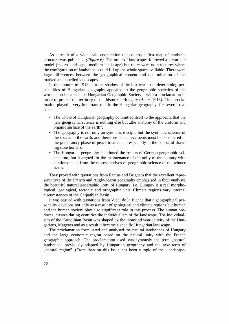
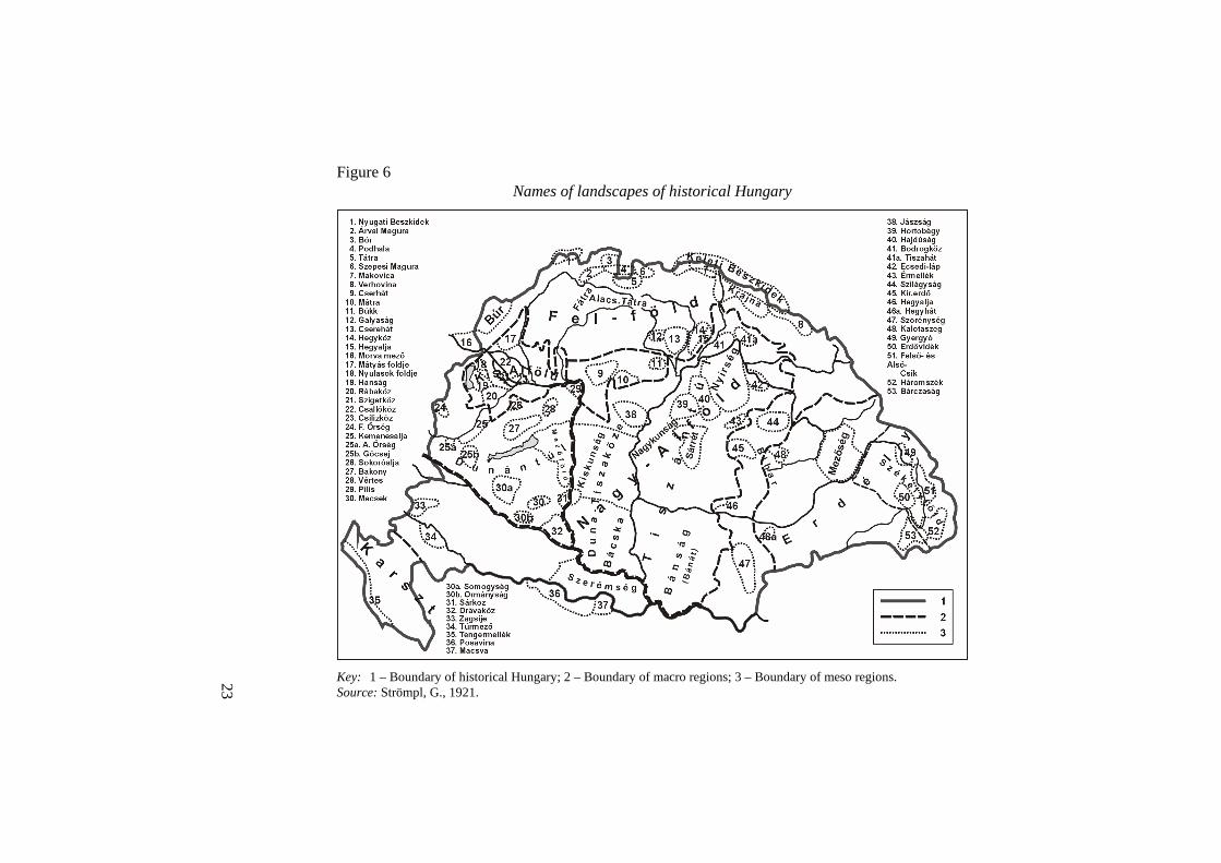
As a result of a wide-scale cooperation the country’s first map of landscap structure was published (Figure 6). The order of landscapes followed a hierarchic model (macro landscape, medium landscape) but there were no structures where the configuration of landscapes could fill up the whole space available. There were large differences between the geographical content and determination of the marked and labelled landscapes.
In the autumn of 1918 – in the shadow of the lost war – the determining per-sonalities of Hungarian geography appealed to the geographic societies of the world – on behalf of the Hungarian Geographic Society – with a proclamation in order to protect the territory of the historical Hungary (Anon. 1918). This procla-mation played a very important role in the Hungarian geography, for several rea-sons:
• The whole of Hungarian geography committed itself to the approach, that the new geographic science is nothing else but „the anatomy of the uniform and organic surface of the earth”;
• The geography is not only an synthetic disciple but the synthetic science of the spaces in the earth, and therefore its achievements must be considered in the preparatory phase of peace treaties and especially in the course of draw-ing state borders,
• The Hungarian geography mentioned the results of German geographic sci-ence too, but it argued for the maintenance of the unity of the country with citations taken from the representatives of geographic science of the winner states.
They proved with quotations from Reclus and Brigham that the excellent repre-sentatives of the French and Anglo-Saxon geography emphasised in their analyses the beautiful natural geographic unity of Hungary, i.e. Hungary is a real morpho-logical, geological, tectonic and orographic unit. Climate regions vary internal circumstances of the Carpathian Basin.
It was argued with quotations from Vidal de la Blache that a geographical per-sonality develops not only as a result of geological and climate regions but human and the human society play also significant role in this process. The human pro-duces, creates during centuries the individualism of the landscape. The individual-ism of the Carpathian Basin was shaped by the thousand year activity of the Hun-garians, Magyars and as a result it became a specific Hungarian landscape.
The proclamation formulated and analysed the natural landscapes of Hungary and the large economic region based on the natural unity with the French geographic approach. The proclamation used synonymously the term „natural landscape” previously adapted by Hungarian geography and the new term of „natural region”. (From than on this issue has been a topic of the „landscape-
23
region” Figure 6
Names of landscapes of historical Hungary
Key: 1 – Boundary of historical Hungary; 2 – Boundary of macro regions; 3 – Boundary of meso regions. Source: Strömpl, G., 1921.
24
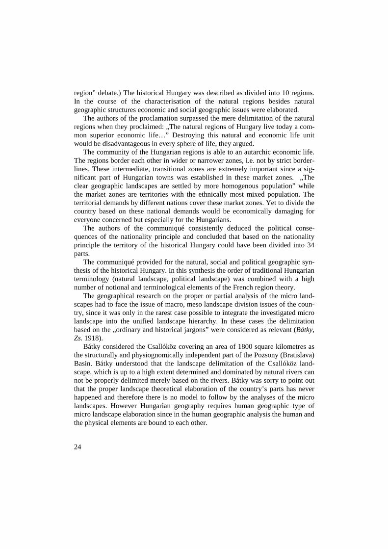
region” debate.) The historical Hungary was described as divided into 10 regions. In the course of the characterisation of the natural regions besides natural geographic structures economic and social geographic issues were elaborated.
The authors of the proclamation surpassed the mere delimitation of the natural regions when they proclaimed: „The natural regions of Hungary live today a com-mon superior economic life…” Destroying this natural and economic life unit would be disadvantageous in every sphere of life, they argued.
The community of the Hungarian regions is able to an autarchic economic life. The regions border each other in wider or narrower zones, i.e. not by strict border-lines. These intermediate, transitional zones are extremely important since a sig-nificant part of Hungarian towns was established in these market zones. „The clear geographic landscapes are settled by more homogenous population” while the market zones are territories with the ethnically most mixed population. The territorial demands by different nations cover these market zones. Yet to divide the country based on these national demands would be economically damaging for everyone concerned but especially for the Hungarians.
The authors of the communiqué consistently deduced the political conse-quences of the nationality principle and concluded that based on the nationality principle the territory of the historical Hungary could have been divided into 34 parts.
The communiqué provided for the natural, social and political geographic syn-thesis of the historical Hungary. In this synthesis the order of traditional Hungarian terminology (natural landscape, political landscape) was combined with a high number of notional and terminological elements of the French region theory.
The geographical research on the proper or partial analysis of the micro land-scapes had to face the issue of macro, meso landscape division issues of the coun-try, since it was only in the rarest case possible to integrate the investigated micro landscape into the unified landscape hierarchy. In these cases the delimitation based on the „ordinary and historical jargons” were considered as relevant (Bátky, Zs. 1918).
Bátky considered the Csallóköz covering an area of 1800 square kilometres as the structurally and physiognomically independent part of the Pozsony (Bratislava) Basin. Bátky understood that the landscape delimitation of the Csallóköz land-scape, which is up to a high extent determined and dominated by natural rivers can not be properly delimited merely based on the rivers. Bátky was sorry to point out that the proper landscape theoretical elaboration of the country’s parts has never happened and therefore there is no model to follow by the analyses of the micro landscapes. However Hungarian geography requires human geographic type of micro landscape elaboration since in the human geographic analysis the human and the physical elements are bound to each other.
25
A summarizing evaluation on Hungary edited by Lajos Lóczy was published in 1918. The publication of this book was initiated by the Hungarian Geographic Society at an earlier time (Lóczi Lóczy, L. ed. 1918). The book discusses the his-tory of the Hungarian Empire in public law and territorial context but the papers of Lóczy and Cholnoky provide comprehensive analyses on Hungarian geographical structures.
It was István Dékány who – first in the history of Hungarian geography – pro-vided a detailed theoretical analysis on landscape theory as a fundamental question of Hungarian geographical science (Dékány, I. 1918) and the possible role of land-scape factors in the process of development. Dékány studied landscape theory mostly on philosophical level and fully integrated international theoretical ap-proaches and debates into his researches.
Between 1918–1920, Hungarian geography played an important role in the sci-entific efforts for maintaining Hungary’s territorial integrity. Pál Teleki and Lajos Lóczy as the chairmen of the Association for the Defence of Hungary’s Territorial Integrity participated directly in political struggles.
6 The trends during the 1920–1944
Following the lost World War in 1918 Hungarian landscape geography had to face several basic questions:
• If the coincidence and unity of the Carpathian Basin and historic Hungarian state is eliminated, how should the natural macro-, medium- and micro-land-scapes be delimited within the new state borders?
• If the country is not any more a natural geographic unit, whether it is possi-ble to apprehend or interpret the internal territories in their natural and land-scape quality?
• In which form natural geographic landscapes can exist within an artificial, political creation?
• Is it necessary or at all possible to create a new natural geographic landscape delimitation adapted to the new state borders, i.e. – this was the standpoint of the majority – should geography rather research, elaborate, analyse the his-toric Hungary instead of the new state created by the Peace Treaty of Tri-anon?
After the Trianon Peace Treaty – partly the sharp debates during the Peace Treaty’s scientific preparation resulted a theoretical and partially institutional cri-sis in Hungarian geographic science. Some social geographers were on the opinion that they had no opportunity – within the framework of the Hungarian Geographic

26
Society – to carry out their researches in social geography and ‘Földrajzi Közlemé-nyek’ is not a real forum for the publication of their papers in social geography. For this reason they founded a Human Geography section within the Hungarian Ethnographic Society and published a journal in Szeged titled ‘Föld és Ember’ (Earth and Man) with the purpose of introducing social geography as a science in Hungary.
Between World War I and II the most important landscape researches were at-tached to university departments and senior professors, thus we are providing a brief summary of results following this structure.
6.1 Pál Teleki and his school of landscape geography
At the end of the 1920’s Teleki interrupted the development of his political carreer (he was a minister, and later on prime minister for a short time), and became a professor at the Department of Economic and Political Geography at the newly opened Faculty of Economics of Budapest University.
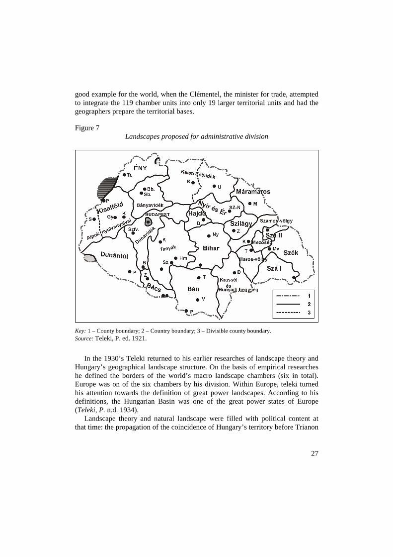
Teleki pronounced his landscape administrative approach during his lecturing tour in the United States in 1921, and applied the most important theses of his theory – following its disintegration – to the historical Hungary (Figure 7). Teleki believed that the ethnical principle is very important as regards the territorial structures, yet its exclusive consideration could lead to similar mistakes as any exclusiveness. The negligence of the traditions, the natural geographic and eco-nomic features and other interests will have extremely negative consequences in Europe.
If the Hungarian public administrative units established were based merely on the aspect of national majorities, a large public administrative unit should have been established in the central part of the country, with a population of 8,8 million. At the peripheries there would be a mosaic-patterned system of administrative units with mixed or more or less homogenous population.
Public administration would have been unable to operate within such frame-works – based on a single principle. A rational public administrative system can only be established based on an approach, which considers both, the national prin-ciple and the system of natural landscapes. He considered in the course of the de-limitation of natural landscapes the natural-, transport-, settlement and economic geographical elements and he attempted to identify manageable territorial units on the basis of complexity.
These manageable territorial units must be equipped with some improvement and development abilities. Telei believed that in this respect the French provided a
27
good example for the world, when the Clémentel, the minister for trade, attempted to integrate the 119 chamber units into only 19 larger territorial units and had the geographers prepare the territorial bases.
Figure 7 Landscapes proposed for administrative division
Key: 1 – County boundary; 2 – Country boundary; 3 – Divisible county boundary. Source: Teleki, P. ed. 1921.
In the 1930’s Teleki returned to his earlier researches of landscape theory and Hungary’s geographical landscape structure. On the basis of empirical researches he defined the borders of the world’s macro landscape chambers (six in total). Europe was on of the six chambers by his division. Within Europe, teleki turned his attention towards the definition of great power landscapes. According to his definitions, the Hungarian Basin was one of the great power states of Europe (Teleki, P. n.d. 1934).
Landscape theory and natural landscape were filled with political content at that time: the propagation of the coincidence of Hungary’s territory before Trianon

28
with the Carpathian Basin served as a basis for the state border revision policy of Hungarian geographic science.
Teleki’s research of the Hungarian Plain was an experiment towards the defini-tion of the Plain as a landscape but it was very important from the point of scien-tific theory (Figure 8). Teleki was well aware of the fact that a one-sided definition of a geographical macro landscape would imply serious theoretical and practical problems. Although during the territorial definition of a landscape he took nature geographical, historical, settlement geographical, ethnic and economic factors into account, but he considered its orographical character the most definitive geo-graphical feature of the Hungarian Plain.
Figure 8 The Great Plain as landscape
Key: 1 – Orographical boundary; 2 – 600 mm isohyet; 3 – 22 C isotherma; 4 – boundary of hamlets area; 5 – Boundary of Turkish occupation; 6 – boundary of absolute majority of Magyars; 7 – Boundary of black soil; 8 – Boundary of brown soil.
Source: Teleki, P. ed. 1936.

29
Applying the results of his research on the area of historical Hungary (the ter-ritory of Hungary before Trianon) (Figure 9) Teleki declared that even geographi-cal macro regions cannot be outlined by a single line as between macro regions always there lies a kind of transitional zone. The separation of macro regions has usually transitional character, thus marking a single border line always implies over-simplifications and deformations.
Figure 9 Landscape structure of historical Hungary
Source: Teleki, P. ed. 1936.
Teleki opened a separate study field in its macro regional researches by com-
paring the economic intensification of landscapes with population density. He calculated the economic performance of macro landscapes on the basis of differ-ences in population density indicators.
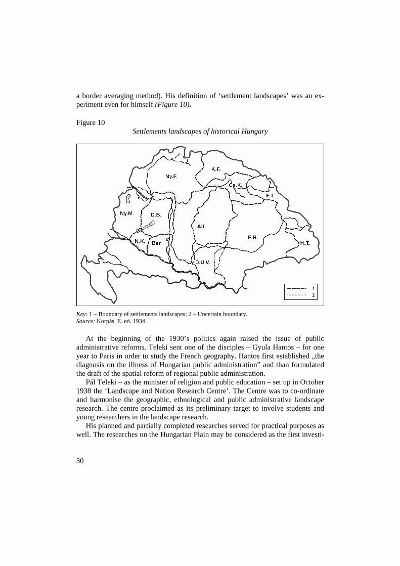
Korpás, E. was on the opinion, that at first not the complex macro landscapes but ‘sectoral landscapes’ should be explored on the area of historical Hungary and after Hungarian geographical science has explored all sectoral landscape struc-tures, will come the time for the definition of the border of complex landscapes (by
30
a border averaging method). His definition of ‘settlement landscapes’ was an ex-periment even for himself (Figure 10).
Figure 10 Settlements landscapes of historical Hungary
Key: 1 – Boundary of settlements landscapes; 2 – Uncertain boundary. Source: Korpás, E. ed. 1934.
At the beginning of the 1930’s politics again raised the issue of public administrative reforms. Teleki sent one of the disciples – Gyula Hantos – for one year to Paris in order to study the French geography. Hantos first established „the diagnosis on the illness of Hungarian public administration” and than formulated the draft of the spatial reform of regional public administration.
Pál Teleki – as the minister of religion and public education – set up in October 1938 the ‘Landscape and Nation Research Centre’. The Centre was to co-ordinate and harmonise the geographic, ethnological and public administrative landscape research. The centre proclaimed as its preliminary target to involve students and young researchers in the landscape research.
His planned and partially completed researches served for practical purposes as well. The researches on the Hungarian Plain may be considered as the first investi-
31
gationsserving for systematical regional development objectives in Hungary. Re-searches on other landscapes of Hungary served for the preparation of public ad-ministration reform. The young researchers of the centre facilitated in November 1938 a landscape research exhibition, which caught in the crossfire of debates. Nobody doubted the authenticity of the data on the maps in the exhibition yet the outcomes shocked the representatives of both the large agriculture and the finan-cial sphere. Teleki had the exhibition shut down earlier than the planned and in a ministerial decree he dissolved the centre in December of 1938.
The short existence and destiny of the centre made clear for the researchers and for concerned proprietary circles that the spatial division of property structure within the country is unbelievably unhealthy. The majority of property is owned by a small layer and is located extremely concentrated.
Ferenc Fodor introduced a special ladscape theory between the two world wars. In the 1920’s he had important role in the foundation of the concept and theory of economic and political landscape.
Fodor was rather a colleague than a student of Teleki. In 1926 he proclaimed that the ‘Carpathian Basin’ itself was merely a natural formation but it was the Hungarians who after their settlement in 896 had transformed it into a home coun-try and named as Hungarian basin.
In the 1930’s because of his family tragedies and illness he turned towards re-ligion. He believed that landscape was a collective creation of man and God. God created the nature geographical condtions anfd it was man’s duty to develop the further. (He wrote his thesis after the Second World War titled ‘The Geography of Hungarian Existence’ summarizing all of his activities. It is one of the most excit-ing political geographical essays of the Hungarian geographic science from several aspects, but at the same time it is also the most problematic one.)
6.2 Jenı Cholnoky
At the start of the period Cholnoky had a key position in Hungarian geographic science. It was because of his earlier scientific activities and his friendship with Teleki.
Between the two world wars Cholnoky achieved original and important results in morphological researches. His activity in landscape geography was manifested in descriptive geography and partly in scientific knowledge dissemination.
From the 1920’s Cholnoky regarded the territorial integration of the Hungarian Basin with the territory of historic Hungary as an evidence and in all of his works he referred to this historical territory of state (Choloky, J. 1926).

32
In the 1930’s Cholnoky in his summarizing works (Cholnoky, J. n.d.) preferred synthesis to analytical researches. He divided the area of historic Hungary into landscapes on genetical basis and analysed the landscapes’ special features as well.
In 1940 Cholnoky retired and founded two departments of geography from the one he had headed. He left the department of nature geography for Béla Bulla, and the department of human geography for Tibor Mendöl.
6.3 Gyula Prinz’s activity in landscape geography
After the World War, Prinz treated the issue of public administration with a differ-ent approach from the other geographers. The essential difference was that ac-cording to Prinz only the existing state territory can be divided into public admin-istrative units. The public administrative organisation of space may only elaborate real spaces but no historical ideals.
Prinz aimed preliminarily at dividing the public administration of the county level into „transportation landscapes”, in reality into isochronous units. Based on the above principles he elaborated the possible spatial organisational foundation of the regional system. In his belief the regional public administrative division has no justification in the new, small Hungary, yet if politics for some reasons considers such division necessary there shall be an available draft to decide on.
Prinz joined repeatedly the debates on Hungarian public administration. He elaborated the geographical methodology of administrative space organisation and he aimed at basing both the district and the county system besides the transporta-tion landscapes on the hierarchic system of complex geographical landscapes.
In the 1930’s Prinz joined the opinion of the majority of Hungarian geographers stating that Hungarian geographic science should carry out researches within the territorial structure of historic Hungary and the results should also be relevant to this geographic area. The only acceptable for him scientific and objective division of the macro landscapes of Hungary (Figure 11) was rather refused than approved by the Hungarian scientific and political elite.
6.4. Károly Kogutowicz
Károly Kogutowicz, a university professor born in a cartographic dynasty, founded a geographical department in Szeged dealing mostly with human geography in the early 1920’s. The department considered the research of the features and condi-tions of Hungary’s human geography and the writing of a series on Hungary’s macro landscapes its primary task.

33
Figure 11 Landscapes of historical Hungary
Source: Prinz, Gy. ed. 1936.
The first modern Hungarian geographical lexicon was published as a result of Kogutowicz’s work (Bátky, Zs.–Kogutowicz, K. 1925) including partly concepts, partly statistical materials. The notion of landscape in the lexicon was defined as ‘a natural territory of physical land surface’ and the lexicon did not have the heading of Carpathian Basin.
In 1930 Kogutowicz started his landscape geographic series presenting Hun-gary. Already at the start he found contradictions in the definition and naming of the geographic space. He was going to assess and describe the macro landscape of the ‘Hungarian Basin’ surrounded by the Carpathians (which notion had several alternative namings in Hungarian geographic literature).
Kogutowicz described ‘landscape as an independent organisation’ having its own past, present and future. He defined his primary research ojectives as ‘to rec-ognize and describe different natural landscapes’.
He was the most conscious and definite of all his contemporary fellow re-searchers in the belief that human activity is a very important factor in landscape formation process.

34
His two published books on landscape geography (Kogutowicz, K. 1930, 1936) provided new basis for the approach to landscape but its reception by the general public (partly because of personal conflicts) was not unanimously positive.
A map for grammar scools published by Kogutowicz in 1940 neither used the name of Carpathian Basin on the maps of Europe, but rather the name of Hungar-ian Plain as an integrating spatial term for the territory surrounded by the Carpa-thians.
7 Territorial growth and its consequences on landscape geography (1938–1945)
Between 1938–1941 Hungary’s borders were in a constant change and new territo-rial structures were shaping up. The majority of actors considered this period as a success of territorial revision and themselves as winners of history. Many of the contemporary geographers and politicians considered as an evidence that not only the territory of Hungary had grown bigger but it was turning into an empire again and would turn into the leading power of the region, just like it was in the age of King Stephen I (In fact Hungary became more and more subordinated to Ger-many’s power and political influence).
The growth in the country’s size after 1938 created new problems in the fields of public administration, landscape organization and the definition of landscapes within the territory of the changed borders. Both the earlier division of landscapes and the system of landscapes originiating from new scientific theories had to be reshaped again.
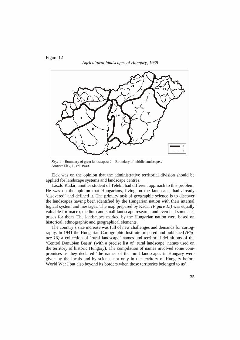
During the definition of ‘agricultural landscapes’ (Figure 12) both researchers and the Central Statistical Office had to face a modified structure and features of the internal spatial system.
In 1939 András Rónai published his map on the population landscapes of the Carpathian Basin. This work was preceeded by a study on the mixture of nationalities in the Carpathian Basin (Figure 13).
The Department of Landscape and Nation Research at the State Science Insti-tute headed by András Rónai called for a competition for young researchers in the field of landscape research, it published a series under the title ‘Hungarian Land-scape and National Knowledge’ with remarkable analyses.
For the state borders of 1940 Péter Elek, one of Teleki’s students, applied Teleki’s landscape administrative theory that Teleki had created in year 1921. The definition of macro, medium and small landscape system (Figure 14) served for the introduction of public administrative reforms.
35
Figure 12 Agricultural landscapes of Hungary, 1938
Key: 1 – Boundary of great landscapes; 2 – Boundary of middle landscapes. Source: Elek, P. ed. 1940.
Elek was on the opinion that the administrative territorial division should be
applied for landscape systems and landscape centres. László Kádár, another student of Teleki, had different approach to this problem.
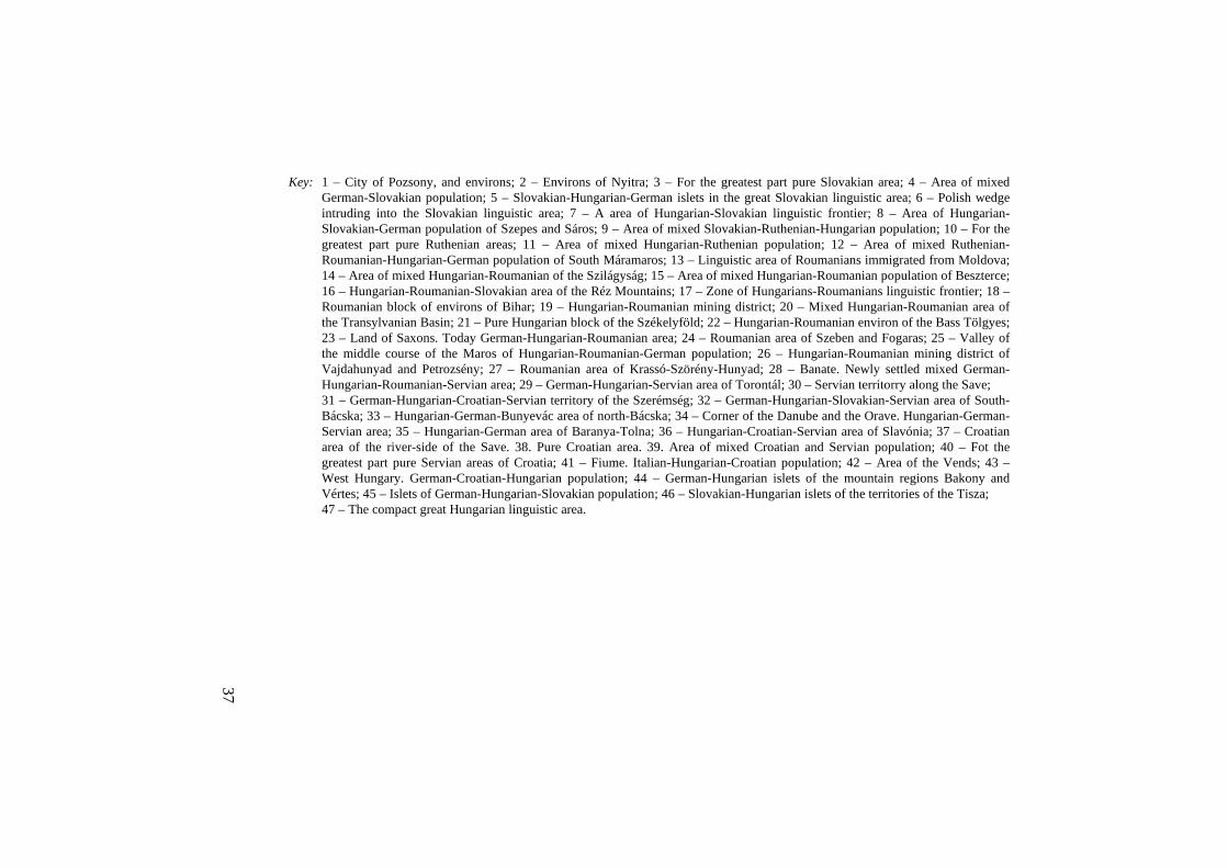
He was on the opinion that Hungarians, living on the landscape, had already ‘discvered’ and defined it. The primary task of geographic science is to discover the landscapes having been identified by the Hungarian nation with their internal logical system and messages. The map prepared by Kádár (Figure 15) was equally valuable for macro, medium and small landscape research and even had some sur-prises for them. The landscapes marked by the Hungarian nation were based on historical, ethnographic and geographical elements.
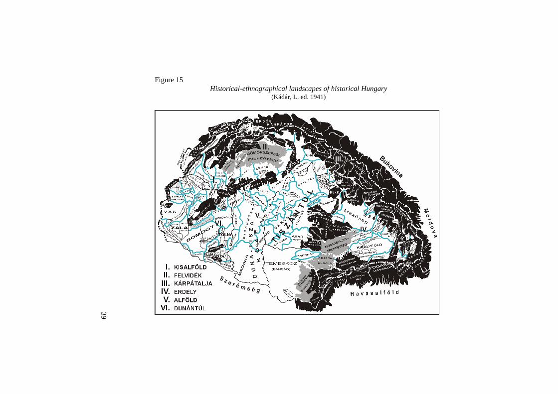
The country’s size increase was full of new challenges and demands for cartog-raphy. In 1941 the Hungarian Cartographic Institute prepared and published (Fig-ure 16) a collection of ‘rural landscape’ names and territorial definitions of the ‘Central Danubian Basin’ (with a precise list of ‘rural landscape’ names used on the territory of historic Hungary). The compilation of names involved some com-promises as they declared ‘the names of the rural landscapes in Hungary were given by the locals and by science not only in the territory of Hungary before World War I but also beyond its borders when those territories belonged to us’.
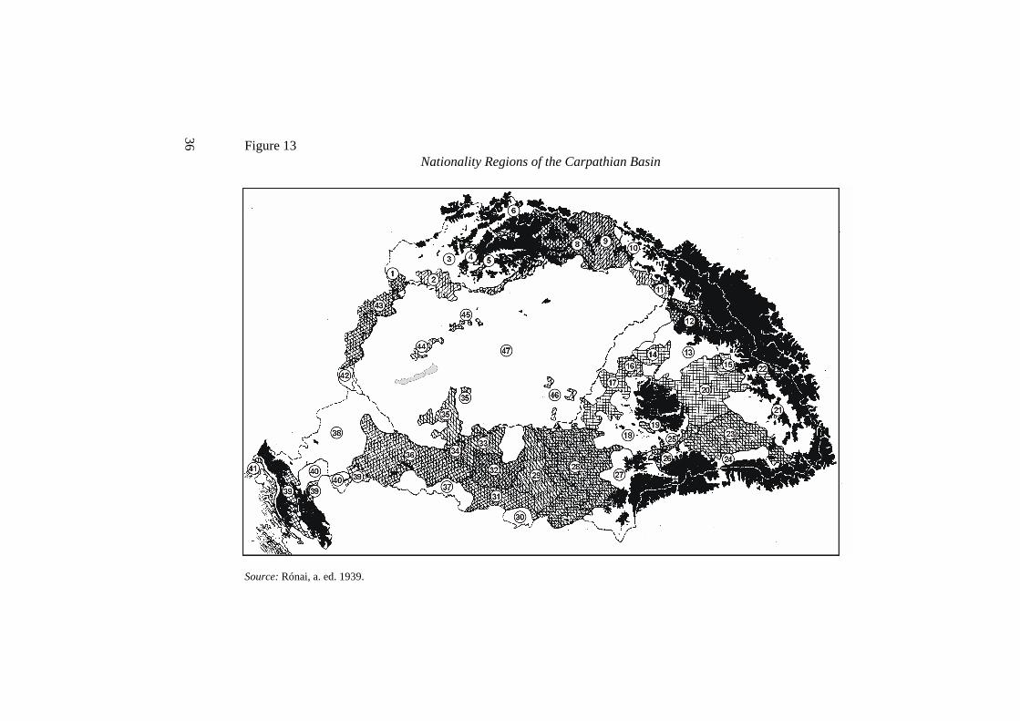
36 Figure 13
Nationality Regions of the Carpathian Basin
Source: Rónai, a. ed. 1939.
37
Key: 1 – City of Pozsony, and environs; 2 – Environs of Nyitra; 3 – For the greatest part pure Slovakian area; 4 – Area of mixed German-Slovakian population; 5 – Slovakian-Hungarian-German islets in the great Slovakian linguistic area; 6 – Polish wedge intruding into the Slovakian linguistic area; 7 – A area of Hungarian-Slovakian linguistic frontier; 8 – Area of Hungarian-Slovakian-German population of Szepes and Sáros; 9 – Area of mixed Slovakian-Ruthenian-Hungarian population; 10 – For the greatest part pure Ruthenian areas; 11 – Area of mixed Hungarian-Ruthenian population; 12 – Area of mixed Ruthenian-Roumanian-Hungarian-German population of South Máramaros; 13 – Linguistic area of Roumanians immigrated from Moldova; 14 – Area of mixed Hungarian-Roumanian of the Szilágyság; 15 – Area of mixed Hungarian-Roumanian population of Beszterce; 16 – Hungarian-Roumanian-Slovakian area of the Réz Mountains; 17 – Zone of Hungarians-Roumanians linguistic frontier; 18 – Roumanian block of environs of Bihar; 19 – Hungarian-Roumanian mining district; 20 – Mixed Hungarian-Roumanian area of the Transylvanian Basin; 21 – Pure Hungarian block of the Székelyföld; 22 – Hungarian-Roumanian environ of the Bass Tölgyes; 23 – Land of Saxons. Today German-Hungarian-Roumanian area; 24 – Roumanian area of Szeben and Fogaras; 25 – Valley of the middle course of the Maros of Hungarian-Roumanian-German population; 26 – Hungarian-Roumanian mining district of Vajdahunyad and Petrozsény; 27 – Roumanian area of Krassó-Szörény-Hunyad; 28 – Banate. Newly settled mixed German-Hungarian-Roumanian-Servian area; 29 – German-Hungarian-Servian area of Torontál; 30 – Servian territorry along the Save; 31 – German-Hungarian-Croatian-Servian territory of the Szerémség; 32 – German-Hungarian-Slovakian-Servian area of South-Bácska; 33 – Hungarian-German-Bunyevác area of north-Bácska; 34 – Corner of the Danube and the Orave. Hungarian-German-Servian area; 35 – Hungarian-German area of Baranya-Tolna; 36 – Hungarian-Croatian-Servian area of Slavónia; 37 – Croatian area of the river-side of the Save. 38. Pure Croatian area. 39. Area of mixed Croatian and Servian population; 40 – Fot the greatest part pure Servian areas of Croatia; 41 – Fiume. Italian-Hungarian-Croatian population; 42 – Area of the Vends; 43 – West Hungary. German-Croatian-Hungarian population; 44 – German-Hungarian islets of the mountain regions Bakony and Vértes; 45 – Islets of German-Hungarian-Slovakian population; 46 – Slovakian-Hungarian islets of the territories of the Tisza; 47 – The compact great Hungarian linguistic area.

38 Figure 14
Landscapes proposed for administrative division
Key: 1 – Macro-landscape boundary; 2 – Medium-landscape boundary; 3 – Micro-landscape boundary; 4 – Macro-landscape centre; 5 – Medium-landscape centre.
Source: Elek, P. ed. 1940.
39
Figure 15 Historical-ethnographical landscapes of historical Hungary
(Kádár, L. ed. 1941)
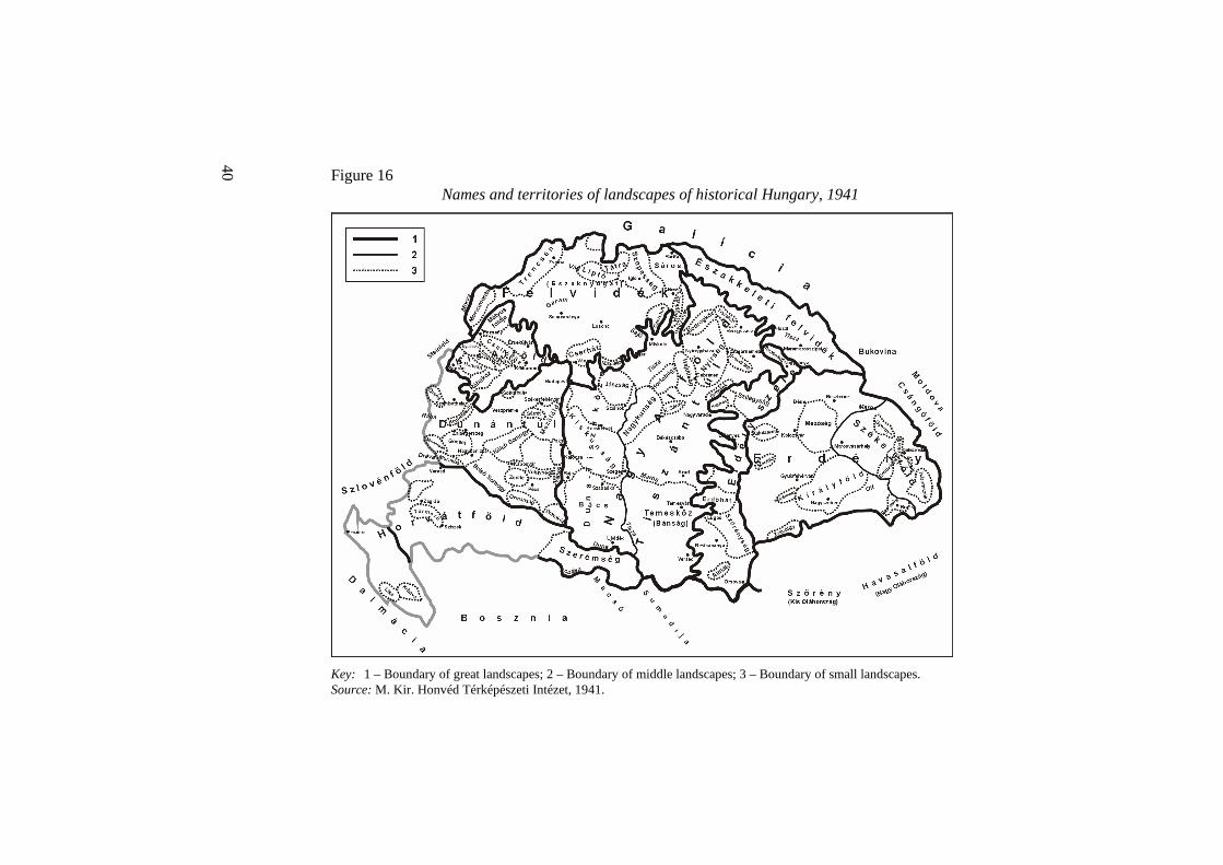
40 Figure 16
Names and territories of landscapes of historical Hungary, 1941
Key: 1 – Boundary of great landscapes; 2 – Boundary of middle landscapes; 3 – Boundary of small landscapes. Source: M. Kir. Honvéd Térképészeti Intézet, 1941.

41
Tibor Baráth, the historian but having comprehensive geographical knowledge as well, in his ‘state philosophical’, state historical and geo-philosophical’ essay used the Carpathian Basin name even in the title, and in his historical retrospective view he defined the old country building processes as Hungarians – in his opinion – since its first moment had already been aware of the integrative force of the macro space.
The summary titled ‘Fine Hungarian Landscapes’ was partly scientific, partly science disseminating (Gaál, I. 1944). The book had very important role in pro-viding information on the area of the new parts of Hungary.
8 Problems of landscape research between 1945–1948
When Hungary lost the Second World War, Hungarian geographical science could do nothing but to harmonize its theories with the changed political environment and expectations.
Even under the new circumstances the category of landscape was carrying new poplitical messages. In 1946, in the three-volumed Danube landscape monography the Carpathian Basin was recognized as a new special spatial formation in the neighbourhood of river Danube. According to contemporary interpretations, the Danube environment was referred to as the Carpathian Basin and its neighbour-hood consisting of member countries (Austria, Bulgaria, Czechoslovakia, Yugo-slavia, Hungary, Romania). This macro region’s primary mission was to promote the peaceful coexistence of these different nations (Radisics, E. ed. 1946).
The definition of ‘Danube Landscape’ was itself a political action, as this kind of interpretation treated countries as a kind of topographic and partly a functional spatial community. The territories having been occupied by the Germans in the Second World War were excluded from this spatial community.
The professors of the two geographical departments of Budapest University published their monography under the title ‘The Geography of the Carpathian Ba-sin’ in 1947 (Bulla, B.–Mendöl, T. 1947). The authors – in the new political milieu – were forced to give an explanation; ‘The territory of our state has different parts of natural landscape, its borders integrate not full landscapes but their fragments into a political unit… The Carpathian Basin is the smallest natural unit where the territory of the Hungarian state shared with other states can fit the best’. (Bulla, B –Mendöl, T. 1947, p. VI.)
When the geography of the Carpathian Basin was written the description of both the natural and the ‘artificial’ landscapes was primarily based on macro land-scapes. The description of middle or small landscapes was only in a few cases in

42
the monograph. Although the role of natural geography was still dominating in the book, but in several areas, the role of society in the formation of spatial processes and structures was also emphasized.
An interesting feature of the book, that it shows the Carpathian Basin in several variations of territorial definition and sizes.
9 Summary
In the modern Hungarian geographic science evolving since the 1860’s the analy-sis of the country – because of the special historical development – played a sig-nificant role. At the beginning the analysis based on administrative units was dominant later, during the investigation of natural geographic structures the natural large landscapes and finally the medium size landscapes appeared too. One of the dominant features of Hungarian landscape geography is that it nearly has always neglected the investigation of micro landscapes.
The theoretic aspects of landscape appeared in a wider scale in Hungarian geographic science since the 1910’s as a result of German and partially French and English influence. The landscape theory was bound with the conceptual redefinition of geographic science, i.e. after the centenary the majority of leading Hungarian geographers defined the geographic science as landscape geography.
Having overviewed an interesting period of Hungarian landscape geography we can conclude that at the beginning geography applied the non-differentiated term of landscape of the public jargon and public thinking. Later, as a result of the de-velopments in the international geographic science, the category of landscape was filled with geographic scientific content. Landscape was first applied as a natural geographic category, later – partly due to the impacts of the French human geogra-phy and partially as a result of the losses after the World War I. – it was filled with political, public administrative content.
Following the World War I. the approach more and more succeeded that geo-graphic science should not follow the political and public administrative system but the public administrative system shall be adapted to the objective spatial cate-gories, natural life units, landscapes and the hierarchy of landscapes of geography.
During the period between the two World Wars the approach (which existed at earlier times too) was developed, according to which the country is a physical and natural unit while the state is a space shaped by the actual international power relations. Therefore the preliminary task of geographic science is to investigate the natural – physical space, former territory of Hungary.
43
Between 1945–1948 there were chances for the complex geographical research of the Carpathian Basin (i.e. to maintain the ideology of the period between the two world wars. The most comprehensive Hungarian language overview on the region was published at this time
After the communists’ coming on power in 1948, natural and landscape geog-raphy researches were „limited to” the territories within state borders. Ruling poli-ticians made clear for geographers that the areas marked as natural geographic units cannot disregard state borders. Thus, the answer for a scientific question turned to be a political one. Thus year 1948 started a new period both in political and scientific sense. In 1949 the activity of the Hungarian Geographic Society was banned by politicians which may be explained by its political and partly its scien-tific role in the period between the two world wars.
44
References
ANON. 1918: A Magyar Földrajzi Társaság szózata a világ Földrajzi Társaságaihoz (The appeal of the Hungarian Geographic Society to the Geographic Societies of the world). – Földrajzi Közlemények. Vol. XLVI. No. 7–10. pp. 289–320.
ANON. 1938: A Táj- és Népkutató Központ kiállítása (The exhibition of the Hungarian Landscape and Nation Research Centre). Kiállítási vezetı. Budapest, Egyetemi nyomda.
BARÁTH, T. 1943: Az országépítés filozófiája a Kárpát-medencében (Philosophy of state building in Carpathian Basin). Kolozsvár, Nagy Jenı Kiadása.
BÁLINT, S. 1939: Magyarország földrajza (Geography of Hungary). – Budapest, Szent István-Társulat.
BÁTKY, ZS. 1918: Néhány vonás Csallóköz település-földrajzához. (Some features to the settlement geography of the Csallóköz) – Földrajzi Közlemények. Vol. XLVI. No. 7 – 10, pp. 327 – 341.
BÁTKY, ZS.–KOGUTOWICZ, K. (eds.) 1921: Kogutowicz zsebatlasza az 1922. évre. (Pocet atlas for 1922). – Budapest, Magyar Néprajzi Társaság Emberföldrajzi Szakosz-tálya.
BÁTKY, ZS.–KOGUTOWICZ, K. (eds.) 1925: Kogutowicz zsebatlasza az 1926. évre. (Pocet atlas for 1926). – Budapest, Magyar Néprajzi Társaság Emberföldrajzi Szakosz-tálya.
BÉL, M. 1735: Notitia Hungariae novae historico geographica. Vienna. BÉL, M. 1792a: Compendium Hungariae Geographicum. – Pozsony, Pest Landerer. BÉL, M. 1792b: Compendium regnorum Slavoniae, Croatiae, Dalmatiae, Galliciae, etc. –
Pozsony, Kassa, Landerer. BULLA, B. 1934: Einige Züge zum geopolitischen Bild des ungarischen Beckens. – Unga-
rische Jahrbücher. Vol. 14, No.3. pp. 249–253. BULLA, B. 1940: Az Alföld (The Great Plain). – Budapest, Magyar Szemle Társaság.
Kincsestár, No. 116. BULLA, B.–MENDÖL, T. 1947: A Kárpát-medence földrajza (Geography of the Carpa-
thian Basin). Budapest, Egyetemi nyomda. BEUDANT, F. S. 1822: Voyage mineralogique et geologique en Hongrie pendant l’anné
1818, Paris. Vol. I–III. BROZÓCZKY, K. (szerk.) 1906: Nagy Magyar Atlas (Great Hungarian Atlas). Budapest,
Magyar Földrajzi Társaság, Lampel R. Könyvkereskedése. CHOLNOKY, J. 1911: A tartós államalakulásokról (About stabil state formations). –
Magyar Figyelı. Vol. I. pp. 71–76. CHOLNOKY, J. 1914: Magyarország természetes déli határa. (The natural border of Hun-
gary in the south.) – Magyar Figyelı. Vol. IV. pp. 432–437. CHOLNOKY, J. 1920: Magyarország területének épsége tudományos földrajzi szempont-
ból. (Territorial unity of Hungary from the points of view of scientific geography) – Új Magyar Szemle. No. 3, pp. 285–293.
CHOLNOKY, J. (szerk.) 1920: A magyar béketárgyalások, I–III. (Hungarian peace discus-sions) – Budapest, M. Kir. Külügyminisztérium.
45
CHOLNOKY, J. 1921: Az emberföldrajz alapjai (Basis of human geography). Budapest, Magyar Földrajzi Értekezések.
CHOLNOKY, J. 1923: Általános földrajz, I–II. (General geography). – Pécs–Budapest, Danubia Kiadó.
CHOLNOKY, J. 1926: Magyarország földrajza (Geography of Hungary). – Pécs, Danubia. CHOLNOKY, J. n.d. Hazánk és népünk egy ezredéven át (Hungarians through one thou-
sand years). – Budapest, Somló Béla Könyvkiadó. CHOLNOKY, J. n.d. A Kárpátoktól az Aldunáig (From the Carpathians to the Lower Da-
nube). – Budapest, Somló Béla Könyvkiadó. CHOLNOKY, J. n.d. (1937): Magyarország földrajza (Geography of Hungary). – Buda-
pest, Franklin-Társulat. CZIRBUSZ, G. 1902: Magyarország a XX. évszáz elején (Hungary at the beginning of the
20th century). – Temesvár, Polatsek. CZIRBUSZ, G. 1912: A nemzeti mővelıdés geográfiája és a geográfiai fatalisták (Geogra-
phy of national culture and geographical fatalists). – Budapest, Eggenberger. CZIRBUSZ, G. 1919: Antropo-geographia, III. Geopolitika. – Budapest, Franklin-Társulat. CSIZMADIA, A. 1936: Tájkultúra és közigazgatás (Culture of landscape and public ad-
ministration). – Országút. No. 6–7, pp. 31–33. DÉKÁNY, I. 1918: A földrajz tudományos módszere és ismerettana. A tájtényezı a fej-
lıdésben. (Methodological questions and onthology of geography. Role of landscape faktor in development). – Földrajzi Közlemények. Vol. XLVI. pp. 1–22.
DÉKÁNY, I. 1924: Az ember és környezete viszonyának új elmélete. (A new theory of man – nature relationship) – Földrajzi Közlemények. Vol. LII, No. 1–3, pp. 1–23.
ELEK, P. 1940: Terület és közigazgatás. (Area and public administration) In: Dolgozatok a közigazgatási reform körébõl.) Budapest, Magyar Közigazgatástudományi Intézet.
ELEK, P. 1942: A mezõgazdasági közigazgatás területi beosztásának reformja. (Reform of agricultural public administration) – Közigazgatástudomány. Vol. 5. pp. 241–260.
FODOR, F. 1924: Magyarország gazdasági földrajza. (Economic geography of Hungary) Budapest, Franklin-Társulat.
FODOR, F. 1926: A szülıföld- és honismeret könyve (A book on own home). – Budapest, A Magyar Népmővelés Könyvei.
FODOR, F. 1928: A trianoni békeszerzıdés földrajzi megvilágításban. (Trianon peace treaty from the points of geography) In: Igazságot Magyarországnak. – Budapest, Magyar Külügyi Társaság, pp. 347–386.
FODOR, F. 1930: A Szörénység tájrajza (Chronography of the Szörénység). – Budapest, Athenaeum.
FODOR, F. 1937: Magyar föld, magyar élet (Hungarian land, Hungarian life). – Budapest, Szent István-Társulat kiadása.
FODOR, F. 1948: A magyar lét földrajza (Geography of Hungarian existence). – Budapest, MTA Könyvtár, Kézirattár. I. kötet szöveges rész, II. kötet ábrák.
GAÁL, I. 1944: Szép magyar tájak (Beautiful Hungarian landscapes). Budapest, Kir. Magy. Természettudományi Társulat.
GRÓF, I.–NIKLAI, P. 1941: Magyarország tájegységei (Geographical units of Hungary). – Budapest, Magyar Szociográfiai Intézet.

46
HAJDÚ, Z. 1995: A magyar államtér változásainak történeti és politikai földrajzi szemlélete a Magyar földrajztudományban 1948-ig (Historical and political geographical views on changing of Hungarian territory, until 1948). – Tér és Társadalom. No. 3–4, pp. 111–132.
HAJDÚ, Z. 1996: Az „államtáj” és a „tájállam” problematikája a magyar földrajztudomány-ban 1948-ig. (The issue of the „state landscape” and the „landscape state” in the Hun-garian geography until 1948.) – Földrajzi Közlemények. Vol. CXX. (XLIV) pp. 137 – 150.
HAJDÚ, Z. 2001a: Magyarország közigazgatási földrajza (Geography of Hungarian public administration). – Budapest–Pécs, Dialóg Campus Kiadó.
HAJDÚ, Z. 2001b: Teleki Pál tájelméleti munkássága. (The landscape theory of Pál Teleki) – Földrajzi Közlemények. Vol. CXXV. (XLIX.) No. 1–2. pp. 51.64.
HAJDÚ, ZS.–HAJDÚ, Z. 1997: Interprétation des relations entre l’État et le paysage dans la géographie hongroise du XVIe siécle jusqu au milieu du XXe siécle. Collegium Bu-dapest, Atelier international, 20–24 mai 1997. Frontiers, espaces et identites en Europe.
HANTOS, GY. 1931: A magyar közigazgatás területi alapjai (The territorial foundations of the Hungarian public administration). – Budapest, Athenaeum.
HEVESI, A. 2003: A Kárpát-medence és a Kárpátok természetföldrajzi tájtagolásról. (About physical geographical division of Carpathians and Carpathian Basin) – Földrajzi Értesítı. Vol. LII. No. 3–4, pp. 253–267.
HUNFALVY, J. 1863: A Magyar Birodalom természeti viszonyainak leírása I. (The de-scription of the natural circumstances of the Hungarian Empire) – Pest, Emich Gusztáv.
KÁDÁR, L. 1941: A magyar nép tájszemlélete és Magyarország tájnevei (The landscape approach of the Hungarian nation and the names of landscapes in Hungary). – Budapest, Országos Táj- és Népkutató Intézet.
KÁDÁR, L. 1943: Magyar ember a magyar tájban. (Hungarian man in the Hungarian land-scape) In: BARTUCZ L. (ed.) A magyar nép. – A mőveltség könyvtára. No. 9. Buda-pest, Singer és Wolfner, pp. 69–90.
KISS, L. 1988: Földrajzi nevek etimológiai szótára, I–II. (Etymological dictionary of geo-graphical names) – Budapest, Akadémiai Kiadó.
KOGUTOWICZ, K. 1930–1936: Dunántúl és Kisalföld írásban és képben, I–II. (Transda-nubia and Little Plain in text and pictures). – Szeged, M. Kir. Ferenc József Tudomány-egyetem.
KORPÁS, E. 1934: Magyarország települési tájegységei. (The settlement regions of Hun-gary) – Földrajzi Közlemények. Vol. LXII. pp. 193–195.
LÓCZI LÓCZY, L. (ed.) 1918: A Magyar Szent Korona Országainak földrajzi, társa-dalomtudományi, közmővelıdési és közgazdasági leírása (Geographic, social scientific, educational and economic description of the country of the Hungarian Holy Crown). – Budapest, Magyar Földrajzi Társaság.
MAGYARY, Z. 1939: A Táj- és Népkutató Központ rövid fennállásának története. (The history of the short existence of the Landscape and Nation Research Centre) – Közigaz-gatástudomány, Vol. II. pp. 53–70.
MAGYARORSZÁG kistérképei (Small maps of Hungary). Budapest, M. Kir. Honvéd Térképészeti Intézet, 1941.

47
MENDÖL, T. 1932: Táj és ember. Az emberföldrajz áttekintése (Landscape and Human. A short overview of human geography). – Budapest, Magyar Szemle Társaság. Kincsestár.
MENDÖL, T. 1947: A magyar emberföldrajz múltja, jelen állása és feladatai (Past, present and tasks of Hungarian human geography). – Budapest, Néptudományi Intézet.
OLÁH, M. 1536/1985: Hungaria. – Budapest. Magvetı Könyvkiadó. Gondolkodó Magya-rok.
PRINZ, GY. 1914: Magyarország földrajza (Geography of Hungary). – Budapest, Magyar Földrajzi Intézet.
PRINZ, GY. 1923: Térképek az állam szolgálatában (Maps in the service of the state). – In: Kogutowicz zsebatlasza az 1922. évre. – Budapet.
PRINZ, Gy. 1923: Európa természeti földrajza (Geography of Europe). – Budapest, Világ-irodalmi Kiadó.
PRINZ, GY. 1934: Földrajz az államigazgatás szolgálatában. (Geography in the service of state administration) – Földrajzi Közlemények. 4–6, pp. 69–81.
PRINZ, Gy. 1944: Magyarország földrajza (Geography of Hungary). – Budapest, Renais-sance Kiadó.
PRINZ, GY.–TELEKI, P.–CHOLNOKY, J. n.d. (1936): Magyar Földrajz I–III. (Hungarian geography I–III.) – Budapest, Egyetemi nyomda.
RADISICS, E. (ed.) 1946: A Dunatáj I–III. (Danube landscape I–III.) – Budapest, Gergely Rt.
RÓNAI, A. 1939: Nemzetiségi problémák a Kárpát-medencében. (Minority problems in the Carpathian Basin) – Földrajzi Közlemények. Vol. LXVII, pp. 461–473.
RÓNAI, A. (ed.) 1945: Közép-Európa atlasza (Atlas of Central Europe). – Budapest–Bala-tonfüred, Államtudományi Intézet.
SZALLER, GY. 1796: Magyarország földleírásának rövid foglalattya (Short summary of the land description of Hungary). – Pozsony.
SZÁSZKY-TOMKA, J. 1777: Introductio orbis antigui et geographiam. – Pozsony, Kassa, Landerer.
SZEPSI CSOMBOR, M. 1620/1979: Europica varietas. – Budapest, Szépirodalmi Könyv-kiadó.
TELEKI, P. 1917a: Táj és faj (Landscape and species). – Turán. Vol. V. No. 1. pp. 17–30. TELEKI, P. 1917b: A földrajzi gondolat története, (History of the geographic idea) Essay.
Budapest. A szerzı kiadása. TELEKI, P. n.d. (1934): Európáról és Magyarországról (About Europe and Hungary). –
Budapest, Athenaeum. TELEKI, P. 1936: A gazdasági élet földrajzi alapjai I–II. (Geographical bases of economic
life). – Budapest, Centrum. TELEKI, P. 1937: A tájfogalom jelentıségérıl (The significance of the term of landscape)
Budapesti Szemle, Tom. 247, pp. 129–141. THIRRING, G. 1888: A Földrajzi Közlemények I–XV. kötet (1873–1887) név- és tárgymu-
tatója (Names and subjects of Földrajzi Közlemények). – Budapest, Fanda J. Nyomda. VIDAL DE LA BLACHE, P. 1910: Les regions Francaises. – Revue de Paris. December
15, pp. 821–847. WHITTLESEY, D. S. 1944: The Earth and the State. – New York, Henry Holt.
48
The Discussion Papers series of the Centre for Regional Studies of the Hungarian Academy of Sciences was launched in 1986 to publish summaries of research findings on regional and urban development.
The series has 5 or 6 issues a year. It will be of interest to geographers, economists, sociologists, experts of law and political sciences, historians and everybody else who is, in one way or another, engaged in the research of spatial aspects of socio-economic development and planning.
The series is published by the Centre for Regional Studies. Individual copies are available on request at the Centre.
Postal address
Centre for Regional Studies of the Hungarian Academy of Sciences P.O. Box 199, 7601 PÉCS, HUNGARY
Phone: (36–72) 212–755, 233–704 Fax: (36–72) 233–704
www.dti.rkk.hu www.rkk.hu
Director general
Gyula HORVÁTH
Editor
Zoltán GÁL [email protected]
Forthcoming in the Discussion Papers series
Stages of development, spatial structure and the expanding European integration of the Hungarian banking system
by
Zoltán GÁL
Papers published in the Discussion Papers series
Discussion Papers /Specials
BENKİNÉ LODNER, Dorottya (ed.) (1988): Environmental Control and Policy: Proceedings of the Hungarian–Polish Seminar in the Theoretical Problems of Environmental Control and Policy
OROSZ, Éva (ed.) (1988): Spatial Organisation and Regional Development Papers of the 6th Polish–Hungarian geographical Seminar
DURÓ, Annamária (ed.) (1993): Spatial Research and the Social–Political Changes: Papers of the 7th Polish–Hungarian Seminar
DURÓ, Annamária (ed.) (1999): Spatial Research in Support of the European Integration. Proceedings of the 11th Polish–Hungarian Geographical Seminar (Mátraháza, Hungary 17–22 September, 1998)
GÁL, Zoltán (ed.) (2001): Role of the Regions in the Enlarging European Union
HORVÁTH, Gyula (ed.) (2002): Regional Challenges of the Transition in Bulgaria and Hungary
KOVÁCS, András Donát (ed.) (2004): New Aspects of Regional Transformation and the Urban-Rural Relationship
Discussion Papers
No. 1 OROSZ, Éva (1986): Critical Issues in the Development of Hungarian Public Health with Special Regard to Spatial Differences
No. 2 ENYEDI, György – ZENTAI, Viola (1986): Environmental Policy in Hungary
No. 3 HAJDÚ, Zoltán (1987): Administrative Division and Administrative Geography in Hungary
No. 4 SIKOS T., Tamás (1987): Investigations of Social Infrastructure in Rural Settlements of Borsod County
No. 5 HORVÁTH, Gyula (1987): Development of the Regional Management of the Economy in East-Central Europe
No. 6 PÁLNÉ KOVÁCS, Ilona (1988): Chance of Local Independence in Hungary
No. 7 FARAGÓ, László – HRUBI, László (1988): Development Possibilities of Backward Areas in Hungary
No. 8 SZÖRÉNYINÉ KUKORELLI, Irén (1990): Role of the Accessibility in De-velopment and Functioning of Settlements
No. 9 ENYEDI, György (1990): New Basis for Regional and Urban Policies in East-Central Europe
50
No. 10 RECHNITZER, János (1990): Regional Spread of Computer Technology in Hungary
No. 11 SIKOS T., Tamás (1992): Types of Social Infrastructure in Hungary (to be not published)
No. 12 HORVÁTH, Gyula – HRUBI, László (1992): Restructuring and Regional Policy in Hungary
No. 13 ERDİSI, Ferenc (1992): Transportation Effects on Spatial Structure of Hungary
No. 14 PÁLNÉ KOVÁCS, Ilona (1992): The Basic Political and Structural Problems in the Workings of Local Governments in Hungary
No. 15 PFEIL, Edit (1992): Local Governments and System Change. The Case of a Regional Centre
No. 16 HORVÁTH, Gyula (1992): Culture and Urban Development (The Case of Pécs)
No. 17 HAJDÚ, Zoltán (1993): Settlement Network Development Policy in Hungary in the Period of State Socialism (1949–1985)
No. 18 KOVÁCS, Teréz (1993): Borderland Situation as It Is Seen by a Sociologist
No. 19 HRUBI, L. – KRAFTNÉ SOMOGYI, Gabriella (eds.) (1994): Small and me-dium-sized firms and the role of private industry in Hungary
No. 20 BENKİNÉ Lodner, Dorottya (1995): The Legal-Administrative Questions of Environmental Protection in the Republic of Hungary
No. 21 ENYEDI, György (1998): Transformation in Central European Postsocialist Cities
No. 22 HAJDÚ, Zoltán (1998): Changes in the Politico-Geographical Position of Hun-gary in the 20th Century
No. 23 HORVÁTH, Gyula (1998): Regional and Cohesion Policy in Hungary
No. 24 BUDAY-SÁNTHA, Attila (1998): Sustainable Agricultural Development in the Region of the Lake Balaton
No. 25 LADOS, Mihály (1998): Future Perspective for Local Government Finance in Hungary
No. 26 NAGY, Erika (1999): Fall and Revival of City Centre Retailing: Planning an Urban Function in Leicester, Britain
No. 27 BELUSZKY, Pál (1999): The Hungarian Urban Network at the End of the Second Millennium
No. 28 RÁCZ, Lajos (1999): Climate History of Hungary Since the 16th Century: Past, Present and Future
No. 29 RAVE, Simone (1999): Regional Development in Hungary and Its Preparation for the Structural Funds
No. 30 BARTA, Györgyi (1999): Industrial Restructuring in the Budapest Agglomeration

51
No. 31 BARANYI, Béla–BALCSÓK, István–DANCS, László–MEZİ, Barna (1999): Borderland Situation and Peripherality in the North-Eastern Part of the Great Hungarian Plain
No. 32 RECHNITZER, János (2000): The Features of the Transition of Hungary’s Regional System
No. 33 MURÁNYI, István–PÉTER, Judit–SZARVÁK, Tibor–SZOBOSZLAI, Zsolt (2000): Civil Organisations and Regional Identity in the South Hungarian Great Plain
No. 34 KOVÁCS, Teréz (2001): Rural Development in Hungary
No. 35 PÁLNÉ, Kovács Ilona (2001): Regional Development and Governance in Hun-gary
No. 36 NAGY, Imre (2001): Cross-Border Co-operation in the Border Region of the Southern Great Plain of Hungary
No. 37 BELUSZKY, Pál (2002): The Spatial Differences of Modernisation in Hungary at the Beginning of the 20th Century
No. 38 BARANYI, Béla (2002): Before Schengen – Ready for Schengen. Euroregional Organisations and New Interregional Formations at the Eastern Borders of Hun-gary
No. 39 KERESZTÉLY, Krisztina (2002): The Role of the State in the Urban Development of Budapest
No. 40 HORVÁTH, Gyula (2002): Report on the Research Results of the Centre for Regional Studies of the Hungarian Academy of Sciences
No. 41 SZIRMAI, Viktoria–A. GERGELY, András–BARÁTH, Gabriella–MOLNÁR, Balázs–SZÉPVÖLGYI, Ákos (2003): The City and its Environment: Competi-tion and/or Co-operation? (A Hungarian Case Study)
No. 42 CSATÁRI, Bálint–KANALAS, Imre–NAGY, Gábor –SZARVÁK, Tibor (2004): Regions in Information Society – a Hungarian Case-Study
No. 43 FARAGÓ, László (2004): The General Theory of Public (Spatial) Planning (The Social Technique for Creating the Future)