district system management plan - california …dot.ca.gov/dist10/docs/final_2015_dsmp.pdf · 1...
TRANSCRIPT

i
DISTRICT SYSTEM MANAGEMENT PLAN
DISTRICT 10 JUNE 2015


iii
TABLE OF CONTENTS ABOUT THE DISTRICT SYSTEM MANAGEMENT PLAN ............................................................... 1
STAKEHOLDER COORDINATION ................................................................................................ 1
EXECUTIVE SUMMARY .............................................................................................................. 2
1. DISTRICT PROFILE .............................................................................................................. 4
DISTRICT OVERVIEW ............................................................................................................... 5
TRANSPORTATION SYSTEM .................................................................................................... 20
TRANSPORTATION PARTNERS ................................................................................................. 47
PLANNING EFFORTS .............................................................................................................. 49
ENVIRONMENTAL SETTING ..................................................................................................... 61
CLIMATE CHANGE ................................................................................................................ 62
SUSTAINABILITY ................................................................................................................... 64
2. MANAGEMENT PLAN ...................................................................................................... 65
GOALS ............................................................................................................................... 65
POLICIES ............................................................................................................................ 71
STRATEGIC CORRIDOR PLAN ................................................................................................... 72
3. DSMP PROJECT LIST ........................................................................................................ 95
APPENDIX ....................................................................................................................... A‐1
APPENDIX A: PROJECT LIST ................................................................................................... A‐1
APPENDIX B: INTERCITY RAIL PROJECT LIST .............................................................................. B‐1
APPENDIX C: GLOSSARY OF TERMS AND ACRONYMS .................................................................. C‐1

iv
Document produced by
Caltrans District 10
System Planning and Goods Movement Branch
Lynn O’Connor, Chief
(209) 948‐3975
For additional information on the DSMP, contact:
Betty Kibble, Associate Transportation Planner (project list)
(209) 948‐3929
Michael Robinson, Associate Transportation Planner (report)
(209) 948‐7575

v

1
ABOUT THE DISTRICT SYSTEM MANAGEMENT PLAN
System Planning is the long‐range transportation planning process for the California Department of Transportation (Caltrans). The System Planning process fulfills Caltrans’ statutory responsibility as owner/operator of the State Highway System (SHS) (Gov. Code §65086) by evaluating conditions and proposing enhancements to the SHS. Through System Planning, Caltrans focuses on developing an integrated multimodal transportation system that meets Caltrans’ goals of safety and health, stewardship and efficiency, sustainability, livability and economy, system performance, and organizational excellence. The System Planning process is primarily composed of four parts: the District System Management Plan (DSMP), the Transportation Concept Report (TCR), the Corridor System Management Plan (CSMP), and the DSMP Project List. The district‐wide DSMP is the strategic policy and planning document that focuses on system preservation, operating, managing, and developing the transportation system. The TCR is a planning document that identifies the existing and future route conditions as well as future needs for each route on the SHS. The CSMP is a complex, multi‐jurisdictional planning document that identifies future needs within corridors experiencing or expected to experience high levels of congestion. The CSMP serves as a TCR for segments covered by the CSMP. The DSMP Project List is an appendix to the DSMP and provides a list of planned and partially programmed transportation projects used to recommend projects for funding. These System Planning products are also intended as resources for stakeholders, the public, and partner, regional, and local agencies.
STAKEHOLDER COORDINATION
Caltrans is committed to a continuous and comprehensive public communication and outreach process to maximize external input into our planning activities. In particular, local residents can provide valuable informa‐tion regarding the needs of facility users, the character of the community, the design specifications desired, and educate the planning team about historical safety and congestion patterns. Seeking input from the community as early as possible helps avoid potential problems and makes the acceptance of the residents to changes a much easier process. The District is continuously exploring new methods of engaging stakeholders and interest groups to ensure they have the opportunity to participate in the development of plans and projects that affect their daily lives. This includes consulting with the Tribal Community, local governments, and the community prior to making decisions, taking actions, or implementing programs that may impact their communities, including the planning and development of projects identified throughout the DSMP. A successful public participation process involves understanding the local governments and the community, and determining the best way to solicit public feedback on all aspects of proposed State highway improvements. Caltrans uses a number of forums for stakeholder outreach: including websites, public meetings, email, fliers, tribal consultation, newsletter, attending local government and community meetings to provide updates, and accepting written and verbal comments.
DSMP PurposeCalifornia’s State Highway System needs long range planning documents to guide the logical development of transportation systems as required by CA Gov. Code §65086 and as necessitated by the public, stakeholders, and system users. The purpose of the DSMP is to develop the District’s vision of how the transportation system will be maintained, managed, and developed over the next 20 years and beyond. It provides a vehicle for the development of multimodal, multijurisdictional system strategies. The DSMP is developed with the goals of increasing safety, improving mobility, providing excellent stewardship, and meeting community and environmental needs throughout the District.
2
EXECUTIVE SUMMARY
The District 10 DSMP is organized into three sections. The first section, the District Profile, delineates the existing status of District 10—it reports upon the advances District 10 has made with the multimodal infrastructure within its areas of responsibility. The second section, the Management Plan, lays out the future plan of the SHS. The third section, the Project List, provides a table of projects that address current and future transportation needs. The District Profile includes an overview of the District. The intent of the section is to provide a sense of how District 10 compares to State demographic patterns, in anticipation of how best the Department’s vision, goals, policies, and values apply to the District. The section includes demographic and economic comparisons and analyses to better assess the dynamics of the work commute, and an overview of the various transportation components in the District. Notable commute findings include:
25% of all workers in District 10 work outside of the county where they reside. 15% of all workers that live in District 10 work outside the District. Travel time for these commuters averages an hour.
The volume of the interregional commute should grow to 120,000 commuters by 2022, with the greatest increase expected for commuters to Alameda, San Joaquin, Stanislaus, and Santa Clara Counties.
A larger share of the interregional commute occurs within the SR 99 Corridor which connects the cities of Merced, Turlock, Ceres, Modesto, Ripon, Manteca, Stockton, Lodi, and Sacramento than the freeway network that connects San Joaquin and Stanislaus Counties to the Bay Area on the Interstate Corridor.
13.1% of commuters carpool, 21.5% of commuters traveling to counties outside District 10 carpool.
Only a small number of commuters use transit, highlighting a need for better transit interconnections in the District to increase ridership.
Efforts to improve corridor efficiency by managed lanes, and manage traffic demand by ramp metering are prioritized for the Interstate Corridor, and expected to be in place by 2040. The SR 99 Corridor has lower priority, and may not see full implementation of these until after 2040.
A reduction in passenger car trips may be filled by increases in truck volume.
The District Profile ends with an outline of District 10’s planning efforts consistent with State planning efforts, and specific planning efforts undertaken by the District. Included in this section is a discussion outlining partnership planning efforts with local transportation planning agencies, followed by a short summary of the District's environmental setting. The District Management Plan identifies the District’s planning goals and policies, and includes the Strategic Corridor Plan. The District’s goals emulate those of the California Transportation Plan 2040 (CTP):
1. Improve multimodal mobility and accessibility for all people 2. Preserve the Multimodal Transportation System 3. Support a Vibrant Economy 4. Improve Public Safety and Security 5. Foster Livable and Healthy Communities and Promote Social Equity 6. Practice Environmental Stewardship

3
The final section is the Project List that catalogs all the projects the District identified as efforts needing development to improve or maintain the existing transportation corridors in the District that are currently unfunded or underfunded.
4
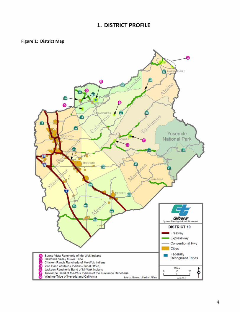
1. DISTRICT PROFILE
Figure 1: District Map

5
DISTRICT OVERVIEW District 10 serves the northern portion of the San Joaquin Valley (SJV), the Sierra Nevada foothills, and in part, the San Francisco Bay Area (Bay Area, as part of the Combined Metropolitan Statistical Area). The primary economic activity in the region is agriculture, with San Joaquin, Stanislaus, and Merced Counties among the ten highest earning agricultural counties in the nation.1 Movement of farm goods to market or processing plants has fostered a higher percentage of truck traffic on the highway system than is the case elsewhere in the State. Most of the District’s population lives in the SJV, and population growth in the District has been the highest percentage‐wise in the State for the past twenty years.2 This growth has been driven by the higher residential property values in surrounding urban areas (e.g. the counties fringing the Bay Area and Sacramento) pushing newer and lower income residents to the periphery. Since District 10 is on the edge of two major metropolitan areas, a high percentage of residents both work outside of the county and the District where they live. Additionally, the District contains several popular recreation travel destinations, particularly Yosemite National Park (Yosemite). Merced, Tuolumne, and Mariposa Counties’ local economies depend upon tourism to Yosemite. The District has been active in integrating Yosemite transportation planning into our interregional transportation planning, and in supporting the development of the Yosemite Area Regional Transportation System (YARTS). The current population of District 10 is 1,653,646. Over 90% of District 10’s population resides in the three western SJV counties, while 10% live in the remaining rural counties (see Table 1). This disparity results in distinct interregional facilities and demands. Freeways dominate the portion of SHS within the SJV providing support for local, intercity, and interregional commutes into adjoining counties and for high volume goods movement.
Table 1: Current and Future Population Statistics For District 10 (2010‐2040)3
County Population (2014)
Population (2040)
% change from 2010 to 2013
Growth rate from 2010 to 2040
% of Population that is White
% of Population that is Hispanic
or Latino
Median household Income
% of Population that are Persons below Poverty level
Alpine 1,159 1,249 ‐1.4% 0.0% 71.8% 9.8% $58,636 16.6%
Amador 36,519 43,165 ‐4.7% 0.4% 90.9% 12.7% $53,684 12.6%
Calaveras 44,515 55,881 ‐3.2% 0.7% 92.1% 11.1% $55,295 10.9%
Mariposa 17,755 21,221 ‐2.9% 0.5% 90.2% 10.0% $49,820 16.1%
Merced 263,228 389,934 5.0% 1.7% 81.9% 56.8% $42,591 25.4%
San Joaquin
704,379 1,037,761 4.6% 1.7% 68.4% 40.1% $53,380 18.2%
Stanislaus 525,491 714,910 3.1% 1.3% 84.3% 43.5% $49,297 20.3%
Tuolumne 53,874 59,821 ‐3.9% 0.2% 91.1% 11.2% $48,426 14.5%
District 10
1,653,646 2,323,942 3.3% 1.5% 77.8% 41.2% ‐ 19.6%
California 38,340,074 47,233,240 2.9% 0.9% 73.5% 38.4% $61,094 15.9%
Overall, the District’s population increased at a rate of approximately 1% for the period of 2012 to 2013. However, the counties of Amador, Calaveras, and Tuolumne experienced negative growth for that period.
1 United States Department of Agriculture 2 Public Policy Institute, The Amazing Changing California Population (July, 2014). 3 Department of Finance, US Census.
6
Within the District’s rural eastern counties, conventional highways serve local communities, often with expressway facilities connecting to the more populous SJV. These rural highways also support interregional commutes and goods movement but at much lower volumes. In addition, a large component of the eastern counties’ interregional traffic is often recreational (e.g. numerous peak hour traffic events will occur between Friday evening and Monday morning during the vacation seasons). Estimated population growth for the District by 2040 is 1.45% (2,323,942) while the State will grow at 0.9%.4 Most of the District’s urban areas cluster along I‐5 and SR 99, with the larger cities tending to be located in the northwest portion of the District. The communities of Tracy, Lathrop, Manteca, Stockton, and Lodi were included with other Bay Area cities into a Combined Metropolitan Statistical Area by the federal government. The ethnic diversity of District 10 can be inferred from comparing the percentage of the population that is white to the percentage of the population that is Hispanic or Latino. With the exception of Alpine and San Joaquin Counties, all the counties in the District report a higher percentage of their population as white compared to the State average. Only Merced, Stanislaus, and San Joaquin Counties report a percentage of the population that is Hispanic or Latino greater than the State Average. This suggests that the mountain counties are relatively racially and ethnically homogeneous, while Merced, Stanislaus, and San Joaquin are more heterogeneous. Generally, it is presumed that population with greater ethnic heterogeneity will be poorer. When we consider household income, this relationship does not appear to hold up, since all counties report household median incomes below the State median income. However, this relationship does appear to hold up when comparing the percentage of the population that is Hispanic or Latino to the percentage of persons with incomes below poverty level. Both the populations and the governments within District 10 are poorer than elsewhere in the State. This would suggest that monies available for spending on transportation improvements are lacking compared to elsewhere in the State, and that efforts to levy special sales tax in support of local expansion of the transportation infrastructure may be more regressive than elsewhere, and lack voter support.5 Funding for projects may only come from the State Transportation Improvement Fund (STIP), the State Highway Operation and Protection Program, and special bond levies. The number of workers 16 years and older in District 10 is 613,454 or 37.3% of the population. Of the working population, approximately 25% (152,044) work outside the county in which they reside. For District 10 interregional commuters, Alameda County is the preferred destination, followed by San Joaquin, Stanislaus, Santa Clara, Sacramento, Contra Costa, and Merced Counties. The top five work destinations outside of District 10 are San Jose, Livermore, Sacramento, Oakland, and Pleasanton. Communities with a high proportion of interregional commuters are Tracy, Manteca, Los Banos, Stockton, and Modesto.6 Typically, in the United States, the more rural an area is, the greater its poverty. Table 2 assesses the percentage of the population that lives in urban or rural areas for the state, the District, and the counties within the District, and compares it with three economic categories—incomes below the poverty line, incomes between the federal poverty line and 150% of the federal poverty line, and the household with incomes in excess of 150% of the federal poverty line. Read another way, the three categories, are the extremely poor, the poor, and the middle class. Only in the mountain counties are the percentage of middle class household incomes exceed the state average, while the SJV has numbers of both extremely poor and poor households which exceed the State average.
4 California Department of Finance 5 The only exception to this is San Joaquin County’s Measure K sales tax measure 6 Census Transportation Planning Products (CTPP), Five year data set, 2006‐2010

7
Table 2: Comparison of urban vs. rural population for District 10 (2013)7
Place %
Urban* % Rural
% of Households (incomes below the federal poverty line)
% of Households (incomes between the federal poverty line and 150% of
federal poverty line)
% of Households (incomes above 150% of poverty
line)
California 91.6 8.4 12.1 9.1 78.9
District 10 80.3 19.7 14.3 10.9 74.8
San Joaquin 85.1 14.9 13.7 10.3 76.0
Stanislaus 88.5 11.5 14.4 11.3 74.4
Merced 80.3 19.7 19.3 14.2 66.5
Tuolumne 53.7 46.3 11.9 8.8 79.3
Calaveras 20.6 79.4 8.2 7.6 84.2
Amador 38.1 61.9 7.9 8.6 83.5
Mariposa 0 100 14.2 9.0 76.7
Alpine 0 100 4.9 4.9 90.2
*Percent of population that lives in areas defined as urban or urbanized by Census.
The issue of poverty is an important one for the San Joaquin Valley,8 and should be a consideration for District 10 when gauging the success of its commitment to livability, sustainability, and economy. At this time, it is unclear whether the poverty indicators (e.g. households and individuals below the federal poverty line, and household income) reflect a continuing regional pattern, or may be due to recent demographic changes. As a percentage of local population, the number of individuals living in poverty that live in the suburbs exceeds that for urban areas. Whether this may reflect the high rates of foreclosures in the region during the recession, or displacement due to of gentrification in the Bay Area is unclear. The suburbs lack the historical investment in transportation infrastructure necessary to access employment and services compared to cities,9 for the District this will remain a relatively new and ongoing challenge. Although District 10 may be divided geographically into two regions (the urban SJV and the rural mountain counties); there are three economic regions—the portion of the San Joaquin County that is included in the Bay Area Combined Metropolitan Statistical Area; the remaining parts of San Joaquin County along with Stanislaus and Merced Counties; and the eastern, mountain counties of Alpine, Amador, Calaveras, Mariposa, and Tuolumne. For the region, it appears that higher than average rates of poverty correlate inversely with access to employment in the Bay Area (or correlate with seasonal employment in agriculture), so it may be assumed that the cities with a large population of workers employed in the Bay Area or Sacramento are distinct from those that do not.10 As much of the District is public land or agricultural land, this allows the District to persist in retaining its rural designation. Land administered by public agencies and farmland are not typically associated with growth in transportation volumes. Although urban land uses occur in proximity to the Altamont Pass, since the previous DSMP, noteworthy growth and development have not yet occurred. Unemployment in the region has lagged behind that of the rest of the Bay Area, and although picking up in the San Joaquin County, remains predominantly in the lower paying wage sectors. Table 3 compares selected household characteristics between District 10 and the State. These indicate that there is the percentage of home ownership rates for the SJV counties (53.6% to 58.3%) that is comparable to the State percentage (55.3%), but for the mountain counties, the rates are much higher (66.6% to 81.5%). For the percentage of housing in multiunit structures, the State average is 31.0%, but with the exception of Alpine
7 CTPP five year 2006‐2010 database 8 See “California’s San Joaquin Valley: A Region in Transition”, Congressional Research Service, Library of Congress, 2005. 9 The Atlantic, Suburbs and the New American Poverty, January 7, 2015 10 This pattern is evident with data at the level of Census Data Places, but that table is too large for display

8
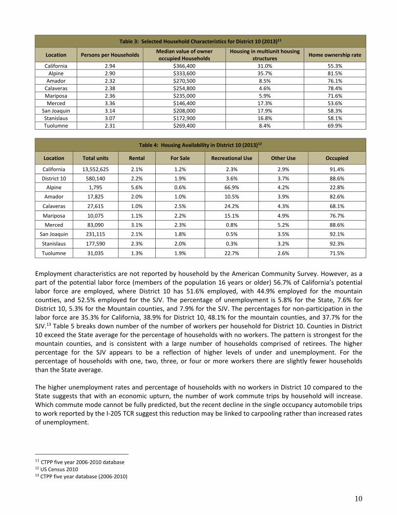
County (35.7%) none of the counties in District 10 approach that value (4.6% to 17.9%). Comparison of the number of persons per household that for the State (2.94) the SJV counties exceeded this average (3.07‐3.36), but the State average exceeds that for the mountain counties (2.31‐2.90). Households within the mountain counties have enjoyed greater economic stability than those in the SJV—this is reflected by the greater percentage of home ownership and smaller household size—indications of families having neared the end of child rearing, and approaching retirement (over half the population is over the age of 45 compared to less than a third for the SJV). Because of the fewer household occupants and older age, fewer vehicle trips are generated by household, and many of these single vehicle occupancy trips likely occur at times other than peak hour. Table 4 compiles patterns of housing availability. District 10 compared to the State has almost the same percentage of housing units available as rental, but exceeds the percentage for housing units for sale, for recreation use, and other uses. The result is that there is a lower percentage of housing units occupied in District 10 compared to the State. Within District 10, the distribution of rental housing appears evenly spread between the counties (Alpine being an exception), the distribution of housing units for sale has three counties below the District average (Alpine, Amador, and San Joaquin), with Calaveras having the highest percentage over the District average; the distribution of excessive numbers of recreational housing units appears almost exclusively a characteristic of the mountain counties; while no real pattern might be discerned regarding housing units employed for other uses, except the highest percentages are in the southern counties in the District (Merced and Mariposa); for occupied housing the SJV counties equal or exceed the District average (San Joaquin and Stanislaus actually exceed the State average), while the mountain counties have lower percentages of the housing stock that occupied. Comparison of the data in the two tables regarding rental housing indicates an interesting regional characteristic. Although the percentage of housing units for rent are comparable between the State and District 10, there are far more multiunit housing structures in the State than in the District. What this suggests is that either there are more single family residences available for rent in District 10, or there are fewer condominiums and apartment houses in District 10 than elsewhere. This might be taken as an indication of a need to include in future planning far more high density housing developments, to address this shortfall. The lack of multiunit housing throughout the region also indicates an absence of entry level housing for young households. Statewide the percentage of population between the ages of 18 to 35 is 25.7%, while for SJV this is 27.1% and the mountain counties 16.0%. Since multiunit housing for the SJV is around 17% of total residences, and for the mountain counties is around 5% to 6%, the shortfall appears chronic, and is probably allayed by children living at home longer, or moving out of the region. Households with adult children will generate more vehicle trips, especially single occupant automobile trips, than those with under age children. The lower percentage of occupied housing units in the mountain counties reflects a long term pattern of vacation and retirement homes sales in the area. Though partly due to recreational attractions, the likely driver was low property values. Regions with larger percentages of housing units provided as either vacation or second homes experience little in the way of expansion of services and economic diversification. Adding to lack of economic development, many of the regions’ second residences were defaulted upon during the recession. These conditions often lead to an outmigration of young adults and families, and residents traveling long distances to work, and to obtain services.

9
Figure 2: Land Use in District 10
10
Table 3: Selected Household Characteristics for District 10 (2013)11
Location Persons per Households Median value of owner occupied Households
Housing in multiunit housing structures
Home ownership rate
California 2.94 $366,400 31.0% 55.3%
Alpine 2.90 $333,600 35.7% 81.5%
Amador 2.32 $270,500 8.5% 76.1%
Calaveras 2.38 $254,800 4.6% 78.4%
Mariposa 2.36 $235,000 5.9% 71.6%
Merced 3.36 $146,400 17.3% 53.6%
San Joaquin 3.14 $208,000 17.9% 58.3%
Stanislaus 3.07 $172,900 16.8% 58.1%
Tuolumne 2.31 $269,400 8.4% 69.9%
Table 4: Housing Availability in District 10 (2013)12
Location Total units Rental For Sale Recreational Use Other Use Occupied
California 13,552,625 2.1% 1.2% 2.3% 2.9% 91.4%
District 10 580,140 2.2% 1.9% 3.6% 3.7% 88.6%
Alpine 1,795 5.6% 0.6% 66.9% 4.2% 22.8%
Amador 17,825 2.0% 1.0% 10.5% 3.9% 82.6%
Calaveras 27,615 1.0% 2.5% 24.2% 4.3% 68.1%
Mariposa 10,075 1.1% 2.2% 15.1% 4.9% 76.7%
Merced 83,090 3.1% 2.3% 0.8% 5.2% 88.6%
San Joaquin 231,115 2.1% 1.8% 0.5% 3.5% 92.1%
Stanislaus 177,590 2.3% 2.0% 0.3% 3.2% 92.3%
Tuolumne 31,035 1.3% 1.9% 22.7% 2.6% 71.5%
Employment characteristics are not reported by household by the American Community Survey. However, as a part of the potential labor force (members of the population 16 years or older) 56.7% of California’s potential labor force are employed, where District 10 has 51.6% employed, with 44.9% employed for the mountain counties, and 52.5% employed for the SJV. The percentage of unemployment is 5.8% for the State, 7.6% for District 10, 5.3% for the Mountain counties, and 7.9% for the SJV. The percentages for non‐participation in the labor force are 35.3% for California, 38.9% for District 10, 48.1% for the mountain counties, and 37.7% for the SJV.13 Table 5 breaks down number of the number of workers per household for District 10. Counties in District 10 exceed the State average for the percentage of households with no workers. The pattern is strongest for the mountain counties, and is consistent with a large number of households comprised of retirees. The higher percentage for the SJV appears to be a reflection of higher levels of under and unemployment. For the percentage of households with one, two, three, or four or more workers there are slightly fewer households than the State average. The higher unemployment rates and percentage of households with no workers in District 10 compared to the State suggests that with an economic upturn, the number of work commute trips by household will increase. Which commute mode cannot be fully predicted, but the recent decline in the single occupancy automobile trips to work reported by the I‐205 TCR suggest this reduction may be linked to carpooling rather than increased rates of unemployment.
11 CTPP five year 2006‐2010 database 12 US Census 2010 13 CTPP five year database (2006‐2010)

11
Table 5: Numbers of Workers in Household for District 10 (2010)14
Location Households % With No Workers
% With One Worker
% With Two Workers
% With Three Workers
% With Four or More
California 12,392,850 23.7% 39.5% 28.7% 5.9% 2.2%
District 10 514,165 27.9% 37.9% 27.4% 5.2% 1.6%
Alpine 410 34.1% 34.1% 26.8% 4.9% 0.0%
Amador 14,715 36.3% 37.8% 22.2% 3.2% 0.6%
Calaveras 18,795 35.5% 36.7% 23.7% 3.4% 0.8%
Mariposa 7,725 45.1% 28.7% 24.3% 1.6% 0.3%
Merced 73,585 27.8% 36.8% 28.2% 5.7% 1.4%
San Joaquin 212,905 25.6% 39.0% 27.9% 5.7% 1.9%
Stanislaus 163,840 26.6% 38.3% 28.2% 5.3% 1.7%
Tuolumne 22,190 41.2% 33.2% 21.4% 3.6% 0.7%
According to the census, a middle class household is one where the household income exceeds the median household income for the State. For California, the median household income is $61,094. Table 6 indicates that on average, for a household to be middle class in the SJV, there are likely to be three workers in the household. For the mountain counties there are likely to be two workers. What Table 6 also indicates is that for households in all counties in District 10, to attain the median income for that county requires that there be at least two workers in the household. Since the median income for SJV is below the State median income, this indicates that a majority of households there fall into the category of poor. Although poor households generate fewer trips overall, the higher number of workers reported for the SJV suggests a higher number of mandatory trips per household to be likely.
Table 6: Average number of workers in households by household income for District 10 (2013)15
Location Income $0‐$15,000 $15,000‐
$25,000 $25,000‐$35,000
$35,000‐$49,999
$50,000‐$74,999
$75,000‐$99,999
$100,000‐$149,999
$150,000‐ or more
California 0.89 1.61 2.06 2.33 2.53 2.66 2.73 2.77
Alpine 0.00 0.86 1.50 1.93 2.12 2.63 3.27 2.89
Amador 0.93 0.97 1.65 1.81 1.95 2.42 2.58 2.84
Calaveras 0.40 1.19 1.55 2.05 2.09 2.63 2.58 2.51
Mariposa 0.37 0.60 1.30 1.26 2.39 2.34 2.64 2.93
Merced 0.78 1.75 2.20 2.46 2.62 2.69 2.83 2.79
San Joaquin 0.79 1.58 1.94 2.29 2.54 2.72 2.81 2.82
Stanislaus 0.81 1.46 2.03 2.39 2.61 2.66 2.78 2.79
Tuolumne 0.51 1.13 1.41 1.77 2.13 2.40 2.45 2.79
Grey cells indicate where median household income for the county falls
One of the current goals of the Department stresses creating and maintaining a transportation system reflecting a commitment to sustainability, livability and economy—to make long lasting smart mobility decisions that improve the environment, support a vibrant economy, and build communities instead of sprawl. In the discussion that follows is an attempt to delineate the baseline condition in District 10 for meeting this goal. The following discussion attempts to characterize the parameters of the commute to work by occupation and geography. The goal is to anticipate potential strategies outlined and potential performance measures to assess District success under the Smart Mobility 2010: A Call to Action (also known as the Smart Mobility Framework or SMF, discussed below in Planning Efforts) or . Much of this will apply to the discussion of District goals under the District Management Plan below.
14 CTPP five year database (2006‐2010) 15 CTPP five year database (2006‐2010)

12
A large fraction of the workforce in District 10 engages in an interregional16 commute (approximately 25%, with 15% of the total traveling outside of the District);17 however, the portion that does so as single occupancy drivers exceeds 70% of the total.18 Several demographic parameters are unknown regarding this commute. Some simple questions that the discussion hopes to answer, is whether workers in occupations participate, do the participants earn higher incomes compared to others in their occupation, can local incentives be developed to have these workers work within the District. Current employment is estimated at 526,660 jobs in the District, with an estimated increase in jobs to 96,090 by 2022.19 The estimated number of workers in the District currently exceeds the number of available jobs by 86,794. Following projected growth rates, the number of workers in the District will likely increase to 733,457, with the employment gap increasing to 120,003 by 2022.20 These workers will need to seek employment outside of District 10, with the likely work destinations in the Bay Area, or Greater Sacramento. It does not seem likely that land use planning efforts to relocate jobs and businesses to cities in District 10 allied with in‐fill or transit oriented development efforts would adequately address this need. The rest of the discussion in this section characterizes the nature of the interregional work commute, to better address the challenges in reducing single occupancy vehicle trips on the SHS, and successfully implementing mode shift to carpools, transit and active transportation. Table 7 compares the District to State patterns of employment by seven general occupational classes, and then breaks them out by commute pattern. From the table, we can see that 24.7% of workers commute outside the county where they live, and 15.1% of workers commute outside District 10. Although the American Household Survey reports occupations in several categories from a set of seven to fourteen, for purposes of an overview, the division of the work force into seven job categories was selected.21 By making this comparison, it was hoped that the pattern of employment in the district was comparable to the State—this would permit application of policies and strategies developed in other Districts to be implemented in District 10, with little modification. That does not appear to be the case. The worker population in the District is overrepresented by occupational Classes 1 and 3, and underrepresented by Class 4. This pattern would seem consistent with the observation that most households in District 10 are poor. These three occupational classes, along with occupational Class 2 comprise more than two thirds of the workers that live in the District and work outside the county in which they reside. These four occupational classes are discussed below at length.22 Occupational Class 1 is comprised of workers that engage in agriculture, forestry, fishing and hunting, mining, construction, or serve in the Armed Forces. Given that the foremost economic activity in District 10 is agriculture, this should not be a surprise. What would be expected by the population within this classification is that most would possess education consistent with attending high school, be seasonally employed, be ethnically heterogeneous, and experience higher than average rates of poverty and food insecurity. The information provided does not make distinctions between head of household or a second income earner. Most workers in this category live at some distance from their place of work, such that they depend upon cars (or in the case of agricultural workers, van pools) for travel; however, their partners and dependents may rely upon transit services or active transportation to go about their daily lives.
16 Commutes may be three types, local, intercity, and interregional 17 See Table 5 District 10 Employment and Interregional Commute by Occupational Class below 18 CTPP five year 2006‐2010 database 19 California Economic Development Department, Long Term Employment Projections 2012‐2022 20 This was obtained by multiplying the current number of workers by the growth rate of 1.5% 21 CTPP five year 2006‐2010 database (data originated from the American Household Survey) 22 Descriptions of all seven occupational classes are presented in Table 5, and are not repeated in the text

13
23 CTPP five year 2006‐2010 database
Table 7: District 10 Employment and Interregional Commute by Occupational Class (2010)23
Occupational Class
Percentage of Total
Occupations in California
Percentage of Total
Occupations in District 10
Percentage of Class That Travels to Work Outside County They
Reside In
Overall Aggregate
Percentage of Total
Occupations
Percentage of Class That
Travels to Work Outside District
Percentage of Total Work Outside District
1. Agriculture, forestry, fishing and hunting, and mining; & Construction; & Armed Forces
9.8% 14.1% 31.2% 4.4% 20.3% 2.9%
2. Manufacturing 10.3% 11.2% 30.3% 3.4% 19.0% 2.1%
3. Wholesale trade; Retail Trade; Transportation and warehousing; and utilities
19.0% 21.4% 24.8% 5.3% 14.0% 3.0%
4. Information; Finance, insurance, real estate and rental and leasing; Professional, scientific, management, administrative; and waste management services
22.0% 14.8% 28.7% 4.2% 20.9% 3.1%
5. Educational, health and social services
19.7% 20.5% 17.7% 3.6% 9.1% 1.9%
6. Arts, entertainment, recreation, accommodation and food services
9.2% 8.1% 16.0% 1.3% 8.5% 0.7%
7. Other services (except public administration); Public Administration
9.8% 9.9% 24.8% 2.5% 15.0% 1.5%
Total portion of District 10
‐ 100% ‐ 24.7% ‐ 15.1%

14
24 CTPP five year 2006‐2010 database
Table 8: Total and Interregional (Inter.) Work Commutes by County and Occupation (2010)24
Occupation Class Total 1 2 3 4 5 6 7
County Total Inter. Total Inter. Total Inter. Total Inter. Total Inter. Total Inter. Total Inter. Total Inter.
Alpine # 363 68 49 14 14 10 34 4 45 15 94 14 44 4 79 4
% 0.1% 18.7% 0.1% 28.6% 0.02% 71.4% 0.03% 11.8% 0.05% 33.3% 0.1% 14.9% 0.1% 9.1% 0.1% 5.1%
Amador # 13,573 3,748 1,464 479 710 290 2765 925 1929 614 2190 585 2238 198 2283 663
% 2.2% 27.6% 1.7% 32.7% 1.0% 40.8% 2.1% 33.5% 2.1% 31.8% 1.7% 26.7% 4.5% 8.8% 3.8% 29.0%
Calaveras # 18,674 8,849 2,499 1214 915 520 4,010 2,190 2955 1155 3650 1355 1925 1050 2700 1360
% 3.0% 47.4% 2.9% 48.6% 1.3% 56.8% 3.1% 54.6% 3.3% 39.1% 2.9% 37.1% 3.9% 54.5% 4.5% 50.4%
Mariposa # 7140 2155 930 305 390 220 1045 550 830 235 1305 410 1440 115 1195 315
% 1.2% 30.2% 1.1% 32.8% 0.6% 56.4% 0.8% 52.6% 0.9% 28.3% 1.0% 31.4% 2.9% 8.0% 2.0% 26.4%
Merced # 91159 22699 17404 5154 11535 3475 18185 4560 10294 2774 19440 3380 6619 1319 7704 2064
% 14.9% 24.9% 20.1% 29.6% 16.8% 30.1% 13.8% 25.1% 11.4% 26.9% 15.4% 17.4% 13.4% 19.9% 12.7% 26.8%
San Joaquin # 261268 67488 34274 10494 27545 9145 57903 13663 43810 14225 52689 10154 19175 3220 25789 6534
% 42.6% 25.8% 39.7% 30.6% 40.2% 33.2% 44.1% 23.6% 48.3% 32.5% 41.8% 19.3% 38.7% 16.8% 42.6% 25.3%
Stanislaus # 200440 43360 27168 8608 26164 6859 43570 9990 28114 6519 42034 5864 15105 1740 18269 3794
% 32.7% 21.6% 31.5% 31.7% 38.2% 26.2% 33.2% 22.9% 31.0% 23.2% 33.4% 14.0% 30.5% 11.5% 30.2% 20.8%
Tuolumne # 20217 3047 2500 595 1257 252 3795 640 2671 501 4495 520 2924 229 2548 288
% 3.3% 15.1% 2.9% 23.8% 1.8% 20.0% 2.9% 16.9% 2.9% 18.8% 3.6% 11.6% 5.9% 7.8% 4.2% 11.3%
15
Occupational Class 2 is comprised of workers in the mechanical trades. These workers should cluster in urban areas where manufacturing is prevalent. Many of the workers in this occupation have educations that range from high school to two years of college, with year round employment, and have households that experience little in the way of poverty or food insecurity. Workers in this class likely drive alone to work, and are unlikely to carpool as most worksites employ one or two skilled mechanics. Occupational Class 3 is comprised of workers that engage in wholesale trade; retail trade; transportation and warehousing; or in the utility services sector. That Class 3 is a larger than expected compared to the State as a whole should not be surprising. Generally, this sector experiences lower wages compared to other occupational sectors. Workers in this sector are most likely to have relocated from the Bay Area, due to the lower cost of living. Noteworthy is that nationally, retail employment is one of the growth industries, and it might be expected for this class to increase over time. What would be expected of the population within this classification is similar to the expectations of Class 1, though there exists less likelihood of seasonal employment, and levels of poverty and food insecurity should be diminished compared to workers in Class 1. When living close to their place of employment, workers in this sector may use transit, if available, or walk and bicycle; but will likely drive if work is some distance away. Occupational Class 4 is comprised of workers that engage in the information industry; finance, insurance, real estate and rental and leasing; and, whose work might be characterized as professional, scientific, management, or administrative; or waste management services. What would be expected of the population within this classification are educational attainments of a college education, higher wages, salaried rather than hourly wages, with incomes above the median household income. This sector is the most likely to telecommute, and use commuter rail, but will still predominantly drive to work. Members of these four occupational classes, tend to work outside the county in which they reside at higher proportions than the other occupational classes. However, only workers in Class 1, 2, and 4, work outside the District at higher proportions than the other occupational classes. Reduction in commuting outside the county where one works might be addressed in part by urban infill targeting the particular occupational class, but such a strategy presumes that the workers are the sole wage earners in the household. A better approach might be mode shift, but this presumes shared destinations between the four occupational classes. Table 8 describes the various occupational classes by county of residence, with the percentage of workers in that occupational class that reside in the county. For each occupational class, the table by county reports the number of workers in that occupation; how much of a percentage that is District‐wide; the number of workers that commute outside the county they reside, and how much of percentage that is for the number of workers there are in that county. Table 8 also compares the counties where members of the occupational classes reside. By comparing the total percentage of workers in a county, to how much of a percentage of a particular occupational class is there, one can discern if the distribution is simply a function of population size or something else. In the case of Occupational Class 1, the only county where its percentage is greater than expected (by 10% or more) is Merced County. For Class 2, the only counties where its percentage is greater than expected (by 10% or more) are Stanislaus and Merced Counties. For Class 3, the distribution appears in line with county population, with a slight percentage greater than expected for San Joaquin and Stanislaus Counties. For Class 4, the distribution is near or below expected for all counties with the exception of San Joaquin County. For Class 5 and 6, their distributions appear to approximate the numbers of workers expected based upon population. Class 7 shows a bias of exceeding the expected numbers within the mountain counties, with a below expected percentage in Merced and Stanislaus Counties.

16
Regional patterns of commuting can also be discerned from Table 8—although 24.7% of workers commute outside the county that they reside, workers in Amador, Calaveras, Mariposa, Merced, and San Joaquin exceed this percentage. That three of these are mountain counties, the commute patterns of Alpine and Tuolumne Counties might merit some discussion since they appear to fall outside the pattern. For Alpine County, it is known that the percentage of the work commute outside the county is much higher; however, this portion of the work commute is into Nevada and is outside the focus of the data collection. It is unclear why only 15% of workers commute outside Tuolumne County, but larger than expected numbers of workers in that county fall into Occupational Classes 5 and 6, which may reflect a workforce more greatly reliant on income from local tourism (and may explain in part the reverse commute from Merced and Stanislaus Counties) than other counties (the percentage of Class 6 exceeds the expected District percentage for all mountain counties, though this is not true for Class 5). Tables 9, 10, and 11 characterize the interregional work commute as to destination. Table 9 provides the destination by county of the District 10 work commute. In all cases there appears to be a proximity effect, that a nearby county provides the largest number of out of area commuters. However as five of the first ten counties as to highest in‐commute numbers from District 10 are in the Bay Area, and more workers commute into Santa Clara County from San Joaquin County than Merced County suggests there may be an additional gravity factor at play. From Table 10, and considering just occupational classes 1‐4, the expected pattern is that the county that draws the largest aggregate number of commuters should draw proportionately higher from each occupational category. For Class 1, the largest numbers commute to Alameda and Santa Clara, slightly ahead of San Joaquin and Stanislaus, with the trend of approximately 2,000 commuters continuing with the same relative numbers to Sacramento. For Class 2, there is a much stronger skew with a larger overall proportion working in Alameda and Santa Clara (one would expect these levels to be flatter, and closer to the pattern of Class 1 given the history of both Modesto and Stockton as industrial towns). For Class 3, Alameda and San Joaquin draw the greatest number, almost in line with the expected pattern. Class 4 is disproportionately represented in Alameda County. Table 11 is a two direction analysis of the interregional commute from District 10 by occupation. For each destination county, the number of commuters by occupational class is compared to both the total number of commuters, and the total number of commuters in that occupational class. Comparison may then be made between the expected number of commuters by either comparison, and the actual amount. The table gives some indication of how patterns may persist over time. Where both percentages exceed the expected value, there is a strong likelihood of the destination county lacking some amenity by which the class of workers might desire in order to avoid a longer commute, and this condition has persisted over time. One would also expect growth in the number of commuters for the particular occupational class to that destination. Continued growth in the volume of interregional commutes to Alameda, San Joaquin, Stanislaus, and Santa Clara Counties as all show a large component of the interregional commutes to each exist within the same occupational classes—2, 3, 4, and 5. The pattern suggests that workers with the same set of job skills are being redistributed by their access to higher paying markets, from where they cannot afford to live near their work, they relocate to hinterland areas where they may displace workers further outwards. This condition should continue to persist until the regional pay disparities, and property values, along with commute costs equilibrate. For the seven occupational classes, the only class that shows a strong geographic bias is Class 4: most of the workers in District 10 in this category live in San Joaquin County, and a majority of those workers work in Alameda County. The rest of the occupational classes are better dispersed throughout the District. District 10 has become a bedroom community for the Bay Area and the Sacramento Metropolitan Area, and will continue to be so for the conceivable future. Lower household incomes and higher rates of unemployment in

17
District 10 compared to the State will likely persist until affordable housing becomes available in the two urban areas, reducing the migration of poor working households into the District. Development in the District should target businesses that provide greater local employment in the occupations over represented in the District with an eye to reducing the number of households whose income depends on seasonal employment. These are all activities the District can advocate for through continuing review and comments upon ongoing blue print planning efforts, urban infill efforts, and through the intergovernmental review process. District 10 due its high number of poor households should anticipate continued unavailability of local sales tax revenues to fund transportation improvements, as families vote their pocketbooks. Funding for transportation projects in the District will continue to rely upon the availability of state and federal funding streams. The District may need to champion a different manner of funding, as increased sales tax and gas tax place greater financial burdens upon poorer households than middle or upper class. The projected increase in the number of workers working outside the District will put considerable strain on the existing SHS in the District. Mode shift to carpooling, transit, and whenever possible active transportation may reduce the demand, but will require considerable public or private subsidies for those commuters in agricultural, construction, retail, and office administration occupations, who may not be able to afford the costs in both time and money to change over to transit or carpooling.
Table 9: Selected Destinations for District 10 Interregional Commute (2010)25
WORKPLACE\ORIGIN Alpine Amador Calaveras Mariposa Merced San
Joaquin Stanislaus Tuolumne Total
Alameda 0 200 495 125 755 26,100 8,190 180 36,045
San Joaquin 0 470 3,175 0 1,610 ‐ 17,120 390 22,765
Stanislaus 0 120 345 285 10,015 10,050 ‐ 940 21,755
Santa Clara, 0 115 225 155 4,125 7,920 3,985 100 16,625
Sacramento , 4 1,725 575 60 210 7,785 1,185 85 11,629
Contra Costa 0 250 245 20 245 5,380 1,540 4 7,684
Merced 0 0 0 520 ‐ 420 5,640 95 6,675
San Francisco 0 35 80 0 185 2,580 855 140 3,875
San Mateo 0 0 15 10 285 1,915 1,170 60 3,455
Tuolumne 0 0 1,070 295 95 425 890 ‐ 2,775
Amador 0 ‐ 1,940 0 0 505 135 15 2,595
Fresno 0 0 55 175 1,365 325 425 70 2,415
Madera, 0 0 10 330 1,190 25 270 20 1,845
Calaveras 0 390 ‐ 35 25 440 155 570 1,615
Mariposa 0 0 55 ‐ 140 20 40 110 365
Alpine 0 85 210 0 0 10 0 20 325
25 CTPP five year 2006‐2010 database

18
26 CTPP five year 2006‐2010 database
Table 10: Select Work Destination Counties for District by Occupation (2010)26
Destination/ Occupation
Class 1 2 3 4 5 6 7 Total
Alameda 2,898 6,099 7,675 7,880 4,810 1,350 3,089 33,801
San Joaquin 2,210 3,264 6,835 2,975 3,375 594 2,315 21,568
Stanislaus 2,107 2,820 4,750 2,575 5,200 1,270 1,735 20,457
Santa Clara 2,135 4,160 2,865 3,059 1,680 490 1,389 15,778
Sacramento 2,013 450 2,160 2,415 1,599 690 1,855 11,182
Contra Costa 1,442 525 1,575 1,954 910 394 575 7,375
Merced 1,116 1,200 1,155 680 1,350 275 330 6,106
San Francisco 975 154 500 1,065 480 349 319 3,842
San Mateo 840 445 840 845 355 195 184 3,704
Tuolumne 1,050 235 585 275 285 450 745 3,625
Amador 674 80 470 355 369 650 485 3,083
Fresno 826 225 625 290 270 75 205 2,516
Madera 668 305 435 105 230 75 470 2,288
Calaveras 719 135 265 215 265 195 190 1,984
Mariposa 292 10 50 4 30 65 40 491
Alpine 272 0 0 0 15 205 85 577

19
27 CTPP five year 2006‐2010 database
Table 11: Percentages of total commute by occupational class (2010)27
Occupational Class 1 2 3 4 5 6 7
County % of total % of class
% of total
% of class
% of total
% of class
% of total
% of class
% of total
% of class
% of total
% of class
% of total
% of class
expected % of total
Alameda 8.6% 10.8% 18.0% 29.4% 22.7% 23.6% 23.3% 30.3% 14.2% 21.6% 4.0% 17.1% 9.1% 20.6% 14.3%
San Joaquin 10.2% 8.2% 15.1% 15.7% 31.7% 21.0% 13.8% 11.4% 15.6% 15.1% 2.8% 7.5% 10.7% 15.4% 14.3%
Stanislaus 10.3% 7.8% 13.8% 13.6% 23.2% 14.6% 12.6% 9.9% 25.4% 23.3% 6.2% 16.1% 8.5% 11.5% 14.3%
Santa Clara 13.5% 7.9% 26.4% 20.0% 18.2% 8.8% 19.4% 11.7% 10.6% 7.5% 3.1% 6.2% 8.8% 9.2% 14.3%
Sacramento 18.0% 7.5% 4.0% 2.2% 19.3% 6.6% 21.6% 9.3% 14.3% 7.2% 6.2% 8.8% 16.6% 12.3% 14.3%
Contra Costa 19.6% 5.4% 7.1% 2.5% 21.4% 4.8% 26.5% 7.5% 12.3% 4.1% 5.3% 5.0% 7.8% 3.8% 14.3%
Merced 18.3% 4.2% 19.7% 5.8% 18.9% 3.6% 11.1% 2.6% 22.1% 6.1% 4.5% 3.5% 5.4% 2.2% 14.3%
San Francisco 25.4% 3.6% 4.0% 0.7% 13.0% 1.5% 27.7% 4.1% 12.5% 2.2% 9.1% 4.4% 8.3% 2.1% 14.3%
San Mateo 22.7% 3.1% 12.0% 2.1% 22.7% 2.6% 22.8% 3.2% 9.6% 1.6% 5.3% 2.5% 5.0% 1.2% 14.3%
Tuolumne 29.0% 3.9% 6.5% 1.1% 16.1% 1.8% 7.6% 1.1% 7.9% 1.3% 12.4% 5.7% 20.6% 5.0% 14.3%
Amador 21.9% 2.5% 2.6% 0.4% 15.2% 1.4% 11.5% 1.4% 12.0% 1.7% 21.1% 8.3% 15.7% 3.2% 14.3%
Fresno 32.8% 3.1% 8.9% 1.1% 24.8% 1.9% 11.5% 1.1% 10.7% 1.2% 3.0% 1.0% 8.1% 1.4% 14.3%
Madera 29.2% 2.5% 13.3% 1.5% 19.0% 1.3% 4.6% 0.4% 10.1% 1.0% 3.3% 1.0% 20.5% 3.1% 14.3%
Calaveras 36.2% 2.7% 6.8% 0.6% 13.4% 0.8% 10.8% 0.8% 13.4% 1.2% 9.8% 2.5% 9.6% 1.3% 14.3%
Mariposa 59.5% 1.1% 2.0% 0.0% 10.2% 0.2% 0.8% 0.0% 6.1% 0.1% 13.2% 0.8% 8.1% 0.3% 14.3%
Alpine 47.1% 1.0% 0.0% 0.0% 0.0% 0.0% 0.0% 0.0% 2.6% 0.1% 35.5% 2.6% 14.7% 0.6% 14.3%
Expected % of class 6.3% 6.3% 6.3% 6.3% 6.3% 6.3% 6.3%

20
TRANSPORTATION SYSTEM
State Highway System District 10 maintains 3,670 lane miles and 1,328 centerline miles of interstate and State highways.28 Within that system there are 844 bridges, and an indefinite number of culverts. Of the approximately 3,550 lane miles reported by Maintenance29, 1,463 lane miles have distressed pavement, with programmed projects to alleviate 1,024 lane miles of distressed pavement by 2018. It is expected that the residual 439 distressed lane miles will be addressed in later highway maintenance or State Highway Operation and Protection Program (SHOPP) projects. Only 54 bridges are categorized as structurally deficient, including 18 identified within the Structure Replacement and Improvements Needs (STRAIN) report. For culverts only 73% of all highway post miles (PM) have been surveyed for culverts with 7,704 culverts inspected as of December 31, 2014. Several of the State routes within the District are included in the Interregional Road System (IRRS, see Table 10 and Figure 3), a facility intended to provide interconnection within the State between population centers by highways built to either expressway or freeway standards. IRRS priorities are identified in the Interregional Transportation Strategic Plan (ITSP) which characterizes a state‐wide planning emphasis as to how SHS expansion may be carried out. Highest or first priorities on this system are designated focus routes, of which SR 99 and SR 152 are included; the second tier, high emphasis routes, currently possess the proper facilities, but may lack capacity to adequately handle current or near future traffic volumes; the last tier, a set of priority corridors compared to other routes in the SHS, but not considered critical.30 Included in the District are several ‘traversable highways’, legislatively designated routes that have not been constructed. These include portions of SR 65, SR 104, SR 108, and SR 130, along with routes SR 234, SR 235, and SR 239 (Table 12). District effort to construct these routes depends in part upon local transportation planning priorities. Although there appears to be an effort to include the segment of SR 108 between I‐5 and SR 99 into the Regional Transportation Plan (RTP) by Stanislaus Council of Governments (StanCOG); the development of a SR 239 corridor is currently under study by District 4; and, consideration of the extension of SR 104 from SR 49 to SR 88 by Amador County Transportation Commission (ACTC) is ongoing, efforts to construct these traversable highways are not indicated in RTPs.
Table 12: District 10 Interstate Highways, State Highways & Unconstructed State Highways
Interstate Highways
I‐5 I‐205 I‐580
State Highways
SR 4 SR 12 SR 16 SR 26 SR 33 SR 41 SR 49
SR 59 SR 88 SR 89 SR 99 SR 104* SR 108* SR 120
SR 124 SR 132 SR 140 SR 152 SR 165 SR 207 SR 219
Unconstructed State Highway (legislatively designated but currently unconstructed)
SR 130 SR 234 SR 235 SR 239 SR 65
Focus routes are indicated in red, high emphasis routes in blue, other IRRS routes are underlined, and partially constructed routes are indicated by (*).
28 District 10 website (2014) 29 Maintenance distressed pavement report. The difference in lane miles between the two reports, reflect data from different years. 30 The ITSP is currently being updated, and may place greater emphasis on corridors rather than specifying particular routes for improvement.

21
Figure 3: Interregional Road System in District 10

22
All freeways and expressways within District 10 are included in the National Highway System (NHS). Conventional highways typically lack the lane and shoulder widths for inclusion in the NHS, although SR 49 was recently included, and an effort is underway to have SR 4 between O’Byrnes Ferry Road in Copperopolis and SR 49 in Angels Camp so designated (see Figure 4). In review of the SHS, with the consent and cooperation of local governments, District 10 will be considering the future relinquishment of three routes: SR 59 from the City of Merced to Snelling; SR 108, from SR 132 to SR 219 and SR 207 in its entirety. The segments of both SR 59 and SR 207 serve a minor and insignificant role in the interregional movement of people and goods; and the portion of SR 108 would likely be offered to the City of Modesto in a state of good repair once the North County Corridor is completed. The Safe Accountable Flexible, Efficient Transportation Equity Act—A Legacy for Users (SAFETEA‐LU) provided funding to re‐designate SR 99 an Interstate, but the process to implement that status has not been completed. The constraint is limited funding to implement the change due to the presence of substandard interstate facilities. The District will continue to track this issue. The measure of the mean time it takes to travel to work in District 10 for the various counties is reported in Table 13. The mean time it takes to complete an interregional commute to work was obtained by removing local work trips from the database. From the table, the mean time to commute to work for workers living in District 10 exceeds the average time to commute to work for workers living throughout the State. However, calculating the mean time to travel to work, when the commute is interregional, the travel time doubles.
Table 13: District 10 Travel Time (2010)31
Place Mean Time to Travel to Work (minutes) Mean Time to Travel to Work (Interregional, minutes)
California 27.2 ‐
Alpine 23.7 39.3
Amador 30.0 57.4
Calaveras 35.5 55.3
Mariposa 32.0 59.9
Merced 26.3 51.6
San Joaquin 29.4 60.1
Stanislaus 26.6 56.1
Tuolumne 25.1 67.5
District 10 27.7 57.5
Table 14 gives the travel time by mode. The increased travel time for interregional commuters would appear to result in part from the lack of managed lanes on the two main commute corridors—the Interstate Corridor and the SR 99 Corridor.
Table 14: District 10 Mean Travel Time by Mode (2010)32
Mode Overall Travel Time Interregional Travel Time
Single Occupancy 27 55
Carpool 37 64
Transit and other 22 71
31 Census Transportation Planning Products (Five Year Series 2006‐2010) 32 Census Transportation Planning Products (Five Year Series 2006‐2010)

23
Figure 4: Portions of the State Highway System on the National Highway System
24
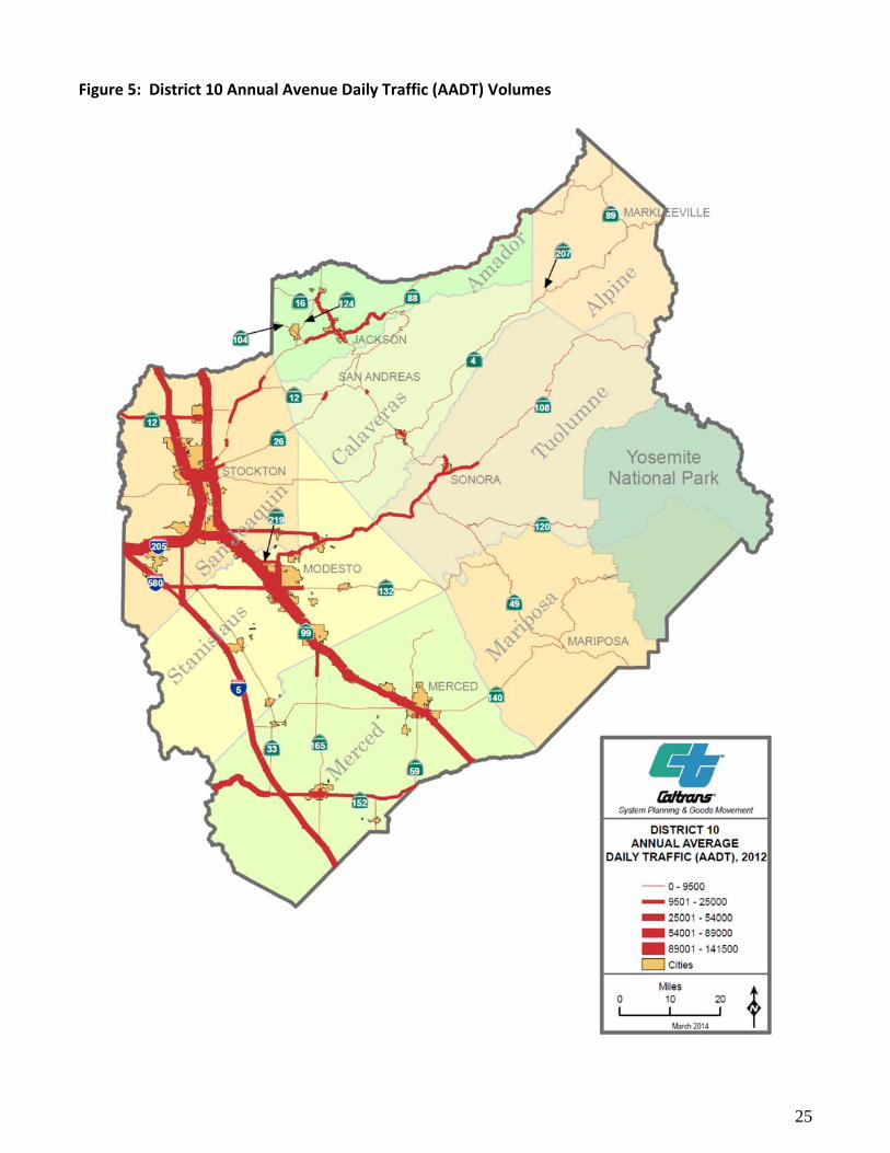
Successful efforts to maintain or improve corridor efficiency should provide over time measures of mean travel time approximately equal to or less than that reported for the table as it is expected that the number of commuters will increase. A trend toward a larger proportion of commuters using carpools will result in an increase in mean travel time to work, but this segment of the commuting population can be measured separately from the total commuting population. As can be seen from Figure 5, the highest traffic volumes in District 10 occur in two corridors, the Interstate corridor, which can experience daily volumes of between 9,000 and 15,000 vehicles, and the SR 99 corridor, which can experience daily volume of 2,500 near the Madera County line and 15,000 in the City of Modesto. The need for an ongoing congestion management strategy for District 10 is apparent. Generally, two system‐wide strategies can be used together, either making a corridor more efficient (usually by segregating traffic streams into managed lanes or truck lanes), or by better regulating demand during the peak hour (usually by ramp metering). Figures 6 and 7 indicate that prioritization for both managed lanes and ramp metering target the Interstate Corridor over the SR 99 Corridor. Both ramp metering and managed lane efforts are now in the implementation phase, with ramp meters in place at the Mountain House Interchange on I‐205, and with the widening of I‐5 between the March Lane and Hammer Lane to accommodate future managed lanes in construction. A final ongoing strategy to improve traffic system performance and operations is the implementation of a Transportation Management System (TMS). The TMS integrates various Intelligent Transportation System (ITS) elements in order to provide the motorist with up to date information on driving conditions throughout the District (and is tied in to the state‐wide system), as well as facilitate incident response. Typical ITS elements may include traffic signals, ramp meters, traffic monitoring stations, changeable message signs, highway advisory radio, closed circuit television cameras, and roadway weather information systems.
25
Figure 5: District 10 Annual Avenue Daily Traffic (AADT) Volumes

26
Figure 6: Planned Managed Lanes in District 10

27
Figure 7: Ramp Metering Priorities in District 10
28
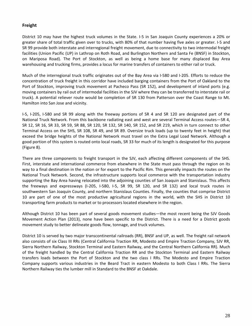
Freight District 10 may have the highest truck volumes in the State. I‐5 in San Joaquin County experiences a 20% or greater share of total traffic given over to trucks, with 80% of that number having five axles or greater. I‐5 and SR 99 provide both interstate and interregional freight movement, due to connectivity to two intermodal freight facilities (Union Pacific (UP) in Lathrop on Roth Road, and Burlington Northern and Santa Fe (BNSF) in Stockton, on Mariposa Road). The Port of Stockton, as well as being a home base for many displaced Bay Area warehousing and trucking firms, provides a locus for marine transfers of containers to either rail or truck. Much of the interregional truck traffic originates out of the Bay Area via I‐580 and I‐205. Efforts to reduce the concentration of truck freight in this corridor have included barging containers from the Port of Oakland to the Port of Stockton, improving truck movement at Pacheco Pass (SR 152), and development of inland ports (e.g. moving containers by rail out of intermodal facilities in the SJV where they can be transferred to interstate rail or truck). A potential reliever route would be completion of SR 130 from Patterson over the Coast Range to Mt. Hamilton into San Jose and vicinity. I‐5, I‐205, I‐580 and SR 99 along with the freeway portions of SR 4 and SR 120 are designated part of the National Truck Network. From this backbone radiating east and west are several Terminal Access routes—SR 4, SR 12, SR 16, SR 33, SR 59, SR 88, SR 120, SR 132, SR 140, SR 152, and SR 219, which in turn connect to other Terminal Access on the SHS, SR 108, SR 49, and SR 89. Oversize truck loads (up to twenty feet in height) that exceed the bridge heights of the National Network must travel on the Extra Legal Load Network. Although a good portion of this system is routed onto local roads, SR 33 for much of its length is designated for this purpose (Figure 8). There are three components to freight transport in the SJV, each affecting different components of the SHS. First, interstate and international commerce from elsewhere in the State must pass through the region on its way to a final destination in the nation or for export to the Pacific Rim. This generally impacts the routes on the National Truck Network. Second, the infrastructure supports local commerce with the transportation industry supporting the Bay Area having relocated into the adjoining counties of San Joaquin and Stanislaus. This affects the freeways and expressways (I‐205, I‐580, I‐5, SR 99, SR 120, and SR 132) and local truck routes in southwestern San Joaquin County, and northern Stanislaus Counties. Finally, the counties that comprise District 10 are part of one of the most productive agricultural regions in the world, with the SHS in District 10 transporting farm products to market or to processors located elsewhere in the region. Although District 10 has been part of several goods movement studies—the most recent being the SJV Goods Movement Action Plan (2013), none have been specific to the District. There is a need for a District goods movement study to better delineate goods flow, tonnage, and truck volumes. District 10 is served by two major transcontinental railroads (RR), BNSF and UP, as well. The freight rail network also consists of six Class III RRs (Central California Traction RR, Modesto and Empire Traction Company, SJV RR, Sierra Northern Railway, Stockton Terminal and Eastern Railway, and the Central Northern California RR). Much of the freight handled by the Central California Traction RR and the Stockton Terminal and Eastern Railway transfers loads between the Port of Stockton and the two class I RRs. The Modesto and Empire Traction Company supports various industries in the Beard Tract in eastern Modesto to both Class I RRs. The Sierra Northern Railway ties the lumber mill in Standard to the BNSF at Oakdale.

29
Figure 8: District Truck Routes

30
One special consideration at the interface of highway and rail transport is at‐grade crossings. These are within the RR’s right of way, regulated by the Public Utilities Commission, and lack Caltrans jurisdiction. Associated with at‐grade crossings are safety and congestion issues, and they present particular difficulties in urban settings on conventional highways. Though there are several at‐grade crossings on State highways, specific concerns center on those in urban settings: SR 59 at 16th Street in Merced, SR 132 at Eighth Street in Modesto, and SR 132 at Santa Fe in Empire. The Port of Stockton is an inland port accessible by the Stockton Deep Water Channel. The Port has implemented the Marine Highway (M‐580) associated with the Port of Oakland. M‐580’s name refers to the preferred truck route out of the Port of Oakland. M‐580 provides barges laded with containers to circulate between the Ports of Oakland and Stockton with the intent to reduce truck trips. Trucks access the Port by the SR‐4 onto Fresno Avenue. An extension of the freeway to better access the Port is underway.
Figure 9: Port of Stockton
The Port of Stockton is District 10’s only commercial port. Much of the goods imported and exported from the Port transferred directly to rail, and do not affect the SHS. Since the suspension of the M‐580 project to move containers out of the Port of Oakland to the Port, it has been difficult to assess the additional volume of truck traffic supporting the Port’s operations. In the short term, much of the freight needs of the District are addressed. However, there is a great deal of uncertainty with that claim. Much of the District’s truck counts are based upon traffic censuses and estimates performed over ten years ago, and may not reflect actual traffic volumes. Real time data cannot be obtained, for although traffic monitoring stations count vehicles, it does not discriminate between cars and trucks. Trucks can be identified by weigh in motion (WIM) detectors, but only two are installed in the District, and neither is used to provide real time data to the Freeway Performance Measurement System (PeMS) network. To better assess freight needs, a District goods movement study needs to be undertaken, and more WIM sites need to be installed and linked into the PeMS system.

31
Transit In District 10 there are 47 public and private transit service providers. Services include Amtrak and Altamont Commuter Express (ACE) rail services, a private intercity and interregional carrier (Greyhound), numerous specialty private services, as well as publically operated local and regional bus transit services (see Table 13). All counties in District 10 provide dial‐a‐ride service, but only Amador, Calaveras, Merced, San Joaquin, Stanislaus, and Tuolumne provide deviated fixed route transit service. YARTS provides a transit service centered upon Yosemite National Park, and provides a measure of relief for highway congestion linked to tourism. Currently, there is no light rail system operating on a rail line separate from freight in District 10. San Joaquin Rapid Transit District (SJRTD) anticipates acquisition of abandoned railroad for bus rapid transit service (BRT) with eventual conversion to light rail.33 There are transit connections to light rail outside of the region. Both the SJRTD and the Modesto Area Express (MAX) provide connections to the Bay Area Rapid Transit (BART) station at Pleasanton, and the Amador Regional Transit Service (ARTS) provides a connection to the Sacramento light rail. BART is proposing an extension of service to Livermore, but is unlikely to extend connections into San Joaquin County.
33 SJ RTD Transit Gap Study, 2010, p.33: see TC 4.12
Table 15: District 10 Public Transit Service Providers
County Transit Service Local Intercity Interregional Transit Center
Passenger Rail
Alpine Alpine County Transit Yes Yes Yes No No
Amador ARTS Yes Yes Yes Yes Yes
Calaveras Calaveras Transit Yes Yes Yes No No
Mariposa Mari‐Go YARTS Amtrak‐ bus service
Yes No No
Yes Yes Yes
Yes Yes Yes
No No No
No Yes Yes
Merced The Bus CATLinX YARTS Amtrak‐San Joaquin
Yes Yes No No
Yes Yes No No
Yes Yes Yes Yes
Yes Yes Yes Yes
No No Yes Yes
San Joaquin SJRTD Blossom Express Breeze e‐TRANS Grapeline Manteca Transit South County TRACER ACE Amtrak‐San Joaquin
Yes Yes Yes Yes Yes Yes Yes Yes No No
Yes No Yes No No No Yes No Yes Yes
Yes No No No No No Yes No Yes Yes
Yes No No No Yes No No Yes Yes Yes
Yes No No No No No Yes No Yes Yes
Stanislaus StaRT MAX CAT ROTA BLAST Amtrak‐San Joaquin
Yes Yes Yes Yes Yes No
Yes No No Yes No Yes
No Yes No No No Yes
Yes Yes No Yes Yes No
No Yes No No No Yes
Tuolumne Tuolumne County Transit YARTS
Yes No
Yes Yes
No Yes
Proposed Proposed
No Yes

32
The SHS in District 10 is used for intercity and interregional transit. Portions of SR 4, I‐5, I‐205, SR 12, SR 16, SR 49, SR 88, SR 99, SR 120, and SR 140 provide transit service between counties; the same routes with the addition of SR 33, SR 59, and SR 108 also serve to provide intercity and local transit service. BRT service has not been deployed upon any SHS routes in District 10, though this might change with the installation of managed lanes on the interstate corridor. Although there are a large number of transit providers, connectivity between services is poor. There is no interregional transit service from the five mountain counties into the three valley counties, despite these being the primary out of county work locations. Connections between local transit and ACE do not occur in Manteca and Lathrop,34 despite these communities having a high percentage of local residents that work in the Bay Area. A similar situation occurs in Turlock, where there is no transit connection to the Amtrak station in Denair. Presently, car and van pooling appear to be the predominant mechanism for reducing vehicle trips on the SHS. In the District, 13.1% of all workers carpool and 1.2% use transit. For workers who travel outside the District, the numbers climb to 21.5% who carpool and 3.3% who use transit (see Table 16). Park and Ride lots help facilitate both transit use and carpooling. District 10 owns and operates five park and ride lots, with another six private park and ride lots operating through lease agreements.
Table 16: Mode of travel to work for incorporated areas of San Joaquin Valley Counties in District 10 (2010)*35
Total
Workers % of Total Drive Alone
% of Workers
Carpool % of
Workers Transit
% of Workers
Total for Cities
370,650 100 287,437 77.5 48,707 13.1 4,494 1.2
Work in District
306,369 82.7 239,953 78.3 34,891 11.4 2,364 0.8
Work Outside District
64,281 17.3 47,484 73.9 13,816 21.5 2,130 3.3
*Walking, Bicycling, Taxis, Motorcycles, and Other categories had values too small to display
Scheduling and integration of various intercity transit services through the District appears poor (Table 17). Without specifying commute period trips, reasonable transit travel times exist between destinations outside of trips originating from or ending at Merced or Turlock. For trips originating from Stockton, both rail and transit are reported, given that most rail service (Amtrak San Joaquin) occurs outside the peak commute, while bus service operates throughout the day. Although Tracy would likely serve as a transit hub (e.g. have shortest overall times to all destinations), trips to various locations in Alameda and Santa Clara take longer than they do from Stockton. This likely reflects that services into the Bay Area travel through the north edge of the city, and would require a bus trip into the transit center, while the system in Stockton is more centrally located.
Table 17: District 10 Intercity Transit Times—one way trips (2015)36
From/To Modesto Tracy Merced Manteca Turlock Lodi Pleasanton San Jose Sacramento
Stockton 0:28 0:25 1:07 0:47/1:06 2:43 0:29/1:09 1:21 1:50 0:50
Modesto ‐ 3:05 0:40 2:10 2:21 3:33 3:14 4:05 4:01
Tracy ‐ 7:07 2:15 3:44 3:12 2:59 3:34 2:54
Merced ‐ 3:04 2:36 4:34 12:09 4:04 4:36
Manteca ‐ 2:34 1:47 3:31 4:46 2:23
Turlock ‐ 6:24 5:36 5:02 3:02
Lodi ‐ 3:40 5:30 0:38
34 Interregional service to the ACE station is provided by MAX, but not by SJ RTD, nor Manteca Transit. 35 CTPP five year 2006‐2010 database 36 Obtained from Google Get Directions Mapping Software with transit interface.

33
Figure 10: Interregional Passenger Rail in District 10

34
Intercity and Interregional Transit The District has two intercity rail providers, Amtrak San Joaquin and ACE; and one interregional transit provider, YARTS. In the future, High Speed Rail (HSR) will be in place to provide a third interregional service (see Figure 10). Of the three existing services, only ACE provides service in the peak hour, in the peak hour direction, to workers in District 10.
Amtrak San Joaquin The Amtrak San Joaquin corridor provides a hybrid service of passenger rail and bus (Figure 11). The backbone of the system is the rail service which follows BNSF rights of way from either the East Bay or Sacramento to Bakersfield. Train arrivals and departures at stations in District 10 occur outside the peak hour commute, with the earliest northbound departure from Merced occurring at 7:48, and the earliest southbound departure at 7:18 from Lodi.37 Within District 10, Amtrak buses provide connections between the Amtrak stations from Stockton to Sacramento, from Stockton to San Jose, and from Merced to Yosemite National Park (via YARTS). Bus service also operates outside of the peak hour excepting trips in the direction opposite the commute. Proposed improvements for the San Joaquin within District 10 entail double tracking portions of the route. 38
Altamont Commuter Express (ACE) ACE provides interregional rail transit for District 10 into the Bay Area during peak commute times (Figure 12). A 2011 ACE passenger survey found that 75.8% of the passengers were previously solo drivers. ACE ridership has climbed steadily, carrying an average of 4,000 riders per day, amounting to over a million riders a year. The 85 mile corridor parallels I‐580 and I‐680, two of the most congested highways in the San Francisco Bay Area. It has proven to be a successful program because it has multi‐regional support, a strong funding foundation, and provides an attractive, timely, and cost‐saving alternative to driving alone. ACE’s vision for the future is to improve the existing service between Stockton and San Jose with added frequencies, and to extend service to additional central valley communities, downtown Modesto in the near term, and downtown Merced subsequently. An improved ACE would offer a catalyst for smart growth in communities by revitalizing city core areas and addressing traffic congestion issues in the cities of the northern central valley.
37 Amtrak California San Joaquin timetable, March 2015 38 California State Rail Plan, 2013, pp 223‐232

35
Figure 11: California Intercity Rail and Feeder Bus Routes

36
Figure 12: ACE service area
High Speed Rail (HSR)
The California HSR Authority is responsible for planning, designing, building and operation of the first HSR in the nation with speeds capable of exceeding 200 miles per hour. Voters approved Proposition 1A in 2008 authorizing $9.95 billion in general obligation bonds for the HSR project; of that amount $950 million was reserved for capital improvements, such as the ACE. These funds must be allocated to intercity, commuter and urban rail projects that provide direct connectivity to the HSR system. Over $5.8 billion ($2.6 billion in State and $3.2 billion in federal funding) was appropriated in 2012 in SB 1029 (Committee on Budget and Fiscal Review 2012) for the first construction section of the Initial Operating Section (IOS). Once completed, a portion of the existing San Joaquin intercity rail service will be able to use this track to travel at higher speed while reducing travel times on the southern section of the intercity rail corridor. The operation of this interim San Joaquin service along the first construction section of the IOS is anticipated to begin in 2018 and will provide an immediate benefit to the State’s passenger rail program. An integrated system, whereby the HSR system running from San Francisco to Los Angeles/Anaheim via the Central Valley and later to Sacramento and San Diego (see Figure 10). The system will total 800 miles with up to 24 stations, will produce economic benefits, support statewide environmental and energy goals, create near‐and long‐term employment, reduce vehicle travel, and improve mobility throughout the State. HSR will reduce travel times for train riders, save 12.7 million barrels of oil, reduce greenhouse gas emission by 12 billion pounds per year, support a clean and sustainable travel mode, and generate more than 1 billion in annual revenue. An integrated system where HSR and conventional passenger rail services feed into one another will improve ridership potential for all participating services.

37
Figure 13: High Speed Rail
Additional information is available at http://www.cahighspeedrail.ca.gov/.
Yosemite Area Regional Transportation System (YARTS) YARTS is currently the only transit service in District 10 developed to address traffic and air quality impacts associated with tourism and recreation. Yosemite National Park (the Park) has sought solutions to traffic congestion, and air quality impacts due to the large proportion of visitors entering the Park with their personal vehicles. In recent years, the Park Service had to turn away visitors as the number of vehicles exceeded the number of available parking. Four million people visit Yosemite annually with approximately 12 percent coming to the park from out of state or out of the country. Among the solutions was YARTS (Figure 14), to provide year round, public transit between Yosemite National Park, and its gateway communities. From Merced, YARTS replaced the Amtrak bus service that accessed the Park. In July 2011, YARTS surpassed a record of 12,000 passengers, more than any other month in the 11‐year history of the service. Intercity bus service to the Park lessens the impact of providing parking, mitigates increasing congestion and air pollution, and provides a pedestrian and bicycle friendly outdoor experience.

38
Figure 14: YARTS

39
Support Facilities Rest Areas
Caltrans owns and maintains six freeway rest areas in District 10 (locations on Figure 18). Merced County has two for northbound and southbound I‐5, located 0.7 miles north of the Fresno County line. Stanislaus County has four rest areas. One pair is for northbound and southbound I‐5, located 0.9 miles south of the San Joaquin County line. The second pair is for northbound and southbound SR‐99, located 2.3 miles south of the City of Turlock (Figure 15). More information can be obtained about all Caltrans owned and operated rest stops online: www.dot.ca.gov/hq/maint/ra/.
Figure 15: Rest Area on SR‐99 South of Turlock
Park and Ride
Park‐and‐ride offer commuters a location to park their cars at no cost and continue their travels by car/vanpool or transit. This commute option helps in decreasing traffic congestion and reducing air pollution. District 10 has created a District‐wide Park and Ride Plan and currently owns and operates five Park and Ride facilities (locations on Figure 18). Three privately‐owned Park and Ride facilities operate through a lease agreement. Three additional Park and Ride lots are in the lease agreement process and will soon serve Modesto Area residents.
Maintenance Stations Critical to system preservation and maintenance is adequate coverage by district maintenance services. The District 10 Maintenance Department is divided into seven service groups—Electrical and Structural Painting; Special Crews; Pine Grove Maintenance Region; Altaville Maintenance Region; Modesto Maintenance Region; Stockton Maintenance Region; and, Merced Maintenance Region. There are currently 24 maintenance stations in District 10 that provide service coverage to the SHS in District 10 (see Figure 16). Whether availability of funding that will address future needs is unknown, and upgrades may require additional maintenance stations or greater expenditures in contractor services.

40
Figure 16: District Ten Maintenance Stations

41
Aviation
There are nineteen public airports in District 10 (See Table 18 and Figure 17). Of these, three are commercial airports (facilities that offer access to major passenger airlines and freight carriers); four are regional airports; eight are community airports; and four are limited use. Much of the support Caltrans offers these airports is provided through the aeronautics division, rather than at the district level.
Table 18: Airports in District 1039
County Name
Commercial Airports
Merced Merced Municipal Airport‐‐Macready Field
San Joaquin Stockton Metropolitan Airport
Regional Airports
Mariposa Mariposa and Yosemite Airport
San Joaquin Tracy Municipal Airport
Stanislaus Modesto City and County Airport
Tuolumne Columbia Airport
Amador Westover Field Amador County Airport
Community
Merced Los Banos Municipal Airport
Merced Gustine Airport
Merced Castle Airport
Stanislaus Turlock Municipal
Stanislaus Oakdale Municipal
Tuolumne Pine Mountain Lake Airport
San Joaquin Lodi Airport
Calaveras Calaveras County, Maury Rasmussen Airport
Limited Use
San Joaquin New Jerusalem
San Joaquin Kingdon Airpark
San Joaquin Lodi Airpark
Alpine Alpine County Airport
District 10’s two commercial airports handle domestic flight services. With District 10’s close proximity to major metropolitan airports in the Bay Area and Sacramento, there has been a tendency for the airports to underperform compared to the State as a whole (See Table 19). As might be expected, Stockton Metropolitan Airport leads in passenger traffic by a margin of almost two to one over Macready Field, but performs poorly as a freight operation. Ongoing efforts have been underway to increase the freight leaving Stockton Metropolitan Airport. It is expected to remain light until the completion of the Arch and Sperry Road project, and development of commercial and industrial zoned properties near the airport.
39 Caltrans Office of Aviation

42
Modesto City and County Airport, recently downgraded from a commercial to regional airport due to loss of their domestic passenger carrier, presently benefits from a better connection to freight opportunities than does Stockton Metropolitan.
Table 19: Performance of Commercial Airports in District 10 (2012)40
Location Airport Passenger Traffic Freight (Tons) Percentage of State Total
2011 2012 2011 2012 Passenger Freight
Merced Co. Merced 6,519 6,975 84 197 ‐ ‐
San Joaquin Co. Stockton Metro 111,047 124,606 N/A 5 ‐ ‐
District 10 (numbers include Modesto)
‐ 157,599 164,580 455 603 0.09% 0.02%
State Wide ‐ 172,019,001 178,991,558 3,652,916 3,803,515 100% 100%
Macready Field which serves the smallest of the three urban areas has managed to double its freight output. Passenger service is limited to Great Lakes Airlines twice daily weekday, once on Saturday service to Los Angeles International Airport. All five of the regional airports enjoys proximity and access to the SHS: the Mariposa and Yosemite Airport is off of SR 49 north of Mariposa, Tracy Municipal Field is accessible by both I‐580 and I‐205, Columbia Airport from SR 49, and, Westover Field, from SR 49. Modesto City and County Airport enjoys close access to Mitchell Road, a Surface Transportation Assistance Act (STAA) terminal access route that accesses both SR 99 and SR 132. Community and Limited Use Airports have important roles in emergency response, and within District 10 have access to the SHS.
40 Caltrans Office of Aviation
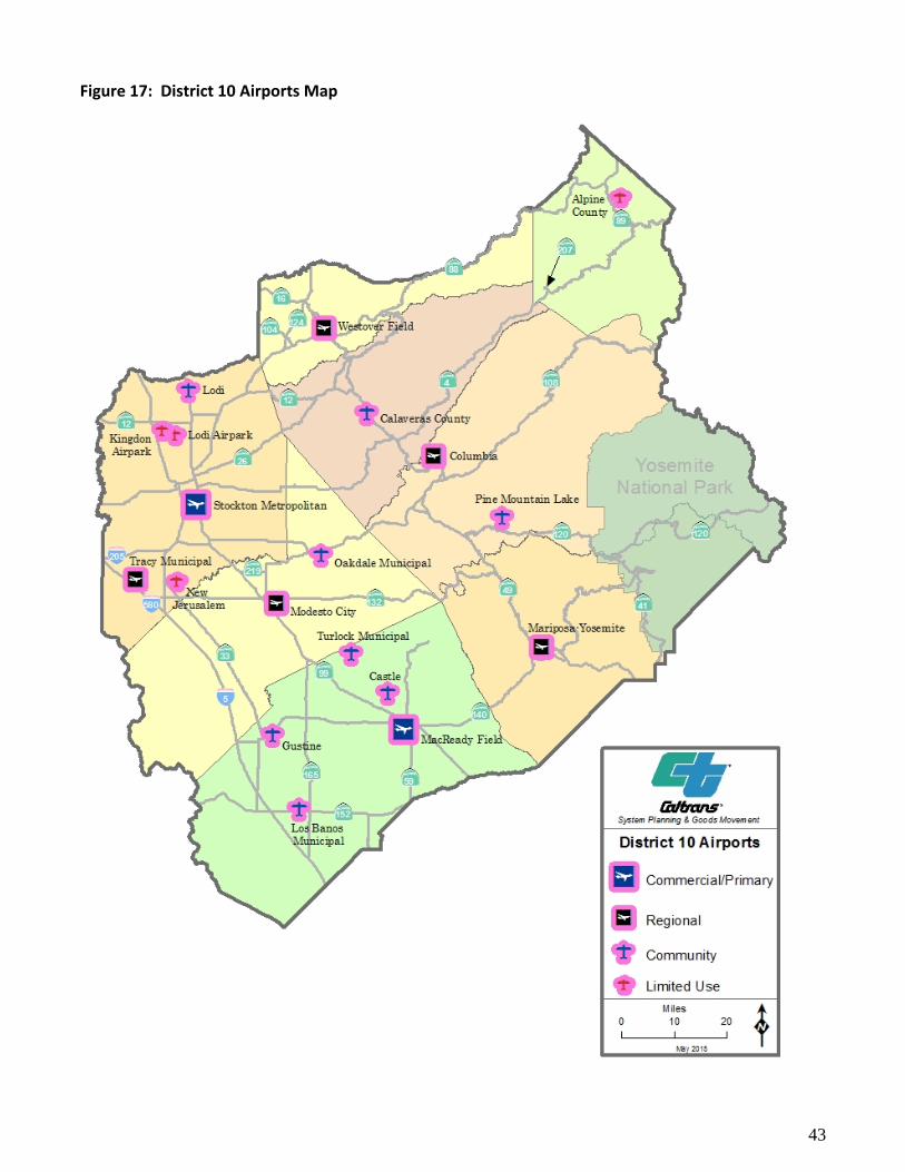
43
Figure 17: District 10 Airports Map

44
Bicycle Active transportation refers to any human powered transportation. Bicycle and pedestrian networks support active transportation. It is the District’s role to support these activities within or adjacent to the SHS, regardless of whether the activity is interregional, or part of the work commute. Bicycle and pedestrian access to SHS facilities are displayed in Figure 18. District 10 maintains over 1,000 highway centerline miles that are bicycle accessible. Much of that facility is Class III, where bicycles in conformance with the vehicle code are legally permitted to share the lane. Much of this portion of the facility may be considered where one travels by bicycle at one’s risk. Increasing shoulder widths to permit bicycle refuge from traffic is an ongoing District effort when coupled with other system maintenance or improvement projects. Within urban settings, with local planning assent, these shoulder improvements can permit segregation of bicyclists from vehicular traffic into Class II bike lanes. Currently, Class II bike lanes are found on portions of SR 12 in Lodi; SR 132 and SR 219 in Modesto; SR 140 in Merced and are proposed for SR 152 in Los Banos. Currently, the service road for the Edmund Brown Sr. Aqueduct provides a parallel Class I bicycle route for I‐580 and I‐5 from Tracy south to the San Luis Reservoir near Santa Nella off of SR 33. For the other approximately 400 center lane miles (all freeway) that are not bicycle accessible, there is less that the District can achieve to pursue an active transportation network. Common barriers to bicycle connectivity are the lack of adequate river crossings. Often of the few local bridges available, these already accommodate restricted bicycle use facilities; and, other bridges lack the lane and shoulder width to permit safe bicycle crossing. Retrofitting these structures to permit safe bicycle access would incur prohibitive costs that exceed the likely benefits. Also prevalent are topographic constraints where additional width to accommodate a separate bicycle lane or a parallel bicycle facility is not consistently available. The District has developed a District 10 Bicycle Guide that is available on the Caltrans website located at http://www.dot.ca.gov/dist10/docs/BIKEGUIDE0809.pdf. The plan outlines the different bike plans in jurisdictions throughout the District, and identifies the various routes and what to expect while cycling in the District. Most freeways are closed to bicycle travel. Exceptions are made when no alternative to the highway exists. Figure 18 is an overview of District 10 bike routes on the SHS. Proximity of District 10 to Bay Area populations with their high number of bicycle commuters and recreationists suggest there may be a demand for a long distance bicycle corridor from the Bay Area to recreational draws in District 10. A likely candidate would be Yosemite. Currently there are several gaps in existing and proposed bicycle routes (Class I and Class II) that such a route does not exist.
Pedestrian Pedestrian needs arise in association with conventional highway facilities. In many of these cases, the towns and cities are small, with populations less than 8,000. Periods of high pedestrian use often coincide with when schools are in session, and use often remains light throughout the rest of the day. Projects to improve walking use associated with schools can usually be addressed through applications for Safe Route to Schools grants. The exceptions to this are in larger towns‐‐SR 152 in Los Banos, SR 59 and SR 140 in Merced, SR 132 and SR 108 in Modesto. With the exception of SR 59 (which was addressed in part by a community planning grant), these highways pass through significant commercial centers, but are not subject to heavy pedestrian use, or associated pedestrian safety issues.
Whenever pedestrian facilities are present upon the SHS, District 10 has provided appropriate Americans with Disabilities Act (ADA) access, or is in the process of upgrading facilities to meet current ADA guidelines. These apply most readily to bridge overcrossings along I‐5 and SR 99.

45
The Mokelumne Coast to Crest Trail may serve as a long distance hiking and equestrian trail (bicycle use likely would be limited to mountain bikes). The trail extends from Martinez to the crest of Ebbetts Pass. Currently, three segments of the trail are developed for public use, two of which occur in District 10. The District is unaware of any other proposal for another long distance multiuse path.

46
Figure 18: Bicycle and Pedestrian Access to State Highway Facilities in District 10
47
TRANSPORTATION PARTNERS Each of the three Metropolitan Planning Organizations (MPOs) and the five Regional Transportation Planning Agencies (RTPAs) are responsible for preparing the RTP for their respective jurisdictions (see Table 20 and Figure 19). The RTP is a long‐range (20 years or more) plan that provides a blueprint for future transportation improvements and investments based on specific transportation goals, objectives, policies and strategies. Key transportation agency partners also include Yosemite National Park (YNP), California Highway Patrol (CHP), city and county planning and public works departments, SJRTD, ACE, and the Port of Stockton.
Table 20: District 10 Transportation Partners
Metropolitan Planning Organization
Merced County Association of Governments (MCAG) San Joaquin Council of Governments (SJCOG) Stanislaus Council of Governments (StanCOG)
Regional Transportation Planning Agency
Alpine County Local Transportation Commission (ACLTC) Amador County Transportation Commission (ACTC) Calaveras County Council of Governments (CCOG) Mariposa County Local Transportation Commission (MCLTC) Tuolumne County Transportation Commission (TCTC)
Congestion Management Agency
San Joaquin Council of Governments (SJCOG) Stanislaus Council of Governments (StanCOG)
County Transportation Commission
Alpine County Local Transportation Commission Amador County Transportation Commission Mariposa County Local Transportation Commission Tuolumne County Transportation Commission
Federal, State and Local Agencies
Yosemite National Park California Highway Patrol City and county planning and public works departments San Joaquin Regional Transit District Altamont Commuter Express Port of Stockton
Tribes (federally recognized and there are no Tribal
Employment Rights Ordinance (TERO) tribes whose territory
falls within Caltrans District 10)
Buena Vista Rancheria of Me‐Wuk Indians California Valley Miwok Tribe Chicken Ranch Rancheria of Me‐Wuk Indians Ione Band of Miwok Indians Jackson Rancheria Band of Mi‐Wuk Indians Tuolumne Band of Me‐Wuk Indians Washoe Tribe of Nevada and California
Air District
Alpine – Great Basin Unified, Air Pollution Control District ( APCD) Amador – Amador APCD Calaveras – Calaveras County APCD Tuolumne – Tuolumne County APCD Mariposa ‐‐ Mariposa County APCD San Joaquin, Stanislaus, Merced Counties – San Joaquin Valley APCD

48
Figure 19: Transportation Planning Partners in District 10

49
PLANNING EFFORTS
Statewide Planning Efforts and Policies SMART Mobility 2010: A Call to Action (or Smart Mobility Framework‐‐SMF) The SMF addresses the following needs:
the State mandate to find solutions to climate change,
the need to reduce per capita vehicle miles traveled,
demand for a safe transportation system that gets people and goods to their destinations and,
the commitment to create a transportation system that advances social equity and environmental justice.
Smart Mobility moves people and freight while enhancing California’s economic, environmental, and human resources by emphasizing:
convenient and safe multi‐modal travel,
speed suitability,
accessibility,
management of the circulation network, and
efficient use of land. The following six principles express the priorities and values of Smart Mobility: Location Efficiency‐‐Integrate transportation and land use in order to achieve high levels of non‐motorized travel and transit use, reduced vehicle trip making, and shorter average trip length while providing a high level of accessibility. Reliable Mobility‐‐Manage, reduce, and avoid congestion by emphasizing multi‐modal options and network management through operational improvements and other strategies. Provide predictability and capacity increases focused on travel that supports economic productivity. Health and Safety‐‐Design, operate, and manage the transportation system to reduce serious injuries and fatalities, promote active living, and lessen exposure to pollution. Environmental Stewardship‐‐Protect and enhance the State’s transportation system and its built and natural environment. Act to reduce the transportation system’s emission of GHGs that contribute to global climate change. Social Equity‐‐Provide mobility for people who are economically, socially, or physically disadvantaged in order to support their full participation in society. Design and manage the transportation system in order to equitably distribute its benefits and burdens. Robust Economy‐‐Invest in transportation improvements—including operational improvements—that support the economic health of the State and local governments, the competitiveness of California’s businesses, and the welfare of California residents.

50
Draft California Transportation Plan 2040 (CTP) As of this time, the CTP has not been finalized. The DSMP is developed to reflect the vision of the CTP:
California’s transportation system is safe, sustainable, and globally competitive. It provides reliable and efficient mobility and accessibility for people, goods, and services while meeting our greenhouse gas emission reduction goals and preserving community character. This integrated, connected, and resilient system supports a prosperous economy, human and environmental health, and social equity.
The vision includes six goals and eighteen policies listed below:41
A. Improve Multimodal Mobility and Accessibility for All People: 1. Manage and Operate an Efficient Integrated System 2. Invest Strategically to Maximize System Performance 3. Provide Viable and Equitable Multimodal Choices including Active Transportation
B. Preserve the Multimodal Transportation System:
4. Apply Sustainable Preventative Maintenance and Rehabilitation Strategies 5. Evaluate Multimodal Life Cycle Costs in Project Decision Making 6. Adapt the Transportation System to Reduce Impacts from Climate Change
C. Support a Vibrant Economy:
7. Support Transportation Choices to Enhance Economic Activity 8. Enhance Freight Mobility, Reliability, and Global Competitiveness 9. Seek Sustainable and Flexible Funding to Maintain and Improve the System
D. Improve Public Safety and Security:
10. Reduce Fatalities, Serious Injuries, and Collisions 11. Provide for System Security, Emergency Preparedness, Response, and Recovery
E. Foster Livable and Healthy Communities and Promote Social Equity:
12. Expand Engagement in Multimodal Transportation Planning and Decision Making 13. Integrate Multimodal Transportation and Land Use Development 14. Integrate Health and Social Equity into Transportation Planning and Decision Making
F. Practice Environmental Stewardship:
15. Integrate Environmental Considerations in All States of Planning and Implementation 16. Conserve and Enhance Natural, Agricultural, and Cultural Resources 17. Reduce Greenhouse Gas Emissions and Other Air Pollutants 18. Transform to a Clean and Energy Efficient Transportation System
The CTP provides a list of possible policy performance measures.42 Adoption of these measures will depend upon their final form. Many of the draft possible policy performance measures appear to lack quantifiable measurements, and/or include subjective measurement.
41 CTP March 2015 Draft (Public Review Draft) 42 CTP, Table 1, p. 6
51
Without performance measures, District 10 cannot evaluate the effectiveness of its commitment to a variety of goals it supports. Because this goes against the values of transparency and accountability, it would be imperative that the federal fiscal year 2017 DSMP include them. One noteworthy place to start would be from the prior District commitment to improve project delivery. Ass California Rail Plan (RP) The RP provides little specificity on passenger rail efforts in District 10 other than the Amtrak San Joaquin. The proposed effort to double track the San Joaquin in San Joaquin County appears to be programmed, but no date is provided.43 No other specific deficiencies were noted within the District. There is a District wide need to reduce commute travel demand on the SHS by shifting travel to modes other than single occupancy. With 25% of all workers traveling outside of their county of residence, there appears a regional need for an alternative travel network, whether this is bus or passenger rail is unclear. The Rail Plan does not indicate that such a planning effort is underway in the District for passenger rail. Additional improvements are expected to be proposed by the new Joint Powers Authority managing the corridor. Interregional Transportation Strategic Plan (ITSP) The ITSP had direct pertinence to District planning efforts, and our partnering with other transportation planning agencies. The partnership is critical to leverage both State Transportation Improvement Program (STIP) and Interregional Transportation Improvement Program (ITIP) monies on projects that provide some level of congestion relief for local and interregional travel. Over the last few years several partner agencies have made requests for routes on the IRRS to be elevated to high emphasis or focus routes. Within the District, this should only occur when a route on the IRRS has attained facility status consistent with the planning goals of the ITSP. The two focus routes in District 10 are SR 99 and SR 152. For SR 99 the ITSP envisions an eight lane expressway facility. Current efforts to construct the route to six lane freeway throughout the District are underway. These efforts are summarized in Route 99 Corridor Business Plan. The Livingston Median Widening is the only programmed improvement that is partially constrained. There are others—widen SR 99 at Merced and Atwater, and the Lodi widening are Tier II in their respective RTPs, and are not programmed for the next round of construction. Efforts for SR 152 center upon gap closure by upgrading the remaining conventional highway segments to expressway. The proposed Los Banos Bypass has been split into three phases. The first two phases look to be constructed prior to 2035. Complete Streets
Caltrans views all transportation improvements as opportunities to improve safety, access and mobility for all travelers in California and recognize bicycle, pedestrian and transit modes as integral elements of the Deputy Directive 64‐R1, Complete Streets‐Integrating the Transportation System, as policy to develop integrated multimodal projects in balance with community goals, plans and values. By considering “complete streets” early in the system planning process, a transportation facility that is planned, designed, operated and maintained to provide safe mobility for all users will ensure that travelers of all ages and abilities can move safety and efficiently across a fully integrated transportation network.
43 SJCOG RTP (2014), Table 6‐8 Rail Corridor Improvements Category, ID SJ‐07‐0001

52
Context Sensitive Solutions Caltrans understands the value of input from local agencies and the public in the planning process. To ensure this occurs, Caltrans established the Director’s Policy for Context Sensitive Solutions, which requires the District to:
…use innovative and inclusive approaches that integrate and balance community, aesthetic, historic, and environmental values with transportation safety, maintenance, and performance goals. Context sensitive solutions are reached through a collaborative, interdisciplinary approach involving all stakeholders.
Caltrans looks beyond the basic highway guidelines and tries to design projects that incorporate the character and needs of local communities. This involves looking at a broader range of solutions, including aesthetic design elements, to ensure the local communities can retain their existing character while maintaining a safe and effective transportation system. To achieve such goals, Caltrans has become more inclusive of local agencies and the public within the planning and design processes to ensure the proper elements are included in our projects that protect the character and spirit of local communities. Caltrans published the Main Streets: Flexibility in Design and Operations guide in July 2002 to address the concepts, limitations and concerns that local areas face when a state highway is a main street. The challenge is to maintain these “main streets” promoting livable communities while ensuring and maintaining the purpose of the State highway for regional and interregional travel. Within the District, several State highways traverse the downtown areas of communities. These conventional “main street” highways also serve local traffic and are characterized by stop signs or signalized intersections, on‐street parking, slower speed limits, and pedestrian activity at adjacent commercial establishments.
Climate Adaptation
Assembly Bill (AB) 32, signed into law in 2007 by Governor Schwarzenegger, requires the State to reduce its greenhouse gas (GHG) emission levels by 2030 to the 1990 levels. To help achieve this, in 2008, Senate Bill (SB) 375 was signed into law and will require the California Air Resources Board (CARB) to develop regional greenhouse GHG emission reduction targets for cars and light trucks for each of the State’s 18 MPO’s. The MPO’s are required to develop plans to meet their regional GHG reduction target through either the financially constrained sustainable communities strategy as part of their RTP’s or as an unconstrained alternative planning strategy.
District Level Planning Efforts District 10 Intelligent Transportation Systems/Operations (ITS/Ops) Plan The ITS/Ops Plan is a two year study that will be completed in 2017. The plan is intended to provide a cost savings by combining efforts currently carried out by two discrete engineering offices—Traffic Electrical and Traffic Operations. The plan will identify those locations which may benefit by combining efforts to address operational improvements with congestion or traffic monitoring. The ITS/Ops Plan will prioritize these existing projects, and provide criteria for future prioritization. This will depend on an operational overview that will parameterize how ITS/Operations will work on key transportation corridors, and address key elements of traffic demand and traffic incident management such as ramp meters, and incident reporting to travelers. Included in the effort will be an evaluation of the existing Traffic Management Center in District 10, and recommendations to better facilitate traffic management. Aside from the projected cost savings, the benefit of the plan will be reduce traffic congestion and improved highway safety.
53
Corridor System Management Plans (CSMPs)
CSMPs are developed throughout the State for corridors wherever funding is being used from the Corridor Mobility Improvement Account (CMIA) and Highway 99 Bond Programs created by the passage of the Highway Safety, Traffic Reduction, Air Quality, and Port Security Bond Act of 2006, approved by the voters as Proposition 1B on November 7, 2006. CSMPs provide for the integrated management of travel modes and roadways so as to facilitate the movement of people and goods within our most congested transportation corridors. Each CSMP presents an analysis of existing and future traffic conditions and proposes strategies to maintain and enhance mobility within each corridor, primarily focusing on low‐cost, operational improvements and daily system operational activities. The corridor management planning strategy is based on the integration of system planning and system management. Each CSMP addresses State highways, parallel and connecting roadways, regional transit services, bicycle facilities, as well as other regional transportation‐related modes pertinent to corridor mobility. Transportation Concept Reports (TCRs)
The TCR is a long‐term planning document that each Caltrans district prepares for every State highway in its jurisdiction. The purpose of the TCR is to determine how the State highway will be improved and managed over a 20‐year period so that it maintains a minimum acceptable Level of Service (LOS). Each TCR presents an overview of the route’s current condition, information regarding programmed improvements, significant factors influencing the route’s existing and future condition, traffic projections, the concept (minimum acceptable LOS for the 20‐year planning horizon) and the State highway facility (concept facility) required to maintain the concept LOS. The TCR also includes an ultimate concept, which is a long‐term vision for the highway facility beyond the 20‐year planning horizon. The objective is to have local, regional, and State consensus on the future corridor needs so that Caltrans and its partners can plan and develop the improvements needed to maintain the concept LOS. District staff and the external partners can use the TCR as input for general plans, specific plans, regional transportation plans and other planning documents and processes. For routes that have a CSMP, the CSMP serves as the TCR for the overlapping segment. Partnership Driven District and Local Planning Priorities: This section was developed to permit a means to evaluate and account for how well the District performs in meeting its planning priorities in partnership with other local planning jurisdictions. Local and State planning priorities meet at the intersection of competing interests. District 10’s (and the Department’s) primary role in addressing the multimodal transportation system is interregional in focus, and is best exemplified by our efforts to maintain and improved the IRRS as outlined in the ITSP. Our second role, or often primary role in the rural mountain counties, is to improve traffic safety and operations through the SHOPP and the minor programs. Projects appropriate to each category may be identified in local transportation planning in the RTP, and are reported in this section by county.

54
ALPINE COUNTY: Currently, there are no Tier I improvement priorities on the State highway corridors within Alpine County. SR 88 and portions of SR 4 and SR 89 are on the IRRS, but future growth in traffic volumes will not necessitate any capacity increasing improvements. Upgrading the SR 4 corridor beyond Lake Alpine might be desirable, but would be inconsistent with the ACLTC RTP, as well as being outside the portion of the route designated IRRS. Efforts identified in the RTP address financially unconstrained operational improvements rather than capacity increasing improvements. These projects are listed in Table 21. Aside from the roadway rehabilitation project and the truck climbing lane, most of these improvements can be combined with other undertakings within the same post miles.
Table 21: Alpine County Projects (2007 RTP)
Route Tier Proposed Project
88 2 Roadway rehabilitation from Carson Pass to Red Lake Road
88 2 Visitor Information and Interpretative Kiosk near Woodfords
88 2 Left turn pockets at Diamond Valley and Foothill Road intersections
88 2 Install turn pocket on westbound approach to the SR 89 S intersection (near Woodfords)
88 2 Left turn pockets at Blue Lakes Road
88 2 Left turn pockets at Emigrant Trail
88 2 North bound acceleration lane at Kirkwood Meadows Drive
88 2 Install signs warning of approach to Markleeville turn off near the Woodfords M.S.
89 2 Truck climbing lane between Pickett’s Junction and El Dorado County line
AMADOR COUNTY: Three State highways in Amador County are on the IRRS: SR 16, SR 49, and SR 88. The effort to improve SR 88 in the vicinity of Pine Grove is a partially funded undertaking referred to as the Pine Grove Improvements. The Pine Grove Improvements involves a three mile segment between Climax Road and Tabeaud Road. The project includes shoulder widening on both sides of the highway, along with a six foot wide sidewalks from Ridge Road to Pine Grove Elementary School. Traffic signals will be installed at three intersections‐‐Irishtown Road, Volcano Road, and Tabeaud Road. Driveways within the segment will be standardized. Additional lanes are to be added at intersections to facilitate turning movements. The effort will also improve bicycle movement in Pine Grove by installation of a Class II from the intersection of Climax Road to Ridge Road; and Class I from Ridge Road to Pine Grove Elementary School.44 Other high level improvements in the current RTP are to construct a bypass of the City of Jackson on SR 49, and a realignment of SR 104 around Ione. No improvements are included for SR 16 (see Table 22). A review of recent TCRs indicates a possible need for a passing lane on SR 88 between Pine Grove and Pioneer, as well as an operational improvement on SR 16 between SR 124 and SR 49.
44 EA 10‐0G550‐ Draft Project Report, 2015 p.3—more specific details may be found there.

55
Table 22: Amador County Projects (2007 RTP)
Route Tier Proposed Project
88 1 Pine Grove Corridor Improvement Project (Pine Grove 2025‐2035)
49 1 Install roundabout at Shenandoah Rd (Plymouth, 2017)
88 1 Realign and Signalize intersection at Sutter Street (Jackson, 2016)
49 1 Plymouth Corridor Improvement Project Phase I (Plymouth, 2035)
104 1 Install bike and pedestrian. improvements at E. Main intersection (Ione, 2025)
49,88 1 Jackson Corridor Improvement Project Phase I (Jackson, 2025‐2035)
104 1 Improve intersection at Golf Links Road (Ione, 2035) {West Ione Bypass?}
124 1 Install turn pockets and improve intersection at Howard Park (Ione, 2035)
104 1 Bike and Pedestrian Improvements at Shakeley Road (Ione 2025)
16 1 Install turn pockets at Latrobe Road (2025)
49,16 1 Widen shoulders (Dry Town, 2035)
88 1 Improve intersection at Buckhorn Ridge Road (2035)
88 1 Widen shoulders between Columbia Dr and Antelope Dr. (2035)
49 1 Improve intersection at Bell Road (2035)
49,88 2a Install signal at Argonaut Lane (Martell, 2025)
88 2a Stage II of Pine Grove Corridor Improvement Project (Pine Grove, 2035)
49,104 2a Construct right turn lanes and sidewalks to Sutter Hill Road (Martell, 2035)
88 2a Wicklow Way Extension (Martell, 2035)
49,104 2a Signalize Jackson Valley (E) intersection (2035)
49,88 2a Jackson Corridor Improvement Project Phase II (Jackson, 2025‐2035)
49 2a Plymouth Corridor Improvement Project Phase II (Plymouth, 2035)
104 2a West Ione Roadway Strategy (Ione, 2035) {Phase II?}
88 2a Improve Buena Vista Road intersection (2035)
104 2a Widen between SR 88 and SR 49 (Martell, 2035)
88 2a Signalize Jackson Valley (W) intersection (2035)
88 2a Improve intersection with SR 26 (2035)
88 2a Improve intersection with SR 124 (2035)
49 2 Improve for bike lanes between SR 16 and City of Plymouth (Plymouth, 2035)
88 2 Improve intersection at Aqueduct Road (Pine Grove?, 2035)
16 2 Improve intersection with SR 124 (2035)
49,88 2 Widen shoulders between Argonaut Rd and Vogan Toll Road (Jackson, 2035)
88 2 Improve intersection at Omo Road (2035)
88 2 Improve intersection at Sugar Pine Dr. (2035)
88 2 Improve intersection at Tiger Creek Road (2035)
88 2 Improve intersection at Toyton Road (2035)
88 2 Improve intersection at Taves Road (2035)
88 2 Improve intersection at Molefino Road (2035)
104 2 Install left turn pocket at PM 5.82 (Ione, 2035)
104 2 Improve segment from Michigan Bar Road to Foothill Boulevard (Ione, 2035)
124 2 Improve segment from E. Main Street to Sutter—Ione Road (Ione, 2035)
CALAVERAS COUNTY: Three State highways in Calaveras County are on the IRRS: SR 4, SR 12, and SR 49. The effort to improve SR 4 between Copperopolis and Angels Camp is a partially funded undertaking referred to as the Wagon Trail Realignment. The Wagon Trail Realignment is the last stage in upgrading the rural portion of SR 4 west of Angels Camp. The project proposes to either rebuild SR 4 on a new 6.7 mile expressway alignment with a design speed of 70 Miles Per Hour (MPH), or to improve the existing alignment with curve corrections and shoulder widening to have a

56
design speed of 55 MPH.45 A project report describing the approved alternative will not be available until November 2016. Completion of the project will result in SR 4 providing a second terminal access truck route into Calaveras County from the National Truck Network; improving the conditions on the existing Class III bicycle lane; improving overall safety; and shortening commute times between southern Calaveras County, Stockton and the Bay Area (see Table 23). A review of recent TCRs indicates a need for passing lanes between San Andreas and the Amador County line on SR 49.
Table 23: Calaveras County Projects (2007 RTP)
Route Tier Proposed Project
4 1 Wagon Trail Realignment
26 2 Cosgrove Creek Bikeway (TE project) 2015‐2017
26 SHOPP Two way left turn lane PM 8.9
26 SHOPP Install traffic signals PM 8.4
26 SHOPP Erosion Control and Retaining Wall
4 SHOPP Crosswalk, signals, and ADA improvement PM 29.6
4 SHOPP Curve Improvement PM 42.8
49 2 Bypass at Angels Camp
4 2 Class II bike lane Pennsylvania Gulch to Tom Bell Road (Murphys)
49 2 Class II bike lane Pool Station Road to Mountain Ranch Road (San Andreas)
12 2 Class II bike lane Pine Street to Lime Creek Road (Valley Springs)
26 2 Class II bike lane Hogan Dam Road to SR 12 (Valley Springs)
26 2 Class II bike lane Sneed Road to Railroad Flat Road (West Point)
4 2 Widen to Four Lanes (location unspecified)
4 2 Construct Passing Lanes
12 2 Widening
12/26 2 Valley Springs Bypass
MARIPOSA COUNTY: Three State highways in Mariposa County are on the IRRS: SR 49, SR 120, and SR 140. No STIP funded projects are currently being considered for Mariposa County, and the current RTP only identifies three efforts that are fully to partially funded, these include improvements to SR 140 with installation of passing lanes near the county line, widening SR 132 near the county line, and to acquire right of way for a bridge (See Table 24). A critical undertaking not identified in the current RTP is to address the Ferguson Slide that closed SR 140 east of Briceburg to traffic. A temporary one lane detour was constructed to address the situation, but no permanent repair has been undertaken. Currently, there are two SHOPP projects in the Plans Specifications, and Estimates/Right of Way (PS&E/RW) stage of implementation—the first is to remove the debris from the slide; and the second is to construct a structure, a rock shed, to impede the future deposition on the road by allowing the debris to fall onto an overhand, and collect on the opposite side of the highway. Work is anticipated to start in the winter of 2016.
45 EA 10‐OE530K Project Study Report, 2001, p.1
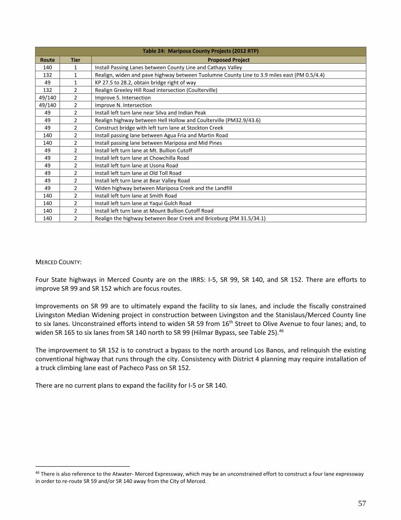
57
MERCED COUNTY: Four State highways in Merced County are on the IRRS: I‐5, SR 99, SR 140, and SR 152. There are efforts to improve SR 99 and SR 152 which are focus routes. Improvements on SR 99 are to ultimately expand the facility to six lanes, and include the fiscally constrained Livingston Median Widening project in construction between Livingston and the Stanislaus/Merced County line to six lanes. Unconstrained efforts intend to widen SR 59 from 16th Street to Olive Avenue to four lanes; and, to widen SR 165 to six lanes from SR 140 north to SR 99 (Hilmar Bypass, see Table 25).46 The improvement to SR 152 is to construct a bypass to the north around Los Banos, and relinquish the existing conventional highway that runs through the city. Consistency with District 4 planning may require installation of a truck climbing lane east of Pacheco Pass on SR 152. There are no current plans to expand the facility for I‐5 or SR 140.
46 There is also reference to the Atwater‐ Merced Expressway, which may be an unconstrained effort to construct a four lane expressway in order to re‐route SR 59 and/or SR 140 away from the City of Merced.
Table 24: Mariposa County Projects (2012 RTP)
Route Tier Proposed Project
140 1 Install Passing Lanes between County Line and Cathays Valley
132 1 Realign, widen and pave highway between Tuolumne County Line to 3.9 miles east (PM 0.5/4.4)
49 1 KP 27.5 to 28.2, obtain bridge right of way
132 2 Realign Greeley Hill Road intersection (Coulterville)
49/140 2 Improve S. Intersection
49/140 2 Improve N. Intersection
49 2 Install left turn lane near Silva and Indian Peak
49 2 Realign highway between Hell Hollow and Coulterville (PM32.9/43.6)
49 2 Construct bridge with left turn lane at Stockton Creek
140 2 Install passing lane between Agua Fria and Martin Road
140 2 Install passing lane between Mariposa and Mid Pines
49 2 Install left turn lane at Mt. Bullion Cutoff
49 2 Install left turn lane at Chowchilla Road
49 2 Install left turn lane at Usona Road
49 2 Install left turn lane at Old Toll Road
49 2 Install left turn lane at Bear Valley Road
49 2 Widen highway between Mariposa Creek and the Landfill
140 2 Install left turn lane at Smith Road
140 2 Install left turn lane at Yaqui Gulch Road
140 2 Install left turn lane at Mount Bullion Cutoff Road
140 2 Realign the highway between Bear Creek and Briceburg (PM 31.5/34.1)

58
SAN JOAQUIN COUNTY: Seven State highways in San Joaquin County are on the IRRS: I‐5, I‐205, I‐580, SR 4 SR 12, SR 88, and SR 120. There are efforts underway to improve I‐5, SR 99, and SR 120. SJCOG also has access to funding via Measure K, and is not fully dependent upon highway account fund monies. Currently, the SJCOG RTP has 30 fully and partially constrained projects identified, these include 21 interchange projects and 9 highway improvement projects. Ten of the projects lie outside of efforts to increase the capacity on I‐5, I‐205, or SR 120—these are interchange improvements on I‐580 at Corral Hollow and Lammers Roads; and on SR 99 at SR 12, Harney Lane, Austin Road, Raymus Expressway, and Gateway Boulevard. Noteworthy is the absence of any funded expansion of the capacity of SR 99 in the 2014 RTP. There is an effort to construct a six lane facility in Lodi, but no efforts to expand the facility to eight lanes are presently indicated. The SR 99 Business Plan should be understood as outlining how the District in partnership with the MPOs will fulfill the goals of the ITSP. Goal one has been achieved—eliminating gaps and building consistent freeway facility thought the District. Goal two is construct SR 99 to six lane facility. Within San Joaquin County, with the completion of the South Stockton and Manteca Widening, SR 99 will be six lanes from the Stanislaus County line to Harney Lane. According to the SR 99 Business Plan, a proposed project would address the gap between Harney Lane and the Sacramento County line at a cost of $140 million, however no such project currently exists, although approximately 63% of all workers in District 10 who commute to Sacramento are expected to travel via SR 99. Within the timeframe of this document, efforts sufficient to transform the I‐5 and I‐205 corridor to an eight lane freeway that includes a managed for high occupancy vehicles will be completed. Unconstrained efforts to widen SR 12 from I‐5 to SR 88, to widen SR 88 from south of Lockeford at the intersection of SR 12 West to the SR 12 East intersection north of Clements; and to extend Navy Drive to Charter Way and reroute SR 4 are included in the RTP (see Tables 26 and 27). A review of recent TCRs has identified the following unmet needs: widening of the Channel Viaduct on I‐5 to accommodate more lanes, install passing lanes on SR 88 between Comstock Road and SR 12 W, and reconstruct SR 132 to expressway between SR 33 and Stanislaus County line.
Table 25: Merced County Projects (2014 RTP)
Route Tier Proposed Project
99 1 Widen to six lanes between Livingston and Stanislaus County (2020)
152 1 New expressway from SR 165 to Santa Fe Road ‐ phase I (Los Banos, 2023)
152 1 New expressway from SR 165 to west of Los Banos ‐ phase 2 (Los Banos, 2033)
59 2 Atwater‐Merced Expressway (Green Sands to SR 59)
59 2 Widen between 16th Street and Olive Ave.
99 2 Widen to six lanes with Cities of Merced and Atwater
165 2 Widen to six lanes between SR 140 and SR 99

59
Table 26: San Joaquin County Highway Projects (2014 RTP, Priorities by Completion Year)
Route Project Description Completion Year
I‐5 Widen to eight lanes for HOV, French Camp Road to Charter Way 2030
I‐5 Widen to eight lanes for HOV, Hammer Lane to Eight Mile Road 2031
I‐5 Widen to eight lanes for HOV, SR 120 to French Camp Road 2034
I‐5 Widen to twelve lanes, I‐205 to SR 120 2038
I‐205 Widen to eight lanes for HOV, I‐580 to Eleventh Street 2032
I‐205 Widen to eight lanes for HOV, Eleventh Street to MacArthur Dr. 2035
I‐205 Widen to eight lanes for HOV, MacArthur Dr. to I‐5 2037
120 Widen to six lanes, I‐5 to SR 99 2040
12 Widen to six lanes between Lower Sacramento Road and SR 99 No Date, Unconstrained (ND)
12 Widen to four lanes between I‐5 and Lower Sacramento Road ND
88, 12 Widen to four lanes from SR 12W and SR 12E ND
4 New alignment Navy Dr. to Charter Way ND
99 Widen to six lanes, Harney Road to Turner Road ND
Table 27: San Joaquin County Interchange Projects (2014 RTP, Priorities by Completion Year)
Route Project Description Completion Year
I‐5 Construct Interchange at Lathrop Road 2018
I‐5 Construct Interchange at Louise Road 2015
I‐5 Construct Interchange at Roth Road 2018
99 Construct Interchange at Kettleman Lane (SR 12 W) 2030
99 Construct Interchange at Harney Lane ND
120 Construct Interchange at Union Road 2015
99 Construct Interchange at Austin Road 2015
99 Construct Interchange at Raymus Expressway ND
120 Construct Interchange at McKinley Ave. 2021
99 Construct Interchange at Eight Mile Road 2020
99 Construct Interchange at Morada Road 2021
I‐5 Construct Interchange at Hammer Lane 2025
I‐5 Construct Interchange at Otto Dr. 2031
I‐5 Construct Interchange at Eight Mile Road 2031
I‐205 Construct Interchange at Lammers Road and Eleventh Street 2018
I‐205 Modify Interchange at Grant Line Road 2024
I‐205 Construct Interchange at Paradise Road and Chrisman 2026
I‐580 Construct Interchange at Corral Hollow Rd ND
I‐580 Construct Interchange at Lammers Road ND
99 Widen to six lanes, Harney Road to Turner Road ND
120 Reconstruct interchange at Yosemite/Guthmiller Roads ND
99 New interchange at Olive Expressway ND
I‐5 New interchange at Gateway Boulevard ND
99 New interchange at March Lane and Wilson Way ND
99 New interchange at Gateway Boulevard ND
I‐205 Modify interchange at MacArthur ND
I‐580 Modify interchange at Corral Hollow Road ND
I‐580 New interchange at Lammers Road ND
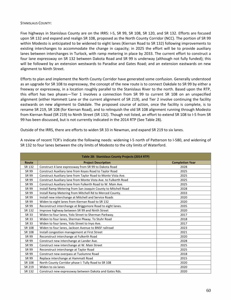
60
STANISLAUS COUNTY: Five highways in Stanislaus County are on the IRRS: I‐5, SR 99, SR 108, SR 120, and SR 132. Efforts are focused upon SR 132 and expand and realign SR 108, proposed as the North County Corridor (NCC). The portion of SR 99 within Modesto is anticipated to be widened to eight lanes (Kiernan Road to SR 132) following improvements to existing interchanges to accommodate the change in capacity; in 2025 the effort will be to provide auxiliary lanes between interchanges in Turlock, with ramp metering in place by 2033. The current effort to construct a four lane expressway on SR 132 between Dakota Road and SR 99 is underway (although not fully funded); this will be followed by an extension westwards to Paradise and Gates Road; and an extension eastwards on new alignment to Ninth Street. Efforts to plan and implement the North County Corridor have generated some confusion. Generally understood as an upgrade for SR 108 to expressway, the concept of the new route is to connect Oakdale to SR 99 by either a freeway or expressway, in a location roughly parallel to the Stanislaus River to the north. Based upon the RTP, this effort has two phases—Tier 1 involves a connection from SR 99 to current SR 108 on an unspecified alignment (either Hammett Lane or the current alignment of SR 219), and Tier 2 involve continuing the facility eastwards on new alignment to Oakdale. The proposed course of action, once the facility is complete, is to rename SR 219, SR 108 (for Kiernan Road), and to relinquish the old SR 108 alignment running through Modesto from Kiernan Road (SR 219) to Ninth Street (SR 132). Though not listed, an effort to extend SR 108 to I‐5 from SR 99 has been discussed, but is not currently indicated in the 2014 RTP (See Table 28). Outside of the IRRS, there are efforts to widen SR 33 in Newman, and expand SR 219 to six lanes. A review of recent TCR’s indicate the following needs: widening I‐5 north of Patterson to I‐580, and widening of SR 132 to four lanes between the city limits of Modesto to the city limits of Waterford.
Table 28: Stanislaus County Projects (2014 RTP)
Route Project Description Completion Year
SR 132 Construct 4 lane expressway from SR 99 to Dakota Road 2028
SR 99 Construct Auxiliary lane from Keyes Road to Taylor Road 2025
SR 99 Construct Auxiliary lane from Taylor Road to Monte Vista Ave. 2025
SR 99 Construct Auxiliary lane from Monte Vista Ave. to Fulkerth Road 2025
SR 99 Construct Auxiliary lane from Fulkerth Road to W. Main Ave. 2025
SR 99 Install Ramp Metering from San Joaquin County to Mitchell Road 2028
SR 99 Install Ramp Metering from Mitchell Rd to Merced County. 2033
SR 99 Install new interchange at Mitchell and Service Roads 2020
SR 99 Widen to eight lanes from Kiernan Road to SR 132 2020
SR 99 Reconstruct interchange at Briggsmore Road to eight lanes. 2035
SR 132 Improve highway between SR 99 and Ninth Street 2020
SR 33 Widen to four lanes, Yolo Street to Sherman Parkway. 2017
SR 33 Widen to four lanes, Sherman Pkway. To Stuhr Road 2018
SR 33 Widen to four lanes, Yolo Street to Inyo Ave. 2017
SR 108 Widen to four lanes, Jackson Avenue to BNSF railroad 2023
SR 108 Install congestion management at First Street 2021
SR 99 Reconstruct interchange at Fulkerth Road 2020
SR 99 Construct new interchange at Lander Ave. 2028
SR 99 Construct new interchange at W. Main Street 2025
SR 99 Reconstruct interchange at Taylor Road 2025
SR 99 Construct new overpass at Tuolumne Road 2018
SR 99 Replace interchange at Hammatt Road 2015
SR 108 North County Corridor phase I: Tully Road to SR 108 2020
SR 219 Widen to six lanes 2020
SR 132 Construct new expressway between Dakota and Gates Rds. 2020

61
TUOLUMNE COUNTY: Three State highways in Tuolumne County are on the IRRS: SR 49, SR 108, and SR 140. The Tuolumne County RTP may not reflect current planning priorities, as the second stage of the East Sonora Bypass was recently completed, but no third stage, though discussed with TCTC, is indicated in the RTP. (see Table 29) District 10 continues to work with TCTC and the City of Sonora on developing a complete streets strategy for downtown Sonora served by SR 49. Currently, the City, with assistance from TCTC, has developed a Vision Sonora document that that addresses locally desirable operational enhancements for active transportation, transit, and automobiles in the old town area.
Table 29: Highway Improvements in the Tuolumne County RTP (2007)
Route Tier Proposed Project
49,108 1a Widen to five lanes between Rawhide Rd, and Fifth Avenue (Jamestown, 2011)
120 1a Install Traffic Signal at SR 108—Yosemite Jct. (2020)
49 1a Realign route between Fraguero Rd to Mormon Creek Road (2020) {SHOPP}
120 1a Widen between Old Priest Grade and Big Oak Flat Road (Groveland, 2020) {SHOPP}
108,120 1a Pavement Rehabilitation between Tulloch Rd and Green Springs Road (2020) {SHOPP}
49 1b Widen to five lanes between Greenley Road extension to Parrott’s Ferry Road (Sonora, 2030)
49,108 2 Widen to five lanes between Chicken Ranch Road and Main Street (Jamestown, ND)
49,108 2 Widen to five lanes from Main Street to SR 49 diverge (Sonora, ND)
108,120 2 Widen to four lane expressway from Yosemite Jct to existing four lane. (ND)
49 2 Western Bypass (Sonora, ND)
49,108 2 Construct expressway (two or four lane) between High School Road and Rawhide Road (ND)
108 2 Widen to four lanes between SR 120 and SR 49 (ND)
ENVIRONMENTAL SETTING District 10 may be one of the more environmentally diverse in the State. The setting varies from the Sacramento and San Joaquin River's Delta in San Joaquin County, through the oak grassland and vernal pools of eastern San Joaquin, Stanislaus, and Merced Counties, into the Sierra Nevada Foothills, and the Sierra Nevada Range in Amador, Calaveras, Tuolumne, and Mariposa Counties, to the eastern slope of the Sierra Nevada and the Monitor Range in Alpine County. Within this diverse environment exist numerous recreation opportunities. Beside Yosemite National Park, the region has several State Parks, numerous boating, fishing, and swimming opportunities, as well as mountain bicycling, backpacking and hiking in Amador, Sierra, Stanislaus, and Toiyabe National Forests; and Merced, San Joaquin River, and San Luis National Wildlife Preserves; and in the Central California Section of the Bureau of Land Management. With such a varying range of environmental resources, there exist widespread environmental concerns. Widespread and specific issues related to biota, cultural resources, and wetlands exist in areas owned by various public land management agencies and the public. Industrial development was limited to older cities such as Stockton, mining districts extracting gold, copper, or asbestos, and now aggregate. As a landscape dominated by agriculture in the SJV, along with mining and timber harvesting in the mountain counties, the persistent disturbance has endangered or threatened many local species. Waterways and wetlands, such as the river system connected to the Sacramento and San Joaquin River Delta, along with the marshlands distributed along the San Joaquin River in Merced County, and the vernal pools that dot the Valley upland, occur throughout the region. Human occupation of the region dates back thousands of years to the end of the Pleistocene, providing extensive and numerous prehistoric, proto‐historic, and historic cultural resources. The SJV, being a depositional

62
basin, has yielded at times deposits of Tertiary and Quaternary period animal and plant remains, as has been the recent case with the recovery of mammoth bones and other mammal remains at the SR 99 construction in southern Merced County. Being an enclosed basin surrounded by mountains, and the presence of inversions and high pressure year round, the SJV often reports the worst air quality nation‐wide. Portions of I‐5 and I‐580, along with State Routes 4, 88, 89, 120 are designated scenic highways, with portions of SR 4 and SR 120 federally designated Scenic Byways (see Figure 20). Approximately one third of the area within the District is public land, with uplands dominated by the USDA Forest Service and the National Park Service, and the lowlands by the US Fish and Wildlife Service along with the US Bureau of Reclamation. District 10’s two Intergovernmental Review (IGR) units, Rural and Metropolitan, address the District’s commitment to sustainability with other planning agencies’ efforts to best conserve environmental values. Currently, a large number of Habitat Conservation Plans (HCP) are in the process of development for various planning and resource management entities in the region, most recently the joint Department of Water Resources (DWR)/United States Reclamation Services’ EIR/EIS for the Bay Delta habitat conservation plan, for which the District has commented. A significant environmental variable that will influence future District management decisions is global warming. Aside from efforts to reduce the carbon footprint of Department activities, and as well as residents of California using the SHS, are the considerations affiliated with rising sea level. Portions of SR‐4, SR‐12, and I‐5 that are in the Sacramento and San Joaquin Rivers Delta are below sea level. Though recent efforts to upgrade river deltas may reduce the concern of sea level rise overtopping the crest, research indicates an intensification of extreme weather events has been paired with increasing atmospheric temperatures. Elevation of the magnitude of rainfall and flood events, especially if associated with high tides may result in overtopping and levee failure.
CLIMATE CHANGE Climate Change refers to the pattern of increasing average global temperatures that have been observed over the past half century. The cause of the warming is the anthropogenic release of carbon dioxide by the burning of fossil fuels, and of methane through expansion of European grazing practices worldwide. As of 2012, 28% of the nation’s production of greenhouse gases were attributable to transportation (15% percent globally).47 Climate Change has produced three significant global shifts—increases in sea level, altered patterns of precipitation, and increased pH in the oceans. Two of these are significant for California—sea level rise and changes in precipitation. For District 10 this means there will be an increased susceptibility to flooding of highways located in proximity to river levees, or on segments located in areas below sea level (specifically SR 4 west of Stockton, portion of I‐5, and SR 12 west of Lodi). Efforts to address Climate Change need to consider two strategies—reduction of greenhouse gas emissions, and accommodating a changing climate. The first requires the adoption of alternative fuels, alternative and public transportation, and better land‐use patterns to begin reducing our country’s total vehicle miles traveled each year. The second requires investment in upgrading the portions of the multimodal transportation system most vulnerable to adverse climate changes.
47 Inventory of US Greenhouse Gas Emissions and Sinks 1990‐2012, US EPA

63
Figure 20: Scenic Highways in District 10

64
SUSTAINABILITY48 Caltrans is the public steward of the State’s transportation system. There are three elements to our role as steward—conservation, environmental justice, and sustainability. Sustainability is the effort to balance, preserve, and enhance social, community, environmental, and economic resources, now and for future generations. Applying the concept of sustainability to human activities presents some specific challenges, as sustainability refers to a stable ecosystem near or at its carrying capacity, while the human population growth is often portrayed as overshooting the carrying capacity of the planet.49 Caltrans efforts to develop a sustainable highways practice is in its initial stages. The concept was first identified in the SMF, and is most identified with the efforts to reduce greenhouse gas emissions. Federal Highway Administration (FHWA) developed a sustainable highways initiative in 2010. They provide a more expansive characterization of sustainability as “…the ‘triple bottom line’ concept, which includes giving consideration to three primary principles: Social, Environmental, and Economic. The goal of sustainability is the satisfaction of basic social and economic needs, both present and future, and the responsible use of natural resources, all while maintaining or improving the well‐being of the environment on which life depends.” This has led to the release earlier this year of the Infrastructure Voluntary Evaluation Sustainability Tool (INVEST). INVEST is intended as a practical, web‐based, collection of voluntary best practices, called criteria, designed to help transportation agencies integrate sustainability into their programs (policies, processes, procedures and practices) and projects. Caltrans is among the early users on the initial deployment.50 The Director’s Directive on this policy is still in draft form, but the criteria for this are laid out in both the SMF and CTP, and will be included in District practice.
48 See draft Directors Policy “On Stewardship and Sustainability” DP‐4 (December 11, 2014) 49This issue is best discussed in Hardin, Garret “The Tragedy of the Commons”, Science (162) pp1243‐1248 (1968) 50 Information on this can be found at: https://www.sustainablehighways.org/

65
2. MANAGEMENT PLAN
GOALS The Caltrans Mission is to provide a safe, sustainable, integrated and efficient transportation system to enhance California’s economy and livability. The Caltrans Vision is to be a performance‐driven, transparent and accountable organization that values its people, resources and partners, and meets new challenges through leadership, innovation and teamwork. Caltrans' Goals are:
Safety and Health‐‐To provide a safe transportation system for workers and users, and promote health through active transportation and reduced pollution in communities.
Stewardship and Efficiency‐‐Money counts, we need to responsibly manage California’s transportation‐related assets.
Sustainability, Livability and Economy‐‐The Department needs to make long‐lasting, smart mobility decisions that improve the environment, support a vibrant economy, and build communities, not sprawl.
System Performance‐‐The Department will utilize leadership, collaboration and strategic partnerships to develop an integrated transportation system that provides reliable and accessible mobility for travelers.
Organizational Excellence‐‐The Department will be a national leader in delivering quality service through excellent employee performance, public communication, and accountability.
Caltrans values integrity‐‐we promote trust and accountability through our consistent and honest actions; commitment‐‐we are dedicated to public service and strive for excellence and customer satisfaction; teamwork‐‐we inspire and motivate one another through effective communication, collaboration and partnership; and, innovation‐‐we are empowered to seek creative solutions and take intelligent risks. To implement our goals within a rubric of accountability, transparency, and being performance‐based, District 10 needs to characterize its baseline condition, and to assess the question of how well do we serve the public‐‐are we good stewards of the public trust? Only then can we then move forward to identify those actions we can undertake that directly influence performance, upon what time scales can performance be improved, and what are the best empirical and quantitative measures to assess improvement. For this reason, performance measures were not developed with this document, but will be provided in future DSMPs. Consistent with Caltrans' goals and by extension District 10’s goals for transportation are the goals of the California Transportation Plan (CTP):
1. Improve Multimodal Mobility and Accessibility for all People 2. Preserve the Multimodal Transportation System 3. Support a Vibrant Economy 4. Improve Public Safety and Security 5. Foster Livable and Healthy Communities and Promote Social Equity 6. Practice Environmental Stewardship
Caltrans is the steward of the State’s transportation system, within which it has specific responsibilities to address interregional travel, to maintain and upgrade the SHS, and to partner with local governments to address regional travel needs. District 10 is a geographical area within the political boundaries of the eight counties it
66
serves. District 10 is not autonomous, and must work with adjoining political jurisdictions and Caltrans districts to better serve its community. For a management plan to encompass its vision, it must rely upon accurate and up to date data to assess the choice of which priorities best serve long term public interests. This has been laid out in the first section of this report in which the District Overview characterizes the unique character of District demographics and commute dynamics, and the Transportation section in which the multimodal infrastructure has been laid out, with both its strengths and weaknesses defined. It should be noted that none of the goals explicitly address sustainability, though all five concern it. Sustainability refers to the ability of a system to efficiently use and conserve resources over a long time range, to ensure their availability for future generations. In California, our management of renewable electrical power may be seen as sustainable, sustainable as well as the recent concerted effort to reduce our water usage by updating irrigation systems with smart monitoring and control systems. In the case of Goal 1, completing and integrating the multimodal transportation system, the District does not see the current SHS it manages as capable of providing a sustainable transportation infrastructure, but is working towards one that in the future that may. Goal 2, better integration of transit into the multimodal transportation system, would appear to be an aspect of Goal 1, with the exception that transit planning is not handled directly by the District. Goal 3, improved corridor and reliability, directly relates to attaining a sustainable transportation system that makes less of a demand on time and energy. Goal 4, reduce fatalities, serious injuries, and collisions, reflects an improvement of the system’s efficiency. Goal 5, foster livable and healthy communities and promote social equity, places that are liable and healthy would be a product of a sustainable environment, while improved social equity can only improve sustainability as human talents and opportunities would not be lessened.
Goal 1: Improve multimodal mobility and accessibility for all people. The policies associated with this goal are:
1. Manage and operate an efficient integrated system. 2. Invest strategically to maximize system performance. 3. Provide viable and equitable multimodal choices including active transportation.
It is important to understand that District 10 is not autonomous, in that it cannot address all the planning needs of the SHS that its population uses. To achieve a planning process that is comprehensive, cooperative, and continual, District 10 must align its efforts with neighboring districts as well as local transportation planning agencies. Although there are projects identified for continued expansion of the system, the district must also consider strategies to monitor and analyze traffic patterns, optimize system performance, identify multimodal integration opportunities and collaborate on operational improvements as part of the District’s Transportation System Management and Operation (TSMO). District 10 in its partnering can point to many successes, but the relative disadvantages of a rural county maintaining a transportation infrastructure consistent with the planning goals and actions of neighboring urban districts are easy to enumerate. With a commuting population in which 10.3% carpool, and 1.3% use transit, a strong demand for managed lanes exists. Though the District may elect to support the development of special use lanes for transit and carpools on freeways that serve interregional commuting, most RTPs target freeway expansion to eight lanes before offering car pool or transit lanes. Six lane facilities exist on I‐5 and I‐205 in San Joaquin County. SJCOG envisions these facilities to be eight lanes complete with managed lanes by 2040. SR 99 has several projects to bring the facility up to six lanes for much of District 10, though some are partially funded. Efforts to expand the facility to eight

67
lanes are unconstrained, and only apply to Stanislaus County. Increased capacity of the freeway connectors between I‐5 and SR 99 include expansion of SR 120 to six lanes, and conversion of SR 132 to an expressway/freeway. Though needed, widening of the freeway portion of SR 4 may be infeasible given its lack of available right of way. A new highway connecting SR 99 and I‐5 near Stockton might need to be considered to in order to alleviate the traffic demand in 2040 (there are two traversable highways that may meet this need). All of these transportation corridors restrict bicycle and pedestrian access, and for the most part lack parallel facilities. The District needs to collaborate in providing the appropriate bicycle and pedestrian facilities by reviewing the local bicycle and pedestrian networks, and identify where improvements would fill service gaps, and second to review how best the corridor supports bicycle and pedestrian use, and to what purpose—work, leisure, running errands, or commuting to school. The goal is to enhance first and last mile connections. Transit presents another consideration. Although the Interstate corridor supports bus transit service into the Bay Area, and ACE provides passenger rail, the system lacks the network connections between these two systems, and does not provide similar access to intercity transit services or BRT. The SR 99 corridor although served by Amtrak San Joaquin, the passenger rail’s trains and buses do not operate during peak hour in the peak travel direction, and there is no intercity bus service with timely connections to other buses in which commuters throughout the corridor are served in an efficient and timely manner. Although the majority of workers in the mountain counties work in the SJV, none of the mountain counties provides a transit connection to the SJV. Within the mountain counties, the District will continue to develop better complete streets and context sensitive solutions strategies for many of the smaller towns and cities served by State highways in order to provide for needs of all travelers. Ideally, these efforts should permit future relinquishment of facilities to enable improved interregional travel times by bypassing the towns with expressways, while providing a conventional road facility that meets local needs and demands. To do this, our agency must be aware of local priorities as expressed by current and approved community plans and the like, and to construct a mechanism for which these needs may be incorporated into highway projects that address our agency’s needs. It may require a complete streets coordinator to interact with project managers early in the project development process to accomplish inclusion of these goals.
Goal 2: Preserve the Multimodal Transportation System The policies associated with this goal are:
1. Preserve the multimodal transportation system. 2. Apply sustainable preventative maintenance and rehabilitation strategies. 3. Evaluate multimodal life cycle costs in project decision making. 4. Adapt the transportation system to reduce impacts from climate change.
Preservation of the multimodal transportation system entails two practices—upkeep and operational modifications. Monitoring of the system conditions and operational performance is done through inspections, traffic studies and system analysis. The results of these efforts are used to prepare the Ten‐Year State Highway Operations and Protection Program (SHOPP). The funding source for the SHOPP is the State Highway Account (SHA) and is insufficient to preserve and maintain the existing transportation infrastructure. Due to these constrained resources, Caltrans and District 10 focus on the most critical project categories such as emergency, safety, mandates, bridge, pavement and culvert preservation.

68
All preservation efforts rely upon timeliness of the implementation of the action, the longer it takes to fix a problem from the time it is identified until the project is completed affects depreciation and scope. For example, a simple overlay, if constructed in time, may serve to maintain pavement condition for ten years, if delayed, conditions continue to deteriorate, and the life span may be reduced to five years, or a more extensive and expensive action may need to be undertaken. Efforts to integrate projects that share the same general location, and can mutually benefit by timely implementation to reduce traffic control and other costs have been underway for some time. Operational modifications or adjustments, may originate internally from the Traffic Operations Branch, Transportation Planning, or from local transportation planning agencies. These efforts address efforts to maintain multimodal functionality in face of changing uses upon the transportation system, and support sustainability. Spot locations that address congestion without adding capacity can be funded from the SHOPP. These operation improvements include but are not limited to:
Ramp metering
Traffic signal synchronization
Traveler Information systems (including possible vehicle classification abilities)
Incident management
Traffic monitoring systems However, with the decline in the availability and cost increases of the SHOPP, more collaboration with local partners is required. An example of a successful collaboration is the Ramp Metering Memorandum of Understanding with the SJCOG. This allows both the state and the local MPO to address both interregional and local transportation concerns.
Goal 3: Support a Vibrant Economy The policies associated with this goal are:
1. Support transportation choices to enhance economic activity. 2. Enhance freight mobility, reliability, and global competitiveness. 3. Seek sustainable and flexible funding to maintain and improve the system.
The Department serves two economic roles, one is direct, the other indirect. Our direct role is as a generator of private sector employment. This role is directly related to efforts to attain goals 1 and 2. Our indirect role is providing a transportation system that is efficient and reliable. Several benefits accrue with improved corridor efficiency and reliability. For commuters, trips to and from work, one can expect improved efficiency to reduce the time it takes to travel, while one can expect from improved reliability to keep each trip to within the same timeframe as before. These indirectly bring improved economic efficiency for the commuter and employer; and, a healthier lifestyle for commuters with less time spent coping with both the lack of activity and stress associated with driving. For goods movement, trips incur fewer costs from time spent driving to savings in expended fuel, leading to lower costs, along with improved efficiency. In order to promote improved efficiencies, District 10 is committed to strategies to optimize the existing transportation system by providing improved system monitoring and performance evaluations. This effort includes investing in Intelligent Transportations System (ITS) elements along key corridors within Distinct 10 such as SR 99, I‐5, and SR 120. With the installation of ITS elements, the District will be better equipped to begin developing Active Transportation Management strategies to optimize system efficiencies to promote time‐cost savings in goods movement.

69
Goal 4: Improve Public Safety and Security The policies associated with this goal are:
1. Reduce fatalities, serious injuries, and collisions. 2. Provide for system security, emergency preparedness, response, and recovery.
District 10 is committed to attaining and sustaining a safe SHS and adhering to the Strategic Highway Safety Plan (SHSP). An SHSP is a statewide data‐driven traffic safety plan that coordinates the efforts of a wide range of organizations to reduce traffic accident fatalities and serious injuries on all public roads. In coordination with federal, state, local and private sector safety stakeholders, the SHSP establishes goals, objectives, and emphasis (or challenge) areas. It is a continuous process to identify strategies based on collision data to reduce and eliminate safety hazards for all users. Federal regulations also require alignment with other plans including the California Transportation Plan, the California Freight Plan, and the Safety Improvement Program.
Although most planned and programmed projects have as part of their design a component to maintain or improve the safety of a corridor, projects that are explicitly undertaken to reduce fatalities, injuries, and collisions are programmed into the SHOPP under the program codes 201‐010 and 201‐015 or under the federal highway safety project program known as HB‐1. The District 10’s Safety Program includes efforts to move safety concerns from the conceptual phase to complete in construction expeditiously as possible. The District currently has 32 safety projects on its approved project list. Of these, four of the projects are candidates, two are in the process of completing a project initiation document (PID), seven are in the Project Approval and Environmental Document stage (PA/ED), with the rest are in the Plans, Specifications, and Estimates (PS&E) or Right of Way (R/W) phase. A table listing these projects is provided in the appendix. Monitoring their collective progress over time will be one performance measure on how well District 10 fulfills this goal. A comparison of Traffic Accident Surveillance and Analysis System (TASAS) reported collisions for 2010 to 2012 for Districts throughout the State is provided (Table 30). Those reported incidents were divided by the number of lane miles in District and the State for 2013. What the index over the last three years shows is that the District experienced fewer collisions per lane mile than the State, and that this ratio declined over time. Information on serious injuries and fatalities were not provided, but likely follow similar trends, but are probably closer in value (this assumes that more non‐serious or non‐fatal accidents accompany collisions on urban highway compared to rural).

70
Table 30: Comparison of collisions per lane mile for District 10 (2012)51
Year Statewide Average District 10 Average
2010 3.02 1.79
2011 2.94 1.70
2012 2.85 1.73
Goal 5: Foster Livable and Healthy Communities and Promote Social Equity The policies associated with this goal are:
1. Expand engagement in multimodal transportation planning and decision making. 2. Integrate multimodal transportation and land use development. 3. Integrate health and social equity into transportation planning and decision making.
In towns and cities a highway brings access to other places, and commerce. But a highway also brings noise, air pollution, and traffic. The negative impacts of a highway can be mitigated by many actions—elevating the driving surface; bypassing the town, with access by a turn off or an interchange; constructing sound walls; performing a speed survey. However, there is still interplay between a highway and humans that is adverse. One direct role the District can play is in assisting the development of active transportation networks in towns and cities served by conventional highways is to include design considerations for bikeways. This could be simple re‐striping or shoulder widening to provide for Class II (one way bike lane) or Class III (shared use) bikeways. With the passage of AB 1193 in 2014, Class IV protected bikeways within or along the roadway are also an option. These are options that can connect Class I bike paths that may currently exist or proposed by future local community developments for greater connectivity. Pedestrian needs may additionally be addressed by installation of complete sidewalks without gaps, marked crosswalks at intersections, and curb ramps that are ADA compliant. This need becomes especially apparent in small historic towns dependent upon tourism. These places were mostly constructed prior to the development of the modern highway system; the highway forms the main street connecting commercial areas, and was originally organized around walking. Less apparent would be initial District sponsorship of recreation bicycle routes that provide access from population centers to popular tourist destinations. A bicycle route connecting the Bay Area to Yosemite National Park, which could descend from the Altamont Pass and travel adjacent to the SR 120 or SR 140 corridors could be developed. A similar route could access Calaveras Big Trees and Alpine Lake on SR 4. The proposed bikeways could be a connection of the various bikeway classifications dependent upon the Right of Way availability and the configuration and designation of the transportation system. Similar walking corridors like the Mokelumne Coast to Crest Trail might also be a consideration, though walking paths often place a premium on solitude and isolation that may be aesthetically incompatible with vehicle traffic on highways. A District effort to address and promote social equity would be controversial. Through refurbishing overcrossings and undercrossing with pedestrian and bicycle accessible curbs and lanes, along with the installation of sound walls or other noise attenuating solutions at schools near or adjacent to past highway widening will promote better accessibility of lower income neighborhoods to schools and services. A first step to
51 HQ Division of Maintenance and Operations
71
address this potential need would be the development of a highway active transportation crossing plan that prioritizes locations for improvement. The second step would be to monitor the progress in making these improvements.
Goal 6: Practice Environmental Stewardship The policies associated with this goal are:
1. Integrate environmental considerations in all states of planning and implementation. 2. Conserve and enhance natural, agricultural, and cultural resources. 3. Reduce greenhouse gas emissions and other air pollutants. 4. Transform to a clean and energy efficient transportation system.
With the passage of the California Environmental Quality and the National Environmental Policy Acts, the Department has been expected to disclose any environmental impact brought about by an undertaking, and address the manner it may mitigate that impact. Department policies already advocate avoidance as the preferred project action as it has the least cost, and requires little time to implement. The Department already has implemented actions to make its fleets greener, and has installed several methanol filling stations. Previous efforts in District 10 include the installation solar panels and replacement of lights to LED bulbs. The district recently installed a second electric charging station and ad added an electric vehicle to the fleet. The West Coast Green Highway is an initiative to promote the use of cleaner fuels. The 1350 miles of I‐5 stretching from the U.S. border with Canada to the U.S. border with Mexico has been designated a “Corridor of the Future” by the US DOT. As part of this effort Caltrans is working with California Energy Commission to support the development of the I‐5 corridor as well as SR 99 to include deployment of alternative fuel stations for electric, hydrogen, natural gas, bio‐fueled vehicles. As these efforts progress, there will be opportunities for District 10 to participate in this effort along these two corridors.
POLICIES The District will work to:
Reduce fatalities, serious injuries, and collisions through problem identification, design, implementation of best practices, and education, providing safe mobility for all users, including motorists, bicyclists, pedestrians and transit riders.
Implement complete streets policy in all planning, programming, design, construction, operations, and maintenance activities and products on the State Highway System.
Create, manage and operate an efficient, integrated system, providing viable and equitable multimodal choices including the Active Transportation Program, and invests strategically to optimize system performance.
Deliver transportation projects and services efficiently.

72
Place an emphasis on sustainability and system preservation through preventive maintenance and rehabilitation strategies, evaluating life cycle costs in project decision making, and using performance measures to determine need for operational improvements.
Practice environmental stewardship and sustainability by integrating environmental considerations in all stages of planning and implementation, conserving natural and cultural resources, and reducing greenhouse gas emissions.
Integrate health and social equity in all transportation planning and decision making.
Support an efficient transportation system that improves the State's economic activity; enhances freight mobility, and reliability; and increases global competitiveness.
STRATEGIC CORRIDOR PLAN The Strategic Corridor Plan (Plan) is the outcome of the District review of various planned and proposed projects, and setting priorities for these projects. The Plan addresses each route, and segregates the project list by three categories—system expansion, these are mostly addressed by local planning agencies in their RTPs usually designated by STIP or Regional Improvement Program (RIP) funding; system management and operations, these are presently unfunded SHOPP candidates that improve highway operations; and system preservation, these are presently unfunded SHOPP candidates that maintain the existing highway facilities. Prioritization is only provided for system expansion relied on information available in RTPs as to completion dates. SHOPP project prioritization is based on the highest priority statewide needs for capital improvements which do not add a new traffic lane to the state highway system. It is not based on county shares or historical percentages. Since funding is constrained, the focus remains on the most critical categories of projects: safety, mandates, bridge and pavement preservation and culverts. Every traffic safety project (201.010) meeting specific criteria is programmed in the year in which it is estimated to be delivered. Reservations are held to fund projects as they are identified. All other SHOPP projects are programmed according to rehabilitation needs and category priorities established by each of the specific Statewide Program Managers. Beginning with the 2014 SHOPP, Regional Transportations Agencies have an opportunity to review and comment on proposed Draft SHOPP documents in an effort to provide improved communication and opportunity for coordination of projects. The following characterizations of State highways within the District are meant for summary purposes only. Particularly, statements characterizing current challenges assume future conditions will be consistent with previously proposed operational improvements and that maintaining facilities will be consistent with requirements of the Highway Design Manual. These statements address needs noted in TCRs but, as of yet, unaddressed by local RTPs. System and operations improvements listed may be adjusted upon the completion of the District 10 ITS/Ops Plan in 2017. The plan will identify those locations which may benefit by combining efforts to address operational improvements with congestion or traffic monitoring. The ITS/Ops Plan will prioritize these existing projects, and provide criteria for future prioritization. Included in the effort will be an evaluation of the existing Traffic Management Center in District 10, and recommendations to better facilitate traffic management.

73
State Route 4 (SR 4)
SR 4 originates from I‐80 in Contra Costa County, and terminates at SR 89 in Alpine County. Within District 10, SR 4 serves San Joaquin, Stanislaus, Calaveras, and Alpine Counties, and serves as an east/west freeway link between I‐5 and SR 99. Much of the rural route is built to conventional highway standards, with portions as expressway. Beyond SR 207 in Alpine County the route is closed in winter. Characteristics
On Interregional Road System with portions within the City Limits of Stockton on the National Highway System. Two segments are Terminal Access routes: Port of Stockton Expressway to O’Byrnes Ferry Road (Copperopolis), and, from SR 49 (Angels Camp) to SR 207 (Bear Valley). The freeway portion is part of the Strategic Highway Network (STRAHNET).
Achievements
New expressway bypassing congested section serving Angels Camp constructed. Realign SJ‐4 along Navy Drive to access Port of Stockton
Opportunities
Need to upgrade and improve connectivity to San Francisco Bay Area constrained by Bay Delta wetlands and antiquated two lane bridges; extension of freeway to Port of Stockton, and creating a through route; and the future widening of freeway section between I‐5 and SR 99.
System Expansion Priority 1: Wagon Trail Priority 2: Expansion and widening of SJ‐4 between the Contra Costa County line to Tracy Boulevard
System Management and Operations
Vallecito Intersection Improvements EA 10‐0G230 Arnold Curve Correction EA 10‐0F950
System Preservation
Maintenance Vehicle Pullouts (MVP) and Roadside Paving (Freeway) EA 10‐0X690 Bear Valley CAPM EA 10‐0J720 Bridge rail upgrade on Old River Bridge EA 10‐0G260 Highway Beautification and Modernization (Freeway) EA 10‐0G330
Interstate 5 (I‐5)
I‐5 originates at the Mexican border near San Diego and ends at the Oregon border north of Yreka. As an interstate, I‐5 is on the IRRS and is a high emphasis route along the portions that are rural. I‐5 serves California as the principal north/south route that supports high volumes of traffic and freight. Within District 10 it serves as the interregional work commute to the San Francisco Bay Area and the regional work commute within San

74
Joaquin County. From Merced County to Lathrop, I‐5 is rural. From Lathrop to Lodi the route is mostly urban, and it continues from Lodi to the Sacramento County line in a rural setting. Characteristics
I‐5 is a High Emphasis/Focus Route on the IRRS and on the NHS. It is designated part of the National Network by the STAA for large trucks, part of the Primary Freight Network by Moving Ahead for Progress in the 21st Century (MAP‐21) and on STRAHNET.
Achievements Although a high emphasis route in the IRRS, all of I‐5 is constructed to freeway standards, and has attained the primary goal of the ITSP. Targeted improvements such as widening the freeway north of the Channel Viaduct to Benjamin Holt are underway. Median barrier constructed between Turner road and Beavers Slough Bridge.
Opportunities For the segment of I‐5 from the Eleventh Street Interchange east of Tracy north to the SR 12 Interchange the concept LOS will become deficient by 2030. Improvement is constrained by the need to replace two bridges over portions of the San Joaquin River: Mossdale (at the SR 120 Interchange) and the San Joaquin River Viaduct (near the SR 4 Interchange), though programmed projects are included in the SJCOG RTP to address this need. Currently programmed projects to address need will require additional operational improvements as outlined in the I‐205/I‐5 CSMP, as well as future interchange spacing consistent with current Highway Design Manual (HDM).
System Expansion Priority 1: Widen to eight lanes between French Camp Road to Charter Way Priority 2: Widen to eight lanes between Hammer Lane and Eight Mile Road Priority 3: Widen to eight lanes between SR 120 and French Camp Road Priority 4: Widen to twelve lanes between I‐205 and SR 120 Priority 5: Widen to eight lanes Eight Mile Road to Gateway Boulevard Priority 6: Widen to six lanes between Sperry Road and I‐580 (S) Priority 7: Widen to six lanes between I‐580 and I‐205
System Management and Operations Westley I‐5 Median Barrier EA 10‐0Y640 Roadside Safety Improvements between SR 4 and SR 12 Roadside Safety Improvements between Manilla and SR 4 Roadside Safety Improvements near Lodi Roadside Safety Improvements near Tracy EA 10‐1C780 Upgrade and repair TMS elements EA 10‐1C960 Closed Circuit Television Cameras (CCTV) and Highway Advisory Radios (HARs) in SJ EA 10‐3A380
System Preservation Overlay between Eight Mile Road and Sacramento County line MVP and Roadside Paving between Louise Ave. and Eight Mile Road EA 10‐0X720 Replace Paradise Cut Bridge EA 10‐0W210 Stockton Channel Viaduct Rehab EA 10‐0X460

75
Ramp work between Garzas Creek Bridge and San Joaquin County line EA 10‐4773U Resurface Bridge Decks between Hospital Creek and Pixley Slough Bridges. EA 10‐0G240 Bridge Rehab for Ten Bridges EA 10‐0P540 Improve Westley Rest Area EA 10‐1C270 Santa Nella CAPM EA 10‐1C510
State Route 12 (SR 12)
SR 12 originates from SR 1 in Sonoma County and terminates at SR 49 at San Andreas. Within District 10, the route serves San Joaquin and Calaveras Counties. A considerable portion of the route is constructed to conventional highway standards. The route serves as an important agricultural freight connection to the northern Bay Area. SR 12 serves as a big box retail center, “Main Street” for the City of Lodi. Characteristics
SR 12 is on the IRRS. From San Joaquin county line to where SR 12 diverges from SR 88 north of Clements is designated on the NHS and is an STAA Terminal Access Route.
Achievements
Construction of median barrier on Bouldin Island underway. Installation of ITS elements along I‐5 underway. Updating of conventional highway section west of Burson at Pettinger Road to current design standards completed.
Opportunities There is a need for the route to serve as third east west expressway or freeway connection between I‐5 and SR 99. A new alignment would reduce need to address conditions on conventional highway segment serving Lodi. An antiquated bridge (Mokelumne River Bridge) constrains expansion of facility to four lanes expressway westwards to Solano County.
System Expansion
Priority 1: Widen to six lanes between Lower Sacramento Road and SR 99 Priority 2: Widen to four lanes between I‐5 and Lower Sacramento Road Priority 3: Widen to four lanes between Sacramento County line and I‐5 Priority 4: Bypass Valley Springs
System Management and Operations
No project improvements identified at this time. Will continue to evaluate and recommend improvements as needs arise.
System Preservation
Structural Section Repair (Lodi Rehab #1) between Terminous and PM 9.5. EA 10‐281150 Lockeford Culvert Rehab EA 10‐0S990

76
State Route 16 (SR 16)
SR 16 consists of two segments. The western section originates from SR 20 in Colusa County (Wilbur Springs) to I‐5 (Woodland), and the eastern section originates from SR 50 (Sacramento) to SR 49 (Plymouth). Within District 10, SR 16 accesses Amador County and is a rural expressway. Characteristics
The route is on IRRS and is an STAA Terminal Access Route.
Achievements No projects identified.
Opportunities Future widening to four lanes to meet current and future work commute to Sacramento region and access control to maintain expressway standards.
System Expansion No project improvements identified at this time. Will continue to evaluate and recommend improvements as needs arise.
System Management and Operations
Improve highway operations between SR 124 and SR 4952
System Preservation No project improvements identified at this time. Will continue to evaluate and recommend improvements as needs arise.
State Route 26 (SR 26)
SR 26 is an east/west two lane conventional highway beginning at SR 99 (Fremont Street) in Stockton and ending at SR 88 east of Pine Grove in Amador County. This 63.47 mile corridor lies entirely within District 10, crossing San Joaquin and Calaveras Counties and a small portion of Amador County. It also traverses the communities of Stockton, Linden, Bellota, Valley Springs, Mokelumne Hill, Glencoe, and West Point. SR 26 runs concurrently with SR 12 in Valley Springs from the West Junction of SR 12 (CAL post mile (PM) 010.302) to the East Junction of SR 12 (CAL PM 010.435). This corridor primarily serves interregional traffic. In the Stockton area, the SR 26 corridor serves commercial/industrial development and is a major truck route for the transfer of solid waste from Stockton to the facility in Bellota, the Foothill Sanitary Landfill. Average daily volume is 620 tons and reached 212,190 tons delivered in 2011. It also serves as a local commuter route in the cities of Stockton and Linden. SR 26 serves to provide access to New Hogan Reservoir, and the Rancho Calaveras and La Contenta residential developments near Valley Springs. This corridor serves as an important access route to many other communities and recreational facilities of the Gold Country and as a corridor for “farm to market” goods.
52 See SR 16 TCR.

77
Characteristics The route is on the California Freeway and Expressway (F&E) system from SR 99 to SR 12 but not on the IRRS. It is a Terminal Access Route consistent with STAA provision from SR 99 to Podesta Farms; on the California Legal Truck Network with a king pin to rear axle length of 40' from Podesta Farms to Escalon Belotta Rd; and from SR 12 to SR 49 and an Advisory Truck Route for trucks with a king‐pin‐to‐rear‐axle length of 30' or 32' or less from Escalon Belotta Road to SR 12; and for SR 49 to SR 88.
Achievements
Shelley Curve Correction Opportunities
There is a need for access management in urban areas‐‐Stockton (from SR 99 to the Stockton Diverting Canal) and Rancho Calaveras/Valley Springs (Olive Orchard Road to SR 12). Due to hilly terrain and narrow to non‐existent shoulders on the roads, bicycle facilities are limited in Calaveras and Amador Counties.
System Expansion
No project improvements identified at this time. Will continue to evaluate and recommend improvements as needs arise.
System Management and Operations
SR 26 Rumble Strips EA 10‐0Y650 System Preservation
Replace Bridge Rails at Calaveras River Bridge EA 10‐0C840 Slope Stabilization at 12 locations in Calaveras County EA 10‐0V480
State Route 33 (SR 33)
SR 33 is primarily a north/south rural route that begins at I‐5 in Merced County, south of Dos Palos, and it ends in San Joaquin County, north of the SR 132 interchange in Vernalis. The corridor traverses the flat lands of Western SJV. The first city it crosses through is Dos Palos. At SR 152 it becomes the concurrent route in an east/west trajectory for approximately 21 miles, which includes the City of Los Banos. Then, SR 33 continues in a north/south direction through the City of Gustine and up to the Merced/Stanislaus County Line. In Stanislaus County it continues in a north/south trajectory through the cities of Newman and Patterson, then up to the Stanislaus/San Joaquin County Line ending at Vernalis in San Joaquin County. The corridor serves as a connector between I‐5 and SR 152, SR 59, SR 165, SR 132, SR 99, and SR 580/SR 205. Characteristics
It is on the F&E System and is on the NHS where it is concurrent with SR 152. Its functional classification is a minor arterial until it becomes concurrent with SR 152. It begins again at Gonzaga Road, and makes a north/south trajectory to I‐5 as a minor arterial again. From I‐5 it continues as a major collector until it becomes a concurrent route with SR 140 through the City of Gustine. It begins again as a major collector until the City of Patterson where it is classed as a minor arterial through the city limits only. Beyond Patterson, SR 33 is a major collector until its terminus in Vernalis in San Joaquin County.

78
The highway functions as a “main street” through the towns of Dos Palos, Los Banos, Gustine, Newman, and Patterson. It is a part of the STAA Terminal Access route system for heavy duty trucks, except from Cottonwood Road in Merced County (PM 22.440) to the south junction of SR 140 in Gustine (PM 26.463), where it is classed as California Legal Network. Where SR 33 is concurrent with SR 140 in Gustine it is California Legal Advisory.
Achievements
No projects identified.
Opportunities Access Management continues to be a challenge. Route Conditions‐‐Congestion through the City of Los Banos where it is concurrent with SR 152, Pacheco Boulevard is already at LOS F. Traffic congestion will increase at a growth rate of 1.52 percent between the Los Banos College entrance (East side) and SR 165, and between Wards Ferry Road and SR 165 at 2.65 percent per year (West side). It closely parallels the railroad tracks between I‐5 and Gustine. Several bridges require upgrade of bridge rails—three in Stanislaus County and three in Merced County. The California Aqueduct crossing (Bridge Number 39‐0190) will require a seismic retrofit and is in the ten year plan.
System Expansion Priority 1: Widen to five lanes in City of Newman (Non‐STIP) Priority 2: Widen to five lanes in City of Patterson
System Management and Operations
Install Rumble Strips in Merced and Stanislaus Counties. EA 10‐1C490
System Preservation No project improvements identified at this time. Will continue to evaluate and recommend improvements as needs arise.
State Route 41 (SR 41)
Although a small portion of SR 41 is located within District 10 in Mariposa County (Fish Camp and the surrounding vicinity), the route in its entirety is assigned to Caltrans District 6 for reporting purposes. SR 41 can be found within the District 6 Transportation Concept Report.
State Route 49 (SR 49)
The Golden Chain Highway, SR 49 originates at SR 41 in Oakhurst in Madera County and ends at SR 70 near Vinton in Plumas County. In District 10, SR 49 traverses Mariposa, Tuolumne, Calaveras, and Amador Counties. SR 49 serves twenty one communities in the Gold Country and is considered a ‘Main Street’ highway for the City of Sonora, the City of Angels Camp, the town of San Andreas, and the City of Jackson, among others.
79
It leaves District 10 at the Amador/El Dorado county line north of the City of Plymouth. In addition to being used locally by area commute traffic, SR 49 is also a highly desirable recreation and tourism route with considerable weekend traffic. It is has been accepted for inclusion into the NHS. Characteristics
SR 49 is on the National Highway System between Mariposa at SR 140 and SR 16. The route is built to expressway facility from Madera County line to SR 140, on the F&E system SR 108W to SR 108E, and from SR 88 in Jackson to the El Dorado County line, and conventional highway for the rest of the route. Truck access on the route varies. Segments of SR 49 that are Terminal Access Routes: from the Madera County Line to 1.25 miles north of Bear Valley Road in Mariposa County; from SR 120 to Ponderosa Dr. in Tuolumne County; from Finnegan Lane (Angels Camp) to SR 12 in Calaveras County; and from Scottsville Boulevard (Jackson) to Main St in Plymouth in Amador County. One Segment of SR 49 is on the California Legal Truck Network, the segment from SR 12 (Calaveras County) to Scottsville Blvd (Jackson, Amador County). Segments that are posted as advisory for vehicles with a kingpin‐to‐rear‐axle (KPRA) length of over 30' from 1.25 miles north of Bear Valley (Mariposa County) to the SR 120 (Tuolumne County); from Ponderosa Road (Tuolumne County) to Finnegan Lane (Calaveras County); and, from Main Street (Plymouth, Amador County) to the El Dorado County line. SR 49 is accessible to bicycles.
Achievements SR 49 and Ashworth Road left turn channelization and roadway widening Poppy Hills Drive curve improvement (realign roadway and widen shoulders) Jamestown acceleration lane Sutter Creek Bypass Jackson Gate Traffic Signal
Opportunities Balancing system need for expressway facilities to fulfill Caltrans' commitment to interregional travel through access management and context sensitivity to local concerns and needs related to the highway as ‘Main Street.’ Improve segments of SR‐49 crossing the Merced, and Stanislaus River Canyons from advisory truck routes to Terminal Access Truck Routes.
System Expansion Priority 1: Widen to five lanes between Greeley Road and Parrotts Ferry Road Priority 2: New expressway to bypass Angels Camp Priority 3a: Widen to five lanes between Chicken Ranch Road and Main Street53 Priority 3b: Widen to five lanes between Main Street and Sonora exit
53 Priority 3a and 3b have same year of completion, this applies elsewhere

80
System Management and Operations Install Rumble Strips in Calaveras and Amador Counties EA 10‐0Y980 Improve Shaw’s Flat Intersection EA 10‐1E290 Jamestown Two Way Left Turn Lane EA 10‐0G940
System Preservation Moccasin Creek Slip out Repair EA 10‐0L790 Jackson Overlay EA 10‐46130 Remove and Replace Bridge Rail at Calaveritas Creek EA 10‐0V190 Bridge rail replacement or upgrade EA 10‐0W960
State Route 59 (SR 59)
SR 59 is primarily a south to north rural route that begins at SR 152 in Merced County where it proceeds north through the town of El Nido into the city of Merced. There, it runs concurrently with SR 99 freeway and SR 140 where to ‘R’ and ‘V’ Street. From the ‘R’ and ‘V’ Street interchanges, SR 59 continues north, and terminates in the town of Snelling, at the intersection of County Routes J59 and J16. Characteristics
It is on the F&E System and is a Terminal Access Truck Route.
Achievements Construction of the Atwater Merced Expressway Interchange on SR 99 (replacing Buhach Road Interchange).
Opportunities Realign SR 59 away from the City of Merced as the Atwater Merced Expressway. Relinquishment of portion of SR 59 north of SR 99 from State to local control (or with the realignment of the Merced Atwater Expressway, north to Bellevue Road).
System Expansion Realignment onto Buhach Road and the Merced Atwater Expressway
System Management and Operations Install Roundabout at Olive Avenue/Santa Fe Dr. Intersection EA 10‐1E350
System Preservation
Mariposa Creek Rehab EA 3A670 Replace and widen Bear Creek and Black Rascal Bridges EA 3A270
State Route 88 (SR 88)
SR 88 begins at SR 99 (Stockton) and terminates at the Nevada state line in Alpine County. The route serves San Joaquin, Amador, and Alpine Counties. All of the route is conventional highway, and is the only route in the District crossing the Sierra Nevada that is open year round. The route serves as a “main street” for Waterloo, Lockeford, Clements, Jackson, Pine Grove, Pioneer, and Buckhorn.

81
Characteristics It is on the IRRS and is on the NHS from SR 99 (Stockton) to SR 49 (Martell). Terminal Access Route from SR 99 to SR 49; and from Caples Lake (Alpine County) to Nevada State Line.
Achievements Widened two narrow bridges between San Joaquin and Amador County lines and SR 104 as part of a pavement overlay project (in construction).
Opportunities San Joaquin County portion of the route has seven signals, and proposes another at Liberty Road. Signals along with reduced speed limits within towns reduce effectiveness of SR 88 as rural highway and future expressway. Future consideration of new route or bypasses may be needed, as widening to four lanes may be unfeasible. Increased passing opportunities in Amador and Alpine Counties are needed to lessen the delay caused by high truck and recreational traffic to restore highway performance. Consideration for a snow shed may eliminate or reduce annual needs for avalanche control.
Access management continues to be a concern.
System Expansion: Priority 1: Pine Grove Corridor Improvements Priority 2: Widen to four lanes between SR 12 W and SR 12 E
System Management and Operations: Install Rumble Strips between View Lane and Mokelumne River Bridge 10‐0Y680
System Preservation:
Roadside Safety Improvements/Chain Control Lighting, Jackson to Carson Pass Rock Slope Repair (Alpine) EA 10‐0H870 Caples Lake Rehab EA 10‐0J600 Peddler Hill Rehab EA 10‐0K130 Carson Spur Rehab EA 10‐0M790 CAPM between SR 124 and SR 49 EA 10‐0Q210 Drainage System Work EA 10‐0S740 Rehab between Waterloo and Lockeford EA 10‐27920 Carson River Bridge Scour Mitigation EA 10‐0X470
State Route 89 (SR 89)
SR 89 originates at SR 395 (Mono County) and continues north to terminate at I‐5 (Siskiyou County). The route runs through Alpine County, and is a "main street" for the town of Markleeville. The current facility is conventional highway. The portion of the route south of SR 4 is closed in winter. Characteristics
The route is on the IRRS and is a Terminal Access route from the El Dorado County line south to Pine Hill Resort (Markleeville).

82
Achievements No projects identified.
Opportunities
Increased passing opportunities north of SR 88 to the El Dorado County line.
System Expansion Priority 1: Truck climbing lane between SR 88 and El Dorado County line
System Management and Operations No project improvements identified at this time. Will continue to evaluate and recommend improvements as needs arise.
System Preservation No project improvements identified at this time. Will continue to evaluate and recommend improvements as needs arise.
State Route 99 (SR 99)
As the principal north/south freeway in the Central Valley, SR 99 is also a major connector to all east/west routes that link to the San Francisco Bay Area, the Central Coast, and the Sierra Nevada mountains. SR 99 provides for movement of goods for the entire Central Valley particularly with respect to shipment of agricultural products to both domestic and world markets. Agriculture, while the valley’s most significant economic activity, is also a major component in the larger California economy. Department of Finance statistics shows that over 50% of California’s agricultural output originates in SR 99 corridor counties. Characteristics
SR 99 is both a State High Emphasis and Focus Route on the IRRS. It is functionally classified as an ‘other principal arterial,’ part of the F&E system, and on the MAP‐21 NHS. The route is included in the Non‐Interstate STRAHNET under the Federal‐Aid Surface Transportation Program and a part of the National Truck Network of the STAA for large trucks. As Intermodal Corridor of Economic Significance (ICES), SR 99 has been deemed by the State to be critical to statewide movement of freight.
Achievements South Stockton Widening Pelandale Interchange Kiernan Road/SR 219 Interchange Southbound Livingston Median Widening Arboleda Freeway and Interchange Plainsburg Freeway and Interchange

83
Opportunities The Interregional Transportation Strategic Plan (1998)54 identifies a concept facility of eight lanes for SR 99. Included in the concept facility are managed lanes for carpooling, transit, or high occupancy toll lanes. Thirty three bridges have vertical clearances of 16 feet or less. Increased vertical clearance will assist improved goods movement.
System Expansion
Priority 1: Widen to six lanes between Livingston and Stanislaus County line (northbound) Priority 2: Widen between Harney Lane and Turner Road Priority 3: Widen to six lanes within City of Merced and Atwater Priority 4: Widen to six lanes between Turner Road and Sacramento County line Priority 5a: Widen to eight lanes between Mitchell Road and Hatch Road Priority 5b: Widen to eight lanes between Hatch Road and Tuolumne Road Priority 5c: Widen to eight lanes between Tuolumne Road and Kansas Ave. Priority 5d: Widen to eight lanes between Kansas Ave. and Carpenter Road Priority 5e: Widen to eight lanes between Carpenter Road and San Joaquin County line
System Management and Operations Install Auxiliary Lane between Keyes Rd and Taylor Road (STANCOG) Install Auxiliary Lane between Taylor Rd and Monte Vista Ave. (STANCOG) Install Auxiliary Lane between Monte Vista Ave. and Fulkerth Road (STANCOG) Install Auxiliary Lane between Fulkerth Road and W. Main Ave. (STANCOG) Roadside Safety Improvements in Livingston, No ID Livingston Median Barrier EA 10‐0Y630 Install TMS elements between Whitmore Ave. and Hammatt Road EA 10‐0M950 Install Ramp Meters, ITS, and fiber optic between Jack Tone Road and SR 120 E EA 10‐1C301 Install Ramp Meters, ITS, and fiber optic in Stanislaus County EA 10‐1C304 Relocate overhead signs on various locations EA 10‐0Y620 Auxiliary Lane between Hatch Road and Ninth Street EA 10‐0L870 Modify the Beckwith Road/Carpenter Road Interchange EA 10‐0V110 Victor Road (SR 12) On Ramp EA 10‐1C280 Improve Turner Road Onramp EA 10‐1C260 Install Rumble Strips (MER, SJ, STA) EA 10‐1C470
System Preservation SJ 99 MVP EA 10‐0X640 STA 99 MVP, Extend Gore, Pave Slopes EA 10‐0X660 Upgrade Planting and Irrigation between SR 88 and Peltier Road EA 10‐0C880 Turner Station Rehab EA 10‐0E170 Ripon Planting Rehab Between Stanislaus River Bridge and Milgeo Ave. EA 10‐0H490 Highway Planting, Childs Ave. to West Merced OH EA 10‐0L010 Lathrop/Arch Road Overlay or CAPM EA 10‐0Q150 SR 99 Merced Rehab EA 10‐1C170 Mer 99 Roadway Rehab between Westside Blvd to Buhach Road EA 10‐3A720 STA Lighting, Between Whitmore Avenue and Tuolumne Boulevard EA 10‐0Y010
54 The 2015 update of the ITSP employs a multimodal corridor concept that may shift planning emphasis towards prioritizing active transportation, and de-emphasis upon a interconnecting system of expressways, although an approved final document is unavailable at this time.
84
State Route 104 (SR 104)
SR 104 is an east to west rural route originating at SR 99 at Galt (Sacramento County), passes through Clay and Ione, joins SR 88 and splits off on Ridge Road near Martell, and terminates at SR‐49 in Sutter Hill. An unbuilt portion of the route continues from SR 49 and continues east on Ridge Road to a terminus at SR 88 in Pine Grove. The corridor is a minor arterial or major connector, with moderate to light traffic volumes, that provides a “Main Street” to the City of Ione’s historic district, and because of such is an advisory truck route. Characteristics
SR 104 is on the F&E System. It is a part of the STAA Terminal Access route system for trucks from PM 8.386 and 10.072. The rest of the route is either California Legal or California Legal Advisory with a KPRA advisory of a 30' length for trucks. SR 104 is accessible to bicycles.
Achievements A Highway Rail Grade Crossing warning device is in construction in Amador County near Ione on SR 104 at Edwin railroad crossing. The Dry Creek Bridge was replaced in February 2007.
Opportunities The Ione Bypass which would create a new two lane expressway on a new alignment from Collins Road left to Foothill Blvd Left PM 4.0 to 6.5 will move traffic around the city of Ione. It has been an inactive project for several years. Environmental Issues‐‐Amador County has been designated as non‐attainment for the 8 hour ozone classification. Transportation projects now need to be fiscally constrained and included in a Transportation Demand Management (TDM) model. Access control to maintain highway performance.
System Expansion Priority 1: Construct new expressway to bypass downtown Ione.
System Management and Operations No project improvements identified at this time. Will continue to evaluate and recommend improvements as needs arise.
System Preservation No project improvements identified at this time. Will continue to evaluate and recommend improvements as needs arise.
85
State Route 108 (SR 108)
SR 108 is an east to west route originating from SR 132 (Modesto) and ending at SR 395 (north of Bridgeport) with an unbuilt portion located between I‐5 and SR 99. The route is subject to winter closure past the community of Strawberry. For all of Stanislaus County the route is conventional highway, but portions of the year round route are built to expressway in Tuolumne County. Characteristics
On the IRRS. It is included in the NHS for Stanislaus, and Tuolumne County west of Sonora. Terminal Access from Intersection of McHenry Boulevard and Needham Street (Modesto) eastwards to Herring Lane (Strawberry).
Achievements Construction of East Sonora Bypass Phase II.
Opportunities Need for ongoing effort to close gaps between existing expressways in Tuolumne County east of Sonora. A southern west to east connector between I‐5 and SR 99 may be needed in the future, and may be met by the unbuilt portion of the highway. Relinquishment of a portion of SR 108 within the City of Modesto from State to local control.
System Expansion Priority 1: North County Corridor phase 1 (west of McHenry Ave.) Priority 2: Widen to four lanes between Jackson Ave. and BNSF tracks. (Non‐STIP) Priority 3: East Sonora Bypass Stage III Priority 4: North County Corridor phase 2 (east of McHenry Ave.) Priority 5: Widen to six lanes from Modesto City Limits to General Plan Boundary (partial) Priority 6: Widen to four lanes between SR 120 and SR 49
System Management and Operations Roadside Safety Improvements, Chain Control Lighting Improve Yosemite Junction Intersection EA 10‐1C540
System Preservation East Long Barn Rehab, between Long Barn and Heliport Road EA 10‐46210 Install Wire Mesh between Old Strawberry Road and Beardsley Road EA 10‐0Y800
State Route 120 (SR 120)
SR 120 is an east to west route beginning at I‐5 west of Manteca. The route continues east through Escalon, Oakdale, Chinese Camp, Big Oak Flat, Groveland, and into Yosemite National Park. From the Park is continues eastward into Mono County, and terminates as SR 6 near the Nevada border. The corridor provides a convenient east/west linkage for commuter and recreational traffic between the Bay Area and the Sierra Nevada mountains.

86
Between I‐5 and SR 99, SR 120 is Freeway. East of SR 99 it is conventional highway, and serves as a “main Street’ for Oakdale, Big Oak Flat, and Groveland. The primary recreation access to Yosemite Park, SR 120 experiences heavy traffic volumes during the weekends. Characteristics
SR 120 is on the IRRS, the NHS, and eligible for State scenic highway status in Tuolumne and Mariposa Counties. As a truck route, it is an STAA compliant Terminal Access route through San Joaquin, Stanislaus, Mariposa, and Tuolumne Counties to its intersection with SR 49 South. Past SR 49 South, it becomes a California Advisory Truck Route until the entrance to Yosemite National Park.
Achievements The North County Corridor has been conceptualized for a portion of SR 120 through the City of Oakdale. SR 120 was included within the SJV HOV and Ramp Metering Study and is included as a potential route for HOV lanes and ramp metering between I‐5 and SR 99.
Opportunities Several at grade rail road crossings exist on the route in the Cities of Escalon and Oakdale.
System Expansion
Priority 1: Widen to six lanes between I‐5 and SR 99 Priority 2: Widen between Old Priest Grade and Big Oak Flat Road Priority 2: Widen to four lanes between Yosemite Junction to existing four lane Priority 3: Widen to four lanes from Tuolumne County line to Oakdale Priority 4: New expressway bypassing Escalon
System Management and Operations No project improvements identified at this time. District 10 will continue to evaluate and recommend improvements as needs arise.
System Preservation
SR 120 MVP and Roadside Paving (freeway) EA 10‐0X710 Chinese Camp Rehab II, between Shawmut Road and Moccasin Creek Bridge. EA 10‐3A700 CAPM east of Buck Meadows (between Groveland and Buck Meadows) EA 10‐0E960 Blitz Creek Bridge Scour Mitigation EA 10‐0X0500 Build Safety Roadside Rest Area at Yosemite Jct. EA 10‐29646
State Route 124 (SR 124)
SR 124 begins at SR 88 south of the City of Ione and terminates at SR 16. A conventional highway south of Ione, and an expressway north of Ione. SR124 experiences light vehicular and truck traffic Characteristics
SR 124 is on the California F&E system in its entirety.

87
As a truck route, SR 124 is an STAA compliant Terminal Access Route from for one mile north of SR 88, and for the rest of the route is a California Advisory Truck Route to its terminus at SR 16. In the City of Ione, the State highway is also the “Main Street”.
Achievements
No projects identified.
Opportunities Access management Context sensitive solutions for downtown Ione Downtown Ione geometrics
System Expansion
No project improvements identified at this time. Will continue to evaluate and recommend improvements as needs arise.
System Management and Operations No project improvements identified at this time. Will continue to evaluate and recommend improvements as needs arise.
System Preservation No project improvements identified at this time. Will continue to evaluate and recommend improvements as needs arise.
State Route 132 (SR 132)
SR 132 is an east to west route completely within District 10. Originating at I‐580, the route terminates at SR 49 (Coulterville), and serves San Joaquin, Stanislaus, Mariposa and Tuolumne Counties. Aside from a short segment in San Joaquin County, the entire route is conventional highway. The route serves as “Main Street” for the community of Empire, City of Waterford, and the town of La Grange. Characteristics
Segments between I‐580 and SR 99 are on the IRRS; and the portion between I‐5 and the unbuilt SR 65 is on the F&E System. It is on the NHS from I‐580 to Root Road (Empire) and is a Terminal Access Route from I‐580 to SR 99. Important freight corridor from I‐580 to Santa Fe Road in Empire.
Achievements
Widening highway to four lanes between Riverside Drive and Franzine/Condoni Drives (Modesto).
Opportunities Fill gaps between four lane freeway segment between I‐580 and I‐5 with programmed new four lane expressway at SR 99.
System Expansion
Priority 1: Construct new expressway from SR 99 to Dakota Road Priority 2: Construct new expressway between Dakota Road and Paradise/Gates Roads Priority 3: Construct four lane expressway between SR 33 and Stanislaus County line

88
Priority 4: Improve connection to SR 99 (to Santa Fe Ave.) Priority 5: Widen to four lanes between Santa Fe Ave. and Geer Road
System Management and Operations Safety Improvements EA 10‐1C400 Install ADA pedestrian infrastructure
System Preservation No project improvements identified at this time. Will continue to evaluate and recommend improvements as needs arise.
State Route 140 (SR 140)
SR 140 is an east to west route that begins at I‐5 at the Stanislaus/Merced County line and ends at Yosemite National Park. The corridor serves the cities of Gustine, and Merced, Planada, and communities of Cathey’s Valley, Mariposa, Midpines, and El Portal. Characteristics
Starting at Franklin Road west of the City of Merced, SR 140 is on the IRRS, is on NHS, and on the F&E System. It is a designated at Terminal Access truck route consistent with the STAA from I‐5 to SR 49 in the town of Mariposa. Beyond Mariposa it is temporarily restricted due to the Ferguson Slide. Between its junction with SR 49 in the town of Mariposa to the Yosemite National Park boundary (PM 22.8‐PM 51.8) it is officially designated part of the State Scenic Highways and Historic Parkways State Scenic Highway System. It is eligible to be part of the State Scenic Highways from PM 21.2‐22.8.
Achievements
A preventative maintenance project to place approximately 1.2 inches of rubberized hot mix asphalt on SR 140 in Merced County from 0.2 miles west of Tower Drive to the Mariposa County line (PM 39.0 to 50.3) was recently implemented. The permanent restoration project for the Ferguson slide is now an active, programmed project in the Plans, Specifications, and Estimates (PS&E) phase. The Project Approval/Environmental Document (PA&ED) phase was achieved in January, 2014. Construction is scheduled for FY 2016 for its permanent restoration. Two bridges were built on SR 140 at the Merced River in 2008. They are both named Merced River Bridge. (40‐0057 and 40‐0058). There were remaining SR 99 Bond funds to rebuild the SR 99/Buhach Interchange for the Atwater‐Merced Expressway that will eventually become part of the new alignment for SR 140.
Opportunities
Rock falls and icy roads are problems that affect the portion of SR 140 between Mariposa and its terminus at the boundary with Yosemite National Park. This occurs due to inclement weather. There typically is a 15 minute wait to get to Yosemite, as it is only open to alternating one way traffic. Air quality issues arise from the large number of vehicles entering and exiting the park.

89
System Management and Operations Shoulder widening between I‐5 and SR 33 EA 10‐0L880 Modify access roads at Gustine and Planada EA 10‐Y0130 Left Turn Channelization at Smith Road EA 10‐0J780 Install Curb Ramps in Mariposa EA 10‐0Y590
System Preservation
Repair Concrete Rock Slope Protection at Crane Creek EA 10‐0E800 Widen Bridges and Structural Section Repair between West Jct. SR 33 and San Joaquin Br. EA 10‐35461 Mariposa CAPM EA 10‐0Y770
State Route 152 (SR 152)
SR 152 begins at its junction with SR 1 in Watsonville in Santa Cruz County and ends at its junction with SR 99 in Madera County. It becomes a major east to west interregional route starting at U.S. 101 connecting the southern San Francisco Bay Area with I‐5 and SR 99 in the SJV. In District 10, SR 152 passes through Merced County and the City of Los Banos, with much of the facility a four lane expressway, except for the conventional highway that passes through the City of Los Banos. Characteristics
SR 152 and 156 provide the only direct agricultural goods movement, and recreational routes south of the Bay Area to the coast. It links with SR 99, I‐5 and U.S. 101 to the urbanized Monterey/South Bay region and provides the only access to the coastal recreation areas, agricultural centers and high growth valley centers between I‐205 and SR 41 in the valley within approximately 120 miles. It is a part of the IRRS as both a High Emphasis and Focus Route. It is also included in the F&E system, an NHS route, functionally classified as 'other principal arterial,' and a STAA Terminal Access Route. It is designated on the California State Scenic Highway System from the portion from the Santa Clara County line at PM 0.00 to I‐5 at R13.244/11.27‐13.848. Otherwise, it is not eligible or designated for federal or State scenic highway status.
Achievements
HSR has been planned within the SR 152 corridor between Merced and San Jose. The San Jose to Merced section of the 800‐mile system is 125 miles long. Projections estimate 7,600 boardings daily in San Jose and about 5,300 in Merced, with travel time between San Jose and Merced estimated at 45 minutes. There are stops at Merced, Gilroy, and San Jose. It is unknown at this time how HSR may alter commute patterns. A Los Banos SR 152 Operational Study is being prepared for the route within the Los Banos city limits. It is a joint project between the City, Caltrans, and MCAG for congestion and active transportation connectivity improvements in lieu, and until the completion of the bypass.
Opportunities
Los Banos has grown into a commuter suburb connected to Monterey and Santa Clara Counties. Continued population growth along with congestion on the SR 101 corridor will require development of transit connections to work commute locations.
System Expansion
Priority 1: Los Banos Bypass Stage I

90
Priority 2: Los Banos Bypass Stage II Priority 3: Los Banos Bypass Stage III
System Management and Operations SR 152 Merced Median Barriers EA: 10‐1C550 Westbound Truck Climbing lane between I‐5 and Santa Clara County line
System Preservation
No project improvements identified at this time. Will continue to evaluate and recommend improvements as needs arise.
State Route 165 (SR 165)
SR 165 is primarily a north to south rural route that connects I‐5 and SR 99 through Merced County. The corridor serves the City of Los Banos and the communities of Stevinson and Hilmar. SR 165 is an important goods movement route for movement of agricultural products to processors or to market. Characteristics
The route is a minor arterial from I‐5 to Pacheco Boulevard (PM 0.00 to PM 7.782), and from Pacheco Boulevard to approximately Quail Street (PM 7.782‐PM 10.740) it is 'other principal arterial,' from approximately Quail Street up to the City of Turlock limits in Stanislaus County (MER PM 10.740‐STA PM 1.400) it reverts back to a minor arterial. At PM 1.400 to its end at PM 1.545 in Stanislaus County at the SR 99 interchange it is 'other principal arterial.' Principal arterials are on the MAP‐21 NHS. It is not on the IRRS but it is a terminal access route consistent with provisions of STAA.
Achievements CAPM completed between I‐5 and Henry Miller Road. Westside Curve correction project expected to be in construction by 2016. Opportunities
Merced River Bridge performs as a bottleneck during peak traffic times. Access Management Plan needed for Hilmar.
System Expansion
Priority 1: Hilmar Bypass
System Management and Operations No project improvements identified at this time. Will continue to evaluate and recommend improvements as needs arise.
System Preservation Henry Miller Rehab EA 10‐38220 Replace Bridge Rails on Three Bridges EA 10‐0W860

91
Interstate 205 (I‐205)
I‐205 connects I‐5 with I‐580 through the City of Tracy. It serves the District as the primary work commute to the San Francisco Bay Area via the I‐580 corridor in District 4, and is a significant freight connection from the SJV to the Port of Oakland. Characteristics
High Emphasis Focus Route on the IRRS, on the NHS and built to freeway standards. It is designated part of the National Network by the STAA for large trucks and part of the Primary Freight Network by MAP‐21.
Achievements
Although a high emphasis route in the IRRS, all of I‐205 is constructed to freeway standards, and has attained the primary goal of the ITSP. Targeted improvements constructed such as widening the freeway to include auxiliary lanes within the City of Tracy.
Opportunities Further widening appears constrained by limited right of way within the City of Tracy, but there is present need to widen the facility to include an HOV lane. Develop future connection to as yet un‐built SR 239 (Tri link) to provide a link to SR 4 north of Brentwood in Contra Costa County.
System Expansion Priority 1: Widen to eight lanes between I‐580 and Eleventh Street Priority 2: Widen to eight lanes between Eleventh Street and MacArthur Dr. Priority 3: Widen to eight lanes between MacArthur Dr. and I‐5
System Management and Operations Construct Eastbound Auxiliary lane from Mountain House Pkwy to Eleventh Street EA 10‐0K710 SR 205 Smart Corridor – Phase 2 EA 10‐1C330
System Preservation Tracy Planting Rehab (Corral Hollow to MacArthur Dr.) EA 10‐0H470 MVP and Roadside Paving EA 10‐0X0700
State Route 207 (SR 207)
State Route 207 is a one mile long north to south highway from SR 4 to the Mount Reba Ski Area. The route is subject to recreational traffic during the winter, but is not an important commuting or goods movement corridor. The lack of interregional functionality makes it a good candidate for eventual relinquishment. Characteristics
It is a major collector, a Terminal Access route consistent with the STAA, and also part of the California Legal Truck Network.

92
Achievements No projects identified.
Opportunities Caltrans’ primary operation service on SR 207 is snow removal, which totals about a mile and incurs a relatively high maintenance cost. Relinquishment of SR 207 from State to local control.
System Expansion No project improvements identified at this time. Will continue to evaluate and recommend improvements as needs arise.
System Management and Operations No project improvements identified at this time. Will continue to evaluate and recommend improvements as needs arise.
System Preservation No project improvements identified at this time. Will continue to evaluate and recommend improvements as needs arise.
State Route 219 (SR 219)
SR 219 is an east to west connector between SR 99 (Salida) and SR 108 (Modesto). The facility is a four lane conventional highway. SR 219 serves as a significant truck route connection to SR 108 and SR 120 from SR 99. Characteristics
Terminal Access Route consistent with STAA.
Achievements Facility widened to four lanes.
Opportunities Route number likely to be replaced by SR 108 with the construction of the North County Corridor.55
System Expansion Priority 1: Widen to six lanes between SR 99 and SR 108 as either expressway for freeway (North County Corridor).
System Management and Operations No project improvements identified at this time. Will continue to evaluate and recommend improvements as needs arise.
System Preservation No project improvements identified at this time. Will continue to evaluate and recommend improvements as needs arise.
55 North County Corridor proposes a realignment of SR108 from SR 99 in Salida to SR 120 in Oakdale, and upgraded to expressway. It is in the current RTP in two stages, with stage 1 approximating the current alignment of SR 219.

93
Interstate 580 (I‐580)
I‐580 connects SR 101 in San Rafael to I‐5 south of Tracy. I‐580 serves the Bay Area with a large share of total commuter traffic and interregional freight transport. Its role in District 10 is somewhat diminished, as much of the commuter and freight traffic travels upon I‐205. Within the District, I‐580 runs from the intersection with I‐205 to I‐5. Characteristics
High Emphasis Focus Route on the IRRS and on the NHS. The route is designated part of the National Network by the STAA for large trucks.
Achievements
Although a High Emphasis route in the IRRS, all of I‐580 is constructed to freeway standards, and has attained the primary goal of the ITSP. There exist no significant targeted improvements for this route.
Opportunities Adequate forecasts of future growth.
System Expansion No project improvements identified at this time. Will continue to evaluate and recommend improvements as needs arise.
System Management and Operations No project improvements identified at this time. Will continue to evaluate and recommend improvements as needs arise.
System Preservation No project improvements identified at this time. Will continue to evaluate and recommend improvements as needs arise.
Multiple Routes and Counties System Management and Operations:
TMS Elements Upgrades (SJ, MER, STA, TUO), EA 10‐1C620 Improve STAA Turning Radius (SJ), EA 10‐0V150 Install HARs (MER, SJ, STA), EA 10‐0E84U Install CCTV, and HARs (SJ, various routes), EA 10‐3A380 5/99 SJ ADA Improvements (SJ, STA), EA 10‐1C060 ADA Pedestrian Improvements (MER, routes 33,165) ADA Pedestrian Improvements (MER, STA) Tuolumne Guardrail (TOU, various routes), EA 10‐0Y220 ADA Infrastructure, (MER routes 152, 165), EA 10‐0X520 Crosstown TMS (SJ routes 5, 99,120), EA 10‐3A400 San Joaquin HFST (SJ, 5, 99) routes, EA 10‐0Y690 Install Rumble Strips (MER), EA 10‐1C450 TMS system upgrades (MER, SJ, STA, TUO), EA 10‐1C620

94
System Preservation:
Drainage System Restoration (AMA, SJ), EA 10‐0N720 Drainage System Restoration (ALP, AMA, CAL, TUO), EA 10‐0P450 Rehabilitate Signs (MER, SJ, STA), EA 10‐1C530 Repair and Rehab Bridge Substructures (MER, MPA, SJ, STA), EA 10‐1C810 Upgrade Bridge Rails (ALP, AMA, CAL,), EA 10‐0X750 Drainage System Preservation (CAL, STA; routes 4, 12, 26, 49) Replace Overhead Signs (Throughout District) Upgrade and repair TMS elements and improve communications (Various), EA 10‐1C960 Culvert Rehabilitation (SJ, routes 12, 88), EA 10‐0S900 Deck and Bridge Rail upgrade (CAL, TUO), EA 10‐0G250 Bridge Seismic Retrofit (TUO, various), EA 10‐1C840 Bridge rail replacement (MER, various), EA 10‐0Y720 Yosemite Jct. Rehab. (TUO 108, 120), EA 10‐30503 Repair Existing ITS Infrastructure Bridge Maintenance (SJ, 4, 5), EA 10‐1C800 Culvert Rehab (ALP, AMA, TUO), EA 10‐0S750 Drainage Restoration (TUO, routes 49, 108, 120), EA 10‐1C690 Drainage Restoration (MER, SJ), EA 10‐0S120 Culverts (MER, SJ, STA), EA 10‐1C200 Seismic Retrofit (MER routes 59, 140, 152), EA 10‐0G830 SJ‐99/Mer‐152 Pedestrian and Bridges ADA Rehab (MER, SJ), EA 10‐0X340 Information unavailable, this is placeholder, EA 10‐1C430 Information unavailable, this is placeholder, EA 10‐1C440 Information unavailable, this is placeholder, EA 10‐1C460 Information unavailable, this is placeholder, EA 10‐1C480 Drainage System Restoration (AMA, SJ), EA 10‐0N720 Drainage System Restoration (ALP, AMA, CAL, TOU), EA 10‐0P450

95
3. DSMP PROJECT LIST
The Project List is included in Appendix A and starts on Page A‐1. The list includes projects in the District that are partially funded or planned for the future. The project list includes projects in the State Highway Operations and Protection Program (SHOPP), partially funded projects in the State Transportation Improvement Program (STIP), Regional Transportation Plan (RTP) projects, and other sources.

APPENDIX A
PROJECT LIST
Cnty_Route
_Beg. PM
Cnty_Route
_End PMLocation Project Description Mode
CTC Project
CategoryTier
Est. Total
Cost
($1000)
Proposed
Completion
Year
PID
Completion
Date
Lead
Agency
Source
Document
Unconst.
RTP
Project
ID #PPNO RTP ID#
Funding
Source
ALP_4_0 ALP_4_0In Alpine County on SR 4 from
Carson Pass to Red Lake Road
Roadway
rehabilitation Highway
System
PreservationIII
not
available
not
available
not
available
not
available
ACLTC
2010 RTP
Tier 2
Ynot
assigned
not
assigned
not
assignedSTIP
ALP_4_0.000 ALP_4_3.200
In Alpine County on SR 4 from
Calaveras County line to 0.5 KM
east of SR 207
CAPM
(Bear Valley CAPM)Highway
System
PreservationIII $1,250
not
available10/17/2003 Caltrans
2014‐2015
PID Q2
SHOPP
EA10‐
0J7201044
not
assignedSHOPP
ALP_4_0
ALP_88_0
ALP_207_0
AMA_16_0
AMA_49_0
TUO_108_0
ALP_4_0
ALP_88_0
ALP_207_0
AMA_16_0
AMA_49_0
TUO_108_0
In Alpine County on SR 4, SR 88 and
SR 207, in Amador County on SR 16
and SR 49, and in Tuolumne County
on SR 108
ALP/AMA/TUO
Culvert RehabHighway
System
PreservationIII $3,612
not
available5/9/2014 Caltrans
2014‐2015
PID Q2
SHOPP
EA10‐
0S750
EFIS
1014000
099
not
assigned
not
assignedSHOPP
ALP_4_19.480
ALP_88_0
ALP_89_0
ALP_4_31.100
ALP_88_0
ALP_89_0
In Alpine County on SR 4, SR 88 and
SR 89 at various locations
Alpine
Culvert RehabHighway
System
PreservationIII $2,824
not
available5/9/2014 Caltrans
2014‐2015
PID Q2
SHOPP
EA10‐
0S680
EFIS
1014000
100
not
assigned
not
assignedSHOPP
ALP_4_26.150
ALP_88_0
ALP_89_0
AMA_49_0
CAL_26_0
ALP_4_26.150
ALP_88_0
ALP_89_0
AMA_49_0
CAL_26_0
In Alpine County on SR 4 at Silver
Creek Br, on SR 88 at West Fork
Carson River Br & on SR 89 at
Markleeville Creek Br, in Amador
County on SR 49 at Mokelumne
River Br and Consumnes River Br, &
in Calaveras County on SR 26 at
North & South Fork Mokelumne
River Br
Bridge Rail Upgrade
(Mountain Counties
Bridge Rails)
HighwaySystem
PreservationIII $2,300
not
available
not
availableCaltrans
D10 APL Log
2014‐2015
PID Q2
SHOPP
EA10‐
0X750
EFIS
1013000
009
not
assigned
not
assignedSHOPP
ALP_88_0 ALP_88_0In Alpine County on SR 88 near
Woodfords
Visitor Information
and Interpretative
Kiosk
Highway IIInot
available
not
available
not
available
not
available
ACLTC
2010 RTP
Tier 2
Ynot
assigned
not
assigned
not
assignedTE
ALP_4_19.480
ALP_88_0
ALP_89_0
ALP_4_31.100
ALP_88_0
ALP_89_0
In Alpine County on SR 4, SR 88 and
SR 89 at various locationsAlpine Culvert Rehab Highway
System
PreservationIII $2,824
not
available5/9/2014 Caltrans
2014‐2015
PID Q2
SHOPP
EA10‐
0S680
EFIS
1014000
100
not
assigned
not
assignedSHOPP
ALP_88_5.300 ALP_88_5.300In Alpine County on SR 88 near
Woodlake Road
Modify Slope (Rock
Slope Repair ALP
SR 88)
HighwaySystem
PreservationIII $3,017
not
available1/29/2008 Caltrans
2014‐2015
PID Q2
SHOPP
EA10‐
0H8700191
not
assignedSHOPP
ALP_4_26.150
ALP_88_0
AMA_49_0
CAL_26_0
ALP_4_26.150
ALP_88_0
AMA_49_0
CAL_26_0
In Alpine County on SR 4 at Silver
Creek Br, on SR 88 at West Fork
Carson River Br & on SR 89 at
Markleeville Creek Br, in Amador
County on SR 49 at Mokelumne
River Br and Consumnes River Br, &
in Calaveras County on SR 26 at
North & South Fork Mokelumne
River Br
Bridge Rail Upgrade
(Mountain Counties
Bridge Rails)
HighwaySystem
PreservationIII $2,300
not
available
not
availableCaltrans
D10 APL Log
2014‐2015
PID Q2
SHOPP
EA10‐
0X750
EFIS
1013000
009
not
assigned
not
assignedSHOPP
2015 DSMP PROJECT LIST
ALPINE COUNTY
A‐1

APPENDIX A
PROJECT LIST
Cnty_Route
_Beg. PM
Cnty_Route
_End PMLocation Project Description Mode
CTC Project
CategoryTier
Est. Total
Cost
($1000)
Proposed
Completion
Year
PID
Completion
Date
Lead
Agency
Source
Document
Unconst.
RTP
Project
ID #PPNO RTP ID#
Funding
Source
2015 DSMP PROJECT LIST
ALP_88_0.000 ALP_88_R6.000
In Alpine County from Amador
County Line to 0.75 Mile east of the
Carson Pass Summit
Caples Lake Rehab HighwaySystem
PreservationIII $12,600
not
available10/14/2005 Caltrans
2014‐2015
PID Q2
SHOPP
EA10‐
0J600
EFIS
1012000
001
1351not
assignedSHOPP
ALP_88_0.300 ALP_88_2.600
In Alpine county near Caples Lake
on SR 88 from 0.3 Mile east of
Amador County Line to 0.4 Mile
east of Schneider Road
SJ/ALP SR 88
Drainage SystemHighway
System
PreservationIII $2,002 2018 6/2/2014 Caltrans
2014‐2015
PID Q2
SHOPP
EA10‐
0S740
EFIS
1013000
260
not
assigned
not
assignedSHOPP
ALP_88_12.500 ALP_88_12.500
In Alpine County near Sorensens on
SR 88 at West Fork Carson River
Bridge (# 31‐0014)
Carson River Bridge
Scour MitigationHighway
System
PreservationIII $3,000
not
available
not
availableCaltrans
2014‐2015
PID Q2
SHOPP
EA10‐
0X470
EFIS
1012000
260
not
assigned
not
assigned
SHOPP
Scour
ALP_88_0 ALP_88_0
In Alpine County on SR 88 at
Diamond Valley and Foothill Road
intersections
Left turn pockets HighwaySystem
ManagementIII
not
available
not
available
not
available
not
available
ACLTC
2010 RTP
Tier 2
Ynot
assigned
not
assigned
not
assignedSTIP
ALP_88_0 ALP_88_0
In Alpine County on SR 88 on
westbound approach to SR 89
South intersection near Woodfords
Install turn pocket on
westbound approach
to the SR 89 S
intersection
(near Woodfords)
HighwaySystem
ManagementIII
not
available
not
available
not
available
not
available
ACLTC
2010 RTP
Tier 2
Ynot
assigned
not
assigned
not
assignedSTIP
ALP_88_0 ALP_88_0In Alpine County on SR 88 at
Blue Lakes RoadLeft turn pockets Highway
System
ManagementIII
not
available
not
available
not
available
not
available
ACLTC
2010 RTP
Tier 2
Ynot
assigned
not
assigned
not
assignedSTIP
ALP_88_0 ALP_88_0In Alpine County on SR 88 at
Emigrant TrailLeft turn pockets Highway
System
ManagementIII
not
available
not
available
not
available
not
available
ACLTC
2010 RTP
Tier 2
Ynot
assigned
not
assigned
not
assignedSTIP
ALP_88_0 ALP_88_0In Alpine County north bound on
SR 88 at Kirkwood Meadows Drive
North bound to west
bound left‐turn
acceleration lane
HighwaySystem
ManagementIII
not
available
not
available
not
available
not
available
ACLTC
2010 RTP
Tier 2
Ynot
assigned
not
assigned
not
assignedSTIP
ALP_88_0 ALP_88_0
In Alpine County on SR 88
approaching Markleeville turn off
near the Woodfords Maintenance
Station
Install signs
warning of approach
to Markleeville turn
off
HighwaySystem
ManagementIII
not
available
not
available
not
available
not
available
ACLTC
2010 RTP
Tier 2
Ynot
assigned
not
assigned
not
assignedSTIP
ALP_88_0 ALP_88_0In Alpine County on SR 89 at
North Pickett's Junction
Truck climbing lane
between Pickett’s
Junction and 3.5 miles
north of Luther Pass
HighwaySystem
ManagementIII
not
available
not
available
not
available
not
available
ACLTC
2010 RTP
Tier 2
Ynot
assigned
not
assigned
not
assignedSTIP
ALP_4_0
ALP_88_0
ALP_207_0
AMA_16_0
AMA_49_0
TUO_108_0
ALP_4_0
ALP_88_0
ALP_207_0
AMA_16_0
AMA_49_0
TUO_108_0
In Alpine County on SR 4, SR 88 and
SR 207, in Amador County on
SR 16 and SR 49, and in Tuolumne
County on SR 108
ALP/AMA/TUO
Culvert RehabHighway
System
PreservationIII $3,612
not
available5/9/2014 Caltrans
2014‐2015
PID Q2
SHOPP
EA10‐
0S750
EFIS
1014000
099
not
assigned
not
assignedSHOPP
A‐2

APPENDIX A
PROJECT LIST
Cnty_Route
_Beg. PM
Cnty_Route
_End PMLocation Project Description Mode
CTC Project
CategoryTier
Est. Total
Cost
($1000)
Proposed
Completion
Year
PID
Completion
Date
Lead
Agency
Source
Document
Unconst.
RTP
Project
ID #PPNO RTP ID#
Funding
Source
2015 DSMP PROJECT LIST
ALP_4_19.480
ALP_88_0
ALP_89_0
ALP_4_31.100
ALP_88_0
ALP_89_0
In Alpine County on SR 4, SR 88 and
SR 89 at various locations
Alpine
Culvert RehabHighway
System
PreservationIII $2,824
not
available5/9/2014 Caltrans
2014‐2015
PID Q2
SHOPP
EA10‐
0S680
EFIS
1014000
100
not
assigned
not
assignedSHOPP
ALP_4_0
ALP_88_0
ALP_207_0
AMA_16_0
AMA_49_0
TUO_108_0
ALP_4_0
ALP_88_0
ALP_207_0
AMA_16_0
AMA_49_0
TUO_108_0
In Alpine County on SR 4, SR 88 and
SR 207, in Amador County on SR 16
and SR 49, and in Tuolumne County
on SR 108
ALP/AMA/ TUO
Culvert RehabHighway
System
PreservationIII $3,612
not
available5/9/2014 Caltrans
2014‐2015
PID Q2
SHOPP
EA10‐
0S750
EFIS
1014000
099
not
assigned
not
assignedSHOPP
AMA_4_0 AMA_4_0 Throughout District 10
Replace OH Sign
Panels & Structure,
Upgrade OH Lighting
to LED and lighting
Rehab
HighwaySystem
PreservationIII $1,350
not
available
not
availableCaltrans
10‐Year
SHOPP16037
not
assigned
not
assignedSHOPP
AMA_R16_6.385 AMA_R16_6.385In Amador County on SR 16 at
Latrobe RoadInstall turn pockets Highway
System
ManagementII $750 2025
not
available
not
available
ACTC Draft
RTP 2015
Tier 1
Nnot
available
not
assignedM
SHOPP
Minor
AMA_16_9.093 AMA_16_9.093In Amador County on SR 16 at
SR 124Improve intersection Highway
System
ManagementIII $1.4M 2035
not
available
not
available
ACTC Draft
RTP 2015
Tier 2b
Ynot
available
not
assignedHH
SHOPP
Minor
AMA_16_0 AMA_16_0In Amador County on SR 16
between SR 124 and SR 49
Operational
ImprovementHighway
System
ManagementIV
not
available
not
available
not
available
not
available
not
available
not
available
not
available
not
available
not
available
AMA_16_0
AMA_49_0
AMA_16_0
AMA_49_0
In Amador County on SR 49 from
SR 16 to Dry Town
Widen shoulders,
improve ped crossing
and safety signage
HighwaySystem
ManagementII $250 2035
not
available
not
available
ACTC Draft
RTP 2015
Tier 1
Nnot
available
not
assigned26
SHOPP
Minor
ALP_4_0
ALP_88_0
ALP_207_0
AMA_16_0
AMA_49_0
TUO_108_0
ALP_4_0
ALP_88_0
ALP_207_0
AMA_16_0
AMA_49_0
TUO_108_0
In Alpine County on SR 4, SR 88 and
SR 207, in Amador County on SR 16
and SR 49, and in Tuolumne County
on SR 108
ALP/AMA/TUO
Culvert RehabHighway
System
PreservationIII $3,612
not
available5/9/2014 Caltrans
2014‐2015
PID Q2
SHOPP
EA10‐
0S750
EFIS
1014000
099
not
assigned
not
assignedSHOPP
SJ_26_2.930
CAL_26_0
AMA_26_0
SJ_26_20.510
CAL_26_0
AMA_26_0
In San Joaquin, Calaveras and
Amador Counties on SR 26SR 26 Rumble strips Highway
System
ManagementIII $1.70 2017 6/26/2014 Caltrans
D10 APL Log
2014‐2015
PID Q2
Safety
EA10‐
0Y650
EFIS
1013000
271
not
assigned
not
assigned
SHOPP
SAFETY
CAL_49_0.180
AMA_26_0
CAL_49_5.150
AMA_26_0
In Calaveras County on SR 49 from
south of Jackson for 10.3 miles to
north of San Andreas , from south
of San Andreas, from south of San
Andreas 9.3 miles to north of
Angels Camp, and a 5 miles stretch
near Glory Hole Recreation Area
CAL SR 26/49 & AMA
SR 26 rumble stripsHighway
System
ManagementIII $5.80 2017 7/10/2014 Caltrans
D10 APL Log
2014‐2015
PID Q2
Safety
EA10‐
0Y980
EFIS
1014000
089
3083not
assigned
SHOPP
SAFETY
AMADOR COUNTY
A‐3

APPENDIX A
PROJECT LIST
Cnty_Route
_Beg. PM
Cnty_Route
_End PMLocation Project Description Mode
CTC Project
CategoryTier
Est. Total
Cost
($1000)
Proposed
Completion
Year
PID
Completion
Date
Lead
Agency
Source
Document
Unconst.
RTP
Project
ID #PPNO RTP ID#
Funding
Source
2015 DSMP PROJECT LIST
AMA_49_0 AMA_49_0
In Amador County on SR 49/
Main Street/Shenandoah Road
(Plymouth)
Install roundabout HighwaySystem
ManagementII $3.8M 2017
not
available
not
available
ACTC Draft
RTP 2015
Tier 1
Nnot
assigned
not
assignedA
SHOPP
Minor
RTMF
Other
AMA_49_0 AMA_49_0
In Amador County on SR 49 at the
intersections of Empire and
Zinfandel Roads
(Plymouth)
Plymouth Corridor
Improvement Project
Phase I (intersection
and multimodal
improvements)
HighwaySystem
ManagementII $6.1M 2035
not
available
not
available
ACTC Draft
RTP 2015
Tier 1
Nnot
assigned
not
assignedI, J
RIP
RTMF
AMA_49_0 AMA_49_0In Amador County on SR 49 at
Bell Road
Improve intersection
(curve correction and
widen shoulder)
HighwaySystem
ManagementII $200 2035
not
available
not
available
ACTC Draft
RTP 2015
Tier 1
Nnot
assigned
not
assignedO
SHOPP
Minor
AMA_49_0 AMA_49_0
In Amador County on SR 49 from
Main Street to Poplar, Poplar to
Empire, and Zinfandel to City Limits
(Plymouth)
SR 49 Plymouth
Corridor Improvement
Project Phase II
(intersection and
multimodal
improvements)
HighwaySystem
ManagementIII $9.1M 2035
not
available
not
available
ACTC Draft
RTP 2015
Tier 2a
Ynot
assigned
not
assignedY, 39,40
RIP
Other
AMA_49_14.723 AMA_49_16.442In Amador County on SR 49 from
SR 16 to the City of Plymouth
Improve for bike lanes
(widen shoulder and
add bike lane and &
safety signage)
BicycleSystem
ExpansionIII $340 2035
not
available
not
available
ACTC Draft
RTP 2015
Tier 2b
Ynot
assigned
not
assigned60 Other
ALP_4_26.150
ALP_88_0
AMA_49_0
CAL_26_0
ALP_4_26.150
ALP_88_0
AMA_49_0
CAL_26_0
In Alpine County on SR 4 at Silver
Creek Br, on SR 88 at West Fork
Carson River Br & on SR 89 at
Markleeville Creek Br, in Amador
County on SR 49 at Mokelumne
River Br and Consumnes River Br, &
in Calaveras County on SR 26 at
North & South Fork Mokelumne
River Br
Bridge Rail Upgrade
(Mountain Counties
Bridge Rails)
HighwaySystem
PreservationIII $2,300
not
available
not
availableCaltrans
D10 APL Log
2014‐2015
PID Q2
SHOPP
EA10‐
0X750
EFIS
1013000
009
not
assigned
not
assignedSHOPP
ALP_4_0
ALP_88_0
ALP_207_0
AMA_16_0
AMA_49_0
TUO_108_0
ALP_4_0
ALP_88_0
ALP_207_0
AMA_16_0
AMA_49_0
TUO_108_0
In Alpine County on SR 4, SR 88 and
SR 207, in Amador County on SR 16
and SR 49, and in Tuolumne County
on SR 108
ALP/AMA/TUO
Culvert RehabHighway
System
PreservationIII $3,612
not
available5/9/2014 Caltrans
2014‐2015
PID Q2
SHOPP
EA10‐
0S750
EFIS
1014000
099
not
assigned
not
assignedSHOPP
AMA_49_4.000 AMA_49_6.700
In and near Jackson from 0.1 KM
south of South Junction SR 88 to
0.5 KM north of Amador Central
Railroad Crossing
AC overlay and widen
shoulder
(SR 49 Jackson
overlay)
HighwaySystem
PreservationIII $10,745
not
available9/16/1997 Caltrans D10 APL Log
EA10‐
46130
EFIS
1012000
005
2128not
assignedSHOPP
A‐4

APPENDIX A
PROJECT LIST
Cnty_Route
_Beg. PM
Cnty_Route
_End PMLocation Project Description Mode
CTC Project
CategoryTier
Est. Total
Cost
($1000)
Proposed
Completion
Year
PID
Completion
Date
Lead
Agency
Source
Document
Unconst.
RTP
Project
ID #PPNO RTP ID#
Funding
Source
2015 DSMP PROJECT LIST
AMA_49_0
AMA_88_0
AMA_49_0
AMA_88_0
In Amador County on SR 49/88
from "Jackson Local Collector" to
Main Street, SR 49/88 intersection,
on SR 49 from SR 88 to
Clinton Road, SR 88 to
Schober Avenue, from
South Avenue Bridge to
French Bar Road, and
French Bar Road to Clinton.
Jackson Corridor
Improvement Project
Phase I
(curb ramps and
sidewalks, widen
bridge and add left
turn pockets, improve
ped crossing)
HighwaySystem
PreservationII $12.4M 2025‐2035
not
available
not
available
ACTC Draft
RTP 2015
Tier 1
Nnot
assigned
not
assigned8‐9, H Other
AMA_49_0
AMA_88_0
AMA_49_0
AMA_88_0
In Amador County on SR 49/88
intersection at Argonaut Lane
(Martell)
Realign and install
signalize intersectionHighway
System
ManagementIII $3M 2025
not
available
not
available
ACTC Draft
RTP 2015
Tier 2a
Ynot
assigned
not
assignedP
SHOPP
Minor
RTMF
Other
AMA_49_0
AMA_88_0
AMA_49_0
AMA_88_0
In Amador County on SR 49 from
Main Street to SR 88 Intersection,
SR 49/South Broadway intersection,
SR 88 from Broadway to Court
Street, SR 88/ Mission intersection,
SR 49/Martell Road/Jackson Gate,
SR 104/ Prospect Drive/Bowers
Drive, "Jackson Local Collector",
SR 88/ Martell Cutoff, SR 88 from
Wicklow Way to SR 49, SR 88 from
SR 104 to Wicklow Way.
Jackson Corridor
Improvement Project
Phase II
(curb ramps,
sidewalks, crosswalks,
realign and signalize
intersections, add left
turn lanes, improve
shoulders, pavement
rehab, curve
corrections, widen
shoulders, resurface,
access control, safety
improvements)
HighwaySystem
PreservationIII $33.1M 2025‐2035
not
available
not
available
ACTC Draft
RTP 2015
Tier 2a
Ynot
assigned
not
assigned
R, T, W, X
32‐38
RIP
IIP
RTMF
Other
AMA_49_0
AMA_88_0
AMA_49_0
AMA_88_0
In Amador County on SR 49/88
from Argonaut Road and Vogan Toll
Road (Jackson)
Widen shoulders HighwaySystem
ManagementIII $1.2M 2035
not
available
not
available
ACTC Draft
RTP 2015
Tier 2b
Ynot
assigned
not
assigned61
RIP
IIP
SHOPP
Minor
AMA_49_0
AMA_104_0
AMA_49_0
AMA_104_0
In Amador County on SR 49/SR 104
from Ridge Road to Sutter Hill Road
(Martell)
Construct right turn
lanes and sidewalks to
Sutter Hill Rd.
HighwaySystem
ManagementIII $1.8M 2035
not
available
not
available
ACTC Draft
RTP 2015
Tier 2a
Ynot
assigned
not
assignedS Other
AMA_49_0
AMA_104_0
AMA_49_0
AMA_104_0
In Amador County on SR 88/
SR 104/ Jackson Valley Road east
Signalize Jackson
Valley (E) intersection Highway
System
ManagementIII $1.5M 2035
not
available
not
available
ACTC Draft
RTP 2015
Tier 2a
Ynot
assigned
not
assignedV
SHOPP
Minor
Other
AMA_88_ 0 AMA_88_ 0
In Amador County on SR 88 from
Ridge Road to Berry Street, Ridge
Road intersection, Berry to Hilltop,
Hilltop to Tabeaud Road.
(Pine Grove)
Pine Grove Corridor
Improvement Project
(add sidewalks,
intersection
improvements, add
east bound dual left
and west bound right
turn lanes, signalize
intersections, ped
crossing, revise school
access, signalize
intersection, extend
west bound passing
lane)
HighwaySystem
ManagementII $29M 2025‐2035
not
available
not
available
ACTC Draft
RTP 2015
Tier 1
Nnot
assigned
not
assigned4‐6, G
RTMP
Other
A‐5

APPENDIX A
PROJECT LIST
Cnty_Route
_Beg. PM
Cnty_Route
_End PMLocation Project Description Mode
CTC Project
CategoryTier
Est. Total
Cost
($1000)
Proposed
Completion
Year
PID
Completion
Date
Lead
Agency
Source
Document
Unconst.
RTP
Project
ID #PPNO RTP ID#
Funding
Source
2015 DSMP PROJECT LIST
AMA_88_ 0 AMA_88_ 0In Amador County on SR 88
between Pine Grove and PioneerInstall Passing Lane Highway
System
ManagementIV
not
available
not
available
not
available
not
available
not
available
not
available
not
available
not
available
not
available
AMA_88_ 0 AMA_88_ 0In Amador County on SR 88 at
Sutter Street (Jackson)
Realign and Signalize
intersection at Sutter
Street
HighwaySystem
ManagementII $837 2016
not
available
not
available
ACTC Draft
RTP 2015
Tier 1
Nnot
assigned
not
assignedB
SHOPP
Minor
Other
AMA_88_ 0 AMA_88_ 0In Amador County on SR 88 at
Buckhorn Ridge Road. Improve intersection Highway
System
ManagementII $300 2035
not
available
not
available
ACTC Draft
RTP 2015
Tier 1
Nnot
assigned
not
assignedN
SHOPP
Minor
AMA_88_ 0 AMA_88_ 0In Amador County on SR 88 from
Columbia Drive to Antelope Drive.Widen shoulders Highway
System
ManagementII $2.5M 2035
not
available
not
available
ACTC Draft
RTP 2015
Tier 1
Nnot
assigned
not
assigned31
SHOPP
Minor
AMA_88_ 0 AMA_88_ 0
In Amador County on SR 88 from
Climax Road to Ridge Road,
SR 88/Ridge Road intersection,
Berry to Hilltop, Hilltop to Tabeaud
Road. (Pine Grove)
Stage II of Pine Grove
Corridor Improvement
Project (Realign
intersection , add
receiving pocket,
intersection
improvements, add
east bound dual left
and west bound right
turn lanes, signalize
intersections, ped
crossing, revise school
access, signalize
intersection, extend
west bound passing
lane)
HighwaySystem
ManagementIII
$8M if IIP
matched2035
not
available
not
available
ACTC Draft
RTP 2015
Tier 2a
Ynot
assigned
not
assignedQ, G, 5, 6
IIP
SHOPP
Minor
Other
AMA_88_ 0 AMA_88_ 0In Amador County on
SR 88/ Wicklow Way (Martell)
Align intersection with
Sierra Pacific Drive
and signalize (Wicklow
Way Extension)
HighwaySystem
ManagementIII $4.8M 2035
not
available
not
available
ACTC Draft
RTP 2015
Tier 2a
Ynot
assigned
not
assignedU Other
AMA_88_ 0 AMA_88_ 0In Amador County on SR 88 at
Buena Vista Road
Improve Buena Vista
Road intersectionHighway
System
ManagementIII $1.5M 2035
not
available
not
available
ACTC Draft
RTP 2015
Tier 2a
Ynot
assigned
not
assignedZ
RTMP
Other
AMA_88_ 0 AMA_88_ 0In Amador County on SR 88 at
Jackson Valley Road (W)
Signalize Jackson
Valley (W) intersection Highway
System
ManagementIII $1.5M 2035
not
available
not
available
ACTC Draft
RTP 2015
Tier 2a
Ynot
assigned
not
assignedAA
SHOPP
Minor
RTMF
Other
AMA_88_ 0 AMA_88_ 0In Amador County on SR 88 at
SR 26 intersection
Improve intersection
with SR 26Highway
System
ManagementIII $350 2035
not
available
not
available
ACTC Draft
RTP 2015
Tier 2a
Ynot
assigned
not
assignedBB
SHOPP
Minor
RTMF
Other
AMA_88_ 0 AMA_88_ 0In Amador county on SR 88 at
SR 124 intersection
Improve intersection
with SR 124 Highway
System
ManagementIII $150 2035
not
available
not
available
ACTC Draft
RTP 2015
Tier 2a
Ynot
assigned
not
assignedCC
RIP
SHOPP
Minor
RTMF
Other
AMA_88_ 0 AMA_88_ 0In Amador County on SR 88 at
Aqueduct Road
Improve intersection
at Aqueduct RoadHighway
System
ManagementIII $700 2035
not
available
not
available
ACTC Draft
RTP 2015
Tier 2b
Ynot
assigned
not
assignedGG
SHOPP
Minor
A‐6

APPENDIX A
PROJECT LIST
Cnty_Route
_Beg. PM
Cnty_Route
_End PMLocation Project Description Mode
CTC Project
CategoryTier
Est. Total
Cost
($1000)
Proposed
Completion
Year
PID
Completion
Date
Lead
Agency
Source
Document
Unconst.
RTP
Project
ID #PPNO RTP ID#
Funding
Source
2015 DSMP PROJECT LIST
AMA_88_ 0 AMA_88_ 0In Amador County on SR 88 at
Omo Road
Improve intersection
at Omo RoadHighway
System
ManagementIII $250 2035
not
available
not
available
ACTC Draft
RTP 2015
Tier 2b
Ynot
assigned
not
assignedII
SHOPP
Minor
AMA_88_ 0 AMA_88_ 0In Amador County on SR 88 at
Sugar Pine Drive
Improve intersection
(correct sight distance)
at Sugar Pine Drive
HighwaySystem
ManagementIII $600 2035
not
available
not
available
ACTC Draft
RTP 2015
Tier 2b
Ynot
assigned
not
assignedJJ
SHOPP
Minor
AMA_88_ 0 AMA_88_ 0In Amador County on SR 88 at
Tiger Creek Road
Improve intersection
at Tiger Creek RoadHighway
System
ManagementIII $500 2035
not
available
not
available
ACTC Draft
RTP 2015
Tier 2b
Ynot
assigned
not
assignedKK
SHOPP
Minor
AMA_88_ 0 AMA_88_ 0In Amador County on SR 88 at
Toyton Road
Add west bound
turn pocketHighway
System
ManagementIII $600 2035
not
available
not
available
ACTC Draft
RTP 2015
Tier 2b
Ynot
assigned
not
assignedLL
SHOPP
Minor
AMA_88_ 0 AMA_88_ 0In Amador County on SR 88 at
Taves Road
Add west bound
turn pocketHighway
System
ManagementIII $650 2035
not
available
not
available
ACTC Draft
RTP 2015
Tier 2b
Ynot
assigned
not
assignedMM
SHOPP
Minor
AMA_88_21.6 AMA_88_24.6
In Amador County on SR 88 through
the town of Pine Grove from west
of Climax Road to east of Tabeaud
Road
Pine Grove
ImprovementsHighway
System
ExpansionI $39,000 2025 6/29/2007
not
available
D10 APL Log
STIP
EA10‐
0G550
EFIS1000
000047
24544‐6, G,
Q,5,6,GG
RIP
Local
Oversight
Demo
LCO
AMA_88_ 0 AMA_88_ 0In Amador County on SR 88 at
Molfino Road
Add east bound
turn pocketHighway
System
ManagementIII $650 2035
not
available
not
available
ACTC Draft
RTP 2015
Tier 2b
Ynot
assigned
not
assignedOO
SHOPP
Minor
AMA_88_54.700 AMA_88_60.800
In Amador County at Peddler Hill on
SR 88 from 0.1 mile west of Foster
Meadow Road to 1.1 mile east of
Shot Rock Vista Point
Peddler Hill Rehab HighwaySystem
PreservationIII $20,300
not
available11/29/2005 Caltrans
2014‐2015
PID Q2
SHOPP
EA10‐
0K130
EFIS
1012000
002
2680not
assignedSHOPP
AMA_88_66.600 AMA_88_71.600
In Amador County near Carson Spur
on SR 88 from 0.7 mile east of Kays
Road to the Alpine County Line
Carson Spur Rehab HighwaySystem
PreservationIII $24,300
not
available12/7/2007 Caltrans
2014‐2015
PID Q2
SHOPP
EA10‐
0M790
EFIS
1000000
129
0234not
assignedSHOPP
AMA_88_5.500 AMA_88_14.300 On SR 88 from SR 124 to SR 49
AC overlay and digouts
(CAPM Amador
County on SR 88
between
SR 124 and 49)
HighwaySystem
PreservationIII $6,113
not
available9/4/2007 Caltrans
2014‐2015
PID Q2
SHOPP
EA10‐
0Q210 0167
not
assignedSHOPP
AMA_88_15.100 AMA_88_40.000 Near Jackson to Carson Pass
Roadside Safety
Improvements/Chain
Control lighting
HighwaySystem
PreservationIII $1,852
not
available
not
availableCaltrans
10‐Year
SHOPP16106
not
assigned
not
assignedSHOPP
AMA_104_0 AMA_104_0
In Amador County on SR 104 from
East Main to Elementary School
(Ione)
Add sidewalks, bike
lanes, school access &
safety
PedestrianSystem
ManagementII $350 2025
not
available
not
available
ACTC Draft
RTP 2015
Tier 1
Nnot
assigned
not
assigned7 Other
AMA_104_0 AMA_104_0In Amador County on SR 104 at
Golf Links Drive intersection (Ione)
Improve intersection
at Golf Links Road
{West Ione Bypass}
HighwaySystem
ManagementII $1.5M 2035
not
available
not
available
ACTC Draft
RTP 2015
Tier 1
Nnot
assigned
not
assignedK RIP
A‐7

APPENDIX A
PROJECT LIST
Cnty_Route
_Beg. PM
Cnty_Route
_End PMLocation Project Description Mode
CTC Project
CategoryTier
Est. Total
Cost
($1000)
Proposed
Completion
Year
PID
Completion
Date
Lead
Agency
Source
Document
Unconst.
RTP
Project
ID #PPNO RTP ID#
Funding
Source
2015 DSMP PROJECT LIST
AMA_104_0 AMA_104_0
In Amador County on SR 104 from
Shakely Lane to Sutter Lane
(Ione)
Add sidewalks and
bike signagePedestrian
System
ManagementII $425 2025
not
available
not
available
ACTC Draft
RTP 2015
Tier 1
Nnot
assigned
not
assigned28,30 Other
AMA_104_0 AMA_104_0 In Amador County in Ione
Western Ione
Roadway Strategy
(Construct Bypass)
HighwaySystem
ExpansionIII $88.3M 2035
not
available
not
available
ACTC Draft
RTP 2015
Tier 2a
Ynot
assigned
not
assigned44‐47
RIP
IIP
RTMF
Other
AMA_104_0 AMA_104_0
In Amador County on SR 104 from
SR 88 to SR 49
(Martell)
Widen HighwaySystem
ManagementIII $4.2M 2035
not
available
not
available
ACTC Draft
RTP 2015
Tier 2a
Ynot
assigned
not
assigned43
RTMP
Other
AMA_104_0 AMA_104_0
In Amador County on SR 104 at
Tregaskis Lane
(Ione)
Install west bound left
turn laneHighway
System
ManagementIII $1.2M 2035
not
available
not
available
ACTC Draft
RTP 2015
Tier 2b
Ynot
assigned
not
assigned62
SHOPP
Minor
Other
AMA_104_0 AMA_104_0
In Amador County on SR 104 from
Michigan Bar to Foothill Blvd.
(Ione)
Minor improvements
on segmentHighway
System
ManagementIII $15M 2035
not
available
not
available
ACTC Draft
RTP 2015
Tier 2b
Ynot
assigned
not
assigned65 Other
AMA_124_0 AMA_124_0
In Amador County on SR 124 at
Howard Park/Ione Parkway Drive
(Ione)
Install turn pockets
and intersection
improvements
HighwaySystem
ManagementII $1.5M 2035
not
available
not
available
ACTC Draft
RTP 2015
Tier 1
Nnot
assigned
not
assignedL RIP
AMA_124_0 AMA_124_0
In Amador County on SR 124 from
East Main Street to Sutter Ione
Road
Major improvements HighwaySystem
ManagementIII $21M 2035
not
available
not
available
ACTC Draft
RTP 2015
Tier 2b
Ynot
assigned
not
assigned66 Other
CAL_4_0 CAL_4_0 In Calaveras County on
SR 4 Post Mile 29.6
Crosswalk, signals, and
ADA improvementPedestrian
System
ExpansionI $1,800
not
available
not
available
not
available
CCOG
RTP 2012
Tier 1
Nnot
assigned
not
assigned
not
assigned
10 Year
County
SHOPP
CAL_4_0 CAL_4_0 In Calaveras County on
SR 4 at Post Mile 42.8Curve Improvement Highway
System
ManagementI $4,000
not
available
not
available
not
available
CCOG
RTP 2012
Tier 1
Nnot
assigned
not
assigned
not
assigned
10 Year
County
SHOPP
CAL_4_0 CAL_4_0
In Calaveras County on SR 4 from
Pennsylvania Gulch to Tom Bell
Road (Murphys)
Class II bike lane
(0.4 miles)Bicycle
System
ExpansionIII $18
not
available
not
available
not
available
CCOG
RTP 2012
Tier 2
Ynot
assigned
not
assigned
not
assigned
not
available
CAL_4_0 CAL_4_0In Calaveras County on
SR 4 through Study Area
Widen to Four Lanes
(location unspecified)Highway
System
ExpansionIII TBD
not
available
not
available
not
available
CCOG
RTP 2012
Tier 2
Ynot
assigned
not
assigned
not
assigned
not
available
CAL_4_0 CAL_4_0 In Calaveras County on SR 4Construct
Passing Lanes Highway
System
ManagementIII
not
available
not
available
not
available
not
available
CCOG
RTP 2012
Tier 2
Ynot
assigned
not
assigned
not
assigned
not
available
CAL_4_R10.300 CAL_4_16.400
In Calaveras County on SR 4 from
east of Copperopolis to approx. 6.4
KM west of SR 49 intersection in
Altaville (Angels Camp)
Wagon Trail
Expressway on new
alignment (Wagon
Trail Realignment)
HighwaySystem
ExpansionI $28,617 2023 6/29/2001 CCOG
CCOG
RTP 2012
Tier 1
N
EA10‐
0E530
EFIS
1000000
025
3067not
assigned
RIP
Oversight
LCO
CAL_4_21.100 CAL_4_21.800
In Calaveras County in Angels Camp
on SR 4 at South Junction SR 49
intersection
(BR # 30‐0008, #30‐0019)
SR 49 and Vallecito
Road intersection
improvements
HighwaySystem
ExpansionIII $5,361
not
available6/30/2005
CCOG/
City of
Angels
Camp
D10 Non‐
SHOPP
Reimb List
Coop#
10‐405
EA10‐
0G230
EFIS
1014000
027
0200not
assignedRIP
CALAVERAS COUNTY
A‐8

APPENDIX A
PROJECT LIST
Cnty_Route
_Beg. PM
Cnty_Route
_End PMLocation Project Description Mode
CTC Project
CategoryTier
Est. Total
Cost
($1000)
Proposed
Completion
Year
PID
Completion
Date
Lead
Agency
Source
Document
Unconst.
RTP
Project
ID #PPNO RTP ID#
Funding
Source
2015 DSMP PROJECT LIST
CAL_4_42.700 CAL_4_43.500
On SR 4 in Calaveras County
between 0.1 miles east of Morgan
Road and 1.0 mile east of Moran
Road
Curve improvements
(Arnold curve
correction)
HighwaySystem
PreservationIII $8,004
not
available11/15/2005 Caltrans
2014‐2015
PID Q2
SHOPP
EA10‐
0F9503243
not
assignedSHOPP
CAL_4_0
CAL_12_0
CAL_26_0
CAL_49_0
CAL_4_0
CAL_12_0
CAL_26_0
CAL_49_0
In Cal, Sta Counties on SR 4, SR 12,
SR 26, & SR 49
Drainage system
restorationHighway
System
PreservationIII $5,480
not
available
not
availableCaltrans
10‐Year
SHOPP16017
not
assigned
not
assignedSHOPP
CAL_4_41.900 CAL_4_42.400 Chain Control area near Arnold
Roadside Safety
Improvements/
Chain Control lighting
HighwaySystem
PreservationIII $2,130
not
available
not
availableCaltrans
10‐Year
SHOPP16107
not
assigned
not
assignedSHOPP
CAL_4_R21.090 CAL_4_48.000Angels Camp to Camp Connell/
San Andreas to Mokelumne Hill
ADA pedestrian
infrastructurePedestrian
System
ExpansionIII $2,430
not
available
not
availableCaltrans
10‐Year
SHOPP16252
not
assigned
not
assignedSHOPP
CAL_12_0 CAL_12_0
In Calaveras County on SR 12 from
Pine Street to Lime Creek Road
(Valley Springs)
Class II bike lane
(0.6 miles)Bicycle
System
ExpansionIII $15
not
available
not
available
not
available
CCOG
RTP 2012
Tier 2
Ynot
assigned
not
assigned
not
assigned
Not
available
CAL_12_0 CAL_12_0 In Calaveras County on SR 12 Widening HighwaySystem
ManagementIII $373
not
available
Not
available
not
available
CCOG
RTP 2012
Tier 2
Ynot
assigned
not
assigned
not
assigned
Not
available
CAL_12_0
CAL_26_0
CAL_12_0
CAL_26_0
In Calaveras County SR 12/26
BypassValley Springs Bypass Highway
System
ExpansionIII $2,736
not
available
Not
available
not
available
CCOG
RTP 2012
Tier 2
Ynot
assigned
not
assigned
not
assigned
Not
available
CAL_26_0 CAL_26_0 not availableCosgrove Creek
BikewayBicycle
System
ExpansionI $597 2015‐2017
not
available
not
available
CCOG
RTP 2012
Tier 2
Ynot
assigned
not
assigned
not
assignedTE
CAL_26_0 CAL_26_0 In Calaveras County on
SR 26 at St Andrews Road
Two way left turn lane
PM 8.9Highway
System
PreservationI $1,000
not
available
not
available
not
available
CCOG
RTP 2012
SHOPP
Tier 1
Nnot
assigned
not
assigned
not
assigned
10 Year
County
SHOPP
CAL_26_0 CAL_26_0In Calaveras County on
SR 26 at Vista Del Lago
Install traffic signals
PM 8.4Highway
System
PreservationI $1,300
not
available
not
available
not
available
CCOG
RTP 2012
SHOPP
Tier 1
Nnot
assigned
not
assigned
not
assigned
10 Year
County
SHOPP
CAL_26_0 CAL_26_0 not available
Erosion Control and
Retaining Wall PM
24.1
HighwaySystem
PreservationI $3,700
not
available
not
available
not
available
CCOG
RTP 2012
SHOPP
Tier 1
Nnot
assigned
not
assigned
not
assigned
10 Year
County
SHOPP
CAL_26_0 CAL_26_0
In Calaveras County on
SR 26 from Hogan Dam Road to
SR 12 (Valley Springs)
Class II bike lane
(0.5 miles)Bicycle
System
ExpansionIII $9
not
available
not
available
not
available
CCOG
RTP 2012
Tier 2
Ynot
assigned
not
assigned
not
assigned
Not
available
SJ_26_2.930
CAL_26_0
AMA_26_0
SJ_26_20.510
CAL_26_0
AMA_26_0
In San Joaquin, Calaveras and
Amador Counties on SR 26SR 26 Rumble strips Highway
System
ManagementIII $1.70 2017 6/26/2014 Caltrans
D10 APL Log
2014‐2015
PID Q2
SHOPP
EA10‐
0Y650
EFIS
1013000
271
TBDnot
assigned
SHOPP
SAFETY
A‐9

APPENDIX A
PROJECT LIST
Cnty_Route
_Beg. PM
Cnty_Route
_End PMLocation Project Description Mode
CTC Project
CategoryTier
Est. Total
Cost
($1000)
Proposed
Completion
Year
PID
Completion
Date
Lead
Agency
Source
Document
Unconst.
RTP
Project
ID #PPNO RTP ID#
Funding
Source
2015 DSMP PROJECT LIST
ALP_4_26.150
ALP_88_0
AMA_49_0
CAL_26_0
ALP_4_26.150
ALP_88_0
AMA_49_0
CAL_26_0
In Alpine County on SR 4 at Silver
Creek Br, on SR 88 at West Fork
Carson River Br & on SR 89 at
Markleeville Creek Br, in Amador
County on SR 49 at Mokelumne
River Br and Consumnes River Br, &
in Calaveras County on SR 26 at
North & South Fork Mokelumne
River Br
Bridge Rail Upgrade
(Mountain Counties
Bridge Rails)
HighwaySystem
PreservationIII $2,300
not
available
not
availableCaltrans
D10 APL Log
2014‐2015
PID Q2
SHOPP
EA10‐
0X750
EFIS
1013000
009
not
assigned
not
assignedSHOPP
CAL_4_0
CAL_12_0
CAL_26_0
CAL_49_0
CAL_4_0
CAL_12_0
CAL_26_0
CAL_49_0
In Cal, Sta Counties on
SR 4, SR 12, SR 26, & SR 49
Drainage system
restorationHighway
System
PreservationIII $5,480
not
available
not
availableCaltrans
10‐Year
SHOPP16017
not
assigned
not
assignedSHOPP
CAL_26_0 CAL_26_0In Calaveras County on
SR 26 at 12 locations
CAL SR 26 slope
stabilizationHighway
System
PreservationIII $4,678
not
available
not
availableCaltrans
2014‐2015
PID Q2
SHOPP
EA10‐
0V480
EFIS
1013000
264
not
assigned
not
assignedSHOPP
CAL_26_0
CAL_104_0
CAL_26_0
CAL_104_0
In Calaveras County on
SR 26/SR104 from Sneed Road to
Railroad Flat Road (West Point) (sic)
Class II bike lane
(1.9 miles)Bicycle
System
ExpansionIII $17
not
available
not
available
not
available
CCOG
RTP 2012
Tier 2
Ynot
assigned
not
assigned
not
assigned
Not
available
CAL_26_30.000
TUO_00_0
CAL_26_30.000
TUO_00_0
In Calaveras & Tuolumne Counties
at various locations
Bridge deck
rehabilitation and rail
upgrade (Calaveras/
Tuolumne Bridge
Rehab)
HighwaySystem
PreservationIII $5,000
not
available
not
availableCaltrans
D10 APL Log
SHOPP
EA10‐
0G250
not
assigned
not
assignedSHOPP
CAL_49_0 CAL_49_0
In Calaveras County on
SR 49 between San Andreas and
Amador County Line
Install passing lane HighwaySystem
ManagementIV
not
available
not
available
not
available
not
available
not
available
not
available
not
available
not
available
not
available
CAL_49_0 CAL_49_0In Calaveras County from
SR 49 North to SR 49 South
Construct a new two
lane roadway
(4 miles) Bypass at
Angels Camp
HighwaySystem
ExpansionIII $89,338
not
available
not
available
not
available
CCOG
RTP 2012
Tier 2
Ynot
assigned
not
assigned
not
assigned
not
assigned
CAL_49_0 CAL_49_0
In Calaveras County on
SR 49 from Pool Station Road to
Mountain Ranch Road
(San Andreas)
Class II bike lane
(1.4 miles)Bicycle
System
ExpansionIII $59
not
available
not
available
not
available
CCOG
RTP 2012
Tier 2
Ynot
assigned
not
assigned
not
assigned
not
assigned
CAL_4_0
CAL_12_0
CAL_26_0
CAL_49_0
CAL_4_0
CAL_12_0
CAL_26_0
CAL_49_0
In Cal, Sta Counties on
SR 4, SR 12, SR 26, & SR 49
Drainage system
restorationHighway
System
PreservationIII $5,480
not
available
not
availableCaltrans
10‐Year
SHOPP16017
not
assigned
not
assignedSHOPP
CAL_49_0.180
AMA_26_0
CAL_49_5.150
AMA_26_0
In Calaveras County on SR 49 from
south of Jackson for 10.3 miles to
north of San Andreas, from south of
San Andreas, from south of San
Andreas 9.3 miles to north of
Angels Camp, and a 5 miles stretch
near Glory Hole Recreation Area
CAL SR 26/49 & AMA
SR 26 rumble stripsHighway
System
ManagementIII $5.80 2017 7/10/2014 Caltrans
D10 APL Log
2014‐2015
PID Q2
Safety
EA10‐
0Y980
EFIS
1014000
089
3083not
assigned
SHOPP
SAFETY
A‐10

APPENDIX A
PROJECT LIST
Cnty_Route
_Beg. PM
Cnty_Route
_End PMLocation Project Description Mode
CTC Project
CategoryTier
Est. Total
Cost
($1000)
Proposed
Completion
Year
PID
Completion
Date
Lead
Agency
Source
Document
Unconst.
RTP
Project
ID #PPNO RTP ID#
Funding
Source
2015 DSMP PROJECT LIST
CAL_49_12.500 CAL_49_16.400 BR. # 30 0016, #30 0017, #30 0018
Bridge rail
replacement/
upgrade
HighwaySystem
PreservationIII $5,600
not
available
not
availableCaltrans
10‐Year
SHOPP D10
APL Log
2014‐2015
PID Q2
SHOPP
EA10‐
0V190
EFIS
1000020
535
not
assigned
not
assignedSHOPP
CAL_49_16.400 CAL_49_16.400
In Calaveras County on
SR 49 at Calaveritas Creek Bridge
(BR. #30 0016)
Remove and replace
bridge rail (Calaveritas
Creek bridge rail
replacement job)
HighwaySystem
PreservationIII $550
not
available
not
availableCaltrans
D10 APL Log
SHOPP
EA10‐
0W960
14130
not
assigned
not
assignedSHOPP
MER_0_0
MPA_0_0
SJ_0_0
STA_0_0
MER_0_0
MPA_0_0
SJ_0_0
STA_0_0
In Merced, Mariposa, San Joaquin,
and Stanislaus Counties on various
State Routes at 13 bridge locations
D10 Bridge
substructure repairsHighway
System
PreservationIII $2,366
not
available
not
availableCaltrans
D10 APL Log
2014‐2015
PID Q2
SHOPP
EA10‐
1C810
EFIS
1015000
038
3102not
assignedSHOPP
MPA_49_0 MPA_49_0 In Mariposa County on SR 49
KP 27.5 to KP 28.2,
obtain bridge right of
way
HighwaySystem
PreservationII $4,100 2012‐2022
not
available
not
available
MCLTC
RTP 2012
Tier 1
Nnot
assigned
not
assigned
not
assignedITIP
MPA_49_0 MPA_49_0In Mariposa County on
SR 49 near Silva and Indian PeakInstall left turn lane Highway
System
ManagementIII $50 2023‐2035
not
available
not
available
MCLTC
RTP 2012
Tier 2
Ynot
assigned
not
assigned
not
assignedSTIP
MPA_49_0 MPA_49_0
In Mariposa County on
SR 49 from Hell Hollow to
Coulterville (PM32.9/43.6)
Realign highway HighwaySystem
ExpansionIII $5,450 2023‐2035
not
available
not
available
MCLTC
RTP 2012
Tier 2
Ynot
assigned
not
assigned
not
assignedSTIP
MPA_49_0 MPA_49_0In Mariposa County on
SR 49 at Stockton Creek
Construct bridge with
left turn laneHighway
System
ExpansionIII $1,000 2023‐2035
not
available
not
available
MCLTC
RTP 2012
Tier 2
Ynot
assigned
not
assigned
not
assignedSTIP
MPA_49_0 MPA_49_0 In Mariposa County on
SR 49 at Mt. Bullion CutoffInstall left turn lane Highway
System
ManagementIII $50 2023‐2035
not
available
not
available
MCLTC
RTP 2012
Tier 2
Ynot
assigned
not
assigned
not
assignedSTIP
MPA_49_0 MPA_49_0In Mariposa County on
SR 49 at Triangle RoadInstall left turn lane Highway
System
ManagementIII $50 2023‐2035
not
available
not
available
MCLTC
RTP 2012
Tier 2
Ynot
assigned
not
assigned
not
assignedSTIP
MPA_49_0 MPA_49_0In Mariposa County on
SR 49 at Chowchilla RoadInstall left turn lane Highway
System
ManagementIII $50 2023‐2035
not
available
not
available
MCLTC
RTP 2012
Tier 2
Ynot
assigned
not
assigned
not
assignedSTIP
MPA_49_0 MPA_49_0In Mariposa County on
SR 49 at Usona RoadInstall left turn lane Highway
System
ManagementIII $50 2023‐2035
not
available
not
available
MCLTC
RTP 2012
Tier 2
Ynot
assigned
not
assigned
not
assignedSTIP
MPA_49_0 MPA_49_0In Mariposa County on
SR 49 at Old Toll RoadInstall left turn lane Highway
System
ManagementIII $50 2023‐2035
not
available
not
available
MCLTC
RTP 2012
Tier 2
Ynot
assigned
not
assigned
not
assignedSTIP
MPA_49_0 MPA_49_0In Mariposa County on
SR 49 at Bear Valley RoadInstall left turn lane Highway
System
ManagementIII $50 2023‐2035
not
available
not
available
MCLTC
RTP 2012
Tier 2
Ynot
assigned
not
assigned
not
assignedSTIP
MPA_49_0 MPA_49_0
In Mariposa County on
SR 49 from Mariposa Creek to the
Landfill
Widen highway HighwaySystem
ManagementIII $500 2023‐2035
not
available
not
available
MCLTC
RTP 2012
Tier 2
Ynot
assigned
not
assigned
not
assignedSTIP
MPA_132_0 MPA_132_0
In Mariposa County on
SR 132 from the Tuolumne County
Line to 3.9 miles east (PM 0.5/4.4)
Realign, widen and
pave highwayHighway
System
ManagementII $1,950 2012‐2022
not
available
not
available
MCLTC
RTP 2012
Tier 1
Nnot
assigned
not
assigned
not
assignedITIP
MARIPOSA COUNTY
A‐11
APPENDIX A
PROJECT LIST
Cnty_Route
_Beg. PM
Cnty_Route
_End PMLocation Project Description Mode
CTC Project
CategoryTier
Est. Total
Cost
($1000)
Proposed
Completion
Year
PID
Completion
Date
Lead
Agency
Source
Document
Unconst.
RTP
Project
ID #PPNO RTP ID#
Funding
Source
2015 DSMP PROJECT LIST
MPA_132_0 MPA_132_0
In Mariposa County on
SR 132 at Greeley Hill Road
intersection (Coulterville)
Realign Greeley Hill
Rd. intersection
(Coulterville)
HighwaySystem
ExpansionIII $6,200 2023‐2035
not
available
not
available
MCLTC
RTP 2012
Tier 2
Ynot
assigned
not
assigned
not
assignedSTIP
STA_132_0
MPA_132_0
SJ_5_0
STA_132_0
MPA_132_0
SJ_5_0
Installing rumble strips along
SR 132 in Stanislaus an Mariposa
Counties and along I‐5 in
San Joaquin County
SR 132 installing
rumble stripsHighway
System
ManagementIII $2,015 2018 5/27/2015 Caltrans
D10 APL Log
2014‐2015
PID Q2
Safety
EA10‐
1E200 3127
not
assigned
SHOPP
SAFETY
MPA_140_0 MPA_140_0
In Mariposa County on
SR 140 from the County Line to
Cathays Valley
Install Passing Lanes HighwaySystem
ManagementII $2,900 2012‐2022
not
available
not
available
MCLTC
RTP 2012
Tier 1
Nnot
assigned
not
assigned
not
assignedITIP
MPA_140_0 MPA_140_0
In Mariposa County on
SR 140 from Agua Fria to
Martin Road
Install passing lane HighwaySystem
ManagementIII $1,300 2023‐2035
not
available
not
available
MCLTC
RTP 2012
Tier 2
Ynot
assigned
not
assigned
not
assignedSTIP
MPA_140_0 MPA_140_0In Mariposa County on
SR 140 from Mariposa to Mid PinesInstall passing lane Highway
System
ManagementIII $1,550.00 2023‐2035
not
available
not
available
MCLTC
RTP 2012
Tier 2
Ynot
assigned
not
assigned
not
assignedSTIP
MPA_140_0 MPA_140_0In Mariposa County on
SR 140 at Smith RoadInstall left turn lane Highway
System
ManagementIII $50 2023‐2035
not
available
not
available
MCLTC
RTP 2012
Tier 2
Ynot
assigned
not
assigned
not
assignedSTIP
MPA_140_0 MPA_140_0In Mariposa County on
SR 140 at Yaqui Gulch RoadInstall left turn lane Highway
System
ManagementIII $50 2023‐2035
not
available
not
available
MCLTC
RTP 2012
Tier 2
Ynot
assigned
not
assigned
not
assignedSTIP
MPA_140_0 MPA_140_0
In Mariposa County on
SR 140 at Mount Bullion
Cutoff Road
Install left turn lane HighwaySystem
ManagementIII $50 2023‐2035
not
available
not
available
MCLTC
RTP 2012
Tier 2
Ynot
assigned
not
assigned
not
assignedSTIP
MPA_140_0 MPA_140_0
In Mariposa County on
SR 140 from Bear Creek to
Briceberg (PM 31.5/34.1)
Realign the highway HighwaySystem
ExpansionIII $1,300 2023‐2035
not
available
not
available
MCLTC
RTP 2012
Tier 2
Ynot
assigned
not
assigned
not
assignedSTIP
MPA_49_0
MPA_140_0
MPA_49_0
MPA_140_0
In Mariposa County on
SR 49/SR 140 South Intersection
Improve South
IntersectionHighway
System
ManagementIII $1,000 2023‐2035
not
available
not
available
MCLTC
RTP 2012
Tier 2
Ynot
assigned
not
assigned
not
assignedSTIP
MPA_49_0
MPA_140_0
MPA_49_0
MPA_140_0
In Mariposa County on
SR 49/SR 140 North Intersection
Improve North
IntersectionHighway
System
ManagementIII $1,000 2023‐2035
not
available
not
available
MCLTC
RTP 2012
Tier 2
Ynot
assigned
not
assigned
not
assignedSTIP
MPA_140_50.900 MPA_140_51.200
On SR 140 in Mariposa County from
Crane Creek Bridge to 1.0 KM west
of Yosemite Park boundary
Repair undermined
concrete rock slope
protection
(SR 140 ‐ Slope Repair)
HighwaySystem
PreservationIII $4,757
not
available11/23/2005 Caltrans
2014‐2015
PID Q2
SHOPP
EA10‐
0E8004942
not
assignedSHOPP
MPA_140_22.300 MPA_140_22.300
In Mariposa County, on
SR 140, at the intersection of
Smith Road
Left Turn
Channelization ‐ non
signalized intersection
(Smith Road)
HighwaySystem
ManagementIII $883
not
available
not
availableCaltrans
2014‐2015
PID Q2
SHOPP
EA10‐
0J7800030
not
assignedSHOPP
SJ_140_21.220 SJ_140_22.080
In Mariposa County on
SR 140 in the town of Mariposa
from South Junction SR 49/140 to
12th Street
SR 140 curb ramps and
sidewalk installationPedestrian
System
ExpansionIII $1,500
not
available
not
availableCaltrans
2014‐2015
PID Q2
SHOPP
EA10‐
0Y590
EFIS
1013000
240
not
available
not
assignedSHOPP
A‐12

APPENDIX A
PROJECT LIST
Cnty_Route
_Beg. PM
Cnty_Route
_End PMLocation Project Description Mode
CTC Project
CategoryTier
Est. Total
Cost
($1000)
Proposed
Completion
Year
PID
Completion
Date
Lead
Agency
Source
Document
Unconst.
RTP
Project
ID #PPNO RTP ID#
Funding
Source
2015 DSMP PROJECT LIST
MPA_140_12.000 MPA_140_22.000
In Mariposa County on
SR 140 in and near Mariposa from
1.7 miles East Catheys Valley Park
to North Junction SR 49/140
SR 140 Mariposa
CAPMHighway
System
PreservationIII $9,500
not
available
not
availableCaltrans
D10 APL Log
2014‐2015
PID Q2
SHOPP
EA10‐
0Y770
EFIS
1015000
008
not
available
not
assignedSHOPP
MPA_140_0 MPA_140_0
Eight bridge locations at
Miles Creek Bridges
(#40 0015 & #40 0017),
Bear Creek Bridges
(#40 0003 & #40 0005),
Slate Gulch Bridge
(#40 0006),
Sweetwater Creek Bridge
(#40 0007),
South Ford Merced River Bridge
(#40 0009)
Bridge rail
replacement/
upgrade
HighwaySystem
PreservationIII $2,380
not
available
not
availableCaltrans
10‐Year
SHOPP
EA10‐
0X760
14092
not
available
not
assignedSHOPP
SJ_0_0
MER_0_0
STA_0_0
TUO_0_0
SJ_0_0
MER_0_0
STA_0_0
TUO_0_0
In District 10 at various locations
SJ/MER/STA/TUO
TMS element
upgrades
HighwaySystem
ManagementIII $1,740 2020
not
availableCaltrans
D10 APL Log
2014‐2015
PID Q2
SHOPP
EA10‐
1C620
EFIS
1015000
001
not
assigned
not
assignedSHOPP
MER_0_0
STA_0_0
SJ_0_0
MER_0_0
STA_0_0
SJ_0_0
In Merced, Stanislaus, and San
Joaquin Counties on various State
Routes and locations
MER/STA/SJ
signs rehabHighway
System
PreservationIII $1,100 2020
not
availableCaltrans
D10 APL Log
2014‐2015
PID Q2
SHOPP
EA10‐
1C530
EFIS
1015000
002
not
assigned
not
assignedSHOPP
MER_0_0
MPA_0_0
SJ_0_0
STA_0_0
MER_0_0
MPA_0_0
SJ_0_0
STA_0_0
In Merced, Mariposa, San Joaquin,
and Stanislaus Counties on various
State Routes at 13 bridge locations
D10 Bridge
substructure repairsHighway
System
PreservationIII $2,366 2023
not
availableCaltrans
D10 APL Log
2014‐2015
PID Q2
SHOPP
EA10‐
1C810
EFIS
1015000
038
3102not
assignedSHOPP
MER_5_0
MER_99_0
SJ_4_0
SJ_5_0
SJ_99_0
SJ_120_0
SJ_205_0
STA_5_0
STA_99_0
STA_120_0
MER_5_0
MER_99_0
SJ_4_0
SJ_5_0
SJ_99_0
SJ_120_0
SJ_205_0
STA_5_0
STA_99_0
STA_120_0
In San Joaquin, Merced and
Stanislaus Counties on I‐5, SR 4,
SR 99, SR 120 and I‐205
MER/SJ/STA
CulvertsHighway
System
PreservationIII $2,675 2018 5/9/2014 Caltrans
2014‐2015
PID Q2
SHOPP
EA10‐
1C200
EFIS
1014000
098
not
assigned
not
assignedSHOPP
SJ_5_0.0
SJ_99_0.0
SJ_580_0.0
MER_5_0.0
STA_5_0.0
STA_99_0
SJ_5_0.0
SJ_99_0.0
SJ_580_0.0
MER_5_0.0
STA_5_0.0
STA_99_0
In Merced County, Stanislaus
County, and San Joaquin County at
various locations SJ I‐5, SJ SR 99,
SJ I‐580, MER I‐5, STA I‐5,
STA SR 99
Installation of HAR'S HighwaySystem
ManagementIII $950
not
available
not
availableCaltrans
2014‐2015
PID Q2
SHOPP
EA10‐
0E84U7163
not
assignedSHOPP
MERCED COUNTY
A‐13

APPENDIX A
PROJECT LIST
Cnty_Route
_Beg. PM
Cnty_Route
_End PMLocation Project Description Mode
CTC Project
CategoryTier
Est. Total
Cost
($1000)
Proposed
Completion
Year
PID
Completion
Date
Lead
Agency
Source
Document
Unconst.
RTP
Project
ID #PPNO RTP ID#
Funding
Source
2015 DSMP PROJECT LIST
MER_5_31.800
STA_5_0
MER_5_32.500
STA_5_0
On Route I‐5 in Merced and
Stanislaus Counties from Garzas
Creek Bridge to the Stanislaus
County Line
STA I‐5 Ramps HighwaySystem
PreservationIII $5,115 2019 6/24/2012 Caltrans
2014‐2015
PID Q2
SHOPP
EA10‐
4773U
EFIS
1013000
058
9052not
assignedSHOPP
MER_5_0
MER_59_0
MER_99_0
SJ_5_0
SJ_12_0
SJ_88_0
SJ_99_0
SJ 132 0
MER_5_0
MER_59_0
MER_99_0
SJ_5_0
SJ_12_0
SJ_88_0
SJ_99_0
SJ 132 0
In Merced, and San Joaquin
Counties on I‐5, SR 12, SR 88,
SR 132, and SR 59, SR 99, SR 152
at various locations
I‐5 & SR 33
drainage restorationHighway
System
PreservationIII $2,550 2021
not
availableCaltrans
D10 APL Log
2014‐2015
PID Q2
SHOPP
EA10‐
0S120
EFIS
1015000
005
not
assigned
not
assignedSHOPP
MER_5_0
MER_99_0
SJ_4_0
SJ_5_0
SJ_99_0
SJ_120_0
SJ_205_0
STA_5_0
STA_99_0
STA_120_0
MER_5_0
MER_99_0
SJ_4_0
SJ_5_0
SJ_99_0
SJ_120_0
SJ_205_0
STA_5_0
STA_99_0
STA_120_0
In San Joaquin, Merced and
Stanislaus Counties on I‐5, SR 4,
SR 99, SR 120 and I‐205
MER/SJ/STA
CulvertsHighway
System
PreservationIII $2,675 2018 5/9/2014 Caltrans
2014‐2015
PID Q2
SHOPP
EA10‐
1C200
EFIS
1014000
098
not
assigned
not
assignedSHOPP
MER_5_19.000 MER_5_26.000Near Santa Nella ‐ repair concrete
pavement at UCs and bridgesCAPM Highway
System
PreservationIII $1,800
not
available
not
availableCaltrans
10‐Year
SHOPP
EA10‐
1C510
15946
not
assigned
not
assignedSHOPP
MER_33_0
STA_33_0
MER_33_0
STA_33_0
Various locations along SR 33 in
Merced and Stanislaus Counties
SR 33 Installing rumble
stripsHighway
System
PreservationIII $3.70 2018 5/27/2015 Caltrans
D10 APL Log
2014‐2015
PID Q2
Safety
EA10‐
1C490
EFIS
1015000
091
3128not
assigned
SHOPP
SAFETY
MER_33_R0.400 MER_33_17.200Santa Nella, Dos Palos, Gustine,
Hilmar
ADA pedestrian
infrastructurePedestrian
System
ExpansionIII $2,025
not
available
not
availableCaltrans
10‐Year
SHOPP16253
not
assigned
not
assignedSHOPP
MER_5_0
MER_59_0
MER_99_0
SJ_5_0
SJ_12_0
SJ_88_0
SJ_99_0
SJ 132 0
MER_5_0
MER_59_0
MER_99_0
SJ_5_0
SJ_12_0
SJ_88_0
SJ_99_0
SJ 132 0
In Merced, and San Joaquin
Counties on I‐5, SR 12, SR 88,
SR 132, and SR 59, SR 99, SR 152
at various locations
I‐5 & SR 33
drainage restorationHighway
System
PreservationIII $2,550 2021
not
availableCaltrans
D10 APL Log
2014‐2015
PID Q2
SHOPP
EA10‐
0S120
EFIS
1015000
005
not
assigned
not
assignedSHOPP
MER_59_0
MER_140_0
MER_59_0
MER_140_0
In Mer SR 59, SR 140 ‐ Bear Creek
(#39 0009 L/R), Black Rascal Canal
(#39 0068), Los Banos Creek
(WBr MudSlough) (#39 0090)
Bridge rail
replacement/
upgrade
HighwaySystem
PreservationIII $3,410
not
available
not
availableCaltrans
10‐Year
SHOPP
EA10‐
0Y720
15842
not
assigned
not
assignedSHOPP
MER_59_0
MER_140_0
MER_152_0
MER_59_0
MER_140_0
MER_152_0
In Merced County on SR 59, SR 140
and SR 152 at various bridges
Merced
seismic restorationHighway
System
PreservationIII $10,600 2023 7/1/2014 Caltrans
D10 APL Log
2014‐2015
PID Q2
SHOPP
EA10‐
0G830
EFIS
1012000
316
not
assigned
not
assignedSHOPP
A‐14

APPENDIX A
PROJECT LIST
Cnty_Route
_Beg. PM
Cnty_Route
_End PMLocation Project Description Mode
CTC Project
CategoryTier
Est. Total
Cost
($1000)
Proposed
Completion
Year
PID
Completion
Date
Lead
Agency
Source
Document
Unconst.
RTP
Project
ID #PPNO RTP ID#
Funding
Source
2015 DSMP PROJECT LIST
MER_59_0 MER_59_0In Merced County from
Green Sands to SR 59/Bellevue
Atwater‐Merced
Expressway ‐ new
4 lane expressway
HighwaySystem
ExpansionIII $180
not
available
not
available
not
available
MCAG
RTP 2014
Tier 2
Ynot
assigned
not
assigned
not
assigned
Not
available
MER_59_0 MER_59_0
In Merced County on
SR 59 from 16th Street to
Olive Avenue
Widen HighwaySystem
ManagementIII $35
not
available
not
available
not
available
MCAG
RTP 2014
Tier 2
Ynot
assigned
not
assigned
not
assigned
Not
available
MER_59_0.000
MER_152_0
MER_59_12.600
MER_152_0
In Merced County on
SR 59 and SR 152
at various locations
Merced rumble strips HighwaySystem
PreservationIII $5.95 2017 12/23/2014 Caltrans
D10 APL Log
2014‐2015
PID Q2
Safety
EA10‐
1C4505004
not
assigned
SHOPP
SAFETY
MER_59_10.400 MER_59_14.800On SR 59 from Mariposa Creek to
northbound SR 99 on‐ramp
Rehab
(Mariposa Creek
Rehab)
HighwaySystem
PreservationIII $12,084 2018 10/18/2005 Caltrans
D10 APL Log
2014‐2015
PID Q2
SHOPP
EA10‐
3A6705256
not
assignedSHOPP
MER_59_15.200 MER_59_16.300
In Mer Co on SR 59, at various
locations from Bear Creek Br to
Black Rascal Bridge
Replace and widen
bridges
(Bear Creek & Black
Rascal bridge
rehabilitation)
HighwaySystem
PreservationIII $7,171
not
available
not
availableCaltrans
2014‐2015
PID Q2
SHOPP
EA10‐
3A2705265
not
assignedSHOPP
MER_59_16.100 MER_59_16.100
The intersection of SR 59 and
West Olive Avenue/Santa Fe Drive
in Merced County
Merced SR 59 West
Olive RoundaboutHighway
System
ManagementIII $3.85
not
available
not
availableCaltrans
D10 APL Log
2014‐2015
PID Q2
Safety
EA10‐
1E350
EFIS
1015000
106
not
assigned
not
assigned
SHOPP
SAFETY
MER_99_0 MER_99_0In Merced County on
SR 99 from Livingston to DelhiWiden to six lanes Highway
System
ManagementII $74 2020
not
available
not
available
MCAG
RTP 2014
Tier 1
Nnot
assigned
not
assigned
not
assignedITIP
MER_99_0 MER_99_0
In Merced County on
SR 99 from the City of Merced to
the City of Atwater
Widen to six lanes HighwaySystem
ManagementIII $420
not
available
not
available
not
available
MCAG
RTP 2014
Tier 2
Ynot
assigned
not
assigned
not
assigned
Not
available
STA_99_0
MER_99_0
STA_99_0
MER_99_0
In Stanislaus and Merced Counties
on SR 99 at various locations from
the City of Merced to the City of
Modesto
Relocate overhead
sign structures (SR 99
safety improvements)
HighwaySystem
ManagementIII $4,704 2018 3/2/2015 Caltrans
D10 APL Log
2014‐2015
PID Q2
SHOPP
EA10‐
0Y620
EFIS
1013000
246
3109not
assignedSHOPP
MER_140_0
MER_99_0
STA_99_0
STA_108_0
MER_140_0
MER_99_0
STA_99_0
STA_108_0
In Merced County near Merced on
SR 140 at Arboleda Drive, in
Atwater on SR 99 at Applegate
Road. And in Stanislaus County in
River Bank on SR 108 at Eighth
Street
Tri‐Cities
flashing beaconsHighway
System
ManagementIII
not
available2016 10/29/2013 Caltrans
D10 APL Log
2014‐2015
PID Q2
Safety
EA10‐
0X300
EFIS
1012000
209
3029not
assigned
SHOPP
SAFETY
MER_5_0
MER_59_0
MER_99_0
SJ_5_0
SJ_12_0
SJ_88_0
SJ_99_0
SJ 132 0
MER_5_0
MER_59_0
MER_99_0
SJ_5_0
SJ_12_0
SJ_88_0
SJ_99_0
SJ 132 0
In Merced, and San Joaquin
Counties on I‐5, SR 12, SR 88,
SR 132, and SR 59, SR 99, SR 152
at various locations
I‐5 & SR 33
drainage restorationHighway
System
PreservationIII $2,550 2021
not
availableCaltrans
D10 APL Log
2014‐2015
PID Q2
SHOPP
EA10‐
0S120
EFIS
1015000
005
not
assigned
not
assignedSHOPP
A‐15

APPENDIX A
PROJECT LIST
Cnty_Route
_Beg. PM
Cnty_Route
_End PMLocation Project Description Mode
CTC Project
CategoryTier
Est. Total
Cost
($1000)
Proposed
Completion
Year
PID
Completion
Date
Lead
Agency
Source
Document
Unconst.
RTP
Project
ID #PPNO RTP ID#
Funding
Source
2015 DSMP PROJECT LIST
MER_99_0.000 MER_99_18.600In Merced County along SR 99 from
Merced to Fresno
High Speed Train
System
(High Speed Rail
Merced to Fresno)
Commuter
Rail
System
ExpansionI $250
not
available10/25/2010
not
available
D10 APL Log
STIP
EA10‐
0V070
EFIS
1000020
026
0277not
assigned
Oversight
Reimbursed
Rail
MER_99_11.5
STA_99_R7.000
SJ_99_0.000
MER_99_R37.300
STA_99_R10.500
SJ_99_28.500
Install shoulder rumble strips
along SR 99 from PM 11.5/R37.3,
in Merced County along SR 99 from
PM R7.0/R10.5,
in Stanislaus County along SR 99
from PM 0.0/28.5,
in San Joaquin County
SR 99 rumble strip
installationHighway
System
PreservationIII $0.80 2018
not
availableCaltrans
D10 APL Log
2014‐2015
PID Q2
Safety
EA10‐
1C470
not
assigned
not
assigned
SHOPP
SAFETY
MER_99_R28.200 MER_99_R37.300
In Merced County in Livingston
on SR 99 from 0.8 mile south of
Hammatt Avenue to
Merced/Stanislaus County Line
(Northbound)
NB Livingston
median wideningHighway
System
ManagementI $25,285 2023
not
available
not
available
D10 APL Log
STIP
EA10‐
0Q121
EFIS
1014000
167
0161Anot
assignedIIP
MER_99_R28.200 MER_99_R37.300
In Merced County
in Livingston on SR 99 from 0.8 mile
south of Hammatt Avenue to
Merced/ Stanislaus County Line
(Southbound)
SB Livingston
median wideningHighway
System
ManagementI $26,011 2021
not
available
not
available
D10 APL Log
STIP
EA10‐
0Q122
EFIS
1014000
168
0161Bnot
assignedIIP
MER_99_R12.800 MER_99_19.300
In Merced County
in Merced on SR 99 from north of
Mission Avenue to
1.26 miles south of Buhach Road
Merced SR 99
wideningHighway
System
ManagementI $0
not
available
not
available
not
availableSTIP
EA10‐
0U230
EFIS
1013000
074
not
assigned
not
assignedSTIP
MER_99_12.800 MER_99_16.600
Highway planting restoration
in Merced County on Route 99 from
0.2 miles south of the Childs
Avenue OC to the West Merced OH
Highway planting
restoration
(Childs Ave. West
Merced landscape
restoration)
HighwaySystem
PreservationIII $2,570
not
available9/21/2005 Caltrans
D10 APL Log
2014‐2015
PID Q2
SHOPP
EA10‐
0L0105409A
not
assignedSHOPP
MER_99_R12.700 MER_99_17.600
In and near the City of Merced from
0.2 mile south of Childs Avenue to
0.2 mile south of Franklin Road OC
SR 99 Merced rehab HighwaySystem
PreservationIII $45,344 2025 9/25/2014 Caltrans
D10 APL Log
2014‐2015
PID Q2
SHOPP
EA10‐
1C170
EFIS
1014000
144
3089not
assignedSHOPP
MER_99_20.500 MER_99_24.300
In Merced County in Atwater from
Buhach Overcrossing to 0.8 mile
south of Westside Boulevard Under ‐
crossing
MER SR 99 roadway
pavement
rehabilitation
HighwaySystem
PreservationIII $31,916 2023 7/7/2014 Caltrans
D10 APL Log
2014‐2015
PID Q2
SHOPP
EA10‐
3A720
EFIS
1013000
259
5431not
assignedSHOPP
MER_99_23.800 MER_99_30.400
In Merced County in and near
Livingston on SR 99 from 0.3 mile
north of West Atwater to Winton
Parkway
Livingston
median barrierHighway
System
ManagementIII $0.80 2018 4/28/2014 Caltrans
D10 APL Log
2014‐2015
PID Q2
Safety
EA10‐
0Y630
EFIS
1013000
269
3069not
assigned
SHOPP
SAFETY
MER_99_25.300 MER_99_R37.300 In LivingstonRoadside Safety
ImprovementsHighway
System
PreservationIII $1,416
not
available
not
availableCaltrans
10‐Year
SHOPP9375
not
assigned
not
assignedSHOPP
A‐16

APPENDIX A
PROJECT LIST
Cnty_Route
_Beg. PM
Cnty_Route
_End PMLocation Project Description Mode
CTC Project
CategoryTier
Est. Total
Cost
($1000)
Proposed
Completion
Year
PID
Completion
Date
Lead
Agency
Source
Document
Unconst.
RTP
Project
ID #PPNO RTP ID#
Funding
Source
2015 DSMP PROJECT LIST
MER_140_0
MER_99_0
STA_99_0
STA_108_0
MER_140_0
MER_99_0
STA_99_0
STA_108_0
In Merced County near Merced
on SR 140 at Arboleda Drive,
in Atwater on SR 99 at Applegate
Road. And in Stanislaus County in
River Bank on SR 108 at Eighth
Street
Tri‐Cities
flashing beaconsHighway
System
ManagementIII
not
available2016 10/29/2013 Caltrans
D10 APL Log
2014‐2015
PID Q2
Safety
EA10‐
0X300
EFIS
1012000
209
3029not
assigned
SHOPP
SAFETY
MER_59_0
MER_140_0
MER_59_0
MER_140_0
In Mer SR 59, SR 140 ‐
Bear Creek (#39 0009 L/R),
Black Rascal Canal (#39 0068),
Los Banos Creek (WBr MudSlough)
(#39 0090)
Bridge rail
replacement/
upgrade
HighwaySystem
PreservationIII $3,410
not
available
not
availableCaltrans
10‐Year
SHOPP
EA10‐
0Y720
15842
not
assigned
not
assignedSHOPP
MER_59_0
MER_140_0
MER_152_0
MER_59_0
MER_140_0
MER_152_0
In Merced County on
SR 59, SR 140 and SR 152
at various bridges
Merced
seismic restorationHighway
System
PreservationIII $10,600 2023 7/1/2014 Caltrans
D10 APL Log
2014‐2015
PID Q2
SHOPP
EA10‐
0G830
EFIS
1012000
316
not
assigned
not
assignedSHOPP
MER_140_0.300 MER_140_4.200On SR 140 between
0.3 miles east of I‐5 and SR 33
Shoulder widening
(Shoulder widening on
SR 140)
HighwaySystem
ManagementIII $7,017 2018 9/14/2007 Caltrans
D10 APL Log
2014‐2015
PID Q2
SHOPP
EA10‐
0L8800038
not
assignedSHOPP
MER_140_2.300 MER_140_49.000In Merced County near Gustine and
Planada on SR 140 at 13 locations
MER SR 140 access
roadsHighway
System
ManagementIII $3,321 2020 6/25/2014 Caltrans
D10 APL Log
2014‐2015
PID Q2
SHOPP
EA10‐
0Y130
EFIS
1013000
243
3074not
assignedSHOPP
MER_140_4.300 MER_140_11.700Near Gustine from West Junction
SR 33 to San Joaquin River Bridge
Structural section
repair and widen
three bridges
(Mud Slough rehab)
HighwaySystem
PreservationIII $7,075
not
available8/30/1999 Caltrans
D10 APL Log
2014‐2015
PID Q2
SHOPP
EA10‐
354615541
not
assignedSHOPP
MER_152_0 MER_152_0
In Merced County on
SR 152 between I‐5 and
Santa Clara County Line
Install Truck Climbing
LaneHighway
System
ManagementIV
not
available
not
available
not
available
not
available
not
available
not
available
not
available
not
available
not
available
MER_152_0 MER_152_0
In Merced County on
SR 152 from west of Los Banos to
SR 165 (Los Banos, 2033)
New 4 lane
expressway
segment 2
HighwaySystem
ExpansionII $154 2033
not
available
not
available
MCAG
RTP 2014
Tier 1
not
assigned
not
assigned
not
assigned
RTIP
RTIF
ITIP
MER_59_0
MER_140_0
MER_152_0
MER_59_0
MER_140_0
MER_152_0
In Merced County on
SR 59, SR 140 and SR 152
at various bridges
Merced seismic
restorationHighway
System
PreservationIII $10,600 2023
not
availableCaltrans
D10 APL Log
2014‐2015
PID Q2
SHOPP
EA10‐
0G830
EFIS
1012000
316
not
assigned
not
assignedSHOPP
MER_59_0.000
MER_152_0
MER_59_12.600
MER_152_0
In Merced County on
SR 59 and SR 152
at various locations
Merced rumble strips HighwaySystem
PreservationIII $5.95 2017 12/23/2014 Caltrans
D10 APL Log
2014‐2015
PID Q2
Safety
EA10‐
1C4505004
not
assigned
SHOPP
SAFETY
MER_152_R0.000 MER_152_R40.800In Merced County along SR 152
from Merced to San Jose
High Speed Rail
Merced to San Jose
Commuter
Rail
System
ExpansionI $250,000
not
available
not
available
CA High
Speed Rail
D10 APL Log
STIP
EA10‐
0V090
EFIS
1000020
027
0278not
assigned
Oversight
Reimbursed
Rail
A‐17

APPENDIX A
PROJECT LIST
Cnty_Route
_Beg. PM
Cnty_Route
_End PMLocation Project Description Mode
CTC Project
CategoryTier
Est. Total
Cost
($1000)
Proposed
Completion
Year
PID
Completion
Date
Lead
Agency
Source
Document
Unconst.
RTP
Project
ID #PPNO RTP ID#
Funding
Source
2015 DSMP PROJECT LIST
MER_152_20.600
MER_165_0
MER_152_21.100
MER_165_0
In Merced County
at various locations
MER SR 152, SR 165
ADA infrastructure PedestrianSystem
ExpansionIII $3,700 2029 3/16/2015 Caltrans
D10 APL Log
2014‐2015
PID Q2
SHOPP
EA10‐
0X520
EFIS
1013000
002
not
assigned
not
assignedSHOPP
MER_152_R22.300 MER_152_R25.800
In Merced County in Los Banos
from SR 165 to SR 152 near
Santa Fe Road
Construct four‐lane
freeway bypass on
six‐lane right of way
with signalized at‐
grade intersections
(Los Banos Bypass
Segment I)
HighwaySystem
ExpansionI $39,418 2020
not
available
CITY OF
LOS
BANOS
D10 APL Log
STIP
EA10‐
41911
EFIS
1000020
455
5707Anot
assigned
RIP
IIP
Local
MER_152_0 MER_152_0
In Merced County on
SR 152 from SR‐165 to
Santa Fe Grade (Los Banos)
New 4 lane
expressway
segment 1
HighwaySystem
ExpansionII $44 2023
not
available
not
available
MCAG
RTP 2014
Tier 1
Nnot
assigned
not
assigned
not
assigned
RTIP
RTIF
ITIP
MER_152_R2.400 MER_152_R6.000In Merced County along SR 152
from PM R2.4 to PM R6.0
SR 152 Merced
median barriersHighway
System
ManagementIII $0 2018 4/28/2015 Caltrans
D10 APL Log
2014‐2015
PID Q2
SHOPP
EA10‐
1C550
EFIS
1014000
208
0000not
assignedSHOPP
MER_165_0 MER_165_0In Merced County
on SR 165 from SR 140 to SR 99Widen to six lanes Highway
System
ManagementIII $130
not
available
not
available
not
available
MCAG
RTP 2014
Tier 2
Ynot
available
not
assigned
not
assigned
Not
available
MER_152_20.600
MER_165_0
MER_152_21.100
MER_165_0
In Merced County at various
locations
MER SR 152, SR 165
ADA infrastructure PedestrianSystem
ExpansionIII $3,700 2029 3/16/2015 Caltrans
D10 APL Log
2014‐2015
PID Q2
SHOPP
EA10‐
0X520
EFIS
1013000
002
not
assigned
not
assignedSHOPP
MER_165_0.000 MER_165_11.700In Merced County on SR 165
between I‐5 and Henry Miller Road
Rehabilitate the
existing asphalt
concrete roadway
(Henry Miller rehab)
HighwaySystem
PreservationIII $26,417 2019 10/27/2005 Caltrans
D10 APL Log
SHOPP
EA10‐
38220 5830
not
assignedSHOPP
MER_165_7.200 MER_165_30.300
In Merced County on SR 165 at
Central California Irrigation District
(CCID) Main Canal Bridge
(BR # 39 0202) and
Merced River Bridge
(BR # 39 0217)
CCID Main Canal
Bridge railHighway
System
PreservationIII $4,000
not
available
not
availableCaltrans
2014‐2015
PID Q2
SHOPP
EA10‐
0W860
EFIS
1012000
070
not
assigned
not
assignedSHOPP
SJ_0_0
MER_0_0
STA_0_0
TUO_0_0
SJ_0_0
MER_0_0
STA_0_0
TUO_0_0
In District 10 at various locations
SJ/MER/STA/ TUO
TMS element
upgrades
HighwaySystem
ManagementIII $1,740 2020
not
availableCaltrans
D10 APL Log
2014‐2015
PID Q2
SHOPP
EA10‐
1C620
EFIS
1015000
001
not
assigned
not
assignedSHOPP
MER_0_0
STA_0_0
SJ_0_0
MER_0_0
STA_0_0
SJ_0_0
In Merced, Stanislaus, and
San Joaquin Counties on various
State Routes and locations
MER/STA/SJ
signs rehabHighway
System
PreservationIII $1,100 2020
not
availableCaltrans
D10 APL Log
2014‐2015
PID Q2
SHOPP
EA10‐
1C530
EFIS
1015000
002
not
assigned
not
assignedSHOPP
A‐18

APPENDIX A
PROJECT LIST
Cnty_Route
_Beg. PM
Cnty_Route
_End PMLocation Project Description Mode
CTC Project
CategoryTier
Est. Total
Cost
($1000)
Proposed
Completion
Year
PID
Completion
Date
Lead
Agency
Source
Document
Unconst.
RTP
Project
ID #PPNO RTP ID#
Funding
Source
2015 DSMP PROJECT LIST
MER_0_0
MPA_0_0
SJ_0_0
STA_0_0
MER_0_0
MPA_0_0
SJ_0_0
STA_0_0
In Merced, Mariposa, San Joaquin,
and Stanislaus Counties on various
State Routes at 13 bridge locations
D10 Bridge
substructure repairsHighway
System
PreservationIII $2,366 2023
not
availableCaltrans
D10 APL Log
2014‐2015
PID Q2
SHOPP
EA10‐
1C810
EFIS
1015000
038
3102not
assignedSHOPP
SJ_4_0 SJ_4_0
In San Joaquin County on
SR 4 new alignment from
Navy Drive to Charter Way
New alignment HighwaySystem
ExpansionIII $200,000
not
available
not
available
not
available
SJCOG
RTP 2014
Tier 2
Ynot
assigned
not
assignedTier 2
not
available
SJ_4_0.0
SJ_5_0
SJ_4_0.0
SJ_5_0
In San Joaquin County on
SR 4 and I‐5 at Old River BridgeSJ bridge maintenance Highway
System
PreservationIII $3,085 2023
not
availableCaltrans
D10 APL Log
2014‐2015
PID Q2
SHOPP
EA10‐
1C800
EFIS
1015000
037
not
assigned
not
assignedSHOPP
SJ_4_0 SJ_4_0In San Joaquin County near
Stockton at Old River Bridge
Bridge rail upgrade
and widening
(Old River Bridge
Replacement)
HighwaySystem
PreservationIII $7,000
not
available
not
availableCaltrans
D10 APL Log
2014‐2015
PID Q2
SHOPP
EA10‐
0G2607011
not
assignedSHOPP
SJ_4_0 SJ_4_0
SJ SR 4/Filbert St., SJ SR 4/
Stanislaus St., SJ I‐5/Kasson Blvd,
SJ SR 99/ Peltier Rd.,
SJ I‐205/Tracy Blvd.
STAA turning radius
improvementsHighway
System
ManagementIII $1,600
not
available
not
availableCaltrans
10‐Year
SHOPP
EA10‐
0V150
13769
not
assigned
not
assignedSHOPP
SJ_5_0
SJ_4_14.500
SJ_99_0
SJ_5_0
SJ_4_21.100
SJ_99_0
In San Joaquin County in Stockton
on I‐5 and SR 4 and SR 99
at various locations
Crosstown TMS HighwaySystem
ManagementIII $6,514
not
available4/20/2006 Caltrans
D10 APL Log
SHOPP
EA10‐
3A400
EFIS
1000000
414
7048not
assignedSHOPP
SJ_4_19.700 SJ_4_19.700
In San Joaquin County in Stockton
on SR 4 at SR 99 separation
(BRIDGE #29‐0155)
SJ SR 4/99
bridge rehabHighway
System
PreservationIII $12,336 2020 5/30/2014 Caltrans
D10 APL Log
2014‐2015
PID Q2
SHOPP
EA10‐
0X310
EFIS
1013000
265
not
assigned
not
assignedSHOPP
MER_5_0
MER_99_0
SJ_4_0
SJ_5_0
SJ_99_0
SJ_120_0
SJ_205_0
STA_5_0
STA_99_0
STA 120 0
MER_5_0
MER_99_0
SJ_4_0
SJ_5_0
SJ_99_0
SJ_120_0
SJ_205_0
STA_5_0
STA_99_0
STA 120 0
In San Joaquin, Merced and
Stanislaus Counties on I‐5, SR 4,
SR 99, SR 120 and I‐205
MER/SJ/STA
CulvertsHighway
System
PreservationIII $2,675 2022 5/9/2014 Caltrans
D10 APL Log
2014‐2015
PID Q2
SHOPP
EA10‐
1C200
EFIS
1014000
098
not
assigned
not
assignedSHOPP
SJ_4_15.300 SJ_4_19.400
In San Joaquin County on
SR 4 from Fresno Avenue to the
Junction of SR 99/SR 4
Highway
beautification and
modernization
HighwaySystem
PreservationIII $1,245
not
available
not
availableCaltrans
2014‐2015
PID Q2
SHOPP
EA10‐
0G3307050
not
assignedSHOPP
SAN JOAQUIN COUNTY
A‐19

APPENDIX A
PROJECT LIST
Cnty_Route
_Beg. PM
Cnty_Route
_End PMLocation Project Description Mode
CTC Project
CategoryTier
Est. Total
Cost
($1000)
Proposed
Completion
Year
PID
Completion
Date
Lead
Agency
Source
Document
Unconst.
RTP
Project
ID #PPNO RTP ID#
Funding
Source
2015 DSMP PROJECT LIST
SJ_4_R15.677 SJ_4_R19.179In San Joaquin County in Stockton
on SR 4 from SR 99 to I‐5
SR 4 MVP & roadside
pavingHighway
System
PreservationIII $2,500 2022
not
availableCaltrans
D10 APL Log
2014‐2015
PID Q2
SHOPP
EA10‐
0X690
EFIS
1013000
241
3110not
assignedSHOPP
SJ_4_29.300 SJ_4_33.700
In San Joaquin County in and near
Lodi on SR 99 from 0.2 mile south of
SR 12 Separation to 0.1 mile north
of Acampo Road
SJ SR 99 maintenance
pulloutsHighway
System
PreservationIII $2,796 2020 6/2/2014 Caltrans
D10 APL Log
2014‐2015
PID Q2
SHOPP
EA10‐
0X640
EFIS
1013000
083
not
assigned
not
assignedSHOPP
SJ_5_0 SJ_5_0In San Joaquin County on
I‐5 at Stockton River
Widen Channel
Viaduct Highway
System
ManagementIV
not
available
not
available
not
available
not
available
not
available
not
available
not
available
not
available
not
available
SJ_5_0 SJ_5_0
In San Joaquin County on
I‐5 from French Camp Road to
Charter Way
Widen to eight lanes
for HOV Highway
System
ManagementII $97,880 2030
not
available
not
available
SJCOG
RTP 2014
Tier 1
Nnot
assigned
not
assigned07‐1005
Measure K
Renewal
RTIF
SJ_5_0 SJ_5_0
In San Joaquin County on
I‐5 HOV from Hammer Lane to
Eight Mile Road
Widen to eight lanes
for HOVHighway
System
ManagementII $124,620 2031
not
available
not
available
SJCOG
RTP 2014
Tier 1
Nnot
assigned
not
assigned11‐1001
Measure K
Renewal
RTIF
SJ_5_0 SJ_5_0
In San Joaquin County on
I‐205 from SR‐120 to
French Camp Road
Widen to eight lanes
for HOVHighway
System
ManagementII $103,689 2032
not
available
not
available
SJCOG
RTP 2014
Tier 1
Nnot
assigned
not
assigned07‐1003
Measure K
Renewal
RTIF
SJ_5_0 SJ_5_0In San Joaquin County on
I‐5 from SR 120 to French Camp
Widen to eight lanes
inside Highway
System
ManagementII $193,880 2034
not
available
not
available
SJCOG
RTP 2014
Tier 1
Nnot
assigned
not
assigned07‐1006
Measure K
Renewal
RTIF
SJ_5_0 SJ_5_0
In San Joaquin County on
I‐5 at Louise Avenue
(P.M. 16.4‐16.6)
Reconstruct
Interchange Highway
System
ExpansionII $33,000 2015
not
available
not
available
SJCOG
RTP 2014
Tier 1
Nnot
assigned
not
assigned07‐2005
not
available
SJ_5_0 SJ_5_0In San Joaquin County on
I‐5 at Roth Road
Relocation of
intersection at
Roth/Harlan Road
inclusive of
signalization;
relocation of
intersection at
Roth/Manthey Road
inclusive of
signalization. Widen
from 2‐5 lanes from
Roth/Harlan Road
intersection to
Roth/Manthey Road
Intersection
HighwaySystem
ManagementII $16,800 2018
not
available
not
available
SJCOG
RTP 2014
Tier 1
Nnot
assigned
not
assigned11‐3066
not
available
SJ_5_0 SJ_5_0
In San Joaquin County on
I‐5 at Hammer Lane
(P.M. 32.6)
Interchange
modification and
auxiliary lanes
HighwaySystem
ManagementII $37,200 2025
not
available
not
available
SJCOG
RTP 2014
Tier 1
N
CTIPS
#212‐
0000‐
0309
not
assigned11‐2004
not
available
SJ_5_0 SJ_5_0
In San Joaquin County on
I‐5 at Otto Drive
(P.M. 33.3/34.2)
Construct a new
Interchange and
auxilary lanes
HighwaySystem
ExpansionII $92,800 2031
not
available
not
available
SJCOG
RTP 2014
Tier 1
N
CTIPS
#212‐
0000‐
0309
not
assigned11‐2006
FTIP
2007
A‐20

APPENDIX A
PROJECT LIST
Cnty_Route
_Beg. PM
Cnty_Route
_End PMLocation Project Description Mode
CTC Project
CategoryTier
Est. Total
Cost
($1000)
Proposed
Completion
Year
PID
Completion
Date
Lead
Agency
Source
Document
Unconst.
RTP
Project
ID #PPNO RTP ID#
Funding
Source
2015 DSMP PROJECT LIST
SJ_5_0 SJ_5_0
In San Joaquin County on
SR‐99 at Eight Mile Road
(P.M. 35.1‐35.5)
Reconstruct
InterchangeHighway
System
ManagementII $65,900 2020
not
available
not
available
SJCOG
RTP 2014
Tier 1
N
CTIPS
#212‐
0000‐
0582
not
assigned11‐2002
not
available
SJ_5_0 SJ_5_0
In San Joaquin County on
I‐5 at Lathrop Road
(P.M. 7.3/ 17.8)
Reconstruct
interchangeHighway
System
ExpansionII $33,000 2018
not
available
not
available
SJCOG
RTP 2014
Tier 1
N
CTIPS
#212‐
0000‐
0525
not
assigned07‐2004
not
available
STA_132_0
MPA_132_0
SJ_5_0
STA_132_0
MPA_132_0
SJ_5_0
Installing rumble strips along
SR 132 in Stanislaus and Mariposa
Counties and along I‐5 in
San Joaquin County
SR 132 installing
rumble stripsHighway
System
ManagementIII $2,015 2018 5/27/2015 Caltrans
D10 APL Log
2014‐2015
PID Q2
Safety
EA10‐
1E200 3127
not
assigned
SHOPP
SAFETY
SJ_5_0
STA_5_0
SJ_5_0
STA_5_0
In San Joaquin and Stanislaus
at 10 bridgesSJ I‐5 bridge rehab Highway
System
PreservationIII $1,700 2022
not
availableCaltrans
D10 APL Log
2014‐2015
PID Q2
SHOPP
EA10‐
0P540
EFIS
1013000
251
not
assigned
not
assignedSHOPP
SJ_5_0
SJ_99_0
SJ_5_0
SJ_99_0
In San Joaquin County on
I‐5 and SR 99 at various locations
San Joaquin HFST ‐
Friction Surface
Treatment
HighwaySystem
PreservationIII $2.90 2015 2/14/2013 Caltrans
D10 APL Log
2014‐2015
PID Q2
Safety
EA10‐
0Y690K
EFIS
1014000
033
3030not
assigned
SHOPP
SAFETY
SJ_4_0.0
SJ_5_0
SJ_4_0.0
SJ_5_0
In San Joaquin County
on SR 4 and I‐5 at Old River BridgeSJ bridge maintenance Highway
System
PreservationIII $3,085 2023 not available Caltrans
D10 APL Log
2014‐2015
PID Q2
SHOPP
EA10‐
1C800
EFIS
1015000
037
3113not
assignedSHOPP
SJ_5_0
SJ_4_14.500
SJ_99_0
SJ_5_0
SJ_4_21.100
SJ_99_0
In San Joaquin County in Stockton
on I‐5 and SR 4 and SR 99
at various locations
Crosstown TMS HighwaySystem
ManagementIII $6,514
not
available4/20/2006 Caltrans
D10 APL Log
SHOPP
EA10‐
3A400
EFIS
1000000
414
7048not
assignedSHOPP
SJ_5_0.0
SJ_99_0.0
SJ_5_0.0
SJ_99_0.0
In San Joaquin County in Stockton
on I‐5 and SR 99 and in Ripon and
Lodi on SR 99
SJ I‐5/SR 99
ADA improvementsHighway
System
PreservationIII $17,615 2023
not
availableCaltrans
D10 APL Log
2014‐2015
PID Q2
SHOPP
EA10‐
1C060
EFIS
1014000
102
not
assigned
not
assignedSHOPP
SJ_5_0
SJ_99_0
SJ_580_0
MER_5_0
STA_5_0
STA_99_0
SJ_5_0.0
SJ_99_0
SJ_580_0
MER_5_0
STA_5_0
STA_99_0
In Merced County, Stanislaus
County, and San Joaquin County at
various locations. SJ I‐5, SJ SR 99,
SJ I‐580, MER I‐5, STA I‐5, STA
SR 99
Installation of HAR'S HighwaySystem
ManagementIII $950
not
available
not
availableCaltrans
2014‐2015
PID Q2
SHOPP
EA10‐
0E84U7163
not
assignedSHOPP
MER_5_0
MER_99_0
SJ_4_0
SJ_5_0
SJ_99_0
SJ_120_0
SJ_205_0
STA_5_0
STA_99_0
STA 120 0
MER_5_0
MER_99_0
SJ_4_0
SJ_5_0
SJ_99_0
SJ_120_0
SJ_205_0
STA_5_0
STA_99_0
STA 120 0
In San Joaquin, Merced and
Stanislaus Counties on
I‐5, SR 4, SR 99, SR 120 and I‐205
MER/SJ/STA
CulvertsHighway
System
PreservationIII $2,675 2018 5/9/2014 Caltrans
D10 APL Log
2014‐2015
PID Q2
SHOPP
EA10‐
1C200
EFIS
1014000
098
not
assigned
not
assignedSHOPP
A‐21

APPENDIX A
PROJECT LIST
Cnty_Route
_Beg. PM
Cnty_Route
_End PMLocation Project Description Mode
CTC Project
CategoryTier
Est. Total
Cost
($1000)
Proposed
Completion
Year
PID
Completion
Date
Lead
Agency
Source
Document
Unconst.
RTP
Project
ID #PPNO RTP ID#
Funding
Source
2015 DSMP PROJECT LIST
MER_5_0
MER_59_0
MER_99_0
SJ_5_0
SJ_12_0
SJ_88_0
SJ_99_0
SJ 132 0
MER_5_0
MER_59_0
MER_99_0
SJ_5_0
SJ_12_0
SJ_88_0
SJ_99_0
SJ 132 0
In Merced, and San Joaquin
Counties on I‐5, SR 12, SR 88,
SR 132, and SR 59, SR 99, SR 152
at various locations
I‐5 & SR 33
drainage restorationHighway
System
PreservationIII $2,550 2021
not
availableCaltrans
D10 APL Log
2014‐2015
PID Q2
SHOPP
EA10‐
0S120
EFIS
1015000
005
not
assigned
not
assignedSHOPP
SJ_5_26.500 SJ_5_R12.700On Route I‐5 and State Route I‐580
in San Joaquin County
High Speed Rail ‐
Altamont Pass
(Altamont Corridor
High Speed Rail)
Commuter
Rail
System
ExpansionI $50
not
available
not
available
D10 APL Log
STIP
EA10‐
0V100
EFIS
1000020
089
0293not
assigned
Oversight
Reimbursed
Rail
SJ_5_R12.700 SJ_5_R13.400
In San Joaquin County
south of Lathrop
on I‐5 at Paradise Cut Bridge
(# 29 0032L)
Replace
Paradise Cut BridgeHighway
System
PreservationIII $28,203 2020 5/15/2014 Caltrans
D10 APL Log
2014‐2015
PID Q2
SHOPP
EA10‐
0W210
EFIS
1012000
040
0320not
assignedSHOPP
SJ_5_26.500 SJ_5_26.500
In San Joaquin in Stockton
on I‐5 at the Stockton Channel
Viaduct (#29‐0176 L/R)
Stockton Channel
Viaduct Bridge rehabHighway
System
PreservationIII $43,000
not
available6/30/2014 Caltrans
D10 APL Log
2014‐2015
PID Q2
SHOPP
EA10‐
0X460
EFIS
1012000
259
not
assigned
not
assignedSHOPP
SJ_5_R16.059 SJ_5_35.679
In San Joaquin County
in Lathrop/ Stockton on Route I‐5
on Louise Avenue to Eight Mile
Road
SJ I‐5 MVP & Roadside
PavingHighway
System
PreservationIII $2,730 2021 5/27/2015 Caltrans
10‐Year
SHOPP D10
APL Log
2014‐2015
PID Q2
SHOPP
EA10‐
0X720
EFIS
1013000
242
3112not
assignedSHOPP
SJ_5_1.100 SJ_5_34.500
In San Joaquin County at various
locations from Hospital Creek
Bridge to Pixley Slough Bridge
Resurface bridge
decks (SJ I‐5 Deck
Resurface)
HighwaySystem
PreservationIII $3,500
not
available
not
availableCaltrans
2014‐2015
PID Q2
SHOPP
EA10‐
0G2407164
not
assignedSHOPP
SJ_5_R14.500 SJ_5_R17.100Various locations throughout
San Joaquin County
Closed Circuit TV
Cameras, Hwy
Advisory Radios, CMS'
(San Joaquin ITS)
HighwaySystem
ManagementIII $2,700
not
available
not
availableCaltrans
2014‐2015
PID Q2
SHOPP
EA10‐
3A3807215
not
assignedSHOPP
SJ_5_26.200 SJ_5_40.100 SR 4 to SR 12Roadside Safety
ImprovementsHighway
System
PreservationIII $2,551
not
available
not
availableCaltrans
10‐Year
SHOPP14127
not
assigned
not
assignedSHOPP
SJ_5_32.700 SJ_5_49.800Eight Mile Road to
Sacramento County Line2R Highway
System
PreservationIII $75,000
not
available
not
availableCaltrans
10‐Year
SHOPP14132
not
assigned
not
assignedSHOPP
SJ_5_19.400 SJ_5_25.100 Manilla to SR 4Roadside Safety
ImprovementsHighway
System
PreservationIII $2,801
not
available
not
availableCaltrans
10‐Year
SHOPP16108
not
assigned
not
assignedSHOPP
SJ_5_32.600 SJ_5_49.800 In and near LodiRoadside Safety
ImprovementsHighway
System
PreservationIII $2,604
not
available
not
availableCaltrans
10‐Year
SHOPP16109
not
assigned
not
assignedSHOPP
SJ_5_0 SJ_5_0 In and near Tracy Roadside Safety
ImprovementsHighway
System
PreservationIII $1,502
not
available
not
availableCaltrans
10‐Year
SHOPP
EA10‐
1C780
16110
not
assigned
not
assignedSHOPP
A‐22

APPENDIX A
PROJECT LIST
Cnty_Route
_Beg. PM
Cnty_Route
_End PMLocation Project Description Mode
CTC Project
CategoryTier
Est. Total
Cost
($1000)
Proposed
Completion
Year
PID
Completion
Date
Lead
Agency
Source
Document
Unconst.
RTP
Project
ID #PPNO RTP ID#
Funding
Source
2015 DSMP PROJECT LIST
SJ_5_0 SJ_5_0 In District 10 at Various Locations
Upgrade and repair
existing obsolete and
broken TMS elements
and improve
communications
HighwaySystem
ManagementIII $1,500
not
available
not
availableCaltrans
10‐Year
SHOPP
EA10‐
1C960
16180
not
assigned
not
assignedSHOPP
SJ_5_0 SJ_5_0 TBD Bridge
Seismic RetrofitHighway
System
PreservationIII $12,745
not
available
not
availableCaltrans
10‐Year
SHOPP
EA10‐
TSR01
15858
not
assigned
not
assignedSHOPP
SJ_5_0 SJ_5_0 TBD
Transportation
Permit Requirement
for Bridges
HighwaySystem
PreservationIII $2,060
not
available
not
availableCaltrans
10‐Year
SHOPP
EA10‐
TTP01
16196
not
assigned
not
assignedSHOPP
SJ_12_0 SJ_12_0
In San Joaquin County on
SR 12 from Lower Sacramento Road
to SR‐99
Widen to six lanes HighwaySystem
ExpansionIII $58,100
not
available
not
available
not
available
SJCOG
RTP 2014
Tier 2
Ynot
assigned
not
assigned
not
available
not
available
SJ_12_0 SJ_12_0
In San Joaquin County on
SR 12 from I‐5 and Lower
Sacramento Road
Widen to four lanes HighwaySystem
ExpansionIII $75,000
not
available
not
available
not
available
SJCOG
RTP 2014
Tier 2
Ynot
assigned
not
assigned
not
available
not
available
MER_5_0
MER_59_0
MER_99_0
SJ_5_0
SJ_12_0
SJ_88_0
SJ_99_0
SJ 132 0
MER_5_0
MER_59_0
MER_99_0
SJ_5_0
SJ_12_0
SJ_88_0
SJ_99_0
SJ 132 0
In Merced, and San Joaquin
Counties on I‐5, SR 12, SR 88,
SR 132, and SR 59, SR 99, SR 152
at various locations
I‐5 & SR 33 drainage
restorationHighway
System
PreservationIII $2,550 2021
not
availableCaltrans
D10 APL Log
2014‐2015
PID Q2
SHOPP
EA10‐
0S120
EFIS
1015000
005
not
assigned
not
assignedSHOPP
SJ_12_5.000 SJ_12_9.500
On SR 12 in San Joaquin County
between pm 5.0, near Terminous
from Potato Slough Bridge and
pm 9.5, 0.12 miles east of
Guard Road
Structural section
repair
(Lodi Rehab #1)
HighwaySystem
PreservationIII $9,246
not
available10/9/2007 Caltrans
2014‐2015
PID Q2
SHOPP
EA10‐
28150
EFIS
1012000
006
7373not
assignedSHOPP
SJ_12_0.000 SJ_12_0.000
Near Lockeford on
SR 12 and SR 88
at various locations
Culvert rehabilitation
(Lockeford Culvert
Rehab)
HighwaySystem
PreservationIII $1,000
not
available
not
availableCaltrans
2014‐2015
PID Q2
SHOPP
EA10‐
0S900
EFIS
1013000
261
not
assigned
not
assignedSHOPP
SJ_88_0
SJ_12_0
SJ_88_0
SJ_12_0
In San Joaquin County on
SR 88/12 from SR‐12W and
SR‐12E
Widen to four lanes HighwaySystem
ExpansionIII $72,500
not
available
not
available
not
available
SJCOG
RTP 2014
Tier 2
Ynot
assigned
not
assigned
not
assigned
not
available
SJ_26_17.100 SJ_26_17.900
On SR 26 from
0.4 km east of Duck Creek to
1.4 km west of
Sandstone Creek Bridge.
Curve correction
(Shelly curve
correction #1)
HighwaySystem
ManagementIII $3,565
not
available6/28/2007 Caltrans
Status of
Projects
EA10‐
0E3707488
not
assignedSHOPP
SJ_26_15.300 SJ_26_15.300
In San Joaquin County near Bellota
on SR 26 at the Calaveras River
Bridge (#29‐0041)
Calaveras River
Bridge RailHighway
System
PreservationIII $1,200
not
available
not
availableCaltrans
2014‐2015
PID Q2
SHOPP
EA10‐
0C840
EFIS
1013000
262
0172not
assignedSHOPP
A‐23
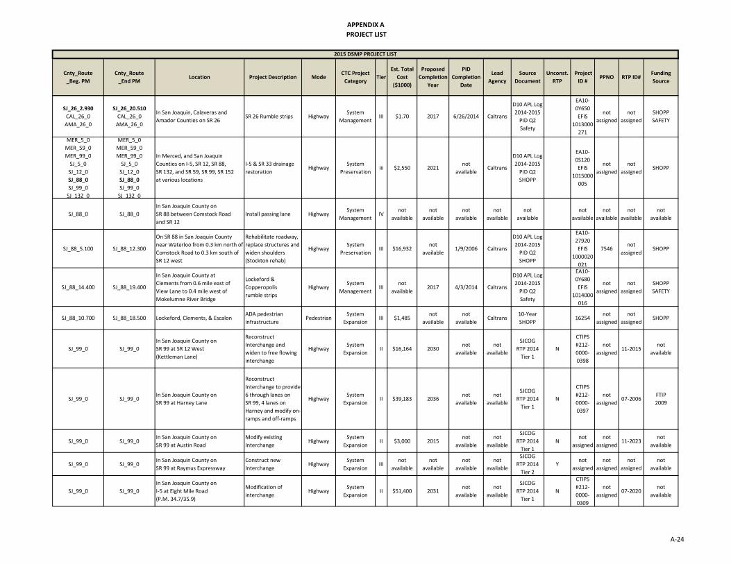
APPENDIX A
PROJECT LIST
Cnty_Route
_Beg. PM
Cnty_Route
_End PMLocation Project Description Mode
CTC Project
CategoryTier
Est. Total
Cost
($1000)
Proposed
Completion
Year
PID
Completion
Date
Lead
Agency
Source
Document
Unconst.
RTP
Project
ID #PPNO RTP ID#
Funding
Source
2015 DSMP PROJECT LIST
SJ_26_2.930
CAL_26_0
AMA_26_0
SJ_26_20.510
CAL_26_0
AMA_26_0
In San Joaquin, Calaveras and
Amador Counties on SR 26SR 26 Rumble strips Highway
System
ManagementIII $1.70 2017 6/26/2014 Caltrans
D10 APL Log
2014‐2015
PID Q2
Safety
EA10‐
0Y650
EFIS
1013000
271
not
assigned
not
assigned
SHOPP
SAFETY
MER_5_0
MER_59_0
MER_99_0
SJ_5_0
SJ_12_0
SJ_88_0
SJ_99_0
SJ 132 0
MER_5_0
MER_59_0
MER_99_0
SJ_5_0
SJ_12_0
SJ_88_0
SJ_99_0
SJ 132 0
In Merced, and San Joaquin
Counties on I‐5, SR 12, SR 88,
SR 132, and SR 59, SR 99, SR 152
at various locations
I‐5 & SR 33 drainage
restorationHighway
System
Preservationiii $2,550 2021
not
availableCaltrans
D10 APL Log
2014‐2015
PID Q2
SHOPP
EA10‐
0S120
EFIS
1015000
005
not
assigned
not
assignedSHOPP
SJ_88_0 SJ_88_0
In San Joaquin County on
SR 88 between Comstock Road
and SR 12
Install passing lane HighwaySystem
ManagementIV
not
available
not
available
not
available
not
available
not
available
not
available
not
available
not
available
not
available
SJ_88_5.100 SJ_88_12.300
On SR 88 in San Joaquin County
near Waterloo from 0.3 km north of
Comstock Road to 0.3 km south of
SR 12 west
Rehabilitate roadway,
replace structures and
widen shoulders
(Stockton rehab)
HighwaySystem
PreservationIII $16,932
not
available1/9/2006 Caltrans
D10 APL Log
2014‐2015
PID Q2
SHOPP
EA10‐
27920
EFIS
1000020
021
7546not
assignedSHOPP
SJ_88_14.400 SJ_88_19.400
In San Joaquin County at
Clements from 0.6 mile east of
View Lane to 0.4 mile west of
Mokelumne River Bridge
Lockeford &
Copperopolis
rumble strips
HighwaySystem
ManagementIII
not
available2017 4/3/2014 Caltrans
D10 APL Log
2014‐2015
PID Q2
Safety
EA10‐
0Y680
EFIS
1014000
016
not
assigned
not
assigned
SHOPP
SAFETY
SJ_88_10.700 SJ_88_18.500 Lockeford, Clements, & Escalon ADA pedestrian
infrastructurePedestrian
System
ExpansionIII $1,485
not
available
not
availableCaltrans
10‐Year
SHOPP16254
not
assigned
not
assignedSHOPP
SJ_99_0 SJ_99_0
In San Joaquin County on
SR 99 at SR 12 West
(Kettleman Lane)
Reconstruct
Interchange and
widen to free flowing
interchange
HighwaySystem
ExpansionII $16,164 2030
not
available
not
available
SJCOG
RTP 2014
Tier 1
N
CTIPS
#212‐
0000‐
0398
not
assigned11‐2015
not
available
SJ_99_0 SJ_99_0In San Joaquin County on
SR 99 at Harney Lane
Reconstruct
Interchange to provide
6 through lanes on
SR 99, 4 lanes on
Harney and modify on‐
ramps and off‐ramps
HighwaySystem
ExpansionII $39,183 2036
not
available
not
available
SJCOG
RTP 2014
Tier 1
N
CTIPS
#212‐
0000‐
0397
not
assigned07‐2006
FTIP
2009
SJ_99_0 SJ_99_0In San Joaquin County on
SR 99 at Austin Road
Modify existing
InterchangeHighway
System
ExpansionII $3,000 2015
not
available
not
available
SJCOG
RTP 2014
Tier 1
Nnot
assigned
not
assigned11‐2023
not
available
SJ_99_0 SJ_99_0In San Joaquin County on
SR 99 at Raymus Expressway
Construct new
Interchange Highway
System
ExpansionIII
not
available
not
available
not
available
not
available
SJCOG
RTP 2014
Tier 2
Ynot
assigned
not
assigned
not
assigned
not
available
SJ_99_0 SJ_99_0
In San Joaquin County on
I‐5 at Eight Mile Road
(P.M. 34.7/35.9)
Modification of
interchangeHighway
System
ExpansionII $51,400 2031
not
available
not
available
SJCOG
RTP 2014
Tier 1
N
CTIPS
#212‐
0000‐
0309
not
assigned07‐2020
not
available
A‐24

APPENDIX A
PROJECT LIST
Cnty_Route
_Beg. PM
Cnty_Route
_End PMLocation Project Description Mode
CTC Project
CategoryTier
Est. Total
Cost
($1000)
Proposed
Completion
Year
PID
Completion
Date
Lead
Agency
Source
Document
Unconst.
RTP
Project
ID #PPNO RTP ID#
Funding
Source
2015 DSMP PROJECT LIST
SJ_99_0 SJ_99_0
In San Joaquin County on
SR 99 at Morada
(P.M. 23.5‐24.5)
Reconstruct
InterchangeHighway
System
ExpansionII $698,000 2021
not
available
not
available
SJCOG
RTP 2014
Tier 1
N
CTIPS
#212‐
0000‐
0561
not
assigned11‐2001
not
available
SJ_99_0 SJ_99_0
In San Joaquin County on
SR 99 from Harney Lane to
Turner Road
Widen to six lanes HighwaySystem
ExpansionIII
not
available
not
available
not
available
not
available
SJCOG
RTP 2014
Tier 2
Ynot
assigned
not
assignedTier 2
not
available
SJ_99_0 SJ_99_0In San Joaquin County on
SR 99 at Olive ExpresswayNew interchange Highway
System
ExpansionIII $100,000
not
available
not
available
not
available
SJCOG
RTP 2014
Tier 2
Ynot
assigned
not
assignedTier 2
not
available
SJ_99_0 SJ_99_0
In San Joaquin County on
SR 99 at March Lane and
Wilson Way
New interchange HighwaySystem
ExpansionIII $198,100
not
available
not
available
not
available
SJCOG
RTP 2014
Tier 2
Ynot
assigned
not
assignedTier 2
not
available
SJ_99_0 SJ_99_0In San Joaquin County on
SR 99 at Gateway Blvd.New interchange Highway
System
ExpansionIII $80,300
not
available
not
available
not
available
SJCOG
RTP 2014
Tier 2
Ynot
assigned
not
assignedTier 2
not
available
SJ_5_0
SJ_99_0
SJ_5_0
SJ_99_0
In San Joaquin County on
I‐5 and SR 99
at various locations
San Joaquin HFST ‐
Friction Surface
Treatment
HighwaySystem
PreservationIII $2.90 2015 2/14/2013 Caltrans
D10 APL Log
2014‐2015
PID Q2
Safety
EA10‐
0Y690K
EFIS
1014000
033
3030not
assigned
SHOPP
SAFETY
SJ_5_0
SJ_4_14.500
SJ_99_0
SJ_5_0
SJ_4_21.100
SJ_99_0
In San Joaquin County in Stockton
on I‐5 and SR 4 and SR 99
at various locations
Crosstown TMS HighwaySystem
ManagementIII $9,800
not
available4/20/2006 Caltrans
D10 APL Log
SHOPP
EA10‐
3A400
EFIS
1000000
414
7048not
assignedSHOPP
SJ_5_0
SJ_99_0
SJ_5_0
SJ_99_0
In San Joaquin County in Stockton
on I‐5 and SR 99 and
in Ripon and
Lodi on SR 99
SJ I‐5/SR 99
ADA improvementsHighway
System
PreservationIII $17,615 2023
not
availableCaltrans
D10 APL Log
2014‐2015
PID Q2
SHOPP
EA10‐
1C060
EFIS
1014000
102
not
assigned
not
assignedSHOPP
SJ_5_0
SJ_99_0
SJ_580_0
MER_5_0
STA_5_0
STA_99_0
SJ_5_0
SJ_99_0
SJ_580_0
MER_5_0
STA_5_0
STA_99_0
In Merced County, Stanislaus
County, and San Joaquin County
at various locations.
SJ I‐5, SJ SR 99, SJ I‐580,
MER I‐5,
STA I‐5, STA SR 99
Installation of HAR'S HighwaySystem
ManagementIII $950
not
available
not
availableCaltrans
2014‐2015
PID Q2
SHOPP
EA10‐
0E84U7163
not
assignedSHOPP
MER_99_11.5
STA_99_R7.000
SJ_99_0.000
MER_99_R37.300
STA_99_R10.500
SJ_99_28.500
Install shoulder rumble strips along
SR 99 from PM 11.5/R37.3, in
Merced County along SR 99 from
PM R7.0/ R10.5, in
Stanislaus County along SR 99 from
PM 0.0/28.5, and
in San Joaquin County
SR 99 rumble strip
installationHighway
System
ManagementIII $0.80 2018
not
availableCaltrans
D10 APL Log
2014‐2015
PID Q2
Safety
EA10‐
1C470
not
assigned
not
assigned
SHOPP
SAFETY
MER_5_0
MER_59_0
MER_99_0
SJ_5_0
SJ_12_0
SJ_88_0
SJ_99_0
SJ 132 0
MER_5_0
MER_59_0
MER_99_0
SJ_5_0
SJ_12_0
SJ_88_0
SJ_99_0
SJ 132 0
In Merced, and San Joaquin
Counties on I‐5, SR 12, SR 88,
SR 132, and SR 59, SR 99, SR 152
at various locations
I‐5 & SR 33
drainage restorationHighway
System
PreservationIII $2,550 2021
not
availableCaltrans
D10 APL Log
2014‐2015
PID Q2
SHOPP
EA10‐
0S120
EFIS
1015000
005
not
assigned
not
assignedSHOPP
A‐25

APPENDIX A
PROJECT LIST
Cnty_Route
_Beg. PM
Cnty_Route
_End PMLocation Project Description Mode
CTC Project
CategoryTier
Est. Total
Cost
($1000)
Proposed
Completion
Year
PID
Completion
Date
Lead
Agency
Source
Document
Unconst.
RTP
Project
ID #PPNO RTP ID#
Funding
Source
2015 DSMP PROJECT LIST
MER_5_0
MER_99_0
SJ_4_0
SJ_5_0
SJ_99_0
SJ_120_0
SJ_205_0
STA_5_0
STA_99_0
STA 120 0
MER_5_0
MER_99_0
SJ_4_0
SJ_5_0
SJ_99_0
SJ_120_0
SJ_205_0
STA_5_0
STA_99_0
STA 120 0
In San Joaquin, Merced and
Stanislaus Counties on
I‐5, SR 4, SR 99, SR 120 and I‐205
MER/SJ/STA
CulvertsHighway
System
PreservationIII $2,675 2018 5/9/2014 Caltrans
2014‐2015
PID Q2
SHOPP
EA10‐
1C200
EFIS
1014000
098
not
assigned
not
assignedSHOPP
SJ_99_0.0
STA_99_R0.0
MER_0 _0
SJ_99_38.8
STA_99_R24.8
MER_0 _0
On SR 99 in San Joaquin
(PM 0.0/38.8)
Stanislaus
(PM R0.0/ R24.8) and
Merced Counties
High Speed Rail ‐
Merced to
Sacramento (Merced
to Sacramento High
Speed Rail)
Commuter
Rail
System
ExpansionI $250
not
available
not
available
not
available
STIP
Candidate
list
EA10‐
0V080
EFIS
1000020
088
0291not
assigned
Oversight
Reimbursed
Rail
SJ_99_31.300 SJ_99_31.600
In San Joaquin County in Lodi on
SR 99 at Turner Road southbound
on‐ramp
Turner Road on‐ramp HighwaySystem
ExpansionI $2,550 2019 4/3/2014
not
available
D10 APL Log
STIP
EA10‐
1C260
EFIS
1014000
090
3045not
assigned
RIP
Local
Oversight
SJ_99_20.100 SJ_99_34.700
In and near Stockton and Lodi at
various locations from 0.3 km south
of SR 88 to 0.3 km north of
Peltier Road
Upgrade planting and
irrigation
(Peltier Road
Landscape)
HighwaySystem
PreservationIII $1,443
not
available8/27/1999 Caltrans
2014‐2015
PID Q2
SHOPP
EA10‐
0C8807686
not
assignedSHOPP
SJ_99_10.900 SJ_99_12.500
Near Stockton from 1.6 miles north
of Lathrop Road to 2.4 miles south
of Arch Road OC
Structure rehab,
ramp rehab, and
bridge rail upgrade
(Turner Station rehab)
HighwaySystem
PreservationIII $18,879
not
available9/18/2001 Caltrans
2014‐2015
PID Q2
SHOPP
EA10‐
0E1707653
not
assignedSHOPP
SJ_99_0.200 SJ_99_1.700
In San Joaquin County in Ripon
on SR 99 from 0.3 km north of the
Stanislaus River Bridge to Milgeo
Avenue OC
Highway planting
restoration
(Ripon Planting Rehab)
HighwaySystem
PreservationIII $1,288
not
available9/12/2001 Caltrans
2014‐2015
PID Q2
SHOPP
EA10‐
0H4907611
not
assignedSHOPP
SJ_99_10.000 SJ_99_14.000
On SR 99 from 0.8 miles north of
Lathrop Road Overcrossing to 0.6
miles south of Arch Road
Overcrossing
Digout and repair of
localized failures/AC
overlay (Lathrop/Arch
Road overlay CAPM
HighwaySystem
PreservationIII $7,385
not
available10/16/2007 Caltrans
2014‐2015
PID Q2
SHOPP
EA10‐
0Q1500162
not
assignedSHOPP
SJ_99_30.800 SJ_99_31.500
In San Joaquin County in Lodi on
SR 99 at Victor Road northbound on‐
ramp
Victor on‐ramp HighwaySystem
ManagementIII $6,911
not
available6/10/2014
SJCOG will
be lead
for PID
phase/
Caltrans
2014‐2015
PID Q2
SHOPP
EA10‐
1C280
EFIS
1014000
134
not
assigned
not
assignedSHOPP
SJ_99_2.000 SJ_99_5.400
In Ripon and Manteca
from Jack Tone Road to
Yosemite Avenue
Install ramp meters,
fiber optic, and ITS
elements
HighwaySystem
ManagementIII $4,000
not
available
not
availableCaltrans
10‐Year
SHOPP
EA10‐
1C301
14133
not
assigned
not
assignedSHOPP
A‐26

APPENDIX A
PROJECT LIST
Cnty_Route
_Beg. PM
Cnty_Route
_End PMLocation Project Description Mode
CTC Project
CategoryTier
Est. Total
Cost
($1000)
Proposed
Completion
Year
PID
Completion
Date
Lead
Agency
Source
Document
Unconst.
RTP
Project
ID #PPNO RTP ID#
Funding
Source
2015 DSMP PROJECT LIST
SJ_99_0 SJ_99_0 TBD Safety Improvements HighwaySystem
ManagementIII $6,000
not
available
not
availableCaltrans
10‐Year
SHOPP
EA10‐
TTS01
15781
not
assigned
not
assignedSHOPP
SJ_120_0 SJ_120_0
In San Joaquin County on
SR 120 at Union Road
(P.M. 4.1/4.1)
Reconstruct
InterchangeHighway
System
ExpansionII $22,000 2015
not
available
not
available
SJCOG
RTP 2014
Tier 1
Nnot
assigned
not
assigned07‐2012
not
available
SJ_120_0 SJ_120_0In San Joaquin County on
SR 120 at McKinley AvenueConstruct Interchange Highway
System
ExpansionII $27,850 2021
not
available
not
available
SJCOG
RTP 2014
Tier 1
N
CTIPS
#212‐
0000‐
0231
not
assigned07‐2009
FTIP
2009
SJ_120_0 SJ_120_0
In San Joaquin County on
SR 120 at Yosemite/
Guthmiller Roads
Reconstruct
interchange Highway
System
ExpansionIII $22,000
not
available
not
available
not
available
SJCOG
RTP 2014
Tier 2
Ynot
assigned
not
assigned
not
assigned
not
available
SJ_120_0 SJ_120_0In San Joaquin County on
SR 120 from I‐5 to SR‐99
Widen to
six lanes (inside)Highway
System
ExpansionII $115,191 2040
not
available
not
available
SJCOG
RTP 2014
Tier 1
Nnot
assigned
not
assigned07‐1014
Measure K
Renewal
RTIFMER_5_0
MER_99_0
SJ_4_0
SJ_5_0
SJ_99_0
SJ_120_0
SJ_205_0
STA_5_0
STA_99_0
STA_120_0
MER_5_0
MER_99_0
SJ_4_0
SJ_5_0
SJ_99_0
SJ_120_0
SJ_205_0
STA_5_0
STA_99_0
STA_120_0
In San Joaquin, Merced and
Stanislaus Counties on
I‐5, SR 4, SR 99, SR 120 and I‐205
MER/SJ/STA
CulvertsHighway
System
PreservationIII $2,675 2018 5/9/2014 Caltrans
2014‐2015
PID Q2
SHOPP
EA10‐
1C200
EFIS
1014000
098
not
assigned
not
assignedSHOPP
SJ_120_R2.573 SJ_120_T6.535In San Joaquin County in Manteca
on SR 120 from McKinley to SR 99
SR 120 MVP &
roadside pavingHighway
System
PreservationIII $2,971 2020
not
availableCaltrans
D10 APL Log
2014‐2015
PID Q2
SHOPP
EA10‐
0X710
EFIS
1013000
247
3120not
assignedSHOPP
SJ_132_0 SJ_132_0
In San Joaquin County on
SR 132 between SR 33 and
Stanislaus County Line
Expand facility to
expresswayHighway
System
ExpansionIV
not
available
not
available
not
available
not
available
not
available
not
available
not
available
not
available
not
available
MER_5_0
MER_59_0
MER_99_0
SJ_5_0
SJ_12_0
SJ_88_0
SJ_99_0
SJ_132_0
MER_5_0
MER_59_0
MER_99_0
SJ_5_0
SJ_12_0
SJ_88_0
SJ_99_0
SJ_132_0
In Merced, and San Joaquin
Counties on I‐5, SR 12, SR 88,
SR 132, and SR 59, SR 99, SR 152
at various locations
I‐5 & SR 33
drainage restorationHighway
System
PreservationIII $2,550 2021
not
availableCaltrans
D10 APL Log
2014‐2015
PID Q2
SHOPP
EA10‐
0S120
EFIS
1015000
005
not
assigned
not
assignedSHOPP
SJ_205_0 SJ_205_0
In San Joaquin County on
I‐205 from Eleventh Street to
MacArthur Drive
Widen to eight lanes
(inside and outside)
for HOV
HighwaySystem
ExpansionII $143,450 2035
not
available
not
available
SJCOG
RTP 2014
Tier 1
Nnot
assigned
not
assigned14‐1001
Measure K
Renewal
RTIF
SJ_205_0 SJ_205_0In San Joaquin County on
I‐205 from MacArthur Drive to I‐5
Widen to eight lanes
(inside outside)
for HOV
HighwaySystem
ExpansionII $143,184 2037
not
available
not
available
SJCOG
RTP 2014
Tier 1
Nnot
assigned
not
assigned14‐1002
Measure K
Renewal
RTIF
SJ_205_0 SJ_205_0
In San Joaquin County on
I‐5 HOV Mossdale from
SR 120 to I‐205
(P.M. R13.9 ‐ R15.6)
Widen to twelve lanes
for HOVHighway
System
ExpansionII $207,970 2038
not
available
not
available
SJCOG
RTP 2014
Tier 1
Nnot
assigned
not
assigned07‐1008
Measure K
Renewal
RTIF
A‐27

APPENDIX A
PROJECT LIST
Cnty_Route
_Beg. PM
Cnty_Route
_End PMLocation Project Description Mode
CTC Project
CategoryTier
Est. Total
Cost
($1000)
Proposed
Completion
Year
PID
Completion
Date
Lead
Agency
Source
Document
Unconst.
RTP
Project
ID #PPNO RTP ID#
Funding
Source
2015 DSMP PROJECT LIST
SJ_205_0 SJ_205_0
In San Joaquin County on
I‐205/Lammers Road/
Eleventh Street
Construct Interchange
at Eleventh Street.
Realign and widen
Eleventh Street to 6
lanes north of Grant
Line to Byron Road.
Construct Auxilary
lane Hansen to
Eleventh in WB I‐205
Eleventh Street to
Grant Line Road
HighwaySystem
ExpansionII $82,580 2018
not
available
not
available
SJCOG
RTP 2014
Tier 1
N
CTIPS
#212‐
0000‐
0227
not
assigned11‐2010
FTIP
2007
SJ_205_0 SJ_205_0In San Joaquin County on
I‐205 at Grant Line Road
Modify existing
InterchangeHighway
System
ExpansionII $32,574 2024
not
available
not
available
SJCOG
RTP 2014
Tier 1
Nnot
assigned
not
assigned11‐2011
not
available
SJ_205_0 SJ_205_0In San Joaquin County on
I‐205 at Paradise Road/Chrisman
Phase 1: Construct
new interchange east‐
west ramps
HighwaySystem
ExpansionII $36,056 2026
not
available
not
available
SJCOG
RTP 2014
Tier 1
N
CTIPS
#212‐
0000‐
0228
not
assigned11‐2012
FTIP
2009
SJ_205_0 SJ_205_0In San Joaquin County on
I‐205 at MacArthurModify interchange Highway
System
ExpansionIIII $9,670
not
available
not
available
not
available
SJCOG
RTP 2014
Tier 2
Ynot
assigned
not
assignedTier 2
not
available
MER_5_0
MER_99_0
SJ_4_0
SJ_5_0
SJ_99_0
SJ_120_0
SJ_205_0
STA_5_0
STA_99_0
STA_120_0
MER_5_0
MER_99_0
SJ_4_0
SJ_5_0
SJ_99_0
SJ_120_0
SJ_205_0
STA_5_0
STA_99_0
STA_120_0
In San Joaquin, Merced and
Stanislaus Counties on
I‐5, SR 4, SR 99, SR 120 and I‐205
MER/SJ/STA
CulvertsHighway
System
PreservationIII $2,675 2018 5/9/2014 Caltrans
2014‐2015
PID Q2
SHOPP
EA10‐
1C200
EFIS
1014000
098
not
assigned
not
assignedSHOPP
SJ_205_1.100 SJ_205_1.600
In San Joaquin County in the City of
Tracy along Mountain House
Parkway (MHP) at
I‐205 Interchange
I‐205/MHP
interchangeHighway
System
ExpansionI $15 2020
not
available
City of
Tracy
Non‐SHOPP
Reimb
COOP#
10‐440
EA10‐
1E210
EFIS
1015000
010
not
assigned
not
assigned
Local
Oversight
Reimbursed
$95,000
SJ_205_R5.900 SJ_205_R8.300
In San Joaquin County in Tracy on
Route I‐205 from south of Corral
Hollow UC to 0.2 km east of
Macarthur Drive
Highway planting
restoration
(Tracy Planting
Rehab job)
HighwaySystem
PreservationIII $2,938
not
available10/18/2005 Caltrans
D10 APL Log
2014‐2015
PID Q2
SHOPP
EA10‐
0H4707879
not
assignedSHOPP
SJ_205_2.000 SJ_205_2.600
On Route I‐205 between
Mountain House Parkway
on‐ramp and Eleventh Street
off‐ramp
Construct eastbound
auxillary lane
(Route I‐205 auxiliary
lane project)
HighwaySystem
ManagementIII $2,691
not
available9/1/2005 Caltrans
Status of
Projects
EA10‐
0K7107866
not
assignedSHOPP
SJ_205_L0.000 SJ_205_R13.400
In San Joaquin County on
Route I‐205 near Tracy from
Alameda County line to Route I‐5
I‐205 SMART Corridor ‐
PHASE 2Highway
System
ManagementIII $8,900 2022 6/9/2014 Caltrans
D10 APL Log
2014‐2015
PID Q2
SHOPP
EA10‐
1C330
EFIS
1014000
146
not
assigned
not
assignedSHOPP
A‐28

APPENDIX A
PROJECT LIST
Cnty_Route
_Beg. PM
Cnty_Route
_End PMLocation Project Description Mode
CTC Project
CategoryTier
Est. Total
Cost
($1000)
Proposed
Completion
Year
PID
Completion
Date
Lead
Agency
Source
Document
Unconst.
RTP
Project
ID #PPNO RTP ID#
Funding
Source
2015 DSMP PROJECT LIST
SJ_205_1.055 SJ_205_R12.652
In San Joaquin County
in/near Tracy on Route
I‐205 from Patterson to Route I‐5
Route I‐205 MVP &
roadside pavingHighway
System
PreservationIII $2,000 2022
not
availableCaltrans
D10 APL Log
2014‐2015
PID Q2
SHOPP
EA10‐
0X700
EFIS
1013000
248
3111not
assignedSHOPP
SJ_205_0 SJ_205_0 All Counties, All Routes
Repair
existing ITS
Infrastructure
HighwaySystem
ManagementIII $1,200
not
available
not
availableCaltrans
10‐Year
SHOPP16179
not
assigned
not
assignedSHOPP
ALA_239_0
CC_239_0
SJ_239_0
ALA_239_0
CC_239_0
SJ_239_0
SR‐4 Brentwood,
I‐580 west of Tracy
Proposed new route
14 to 15 miles long
(Transit link)
TransitSystem
ExpansionI
$756‐$784
Million2022
April‐
October
2015
Contra
Costa
Transport
ation
Authority
Non‐SHOPP
Feasibility
Studies
EA04‐
3G860K
EFIS
4130001
98
not
assigned
not
assigned
Local
Federal
Funds
In STIP
P3 and
Tolling
SJ_580_0 SJ_580_0In San Joaquin County on
I‐580 at Corral Hollow RoadModify interchange Highway
System
ExpansionIII $20,000
not
available
not
available
not
available
SJCOG
RTP 2014
Tier 2
Ynot
assigned
not
assignedTier 2
not
available
SJ_580_0 SJ_580_0In San Joaquin County on
I‐580 at Lammers RoadNew interchange Highway
System
ExpansionIII $55,000
not
available
not
available
not
available
SJCOG
RTP 2014
Tier 2
Ynot
assigned
not
assignedTier 2
not
available
SJ_5_0
SJ_99_0
SJ_580_0
MER_5_0
STA_5_0
STA_99_0
SJ_5_0
SJ_99_0
SJ_580_0
MER_5_0
STA_5_0
STA_99_0
In Merced County, Stanislaus
County, and San Joaquin County
at various locations.
SJ I‐5, SJ SR 99, SJ I‐580,
MER I‐5,
STA I‐5, STA SR 99
Installation of HAR'S HighwaySystem
ManagementIII $950
not
available
not
availableCaltrans
2014‐2015
PID Q2
SHOPP
EA10‐
0E84U7163
not
assignedSHOPP
SJ_580_13.300 SJ_580_13.800
In San Joaquin County
in the City of Tracy along
Mountain House Parkway (MHP) at
I‐580 interchange
I‐580/MHP
interchange
modifications
HighwaySystem
ExpansionI $15 2020
not
available
City of
Tracy
Non‐SHOPP
Reimb
COOP#
10‐439
EA10‐
1E220
EFIS
1015000
011
not
assigned
not
assigned
Local
Oversight
Reimbursed
$130,000
SJ_99_0
MER_152_0
SJ_99_0
MER_152_0
In San Joaquin County on
SR 99 in Stockton at Marsh Street
and in Ripon at Acacia Avenue, and
in Merced County in Los Banos on
SR 152 at 7th Street
SJ‐99/MER SR‐152
Ped bridge
ADA rehab
HighwaySystem
PreservationIII $3,046 2023 5/30/2014 Caltrans
D10 APL Log
2014‐2015
PID Q2
SHOPP
EA10‐
0X340
EFIS
1013000
077
not
assigned
not
assignedSHOPP
SJ_0_0
MER_0_0
STA_0_0
TUO_0_0
SJ_0_0
MER_0_0
STA_0_0
TUO_0_0
In District 10 at various locations
SJ/MER/STA/TUO
TMS element
upgrades
HighwaySystem
ManagementIII $1,740 2020
not
availableCaltrans
D10 APL Log
2014‐2015
PID Q2
SHOPP
EA10‐
1C620
EFIS
1015000
001
not
assigned
not
assignedSHOPP
MER_0_0
STA_0_0
SJ_0_0
MER_0_0
STA_0_0
SJ_0_0
In Merced, Stanislaus, and
San Joaquin Counties on various
State Routes and locations
MER/STA/SJ
signs rehabHighway
System
PreservationIII $1,100 2020
not
availableCaltrans
D10 APL Log
2014‐2015
PID Q2
SHOPP
EA10‐
1C530
EFIS
1015000
002
3129not
assignedSHOPP
STANISLAUS COUNTY
A‐29

APPENDIX A
PROJECT LIST
Cnty_Route
_Beg. PM
Cnty_Route
_End PMLocation Project Description Mode
CTC Project
CategoryTier
Est. Total
Cost
($1000)
Proposed
Completion
Year
PID
Completion
Date
Lead
Agency
Source
Document
Unconst.
RTP
Project
ID #PPNO RTP ID#
Funding
Source
2015 DSMP PROJECT LIST
MER_0_0
MPA_0_0
SJ_0_0
STA_0_0
MER_0_0
MPA_0_0
SJ_0_0
STA_0_0
In Merced, Mariposa, San Joaquin,
and Stanislaus Counties on various
State Routes at 13 bridge locations
D10 Bridge
substructure repairsHighway
System
PreservationIII $2,366 2023
not
availableCaltrans
D10 APL Log
2014‐2015
PID Q2
SHOPP
EA10‐
1C810
EFIS
1015000
038
3102not
assignedSHOPP
CAL_4_0
CAL_12_0
CAL_26_0
CAL_49_0
STA_4_0
CAL_4_0
CAL_12_0
CAL_26_0
CAL_49_0
STA_4_0
In Cal, Sta Counties on
SR 4, SR 12, SR 26, & SR 49
Drainage system
restorationHighway
System
PreservationIII $5,480
not
available
not
availableCaltrans
10‐Year
SHOPP16017
not
assigned
not
assignedSHOPP
MER_5_0
MER_99_0
SJ_4_0
SJ_5_0
SJ_99_0
SJ_120_0
SJ_205_0
STA_5_0
STA_99_0
STA 120 0
MER_5_0
MER_99_0
SJ_4_0
SJ_5_0
SJ_99_0
SJ_120_0
SJ_205_0
STA_5_0
STA_99_0
STA 120 0
In San Joaquin, Merced and
Stanislaus Counties on
I‐5, SR 4, SR 99, SR 120 and I‐205
MER/SJ/STA
CulvertsHighway
System
PreservationIII $2,675 2018 5/9/2014 Caltrans
2014‐2015
PID Q2
SHOPP
EA10‐
1C200
EFIS
1014000
098
not
assigned
not
assignedSHOPP
SJ_5_0
SJ_99_0
SJ_580_0
MER_5_0
STA_5_0
STA_99_0
SJ_5_0
SJ_99_0
SJ_580_0
MER_5_0
STA_5_0
STA_99_0
In Merced County, Stanislaus
County, and San Joaquin County
at various locations.
SJ I‐5, SJ SR 99, SJ I‐580,
MER I‐5,
STA I‐5, STA SR 99
Installation of HAR'S HighwaySystem
ManagementIII $950
not
availablenot available Caltrans
2014‐2015
PID Q2
SHOPP
EA10‐
0E84U7163
not
assignedSHOPP
MER_5_31.800
STA_5_0
MER_5_32.500
STA_5_0
On Route I‐5 in Merced and
Stanislaus Counties from
Garzas Creek Bridge to the
Stanislaus County Line
STA I‐5 Ramps HighwaySystem
PreservationIII $5,115 2019 6/24/2012 Caltrans
2014‐2015
PID Q2
SHOPP
EA10‐
4773U
EFIS
1013000
058
9052not
assignedSHOPP
MER_4_0
MER_5_0
SJ_4_0
SJ_5_0
SJ_99_0
SJ_120_0
SJ_205_0
STA_4_0
STA_5_0
STA_99_0
STA 120 0
MER_4_0
MER_5_0
SJ_4_0
SJ_5_0
SJ_99_0
SJ_120_0
SJ_205_0
STA_4_0
STA_5_0
STA_99_0
STA 120 0
In San Joaquin, Merced and
Stanislaus Counties on
I‐5, SR 4, SR 99, SR 120 and I‐205
MER/SJ/STA
CulvertsHighway
System
PreservationIII $2,675 2018 5/9/2014 Caltrans
2014‐2015
PID Q2
SHOPP
EA10‐
1C200
EFIS
1014000
098
not
assigned
not
assignedSHOPP
SJ_5_0
STA_5_0
SJ_5_0
STA_5_0
In San Joaquin and Stanislaus
at 10 bridgesSJ I‐5 bridge rehab Highway
System
PreservationIII $1,700 2022
not
availableCaltrans
D10 APL Log
2014‐2015
PID Q2
SHOPP
EA10‐
0P540
EFIS
1013000
251
3118not
assignedSHOPP
STA_5_15.800 STA_5_15.900In Stanislaus County near Patterson
on I‐5 at Sperry Road interchange
I‐5
Sperry Road
Interchange
HighwaySystem
ExpansionI $7,337
not
available9/5/2002
not
available
D10 APL Log
Local
Oversight
EA10‐
0G420
EFIS
1014000
038
9124not
assignedRIP
A‐30

APPENDIX A
PROJECT LIST
Cnty_Route
_Beg. PM
Cnty_Route
_End PMLocation Project Description Mode
CTC Project
CategoryTier
Est. Total
Cost
($1000)
Proposed
Completion
Year
PID
Completion
Date
Lead
Agency
Source
Document
Unconst.
RTP
Project
ID #PPNO RTP ID#
Funding
Source
2015 DSMP PROJECT LIST
STA_5_0 STA_5_0In Stanislaus County on
SR 5 at Sperry Road and I‐580Widen to six lanes Highway
System
ExpansionIV
not
available
not
available
not
available
not
available
not
available
not
available
not
available
not
available
not
available
STA_5_27.000 STA_5_27.400
In Stanislaus County on
I‐5 at the Westley Roadside
Rest Area
Westley Rest Area HighwaySystem
PreservationIII $9,000 2022
not
availableCaltrans
D10 APL Log
2014‐2015
PID Q2
SHOPP
EA10‐
1C270
EFIS
1014000
097
not
assigned
not
assignedSHOPP
STA_5_17.270 STA_5_25.520
In Stanislaus County near Westley
on I‐5 from Hansen Road to
Hamilton Road
Westley I‐5
median barrierHighway
System
ManagementIII $1.60 2017 6/5/2014 Caltrans
D10 APL Log
2014‐2015
PID Q2
Safety
EA10‐
0Y640
EFIS
1013000
270
0000not
assigned
SHOPP
SAFETY
STA_33_0 STA_33_0
In Stanislaus County on
SR 33 from Yolo Street to
Sherman Parkway
Widen to four lanes HighwaySystem
ExpansionII $4,753 2017
not
available
not
available
STANCOG
RTP 2014
Tier 1
Nnot
assigned
not
assignedN01
CFF
LTF
CMAQ
RSTP
Local
STA_33_0 STA_33_0
In Stanislaus County on
SR 33 from Sherman Parkway to
Stuhr Road
Widen to four lanes HighwaySystem
ExpansionII $4,298 2018
not
available
not
available
STANCOG
RTP 2014
Tier 1
Nnot
assigned
not
assignedN02
CFF
LTF
CMAQ
RSTP
Local
STA_33_0 STA_33_0
In Stanislaus County on
SR 33 from Yolo Street to
Inyo Avenue
Widen to four lanes HighwaySystem
ExpansionII $3,689 2017
not
available
not
available
STANCOG
RTP 2014
Tier 1
Nnot
assigned
not
assignedN04
CFF
LTF
CMAQ
RSTP
Local
MER_33_0
STA_33_0
MER_33_0
STA_33_0
Various locations along SR 33 in
Merced and Stanislaus Counties
SR 33 Installing rumble
stripsHighway
System
ManagementIII $3.70 2018 5/27/2015 Caltrans
D10 APL Log
2014‐2015
PID Q2
Safety
EA10‐
1C490
EFIS
1015000
091
3128not
assigned
SHOPP
SAFETY
STA_33_0.500 STA_33_14.500Newman, Patterson, Riverbank, and
Waterford
ADA pedestrian
infrastructurePedestrian
System
ExpansionIII $2,160
not
available
not
availableCaltrans
10‐Year
SHOPP16256
not
assigned
not
assignedSHOPP
STA_99_0 STA_99_0
In Stanislaus County on
SR 99 from Keyes Road to
Taylor Road
Construct
Auxillary lane Highway
System
ManagementII $6,226.00 2025
not
available
not
available
STANCOG
RTP 2014
Tier 1
Nnot
assigned
not
assignedRE‐02
STIP
IIP
RSTP
CMAQ
STA_99_0 STA_99_0
In Stanislaus County on
SR 99 from Taylor Road to
Monte Vista Avenue
Construct
Auxillary laneHighway
System
ManagementII $6,520 2025
not
available
not
available
STANCOG
RTP 2014
Tier 1
Nnot
assigned
not
assignedRE‐03
STIP
IIP
RSTP
CMAQ
STA_99_0 STA_99_0
In Stanislaus County on
SR 99 from Monte Vista Avenue to
Fulkerth Road
Construct
Auxillary lane Highway
System
ManagementII $6,461 2025
not
available
not
available
STANCOG
RTP 2014
Tier 1
Nnot
assigned
not
assignedRE‐04
STIP
IIP
RSTP
CMAQ
STA_99_0 STA_99_0
In Stanislaus County on
SR 99 from Fulkerth Road to
W. Main Avenue
Construct
Auxilary lane Highway
System
ManagementII $6,402 2025
not
available
not
available
STANCOG
RTP 2014
Tier 1
Nnot
assigned
not
assignedRE‐05
STIP
IIP
RSTP
CMAQ
A‐31

APPENDIX A
PROJECT LIST
Cnty_Route
_Beg. PM
Cnty_Route
_End PMLocation Project Description Mode
CTC Project
CategoryTier
Est. Total
Cost
($1000)
Proposed
Completion
Year
PID
Completion
Date
Lead
Agency
Source
Document
Unconst.
RTP
Project
ID #PPNO RTP ID#
Funding
Source
2015 DSMP PROJECT LIST
STA_99_0 STA_99_0
In Stanislaus County on
SR 99 from San Joaquin County to
Mitchell Road
Install
Ramp Metering Highway
System
ManagementII $15,758 2028
not
available
not
available
STANCOG
RTP 2014
Tier 1
Nnot
assigned
not
assignedRE‐06
STIP
IIP
RSTP
CMAQ
STA_99_0 STA_99_0
In Stanislaus County on
SR 99 from Mitchell Road to
Merced County
Install
Ramp Metering Highway
System
ManagementII $3,097 2033
not
available
not
available
STANCOG
RTP 2014
Tier 1
Nnot
assigned
not
assignedRE‐07
STIP
IIP
RSTP
CMAQ
STA_99_0 STA_99_0In Stanislaus County on
SR 99 at Mitchell and Service Roads
Install
new interchange Highway
System
ExpansionII $122,987 2020
not
available
not
available
STANCOG
RTP 2014
Tier 1
Nnot
assigned
not
assignedC‐08
PFF
RSTP
Other
STA_99_0 STA_99_0 In Stanislaus County on
SR 99 from Kiernan Road to SR‐132Widen to eight lanes Highway
System
ExpansionII $50,670 2020
not
available
not
available
STANCOG
RTP 2014
Tier 1
Nnot
assigned
not
assignedM‐02
STIP
PFF
IIP
STA_99_0 STA_99_0
In Stanislaus County on
SR 99 at Briggsmore Road to
eight lanes
Reconstruct
interchangeHighway
System
ExpansionII $98,679 2035
not
available
not
available
STANCOG
RTP 2014
Tier 1
Nnot
assigned
not
assignedM‐16 STIP
STA_99_0 STA_99_0In Stanislaus County on
SR 99 at Fulkerth Road
Reconstruct
interchangeHighway
System
ExpansionII $12,667 2020
not
available
not
available
STANCOG
RTP 2014
Tier 1
Nnot
assigned
not
assignedT01
CMAQ
Dev. Fees
RSTP
STIP
STA_99_0 STA_99_0In Stanislaus County on
SR 99 at Lander Avenue
Construct new
interchangeHighway
System
ExpansionII $35,785 2028
not
available
not
available
STANCOG
RTP 2014
Tier 1
Nnot
assigned
not
assignedT25
CMAQ
Dev. Fees
STIP
STA_99_0 STA_99_0In Stanislaus County on
SR 99 at W. Main Street
Construct new
interchangeHighway
System
ExpansionII $19,091 2025
not
available
not
available
STANCOG
RTP 2014
Tier 1
Nnot
assigned
not
assignedT26
CMAQ
Dev. Fees
STIP
STA_99_0 STA_99_0In Stanislaus County on
SR 99 at Taylor Road
Reconstruct
interchange Highway
System
ExpansionII $7,693 2025
not
available
not
available
STANCOG
RTP 2014
Tier 1
Nnot
assigned
not
assignedT27
CMAQ
Dev. Fees
STIP
STA_99_0 STA_99_0In Stanislaus County on
SR 99 at Tuolumne Road
Construct
new overpassHighway
System
ExpansionII $9,693 2018
not
available
not
available
STANCOG
RTP 2014
Tier 1
Nnot
assigned
not
assignedT28
CMAQ
Dev. Fees
STIP
STA_99_0 STA_99_0In Stanislaus County on
SR 99 at Hammatt Road
Replace
interchange Highway
System
ExpansionII $95,524 2015
not
available
not
available
STANCOG
RTP 2014
Tier 1
Nnot
assigned
not
assignedSC02
STIP
PFF
STA_99_0
MER_99_0
STA_99_0
MER_99_0
In Stanislaus and Merced Counties
on SR 99 at various locations from
the City of Merced to the
City of Modesto
Relocate overhead
sign structures
(SR 99 safety
improvements)
HighwaySystem
ManagementIII $4,704 2018 3/2/2015 Caltrans
D10 APL Log
2014‐2015
PID Q2
SHOPP
EA10‐
0Y620
EFIS
1013000
246
3109not
assignedSHOPP
SJ_5_0
SJ_99_0
SJ_580_0
MER_5_0
STA_5_0
STA_99_0
SJ_5_0
SJ_99_0
SJ_580_0
MER_5_0
STA_5_0
STA_99_0
In Merced County, Stanislaus
County, and San Joaquin County
at various locations.
SJ I‐5, SJ SR 99, SJ I‐580,
MER I‐5,
STA I‐5, STA SR 99
Installation of HAR'S HighwaySystem
ManagementIII $950
not
available
not
availableCaltrans
2014‐2015
PID Q2
SHOPP
EA10‐
0E84U7163
not
assignedSHOPP
A‐32

APPENDIX A
PROJECT LIST
Cnty_Route
_Beg. PM
Cnty_Route
_End PMLocation Project Description Mode
CTC Project
CategoryTier
Est. Total
Cost
($1000)
Proposed
Completion
Year
PID
Completion
Date
Lead
Agency
Source
Document
Unconst.
RTP
Project
ID #PPNO RTP ID#
Funding
Source
2015 DSMP PROJECT LIST
MER_140_0
MER_99_0
STA_99_0
STA_108_0
MER_140_0
MER_99_0
STA_99_0
STA_108_0
In Merced County near Merced on
SR 140 at Arboleda Drive, in
Atwater on SR 99 at Applegate
Road. And in Stanislaus County in
River Bank on SR 108 at Eighth
Street
Tri‐Cities
flashing beaconsHighway
System
ManagementIII
not
available2016 10/29/2013 Caltrans
D10 APL Log
2014‐2015
PID Q2
Safety
EA10‐
0X300
EFIS
1012000
209
3029not
assigned
SHOPP
SAFETY
MER_5_0
MER_99_0
SJ_4_0
SJ_5_0
SJ_99_0
SJ_120_0
SJ_205_0
STA_5_0
STA_99_0
STA_120_0
MER_5_0
MER_99_0
SJ_4_0
SJ_5_0
SJ_99_0
SJ_120_0
SJ_205_0
STA_5_0
STA_99_0
STA_120_0
In San Joaquin, Merced and
Stanislaus Counties on
I‐5, SR 4, SR 99, SR 120 and I‐205
MER/SJ/STA
CulvertsHighway
System
PreservationIII $2,675 2018 5/9/2014 Caltrans
2014‐2015
PID Q2
SHOPP
EA10‐
1C200
EFIS
1014000
098
not
assigned
not
assignedSHOPP
MER_99_11.5
STA_99_R7.000
SJ_99_0.000
MER_99_R37.300
STA_99_R10.500
SJ_99_28.500
Install shoulder rumble strips along
SR 99 from PM 11.5/ R37.3, in
Merced County along SR 99 from
PM R7.0/R10.5, in Stanislaus
County along SR 99 from
PM 0.0/28.5, in San Joaquin County
SR 99 rumble strip
installationHighway
System
ManagementIII $1,830 2018
not
availableCaltrans
D10 APL Log
2014‐2015
PID Q2
Safety
EA10‐
1C470
not
assigned
not
assigned
SHOPP
SAFETY
STA_99_13.4 STA_99_13.8
In Stanislaus County on
SR 99 northbound between
Hatch Road and South 9th Street
Stanislaus
auxiliary laneHighway
System
ManagementIII $1,880 2022 5/4/2015 Caltrans
D10 APL Log
2014‐2015
PID Q2
SHOPP
EA10‐
0L870
EFIS
1015000
003
0037not
assignedSHOPP
STA_99_R18.200 STA_99_R20.500In Stanislaus County in Modesto on
SR 99 at Beckwith Road interchange
SR 99 Beckwith Road
& Carpenter Road
accel/decel lanes
HighwaySystem
ManagementIII $6,497 2019 4/10/2015 Caltrans
D10 APL Log
2014‐2015
PID Q2
SHOPP
EA10‐
0V110
EFIS
1014000
158
not
assigned
not
assignedSHOPP
STA_99_R11.8 STA_99_R24.5
In Stanislaus County Northbound
and Southbound from
Whitmore Avenue (Ceres) to
Hammett Road (near Ripon)
TMS electrical
elements
(TMS Electrical
Elements, Whitmore
to Hammett Rd.)
HighwaySystem
ManagementIII $0 2019
not
availableCaltrans
D10 APL Log
2014‐2015
PID Q2
SHOPP
EA10‐
0M9500046
not
assignedSHOPP
STA_99_R3.450 STA_99_R5.700In Stanislaus County in Turlock on
SR 99
STA 99 MVP/
extended gores/
slope paving
HighwaySystem
PreservationIII $1,000
not
available
not
availableCaltrans
D10 APL Log
2014‐2015
PID Q2
SHOPP
EA10‐
0X660
EFIS
1013000
249
not
assigned
not
assignedSHOPP
STA_99_11.700 STA_99_15.000
In Stanislaus County in and near
Modesto on SR 99 from 0.2 mile
south of Whitmore Avenue to
Tuolumne Blvd
STA 99 lighting HighwaySystem
ManagementIII $4.90 2018 4/28/2014 Caltrans
D10 APL Log
2014‐2015
PID Q2
Safety
EA10‐
0Y100
EFIS
1013000
268
3070not
assigned
SHOPP
SAFETY
STA_99_R22.000 STA_99_R4.750
In Ripon and Manteca
from Jack Tone Road to
Yosemite Avenue
Install
ramp meters,
fiber optic, and
ITS elements
HighwaySystem
ManagementIII $2,800
not
available
not
availableCaltrans
10‐Year
SHOPP
EA10‐
1C304
14155
not
assigned
not
assignedSHOPP
A‐33

APPENDIX A
PROJECT LIST
Cnty_Route
_Beg. PM
Cnty_Route
_End PMLocation Project Description Mode
CTC Project
CategoryTier
Est. Total
Cost
($1000)
Proposed
Completion
Year
PID
Completion
Date
Lead
Agency
Source
Document
Unconst.
RTP
Project
ID #PPNO RTP ID#
Funding
Source
2015 DSMP PROJECT LIST
STA_108_0 STA_108_0
In Stanislaus County on
SR 108 from Jackson Avenue to
BNSF RR
Widen to four lanes HighwaySystem
ExpansionII $4,845 2023
not
available
not
available
STANCOG
RTP 2014
Tier 1
Nnot
assigned
not
assignedR03
RSTP
Dev. Fees/
Traffic
Impact Fees
STA_108_0 STA_108_0 In Stanislaus County on
SR 108 at First Street
Install
congestion
management
HighwaySystem
ManagementII $2,512 2021
not
available
not
available
STANCOG
RTP 2014
Tier 1
Nnot
assigned
not
assignedR21 CMAQ
MER_140_0
MER_99_0
STA_99_0
STA_108_0
MER_140_0
MER_99_0
STA_99_0
STA_108_0
In Merced County near Merced on
SR 140 at Arboleda Drive, in
Atwater on SR 99 at Applegate
Road. And in Stanislaus County in
River Bank on SR 108 at Eighth
Street
Tri‐Cities
flashing beaconsHighway
System
ManagementIII
not
available2016 10/29/2013 Caltrans
D10 APL Log
2014‐2015
PID Q2
Safety
EA10‐
0X300
EFIS
1012000
209
3029not
assigned
SHOPP
SAFETY
STA_108_R27.500 STA_108_R45.500
In Stanislaus County north of the
City of Modesto from
SR 99 to SR 120 east of the
City of Oakdale
North County Corridor HighwaySystem
ExpansionI $496,000 2023 4/9/2008
not
available
D10 APL
STIP
EA10‐
0S800
EFIS
1000000
263
not
assignedSC03
RIP
Oversight
LCO
MER_5_0
MER_99_0
SJ_4_0
SJ_5_0
SJ_99_0
SJ_120_0
SJ_205_0
STA_5_0
STA_99_0
STA_120_0
MER_5_0
MER_99_0
SJ_4_0
SJ_5_0
SJ_99_0
SJ_120_0
SJ_205_0
STA_5_0
STA_99_0
STA_120_0
In San Joaquin, Merced and
Stanislaus Counties on
I‐5, SR 4, SR 99, SR 120 and I‐205
MER/SJ/STA
CulvertsHighway
System
PreservationIII $2,675 2018 5/9/2014 Caltrans
2014‐2015
PID Q2
SHOPP
EA10‐
1C200
EFIS
1014000
098
not
assigned
not
assignedSHOPP
STA_120_12.200 STA_120_12.200
In Stanislaus County on
SR 120 at Blitz Creek Bridge
(#38‐0065)
Blitz Creek Bridge
Scour MitigationHighway
System
PreservationIII $1,500
not
available
not
availableCaltrans
D10 APL Log
2014‐2015
PID Q2
SHOPP
EA10‐
0X500
EFIS
1012000
272
not
assigned
not
assignedSHOPP
STA_132_0 STA_132_0In Stanislaus County on
SR 132 from SR‐99 to Ninth Street Various improvements Highway
System
PreservationII $6,333 2020
not
available
not
available
STANCOG
RTP 2014
Tier 1
Nnot
assigned
not
assignedM‐11 STIP
STA_132_0
MPA_132_0
SJ_5_0
STA_132_0
MPA_132_0
SJ_5_0
Installing rumble strips along
SR 132 in Stanislaus an Mariposa
Counties and along I‐5 in San
Joaquin County
SR 132 installing
rumble stripsHighway
System
ManagementIII $2,015 2018 5/27/2015 Caltrans
D10 APL Log
2014‐2015
PID Q2
Safety
EA10‐
1E200 3127
not
assigned
SHOPP
SAFETY
STA_132_6.300 STA_132_11.400
In Stanislaus County on
SR 132 West Extension from Dakota
to Gates
SR 132 West Extension
improvementHighway
System
ExpansionI $10,000 2026
not
available
not
available
Non‐SHOPP
SHA
EA10‐
1E280
EFIS
1015000
027
3123 SC62 RIP
A‐34

APPENDIX A
PROJECT LIST
Cnty_Route
_Beg. PM
Cnty_Route
_End PMLocation Project Description Mode
CTC Project
CategoryTier
Est. Total
Cost
($1000)
Proposed
Completion
Year
PID
Completion
Date
Lead
Agency
Source
Document
Unconst.
RTP
Project
ID #PPNO RTP ID#
Funding
Source
2015 DSMP PROJECT LIST
STA_132_R11.300 STA_132_R14.700
In Stanislaus County on
SR 132 in Modesto on
new alignment from
Dakota to SR 99
Construct
4‐lane expressway on
new alignment and
soundwall
(SR 132 West
Expressway)
HighwaySystem
ExpansionI $30,788 2022 12/17/1997 STANCOG
D10 APL Log
STIP
EA10‐
40350
EFIS
1000000
424
0944M RE‐01
RIP
TCRP
Local
Oversight
STA_132_13.400 STA_132_20.300In Stanislaus County on
SR 132 in Modesto
ADA pedestrian
infrastructurePedestrian
System
ExpansionIII $3,460
not
available
not
availableCaltrans
10‐Year
SHOPP16255
not
assigned
not
assignedSHOPP
STA_132_0 STA_132_0In Stanislaus County on
SR 132 from Modesto to WaterfordWiden to four lanes Highway
System
ExpansionIV
not
available
not
available
not
available
not
available
not
available
not
available
not
available
not
available
not
available
STA_132_0 STA_132_0In Stanislaus County on
SR 132Safety Improvements Highway
System
ManagementIII $3,000
not
available
not
availableCaltrans
10‐Year
SHOPP
EA10‐
1C400
11347
not
assigned
not
assignedSHOPP
STA_219_0 STA_219_0In Stanislaus County on
SR 219Widen to six lanes Highway
System
ExpansionII $41,527 2020
not
available
not
available
STANCOG
RTP 2014
Tier 1
Nnot
assigned
not
assignedSC61 STIP
A‐35
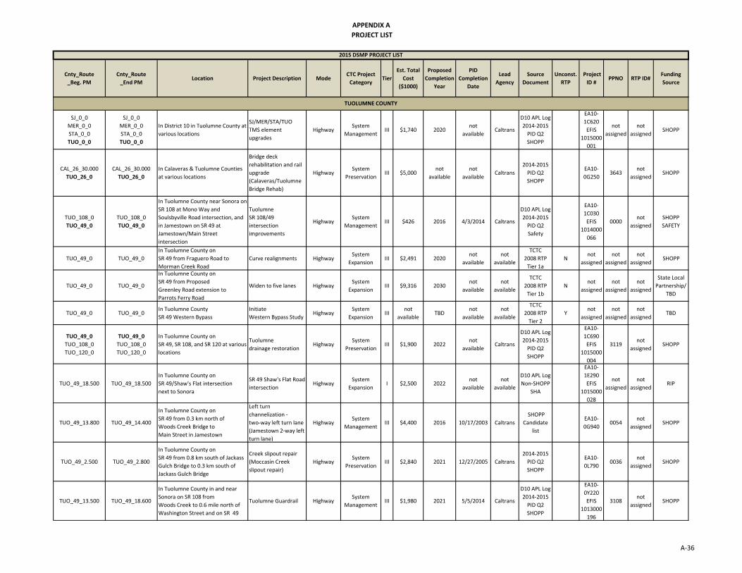
APPENDIX A
PROJECT LIST
Cnty_Route
_Beg. PM
Cnty_Route
_End PMLocation Project Description Mode
CTC Project
CategoryTier
Est. Total
Cost
($1000)
Proposed
Completion
Year
PID
Completion
Date
Lead
Agency
Source
Document
Unconst.
RTP
Project
ID #PPNO RTP ID#
Funding
Source
2015 DSMP PROJECT LIST
SJ_0_0
MER_0_0
STA_0_0
TUO_0_0
SJ_0_0
MER_0_0
STA_0_0
TUO_0_0
In District 10 in Tuolumne County at
various locations
SJ/MER/STA/TUO
TMS element
upgrades
HighwaySystem
ManagementIII $1,740 2020
not
availableCaltrans
D10 APL Log
2014‐2015
PID Q2
SHOPP
EA10‐
1C620
EFIS
1015000
001
not
assigned
not
assignedSHOPP
CAL_26_30.000
TUO_26_0
CAL_26_30.000
TUO_26_0
In Calaveras & Tuolumne Counties
at various locations
Bridge deck
rehabilitation and rail
upgrade
(Calaveras/Tuolumne
Bridge Rehab)
HighwaySystem
PreservationIII $5,000
not
available
not
availableCaltrans
2014‐2015
PID Q2
SHOPP
EA10‐
0G2503643
not
assignedSHOPP
TUO_108_0
TUO_49_0
TUO_108_0
TUO_49_0
In Tuolumne County near Sonora on
SR 108 at Mono Way and
Soulsbyville Road intersection, and
in Jamestown on SR 49 at
Jamestown/Main Street
intersection
Tuolumne
SR 108/49
intersection
improvements
HighwaySystem
ManagementIII $426 2016 4/3/2014 Caltrans
D10 APL Log
2014‐2015
PID Q2
Safety
EA10‐
1C030
EFIS
1014000
066
0000not
assigned
SHOPP
SAFETY
TUO_49_0 TUO_49_0
In Tuolumne County on
SR 49 from Fraguero Road to
Morman Creek Road
Curve realignments HighwaySystem
ExpansionIII $2,491 2020
not
available
not
available
TCTC
2008 RTP
Tier 1a
Nnot
assigned
not
assigned
not
assignedSHOPP
TUO_49_0 TUO_49_0
In Tuolumne County on
SR 49 from Proposed
Greenley Road extension to
Parrots Ferry Road
Widen to five lanes HighwaySystem
ExpansionIII $9,316 2030
not
available
not
available
TCTC
2008 RTP
Tier 1b
Nnot
assigned
not
assigned
not
assigned
State Local
Partnership/
TBD
TUO_49_0 TUO_49_0In Tuolumne County
SR 49 Western Bypass
Initiate
Western Bypass StudyHighway
System
ExpansionIII
not
availableTBD
not
available
not
available
TCTC
2008 RTP
Tier 2
Ynot
assigned
not
assigned
not
assignedTBD
TUO_49_0
TUO_108_0
TUO_120_0
TUO_49_0
TUO_108_0
TUO_120_0
In Tuolumne County on
SR 49, SR 108, and SR 120 at various
locations
Tuolumne
drainage restorationHighway
System
PreservationIII $1,900 2022
not
availableCaltrans
D10 APL Log
2014‐2015
PID Q2
SHOPP
EA10‐
1C690
EFIS
1015000
004
3119not
assignedSHOPP
TUO_49_18.500 TUO_49_18.500
In Tuolumne County on
SR 49/Shaw's Flat intersection
next to Sonora
SR 49 Shaw's Flat Road
intersectionHighway
System
ExpansionI $2,500 2022
not
available
not
available
D10 APL Log
Non‐SHOPP
SHA
EA10‐
1E290
EFIS
1015000
028
not
assigned
not
assignedRIP
TUO_49_13.800 TUO_49_14.400
In Tuolumne County on
SR 49 from 0.3 km north of
Woods Creek Bridge to
Main Street in Jamestown
Left turn
channelization ‐
two‐way left turn lane
(Jamestown 2‐way left
turn lane)
HighwaySystem
ManagementIII $4,400 2016 10/17/2003 Caltrans
SHOPP
Candidate
list
EA10‐
0G9400054
not
assignedSHOPP
TUO_49_2.500 TUO_49_2.800
In Tuolumne County on
SR 49 from 0.8 km south of Jackass
Gulch Bridge to 0.3 km south of
Jackass Gulch Bridge
Creek slipout repair
(Moccasin Creek
slipout repair)
HighwaySystem
PreservationIII $2,840 2021 12/27/2005 Caltrans
2014‐2015
PID Q2
SHOPP
EA10‐
0L7900036
not
assignedSHOPP
TUO_49_13.500 TUO_49_18.600
In Tuolumne County in and near
Sonora on SR 108 from
Woods Creek to 0.6 mile north of
Washington Street and on SR 49
Tuolumne Guardrail HighwaySystem
ManagementIII $1,980 2021 5/5/2014 Caltrans
D10 APL Log
2014‐2015
PID Q2
SHOPP
EA10‐
0Y220
EFIS
1013000
196
3108not
assignedSHOPP
TUOLUMNE COUNTY
A‐36

APPENDIX A
PROJECT LIST
Cnty_Route
_Beg. PM
Cnty_Route
_End PMLocation Project Description Mode
CTC Project
CategoryTier
Est. Total
Cost
($1000)
Proposed
Completion
Year
PID
Completion
Date
Lead
Agency
Source
Document
Unconst.
RTP
Project
ID #PPNO RTP ID#
Funding
Source
2015 DSMP PROJECT LIST
TUO_49_0 TUO_49_0
In Tuolumne County on
SR 49, SR 120 ‐ PM Var
New Melones Reservoir
SR‐49 (#32 0040)
Big Oak Sidehill Viaduct (#32 0055)
Bridge
Seismic RetrofitHighway
System
PreservationIII $19,588
not
available
not
availableCaltrans
10‐Year
SHOPP
EA10‐
1C840
15859
not
assigned
not
assignedSHOPP
TUO_49_0
TUO_108_0
TUO_49_0
TUO_108_0
In Tuolumne County on
SR 108 from Rawhide Road
to Fifth Avenue
Widen to five lanes HighwaySystem
ExpansionII $20,464 2011
not
available
not
available
TCTC
2008 RTP
Tier 1a
Nnot
assigned
not
assigned
not
assigned
TIF/
State Local
Partnership
TUO_49_0
TUO_108_0
TUO_49_0
TUO_108_0
In Tuolumne County on
SR 49/108 from
Chicken Ranch Road to
Main Street
Widen to five lanes on
SR 49/108Highway
System
ExpansionIII $13,866 Buildout
not
available
not
available
TCTC
2008 RTP
Tier 2
Ynot
assigned
not
assigned
not
assignedTBD
TUO_49_0
TUO_108_0
TUO_49_0
TUO_108_0
In Tuolumne County on
SR 49/108 from Main Street to
SR 49 Junction south of Sonora
(Jamestown)
Widen SR 49/108 HighwaySystem
ExpansionIII $19,162 Buildout
not
available
not
available
TCTC
2008 RTP
Tier 2
Ynot
assigned
not
assigned
not
assignedTBD
TUO_49_0
TUO_108_0
TUO_49_0
TUO_108_0
In Tuolumne County on
a New two or four lane expressway
SR 49/108 from High School Road in
Jamestown to Rawhide Road
north of Sonora
Construct a new
two or four lane
expressway
HighwaySystem
ExpansionIII $17,000 Buildout
not
available
not
available
TCTC
2008 RTP
Tier 2
Ynot
assigned
not
assigned
not
assignedTBD
TUO_108_0 TUO_108_0
In Tuolumne County on
SR 108 (Montezuma Junction)
between SR 120 and SR 49
Widen to four lanes HighwaySystem
ExpansionIII $3,500 Buildout
not
available
not
available
TCTC
2008 RTP
Tier 2
Ynot
assigned
not
assigned
not
assignedTBD
ALP_4_0
ALP_88_0
ALP_207_0
AMA_16_0
AMA_49_0
TUO_108_0
ALP_4_0
ALP_88_0
ALP_207_0
AMA_16_0
AMA_49_0
TUO_108_0
In Alpine County on SR 4, SR 88 and
SR 207 in Amador County on SR 16
and SR 49, and in Tuolumne County
on SR 108
ALP/AMA/TUO
Culvert RehabHighway
System
PreservationIII $3,612 2022 5/9/2014 Caltrans
2014‐2015
PID Q2
SHOPP
EA10‐
0S750
EFIS
1014000
099
not
assigned
not
assignedSHOPP
TUO_108_0
TUO_49_0
TUO_108_0
TUO_49_0
In Tuolumne County near Sonora
on SR 108 at Mono Way and
Soulsbyville Road intersection, and
in Jamestown on SR 49 at
Jamestown/Main Street
intersection
Tuolumne
SR 108/49 intersection
improvements
HighwaySystem
ManagementIII $426 2016 5/22/2014 Caltrans
D10 APL Log
2014‐2015
PID Q2
Safety
EA10‐
1C030
EFIS
1014000
066
0000not
assigned
SHOPP
SAFETY
TUO_49_0
TUO_108_0
TUO_120_0
TUO_49_0
TUO_108_0
TUO_120_0
In Tuolumne County on
SR 49, SR 108, and SR 120
at various locations
Tuolumne
drainage restorationHighway
System
PreservationIII $1,900 2022
not
availableCaltrans
D10 APL Log
2014‐2015
PID Q2
SHOPP
EA10‐
1C690
EFIS
1015000
004
3119not
assignedSHOPP
TUO_108_4.300 TUO_108_4.300
In Tuolumne County on
SR 108 within the East Sonora
Bypass Stage II limits at
Peaceful Oak Interchange
Peaceful Oak Ramps HighwaySystem
ExpansonI $6,497 2019 12/16/2013
not
available
Non‐SHOPP
SHA
EA10‐
0Y210
EFIS
1013000
104
not
assigned
not
assignedRIP
A‐37

APPENDIX A
PROJECT LIST
Cnty_Route
_Beg. PM
Cnty_Route
_End PMLocation Project Description Mode
CTC Project
CategoryTier
Est. Total
Cost
($1000)
Proposed
Completion
Year
PID
Completion
Date
Lead
Agency
Source
Document
Unconst.
RTP
Project
ID #PPNO RTP ID#
Funding
Source
2015 DSMP PROJECT LIST
TUO_108_L0.000 TUO_108_L2.800
In Tuolumne County on
SR 108 and SR 120 from 7.7 km
west of SR 108/120 Junction to
West Junction of SR 49
(KP L0.0/L4.5) (KP 2.87/ 19.47)
AC overlay and widen
(Yosemite Junction
Rehab)
HighwaySystem
PreservationIII $22,400
not
available7/21/1997 Caltrans
2014‐2015
PID Q2
SHOPP
EA10‐
30503
EFIS
1013000
267
not
assigned
not
assignedSHOPP
TUO_108_R18.900 TUO_108_24.500
In Tuolumne County on
SR 108 Near Long Barn from 0.2 km
east of Long Barn Connection
to 0.8 km east of Heliport Road
Pavement rehab and
shoulder widening at
various locations
(East Long Barn
Rehab)
HighwaySystem
PreservationIII $10,992 2019 9/24/2001 Caltrans
2014‐2015
PID Q2
SHOPP
EA10‐
46210
EFIS
1013000
266
0157not
assignedSHOPP
TUO_108_32.200 TUO_108_34.410
In Tuolumne County on
SR 108 from 0.3 mile east of
Old Strawberry Road to 0.7 mile
west of Beardsley Road
SR 108 Tuolumne
wire meshHighway
System
PreservationIII $1,550 2029
not
availableCaltrans
D10 APL Log
2014‐2015
PID Q2
SHOPP
EA10‐
0Y800
EFIS
1015000
007
not
assigned
not
assignedSHOPP
TUO_108_L0.000 TUO_108_L0.000
In Tuolumne County on
SR 108 at the intersection of SR 108
and SR 120
SR 108 intersection
improvementHighway
System
ManagementIII $0 2021
not
availableCaltrans
D10 APL Log
2014‐2015
PID Q2
SHOPP
EA10‐
1C540
EFIS
1015000
029
3114not
assignedSHOPP
TUO_108_1.800 TUO_108_26.200
In Tuolumne County on
SR 108 Chain Control at various
locations
Roadside Safety
Improvements/
Chain Control lighting
HighwaySystem
ManagementIII $2,230
not
available
not
availableCaltrans
10‐Year
SHOPP16111
not
assigned
not
assignedSHOPP
TUO_108_0
TUO_120_0
TUO_108_0
TUO_120_0
In Tuolumne County on
SR 108/120 from east of
Tulloch Road to west of
Green Springs Road (Keystone)
Rehabilitate pavement HighwaySystem
PreservationIII $5,189 2020
not
available
not
available
TCTC
2008 RTP
Tier 1a
Nnot
assigned
not
assigned
not
assignedSHOPP
TUO_108_0
TUO_120_0
TUO_108_0
TUO_120_0
In Tuolumne County on
SR 108 /120 Widen to four lane
expressway between SR 120 and
existing four lane section
(Keystone)
Widen to four lane
expressway Highway
System
ExpansionIII $17,000 Buildout
not
available
not
available
TCTC
2008 RTP
Tier 2
Ynot
assigned
not
assigned
not
assignedTBD
TUO_120_0 TUO_120_0In Tuolumne County at
SR 120/108 Yosemite Junction
Install traffic signal
and geometric
improvements
HighwaySystem
ManagementII TBD 2020
not
available
not
available
TCTC
2008 RTP
Tier 1a
Nnot
assigned
not
assigned
not
assignedDEV
TUO_120_0 TUO_120_0
In Tuolumne County on
SR 120 from Old Priest Grade to
Big Oak Road (Groveland)
Widen road and install
guardrail Highway
System
ExpansionIII $2,500 2020
not
available
not
available
TCTC
2008 RTP
Tier 1a
Nnot
assigned
not
assigned
not
assignedSHOPP
TUO_49_0
TUO_108_0
TUO_120_0
TUO_49_0
TUO_108_0
TUO_120_0
In Tuolumne County on
SR 49, SR 108, and SR 120
at various locations
Tuolumne
drainage restorationHighway
System
PreservationIII $1,900 2022
not
availableCaltrans
D10 APL Log
2014‐2015
PID Q2
SHOPP
EA10‐
1C690
EFIS
1015000
004
3119not
assignedSHOPP
TUO_120_R32.900 TUO_120_R41.500
In Tuolumne County in Groveland
on SR 120 from 0.2 mile east of
Ferretti Road to 1.9 miles east of
Mariposa County Line near
Buck Meadows
CAPM east of
Buck MeadowsHighway
System
PreservationIII $7,620
not
available10/31/2014 Caltrans
2014‐2015
PID Q2
SHOPP
EA10‐
0E960
EFIS
1013000
254
0335not
assignedSHOPP
A‐38

APPENDIX A
PROJECT LIST
Cnty_Route
_Beg. PM
Cnty_Route
_End PMLocation Project Description Mode
CTC Project
CategoryTier
Est. Total
Cost
($1000)
Proposed
Completion
Year
PID
Completion
Date
Lead
Agency
Source
Document
Unconst.
RTP
Project
ID #PPNO RTP ID#
Funding
Source
2015 DSMP PROJECT LIST
TUO_120_16.200 TUO_120_24.100
In Tuolumne County on
SR 120 from Shawmut Road
just east of Chinese Camp to
Moccasin Creek Bridge
Rehab‐widen shoulder
and AC overlay
(Chinese Camp rehab
II)
HighwaySystem
PreservationIII $2,578 2018 10/13/2005 Caltrans
2014‐2015
PID Q2
SHOPP
EA10‐
3A700
EFIS
1013000
257
0292not
assignedSHOPP
TUO_120_48.800 TUO_120_50.700
In Tuolumne County on
SR 120 about 1.5 miles east of
Sweet Water Road to 0.5 mile west
of South Fork Tuolumne River
Bridge
SR 120 slope
modificationHighway
System
PreservationIII $1,500 2021
not
availableCaltrans
D10 APL Log
2014‐2015
PID Q2
SHOPP
EA10‐
0Y790
EFIS
1015000
006
not
assigned
not
assignedSHOPP
TUO_120_12.100 TUO_120_12.100In Tuolumne County at the Junction
of SR 120 HO8 (Yosemite Junction)
Build new safety
roadside rest
(Yosemite Junction
SRRA)
HighwaySystem
PreservationIII $3,000
not
available
not
availableCaltrans
D10 APL Log
2014‐2015
PID Q2
SHOPP
EA10‐
29646
not
assigned
not
assignedSHOPP
VAR_0_0 VAR_0_0
In Amador and San Joaquin
Counties on SR 4, SR 12, SR 26,
SR 88 and 112 at various locations
Drainage system
restoration (Drainage
improvements ‐ 2)
HighwaySystem
PreservationIII $2,000
not
available
not
availableCaltrans
D10 APL Log
2014‐2015
PID Q2
SHOPP
EA10‐
0N720
not
assigned
not
assignedSHOPP
VAR_0_0 VAR_0_0
In Alpine, Amador, Calaveras, and
Tuolumne Counties on SR 4, SR 26,
SR 88, SR 89, SR 108, SR 120,
SR 124, SR 207 at various location
DRAINAGE SYSTEM
RESTORATION
(Drainage
Improvements ‐ 1)
HighwaySystem
PreservationIII $2,000
not
available
not
availableCaltrans
2014‐2015
PID Q2
SHOPP
EA10‐
0P4500150
not
assignedSHOPP
not
available
not
available
not
available
not
availableHighway
System
ManagementIII
not
available
not
available
not
availableCaltrans
D10 APL Log
2014‐2015
PID Q2
Safety
EA10‐
1C430
not
assigned
not
assigned
SHOPP
SAFETY
not
available
not
available
not
available
not
availableHighway
System
ManagementIII $0.90
not
available
not
availableCaltrans
D10 APL Log
2014‐2015
PID Q2
Safety
EA10‐
1C440
not
assigned
not
assigned
SHOPP
SAFETY
not
available
not
available
not
available
not
availableHighway
System
ManagementIII
not
available
not
available
not
availableCaltrans
D10 APL Log
2014‐2015
PID Q2
Safety
EA10‐
1C460
not
assigned
not
assigned
SHOPP
SAFETY
not
available
not
available
not
available
not
availableHighway
System
ManagementIII $6.40
not
available
not
availableCaltrans
D10 APL Log
2014‐2015
PID Q2
Safety
EA10‐
1C480
not
assigned
not
assigned
SHOPP
SAFETY
not
available
not
available
not
available
Pedestrian Safety
ImprovementsPedestrian
System
ManagementIII
not
available
not
available
not
availableCaltrans
10‐Year
SHOPP15704
not
assigned
not
assignedSHOPP
Tier:
‐ Tier 0: Fully funded, programmed projects
‐ Tier I: Partially programmed projects
‐ Tier II: Fiscally constrained projects that are not programmed
‐ Tier III: Candidate projects likely to be funded if additional funds become available but are not fiscally constrained
‐
‐ Tier V: Other projects identified as needed by the District
Tier IV: Projects that have a demonstrated need but are unlikely to either receive funding, or to be ready to be delivered, within the ten year
A‐39

B-1
APPENDIX B: INTERCITY RAIL PROJECT LIST*
*Intercity Rail Project List provided by Headquarters
Draft Intercity Rail Project List
STIP Year
District
County
Route
Project
Description
Mode
CTC
Project
Category
Est. Total
Cost
($1000)
Proposed
Completion
Year
Source
Documen
t
Funding
Source
Not STIP
4,6,10
Contra Costa, San Joaquin, Stanislaus, Merced, Fresno, Kings, Tulare, Kern
San Joaquin Corridor
Track & Signal: Positive Train Control (Port Charles to Bakersfield)
Intercity Rail
System Preservation
$24,500 2015
San Joaquin Corridor Service
Development Plan
(May 2013)
Partially Allocated Prop 1A
Not STIP
10 Merced SJC
Track & Signal: Merced to Le Grand second main track (segment 1)
Intercity Rail
System Expansion
$40,400 2018 SJ Corridor
SDP (May 2013)
Prop 1A
2012 10 San
Joaquin, Merced
SJC
Track & Signal: Stockton to
Escalon second main track (segments 3)
Intercity Rail
System Expansion
$20,500 2018
Segments 3 & 4
separated per DOR STIP
2012 Funding info
STIP, SJCOG RTP
2018 10 San
Joaquin, Merced
SJC
Track & Signal: Stockton to
Escalon second main track (segments 4)
Intercity Rail
System Expansion
$33,500 2018
Segments 3 & 4
separated per DOR STIP
2012 Funding info
STIP, SJCOG RTP
2016 10 San
Joaquin SJC
Track & Signal: Stockton Hub
Track Upgrades/Related
Facilities
Intercity Rail
System Expansion
$100,000 2018 SJ Corridor
SDP (May 2013)
2014 10 Merced SJC
Track & Signal: Merced to Le Grand second main track
(segment 2‐3)
Intercity Rail
System Expansion
$24,100 2019 to
2040
SJ Corridor SDP
(May 2013) Prop 1A
2018 10 San
Joaquin, Merced
SJC
Track & Signal: Stockton to
Escalon second main track
(segments 1‐2)
Intercity Rail
System Expansion
$22,000 2019 to
2040
SJ Corridor SDP
(May 2013) Prop 1A
C-1
APPENDIX C: GLOSSARY OF TERMS AND ACRONYMS
GLOSSARY OF TERMS
Annual Average Daily Traffic (AADT) ‐‐ the total traffic volume on a given highway or segment in a year divided by 365. The year is from October 1st through September 30th. Raw traffic counts are obtained through a sampling program of highway locations throughout the District, rather than continuous sampling throughout the year (though this may not be accurate for PeMS stations that continuous monitor traffic volumes). These counts are adjusted to compensate for daily and seasonal variability compared to previous records. Base year – the initial year of analysis, usually, the year that recent data is available. Bikeways: Class I (Bike Path) – a separate travel right of way for the exclusive use of bicycles, pedestrians, and possibly equestrians. Class II (Bike Lane) – a lane within a shared right of way for use of bicycles. Usually separated from motorized vehicle traffic by striping, and may permit merging at approached to intersections for right turns. Class III (Bike Route) – shared right of way between motorized vehicles and bicycles, may have wide shoulders to accommodate separation of the two modes, or may be signed to alert motorists to shared use. Bottlenecks – a location where the carrying capacity is substantially less than elsewhere on a route. Often this occurs with a lane reduction, or excessive merging and weaving, or driver distraction, or a surge in demand, or a combination of these and other factors. California Transportation Plan (CTP) – a statewide, long‐range transportation plan with a minimum 20‐year planning horizon intending to address both future mobility needs and reduce greenhouse gas (GHG) emissions. The CTP defines performance‐based goals, policies, and strategies to achieve a collective vision for California’s future, statewide, integrated, multimodal transportation system. The CTP is prepared in response to federal and State requirements and is updated every five years. Capacity – the maximum sustainable hourly flow rate at which persons or vehicles reasonably can be expected to traverse a point or a uniform section of a lane or roadway during a given time period under prevailing roadway, environmental, traffic, and control conditions. Concept LOS – the minimum acceptable LOS over the next 20‐25 years. Conceptual Project – an action or a project that needed to maintain mobility or serve multimodal users, but is not included in a fiscally constrained plan and is not programmed. It could be included in a General Plan or in the unconstrained section of a long‐term plan. Corridor – a broad geographical band that follows a general directional flow connecting major sources of trips that may contain a number of streets, highways, bicycle, pedestrian, and transit route alignments. Off system facilities are included as informational purposes and not analyzed in the TCR.

C-2
Glossary of Terms Continued Facility Concept – describes the future highway facility and the strategies that may be needed to be deployed within the next 20‐25 years. This can include capacity increasing, State highway, bicycle facility, pedestrian facility, transit facility, non‐capacity increasing operational improvements, new managed lanes, conversion of existing managed lanes to another managed lane type or characteristic, TMS field elements, TDM and incident management. Facility Type – refers to a highway as being either a freeway, expressway, conventional, or a one‐way city street. Freight Generator – any facility, business, manufacturing plant, distribution center, industrial development, or other location (convergence of commodity and transportation system) that produces significant commodity flow, measured in tonnage, weight, carload, or truck volume. Headway – the time between two successive vehicles as they pass a point on the roadway, measured from the same common feature of both vehicles. Horizon Year – The year that the future (20‐25 years) data is based on. Intermodal Freight Facility – a location where different transportation modes and networks (air, marine, rail, truck) interconnect and allow freight to be transferred (transloaded) from one mode to another. Intelligent Transportation System (ITS)—an integrated network of communications‐based information and electronics technologies to collect real time traffic information, process it, and take appropriate actions. The intended outcomes are to improve transportation safety, mobility and to enhance worker productivity by reducing travel delay. Level of Service (LOS) ‐‐ a qualitative measure describing operational conditions within a traffic stream and their perception by motorists. A LOS definition generally describes these conditions in terms of speed, travel time, freedom to maneuver, traffic interruption, comfort, and convenience. Six levels of LOS can generally be categorized as follows:

C-3
Glossary of Terms Continued
LOS A describes free flowing conditions. The operation of vehicles is virtually unaffected by the presence of other vehicles, and operations are constrained only by the geometric features of the highway.
LOS B is also indicative of free‐flow conditions. Average travel speeds are the same as in LOS A, but drivers have slightly less freedom to maneuver.
LOS C represents a range in which the influence of traffic density on operations becomes marked. The ability to maneuver with the traffic stream is now clearly affected by the presence of other vehicles.
LOS D demonstrates a range in which the ability to maneuver is severely restricted because of the traffic congestion. Travel speed begins to be reduced as traffic volume increases.
LOS E reflects operations at or near capacity and is quite unstable. Because the limits of the level of service are approached, service disruptions cannot be damped or readily dissipated.
LOS F a stop and go, low speed conditions with little or poor maneuverability. Speed and traffic flow may drop to zero and considerable delays occur. For intersections, LOS F describes operations with delay in excess of 60 seconds per vehicle. This level, considered by most drivers unacceptable often occurs with oversaturation, that is, when arrival flow rates exceed the capacity of the intersection. Multi‐modal –the different modes of commuting within a travel corridor (automobile, subway, bus, rail, bicycle, pedestrian, or air). Park‐and‐Ride – location where commuters park their personal vehicles and continue their trip by carpool, vanpool, or transit.

C-4
Glossary of Terms Continued Peak Hour – the hour of the day in which the maximum volume occurs across a point on the highway. Peak Hour Volume – the hourly volume during the highest hour traffic volume of the day traversing a point on a highway segment. It is generally between 6 percent and 10 percent of the ADT. The lower values are generally found on roadways with low volumes. Peak Period – the part of day during which traffic congestion is at its greatest. Typically, this happens twice a day, in the morning and in the evening during the time most people commute to work or return (rush hour). Peak Period is defined for individual routes, not a District or statewide standard. Planned Project – a planned improvement or action is a project in a fiscally constrained section of a long‐term plan, such as an approved Regional or Metropolitan Transportation Plan (RTP or MTP), Capital Improvement Plan, or measure. Postmile – a measured location on a route within the State Highway System. Typically measured on routes from county lines, the values of a post mile will increase from south to north, or west to east. When a section of road is relocated, new post miles (usually noted by an alphabetical prefix such as "R" or "M") are established for it. If relocation results in a change in length, "milepost equations" are introduced at the end of each relocated portion so that mileposts on the reminder of the route within the county will remain unchanged. Programmed Project – an improvement or action identifying funding amounts by year, and included in short term project funding documents such as the State Transportation Improvement Program (STIP) or the State Highway Operation and Protection Program (SHOPP). Programming refers to projects permitted for expenditure of monies allocated for project development and implementation (are subject to oversight by project managers). Railroads: Class I – a carrier having annual operating revenues of $250 million or more. This class includes the nation’s major railroads. In California, Class I railroads include Union Pacific Railroad (UP) and Burlington Northern Santa Fe Railway (BNSF). Class II – a carrier having annual operating revenues between $250 million and $20 million. Class II railroads are considered mid‐sized freight‐hauling railroad in terms of operating revenues. They are considered “regional railroads” by the Association of American Railroads. Class III – a carrier having annual operating revenues of $20 million or less. The typical Class III is a short line railroad, which feeds traffic to or delivers traffic from a Class I or Class II railroad. Route Designation – refers to design standards applicable to a route based upon legislative intent. Typical legislative designations include but National Highway System (NHS), Interregional Route System (IRRS), Freeway and Expressway System, and Scenic Highway System. Rural – Fewer than 5,000 in population designates a rural area. Limits are based upon population density as determined by the U.S. Census Bureau.
Segment – A portion of a facility between two points.
C-5
Glossary of Terms Continued System Operations and Management Concept – Describe the system operations and management elements that may be needed within 20‐25 years. This can include Non‐capacity increasing operational improvements (aux. lanes, channelization’s, turnouts, etc.), conversion of existing managed lanes to another managed lane type or characteristic (e.g. HOV land to HOT lane), TMS Field Elements, transportation demand management, and incident management. System Preservation ‐ the unmet needs estimate for preserving the state’s transportation system incorporates three elements: preventive maintenance, rehabilitation and reconstruction, and regulatory mandates.
Preventive maintenance applies cost‐effective treatments to existing transportation infrastructure to help preserve it, slowing down future deterioration and maintaining or improving the functional condition of the infrastructure (without significantly increasing the structural capacity). Preventive maintenance strategies are typically applied to assets that are in good condition and have significant remaining service life. This ensures the structural integrity of transportation systems that serve people and freight.
Rehabilitation and reconstruction strategies are applied to transportation infrastructure that is in fair to poor condition. The goal here is to restore assets to an acceptable operating condition.
Preservation efforts also include the cost of regulatory mandates. Examples of regulatory mandates include storm water retrofitting required by the Clean Water Act (CWA) and state water quality control boards, and improvements required by the Americans with Disabilities ACTC (ADA).
TDM ‐ transportation Demand Management programs designed to reduce or shift demand for transportation through various means, such as the use of public transportation, carpooling, telework, and alternative work hours. TDM strategies can be used to manage congestion during peak periods and mitigate environmental impacts. Tier I ‐ partially programmed projects Tier II ‐ fiscally constrained projects that are not programmed. Projects in this category must be from a fiscally constrained document/list (such as the fiscally constrained project list in an RTP) and not from an unconstrained document (such as a TCR). Tier III ‐ projects that the District will advocate to be included in fiscally constrained projects lists (RTP, SHOPP) during the 20‐25 year planning horizon. These are projects that are not currently in a fiscally constrained project list. Tier IV ‐ projects that have a demonstrated need within the 20‐25 year time horizon and have been identified as high priority by the District but are unlikely to receive funding within the 20‐25 year time horizon. These are likely projects that will be programmed if an unexpected funding source becomes available, like an initiative or local measure. Tier V ‐ other projects identified as needed by the District: these may be within the 20‐25 year time horizon, beyond the 20‐25 year time horizon, or only conceptual in nature.

C-6
Glossary of Terms Continued Transportation Management System (TMS) ‐‐ the business processes and associated tools, field elements and communications systems that help maximize the productivity of the transportation system. TMS includes, but is not limited to, advanced operational hardware, software, communications systems and infrastructure, for integrated advanced TMS and information systems, and for electronic toll collection systems. Urban – 5,000 to 49,999 in population designates an urban area. Limits are based upon population density as determined by the U.S. Census Bureau. Urbanized – over 50,000 in population designates an urbanized area. Limits are based upon population density as determined by the U.S. Census Bureau. Vehicle Miles Traveled (VMT) – the total number of miles traveled by motor vehicles on a road or highway segments.

C-7
ACRONYMS AADT ‐ Annual Average Daily Traffic AB – Assembly Bill ACE ‐ Altamont Commuter Express ADA ‐ Americans with Disabilities Act of 1990 ADT ‐ Average Daily Traffic ACLTC ‐ Alpine County Local Transportation Commission ACTC ‐ Amador County Transportation Commission ALP ‐ Alpine AMA ‐ Amador APCD ‐ Air Pollution Control District ARTS ‐ Amador Regional Transit Service BART ‐ Bay Area Rapid Transit BNSF ‐ Burlington Northern Santa Fe BRT ‐ Bus Rapid Transit CAL ‐ Calaveras CALTRANS ‐ California Department of Transportation CAPM ‐ Capital Preventive Maintenance CARB – California Air Resources Board CCOG ‐ Calaveras County Council of Governments CCTVs ‐ Closed Circuit Television Cameras CHP ‐ California Highway Patrol CMA ‐ Congestion Management Agencies CMAQ ‐ Congestion Mitigation and Air Quality CMIA ‐ Corridor Mobility Improvement Account CMS ‐ Changeable Message signs COOP ‐ Cooperative Agreements CSMP ‐ Corridor System Management Plan CSS ‐ Context Sensitive Solutions CTC ‐ California Transportation Commission CTP ‐ California Transportation Plan DOF‐ Department of Finance DSMP ‐ District System Management Plan DWR ‐ Department of Water Resources EB ‐ Eastbound EIS ‐ Environmental Impact Statement EIR ‐ Environmental Impact Report FHWA ‐ Federal Highway Administration F&E ‐ Freeway and Expressway GHG ‐ Green House Gas HAR ‐ (Highway Advisory Radio (HAR) HCP ‐ Habitat Conservation Plan HDM – Highway Design Manual HFST – Friction Surface Treatment HOT ‐ High occupancy toll lane HOV ‐ High occupancy vehicle lane HPP ‐ High Profile Projects HSIP ‐ Highway Safety Improvement Program HSR ‐ High Speed Rail

C-8
Acronyms Continued
ICES ‐ Intermodal Corridor of Economic Significance IGR ‐ Intergovernmental Review IIP ‐ Interregional Improvement Program INVEST – Infrastructure Voluntary Evaluation Sustainability Tool IOS ‐ Initial Operating Section IRRS ‐ Interregional Road System ITS ‐ Intelligent Transportation System ITIP – Interregional Transportation Improvement Program ITSP ‐ Interregional Transportation Strategic Plan ITTS ‐ Interregional Road System KM ‐ Kilometer KPRA ‐ Kingpin to Rear Axle LOS ‐ Level of Service M‐580 ‐ Marine Highway MAP‐21 ‐ Moving Ahead for Progress in the 21st Century MAX ‐ Modesto Area Express MCAGs ‐ Merced County Association of Governments MCCA ‐ Modesto City and County Airport MCLTC ‐ Mariposa County Local Transportation Commission MCTC ‐ Mariposa County Transportation Commission MER ‐ Merced MPA ‐ Mariposa MPO ‐ Metropolitan Planning Organizations MVP – Maintenance Vehicle Pullouts N/A ‐ Not available NHS ‐ National Highway System OWP – Overall Work Program PA&ED ‐ Project Approval/Environmental Document PID ‐ Project Initiation Document PM ‐ Post Mile PPNO ‐ Planning/Programming Number PS&E ‐ Plans, Specifications, and Estimates PSR ‐ Project Study Report RHNA ‐ Regional Housing Needs Allocation RIP ‐ Regional Improvement Program ROW ‐ Right of Way RP – California Rail Plan RSTP ‐ Regional Surface Transportation Program RTIP ‐ Regional Transportation Improvement Program RTIF‐Regional Transportation Impact Fee RTP ‐ Regional Transportation Plan RTPAs ‐ Regional Transportation Planning Agencies RTPA ‐ Regional Transportation Planning Agencies RWIS ‐ Roadway Weather Information System SAFETEA ‐ Safe, Accountable, Flexible and Efficient Transportation Equity Act of 2005 SB ‐ Senate Bill SCS ‐ Sustainable Community Strategies SHA ‐ State Highway Account
C-9
Acronyms Continued SHOPP ‐ State Highways Operations and Protection Program SHS ‐ System Highway System SHSP ‐ Strategic Highway Safety Plan SJ ‐ San Joaquin SJCOG ‐ San Joaquin Council of Governments SJRTD ‐ San Joaquin Regional Transit District SJVGMAP ‐ San Joaquin Valley Goods Movement Action Plan SMF ‐ Smart Mobility Framework SR ‐ State Route SRA – State Recreation Area STA ‐ Stanislaus STANCOG ‐ Stanislaus Council of Governments STRAHNET ‐ Strategic Highway Network STAA ‐ Surface Transportation Assistance Act STIP ‐ State Transportation Improvement Program STRAIN ‐ Structure Replacement and Improvements Needs TASAS – Traffic Accident Surveillance and Analysis System TCR ‐ Transportation Concept Report TCTC ‐ Tuolumne County Transportation Commission TE ‐ Test and Evaluation Project TEA‐21 ‐ Transportation Equity Act for the 21st Century TERO ‐ Tribal Employment Rights Ordinance TDM ‐ Transportation Demand Management TMC ‐ Transportation Management Centers TMD – Transportation Demand Modal TMS ‐ Transportation Management System TSDP ‐ Transportation System Development Program TSMO ‐ Transportation System Management and Operations TUO ‐ Tuolumne US ‐ United States UTC ‐ Ultimate Transportation Concept UP ‐ Union Pacific WIRIS ‐ West Ione Roadway Improvement Strategy YARTS ‐ Yosemite Area Regional Transportation System YNP ‐ Yosemite National Park
