down on the corner - american surveyor magazine · down on the corner march 2015 ... supreme court...
TRANSCRIPT

DOWN ON THE CORNER
MARCH 2015
Geodetic PreppersOPUS users beware
CA Coastal BoundarySupreme Court confusion
NCEES & ExperienceOpen letter and response
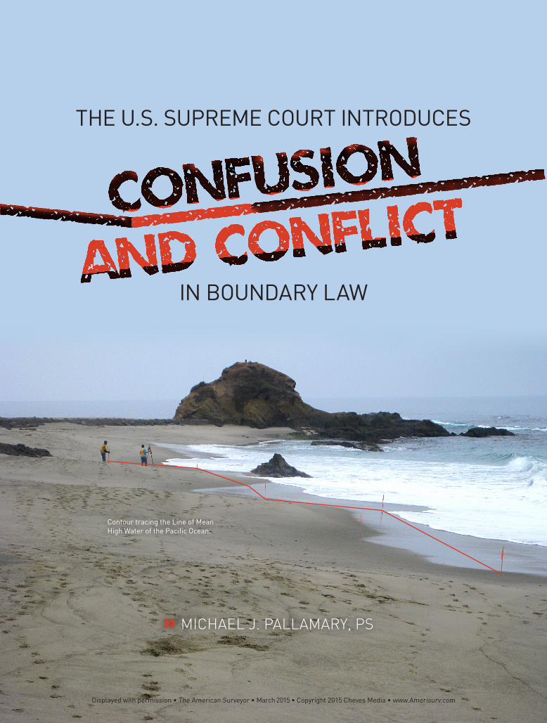
» MICHAEL J. PALLAMARY, PS
CONFUSION
AND CONFLICTIN BOUNDARY LAW
THE U.S. SUPREME COURT INTRODUCES
Contour tracing the Line of Mean High Water of the Pacific Ocean.
Displayed with permission • The American Surveyor • March 2015 • Copyright 2015 Cheves Media • www.Amerisurv.com

Caltrans LS/LSIT Video Exam Preparation Course
EntireTownshipS & O
Lakebed owned by adjacent upland owners.
Lot 2 Lot 4
Lot 3
Lot 5
Lot 6
Upland
Tidalto here
Mountains
OLWM Boundary at least public use
easement over strip between OLWM & OHWM.
Public Lands
Navigableto here
SegregationLine
Swamp & Overflowed Lands
OHWM Boundary
U.S.Meander
LineTidelands
Seaward Limit of Bay (Headland to
Headland)
MLLW per California Practice
Navigable Lake
Harbor3 Geo. miles
3 Geo. miles
CoastalTidelands
Out
er C
ontin
enta
l She
lf La
nds
(Und
er J
uris
dict
ion
of U
.S. G
over
nmen
t) Pa
cific
Oce
an
OHWM
MLLW
Lot 1 Non-
navig
able
Lake
Rancho XX
Confirmed Mexican
Land Grant
Natural river channel cutoff by construction
boundary in last natural location.
Lakebed below OLWM owned by State. Public
use easement over strip between OHWM and
OLWM.
S&O = Swamp & overflowed lands MLLW = Mean lower low water (line) OLWM = Ordinary low water mark OHWM = Ordinary high water mark
Tidal Bay
Figure 14-1. From “Water Boundaries for Land Surveyors,” permission granted by Landmark Enterprises.
14-4
n December 15, 2014, the United States Supreme Court issued a decree in the hopes of settling a decades-old dispute
over the location of California’s offshore boundary, a line common with the United States of America. The conflict originated in 1946 when the federal government sued California for leasing land for oil drilling off-shore from Long Beach. President Truman argued that the submerged lands belonged to the federal government and not the state. The court agreed and congress subsequently passed a law granting states ownership up to three miles off the coast. Considering the location of subsurface oil reserves and mineral resources, the stakes remain high.
According to the 112 page document, the decree “permanently” fixed the boundary line between the two competing govern-ments. According to Sheri Pemberton with the California State Lands Commission, “It’s a huge achievement after all this time. Going forward there’s absolute certainty about what that boundary is.”
The decree follows previous decisions of the court beginning on October 27, 1947 when the court entered its initial decree regarding the entitlement of the United States and the State of California to lands, minerals, and other natural resources underlying the Pacific Ocean offshore of California as per the nascent case, captioned The United States v. California at 332 U.S. 804. On January 31, 1966, the court entered a supplemental decree redefining the federal-state boundary pursuant to the Submerged Lands Act, codified at 43 U.S.C. 1301-1315, 382 U.S. 448 (“SLA”). Consistent with the court’s objectives, it issued three more supplemental decrees between 1977 and 1981, further delin-eating particular portions of the federal-state boundary. [See 432 U.S. 40 (1977); 439 U.S. 30 (1978); 449 U.S. 408 (1981)]. In an article in The Verge, outlining a journalist’s attempt to decipher the decree and captioned: “The Supreme Court just redefined California’s boundaries with this crazy document,” the article offers a unique perspective.
It’s like trying to look at the code of the Matrix to see what Neo’s up to, except you’re actually reading information about rocks and dirt. If you’re patient
enough to scroll through the entire thing, you’ll finally reach the document’s only graphic—an actual map of the changes.
Regrettably, the notion of “absolute certainty” appears to be derived from the misunderstood notion of significant figures and little to no understanding of geodesy. According to the coordinate dependent decree wherein the values are presented to 3 significant figures, troubling questions arise as to how the values were determined. At best, it appears as if the lines were developed by extraction from a GIS map of unknown origin. The key excerpts from the decree and the resultant questions are as follows:
1. Location of the Fixed Offshore Boundary Between the United States and California that is Parallel to the Coastline of Mainland California.
2. The coordinate values are expressed as both NAD 83 and WGS 84 UTM ZONE 11 coordinates in meters.
3. Plane coordinates refer to the Universal Transverse Mercator (UTM). All coordinates are referenced to the North American Datum 1983 (NAD 83), which is equivalent to the World Geodetic System 1984 (WGS 84).
4. Pursuant to 43 U.S.C. 1301(b), upon entry of this decree, the federal-state boundary shall be immobilized at the
coordinates provided in paragraph 3 and shall not be ambulatory.
5. The map attached to the decree includes a depiction of the line represented at a nautical scale map.
The key words have been emphasized for purposes of discussion both above and below. The salient points are as follows:
1 Location of the Fixed Offshore Boundary between the United
States and California that is Parallel to the Coastline of Mainland California.By definition, the decree line is parallel to the coastline of California. Absent an extraordinary definition of the word parallel, it is generally accepted that parallel means two or more lines of a consistent and uniform distance from each other and they are lines that never intersect. According to the SLA at 43 U.S. Code § 1312: “The seaward boundary of each original coastal State is approved and confirmed as a line three geographical miles distant from its coast line.” The code does not say approximately, it does not say more or less, it says “confirmed” indicating it is certain and resolved. Thus, if the three geographical mile decree line is parallel with and dependent on the location of the California “coast line,” does not the
NAD27
WGS84 and NAD83 share the GRS80 ellipsoid but the origin differs by about 2mNAD27 uses the Clark spheroid of 1866, the origin is 236 m from WGS84
NAD83
GEOIDGEOID
Earth MassCenter
Approximately236 meters
Approximately2 meters
NAD27, NAD83, WGS84
WGS84
WGS84 and NAD83 share the GRS80 ellipsoid but the origin differs by about 2mNAD27 uses the Clark spheroid of 1866, the origin is 236 m from WGS84
Displayed with permission • The American Surveyor • March 2015 • Copyright 2015 Cheves Media • www.Amerisurv.com

Caltrans LS/LSIT Video Exam Preparation Course
EntireTownshipS & O
Lakebed owned by adjacent upland owners.
Lot 2 Lot 4
Lot 3
Lot 5
Lot 6
Upland
Tidalto here
Mountains
OLWM Boundary at least public use
easement over strip between OLWM & OHWM.
Public Lands
Navigableto here
SegregationLine
Swamp & Overflowed Lands
OHWM Boundary
U.S.Meander
LineTidelands
Seaward Limit of Bay (Headland to
Headland)
MLLW per California Practice
Navigable Lake
Harbor3 Geo. miles
3 Geo. miles
CoastalTidelands
Out
er C
ontin
enta
l She
lf La
nds
(Und
er J
uris
dict
ion
of U
.S. G
over
nmen
t) Pa
cific
Oce
an
OHWM
MLLW
Lot 1 Non-
navig
able
Lake
Rancho XX
Confirmed Mexican
Land Grant
Natural river channel cutoff by construction
boundary in last natural location.
Lakebed below OLWM owned by State. Public
use easement over strip between OHWM and
OLWM.
S&O = Swamp & overflowed lands MLLW = Mean lower low water (line) OLWM = Ordinary low water mark OHWM = Ordinary high water mark
Tidal Bay
Figure 14-1. From “Water Boundaries for Land Surveyors,” permission granted by Landmark Enterprises.
14-4
coast line control the coordinate values? Is it not a “senior call?” If not, how was the line developed and what is it based upon? Put another way, the precise coordinates of the decree are by definition based upon the precise location of the California coast line. Indeed, if the three mile offset line was anything else other than based upon the coast line, some other controlling feature would have been described. Given the fact that the coast line is a natural monument, it controls the location of the decree line; it is a dependent line and it is subordinate to the location of the coast line.
More confusion and ambiguity are introduced because the California State Lands Commission still uses the nautical
mile for determining the length and location of the three mile measurement while the federal government and all related agencies use the geographical mile. According to the land commission’s website:
The California State Lands Commission (Commission) has jurisdiction and management control over certain public lands of the State that were received by the State from the United States. These lands are of two distinct types—sover-eign and school lands…When California became a state in 1850, it acquired approximately four million acres of land underlying the State’s navigable and tidal waterways. Known as sovereign
lands, these lands include the beds of California’s navigable rivers, lakes and streams, as well as the state’s tide and submerged lands along the State’s more than 1,100 miles of coastline and offshore islands from the mean high tide line to three nautical miles offshore.
The SLA defines the “coast line” as “ the seaward boundaries of the states, wherever they may be, as the line of ordinary low water along that portion of the coast which is in direct contact with the open sea and the line marking the seaward limit of inland waters.” And, according to § 1301 (b) of the act:
The term “boundaries” includes the seaward boundaries of a State or its boundaries in the Gulf of Mexico or any of the Great Lakes as they existed at the time such State became a member of the Union, or as heretofore approved by the Congress, or as extended or confirmed pursuant to section 1312 of this title but in no event shall the term “boundaries” or the term “lands beneath navigable waters” be interpreted as extending from the coast line more than three geo-graphical miles into the Atlantic Ocean or the Pacific Ocean, or more than three marine leagues into the Gulf of Mexico, except that any boundary between a State and the United States under this subchapter or subchapter II of this chapter which has been or is hereafter fixed by coordinates under a final decree of the United States Supreme Court shall remain immobilized at the coordinates provided under such decree and shall not be ambulatory;
Figure 14-1. From “Water Boundaries for Land Surveyors,” permission granted by Landmark Enterprises.
Caltrans LS/LSIT Video Exam Preparation Course
EntireTownshipS & O
Lakebed owned by adjacent upland owners.
Lot 2 Lot 4
Lot 3
Lot 5
Lot 6
Upland
Tidalto here
Mountains
OLWM Boundary at least public use
easement over strip between OLWM & OHWM.
Public Lands
Navigableto here
SegregationLine
Swamp & Overflowed Lands
OHWM Boundary
U.S.Meander
LineTidelands
Seaward Limit of Bay (Headland to
Headland)
MLLW per California Practice
Navigable Lake
Harbor3 Geo. miles
3 Geo. miles
CoastalTidelands
Out
er C
ontin
enta
l She
lf La
nds
(Und
er J
uris
dict
ion
of U
.S. G
over
nmen
t) Pa
cific
Oce
an
OHWM
MLLW
Lot 1 Non-
navig
able
Lake
Rancho XX
Confirmed Mexican
Land Grant
Natural river channel cutoff by construction
boundary in last natural location.
Lakebed below OLWM owned by State. Public
use easement over strip between OHWM and
OLWM.
S&O = Swamp & overflowed lands MLLW = Mean lower low water (line) OLWM = Ordinary low water mark OHWM = Ordinary high water mark
Tidal Bay
Figure 14-1. From “Water Boundaries for Land Surveyors,” permission granted by Landmark Enterprises.
14-4
Displayed with permission • The American Surveyor • March 2015 • Copyright 2015 Cheves Media • www.Amerisurv.com

Caltrans LS/LSIT Video Exam Preparation Course
EntireTownshipS & O
Lakebed owned by adjacent upland owners.
Lot 2 Lot 4
Lot 3
Lot 5
Lot 6
Upland
Tidalto here
Mountains
OLWM Boundary at least public use
easement over strip between OLWM & OHWM.
Public Lands
Navigableto here
SegregationLine
Swamp & Overflowed Lands
OHWM Boundary
U.S.Meander
LineTidelands
Seaward Limit of Bay (Headland to
Headland)
MLLW per California Practice
Navigable Lake
Harbor3 Geo. miles
3 Geo. miles
CoastalTidelands
Out
er C
ontin
enta
l She
lf La
nds
(Und
er J
uris
dict
ion
of U
.S. G
over
nmen
t) Pa
cific
Oce
an
OHWM
MLLW
Lot 1 Non-
navig
able
Lake
Rancho XX
Confirmed Mexican
Land Grant
Natural river channel cutoff by construction
boundary in last natural location.
Lakebed below OLWM owned by State. Public
use easement over strip between OHWM and
OLWM.
S&O = Swamp & overflowed lands MLLW = Mean lower low water (line) OLWM = Ordinary low water mark OHWM = Ordinary high water mark
Tidal Bay
Figure 14-1. From “Water Boundaries for Land Surveyors,” permission granted by Landmark Enterprises.
14-4
Caltrans LS/LSIT Video Exam Preparation Course
EntireTownshipS & O
Lakebed owned by adjacent upland owners.
Lot 2 Lot 4
Lot 3
Lot 5
Lot 6
Upland
Tidalto here
Mountains
OLWM Boundary at least public use
easement over strip between OLWM & OHWM.
Public Lands
Navigableto here
SegregationLine
Swamp & Overflowed Lands
OHWM Boundary
U.S.Meander
LineTidelands
Seaward Limit of Bay (Headland to
Headland)
MLLW per California Practice
Navigable Lake
Harbor3 Geo. miles
3 Geo. miles
CoastalTidelands
Out
er C
ontin
enta
l She
lf La
nds
(Und
er J
uris
dict
ion
of U
.S. G
over
nmen
t) Pa
cific
Oce
an
OHWM
MLLW
Lot 1 Non-
navig
able
Lake
Rancho XX
Confirmed Mexican
Land Grant
Natural river channel cutoff by construction
boundary in last natural location.
Lakebed below OLWM owned by State. Public
use easement over strip between OHWM and
OLWM.
S&O = Swamp & overflowed lands MLLW = Mean lower low water (line) OLWM = Ordinary low water mark OHWM = Ordinary high water mark
Tidal Bay
Figure 14-1. From “Water Boundaries for Land Surveyors,” permission granted by Landmark Enterprises.
14-4
As it appears as if the federal govern-ment intended to fix the common line by declaring the littoral boundary of the State of California to be non-ambulatory, more questions remain unanswered. According to the lands commission in describing the coast line, “…staff believe(s) the ambulatory MHTL will continue to fluctuate within its full known range based on the profile and composition of the beach along with natural phenomena, including wave events, sea-sonal fluctuations, sediment supply, El Niña conditions, Pacific Decadal Oscillations, and long-term sea level rise or fall.” How then can the line be fixed when all known authorities and applicable case law declare it to be ambulatory, particularly given the fact that the California State Lands Commission participated in the creation of the decree?
2 The coordinate values are expressed as both NAD 83 and WGS 84
UTM ZONE 11 coordinates in meters.It is well known within the survey and scientific community that NAD 83 and WGS 84 are not the same; they are not identical; they are different and, they are in an endless state of flux. NAD 83 tracks the movement of the North American plate while WGS84 tracks the center of the mass of the Earth. When they originated back in the 1980’s, they were the same but now, they differ by three to four feet and the difference continues to increase. How then can the court declare the two are the same when they are not? At a minimum, what datum and epoch were used to produce coordinates to three significant figures?
3 Plane coordinates refer to the Universal Transverse Mercator
(UTM). All coordinates are referenced to the North American Datum 1983 (NAD 83), which is equivalent to the World Geodetic System 1984 (WGS 84).
The two are not equivalent. According to Gregory Helmer, PLS of California based GA Helmer Consulting, “NAD83 is a reference frame fixed to the North American Plate and realized on the ground by ties to Continuously Operating Reference Stations (CORS) and internationally-adopted transformation parameters between the International Terrestrial Reference Frame
Some of the country’s most valuable properties are located on the California Coastline.
Every inch of waterfront property is maximized when land is developed. The location of the littoral boundary line is critical.
Displayed with permission • The American Surveyor • March 2015 • Copyright 2015 Cheves Media • www.Amerisurv.com

Caltrans LS/LSIT Video Exam Preparation Course
EntireTownshipS & O
Lakebed owned by adjacent upland owners.
Lot 2 Lot 4
Lot 3
Lot 5
Lot 6
Upland
Tidalto here
Mountains
OLWM Boundary at least public use
easement over strip between OLWM & OHWM.
Public Lands
Navigableto here
SegregationLine
Swamp & Overflowed Lands
OHWM Boundary
U.S.Meander
LineTidelands
Seaward Limit of Bay (Headland to
Headland)
MLLW per California Practice
Navigable Lake
Harbor3 Geo. miles
3 Geo. miles
CoastalTidelands
Out
er C
ontin
enta
l She
lf La
nds
(Und
er J
uris
dict
ion
of U
.S. G
over
nmen
t) Pa
cific
Oce
anOHWM
MLLW
Lot 1 Non-
navig
able
Lake
Rancho XX
Confirmed Mexican
Land Grant
Natural river channel cutoff by construction
boundary in last natural location.
Lakebed below OLWM owned by State. Public
use easement over strip between OHWM and
OLWM.
S&O = Swamp & overflowed lands MLLW = Mean lower low water (line) OLWM = Ordinary low water mark OHWM = Ordinary high water mark
Tidal Bay
Figure 14-1. From “Water Boundaries for Land Surveyors,” permission granted by Landmark Enterprises.
14-4
Caltrans LS/LSIT Video Exam Preparation Course
EntireTownshipS & O
Lakebed owned by adjacent upland owners.
Lot 2 Lot 4
Lot 3
Lot 5
Lot 6
Upland
Tidalto here
Mountains
OLWM Boundary at least public use
easement over strip between OLWM & OHWM.
Public Lands
Navigableto here
SegregationLine
Swamp & Overflowed Lands
OHWM Boundary
U.S.Meander
LineTidelands
Seaward Limit of Bay (Headland to
Headland)
MLLW per California Practice
Navigable Lake
Harbor3 Geo. miles
3 Geo. miles
CoastalTidelands
Out
er C
ontin
enta
l She
lf La
nds
(Und
er J
uris
dict
ion
of U
.S. G
over
nmen
t) Pa
cific
Oce
an
OHWM
MLLW
Lot 1 Non-
navig
able
Lake
Rancho XX
Confirmed Mexican
Land Grant
Natural river channel cutoff by construction
boundary in last natural location.
Lakebed below OLWM owned by State. Public
use easement over strip between OHWM and
OLWM.
S&O = Swamp & overflowed lands MLLW = Mean lower low water (line) OLWM = Ordinary low water mark OHWM = Ordinary high water mark
Tidal Bay
Figure 14-1. From “Water Boundaries for Land Surveyors,” permission granted by Landmark Enterprises.
14-4
(ITRF) and NAD83. It is thoroughly incom-plete without stating the datum tag (the reference to which national adjustment the subject coordinates are referred to), and an epoch date (the decimal year date for which the stated coordinates are valid in relation to the reference frame). This is particularly significant for the California coastline where crustal motion velocities are variable at 5 centimeters per year for areas on the Pacific Plate generally south of San Francisco, 2 centimeters per year for area north of San Francisco on the North American Plate, and 2 centimeters per year in another direction on the Juan de Fuca Plate in Northern California into the Pacific Northwest.”
Helmer, one of the state’s most respected geodetic surveyors also notes, “California is the only state in the nation that has legislated rules for publication of geographic coordinates (latitudes and longitudes—California Business and Professions Code § Chapter 15, Article 3, 8726(f)), directly related to the National Spatial Reference System, in recognition of these challenging geophysics. The US Supreme Court failed to include the critical datum tag and epoch date needed to understand where on the earth the NAD83 coordinates in the decree are intended to be and completely ignored the California Public Resources Code. WGS84 is a mathematical model describing the shape of the earth and its orienta-tion in space and time. It is not realized definitively anywhere on the surface of the earth, and so from a surveyor’s perspec-tive is impossible to position WGS84 at a specific location. The US Department of Defense and the US Department of Transportation, the civilian counterpart in the regulatory authority over GPS, adopted the International Terrestrial Reference System and ITRF as the reference frame for the tracking stations and broadcast orbits for the system. Anyone needing to establish ‘WGS84’ positions therefore interprets that to mean ITRF, and then the question comes to which realization of this truly global geodetic control system.”
Helmer is also critical of the decree, stat-ing, “It is unfortunate that the US Supreme Court did not avail themselves of the extensive geodetic surveying expertise and advanced planetary geophysical science in the State. The result is that the decree is short sighted, scientifically incorrect, and from a Professional Land Surveying perspective, patently ambiguous.”
4 Pursuant to 43 U.S.C. 1301(b), upon entry of this decree, the
federal-state boundary shall be immobilized at the coordinates provided in paragraph 3 and shall not be ambulatory. The decree and the SLA Act appears contradictory with other federal and state laws in that riparian and littoral boundaries are ambulatory. If the intent was to “perma-nently” fix the coast line of California, there are legal provisions to do so. According to the state lands commission:
The dynamic nature of the interface of waterways (ocean, rivers, bays, lakes, etc.) with adjoining lands makes
the determination of the common boundaries between public trust lands and private property a complex issue. In addition, because many early land descriptions and surveys were vague or faulty, great confusion can arise as to property rights along waterways. With recent population increases and development pressures, the need to locate boundaries between private and public lands has accelerated. The resolution of these land title problems is important not only to protect the public’s resources, but also to enable private parties to obtain title insurance and loans for development from lending institutions. To meet these problems, the Commission has developed pro-grams to establish boundaries between
Source: Esri, DigitalGlobe, GeoEye, Earthstar Geographics, CNES/AirbusDS, USDA, USGS, AEX, Getmapping, Aerogrid, IGN, IGP, swisstopo, and theGIS User Community
0 1.5 3Miles
The court decree line is shown plotted adjacent to Point Loma in San Diego. San Diego Bay is to the right and Mexico to the south.
Displayed with permission • The American Surveyor • March 2015 • Copyright 2015 Cheves Media • www.Amerisurv.com

Caltrans LS/LSIT Video Exam Preparation Course
EntireTownshipS & O
Lakebed owned by adjacent upland owners.
Lot 2 Lot 4
Lot 3
Lot 5
Lot 6
Upland
Tidalto here
Mountains
OLWM Boundary at least public use
easement over strip between OLWM & OHWM.
Public Lands
Navigableto here
SegregationLine
Swamp & Overflowed Lands
OHWM Boundary
U.S.Meander
LineTidelands
Seaward Limit of Bay (Headland to
Headland)
MLLW per California Practice
Navigable Lake
Harbor3 Geo. miles
3 Geo. miles
CoastalTidelands
Out
er C
ontin
enta
l She
lf La
nds
(Und
er J
uris
dict
ion
of U
.S. G
over
nmen
t) Pa
cific
Oce
an
OHWM
MLLW
Lot 1 Non-
navig
able
Lake
Rancho XX
Confirmed Mexican
Land Grant
Natural river channel cutoff by construction
boundary in last natural location.
Lakebed below OLWM owned by State. Public
use easement over strip between OHWM and
OLWM.
S&O = Swamp & overflowed lands MLLW = Mean lower low water (line) OLWM = Ordinary low water mark OHWM = Ordinary high water mark
Tidal Bay
Figure 14-1. From “Water Boundaries for Land Surveyors,” permission granted by Landmark Enterprises.
14-4
public and private lands. Research has concentrated on assembling data from historic maps and surveys, libraries and archives, interviews with historians and long-time residents of the affected areas, and recent on-site surveys. The result of such studies for a particular parcel of land may be a “boundary line agreement” or a negotiated “title settlement” in which the State’s interest in the parcel is exchanged for other land or monies for future land acquisitions. (emphasis added)
5The map attached to the decree includes a depiction of the line
represented at a nautical scale map.The State Lands Commission uses the term “nautical mile” when describing the unit of measurement for determining the three mile measurement for the line described in the decree while the unit of measurement under the SLA is the “geographical mile,” which is derived from the curvilinear length as measured along one minute of arc of the Earth’s equator. Per the 1924 International Spheroid, it is equal to 1855.4 meters (6087.26 feet). Under WGS 84, the geographical mile is 1855.3248 meters long (6087.01 feet). Both of these are distinguished from the nautical mile, the measurement taken of one minute of arc measured along any meridian. By international agreement it has been set at 1,852 meters exactly (6076.10 feet) as established at the First International Extraordinary Hydrographic Conference, Monaco (1929). It is the only definition in widespread current use, and is the one accepted by the International Hydrographic organization and by the International Bureau of Weights and Measures. The 1966 decree references a “Geographical mile,” and defines it therein as being 1852 meters in length (6076.10 U.S. Survey Feet or approximately 6076.12 International Feet).
In the case United States v. California (1947), the court used the term “nautical mile” while in the 1966 decree, the unit of measurement is the “geographical mile.” Moreover, because the decree refers to both WGS 84 (with its own length for a geo-graphical mile) and the decree referenced “geographical mile,” which geographical mile is to be used, i.e. 1855.3248 meters or 1,852 meters? In addition, because WGS 84 has been introduced, its use and units
have not been clarified or discussed even though implicated. To the extent Wikipedia is authoritative, it states that a geographical mile is “almost exactly 3 nautical miles.”
If the legal term under the SLA is the “geographical mile,” why is the term being interchanged with the “nautical mile” and why does the State Lands Commission use this term? The late Roy Minnick, PLS, formerly with the state lands commission also uses the term geographical mile in harmony with the SLA.
Given all of the above along with the other inconsistencies, the location of the California coast line, is anything but fixed. How then is this line to be reestablished? What datum was used to establish the coordinates and where were these measurements taken from? Were they derived from elevations along the California coast line to low water, ordinary low water, mean low water, or lower low water? What of the landward properties, those whose boundaries are equally dependent on the location of the California coast line?
In an effort to answer these questions, I reached out to various governmental agencies, officially and unofficially. Their responses are, like the California coastline, ambulatory. Regardless of who is responsible for this work and as it appears evident that some sort of GIS map was used to extract the decree coordinates, the consensus is that a qualified Professional Land Surveyor should have been involved in preparing this document. In addition to the obvious problems, the decree sets a legal
precedence by the apparent reliance on GIS data for describing a boundary line and as the decree foreshadows more decisions by the court, how do GIS coordinates fit into the grand scheme of boundary determina-tion? When one considers the implications of applying such precise values in terrestrial boundary disputes, variances by half a dozen meters cannot be so easily dealt with.
In the hopes of advancing this discus-sion, I urge any interested party to respond to this article. To date, virtually every surveyor I have consulted with agrees there is considerable confusion as a result of this decree and everyone agrees it sets a troubling precedent. Returning to The Matrix movie, as Morpheus said to Neo:
“This is your last chance. After this, there is no turning back. You take the blue pill—the story ends, you wake up in your bed and believe whatever you want to believe. You take the red pill—you stay in Wonderland and I show you how deep the rabbit hole goes.”
What are your thoughts? ◾
www.supremecourt.gov/opinions/14pdf/no5orig_d18e.pdf
Michael Pallamary, PS, is the author of several books and numerous articles. He is a frequent lecturer at conferences and seminars and he teaches real property to attorneys and other members of the legal profession. He has been in the surveying profession since 1971.
Artificial activity along the California coast has altered the location of the shoreline through the construction of protective improvements. Where are they to be built?
Displayed with permission • The American Surveyor • March 2015 • Copyright 2015 Cheves Media • www.Amerisurv.com