
Antelope Creek Watershed Basin Management Plan
Appendix D - Project Prioritization Ranking Worksheets
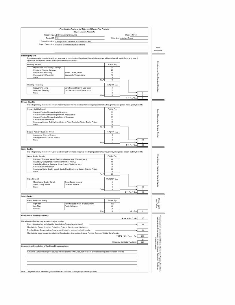
Prepared By: JEO Consulting Group, Inc. Date:
Project ID: P01 Watershed Antelope Creek
Project Location: Antelope Park: Van Dorn St to Sheridan BlvdProject Description: Channel and Wetland Enhancements
Issues
Addressed:
Flooding Impacts
Flooding Benefits Points, PFD
Major Structural Flooding Damage 30Structural Flooding Damage 20Non-Structural Flooding Streets / ROW, Other 15Conservation / Prevention Easements / Acquisitions 10None 0
PFD= 0
Flooding Frequency Multiplier, CFF
Frequent Flooding More frequent than 10-year storm 4Infrequent Flooding Less frequent than 10-year storm 2None 0 0
CFF= 0 0A = PFD * CFF 0
Stream Stability
Stream Stability Benefit Points, PET
Channel Erosion Threatening to Structures 50Channel Erosion Threatening to Public Infrastructure 40Channel Erosion Threatening to Natural Resources 35Conservation / Prevention 10Secondary Stream Stability benefit due to Flood Control or Water Quality Project 10None 0
PET= 10
Erosion Activity / Systemic Threat Multiplier, CEA
Aggressive Channel Erosion 3Non-Aggressive Channel Erosion 2None 0 10
CEA= 2 2B = PET * CEA 20
Water Quality
Water Quality Benefits Points, PWQ
Enhance / Preserve Natural Resource Areas (Lake, Wetlands, etc.) 60Regulatory Compliance / Stormwater Permit / NPDES 60Create New Natural Resource Areas (Lakes, Wetlands, etc.) 50Conservation / Prevention 30Secondary Water Quality benefit due to Flood Control or Stream Stability Project 20None 0
PWQ= 30
Project Benefit Multiplier, CWB
Major Water Quality Benefit Broad-Based Impacts 4Water Quality Benefit Localized Impacts 3None 0 30
CWB= 3 3C = PWQ * CWB 90
Safety Factor
Public Health and Safety Points, PSF
High Risk Potential Loss of Life or Bodily Injury 160Low Risk Public Nuisance 60No Risk 0
PSF= 0 D = PSF 0
Prioritization Ranking SummaryX = A + B + C + D 110
Miscellaneous Factors may be used to adjust scoring:PMISC (See attached worksheet for description of miscellaneous items) 30May Include: Project Location, Coincident Projects, Development Status, etc.PAC, Additional Considerations (may be used to add or subtract up to 60 points) 60May Include: Legal Issues, Jurisdictional Coordination, Complaints, Outside Funding Sources, Wildlife Benefits, etc.
TOTAL = X + PMISC + PAC 200
TOTAL for PROJECT AC-P01 200
Comments or Description of Additional Considerations:
Additional Consideration given as project helps address TMDL requirements and provides direct public education benefits
Note: This prioritization methodology is not intended for Urban Drainage Improvement projects.
Prioritization Ranking for Watershed Master Plan ProjectsCity of Lincoln, Nebraska
1/10/12
Structural and N
on-Structural Flooding
Projects primarily intended to address structural or non-structural flooding will usually incorporate a high or low risk safety factor and may, if applicable, incorporate stream stability or water quality benefits.
Open C
hannel and Surface E
rosion
Projects primarily intended for stream stability typically will not incorporate flooding impact benefits; though may incorporate water quality benefits.
Water Q
uality, Wetlands, N
atural Habitat
Projects primarily intended for water quality typically will not incorporate flooding impact benefits; though may incorporate stream stability benefits.
Public H
ealth and S
afety
Project Location, D
evelopment S
tatus, Coincident P
rojects, Condition /
Maintenance, D
ownstream
Impacts, S
ource Reduction, A
dditional C
onsiderations

MISCELLANEOUS FACTORSP01 Points
AvailablePoints
AssignedLocation Public Property or willing owner of Private Property up to 20 20
Coincident with Adjacent Projects Public Projects (water, sanitary, roads, etc.) up to 20Private Projects up to 10
Development Status Tier I, Priority A 20(Points available are fixed, and are not flexible) Tier I, Priority B 15
Tier I, Priority C 10Existing City Limits 10 10Tier II (development 25 - 50 years) 5Tier III (development > 50 years) 0
Total Miscellaneous Points, P MISC = 30
Tier I, Priority C - This is the later phase of development areas and is intended to be served after Priority A and B. Givencurrent growth rates and infrastructure financing, development would not begin in this area until after 2020 or 2025.
Tier I, Priority A - Areas designated for near term development are generally contiguous to existing development andshould be provided first with basic infrastructure within six years of the adoption of the Plan. Some of the infrastructurerequired for development may already be in place. This area includes some land already annexed, with City commitments tofund infrastructure improvements, but the land is still undeveloped and without significant infrastructure in place yet. Someinfrastructure improvements may be done in the near term while others, such as road improvements that are generally morecostly, may take longer to complete.
Tier I, Priority B - The next areas for development, beyond Priority A, are those which currently lack almost all of theinfrastructure required to support development. In areas with this designation, the community will maintain present uses untilurban development can commence. Infrastructure improvements to serve this area will not initially be included in the City’sCIP, but will be actively planned for in the longer term capital improvement planning of the various city and countydepartments.
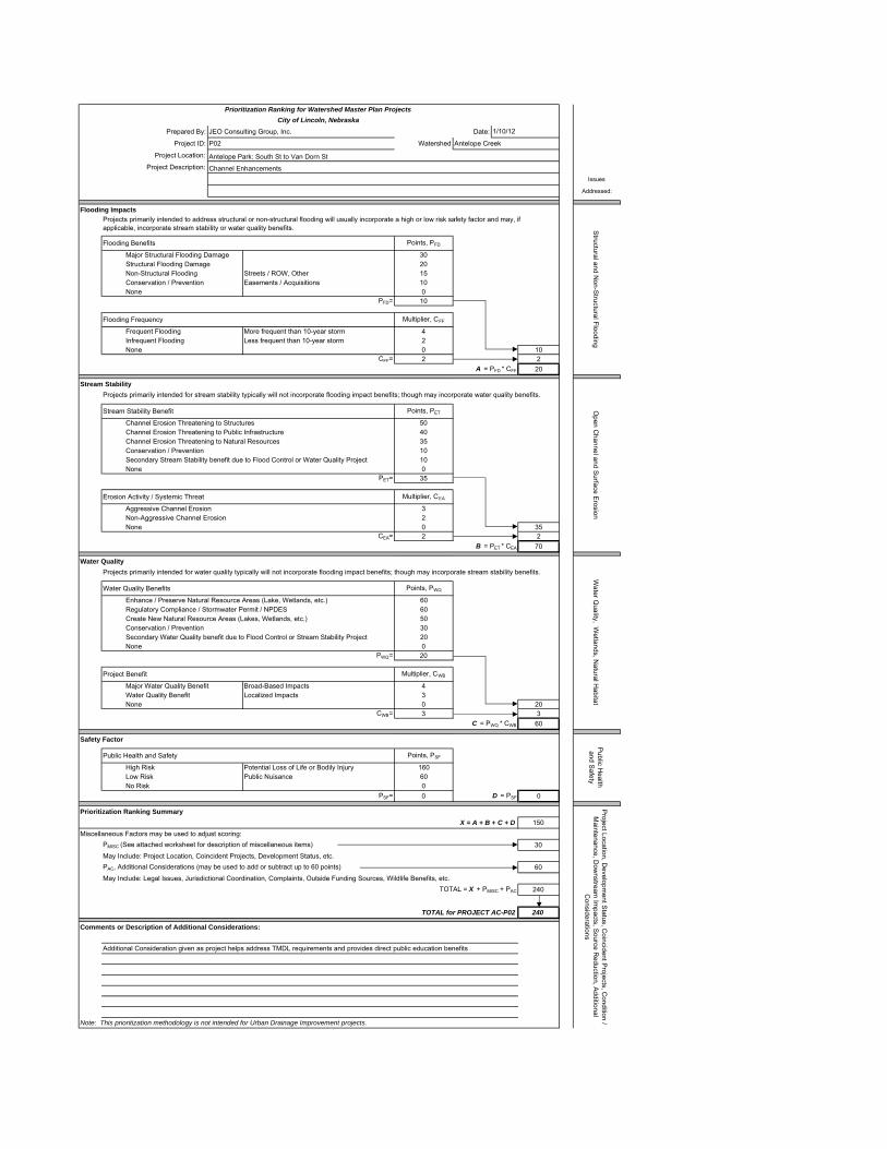
Prepared By: JEO Consulting Group, Inc. Date:
Project ID: P02 Watershed Antelope Creek
Project Location: Antelope Park: South St to Van Dorn StProject Description: Channel Enhancements
Issues
Addressed:
Flooding Impacts
Flooding Benefits Points, PFD
Major Structural Flooding Damage 30Structural Flooding Damage 20Non-Structural Flooding Streets / ROW, Other 15Conservation / Prevention Easements / Acquisitions 10None 0
PFD= 10
Flooding Frequency Multiplier, CFF
Frequent Flooding More frequent than 10-year storm 4Infrequent Flooding Less frequent than 10-year storm 2None 0 10
CFF= 2 2A = PFD * CFF 20
Stream Stability
Stream Stability Benefit Points, PET
Channel Erosion Threatening to Structures 50Channel Erosion Threatening to Public Infrastructure 40Channel Erosion Threatening to Natural Resources 35Conservation / Prevention 10Secondary Stream Stability benefit due to Flood Control or Water Quality Project 10None 0
PET= 35
Erosion Activity / Systemic Threat Multiplier, CEA
Aggressive Channel Erosion 3Non-Aggressive Channel Erosion 2None 0 35
CEA= 2 2B = PET * CEA 70
Water Quality
Water Quality Benefits Points, PWQ
Enhance / Preserve Natural Resource Areas (Lake, Wetlands, etc.) 60Regulatory Compliance / Stormwater Permit / NPDES 60Create New Natural Resource Areas (Lakes, Wetlands, etc.) 50Conservation / Prevention 30Secondary Water Quality benefit due to Flood Control or Stream Stability Project 20None 0
PWQ= 20
Project Benefit Multiplier, CWB
Major Water Quality Benefit Broad-Based Impacts 4Water Quality Benefit Localized Impacts 3None 0 20
CWB= 3 3C = PWQ * CWB 60
Safety Factor
Public Health and Safety Points, PSF
High Risk Potential Loss of Life or Bodily Injury 160Low Risk Public Nuisance 60No Risk 0
PSF= 0 D = PSF 0
Prioritization Ranking SummaryX = A + B + C + D 150
Miscellaneous Factors may be used to adjust scoring:PMISC (See attached worksheet for description of miscellaneous items) 30May Include: Project Location, Coincident Projects, Development Status, etc.PAC, Additional Considerations (may be used to add or subtract up to 60 points) 60May Include: Legal Issues, Jurisdictional Coordination, Complaints, Outside Funding Sources, Wildlife Benefits, etc.
TOTAL = X + PMISC + PAC 240
TOTAL for PROJECT AC-P02 240
Comments or Description of Additional Considerations:
Additional Consideration given as project helps address TMDL requirements and provides direct public education benefits
Note: This prioritization methodology is not intended for Urban Drainage Improvement projects.
Prioritization Ranking for Watershed Master Plan ProjectsCity of Lincoln, Nebraska
1/10/12
Structural and N
on-Structural Flooding
Projects primarily intended to address structural or non-structural flooding will usually incorporate a high or low risk safety factor and may, if applicable, incorporate stream stability or water quality benefits.
Open C
hannel and Surface E
rosion
Projects primarily intended for stream stability typically will not incorporate flooding impact benefits; though may incorporate water quality benefits.
Water Q
uality, Wetlands, N
atural Habitat
Projects primarily intended for water quality typically will not incorporate flooding impact benefits; though may incorporate stream stability benefits.
Public H
ealth and S
afety
Project Location, D
evelopment S
tatus, Coincident P
rojects, Condition /
Maintenance, D
ownstream
Impacts, S
ource Reduction, A
dditional C
onsiderations

MISCELLANEOUS FACTORSP02 Points
AvailablePoints
AssignedLocation Public Property or willing owner of Private Property up to 20 20
Coincident with Adjacent Projects Public Projects (water, sanitary, roads, etc.) up to 20Private Projects up to 10
Development Status Tier I, Priority A 20(Points available are fixed, and are not flexible) Tier I, Priority B 15
Tier I, Priority C 10Existing City Limits 10 10Tier II (development 25 - 50 years) 5Tier III (development > 50 years) 0
Total Miscellaneous Points, P MISC = 30
Tier I, Priority C - This is the later phase of development areas and is intended to be served after Priority A and B. Givencurrent growth rates and infrastructure financing, development would not begin in this area until after 2020 or 2025.
Tier I, Priority A - Areas designated for near term development are generally contiguous to existing development andshould be provided first with basic infrastructure within six years of the adoption of the Plan. Some of the infrastructurerequired for development may already be in place. This area includes some land already annexed, with City commitments tofund infrastructure improvements, but the land is still undeveloped and without significant infrastructure in place yet. Someinfrastructure improvements may be done in the near term while others, such as road improvements that are generally morecostly, may take longer to complete.
Tier I, Priority B - The next areas for development, beyond Priority A, are those which currently lack almost all of theinfrastructure required to support development. In areas with this designation, the community will maintain present uses untilurban development can commence. Infrastructure improvements to serve this area will not initially be included in the City’sCIP, but will be actively planned for in the longer term capital improvement planning of the various city and countydepartments.

Prepared By: JEO Consulting Group, Inc. Date:
Project ID: P03 Watershed Antelope Creek
Project Location: Antelope Park: SW of 33rd and South StProject Description: Bioretention Areas
Issues
Addressed:
Flooding Impacts
Flooding Benefits Points, PFD
Major Structural Flooding Damage 30Structural Flooding Damage 20Non-Structural Flooding Streets / ROW, Other 15Conservation / Prevention Easements / Acquisitions 10None 0
PFD= 10
Flooding Frequency Multiplier, CFF
Frequent Flooding More frequent than 10-year storm 4Infrequent Flooding Less frequent than 10-year storm 2None 0 10
CFF= 2 2A = PFD * CFF 20
Stream Stability
Stream Stability Benefit Points, PET
Channel Erosion Threatening to Structures 50Channel Erosion Threatening to Public Infrastructure 40Channel Erosion Threatening to Natural Resources 35Conservation / Prevention 10Secondary Stream Stability benefit due to Flood Control or Water Quality Project 10None 0
PET= 0
Erosion Activity / Systemic Threat Multiplier, CEA
Aggressive Channel Erosion 3Non-Aggressive Channel Erosion 2None 0 0
CEA= 0 0B = PET * CEA 0
Water Quality
Water Quality Benefits Points, PWQ
Enhance / Preserve Natural Resource Areas (Lake, Wetlands, etc.) 60Regulatory Compliance / Stormwater Permit / NPDES 60Create New Natural Resource Areas (Lakes, Wetlands, etc.) 50Conservation / Prevention 30Secondary Water Quality benefit due to Flood Control or Stream Stability Project 20None 0
PWQ= 50
Project Benefit Multiplier, CWB
Major Water Quality Benefit Broad-Based Impacts 4Water Quality Benefit Localized Impacts 3None 0 50
CWB= 3 3C = PWQ * CWB 150
Safety Factor
Public Health and Safety Points, PSF
High Risk Potential Loss of Life or Bodily Injury 160Low Risk Public Nuisance 60No Risk 0
PSF= 0 D = PSF 0
Prioritization Ranking SummaryX = A + B + C + D 170
Miscellaneous Factors may be used to adjust scoring:PMISC (See attached worksheet for description of miscellaneous items) 30May Include: Project Location, Coincident Projects, Development Status, etc.PAC, Additional Considerations (may be used to add or subtract up to 60 points) 60May Include: Legal Issues, Jurisdictional Coordination, Complaints, Outside Funding Sources, Wildlife Benefits, etc.
TOTAL = X + PMISC + PAC 260
TOTAL for PROJECT AC-P03 260
Comments or Description of Additional Considerations:
Additional Consideration given as project helps address TMDL requirements and provides direct public education benefits
Note: This prioritization methodology is not intended for Urban Drainage Improvement projects.
Prioritization Ranking for Watershed Master Plan ProjectsCity of Lincoln, Nebraska
1/10/12
Structural and N
on-Structural Flooding
Projects primarily intended to address structural or non-structural flooding will usually incorporate a high or low risk safety factor and may, if applicable, incorporate stream stability or water quality benefits.
Open C
hannel and Surface E
rosion
Projects primarily intended for stream stability typically will not incorporate flooding impact benefits; though may incorporate water quality benefits.
Water Q
uality, Wetlands, N
atural Habitat
Projects primarily intended for water quality typically will not incorporate flooding impact benefits; though may incorporate stream stability benefits.
Public H
ealth and S
afety
Project Location, D
evelopment S
tatus, Coincident P
rojects, Condition /
Maintenance, D
ownstream
Impacts, S
ource Reduction, A
dditional C
onsiderations

MISCELLANEOUS FACTORSP03 Points
AvailablePoints
AssignedLocation Public Property or willing owner of Private Property up to 20 20
Coincident with Adjacent Projects Public Projects (water, sanitary, roads, etc.) up to 20Private Projects up to 10
Development Status Tier I, Priority A 20(Points available are fixed, and are not flexible) Tier I, Priority B 15
Tier I, Priority C 10Existing City Limits 10 10Tier II (development 25 - 50 years) 5Tier III (development > 50 years) 0
Total Miscellaneous Points, P MISC = 30
Tier I, Priority C - This is the later phase of development areas and is intended to be served after Priority A and B. Givencurrent growth rates and infrastructure financing, development would not begin in this area until after 2020 or 2025.
Tier I, Priority A - Areas designated for near term development are generally contiguous to existing development andshould be provided first with basic infrastructure within six years of the adoption of the Plan. Some of the infrastructurerequired for development may already be in place. This area includes some land already annexed, with City commitments tofund infrastructure improvements, but the land is still undeveloped and without significant infrastructure in place yet. Someinfrastructure improvements may be done in the near term while others, such as road improvements that are generally morecostly, may take longer to complete.
Tier I, Priority B - The next areas for development, beyond Priority A, are those which currently lack almost all of theinfrastructure required to support development. In areas with this designation, the community will maintain present uses untilurban development can commence. Infrastructure improvements to serve this area will not initially be included in the City’sCIP, but will be actively planned for in the longer term capital improvement planning of the various city and countydepartments.

Prepared By: JEO Consulting Group, Inc. Date:
Project ID: P04 Watershed Antelope Creek
Project Location: Antelope Park: A Street to South StreetProject Description: Modify parking lot, address erosion in meandering channel
Issues
Addressed:
Flooding Impacts
Flooding Benefits Points, PFD
Major Structural Flooding Damage 30Structural Flooding Damage 20Non-Structural Flooding Streets / ROW, Other 15Conservation / Prevention Easements / Acquisitions 10None 0
PFD= 0
Flooding Frequency Multiplier, CFF
Frequent Flooding More frequent than 10-year storm 4Infrequent Flooding Less frequent than 10-year storm 2None 0 0
CFF= 0 0A = PFD * CFF 0
Stream Stability
Stream Stability Benefit Points, PET
Channel Erosion Threatening to Structures 50Channel Erosion Threatening to Public Infrastructure 40Channel Erosion Threatening to Natural Resources 35Conservation / Prevention 10Secondary Stream Stability benefit due to Flood Control or Water Quality Project 10None 0
PET= 10
Erosion Activity / Systemic Threat Multiplier, CEA
Aggressive Channel Erosion 3Non-Aggressive Channel Erosion 2None 0 10
CEA= 2 2B = PET * CEA 20
Water Quality
Water Quality Benefits Points, PWQ
Enhance / Preserve Natural Resource Areas (Lake, Wetlands, etc.) 60Regulatory Compliance / Stormwater Permit / NPDES 60Create New Natural Resource Areas (Lakes, Wetlands, etc.) 50Conservation / Prevention 30Secondary Water Quality benefit due to Flood Control or Stream Stability Project 20None 0
PWQ= 30
Project Benefit Multiplier, CWB
Major Water Quality Benefit Broad-Based Impacts 4Water Quality Benefit Localized Impacts 3None 0 30
CWB= 3 3C = PWQ * CWB 90
Safety Factor
Public Health and Safety Points, PSF
High Risk Potential Loss of Life or Bodily Injury 160Low Risk Public Nuisance 60No Risk 0
PSF= 0 D = PSF 0
Prioritization Ranking SummaryX = A + B + C + D 110
Miscellaneous Factors may be used to adjust scoring:PMISC (See attached worksheet for description of miscellaneous items) 30May Include: Project Location, Coincident Projects, Development Status, etc.PAC, Additional Considerations (may be used to add or subtract up to 60 points) 40May Include: Legal Issues, Jurisdictional Coordination, Complaints, Outside Funding Sources, Wildlife Benefits, etc.
TOTAL = X + PMISC + PAC 180
TOTAL for PROJECT AC-P04 180
Comments or Description of Additional Considerations:
Additional Consideration given as project helps address TMDL requirements and provides indirect public education benefits
Note: This prioritization methodology is not intended for Urban Drainage Improvement projects.
Prioritization Ranking for Watershed Master Plan ProjectsCity of Lincoln, Nebraska
1/10/12
Structural and N
on-Structural Flooding
Projects primarily intended to address structural or non-structural flooding will usually incorporate a high or low risk safety factor and may, if applicable, incorporate stream stability or water quality benefits.
Open C
hannel and Surface E
rosion
Projects primarily intended for stream stability typically will not incorporate flooding impact benefits; though may incorporate water quality benefits.
Water Q
uality, Wetlands, N
atural Habitat
Projects primarily intended for water quality typically will not incorporate flooding impact benefits; though may incorporate stream stability benefits.
Public H
ealth and S
afety
Project Location, D
evelopment S
tatus, Coincident P
rojects, Condition /
Maintenance, D
ownstream
Impacts, S
ource Reduction, A
dditional C
onsiderations

MISCELLANEOUS FACTORSP04 Points
AvailablePoints
AssignedLocation Public Property or willing owner of Private Property up to 20 20
Coincident with Adjacent Projects Public Projects (water, sanitary, roads, etc.) up to 20Private Projects up to 10
Development Status Tier I, Priority A 20(Points available are fixed, and are not flexible) Tier I, Priority B 15
Tier I, Priority C 10Existing City Limits 10 10Tier II (development 25 - 50 years) 5Tier III (development > 50 years) 0
Total Miscellaneous Points, P MISC = 30
Tier I, Priority C - This is the later phase of development areas and is intended to be served after Priority A and B. Givencurrent growth rates and infrastructure financing, development would not begin in this area until after 2020 or 2025.
Tier I, Priority A - Areas designated for near term development are generally contiguous to existing development andshould be provided first with basic infrastructure within six years of the adoption of the Plan. Some of the infrastructurerequired for development may already be in place. This area includes some land already annexed, with City commitments tofund infrastructure improvements, but the land is still undeveloped and without significant infrastructure in place yet. Someinfrastructure improvements may be done in the near term while others, such as road improvements that are generally morecostly, may take longer to complete.
Tier I, Priority B - The next areas for development, beyond Priority A, are those which currently lack almost all of theinfrastructure required to support development. In areas with this designation, the community will maintain present uses untilurban development can commence. Infrastructure improvements to serve this area will not initially be included in the City’sCIP, but will be actively planned for in the longer term capital improvement planning of the various city and countydepartments.

Prepared By: JEO Consulting Group, Inc. Date:
Project ID: P05 Watershed Antelope Creek
Project Location: Roberts Park/East of Holmes Elementary SchoolProject Description: Offline Bioretention Areas, Inline Channel Berms
Issues
Addressed:
Flooding Impacts
Flooding Benefits Points, PFD
Major Structural Flooding Damage 30Structural Flooding Damage 20Non-Structural Flooding Streets / ROW, Other 15Conservation / Prevention Easements / Acquisitions 10None 0
PFD= 10
Flooding Frequency Multiplier, CFF
Frequent Flooding More frequent than 10-year storm 4Infrequent Flooding Less frequent than 10-year storm 2None 0 10
CFF= 2 2A = PFD * CFF 20
Stream Stability
Stream Stability Benefit Points, PET
Channel Erosion Threatening to Structures 50Channel Erosion Threatening to Public Infrastructure 40Channel Erosion Threatening to Natural Resources 35Conservation / Prevention 10Secondary Stream Stability benefit due to Flood Control or Water Quality Project 10None 0
PET= 0
Erosion Activity / Systemic Threat Multiplier, CEA
Aggressive Channel Erosion 3Non-Aggressive Channel Erosion 2None 0 0
CEA= 0 0B = PET * CEA 0
Water Quality
Water Quality Benefits Points, PWQ
Enhance / Preserve Natural Resource Areas (Lake, Wetlands, etc.) 60Regulatory Compliance / Stormwater Permit / NPDES 60Create New Natural Resource Areas (Lakes, Wetlands, etc.) 50Conservation / Prevention 30Secondary Water Quality benefit due to Flood Control or Stream Stability Project 20None 0
PWQ= 30
Project Benefit Multiplier, CWB
Major Water Quality Benefit Broad-Based Impacts 4Water Quality Benefit Localized Impacts 3None 0 30
CWB= 3 3C = PWQ * CWB 90
Safety Factor
Public Health and Safety Points, PSF
High Risk Potential Loss of Life or Bodily Injury 160Low Risk Public Nuisance 60No Risk 0
PSF= 0 D = PSF 0
Prioritization Ranking SummaryX = A + B + C + D 110
Miscellaneous Factors may be used to adjust scoring:PMISC (See attached worksheet for description of miscellaneous items) 30May Include: Project Location, Coincident Projects, Development Status, etc.PAC, Additional Considerations (may be used to add or subtract up to 60 points) 40May Include: Legal Issues, Jurisdictional Coordination, Complaints, Outside Funding Sources, Wildlife Benefits, etc.
TOTAL = X + PMISC + PAC 180
TOTAL for PROJECT AC-P05 180
Comments or Description of Additional Considerations:
Additional Consideration given as project helps address TMDL requirements and provides indirect public education benefits
Note: This prioritization methodology is not intended for Urban Drainage Improvement projects.
Prioritization Ranking for Watershed Master Plan ProjectsCity of Lincoln, Nebraska
1/10/12
Structural and N
on-Structural Flooding
Projects primarily intended to address structural or non-structural flooding will usually incorporate a high or low risk safety factor and may, if applicable, incorporate stream stability or water quality benefits.
Open C
hannel and Surface E
rosion
Projects primarily intended for stream stability typically will not incorporate flooding impact benefits; though may incorporate water quality benefits.
Water Q
uality, Wetlands, N
atural Habitat
Projects primarily intended for water quality typically will not incorporate flooding impact benefits; though may incorporate stream stability benefits.
Public H
ealth and S
afety
Project Location, D
evelopment S
tatus, Coincident P
rojects, Condition /
Maintenance, D
ownstream
Impacts, S
ource Reduction, A
dditional C
onsiderations

MISCELLANEOUS FACTORSP05 Points
AvailablePoints
AssignedLocation Public Property or willing owner of Private Property up to 20 20
Coincident with Adjacent Projects Public Projects (water, sanitary, roads, etc.) up to 20Private Projects up to 10
Development Status Tier I, Priority A 20(Points available are fixed, and are not flexible) Tier I, Priority B 15
Tier I, Priority C 10Existing City Limits 10 10Tier II (development 25 - 50 years) 5Tier III (development > 50 years) 0
Total Miscellaneous Points, P MISC = 30
Tier I, Priority C - This is the later phase of development areas and is intended to be served after Priority A and B. Givencurrent growth rates and infrastructure financing, development would not begin in this area until after 2020 or 2025.
Tier I, Priority A - Areas designated for near term development are generally contiguous to existing development andshould be provided first with basic infrastructure within six years of the adoption of the Plan. Some of the infrastructurerequired for development may already be in place. This area includes some land already annexed, with City commitments tofund infrastructure improvements, but the land is still undeveloped and without significant infrastructure in place yet. Someinfrastructure improvements may be done in the near term while others, such as road improvements that are generally morecostly, may take longer to complete.
Tier I, Priority B - The next areas for development, beyond Priority A, are those which currently lack almost all of theinfrastructure required to support development. In areas with this designation, the community will maintain present uses untilurban development can commence. Infrastructure improvements to serve this area will not initially be included in the City’sCIP, but will be actively planned for in the longer term capital improvement planning of the various city and countydepartments.

Prepared By: JEO Consulting Group, Inc. Date:
Project ID: P06 Watershed Antelope Creek
Project Location: Lincoln Children's ZooProject Description: Green Roof, Permeable Pavement, Bioretention
Issues
Addressed:
Flooding Impacts
Flooding Benefits Points, PFD
Major Structural Flooding Damage 30Structural Flooding Damage 20Non-Structural Flooding Streets / ROW, Other 15Conservation / Prevention Easements / Acquisitions 10None 0
PFD= 15
Flooding Frequency Multiplier, CFF
Frequent Flooding More frequent than 10-year storm 4Infrequent Flooding Less frequent than 10-year storm 2None 0 15
CFF= 2 2A = PFD * CFF 30
Stream Stability
Stream Stability Benefit Points, PET
Channel Erosion Threatening to Structures 50Channel Erosion Threatening to Public Infrastructure 40Channel Erosion Threatening to Natural Resources 35Conservation / Prevention 10Secondary Stream Stability benefit due to Flood Control or Water Quality Project 10None 0
PET= 0
Erosion Activity / Systemic Threat Multiplier, CEA
Aggressive Channel Erosion 3Non-Aggressive Channel Erosion 2None 0 0
CEA= 0 0B = PET * CEA 0
Water Quality
Water Quality Benefits Points, PWQ
Enhance / Preserve Natural Resource Areas (Lake, Wetlands, etc.) 60Regulatory Compliance / Stormwater Permit / NPDES 60Create New Natural Resource Areas (Lakes, Wetlands, etc.) 50Conservation / Prevention 30Secondary Water Quality benefit due to Flood Control or Stream Stability Project 20None 0
PWQ= 60
Project Benefit Multiplier, CWB
Major Water Quality Benefit Broad-Based Impacts 4Water Quality Benefit Localized Impacts 3None 0 60
CWB= 3 3C = PWQ * CWB 180
Safety Factor
Public Health and Safety Points, PSF
High Risk Potential Loss of Life or Bodily Injury 160Low Risk Public Nuisance 60No Risk 0
PSF= 0 D = PSF 0
Prioritization Ranking SummaryX = A + B + C + D 210
Miscellaneous Factors may be used to adjust scoring:PMISC (See attached worksheet for description of miscellaneous items) 30May Include: Project Location, Coincident Projects, Development Status, etc.PAC, Additional Considerations (may be used to add or subtract up to 60 points) 60May Include: Legal Issues, Jurisdictional Coordination, Complaints, Outside Funding Sources, Wildlife Benefits, etc.
TOTAL = X + PMISC + PAC 300
TOTAL for PROJECT AC-P06 300
Comments or Description of Additional Considerations:
Additional Consideration given as project helps address TMDL requirements and provides direct public education benefits
Note: This prioritization methodology is not intended for Urban Drainage Improvement projects.
Prioritization Ranking for Watershed Master Plan ProjectsCity of Lincoln, Nebraska
1/10/12
Structural and N
on-Structural Flooding
Projects primarily intended to address structural or non-structural flooding will usually incorporate a high or low risk safety factor and may, if applicable, incorporate stream stability or water quality benefits.
Open C
hannel and Surface E
rosion
Projects primarily intended for stream stability typically will not incorporate flooding impact benefits; though may incorporate water quality benefits.
Water Q
uality, Wetlands, N
atural Habitat
Projects primarily intended for water quality typically will not incorporate flooding impact benefits; though may incorporate stream stability benefits.
Public H
ealth and S
afety
Project Location, D
evelopment S
tatus, Coincident P
rojects, Condition /
Maintenance, D
ownstream
Impacts, S
ource Reduction, A
dditional C
onsiderations

MISCELLANEOUS FACTORSP06 Points
AvailablePoints
AssignedLocation Public Property or willing owner of Private Property up to 20 20
Coincident with Adjacent Projects Public Projects (water, sanitary, roads, etc.) up to 20Private Projects up to 10
Development Status Tier I, Priority A 20(Points available are fixed, and are not flexible) Tier I, Priority B 15
Tier I, Priority C 10Existing City Limits 10 10Tier II (development 25 - 50 years) 5Tier III (development > 50 years) 0
Total Miscellaneous Points, P MISC = 30
Tier I, Priority C - This is the later phase of development areas and is intended to be served after Priority A and B. Givencurrent growth rates and infrastructure financing, development would not begin in this area until after 2020 or 2025.
Tier I, Priority A - Areas designated for near term development are generally contiguous to existing development andshould be provided first with basic infrastructure within six years of the adoption of the Plan. Some of the infrastructurerequired for development may already be in place. This area includes some land already annexed, with City commitments tofund infrastructure improvements, but the land is still undeveloped and without significant infrastructure in place yet. Someinfrastructure improvements may be done in the near term while others, such as road improvements that are generally morecostly, may take longer to complete.
Tier I, Priority B - The next areas for development, beyond Priority A, are those which currently lack almost all of theinfrastructure required to support development. In areas with this designation, the community will maintain present uses untilurban development can commence. Infrastructure improvements to serve this area will not initially be included in the City’sCIP, but will be actively planned for in the longer term capital improvement planning of the various city and countydepartments.

Prepared By: JEO Consulting Group, Inc. Date:
Project ID: P07 Watershed Antelope Creek
Project Location: Woods ParkProject Description: Separators, Bioretention Areas
Issues
Addressed:
Flooding Impacts
Flooding Benefits Points, PFD
Major Structural Flooding Damage 30Structural Flooding Damage 20Non-Structural Flooding Streets / ROW, Other 15Conservation / Prevention Easements / Acquisitions 10None 0
PFD= 0
Flooding Frequency Multiplier, CFF
Frequent Flooding More frequent than 10-year storm 4Infrequent Flooding Less frequent than 10-year storm 2None 0 0
CFF= 0 0A = PFD * CFF 0
Stream Stability
Stream Stability Benefit Points, PET
Channel Erosion Threatening to Structures 50Channel Erosion Threatening to Public Infrastructure 40Channel Erosion Threatening to Natural Resources 35Conservation / Prevention 10Secondary Stream Stability benefit due to Flood Control or Water Quality Project 10None 0
PET= 0
Erosion Activity / Systemic Threat Multiplier, CEA
Aggressive Channel Erosion 3Non-Aggressive Channel Erosion 2None 0 0
CEA= 0 0B = PET * CEA 0
Water Quality
Water Quality Benefits Points, PWQ
Enhance / Preserve Natural Resource Areas (Lake, Wetlands, etc.) 60Regulatory Compliance / Stormwater Permit / NPDES 60Create New Natural Resource Areas (Lakes, Wetlands, etc.) 50Conservation / Prevention 30Secondary Water Quality benefit due to Flood Control or Stream Stability Project 20None 0
PWQ= 30
Project Benefit Multiplier, CWB
Major Water Quality Benefit Broad-Based Impacts 4Water Quality Benefit Localized Impacts 3None 0 30
CWB= 3 3C = PWQ * CWB 90
Safety Factor
Public Health and Safety Points, PSF
High Risk Potential Loss of Life or Bodily Injury 160Low Risk Public Nuisance 60No Risk 0
PSF= 0 D = PSF 0
Prioritization Ranking SummaryX = A + B + C + D 90
Miscellaneous Factors may be used to adjust scoring:PMISC (See attached worksheet for description of miscellaneous items) 30May Include: Project Location, Coincident Projects, Development Status, etc.PAC, Additional Considerations (may be used to add or subtract up to 60 points) 40May Include: Legal Issues, Jurisdictional Coordination, Complaints, Outside Funding Sources, Wildlife Benefits, etc.
TOTAL = X + PMISC + PAC 160
TOTAL for PROJECT AC-P07 160
Comments or Description of Additional Considerations:
Additional Consideration given as project helps address TMDL requirements and provides indirect public education benefits
Note: This prioritization methodology is not intended for Urban Drainage Improvement projects.
Prioritization Ranking for Watershed Master Plan ProjectsCity of Lincoln, Nebraska
1/10/12
Structural and N
on-Structural Flooding
Projects primarily intended to address structural or non-structural flooding will usually incorporate a high or low risk safety factor and may, if applicable, incorporate stream stability or water quality benefits.
Open C
hannel and Surface E
rosion
Projects primarily intended for stream stability typically will not incorporate flooding impact benefits; though may incorporate water quality benefits.
Water Q
uality, Wetlands, N
atural Habitat
Projects primarily intended for water quality typically will not incorporate flooding impact benefits; though may incorporate stream stability benefits.
Public H
ealth and S
afety
Project Location, D
evelopment S
tatus, Coincident P
rojects, Condition /
Maintenance, D
ownstream
Impacts, S
ource Reduction, A
dditional C
onsiderations

MISCELLANEOUS FACTORSP07 Points
AvailablePoints
AssignedLocation Public Property or willing owner of Private Property up to 20 20
Coincident with Adjacent Projects Public Projects (water, sanitary, roads, etc.) up to 20Private Projects up to 10
Development Status Tier I, Priority A 20(Points available are fixed, and are not flexible) Tier I, Priority B 15
Tier I, Priority C 10Existing City Limits 10 10Tier II (development 25 - 50 years) 5Tier III (development > 50 years) 0
Total Miscellaneous Points, P MISC = 30
Tier I, Priority C - This is the later phase of development areas and is intended to be served after Priority A and B. Givencurrent growth rates and infrastructure financing, development would not begin in this area until after 2020 or 2025.
Tier I, Priority A - Areas designated for near term development are generally contiguous to existing development andshould be provided first with basic infrastructure within six years of the adoption of the Plan. Some of the infrastructurerequired for development may already be in place. This area includes some land already annexed, with City commitments tofund infrastructure improvements, but the land is still undeveloped and without significant infrastructure in place yet. Someinfrastructure improvements may be done in the near term while others, such as road improvements that are generally morecostly, may take longer to complete.
Tier I, Priority B - The next areas for development, beyond Priority A, are those which currently lack almost all of theinfrastructure required to support development. In areas with this designation, the community will maintain present uses untilurban development can commence. Infrastructure improvements to serve this area will not initially be included in the City’sCIP, but will be actively planned for in the longer term capital improvement planning of the various city and countydepartments.

Prepared By: JEO Consulting Group, Inc. Date:
Project ID: P08 Watershed Antelope Creek
Project Location: Gere LibraryProject Description: Separator and Bioretention Area
Issues
Addressed:
Flooding Impacts
Flooding Benefits Points, PFD
Major Structural Flooding Damage 30Structural Flooding Damage 20Non-Structural Flooding Streets / ROW, Other 15Conservation / Prevention Easements / Acquisitions 10None 0
PFD= 0
Flooding Frequency Multiplier, CFF
Frequent Flooding More frequent than 10-year storm 4Infrequent Flooding Less frequent than 10-year storm 2None 0 0
CFF= 0 0A = PFD * CFF 0
Stream Stability
Stream Stability Benefit Points, PET
Channel Erosion Threatening to Structures 50Channel Erosion Threatening to Public Infrastructure 40Channel Erosion Threatening to Natural Resources 35Conservation / Prevention 10Secondary Stream Stability benefit due to Flood Control or Water Quality Project 10None 0
PET= 0
Erosion Activity / Systemic Threat Multiplier, CEA
Aggressive Channel Erosion 3Non-Aggressive Channel Erosion 2None 0 0
CEA= 0 0B = PET * CEA 0
Water Quality
Water Quality Benefits Points, PWQ
Enhance / Preserve Natural Resource Areas (Lake, Wetlands, etc.) 60Regulatory Compliance / Stormwater Permit / NPDES 60Create New Natural Resource Areas (Lakes, Wetlands, etc.) 50Conservation / Prevention 30Secondary Water Quality benefit due to Flood Control or Stream Stability Project 20None 0
PWQ= 30
Project Benefit Multiplier, CWB
Major Water Quality Benefit Broad-Based Impacts 4Water Quality Benefit Localized Impacts 3None 0 30
CWB= 3 3C = PWQ * CWB 90
Safety Factor
Public Health and Safety Points, PSF
High Risk Potential Loss of Life or Bodily Injury 160Low Risk Public Nuisance 60No Risk 0
PSF= 0 D = PSF 0
Prioritization Ranking SummaryX = A + B + C + D 90
Miscellaneous Factors may be used to adjust scoring:PMISC (See attached worksheet for description of miscellaneous items) 20May Include: Project Location, Coincident Projects, Development Status, etc.PAC, Additional Considerations (may be used to add or subtract up to 60 points) 20May Include: Legal Issues, Jurisdictional Coordination, Complaints, Outside Funding Sources, Wildlife Benefits, etc.
TOTAL = X + PMISC + PAC 130
TOTAL for PROJECT AC-P08 130
Comments or Description of Additional Considerations:
Additional Consideration given as project helps address TMDL requirements
Note: This prioritization methodology is not intended for Urban Drainage Improvement projects.
Prioritization Ranking for Watershed Master Plan ProjectsCity of Lincoln, Nebraska
1/10/12
Structural and N
on-Structural Flooding
Projects primarily intended to address structural or non-structural flooding will usually incorporate a high or low risk safety factor and may, if applicable, incorporate stream stability or water quality benefits.
Open C
hannel and Surface E
rosion
Projects primarily intended for stream stability typically will not incorporate flooding impact benefits; though may incorporate water quality benefits.
Water Q
uality, Wetlands, N
atural Habitat
Projects primarily intended for water quality typically will not incorporate flooding impact benefits; though may incorporate stream stability benefits.
Public H
ealth and S
afety
Project Location, D
evelopment S
tatus, Coincident P
rojects, Condition /
Maintenance, D
ownstream
Impacts, S
ource Reduction, A
dditional C
onsiderations

MISCELLANEOUS FACTORSP08 Points
AvailablePoints
AssignedLocation Public Property or willing owner of Private Property up to 20 10
Coincident with Adjacent Projects Public Projects (water, sanitary, roads, etc.) up to 20Private Projects up to 10
Development Status Tier I, Priority A 20(Points available are fixed, and are not flexible) Tier I, Priority B 15
Tier I, Priority C 10Existing City Limits 10 10Tier II (development 25 - 50 years) 5Tier III (development > 50 years) 0
Total Miscellaneous Points, P MISC = 20
Tier I, Priority C - This is the later phase of development areas and is intended to be served after Priority A and B. Givencurrent growth rates and infrastructure financing, development would not begin in this area until after 2020 or 2025.
Tier I, Priority A - Areas designated for near term development are generally contiguous to existing development andshould be provided first with basic infrastructure within six years of the adoption of the Plan. Some of the infrastructurerequired for development may already be in place. This area includes some land already annexed, with City commitments tofund infrastructure improvements, but the land is still undeveloped and without significant infrastructure in place yet. Someinfrastructure improvements may be done in the near term while others, such as road improvements that are generally morecostly, may take longer to complete.
Tier I, Priority B - The next areas for development, beyond Priority A, are those which currently lack almost all of theinfrastructure required to support development. In areas with this designation, the community will maintain present uses untilurban development can commence. Infrastructure improvements to serve this area will not initially be included in the City’sCIP, but will be actively planned for in the longer term capital improvement planning of the various city and countydepartments.

Prepared By: JEO Consulting Group, Inc. Date:
Project ID: P09 Watershed Antelope Creek
Project Location: Eden ParkProject Description: Curb-Cut Bioretention
Issues
Addressed:
Flooding Impacts
Flooding Benefits Points, PFD
Major Structural Flooding Damage 30Structural Flooding Damage 20Non-Structural Flooding Streets / ROW, Other 15Conservation / Prevention Easements / Acquisitions 10None 0
PFD= 0
Flooding Frequency Multiplier, CFF
Frequent Flooding More frequent than 10-year storm 4Infrequent Flooding Less frequent than 10-year storm 2None 0 0
CFF= 0 0A = PFD * CFF 0
Stream Stability
Stream Stability Benefit Points, PET
Channel Erosion Threatening to Structures 50Channel Erosion Threatening to Public Infrastructure 40Channel Erosion Threatening to Natural Resources 35Conservation / Prevention 10Secondary Stream Stability benefit due to Flood Control or Water Quality Project 10None 0
PET= 0
Erosion Activity / Systemic Threat Multiplier, CEA
Aggressive Channel Erosion 3Non-Aggressive Channel Erosion 2None 0 0
CEA= 0 0B = PET * CEA 0
Water Quality
Water Quality Benefits Points, PWQ
Enhance / Preserve Natural Resource Areas (Lake, Wetlands, etc.) 60Regulatory Compliance / Stormwater Permit / NPDES 60Create New Natural Resource Areas (Lakes, Wetlands, etc.) 50Conservation / Prevention 30Secondary Water Quality benefit due to Flood Control or Stream Stability Project 20None 0
PWQ= 30
Project Benefit Multiplier, CWB
Major Water Quality Benefit Broad-Based Impacts 4Water Quality Benefit Localized Impacts 3None 0 30
CWB= 3 3C = PWQ * CWB 90
Safety Factor
Public Health and Safety Points, PSF
High Risk Potential Loss of Life or Bodily Injury 160Low Risk Public Nuisance 60No Risk 0
PSF= 0 D = PSF 0
Prioritization Ranking SummaryX = A + B + C + D 90
Miscellaneous Factors may be used to adjust scoring:PMISC (See attached worksheet for description of miscellaneous items) 30May Include: Project Location, Coincident Projects, Development Status, etc.PAC, Additional Considerations (may be used to add or subtract up to 60 points) 40May Include: Legal Issues, Jurisdictional Coordination, Complaints, Outside Funding Sources, Wildlife Benefits, etc.
TOTAL = X + PMISC + PAC 160
TOTAL for PROJECT AC-P09 160
Comments or Description of Additional Considerations:
Additional Consideration given as project helps address TMDL requirements and provides indirect public education benefits
Note: This prioritization methodology is not intended for Urban Drainage Improvement projects.
Prioritization Ranking for Watershed Master Plan ProjectsCity of Lincoln, Nebraska
1/10/12
Structural and N
on-Structural Flooding
Projects primarily intended to address structural or non-structural flooding will usually incorporate a high or low risk safety factor and may, if applicable, incorporate stream stability or water quality benefits.
Open C
hannel and Surface E
rosion
Projects primarily intended for stream stability typically will not incorporate flooding impact benefits; though may incorporate water quality benefits.
Water Q
uality, Wetlands, N
atural Habitat
Projects primarily intended for water quality typically will not incorporate flooding impact benefits; though may incorporate stream stability benefits.
Public H
ealth and S
afety
Project Location, D
evelopment S
tatus, Coincident P
rojects, Condition /
Maintenance, D
ownstream
Impacts, S
ource Reduction, A
dditional C
onsiderations

MISCELLANEOUS FACTORSP09 Points
AvailablePoints
AssignedLocation Public Property or willing owner of Private Property up to 20 20
Coincident with Adjacent Projects Public Projects (water, sanitary, roads, etc.) up to 20Private Projects up to 10
Development Status Tier I, Priority A 20(Points available are fixed, and are not flexible) Tier I, Priority B 15
Tier I, Priority C 10Existing City Limits 10 10Tier II (development 25 - 50 years) 5Tier III (development > 50 years) 0
Total Miscellaneous Points, P MISC = 30
Tier I, Priority C - This is the later phase of development areas and is intended to be served after Priority A and B. Givencurrent growth rates and infrastructure financing, development would not begin in this area until after 2020 or 2025.
Tier I, Priority A - Areas designated for near term development are generally contiguous to existing development andshould be provided first with basic infrastructure within six years of the adoption of the Plan. Some of the infrastructurerequired for development may already be in place. This area includes some land already annexed, with City commitments tofund infrastructure improvements, but the land is still undeveloped and without significant infrastructure in place yet. Someinfrastructure improvements may be done in the near term while others, such as road improvements that are generally morecostly, may take longer to complete.
Tier I, Priority B - The next areas for development, beyond Priority A, are those which currently lack almost all of theinfrastructure required to support development. In areas with this designation, the community will maintain present uses untilurban development can commence. Infrastructure improvements to serve this area will not initially be included in the City’sCIP, but will be actively planned for in the longer term capital improvement planning of the various city and countydepartments.

Prepared By: JEO Consulting Group, Inc. Date:
Project ID: P10 Watershed Antelope Creek
Project Location: Existing Dry Detention Cell near 60th and South St.Project Description: Modify Existing Extended Detention Basin
Issues
Addressed:
Flooding Impacts
Flooding Benefits Points, PFD
Major Structural Flooding Damage 30Structural Flooding Damage 20Non-Structural Flooding Streets / ROW, Other 15Conservation / Prevention Easements / Acquisitions 10None 0
PFD= 0
Flooding Frequency Multiplier, CFF
Frequent Flooding More frequent than 10-year storm 4Infrequent Flooding Less frequent than 10-year storm 2None 0 0
CFF= 0 0A = PFD * CFF 0
Stream Stability
Stream Stability Benefit Points, PET
Channel Erosion Threatening to Structures 50Channel Erosion Threatening to Public Infrastructure 40Channel Erosion Threatening to Natural Resources 35Conservation / Prevention 10Secondary Stream Stability benefit due to Flood Control or Water Quality Project 10None 0
PET= 0
Erosion Activity / Systemic Threat Multiplier, CEA
Aggressive Channel Erosion 3Non-Aggressive Channel Erosion 2None 0 0
CEA= 0 0B = PET * CEA 0
Water Quality
Water Quality Benefits Points, PWQ
Enhance / Preserve Natural Resource Areas (Lake, Wetlands, etc.) 60Regulatory Compliance / Stormwater Permit / NPDES 60Create New Natural Resource Areas (Lakes, Wetlands, etc.) 50Conservation / Prevention 30Secondary Water Quality benefit due to Flood Control or Stream Stability Project 20None 0
PWQ= 30
Project Benefit Multiplier, CWB
Major Water Quality Benefit Broad-Based Impacts 4Water Quality Benefit Localized Impacts 3None 0 30
CWB= 3 3C = PWQ * CWB 90
Safety Factor
Public Health and Safety Points, PSF
High Risk Potential Loss of Life or Bodily Injury 160Low Risk Public Nuisance 60No Risk 0
PSF= 0 D = PSF 0
Prioritization Ranking SummaryX = A + B + C + D 90
Miscellaneous Factors may be used to adjust scoring:PMISC (See attached worksheet for description of miscellaneous items) 15May Include: Project Location, Coincident Projects, Development Status, etc.PAC, Additional Considerations (may be used to add or subtract up to 60 points) 20May Include: Legal Issues, Jurisdictional Coordination, Complaints, Outside Funding Sources, Wildlife Benefits, etc.
TOTAL = X + PMISC + PAC 125
TOTAL for PROJECT AC-P14 125
Comments or Description of Additional Considerations:
Additional Consideration given as project helps address TMDL requirements
Note: This prioritization methodology is not intended for Urban Drainage Improvement projects.
Prioritization Ranking for Watershed Master Plan ProjectsCity of Lincoln, Nebraska
1/10/12
Structural and N
on-Structural Flooding
Projects primarily intended to address structural or non-structural flooding will usually incorporate a high or low risk safety factor and may, if applicable, incorporate stream stability or water quality benefits.
Open C
hannel and Surface E
rosion
Projects primarily intended for stream stability typically will not incorporate flooding impact benefits; though may incorporate water quality benefits.
Water Q
uality, Wetlands, N
atural Habitat
Projects primarily intended for water quality typically will not incorporate flooding impact benefits; though may incorporate stream stability benefits.
Public H
ealth and S
afety
Project Location, D
evelopment S
tatus, Coincident P
rojects, Condition /
Maintenance, D
ownstream
Impacts, S
ource Reduction, A
dditional C
onsiderations

MISCELLANEOUS FACTORSP10 Points
AvailablePoints
AssignedLocation Public Property or willing owner of Private Property up to 20 5
Coincident with Adjacent Projects Public Projects (water, sanitary, roads, etc.) up to 20Private Projects up to 10
Development Status Tier I, Priority A 20(Points available are fixed, and are not flexible) Tier I, Priority B 15
Tier I, Priority C 10Existing City Limits 10 10Tier II (development 25 - 50 years) 5Tier III (development > 50 years) 0
Total Miscellaneous Points, P MISC = 15
Tier I, Priority C - This is the later phase of development areas and is intended to be served after Priority A and B. Givencurrent growth rates and infrastructure financing, development would not begin in this area until after 2020 or 2025.
Tier I, Priority A - Areas designated for near term development are generally contiguous to existing development andshould be provided first with basic infrastructure within six years of the adoption of the Plan. Some of the infrastructurerequired for development may already be in place. This area includes some land already annexed, with City commitments tofund infrastructure improvements, but the land is still undeveloped and without significant infrastructure in place yet. Someinfrastructure improvements may be done in the near term while others, such as road improvements that are generally morecostly, may take longer to complete.
Tier I, Priority B - The next areas for development, beyond Priority A, are those which currently lack almost all of theinfrastructure required to support development. In areas with this designation, the community will maintain present uses untilurban development can commence. Infrastructure improvements to serve this area will not initially be included in the City’sCIP, but will be actively planned for in the longer term capital improvement planning of the various city and countydepartments.

Prepared By: JEO Consulting Group, Inc. Date:
Project ID: P11 Watershed Antelope Creek
Project Location: Labyrinth Weir on Antelope CreekProject Description: Water quality improvements at weir
Issues
Addressed:
Flooding Impacts
Flooding Benefits Points, PFD
Major Structural Flooding Damage 30Structural Flooding Damage 20Non-Structural Flooding Streets / ROW, Other 15Conservation / Prevention Easements / Acquisitions 10None 0
PFD= 0
Flooding Frequency Multiplier, CFF
Frequent Flooding More frequent than 10-year storm 4Infrequent Flooding Less frequent than 10-year storm 2None 0 0
CFF= 0 0A = PFD * CFF 0
Stream Stability
Stream Stability Benefit Points, PET
Channel Erosion Threatening to Structures 50Channel Erosion Threatening to Public Infrastructure 40Channel Erosion Threatening to Natural Resources 35Conservation / Prevention 10Secondary Stream Stability benefit due to Flood Control or Water Quality Project 10None 0
PET= 0
Erosion Activity / Systemic Threat Multiplier, CEA
Aggressive Channel Erosion 3Non-Aggressive Channel Erosion 2None 0 0
CEA= 0 0B = PET * CEA 0
Water Quality
Water Quality Benefits Points, PWQ
Enhance / Preserve Natural Resource Areas (Lake, Wetlands, etc.) 60Regulatory Compliance / Stormwater Permit / NPDES 60Create New Natural Resource Areas (Lakes, Wetlands, etc.) 50Conservation / Prevention 30Secondary Water Quality benefit due to Flood Control or Stream Stability Project 20None 0
PWQ= 60
Project Benefit Multiplier, CWB
Major Water Quality Benefit Broad-Based Impacts 4Water Quality Benefit Localized Impacts 3None 0 60
CWB= 4 4C = PWQ * CWB 240
Safety Factor
Public Health and Safety Points, PSF
High Risk Potential Loss of Life or Bodily Injury 160Low Risk Public Nuisance 60No Risk 0
PSF= 60 D = PSF 60
Prioritization Ranking SummaryX = A + B + C + D 300
Miscellaneous Factors may be used to adjust scoring:PMISC (See attached worksheet for description of miscellaneous items) 30May Include: Project Location, Coincident Projects, Development Status, etc.PAC, Additional Considerations (may be used to add or subtract up to 60 points) 40May Include: Legal Issues, Jurisdictional Coordination, Complaints, Outside Funding Sources, Wildlife Benefits, etc.
TOTAL = X + PMISC + PAC 370
TOTAL for PROJECT AC-P11 370
Comments or Description of Additional Considerations:
Additional Consideration given as project helps address TMDL requirements and provides indirect public education benefits
Note: This prioritization methodology is not intended for Urban Drainage Improvement projects.
Prioritization Ranking for Watershed Master Plan ProjectsCity of Lincoln, Nebraska
1/10/12
Structural and N
on-Structural Flooding
Projects primarily intended to address structural or non-structural flooding will usually incorporate a high or low risk safety factor and may, if applicable, incorporate stream stability or water quality benefits.
Open C
hannel and Surface E
rosion
Projects primarily intended for stream stability typically will not incorporate flooding impact benefits; though may incorporate water quality benefits.
Water Q
uality, Wetlands, N
atural Habitat
Projects primarily intended for water quality typically will not incorporate flooding impact benefits; though may incorporate stream stability benefits.
Public H
ealth and S
afety
Project Location, D
evelopment S
tatus, Coincident P
rojects, Condition /
Maintenance, D
ownstream
Impacts, S
ource Reduction, A
dditional C
onsiderations
MISCELLANEOUS FACTORSP11 Points
AvailablePoints
AssignedLocation Public Property or willing owner of Private Property up to 20 20
Coincident with Adjacent Projects Public Projects (water, sanitary, roads, etc.) up to 20Private Projects up to 10
Development Status Tier I, Priority A 20(Points available are fixed, and are not flexible) Tier I, Priority B 15
Tier I, Priority C 10 10Existing City Limits 10Tier II (development 25 - 50 years) 5Tier III (development > 50 years) 0
Total Miscellaneous Points, P MISC = 30
Tier I, Priority C - This is the later phase of development areas and is intended to be served after Priority A and B. Givencurrent growth rates and infrastructure financing, development would not begin in this area until after 2020 or 2025.
Tier I, Priority A - Areas designated for near term development are generally contiguous to existing development andshould be provided first with basic infrastructure within six years of the adoption of the Plan. Some of the infrastructurerequired for development may already be in place. This area includes some land already annexed, with City commitments tofund infrastructure improvements, but the land is still undeveloped and without significant infrastructure in place yet. Someinfrastructure improvements may be done in the near term while others, such as road improvements that are generally morecostly, may take longer to complete.
Tier I, Priority B - The next areas for development, beyond Priority A, are those which currently lack almost all of theinfrastructure required to support development. In areas with this designation, the community will maintain present uses untilurban development can commence. Infrastructure improvements to serve this area will not initially be included in the City’sCIP, but will be actively planned for in the longer term capital improvement planning of the various city and countydepartments.

Prepared By: JEO Consulting Group, Inc. Date:
Project ID: P12 Watershed Antelope Creek
Project Location: Van Dorn Plaza and US Post OfficeProject Description: Bioretention Areas
Issues
Addressed:
Flooding Impacts
Flooding Benefits Points, PFD
Major Structural Flooding Damage 30Structural Flooding Damage 20Non-Structural Flooding Streets / ROW, Other 15Conservation / Prevention Easements / Acquisitions 10None 0
PFD= 0
Flooding Frequency Multiplier, CFF
Frequent Flooding More frequent than 10-year storm 4Infrequent Flooding Less frequent than 10-year storm 2None 0 0
CFF= 0 0A = PFD * CFF 0
Stream Stability
Stream Stability Benefit Points, PET
Channel Erosion Threatening to Structures 50Channel Erosion Threatening to Public Infrastructure 40Channel Erosion Threatening to Natural Resources 35Conservation / Prevention 10Secondary Stream Stability benefit due to Flood Control or Water Quality Project 10None 0
PET= 0
Erosion Activity / Systemic Threat Multiplier, CEA
Aggressive Channel Erosion 3Non-Aggressive Channel Erosion 2None 0 0
CEA= 0 0B = PET * CEA 0
Water Quality
Water Quality Benefits Points, PWQ
Enhance / Preserve Natural Resource Areas (Lake, Wetlands, etc.) 60Regulatory Compliance / Stormwater Permit / NPDES 60Create New Natural Resource Areas (Lakes, Wetlands, etc.) 50Conservation / Prevention 30Secondary Water Quality benefit due to Flood Control or Stream Stability Project 20None 0
PWQ= 30
Project Benefit Multiplier, CWB
Major Water Quality Benefit Broad-Based Impacts 4Water Quality Benefit Localized Impacts 3None 0 30
CWB= 3 3C = PWQ * CWB 90
Safety Factor
Public Health and Safety Points, PSF
High Risk Potential Loss of Life or Bodily Injury 160Low Risk Public Nuisance 60No Risk 0
PSF= 0 D = PSF 0
Prioritization Ranking SummaryX = A + B + C + D 90
Miscellaneous Factors may be used to adjust scoring:PMISC (See attached worksheet for description of miscellaneous items) 20May Include: Project Location, Coincident Projects, Development Status, etc.PAC, Additional Considerations (may be used to add or subtract up to 60 points) 20May Include: Legal Issues, Jurisdictional Coordination, Complaints, Outside Funding Sources, Wildlife Benefits, etc.
TOTAL = X + PMISC + PAC 130
TOTAL for PROJECT AC-P12 130
Comments or Description of Additional Considerations:
Additional Consideration given as project helps address TMDL requirements
Note: This prioritization methodology is not intended for Urban Drainage Improvement projects.
Prioritization Ranking for Watershed Master Plan ProjectsCity of Lincoln, Nebraska
1/10/12
Structural and N
on-Structural Flooding
Projects primarily intended to address structural or non-structural flooding will usually incorporate a high or low risk safety factor and may, if applicable, incorporate stream stability or water quality benefits.
Open C
hannel and Surface E
rosion
Projects primarily intended for stream stability typically will not incorporate flooding impact benefits; though may incorporate water quality benefits.
Water Q
uality, Wetlands, N
atural Habitat
Projects primarily intended for water quality typically will not incorporate flooding impact benefits; though may incorporate stream stability benefits.
Public H
ealth and S
afety
Project Location, D
evelopment S
tatus, Coincident P
rojects, Condition /
Maintenance, D
ownstream
Impacts, S
ource Reduction, A
dditional C
onsiderations

MISCELLANEOUS FACTORSP12 Points
AvailablePoints
AssignedLocation Public Property or willing owner of Private Property up to 20 10
Coincident with Adjacent Projects Public Projects (water, sanitary, roads, etc.) up to 20Private Projects up to 10
Development Status Tier I, Priority A 20(Points available are fixed, and are not flexible) Tier I, Priority B 15
Tier I, Priority C 10Existing City Limits 10 10Tier II (development 25 - 50 years) 5Tier III (development > 50 years) 0
Total Miscellaneous Points, P MISC = 20
Tier I, Priority C - This is the later phase of development areas and is intended to be served after Priority A and B. Givencurrent growth rates and infrastructure financing, development would not begin in this area until after 2020 or 2025.
Tier I, Priority A - Areas designated for near term development are generally contiguous to existing development andshould be provided first with basic infrastructure within six years of the adoption of the Plan. Some of the infrastructurerequired for development may already be in place. This area includes some land already annexed, with City commitments tofund infrastructure improvements, but the land is still undeveloped and without significant infrastructure in place yet. Someinfrastructure improvements may be done in the near term while others, such as road improvements that are generally morecostly, may take longer to complete.
Tier I, Priority B - The next areas for development, beyond Priority A, are those which currently lack almost all of theinfrastructure required to support development. In areas with this designation, the community will maintain present uses untilurban development can commence. Infrastructure improvements to serve this area will not initially be included in the City’sCIP, but will be actively planned for in the longer term capital improvement planning of the various city and countydepartments.

Prepared By: JEO Consulting Group, Inc. Date:
Project ID: P13 Watershed Antelope Creek
Project Location: Southeast of 40th and Capital Parkway (North of Campbell's Nursery)Project Description: Separator, Bioretention Areas in open space north of Antelope Creek
Issues
Addressed:
Flooding Impacts
Flooding Benefits Points, PFD
Major Structural Flooding Damage 30Structural Flooding Damage 20Non-Structural Flooding Streets / ROW, Other 15Conservation / Prevention Easements / Acquisitions 10None 0
PFD= 0
Flooding Frequency Multiplier, CFF
Frequent Flooding More frequent than 10-year storm 4Infrequent Flooding Less frequent than 10-year storm 2None 0 0
CFF= 0 0A = PFD * CFF 0
Stream Stability
Stream Stability Benefit Points, PET
Channel Erosion Threatening to Structures 50Channel Erosion Threatening to Public Infrastructure 40Channel Erosion Threatening to Natural Resources 35Conservation / Prevention 10Secondary Stream Stability benefit due to Flood Control or Water Quality Project 10None 0
PET= 0
Erosion Activity / Systemic Threat Multiplier, CEA
Aggressive Channel Erosion 3Non-Aggressive Channel Erosion 2None 0 0
CEA= 0 0B = PET * CEA 0
Water Quality
Water Quality Benefits Points, PWQ
Enhance / Preserve Natural Resource Areas (Lake, Wetlands, etc.) 60Regulatory Compliance / Stormwater Permit / NPDES 60Create New Natural Resource Areas (Lakes, Wetlands, etc.) 50Conservation / Prevention 30Secondary Water Quality benefit due to Flood Control or Stream Stability Project 20None 0
PWQ= 30
Project Benefit Multiplier, CWB
Major Water Quality Benefit Broad-Based Impacts 4Water Quality Benefit Localized Impacts 3None 0 30
CWB= 3 3C = PWQ * CWB 90
Safety Factor
Public Health and Safety Points, PSF
High Risk Potential Loss of Life or Bodily Injury 160Low Risk Public Nuisance 60No Risk 0
PSF= 0 D = PSF 0
Prioritization Ranking SummaryX = A + B + C + D 90
Miscellaneous Factors may be used to adjust scoring:PMISC (See attached worksheet for description of miscellaneous items) 30May Include: Project Location, Coincident Projects, Development Status, etc.PAC, Additional Considerations (may be used to add or subtract up to 60 points) 20May Include: Legal Issues, Jurisdictional Coordination, Complaints, Outside Funding Sources, Wildlife Benefits, etc.
TOTAL = X + PMISC + PAC 140
TOTAL for PROJECT AC-P13 140
Comments or Description of Additional Considerations:
Additional Consideration given as project helps address TMDL requirements
Note: This prioritization methodology is not intended for Urban Drainage Improvement projects.
Prioritization Ranking for Watershed Master Plan ProjectsCity of Lincoln, Nebraska
1/10/12
Structural and N
on-Structural Flooding
Projects primarily intended to address structural or non-structural flooding will usually incorporate a high or low risk safety factor and may, if applicable, incorporate stream stability or water quality benefits.
Open C
hannel and Surface E
rosion
Projects primarily intended for stream stability typically will not incorporate flooding impact benefits; though may incorporate water quality benefits.
Water Q
uality, Wetlands, N
atural Habitat
Projects primarily intended for water quality typically will not incorporate flooding impact benefits; though may incorporate stream stability benefits.
Public H
ealth and S
afety
Project Location, D
evelopment S
tatus, Coincident P
rojects, Condition /
Maintenance, D
ownstream
Impacts, S
ource Reduction, A
dditional C
onsiderations

MISCELLANEOUS FACTORSP13 Points
AvailablePoints
AssignedLocation Public Property or willing owner of Private Property up to 20 20
Coincident with Adjacent Projects Public Projects (water, sanitary, roads, etc.) up to 20Private Projects up to 10
Development Status Tier I, Priority A 20(Points available are fixed, and are not flexible) Tier I, Priority B 15
Tier I, Priority C 10Existing City Limits 10 10Tier II (development 25 - 50 years) 5Tier III (development > 50 years) 0
Total Miscellaneous Points, P MISC = 30
Tier I, Priority C - This is the later phase of development areas and is intended to be served after Priority A and B. Givencurrent growth rates and infrastructure financing, development would not begin in this area until after 2020 or 2025.
Tier I, Priority A - Areas designated for near term development are generally contiguous to existing development andshould be provided first with basic infrastructure within six years of the adoption of the Plan. Some of the infrastructurerequired for development may already be in place. This area includes some land already annexed, with City commitments tofund infrastructure improvements, but the land is still undeveloped and without significant infrastructure in place yet. Someinfrastructure improvements may be done in the near term while others, such as road improvements that are generally morecostly, may take longer to complete.
Tier I, Priority B - The next areas for development, beyond Priority A, are those which currently lack almost all of theinfrastructure required to support development. In areas with this designation, the community will maintain present uses untilurban development can commence. Infrastructure improvements to serve this area will not initially be included in the City’sCIP, but will be actively planned for in the longer term capital improvement planning of the various city and countydepartments.


