
Vanasse Hangen Brustlin, Inc.
3-1 Existing Environmental Conditions
Existing Environmental Conditions
This chapter documents community, natural, and cultural resources that
exist within the project limits of the Route 8 Deficiencies / Needs Study.
This inventory was based primarily on information in the statewide GIS
database (2008), maintained by the Connecticut Department of
Environmental Protection (CTDEP), and direct consultation with state
resource agencies and study area municipalities. In addition, aerial
photography, existing online databases, U.S. Census 2000 data, and
various land use, conservation, and development plans were consulted.
Limited windshield surveys were conducted to field-verify the location
and extent of key resources.
The environmental resources inventory will be used by transportation
engineers and planners to:
� Identify potential “fatal flaws” to the development of the
transportation safety and operational improvement alternatives;
� Identify factors that may affect costs associated with improvements;
and,
� Identify potential regulatory and permitting issues associated with
implementing the recommended improvement alternatives.
To provide a foundation for decision making, environmental constraints
mapping was developed for the Route 8 study area, extending from
Interchange 22 in Seymour north to Interchange 30 in Waterbury. The
width of the study area is 1,000 feet along the Route 8 mainline,
comprised of 500 feet on each side of the Route 8 centerline. At each
interchange, the study area expands to encompass the land area
extending out 500 feet from the ramp termini. For instance, this is
particularly noticeable at Interchange 24, where the ramp termini are
located several hundred feet to the east of the mainline. The
environmental constraints mapping is included in Appendix B-1 to this
report.
3
Vanasse Hangen Brustlin, Inc.
3-2 Existing Environmental Conditions
The following sections discuss community, natural and cultural resource
constraints that could potentially affect the feasibility and development
of proposed improvement alternatives. Topics covered herein include
the following: sensitive noise receptors; community planning, land use,
and municipal facilities; wetlands and surface water resources;
floodplains and stream channel encroachment lines; groundwater
resources; endangered species; farmland soils; cultural resources; Section
4(f) and 6(f) properties; hazardous materials; and population and
employment characteristics with a focus on environmental justice
populations. Within each section, a general description of the location
and extent of resources within the study area is provided, along with an
overview of regulatory constraints associated with those resources.
While specific details of the improvement alternatives are not yet known,
the regulatory framework helps identify potential limitations, permitting
activities, and other potential constraints associated with the intended
improvements.
3.1 Community Resources
This section provides an overview of community resources within the
study area, including sensitive noise receptors, land uses, public
facilities, and community planning.
3.1.1 Sensitive Noise Receptors
The Federal Highway Administration’s (FHWA) Noise Abatement
Criteria (NAC) documented in 23 CFR 772, Procedures for Abatement of
Highway Traffic Noise and Construction Noise, are based on Land Use
Activity Categories. Land uses considered most sensitive to highway
noise are designated as either Land Use Activity Category A or B.
Category A includes important public lands on which serenity and quiet
are of extraordinary significance for their intended purpose. These lands
include outdoor amphitheatres, concert pavilions, and National Historic
Landmarks with significant outdoor use. Land Use Activity Category B
includes picnic areas, recreation areas, playgrounds, active sports areas,
parks, residences, motels, hotels, schools, churches, libraries, and
hospitals. By identifying the location of Category A and Category B land
uses during the early stages of a corridor planning study, measures can
be taken to effectively avoid and/or minimize potential noise impacts
attributed to highway improvements.
Based on a review of GIS data, aerial photography, and limited
windshield surveys, there are no Category A noise-sensitive land uses
Vanasse Hangen Brustlin, Inc.
3-3 Existing Environmental Conditions
within 500 feet of the Route 8 corridor and ramp termini. However,
Category B land uses are abundant, and include recreational
areas/parks, churches, schools and a number of residential clusters.
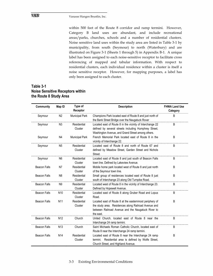
Noise sensitive land uses within the study area are listed in Table 3-1 by
municipality, from south (Seymour) to north (Waterbury) and are
illustrated on Figure 3-1 (Sheets 1 through 5) in Appendix B-1. A unique
label has been assigned to each noise-sensitive receptor to facilitate cross
referencing of mapped and tabular information. With respect to
residential clusters, each individual residence within a cluster is itself a
noise sensitive receptor. However, for mapping purposes, a label has
only been assigned to each cluster.
Table 3-1 Noise Sensitive Receptors within the Route 8 Study Area
Community Map ID Type of
Receptor
Description FHWA Land Use
Category
Seymour N2 Municipal Park Champions Park located east of Route 8 and just north of
the Bank Street Bridge over the Naugatuck Rover
B
Seymour N3 Residential
Cluster
Located east of Route 8 in the vicinity of Interchange 22
defined by several streets including Humphrey Street,
Washington Avenue, and Grand Street among others.
B
Seymour N4 Municipal Park French Memorial Park located east of Route 8 in the
vicinity of Interchange 22.
B
Seymour N5 Residential
Cluster
Located east of Route 8 and north of Route 67 and
defined by Meadow Street, Garden Street and Nichols
Street.
B
Seymour N6 Residential
Cluster
Located east of Route 8 and just south of Beacon Falls
town line. Defined by Lakeview Avenue.
B
Beacon Falls N7 Residential
Cluster
Mobile home park located west of Route 8 and just north
of the Seymour town line.
B
Beacon Falls N8 Residential
Cluster
Small group of residences located east of Route 8 just
south of Interchange 23 along Old Turnpike Road.
B
Beacon Falls N9 Residential
Cluster
Located west of Route 8 in the vicinity of Interchange 23.
Defined by Hopewell Avenue.
B
Beacon Falls N10 Residential
Cluster
Located east of Route 8 along Gruber Road and Lopus
Road.
B
Beacon Falls N11 Residential
Cluster
Located east of Route 8 at the easternmost periphery of
the study area. Residences along Railroad Avenue and
between Railroad Avenue and the Naugatuck River to
the east.
B
Beacon Falls N12 Church United Church, located east of Route 8 near the
Interchange 24 ramp termini.
B
Beacon Falls N13 Church Saint Michaels Roman Catholic Church, located east of
Route 8 near the Interchange 24 ramp termini.
B
Beacon Falls N14 Residential
Cluster
Located east of Route 8 near the Interchange 24 ramp
termini. Residential area is defined by Wolfe Street,
Church Street, and Highland Avenue.
B
Vanasse Hangen Brustlin, Inc.
3-4 Existing Environmental Conditions
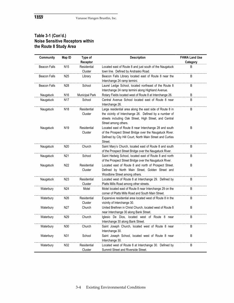
Table 3-1 (Con’d.) Noise Sensitive Receptors within the Route 8 Study Area
Community Map ID Type of
Receptor
Description FHWA Land Use
Category
Beacon Falls N15 Residential
Cluster
Located east of Route 8 and just south of the Naugatuck
town line. Defined by Andrasko Road.
B
Beacon Falls N25 Library Beacon Falls Library located east of Route 8 near the
Interchange 24 ramp termini.
B
Beacon Falls N28 School Laurel Ledge School, located northeast of the Route 8
Interchange 24 ramp termini along Highland Avenue.
B
Naugatuck N16 Municipal Park Rotary Fields located west of Route 8 at Interchange 26. B
Naugatuck N17 School Central Avenue School located east of Route 8 near
Interchange 26.
B
Naugatuck N18 Residential
Cluster
Large residential area along the east side of Route 8 in
the vicinity of Interchange 26. Defined by a number of
streets including Oak Street, High Street, and Central
Street among others.
B
Naugatuck N19 Residential
Cluster
Located east of Route 8 near Interchange 28 and south
of the Prospect Street Bridge over the Naugatuck River.
Defined by City Hill Court, North Main Street and Curtiss
Street.
B
Naugatuck N20 Church Saint Mary’s Church, located east of Route 8 and south
of the Prospect Street Bridge over the Naugatuck River.
B
Naugatuck N21 School Saint Hedwig School, located east of Route 8 and north
of the Prospect Street Bridge over the Naugatuck River.
B
Naugatuck N22 Residential
Cluster
Located east of Route 8 and north of Prospect Street.
Defined by North Main Street, Golden Street and
Woodbine Street among others.
B
Naugatuck N23 Residential
Cluster
Located west of Route 8 at Interchange 29. Defined by
Platts Mills Road among other streets.
B
Waterbury N24 Motel Motel located east of Route 8 near Interchange 29 on the
corner of Platts Mills Road and South Main Street.
B
Waterbury N26 Residential
Cluster
Expansive residential area located west of Route 8 in the
vicinity of Interchange 30.
B
Waterbury N27 Church United Brethren in Christ Church, located west of Route 8
near Interchange 30 along Bank Street.
B
Waterbury N29 Church Iglesio De Dios, located west of Route 8 near
Interchange 30 along Bank Street.
B
Waterbury N30 Church Saint Joseph Church, located west of Route 8 near
Interchange 30.
B
Waterbury N31 School Saint Joseph School, located west of Route 8 near
Interchange 30.
B
Waterbury N32 Residential
Cluster
Located west of Route 8 at Interchange 30. Defined by
Summit Street and Riverside Street.
B

Vanasse Hangen Brustlin, Inc.
3-5 Existing Environmental Conditions
3.1.2 Land Use, Community Planning and Municipal Facilities
This discussion provides an overview of land use patterns and zoning
within the study area as well as key land uses which may be sensitive to
project impacts. Those sensitive land uses include cohesive communities
and neighborhoods, public safety facilities such as police stations, and
community institutions such as schools.
Existing Land Use
Generalized land uses in the study area are shown in Figure 3-1 (Sheets 1
through 5) in Appendix B-1. which also depicts property boundaries.
The single largest property is the publicly owned Naugatuck State Forest
(State of Connecticut). The Route 8 right-of-way (ROW) is another large
publicly owned property (owned by CTDOT.) Other properties are
predominantly in private ownership.
Corridor Overview – Communities in the Naugatuck Valley have a long
history as manufacturing-based economies. Compact communities often
formed near factories and these population centers are still interspersed
today with large undeveloped tracts and low-density rural development.
Within the study area communities, there are numerous industrial sites
along the banks of the Naugatuck River which closely parallels Route 8.
In Seymour, Beacon Falls, and Naugatuck, the town center or downtown
are situated along the river and either adjacent to, or bisected by Route 8.
Much of the land in the study area located in between the town centers
and their residential edges is undeveloped. These areas have either very
steep topography or are preserved open space as part of the Naugatuck
State Forest.
Seymour – The study area in Seymour encompasses most of the
downtown on the east side of Route 8 and a commercial/retail cluster on
the west side of Route 8. It is an area of mixed, mostly nonresidential,
uses common to small downtowns. Interchange 22 is elevated through
most of Seymour. It is a split interchange; the southern off-ramps meet
downtown in a mixed commercial/industrial area adjacent to the historic
town center and the northbound on-ramp abuts a park and residential
neighborhood near the northeastern downtown edge. Traveling
northward in the corridor in Seymour, the land on either side of Route 8
is undeveloped. It is privately owned and characterized by cliffs and the
Naugatuck River.
Beacon Falls – The land on the east side of Route 8 between the southern
Beacon Falls town line and Interchange 23 is undeveloped with very
Vanasse Hangen Brustlin, Inc.
3-6 Existing Environmental Conditions
steep topography. Between the river and the western side of Route 8,
there is a mobile home park. In the immediate vicinity of Interchange 23
is a cluster of commercial uses and a ballfield complex. North of
Interchange 23, the Route 8 corridor traverses a large area of sand and
gravel mining. Yet, in this same area, the western edge of the study area
along Lopus Road Extension has some sparsely spaced homes and one
active farm. Interchange 24 in Beacon Falls is situated at the northern
edge of the downtown. It is an area of automotive and other heavy
commercial uses as well as a public safety complex.
Naugatuck – Interchange 25 is a split interchange. The southerly on-
ramp for Route 8 northbound abuts two large cemeteries. To the south
of the northbound off-ramp in this same locale, the Naugatuck State
Forest and a segment of Connecticut Blue-Blaze trail are on the eastern
side of Route 8. The Naugatuck River forms the western side of the
corridor in this area. At Interchange 26, the Naugatuck Borough center is
just west of the Naugatuck River and Route 8.
The east side of the river and Route 8 in Naugatuck, near Interchange 26,
is mostly residential with some limited commercial activity. There are
recreational fields present (Rotary Fields) between the river and the
highway. Interchanges 27 and 28 are similarly situated in mixed-use,
predominantly residential neighborhoods. The common pattern is
arterial streets with commercial/retail development, surrounded by
clusters of homes on the collector or local roads. This area is one of
transition into a more urban pattern of development characteristic of the
City of Waterbury to the north.
Waterbury – Land uses along Route 8 in southern Waterbury reflect a
historic pattern of prior industrial activity which has changed over time
into a mix of land uses including neighborhood commercial and
residential, and underdeveloped space. Interchange 29 is situated at the
municipal line between Naugatuck and Waterbury. It is adjacent to a
residential neighborhood to the west and sparse commercial
development to the east. Interchange 30 is another split interchange,
interfacing with mostly heavy commercial activity at the southern ramps
and neighborhood-scale commercial uses mixed with residences at the
northern ramps.
Zoning
While there is a wide range of specific municipal zoning designations in
the study area, there are four broad categories of zoning which dominate
the area, including industrial, business, residential, and state forest.
Zoning in each of the study area communities is described below

Vanasse Hangen Brustlin, Inc.
3-7 Existing Environmental Conditions
Seymour – Zoning along the Route 8 corridor in Seymour is primarily
residential and general business at varied allowable densities. The
zoning map and regulations are in the process of being updated and
correlated to one another. As such, a more in-depth description of the
zoning pattern is not currently available.
Beacon Falls – Zoning along the Route 8 corridor in Beacon Falls is
primarily B-1 for general business and industrial. Zones occurring along
the corridor from south to north include:
� B-1 – General business
� I-PD – Planned industrial parks
� R-3– Multifamily residential (in one pocket north of Interchange 23)
� I-1 – General industrial
� R-1 – Single-family residential (limited to two districts south of
Interchange 24 and west of the Naugatuck River)
� SF – State Forest
Naugatuck – Zoning along the Route 8 corridor in Naugatuck is
primarily residential and industrial. Zones occurring along the corridor
from south to north include:
� R-8 - Residential with minimum 8,000 square foot lot; requires public
water and sewer service
� I-1 - Heavy industry
� I-2 - Light industry in lower intensity setting; does not generate
nuisance level pollutants such as odors or noise
� B-2 – Business – General office and commercial on sites suitable for
access by automobiles (motorist oriented); intended for commercial
development on Naugatuck’s arterial streets
� RA-1 – Residential – single to multifamily dwellings in areas served
by water and sewer
� R-15 - Residential with minimum 15,000 square foot lot; requires
public water and sewer service
Waterbury – Zoning along the Route 8 corridor in Waterbury is
primarily industrial. The two industrial zones occurring along the
corridor from south to north include:
� I-P – Planned industrial parks
� I-G – General industrial
There are also varied residential zones abutting these industrial zones
and the study corridor including both low and high density residential.
The City of Waterbury is currently proposing changes to its zoning

Vanasse Hangen Brustlin, Inc.
3-8 Existing Environmental Conditions
within the study area. These changes will be monitored as the Route 8
study progresses.
Communities and Neighborhoods
Neighborhoods can be defined by formal designation or by the presence
of a neighborhood organization. They can also be identified by
residents’ expressed sense of community cohesion, their sense of
unification, “belonging”, or closeness to a neighborhood or community.
With the exception of one Waterbury neighborhood, there are no formal
neighborhoods as designated by local governments within the study
area. Informal neighborhoods are known locally and/or with place-
names within the study area in each community. Their boundaries are
not formally determined, but generally follow the evident edges of
concentrated housing and/or development. A description of each, by
municipality, follows.
Seymour – There are two cohesive neighborhoods that fall wholly or
partially within the study area in Seymour.
� The historic downtown is adjacent and west of the southern ramps of
Interchange 22.
� The Garden City neighborhood surrounds the east side of French
Memorial Park, adjacent to and east of the northern ramps of
Interchange 22. Garden City contains primarily single-family
residences on small lots, with many historic homes.
Beacon Falls –There are two neighborhoods in Beacon Falls within the
study area. An unnamed mobile home park at the town’s southern
border forms its own small neighborhood. A portion of the western edge
of the downtown neighborhood of Beacon Falls occurs within the study
area.
Naugatuck – There are two neighborhoods extending into the study area
in Naugatuck. The first, Downtown Naugatuck, is a historic and
architecturally cohesive area situated along the west bank of the
Naugatuck River and abuts the western edge of the study area. The
second is Union City situated east of Route 8 and centered on North
Main Street. It is also characterized by a cluster of historic structures.
Waterbury – There are two place-name neighborhoods within the study
area in Waterbury. The Brooklyn neighborhood includes the historic St.
Patrick's Church, St. Joseph's Church, Duggan School, Barnard School,
and the historic Riverside Cemetery. While the neighborhood is
extensive, the portions that fall within the study area are limited to the
Vanasse Hangen Brustlin, Inc.
3-9 Existing Environmental Conditions
southeast corner of the Riverside Cemetery (shown on Sheet 5 of Figure
3-5 in Appendix B-1) and the section between St. John’s Street and Route
8. The Platts Mill neighborhood encompasses a residential area that
extends from Waterbury into Naugatuck within the study area on the
western side of Route 8.
Public Safety Facilities and Community Institutions
Public safety facilities and community institutions considered for this
environmental screening include fire stations, ambulance/Emergency
Medical Technician stations, police stations, town government buildings,
schools, and libraries. Locations of these facilities and institutions are
shown on Figure 3-2 (Sheets 1 through 5) in Appendix B-1. Public safety
facilities and community institutions within the study area in each of the
corridor communities are listed in Table 3-2.
Table 3-2 Public Safety Facilities and Community Institutions Located within the Study Area Community Map ID Facility/Institution Address
Seymour CF1 Seymour Senior Center 20 Pine Street
CF2 Seymour Board of Education 98 Bank Street
CF3 Seymour Post Office 91 Main Street
CF4 Seymour Fire Department 1 First Street
CF5 Seymour Town Hall 1 First Street
Beacon Falls CF6 Beacon Falls Fire Station 35 North Main Street
CF7 Beacon Falls Post Office 101 North Main Street
CF8 Beacon Falls Fire Marshall/ State Trooper
119 North Main Street
CF9 Laurel Ledge School 30 Highland Avenue
CF10 Beacon Falls Library 10 Maple Avenue
Naugatuck CF11 Naugatuck Post Office 170 Water Street
CF12 Central Avenue School 28 Central Avenue
CF13 Saint Hedwig School 32 Golden Hill Street
Waterbury CF14 Saint Joseph School 46 Congress Avenue
3.1.3 Local, Regional and State Land Use Plans
The Route 8 study area traverses seven planning regions, namely the
towns of Seymour, Beacon Falls, and Naugatuck, the City of Waterbury,
the Valley Council of Governments (VCOG), the Council of Governments
of the Central Naugatuck Valley (COGCNV) and the State of
Connecticut. The plans formulated for each of these entities articulate a
vision, goals, and objectives for future land use and/or the
transportation system. Key relevant findings of policy contained in the

Vanasse Hangen Brustlin, Inc.
3-10 Existing Environmental Conditions
respective long-range plans of conservation and development (POCD) of
these entities are summarized below.
Seymour – The 2002 Plan of Conservation and Development for Seymour
(Planimetrics, 2002) expresses the overall policies to:
� Preserve open space
� Protect natural resources
� Enhance economic development areas
� Maintain and enhance the community structure
� Maintain housing diversity
A notable component of the strategies for preserving open space is the
goal of creating an overall greenbelt system linking preserved open
spaces in the community. Development strategies of note include
continuing to enhance the downtown and avoiding strip development.
Transportation issues are addressed as part of the chapter on
infrastructure. In this chapter, the POCD calls for:
� Improving transit service
� Conducting an in-depth circulation network study
� Enhancing pedestrian and bicycle travel
The potential for future modifications to Route 8 are not mentioned in
the plan.
Beacon Falls – The main issues raised by residents and addressed in the
Plan of Conservation and Development for Beacon Falls (Planimetrics, 2002)
include:
� Coordination of local activities
� Economic development
� Preservation of open space and natural resources
� Providing community facilities
The conservation plan for Beacon Falls shows a proposed “Open Space
Greenway” that follows the Naugatuck River and crosses Route 8 in one
locale. The goal is to provide a continuous greenbelt connecting the
proposed Naugatuck River Greenway with the Naugatuck State Forest
trails. Development strategies of note include potentially establishing a
Village District to strengthen the character of the downtown and
avoiding strip development. Transportation issues are addressed as part
of the chapter on infrastructure. In this chapter the, POCD calls for:
� The construction of a full interchange on Route 8 to facilitate travel
through the center of town and to access industrial parks
Vanasse Hangen Brustlin, Inc.
3-11 Existing Environmental Conditions
� Improving transit service
� Enhancing bicycle and pedestrian travel
Naugatuck – The POCD for the Borough of Naugatuck dates to 2001. Its
policies, as articulated in the future land use plan, focus on:
� Natural and cultural resource preservation;
� Neighborhood conservation and renewal;
� Enhancing the downtown; and,
� Strategic economic development.
Transportation strategies to support the future land use plan are
discussed in the circulation element, and include:
� Access management
� Correcting current deficiencies in the local roadway network
� Ensuring the roadway network serves all the travel needs in
Naugatuck
� Developing a system of sidewalks
The potential for future modifications to Route 8 are not mentioned in
the plan.
Waterbury – The 2005 City of Waterbury Plan of Conservation and
Development (Phillips Preiss Shapiro, 2005) is contained in two volumes.
Volume 1 documents the vision, goals, and policy recommendations of
the plan while Volume 2 is a community assessment update. The overall
vision for the City focuses on the City’s role and place in the region,
neighborhood and community quality of life, and the “nuts and bolts of a
city that works.” As part of the detailed vision statement it states, “The
City will pursue and support State and regional initiatives that impact
the City and region, including studies for roadways, rail transport, etc.”
Transportation goals and policies stated to support the overall vision
include the following:
Goal: Improve the mobility of all of Waterbury’s residents.
Policies:
� Improve all three dimensions of transit service: coverage, frequency, and
facilities as the need for transit increases in the city.
� Coordinate all modes of transit: local bus, long-distance bus, and rail.
� Promote free circulation of traffic, but not at the expense of on-street parking
in commercial corridors and pedestrian circulation.

Vanasse Hangen Brustlin, Inc.
3-12 Existing Environmental Conditions
� Partner with the CNV-COG to work closely with CTDOT to ensure that the
City’s needs are met when the I-84 and state highways are widened or
reconfigured.
� Promote safe and convenient pedestrian and bicycle facilities in appropriate
locations to meet existing and future demand.
VCOG – The VCOG Regional Plan of Conservation and Development
was recently updated and completed in June, 2008. Key policy areas
addressed in the plan include:
� Conserve important resources
� Encourage responsible growth
� Promote economic development
� Address transportation needs
� Address infrastructure
� Promote regional programs
The specific policies contained in the transportation plan component
include the following:
� Improve Route 8
� Enhance transit service
� Make necessary improvements on major roadways
� Enhance pedestrian and bicycle transportation
The plan supports the improvement of traffic flow at the interchanges on
Route 8 and includes strategies to:
1. Promote efforts to obtain designation of Route 8 as a federal interstate, to
improve highway design, condition, and funding.
2. Continue to work with CTDOT to obtain funding to implement the changes
designed for Route 8 interchanges.
COGCNV – The 2008 update to the COGCNV plan of conservation and
development (Regional Plan of Conservation & Development 2008,
COGCNV, June 2008) presents policies for future development in
separate chapters organized by resource. The Transportation chapter
states that future transportation planning in the region should emphasize
maintaining and improving the existing transportation system rather
than expanding with new construction. It notes that highways will
remain the focal point of the transportation system, but the role of public
transit and ridesharing should be enhanced. Greenways, bikeways,
sidewalks, and pedestrian paths are expected to provide transportation
connections between residential areas and high priority and scenic
destinations. Specific policies for the highway system are as follows:
Vanasse Hangen Brustlin, Inc.
3-13 Existing Environmental Conditions
1. Monitor congestion within the region’s highway network, and
emphasize highway projects that will help address congested
corridors in a timely manner.
2. Seek to improve safety and reduce traffic congestion, energy
consumption, and motor vehicle emissions.
3. Encourage access management techniques along arterial roads to
improve highway capacity and safety.
4. Encourage proper maintenance of the region’s highways, including
ongoing safety and pavement maintenance.
5. Continue the evaluation and maintenance of the region’s bridges.
6. Support context-sensitive design for the region’s highway system
improvements.
7. Increase awareness of commuter parking locations along major
commuter routes, and expand lots where needed.
State of Connecticut - The Connecticut Office of Policy and Management
(OPM) Conservation and Development Policies Plan for Connecticut (2005-
2010) (the C&D Plan) contains growth management, economic,
environmental quality, and public service infrastructure guidelines and
goals for the State of Connecticut. The overall strategy of the C&D Plan
is to reinforce and conserve existing urban areas, to promote appropriate,
sustainable development, and to preserve areas of significant
environmental value.
The Locational Guide Map which accompanies the C&D Plan provides a
geographical interpretation of the State’s conservation and development
policies. The map identifies the following land use designations and
policies within the Route 8 study area:
� Neighborhood Conservation Area for the centers of Seymour, Beacon
Falls and Naugatuck to maintain stable developed neighborhoods
and communities;
� Growth Area between Seymour and Beacon Falls that concentrates
new urban growth outside regional centers in areas capable of
supporting large scale mixed-uses and densities;
� Existing Preserved Open Space for the Naugatuck State Forest; and,
� Regional Center for the Waterbury portion of the corridor that
proposes to revitalize the economic, social, and physical environment
of urban centers.

Vanasse Hangen Brustlin, Inc.
3-14 Existing Environmental Conditions
3.2 Natural Resources
This section provides an overview of natural resources within the study
area, including surface water resources, wetlands, floodplains and
stream channel encroachment lines, groundwater resources, endangered
species, and farmlands.
3.2.1 Surface Water Resources
Water is not only critical to sustaining life, it is also essential for human
activities. Rivers, streams, lakes and ponds are used for drinking water,
irrigation, industrial process water, hydropower and recreation among
other uses. For these and other reasons, local, state and federal laws
protect surface water resources from actions that could potentially
degrade their overall quality and use.
The primary surface water feature in the study area is the Naugatuck
River. The river flows in a southerly direction through the study area,
draining into the Housatonic River at Derby. The Housatonic River, in
turn, flows in a southerly direction until ultimately discharging into Long
Island Sound between Milford and Stratford.
The Route 8 corridor from Interchange 22 north to Interchange 30 is
contained entirely with the Naugatuck River watershed and generally
follows the course of the Naugatuck River within its narrow valley.
Route 8 parallels the river on the east within Seymour and southern
portions of Beacon Falls, then crosses the river twice over a short distance
within Beacon Falls; one crossing occurs just north of Route 42 and the
second crossing is just north of Lopus Road. The Route 8 corridor
remains east and parallel to the river as it continues north through
Naugatuck, and then crosses the river a final time within the study area
at a location just north of Platts Mills Road in Waterbury. North of Platts
Mills Road to Interchange 30, Route 8 parallels the river on the west.
According to the CTDEP Surface Water Quality Standards (December 17,
2002), the Naugatuck River within the study area is designated as a Class
C resource. Table 3-3 provides a description of CTDEP surface water
quality classifications and also identifies the designated uses associated
with each classification.

Vanasse Hangen Brustlin, Inc.
3-15 Existing Environmental Conditions
Table 3-3 Surface Water Quality Classifications Class Designated Uses Description
AA Existing or proposed drinking water supply, fish and wildlife habitat, recreational use (may be restricted,) agricultural and industrial supply. There is no SAA (marine) classification.
Water of highest quality based on water parameters and criteria established by the Connecticut WQS. Waters mapped as AA are known or presumed to meet water quality criteria which support designated AA uses.
A Habitat for fish and other aquatic life and wildlife; potential drinking water supplies; recreational; navigation; and water supply for industry and agriculture. “SA” (marine) uses do not include potential drinking water supplies but do include shellfish harvesting for direct human consumption.
Water of high quality based on water parameters and criteria established by the Connecticut WQS. Waters mapped as A are known or presumed to meet water quality criteria which support designated A uses.
B Habitat for fish and other aquatic life and wildlife; recreational; navigation; and industrial and agricultural water supply. “SB” (marine) uses also include commercial shellfish harvesting.
Water of the minimum acceptable quality based on water parameters and criteria established by the Connecticut WQS. Waters mapped as B are known or presumed to meet water quality criteria which support designated uses.
C Class C waters are suitable for certain fish and wildlife habitat; certain recreational activities; industrial activities and navigation. Class C waters may have good aesthetic value. “SC” (marine) uses also include certain aquacultural operations.
Water of unacceptable quality due to point or non-point sources of pollution. As a result, water is frequently precluded from meeting Class B water quality criteria for one or more designated uses. Water quality conditions are usually correctable through implementation of water quality programs to control point and nonpoint sources. The goal for these waters is achievement of Class A or B criteria and designated uses. For freshwater resources, the goal may also be Class AA. The minimum acceptable goal is Class B unless a DEP and EPA approved Use Attainability Analysis demonstrates that one or more Class B designated uses are not attainable. In those situations, site specific water quality criteria will be employed to insure that all existing uses are maintained.
D Class D waters may be suitable for bathing or other recreational purposes, certain fish and wildlife habitat, industrial uses and navigation. Class D waters may have good aesthetic value. “SD” (marine) uses also include certain aquacultural operations.
Water of unacceptable quality due to severe pollution or presence of certain persistent contaminants in the sediments which may bioaccumulate in the food chain. As a result, water is consistently precluded from meeting Class B water quality criteria for one or more designated uses. Water quality conditions may not be readily correctable through implementation of water quality programs to control point and nonpoint sources. The goal for such waters is identical to the goal for Class C waters.
Source: CTDEP Surface Water Quality Standards (December 17, 2002)
Other waterways in the study area are tributaries to the Naugatuck
River. Table 3-4 lists the tributary streams crossed by Route 8 in the
study area, their general location, and their water quality classification.
Vanasse Hangen Brustlin, Inc.
3-16 Existing Environmental Conditions
These surface water features are depicted on Figure 3-3 (Sheets 1 through
5) in Appendix B-1. Other than the Naugatuck River and these tributary
streams, surfaces water features within the study area include a large
surface water impoundment located immediately west of the Naugatuck
River in Beacon Falls and a few small open water ponds east of Route 8
in Seymour and Beacon Falls. All of these open water ponds are
designated by CTDEP as Class A with respect to water quality.
Table 3-4 Stream Crossings within the Route 8 Study Area Community Stream Name General Location Water Quality
Classification*
Seymour Bladens River Located east of Route 8 and just north of Day Street. The watercourse flows west under Route 8 and into the Naugatuck River.
B
Seymour Mud Brook Located east of Route 8, it drains to the southwest under North Main Street near the Lakeview Avenue intersection and then under Route 8 and into the Naugatuck River.
A
Beacon Falls Egypt Brook Located east of Route 8 and south of Interchange 25 within the Naugatuck State Forest. Drains to the west under Route 8 and into the Naugatuck River.
A
Beacon Falls / Naugatuck
Beacon Hill Brook
Along town boundary between Beacon Falls and Naugatuck. Flows east under Route 8 and into the Naugatuck River in the vicinity of Interchange 25.
A
Naugatuck Unnamed Located east of Route 8. Flows west through a residential area, then under Route 8 in the vicinity of Interchange 26. Discharges into the Naugatuck River near Rotary Field.
A
Naugatuck Fulling Mill Brook / Cold Spring Brook
The confluence of these two brooks is located just east of the study area. The combined drainage then flows in a westerly direction under Route 8 and into the Naugatuck River at a point just south of the Prospect Street Bridge.
Fulling Mill Brook is B; Cold Spring
Brook is A
* CTDEP GIS 2008 – Surface Water Quality Mapping
3.2.2 Wetlands
Wetlands are regulated on the federal level by the U.S. Army Corps of
Engineers (ACOE) under Section 404 of the Clean Water Act and on the
state level by the CTDEP under the Connecticut Inland Wetlands and
Watercourses Act. Because wetlands exhibit many functions considered
beneficial for both humans and wildlife, and because they are a
dwindling resource, both Acts place strong emphasis on wetland
avoidance as the primary means of protecting wetland resources. As
such, alternatives development and selection is often significantly
influenced by these regulations.
Wetlands within the Route 8 study area include inland wetlands defined
by federal regulations and inland wetlands defined by state regulations.
Federal inland wetlands, as defined by the Corps of Engineers Wetland

Vanasse Hangen Brustlin, Inc.
3-17 Existing Environmental Conditions
Delineation Manual (U.S. Army Corps of Engineers, Waterways
Experiment Station, 1987), are identified by a three-parameter approach
that considers hydric soils, hydrophytic vegetation, and the presence of
hydrologic indicators. Connecticut state inland wetlands, as defined by
the Connecticut Wetlands and Watercourse Act, are identified by the
presence of poorly drained, very poorly drained, alluvial, or floodplain
soil types. In many cases, a wetland will qualify as both a state and
federal wetland.
A review of 2008 CTDEP GIS data revealed that there are few wetlands
in close proximity to the Route 8 study area. This is as expected, since
relatively steep (rocky) topography defines much of the Naugatuck River
Valley, particularly in Beacon Falls and Naugatuck, and the level valley
floors have been historically developed.
Limited field reconnaissance was conducted on February 13, 2009 to
verify the presence and extent of wetlands within the corridor. This
effort identified three wetlands not shown on the GIS. Wetlands within
the study area are depicted on Figure 3-3 (Sheets 1 through 5) in
Appendix B-1. Table 3-5 lists wetlands by study area town and provides
a general description of the location and type of each wetland. The
figures and the table indicate those wetlands that were identified by the
GIS data and during field reconnaissance. A unique label has been
assigned to each wetland to facilitate cross-referencing of mapped and
tabular information.
Vanasse Hangen Brustlin, Inc.
3-18 Existing Environmental Conditions
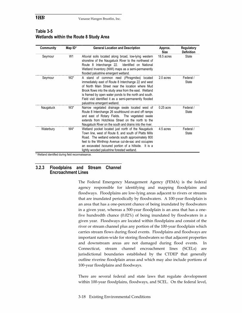
Table 3-5 Wetlands within the Route 8 Study Area Community Map ID* General Location and Description Approx.
Size
Regulatory
Definition
Seymour W1 Alluvial soils located along broad, low-lying western shoreline of the Naugatuck River to the northwest of Route 8 Interchange 22. Identified on National Wetland Inventory (NWI) maps as a semi-permanently flooded palustrine emergent wetland.
18.5 acres State
Seymour W2* A stand of common reed (Phragmites) located immediately east of Route 8 Interchange 22 and west of North Main Street near the location where Mud Brook flows into the study area from the east. Wetland is framed by open water ponds to the north and south. Field visit identified it as a semi-permanently flooded palustrine emergent wetland.
2.0 acres Federal / State
Naugatuck W3* Narrow vegetated drainage swale located west of Route 8 Interchange 26 southbound on-and off ramps and east of Rotary Fields. The vegetated swale extends from Hotchkiss Street on the north to the Naugatuck River on the south and drains into the river.
0.25 acre Federal / State
Waterbury W4* Wetland pocket located just north of the Naugatuck Town line, west of Route 8, and south of Platts Mills Road. The wetland extends south approximately 800 feet to the Winthrop Avenue cul-de-sac and occupies an excavated /scoured portion of a hillside. It is a lightly wooded palustrine forested wetland.
4.5 acres Federal / State
* Wetland identified during field reconnaissance.
3.2.3 Floodplains and Stream Channel Encroachment Lines
The Federal Emergency Management Agency (FEMA) is the federal
agency responsible for identifying and mapping floodplains and
floodways. Floodplains are low-lying areas adjacent to rivers or streams
that are inundated periodically by floodwaters. A 100-year floodplain is
an area that has a one-percent chance of being inundated by floodwaters
in a given year, whereas a 500-year floodplain is an area that has a one-
five hundredth chance (0.02%) of being inundated by floodwaters in a
given year. Floodways are located within floodplains and consist of the
river or stream channel plus any portion of the 100-year floodplain which
carries stream flows during flood events. Floodplains and floodways are
important nation-wide for storing floodwaters so that adjacent properties
and downstream areas are not damaged during flood events. In
Connecticut, stream channel encroachment lines (SCELs) are
jurisdictional boundaries established by the CTDEP that generally
outline riverine floodplain areas and which may also include portions of
100-year floodplains and floodways.
There are several federal and state laws that regulate development
within 100-year floodplains, floodways, and SCEL. On the federal level,
Vanasse Hangen Brustlin, Inc.
3-19 Existing Environmental Conditions
Executive Order 11988, Floodplain Protection, directs federal agencies to
plan and design projects in order to avoid floodplain impacts. If a
proposed action is located within a floodplain, alternatives that avoid
adverse effects and incompatible development must be considered. In
addition, the action must be designed to minimize potential harm to or
within the floodplain. At the state level, the CTDEP Inland Water
Resources Management Division administers Connecticut’s Flood
Management Program (C.G.S. Sections 25-68b through 25-68h inclusive),
which regulates state agency actions affecting floodplains. State agencies
undertaking such actions must submit a Flood Management Certification
describing project activities and the measures taken to meet the
program’s standards. Standards relative to floodplain management
apply to any proposed construction or activities in floodplains, such as
excavation, fill, materials storage, and others. The CTDEP bases their
approval on a variety of considerations including: conformance to the
provisions of FEMA’s National Flood Insurance Program (NFIP);
prevention of flood hazards to human life, health, or property;
prevention of adverse impacts to fish populations or fish passage; and
prevention of intensification of land uses or development in flood prone
areas.
The Connecticut Stream Channel Encroachment Line (SCEL) program
(C.G.S. 22a-342 through 22a-349a) was established post-1955 to ensure
that floodplain development is compatible hydraulically and structurally
with highly flood-prone rivers in the state. CTDEP issues permits for
development within designated SCELs only if there is a clear
demonstration that a project will not cause an increase in flood hazard or
other adverse effects to the floodplain.
Floodplains along the Route 8 corridor are abundant given the location of
the highway directly adjacent to the Naugatuck River. However, for the
most part, Route 8 is located above the 100-year floodplain elevation of
the river, so flood waters do not reach it. Locations where the
Naugatuck River 100-year floodplain is widest within the study area can
be found: in the vicinity of Route 8 Interchange 22 where Mud Brook
enters the study area from the east; along the river from the
Seymour/Beacon Falls town line north to where Route 8 crosses the river
at Pine Bridge; along the eastern shoreline of the river where Route 8
crosses in the vicinity of Interchange 24; and adjacent to Route 8
Interchange 26 near Rotary Fields in Naugatuck. Otherwise, the 100-year
floodplain associated with the Naugatuck River is narrow and occupies
only immediate low-lying shoreline areas. According to the 2008 CTDEP
GIS data and FEMA mapping for study area towns, there are no
designated FEMA floodways associated with the Naugatuck River
within the study area. A Letter of Map Revision (LOMR) is listed on

Vanasse Hangen Brustlin, Inc.
3-20 Existing Environmental Conditions
FEMA’s website for the town of Beacon Falls that resulted in the removal
of a floodway from FEMA mapping.
There are several tributary streams in the study area with 100-year
floodplains that are crossed by Route 8. The most notable include
Bladens River and Mud Brook in Seymour, Beacon Hill Brook on the
Beacon Falls/Naugatuck town line, and Fulling Mill Brook/Cold Spring
Brook in Naugatuck, just south of the Prospect Street Bridge near
Interchange 28.
The CTDEP has designated a SCEL along much of the Naugatuck River
in the study area. The SCEL extends north along the river from
Interchange 22 in Seymour to a location just north of Interchange 24.
From this point to approximately Interchange 25 in Naugatuck, there is
no SCEL associated with the river; however the SCEL designation
reappears from Interchange 25 north to Interchange 30 in Waterbury and
beyond.
Areas of 100-year, and 500-year floodplains and SCELs are depicted on
Figure 3-4 (Sheets 1 through 5) in Appendix B-1.
3.2.4 Groundwater Resources
Groundwater is defined as water that collects or flows beneath the
earth’s surface, filling the porous spaces in soil, sediment, and rocks.
Groundwater originates from rain and from melting snow and ice and is
the source of water for aquifers, springs and wells. The flow of
groundwater generally follows topographic gradients. In the Route 8
study area, the topography indicates that groundwater flows from the
hills and lands above the Naugatuck River Valley towards the river in
the valley floor. The availability of groundwater and its quality within a
particular area varies with local geology, topography, and land use.
Groundwater is the most abundant source of fresh water supply and is
usually more pure than surface water sources. To protect high quality
groundwater resources from potential degradation regulations such as
Connecticut’s Aquifer Protection Act (C.G.S. 22a-345a-bb) have been
enacted.
The 2008 CTDEP GIS database, CTDEP Groundwater Quality Standards
(effective April 12, 1996), and available aquifer maps were consulted to
identify the location and quality of groundwater resources along the
study area. The research determined that there are no Sole Source
Aquifers, Aquifer Protection Areas (APAs), community water supply
wells, or associated wellhead protection zones within 500 feet of Route 8

Vanasse Hangen Brustlin, Inc.
3-21 Existing Environmental Conditions
or the study area ramp termini. There may be individual (private) water
supply wells within the study area, which will be identified in future
phases of the study if private properties are impacted by the proposed
alternatives.
Groundwater quality classifications and designated uses for Connecticut
are presented in Table 3-6. Figure 3-3 (Sheets 1 through 5) in Appendix
B-1 illustrates groundwater resources in the study area.
In terms of groundwater quality, the southern half of the study area,
including the Naugatuck State Forest, is underlain primarily by
groundwater designated by the CTDEP as Class GA. There are a few
Class GB groundwater areas, including an area near Interchange 22 in
Seymour, an area just north of the Route 8 Naugatuck River crossing at
Pine Bridge in Beacon Falls, and one at the Route 8 Naugatuck River
crossing near Lopus Road in Beacon Falls. In the northern half of the
study area, from Saint James Cemetery in Naugatuck north into
Waterbury, the study area is primarily underlain by Class GB
groundwater. The most notable exception is an area of Class GA
groundwater in Waterbury to the south of Interchange 30.
Table 3-6 CTDEP Groundwater Quality Classifications in Study Area
Class Designated Uses Description
GA* Existing private and potential public or private supplies of water suitable for drinking without treatment; base-flow for hydraulically connected surface water bodies.
Water of high quality based on water parameters and criteria established by the Connecticut WQS. Allowable discharges: Same as for GAA, plusdischarge from sewage treatment facilities subject to stringent treatment and discharge requirements, and other wastes of natural origin that easily biodegrade and present no threat to groundwater.
GB Industrial process water and cooling waters; base-flow for hydraulically connected surface water bodies; presumed not suitable for human consumption without treatment.
GB waters are presumed to be degraded due to a variety of pollution sources. Allowable discharges: Same as for GA (the same stringent treatment standards apply), plus certain other biodegradable wastewaters subject to soil attenuation.
Source: CTDEP Groundwater Quality Standards (Effective April 12, 1996).
3.2.5 Endangered Species
Rare, threatened, and endangered species are protected by federal and
state legislation. On the federal level, the United States Department of
Interior’s (DOI) Fish and Wildlife Service (FWS) and the United States
Vanasse Hangen Brustlin, Inc.
3-22 Existing Environmental Conditions
Department of Commerce’s (DOC) National Oceanic and Atmospheric
Administration (NOAA) Fisheries Division jointly administer the Federal
Endangered Species Act (16 U.S.C. 1531-1543). On the state level, the
CTDEP administers the Connecticut Endangered Species Act (C.G.S. Sec.
26-303 to Sec. 26-315). Collectively, the overall objective of these laws is
to conserve, protect, restore, and enhance any federal and/or state
endangered or threatened species and their essential habitat. Any action
which has the potential to significantly affect these protected species
must include all reasonable measures to mitigate any adverse impact.
Information on species designated (listed) as threatened and endangered
at the state and federal levels is compiled and made available through
the CTDEP’s Natural Diversity Data Base (NDDB). Established in 1983,
the NDDB contains data from biological inventories conducted over the
past 100 years. The NDDB currently contains information on the status
of nearly 2,000 species of plants and animals, including invertebrates and
45 natural community types. It also lists unique and significant natural
communities.
The CTDEP NDDB GIS data layer (CTDEP, 2008) was consulted to
determine if there were any records of state threatened or endangered
species in the Route 8 study area. Due to the sensitivity of the
information, the GIS data layer only depicts approximate locations of
protected species, their habitats, and/or significant natural communities.
The GIS data review revealed a total of four NDDB records in the study
area. These locations are depicted on Figure 3-4 (Sheets 1 through 5) in
Appendix B-1 and are generally described as follows:
� Southern end of the Route 8 study area in the vicinity of Interchange
22;
� Just north of the Seymour/Beacon Falls town line;
� West of Interchange 23 in Beacon Falls; and,
� Where the study area passes through the Naugatuck State Forest in
Naugatuck.
Given the four NDDB records in the study area, coordination letters were
sent to both the CTDEP NDDB and the FWS on February 11, 2008,
requesting additional species and habitat information. The CTDEP
responded in letters dated February 27, 2009 and March 5, 2009, which
identified the following NDDB records within the study area:
� State Endangered Species
o Halieetus luecocephalus (bald eagle)
o Vermivora chrysoptera (golden-winged warbler)

Vanasse Hangen Brustlin, Inc.
3-23 Existing Environmental Conditions
� State Threatened Species
o Eumeces fasciatus (five-lined skink)
� State Special Concern Species
o Caprimulgus vociferus (whip-poor-will)
o Papaipema leucostigma (columbine borer)
Once improvement alternatives are selected, consultation with a CTDEP
wildlife specialist will be required to ascertain the need for species
surveys, the potential for impact to identified species, and any mitigation
measures that may be required.
The FWS responded in a letter dated March 17, 2009 which stated that no
federally-listed or proposed threatened or endangered species or critical
habitat under the jurisdication of the FWS are known to occur in the
project study area. Therefore, preparation of a Biological Assessment
and/or further consultation with the FWS under Section 7 of the
Endangered Species Act is not required.
The data requests and responses from the CTDEP and FWS are included
in Appendix B-2, with CTDEP addressing state listed threatened and
endangered species and FWS addressing federal species.
3.2.6 Farmland Soils
The Farmland Protection Policy Act (FPPA) of 1981 (7 CFR 658, as
amended at 59 Federal Register 31117) was enacted by the U.S.
Department of Agriculture (USDA) in order to protect farmlands and to
prevent disturbance to soils important to agricultural production.
Important farmland soils in Connecticut are divided into two basic
groups, prime farmland soils and additional farmland soils of statewide
importance. Prime farmland soils have the best combination of physical
and chemical characteristics for producing food, feed, forage, fiber, and
oilseed crops, and are also available for these uses. In general, prime
farmland soils have an adequate and dependable moisture supply, a
favorable temperature and growing season, acceptable acidity or
alkalinity, acceptable salt and sodium content, and few or no rocks.
Additional farmland soils of statewide importance are not as high quality
as prime farmland soils but are still important for the economical
production of high yield crops. Some may produce as high a yield as
prime farmland soils if conditions are favorable.
Vanasse Hangen Brustlin, Inc.
3-24 Existing Environmental Conditions
A review of Natural Resource Conservation Service (NRCS) soils data
(2008 CTDEP GIS) revealed that there are no prime farmland soils and
only one area of additional farmland soils of statewide importance. That
area is an undeveloped 100-year floodplain located immediately west of
the Naugatuck River in the vicinity of Interchange 22. There is also only
one active farm within the study area. This farm is located in Beacon
Falls to the west of Route 8 along Lopus Road and is shown on Figure 3-2
(Sheet 2) in Appendix B-1. The farm is not located in an area mapped as
being important for farmland soils.
3.3 Cultural and Recreational Resources
This section provides an overview of cultural and recreational resources
within the study area, including historic and archaeological resources,
Section 4(f) lands, and Section 6(f) lands.
3.3.1 Cultural Resources
Cultural resources are an important part of the character of a community,
and may include historic features such as buildings, structures, sites,
objects and districts. They may also include archaeological resources,
which are physical remains, usually buried, of past activities on a site.
Section 106 of the National Historic Preservation Act of 1966, as
amended, requires federal agencies to take into account the effect of an
undertaking on historic properties listed on or eligible for listing on the
National Register of Historic Places (National Register). The Act requires
that all federal actions (for instance, projects receiving federal funding)
be studied to determine if the project would have: no effect, no adverse
effect, or an adverse effect on historic resources (36 CFR 800.3).
Research of the records of the Connecticut State Historic Preservation
Office (SHPO), the Connecticut Historic Properties Inventory, and the
National Register database revealed that numerous historic resources are
located within the Route 8 study area. In addition to this documentary
research, FHI conducted a windshield survey of the study area and
solicited information on historic and archaeological resources from the
local historical organizations of each town. The Staff Archaeologist of the
Commission on Culture and Tourism, the office that serves as
Connecticut’s SHPO, was also consulted (see coordination letter included
in Appendix B-2). A response from the SHPO staff archaeologist is
pending.

Vanasse Hangen Brustlin, Inc.
3-25 Existing Environmental Conditions
The cultural resources examined in this section are those eligible or
potentially eligible for listing on either the National Register or the
Connecticut State Register of Historic Places (State Register). The
majority of these resources have previously been identified on the
Connecticut Statewide Historic Resource Inventory (SHRI). All known
historic resources in the study area are depicted on Figure 3-5 (Sheet 1
through 5) in Appendix B-1 and are listed in Table 3-7. A unique label
has been assigned to each historic resource to facilitate cross-referencing
of mapped and tabular information. As noted in Section 3.3.2, these
resources are also potential Section 4(f) resources.
Table 3-7 Known Historic Resources within the Route 8 Study Area
Community Map ID Address
(if known)
Resource Name / Style / Use
(if known)
Designation
Seymour H1 9 Bank Street Barber Shop Downtown Seymour National
Register Historic District, SHRI
Seymour H2 11-15 Bank Street Store Downtown Seymour National
Register Historic District, SHRI
Seymour H3 12 Bank Street Downtown Seymour National
Register Historic District, SHRI
Seymour H4 14-16 Bank Street Downtown Seymour National
Register Historic District, SHRI
Seymour H5 17 Bank Street Downtown Seymour National
Register Historic District, SHRI
Seymour H6 18-22 Bank Street Seymour Furniture Co. Downtown Seymour National
Register Historic District, SHRI
Seymour H7 19-23 Bank Street
Downtown Seymour National
Register Historic District, SHRI
Seymour H8 26-28 Bank Street
Downtown Seymour National
Register Historic District, SHRI
Seymour H9 27-29 Bank Street
Downtown Seymour National
Register Historic District, SHRI
Seymour H10 32-36 Bank Street
Downtown Seymour National
Register Historic District, SHRI
Seymour H11 33-37 Bank Street American Legion Post #10 Downtown Seymour National
Register Historic District, SHRI
Seymour H12 Deforest Street Cities Service Company - Brick
outbuilding associated with
Waterman Pen Complex
Downtown Seymour National
Register Historic District, SHRI
Seymour H13 Deforest Street Cities Service Company -
Medical Arts Building
Downtown Seymour National
Register Historic District, SHRI
Seymour H14 Deforest Street Cities Service - Located partially
under Rte. 8
Downtown Seymour National
Register Historic District, SHRI
Seymour H15 22 Deforest Street S.F.D. Citizen Engine Co. No. 2 Downtown Seymour National
Register Historic District, SHRI
Seymour H16 1 First Street Town Hall Downtown Seymour National
Register Historic District, SHRI

Vanasse Hangen Brustlin, Inc.
3-26 Existing Environmental Conditions
Table 3-7 (Con’d.) Known Historic Resources within the Route 8 Study Area Community Map ID Address
(if known)
Resource Name / Style / Use
(if known)
Designation
Seymour H17 First Street Town Hall Storage Downtown Seymour National
Register Historic District, SHRI
Seymour H18 29-31 First Street Downtown Seymour National
Register Historic District, SHRI
Seymour H19 35-37 First Street Downtown Seymour National
Register Historic District, SHRI
Seymour H20 26-28 Main Street Downtown Seymour National
Register Historic District, SHRI
Seymour H21 46-50 Main Street Downtown Seymour National
Register Historic District, SHRI
Seymour H22 52 Main Street Seymour Metal Workers Union
Local 1827
Downtown Seymour National
Register Historic District, SHRI
Seymour H23 79 Main Street Cities Service Company Downtown Seymour National
Register Historic District, SHRI
Seymour H24 82-84 Main Street Downtown Seymour National
Register Historic District, SHRI
Seymour H25 99-90 Main Street Downtown Seymour National
Register Historic District, SHRI
Seymour H26 91 Main Street Post Office Downtown Seymour National
Register Historic District, SHRI
Seymour H27 101-111 Main Street Seymour Trust Co. Downtown Seymour National
Register Historic District, SHRI
Seymour H28 115 Main Street Seymour Trust Co. Downtown Seymour National
Register Historic District, SHRI
Seymour H29 117-121 Main Street Downtown Seymour National
Register Historic District, SHRI
Seymour H30 127 Main Street Downtown Seymour National
Register Historic District, SHRI
Seymour H31 131-139 Main Street Downtown Seymour National
Register Historic District, SHRI
Seymour H32 141 Main Street Downtown Seymour National
Register Historic District, SHRI
Seymour H33 143-149 Main Street Downtown Seymour National
Register Historic District, SHRI
Seymour H34 151-153 Main Street Mechanics Lodge #73 Downtown Seymour National
Register Historic District, SHRI
Seymour H35 157-161 Main Street Downtown Seymour National
Register Historic District, SHRI
Seymour H36 163-169 Main Street Knights of Columbus Assoc. Downtown Seymour National
Register Historic District, SHRI
Seymour H37 52 Wakeley Street Seymour Furniture Co. Downtown Seymour National
Register Historic District, SHRI
Beacon Falls H38 111 Old Turnpike Road Classical Revival/Victorian SHRI
Beacon Falls H39 343 Lopus Road Colonial Revival SHRI
Beacon Falls H40 152 Lopus Road Shingle style SHRI
Beacon Falls H41 8-10 Pines Bridge Road Cape SHRI
Naugatuck H42 199 Bridge Street ca. 1898 Firehouse SHRI

Vanasse Hangen Brustlin, Inc.
3-27 Existing Environmental Conditions
Table 3-7 (Con’d.) Known Historic Resources within the Route 8 Study Area
Community Map ID Address
(if known)
Resource Name / Style / Use
(if known)
Designation
Naugatuck H43 34 Calvin Street ca. 1890 Queen Anne style
house
SHRI
Naugatuck H44 15 Carroll Street ca. 1900 Neo-Classical Revival
house
SHRI
Naugatuck H45 59 Central Avenue ca. 1895 Queen Anne style
house
SHRI
Naugatuck H46 61 Central Avenue ca. 1890 C.P. Cook House SHRI
Naugatuck H47 65 Central Avenue ca. 1870 Queen Anne style
house
SHRI
Naugatuck H48 8 Curtiss Court ca. 1920 vernacular building SHRI
Naugatuck H49 11 Curtiss Street ca. 1892 Queen Anne style
house
SHRI
Naugatuck H50 22 Curtiss Street ca. 1900 Queen Anne style
house
SHRI
Naugatuck H51 32 Curtiss Street ca. 1895, Daniel A. and Elsie C.
Vera House
SHRI
Naugatuck H52 42 Curtiss Street ca. 1900 Queen Anne style
house
SHRI
Naugatuck H53 74 Curtiss Street ca. 1914 Neo-Classical Revival
house
SHRI
Naugatuck H54 78 Curtiss Street ca. 1890 Queen Anne style
house
SHRI
Naugatuck H55 84 Curtiss Street ca. 1890 Queen Anne style
house
SHRI
Naugatuck H56 124 Curtiss Street ca. 1895 Queen Anne style
house
SHRI
Naugatuck H57 70 Golden Hill Street ca. 1865, L. Spencer House SHRI
Naugatuck H58 44 High Street ca. 1880 Italianate house SHRI
Naugatuck H59 84 High Street ca. 1919 Neo-Classical Revival
house
SHRI
Naugatuck H60 Hillside Cemetery ca. 1875-1900 SHRI
Naugatuck H61 19 Hopkins Street ca. 1860 Greek Revival/Queen
Anne house
SHRI
Naugatuck H62 Maple Street – John H.
Whittemore Memorial Bridge
ca. 1914 SHRI
Naugatuck H63 155 Maple Street ca. 1913 I.O.O.F. Hall SHRI
Naugatuck H64 163 Maple Street ca. 1850 vernacular house SHRI
Naugatuck H65 173-177 Maple Street ca. 1865 Queen Anne row
houses
SHRI
Naugatuck H66 194 Maple Street ca. 1904 Queen Anne house SHRI
Naugatuck H67 23 Myrtle Avenue ca. 1928 Bungalow style house SHRI
Naugatuck H68 178-180 North Main Street ca. 1911 Behlman & Fahey
block
SHRI
Naugatuck H69 212-214 North Main Street ca. 1877 Queen Anne apartment
house
SHRI
Naugatuck H70 219 North Main Street ca. 1920 Neo-Classical Revival
house
SHRI

Vanasse Hangen Brustlin, Inc.
3-28 Existing Environmental Conditions
Table 3-7 (Con’d.) Known Historic Resources within the Route 8 Study Area
Community Map ID Address
(if known)
Resource Name / Style / Use
(if known)
Designation
Naugatuck H71 220 North Main Street ca. 1890 Italianate house SHRI
Naugatuck H72 250-252 North Main Street ca. 1895 Queen Anne style
house
SHRI
Naugatuck H73 282-284 North Main Street ca. 1910 Neo-Classical
Revival/Colonial Revival house
SHRI
Naugatuck H74 286-288 North Main Street ca. 1910 Colonial Revival house SHRI
Naugatuck H75 290-292 North Main Street ca. 1910 Colonial Revival house SHRI
Naugatuck H76 308 North Main Street ca. 1850 L. Gaylord House SHRI
Naugatuck H77 323 North Main Street ca. 1885 Queen Anne House SHRI
Naugatuck H78 333 North Main Street ca. 1860 M. Terrel House SHRI
Naugatuck H79 338 North Main Street ca. 1937, Saint Mary's Rectory SHRI
Naugatuck H80 339 North Main Street ca. 1900 vernacular house SHRI
Naugatuck H81 North Main Street ca. 1908, Saint Mary's Church SHRI
Naugatuck H82 364 North Main Street ca. 1910 Colonial Revival house SHRI
Naugatuck H83 376 North Main Street ca. 1895 Queen Anne/Colonial
Revival House
SHRI
Naugatuck H84 393 North Main Street ca. 1895 Queen Anne style
house
SHRI
Naugatuck H85 18 Oak Street ca. 1900 vernacular house SHRI
Naugatuck H86 22 Oak Street ca. 1900 Neo-Classical Revival
house
SHRI
Naugatuck H87 29 Oak Street ca. 1850 Greek Revival/Colonial
Revival house
SHRI
Naugatuck H88 Oak Street - Pine Hill
Cemetery
ca. 1709 SHRI
Naugatuck H89 70 Oak Street ca. 1920 Crafsman Style house SHRI
Naugatuck H90 13 Prospect Street ca. 1912 Neo-Classical Revival
house
SHRI
Naugatuck H91 248-260 South Main Street ca. 1900 Neo-Classical Revival
house
SHRI
Naugatuck H92 396 South Main Street ca. 1875 Queen Anne Style
house
SHRI
Naugatuck H93 438 South Main Street ca. 1910 Neo-Classical Revival
house
SHRI
Naugatuck H94 Tolles Square ca. 1895 Queen Anne style
house
SHRI
Naugatuck H95 195 Water Street ca. 1908 Railroad Station SHRI
Naugatuck H96 Water Street ca. 1847 Power Canal Intake SHRI
Naugatuck H97 24 Woodbine Street ca. 1765, Thomas Porter House SHRI
Naugatuck H98 36 Woodbine Street ca. 1925 American Foursquare
style house
SHRI
Waterbury H99 50 Charles Street Saint Patrick's Church and
Rectory.
Windshield survey suggests
property is potentially National
Register Eligible

Vanasse Hangen Brustlin, Inc.
3-29 Existing Environmental Conditions
Table 3-7 (Con’d.) Known Historic Resources within the Route 8 Study Area Community Map
ID Address
(if known)
Resource Name / Style / Use (if known)
Designation
Waterbury H100 80-240 Charles, 3rd, 4th, 5th,
Gardner Streets
Late 19th / early 20th century
residential properties.
Windshield survey suggests area
is potentially National Register
Eligible as a district.
Waterbury H101 Riverside Cemetery Riverside Cemetery National
Register Historic District
Waterbury H102 155 South Leonard Street Windshield survey suggests
property is potentially National
Register Eligible.
Waterbury H103 197 South Leonard Street Windshield survey suggests
property is potentially National
Register Eligible.
Sources: National Register of Historic Places, 2009, Connecticut Statewide Historic Resources Inventory (SHRI), Connecticut Historical Commission; Fitzgerald & Halliday, Inc. (windshield surveys)
3.3.2 Section 4 (f) and 6 (f) Lands
This section provides an overview of Section 4(f) and Section 6(f)
resources located within 500 feet of the Route 8 corridor. These resources
are important to consider when planning transportation improvements,
as they are protected by federal legislation.
Section 4(f) Properties
Section 4(f) of the Department of Transportation Act of 1966 (49 USC
303) applies to federally funded transportation projects that impact or
require use of significant publicly owned parks, recreation areas, wildlife
or waterfowl refuges, and historic and archaeological sites listed on or
eligible for listing on the National Register of Historic Places (23 CFR
771.135). The act requires that special efforts be made to protect such
lands during the course of project development. Prior to the FHWA
approving the use of a Section 4(f) property for a transportation project,
it must be demonstrated that there are no feasible or prudent alternatives
avoiding such use. Additionally, it must be demonstrated that all
possible planning has occurred to minimize harm to these important
public resources.
When the significance of a property is unknown, such as when the
importance of a park for recreation is unknown, or when project impacts
to the property are not yet certain, the property is called a “potential”
Section 4(f) property. Hence, at this early planning stage in the Route 8
study, all of the properties identified as Section 4(f) property types are

Vanasse Hangen Brustlin, Inc.
3-30 Existing Environmental Conditions
considered potential Section 4(f) resources. In the case of historic
resources that are part of an eligible historic district, such resources must
be “contributing” features to the district in order to qualify as potential
Section 4(f) resources. In some cases, Section 4(f) may not apply while
Section 106 does apply, depending on the results of coordination among
the State Historic Preservation Office (SHPO), CTDOT and the lead
federal agency.
Potential Section 4(f) resources in the study area are shown on Figure 3-5
(Sheet 1 through 5) in Appendix B-1. Historic Section 4(f) properties are
identified in Table 3-7 of Section 3.3.1. Public parks, recreation areas,
and wildlife or waterfowl refuges within the study area were identified
by community and are listed in the Table 3-8 below. A unique label has
been assigned to each Section 4(f) resource identified in Table 3-8 to
facilitate cross-referencing of mapped and tabular information. As the
project advances in planning and design, potentially impacted properties
will be further investigated in terms of Section 4(f) status.
Table 3-8 Potential Section 4(f) Resources (Non –Historic) Within the Route 8 Study Area Community Map ID Resource Owner Approx. Size
(acres)
Facilities
Seymour 4f-1 French Memorial Park Town of Seymour 13.0 acres Baseball diamond; football field; basketball court; all-purpose play area; picnic area; scenic overlook; benches; band stand
Seymour 4f-2 Champions Park Town of Seymour 0.25 acres Benches, interpretive signage
Beacon Falls 4f-3 Naugatuck State Forest State of Connecticut
5,000 acres None
Beacon Falls 4f-4 Naugatuck River Public Water Access
State of Connecticut
11.1 acres None
Beacon Falls 4f-5 Special Olympics Ball field Town of Beacon Falls
24.0 acres Baseball field, benches
Beacon Falls 4f-10 Naugatuck Trail – CT Blue Blaze Trail
State of Connecticut
Linear – about 8 miles
Unimproved Path
Naugatuck 4f-6 Naugatuck River Water Access State of Connecticut
5.2 acres None
Naugatuck 4f-7 Rotary Fields Rotary Club of Naugatuck
11.0 acres Baseball fields, soccer fields, walking track, benches
Naugatuck 4f-8 Naugatuck River Recreation Access
Borough of Naugatuck
17.1 acres None
Waterbury 4f-9 Rolling Mill Playground City of Waterbury 3.14 acres Play area
Vanasse Hangen Brustlin, Inc.
3-31 Existing Environmental Conditions
Section 6(f) Properties
The Land and Water Conservation Fund Act of 1965 (LWCF) was
enacted to help preserve, develop, and assure access to outdoor
recreation facilities. Its objective was to facilitate participation in
recreational activities and strengthen the overall health of United States
citizens. The act sought to accomplish this objective by providing funds
for federal acquisition and development of lands and other areas and by
“providing funds for and authorizing” federal assistance to states in
recreation planning, acquiring lands and waters, and development of
recreation facilities.
Section 6(f) of the LWCA prohibits the conversion of a property acquired
or developed with land and water conservation funds to a non-
recreational purpose without the approval of the Department of
Interior’s National Park Service (NPS). Properties that were either
acquired or developed with these funds are referred to as Section 6(f)
properties. Based on the National Park Service’s 2008 list of LWCF
properties, there are no Section 6(f) properties within the study area.
3.4 Other Environmental Factors
This section summarizes other environmental factors that could
potentially affect alternatives development. Topics covered include
hazardous materials and environmental justice populations.
3.4.1 Hazardous Materials
Data sources that were reviewed to identify potential hazardous
materials and environmental risk sites within the study area include the
Environmental Protection Agency’s (EPA) Comprehensive
Environmental Response, Compensation, and Liability Information
System (CERCLIS) GIS database (2005), and the CTDEP 2008 GIS
coverage entitled Landfill Leachate and Wastewater Discharges.
Study area communities in the Naugatuck River Valley have a long
history as industrial and manufacturing-based economies. Many
products, industrial processes, and factories were born in the valley
communities including: the process of vulcanized rubber, which was
developed in Naugatuck by Goodyear; the production of Naugahide to
upholster furniture, which was manufactured in Naugatuck; and most
notably the booming brass factory that gave Waterbury its moniker as
the “Brass City.” Therefore, it is not surprising that there are numerous
hazardous materials / environmental risk sites located along the Route 8
study area.
Vanasse Hangen Brustlin, Inc.
3-32 Existing Environmental Conditions
Table 3-9 lists known hazardous materials sites within the study area by
community and type based on the source data that was reviewed. A
windshield survey conducted along the corridor identified several
concentrations of industrial and other high risk land uses within the
study corridor. Although not called out specifically by name, these sites
generally correspond to the industrial land use zones identified in
Section C-1.10b and depicted on Figures Y-2 (Sheets 1 through 5). Once
alternative improvement options are selected, a more detail analysis of
hazardous and contamination conditions can be conducted for those
properties that may potentially be impacted by alternatives construction.
Figure 3-5 (Sheets 1 through 5) in Appendix B-1 illustrates the locations
of known hazardous materials and environmental risk sites within the
study area. A unique label has been assigned to each site identified in
Table 3-9 to facilitate cross-referencing of mapped and tabular
information.

Vanasse Hangen Brustlin, Inc.
3-33 Existing Environmental Conditions
Table 3-9 Hazardous Material Sites within the Route 8 Study Area
Sources: 2008 CTDEP GIS Database (Landfill, Leachate, and Wastewater Discharges and 2005 EPA CERCLIS GIS Database.
3.4.2 Environmental Justice
Demographic data for this environmental screening was drawn from the
Connecticut Economic Resource Center (CERC) Town Profiles (2009) and
2000 U.S. Census data. It includes information on population,
households, and employment. In addition, population characteristics in
Community Map ID Site Name and Brief Description Database
Seymour Z1 Active Salt Storage CTDEP Landfill, Leachate and Wastewater Discharge
Seymour Z2 New Haven Copper – Former combined cooling and wastewater discharge
CTDEP Landfill, Leachate and Wastewater Discharge
Beacon Falls Z3 Bristol Socket Screw – Septic Leachfield CTDEP Landfill, Leachate and Wastewater Discharge
Beacon Falls Z4 Leverty & Hurley – Secondary Discharge CTDEP Landfill, Leachate and Wastewater Discharge
Beacon Falls Z5 Beacon Falls Sewage Treatment Plant CTDEP Landfill, Leachate and Wastewater Discharge
Beacon Falls Z6 Zollo Drum – Historic oil/chemical spills CTDEP Landfill, Leachate and Wastewater Discharge
Beacon Falls Z7 Landfill – Former site of industrial waste disposal CTDEP Landfill, Leachate and Wastewater Discharge
Beacon Falls Z8 Active Salt Storage CTDEP Landfill, Leachate and Wastewater Discharge
Naugatuck Z9 Uniroyal – Cooling water surface discharge CTDEP Landfill, Leachate and Wastewater Discharge
Waterbury Z10 Platt Company – Cooling water surface discharge CTDEP Landfill, Leachate and Wastewater Discharge
Waterbury Z11 Waterbury South End Disposal Area – Active landfill
CTDEP Landfill, Leachate and Wastewater Discharge
Waterbury Z12 Waterbury Sewage Treatment Plant CTDEP Landfill, Leachate and Wastewater Discharge
Waterbury Z13 Waterbury South End Disposal Area – Inactive landfill
CTDEP Landfill, Leachate and Wastewater Discharge & EPA CERCLIS (Not on the National Priorities List)
Waterbury Z14 Hubbard Hall, Inc. EPA CERCLIS (Not on National Priorities List)
Waterbury Z15 Alcort Sail (AMF Alcort) – Inactive industrial pit. CTDEP Landfill, Leachate and Wastewater Discharge
Waterbury Z16 Anaconda Brass (aka) Starbuck Sprague CTDEP Landfill, Leachate and Wastewater Discharge & EPA CERCLIS (Not on the National Priorities List)
Waterbury Z17 Waterbury Plating Co. – Inactive industrial pit CTDEP Landfill, Leachate and Wastewater Discharge
Waterbury Z18 Ansonia Copper & Brass Inc. EPA CERCLIS (Not on National Priorities List)
Vanasse Hangen Brustlin, Inc.
3-34 Existing Environmental Conditions
terms of income and ethnicity are discussed to identify concentrations of
environmental justice (EJ) populations within the study area.
Title VI of the Civil Rights Act of 1964 requires that “no person in the
United States shall, on the ground of race, color, or national origin be
excluded from participation in, be denied the benefits of, or be subjected
to discrimination under any program or activity receiving Federal
financial assistance.” Title VI bars intentional discrimination as well as
any disparate impact discrimination (i.e. a neutral policy or practice that
has the effect of a disparate impact on protected groups).
In 1994, President Clinton issued Executive Order 12898, Federal Actions
to Address Environmental Justice in Minority Populations and Low-Income
Populations. The Executive Order further amplifies Title VI by providing
that “each Federal agency shall make achieving environmental justice
part of its mission by identifying and addressing, as appropriate,
disproportionately high and adverse human health or environmental
effects of its programs, policies, and activities on minority populations
and low-income populations.”
U.S. Census 2000 data were used to map the occurrence of
environmental justice (minority and low-income) populations in the
Census Block Groups which fall within and surround the study area. A
minority person is defined by the Census as anyone who is non-white.
The definition of low-income used for evaluating environmental justice
populations is equivalent to the Census category “below poverty level”.
The purpose of the mapping is to determine where environmental justice
(EJ) groups may live, so that project planning can take these populations
into consideration during the development of Route 8 transportation
improvement alternatives. Table 3-10 below summarizes demographic
data for the study area municipalities, including population, income, and
general employment characteristics. The data is compiled from U.S.
Census information, which divides municipalities into smaller
geographic units called census block groups. The table shows the overall
population of each study area municipality and then displays data for
just the block groups (combined) that are wholly or partially
encompassed by the study area. The block group data more closely
reflects conditions in the study area than town-wide or city-wide data.
Table 3-10 indicates that 80 percent of Seymour’s population (12,000 +
persons) live in the study area’s Census Block Groups while only a small
number of Beacon Falls residents live within study area Census Block
Groups (191 people). Naugatuck and Waterbury are somewhere
between with roughly 50 percent and 10 percent, respectively, of the total
population living in the study area Block Groups.

Vanasse Hangen Brustlin, Inc.
3-35 Existing Environmental Conditions
The table also indicates that the highest household incomes are located in
Beacon Falls and Seymour. The lowest unemployment rate is also in
Beacon Falls at 4.4% with Seymour at a comparable rate of 4.6%. The
unemployment rate in Seymour and Beacon Falls was also comparable to
that of the State of Connecticut as a whole. Waterbury is the least
affluent of the study area communities. It has the lowest median
household income at $42,404 and a relatively high unemployment rate of
7.3 percent.
Table 3-10 Demographic Data for the Study Area Compared to State of Connecticut
Seymour Beacon Falls Naugatuck Waterbury Connecticut
2000 Population 15,454 5,246 30,989 107,271 3,405,565
2000 Pop. in study area Census Block Groups
12,380 191 16,418 10,936 n/a
2008 Est. Population 15,984 5,782 31,678 108,160 3,540,856
2008 Est. Households 6,186 2,176 11,734 41,649 1.333.050
2008 Average HH size 2.6 2.7 2.7 2.6 2.7
2008 Median Income $64,510 $69,675 $63,193 $42,404 n/a
2007 Est. Labor Force 9,325 3,311 17,222 50,031 1,856,499
2007 % Unemployed. 4.6% 4.4% 5.1% 7.3% 4.6%
Source: CERC 2009
Figure 3-1 (Sheets 1 through 5) in Appendix B-1 depicts Census Block
Groups that fall within the study area and highlights those with a
concentration of minority residents or low income residents or both. The
threshold for determining a concentration of EJ populations is based
upon a comparison of the Census Block Group data to a larger
geographic area, namely the municipality, relevant planning region, and
State of Connecticut data. Census Block Groups in the study area with
greater than 9% of the total population below poverty or with a minority
population greater than 18% are considered to have EJ populations.
Table 3-11 summarizes the findings of this analysis. These
environmental justice populations are located in three of the four
communities located along the study area including:
� Nearly all of the study area in Waterbury;
� Along the western edge of the study area near the southern off ramps
of Interchange 28 in Naugatuck; and,
� In the Downtown area of Beacon Falls, adjacent to Interchange 24.
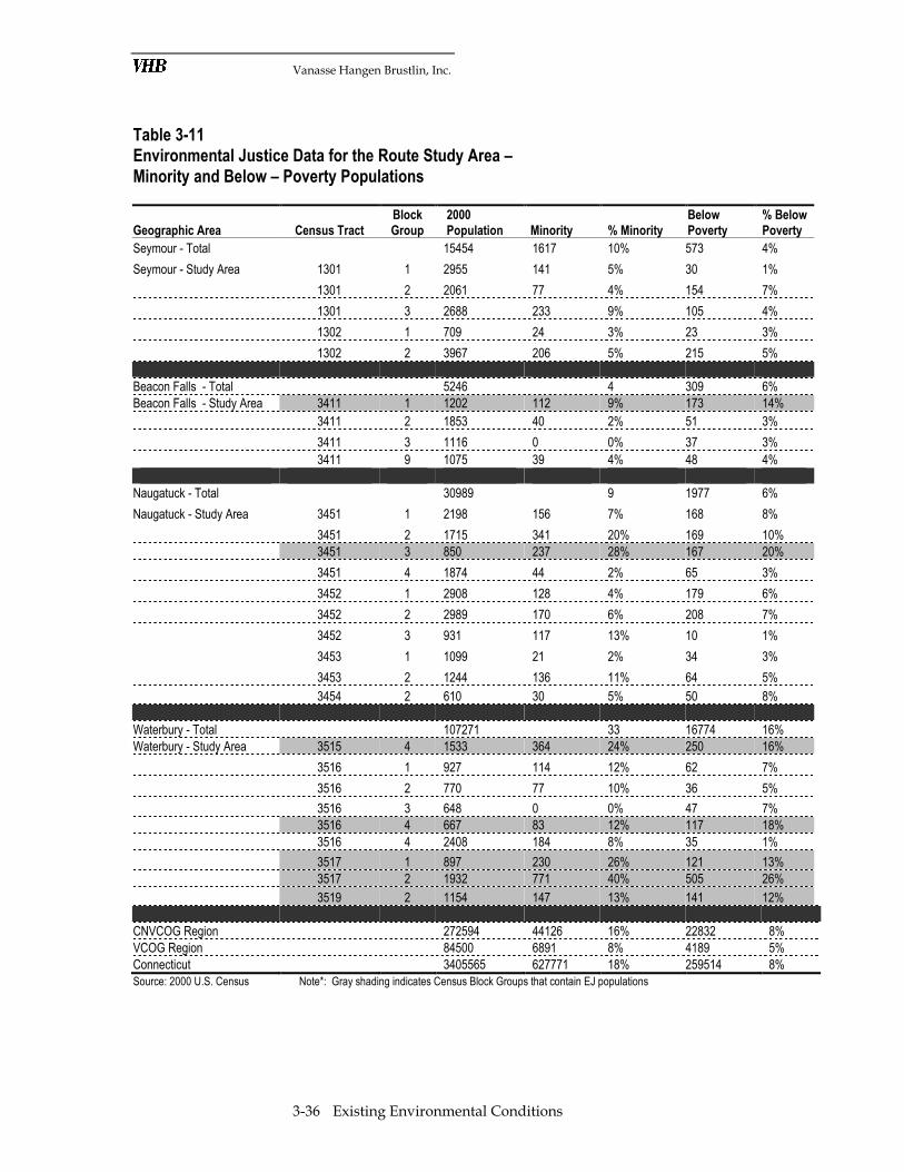
Vanasse Hangen Brustlin, Inc.
3-36 Existing Environmental Conditions
Table 3-11 Environmental Justice Data for the Route Study Area – Minority and Below – Poverty Populations
Geographic Area Census Tract
Block
Group
2000
Population Minority % Minority
Below
Poverty
% Below
Poverty
Seymour - Total 15454 1617 10% 573 4%
Seymour - Study Area 1301 1 2955 141 5% 30 1%
1301 2 2061 77 4% 154 7%
1301 3 2688 233 9% 105 4%
1302 1 709 24 3% 23 3%
1302 2 3967 206 5% 215 5%
Beacon Falls - Total 5246 4 309 6%
Beacon Falls - Study Area 3411 1 1202 112 9% 173 14%
3411 2 1853 40 2% 51 3%
3411 3 1116 0 0% 37 3%
3411 9 1075 39 4% 48 4%
Naugatuck - Total 30989 9 1977 6%
Naugatuck - Study Area 3451 1 2198 156 7% 168 8%
3451 2 1715 341 20% 169 10%
3451 3 850 237 28% 167 20%
3451 4 1874 44 2% 65 3%
3452 1 2908 128 4% 179 6%
3452 2 2989 170 6% 208 7%
3452 3 931 117 13% 10 1%
3453 1 1099 21 2% 34 3%
3453 2 1244 136 11% 64 5%
3454 2 610 30 5% 50 8%
Waterbury - Total 107271 33 16774 16%
Waterbury - Study Area 3515 4 1533 364 24% 250 16%
3516 1 927 114 12% 62 7%
3516 2 770 77 10% 36 5%
3516 3 648 0 0% 47 7%
3516 4 667 83 12% 117 18%
3516 4 2408 184 8% 35 1%
3517 1 897 230 26% 121 13%
3517 2 1932 771 40% 505 26%
3519 2 1154 147 13% 141 12%
CNVCOG Region 272594 44126 16% 22832 8%
VCOG Region 84500 6891 8% 4189 5%
Connecticut 3405565 627771 18% 259514 8% Source: 2000 U.S. Census Note*: Gray shading indicates Census Block Groups that contain EJ populations


