
A Decision Support System for Ecosystem-Based Management ofTropical Coral Reef Environments
F. Muller-Karger, M. Eakin, L. Guild,M. Vega, R. Nemani, T. Christensen, L. Wood, C. Ravillious,C. Hu, C. Nim, J. Li, C. Fitzgerald, J. Hendee, L. Gramer, S.
Lynds
NASA and Earth ScienceEarth Science Division
Applied Sciences Program

Partnerships
NOAA NESDIS/CRW-CRCP (M. Eakin, T. Christensen, J. Li, G. Liu)
NOAA AOML / ICON/CREWS-CRCP (J. Hendee, L. Gramer)
NASA Ames (L. Guild, R. Nemani)UNEP-WCMC (L. Wood, C. Ravilious, C. Fitzgerald)U. South Florida (F. Muller-Karger, C. Hu, M. Vega, B.
Barnes)U. Colorado-CIRES (S. Lynds)Australia (W. Skirving, S. Heron / NOAA)

AcknowledgementsFunding provided by:
NASA Applied Sciences ProgramWoody Turner2008 Ecological Forecasting
application area4-year program (2009-2013)
NOAANESDIS Coral reef Watch
UNEP WCMC (World Conservation Monitoring Centre)

Objectives of the ProgramAssess and meet needs in coral reef
research, management, education
Assess value of high-resolution (1 km ) data(MODIS, AVHRR, other)
Link to higher-resolution mapsGlobal Coral Reef Millennium MapLandsat, other present and future sensors

Accomplishments: 2010-2011Completed user survey for NOAA Coral Reef Watch
products.Developed global high-resolution 4km SST
climatologyDeployed a website with 1 km Coral Reef Watch
(CRW) products for the Florida Keys.Developed prototype cold water event index (cold
snap index) for the Florida Keys.UNEP WCMC integrated the NASA Coral Reef
Millennium Map into their online databases with a Mapserver interface (http://data.unep-wcmc.org/datasets/13).

MARK – add your slides hereI have some slides here you can use (or
delete…)
Add:CRW backgroundApproach to the NASA-NOAA DSS programNew work on climatologiesNew medium and high res high temperature
stress products (AVHRR, MODIS)

High Resolution Prototype CRW Products based on:4 km AVHRR Global PathfinderClimatology
1 km MODIS and AVHRR(Test area: Florida Keys National Marine Sanctuary)

High resolution preserves spatial patterns of importance to reefs
High-resolution (1-km) AVHRR SST imagery (NOAA-16 satellite) showing small-scale (∼1020 km, ∼< 1 ◦C) frontal eddies (annotated with black arrows) along the shallow isobaths in the Florida Straits
January 22, 2002 at 7:36 GMT and January 23, 2002 at 18:45 GMT. Eddies are due to shelf wave dynamics, and they cannot be detected by coarser
resolution data (4 km or lower).
9
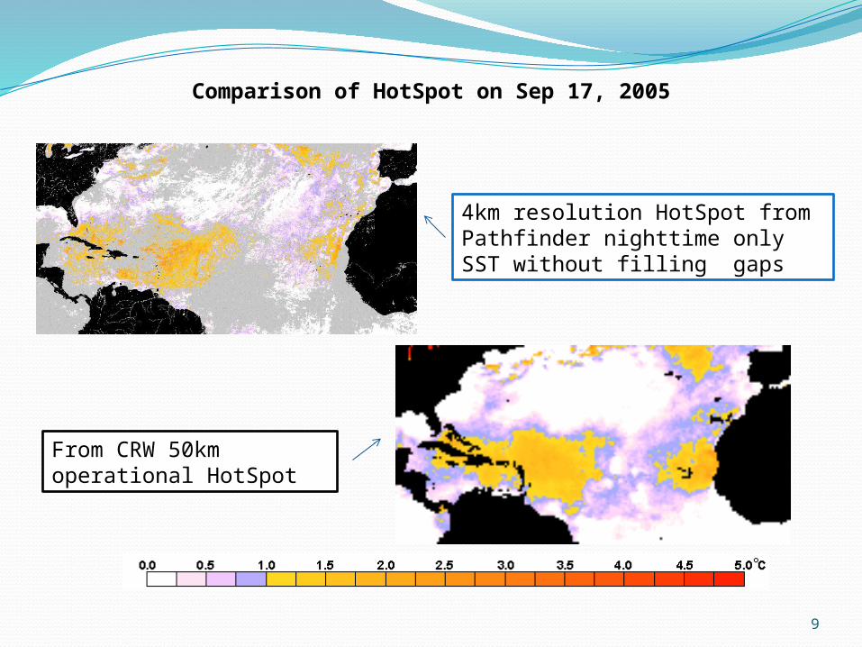
Comparison of HotSpot on Sep 17, 2005
4km resolution HotSpot from Pathfinder nighttime only SST without filling gaps
From CRW 50km operational HotSpot

Issue One: Climatology
Objective:• Build new climatology
at higher resolution
Approach:– Use Pathfinder SST
• 20 y, cross-referenced
– 4 km, nightime, best data– Period:
• Original 50-km NOAA Operational:– Jan 1985 to Dec 1993
excluding 1991 and 1992• New approach:
– Jan 1985 to Dec 2006
• Issues:– Gaps in space and time
– Approach:• Filled gaps in time, then in space
Pathfinder SST v5Percent ‘low quality’ data 1985-2006

Maximum Monthly Mean (MMM) SSTDerived from Pathfinder 4 km Monthly Climatology
Gulf of Mexico /Florida Keys area

High Resolution Stress IndicesCRW ‘HotSpot’
Used USF real-time LAC 1-km AVHRR SST imagesDerived twice-weekly averagesInterploated Pathfinder 4km MMM climatology to
1km|Index:
HotSpot = SST - MMM_SST_climatologyThe ‘HotSpot’ highlights anomalies 1.0 °C ≥ MMM SST
climatology(yellow to red color)
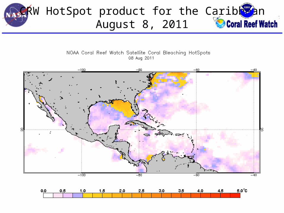
CRW HotSpot product for the CaribbeanAugust 8, 2011

USF HotSpot productsAugust 8, 2011
E50_hotspot.20110808.florida.png
E4km_hotspot.20110808.florida.png
15
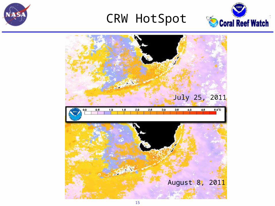
July 25, 2011
August 8, 2011
CRW HotSpot

HotSpot products for the West Florida ShelfAugust 29, 2011
NASA MODIS SSTBased on Pathfinder 4km MMM
USF AVHRR SSTBased on Pathfinder 4km MMM

High Resolution Stress IndicesCRW ‘Degree-Heating Weeks’
• Degree Heating Weeks (DHW) calculated using HotSpots:
• DHWs = 0.5 * Summation of previous 24 twice-weekly HotSpots, where HotSpots have to be at least 1.0 °C to be accumulated.
Methods
• Degree Heating Weeks (DHW) was calculated using the HotSpots that we produced previously.– Calculations were done as implemented by NOAA.
• DHWs = 0.5 * Summation of previous 24 twice-weekly HotSpots, where HotSpots have to be at least 1.0 °C to be accumulated.

CRW DHW product for the CaribbeanSeptember 15, 2011

USF DHW products for the West Florida ShelfSeptember 15, 2011
E50_DHW.20110915.florida.png
E4km_DHW.20110915.florida.png

Cold Stress Index
• Corals have a lower temperature limit under which they are susceptible to stress and death
• Objective:–develop high spatial resolution cold-stress
index to help monitor and forecast coral bleaching or mortality due to cold stress.
Acknowledgement: Collaboration between M. Vega - Rodriguez, F. Muller - Karger, J. Li, C. M. Eakin, L. Guild, C. Hu, G. Liu, S. Lynds, R. Nemani, S. Heron, G. Quiles - Pérez, D. Lirman, R. Ruzicka
21

2010 Florida Keys Case Study
• JAN 2010: Anomalously cold temperatures• Widespread mortality in coral reefs• SST observations helped guide a field survey
22
In situ temperatures

Developing a ‘Cold Snap’ Index
Approach:Nighttime - only AVHRR Pathfinder (v5.0) SST
data at a 4 km spatial resolution (no gap filling) used to create higher resolution climatologies from 1985 – 2006
23
Daily AVHRR Pathfinder SST(4 km – remapped to 1km)
vs. daily USF daily SST(AVHRR 1 km LAC)

‘So what?’Linking science and managementUltimately, the goal is to improve our ability
to alert reef managers around the world of bleaching-level stress, so they can take appropriate actions.
In the Florida Keys, the CRW products have already helped:Guide Rapid Response efforts to assess
reef conditionsInform the public about what may be
happening on the reef when corals are visibly stressed

Visit our Posters!!!


