
10th GEOSS Asia Pacific Symposium (Sep 2017, Hanoi) GEO Carbon and GHG Initiative WG
Background Information on GEO 2017-2019 Work Programme, and
basic plan of GEO-C Task 3
Hiroyuki Muraoka (Contributor to GEO-C Task 3)
Gifu University, Japan Japan Long-Term Ecological Research
network (JaLTER) International LTER East Asia-Pacific
regional network (ILTER-EAP)
GEO Programme Board (Japan member) Contributor to: AOGEOSS TG 2 (APBON), TG 3 (GEO-C) In-situ obs. resources Foundational Task

GEO Strategic Plan 2016-2025: Implementing GEOSS GEO’s Vision Strategic Objectives [Advocate, Deliver, Engage] Societal Benefit Areas (SBAs)… Application oriented Implementation Mechanisms Core functions
GEO 2017-2019 Work Programme Implementation mechanisms
Flagships Initiatives Community Activities Foundational Tasks
GEO Engagement Strategy ❖ 2030 Agenda for Sustainable Development (SDGs) ❖ Climate Change – Greenhouse Gas Monitoring (Paris Agreement) ❖ Disaster Risk Reduction (Sendai Framework)
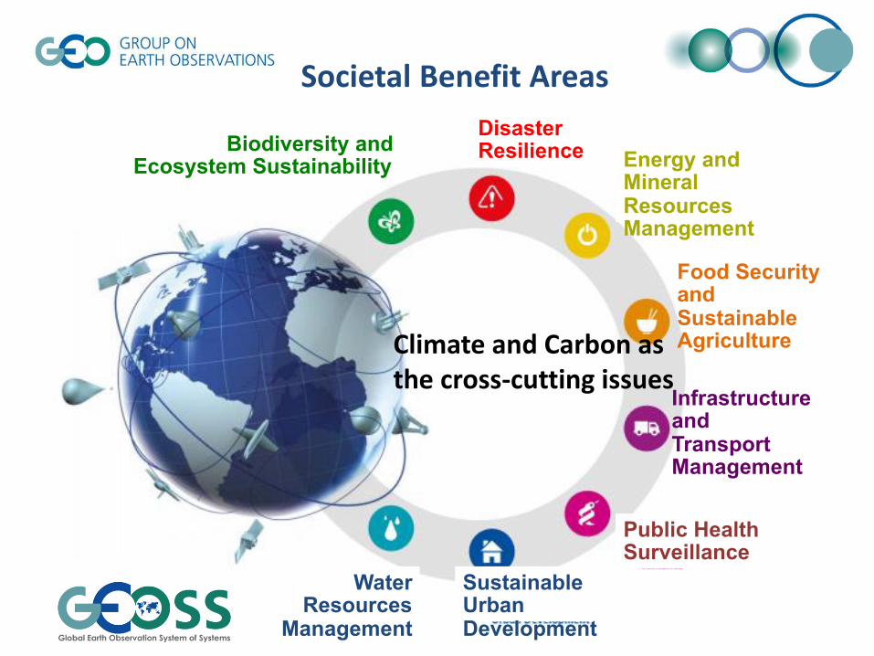
Biodiversity and Ecosystem Sustainability
Disaster Resilience Energy and
Mineral Resources Management
Food Security and Sustainable Agriculture
Infrastructure and Transport Management
Public Health Surveillance
Sustainable Urban Development
Water Resources
Management
Climate and Carbon as the cross-cutting issues
Societal Benefit Areas

GEO 2017 – 2019 Work Programme Cross Cutting Activities
GEO Initiatives AfriGEOSS: Reinforcing Regional African Engagement AmeriGEOSS Asia-Oceania GEOSS (AOGEOSS) Earth Observations in Service of the 2030 Agenda for Sustainable Development (EO4SDG) EuroGEOSS GEO Carbon and GHG Initiative (GEO-C) GEOSS-EVOLVE Oceans and Society: Blue Planet
http://www.earthobservations.org/geoss_wp.php
Community Activities Access to climate data in GEOSS Advancing Communication Networks Citizen Observatories and Crowdsourcing Copernicus Atmospheric Monitoring Services (CAMS) Copernicus Climate Change Service (C3S) Data Analysis and Integration System (DIAS) Digital GEOMUSEUM GFCS – GEO Collaboration Himalayan GEOSS Research Data Science Summer Schools Socio-Economic Benefits of Earth Observations Space and Security Synergized Multi-Source Remote Sensing Products and Services

GEO-Carbon Task 3 Implementation plan outline
Task Objective
To develop and implement on an ongoing basis, a procedure for designing and refining the observation system for identified essential carbon cycle variables that meets user-defined specifications at minimum total cost. Participating institutions (as on the proposal document: this is not a closed list) • University of the Witwatersrand, South Africa [[email protected]] • Gifu University, Japan [Hiroyuki Muraoka, [email protected]] • IG3IS • Lund University, Sweden • Hawassa University, Ethiopia [Dong-Gill Kim, [email protected]] • CAS, China • Princeton University, USA • University of KwaZulu-Natal (UKZN) • National Ecological Observatory Network (NEON) [David Durden, [email protected]]

Task 3 items
Activity 3.1: Specifications of an observing system for essential carbon cycle variables
Task 3.1-1 Create an initial list of Essential Carbon Cycle Variables. Task 3.1-2 Review of carbon observation technologies. Task 3.1-3 A system design specification.
Activity 3.2: Generating and testing optimized design options Task 3.2-1 Determining the observation technology mix. Task 3.2-2 Designing a sampling frame.
Activity 3.3: Periodic adequacy reports Task 3.3 Mapping the ECVs performance, and analyzing gaps and
opportunities.

Task 3 … to start
Inputs and discussions on Day 1&2 … [ to be mapped into above tasks, with names of contributors]
1. Listing essential variables (ECV, EOV, EBV), and analyzing their operability as carbon cycle variables
a. Based on paper/report review (Antonio will join to list EVs) b. Sensitivity analysis (needs modeling work member)… essential for which scale?
2. Reviewing existing (in-situ) observations and white papers, etc. a. Need information from data availability (co-work with Task 2), for each domain (terrestrial, ocean, atmosphere) b. Matrix and maps of thematic and geographical distributions, for networks/programs
3. Equating different measurement techniques and measurements across platforms/networks
a. Community best practices b. Defining essential variables, with a few priorities (depending on targeted products)
4. Gap analysis (geographical, thematic) a. Based on findings from budget calculations / synthesis works (Task 4) b. Overlaying maps of budget calculation, uncertainty (Task 4), and spatial distribution of plots/data c. Need implication from synthesis perspective, IPCC inputs, etc. d. Start from terrestrial in-situ observations/data (because of the large gap and non-coordinated condition) Observation
by satellite is documented by CEOS (2014). • Intensive sites (‘super-sites’) may help us to review the design and consider coordinated obs in link with satellite
RS (try to ecophysiological use of satellite RS: photosynthetic capacity, etc.)
5. Collaboration / consulting with networks and initiatives a. Learning constraining factors of observations by interviewing to other existing initiatives/networks. b. Need support of ‘GEO In-situ obs resource foundational task’ c. “Optimized design” should be discussed with the communities, as there may be on-going activities/efforts, and also
because ‘one-way’ recommendation may not make sense… co-design is needed.
(draft ver. 0) H. Muraoka and D. Durden, July 7, 2017

Essential
Climate
Variables

Column CO2 & CH4
Biophysical information
Phenology
CO2 flux (NEE, GPP, Reco)
Photosynthesis LAI
Chlorophyll fluorescence
SIF
Inversion
Ecosystem C cycle
Water/energy budget Soil respiration
Biomass NPP
Mechanistic interpretation of atmospheric CO2 change
Climate change impacts on terrestrial ecosystem and carbon cycle, and its feedback (local – regional – global) Needs of cross-disciplinary
observations
Validation of column CO2
Model input parameters
Land-use change
Seasonal change of vegetation surface
In-situ observations
Satellite remote sensing
Modeling
Land-use change

In-situ observation needs Rogers et al. (2017) New Phytologist
Many needs are related to
in-situ biodiversity and
ecosystem observations

Cross-cutting network is needed for Earth
observations of biodiversity, ecosystems and C cycle
consequences
from Chapin et al. (2002)
ILTER-EAP
Carbon cycle and its ecological processes (elements) are the cross-cutting them of this network

Ecosystem and land-use types Vegetation structure Temporal change in ecosystems
Primary production (carbon cycle) Eco-hydrology Nutrient cycling
Plant species distribution Wildlife habitat assessment Biological interactions
Satellite remote sensing
Ecological process research, tower flux obs. and modeling
Species and genetic level research
Eart
h s
yste
m a
nd
eco
syst
ems
Bio
logi
cal a
nd
eco
logi
cal p
roce
sses
Satellite obs.
Ecosystem obs.
Biodiversity obs.
ALOS (JAXA)
To fill the observational gaps of essential carbon cycle variables … link in-situ biodiversity & ecosystem obs. with satellite obs.
(collaborate with AsiaFlux, ILTER, APBON, etc.)
(Muraoka, Ishii et al. 2013)

FLUXNET
AsiaFlux
GEO BON
JapanFlux
AP BON
Monitoring sites 1000
(MOE)
ILTER
J-BON
Networking networks
JaLTER
(by N. Saigusa and H. Muraoka)
WG2 of GEOSS-AP
ILTER-EAP


