
MINERAL SURVEY REPORT
FOR DISTRICT
BHARATPUR

1.0 Introduction The district of Bharatpur , takes its name from the town of Bharatpur, which is also the district headquater prior to the formation of Dolphur.
District, Bharatpur was the eastern most districts in Rajasthan. The district lies between 26°44 to 27°50. North latitude and 76° 53' to 77° 40 east longitude. The district covers an area of about 5066 sq. kms. The district is irregularly rectangular in shape. The district has an area of 5,066 km2. It is bounded by Nuh-Mewat district of Haryana on the north, Mathura and Agra districts of Uttar Pradesh on the east, and the district of Dholpur on the south, Karauli on the southwest, Dausa on the west and Alwar district in the north-west.
Bharatpur is well connected by road and rail to other cities in India. The National Highway No. 11 passes through Bharatpur connecting it with Jaipur (181 Kms.) and Agra. Bharatpur is an important junction on Delhi-Bombay main broad gauge line of western railway with branch lines to Agra & Jaipur. The nearest airport is Agra in U.P.
1.1 Bharatpur is a city and newly created municipal corporation in the Indian state
of Rajasthan. Located in the Brij region, Bharatpur was once considered to be
impregnable and unbeatable. The city is situated 180 km south of India's capital, New
Delhi, 178 km from Rajasthan's capital Pink City Jaipur, 55 km west of Agra and 34 km
from Lord Krishna's birthplace Mathura. It is also the administrative headquarters of
Bharatpur District and the headquarters of Bharatpur Division of Rajasthan. The Royal
House of Bharatpur traces its history to the 11th century. Bharatpur is part of National
Capital Region (NCR).[1]
The city has an average elevation of 183 metres (600 ft) and is also known as "Lohagarh"
and the "Eastern Gateway to Rajasthan". It is famous for Keoladeo National Park ( A
UNESCO's World Heritage Site).
Bharatpur lies on the Golden Tourism Triangle of Delhi–Jaipur–Agra and hence a large
number of national and international tourists visit Bharatpur every year.

2 Overview of Mining activity in the District
District Bharatpur is endowed with variety of minerals and are being produce since 1975 onward.
Now a days, closure of mining activity due to banning of mining activity in Aravali hill in Haryana and adjoining Alwar distt. of Rajasthan, a boom has been observed for mining of masonary stone and value addition in form of establishing crusher at pit head.
Masonary stone mining cluster in northern part of distt i.e. near village Nangal, Dholet, Chhapra, Chinawara, Bijasana, Gangora, Papra etc are main feeder to Gurugram of Haryana and Delhi region.
Whereas, masonary stone mining cluster in southeastern part of distt i.e. near village Ghatri, Jaswar, Ghata, Ghatoli, Lakhanpur, Gujarbalai etc are main feeder to Agra and adjoining areas of Uttarpradesh.
Sandstone are quarried at Bansi Pharpur (26°56' : 77°03'). White-spotted reddish
Sandstone of the Bhander Group is in great demand as Building stone.
2.1 Mineral Administration
Mineral administration work in the district is being looked after by Mining Engineer Bharatpur, which is
supervised by Superintending Mining Engineer Bharatpur. To check & curb the unauthorised mining
activities, one Mining Engineer vigilance is also posted at Bharatpur. The geological work is carried out
by office of Senior Geologist, Bharatpur which is supervised by Superintending Geologist Bharatpur .
This office looks after geological work in Bharatpur, Dholpur and Dausa districts. The telephone
numbers of these offices are given below: 1. Suptdg. Mining Engineer, Bharatpur (05644)-22421
2. Mining Engineer, Bharatpur (05644) 22128
3. Superintending Geologist Bharatpur
4. Senior Geologist, Bharatpur (09509815666

2.2Mineral occurances:-
Bharatpur district in an excellent building stone as it is amenable to recieve good
polish and intricate carving meant for lattices and arches. The sandstone occur in
the form of the hill range crossing across district from Roopwas to Bayana. The
impratant silica sand deposit are locate mainly in Bayana tehsil and Weir tehsils .
Mainly revenue collection minearls massonary stone area are Nangal, Chhapra ,
Bijaasana , Chinawra in Pahari Tehsil, Ghatoli,Mertha in Roopwas tehsil and Weir
and Bhusawar tehsil are also produced a mineral massonary stone. Mill stone
mineral is available in Roopwas tehsil,
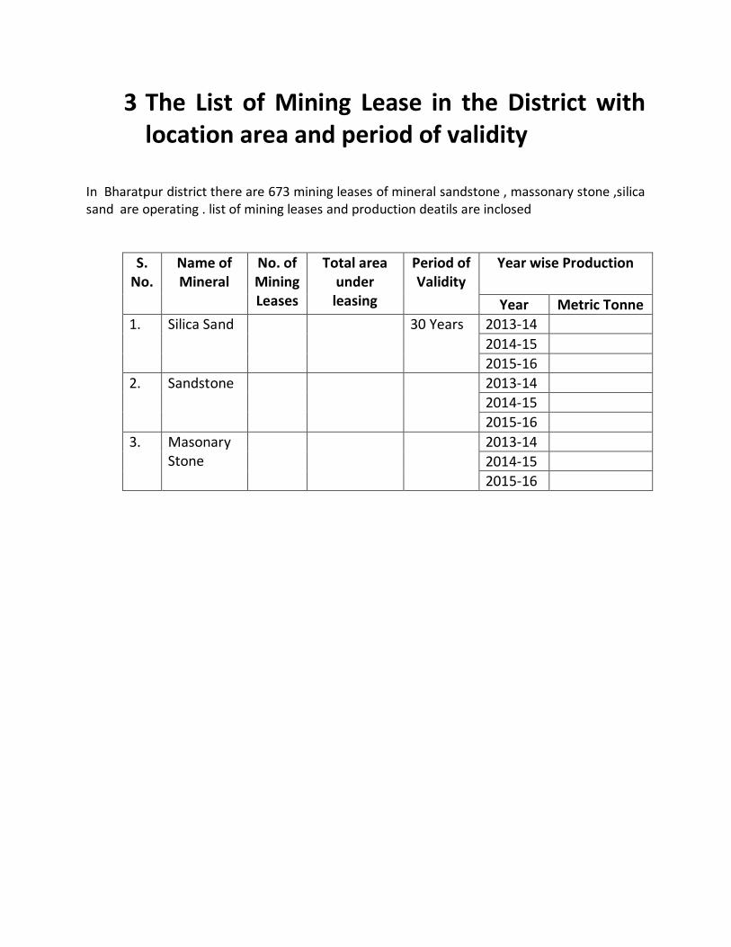
3 The List of Mining Lease in the District with location area and period of validity
In Bharatpur district there are 673 mining leases of mineral sandstone , massonary stone ,silica sand are operating . list of mining leases and production deatils are inclosed
S. No.
Name of Mineral
No. of Mining Leases
Total area under leasing
Period of Validity
Year wise Production
Year Metric Tonne
1. Silica Sand 30 Years 2013-14
2014-15
2015-16
2. Sandstone 2013-14
2014-15
2015-16
3. Masonary Stone
2013-14
2014-15
2015-16
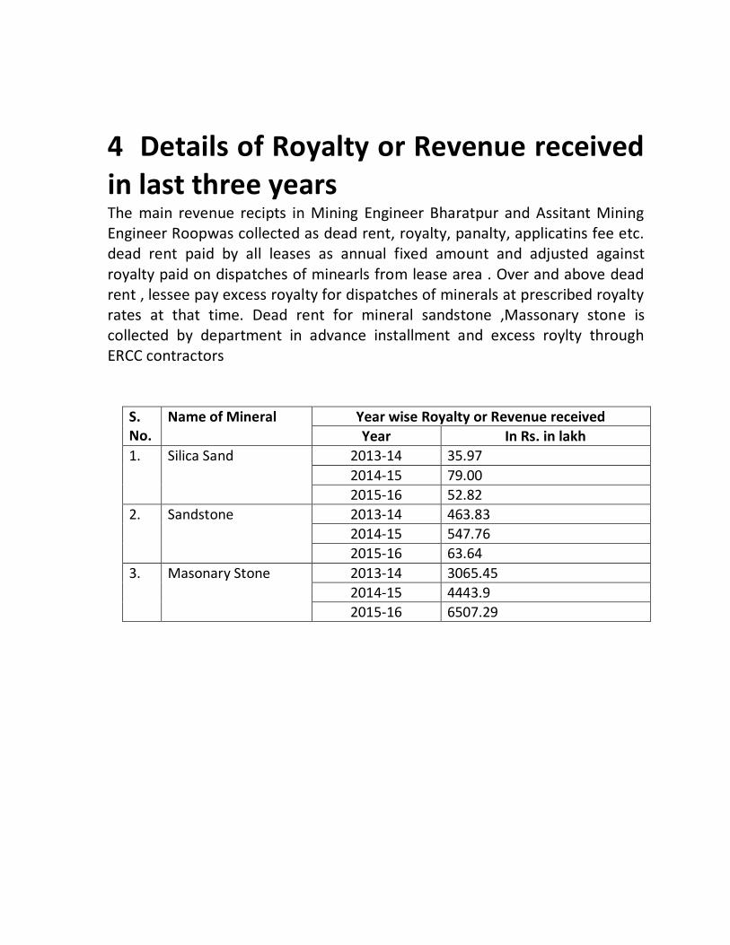
4 Details of Royalty or Revenue received in last three years The main revenue recipts in Mining Engineer Bharatpur and Assitant Mining Engineer Roopwas collected as dead rent, royalty, panalty, applicatins fee etc. dead rent paid by all leases as annual fixed amount and adjusted against royalty paid on dispatches of minearls from lease area . Over and above dead rent , lessee pay excess royalty for dispatches of minerals at prescribed royalty rates at that time. Dead rent for mineral sandstone ,Massonary stone is collected by department in advance installment and excess roylty through ERCC contractors
S. No.
Name of Mineral Year wise Royalty or Revenue received
Year In Rs. in lakh
1. Silica Sand 2013-14 35.97
2014-15 79.00
2015-16 52.82
2. Sandstone 2013-14 463.83
2014-15 547.76
2015-16 63.64
3. Masonary Stone 2013-14 3065.45
2014-15 4443.9
2015-16 6507.29

5 Details of production of Sand or Bajri or minor minerals in last three years Production of Sand or Bajri is very difficult due to lack of deposit in rivers flowing through the Distt.
Production of minor minerals Masonaroy stone , Sand stone and Silica sand are enclosed to the report in Annuxre
6 Process of Deposition of Sediments in the rivers of the District
Rivers flowing through the district are of non-perennial nature.
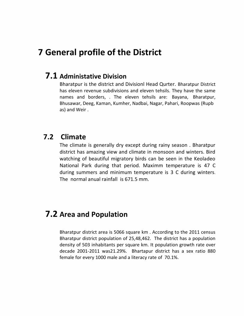
7 General profile of the District 7.1 Administative Division
Bharatpur is the district and Divisionl Head Qurter. Bharatpur District has eleven revenue subdivisions and eleven tehsils. They have the same names and borders, . The eleven tehsils are: Bayana, Bharatpur, Bhusawar, Deeg, Kaman, Kumher, Nadbai, Nagar, Pahari, Roopwas (Rupbas) and Weir .
7.2 Climate The climate is generally dry except during rainy season . Bharatpur district has amazing view and climate in monsoon and winters. Bird watching of beautiful migratory birds can be seen in the Keoladeo National Park during that period. Maximm temperature is 47 C during summers and minimum temperature is 3 C during winters.
The normal anual rainfall is 671.5 mm.
7.2 Area and Population Bharatpur district area is 5066 square km . According to the 2011 census Bharatpur district population of 25,48,462. The district has a population density of 503 inhabitants per square km. It population growth rate over decade 2001-2011 was21.29%. Bhartapur district has a sex ratio 880 female for every 1000 male and a literacy rate of 70.1%.
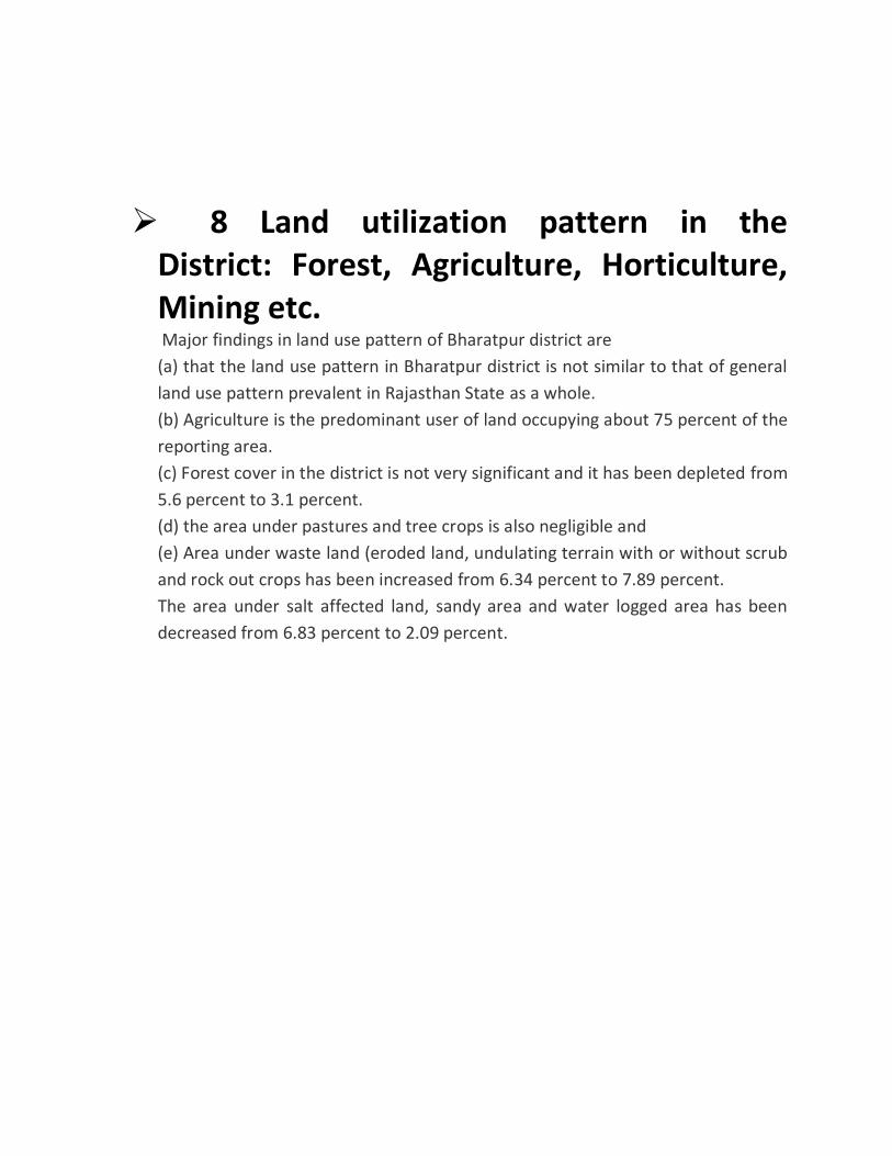
8 Land utilization pattern in the District: Forest, Agriculture, Horticulture, Mining etc. Major findings in land use pattern of Bharatpur district are
(a) that the land use pattern in Bharatpur district is not similar to that of general
land use pattern prevalent in Rajasthan State as a whole.
(b) Agriculture is the predominant user of land occupying about 75 percent of the
reporting area.
(c) Forest cover in the district is not very significant and it has been depleted from
5.6 percent to 3.1 percent.
(d) the area under pastures and tree crops is also negligible and
(e) Area under waste land (eroded land, undulating terrain with or without scrub
and rock out crops has been increased from 6.34 percent to 7.89 percent.
The area under salt affected land, sandy area and water logged area has been
decreased from 6.83 percent to 2.09 percent.
9 Physiography of the District
Physiographically, the district comprises alluvial plains, with detached hills in north and low narrow ranges in western & northwestern parts.
The terrain in Bharatpur & Nadbai is plain while that of Bayana & Rupbas tehsils is diversified by hills.
There are only three main seasonal rivers in this District, namely Ban Ganga,
Rooparel and Gambhir. Ban Ganga starts from Ramgarh Dam of Jaipur district ,
passes from Bharatpur and meets in river Gambhir near tehsil Bayana of District
Bharatpur. Gambhir river starts from Panchna Dam of district Karauli and after
passing from Bharatpur meets River Yamuna in Uttar Pradesh. Rooparel River
starts from hills of district Alwar and enters into Bharatpur from tehsil Kaman.
Instead of this, a Dam, namely, Bandh Baretha is situated near the village Baretha
on river Kakund which starts from the hills of district Karauli. The water of this
dam is used for drinking and irrigation purpose for this district. The capacity of
this dam is 684.00 million cusik feet (29 Gaze feet).
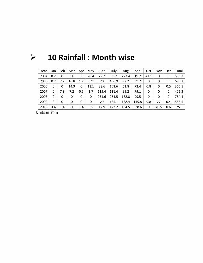
10 Rainfall : Month wise
Year Jan Feb Mar Apr May June July Aug Sep Oct Nov Dec Total
2004 8.2 0 0 3 28.4 72.2 59.7 273.4 19.7 41.1 0 0 505.7
2005 0.2 7.2 16.8 1.2 3.9 20 486.9 92.2 69.7 0 0 0 698.1
2006 0 0 14.3 0 13.1 38.6 163.6 61.8 72.4 0.8 0 0.5 365.1
2007 0 7.8 7.2 0.5 1.7 115.4 111.4 99.2 79.1 0 0 0 422.3
2008 0 0 0 0 0 231.6 264.5 188.8 99.5 0 0 0 784.4
2009 0 0 0 0 0 29 185.1 188.4 115.8 9.8 27 0.4 555.5
2010 3.4 1.4 0 1.4 0.5 17.9 172.2 184.5 328.6 0 40.5 0.6 751
Units in mm
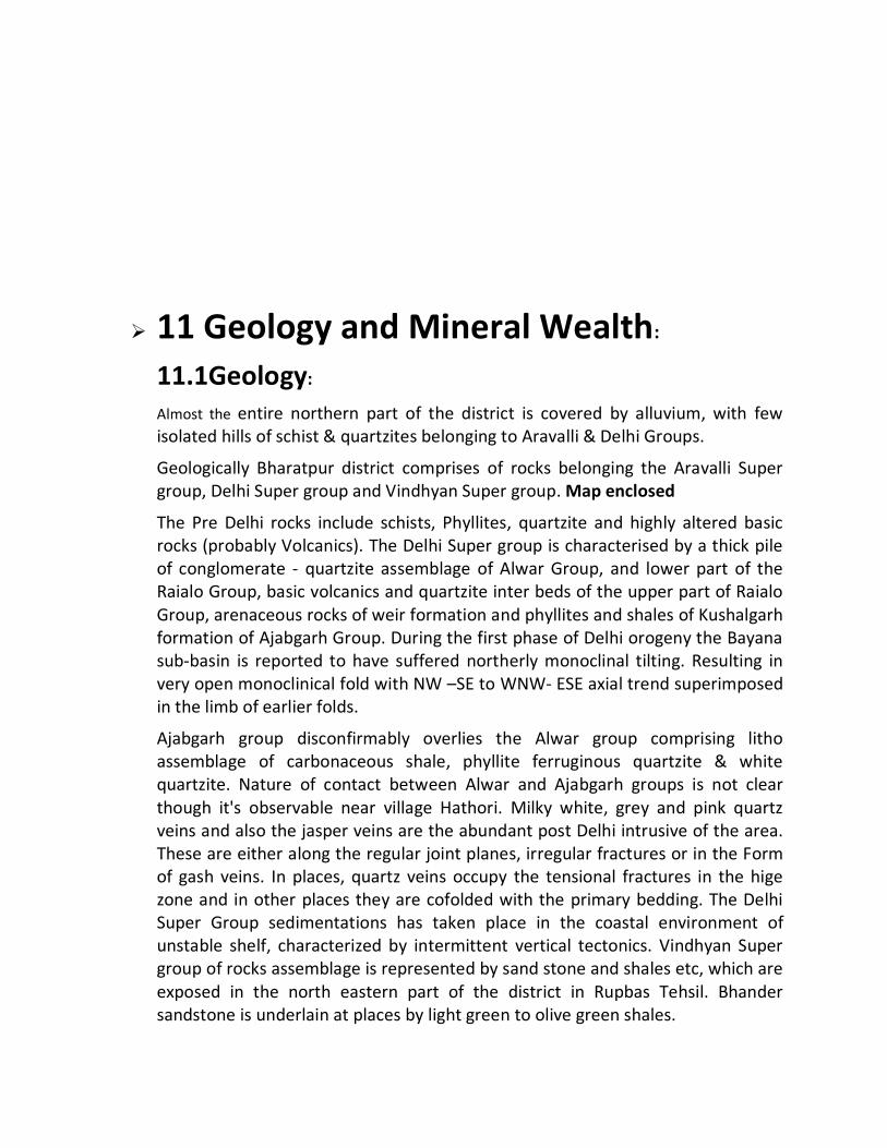
11 Geology and Mineral Wealth:
11.1Geology:
Almost the entire northern part of the district is covered by alluvium, with few isolated hills of schist & quartzites belonging to Aravalli & Delhi Groups.
Geologically Bharatpur district comprises of rocks belonging the Aravalli Super group, Delhi Super group and Vindhyan Super group. Map enclosed
The Pre Delhi rocks include schists, Phyllites, quartzite and highly altered basic rocks (probably Volcanics). The Delhi Super group is characterised by a thick pile of conglomerate - quartzite assemblage of Alwar Group, and lower part of the Raialo Group, basic volcanics and quartzite inter beds of the upper part of Raialo Group, arenaceous rocks of weir formation and phyllites and shales of Kushalgarh formation of Ajabgarh Group. During the first phase of Delhi orogeny the Bayana sub-basin is reported to have suffered northerly monoclinal tilting. Resulting in very open monoclinical fold with NW –SE to WNW- ESE axial trend superimposed in the limb of earlier folds.
Ajabgarh group disconfirmably overlies the Alwar group comprising litho assemblage of carbonaceous shale, phyllite ferruginous quartzite & white quartzite. Nature of contact between Alwar and Ajabgarh groups is not clear though it's observable near village Hathori. Milky white, grey and pink quartz veins and also the jasper veins are the abundant post Delhi intrusive of the area. These are either along the regular joint planes, irregular fractures or in the Form of gash veins. In places, quartz veins occupy the tensional fractures in the hige zone and in other places they are cofolded with the primary bedding. The Delhi Super Group sedimentations has taken place in the coastal environment of unstable shelf, characterized by intermittent vertical tectonics. Vindhyan Super group of rocks assemblage is represented by sand stone and shales etc, which are exposed in the north eastern part of the district in Rupbas Tehsil. Bhander sandstone is underlain at places by light green to olive green shales.
.
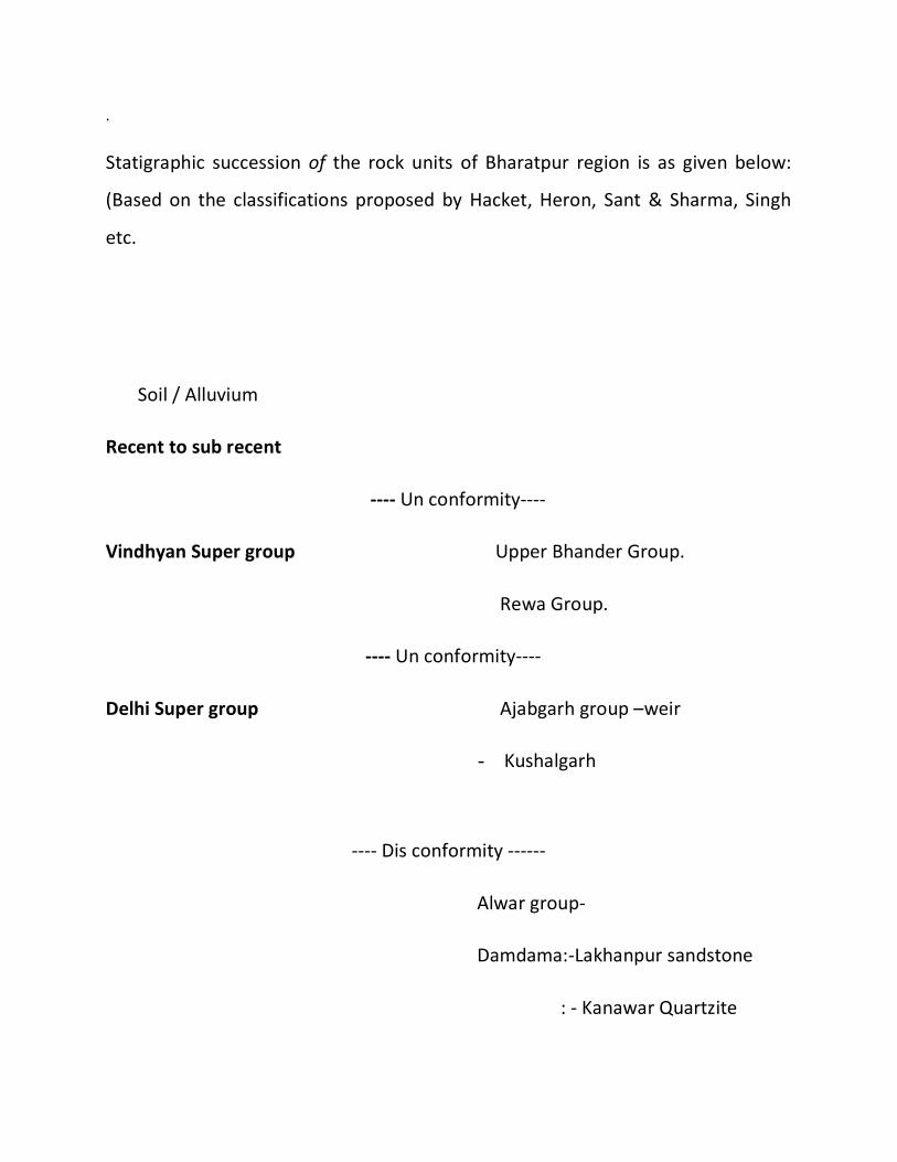
Statigraphic succession of the rock units of Bharatpur region is as given below:
(Based on the classifications proposed by Hacket, Heron, Sant & Sharma, Singh
etc.
Soil / Alluvium
Recent to sub recent
---- Un conformity----
Vindhyan Super group Upper Bhander Group.
Rewa Group.
---- Un conformity----
Delhi Super group Ajabgarh group –weir
- Kushalgarh
---- Dis conformity ------
Alwar group-
Damdama:-Lakhanpur sandstone
: - Kanawar Quartzite
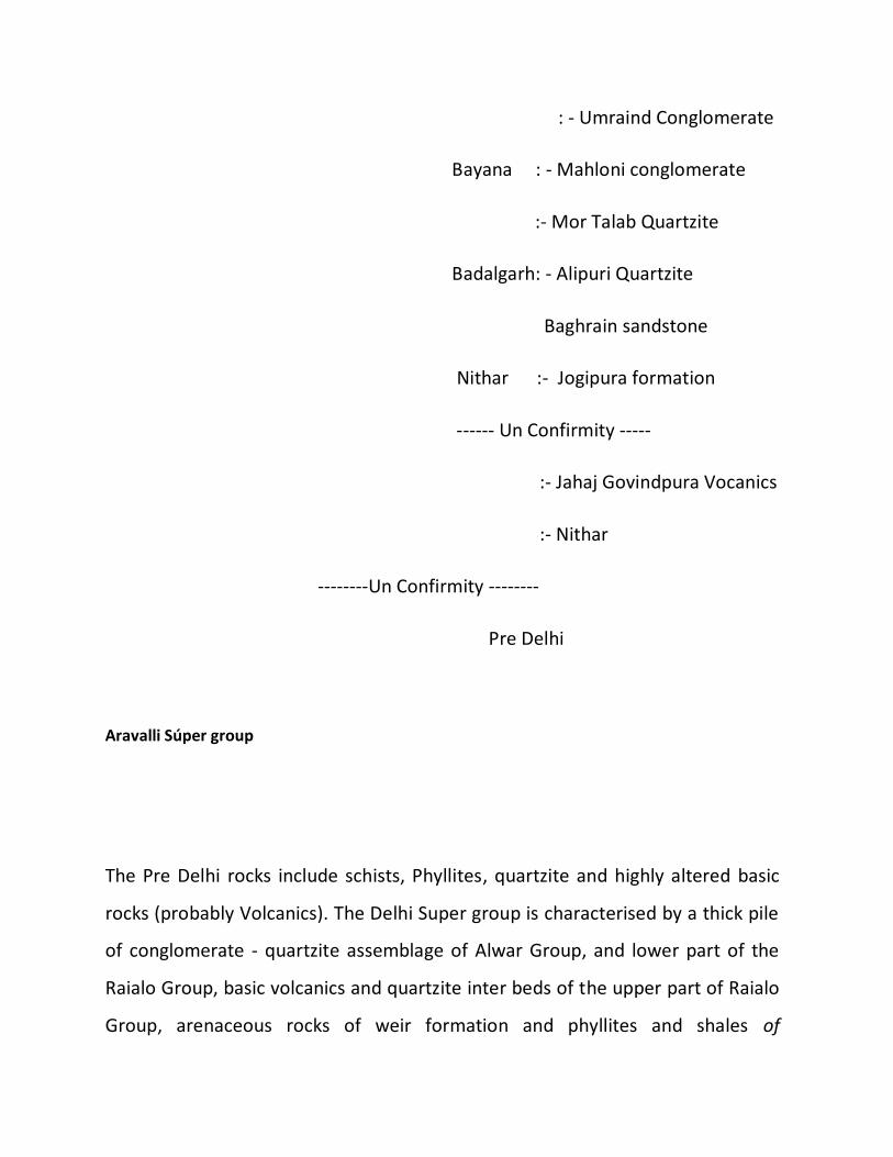
: - Umraind Conglomerate
Bayana : - Mahloni conglomerate
:- Mor Talab Quartzite
Badalgarh: - Alipuri Quartzite
Baghrain sandstone
Nithar :- Jogipura formation
------ Un Confirmity -----
:- Jahaj Govindpura Vocanics
:- Nithar
--------Un Confirmity --------
Pre Delhi
Aravalli Súper group
The Pre Delhi rocks include schists, Phyllites, quartzite and highly altered basic
rocks (probably Volcanics). The Delhi Super group is characterised by a thick pile
of conglomerate - quartzite assemblage of Alwar Group, and lower part of the
Raialo Group, basic volcanics and quartzite inter beds of the upper part of Raialo
Group, arenaceous rocks of weir formation and phyllites and shales of
Kushalgarh formation of Ajabgarh Group. During the first phase of Delhi orogeny
the Bayana sub-basin is reported to have suffered northerly monoclinal tilting.
Resulting in very open monoclinical fold with NW –SE to WNW- ESE axial trend
superimposed in the limb of earlier folds.
Ajabgarh group disconfirmably overlies the Alwar group comprising litho assemblage of carbonaceous shale, phyllite ferruginous quartzite & white quartzite. Nature of contact between Alwar and Ajabgarh groups is not clear though it's observable near village Hathori. Milky white, grey and pink quartz veins and also the jasper veins are the abundant post Delhi intrusive of the area. These are either along the regular joint planes, irregular fractures or in the Form of gash veins. In places, quartz veins occupy the tensional fractures in the hige zone and in other places they are cofolded with the primary bedding. The Delhi Super Group sedimentations has taken place in the coastal environment of unstable shelf, characterized by intermittent vertical tectonics. Vindhyan Super group of rocks assemblage is represented by sand stone and shales etc, which are exposed in the north eastern part of the district in Rupbas Tehsil. Bhander sandstone is underlain at places by light green to olive green shales
11.2 Mineral Wealth:
Barytes, Building Stone and Quartz are the important minerals of the district. Barytes
closely associated with the basic intrusive occurs in the rock of the Delhi Supergroup.
Barytes veins occur as fissure filling in Quartzite. Occurrances are reported from Hatori
(27 °00' : 77°06'), Karwar (27°00' : 77°03') etc. Small deposit of Copper with an
indicated reserve of 1 Million tonne with 1% Cu is located near Khankhera (26°55' :
77°08'). Minor Occurrence of Lead is reported from Jotri (27°35' : 76°58'). Quartz is
available at many places in the district. Quartzite and sandstone are quarried at Bansi
Pharpur (26°56' : 77°03'), Deeg (27°27' : 77°19') etc. White-spotted reddish Sandstone
of the Bhander Group is in great demand as Building stone.
11.2.1 Barytes
Barytes mineralisation occurs over a length of 5.5 km. from west of Hathori to 2
km. WNW of Ghatri. The area has been divided in to three blocks. These are
Hathori, Karwan and Ghatri blocks. The mineralisation is confined to the volcanic
rocks related to Jahaz-Govindpura volcanics of Delhi Super group.
Hathori Block - Five groups of barytes veins have been classified in .this block.
The barytes veins having 1.5 km. length and 5 to 10 cm width are emplaced
along strike joints in the oldest flow of this section. The mineral is transparent,
white to grey in colour in the form of tabular crystals. At places it has iron stains
and shows association of hematite, limonite and vuggy quartz, besides traces of
chalcopyrite, pyrite and malactite. Good quality barytes from 2nd group analyses
Sioz-1.2-2%, Fe2O3 0.4%, Cao &Mgo in traces, Bao-64.4% & SO3-33.54%. A
barytes sample from the third group contains Sio2 2.43%, Fe2O3 0.28%, Al2O3
0.12%, alkalies less than 0.1%BaSO4- 97.02%.
Karwan Block: Barytes veins are emplaced along the cross & strike joints and
irregular fractures in flows, tuffbreccias and overlying quartzites. In general, veins
are thin and show poor quality. Barytes is grey showing iron staining and
association of hematite and biotite.

Ghatri block: Barytes veins are emplaced along bedding and cross joints and
irregular fractures in flows, barytes veins with pinch and swell structures show
maximum length of 4 m and 1 m width. Mineral is translucent to opaque, with
white to grey colour and massive to crystalline in nature.
11.2.2 Sandstone
Sandstone of Vindhyan age is extensively mined in .Bharatpur. Splittable sand
stone is available near village Bansi Paharpur, Bandh Baretha, Turtipura,
Tarsuman, Singhwali etc. Sand stone varies in colour from buff-red to pink and
creamish pink, at places spotted pink .is also seen.
11.2.3 Silica sand
Ferruginous-silica sand is located near Jaggiwanpura village 35 kms.away from
Bayana railway station. The sand occurs as thin bands of friable quartzite within
the massive layers. Occurrences of silica sand are reported near village Doravli
and in the north of Karwan village. The sand is ferruginous. The silica sand is being
mined from the mines located in tehsil Bayana near village Acholi, Gudakhar,
Navali, Agawali, Bajoli, Talimpur & Jaswant nagar. In Kaman tehsil it is being
worked near village Kalawata, Nanerawas, Bol-kheda, Lahsar In Weir tehsil it is
being worked near village Mangren, Gothra and Mansapura. This district is the
second largest producer in the state next to Jaipur. On average sand contains 96
to 97% Sio2 and 0.15% to 0.5% Fe2O3 and sand recovery is about 50%. The silica
sand of Kaman area is ferruginous but on beneficiation in the ceramic ore
dressing laboratory of the state department, it was upgraded to 98.2% Sio2 and
0.05% Fe2O3
11.2.4 Soapstone
Soapstone mineralisation is located near village Nidar (Teh. Bayana) Mangren
(Teh. weir) Bilung (Teh. Kaman). The soap stone is of low grade.
11.2.5 Saltpeter
A belt of nearly 800 sq. kms. Stretching from S.E. of Bharatpur to the N.W. of
Kaman has been located where the KNo3 efflorescence occurs, during the hot
months from April to July.
Saltpetre appears as a very thin, slightly brownish yellow having moisture like
appearance, crisp encrustation on the earth surface. When the encrustation of
the saltpeter is scrapped off from the surface, it again appears within a weak,
which can be again scrapped. If the scrapping is done beyond the crisp layer, and
the settled earth is scrapped the mineral may altogether stop to appear by
efflorescence. It is found that nearly 80 Kgs. of Potassium Nitrate is available from
2400 kgs. of Potassium Nitrate soil i.e. the efflorescent soil contains 3 to 4% of
KN03, though the proportion varies from place to place. The villages producing
good amount of KN03 are AghapurDarapur, Bharatpur, Karot, Jogina, Gunsara,
Sinsini, Deeg, Bhej, Kaman, Sikripatti, Gopalgarh, Pipal Khera, Jorera etc.
]
11.2.6 Copper
Copper mineralisation is located near Khankhera and Ker village, nearly 25 kms.
Due west of Bayana Railway Station by road. The state department has done
detailed prospecting work in the area during 1976-77andestablished0.22million
tonnes of 1.05% Copper in Kher block over a strike length of 180 metre. Copper
mineralisation is in form of lensoid body and largely restricted to the silicified
portions of metavolcanies
11.2.7 Lead
Lead mineralisation is located near Jotri and Piraka areas, located about 16
kms.due west of Nogaon village. The area was investigated by state department.
Lead mineralisation is confined to quartz veins of superficial nature. The chemical
analysis indicates very low values of Pb (less than 1%)


