
`
Shropshire Deer Parks c.1500 - c.1914 Recreation, Status and Husbandry
Sandra Morris
A Thesis submitted for the degree of Doctor of Philosophy in the School of History University of East Anglia
February 2015

This copy of the thesis has been submitted on condition that anyone who consults it is understood to recognise that its copyright rests with the author and that use of any information derived there from must be in accordance with the current UK Copyright Law. In addition, any quotation or extract must include full attribution.

1
Abstract
This study sets out to explore the spatial development, changing use and survival of the post-medieval
deer park in Shropshire. In so doing, it is hoped to add to and complement a body of research that has been
assembled for other parts of the country, in the belief that individual regional studies can throw light on the wider
national picture. Previous research has largely neglected the post-medieval period; this thesis aims to fill that
gap.
Following the Norman Conquest, Shropshire was a semi-autonomous region governed by barons
appointed by the king, and subsequently by the Council of the Marches. This study examines regional
differences - physical, political, social and economic - but also highlights the impact of selected national events
on local circumstances, and those points at which local circumstances achieved national significance. At the
centre of the discussion lies the survival of the deer park, and the extent to which it was dependent on outside
events or local conditions.
The remit of the thesis covers the period c.1500 - c.1900. However, the opening chapter concerns the
Middle Ages, providing the context essential to an understanding of the proliferation of deer parks following the
Norman Conquest, which reached a peak in the thirteenth century. It serves to introduce topics that are pursued
throughout subsequent chapters: the changing nature of hunting, the status conferred by the ownership of a deer
park, the appearance of a non-aristocratic professional landowner, and a developing aesthetic awareness of the
deer park through the centuries that led to spatial changes in its appreciation and location.
Maps, supported by documentary evidence, are used as a tool in tracing the statistics of deer park survival and
numbers are recorded and analysed, in order to compare trends that are local with those that are national.

2
List of Contents
Abstract p. 1
List of Contents p. 2
List of Illustrations p. 3
Introduction p. 7
Chapter 1 The Medieval Deer Park in Shropshire - its distribution and context p.17
Chapter 2 Deer Parks in the Early Modern Period c.1500-1750 - survival, p.65
management and change
Chapter 3 'Improvement' and its Impact on the Deer Park 1750-1830 p.144
Chapter 4 The Reinvention of the Deer Park 1830-1914 p.197
Conclusion p.225
Bibliography p.234
Tables
Table 1: Medieval Deer Park Survival p.64
Table 2: Park Continuity 1500 - 1808 p.142
Table 3: Parks 1752 - 1892 p.224

3
List of Illustrations
Fig 1. Physical map of Shropshire Fig 2. Geological map of Shropshire Figs 3 - 4. Images of the medieval hunt, Gaston Phébus, Livre de Chasse 1405-1410 Fig 5. The Natural Regions of Shropshire (Trevor Rowley, The Shropshire Landscape) Fig 6. Medieval Forests of Shropshire (Victoria County History Vol 4) Fig 7. Medieval Deer Parks (Cantor’s Gazetteer 1983) Fig 8. Plan of Norman England showing areas under special control (Trevor Rowley, The Welsh Border ) Fig 9. Medieval Castle Sites (Salter 1988) Fig 10. Hodnet park, OS 1:25000 Fig 11. Hodnet - section of surviving medieval park boundary wall Fig 12. Aerial View of Clun Castle and garden earthworks (Stamper 1996) Fig 13. Clun Castle & Clun Forest to west, Saxton 1577 Fig 14. Plan of Hopton Castle with presumed garden features (Mark Bowden 2005) Fig 15. Hopton Castle earthworks Fig 16. Hopton Park, (Tithe Award Map 1848, copied Foxall) Fig 17. Hopton ‘landscape’ and park, looking west from castle Fig 18. Whittington Castle, archaeological plan of presumed garden features (EH 2003) Fig 19. Whittington Castle, view to mound Fig 20. Rendering of C17th map of Babbinswood & Whittington (north and south reversed) (EH 2003 from map in National Library of Wales, Aston Hall Deeds 2777) Fig 21. Map showing settlements with uncultivated lands in1341 (Platt, Medieval England, p.98 ) Fig 22, Detail of .Saxton’s County Map Shropshire 1577, showing Shrewsbury & River Severn Fig 23. Saxton’s Map of Shropshire: cartouche & scale (Shropshire Archives) Fig 24. Speed’s Map of Shropshire 1611 (Shropshire Archives) Fig 25. Blome’s Map of Shropshire c.1673 (author's collection) Fig 26. Detail of Morden’s Map of Shropshire 1695 (Shropshire Archives) Fig 27. Detail of Rocque’s Map of Shropshire 1752 (Shropshire Archives) Fig 28. Map of Kynnersley on the Weald Moors 1579 (SA972/7/3/1) Fig 29. Detail showing Lubstree Park 1579 (SA972/7/3/1) Fig 30. Map of Blakemere Park c.1600 , a fragment, (SA 212/466/4) Fig 31. Tilstock Park c.1600 and detail (SA212/466/7) Fig 32. Haughmond Abbey deer park, Speed 1611 Fig 33. Haughmond Abbey deer park, Morden 1695 Fig 34. Haughmond, boundary to Abbey Wood Fig 35. Buildwas Abbey & deer park with detail below, 1650 (SA 6344B) Fig 36. Lillleshall Abbey , Map of Weald Moors 1587 (SA972/7/3/3-4) Fig 37. Willey Old Park, G. Coke, c.1618 (SA 1224/1/12) Fig 38. Willey Park c.1625, (survey by P. Stamper) Fig 39. Extract from Weld’s Journal 1618 concerning a deer fence (SA1224/Box 163) Fig 40. Survey Pitchford deer park 1682 , detail (SA MI1275/1-2 ) Fig 41. Survey Pitchford deer park 1682 (SA MI1275/1-2) Fig 42. Pitchford Hall & gardens , drawing 1714 (Shropshire Archive) Fig 43. Plaish Hall c.1570 Fig 44. Surv ey of Plaish, Hall detail, 1670 ( SA6035/A) Fig 45. Survey of Plaish Park with lodge 1670 (SA6035/A) Fig 46. Condover Hall, built 1586-1600 Fig 47. Condover deer park , Rocque 1752 Fig 48. Moreton Corbet Hall , built c.1560-83 Fig 49. Upton Cressett Hall, gatehouse built 1580 Fig 50. Survey of Upton Cressett Park 1647 (SA 5460/5/1/1) Fig 51. Stone Carving of Tong Castle in Tong churchyard

4
Fig 52. Engraving of Tong Castle, Buck 1731 Fig 53. Survey of Tong Castle & park, Reynolds 1739 (SA6007/11) Fig 54. Survey of Willey New Park, with lodge and drainage details, 1674 (SA1224/1/11) Fig 55. Plan of Willey Hall 1674 (SA1234/1/11) Fig 56. Willey Park c.1757, (drawn P. Stamper) Fig 57. Survey of Aldenham Park, Burton 1722 (SA1093/Box160) Fig 58 Survey of Aldenham Park, detail of lodge & keeper’s yard. Burton 1722 (SA1093/Box160) Fig 59. Aldenham Hall, 1792 ,watercolour by Moses Griffin. Fig 60. Woodcut of Queen Elizabeth I at the hunt, Turberville 1576 Fig 61. Stokesay Manor, west facade with Tudor addition Fig 62. Stokesay Manor , view to deer course and Stokesay Woods Fig 63. Sherborne (Dorset) lodge/grandstand 1634 Fig 64. Swarkestone pavilion/grandstand C17th Fig 65. Frodesley Lodge, tower & viiewing platform, early C17th Fig 66 Lillleshall lodge & stables, Cartwright 1679 (SA972/7/2/1/2) Fig 67. Ditto, Cartwright 1679 (detail) Fig 68. Lilleshall lodge & kennels, Burton 1720 (SA972/7/2/3) Fig 69. Penkridge Hall, c.1590 Fig 70. Loton Park pavilion c.1675 Fig 71. Boscobel House built c.1600, seen today Fig 72. Boscobel House, engraving by Hollar 1660 Fig 73. Cound Hall, built 1704 Fig 74. Cound Hall & deer park, Rocque 1752 Fig 75. Longnor Hall and gardens drawing c.1668 (Shropshire Archive) Fig 76. Longnor Hall , c.1670 Fig 77. Grimsthorpe deer park, Switzer, Knyff & Kip engraving1708 Fig 78. Brand Hall, rebuilt c.1737 Fig 79. Ludford Park, Rocque 1752 Fig 80. Loton Park, Rocque 1752 Fig 81. Kinlet Park, Rocque 1752 Fig 82. Shavington Hall and park, Rocque 1752 Fig 83. Oakly Park, Rocque 1752 Fig 84. Oakly Park, 1760 (private collection) Fig 85. Dothill House garden plan, 1734. (SA1224/1/2) Fig 86. Dothill House wilderness detail (SA1224/1/2) Fig 87. Dothill estate, survey 1776 (SA1224/1/5) Fig 88. Hoards Park, rebuilt c.1650 Fig 89. Apley Hall , C18th north facade Fig 90. Apley Park, Baugh 1808 Fig 91. Upper Works Coalbrookdale, artist unknown, engraving 1758 Fig 92. Philippe de Loutherburg, Coalbrookdale at Night, c.1801 Fig 93. Aldenham Park, Baugh 1808 Fig 94. Aldenham Park, Greenwood 1827 Fig 95. Aldenham Park, OS drawing 1817 Fig 96. Aldenham Park OS 1833-35 Fig 97. Tong Park, designed by Capability Brown1760, destroyed 1954 Fig 98. Tong Castle & Park, Baugh 1808 Fig 99. Tong Castle & Park, OS 1833 Fig 100. Estate Plan of Walcot, 1730 SA875/2 (photocopy) Fig 101. Walcot estate buildings, William Chambers 1764-7 Fig 102. Walcot park, Baugh 1808 Fig 103. A Map of Walcot Demesne with Sundry Woodlands, Messuages.1822 (SA552/8/748) Fig 104. Walcot Park, Greenwood 1827 Fig 105. Map of Lythwood Hall & gardens, Wm Emes 1776, (SA4068/6)

5
Fig 106. Plan for Dudmaston Hall gardens, Wm Emes 1777, (hanging in house) Fig 107. Hawkstone Park, Baugh 1808 Fig 108. Hawkstone Park, Greenwood 1827 Fig 109. Halston Halll, designed by Robert Mylne 1776-77 Fig 110. Halston Park, Greenwood 1827 Fig 111. Halston Park, OS Surveyor’s drawing, 1827 (not numbered) Fig 112. Salvator Rosa, The Ruined Bridge Fig 113. Hawkstone Crags Fig 114. Downton Castle Fig 115. Downton Gorge Fig 116. Attingham Hall, built George Steuart 1784 Fig 117. Repton’s Cedars of Lebanon Fig 118. Attingham deer park, Estate plan 1842 (Shropshire Archives) Fig 119. Attingham deer park, Baugh 1808 Fig 120. Attingham Park, OS Survey 1833 Fig 121. River Tern, Attingham Fig 122. Ludford deer park, Baugh 1808 Fig 123. Ludford Park, OS Survey 1833 Fig 124. Ludford Park, interpreted Stamper (1993) Fig 125. Acton Burnell Castle with C13th crenellations Fig 126. Sham Castle, Acton Burnell 1779-80 Fig 127. Gothic deer barn, Bishop’s Auckland (Durham) c.1760 Fig 128. Boreatton Hall and deer park, Baugh 1808 Fig 129. Boreatton Hall and deer park, Greenwood 1827 Fig 130. Victoria & Albert as Edward III and Queen Phillippa at the Queen’s Plantaganet Ball, l842 Fig 131. G.F.Watts, Sir Galahad, 1862 Fig 132. The Eglinton Tournament 1839, painter not known Fig 133. Oteley Park gardens, (Leighton 1901) Fig 134. Oteley Park, early C20th postcard n.d. Fig 135. Apley Park gardens , designed Edward Milner (Country Life, May 1907) Fig 136. Henley Park, OS Survey 1833 Fig 137. Henley Park, OS 1881 Fig 138. Henley Park Tithe Award 1848 , copied Foxall Fig 139. Cherrington manor, OS 1881 Fig 140. Ashford Carbonell, Tithe Award 1848, copied Foxall Fig 141. Mawley Hall (Country Life July 1910) Fig 142. Mawley Deer Park, OS Survey 1833 Fig 143. Attingham Park, National Trust estate plan 2012, scale 1:8000 Fig 144. Attingham Park 2012 Fig 145. Loton Hall, Museum of Heads 2013 Fig 146. Loton Hall, prize antlers Fig 147. Loton deer park, black fallow deer Fig 148. Longnor Hall, south facade & deer park 2014 Fig 149. Longnor deer park 2014 Fig 150. Longnor deer park, OS Survey 1881 Fig 151. Gilded wooden stag C5th BC, found in Pazyryk (Russia) burial site

6
Acknowledgements
I would like to thank Tom Williamson for his constant enthusiasm and perceptive critique, which have been a
source of inspiration in pursuing this topic. I am also grateful to the staff of Shropshire Archives, and to family
and friends for their encouragement, and particularly to Ian Beckwith for reading the text and offering his
suggestions. Finally, I would not have embarked on or completed this thesis without the warm support of my
partner Peter Salter.
7
Introduction
Since early medieval times the deer has been closely associated with human activity, hunted as a
source of food and represented as a symbol of the human desire to assert authority over nature. In the last fifty
years, a concern for the preservation of diverse habitats has led historians to turn their attention to the deer
park. The main body of contemporary research has focused on the park in the middle ages, with less attention
being paid to its subsequent development. The advent of the eighteenth-century landscape park, and the
interest that that has rightly generated, appears to have to some extent eclipsed the fact that particular deer
parks survived into the nineteenth century and beyond. It is the aim of this thesis to cast further light on the
spatial development and function of the post-medieval deer park in the county of Shropshire, and to explore the
circumstances, whether social, economic or aesthetic, that may explain why some parks persisted and even
expanded, while others shrank, relocated or disappeared entirely over time. This will require examining both the
national and, most importantly, the local context, in order to understand what role has been played by physical
topography, land ownership, and economic pressures. Certain basic issues will need particular attention , such
as the changing relationship of deer park to residence, and whether the location of a particular park, or its size,
played a role in determining its survival.
Before going any further, it is important to define what is meant by a "deer park". In the context of this
thesis, any reference to a park before the eighteenth century is assumed to indicate a deer park. Whether it was
actually stocked with deer at a particular time is something that will require investigation, together with the
implications of possible dormancy and subsequent revival. Although the use of deer parks varied considerably
according to their size and location and changed over time, the earliest county maps – dating, in the case of
Shropshire, from the Christopher Saxton survey of 1577 – indicate, through a basic graphic convention, some
sort of enclosure, whether adjacent to a residence or not. This reflects the most costly aspect of maintaining a
deer park, the need to enclose it in order to keep the deer inside from getting out. This was achieved by
constructing an earthen bank with a 'pale' or fence on the top made of cleft oak stakes nailed to a rail, with a
ditch on the inside. To make construction easier, a deer park was in medieval times, typically although not
always, rectangular in shape with rounded corners. 1
The earliest origins of the deer park have been traced back as far as the Anglo-Saxon period by the
historian Della Hooke2. while Robert Liddiard3, Tom Williamson4, Jean Birrell5, and Simon Mileson6 have made
important contributions to the debate surrounding the form and function of the medieval deer park within the
1 Rackham, O. The History of the Countryside, Dent 1986, pp 125-126 2 Hooke, D., ‘Pre-Conquest Woodland: its distribution and usage’, Agricultural History Review.37, 1989 3Liddiard, R., The Medieval Park: new perspectives, Windgather Press, 2007 Liddiard R.& Williamson T., 'There by Design? Some reflections on medieval elite landscapes', Archaeological Journal, 165, 2008, pp. 520-533 4Williamson, T., 'Designed Landscapes: the regional dimension', Landscapes 5:2 Aut. 2004 5 Birrell, J., 'Deer and Deer Farming in Medieval England', Agricultural History Review, 40:II, pp.112-126 6 Mileson, S. , “Parks in Medieval England” Oxford University Press 2009
8
wider landscape. Emphasis has been placed on the need for a holistic approach to the topic, and Liddiard has
assembled a collection of papers by scholars focusing not only on different aspects of the topic but also on
different regions. Reference is made in the present thesis to Anne Rowe's research in Hertfordshire, exploring
the relationship between parks and woodland; to Stephen Moorhouse's study of the importance of lordship and
land tenure; and to Angus Winchester's account of the topography of Cumbria. Other important work has been
undertaken by Rosemary Hoppitt in Suffolk.7 Their research demonstrates how much regional variations matter,
in trying to form the broader picture. In Hertfordshire, a well wooded county in medieval times, Rowe maintains
that 70% of deer parks were situated on high plateaux.8 In Suffolk, Hoppitt has also established that the
distribution of medieval deer parks was focused on "till uplands".9 Such facts merit comparison with data found
in other parts of the country, such as Cumbria, where Winchester has found that the mainly upland terrain did not
prevent the establishment of large parks attached to baronial castles being used for hunting, while further
enclosures were made for the preservation of deer10. The following pages will aim to demonstrate that in
Shropshire deer parks were created in many different types of terrain, but predominantly as elsewhere in those
areas that were not suitable for arable cultivation, such as heath and woodland.
All the scholars mentioned above are involved in the study of the medieval period.11 The only
comparable undertaking for the period c.1500-c.1850 is the collection of studies dedicated to detailed aspects of
the management of forests and chases assembled and edited by John Langton.12 This little known publication
recognizes the advent of modernity in the procedures of enclosure and land management in the sixteenth
century, at a time when vestiges of feudalism were still reflected in the forest laws and statutes.13 It also points to
the significance of individual regional studies, in their ability to correct some of the assumptions made in national
generalisations. Working on a national scale, invaluable work has been undertaken by Joan Thirsk in relation to
post-medieval agriculture and the economics of land management, introducing the idea of deer farming as a form
of alternative husbandry.14 One of the few contemporary writers to undertake a complete history of deer parks is
John Fletcher, a specialist veterinarian from Scotland who has studied the behaviour and practical management
of deer in parks and on farms at first hand.15 His unique experience has enabled him to fill in a conspicuous gap
in published research, particularly in relation to the nineteenth century and the relevance of deer management
today.
With the exception of the body of research undertaken by Paul Stamper on behalf of English Heritage,
which now forms part of the Shropshire Council Archive,16 there is no published history of the deer park in
Shropshire. By focusing the present thesis on the post-medieval deer park in Shropshire from c.1500 up to the
7 Liddiard, R., The Medieval Park, op cit.
8 Rowe, A., '.The Distribution of Parks in Hertfordshire: landscape, lordship & woodland' ed: Liddiard op cit. p.143
9 Hoppitt, R. 'Hunting in Suffolk's Parks: towards a reliable chronology of imparkment' ed: Liddiard op cit. p.149
10 Winchester, A., 'Baronial & Manorial Parks in Medieval Cumbria', ed. Liddiard op cit. p.169.
11 Liddiard, ed:, The Medieval Park: new perspectives,op cit.
12 Langton, ed:, Forests & Chases of England & Wales c.1500-1850, St. John's College Research Centre, 2008
13 ibid., pp 2-4
14 Thirsk, J. Alternative Agriculture: a history from the Black Death to the present day, Oxford University Press 1997 15
Fletcher, J. Gardens of Earthly Delight: the history of deer parks, Windgather Press 2011 16 Stamper, P., ‘Shropshire’s Historic Parks & Gardens’, Report no: 41, Archaeology Unit Shropshire, 1993

9
outbreak of World War I, it is hoped to fill some of the gaps in existing research. In order to achieve this, it has
seemed important to place this study within the context of the debate surrounding the medieval park - one
reason being that the greatest number of deer parks were created in England in the twelfth and thirteenth
centuries by the Norman settlers and their descendants. The data assembled by Lionel Cantor (1983) for the
county of Shropshire ,17 although questionable in terms of dates of origin given for individual parks, has been
used as a starting-point from which to begin tracing the location and use of those he discovered. This is
addressed in the first chapter, together with the more controversial issue of whether parks formed part of
"designed landscapes" laid out around high-status residences.
The title of the thesis, The post-medieval deer parks of Shropshire c.1500- c.1914, recreation, status
and husbandry, reflects the principal functions attributed to the deer park. Mileson tends to emphasise the role
of hunting as the primary reason for the establishment of deer parks.18 Rackham favours a more pragmatic view:
by introducing the fallow deer into the English countryside the Normans effectively established what Rackham
calls “a new means of exploiting the land”.19 He suggests that “the medieval park was a mainly utilitarian
enterprise, a special kind of farm producing venison ”.20 Liddiard and Williamson concur with this view,
maintaining that every feature of the medieval park was involved with "production", confirming their belief that the
park was created to provide food as well as recreational hunting for the elite.21 One of the main intentions of this
thesis is to trace the relationship between recreation and husbandry in the post-medieval period.
Readers of this thesis may not necessarily be familiar with the borderland county of Shropshire, the
nature of its terrain, and the role it has played in national history and economic development. All of these
aspects have contributed to determining the survival or disappearance of the many deer parks that were
established there in medieval times. As already noted, deer parks were enclosed in many different types of
terrain, but ground unsuitable for agricultural production provided a natural choice , such as the hillsides of the
Stiperstones and the Long Mynd, heath and scant pasture, where deer sometimes shared their grazing with
sheep and horses. It is to be expected that the uniqueness of these geographical circumstances, together with
the political and social history of the region, have determined how the deer parks of Shropshire may differ in their
development from those elsewhere in England.
17 Cantor, L.M., The Medieval Parks of England: a gazetteer, Loughborough University, 1983 18
Mileson, S., op cit. 19 Rackham, O. Trees & Woodland in the British Landscape, Dent 1981, p.143 20 ibid. p.148 21 Liddiard & Williamson, There By Design? op cit. p.529
10
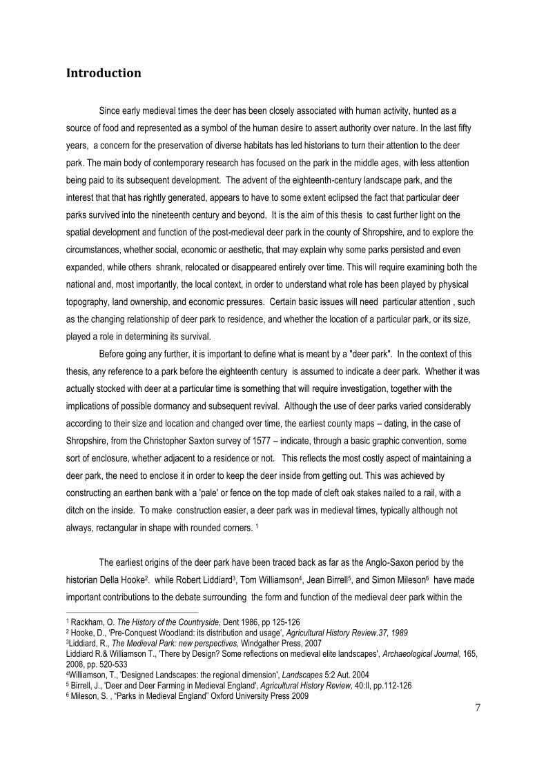
Fig 1. Map of Shropshire

11
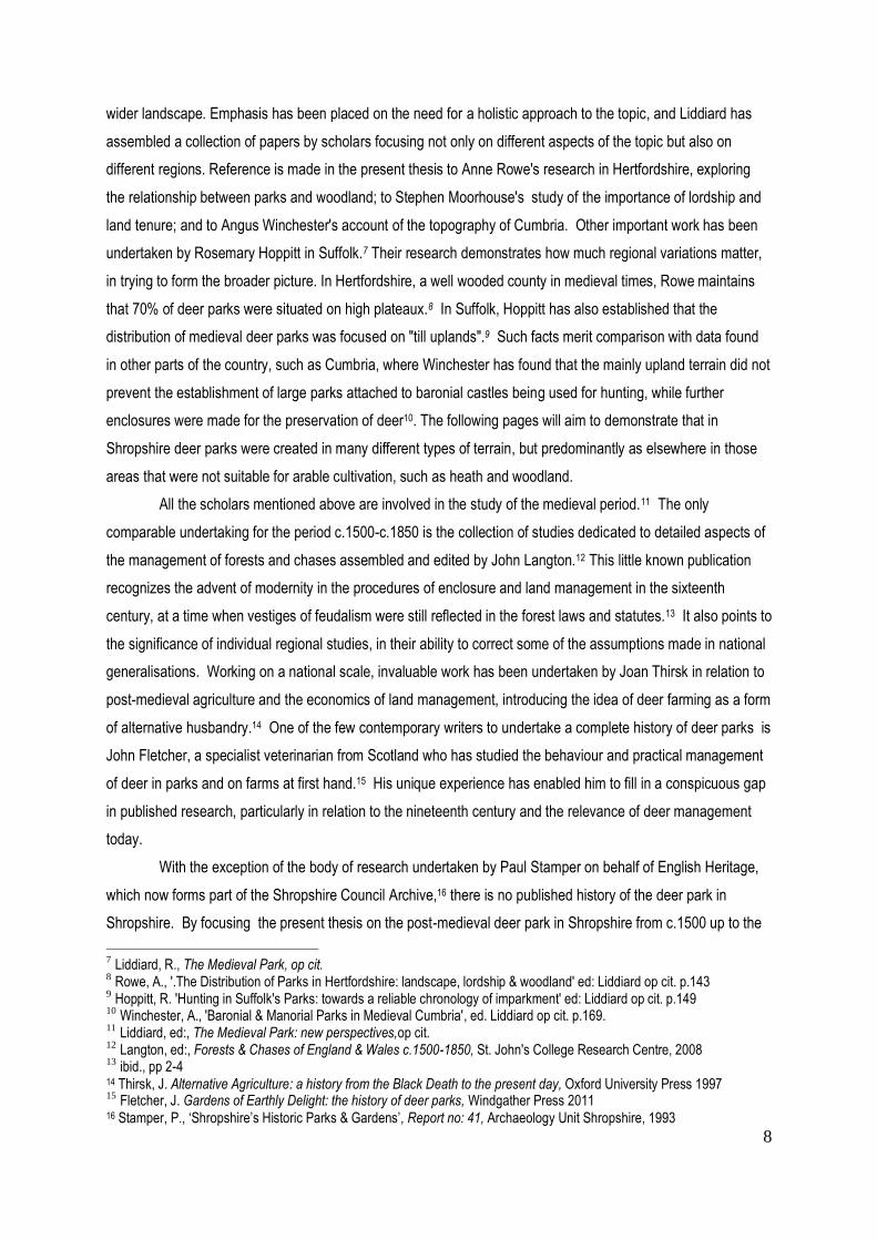
Fig 2. Geological Map of Shropshire
Legend:
30, 41, 60 Pre-Cambrian
53 Basalt (Carboniferous, extrusive)
73-4 Limestone (Silurian)
75-78 Lower Devonian
81-83 Upper carboniferous (Silesian)
84 “Barren Red”
89 Permian & Triassic Sandstones

12
Topography of Shropshire
Shropshire is one of the Border Counties of England, sharing a boundary with Wales. For those
unfamiliar with the county, a brief description of its principal topographic features may prove useful, clarifying the
regional variations involved that have contributed to the distribution of deer parks (Fig 1 ). The Welsh Hills form
the boundary of the county of Shropshire to the west, with a sandstone plain bordering the counties of
Worcestershire and Staffordshire to the east and Cheshire to the north. With a total area of c.3500 square
kilometres (1,346 square miles), it encompasses a wide variety of landscapes based on underlying geology and
consequent soil profiles. Over millennia variations in climate have produced conditions that have changed and
modified this landscape, but in at least the last 4000 years its inhabitants have made their own impact, clearing
the tree cover in most areas and replacing it with agriculture, introducing settlements, mining for minerals and
coal. At different times in the county’s history different types of habitat have been valued above others, both in
economic and social terms. North and South Shropshire are separated by the River Severn that rises in the
Welsh Hills and flows across the county from the northwest, looping around the principal town of Shrewsbury,
and continuing in a south-easterly direction through Bridgnorth towards the Severn Estuary. This river, together
with its many tributaries, is prone to flooding and the rich silt deposited by each inundation has created the fertile
alluvial plains in its immediate vicinity. It has also provided an important transport route between Shropshire and
cities such as Gloucester and Bristol, particularly from the eighteenth century, when coal was discovered in the
carboniferous area north and west of Bridgnorth, in medieval times the site of the only bridge over the Severn
south of Shrewsbury. The North Shropshire Plain was covered by glacial drift at the end of the last Ice Age. The
underlying sandstone emerges in occasional ridges, covered with a reddish loam over clay and giving rise to the
soils of the Salop association22 that are well drained and suitable both for dairy farming and the cultivation of
cereals.23 As will be noted later, this has been a popular settlement area since the Middle Ages. To the north-
west of this region, around Ellesmere, is an area of fen peat over glacio-fluvial drift that is subject to water-
logging. Over time, and with the intervention of man, this has become a landscape of drained marshland and
meres that today include Ellesmere, Blakemere and White Mere.
South Shropshire, on the other hand, is defined by a series of upland ranges formed by ancient
underlying rock, running mainly in a south-west to north-easterly direction in line with the geology of Britain as a
whole. The geology of these hills ranges in antiquity from the Pre-Cambrian rock of the Long Mynd (extending
some 10 kms) and the associated Stretton Hills, to the Ordovician rock of the Stiperstones with their conspicuous
basalt outcrops, through to the younger Silurian limestone and sandstone ridge of Wenlock Edge, extending
some 20 kms. to Much Wenlock (Fig 2). The higher upland areas are overlaid with the often shallow well-drained
loamy soils of the Withnell association and carry a dry moorland habitat unsuited to agricultural development,
and even today used only for sheep grazing and recreation. The more gentle sandstone and limestone
22 Soil characteristics are described according to four categories: major group, group, subgroup, series the lower the category the more precise its definition. The soil series or association reflects the soil’s parent material (substrate), its colour and mineralogical characteristics, and its name is taken from the place where it was first described . Soil Survey of England & Wales 1983 23 Soil Survey of England & Wales 1983
13
escarpments of Wenlock Edge to the south-east have probably always been largely tree-covered; in recent times
there has been some planting of conifers by the Forestry Commission which is now gradually being replaced with
deciduous trees.
The south eastern dip slope of Wenlock Edge is overlaid with brown well-drained silty soils of the local
Munslow association, interbedded with shales of the Barton association that reappear along the scarp running
between Church Stretton and Acton Burnell and cover some 220 square kilometres in the Welsh Borderland.
Parallel with Wenlock Edge lies the wide fertile valley of the River Corve, composed largely of silty shale,
limestone and mudstone over clay, which may be seasonally waterlogged but is used today for permanent
grassland and stock rearing. This valley was an important area for Anglo-Saxon and medieval settlement, and
traces of ridge and furrow, particularly around the former villages of Burley and Abdon, bear witness to the open
field system of farming, which gradually gave way to a less labour intensive pastoral system.24 In addition to its
agricultural and woodland assets, the valley offered an important route for travellers and drovers from Wales to
the River Severn at Bridgnorth.25 A considerable stretch of the valley is covered by soils of the Munslow
association; other areas with this soil association are widespread along the valley of the River Teme west of
Ludlow where almost half the land is still wooded.26 To the south of Corvedale lie the Clee Hills, formed of
sandstone rock with basalt outcrops, the highest hills in the county, rising to almost 600 metres and providing
some of Shropshire’s most desolate landscapes. Brown Clee Hill is overlaid with a combination of stony soil with
boulders of the Malvern association, suitable for deciduous woodland; elsewhere, a Carboniferous and Jurassic
mudstone of the Onecote association produces a wet moorland condition more suited to conifers. Its sister hill,
Titterstone Clee, has a similar soil, with the addition of areas of shallow acid soil overlying sandstone that provide
a drier moorland condition suitable for sheep. Local farmers still have common grazing rights in this area. Both
hill regions were also quarried for minerals in the medieval period, and the quarrying of stone on Titterstone Clee
continued well into the twentieth century.
The important market town of Ludlow, lying in the south of the county on the River Teme, was founded
together with its castle in the Middle Ages and became the seat for the Council of the Marches. To its west, on
the border with Wales, lies the ancient Forest of Clun that shares with much of Herefordshire and the Welsh
Brecon Beacons underlying rocks of the Devonian sandstone type, covered by the silty soils of the Barton
association that appear elsewhere in Shropshire. These conditions have in the twentieth century allowed
coniferous planting to flourish on the steep slopes, although there are some remnants of deciduous woodland.
The flatter areas tend to be peaty and these wet moorland conditions have never been suitable for agriculture.27
The Clun Forest landscape of rolling hills is typical of the Border Country, the context in which the county has
developed, not only geographically but also socially and politically .28
24 www.secretshropshire.org.uk 25 Hill, T., The Historic Landscape of Upper Corvedale, Cressage 2009 26 Soil Survey of England & Wales, op cit 27 ibid. 28 Rowley,T., The Shropshire Landscape, Hodder & Stoughton 1972, Chap.1.

14
Methodology: cartographic evidence
Maps, in the form of county and estate maps, are the basic research tool employed in this thesis.
Shropshire is fortunate in possessing a 1557 county map by Saxton, as well as a wealth of later maps, at both a
local and county level. However, it is important to state from the beginning, that maps cannot be deemed reliable,
without the support of other forms of archival evidence. Maps always have and always will depict a personal view
of the world, whether at national or local scale. As J.B. Harley has shown, “maps are never value free images”.29
However much they purport to be accurate representations of ‘reality’, they inevitably carry the ideology of a
specific place, time and culture".30 It is therefore essential to ask certain questions when looking at any map,
such as, what was its purpose; for whom was it made; and to what degree was that clientele able to read it?
Most importantly, what has been omitted, for strategic, commercial, but ultimately political reasons? Harley
speaks of the “silences” of maps, as being more revealing than what is represented, reflecting the ability of a
state to regulate access to knowledge, or the power of a single landowner to ignore local tensions, by for
example, instructing his surveyor "to omit the houses of the poor”31 It will be important to bear this in mind when
looking at both county and estate maps. Standardisation and manipulation are just two of the pitfalls that
confront us when using cartography as a nonetheless exciting and necessary research tool.
Another problem concerns their survival. Maps are extremely fragile documents, and less easy to store
than books. In the sixteenth century, many must have been lost in the destruction of monastic libraries during
the Dissolution. From the City of London Guildhall library alone, some 900 volumes of maps were removed in
the 1550s.32 From the end of the sixteenth century, maps were also increasingly used as decoration, hung on
walls, made into screens, and as such were easily damaged or even discarded if the owner died or relocated.
Whole libraries were frequently bought and sold.33 In these circumstances, it is likely that we are only looking at a
fraction of the maps that were made. In the context of this thesis, it will be important to examine why certain
topographic details are included and others omitted; why a deer park disappears only to return on a later map.
Each cartographer will, for one reason or another, be focusing on selected features at the expense of others.
Issues such as these can serve to sharpen our awareness of the way in which contemporaries viewed their
landscape. In the following pages journals and estate documents will be explored in the hope of shedding further
light on the way those landscapes were managed, and how the deer park survived in times of social and
economic upheaval.
Of particular interest are the three parks, probably all of medieval origin, that survive in the county
today: Loton Park, privately owned by the Leighton family for the last 400 years; Attingham Park, sold by Lord
Berwick to the National Trust in 1947; and Longnor Park, now leased to Mr Valentine Nicholson. Although it is
not my intention to pursue the history of the park beyond the advent of the First World War, personal interviews
29 Harley, J.B., The New Nature of Maps – essays in the history of cartography, ed. Laxton, P., John Hopkins Unversity Press, 2001, p.53. 30 ibid. p.54 31 ibid, p.99 32 Delano-Smith, C. & Kain, R.J.P., English Maps: a history, The British Library, 1999, p.241 33 ibid. p.246

15
with present owners and/or managers undertaken in the course of research will be introduced where
appropriate, in an attempt to discover what links with the historic past have survived, and whether the continued
management of the deer park has any relevance today.

16
Figs 3 & 4. Gaston Phébus, Livre de Chasse 1405-10

17
Chap 1. The medieval deer park in Shropshire c.1066–c.1400 - its
distribution and social context
Introduction
Historians of the medieval deer park have focused attention on certain key issues: how parks were
distributed, how they were used, what status they afforded the owner, and to what extent they formed part of
"designed landscapes". The aim in this thesis is to look at the physical and social context of deer parks in
Shropshire, and to establish to what extent regional differences within the county may have determined their
distribution and survival. This cannot be done without first considering the medieval background to hunting and
parks.
From the time of the Norman occupation, hunting was the privileged sport of royalty and of those
aristocrats favoured by the king, who had been granted free warren to hunt in wide-ranging royal forests such as
the New Forest and the Forest of Dean. Furthermore, the king expected the provision of facilities for hunting
when he travelled the country. It seems likely, as Fletcher suggests, that the most common form of hunting in
medieval England was the "bow and stable" method, which involved hounds locating a deer in the forest and
horsemen driving it towards hidden archers who made the kill.34 Medieval illustrations of the hunt, such as those
of Gaston Phébus ( 1405-10), suggest that frequently nets or 'toils' were used to enclose a limited space, into
which a selected stag or stags were driven to facilitate the kill. Except on special occasions, it was generally the
servants who did the hunting rather than their masters (Figs 3 & 4). This puts the emphasis on the value of the
venison as a meat and its association with the hierarchical structure of medieval society. Mileson, in his recent
Parks in Medieval England (2009), while emphasising the role of hunting as the primary reason for the
establishment of deer parks, concurs with a theory put forward by Birrell that small parks might have been used
as "deer farms".35 The Normans were keen to ensure that the royal forests provided venison for the court. It was
a sought after meat reserved for the aristocracy, and might be offered as a gift on special occasions as a mark of
particular favour. Most scholars are agreed that the deer park, created by licence of the king, was an outward
sign of social status, "an instantly recognisable sign of wealth" 36 - not least, because the gifting of deer, both
alive and dead, demonstrated what Birrell has described as "the largess and patronage (that) were crucial
attributes of lordship." It was not produced for a market, and its consumption was restricted to an elite, leading
inevitably to poaching and smuggling . Deer parks were therefore carefully managed, and importance was
attached to the keeper's understanding of the requirements of the deer, in terms of food and shelter. 37 It will
34
Fletcher, J.,op cit., pp. 107-109 35
Mileson, S.A., Parks in Medieval England,op cit., p.5 36
ibid. p.15 37
Birrell, J. 'Deer and Deer Farming in Medieval England' Agricultural History Review, 40:2, p.113

18
become apparent later in this chapter that when the king or his barons leased lands to faithful followers, they
frequently retained ownership of the deer park as a place of special privilege. .
Recent studies, led by Liddiard , have focused on the relationship between residence and park, raising
the question as to whether the spatial arrangement was intentional, and by inference the result of a preconceived
master plan, or whether the landscape associated with the medieval castle was achieved through accretion. In
2005 Liddiard fielded the possibility that "little parks", those adjacent to the residence, were intended for
pleasure, while "great parks", those at a distance, had a more utilitarian purpose. He also suggested that the
position of windows in castle residences might reflect a desire to maximise views.38 A further aspect of the
aesthetic debate introduced by Liddiard is the discussion surrounding the possible emblematic value of the deer
park, as a metaphor for "ancient pedigree" 39. These are issues that will be discussed in the course of this
chapter, the intention here being to provide a context and baseline from which to examine subsequent data and
changes in the function and appearance of the park.
The Pre-Conquest landscape
Research related to Domesday Book undertaken by Hooke suggests that deer parks were already
being enclosed by the eleventh century, when the term ‘deer park’ was used in Ongar, Essex.40 Hooke draws
attention to the Anglo Saxon word ‘haga’ meaning a strong fence often surrounding woodland. 41 She refers to
this feature as a ‘pale’ – “perhaps an earthen bank with a timber palisade or hedge above”. ‘Haga’ was equally
used to mean the ‘haw’ of the hawthorn, and Hooke suggests that even prior to the Norman Conquest, hedges
were made of dead hawthorn branches, and almost certainly used to control the movement of deer. Even if
formal deer parks were not introduced until medieval times, boundaries of this kind were, Hooke believes, used
to demarcate “areas set aside for hunting”.42
Liddiard develops this idea in his article 'The Landscapes of Domesday Book' (2003) in which he
differentiates between the Anglo Saxon word “haga”, which he interprets as meaning various types of boundary,
and the “haia” (hayes) recorded in Domesday Book which, he is convinced, were pre-Conquest parks or deer
parks.43 Liddiard explains the discrepancy between the terms ‘park’ and ‘haia’ by the fact that the Domesday
Book survey was carried out by different surveyors in the various regions, without any overall consensus as to
terms. Domesday Book lists only 37 'parks', which Liddiard estimates to be a substantial under-recording. In
Shropshire the term appears only once, with reference to a park at Marsley near Shrewsbury. Although
Domesday mentions no further parks in Shropshire, a ‘haia’ is recorded at Corfton “for catching roe deer”44; no
38 Liddiard, R. Castles in Context, Windgather 2005, p.113 39 ibid., p.145 40 Hooke, D., The Landscape of Anglo-Saxon England, Leicester University Press 1998, p. 157 41 ibid. p.154 42 ibid. p.157 43 Liddiard, R. ‘The Landscapes of Domesday Book’, Landscapes 4:1 Spring 2003 p.6, p.18 44 GDB f.25v. quoted Liddiard, op cit. p.12

19
Fig 5. The Natural Regions of Shropshire
Trevor Rowley, The Shropshire Landscape
Fig 6. Medieval Forests of Shropshire
Victoria County History Vol 4
20
less than three are mentioned at Longnor, described as “secure enclosures”45; and a total of four at Worthen46.
Liddiard suggests that many of these pre-Conquest parks survived intact into the medieval period.47
Stamper, studying documentary and place name evidence in Shropshire, has found 36 ‘haia’, mainly in
the south-west of the county;48 while Rowley suggests that there may have been as many as 60, more than in
any other Midland county.49 . Many of those surviving from Anglo Saxon times may have been only small
enclosures, used for grazing animals, in order to separate them from areas of valuable woodland and coppice.
Some were undoubtedly enclosures for rearing deer, frequently located at some distance from villages and
habitation, a feature that is notable in the ensuing medieval period.
Royal forests and forest law
Before looking at the physical distribution of particular deer parks in Shropshire, it is important to clarify
the meaning of the term ‘forest’, as it was used in the middle ages. Rackham, writing in Trees and Woodland in
the British Landscape, notes that the word ‘forest’ first appears in Domesday Book as “a tract of land subject to
special laws, usually concerned with the preservation of game.”50 This was a legal definition; however Rackham
makes it clear that ‘forests’ defined in this way included a wide variety of land uses, including coppice, pasture,
arable and even settlements – clearly a much broader landscape than the modern use of the word ‘forest’
implies, although there would frequently have been a core of woodland or wood pasture. In medieval times, the
word ‘forest’ described royal forest belonging to the Crown, while the word ‘chase’ (first introduced in the
thirteenth century) indicated a privately owned deer-park.51 It is in this sense that the word ‘forest’ will be
understood in the following pages.
The royal forest achieved its greatest extent in the twelfth century, when about one third of Shropshire
was designated in this way. It included Mount Gilbert (or The Wrekin) in the north, Brewood and Morfe Forests
in the east, The Long Forest and Shirlett Forest in the south; while the Stiperstones and Clee Forest as shown
on the Map of Royal Forests compiled for the Victoria County History (Fig 6:), were to become private chases by
the beginning of the fourteenth century. Apart from their value for hunting, woodland areas within forests were
exploited for timber and underwood: Lythwood in the Long Forest was an important source of oaks and
underwood, sold throughout the county.52 But already, by the end of the twelfth century, the area of royal forest
had been reduced by the need to raise revenue for the Crown. In 1209 the tenants of Brewood Forest paid 100
marks for it to be disafforested. By 1301 Clee Forest had been leased into private hands. 53 Similarly, part of the
range of hills in the west known as the Stiperstones had been granted to the Abbot of Wenlock Priory.
45 GDB f.254v. quoted Liddiard, op.cit. p.12 46 ibid., p,12 47 Liddiard, 'Landscapes of Domesday Book', op cit. p.18 48 Stamper, P., Historic Parks and Gardens of Shropshire, Shropshire Books 1996 49 Rowley, op cit. p.67 50 Rackham, Trees & Woodland, op cit. p.152 51 ibid. p.153 52 VCH Shropshire 4, p.46 53Anderson, J. Corbet, Shropshire: its Early History & Antiquities, London 1864 p.313

21
By the reign of Edward I, considerable parts of the Forest of Shirlett - believed to have been as large as
eighteen by eight kilometres lying to the west of the Severn around the manors of Morville and Chetton - had
been disafforested.54 The Forest of Wrekin to the north, also known as Mount Gilbert, once surrounded this
well-known hill, but by 1300 all that remained was the ‘Haye of Welinton’ (probably remembered in the name
Hay-gate in Wellington). 55 What the map makes clear, is that there were never any royal forests in the northern
part of Shropshire, probably due to the fact that soils of the Salop association - a reddish loam over clay -
favoured the early agricultural development of this fertile area. There were, however, a considerable number of
medieval deer parks in that region.
A closer examination of the distribution of deer parks in Shropshire will reveal that many lay on the
edges of land under forest law. Although most medieval kings enjoyed hunting, they also had more demanding
preoccupations that required the generation of income, particularly in Shropshire due to persistent conflicts with
the Welsh. Significant parts of royal estates were leased out to barons and favoured retainers who in turn leased
parts of their estates to knightly sub-tenants. To set up a private park within a royal forest it was necessary for a
lord to obtain and pay for a licence from the king. Once land had been removed from forest law, no licence was
required, making such parks less easy to trace. During the course of the twelfth and thirteenth centuries many
areas within the royal forest were enclosed or ‘imparked’, usually with royal licence but sometimes without.
Between 1329-31 the law was more strongly enforced, and many lords were fined over disputed rights to create
parks in disafforested areas. As a result of this greater stringency in upholding the law, there was an increase in
the registration of park licences in the 1330s and 1340s. Research into the existence of such licences lies
outside the scope of this thesis; however, the practice continued into Tudor times, when all new parks required
licences.56
.
Woodland cover in relation to the distribution of deer parks
By early medieval times, barren moorland areas on high ground, supporting only shallow soils of the
Withnell association, were unlikely to have been tree-covered. The Long Forest, lying to the east of the
Stiperstones originally included the hills of the Long Mynd, the Lawleys, Wenlock Edge, and the fertile valleys of
silty shale and mudstone in between. Of these, Wenlock Edge has remained consistently wooded while the
steep slopes of the other higher hills still support some fragmented patches of woodland. To the east of the River
Severn, the forest of Morfe was one of the last royal forests to survive, and retained a significant degree of
woodland, while Wyre Forest, part of the adjacent county of Worcestershire, is still a well wooded area today.
However, the Survey of Shropshire Forests of 1235 recorded only a few remaining fragments.57
Research undertaken by those regional historians already mentioned, has shown countrywide a general
association of parks (specifically ‘deer parks’) with well-wooded areas. Rowe has demonstrated that in
54 Anderson, op cit. p.245 55 ibid., p.120 56 Mileson, S.A., Parks in Medieval England, op cit., pp 124-7 57 Anderson, op cit. p.243

22
Hertfordshire 75% of those manors containing deer parks had woodland at the time of the Conquest.58 In the
lowlands of Suffolk where there was no royal forest and consequently no licences to impark, research
undertaken by Hoppitt has shown that areas such as the Breckland in the north-west and the Sandlings coastal
strip appear to have been cleared of woodland in prehistoric times, leaving the area in the north and east well
wooded in the Middle Ages. Parks in this county have often been found on higher ground not suitable for arable
cultivation, irrespective of woodland cover.59
In the case of Shropshire, Hooke has calculated that in 1086 the Domesday Survey recorded only 8% of
the county as woodland. But as she has pointed out, this did not include any royal forests or woodland that may
already have been owned by the king. Indeed, she has referred to the frequent mention of “hays” as an
indication that there was more woodland than that recorded.60 Nevertheless, as already noted, the underlying
geology and soil profiles of particular regions in Shropshire suggest that in the post-Conquest period higher parts
of the county would have been moorland or heath, rather than woodland. It would therefore seem, that by late
Saxon times, woodland cover was not a prerequisite for the establishment of deer parks, although evidence
seems to suggest that in Shropshire much woodland survived, albeit fragmented, beyond the end of the Middle
Ages. Parks were enclosed in a variety of different terrains, with wood pasture providing the most suitable habitat
for deer.
Deer are voracious grazing animals, but are selective in what they eat, preferring ash, elm, hawthorn
and hazel. As Rackham has pointed out, these trees are therefore uncommon in wood pasture, a habitat where
deer graze alongside standard trees on a regular basis. Oak, beech, and hornbeam survive relatively well,
generally being pollarded in order to keep them out of reach of grazing animals and to provide a regular supply of
wood. Rackham has shown that pollarded oaks may live three times longer than those that have not been
pollarded.61 Both standing timber and coppice were valuable resources during the Middle Ages, providing
building material, fuel, fencing material and charcoal for iron smelting sourced from coppice. Within the deer
park, wood pasture frequently existed alongside coppice, which had to be protected from deer and indeed from
other grazing animals that sometimes shared the park; consequently, deer parks were frequently
‘compartmented’, with internal banks separating the coppice from the grazing areas (known as launds). 62
The extent of the association of deer parks with woodland in Shropshire should not be underestimated.
Evidence drawn from the Anglo Saxon origins of contemporary place names indicates areas where settlements
connected with deer parks formerly lay within woodland. 63 The greatest number (9) of settlement names
associated with medieval deer parks, to which reference will be made later in this chapter, have the OE suffix
–‘leah’ ( -ley) signifying ‘an open place in a wood, a grove etc.’ This suggests that deer parks at Adderley,
Frodesley, Hadley, Highley, Madeley, Marsley, Minsterley, Rowley, and Oteley may well have been enclosed
58 Rowe, A., op cit. p.143 59 Hoppitt, R., ‘Hunting Suffolk’s Parks: towards a reliable chronology of imparkment’ in Liddiard, R. ed: op cit. pp 149-154 60 Hooke, op cit. p.61 61 Rackham, The History of the Countryside, Dent 1986. p.151 62 ibid. pp.120-123 63 Ekwall, E., The Concise Oxford Dictionary of English Place Names, 4th ed: Oxford 1960, for all information relating to place names.
23
within surrounding woodland prior to the Conquest. A further name with a woodland connection is Prees from
OW ‘prys’ (woodland, covert); while Earnstrey and Earnwood – ‘the eagle’s tree’ and ‘eagle’s wood’ respectively
– were medieval parks lying in Corvedale, where substantial woodland clearance took place in medieval times.
Similarly, Lythwood – ‘wood on a slope – indicates the presence of a park, formerly in the Lye Forest, located in
what is now a suburb of Shrewsbury. Using the evidence of place names, it is possible to infer areas of former
woodland cover where ‘hayes’ appear to have been created. In some cases, archaeological evidence in the
form of early earthworks has been used to substantiate such evidence. At this stage, before individual parks
have been examined, it therefore seems justifiable to conclude that in Shropshire a number of enclosures existed
prior to the Conquest which in all likelihood were used to keep deer, and that the majority, although not all, were
concentrated in well-wooded districts.
Data and distribution of medieval deer parks in Shropshire
Medieval deer parks are sometimes mentioned in Inquisitions post Mortem and Patent Rolls, and it was
based on such evidence that Leonard Cantor compiled his Gazetteer of Medieval Deer Parks in 1983. In this
thesis, in which a brief examination of the medieval period serves to provide a context for the later development
of the post medieval park, Cantor's Gazetteer will be used as a baseline from which to examine the continuity or
discontinuity of individual deer parks. However, it is important to bear in mind, that the documents studied by
Cantor were used, not to record the creation of deer parks, but often the offences - poaching, fence breaking etc.
that were committed within pre-existing parks.64 It would therefore seem likely that many were created earlier
than the dates he has offered as the first documentary evidence for the 57 medieval deer parks he recorded in
Shropshire (Fig 7). It is useful to compare Cantor's figure of 57 for Shropshire with his lower figure of 44 for
Hertfordshire. Based on detailed research in that county, Rowe believes that the figure for Hertfordshire should
be more in the region of 66 65, and indeed initial research in Shropshire has revealed additional medieval parks,
raising the number there to approximately 73. This figure has been arrived at by referring to the Shropshire HER
which includes a further 12 deer parks that county archaeologists believe to be of medieval origin although not
mentioned by Cantor. These are: 66
Betton Park - enclosed from Betton Wood 1175-1190
Darvill, Shrewsbury - believed to have been a late Saxon to Early Medieval 'hay' or deer fold
Hem Park - mentioned as a 'deer park' in 1364
64 Hoppitt, op cit.,p.149 65
Rowe, op cit. p.128 66 Complete list in the Shropshire Historic Environment Record

24
1.Acton Burnell2.Adderley3.Alberbury4.Berwick5.Blake Mere 6.Burford7.Cardeston8.Caus 9.Chelmarsh10 Cheswardine11..Chetwynd12.Cleobury Mortimer13.Cound14.Crees (in Leebotwood)15.Earnstrey 16.Earnwood 17.Ellesmere18.Fitz19.Frodesley20.Hadley (Wellington)21.Haughmond22.Hawkestone23.High Ercall24.Highley25.Hodnet26.Idsall (Shifnal)27.Kinlet28.Lilleshall29.Longford30.Lower Hogstow31.Lythwood32.Madeley33.Marsley (Habberley)34.Merrington35.Myddle36.Minsterley37.Onibury38.Oxenbold 39.Prees40.Redcastle 41.Richards Castle42.Rowley43.Rowton44.Ruyton XI Towns45.Shawbury46.Shrawardine47.Stapleton48.Stoke-upon-Tern49.Stottesdon50.Tong51.Walford52.Wem53.Whitchurch54.Whittington55.Woofferton56.Worthen57.Yockleton
Fig 7. Medieval Deer Parks recorded in Cantor’s Gazetteer 1983

25
Holdgate Park, Corvedale - 2 deer parks surviving 1428
Langley Park - not recorded in late C13 surveys, but possibly created afresh after 1315
Longnor Park - park created c.1333
Lubstree Park - originally known as Haye Gubald in 1224
Norton Old Park, Stockton
Oakly Park - believed to be an early hunting park, first mentioned in 1478 as an enclosed park
Oteley Park - c.1300
Stanton upon Hine Heath - believed (by Stamper) to be synonymous with Harcourt Park
Tilstock - map evidence of it being cleared in the late sixteenth century
The work undertaken by Stamper on behalf of the HER, and published as a Report on Historic Parks
and Gardens in 1993, draws on archaeological evidence and post medieval map sources. 67 This report not only
confirms the existence of those deer parks mentioned by Cantor, but includes some further additions to those
included in the HER register. These are:
Baschurch Park - mentioned 1195 when the Abbot of Shrewsbury granted the wood of Birch to extend it
Kenwick - map evidence of 1577 (Saxton) but area not clear
The Hayes, Alberbury - possibly the Hay recorded at Loton manor in Domesday Book
Willey Park - in existence by 1291 in the north part of Willey parish
This brings the number of medieval parks traced so far to a total of c.73, still relatively modest by comparison
with the 130 confirmed in Suffolk by Hoppitt, of which c.40 remained intact for some three hundred years.68 This
Suffolk figure reflects a huge increase on Cantor’s suggested 62 for the county, which is more in line with his
figure of 57 for Shropshire, and comparable with his 54 for Buckinghamshire, 58 for Warwick, and 50 for
Worcestershire . These appear to be average numbers for the country as a whole, whereas the counties with
the greatest number are well ahead, with Sussex at 108, and Essex at 102. The importance of local research is
paramount in establishing reliable figures, and future scholars may reveal that all Cantor's figures are too low.
Before drawing any conclusions as to the survival of individual parks in Shropshire beyond the Middle
Ages, it is necessary to consider post-medieval map evidence. In 1577 Christopher Saxton published his county
map of Shropshire, followed thirty-four years later by that of John Speed (1611). Although the evidence of these
maps was compiled some two hundred years or more after many of the medieval deer parks had ceased to be
active, even John Rocque's map of 1752 can offer insights, while the Ordnance Survey maps of the nineteenth
and twentieth centuries, being more accurate, more detailed, and at a larger scale, reveal names of farmhouses
and even fields that can point to the former location of a medieval park. How many of these parks remained
stable over time is one of the questions that needs to be addressed. However, in order to discover their function,
their subsequent disappearance or absorption into landscape parks and their changing relationship to the
67 Stamper, P., Shropshire’s Historic Parks & Gardens, Report no.41, op cit. 68
Hoppitt, op cit., p.146

26
residence, it is important to look not only at their geographic location, but also at the socio-political structures of
the time which determined their ownership and survival.
Social Hierarchy and Ownership
As Moorhouse has written, “parks have to be understood against the background of their creators and
their uses, and seen against the society in which they were created.” 69 What Moorhouse is drawing attention to
is the need to remember that social and economic idiosyncracies, as well as environmental circumstances,
influenced the particular regional character of parks. When explaining the distribution of parks in Hertfordshire,
Rowe points to "territorial organisation and lordship" rather than topographical location, as having more often
been the driving force.70 This appears to be no less true in the case of Shropshire.
When William the Conqueror apportioned his newly acquired English lands, he granted the three Border
shires of Cheshire, Shropshire and Hereford to the governance of three trusted friends and supporters: William
FitzOsborn, created Earl of Hereford 1067; Hugh d’Avranches, who replaced Gherbod as Earl of Chester in
1077; and Roger de Montgomery, a kinsman, who was created Earl of Shrewsbury. The intention behind this
strategy was that these semi-independent shires ( Fig 8 ) would form a buffer zone to protect the rest of the
country from the raids of the Welsh, but in fact the establishment of a semi-independent ruling hierarchy
precipitated centuries of conflict. Domesday Book gives us some idea of the holding that Montgomery received
from the King: “Earl Roger himself holds from the King the City of Shrewsbury, the whole County and the whole
of the lordship which King Edward had there, with 12 manors which the King held himself, with 57 outliers
belonging there. The Earl also has 11 other manors in this Shire.” 71 Roger de Montgomery not only had power
to determine the administration and jurisdiction of the county of Shropshire on behalf of the king, but in addition
to the fortress of Shrewsbury Castle he retained for himself the manors of Hodnet, Kinlet, Stottesdon, Tong and
Whittington, (all of which were found by Cantor to have had deer parks by the thirteenth century). Roger de
Montgomery was succeeded to the earldom by his son Hugh, who was killed by Vikings in Anglesey, and he in
turn was succeeded by his brother Robert de Bellême who rebelled against Henry I in 1102, thereby forfeiting the
earldom and the manors which were taken back by the Crown.72
Subservient to the Earl in the social hierarchy were a group of barons who were granted estates,
principally so that they might defend the Welsh border. Foremost among these were the Mortimer family. Ralph
de Mortimer had been granted the lordship of Wigmore Castle on the Herefordshire side of the border with Wales
as early as 1075. With additional land in both England and Normandy, the Mortimers fought to extend their
possessions in Wales over five generations. Roger de Mortimer (d.1215), lord of Bridgnorth and Cleobury
69 Moorhouse, S., ‘The Medieval Parks of Yorkshire: Function, Contents & Chronology’ in Liddiard, Robert ed. op.cit. p.125 70
Rowe, op cit. p.143 71 Domesday Book, Shropshire, Phillimore 1986, 4,1,37 72 Lieberman, M., The March of Wales 1067-1300, University of Wales Press, Cardiff 2008

27
Fig 8. Plan of Norman England
showing areas under special control
Trevor Rowley, The Welsh Border
28
Mortimer, was imprisoned by Henry II in 1179 for killing the Welsh prince Cadwallon ap Modog during a period of
negotiated peace between the two countries.73 His descendant, another Roger Mortimer,1st Earl of
March,(d.1330) rebelled against Edward II, took the Queen Isabella as his lover, and effectively ruled England for
a couple of years until overthrown by Edward III. Another powerful force in the county and beyond were the
FitzAlans, descended from a Breton family, who held not only the manors of Oswestry, Clun and Ruyton, but
acquired others in Wales, Norfolk and Sussex. After John FitzAlan (d.1272) married Isabella Mortimer, the power
base of both families was strengthened, as was their rivalry. Their grandson, Edmund FitzAlan (d.1326), Earl of
Arundel, was a staunch supporter of Edward II and was executed on the orders of Isabella and Roger Mortimer.
However, the FitzAlans had built up enormous wealth from their estates, which gave them power at Court where
their support helped to ensure the financial viability of the wars against the French. Their title ensured them a
place among the highest ranks of the Shropshire nobility. 74 Another important baron and landholder was Roger
FitzCorbet, lord of Caus Castle, whose manors included Acton Burnell, Alberbury, Minsterley, Stapleton and
Yockleton, all manors associated with deer parks. Together with the Le Stranges who held Blake Mere and
Knockin, these were the principal land-holding families after the Conquest, who later held responsibility for what
were known as the Welsh Marches - to distinguish them in terms of administration from Wales proper.
Skirmishes into Wales by the barons to extend their holdings were also common, with the de Lacy family, lords of
Ludlow Castle from 1085-95, acquiring the castle of Grosmont in Wales 75 . During the thirteenth century the
most important offices both in the county and at national level were held by descendants of these baronial
families.
It is important to emphasise that the Marches were a virtually autonomous region, lying beyond the
direct control of the English government for almost 500 years. The Marcher lords established their own courts
and held jurisdiction over both civil and criminal cases.76 In addition to the barons, there were a number of
powerful figures in Roger de Montgomery’s impressive retinue, such as Nigel his physician, who was granted the
manor of Adderley, and Robert Pincerna, his chief butler who held Walford. Rainald the king’s Sheriff, an
important official in the county, held 11 manors in the hundred of Baschurch at the time of Domesday Book,
including Shrawardine, togetherwith Condover, Cound, and Hadley. Given the unrest of the period, the warlike
nature of families such as the Mortimers, and the scattered locations of many estates, it seems unlikely that
many of the Marcher lords and their households would have been permanently resident in one place. This raises
the question, as to what extent they were able to enjoy hunting on a regular basis, and how their deer parks may
have been used in their absence. In this respect, Shropshire differed markedly from counties such as
Hertfordshire and Suffolk, where there was no such autonomous administration and more stability at the local
level.
73 Lieberman, M., op cit., p.27 74
Burtscher, M., The FitzAlans, Earls of Arundel and Surrey, Lords of the Welsh Marches (1267-1415) Logaston Press 2008, p.115 75
Rowley, T., The Welsh Border, Archaeology History & Landscape, revised 2001 Tempus, p.111 granted with Skenfrith
and White Castle to Hubert de Burgh by King John in 1201 76 ibid.,pp 90-91

29
By the end of the thirteenth century, during which a large number of new deer parks had been licensed,
another class of landowner began to emerge. Probably the most remarkable individual, in terms of his rise to
power, was Robert Burnell (d.1292-3) whom the historian Marc Morris describes as a clerk"of modest social
origins but great ability" who " joined Edward I's household in the mid-1250s and gradually established himself as
its most indispensable administrative member". Edward recommended him for the post of Archbishop of
Canterbury, but his reputation as a philanderer and the number of his illegitimate children prevented his
promotion. In 1270 he was one of the five men chosen by Edward to administer his kingdom during the king's
absence on the Crusade. On the death of Henry III (1272) , Burnell was virtually "occupying the King's place in
England." On Edward's return, and after his coronation, Burnell was made chancellor and had charge of the seal
that was used to authenticate all royal orders.77 Following the tradition, whereby chancellors were usually
bishops, he was appointed to the bishopric of Bath and Wells. In 1284 he was granted licence to crenellate his
castle of Acton Burnell, where he also created a deer park.
At the same time, shortly after 1281, Laurence de Ludlow, a wool merchant, acquired the tenancy of
Stokesay Castle from John de Grey for the price of a ‘juvenile hawk’ and the payment of 8d. per annum, being
also granted ‘free warren’ to hunt small game in the manor of Stokesay and nearby Whettleton.78 (At this time
there was not yet a deer park at Stokesay). The Ludlow family increased their social status when they added the
manors of Hodnet and Westbury to their possessions through the marriage of Laurence’s son William to the
heiress, Matilda de Hodnet. With the exception of a couple of ‘wild cards’, members of the family served the
county as Sheriffs, Justices of the Peace, and Commissioners of Array for the Crown, accompanying the king on
his wars in Scotland and France. Such tenants, frequently distinguished by their locative names, were required to
pay knight service to their lord, attending his court and supplying foot soldiers as and when need arose. As a
mark of recognition for their allegiance, barons would grant such tenancies to lesser knightly families. Names
such as Thomas de Erdington (Shawbury), John de Segrave (Stottesden) became increasingly common by the
beginning of the fourteenth century, as many old aristocratic families died out through lack of a male heir. Some,
on the other hand, managed to acquire new manors through advantageous marriages ,79 but increasingly
knightly families took over the estates. The Charltons held Apley, Cheswardine Castle and Tong (all associated
with deer parks); the Fulk FitzWarins held Whittington for ten generations; the Hoptons held Hopton Castle; while
by 1376 the Talbots of Lancashire had succeeded to the LeStrange estates in North Shropshire to add to their
earlier acquisition of Richard’s Castle in 1364. For families such as these, the ownership of a deer park was as
important as the ownership of an estate in raising their status in aristocratic society.
The Raising of Medieval Castles
The relationship of the medieval castle to its surrounding landscape has in the last decade become a
contentious issue, with scholars expressing differing views concerning the castle itself – to what extent it was a
77
Morris, M., A Great and Terrible King: Edward I and the forging of Britain, Windmill Books 2009, pp.117-18 78 Train, C., The Sheepe Hath Payed for All – the Ludlows of Shrewsbury (Ludlow Historical Research Group 2000 ) 79 Lieberman, op.cit. p.29

30
Fig 9. Medieval Castle Sites
Salter 1988

31
defensive mechanism and to what extent a residence with the trappings of military style. Liddiard (2005) writes
that the Normans envisaged castle building as a way of “legitimising their succession“.80 He quotes Coulson
(1979) who suggested that military architectural features might have had a “symbolic purpose” as a sign of “lordly
status”.81 Liddiard has found that in some cases castles were overlaid on late Saxon residences, in a process of
reclaiming and upgrading pre-existing sites. 82 This seems to correspond to William I’s wish, following the
Conquest, to “assert power” rather than to continue making war.83 Seen in this light, medieval castles were as
McNeill has commented, “the product of lordship, not the means of establishing it.”84 Importantly, Liddiard makes
a distinction between castles built for defensive purposes and those that were essentially residential. What is
generally agreed among these scholars is that there were many variations in the purpose and use of castles, and
that for a variety of different political, social and economic reasons the balance between these distinctions differs
widely in different parts of the country. The following pages seek to demonstrate that in Shropshire, and
particularly in the border regions of the Welsh Marches, castles played a predominantly defensive role and also
acted as bases for expansion into Wales by some of the more ambitious barons.85
Cathcart King suggested that in Shropshire 112 castles were raised between 1066-1652, not including
fortified and moated manors of which there were many. He showed this to be the area with the highest number
of castles documented, apart from the Scottish Borders. According to King’s data, only 22 sieges were recorded
in relation to these castles86 – a very low figure, implying that very few castles actually witnessed a siege.
However, a closer examination of individual cases shows that a considerable number of castles in Shropshire
were besieged several times, both in the medieval period and again during the Civil War. It therefore seems very
likely that King’s figure will prove to be a very low estimate in this much disputed territory.
There were three castles already standing on the Herefordshire/Shropshire border prior to the
Conquest: Richard’s Castle, Hereford and Ewyas Harold. These are thought to have been built by Normans sent
to this border area by Edward the Confessor as a defensive measure against the threat of Gruffudd ap Llywelyn,
the self-made king of Gwynedd.87 All three are now in the county of Herefordshire and do not form part of this
study. Following the Conquest and the distribution of land discussed above, the Marcher lords were encouraged
by the king to build castles along the Welsh border for defensive purposes. Although there was no specific
military 'plan' , he clearly wished to protect the site of the royal castles at Shrewsbury and Bridgnorth. Earl Roger
de Montgomery was himself responsible for raising castles at Quatford to the east of the county, and Ellesmere
and Whittington close to the Welsh border, together with others on the Welsh side of Offa’s Dyke. According to
Salter, he also made it a condition of apportioning land to his closest followers that they in turn would build a
fortified dwelling. These were initially of the motte and bailey type introduced by the Normans, and a total of
80 Liddiard, R., Castles in Context, Windgather 2005, p.14 81 ibid. pp.6-7 82 ibid. p.30 83 ibid. pp.18-22 84 McNeil, T.,’Hiberna Pacata et Castellata’, (1990), in Liddiard op.cit. p.38 85 Hooke, D. op cit. p.62 86 King, D.J.C., Castellarium Anglicanum (1983) in Liddiard op.cit. pp.72-6 87 Lieberman op cit. p.18

32
some 75 were built between 1075-1100 88 (Fig 9). Most were of timber on earth mounds and probably only
served as temporary structures. This would explain the large number of mottes surviving on the Welsh side of the
county and along all the major west-east routes from Wales, including that leading through Corvedale to the
River Severn at Bridgnorth depicted on Salter’s map of medieval castles. Some of these were clearly inadequate
for a defensive role, and during more peaceful periods, such as the forty years following the truce with the Welsh
princes negotiated by Henry II between 1171-72, many were probably not maintained and fell into ruin. 89 Others
were gradually replaced or rebuilt in stone; a few such as Roger de Lacy’s Ludlow Castle (built 1085-95) had
unusually been provided with stone defences in the first place. Its chapel of c.1140 was one of the few stone
structures built in Shropshire before 1154, the date when Henry II took steps to reduce the number of baronial
castles in order to control the power of the barons.90
It seems unlikely that the temporary wooden structures, manned perhaps by a single castellan, would
have been provided with deer parks. However, at least 20 of the 57 medieval deer parks identified in Shropshire
by Cantor (1983) are associated with a castle of some sort. Looking at these more closely, two important facts
emerge: firstly, these particular castles were raised by leading figures and powerful families of the time, including
those mentioned above, rather than by minor local lords; secondly, even though they have in some cases lain
ruinous for many centuries, they appear to have been either originally or subsequently built in stone. It was
these more substantial buildings, used as a residence for at least some part of the time by major baronial figures
that were frequently associated with a deer park. Whether they used the park for some form of hunting, or to
ensure a supply of meat for the lord's table, must surely have depended on the size and location of the park in
relation to the residence. What lies beyond doubt, is that the threat of a siege or a skirmish was continually
present. It was only later, predominantly in the second half of the thirteenth century, that a number of the more
ambitious stone castles were refurbished to include greater domestic comforts, with elaborate outer baileys and
occasionally even gardens. The implications of this will be discussed later in the chapter.
Some of the early mottes were replaced by fortified manors, such as Stokesay raised by Picot de Say.
These would have been what Liddiard calls “secure residences”, frequently serving as the administrative centre
or ‘caput’ of a collection of manors often widely scattered throughout the county.91 The ‘caput’ would generally
include a courthouse with officials empowered to deal with local offences such as poaching or property
infringement. However, this preoccupation with manorial administration should not obscure the fact that all those
living in the border area had to be prepared for the continuing threats from Wales that did not finally diminish until
the death of Owen Glendower in 1416. A licence to crenellate that had to be sought from the Crown generally
included more than a fancy battlement. In the early years of the reign of Edward II such licences were awarded
to the LeStranges at Myddle Castle (1307), to William ale Mouton at Dawley (1316), and to Sir John Charlton at
88 Salter, M., The Castles and Moated Mansions of Shropshire, Folly Publications 1988, p.2 89 Liddiard, Castles, op.cit. pp.81-2 90 It was in 1155 that Bridgnorth, seat of the rebellious Roger de Mortimer, was captured by the Crown and Cleobury Castle destroyed. 91 Liddiard, op cit. p.17

33
Charlton (1316).92 Although it has been argued, and in some cases can be shown to be true, that licences to
crenellate were another way of demonstrating social status and inferring military prowess, there is no doubt that
in Shropshire the medieval period was a time of constant upheaval and “military vigilance was a continuing
precondition of lordship” 93 This instability was caused in part by the very system that had been intended to
ensure it.
Castles and associated deer parks
Since one of the main issues to be considered in this thesis is the relationship between deer park and
residence, a closer examination of the 20 deer parks (out of the 57 recorded by Cantor) associated with
medieval castles will serve as a starting point. It is interesting to note that neither Shrewsbury, Ludlow nor
Bridgnorth, the principal royal castles of the medieval period in Shropshire, had their own adjacent deer park.
This is probably due to the strategic role played by these castles in the constant skirmishes with the Welsh, to
their military and administrative importance, to the fact that they were seldom used as permanent residences, but
also perhaps because hunting was available to those who were granted free warren in the royal forests nearby.
In contrast to much grander royal castles in other parts of England, such as Windsor, Richmond, Kenilworth, and
the many others of high status, where Creighton suggests that deer parks were a feature of a ‘designed
landscape’,94 these Shropshire castles were relatively modest in size and served a pre-eminently strategic role.
In spite of King’s reference to the small number of sieges of Shropshire castles referred to above,
Salter’s brief history of Shrewsbury Castle suggests a site constantly under siege.95. This was a castle built
primarily for defensive purposes, granted to Earl Montgomery, who was probably seldom in residence, or indeed
visited by the king. In such circumstances, there was probably less requirement for hunting facilities than there
had been in the immediate aftermath of the Conquest when Domesday Book recorded that “The Sheriff sent 36
men on foot to stalk game as long as the King was there. However, at Marsley park he found 36 men for 8 days
by custom.”96 Marsley (OE Marsetelie), as mentioned above, appears to have been a royal park in Saxon times.
The HER records also include evidence of a stretch of land in the northern part of the modern city, known as
Darvill - a corruption of the term 'deerfold' - which suggests the presence of a deer pound and a possible park of
Saxon origin.97 Perhaps most importantly, Lythwood south of Shrewsbury was a royal haye of c.800 acres until
92 www.shropshirehistory.org.uk 93 Train, C., The Sheepe Hath Payed for All – the Ludlows of Shrewsbury, Ludlow Historical Research Group, Ludlow 2000 p.11 94 Creighton,O. Designs upon the Land, The Boydell Press, 2009 95 Salter, Castles and Moated Mansions, op cit., pp 58-62 Built by William I in 1067 specifically to protect the entrance to the loop of the River Severn, Shrewsbury Castle was attacked by the Welsh only two years later. Granted by the king to Roger de Montgomery in 1074, the castle reverted to the Crown following the rebellion of his son Robert de Bellême in 1102, and was placed in the custody of William FitzAlan who also held Oswestry. FitzAlan fortified it on behalf of Queen Matilda in defiance of King Stephen who unsuccessfully stormed the castle in 1139. Twice in the early thirteenth century it was besieged by the Welsh, and although the great hall was rebuilt by Edward I in c.1288 the castle was subsequently neglected for the next three centuries 96 Domesday Book ,Shropshire, C3 op cit. 97 HER Shropshire

34
1346.98 This was a very considerable area of forest available to the king for hunting, but presumably, by 1346
when licence to impark 459 acres was granted to the Abbot of Shrewsbury, Edward III, committed to war with
France, was more interested in the revenue generated by the valuable timber than in the hunting potential of the
forest.
Ludlow, which boasts one of the best-preserved medieval castles in England, is not mentioned in
Domesday Book but formed part of the manor of Stanton (Lacy). It was granted to Walter de Lacy (d.1085)
whose son Roger Lacy I is credited with building the first castle some time before 1095 when he was banished,
after rebelling against the Crown.99 Thereafter, occupation of the castle alternated between powerful local lords
and the reigning monarch. It was at Ludlow Castle in 1225 that Henry III signed a peace treaty with the Welsh
Prince Llewellyn. During the thirteenth century, the castle was the residence of Roger Mortimer. After Edward
Mortimer was crowned Edward IV (1461-83), he set up the Council of the Welsh Marches (1472), which operated
from the castle until the presidency was finally abolished in 1689.100 Below the castle, on the south side of the
River Teme on the border with Herefordshire, lay Bringewood Chase, part of the extensive estates of Edward
Mortimer. After he became king, Bringewood became known as a ‘royal chase’ (an apparent contradiction of
terms); similarly, Mocktree and Deerfold, also part of the Mortimer estates, became ‘royal forests’ and remained
so until they were sold by James I 101. These forests served for the king’s hunting. Lovelace suggests that Oakly
Park (a few miles north of Ludlow), which will be discussed in more detail in a later chapter, may have been
created as a deer farm from which to replenish the stocks of Bringewood Chase.102
The important fortress of Bridgnorth lay in the south-east of the county, raised c.1101 by the military
engineer Robert de Bellême on a ridge above a crossing of the River Severn, to replace his father’s castle at
Quatford. After Bellême rebelled against the Crown, Henry I besieged and captured Bridgnorth and granted it to
Hugh de Mortimer103 Bridgnorth does not appear to have ever had a deer park, although throughout its
chequered history it was much visited by royalty. However, it lay close to Morfe Forest, one of the longest
surviving royal forests, and to Wyre Forest on the Worcestershire side of the border which survives in part to this
day. Mileson recounts that in the 1270s Roger Mortimer created a large private chase in Wyre forest, preventing
others from hunting there, opening up deer leaps to let deer in, and causing crop damage to those living in the
vicinity by those deer that escaped.104 This was almost certainly the medieval deer park of Cleobury Mortimer.
Such was the extent of royal forest in Shropshire up until the thirteenth century, that medieval kings who
undoubtedly enjoyed hunting, did not need dedicated enclosures attached to the royal castles. The great
barons, however, did not all have the right of free warren, and had interest in creating privately enclosed deer
parks .
98
HER Shropshire 99
Lloyd, D., The Concise History of Ludlow, Merlin Unwin Books, 1999, pp. 18-20. 100 Salter, op cit. pp.41-3 101 Lovelace, D., Bringewood Chase unpubl. Report for English Nature (April 2005) Introduction 102 ibid. p.10 103 Salter op. cit. p.22 & p.32 104 Mileson, S. op cit. p.166

35
The Welsh Borders
A distinction needs to be made between castles lying in different regions of the county. The Border
Castles set up by the barons deserve to be considered as a group, since their role was more specifically
defensive, and when military threats from the Welsh receded many were no longer maintained. It would not
therefore be surprising to discover that the deer parks associated with such castles were equally short-lived;
however, this is not always the case and some appear to have been later revived, reappearing as part of Tudor
residences that will be the subject of the next chapter. Among the many defensive structures built on the Welsh
border, the castles of Ellesmere, Whittington, Alberbury, Rowton, Ruyton, Caus, and Shrawardine, all lying in the
north-west of Shropshire, were recorded by Cantor as having had associated deer parks, although of these only
Rowton , Ruyton and Shrawardine survived beyond the Middle Ages (see Table 1). Ellesmere Castle, raised by
Roger de Montgomery in the late eleventh century, can be identified today by a motte that has been flattened for
use as a circular bowling green. Ownership of this castle alternated between the LeStrange family and the
Crown, and in c.1203 it was given to the Welsh Prince Llewellyn as part of the marriage dowry of the king’s
illegitimate daughter Joan; it was probably abandoned together with its deer park soon after 1330.105
Roger FitzCorbet was one of the barons whose services to the king were, as we have already seen,
rewarded with a rich portfolio of manors. 106 In the late eleventh century FitzCorbet raised Caus Castle in the
eastern foothills of the Long Mountain guarding the route from Shrewsbury to Montgomery, and named it after
his Normandy estate in the Pays de Caux. This prestigious fortress was FitzCorbet’s principal seat and 'caput' - a
centre of jurisdiction for his manors. It was seized and burnt by the Welsh in the early twelfth century; but was
evidently of such importance to the crown that the king provided financial help for rebuilding work in 1198. Two
years later, Corbet received permission for a weekly market and a borough was created in the outer bailey. This
continued to prosper until 1300, but once the Welsh threat diminished the borough no longer held a strategic
position and failed to survive the Black Death of 1348-50. The castle itself outlived the residence of the Corbet
family.107 Documentary evidence suggests that the Corbets were particularly interested in hunting. When
Thomas Corbet succeeded his father in 1222, the Sheriff was ordered by Henry III to “allow Corbet to pursue any
three boars throughout the forests of Shropshire, which he might unkennel in his own forest.”.108 Later, in 1236
the king “confirmed by charter to his faithful and beloved Thomas Corbet the whole forest of Teynfrestanes
(Stiperstones), quit of all foresterage and exaction, with such right of hunting and venison, as Roger, his uncle,
had had in the time of Henry II.”109 Thomas’s son Peter was also keen on hunting and was commissioned by a
patent to ”destroy all wolves” throughout Salop, Staffordshire, Gloucestershire, Worcestershire and Hereford.
Cantor has found evidence of a deer park associated with Caus in the Calendar of Inquisitions Post Mortem of
105 Salter, op cit. p.35 106 DB op.cit. 4,4,10 107Salter op cit. p.28 In the 1400s it was garrisoned against Glendower, but had become ruinous by 1521. Once again it
was repaired and a new house built in 1556 which was occupied by the Thynnes until the Civil War when along with so many others it surrendered to Parliament and was dismantled, the ruins used as a quarry for road stone. 108 King’s ‘writ close’ Montgomery , Oct 4th 1224, quoted: Anderson, J. Corbet, op cit. p. 354 109 Anderson, op cit. p.354

36
1300, when it covered 250 acres and was described as woodland. It was probably disparked after the castle
was destroyed in 1645, and by 1679 was divided among tenants.110
The parish of Alberbury-with-Cardeston contained a number of castle sites, which it has been
suggested, were designed to control the routes from Wales,111 although there is no evidence to suggest that they
were part of some kind of overall 'strategic' scheme. Alberbury Castle was one of those that may have monitored
movement towards the Long Mountain, while the north-south route in the east of the parish was controlled by
Rowton Castle.112 In both cases, the Corbets were the overlords. The manor of Alberbury was granted by
FitzCorbet to the turbulent knight Fulke FitzWarine, who is credited with raising a fortress there in c.1205-15.
Fulke quarrelled with Corbet over the terms of his holding, which included the requirement to do knight suit every
three weeks at the court of Caus Castle, and to provide a knight and two servants to attend there in times of
war.113 Alberbury Castle was redundant militarily by 1300 and was occupied as a manor house.114 Salter
suggests that there is some evidence of its having been used during the Civil War, but the associated deer park
recorded by Cantor as existing as late as 1485 115 is not depicted on Saxton's map a century later. Its location
can only be surmised from later Ordnance Survey maps which indicate a hamlet named Lower Hayes and an
Upper Hayes Farm both lying north of the ruins of Alberbury Castle not far from the River Severn. This is possibly
all that remains of the ‘haye’ or enclosure that was recorded in Domesday Book and appeared as a ‘demesne
wood ‘ of the lords of Caus in 1272.116 Peter Corbet retained the right to hunt in the ‘haye’ when Loton, in close
proximity to Alberbury, was granted to Wattlesborough manor in 1278.117 It seems possible that the medieval
version of Loton deer park, not recorded by Cantor, was acquired in this way and may even have occupied the
site of Alberbury park. The history of Loton deer park will be discussed in a later chapter.
South of Alberbury, the Corbets also held the castle of Pontesbury until it was burnt down in c.1300 and
apparently never rebuilt.118 There is no evidence of a deer park associated with this castle, but only a few miles
to the west lay the substantial Minsterley Park, also part of the Corbet portfolio, which according to Cantor was
first recorded in 1274. At the time of the destruction of Pontesbury Castle this park is believed to have contained
300 acres, and may well have been the Corbets' hunting park. But by the late fourteenth century it was used as
a stud, and almost certainly no longer contained deer. It was most probably disparked before the end of the
sixteenth century and is not recorded by Saxton. Its boundary is reflected in the present day Minsterley Farm.119
Yet another castle of significance raised by FitzCorbet in this close-knit assembly of medieval castles was
Rowton Castle. Stamper has confirmed Cantor’s date of 1292 from the Calendar of Inquisitions Post Mortem,
when Robert Burnell of Acton Park had a deer park there. The original castle appears to have been destroyed by
110
VCH vol 8, p.297 & 322. 111
ibid,. p.189 112 ibid., pp.183-9 113 Anderson, op cit. p.358 114 VCH Vol 8 p.189 115 Salter, op cit. p.18 116 VCH Vol 8 p.182 117 ibid.,p.183 118 Salter op cit. p.53 119 HER Shropshire

37
the Welsh in the thirteenth century, and its successor (perhaps of stone, replacing a timber construction) fell
victim to the Parliamentarians.120 The Saxton county map of 1577 shows a building lying to the north-west and
partly within a considerable deer park.
Another family to hold a number of manors in this area were the Fitzalans. Due to their position at court,
Henry I awarded them those estates that post Conquest had been held by Rainald the Sheriff. These included
the manor of Shrawardine which deserves mention here, as its associated deer park appears to have survived
the chequered history of the castle that was besieged and finally dismantled during the Civil War. Prior to 1066
the manor was held by Eli (presumably the same Anglo Saxon Eli who gave her name to Ellesmere). Domesday
Book records that Rainald the Sheriff raised the motte and bailey – one of a pair built on either side of the River
Severn to defend a ford across the river. The castle was destroyed by the Welsh in 1215 during Llewellyn’s raid
on Shrewsbury, and from 1220 was reconstructed by the Fitzalans with materials supplied by Henry III. The
family retained possession of the castle until it was sold to Sir Thomas Bromley in 1583.121 Saxton's map shows
the park that pre-dated his acquisition of the property. In 2001 an archaeological survey of the castle and its
setting was undertaken by Clywd-Powys Archaeological Trust (CPAT), together with a geophysical survey by
ArchaeoPhysica. This revealed that the original castle had consisted of an earthwork motte with a timber tower.
Beyond the ditch lay an outer bailey that was later enlarged; the remains of a curtain wall with three corner
towers are what remain today.122 The 2001 Survey found evidence for an extensive deer park, stretching south
from the castle down to the river. This may well have been used for grazing animals in addition to deer, since this
area lies on the fertile ground of the river plain which has now reverted to agricultural use - the only trace of its
former occupation being some fine timber.
Another important manor held by the Fitzalans was Ruyton XI Towns, so called after the eleven towns
that originally constituted the manor. A castle was raised here on a steep-sided promontory in c.1160 by Hamo
LeStrange, Sheriff of Shropshire, and the deer park recorded by Cantor was enlarged by John LeStrange in
1195.123 Although the castle was besieged and damaged by Fulke FitzWarine in 1203, it was subsequently
extended by Edmund Fitzalan when he received licence to create a borough at Ruyton in 1309.124 The castle
was finally destroyed by Owen Glendower in c.1400 and its ruins were absorbed into the graveyard of the
medieval church. Existing place names north-west of the settlement, including Lodge Farm, Park House and
Park Cottage, suggest that this may have been the site of a considerable deer park, part of which was later
chosen as the setting for the nineteenth-century sham castle of Ruyton Hall.
Information concerning the use of these deer parks by their baronial owners is unfortunately rare. Of the
castles considered so far, only Caus, Rowton and Shrawardine appear to have retained deer parks beyond the
Middle Ages. In the case of the others, they probably failed to outlive the usefulness of their associated castles.
120 Salter, op cit. p.56 121 ibid p.418 122 www.cpat.org.uk/projects/longer/shraward/shraward.htm 123 Stamper, Historic Parks & Gardens, op cit. p.6 124 Salter, op cit. p.56
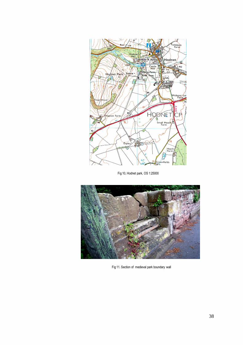
38
Fig 10, Hodnet park, OS 1:25000
Fig 11. Section of medieval park boundary wall

39
With their many scattered estates and military obligations, the aristocratic owners were seldom resident in one
place for long. Although there is documentary evidence that the Corbets enjoyed hunting, with so many parks at
their disposal, it seems more than likely that some were used to rear venison and to produce alternative sources
of income. This topic will re-emerge later in the chapter, but there is no doubt that the cost of maintaining deer
parks for purely recreational purposes must have been less viable at times when the Crown required the services
of the barons and their foot soldiers, together with their financial support, for the wars against France.
North Shropshire
A closer examination of the northern region of Shropshire, with its fertile plains watered by tributaries of
the River Severn, will aim to show whether these conditions offered a significantly different or more diversified
use of the deer park. It has already been pointed out that there was no Forest Law in north Shropshire, so no
royal licence was required to enclose a private park, and there were a considerable number created in this area
in association with castles. The latter may often have been built on the sites of earlier Saxon manor houses, or
were chosen for their proximity to the strategic town of Shrewsbury. Most owed their survival to the accessibility
of the river trading route, which along with the fertility of the land for agriculture and grazing made these popular
locations for post-medieval settlement. North-east of Shrewsbury between the valleys of the Rivers Roden and
Tern and the eastern boundary of Shropshire with Staffordshire, lay a group of medieval deer parks associated
with the important castles of Hodnet, Cheswardine, Adderley, and Shawbury, all of which were recorded by
Saxton as having deer parks that survived beyond the medieval period. It will be important in the context of this
thesis to discover to what extent the survival of parks in this area, their size and use, can be attributed to a
difference in terrain, and their association with castles at some distance from the Welsh border, or whether
ownership by prominent families was even here a determining factor in their fate.
The manor of Hodnet was evidently of such importance that Earl Roger de Montgomery retained it for
himself. When the Montgomery family forfeited their lands after the rebellion of Robert de Bellême, Henry I
endowed it as a seneschalship and subsequent tenants took the name of de Hodnet.125 A castle was raised
here in the late eleventh century, but by the early fourteenth century it appears to have lost all military purpose
and been abandoned; ruins of the motte lying within the grounds of Hodnet Hall are all that remain today. The
first mention of the deer park recorded by Cantor is in 1275 when Sir Odo de Hodnet received permission to
enclose two public footpaths, on condition that he replaced them with alternative routes round his park.126 This
suggests that he may have been suffering from poachers and was looking for greater security for his deer. The
park appears on Saxton’s map, lying west of the church but without any sign of a residence. The most recent
version of the OS map (Fig 10 ) shows the extension of the village street skirting a narrow strip of woodland
running south of the castle motte, which when examined on the ground appears to contain the stretch of park
boundary mound and ditch that is an English Heritage scheduled monument 127 (Fig 11). This confirms that the
125 Anderson, op cit. pp. 378-9 126 Stamper, Historic Parks & Gardens, op cit. p.6 127 HER Shropshire
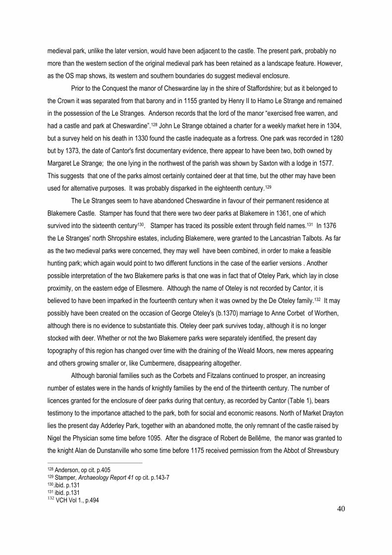
40
medieval park, unlike the later version, would have been adjacent to the castle. The present park, probably no
more than the western section of the original medieval park has been retained as a landscape feature. However,
as the OS map shows, its western and southern boundaries do suggest medieval enclosure.
Prior to the Conquest the manor of Cheswardine lay in the shire of Staffordshire; but as it belonged to
the Crown it was separated from that barony and in 1155 granted by Henry II to Hamo Le Strange and remained
in the possession of the Le Stranges. Anderson records that the lord of the manor “exercised free warren, and
had a castle and park at Cheswardine”.128 John Le Strange obtained a charter for a weekly market here in 1304,
but a survey held on his death in 1330 found the castle inadequate as a fortress. One park was recorded in 1280
but by 1373, the date of Cantor's first documentary evidence, there appear to have been two, both owned by
Margaret Le Strange; the one lying in the northwest of the parish was shown by Saxton with a lodge in 1577.
This suggests that one of the parks almost certainly contained deer at that time, but the other may have been
used for alternative purposes. It was probably disparked in the eighteenth century.129
The Le Stranges seem to have abandoned Cheswardine in favour of their permanent residence at
Blakemere Castle. Stamper has found that there were two deer parks at Blakemere in 1361, one of which
survived into the sixteenth century130. Stamper has traced its possible extent through field names.131 In 1376
the Le Stranges' north Shropshire estates, including Blakemere, were granted to the Lancastrian Talbots. As far
as the two medieval parks were concerned, they may well have been combined, in order to make a feasible
hunting park; which again would point to two different functions in the case of the earlier versions . Another
possible interpretation of the two Blakemere parks is that one was in fact that of Oteley Park, which lay in close
proximity, on the eastern edge of Ellesmere. Although the name of Oteley is not recorded by Cantor, it is
believed to have been imparked in the fourteenth century when it was owned by the De Oteley family.132 It may
possibly have been created on the occasion of George Oteley's (b.1370) marriage to Anne Corbet of Worthen,
although there is no evidence to substantiate this. Oteley deer park survives today, although it is no longer
stocked with deer. Whether or not the two Blakemere parks were separately identified, the present day
topography of this region has changed over time with the draining of the Weald Moors, new meres appearing
and others growing smaller or, like Cumbermere, disappearing altogether.
Although baronial families such as the Corbets and Fitzalans continued to prosper, an increasing
number of estates were in the hands of knightly families by the end of the thirteenth century. The number of
licences granted for the enclosure of deer parks during that century, as recorded by Cantor (Table 1), bears
testimony to the importance attached to the park, both for social and economic reasons. North of Market Drayton
lies the present day Adderley Park, together with an abandoned motte, the only remnant of the castle raised by
Nigel the Physician some time before 1095. After the disgrace of Robert de Bellême, the manor was granted to
the knight Alan de Dunstanville who some time before 1175 received permission from the Abbot of Shrewsbury
128 Anderson, op cit. p.405 129 Stamper, Archaeology Report 41 op cit. p.143-7 130.ibid. p.131 131 ibid. p.131 132
VCH Vol 1., p.494

41
to add part of Betton Wood to his park. Stamper suggests that this was possibly the park depicted by Saxton.
Shropshire HER refers to this as 'Betton Park', which may have been either a separate deer park or part of
Adderley. There is no documentary evidence to suggest how large Betton Wood may have been, but the
present Betton Hall lies some miles to the southeast of Adderley, with a series of ponds and fragments of
woodland lying within its boundaries. The 1881 OS map shows Adderley Hall set in a substantial park, with a
fishpond at its centre.133 This may have included the core of the medieval park.
Where more than one medieval park existed in close proximity to another, there is inevitably some
confusion, not least as to what role each played. Close to the western boundary of Hodnet lies Hawkstone Park,
created on a sandstone ridge and known today for its eighteenth-century picturesque landscape, which will be
discussed in a later chapter. Its first castle, Red Castle, was built on a spur of rock in 1227 by Henry de Audley,
Lord of the Welsh Marches, and Constable of both Shrewsbury and Bridgnorth. Subsequent generations of the
Audley family were known as "Lords of Red Castle". Salter suggests that Red Castle may have proved
unsuitable for residential use at an early stage due to its inaccessible site and was soon abandoned; it was
certainly described as ‘ruinous’ by Leland when he journeyed in Shropshire in 1540, although this does not seem
to have prevented it from housing a parliamentary garrison in 1645.134 Cantor records a deer park at Hawkstone
and at Red Castle, but there is no cartographic evidence of any park in the area before the eighteenth century,
when Rocque depicts a sizeable vineyard at Hawkstone. This is possibly the same vineyard that was previously
associated with the nearby estate of Hodnet, since it would be unusual to find two vineyards in the same area.
Creighton has found evidence of vineyards recorded in Domesday Book in some forty-five places. In the Anglo-
Welsh Marches these were generally less than two acres in size and close to estate centres or associated with
abbeys. Creighton suggests that in addition to their grapes, they were admired for their visual qualities, and after
the deterioration of the climate from the fourteenth century on, became ornamental rather than productive
features.135 In the case of Hawkstone, the vineyard may well have been an element of diversification within the
park. The ruins of Red Castle survive as a picturesque feature of Hawkstone Park.
The foregoing examples highlight the number of deer parks a single family might own, and how they
changed in size over time, sometimes two being absorbed into one, as is presumed at Blakemere. This appears
to be particularly prevalent on the northern Shropshire plains, where the early draining of the peat bogs of the
Weald Moors, which will be discussed in a later chapter, allowed the development of stock grazing and arable
farming. It is likely that economic pressures dictated new ways of using the park. Indeed, the need to increase
agricultural production for a population that was growing until the thirteenth century undoubtedly accounted for
the disappearance of some medieval parks in a region of predominantly fertile soils. But evidence assembled so
far shows that deer parks - even when relatively small - were considered an important aspect of the estate for the
medieval aristocracy, not least on account of the added status gained from rearing deer for venison both for the
household table and as a way of offering hospitality and gifts. In this respect, it did not really matter whether the
133 Stamper, Archaeology Report 41, op cit.,p.121 134 Salter, op.cit. pp.54-5 135 Creighton, op cit pp. 73-74

42
park was adjacent to the castle or lay on the outskirts of the manor, as many seem to have done. However, in
those cases where the deer park surrounded the castle, its aesthetic value was undoubtedly appreciated. Where
the castle survived beyond its defensive purpose, attention could be given to its refurbishment as a residence of
greater comfort and appeal.
South Shropshire
In those manors to the south and east of Shrewsbury, attacks from the Welsh became increasingly rare
over time and the raising of defensive castles less imperative. Within the hundred of Condover south of
Shrewsbury, settlement was most dense along the valley of the River Cound, a tributary of the Severn. This
closely settled area included the parishes of Acton Burnell, Frodesley, Longnor and Ruckley, and appears from
evidence drawn from the Shropshre Archaeological Archive136, together with an examination of sites on the latest
OS map and on the ground, to have almost certainly supported more deer parks than Cantor recorded. The
medieval residences in this region were often moated, rather as a sign of status than with any defensive purpose
in mind. Acton Burnell was the most important manor in the region, granted by Earl Montgomery to Roger
FitzCorbet , who raised a castle here. In the second half of the thirteenth century it became the seat of Robert
Burnell, who, as already noted above, came from a minor local family and rose to become one of the most
important men in England, chief advisor to Edward I and subsequently Chancellor of England and Bishop of Bath
and Wells. It suited the king to have such a powerful ally in the Marches, and in 1281 he was granted free
warren in the Long Forest. In 1283 a Parliament was held in the Great Barn adjacent to the castle. A year later,
as a further mark of the king's esteem, Burnell received licence to crenellate his castle. 137 It would seem that this
crenellation had no military purpose and was intended to raise the status of the residence. The associated deer
park is recorded by Cantor as dating from c.1270, when 40 acres from Cumbes Wood were imparked, and it was
increased by a further 60 acres in 1280. In order to encourage the entry of deer from the forest a deer leap was
constructed in 1283, and a further two by 1290.138 Burnell clearly intended this to be a prestigious park in line
with his newly achieved national status. It lay on the slopes of a hill within sight of the residence, and Burnell's
guests were probably encouraged to hunt, as well as to enjoy their host's venison. The park survives to this day,
although no longer stocked with deer.
It is perhaps not surprising to find a relatively small number of castles in this area, where the chances of
attack were small. The exception appears to have been in Corvedale, where there is evidence of early medieval
castles at Corfham, Broncroft, Holdgate and Millichope, although only the latter two were directly associated with
deer parks. The role of these castles was most probably to defend this important route from Wales. Aside from
this small enclave, the medieval deer parks of South Shropshire are more often part of an extended estate. One
of these was Frodesley Park in the hundred of Condover, the property of the Corbet family, first recorded by
Cantor in 1404 although almost certainly existing earlier. Like Acton Burnell, Frodesley originally lay within the
136 HER Shropshire 137 Stamper, Historic Parks Gardens, op cit. p.15 138 VCH Vol 8 p. 3

43
Long Forest. Domesday Book reports sufficient woodland in the parish for 100 swine, and there were 3 other
enclosed woods. The VCH suggests that the Heypoll and Over-Heypoll woods of 1419 can be identified today
by the field names Hay Pool and Middle Hay Pool. In 1235 it was reported that a thousand tenants were
squatting in Frodesley Wood and many thefts of wood were reported in the fifteenth century. In 1248, when it
still belonged to the Corbet family, there was a “lord’s wood, a fenced park, and a common wood ”.139 This would
suggest an enclosure for deer, distinguished from one for protected timber, and another supplying underwood
for fuel.
One of the most significant deer parks in this region, in the context of this thesis, was Longnor Park,
created in the north eastern part of Micklewood, granted to the lord of Longnor Roger Sprenchose in1221 and
enclosed as a deer park shortly after 1333 when a grant of free warren was obtained. The park was first named
in a lease of 1538140, which may explain why it was not included by Cantor. The Shropshire HER suggests that
the park lay a mile east of Longnor village on the site of Park Farm, formerly Lodge Farm. This however is
almost certainly the lodge of Frodesley Park (see above) and the confusion probably arises due to an early
blurring of the boundaries between Longnor and Frodesley.141 In the course of the following chapters, evidence
will be brought forward to show that a deer park has survived in association with Longnor Hall, albeit in different
forms and locations, from medieval times to the present day.
Changes in medieval boundaries have often made it difficult for later scholars to distinguish between
neighbouring parks, particularly where they were owned by the same family. In the Middle Ages, the parish of
Ruckley and Langley was separate from that of Acton Burnell, but in the sixteenth century it became absorbed
into it, creating some confusion as to the status of Langley Park. Although shown on Saxton’s map of 1577, it is
not included by Cantor. According to the VCH, it was first recorded in 1249, although as it was not mentioned in
any later thirteenth-century surveys it may have been revived in 1319 after a period of disuse, when a grant of
free warren was obtained. The manor of Langley was owned by the Burnells until c.1617 when Humphrey Lee
acquired the manor of Acton Burnell, and Langley became part of that estate.142 Earthworks surrounding the
surviving gatehouse of the sixteenth-century Langley Hall suggest an earlier site, possibly that of the medieval
deer park although this is no more than speculation.
Cantor records several other deer parks in the south of the county in the vicinity of Ludlow that were not
associated with a castle, including Woofferton, Burford, and Onibury. However, there is no evidence of their
survival beyond the medieval period, and they do not appear on any later maps. Stamper has found that
Geoffrey de Cornwall had a deer park at Burford in 1365. Some remnant of this may have survived, since when
the house was sold in 1720 to William Bowles of Vauxhall Glass works, he understood that the estate included a
deer park. Six years of litigation ensued when he discovered that this was no longer the case.143 The site of
Woofferton park lies in what is now an agriculturally developed area with a transmitting station built over much of
139 VCH Vol 8 p.80 140
ibid., p.99 for grant of free warren, see Cal.Chart.R. 1327-41, 292. Lease of 1538, see SRO 567, lease 1538 141 VCH Vol 1, p.79 142
VCH Vol 8 p.141 143 Stamper,(1993 Report) op cit. p.17
44
it. Nevertheless the boundaries of a former park can be traced through the survival of most of the 400m. stretch
of the medieval bank and ditch. In the south this exists at full size, up to 9m.wide x 1m. high. There is
documentary evidence in the Calendar of Patent Rolls 1334-8 to show that Joan Talbot had a park here in 1337
when the theft of deer and other game was reported. The present day Park Lane marks its northern boundary.144
The fate of Onibury deer park is unclear. The manor was granted to Roger de Lacy by the Bishop of Hereford.
After Lacy was banished in 1095, his successors continued to hold the manor until it was claimed by Philip
Burnell, a nephew of Robert Burnell. Cantor produces evidence of a licence to impark dating from 1266. There is
still a fragment of woodland lying on a hill to the north of the village, and a house called Upper Park may offer a
possible clue as to the former location of the park.
Moving east of Ludlow towards the Wyre Forest, a park is recorded by Cantor at Cleobury Mortimer that
is mentioned in Domesday Book as having “a wood capable of fattening 500 swine”. As mentioned above, it
appears to have been enclosed as a private chase by the Mortimer family in the 1270s. Stamper has found
evidence that in 1328 a pack of 86 hunting dogs were maintained here, and by 1331 there was probably a
separate rabbit warren and certainly a lodge 145. This clearly points to the use of the park for hunting deer within
a private enclosure in the king's forest, probably for both recreation and the provision of venison for one of the
most important families in the region. It was still being maintained in 1662 when some 4300 yards of pale were
renewed, although by this time it seems that parcels of land were being leased out and its role as a deer park
had ended. 146 Possible clues as to the original location of the park may be inferred from the whereabouts of
Nailings Coppice, Cleobury Coppice, and Keeper’s Cottage. The park appears to have been located at some
distance from the supposed site of one of Mortimer’s castles, which was destroyed after he fell from power.
As we have seen, the majority of the Mortimer manors lay in the southern half of the region. The manor
of Kinlet, lying between Bridgnorth and Cleobury, appears to have been granted to the family along with
Cleobury Mortimer. From 1295 there was at least one deer park, and in 1308 there is mention of ‘Wopark’ and
‘Old Park’, both of which are presumed to have lain south-west of the hall.147 Once again, this would seem to
suggest that the two parks served different functions, perhaps one was reserved for timber and the other for
deer. Kinlet Hall was rebuilt in 1727 and the hall that survives today is occupied as a school. It includes a hill
bordered by a stream lying north of the village of Kinlet, with a Keeper’s House adjacent to a pond. Kinlet Park,
as marked on the present day OS map, lies to the south of this and further to the south lies Park Farm. Taken
together, these isolated factors suggest a more extensive earlier deer park.
As already noted, the Shropshire HER website lists 45 medieval deer parks in Shropshire, less than
Cantor's 57 but including 12 that he does not mention, and to which a further four may be added creating a total
of c.73, without taking into account the incidences where more than one park appears to have existed, as at
144 HER Shropshire. 145Stamper, Report 1993 op cit.p.7 146 www.shropshirehistory.org.uk op cit. 147
Stamper op cit.p.61
45
Blakemere, Stapleton and Kinlet. These have been left out of the calculation, due to lack of evidence surrounding
their actual use. Some medieval parks, such as Hem Park south of Oswestry appear to have existed for only a
short period or to have been absorbed into a later park.148 Others, such as those at Loton, Oteley, and Longnor
have survived in various forms to the present day. The evidence of the foregoing section does not suggest that
the differences in terrain from north to south of the county, whether in soil profile or altitude, had a significant
bearing on the survival of the medieval deer parks (Fig 5). There were certain exceptions. As already noted, the
draining of the Weald Moors in the northern plains, and the changing profile of the meres, was almost certainly
instrumental in the disappearance of Lubstree park and its division into agricultural holdings. However, high
barren ground, such as that of the Stiperstones and Stretton hills in the south of the county, did not preclude their
use in the post-medieval era as hunting grounds or as breeding grounds for deer. One feature worth noting is the
greater predominance of wooded parks in the south, where the Long Forest - the location of several deer parks
including Frodesley, Acton Burnell, Langley and Longnor - survived into the thirteenth century. Areas of
woodland from one of the longest surviving forests, Morfe Forest, still visible today, account for the wooded
nature of Cleobury park enclosed within the forest itself, which survived into the eighteenth century, albeit without
deer. On the other hand, parks located in Corvedale, such as Earnstrey, Earnwood and Oxenbold, had a
seemingly short life, although this may well prove to be due to political events of the sixteenth century. Indeed,
the evidence put forward so far seems to confirm that political, social and economic events were more significant
than geographic factors in the survival of the medieval deer park.
It has already become apparent that those castles in closest proximity to the Welsh border were not
only in greatest danger of attack, but likely to become redundant as the threat from the Welsh diminished. In
such cases, an associated deer park could be expected to disappear; however, it has been shown that some
parks, notably those of Shrawardine and Rowton, continued to be maintained long after the castles were in ruins.
The reasons for this were almost certainly economic, the parks forming part of a larger agricultural estate. One of
the most striking features of the evidence put forward is the number of parks that might be owned by a single
family, and sometimes, as in the case of Blakemere, Frodesley, Kinlet, Red Castle, located within the same
parish. Such parks were undoubtedly used for different purposes and for the variety of resources that they
provided. Hoppitt has stressed the importance attached to preserving valuable woods and grassland for their
economic value, and imparkment was one way of achieving this.149 It is also important to remember that deer
were not the only animals to be reared in enclosures, which also contained warrens for rabbits or pheasants,
grazing for pigs, and even studs for horses. Stamper has shown that all the parks belonging to the FitzAlans
contained studs, including Clun Castle where more than 160 horses were being grazed within the forest in 1328.
These would have been of great value in times of war. At Myddle, where the LeStranges were overlords, 24
mares and 16 colts together with 80 oxen were stolen from the park in 1315. Stamper also suggests that there
was a warren for rabbits, hares and pheasants within the deer park at Woofferton by 1337.150 It seems likely,
148 HER Shropshire 149 Hoppitt, R., op cit., p.278 quoted Mileson op cit. p.5 150 Stamper, Historic Parks and Gardens, op cit. p.7

46
therefore, that many of the parks referred to in this chapter owed their survival to some form of alternative use, in
addition to or even instead of stocking deer.
Nevertheless, the use of medieval parks for hunting should not be underestimated, particularly where
the owner was a person of high standing, eager to demonstrate his status to neighbours and guests. As already
noted above, John LeStrange actually enlarged his park at Ruyton in 1195; while Robert Burnell of Acton Burnell
increased his park by a further 60 acres in 1280 ,151 suggesting that these particular parks were still being used
for hunting. However, while Mileson states that the prime purpose for the creation of deer parks was the love of
hunting in both its physical and symbolic roles, 152 it was probably only the most prestigious manors that
supported a deer park as hunting ground. Stamper has suggested that most of the parks created between 1270-
1310 in Shropshire were small, ranging from fifty to one hundred acres. However, this does not automatically
exclude them from some form of hunting activity since there were various different ways of hunting, ranging from
the hunting of deer on horseback in open spaces to the ritual chasing of a single animal raised by hounds in an
enclosure. Taylor has suggested, based on archaeological evidence, that coursing was introduced in medieval
times on a dedicated track (or 'course') at a variety of sites in the Midlands, including Helmdon and Harringworth
in Northamptonshire, Bredon Park (Leics.) and Ravensdale in Derbyshire.153 Although no evidence of medieval
deer courses has been confirmed in Shropshire, there is no doubt that deer hunting increasingly became a
spectator sport, as the following chapter will show. Nevertheless, it seems likely that many of the smaller parks
were used as deer reserves – to provide fresh meat for the house and to keep royal forests and chases stocked
with deer. In spite of the presence of other grazing animals introduced to generate income, the importance of
venison for the medieval aristocratic or knightly household, in terms of the prestige it offered, cannot be
overstressed. Grazing domestic animals, wild swine, and rabbits may well have existed alongside deer, which
together with supplies of timber and coppice, not only satisfied the needs of the household but also helped to
generate the income needed to maintain the park. This economic aspect of the deer park became increasingly
important towards the end of the Middle Ages, when agricultural activities and demesne incomes suffered from a
severe fall in population. The maintenance of deer parks was a part of estate management, not only among
aristocratic owners but also undertaken by the many religious houses of Shropshire.
Religious houses - their acquisition and use of deer parks
Although the Marcher lords and their tenants were the principal owners of medieval deer parks in
Shropshire, there is evidence confirmed by Cantor that bishops and monastic houses also had an interest in
acquiring them. It is important to consider this aspect of medieval deer park ownership, since at the time of the
Dissolution of the Monasteries, their land became available to aspiring gentry and members of surviving
aristocracy who were frequently responsible for the revival of medieval deer parks and the creation of new ones.
Although some monastic orders were strictly forbidden to hunt, there is little doubt that many of the abbots
151 Stamper, Historic Parks and Gardens, op cit, p.6 152 Mileson, S. op cit. p.30 153 Taylor,C., 'Ravensdale Park, Derbyshire, and Medieval Deer Coursing', Landscape History 26, (2004) p.49

47
enjoyed the sport, together with the meat it provided.154 For the many religious houses, Benedictine, Cluniac,
Cistercian and Augustinian, founded in Shropshire after the Conquest as dependencies of monastic houses in
France, a deer park represented a significant economic resource. In addition to supplying venison, it provided
timber for building and underwood for fuel. Where there was no woodland, pasture-based parks also brought in
additional revenue, with stock being bought and sold for meat and wool.155
Shrewsbury Abbey was re-founded as a Benedictine monastery by Earl Montgomery in 1083156. Its
estates reverted to the Crown after the revolt of Robert de Bellême in 1102, and were subsequently gifted out.
The abbot of Shrewsbury appears to have obtained a licence to impark part of Lythwood forest, where in 1324
the monks were accused of neglecting the 'haye'. This is an earlier date than that recorded by Cantor as 1346.
Although as already noted, Lythwood was a royal hunting forest, it seems more likely that the abbot wished to
make use of the quality timber for which the forest was renowned.
The only other pre-Conquest foundation in Shropshire was St. Milburga’s monastery at Wenlock. Earl
Roger de Montgomery re-founded it between 1079-82 as a Cluniac priory dependent on La Charité-sur-Loire,
and it subsequently held substantial property in the Clee Hills and Corvedale. During the thirteenth century
extensive rebuilding of the monastery took place, with Henry III providing timber from the royal forests. Wenlock
also increased its lands by assarting in the royal forests of Shirlett and Wrekin, setting up outlying granges such
as Harnage Grange in Condover hundred.157 In 1251 land was imparked at Oxenbold, as recorded by Cantor,
who also notes that the Prior of Wenlock was awarded a licence to impark at Madeley in1283, the park being re-
stocked with deer gifted by the king in 1290, which suggests that royalty actively encouraged the ownership of
deer parks by religious houses. This park continued to be mentioned in Extents in 1370 when the underwood
was cut, and again in 1379.158 By the fourteenth century, however, the parks at both Madeley and Oxenbold
appear to have been reduced, and were reported as being barely sufficient to support animals. Later accounts
refer to the early development of a coal mine at Madeley mentioned in the ‘status domus’ of 1390.
Religious houses enjoyed a great deal of freedom in managing their affairs, being largely exempted
from the taxes imposed on secular landowners. The Cistercian Abbey of Buildwas, founded as a daughter
house of Savigny in 1135 by Roger de Clinton, Bishop of Chester, was small and poor, the monks living in
wooden buildings. By the middle of the twelfth century, however, the abbey was able to expand and undertake
building in local sandstone. A grant of 30 oaks from the Forest of Shirlett was made by the king to enable the
repair of the church. 159 There is no mention of a deer park at Buildwas by Cantor, nor is any recorded on later
county maps, although an estate map of 1650 shows that one was in place by the middle of the seventeenth
century.160 It seems likely that the abbot may have taken advantage of the estates that the abbey had acquired in
154 Pastoureau, E., L'Ours, histoire d'un roi dèchu, suggests that the medieval Church actively encouraged the hunting of deer rather than bears, as being less likely to promote bestiality and licentiousness! 155 Mileson S. op cit. p.65 156 Shropshire Archaeological & Historical Society, 2002, p.15 157 VCH 2, pp.43-44 158 Philpotts, C., ‘Madeley Court’, TSAHS, Vol. LXXXI 2006 159 VCH 2, op cit. pp 50-58 160 SA6344B

48
the early thirteenth century on the Stiperstones and in the hills east of Stretton, where the high-lying wasteland
and moor might well have supported both deer and sheep. In 1264 the monks of Buildwas were selling wool to
Flemish merchants and shipping it down the Severn to Bristol. By the end of the Middle Ages, they were
operating a small iron forge on their land.
Firmer evidence of imparking exists in the form of a licence granted to the Abbot of Haughmond in
1297, 161 quoted by Cantor. This Augustinian abbey is believed to have first been founded during the reign of
Henry I. It was re-founded and given the status of an abbey between 1135-1155, endowed with generous gifts
by the LeStranges and the FitzAlans for whom it was a family monastery. Henry II allowed the monks to assart
around the abbey where they maintained a large park that survived into the eighteenth century. Haughmond
was supported by powerful local lords throughout the Middle Ages,162 and a surviving cartulary enabled Cantor to
identify some of the abbey's outlying acquisitions. Merrington park, north-west of Shrewsbury, was granted to
Haughmond by Robert le Girros in the 1240s, together with the rest of his manor; by 1335 all that remained of
the park was Merrington Wood.163 Crees park (Leebotwood), lying on the edge of the Long Mynd, was set up as
a grange of Haughmond in c.1255. As far back as 1175 Henry II had granted the monks pasture there for their
horses.164 But by 1372, the abbot had leased out his park at Crees to Edward Acton.165 Such evidence is
beginning to show that outlying monastic parks were already becoming untenable in the early fourteenth century.
A colony of canons from Dorchester established the Augustinian abbey of Lilleshall between 1145-48.
They belonged to the order of Arouaise that had adopted a strict Cistercian discipline, and Lilleshall offered what
is described as " a secluded site, with ample woods, and 10 hides of arable land that had been under cultivation
since before the Conquest."166 They were given royal approval by King Stephen, and consequently held the
status of a royal foundation. The abbey lay on the edge of an extensive stretch of marshland northeast of
Shrewsbury known as the Weald Moors. By 1086 Domesday Book records that Godebold the Priest had
enclosed a large area of high ground on the edge of the Moors.167 By 1198 the canons of Lilleshall were paying
20s. a year to cultivate a moor near the abbey. The name of Lubstree Park (not mentioned by Cantor) is first
recorded in 1283 when the Abbot of Lilleshall was granted the right to hunt deer there.168 The abbey estates
were fragmented and scattered, and the abbot attempted to bring them together by exchanging land with other
foundations. Walter de Dunstanville granted the abbot pasture rights in Lizard Wood at Burlington in return for
rights in Lilleshall Wood. By the early fourteenth century the abbey of Lilleshall had acquired serious debts, in
line with many other monastic foundations. Injunctions dating from 1347-50 state that “the woods were being
wasted recklessly. The abbot was ordered not to give away more than 2 oak trees a year as timber; in particular
161 VCH 1, p.493 162
VCH 2, p.60 163
HER Shropshire 164 VCH 2, op cit., p.70 165
Stamper, P.Report 1993 op cit. 166 VCH 2,. op cit., p.76 167 Rowley op cit. p.169 168 HER Shropshire

49
he was warned that he should not allow trees fit for timber to be burned for charcoal.”169 In the previous decade,
cow disease had killed many of the monastic cattle, while workers and tenants were victims of the Black Death of
1348. In 1351 the king granted custody of the abbey to William of Shareshull, a Justice of the Pleas who was
seeking to establish himself as a country landowner.170 He may well have been responsible for maintaining the
deer park, lying north and south of the abbey, later shown on Saxton's map. The large area marked as Kinges
Wood lying south of the enclosed deer park almost certainly refers to the former royal forest.
This brief survey of monastic holdings cannot be concluded without mention of the late twelfth-century
foundation by the FitzAlans of St. Leonard's in the Forest of Brewood of a retreat for Augustinian canonesses,
supervised by the Bishop of Lichfield. Later known as Whiteladies, it lay close to the manor of Boscobel. Many
local landowners gifted the foundation with lands as far away as the Clee Hills. Indeed, the fact that the abbeys
and priories held so many scattered manors reflects the close relationship that existed between the monastic
foundations and their founders. During the Middle Ages there was a firm belief that the soul would remain in
purgatory unless prayers for the dead were said on a regular basis by the living. Hence, the importance of
setting up chantry chapels and gifting money to the church for masses to be held after death. For this reason, the
abbots and priors held a powerful position in medieval society, even if they did not always live according to the
Church's rules. Of particular interest is the warning received at Whiteladies in 1338, when there were five nuns
in addition to the abbess, requiring them to be "less extravagant in dress and to give up hunting and keeping
hounds."171 Whether the nuns were actually hunting themselves, or keeping hunt servants for the purpose, it is
clear that deer were as important to clerics as they were to the aristocracy. This did not, however, make them
good managers of their estates. Many appear to have accrued enormous debts, presumably through profligacy
as well as mismanagement. When times were good, they were able to rely on the sale of timber and coppice
wood from their parks, and wool and meat from their pasture lands, but by the end of the Middle Ages and well
before the Dissolution, their outlying deer parks were no longer economically viable, and many were divided and
sold off to small farms. This appears to have been particularly true in the south of the county, where the abbot of
Wenlock had acquired so many small parks. The disappearance of most of those in Corvedale - Oxenbold,
Earnstrey, Earnwood - can almost certainly be attributed to these circumstances.
Designed landscapes?
Since the question of continuity and the survival of the deer park from medieval times lies at the heart of
this thesis, it is important to consider at what point the park may have formed part of a more aesthetic approach
to the landscape. Evidence presented so far concerning the relationship between the medieval deer park and its
associated residence suggests that although the park was sometimes adjacent to the residence, it was more
often located at some distance, often on the edge of the manor or on high ground unsuited to cultivation. The
following pages will consider the case of three important castles that have been associated with what certain
169 VCH.2 op cit.,p.77 170 ibid. pp 76-78 171 ibid., pp. 83-84

50
scholars have called ‘designed landscapes’, a term used to describe a perceived aesthetic relationship between
the medieval residence and artefacts such as deer parks, dovecots and fishponds. Particularly relevant to this
debate is the distinction made by Liddiard between the ‘Little Park’ and the ’Great Park’, suggesting that the
former was possibly a pleasaunce as opposed to the “more utilitarian ‘Great’ parks, which were usually at some
distance from the castle itself.”172 In the case of Shropshire, these terms are seldom used; at Stapleton, however,
it is suggested in the HER archive that "Great Park" and "Little Park", located in the north and south of the parish
respectively, referred simply to their comparative size.173 An example of a pleasaunce and deer park apparently
overlooked by Cantor, was adjacent to the medieval castle of Holdgate in Corvedale, named after Helgot who
raised a motte and bailey here shortly after the Conquest. This appears to have been a residence of some
importance, since Henry I was received here in 1109. During the reign of Edward I the castle was granted to
Robert Burnell of Acton Burnell who built a more substantial stone residence within the bailey, one of the towers
surviving to this day as part of a later farmhouse.174 The HER has recorded evidence of a garden here by 1292,
together with two deer parks surviving in 1428.175 Although the ruins of the castle are still visible along with those
of the medieval village, the only indication of the deer parks may lie in the name of The Leasowes. One can do
no more than speculate as to how the two parks were differentiated, or how they related to the residence. But
given the known existence of the early garden, we may be looking at an example of a 'Little' and 'Great' Park as
defined by Liddiard.
In the case of Clun Castle, lying to the west of Ludlow, the reference to a ‘little park’ has been noted by
Creighton.176 Clun was an important medieval castle close to the Welsh border that would seem to have
warranted a deer park. However, being located on the edge of Clun Forest (one of the last forests surviving into
the nineteenth century), there were plenty of opportunities for hunting. It was held by the FitzAlans as their main
seat (caput), until in 1289 they became Earls of Arundel in Sussex. In 1216 the castle was besieged by the
forces of King John, and a few years later in 1234 the entire town was burned by the Welsh. The surviving tower
keep together with the curtain wall round the motte date from the later thirteenth century when, Stamper
suggests, the FitzAlans probably remodelled the castle to transform it into a recreational residence, possibly a
hunting lodge. This refurbishment included one of the very few early examples of a water garden in what might
be considered a relatively modest residence, referred to in 1301 as the Little or Small Park. 177 The standing
ruins are believed to have been the lodgings block that would have provided suitable accommodation for royal
visitors such as Edward I who visited in 1295 and Edward III who came to hunt in 1362, presumably both kings
taking advantage of the resources of Clun Forest. By that time the FitzAlans had their principal residence at
Arundel, and although the buildings were well maintained until 1440 they were seldom used by the family. The
royal visits may well have prompted the creation of a pleasure garden, with a large water feature where family
172 Liddiard, Castles in Context, op cit. p.113 173 HER Shropshire 174 Salter, Mike op cit p.36 175 HER Shropshire 176 Creighton, op cit. p.92 177 Stamper,Historic Parks & Gardens, op cit. pp.7-8

51
Fig 12. Aerial View of Clun Castle and garden earthworksStamper 1996
Fig 13. Clun Castle & Clun Forest to west, Saxton 1577
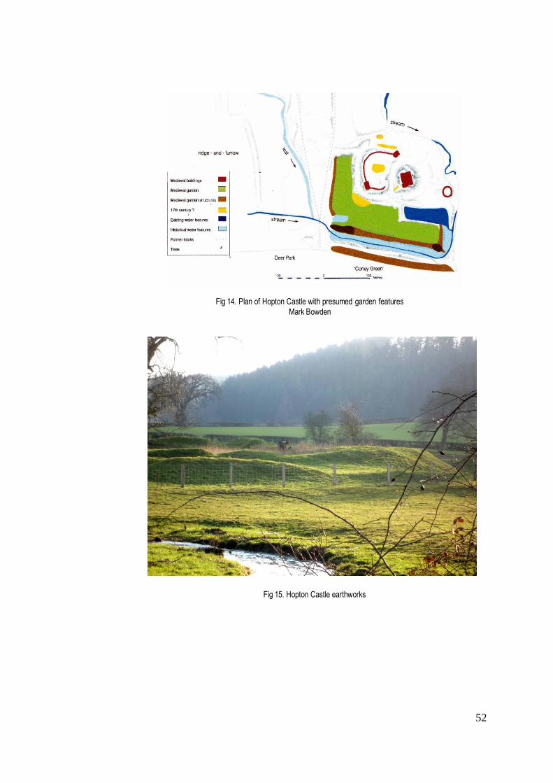
52
Fig 15. Hopton Castle earthworks
Fig 14. Plan of Hopton Castle with presumed garden features
Mark Bowden

53
Fig 16. Hopton Park, Tithe Award Map 1848, copied Foxall
Fig 17. Hopton ‘landscape’ and park, looking west from castle

54
and guests would have come to fish. 178 However, given that the castle was frequently under siege, attacked by
Roger Mortimer in the early fourteenth century and again by Owen Glendower in the early fifteenth,179 together
with the fact that the FitzAlans were seldom in Clun, it is probably unlikely that the garden survived very long.
An aerial photograph, taken for Clwyd-Powys Archaeological Trust , shows a ditch to the south (north in the
image) together with two rectangular ponds (Figs 12 & 13) that have been compared with the pleasaunce
created for Henry V at Kenilworth.180 Water features, as Creighton has pointed out, appeared at many royal
palaces at the end of the thirteenth century, 181 and could be seen in his view as a manifestation of a competitive
culture, a sign of status in much the same way as the deer park.182 Although not recorded by Cantor, an
enclosure was almost certainly created within Clun Forest at some stage, because in 1328 Clun Park (an
enclosure within Clun Forest) was recorded as holding 160 horses.183 Like other parks in Shropshire with
suitable grazing, it may well have had more than one function and been used to raise deer with which to stock
the surrounding forest which was used as a royal hunting ground.
Lying to the south-east of Clun surrounded by hills, are the ruins of Hopton Castle, recently restored
with funding from English Heritage and a private trust. The site is of particular interest to this study because in
2005 the AS&I (Archaeological Survey and Investigation) team undertook an analytical survey of the castle
including the extensive surrounding earthworks (Figs 14 & 15). The aim was to put the castle into its "landscape
context", and with this in mind, Stratascan carried out a resistance survey, a magnetic survey and Ground
Penetrating Radar investigation. English Heritage concluded that this was an early fourteenth-century fortified
tower residence, probably raised by Walter Hopton, a member of a family of socially aspiring lawyers and
courtiers who held the manor at that time. There was almost certainly an earlier motte and bailey or ringwork
castle on the site in the twelfth century, possibly built on a pre-existing prehistoric site of which there are many in
the immediate area. The inner bailey of the surviving castle was enclosed by a stone curtain wall and the outer
bailey was L-shaped with a series of fishponds. The 2005 Survey suggested that there were structures of an
industrial nature (forge? mill?) within the bailey. Mark Bowden, who has written up and published the findings of
the Survey for English Heritage, goes much further in his interpretation. Making reference to recent proposals
about Bodiam Castle, he suggests that “a great tower of such architectural pretension demands…a
contemporary designed landscape.” This, he believes, lay beyond the bailey to the west and south where there
is archaeological evidence of an L-shaped enclosure defined by three ponds created from the stream. Bowden
takes his argument further, drawing attention to Hopton Park to the south and Hopton Heath to the east (both
appearing on the contemporary OS map) as sites of two deer parks, with ‘Coney Green’ to the south with a
series of pillow mounds providing evidence of a rabbit warren. He writes: “The layout of this landscape probably
178 Stamper, Historic Parks & Gardens, op cit., p.8 179 ibid.,p33 180 HER Clun Castle 181 Creighton, op cit. p.61 182 ibid. p.11 183 Stamper, op cit. p.7

55
involved the creation of a ‘correct’ approach to the Castle for high status visitors” 184 although there is no
evidence to substantiate this proposal. This seems to me to be the result of ‘wishful thinking’ influenced by
current trends. Creighton has read a great deal into the plan reproduced in Bowden’s Report, also suggesting
that the ‘rectilinear walkway’ round a series of ponds might have been part of a planned access route.185 Given
the turbulence surrounding the opening years of the fourteenth century, and the activities of Roger Mortimer, a
not too distant neighbour, it is difficult to imagine who would have planned such a route, and for what reason.
Creighton appears to have destroyed his own argument when he writes a couple of pages earlier: “’Design’ as
such was not an authentically medieval concept.” 186 As Williamson and Liddiard point out, design presupposes
a designer with access to an overall concept and the ability to represent it.187 A map of c.1751 by Emanuel
Bowen that is part of the King’s Topographical Collection housed in the British Library shows a deer park
surrounded by a pale.188 If, as Stamper has suggested, there is no record of a deer park here before 1695
subsequent to the destruction of the castle in the Civil War, the park that lay on the hill to the west was almost
certainly post-medieval. However, Foxall's rendering of the Tithe Awards for Hopton (Figs 16 & 17 ) shows that
'the park', located on rising ground, would have been clearly visible from the castle tower, suggesting that the
park may have existed earlier. To carry speculation even further, its form raises the possibility that it might have
contained a deer course. However, the archaeologist who worked on the restoration of the castle, Richard
Morriss, insists that the garden is of post-medieval origin, probably created to emulate the work of a superior lord
(FitzAlan) at nearby Clun Castle.189 In this case, the landscape of Hopton Castle, including its deer park, seems
to have been achieved through accretion, and the ‘landscape design’ proposed by Bowden and Creighton
reflects the aesthetic considerations of the post-medieval period.
Whittington Castle deserves special mention here, due to its unusual continuity as a site, and the
ambiguities surrounding its garden and its relationship to a deer park. Archaeological remains spanning many
centuries were the subject of an archaeological survey in 2001. Whittington was the principal seat of a Fulk de
Warine ( later Fitzwarren) over ten generations, all the descendants bearing the same name, and its history and
layout, including the garden and deer park, have been researched by English Heritage and published in a
comprehensive guide book for visitors to the castle ruins.190 The location chosen for Whittington Castle was a
stretch of low-lying ground surrounded by marsh, a short distance east of the border town of Oswestry, which
may well have been the site of an earlier deer park. A natural spring not only provided constant fresh water for
the inhabitants, but was also sufficient to create a moat and other early water features that formed part of the
context. Archaeological excavations have shown that the defensive ditches lying to the south and west were part
184 Bowden, M., ‘Hopton Castle, Shropshire’ EH Research News.3, Spring 2005 185 Creighton, op cit. p.221 186 ibid. p.219 187 Liddiard & Williamson, ‘There by Design?’ Archaeological Journal 165, 2008 p.532-3 188 BL King’s Topographical Collection XXXVI-1-32 Map of Shropshire c.1751 by Emanuel Bowen 189 Morriss, R., archaeologist for EH, "pers. comm." 2010. 190 EH, Whittington Castle Guidebook (Whittington Castle Preservation Trust 2003) for historical and archaeological information included in the following paragraphs.

56
Fig 18. Whittington Castle archaeological plan of presumed garden features (EH 2003)
Fig 19. Whiittington Castle view to moundFig 20, Rendering of C17th map of Babbinswood &
Whittington
(north and south reversed)
EH 2003 from map in National Library of Wales,
Aston Hall Deeds 2777

57
of an earlier ditched enclosure that is believed to date from the Iron Age,191 providing clear evidence of a castle
having been raised on a pre-existing site. All that had to be done when the medieval castle was built in the early
twelfth century was to re-cut the ditches, which over the course of time had filled with silt. The marshland to the
north was allowed to remain a bog, serving as an additional defence. The forest of Babbinswood to the south
provided the timber needed for construction and subsequently for fuel. This was probably the league of wood
recorded in Domesday Book where the manor of Whittington was attributed to Earl Roger de Montgomery,
having been held by King Edward prior to 1066. The castle was almost certainly rebuilt by Montgomery for
whom the site would have been of considerable defensive significance in this frontier area in the northwest
corner of Shropshire. It seems that the early twelfth-century castle was an earthen motte with a timber tower,
comparable to others in the region. After the disgrace of Montgomery’s son Robert de Bellême, the castle was
granted by Henry I to William Peverel , who in 1138 fortified it on behalf of the Empress Matilda. By the later part
of the twelfth century the timber tower had been replaced with a substantial rectangular stone keep. In 1160
Whittington was once more under royal control, and four years later Henry II granted it to Roger de Powis192 . In
1204 Fulk FitzWarren III, one of the most colourful figures in the Barons’ Rebellion, finally acquired the castle
and manor, and in 1221 was granted leave to strengthen the defences of the castle although “not stronger than
was necessary against the Welsh, or than it was before the Barons’ War”.193 It was not sufficient to resist capture
by Llwellyn two years later. By the time Fulk VI succeeded to Whittington in 1315, the defensive role of the castle
was superfluous and it could be refurbished to provide better accommodation. A huge amount of rebuilding took
place, transforming the castle from a medieval fortress into a desirable residence, with a court house in the south
tower of the gatehouse. The great hall was rebuilt and a garden created by dividing the outer bailey with a water-
filled ditch. This garden has never been excavated, but the geophysical survey undertaken in 2001 identified the
outline of a garden beneath the surface. Based on an excavation of the ditch, English Heritage has attributed it
to the early fourteenth century194 which would make it contemporary with the garden at Clun Castle, although the
results of the survey suggest a more simple outline, perhaps no more than a kitchen garden (Fig 18). The first
mention of a garden dates from an Inquisition of July 1330 which states: “There is a certain house contained in
the Castle which is worth per year in houses gardens cartilages fruits herbage and all receipts five shilling. There
is certain old and ruinous dovecote worth 11d”.195 Whatever was happening to the garden, the bellicose
FitzWarrens were greatly preoccupied with fighting in France. Disaster struck in 1350, when Fulk VIII, still a
minor, died of the plague. An Inquisition of 1378 recorded: : “The castle is of no net value, but is in great need of
191 EH Whittington Castle Guidebook, op cit., p.7 192
- a controversial appointment since the lordship of the manor was vigorously disputed by Fulk FitzWarren I who had
married the niece of William Peverel . Hence his claim to the lordship, which he and his descendants unsuccessfully pursued until Fulk FitzWarren III was granted castle and manor in 1204. 193 EH Whittington Castle Guidebook op cit. p.7 194 ibid., p.24 195 ibid., p.25

58
repair. There are two gardens worth 5s. yearly.” No evidence has been found of a second garden; by 1392 the
castle is described as being ruinous.196
The question of the garden and its relation to the main residential part of the castle and to the deer park
is worth considering in more detail, particularly in light of Creighton’s suggestion that Whittington Castle was
“transformed from a border stronghold into an elite residence at the heart of a designed watery landscape” (my
italics).197 English Heritage concurs to some extent with this view, explaining the unusual alignment of the
rectilinear garden features as having been ‘designed’ to be seen from a viewing mount to the southeast of the
garden. (Fig 19). Evidence for the mount being contemporary with the garden is purely circumstantial, based on
the fact that the castle being ruinous by 1392, there would have been no motivation or money to construct the
mount later. Creighton himself recognises that a garden viewing mount was more often a feature of the sixteenth
and seventeenth centuries, and suggests that here we are looking at “the re-use of the motte of Whittington
Castle as a viewing mount”.198 There is some dispute as to whether this was indeed the original motte, but if this
is the case, and it seems to be plausible, then the twelfth-century rebuilding of the castle took place on an
adjacent but nevertheless different site from the earlier motte. With regard to the construction of a series of
views to be seen from the mount (to which the EH guide refers), it might indeed have been possible to see both
the garden and the deer park to the north from this vantage point, but given the uncertainty surrounding the
earlier use of the mound, it seems unlikely that the landscape was planned as a total entity in the fourteenth
century.
A deer park is first recorded by Cantor at Whittington in 1331. It would appear that it lay northwest of
Whittington where in c.1571 the half-timbered house known as Park Hall was built in the grounds of Whittington
Castle park for Thomas Powell close to the site of a moated lodge.199. A Survey held in c.1545 speaks of “the
lordship and manor, the castle, the chace, the park and the advowson of the rectory of Whittington, Salop,
formerly of John earl of Bath”. 200 It would be interesting to know more about the difference between 'park' and
'chase' as used in this context, but it certainly suggests two enclosures with different functions, possibly one used
for hunting and one for the raising of deer. It is possible, though unsubstantiated, that the garden mount/mound
offered a viewing point for a ritual hunting activity such as coursing. Given the date of the survey (1545), it would
not be unusual to find such a feature in the park. A plan, believed to date from the seventeenth century (Fig 20),
on which south and north have been reversed, shows Babbinswood to the south of Whittington divided into two
differently depicted areas divided by a large vista, perhaps intended to offer views from the castle. There is
something resembling a pale surrounding the section on the right, which also shows a building in the top left
hand corner – possibly a park lodge or even a deer shed. There is no evidence of a specific deer park . The
depiction of a landscape vista through the wood, if this is what it is, almost certainly represents a post-medieval
manipulation. This remains however a matter of pure speculation as Babbinswood has become a dormitory
196 EH Whittington Castle Guidebook op cit , p.27 197 Creighton op.cit. p.68 198 ibid., p.190 199 Stamper, Report 1993, op cit. p.163 200 EH Whittington Castle op cit. p.15

59
settlement for Oswestry and only fragments of woodland remain. Whittington Castle has retained its gatehouse,
and vestiges of its building and garden, but its associated deer park has long disappeared.
Conclusion
The preceding pages have sought to demonstrate the principal features of medieval deer parks in
Shropshire, their distribution, usage, and relationship to the owner's residence - all factors that may have
determined whether a park survived beyond the medieval period or not. Some of these features may be common
to deer parks throughout England while others have been shown to be particular to the region, for topographical,
social and political reasons. Deer parks in the form of 'hayes' probably existed in Shropshire in pre-Conquest
times, but the major initiative for creating new parks dated primarily from the twelfth and thirteenth centuries as in
many other counties. What was perhaps different in the case of Shropshire, and particularly in the Border
regions, was the bellicose nature of the Marcher lords and the effect of the constant sieges and raids from the
Welsh side of the border that essentially continued until the death of Owen Glendower in 1416; even then there
was no real peace until the Acts of Union between England and Wales were confirmed in 1536 and 1542. It has
hopefully become clear in the preceding pages that the majority of the medieval castles raised in Shropshire
were more truly defensive in character than those found in other regions of England, and do not seem to have
been associated with the ‘designed landscapes’ that have become the subject of recent speculation. In the rare
cases where gardens were created, these can be dated to the fourteenth century when the particular castle
(Whittington, Clun, Hopton) had been remodelled as a more sophisticated residence. But deer parks were
associated with castles and fortified residences prior to this and it would seem that their usage differed according
to size and location, and varied over time.
In examining the different regions of Shropshire - the hills and valleys of the Welsh border, the fertile
northern plains, and the varied terrain of the south - the aim has been to identify any regional variations in the
function and survival of deer parks. One of the conclusions reached at this stage has been that Shropshire deer
parks were created in terrains as varied as barren heath, woodland, fertile pasture land, and on hills and in
valleys, and that their survival was more dependent on social, political and economic conditions than on
geographic location. For example, a growing population such as that experienced in the thirteenth century
exerted a greater pressure on converting parks to agricultural use, while a falling population exacerbated by the
Black Death in the middle of the fourteenth century (which is the point at which this chapter concludes) might be
expected to encourage deer park expansion.
The spatial arrangement of this chapter has also served to highlight the distribution of defensive castles
with associated deer parks, particularly intense towards the west and north-west of the county and around the
principal town of Shrewsbury. It is thought that some of these castles may have been raised by the Normans on
the site of a pre-existing deer park, such was the enthusiasm of the Norman barons for hunting and the venison it
provided. What appears indisputable is the fact that from the time of the Norman settlement, the king and the
aristocracy promoted hunting in all its manifestations. Not only was it a way of exhibiting physical prowess and

60
warlike skills, but it was also an expression of social status, authority and wealth, with the gifting of venison seen
as an act of lordship, a way of offering hospitality and rewards for services rendered. The recognised prestige
attached to the ownership of a deer park was one of the principal reasons that members of the expanding
landowning society, including lawyers and merchants, continued to create parks in later and post-medieval
England.
In Shropshire some of the medieval deer parks appear to have been too small for hunting on horseback,
which was commonly carried out in the royal forests which, as already noted, survived here longer than in many
other counties. Smaller parks served for the more ritual forms of hunting, but also as deer farms to preserve
deer for the table, or to re-stock royal forest. Evidence has shown that they also frequently combined a variety of
different uses, from grazing sheep and horses and rearing small game, to providing timber and fuel, and
supplying coppice wood for charcoal burning and smelting. Coppice woods were highly valued in a county
where iron ore, copper and tin mines were a feature of the medieval landscape many centuries before the
eighteenth-century development of the coal and iron industries in the eastern part of the region.
The relationship of park to residence as part of a 'designed landscape' has, as already discussed, been
a controversial topic among scholars. Deer parks in Shropshire appear to have been associated with castles
and manor houses in a variety of ways. In some cases, the park lay on the edge of the manor at some distance
from the residence. It would not be surprising to find that such parks were the first to be abandoned in times of
economic pressure. It has certainly been shown that monastic parks located in the Shropshire Hills or in the
valley of the Corve were neglected and possibly disparked by their distant monasteries well before the
Dissolution. However, it will be important to establish in the following chapters whether those parks adjacent to a
residence had a better chance of survival. What is clear, is that the relationship between park and residence
changed over time; and this will be one of the key topics to be pursued. What the evidence assembled so far
confirms is that land enclosed within a deer park, whether potentially arable and grazing or moorland waste, was
necessarily transformed into "a special and distinctive land use" 201 that included a variety of functions.
Postcript - survival and decline in the fourteenth century
Of the 57 medieval parks listed in Cantor's Gazetteer (not counting those cases where there may have
been more than one in the same parish) only c.17 survived in a sufficiently recognisable form to be depicted on
Saxton's county map in 1577. An additional four not mentioned by Cantor have been identified by Stamper and
confirmed in the HER records to be of medieval origin202 (see Table 1 ); these are Longnor, Loton, Oakly, Oteley,
all shown above to have had medieval deer parks surviving for many centuries. Nevertheless, by the end of the
Middle Ages there had been a loss of some 50 parks from the original estimate of c.73. The preceding
201
Mileson S., Parks in Medieval England, op cit. p10 202
Deer parks recorded by Saxton (1577) believed to be of medieval origin: Acton Burnell, Blakemere, Cheswardine,
Cleobury Mortimer, Frodesley, Haughmond, High Ercall, Hodnet, Shifnal, Kinlet, Lilleshall, Longnor, Loton, Oakly, Oteley, Rowton, Ruyton, Shawbury, Shrawardine, Willey.

61
Fig 21. Settlements with uncultivated lands 1341
Platt, Medieval England, p.98

62
pages have discussed the early disappearance of parks in areas where, at a time of population growth there
was particular pressure for agricultural development, leading to the massive loss of woodland that Shropshire
had suffered by 1300. By the beginning of the fourteenth century farming had expanded out into previously
uncultivated land. At that point the climate, which had been relatively warm during the eleventh and twelfth
centuries, deteriorated, producing unstable weather conditions with very wet summers in 1315 and 1316 . Platt
has shown how this led to harvest failures and the agrarian crisis of 1315-22 when low crop yields and high
prices caused considerable hardship and high mortality among rural populations in the decades before the Black
Death struck in 1348-9.203 The effects were as always regional, with richer estates being generally less
vulnerable. Lovelace reports that according to the Wigmore (Herefordshire border) Surveys of 1324 and 1325,
while revenue from woods and parks stood as low as 5%, meadowland and pasture were twice as valuable as
arable.204 A closer examination of the dates recorded by Cantor reveals only four parks first mentioned in the
1330s and 1340s, as opposed to15 appearing after the middle of the fourteenth century, for the most part in the
1360s and 1370s, the decades following the first appearance in the county of the Black Death. Although some of
these parks may well have existed prior to Cantor's dates, their mention in documents of the period does point to
their survival during those difficult years. Indeed, while some 23 parks were noted in Shropshire by Cantor before
1300, at a time of population growth, a further 29 were recorded between 1300-1400, of which some 15 parks
appear for the first time between 1350-70. During that same period, Thirsk has found that throughout the
country, many smaller parks were extended, making use of vacant land, with occasionally, deserted villages
being turned into deer parks.205
The map compiled by Platt of uncultivated lands in England in 1341 (Fig 21) shows the considerable
number of Shropshire villages and hamlets, particularly in the southern half of Shropshire, in Corvedale and in
the western borders that either shrank or disappeared altogether during the fourteenth century. Platt
demonstrates that in counties such as Yorkshire, Shropshire and Sussex, the spread of uncultivated land
corresponded very closely with "areas known for their inhospitable soils"206. While the fertile plains of north
Shropshire remained largely unaffected, Platt's research suggests that the south of Shropshire suffered almost
as much as those counties northwest of London, such as Buckinghamshire, Hertfordshire, Bedfordshire and the
southern part of Cambridgeshire.
In spite of the labour shortages brought about by the Black Death, deer parks continued to be created
and maintained, as an aspect of what Thirsk has called an "alternative agriculture". Although venison had always
been considered a meat for the aristocracy, the poaching of deer, not only by the peasantry but also by local
gentry, became increasingly commonplace during the fourteenth century, particularly during the period of poor
harvests. The loss of 280 deer stolen from Cleobury Mortimer park in 1322 has already been mentioned. Similar
evidence exists in relation to Whittington Park, where in 1331 the park was raided and 205 horses, 168 cattle,
203 Platt, C., Medieval England: a social history and archaeology from the Conquest to 1600 AD, Routledge & Kegan Paul, 1978, pp.91-97 204 Lovelace, op cit. p.8 205 VCH IV, Vol 10 quoted Thirsk, op cit., p.12 206
Platt, op cit. p.99

63
500 sheep, 1000 swine, together with deer, fish and timber were taken.207 By 1389 matters had become so
serious that the Commons complained to Parliament that “artificers and labourers, and servants and grooms
keep greyhounds and other dogs, and on the holy days when good Christian people be at Church, hearing divine
service, they go hunting in parks, warrens and coneyries of lords and others to the very great destruction of the
same.”208 Throughout this period the Forest Laws remained intact; while parliamentary statutes to protect deer
became increasingly common after 1485. Even after the demise of feudalism, deer continued to be nurtured to
provide recreation and status for the king and the aristocracy and to provide venison for their banquets; “the
capacity to hunt deer, and the ability to grant (or withhold) permission for others to do so, were signs of the very
highest socio-political status.”209 The following chapter will seek to demonstrate how the role of the deer park as
a mark of social status not only helped to preserve it, but was also instrumental in locating it ever closer to the
residence.
207 Platt, op cit. p.283 (Cal. Pat. 1330-4) 208 Statutes of the Realm, 11, p.65 quoted in Trevelyan, G.M. Illustrated English Social History: 1 (Pelican 1964) p.54 209 ibid. p.9

64
Table 1: Medieval Deer Park Survival
Medieval Parks Cantor 1983
lst dates Cantor
Cantor's Documentary Sources
Saxton 1577
Speed 1612
Morden 1695
Rocque 1752
Acton Burnell 1270onw Cal Pat 1266-72 DP DP DP DP
Adderley 1175 Rees, 22 Atherley DP P
Alberbury 1465 VCH 8, p.185
Berwick 1369 Cal IPM XII, 406
Blakemere 1361' Cal IPM XI, 178 DP DP
Burford 1365 Cal IPM XII, 11
Cardeston 1374 onw VCH 8, p.185
Caus 1300 onw Cal IPM III, 451
Chelmarsh 1372 Cal IPM XIII, 162
Cheswardine 1373 onw Cal IPM XIII, 251 DP DP DP P
Chetwynd 1388 SHC XVI, 28 DP
Cleobury Mortimer 1301 onw Cal Pat 1292-1301, 628 DP DP DP
Cound 1298 onw Cal Pat 1292-1301, 383 DP
Crees Leebotwood 1372 Haughmond Cart f51v. 267
Earnstrey 1350 onw C135/98/2 P
Earnwood 1301 Cal Pat 1292-1301, 628
Ellesmere 1327 onw Cal Pat 1327-30, 67
Fitz 1356 Cal Pat 1354-8, 396
Frodesley 1404 VCH 8, p80 DP DP
Hadley Wellington C1277 Shrop Librs. Deed 16317
Haughmond 1297 onw VCH 1, p.493 DP DP Ham DP
Hawkestone 1357 Cal Pat 1354-8, 616 DP
High Ercall (Ercall) 1248 onw Eyton IX, p.84 Eyton IX, p.84 DP DP DP DP?
Highley 1360 Cal Pat 1358-61, 493
Hodnet 1275 VCH 1, p.493 DP DP
Idsall (Shifnal) 1369 Cal IPM XII, 286 DP DP
Kinlet 1295 onw Cal IPM III, 189 P
Lilleshall 1224 onw Eyton VIII, p.258 DP DP DP DP?
Longford 1275 SHC VI, 1, 67 P
Lower Hogstow 1357 Cal Pat 135-8, 616
Lythwood 1346 Cal Pat 1345-8, 73
Madeley 1283 Eyton iii, p320 DP
Marsley 1086 VCH 1, p.493
Merrington 1243 Haughmond Cart f147, 772
Minsterley 1274 onw VCH 8, p.298
Myddle 1315 Cal Pat 1313-17, 250
Onibury 1266 Cal Pat 1258-66, 649
Oxenbold 1251 onw Cal Chart 1 Henry III, 369
Prees 1361 Cal Pat 1358-61, 581
Redcastle 1308 onw Cal IPM V, 29
Richards Castle 1285 Cal Pat 1281-92, 201 DP
Rowley 1309 Cal Pat 1307-13, 240
Rowton 1292 Cal IPM III, 45 DP DP DP
Ruyton XI Towns 1194 Rees, p.18 DP DP
Shawbury 1253 VCH 1, p.493 DP DP DP DP
Shrawardine 1307 Cal Pat 13017,546 DP (x2) DP DP
Stapleton (x2) 1284 onw PRO Lists & Indexes XVII
Stoke-upon-Tern 1327 onw Cal IPM VII,75
Stottesdon 1296 Cal Pat 1292-1301, 217
Tong 1273 SHC VI, 1, 54 DP DP DP P
Walford 1335 Haughmond Cart f224 1280
Wem (x2) 1281 onw Cal IPM II, 229
Whitchurch 1302 onw Cal Pat 1301-7, 81
Whittington 1331 Cal Pat 1330-4, 134
Woofferton 1337 Cal Pat 1334-8, 448
Worthen 1294 Cal Pat 1292-1301, 113 DP
Yockleton 1274 onw VCH 8, p.299
Totals: 57 17 14 12 c.9
Legend: DP = deer park P = park presumed to be unstocked

65
Chapter 2. Deer parks in the Early Modern period c.1500- c.1750
– survival, management and change
Introduction
The beginning of the sixteenth century marked a respite from internal warfare in England, both
nationally and locally in the Marches. The Wars of the Roses were drawn to a conclusion on the battleground of
Bosworth Field where Richard III, the last Yorkist king, was killed and the throne claimed by Henry Tudor. In
Shropshire, the self-proclaimed Welsh prince Owen Glendower had been driven from his last strongholds in the
early fifteenth century. But Henry VIII was still concerned by the lawlessness of the Welsh Marches and pushed
for the enactment of the Laws in Wales Acts210 of 1535-42, which effectively extended the English legal system
into Wales. The Council of the Marches based at Ludlow Castle was given statutory recognition as a legal court
in 1542, and the feudal courts of the Marcher lords forfeited their power to try serious criminal cases. Significant
in the breakdown of feudalism was the disappearance of the Church as a politically independent institution,
following Henry VIII's decision to break away from the Catholic Church in order to enable his divorce from Queen
Katharine and marriage to Anne Boleyn. Henceforth, the supremacy of the monarchy was complete, and Henry
VIII pursued the Dissolution of the Monasteries and the sale of their lands, some of which were acquired by a
new landowning class of gentry and yeomen. These social changes opened the way for new ideas about
agricultural and economic development, and their wider dissemination through the newly developed printing
press.
In this world of developing capitalism, the deer park may well seem an anachronism. But it is important
to remember that many of the Tudor and Stuart kings were passionate about hunting, and this served as an
example to those who could afford to maintain deer parks, not only for recreation but to acquire the opportunity to
breed, eat and gift venison. Mowl writes that by 1500 there were some 3000 deer parks in England and that
"deer parks were the country's leisure industry". 211 In these circumstances, it is surprising to find that so little
research has been devoted to deer parks between the end of the Middle Ages and the introduction of the
eighteenth-century landscape park. Scholars of the period, Mowl, Girouard and Henderson, have all focused
primarily on the buildings associated with the park, its lodges, standings, and pavilions.212 Langton has initiated
useful work in his collection of studies entitled Forests and Chases of England and Wales c.1500-c.1850213,
which includes an essay on the mapping of forests and chases by Baigent. Mention has already been made in
the previous chapter of Thirsk's study of alternative agriculture214, but as Fletcher has pointed out in his
comprehensive history of deer parks, there has been almost no discussion of post-medieval deer management
210 Also known as the Acts of Union. 211 Mowl, T., Elizabethan Jacobean Style, Phaidon 1993, pp. 185-6 212 see Mowl, op cit.; Girouard, M., Life in the English Country House, Yale UP 1978; Henderson, P., The Tudor House and Garden, Yale University Press 2005 213 Langton, J., ed., op cit. 214 Thirsk, J. Alternative Agriculture: a history, Oxford University Press 1997, op cit.

66
comparable with that undertaken by Birrell for the medieval period, as noted above.215 That said, Fletcher's
book is a most useful source for all aspects of deer parks, both practical and aesthetic, ranging over England and
Scotland.216 At a local level, Stamper's Survey of Historic Parks and Gardens in Shropshire (1993) attempted to
establish the boundaries of deer parks at all periods, while Lovelace's unpublished report on Bringewood Chase,
although primarily concerned with the development of woodland and forest, offers interesting information on not
only the former royal forest, but also the enclosed private deer park at Oakly, north of Ludlow.
In order to fill in some of the gaps in current research on deer parks of the Early Modern period, this
chapter will look at the survival of medieval parks alongside the creation of new parks, questioning whether
ownership passed to a new professional class, and trying also to establish how an aesthetic awareness, already
apparent in some medieval parks, developed spatially over the course of this period. But, as already noted in the
previous chapter, the deer park had many functions, and as Fletcher has observed, "the utilitarian was always
associated with the recreational".217 The following pages will therefore look not only at the aesthetics of the deer
park, but also at the role it played in the economic management of the estate.
The advent of cartographic evidence
When John Leland wrote of his journey through Shropshire in 1535, he was disappointingly reticent
about the deer parks he saw. Blakemere, he described as a “very large park” while Hightfield (Ightfield) he
singled out as “having a parke and plenty of wood…”218 It is not possible to tell what he means by large, or how
those parks may have looked. During the period 1500-1750, however, cartographic evidence became available,
and with the advent of estate maps, there appears for the first time visual evidence of how deer parks looked, as
well as how they were used and valued. Shropshire is particularly rich in surviving maps, from Saxton's earliest
county map of 1577 to private estate maps dating from the sixteenth and seventeenth centuries. A careful
analysis of this material, held principally in the Shropshire Archives, will therefore serve as a primary research
tool. For this reason, it is important to discuss and evaluate in some detail the reliability of maps in general and
the contribution they have made to our knowledge of history.
In spite of the proliferation of maps based on field work and measurement, and the emergence of new
surveying tools, cartography at the end of the sixteenth century was far from an exact science. As already
pointed out in the Introduction to this thesis, maps are always subject to the social and political pressures
imposed by those responsible for their creation, and were not widely accessible. Until the middle of the
fourteenth-century maps existed only as extremely rare manuscripts. Most were made as illustrations for the
Bible and as plans of Jerusalem. From the twelfth century, mappaemundi were the most common form of map in
England, made in the monasteries, and the Hereford Mappamundi of c.1300 is probably the best surviving
215 Birrell, J., op cit., pp 112-126 216 Fletcher, J., op cit 217 ibid.,p.95 218 Leland, J., The Itinerary of John Leland 1535-1543, ed: Lucy Toulmin Smith, Southern Illinois University Press 1964, Vol 5:9, p.17
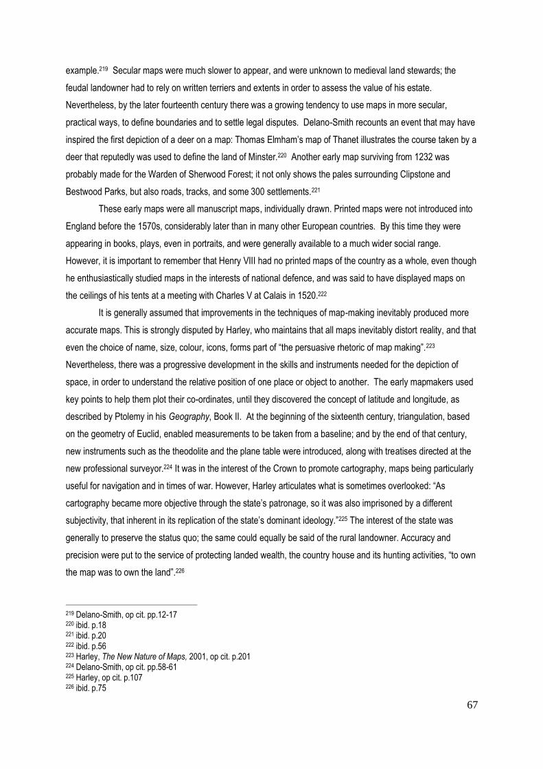
67
example.219 Secular maps were much slower to appear, and were unknown to medieval land stewards; the
feudal landowner had to rely on written terriers and extents in order to assess the value of his estate.
Nevertheless, by the later fourteenth century there was a growing tendency to use maps in more secular,
practical ways, to define boundaries and to settle legal disputes. Delano-Smith recounts an event that may have
inspired the first depiction of a deer on a map: Thomas Elmham’s map of Thanet illustrates the course taken by a
deer that reputedly was used to define the land of Minster.220 Another early map surviving from 1232 was
probably made for the Warden of Sherwood Forest; it not only shows the pales surrounding Clipstone and
Bestwood Parks, but also roads, tracks, and some 300 settlements.221
These early maps were all manuscript maps, individually drawn. Printed maps were not introduced into
England before the 1570s, considerably later than in many other European countries. By this time they were
appearing in books, plays, even in portraits, and were generally available to a much wider social range.
However, it is important to remember that Henry VIII had no printed maps of the country as a whole, even though
he enthusiastically studied maps in the interests of national defence, and was said to have displayed maps on
the ceilings of his tents at a meeting with Charles V at Calais in 1520.222
It is generally assumed that improvements in the techniques of map-making inevitably produced more
accurate maps. This is strongly disputed by Harley, who maintains that all maps inevitably distort reality, and that
even the choice of name, size, colour, icons, forms part of “the persuasive rhetoric of map making”.223
Nevertheless, there was a progressive development in the skills and instruments needed for the depiction of
space, in order to understand the relative position of one place or object to another. The early mapmakers used
key points to help them plot their co-ordinates, until they discovered the concept of latitude and longitude, as
described by Ptolemy in his Geography, Book II. At the beginning of the sixteenth century, triangulation, based
on the geometry of Euclid, enabled measurements to be taken from a baseline; and by the end of that century,
new instruments such as the theodolite and the plane table were introduced, along with treatises directed at the
new professional surveyor.224 It was in the interest of the Crown to promote cartography, maps being particularly
useful for navigation and in times of war. However, Harley articulates what is sometimes overlooked: “As
cartography became more objective through the state’s patronage, so it was also imprisoned by a different
subjectivity, that inherent in its replication of the state’s dominant ideology.”225 The interest of the state was
generally to preserve the status quo; the same could equally be said of the rural landowner. Accuracy and
precision were put to the service of protecting landed wealth, the country house and its hunting activities, “to own
the map was to own the land”.226
219 Delano-Smith, op cit. pp.12-17 220 ibid. p.18 221 ibid. p.20 222 ibid. p.56 223 Harley, The New Nature of Maps, 2001, op cit. p.201 224 Delano-Smith, op cit. pp.58-61 225 Harley, op cit. p.107 226 ibid. p.75

68
Fig 22. Saxton’s Shropshire 1577showing Shrewsbury & River Severn
Fig 23. Saxton’s Shropshire: cartouche & scale

69
While it is the intention of this chapter to examine the range and variety of deer parks in Shropshire in
the Early Modern period through the evidence of contemporary maps, it will be important wherever possible to
test the reliability of that evidence through written documents and journals.
County Maps
Cartographic evidence available in Shropshire for the period 1500 – 1750 can be divided into two basic
categories: county maps and estate maps. As already mentioned in the previous chapter, Shropshire is
particularly fortunate in having a county map of 1577 by Christopher Saxton, one of the earliest in the country,
published two years prior to his Atlas of Great Britain, which consisted of 34 maps engraved on copper plate.
The publication was made possible initially through the interest of William Cecil, Lord Burghley, who was an
enthusiast when it came to “lineal descriptions”227, and through the sponsorship of Thomas Seckford, another
prominent political figure in Queen Elizabeth’s government. Saxton claimed to base his work on “systematic field
work - surveying, observation and sketching,”228 and may fairly be considered to have established the format for
the county map. However, details are strictly limited: the Saxton Survey of Shropshire (Fig 22 ) depicts rivers,
selected hills, towns and major settlements, castles and 31 deer parks of varying size and shape. The technique
used to depict deer parks was not standardised, as there are five different designs for the parks on the 34
county sheets he completed, but in Shropshire the parks are enclosed within a line that suggests a fence or pale,
although the outline is often quite faint. These enclosures contain stylised trees, and sometimes a building, an
important factor in assessing the function of the park, which will be discussed later in more detail. Although they
offer invaluable information on the existence of deer parks in each region, the Saxton maps do not attempt to
distinguish the nature of the terrain. As Harley points out, “space is more important than place”.229 In other
words, there is little detail to differentiate one locality from another. This standardisation was made more uniform
by the introduction of printing. Indeed, the only distinction between one settlement and another lies in the size of
the typeface used. Shrewsbury, as the county town, merits the inclusion of a few buildings. So what was the
purpose of Saxton’s maps and why do deer parks figure so prominently? A clue lies in the decorative cartouche
and the royal coat of arms, together with that of Thomas Seckford, which figure so prominently on the Shropshire
map.(Fig 23) Elizabeth l encouraged the publication of the Saxton maps, in the belief that they strengthened a
“sense of provincial identity and independence”; they certainly paid tribute to the local aristocracy.230 Saxton’s
map was made for the landowners, sponsored by royalty, and as such was expected to highlight their most
valued possession, the deer park. In other words, the map reflected prevailing social priorities.231 This being the
case, we would expect to find a comprehensive record of existing deer parks, but as the following pages will
show, there were some apparent omissions. This raises the question as to whether those deer parks depicted
by Saxton necessarily contained deer.
227 Delano-Smith & Kain, op cit. p.66 228 ibid. p.68 229 Harley, J.B., op cit. pp 97-99 230 ibid. p.90 231 Delano-Smith & Kain, op cit. pp. 70-71

70
In the 1590s the mapmaker John Norden set out to improve on Saxton’s county maps by including
more villages and parks, and a basic network of roads. However, only two counties, Middlesex and
Hertfordshire, were published in his lifetime, and there is no county map for Shropshire in his Speculum
Britanniae.232 The next county map to appear was John Speed’s Survey of Shropshire published 1611 as part of
his Theatre of the Empire of Great Britain. John Speed did not receive royal patronage for his publication, and
the Shropshire map is appropriately dedicated to the Earls Roger Montgomery and John Talbot, and includes
their coats of arms as well as the obligatory royal insignia (Fig 24). In making his map, which is very similar to
Saxton’s in the information it offers and almost certainly based on it, he had his eye on its financial success. He
therefore concentrated on the visual appeal of his presentation, hoping that this would attract a large number of
contributors. In fact, his Theatre was re-issued fourteen times in the period up to 1770 and Samuel Pepys, when
Secretary of the Admiralty in 1662, had to rely on Speed’s map of the Forest of Dean as the best available, when
he was ordering timber for the navy.233 To enhance the appeal of his Shropshire map, Speed included in the top
right hand corner a contemporary three- dimensional representation of the county town of Shrewsbury, with a key
to its principal streets; and in the bottom right hand corner, an image of the Battle of Shrewsbury (1403) with a
short description. Speed was the first to include the boundaries of the hundreds,234 and in almost every
settlement he depicted its church; the deer parks are clearly enclosed with a pale, and their interiors are coloured
green with token trees and the occasional building.
In the 100 years following the publication of Saxton’s map of 1577 it would be fair to say that many of
the county maps, including that of Speed, were little more than re-issues or updates of the same material. This
almost certainly accounts for the omissions on Speed's map that will become apparent in the course of the
following pages. Delano-Smith points out that notes suggesting that a map was “actually surveyed” may mean no
more than that it was “compiled” from existing maps.235 Richard Blome’s county map of Shropshire published in
1673 is a case in point (Fig 25). Visually, it is almost a replica of the John Speed survey, with the boundaries of
the hundreds more clearly defined. As far as deer parks are concerned, Blome used the same techniques for
their depiction. Robert Morden, on the other hand, prided himself on regenerating the county map (Fig 26). In his
introduction to Gibson’s 1695 edition of Camden’s Britannia he asserts that all the maps in that volume have
been newly engraved according to surveys made since Saxton and Speed236 - which means since the Civil War.
Delano-Smith, however, maintains that he himself did no new fieldwork, but sent individual maps out to the
regions to be “corrected and updated from local knowledge”.237
232Delano-Smith & Kain, op cit. p.72 233 ibid., p.79 234 Harley, op cit. p.68 235 Delano-Smith, op cit. p.84 236 Harley, op cit. p.69 237 ibid. p.84

71
Fig 24. Speed’s Map of Shropshire 1611
Fig 24. Morden’s Map of Shropshire 1695
detail (Shropshire Archives)
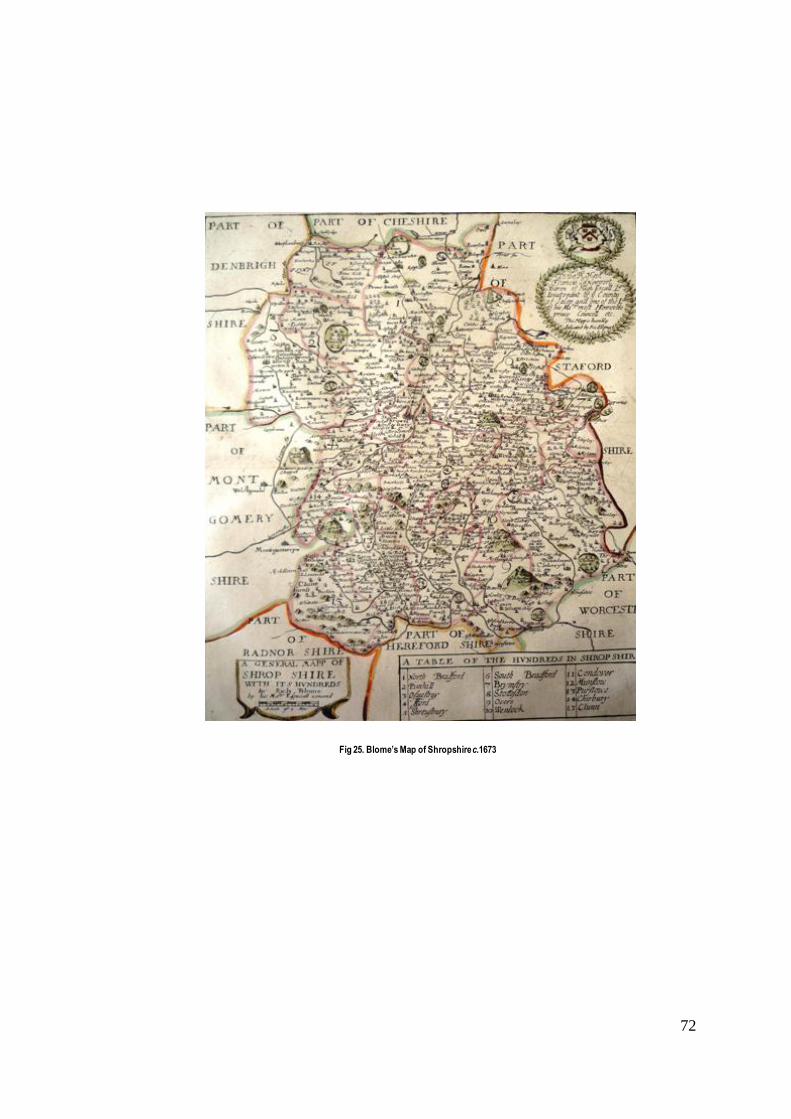
72
Fig 25. Blome’s Map of Shropshire c.1673

73
Fig 26. Detail of Morden’s Map of Shropshire 1695
Fig 27. Detail of Rocque’s Map of Shropshire 1752
for comparison

74
By the end of the first decade of the seventeenth century, all the English counties had been surveyed
and published in map form at least twice, by Saxton and then Speed.238 There was an inevitable hiatus in the
publication of county maps during the years of the Civil War and Commonwealth, but it is interesting to note that
it was Saxton’s wall map, reduced in size, that was used by the rival commanders in that conflict.239 The
Emanuel Bowen map of Shropshire (1751) preceded that of John Rocque by only one year, but serves to
highlight the scale of the latter's achievement (Fig 27). Where Bowen’s map was based on those of Saxton and
Speed, although at a larger scale, Rocque was the outstanding cartographer of his time, both in terms of his
representational skills and of the content he sought to depict. It is important to remember that Rocque was a
Frenchman and came to England with a predilection for the orderliness and geometric precision of the classical
park favoured by the French court, a fashion that was to spread to England, albeit undertaken with more modest
means, particularly in outlying counties such as Shropshire. Known in his own country as a “dessinateur des
jardins”, he added details of gardens and parks not seen on maps before: avenues and rides, already apparent
in parks designed by George London and Henry Wise, and by Charles Bridgeman in the late seventeenth and
early eighteenth century. His 1752 map for Shropshire, published on four separate sheets, offered a distinction,
albeit ‘notional’, between arable, pasture, woodland and heath, although field boundaries were probably
sketched by eye rather than measured.240 Where deer parks are concerned, the Rocque maps indicate a
considerable amount of surviving woodland; they also introduce the first signs on a county map of a new
aesthetic approach. But although the map-making techniques and printing facilities at his disposal allowed a
much clearer depiction of the topography, at the same time, deer parks were possibly of less interest to him than
to his predecessors and it is not always easy to say with any certainty whether a particular park is still enclosed.
Here for the first time on a county map, a new understanding of the word ‘park’ has to be assumed ; even if it is
enclosed, it may no longer contain deer. It will be necessary to look at other documentary evidence to try and
establish how the park has evolved. As far as providing data is concerned, Rocque’s map is of greatest interest
in depicting new parks, but eighteenth-century estate plans throw more light on the function and use of these
important status symbols, which may or may not include deer.
One further county map that will be used as a reference is that of Robert Baugh, dating from 1808.
Although this lies outside the dates of the period covered in this chapter, it will sometimes be useful as a
corrective where the Rocque evidence is unclear.
Estate Maps
“Estate maps, though derived from instrumental survey, symbolized a social structure based on landed
property; county and regional maps, though founded on triangulation, articulated local values and rights.” 241
(J.B.Harley)
238 Delano-Smith, op cit. p.75 239 ibid. p.76 240. ibid., pp.87-88 241 Harley, op cit. p.77

75
In the medieval period, land was valued according to the rights and privileges it conferred. By the
sixteenth century, as feudalism was replaced by the early features of capitalism, land was increasingly valued for
its financial returns. By the seventeenth century, the need for a landowner “to know his own” was articulated in
the treatises of surveyors such as John Norden (1618) and Ralph Agas (d.1621),242 who recognised that the map
could be an important management tool. Norden saw his job as enabling a landlord “sitting in his chair.. (to) see
what he hath upon the sudden view”.243 In his opinion the surveyor was not a cartographer, but had a social role
to play in the management and preservation of agrarian life.244 Agas pointed out three advantages of the map
over the written document: “precision of location, efficiency of land management, and permanence of record” .245
The “precision” that Agas refers to, was always dependent on the skills of the individual surveyor; while
“permanence” is questionable, given the fragility of maps. What Agas may have had in mind was what Harley
describes as a way of “translating property rights into a tangible and legally binding image.”246 In order to do this,
the map needed to show both field acreage and values. By replacing written surveys with manuscript maps,
landowners were able to see their land as a whole for the first time and to judge its potential for development. As
Baigent points out, “survey and mapping are most desirable to the landlord when they identify readily exploitable
ways to increase profit.”247 One of the ways in which they could be particularly useful, was in revealing the gap
between existing rents and the potential for increasing them.248
The need to value an estate might be prompted by transfer of property or by disputes between tenants
or inheritors over legal boundaries, particularly after disparking had taken place; in all these situations the estate
map was an important tool. It was also a critical reference point in the management of the estate, frequently
showing the acreage and use of different fields and woodland. In the following pages an attempt will be made to
detect the motives behind the execution of the handful of maps that have survived. An important point to bear in
mind is that at a time when painting focused on the portrait rather than the landscape, the finely executed estate
map with its decorative border, heraldry and compass point, became a collectable item, a source of pride and a
symbol of status, often displayed on the wall of the mansion. Such maps are easily recognised, since they were
usually painted on vellum, in colour, and bear little evidence of being much handled, whereas those used for
management of the estate on a daily basis are frequently in poor condition and even overlaid with scribbled
notes. The depiction of the deer park, its size and the way it was managed seems to have been almost as
significant as the emblazoned coat of arms, sometimes newly purchased by an ambitious landowner that
frequently appears in one corner along with the compass rose. During the course of the seventeenth-century
maps begin to reveal a somewhat different image of the park – one in which profitability is the dominant motive
for their execution, with timber and coppice, pasture and even arable enclosures, apparently having taken over
242
Ralph Agas (d.1621), born in Suffolk, is chiefly known for his bird's-eye views of Oxford, Cambridge and London. 243 Norden, J., The Surveyor’s Dialogue, 1618, a critical edition ed: Netzloff, M., Ashgate 2010,,p.xvi 244 ibid., Introduction p.xvii 245 Delano-Smith op cit. pp 116-118 246 Harley, op cit. p.61 247 Baigent, E., ‘Mapping Forests and Chases, c.1530-c.1670’ in Forests & Chases of England & Wales c.1500-c.1850, ed:Langton (St. John’s College Research Centre) 2005, p.24 248 ibid. p. 24

76
Fig 28 . Kynnersley on the Weald Moors , detail of map SA972/7/3/1 1579
Fig 29. Lubstree Park , detail of SA972/7/3/1 1579
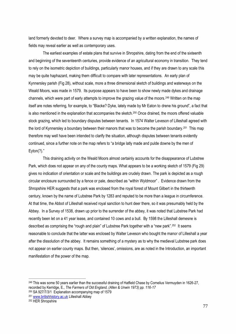
77
land formerly devoted to deer. Where a survey map is accompanied by a written explanation, the names of
fields may reveal earlier as well as contemporary uses.
The earliest examples of estate plans that survive in Shropshire, dating from the end of the sixteenth
and beginning of the seventeenth centuries, provide evidence of an agricultural economy in transition. They tend
to rely on the isometric depiction of buildings, particularly manor houses, and if they are drawn to any scale this
may be quite haphazard, making them difficult to compare with later representations. An early plan of
Kynnersley parish (Fig 28), without scale, more a three dimensional sketch of buildings and waterways on the
Weald Moors, was made in 1579. Its purpose appears to have been to show newly made dykes and drainage
channels, which were part of early attempts to improve the grazing value of the moors.249 Written on the map
itself are notes referring, for example, to “Blacke? Dyke, lately made by Mr Eaton to drene his ground”, a fact that
is also mentioned in the explanation that accompanies the sketch.250 Once drained, the moors offered valuable
stock grazing, which led to boundary disputes between tenants. In 1574 Walter Leveson of Lilleshall agreed with
the lord of Kynnersley a boundary between their manors that was to become the parish boundary.251 This map
therefore may well have been intended to clarify the situation, although disputes between tenants evidently
continued, since a further note on the map refers to “a bridge latly made and pulde downe by the men of
Eyton(?).”
This draining activity on the Weald Moors almost certainly accounts for the disappearance of Lubstree
Park, which does not appear on any of the county maps. What appears to be a working sketch of 1579 (Fig 29)
gives no indication of orientation or scale and the buildings are crudely drawn. The park is depicted as a rough
circular enclosure surrounded by a fence or pale, described as “within Wyldmoor” . Evidence drawn from the
Shropshire HER suggests that a park was enclosed from the royal forest of Mount Gilbert in the thirteenth
century, known by the name of Lubstree Park by 1283 and reputed to be more than a league in circumference.
At that time, the Abbot of Lilleshall received royal sanction to hunt deer there, so it was presumably held by the
Abbey. In a Survey of 1538, drawn up prior to the surrender of the abbey, it was noted that Lubstree Park had
recently been let on a 41 year lease, and contained 10 cows and a bull. By 1598 the Lilleshall demesne is
described as comprising the “rough and plain” of Lubstree Park together with a “new park”.252 It seems
reasonable to conclude that the latter was enclosed by Walter Leveson who bought the manor of Lilleshall a year
after the dissolution of the abbey. It remains something of a mystery as to why the medieval Lubstree park does
not appear on earlier county maps. But then, ‘silences’, omissions, are as noted in the Introduction, an important
manifestation of the power of the map.
249 This was some 50 years earlier than the successful draining of Hatfield Chase by Cornelius Vermuyden in 1626-27, recorded by Kerridge, E., The Farmers of Old England, (Allen & Unwin 1973) pp. 116-17 250 SA 927/7/3/1 Explanation accompanying map of 1579 251 www.britishhistory.ac.uk Lilleshall Abbey 252 HER Shropshire

78
Fig 31. Tilstock Park , SA212/466/7 c.1600 and detail below
Fig 30. Blakemere Park , detail of survey SA212/466/4 c.1600

79
A number of early estate maps relate specifically to deer parks, one of the earliest being a fragment of
Blakemere Park (c.1600) 253 and in the same parish of Whitchurch, a contemporary map of Tilstock Park254. The
Blakemere map (Fig 30) shows quite simply that the park was paled and compartmentalised, with a section
containing trees alongside one that appears to be empty. In the corner is a fragment of the coat of arms of the
Talbots who succeeded to the estates of the LeStranges in the fourteenth century. Sylvia Watts, who has
undertaken research in Whitchurch parish, writes that “the lord of the manor’s park, Blakemere, was the first area
to be turned into farm land. However, in 1509 much of the park was used specifically for deer, and in 1559 there
was still a master of the chase.” 255 In 1535 it was visited by Leland who observed both red and fallow deer in the
park. 256 The survey, which Watts attributes to 1572, shows that it was still at least partly wooded at that time,
but by 1583 it was leased for pasture.257 Although, perhaps surprisingly, Blakemere park appears consistently
on the county maps up to and including Blome's map of 1675,258 it is not recorded on the Morden map of 1695.
The plan of Tilstock Park (Fig 31 ) of the same period is barely readable to the naked eye, but close
examination reveals that it was already divided into four compartments, three of which are attributed to specific
tenants: Gregorie, Chawner and Greene. Of these, the first two are depicted, axe in hand, evidently in the
process of felling timber; some trees are shown lying on the ground, while the stumps of others are clearly
visible. Greene, on the other hand, does not appear to have cut his timber, and his wood is bisected by a stream
and fish ponds. There are two buildings shown immediately outside the park pale to the north, perhaps the
houses of the tenants. Nowhere is there any sign of deer. It seems that Tilstock was disparked around 1600
and this process was being recorded on the map. The deer park does not appear on any of the county maps,
suggesting that it may never have contained deer, but rather been fenced to keep them out of the precious
woodland and coppice.
The sequence of maps described above can be used to point to the survival or demise of individual deer
parks, and give an approximate indication of their location and size (see Table 2). Saxton's map of 1577 records
a total of 30 deer parks of which 19 are survivors from the Middle Ages.259 A comparison of Speed’s map of
1611 with that of Saxton reveals relatively few changes, which is what might have been expected in view of his
manner of work. Of the 27 recorded, 17 can be dated back to the Middle Ages. The two medieval parks which
have been lost since Saxton's map appear to be Adderley, which reappears on Bowen's map of 1751, and one of
the two parks shown by Saxton at Shrawardine. Blome's map of 1675 shows a total of 23, of which 14 are
253 SRO 212/466/4 Blackmeare Park n.d. c.C17 254 SRO 212/466/7 Map of Tilstocke Park n.d. c.C17 255 Watts, S., Midland History Vol.25 June 2000, ‘The Significance of Colonisation in Two North Shropshire Parishes’ pp.61-77 256 Leland, op cit. p.131 257 Watts, S., op cit. 258 It is perhaps worth noting that there was evidence of two medieval parks at Blakemere, as mentioned in the previous chapter. It seems likely that by the sixteenth century these had been merged, or that one had already been disparked. 259 See f.n.195 above.
80
medieval. Although published fifteen years after the Restoration, the parks shown are identical to those depicted
by Speed except that four have disappeared. These are Dean Park in the south of the county, which never
reappears; together with the parks of Acton Burnell, Haughmond Park and Rowton Park, which reappear on the
Robert Morden map of 1695 only twenty years later. This may represent a simple omission on the part of Blome,
or very likely, a period of temporary dormancy following the Civil War and the disruption that it caused. How this
period and the Restoration of the monarchy in 1660 affected individual deer parks will be discussed later in this
chapter. Robert Morden's map of 1695 depicts a total of 24 deer parks, a similar number to Blome, of which 13
are medieval. However, this apparent similarity conceals the fact that since Blome’s map of only twenty years
earlier, 10 parks had disappeared and nine had been added. Those that had disappeared include the medieval
parks of Blakemere, Oteley, Ruyton, Hodnet, Shifnal, and Cleobury Park, together with Ightfield, Kenwick; Plaish,
and Okeley (Oakly). Further evidence of their disparkment will be examined later; in the case of Oteley and
Oakly Parks, these reappear on Rocque's map of 1752. Those that have been added by Morden fall into two
distinct categories: parks created as the settings for new houses in the sixteenth century, including Belswardine
Hall ( c.1540), Condover Hall ( pre 1598); and those created after 1660, such as Shavington Hall (built 1685);
together with those that reappear, possibly because the parks have been revived in line with a remodelling of the
residence, including Hopton Castle, Haughmond Abbey, Madeley, Rowton and Frodesley Lodge park. Whereas
at the end of the Middle Ages there were 19 surviving deer parks, there were only c.11 by the beginning of the
eighteenth century. In the interests of greater clarity, a simplified chronological table (Table2), showing the
continuity of individual deer parks on the various county maps is appended at the end of this chapter. The
disappearance and reappearance of a park at a later date raises the interesting question of temporary
‘dormancy’, which will require the further investigation of individual cases. Evidently, the county maps were not
sufficiently detailed to suggest how the parks were used, although the presence of a building either within or on
the edge of a park may offer a clue. Other details have to await the introduction of the estate map which, where it
exists, throws additional light on many of these intriguing questions.
The Dissolution of the Monasteries
Certain key national events defined the Early Modern period and impacted on the rural landscape,
creating changes that led to the disappearance, transformation, or revival of the deer park, and these events will
be discussed in the following pages. Firstly, the Dissolution of the Monasteries by Henry VIII, which changed the
balance of prevailing land ownership, provided increased opportunities for aspiring gentry to acquire estates
alongside the aristocracy. Evidence gathered for the Victoria County History confirms that monastic lands,
granted initially to those who had found favour with the Crown, were often sold on to members of the
professional classes and gentry. Where a deer park already existed in proximity to the monastic buildings, it
appears to have frequently been maintained, whereas outlying parks more often reverted to agricultural use.
Evidence for this is often dependent on the existence of estate maps. Unfortunately, there are no remaining
estate maps or even a cartulary for Wenlock Priory, which at its prime in the thirteenth century held land in the

81
Corve River valley, including the medieval parks of Oxenbold, Earnstrey, and further east, Madeley, all of which
by the fourteenth century were reported as being barely sufficient to support animals.260 Of these, only Madeley
appears to have survived the dissolution of the priory, possibly due to the early development of mineral
resources in the area of the park, as noted in the previous chapter. When Wenlock Priory was dissolved in 1540
there were only 12 monks living there, and the site was bought by Thomas Lawley from the king’s physician
Agostino Agostini.261 Unusually, Lawley, who transformed the former prior’s lodgings into a private house, was a
local man, descended from a line of Much Wenlock freeholders. His descendants were local dignitaries, destined
to become MPs for Wenlock in the seventeenth century. Madeley, which was managed as a grange of Wenlock
Priory, was bought after the Dissolution by Robert Brooke, a noted lawyer, later elected Speaker of the House of
Commons and knighted in 1555. He was selling coal from his own pits in 1570. Madelely is not recorded by
either Saxton or Speed, but the park reappears briefly on Morden's map, only to have been disparked by the time
of Rocque (1752).
Two other monastic sites, Haughmond Abbey and Lilleshall, recorded by Cantor as having medieval
deer parks, appear consistently on the maps of Saxton, Speed, Morden and Rocque. After its dissolution,
Haughmond was sold in 1542 to Sir Rowland Hill, former lord mayor of London (1529) whose descendants were
to become one of the principal landowning families in Shropshire. The Haughmond estate was inherited through
Hill's sister by the Barker family, who were responsible for pulling down most of the conventual buildings and
transforming the abbot’s lodgings into their private residence. The monastic ruins were incorporated in a formal
garden, to the north and west of which lay the deer park. Saxton shows the park containing a building, almost
certainly a lodge, and by 1695 Morden's map shows the abbey itself enclosed within the park pale (Figs 32, 33).
An English Heritage Survey undertaken in 2002 confirmed the existence of the Barkers' landscape. Abbey Wood
exists to this day, although any deer are likely to be wild (Fig 34).
In the case of Lilleshall, there are two surviving surveys, one of 1679 and one of 1720, which will be
discussed later in the chapter. When the abbey was dissolved in 1538, the site was granted to William
Cavendish, a courtier, who subsequently sold it on to James Leveson (d.1547), a Wolverhampton wool merchant
(Fig 35). His grandson, Walter Leveson, was involved in the dispute concerning the Weald Moors mentioned
previously, and appears to have been a ruthless encloser with little regard for commoners' grazing rights. In the
late sixteenth century he was three times MP for Shropshire. 262
Finally, in the context of monastic sites, mention should be made of Buildwas Abbey and park, granted
to Edward, Lord Grey of Powys after the Dissolution. Although no deer park appears on any of the county maps
260 VCH 2, pp.38-46 261 ibid. 262 The History of Parliament, Vol. 1558-1603. Walter Leveson was MP for Shropshire in 1584, 1586, 1589. He was subsequently involved in charges concerning debt and conspiracy.

82
Fig 34. Boundary to Abbey Wood
Fig 32. Haughmond Abbey park, Speed 1611
Fig 33. Haughmond Abbey Park, Morden 1695

83
Fig 36. Lillleshall Abbey, detail of Map of Weald Moors SA972/7/3/3-4 1587
Fig 35. Buildwas Abbey with deer park , detail with park below, SA 6344B 1650

84
before Rocque, there is a surviving estate plan of 1650,263 which is not accompanied by a written survey, but
nevertheless shows what appears to be a deer park containing a lodge (Figs. 36 & 37 ). One of the properties
formerly belonging to Buildwas Abbey was Harnage Grange, which in the fifteenth century was occupied by the
farmers of the abbey grange. After the Dissolution, it was acquired by the Fowler family. A deer park is not
recorded here before 1684 when a new house was being built, depicted by Bowen on his map of 1751 where it is
shown with a pale. It is believed to have been located on high ground south of the house and was disparked by
1774.264 However, it does not appear as a park on Rocque’s map a year later than Bowen’s. Field names - Far
Park Field ; Near Park Field ; Lodge Field; Park Meadow; Park Piece - suggest the former area of the deer park.
Richard Lacon, the owner of Willey Park lying north of Bridgnorth, was among those who benefited
from the sale of monastic lands. In 1262, the Prior of Wenlock had enclosed four and a half acres from Shirlett
Forest in order to make a deer park. In the early fourteenth century, after Shirlett had been disafforested (1301),
there were two large woods in the manor.265 A deer park at Willey, although not mentioned by Cantor, is
recorded by Saxton, Speed, Morden and Rocque . By the fourteenth century there were already two parks. In
1537, following the dissolution of Wenlock Priory, Richard Lacon was able to buy 60 acres of abbey lands to
enlarge Willey Old Deer Park, an area known as Prior's Tongue. In 1618 this park, lying north of the township,
comprised 432 acres lying to the south and west of a sixteenth-century house. 266 That same year, the manor
was bought from Sir Francis Lacon for £7000 by John Weld, a former town clerk of London, who was 37 years of
age. A contemporary description of the house and deer park describes: “one fayre house buylt most parte with
stone and the court walled about with bricke with all offices fitt for the habitacon of a wor… man having become
the anntient seate or dwelling of a knight." The same document goes on to refer to “one great parke paled
aboute being fower myles compass.”267 A Survey of the Old Park made by George Coke (not dated but c. 1618)
shows the park already divided into three separate compartments, all of which were wooded 268 (Fig 37 ). After
the allotment of the former royal forest of Shirlett in 1625, Weld acquired a further 400 acres which together with
Thistly and Mill Fields west of Willey, he enclosed in a new park,. Here he introduced deer and created and
stocked new fishponds269 (Figs 38 & 39 ). In an important memorandum book written in 1619 and 1631, John
Weld noted the extent of the park’s 3,300 timber trees, and proposed that stocks of deer, swans, fish and bees
might be introduced and horses bred there. 270 This invaluable document throws new light on farming practices
and park management and will be discussed later in the chapter.
The evidence laid out in the preceding paragraphs, largely derived from maps, seems to show that the
new landowners who acquired monastic sites had both the will and the finances to maintain and even extend
those parks that were in the immediate vicinity of the monastic buildings, adding prestige to their newly converted
263 SA 6344B Survey of the Manor of Buildwas, 1650 264 VCH 8, p.62 265 VCH 10, p.447 266 ibid., p.453 267 SA1224/3/187 Particular of Willey, c.1618. 268 SA1224/1/12 Survey of the Ould Parke at Willey, C17 (permission Lady Forester) 269 Stamper,Report 1993, op cit. pp. 109-11 270 SA1224/1/Box 163 John Welds memo book 1619/20
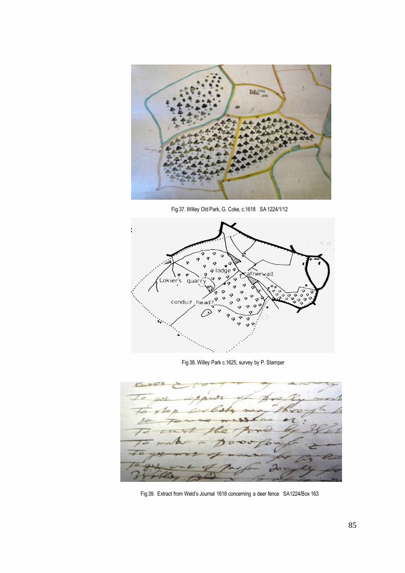
85
Fig 37. Willey Old Park, G. Coke, c.1618 SA 1224/1/12
Fig 38. Willey Park c.1625, survey by P. Stamper
Fig 39. Extract from Weld’s Journal 1618 concerning a deer fence SA1224/Box 163

86
houses. But as already indicated in the previous chapter, the outlying monastic deer parks, such as Oxenbold
and Madeley, particularly those lying on inhospitable high ground in the Shropshire Hills, such as Crees, were
among the first medieval deer parks to disappear and had probably been disparked before the Dissolution.
The creation of parks as settings for new houses
The redistribution of monastic lands serves to draw attention to a change that was beginning to occur in
the spatial relationship between residence and deer park. However, the newly converted monastic residences
were a small minority compared with the number of impressive new brick, stone, and timber mansions that were
built in Shropshire in the period stretching from the late sixteenth century until the outbreak of the Civil War.
In her book on Tudor houses and gardens, Henderson points out the specific architectural features of the Tudor
country house that related to its function as an observatory of the hunt. 271 The theme is taken up by Mowl, who
emphasises the theatrical aspects of many of the new features of country houses built by the end of the sixteenth
and early seventeenth centuries, such as flat roof leads, projecting bay windows, and turrets, all of which he
attributes to the contemporary enthusiasm for hunting. He observes that "hunting moved up naturally from being
the honest pursuit of food to that most contentious of pleasures, the ritual destruction of animals, a sport not
simply for participants but for spectators."272 In the following pages, the importance of these new or in some
cases revived architectural features will be discussed, in relation to changes in the way deer parks appear to
have been used in the Tudor and Elizabethan periods, not only in Shropshire but also in England as a whole. A
further topic for discussion will be Holinshed's comment, quoted by Mowl, that the "proliferation of parks.....
bringeth no gaine or profit to the owner" ... (being) " maintayned only for hys pleasure to the no small decay of
husbandry".273 Profit, however, was not the landowner's only consideration. André Borde (1490-1549), quoted by
Thirsk, commented that "a park replete with deer and conies is a necessary and pleasant thing to be annexed
to a mansion."274 The idea has been raised of a park being 'annexed' to the dwelling for its aesthetic value.
Queen Elizabeth herself does not appear to have visited Shropshire, as many of her predecessors had done;
consequently, there is no house of the period comparable to Hatton’s Holdenby or Cecil’s Theobalds, which , as
Girouard notes, were designed virtually as royal palaces, at great expense to their owners. 275 Nevertheless,
there were some grand mansions built by eminent members of local society, and the deer park was still
considered an important asset to any country house, and seen as a symbol of wealth and status. Its proximity to
the house was something to be desired; but to assume that this was always the case, would be to
underestimate the number of deer parks that survived from the medieval period and the previous decades of
Tudor rule. In order to assess the balance of new parks to old, and to try and establish the differences in their
location and use, the first step will be to look at selected examples shown on contemporary county maps, with
the additional evidence provided by estate maps where they exist.
271 Henderson, P., The Tudor House & Garden, op cit. p.167 272 Mowl, T., Elizabethan Jacobean Style, Phaidon 1993 p.185 273 ibid. p.186 274 Thirsk, J. Alternative Agriculture, op cit. p.162 275 Girouard, M.,Life in the English Country House, op cit. pp 111-114

87
Fig 40. Pitchford deer park , detail of SA MI1275/1-2 1682
Fig 42. Pitchford Hall & gardens , drawing 1714
Fig 41. Survey of Pitchford estate , SA MI1275/1-2 1682

88
The new parks created in Shropshire to complement the fine Tudor and Elizabethan mansions,
following the turmoil of the Reformation and the Dissolution of the Monasteries, were to some extent created by
members of the aspiring gentry from the legal professions and the cloth trade. Landowners such as these were
eager to draw attention to their newly acquired estate, and a new deer park served to underline their position in
society. The following paragraphs will look at these new parks, to try and establish how they differed spatially
from their predecessors. In some cases contemporary surveys exist, but where the evidence of later maps is
required, they have been introduced, in the knowledge that changes may have taken place in the intervening
years.
A large number of these new residences and deer parks were gathered in the hundred of Condover,
particularly in the middle and east of the hundred, towards the River Severn. The area was probably favoured on
account of its proximity to the county town of Shrewsbury, an important economic and social centre, the transport
facilities offered by the river, and the fertility of the soil in this relatively low-lying river plain, fed by the River
Cound (a tributary of the Severn). John Leland, passing on the road from Shrewsbury to Cound in the 1540s,
commented on “good ground, corne and grasse, but noe greate wood in sight.”276 It was a region that might
have supported a variety of agricultural activities, and as such provide income from a number of sources. There
was even a small port on the River Cound, enabling the export of produce to Bristol. It was in this area that the
building of Belswardine Hall (1540), Pitchford Hall (1549), Plaish Hall (1570s), and Condover Hall (1586-98) took
place, all accompanied by deer parks on new sites.277
Belswardine Hall was inherited by Francis Harnage in 1584 and it seems likely that he was responsible
for creating a deer park. There is no evidence of any earlier park, and it does not appear on any of the county
maps before Morden (1695) who shows a large park, but neither his map nor that of Rocque give any clear
indication of its relation to the house. There is no estate plan surviving for Belswardine manor, and it is therefore
less useful to the present discussion than Pitchford Hall, a fine timber-framed house in what might be considered
a vernacular style, built in 1549 for Adam Ottley, grandson of Thomas Ottley, a Shrewsbury wool merchant who
had acquired the manor in 1473. The first evidence of a deer park at Pitchford is found in a document showing
that in 1638 Lord Newport presented Francis Ottley with deer from High Ercall park to stock what he refers to as
his "new deer park"278. This date explains why it does not appear on Speed’s map of 1611, although its omission
from Morden's map is surprising since by1682 it covered 191 acres.279 The first county map to record the park is
that of Rocque (1752) who shows it as enclosed, although the location of the associated hall is not clear.
However, a map of Pitchford Manor made for a Thomas Ottley in 1682 shows the Parke as a self-contained area
in which deer are depicted grazing280 (Figs 40-42). A drawing of the house completed in 1714 shows elaborate
276 Leland, op cit. p.84 277 Pevsner, Shropshire, op cit.p.230 278 Stamper, Historic Parks & Gardens of Shropshire, op cit. p.18 279 VCH 8, p.116 280 SA MI1275/1-2 Map of the Manor of Pitchford 1682

89
formal gardens that included a surviving tree house and orchards, but there is no sign of a deer park. After 1752
Pitchford park disappears from the county maps, and was probably disparked before 1766.281
Neighbouring Plaish Hall (1570s) offers firmer evidence of the relationship of park to mansion (Fig 43).
The builder of Plaish Hall was a member of the legal profession, William Leighton, who was to become Chief
Justice of Wales. His newly created brick manor house and deer park at Plaish are first recorded on Saxton's
map of 1577, with the residence shown just on the edge of the southeast boundary of the deer park. It
reappears on Speed's map with the same configuration, but is no longer recorded by Morden in 1695. Based on
information drawn from the Victoria County History, it seems that the park was used for horse pasture in the mid-
seventeenth century, as general pasture by 1671, and subdivided between 1675-6, which would explain its
disappearance from the county maps.282 This means that it was used as a deer park for less than a hundred
years, which would seem to suggest that even before the Civil War, the family had found it impossible or
impractical to retain the deer. One possible explanation for this may lie in the family history: William Leighton’s
descendant , the poet and composer William Leighton, was imprisoned for debt in 1610, and by 1658 the manor
of Plaish was heavily mortgaged. Twelve years later it was sold to Sir Rowland Hunt of Boreatton 283 who was to
establish a deer park on the Boreatton property. An estate survey of Plaish made in 1670 for Rowland Hunt by
the surveyor Edward Bury284, probably at the time of his purchase, shows the house in the top left hand c'orner,
which is initially confusing until we realise from the compass that the map has, as so often at this period, been
inverted (Figs.44 & 45). The mansion is drawn in black and white, with gables, whereas the lodge within the
park and other buildings are quite basic in design and coloured. Although the mansion lies just outside the park
boundary, there is clear evidence of a visual link with the park. The explanation accompanying the map of 1670
identifies a horse pasture and two meadows 285 lying between the house and the park. These may well have
been used to grow hay for the deer, or alternatively, as the VCH has concluded, indicate the beginning of the
park’s change of usage. The whole area of the park is enclosed with a brown line indicating a pale, and the
manor is shown as well wooded, even though the depiction of the trees is stylised. The purpose of the map
appears to have been to define the boundaries of the various tenants' land prior to sale.
Lying within the same area, the 300 acre deer park of Condover Hall, created in 1600 to accompany the
new mansion,286 appears to have been omitted from contemporary maps. Described by Pevsner as “the
grandest Elizabethan house in Shropshire”,287 Condover Hall was built in local red sandstone between 1586-98
(Fig 46) for Thomas Owen, Justice of Common Pleas, MP and Recorder for Shrewsbury, member of the Council
of the Marches, who was granted the estate by Queen Elizabeth. His wealth and position enabled him to employ
the best contemporary designers and masons. He died before the completion of the house, which remained in
281 VCH 8, op cit. p.116. 282 ibid. p.397 283 VCH 10, p.31 284 SA 6035/A Plot & Description of the manor of Plaish for Rowland Hunt Esq. 1670 285
There is no evidence that these were 'water meadows', in the sense described later in the chapter, as there is no obvious
source of water for flooding. 286 VCH 8, p.28 287 Pevsner, Shropshire, op cit. p.230

90
Fig 44. Detail of Survey of Plaish Hall , with deer park bottom right, SA6035/A 1670
Fig 45. Detail of Survey of Plaish Park with lodge
SA 6035/A 1670
Fig 43. Plaish Hall c.1570
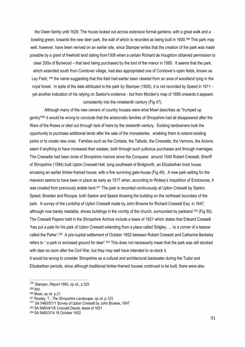
91
the Owen family until 1629. The house looked out across extensive formal gardens, with a great walk and a
bowling green, towards the new deer park, the wall of which is recorded as being built in 1600.288 This park may
well, however, have been revived on an earlier site, since Stamper writes that the creation of the park was made
possible by a grant of freehold land dating from1308 when a certain Richard de Houghton obtained permission to
clear 200a of Buriwood – that land being purchased by the lord of the manor in 1565. It seems that the park,
which extended south from Condover village, had also appropriated one of Condover’s open fields, known as
Ley Field, 289 the name suggesting that this field had earlier been cleared from an area of woodland lying in the
royal forest. In spite of the date attributed to the park by Stamper (1600), it is not recorded by Speed in 1611 -
yet another indication of his relying on Saxton's evidence - but from Morden’s map of 1695 onwards it appears
consistently into the nineteenth century (Fig 47).
Although many of the new owners of country houses were what Mowl describes as "trumped up
gentry"290 it would be wrong to conclude that the aristocratic families of Shropshire had all disappeared after the
Wars of the Roses or died out through lack of heirs by the sixteenth century. Existing landowners took the
opportunity to purchase additional lands after the sale of the monasteries, enabling them to extend existing
parks or to create new ones. Families such as the Corbets, the Talbots, the Cressetts, the Vernons, the Actons,
seem if anything to have increased their estates, both through such judicious purchases and through marriages.
The Cressetts had been lords of Shropshire manors since the Conquest; around 1540 Robert Cressett, Sheriff
of Shropshire (1584) built Upton Cressett Hall, lying southwest of Bridgnorth, an Elizabethan brick house
encasing an earlier timber-framed house, with a fine surviving gate-house (Fig 49). A new park setting for the
mansion seems to have been in place as early as 1517 when, according to Wolsey’s Inquisition of Enclosures, it
was created from previously arable land.291 The park is recorded continuously at Upton Cressett by Saxton,
Speed, Bowden and Rocque, both Saxton and Speed showing the building on the northeast boundary of the
park. A survey of the Lordship of Upton Cressett made by John Browne for Richard Cressett Esq. in 1647,
although now barely readable, shows buildings in the vicinity of the church, surrounded by parkland 292 (Fig 50).
The Cressett Papers held in the Shropshire Archive include a lease of 1621 which states that Edward Cressett
“has put a pale for his park of Upton Cressett extending from a place called Sidgley….. to a corner of a leasow
called the Parke”.293 A pre-nuptial settlement of October 1652 between Robert Cressett and Catherine Berkeley
refers to “ a park or enclosed ground for deer”.294 This does not necessarily mean that the park was still stocked
with deer so soon after the Civil War, but they may well have intended to re-stock it.
It would be wrong to consider Shropshire as a cultural and architectural backwater during the Tudor and
Elizabethan periods, since although traditional timber-framed houses continued to be built, there were also
288
Stamper, Report 1993, op cit., p.325 289 ibid. 290 Mowl, op cit. p.21 291 Rowley, T., The Shropshire Landscape, op cit. p.123 292
SA 5460/5/1/1 Survey of Upton Cressett by John Browne, 1647 293 SA 5460/4/1/6 Cressett Deeds, lease of 1621 294 SA 5460/3/14 16 October 1652

92
Fig 48. Moreton Corbet Hall , built c,1560-83
Fig 46. Condover Hall, 1586-1600
Fig 47. Condover deer park , Rocque 1752

93
Fig 49. Upton Cressett Hall , gatehouse 1580
Fig 50. Survey of Upton Cressett Park 1647 SA 5460/5/1/1

94
outstanding mansions, such as Condover Hall, which Pevsner has compared with Hardwick Hall (Derbyshire);
and Moreton Corbet Hall whose sixteenth-century ruins remain as evidence of the county’s only sophisticated
Renaissance house (Fig 48 ). Robert Corbet, one of the few Shropshire aristocrats to have played a diplomatic
role at court, built his new mansion in the1560s and modified it in 1583, to replace the original medieval castle
on the same site northeast of Shrewsbury. Stamper suggests that there was a deer park created north and west
of Moreton Corbet parish church in the late seventeenth century.295 While there is some archaeological evidence
of a contemporary formal garden, there is no sign of the park. Moreton Corbet does not appear on any of the
county maps, and it seems more likely that the park in question was Sowbatch deer park, recorded by both
Morden and Rocque, associated with the sixteenth-century home of Andrew Corbet, Robert’s younger brother.
But this remains pure speculation. Whether or not there was originally a deer park associated with Moreton
Corbet, the new mansion was fired by Parliamentary troops in 1645 and never reinhabited. It survives as an
evocative ruin.
Around 1588 Robert Corbet began work on Stanwardine Hall and park, as a residence for himself and
his wife Jane Kynaston. Once again, there is no evidence of a deer park on any county map before Rocque, who
shows a wooded site framed by a road southwest of and separate from the hall. However, there is good
evidence to suggest that a deer park was established at Stanwardine-in-the-Wood at the same time as the
house. Based on field names researched by Foxall from nineteenth-century tithe awards, the park appears to
have lain about a mile south of the house. A surviving document shows that it was still stocked with deer in
1671, when Philip Henry wrote in his diary of 12th July, “With wife at Stanwardine…..I accompanied them (the
Corbets, owners of Stanwardine), killing a buck in their own park, far from being taken with any great delight or
pleasure in ye sport; they sent part of him to Broad-oke after us”….296 - an interesting comment on contemporary
attitudes to hunting and hospitality which had survived from medieval times. By the time the park appears on the
Rocque map (1752), it was probably no longer a deer park, the estate having been sold in 1701.297
A deer park that appears on the county maps with great consistency is that of Tong Castle, a medieval
survivor depicted by Saxton, Speed and Morden. In none of these county maps is there any suggestion that the
residence ever lay within the boundaries of the deer park. The early history of this once important medieval
castle has been told in the previous chapter; the residence was rebuilt by Sir Henry Vernon c.1500. Pevsner
credits this house with being the first large-scale building in brick to be constructed in Shropshire.298 There are
two surviving images: both showing a courtyard house, with towers at the corners that may have been used for
viewing the park. One is a contemporary carving in stone currently lying in the churchyard, and the other an
engraving of 1731 by Buck (Figs 51 & 52 ). The medieval park associated with Tong Castle lay to the east of this
residence, and will be discussed in more detail in the following pages (Fig 53).
295 Stamper, Report 1993, op cit. p.183 296 ibid., p.211 297 www.parksandgardens.ac.uk Stanwardine in the Wood 298 Pevsner,Shropshire, op cit., p.659

95
Fig 51 Stone Carving of Tong Castle in Tong churchyard
Fig 52. Engraving of Tong Castle , Buck 1731
Fig 53. Survey of Tong Castle & park, Reynolds 1739 SA6007/11

96
The evidence assembled so far seems to suggest that in the period prior to the Civil War only about
eight deer parks were specifically created as a setting for a new house, or perhaps more correctly as a visual
complement to the house, and of these six were created on new sites, four of them concentrated in the Condover
Hundred. 299 By correlating the county maps dating from Saxton (1577) to Rocque (1752) and estate maps
where they have been found to exist, it seems plausible to suggest that whereas the new deer parks were
intentionally created close to the house, those surviving from medieval times often lay at some distance from it.
Tong Castle offers a clear example of the latter, with its medieval park remaining at a distance from the house,
even when this was rebuilt. Whether the closer relationship of house to park contributed to the park’s survival is
something that will need to be addressed alongside an examination of its management and use.
Lodges & viewing facilities
One of the things revealed by seventeenth-century estate maps is the presence of buildings within the
park in addition to the main residence. The identification of these buildings can help to clarify the function of the
park at a given period, which is one of the aspects that this thesis is seeking to establish. Many have been
referred to as 'lodges'. Girouard has pointed out that the term ‘lodge’ was no more than “a variant of
lodgings".300 This goes some way to explain why we find 'lodges' playing such a wide variety of roles, from the
medieval parker's lodge, conveniently situated within the park to enable the parker to feed and protect the deer
from poachers, to something much more sophisticated, somewhere between a country house and a secret
retreat. Henderson explains the need felt by some landowners for a modest dwelling at some distance from the
main house to offer an escape from the busy lifestyle of the country houses of the Tudor period, which were used
as power bases for "the administration of lands and the ostentatious display of wealth and power."301 Privacy
would have been an essential feature of such a retreat, although some lodges were large enough to house a
retinue for a short time. Francis Bacon is believed to have built Verulam House at Gorhambury as "an ideal
intellectual refuge". A few lodges, such as that of Thomas Tresham at Rushton (Northants) were not only
complex in form, but also in meaning.302 Mowl suggests that the location of Tresham's lodge within a network of
rides was typical of many others, allowing deer to be driven past the windows for the enjoyment of the owner and
his guests.303 Girouard believes that most Elizabethan and Jacobean lodges were no more than a mile from a
house. Cartographic evidence for the location of lodges of the sixteenth century and earlier is difficult to confirm.
Both Saxton and Speed show only ten deer parks in Shropshire that include a building, and the nature of that
299 Belswardine, Pitchford, Plaish, Condover, Upton cressett and Stanwardine boasted new houses and new deer parks on
new sites. 300 Girouard, Life in the English Country House, op cit., p.77 301 Henderson, op cit. p.170 302 ibid. pp 172-177 Begun in 1593, its architecture represents the Holy Trinity, with elaborate decoration based on threes. A further Tresham lodge, New Bield (begun 1594) at Lyveden, was based on the form of a Greek cross; it was never completed. 303 Mowl, op cit. p.188
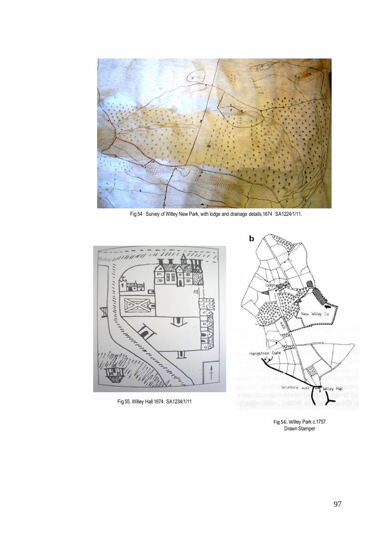
97
Fig 54 Survey of Willey New Park, with lodge and drainage details,1674 SA1224/1/11.
Fig 55. Willey Hall 1674 SA1234/1/11
Fig 56. Willey Park c.1757
Drawn Stamper

98
building, whether residence or lodge, is not clear. It is therefore necessary to turn to alternative sources, either
estate maps or documentary evidence, to confirm whether a lodge existed, and what kind of lodge it may have
been. Mowl has suggested that by 1500 most deer parks would have contained a lodge.304 The following pages
will look at individual examples in Shropshire parks to establish how they were located and used.
The medieval keeper’s lodge was generally built within the precincts of the park or forest. Over time, it
gradually acquired additional facilities including small gardens and outbuildings, including kennels for dogs. One
of the principal duties of the park keeper was, as already noted, to protect the deer from poachers, and to report
any problems to the landowner. These problems persisted in the Early Modern period wherever deer were
present. At Willey Park in 1636 a certain Edward Hayward appeared before the manorial court, accused of
“taking holly bushes from the new park and stealing one of the pales.” 305 Fish and venison were also stolen.
The Willey Park estate map of 1674 shows a keeper’s lodge in the New Park, presumably built by Weld to
address such problems 306 (Figs 54-56). The status of the park keeper's role seems to have varied
considerably from one estate to another and changed over time. At Oakly Park, for example, the office of
Keeper was assigned in 1588 to a certain Thomas Crofte on the death of William Earl of Pembroke. The fee or
wages were two pence a day, plus the “right to herbage and pannage of the park.”307 On Crofte’s death in 1590,
Elizabeth I granted a lease to Charles Foxe308, who with his descendants, not only became responsible for the
herbage and pannage of the park, which in 1617 they held in trust for Prince Charles, but were also bound to
“maintain the deer and game in the park – at least 100 deer – allowing them feeding and keeping both winter and
summer.”309 The role of park keeper as a steward of parks and their game was underlined by an Act of
Parliament of 1671.310 Edward Cressett of Cound was appointed gamekeeper to Sir Thos. Wolryche in 1695
when Edward Acton of Aldenham Hall (his cousin) signed a warrant authorising him to undertake this role.311 It is
unlikely that such members of the gentry lived in a traditional park keeper’s lodge, but there seems little doubt
that the social spectrum of those acting as ‘keepers’ broadened considerably during the later sixteenth and
seventeenth centuries.
Although few medieval lodges have survived to this day, some elements have been preserved
embedded in later structures. One such lies in Upper Millichope in the Corve Valley, built as a lodge for the
royal forester of the Long Forest. Pevsner has identified the two storey stone building as predominantly of the
304 Mowl, op cit. p.185 305 SA 1224/2/357 quoted Stamper, Transactions of Shropshire Archaeological Society, LXV, op cit. 306 SA 1224/1/11 Survey of New Park, op.cit. 307 SA 20/6/127 Jan 30 Eliz I (1588) Assignment of the office of Keeper 308 SA 20/6/128 July 32 Eliz I (1590) Granting of a lease 309 SA 20/6/130-131 14 July 15 Jas.I (1617) 310
all Lords of Manors were authorised to “make one or more gamekeepers in the manors and authorise him or them to
seize all guns, bows, greyhounds, setting dogs, lurchers (or other dogs to kill hares or conies) ferrets, tramells, lowbells, hares or other nets, hare pipes or other engines for taking or killing conies, hares, pheasants, partridges, etc., and to seize any angle hair noose trolls or spears, pot nets, fish hooks, or other engines for taking and destroying of any fish in any river, stew pond, moat or other water." 311 SA 5460/9/3/1 7 Dec 1695 This appears to be the same Edward Cressett who became Sheriff of Shropshire in 1702-3 and subsequently MP for Shrewsbury in 1710.
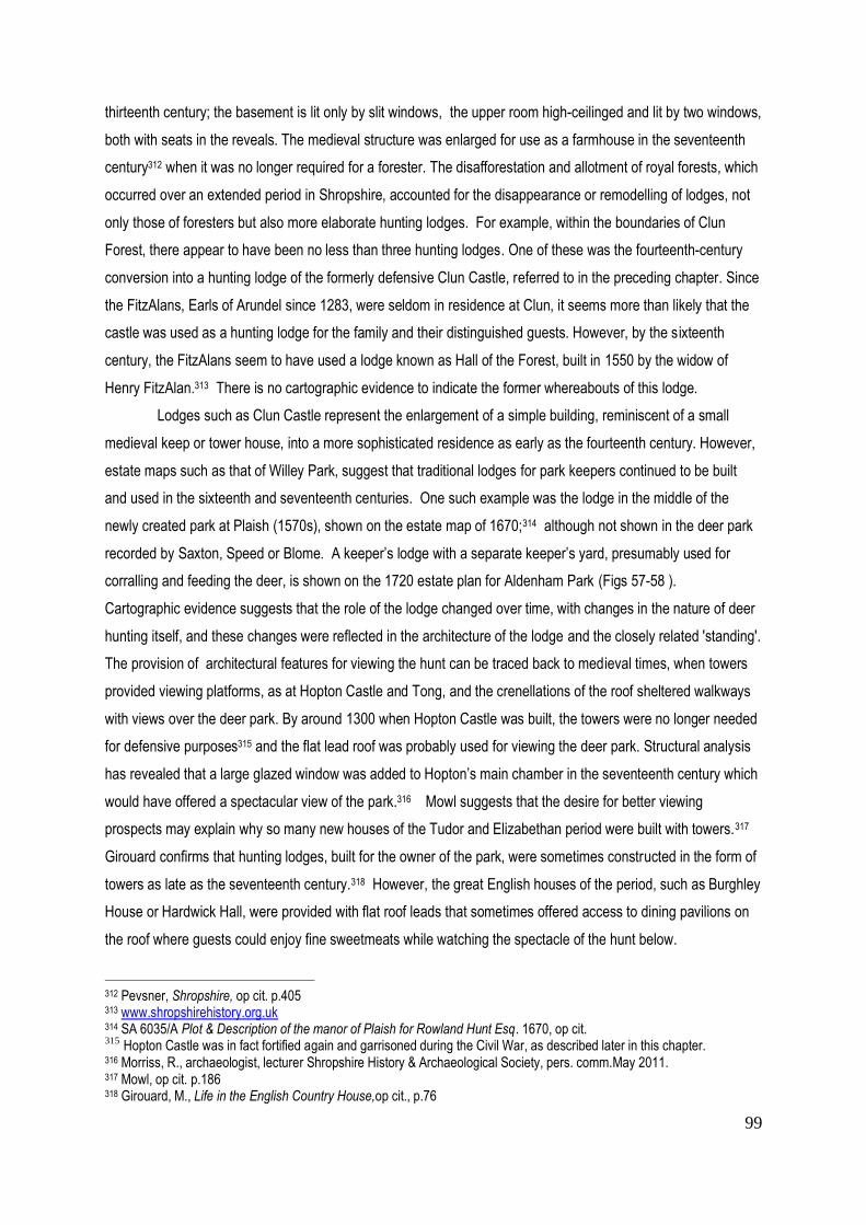
99
thirteenth century; the basement is lit only by slit windows, the upper room high-ceilinged and lit by two windows,
both with seats in the reveals. The medieval structure was enlarged for use as a farmhouse in the seventeenth
century312 when it was no longer required for a forester. The disafforestation and allotment of royal forests, which
occurred over an extended period in Shropshire, accounted for the disappearance or remodelling of lodges, not
only those of foresters but also more elaborate hunting lodges. For example, within the boundaries of Clun
Forest, there appear to have been no less than three hunting lodges. One of these was the fourteenth-century
conversion into a hunting lodge of the formerly defensive Clun Castle, referred to in the preceding chapter. Since
the FitzAlans, Earls of Arundel since 1283, were seldom in residence at Clun, it seems more than likely that the
castle was used as a hunting lodge for the family and their distinguished guests. However, by the sixteenth
century, the FitzAlans seem to have used a lodge known as Hall of the Forest, built in 1550 by the widow of
Henry FitzAlan.313 There is no cartographic evidence to indicate the former whereabouts of this lodge.
Lodges such as Clun Castle represent the enlargement of a simple building, reminiscent of a small
medieval keep or tower house, into a more sophisticated residence as early as the fourteenth century. However,
estate maps such as that of Willey Park, suggest that traditional lodges for park keepers continued to be built
and used in the sixteenth and seventeenth centuries. One such example was the lodge in the middle of the
newly created park at Plaish (1570s), shown on the estate map of 1670;314 although not shown in the deer park
recorded by Saxton, Speed or Blome. A keeper’s lodge with a separate keeper’s yard, presumably used for
corralling and feeding the deer, is shown on the 1720 estate plan for Aldenham Park (Figs 57-58 ).
Cartographic evidence suggests that the role of the lodge changed over time, with changes in the nature of deer
hunting itself, and these changes were reflected in the architecture of the lodge and the closely related 'standing'.
The provision of architectural features for viewing the hunt can be traced back to medieval times, when towers
provided viewing platforms, as at Hopton Castle and Tong, and the crenellations of the roof sheltered walkways
with views over the deer park. By around 1300 when Hopton Castle was built, the towers were no longer needed
for defensive purposes315 and the flat lead roof was probably used for viewing the deer park. Structural analysis
has revealed that a large glazed window was added to Hopton’s main chamber in the seventeenth century which
would have offered a spectacular view of the park.316 Mowl suggests that the desire for better viewing
prospects may explain why so many new houses of the Tudor and Elizabethan period were built with towers.317
Girouard confirms that hunting lodges, built for the owner of the park, were sometimes constructed in the form of
towers as late as the seventeenth century.318 However, the great English houses of the period, such as Burghley
House or Hardwick Hall, were provided with flat roof leads that sometimes offered access to dining pavilions on
the roof where guests could enjoy fine sweetmeats while watching the spectacle of the hunt below.
312 Pevsner, Shropshire, op cit. p.405 313 www.shropshirehistory.org.uk 314 SA 6035/A Plot & Description of the manor of Plaish for Rowland Hunt Esq. 1670, op cit. 315
Hopton Castle was in fact fortified again and garrisoned during the Civil War, as described later in this chapter. 316 Morriss, R., archaeologist, lecturer Shropshire History & Archaeological Society, pers. comm.May 2011. 317 Mowl, op cit. p.186 318 Girouard, M., Life in the English Country House,op cit., p.76

100
Fig 58. Survey of Aldenham Park, detail showing lodge & keeper’s yard. Burton 1722
Fig 57. SA1093/Box160 Survey of Aldenham Park, Burton 1722
Fig 59. Aldenham Hall, watercolour by Moses Griffin 1792.

101
Royal patronage of hunting was, as already noted, an important aspect of its popularity among the
aristocracy and gentry. Henry VIII was an enthusiastic supporter of the deer hunt, and as a young man rode to
hounds almost every day. However, after a hunting accident in 1536 when he was already grossly overweight,
he was no longer able to take such an active part, and instead chose to watch the more ritual form of deer
coursing, which involved hounds chasing selected deer over a track often as much as a mile in length, with
spectators watching from specially constructed timber stands (or standings). 319 In 1537 he created a coursing
track at Hampton Court. Henry’s daughter Queen Elizabeth was equally keen on hunting, and expected to be
entertained with a deer hunt when she visited country houses on her progress through the country. The rituals
with which the Queen engaged prior to the hunt included the examination of the dung of a selected stag, to
determine whether it was worthy of being hunted; and subsequently she was the first to thrust a knife into the
fallen deer (Fig 60 ). James I was even more bloodthirsty, reputedly plunging his bare feet into the “blood and
guts of newly shot stag”. 320 Although this may seem abhorrent to us today, it would be wrong to underestimate
the importance of imagery and ritual to the society of the Early Modern period, accustomed as they were to
attending the hanging and disembowelling of condemned criminals. The rituals associated with the hunt
demonstrate the iconic nature of the stag in the eyes of contemporary society, its pursuit akin to the chivalric
rituals of the medieval tilt and tournament, revived by Henry VIII.
In his paper on the presumed medieval deer course at Ravensdale Park (Derbyshire), Taylor suggests
that already by the fifteenth century, hunting had "changed from a largely participatory sport to a spectator
one".321 Although Taylor's research indicates that there were already deer courses in medieval times, no
evidence of this can be confirmed in Shropshire. The popularity of coursing deer as a sport appears to have
become established in the sixteenth and seventeenth centuries, when there were three principal forms of
coursing, all of which involved dogs chasing one or two selected deer, and spectators placing bets on which dog
was fastest. 'Purlieu coursing' took place on open land, whereas more often coursing took place on specially
constructed tracks, either temporary tracks bounded by nets set on poles, or permanent tracks bounded by walls
or hedges.322 Only one example of a course has been confirmed in Shropshire, although there may well have
been more.323 This was at Stokesay Castle, where by 1577 a 275 acre deer park was added by the Vernons in
the woods to the west of their upgraded medieval residence 324 (Figs 61, 62). The park, most probably a
separate enclosure in Stoke Wood, is recorded by Saxton, Speed, Blome and Morden. Evidence for a course is
based on a map of the manor of Stokesay made for William Lord Craven in 1772, which describes Plot 18, a
rectangular elongated field lying in front of the west facade of the mansion, as “The Course”. 325 This suggests
319 Mowl, op cit. p.186 320 ibid. p.191 321 Taylor, C. op cit. p.52 322 ibid. pp. 44-46 323 The possibility of a deer course at Hopton Castle, based on the shape of the presumed park, has been discussed in the previous chapter. 324 HER Shropshire 325 SA6001/2480 Map of the Manor of Stokesay, made for Wm Lord Craven by Charles Baldwin, 1772

102
Fig 60. Woodcut of Queen Elizabeth I at the hunt, Turberville 1576
Fig 61. Stokesay Manor, west facade with Tudor addition
Fig 62. Stokesay Manor , view to deer course and Stokesay Woods
103
that already, in the early stages of planning the new deer park, the Vernons intended to course deer, and would
have viewed the spectacle from the west-facing windows of their residence or from the flat roof of the tower to
the south. Henderson, Mowl and Taylor all agree that deer courses were usually about one mile long and a
quarter
of a mile wide. Henderson suggests that deer coursing was especially popular for its gambling opportunities.326
Standings for viewing the course, or grandstands as they were sometimes called, offered an opportunity for
women to enjoy the sport and appreciate the aesthetic qualities of the deer and dogs. Taylor emphasises the
social aspects of the gathering - dining facilities were often included - and there was an opportunity to display
wealth and status 327. Grandstands could take the form of elaborate buildings. One of the few surviving examples
in England is Lodge Park on the Sherborne estate, a fine two storey stone building, with a flat roof and extended
first floor balcony overlooking the course (Fig 63). It was built around 1634 by John ‘Crump’ Dutton, together
with a mile long walled enclosure for the course. The ground floor consisted of an entrance hall, with a Great
Hall above for entertaining guests, and kitchens in the basement. It was remodelled in the 1720s when the
landscape was transformed by Charles Bridgeman, but has now been returned to its original form by the National
Trust.328 Another probable former grandstand of the same period is Swarkestone Pavilion (Derbyshire), which
shares a similar plan, with a walled enclosure that may well have been used for coursing or maintaining deer.
(Fig 64 ). It has been preserved by the Landmark Trust. In Shropshire, Pevsner suggests that Pepper Hill, lying
on top of a sandstone cliff on the north eastern border with Staffordshire may originally have been built as a
standing for deer coursing in the park enclosed in 1519.329 It appears on both Saxton's and Speed's maps as a
building within the bounds of the more northerly of two parks ascribed to Pepper Hill. However, in 1543 it was
described by Leland as a “goodly lodge”, which at the time was already inhabited by Sir John Talbot. In 1695
Morden's county map shows only one park and four years later the house was rebuilt for the Earl of
Shrewsbury’s steward. Over a period of one hundred years, its function as a lodge had totally changed.
There are no other confirmed examples of standings being built in Shropshire, but many buildings
carried special features to enable better viewing of the hunt. At Frodesley, in the Condover Hundred, where the
deer park had been revived in1609 following a period of dormancy, a lodge was built with a viewing platform, a
flat roof overlooking the park.(Fig 65) In 1675 it was occupied by Sir Richard Corbett while his new house at
Longnor was being built. The park is shown and its lodge named by Morden, who depicts it as clearly enclosed.
It may possibly have contained a course. We have no evidence of this, although part of the park wall survives,
together with the lodge, known today as Lodge Farm.
By the beginning of the seventeenth century, there is further evidence of lodges being occupied by the
gentry, whether temporarily or longer term. Lilleshall Lodge was the Levesons' first home in the parish after
James Leveson acquired the abbey lands following the Dissolution. A building is shown in the park by Saxton,
326 Henderson, op cit., pp.167-177 327 Taylor, op cit. p.47 328 www.wikepedia.org 329 Pevsner, Shropshire, op cit. p.156

104
Fig 63. Sherborne (Dorset) lodge/grandstand 1634
Fig 64. Swarkestone pavilion/grandstand C17th
Fig 65. Frodesley Lodge, tower & viiewing platform, early C17th

105
Fig 66. Lillleshall lodge & stables, Cartwright 1679 SA972/7/2/1/2
Fig 68 . Lilleshall lodge & kennels, Burton 1720 (detail) SA972/7/2/3
Fig 67. Cartwright 1679 (detail)
106
Speed, Morden and Bowen, although there is no indication of its role. However, in 1604, after the death of his
father Walter, the lodge was occupied by Sir Richard Leveson 330. At that time it was a two storey building with a
great chamber over the hall, and Stamper has found evidence of a viewing balcony being added in the first half
of the1600s,331 some time before the Cartwright survey of 1679 (Fig 66). A member of the Leveson family was
living in this lodge when the abbey buildings were garrisoned in 1645, but thereafter the family was never
continuously in residence, leaving the responsibility of the park to a keeper. 332 The Survey of 1679 made by
Wm. Cartwright shows an elaborate 3 storey building with a deep balcony built over an arcade, similar to that at
Sherborne, and with outlying stables or kennels (Figs 66 & 67). Since deer and dogs are depicted on this map,
it suggests that deer were being actively hunted in the park at this time. In 1720, when Thomas Burton surveyed
Lilleshall Park for William Leveson-Gower, the total area of the park was given as 793 acres, clearly enclosed
with a pale, and with indications of possible deer leaps and barns; the lodge and its outlying buildings remained
intact 333 (Fig 68). By 1774 the Leveson-Gowers had left Lilleshall for good, and the deer park was split up by
1783. The lodge was gradually dismantled and eventually demolished.334
One of the other uses to which a lodge might be put was to act as a dower house. In 1672 Elizabeth
Cressett, widow, of Upton Cressett had been living in the Lodge House in the park, which was still stocked with
deer when it was leased with its grounds to Jon Shipman, yeoman.335 In 1699 he was described as ‘forester’ to
Upton Cressett.336 During the late sixteenth and early seventeenth centuries a number of lodges appear to have
been built specifically as alternative residences. Girouard refers to the medieval practice of “keeping ‘secret
house’”: lodges might be used for family excursions, as a private meeting-place, or simply as a place of
retirement rather like a second home.337 Stamper has suggested that Penkridge Hall near Leebotwood, a timber-
framed building with one room on each of two floors, was built as early as 1590 by Rowland Whitbrook, a
Bridgnorth wool merchant, as a place from which to hunt deer in the Lawley Hills 338 (Fig 69 ). It appears on
Rocque’s map of 1752 but there is no indication of an associated deer park, so Stamper's suggestion seems
entirely plausible. Houses such as this were often quite modest, when compared with the formality and
pretension of contemporary mansions such as Condover or Pitchford Halls. Henderson suggests that the privacy
they provided was highly valued. 339
Shropshire cannot boast a lodge of real architectural distinction, comparable with Tresham's Warrener's
House in Rushton (Northants). However, of particular interest to this thesis is the surviving lodge built at Loton
Park in c.1675 (Fig 70). This is a small sandstone building on two floors, connected by a staircase, with a hearth
330 www.britishhistory.ac.uk 331
Stamper, Historic Parks & Gardens, p.17 332 SA 972 bundle 233, item 1, quoted Stamper, op cit. 333 SA 972/7/2/3 Map of Lilleshall Park,1720, op cit. 334 www.britishhistory.ac.uk 335 SA 5460/4/10 20 March 25 Charles II (1672/3) 336 SA 5460/4/1/13 337 Girouard, op cit., p.106 338 Stamper,Historic Parks & Gardens, op.cit. p.19 339 Henderson, op cit. pp 170-2

107
Fig 69 . Penkridge Hall, c.1590 Fig 70. Loton Park pavilion c.1675
Fig 71 Boscobel House c.1600
Fig 72 Boscobel House, Hollar 1660

108
on each floor and stone-framed windows. It stands within the deer park that was created in the seventeenth
century together with the mansion built from 1665 built by the Leightons.340 It appears on the county maps from
1751 (Bowen). Stamper suggests that it may have been intended as a “sylvan banqueting house”341, a place
where the lord might retreat, alone or with special company, to enjoy a glorified picnic. But as Girouard points
out, the distinction between hunting lodge and banqueting house, the latter also often distanced from the
house as at Wrest Park, is by this time often blurred.342 The present owner of Loton Park, Sir Michael Leighton,
maintains that evidence in his private archive confirms that there was a bowling green on this site within the park,
for which the 'lodge' served as a pavilion.343
What the evidence presented above seems to suggest is that the increasing incidence of the lodge
being used as a country house retreat, marks a very significant change in the way the deer park itself was used
and perceived. What was initially built as a facility for the forester responsible for the rearing and maintenance of
deer, had been transformed into a building from which to view and aesthetically appreciate the deer and the
park. As the maps referred to have already indicated and later pages will confirm, this role became increasingly
common after 1660 when Boscobel House, used as a retreat by the Catholic recusant John Giffard, and briefly
visited by Charles II after the battle of Worcester, when he reputedly hid in its oak tree, was converted into a
hunting lodge with a viewing tower 344 (Figs 71, 72).
Improvements in park and estate management prior to the Civil War
In a letter written to the Earl of Shrewsbury in 1604, Humfrey Nurthall, the keeper of his park at Shifnal
(N. Shrops), complained of his difficulties in attempting to feed and enclose some 2000 deer that had been
forced to share their grazing with cattle. “They doe gretlie decaye by meanes of convertinge of the best parte of
the parke into Tyllage and mowing growndes being utterlie excluded from the same and wyntour feedinge in
those partes.” 345
Already in medieval times, deer had shared their grazing with other animals and parks had been
compartmentalised in order to protect timber and coppice. By the sixteenth century many of the old medieval
parks had, as already noted in the previous chapter, been broken up and converted to agricultural use. Dairy
farming and stock rearing were well suited to the fertile plains of North Shropshire, and landowners in this region
were able to respond to an increasing population, which according to data quoted byThirsk rose from 2.75 million
in 1541 to 4.1 million in 1601, creating a big demand for food, particularly in the regions close to the expanding
city of Birmingham where butter and cheese were increasingly in demand. 346 Well before the period 1650-1750,
340
This seventeenth century deer park at Loton was created on a more southerly site than the medieval park referred to in the previous chapter 341 Stamper, Historic Parks & Gardens, op cit. p.19 342 Girouard, op cit., p.106 343 Sir Michael Leighton, per.comm.2013 The private archive is not available for viewing, so this cannot be confirmed. 344 The Rocque depiction of the site gives no suggestion of an associated deer park, although the 1660 illustration by Hollar suggests that the formal garden was closely fenced, possibly against the intrusion of deer from the surrounding woodland 345 Lambeth Palace, Shrewsbury Papers, MS 702 f.37 I am grateful to Dr Sylvia Watts for allowing me to see this letter. 346 Thirsk, J., England' Agricultural Regions and Agrarian History, 1500-1750, Macmillan Education, 1987, p.18

109
which is when most of the estate plans referred to here were drawn up, new forms of agricultural activity were
being pursued to provide a better economic return. By 1650, particularly during the Commonwealth, agricultural
treatises and publications concerned with the introduction of new crops and new technology were being widely
read347, although inevitably their dissemination varied from one part of the country to another. How quickly the
new ideas and systems spread is a matter of dispute among historians. While Kerridge considers that the
introduction of new crops and new systems had been completed some 200 years before 1750, the date of the
so-called Agricultural Revolution, Overton finds this to be a gross exaggeration and speaks of "a few precocious
farmers growing new crops, or dabbling in some new husbandry practice" providing insufficient grounds for
using the term 'revolution' .348 Mingay places the history of agricultural change over a much longer period,
stretching from the sixteenth to twentieth century. Thirsk reasonably suggests looking at the history of
agricultural improvements as a "continuum".349 Nevertheless, it does seem that the period prior to the Civil War
was one of agricultural innovation and change, as the following pages will seek to demonstrate.
Already in the early years of the seventeenth century, contemporary commentators such as John
Norden and Gervase Markham were publishing texts, for the benefit of “Gentlemen, Farmers, and
Husbandmen”, showing how all types of ground might be improved to produce a more profitable return.350 In his
The Surveyor’s Dialogue, Norden rebuked those farmers who neglected their land through ignorance, and
encouraged them to experiment with new practices, specifically those appropriate to their region and soil.351 His
treatise was first published in 1618, the very same year in which John Weld acquired Willey Park and a year
later, started to write his book of Memoranda, in which he noted ways in which he was improving his estate. A
Survey drawn up in 1618 by George Cole shows Willey Old Park divided into three wooded compartments, one
of which appears to contain a lodge (Fig 37). The accompanying explanation gives a total acreage of 432 acres,
which includes The Moore Haye (48 acres), The Coppice (134 acres), The Broade Park (91 acres) and a “dry
pool” of 5 acres.352 At that time, there were also three closes of pasture (39 acres), but overall the estate plan
indicates a predominantly wooded park. On 3rd January 1619 Weld was considering how “to make best profit of
ground and marsh,” to introduce deer into the park, and to dredge the pond by Willey forge, 353. Later in the
same year, Weld wrote that the portion of the park obtained from the Abbot of Wenlock was not part of the Forest
of Shirlett and “never had deer in it”.354 He therefore proposed to introduce deer alongside other improvements,
347 Raylor, T.’Samuel Hartlib and the Commonwealth of Bees’ in eds: Leslie & Raylor, Culture & Cultivation in Early Modern England, Leicester Univ. Press 1992, p.95 348 Overton, Mark, 'Agricultural Revolution? Development of the agrarian economy in early Modern England', in A.R.H. Baker & D. Gregory (eds), Explorations in Historical Geography. Interpretative Essays, Cambridge 1984 p.122 quoted Thirsk op cit., p.59 349 Thirsk, op cit., p.57 350 Norden, J. The Surveyor’s Dialogue, op cit., p.1 351 McRae,A. ‘Husbandry Manuals & the Language of Agrarian Improvement’, in eds; Leslie & Raylor, op cit. p.51 352 SA 1224/7/1 Survey of the Manor Willey, 1618 353 SA 1224/Box 163, John Weld’s Journal, 1619, p.2 354 Ibid., p.11

110
such as “to make small stew ponds neare the house and in the Park to mend the grounds by overflowing them or
Liming them or drayning them.”355
These ideas for improvement might well have been taken directly from Norden, and were current at the
time, although Weld appears to have been among the earliest practitioners in his county . With regard to liming,
Norden notes that in Shropshire, as also in Denbighshire and Flintshire, industrious farmers “do buy, dig and
fetch limestones, two, three, four miles off, and in their fields build lime-kilns, burn it, and cast it on their fields, to
their great advantage”, since it helps to counteract “cold and moist grounds”.356 In his advice to the Bailiff, Norden
emphasised the value of meadows and rebuked the bailiff for leaving ground “idle and waste, and to foster
nothing but Bogs, Sedges, Flags, Rushes.... where, if it were duly drained and carefully husbanded, it would
make good meadow in short time”.357 He refers to a technique for doing this by “overflowing” the land: “Boggy
and spongy ground.. though in its own nature it be too moist, yet if it be overflowed with water often, it will settle
and become firm.”358
In order to explain the system to which Norden is referring here, it is important to distinguish between
'pastures', which were grazed by stock throughout the year, and 'meadows' only grazed for part of the year,
whose main purpose was to produce a crop of hay.359 Kerridge describes 'floating' as covering the land with a
thin sheet of water, about one inch deep, which not only provided a layer of rich sediment, but also protected the
ground from winter frosts, so that the grass was produced earlier in the year. At the beginning of March the
floodgates were closed and the meadow left to dry out.360 The earlier and better quality grass produced by this
method enabled farmers to increase the numbers of grazing stock361. The sluices were sometimes opened a
second time, in order to ensure a good crop of hay, but Williamson maintains that the primary purpose of
'floating' was to provide the early grass through raising the ground temperature.362 Irrigation of meadows had
been practised since the Middle Ages, 363 possibly even in Roman times, but Kerridge maintains that artificial
'floating' was invented around 1580 by a certain Rowland Vaughan in the Golden Valley of Herefordshire.364
Taylor suggests that the system Vaughan practised on the Earl of Pembroke's estate was probably of the
'catchwork' variety, with water captured from the nearby hills and run through channels over the meadows.365
355 SA 1224/Box 163, John Weld’s Journal, 1619., p.4 356 Norden, J., op cit. p.180 357 ibid., pp.147-8 358 ibid., p.155 359
Williamson, T., 'Floating in Context' in Water Meadow: history, ecology & conservation, eds.Cook, T. & Williamson T.,
Windgather Press 2007, p.35 360 Kerridge,E., The Farmers of Old England, Allen & Unwin, 1973, pp. 110-111 361 Eds: Leslie, M. & Raylor, T., Culture & Cultivation in Early Modern England, op cit. p.29 362 Williamson,T., op cit., p.42-3 363 Taylor, C., 'The Archaeology of Water Meadows' in Cook & Williamson, op cit., pp. 23-29 Archaeologist Christopher Taylor refers to three types of floating: "bedworks", which superficially resembled ridge and furrow forms, with a channel of water diverted along the ridge; "catchworks", which were cheaper to make, but involved capturing water from a hilly site and running it over the meadow through channels; and finally, "floating upwards" in which a stream was dammed and the water allowed to float back over the meadow. 364 Kerridge, op cit. p.110 365
Taylor,C., op cit. - as explained in previous note above.
111
In Shropshire, one of the earliest records of land improvement is the drainage system recorded on the
1579 map of Kynnersley and Lubstree Park, to which reference has already been made,366 which demonstrates
the efforts of a Mr Eaton to drain his land on the Weald Moors by a simple system of weirs and drains. (Fig 28)
Archaeology has revealed a hybrid form of irrigation practised near the River Severn at Buildwas in North
Shropshire, where the meadows were naturally flooded with water from the river for several weeks early in the
year, and later supplemented by a bedwork system of ridge and furrow. 367 There were probably other examples
waiting to be rediscovered along the length of the Severn.
John Weld of Willey Hall noted down his ideas on the subject of irrigation in his Memoranda Book of
1631, written for the benefit of his wife and son after his death. “The Old Park may be much improved by leading
Bentall marsh water over my copy, and by water which may be carried from my new ponds, and from Sandy
Pool, and great pool, and the spring at the copy head and the brook that runs west from my Lodge pool...” 368
This sounds like a version of catchworks; Weld had plenty of water sources, and was also considering
improvements to his New Park “by ploughing it, and making a meadow all along the brook.”369 A Survey of 1674
shows the New Park, with what appear to be graphic representations of draining systems with sluices. (Fig 54)
In his Memoranda book of 1631 Weld uses the words “improve” and “improvement” for the first time. It is quite
possible that he was reading Norden, and even Gervase Markham whose The English Husbandman The First
Part appeared the same year. McRae points out that during the seventeenth century the concept of
“improvement” was increasingly associated with financial profit.370 The possibility of raising rents was no doubt
the driving force behind Weld’s attempts to improve his land. According to Bettey's research, the value of water
meadows was approximately twice that of those left unwatered.371 At the same time that these new practices
were being introduced, parks were still valued, as they always had been, for the wood and timber they produced.
In 1618, Weld had requested from his surveyor Samuel Parsons a precise account of the number of timber trees,
dotterels (pollarded trees), saplings, and even dead trees distributed throughout the estate. In the ‘park
demesne’ together with Birches Leasowe, there were a total of 3272 timber trees and 940 dotterels, which
included 700 timber trees and 350 dotterells in the 134 acres of coppice. On the estate as a whole there were
6883 trees, of which 4581 were timber trees, 405 saplings, and 1837 dotterels.372 This suggests a heavily
wooded park, as the two surveys seem to confirm, and widespread use of pollarding throughout the manor.
The wilful destruction of forest was noted by a number of commentators in the early sixteenth century.
John Manwood drew attention in 1615 to the value of the Law in protecting the forest and its wild beasts, “…a
Forest cannot have continuance without woody grounds and fruitful pastures. And so consequently it followeth,
366 SA 972/7/3/1 Map of Lubstree Park, 1579 367 Taylor, C., op cit., p.31 368 SA 1224/Box 163 Memoranda Book of John Weld, 1631 369 Ibid. 370 McRae, A., ‘Husbandry Manuals and the Language of Agrarian Improvement’ op cit., pp. 36-7 “To improve”: the OED gives the early usage of the word as meaning “to turn land to profit; to enclose and cultivate (waste land); hence to make land more valuable by such means.” 371 Bettey,J.H., 'The Development of Water Meadows in Dorset', Agricultural History Review, 25, pp 37-43 372 SA 1224/7/1 Survey of Willey Park, 1618

112
that to destroy the coverts of the Forest, is to destroye the Forest itselfe. Also to convert the pasture grounds,
meadows, and feedings into arable land, is likewise to destroy the forest.”.373 Norden also deplored the loss of
timber trees, and criticised those landowners who, ignoring the Statute 35 Henry VIII drawn up in 1543 for the
Preservation of Woods, had been too eager to cut down trees and replace woodland with arable. He counselled
“every good husband... both upon his own land as also upon such as he holds of other men, ... to maintain and
to the uttermost to preserve the timber trees and saplings likely to become timber trees, Oak, Elm, and Ash,..”
Furthermore, he urged them to plant a number of trees per acre, or to sow acorns, ash keys, hawthorn berries
and nuts.374 Clearly, John Weld would not have been the only landowner to take note of the advice offered in
contemporary treatises. The same surveyor who counted the trees in Willey Park in 1618 seems to have been at
work on Cound Moor after 1622, when he counted “3433 great oaks of good timber, corrected to 2433 oaks by
account delivered in by bailiff Dodd.” In March 1621/2 the bailiff and five others had estimated 2616 trees, of
which 762 were required to be provided for ‘houseboote’ 375 - their estimated value based on 5s.7d. per tree.376
Unfortunately, there is little other evidence of the calibre of Weld’s journal to show what improvements
other landowners were undertaking before the Civil War, although Kerridge has observed that from the end of
the sixteenth century there was a move towards the creation of what he calls “capital farms”, achieved by
consolidating the demesne lands, with the farmer managing them himself.377 Thirsk attributes improved
agricultural production over the period 1500-1750 to not only more varied farming systems and new crops, but
also to the fact that more gentry became actively engaged in farming, and more books of practical advice
became available.378
One of the questions raised by Weld's account of his 'improvements' is why he should have chosen to
experiment in his parkland. It is worth remembering, that on most estates the arable land and pasture would
have been let out to a tenant, whereas, as already noted, the deer park was usually retained by the landowner
for his private use. Not all landowners were as 'hands on' as Weld appears to have been, managing his estate in
its entirety. What his actions may indicate is a developing conflict between modern improvements and the
traditional use of the deer park as a place of recreation for the family and their guests, leading a man such as
Weld, with a good head for financial return, to seek to increase the profitable grazing land within his park by
improving the pasture through irrigation.
The Civil War in Shropshire 1642-48
Once again in the history of Shropshire, national events intervened, causing unforeseen changes in the
management of the countryside and impacting on the survival of the deer park and its deer. Between1642-46
and again briefly in 1648, Civil War caused widespread destruction in the county. Deer parks seldom escaped
373 Manwood,J., A Treatise of the Laws of the Forest, London 1615,.quoted Stenton, D. M., English Society in the Middle Ages ,Penguin 1951, p.102 374 Norden, J., op cit. p.67 375 ‘houseboote’ is the name given to firewood to which the commoners were entitled. 376 SA 5460/5/2/2 Particulars of Cound Moor and the Timber there, post 1622 377 Kerridge, op cit., pp. 103-4+ 378 Thirsk, op cit., p.60

113
unscathed. Shropshire was predominantly royalist and garrisons were installed in a number of medieval castles,
some previously uninhabited and, like Bridgnorth, refortified for the purpose of protecting the town.379 Caus
Castle, once the principal seat of the Corbets, was one of many that were never reinhabited, and their associated
deer parks disappeared. Shrawardine Castle was held by a royalist garrison, reputed to have levelled a large
part of the village in order to better defend the castle. On the surrender of the garrison, both the castle and
surrounding buildings were fired, the stone from the keep being used to strengthen the defences in
Shrewsbury.380 In spite of this, the deer park recorded by Saxton and Speed, survived long enough to be
depicted by Morden and Bowden (1751) before finally disappearing from the county maps. It seems unlikely that
it would have continued to be stocked with deer, since the Corbet family did not build a new residence on the
estate.
Hopton Castle, owned by one of the few important parliamentarians in the county, with connections to
Brampton Bryan, a parliamentarian stronghold on the Herefordshire border, was held by a small garrison. After
routing their royalist attackers from Ludlow on more than one occasion, the garrison was finally forced to
surrender. The castle was severely damaged and never re-inhabited,381 but the deer park survived to be
recorded by Morden and Bowden in 1751. Porter suggests that in most cases, the demolition of castles took
place in early 1647 when they were left empty or in the hands of small garrisons unable to defend them. At the
very least, they were ‘slighted’, which is to say that their outer walls were demolished, so that they could not be
re-garrisoned.382 Where their deer parks survived, the question arises as to what their function may
subsequently have been, and whether they were restocked with deer or reverted to agricultural use - and if so,
why they continued to appear on county maps.
It is perhaps unsurprising to find that previous monastic houses, such as Lilleshall and Haughmond,
held as royalist garrisons, were targeted during the Civil War. The abbey house of Lilleshall, described above,
was garrisoned for the king and besieged by parliamentary forces. Nevertheless, the buildings were evidently
not beyond repair, as the later evidence of estate maps of 1679 and 1720 has revealed.383 (Figs 66, 68) But for
some families who supported the king, the Civil War meant the collapse of family fortunes and the sequestration
of their estates. A body known as the Committee of Both Kingdoms, set up during the Commonwealth, had the
authority to advise local committees not to burn down certain houses. As a result, mansions of national
importance such as Chatsworth, Hardwick Hall and Burghley survived. In Shropshire, the local committee
received notice to prevent the firing of High Ercall Hall, the Jacobean mansion built by Sir Francis Newport, and
damage was confined to “slighting and draining the moat”.384 Sir Richard Newport (1587-1650) had been
appointed as a mediator in the Civil War, but secretly he sided with Ottley of Pitchford in supporting the king, and
379 Porter, S., Destruction in the English Civil War, (Alan Sutton 1994) 380 www.cpat.org.uk Archaeological Report on Shrawardine Castle 381 Hopton Castle was held by a handful of soldiers under Capt Samuel More who attempted to negotiate their surrender. While he was imprisoned, the rest of the garrison were mutilated and stoned to death. Mark Bowden op cit. 382 Porter, op cit. p.130 383 SA 972/233/1 Lilleshall Park, 1679 384 Porter op.cit. p.63 'slighting' involved pulling down the outer walls so that the building could not be reinhabited

114
had pledged £6000 to the king's cause in return for a baronetcy. After the execution of Charles I, Newport fled to
France where he died in 1651. His eldest son, Francis, who had fought for the royalist cause and been taken
prisoner at the Battle of Oswestry, was rewarded for his loyalty after 1660, holding various posts at court, and
being granted the title of Earl of Bradford in 1694. However, the family abandoned High Ercall after 1660 for their
new house at Eyton-on-Severn (built 1604), although the Ercall deer park continued to appear on all the county
maps up to 1752.
Other landowners were less fortunate. The Talbot family estates at Whitchurch and Albrighton were
sequestered in 1647, and Francis Talbot, 11th Earl of Shrewsbury (1623-1668) fought as a captain in the royalist
army at the Battle of Worcester (1651). After that defeat, he fled to Europe in the company of Charles II, but
returned in 1653 when he succeeded to his father's earldom and petitioned Cromwell to pardon him.385 The
Brookes of Madeley Hall were also committed Catholics and royalists who garrisoned their mansion for the king,
but abandoned it after the fall of Shrewsbury in 1645. Some of their land was still in sequestration in 1660, and
nine years later the estate passed to a cousin in Staffordshire. A Survey drawn up in 1702 prior to the sale of the
manor in 1705 includes field names such as Upper Pool Park and Lower Pool Park,386 but after the purchase of
the estate by Matthias Astley (1705), Madeley Hall became a tenanted farmhouse and the deer park was no
longer maintained. Recorded for the first time by Morden (1695), it had been disparked and cultivated by 1752.
Apley Park , which had been acquired by William Whitmore of London in the late sixteenth century and its
medieval house replaced by an Elizabethan mansion, was besieged in 1644 and then recaptured by royalists
who later demolished the house. Sir Thomas Whitmore was taken prisoner.387
Many country houses were, however, saved by influential landowners. While the King still remained
in power, petitions were made to him on behalf of men of high standing held prisoner, such as Edward Cressett
of Cound who was said to be “ a person of good estate and esteem in this county and has been from the
beginning of and through 'these unnaturall warrs' "a ready and constant servant to his majesty and his
commanders in this county and parts with his counsel, industry, purse, men and arms on all occasions .. and is
reputed still to be a man of clear affection to His Majesty and his righteous cause. “ The king was asked to agree
to give Cressett his freedom in exchange for a less ‘useful’ prisoner.388 Similarly, John Weld senior and his son,
of Willey Park, were treated favourably by the king who bestowed knighthoods on them during a royal visit to
Wellington. After the king’s defeat, however, their estates were sequestrated and they were fined as
“delinquents”.389 John Weld died in 1666, the Civil War having seriously reduced his finances.
385 www.wikipedia.org On Charles II's return, Talbot was made Lord Housekeeper of Hampton Court, but was mortally wounded in a duel with George Villiers, 2nd Duke of Buckingham, who was his wife's lover. 386 Phillpotts,C., 'Madeley Court',Transactions of the Shropshire Archaeological & Hstorical Society 81, 2006, p.55 387 Shropshire Archaeology, 2nd Series VIII 1896, p.230 and Pevsner, Shropshire, op cit. p.115 The remains of this house are still visible in the later neo-Gothic mansion built by John Webb. 388 SA 5460/8/2/2 Plea to King Charles for release, n.d. (during Civil War) 389 ‘Sequestration Papers of Sir John Weld senior and Sir John Weld junior, knights of Willey’ in Transactions of the Shropshire Archaeological & Historical Society, 3rd Series, 1, 1901, pp.185-212.

115
Since there were no royal palaces in Shropshire, there was no destruction comparable to that of
Richmond, Oatlands, Berkhamsted, Holdenby and Theobalds on the national scene.390 Many of the soldiers who
acquired lesser estates could not afford to maintain them, and Gentles writes of timber being felled and deer
killed, to increase revenue.391 The cases cited above, together with the evidence of later estate maps already
examined, suggest that in Shropshire some deer parks were able to survive the war, but that does not mean to
say that there was no damage inflicted on them, or that the deer survived. At the outset of the War large
stretches of woodland were felled in order to prevent enemy troops from finding cover or fuel. Fletcher has
pointed out that parks also served as military encampments and were laid waste in the process. 392 As soldiers
crossed and re-crossed the county, woodland and crops were inevitably vandalised and any animals taken for
food. There is evidence that the woods at Cressage, enclosed by Lord Newport in 1519, were seriously damaged
during the war. 393 They do however appear as deer parks on Morden's map of 1695. Longnor’s old park, which
had been extended by Edward Corbett in 1575 to include the western part of Micklewood, was disparked
around1686, the stock of deer having been destroyed.394 At Shawbury park, Glebe Terriers provide evidence of
park pales having been repaired in 1649, presumably damaged in the war, but by 1698 Shawbury had been
disparked.395 To make matters worse, the period of the war coincided with bad weather and by the late 1640s
high food prices put increased pressure on local populations, encouraging poaching.396 A lease of 1672 between
Elizabeth Cressett of Upton Cressett and John Shipman, a tenant, refers to “the close or inclosed ground of
pasture in Upton Cressett called the Parke, being now stocked with deer” (my italics), 397 suggesting that during
previous years there had been no deer. It would be reasonable to conclude that the Civil War contributed to a
massive decline in the deer population and the dismantling of deer parks that could no longer be economically
managed.
In the 1650s, however, during the Commonwealth, a number of significant writers, such as Walter Blith,
John Evelyn, Samuel Hartlib, and John Beale had emerged, committed to the better management of land. They
took their inspiration from Virgil’s Georgics, which had appeared in translation in 1589, in order to promote “a
new philosophy of estate management” according to which landowners were encouraged to see themselves as
“patriarchal” figures, stewards of the land and its tenants, unlike the feudal landlords who were their
predecessors.398 John Evelyn’s interest in improvement dated from 1653 when, as a royalist, he was removed
from public office and retired to his garden at Sayes Court. In that same year Walter Blith, in his own words a
“lover of ingenuity”, published The English Improver Improved, or the Survey of Husbandry Surveyed, in which
390Gentle, I. (1971) in Thirsk, J., The Restoration, Longman 1976. According to research undertaken by Gentle, Theobalds in Hertfordshire was acquired by officers of Thomas Fairfax's horse regiment, who demolished the palace and divided up 30 acres of the estate into small plots on which tenement houses were built for members of a community of Republicans. 391 ibid., pp.105-107 392
Fletcher, op cit., p.177 393 VCH 8, p.73 394 ibid. p. 99 395 Glebe Terriers: Information by courtesy of Ralph Collingwood. 396 Porter, op cit., pp. 90-91 397 SA 5460/4/1/10 20 March 1672/3 398 Thirsk, J., ‘Making a Fresh Start: C16th Agriculture & Classical Inspiration’ in: Eds. Leslie, M. & Raylor, T. op cit. p.19.

116
he offered six “Pieces of Improvement”. These included “floting and watering”; draining fens and reducing bog
(practices already noted in Shropshire before the Civil War); becoming familiar with the characteristics and needs
of different soils; and “doubling the growth of wood” by new planting.399 Blith’s treatise was dedicated to Lord
Cromwell and his Council of State, and sought to point out to that company their error in “not compelling men to
plant wood where they do cut down”, since so much of the nation’s wood was being lost to deforestation.400 He
referred them to the customs of the Ancients, who planted all barren earth, hailing them as “they the planters, we
the destroyers.”. John Evelyn, as a royalist, promoted the planting of trees primarily in order to replace those
woods that had been lost in the Civil War and to provide the royal navy with timber. He engaged in a long
correspondence with John Beale, a Herefordshire gentleman who had retired to the country in the 1640s to
devote his time to the cultivation of fruit trees and the “improvement of husbandry”.401 Beale promised Evelyn that
he would devise a scheme for planting trees for the benefit of both body and mind. For both men, the practical
and the aesthetic aspects of the landscape were intimately interlinked.402 The publication of Evelyn's advice on
tree planting in his book Sylva (1664) was to play an important role in the management of estates after the
Restoration.
The Restoration of the monarchy
When Charles II returned from exile and was restored to the throne in 1660, his aim was to pacify those
of differing persuasions who had suffered during the Civil War and Interregnum. Compensation was to be offered
to purchasers of confiscated land, who were most likely to lose out by the king's return. When problems arose,
Charles decided to refer the matter to Parliament. However, the royal commission that was set up dealt
essentially with Crown and Church lands, rather than with the private estates of 'delinquents' who were advised
to make their claims through a court of law.403 Thirsk suggests that this compromise solution, which offered
compensation rather than the confirmation of purchases made during the previous troubled years, satisfied a
sufficient number of people, in part because the problem was relatively small. Out of a sample of 50 Royalists
with land that she has traced in southeast England, 19 (38%) had managed to buy back 45 out of 179 properties
(25%) before 1660. Another 81 properties were recovered after 1660, meaning that 70% of properties sold
under the Commonwealth reverted to their original owners - suggesting that most Royalists regained their
land.404 Clearly, these statistics will not apply to every part of the country, and regional differences need to be
noted. In Northamptonshire, for example, Habakkuk found that in the case of all royalists investigated, it
transpired that their debts were incurred before the Civil War, forcing them to sell off some of their land.405
There has been some dispute among scholars of the period, as to what extent the old regime was
restored after 1660. Thirsk quotes Bishop Burnet, writing in 1723 that public opinion supported the return of the
399 Blith, W., The English Improver Improved, or the Survey of Husbandry Surveyed, London 1653 400 ibid, Part II, p.82 401 Parry, G., ‘John Evelyn as Hortulan Saint’ in eds: Leslie & Raylor, op cit., p.139 402.Ibid.,pp.139-141 403 Thirsk, Joan, The Restoration, op cit., pp. 93-96 404 ibid. p.98 405
Habakkuk, op cit., pp. 100-101

117
monarchy "so that matters might again fall into their old channel".406 She refers to the political conservatism
prevalent at the time of the Restoration that "restored the gentry to their old seats of local power, (which) they
sank into... with relief and satisfaction, determined not to stir again."407 While there may well be an element of
truth in this analysis, it does not take into account changes in land ownership that had a considerable impact on
Shropshire parks in this period. The increase in the number of landowners drawn from the merchant classes and
the professions, which had already begun before the end of the sixteenth century, encouraged by the availability
of monastic lands for sale after the Dissolution, continued throughout the seventeenth century and into the
Restoration period, bringing new wealth into the county. Although landowners such as William Whitmore of
Apley Hall, a London merchant, had already acquired estates in the late sixteenth century, and in his case, was
seeking to expand his investment in land, a handful of new aspiring owners did acquire estates after 1660. One
of these was Richard Lyster, a merchant draper, who bought Rowton Castle in 1698, and instructed his
executors to spend £1000 on building a new mansion on the original site.408 The medieval deer park recorded
there by Saxton and Speed is also shown by Morden and Bowen, but has been disparked before Rocque.
Not surprisingly, virtually no new building had taken place in Shropshire in the years between the
execution of Charles I and the restoration of the monarchy in 1660. But once stability had been assured,
landowners seem to have been keen to resume their traditional lifestyle, and to demonstrate through the building
of new houses and parks that wealth and power had not been irreparably undermined. With the return of exiled
royalists from the continent, new ideas of landscape design began to emerge, influenced by the fashionable
formal landscapes that English landowners had seen in France and Holland. Although designs as elaborate as
those seen at Vaux-le-Vicomte or Het Loo were beyond the means of provincial landowners, there were certain
features, such as avenues and formal canals, bowling greens, parterres and topiary, which were quickly
assimilated.
The number of new houses with associated deer parks built in Shropshire after 1660 that can be
confirmed by existing evidence, exceeded those built during the Tudor and Elizabethan period. This renewed
interest in deer parks seems to reflect a desire to reinstate those traditional rites and customs that had been
suppressed during the Commonwealth. The following is a list of the principal sites in Shropshire where houses
associated with deer parks were either newly built or updated between 1660-1750: Longnor Park (c.1668);
Loton Park (c.1670); Shavington Hall (1685); Aldenham Park (1691); Boreatton Park (c.1700); Cound Hall
(1704); Condover Hall (1705); Hawkstone Park (1720); Henley Park (1725); Kinlet Park (from 1727); Dothill
(1734); Linley Hall (1742). Of the twelve mansions listed here, all but four were sited within or adjacent to a park
setting. These parks were not necessarily new; indeed, those located at a certain distance from the house were
primarily of medieval origin: Loton, Cound, Hawkstone, Kinlet - while Longnor Park was relocated to a new but
smaller site near the new house. None of these had been recorded on any county map prior to Rocque (1752),
who continued to depict Longnor Park on its original medieval site . At this point, the problems surrounding an
406 'Bishop Burnet's History of His Own Time' (1723) in Thirsk,The Restoration, op cit. p.xi 407
Thirsk, op cit. p.xx 408 Pevsner, Shropshire, op cit. p.490
118
Fig 73. Cound Halll, built 1704
Fig 74. Cound Hall & deer park, Rocque 1752

119
Fig 75. Longnor Hall and gardens, copy of lost paintings of.c.1668
made by Frances Stackhouse in C19th (private coll. T.W.E. Corbett)
Fig 76. Longnor Hall , c.1670

120
interpretation of the Rocque map become increasingly evident, since it is seldom clear whether the parks
depicted are actually enclosed deer parks. In order to provide a clearer idea of park survival rates, it has been
found necessary to refer to the Baugh map of 1808 (see Table 2). What a comparison between the county maps
suggests is that certain parks went through a period of dormancy, whether due to the political disruption of the
Civil War or to economic factors, before being revived in the post-Restoration period.
One of these was Cound Park, a park of medieval origin, created some time after 1254. It appears to
have fallen into a state of dormancy for many years since it does not appear on any county map before Rocque.
who in 1752 recorded the fine brick and stone mansion built in 1704 for Edward Cressett (formerly of Upton
Cressett) by John Prince of Shrewsbury, a distinguished local builder (Figs 73, 74). Some forty years later a new
park setting, complete with gardens and orchards, stretched east towards the River Severn. In 1748 a turnpike
road from Shrewsbury to Bridgnorth was built through the park northeast of the hall. As a result, the old park
was disparked and a new one created south of the road.409 References to this park in the Cressett Papers
include a mention in 1695 of “demesnes (that) now are or were called the Parke”410, suggesting that it no longer
supported deer. However, in 1731 Barbara Cressett, widow, assigned to the Rev. Edward Cressett a lease on
Cound Hall, together with “the park or paddock of deer near the capital messuage”.411 Perhaps, the portion of the
park containing deer had been reduced, and its function was now to breed deer for venison. No estate map to
confirm this has been found.
Longnor Park, where the deer had been destroyed in the Civil War, was finally disparked around 1686,
by which time Sir Richard Corbet had already built a new mansion(c.1668) with formal gardens in the Dutch style
shown on a contemporary drawing 412 (Figs 75, 76 ). Rocque still shows the park on its original medieval site,
with a bowling green to the north. This suggests that the earlier park may have survived for a while as a separate
pleasure garden, but by the end of the eighteenth century a new 73 acre park 413 had been created on a new site
south of the house, clearly depicted by Baugh in 1808.
Avenues and rides - a new aesthetic
The relocation of the deer park to a site closer to the house, and the creation of new parks in locations
that could be more easily viewed by the owner and his guests, points to an increasing appreciation of the
aesthetic qualities of the park from the end of the sixteenth century through to the eighteenth century. One of the
earliest indications of change was the introduction of the bowling green into the park. Reference has already
been made above to the bowling green that appears on Rocque's map of Longnor Park, before the park was
relocated. The pavilion in Loton Park appears to have served another bowling green 414, dating from around1675
after Robert Leighton of Wattlesborough, a brickmaker, moved to Loton Hall. There the family seem to have
409 Stamper, Report 1993, op cit. p.333 410 SA 5460/3/20 29 July 1695 411 SA 5460/4/8/25 20 March 1731/2 412 Drawings made in the C19th by Frances Stackhouse of lost paintings of 1670, private collection of T.W.E. Corbett, repr. Stamper, Historic Parks & Garden, op cit. p.26 413 Stamper, Report 1993, op cit. p.377. 414 Pers. comm. Sir Michael Leighton, 2013.
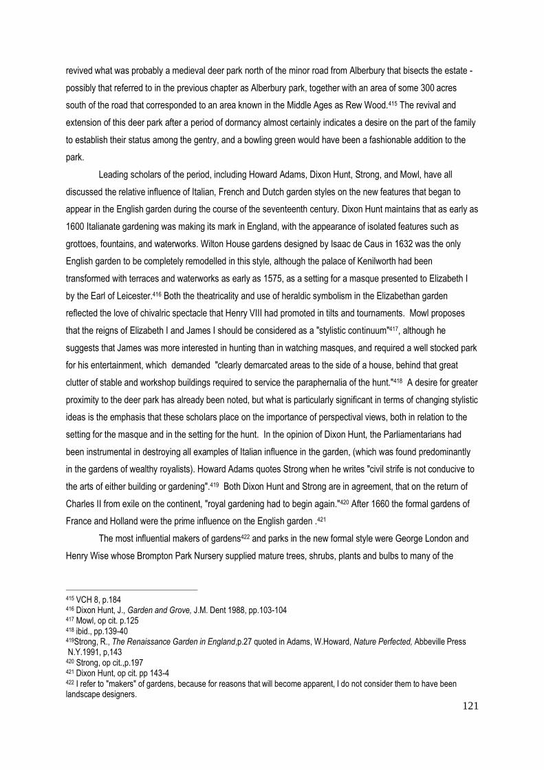
121
revived what was probably a medieval deer park north of the minor road from Alberbury that bisects the estate -
possibly that referred to in the previous chapter as Alberbury park, together with an area of some 300 acres
south of the road that corresponded to an area known in the Middle Ages as Rew Wood.415 The revival and
extension of this deer park after a period of dormancy almost certainly indicates a desire on the part of the family
to establish their status among the gentry, and a bowling green would have been a fashionable addition to the
park.
Leading scholars of the period, including Howard Adams, Dixon Hunt, Strong, and Mowl, have all
discussed the relative influence of Italian, French and Dutch garden styles on the new features that began to
appear in the English garden during the course of the seventeenth century. Dixon Hunt maintains that as early as
1600 Italianate gardening was making its mark in England, with the appearance of isolated features such as
grottoes, fountains, and waterworks. Wilton House gardens designed by Isaac de Caus in 1632 was the only
English garden to be completely remodelled in this style, although the palace of Kenilworth had been
transformed with terraces and waterworks as early as 1575, as a setting for a masque presented to Elizabeth I
by the Earl of Leicester.416 Both the theatricality and use of heraldic symbolism in the Elizabethan garden
reflected the love of chivalric spectacle that Henry VIII had promoted in tilts and tournaments. Mowl proposes
that the reigns of Elizabeth I and James I should be considered as a "stylistic continuum"417, although he
suggests that James was more interested in hunting than in watching masques, and required a well stocked park
for his entertainment, which demanded "clearly demarcated areas to the side of a house, behind that great
clutter of stable and workshop buildings required to service the paraphernalia of the hunt."418 A desire for greater
proximity to the deer park has already been noted, but what is particularly significant in terms of changing stylistic
ideas is the emphasis that these scholars place on the importance of perspectival views, both in relation to the
setting for the masque and in the setting for the hunt. In the opinion of Dixon Hunt, the Parliamentarians had
been instrumental in destroying all examples of Italian influence in the garden, (which was found predominantly
in the gardens of wealthy royalists). Howard Adams quotes Strong when he writes "civil strife is not conducive to
the arts of either building or gardening".419 Both Dixon Hunt and Strong are in agreement, that on the return of
Charles II from exile on the continent, "royal gardening had to begin again."420 After 1660 the formal gardens of
France and Holland were the prime influence on the English garden .421
The most influential makers of gardens422 and parks in the new formal style were George London and
Henry Wise whose Brompton Park Nursery supplied mature trees, shrubs, plants and bulbs to many of the
415 VCH 8, p.184 416 Dixon Hunt, J., Garden and Grove, J.M. Dent 1988, pp.103-104 417 Mowl, op cit. p.125 418 ibid., pp.139-40 419Strong, R., The Renaissance Garden in England,p.27 quoted in Adams, W.Howard, Nature Perfected, Abbeville Press N.Y.1991, p,143 420 Strong, op cit.,p.197 421 Dixon Hunt, op cit. pp 143-4 422 I refer to "makers" of gardens, because for reasons that will become apparent, I do not consider them to have been landscape designers.
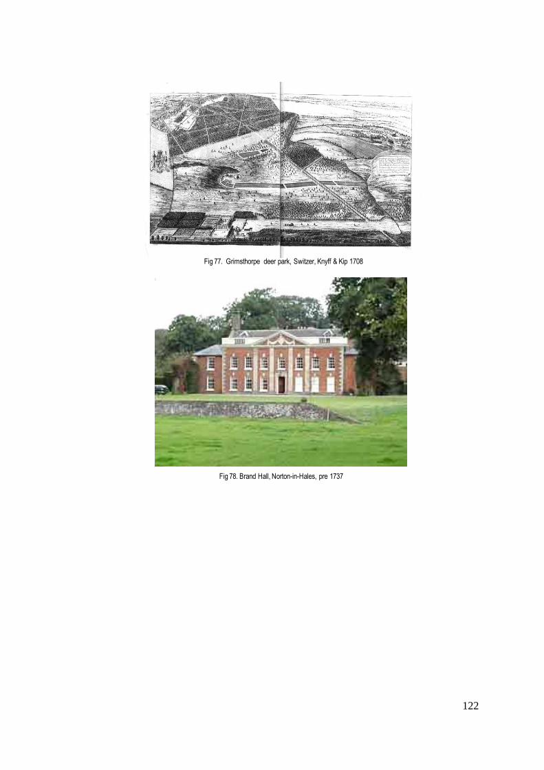
122
Fig 77. Grimsthorpe deer park, Switzer, Knyff & Kip 1708
Fig 78. Brand Hall, Norton-in-Hales, pre 1737
123
leading country estates at the end of the seventeenth century. There is no evidence that George London
undertook any projects in Shropshire – apart from the possible design for a parterre at Moor Park just across the
southern border in Herefordshire, which is attributed to him. However, their work was widely publicised through
the contemporary engravings of Knyff and Kip, published in 1708 as Le Nouveau Theatre de la Grande
Bretagne, which included the newly designed gardens and parks of royalty, lords and gentlemen. Although these
images were created to please a landowner, whose project might not even have been completed, and therefore
like the estate maps, cannot be assumed to be accurate, what is of particular interest in the context of deer parks
is the predominance of tree-lined avenues and rides. A product of the Brompton Park Nursery, where he trained
with George London, Stephen Switzer developed this style beyond the pattern books and made it his own.423
The formal gardens that Switzer designed at Grimsthorpe Castle (Lincs) for the Earl of Lindsey in c.1700
(Fig 77), were extended into the parkland beyond by tree-lined avenues that connected the gardens with a
distant woodland criss-crossed with rides, emphasising the importance that Switzer attached to "the distant
unlimited Prospect".424 In the preface to the first volume of his Ichnographica Rustica (first published 1718), he
writes that the design of a garden should be "bold in the French manner... (with) long extended shady walks, and
groves".425 Switzer's aim was to combine the profitable aspects of an estate with aesthetic components. His
rides or walks served a dual purpose, adding to "the Beauty as well as be(ing) for the Conveniency of carting in
and out all that is wanting..."426 Although Switzer does not ever specifically refer to the deer park, the rides also
served to facilitate the pursuit and control of deer - indeed, may even have served for a form of coursing.
The idea that the wider estate might form part of the aesthetic experience was underlined by the
introduction of the ha-ha from France, a lined ditch not unlike a deer leap that prevented grazing animals from
entering the garden without obstructing the view of the landscape beyond. Charles Bridgeman, also trained at
Brompton Park, is credited by Horace Walpole with introducing the ha-ha into England at Houghton in the early
1720s. There is little evidence of ha-has being constructed in Shropshire before the late eighteenth-century,
when examples by Repton can be found at Longner and Attingham, which will be discussed later in the chapter.
The earliest that has been discovered appears to be that at Brand Hall at Norton-in-Hales (N. Shrops), possibly
dating to 1737 when the seventeenth-century house was updated (Fig 78).427 The ideas expressed by Switzer
were to a large extent echoed by Batty Langley, who published his New Principles of Gardening in 1728. In his
introduction he referred to the importance of hills and mounts in offering views, and stipulated that trees should
be planted in avenues to offer shade. Among the "entertainments" to be introduced into a park, he included
"Warrens of Hares and Rabbits, Aviaries, Manazaries, Bowling-Greens."428 As we have already seen, bowling-
greens had already appeared in Shropshire parks some fifty years earlier.
423 Andre Mollet's Jardin de Plaisir,first published Stockholm 1651, English version 1670. 424 Switzer S., Ichnographica Rustica:: The Nobleman Gentleman and Gardener's Recreation 3, London 1718,reprinted Garland 1982 p.38 425 ibid. Vol 1. p.xviii 426 ibid. Section IX p.231 427
HER Shropshire 428 Langley, B., New Principles of Gardening, London 1728, Intro.
124
Rocque (1752) was the earliest of the county cartographers to depict these features, although in
Shropshire individual estate maps examined above were beginning to show avenues from about 1720 onwards.
An earlier example is a drawing of of Pitchford Hall, dated 1714, showing two parallel avenues planted some
distance apart emphasising the approach to the house. Particularly notable were the avenues and rides of
Aldenham Hall (built 1691), as shown in the Burton Survey of 1722 (Fig 57), where rides cut through the deer
park connected it with the house, which was approached from the road by a generous double avenue, with fine
wrought-iron gates made by Robert Bakewell of Derby. A watercolour of Aldenham Hall painted by Moses Griffin
in 1792 suggests that by that time, the trees of the approach avenue were fully mature (Fig 59). An avenue such
as this heralded the status and indeed wealth of its owner, while those at Tong Castle, clearly defined on the
Vernon's estate map of 1739, but most probably planted earlier, appear to have been aligned with the express
purpose of creating a physical if not visual link from the castle to the old medieval deer park (Fig 53).
Although few examples of avenues dating from the early eighteenth century have been found in
Shropshire, this does not mean that avenues had not been introduced earlier as a feature of the deer park
elsewhere in England. In her unpublished dissertation on avenues, Couch has discovered the first mention of the
word “avenue” in an English context in John Evelyn’s diary entry of 25th August 1654. Although most avenues
were planted after the Restoration of the Monarchy, Evelyn described avenues that were already ‘old’ in the
seventeenth century.429 Twelve years after the publication of Evelyn’s influential work Sylva on the cultivation of
forest trees (1664), Moses Cook, one of the original partners in the founding of the Brompton Park Nursery,
published The Manner of Raising, ordering, and Improving Forest and Fruit Trees (1676). Cook had been
instrumental in creating woodland walks four years earlier at Cassiobury (Hertfordshire) where he was head
gardener. Cook, Evelyn and Langley offered detailed advice on the types of trees best suited to planting in
avenues, the most commonly used species being lime, elm and sweet chestnut. Of these lime (tilia cordata) was
the most popular, being recommended by Cook as long-lived, resistant to wind damage, and easily reproduced
by layering.430 At Cassiobury in 1672, Cook had planted 296 limes in 4 rows without suffering any losses. Horse
chestnut, on the other hand, he considered too susceptible to wind damage, and although planted in Bushy Park
in 1699 it was less used after 1752. 431
These writers were instrumental in disseminating ideas about gardening and encouraging the planting
of trees. Their work would have been widely available and certainly familiar to those who attended the Kit Kat
Club, a meeting-place in the Strand that at the end of the seventeenth and beginning of the eighteenth centuries
welcomed prominent Whig landowners, including Sir Robert Walpole, the architect Sir John Vanbrugh, the patron
Lord Burlington and writers such as Addison and Steele. The newly formed Royal Society (1660) encouraged
429 Couch, S., Avenue Planting 1660-1850, unpublished diploma thesis, Architectural Association School of Architecture, London, 1991, p. 12 430 ibid., pp.34-35 431 ibid. p.35

125
Fig 79. Ludford Hall and park, Rocque 1752
Fig 80. Loton Hall and park, Rocque 1752

126
Fig 81. Kinlet Hall and park, Rocque 1752
Fig 82. Shavington Park, Rocque 1752

127
papers on recent discoveries in the world of science and botany. ( It seems that the gift of a haunch of venison
ensured honorary membership of that learned society! 432 ) However, it may have been some time before thenew
ideas reached rural Shropshire. A letter of 1725 written by a certain Joseph Cox to his employer Dame Mary
Charlton of Ludford Hall reflects current aesthetic ideas. The associated deer park had been created at some
distance from the house, in what was most probably part of the royal Bringewood Chase. The letter refers to the
extension of the “gardens, orchard, and walnut tree walk and 11 trees of ornament and shelter to the house, and
to walks and plantations made for ornament in the park (my italics) and proper shelter for deer.”433 There is no
cartographic evidence of this park prior to Rocque's map which shows the plantations of Ludford Park, whether
these were orchard or other trees, as being separate from the enclosed area of the deer park, although possibly
visually linked (Fig 79).
By 1752 Rocque's map of Shropshire depicted some dozen examples of tree-lined avenues, the
majority serving as approaches to new mansions. These included a central avenue through the park to
Condover Hall and a new entrance avenue to the relocated mansion at Hodnet (c.1607). In the context of this
thesis, however, the principal concern is not only with avenues, but with avenues relating mansions to their
parks. In the case of Shavington Park, in the north of the county, Rocque makes it clear that multiple avenues
have been used to connect its park with the newly built mansion lying to the west (Fig 82). A deer park with an
early house within its bounds had been recorded here by Saxton in 1577. Shavington was the seat of the
Needham family, the title of Viscount Kilmorey being granted through the peerage of Ireland in 1625 to Sir Robert
Needham, MP for Shropshire and High Sheriff (1606), whose two sons fought for the royalist cause in the Civil
War. The 6th Viscount Kilmorey (d.1687) clearly benefited from the restoration of the monarchy, and in 1685
replaced the early house with a mansion described by Pevsner as “perhaps the grandest, certainly the largest,
house of its date in Shropshire.”434 It seems possible that the avenues depicted by Rocque dated from this time.
By the middle of the eighteenth century, the avenue had been more generally adopted in Shropshire as
a means of linking residence and park, whether physically or conceptually. Loton Hall (c.1670), separated from
its park to the south by a road, was visually linked by four parallel avenues or rides penetrating the park from
north to south as depicted by Rocque (Fig 80). Today house and deer park are separated once again and no
evidence of the avenues remains. Loton Hall shared the same architect, Francis Smith of Warwick, with Kinlet
Hall (1677), south of Bridgenorth, principally known as the home of the florist, John Rea. The residence was
rebuilt between 1727-29 for William Lacon Childe. The deer park, originally medieval and recorded by Cantor,
appears to have lain dormant for many decades until opened up again as the setting for the new mansion. It is
recorded for the first time on a county map in 1752 when Rocque depicted what seem to be a series of avenues
and formal plantings laid out with the specific intention of creating a connection with the park (Fig 81).
432 Fletcher, J., op cit. p.4 433 SA 11/383 ibid. Letter 22 Feb 1725 434 Pevsner, Shropshire, op cit. p.498 Shavington Hall was demolished in 1959.

128
Fig 83. Oakly Park, Rocque 1752
Fig 84. . Oakly Park, 1760 (private collection) Lovelace
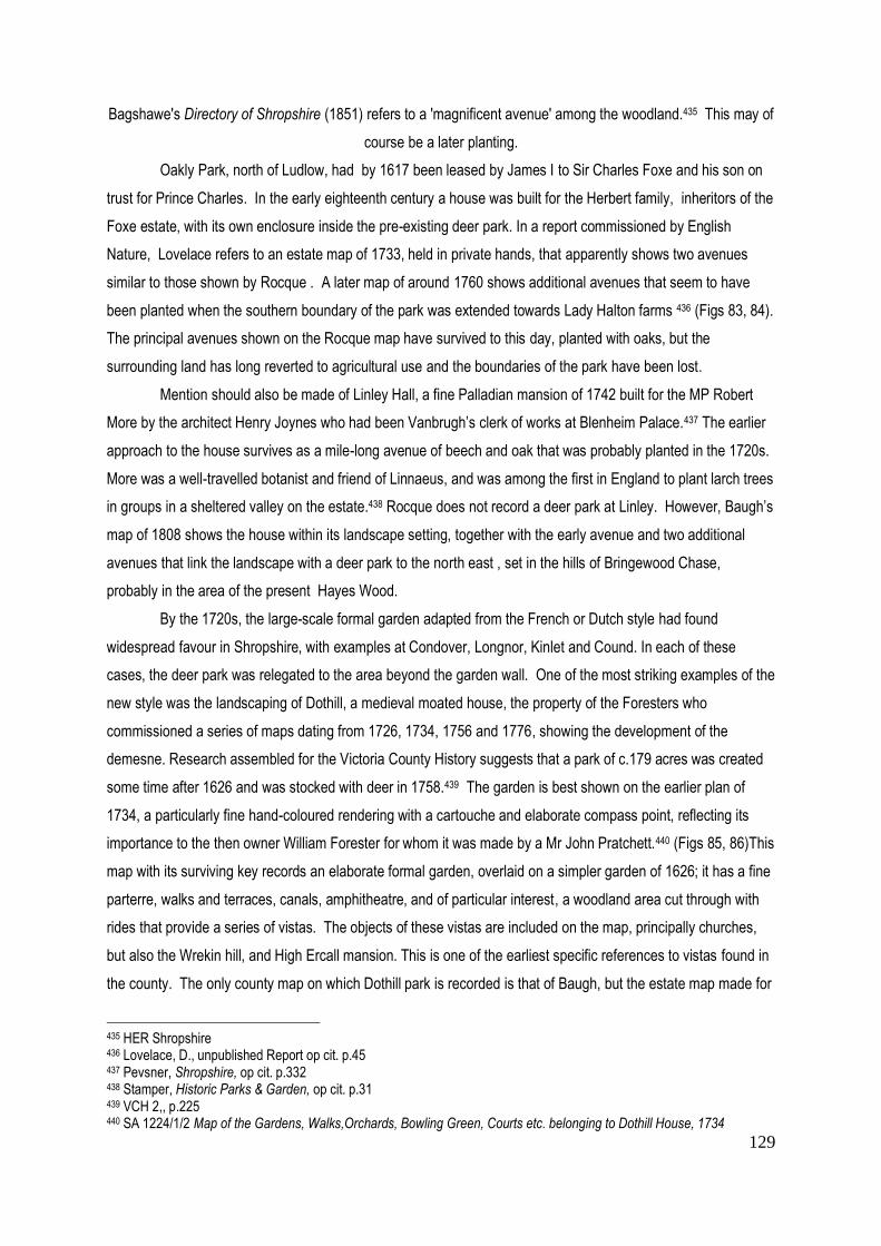
129
Bagshawe's Directory of Shropshire (1851) refers to a 'magnificent avenue' among the woodland.435 This may of
course be a later planting.
Oakly Park, north of Ludlow, had by 1617 been leased by James I to Sir Charles Foxe and his son on
trust for Prince Charles. In the early eighteenth century a house was built for the Herbert family, inheritors of the
Foxe estate, with its own enclosure inside the pre-existing deer park. In a report commissioned by English
Nature, Lovelace refers to an estate map of 1733, held in private hands, that apparently shows two avenues
similar to those shown by Rocque . A later map of around 1760 shows additional avenues that seem to have
been planted when the southern boundary of the park was extended towards Lady Halton farms 436 (Figs 83, 84).
The principal avenues shown on the Rocque map have survived to this day, planted with oaks, but the
surrounding land has long reverted to agricultural use and the boundaries of the park have been lost.
Mention should also be made of Linley Hall, a fine Palladian mansion of 1742 built for the MP Robert
More by the architect Henry Joynes who had been Vanbrugh’s clerk of works at Blenheim Palace.437 The earlier
approach to the house survives as a mile-long avenue of beech and oak that was probably planted in the 1720s.
More was a well-travelled botanist and friend of Linnaeus, and was among the first in England to plant larch trees
in groups in a sheltered valley on the estate.438 Rocque does not record a deer park at Linley. However, Baugh’s
map of 1808 shows the house within its landscape setting, together with the early avenue and two additional
avenues that link the landscape with a deer park to the north east , set in the hills of Bringewood Chase,
probably in the area of the present Hayes Wood.
By the 1720s, the large-scale formal garden adapted from the French or Dutch style had found
widespread favour in Shropshire, with examples at Condover, Longnor, Kinlet and Cound. In each of these
cases, the deer park was relegated to the area beyond the garden wall. One of the most striking examples of the
new style was the landscaping of Dothill, a medieval moated house, the property of the Foresters who
commissioned a series of maps dating from 1726, 1734, 1756 and 1776, showing the development of the
demesne. Research assembled for the Victoria County History suggests that a park of c.179 acres was created
some time after 1626 and was stocked with deer in 1758.439 The garden is best shown on the earlier plan of
1734, a particularly fine hand-coloured rendering with a cartouche and elaborate compass point, reflecting its
importance to the then owner William Forester for whom it was made by a Mr John Pratchett.440 (Figs 85, 86)This
map with its surviving key records an elaborate formal garden, overlaid on a simpler garden of 1626; it has a fine
parterre, walks and terraces, canals, amphitheatre, and of particular interest, a woodland area cut through with
rides that provide a series of vistas. The objects of these vistas are included on the map, principally churches,
but also the Wrekin hill, and High Ercall mansion. This is one of the earliest specific references to vistas found in
the county. The only county map on which Dothill park is recorded is that of Baugh, but the estate map made for
435 HER Shropshire 436 Lovelace, D., unpublished Report op cit. p.45 437 Pevsner, Shropshire, op cit. p.332 438 Stamper, Historic Parks & Garden, op cit. p.31 439 VCH 2,, p.225 440 SA 1224/1/2 Map of the Gardens, Walks,Orchards, Bowling Green, Courts etc. belonging to Dothill House, 1734

130
Fig 85 . SA1224/1/2 Dothill House garden plan, 1734.
Fig 86. Dothill House wilderness detail
Detail: View to Ercall House
Fig 87. SA1224/1/5 Dothill estate, survey 1776

131
George Forester in 1776 shows a section of ‘park’ to the west of the garden and ‘part of Myddle Park’
compartmentalised in the north-east.441 (Fig 87).
What the evidence of the previous pages seems to suggest is that where it was impossible to lay out a
new park around a house, or to place a new house within an existing park, a configuration of avenues, whether
single or multiple, served to form a physical and visual link between house and park - a geometric arrangement
of trees being used as a clear statement, not only of hierarchical status, but also as an appreciation of the deer
park as an ornamental feature to be seen as part of the estate. A closer examination of the engravings of Knyff
and Kyp shows what an important role avenues and rides played in creating vistas and bringing the estate
together as an aesthetic whole in the first decades of the eighteenth century. Trees offered both practical,
economic and aesthetic advantages. In his Ichnographia Rustica Stephen Switzer alludes to the benefit of
planting trees in the proximity of the house to protect it from winds.442 However, his preoccupation with the
planting of trees extended beyond the purely practical. He suggested that they should be “naturally and
promiscuously scatter’d and dispers’d over a whole Estate”, while his appreciation of the natural landscape
included “Hedgerows, little natural Coppices, large Woods, Cornfields etc., mix’d one amongst another (being) as
delightful as the finest Garden”.443 When writing these lines, Switzer was looking beyond the formal garden in
favour of a much wider perspective of the ‘entire estate’, made visible across the ha-ha. In this context, the deer
park continued to have a role to play, both as an aesthetic component of the estate and as a source of venison.
Estate management - a 'continuum'?
Agricultural improvement of the kind seen at Willey in the early years of the seventeenth century had
inevitably been interrupted by the Civil War. But, as already noted, the inspiration for better estate management
had been promulgated by writers such as John Evelyn during the period of the Interregnum. However, Evelyn's
most influential treatise, Sylva, was not published until after the Restoration when as a member of the Royal
Society, he first presented Sylva as a paper, which was widely read by members of that learned society and
others interested in botany and sylviculture. Changes in land management that took place after the Restoration
focused on repairing damage caused to neglected estates and restoring their viability as a source of financial
income.444 In a letter written in 1667 the Duchess of Newcastle described the Duke of Newcastle's return to his
estates in 1660, when he discovered that out of the eight parks that he held before the wars, Welbeck Park
(Notts) was the only one that had not been totally destroyed. Due to his good management of his affairs, she
wrote, "by degrees he stocked and manured those lands" that he maintained for his own use.445 . The following
pages will look at some of the parks that were revived or newly created following the Restoration of the Monarchy
441 SA 1224/1/5 Plan of George Forester’s Dothill Estate made by Walter Dutton & J. Hand, 1776 442 Switzer, S., Ichnographia Rustica, Vol 3 Section III, IV, pp 37-48 443 ibid. 444
Hill, C.,1949 in Thirsk, J., The Restoration, op cit. p.109 445
'Duchess of Newcastle, 1667' in Thirsk, J. op cit. p.103

132
in 1660 from an economic viewpoint, to try and discover whether a new concept of the deer park was introduced,
and to what extent the period witnessed a re-statement of earlier traditions.
The post- Restoration years saw the continuation of developments in estate management already
noted prior to the 1640s. During the seventeenth century a great number of landowners, such as the Duke of
Newcastle returning from exile, became more closely involved with the management and improvement of their
estates. The expense of maintaining a deer park had to be balanced against its value as an aesthetic feature
and as a measure of one's place in society. It is important to remember that the years between 1670-1710 had
seen the coldest winters of what is generally termed the Little Ice Age, with a decline in temperatures that had
begun, albeit with fluctuations, at the end of the Middle Ages 446, with snow sometimes lying for as long as twenty
to thirty days. The severest winter was that of 1683-4 when in Somerset the ground froze to a depth of four feet.
Such temperatures must have caused huge problems for those maintaining deer; indeed, on January 24th 1684
Evelyn wrote in his diary of "many Parks of deere destroied".447 Deer did not in themselves represent a good
economic return. Writing in his journal in 1631, John Weld had considered “whether best to dispark my park
when I die, for it is a trouble and charge, and gets much envy.”448 This reference to “envy” underlines the fact,
that deer parks were still considered to be a sign of social status. They had always been expensive to maintain:
deer had to be fed in winter, park boundaries maintained, and park keepers’ wages paid. In times of recession,
whether due to poor harvests, bad weather, or political upheaval, other forms of agricultural activity were, as
already observed, required to ensure the financial viability of an estate. The following paragraphs will show what
activities were adopted in the years following the Restoration.
.
One landowner anxious to prove his good stewardship was Sir Blunden Charlton of Ludford Park. The
Charltons had acquired the estate in 1607. The house, originally part of the thirteenth-century Hospital of St
John, had been modified over many centuries. After the Restoration, it was the home of Sir Job Charlton,
Speaker of the Commons, created Baronet in 1686. A year later, he entertained James II at his mansion, and it
seems possible that the walled deer park had been created by this time, although the only evidence of it on a
county map is on that of Rocque (Fig 79). In an undated document produced in the course of a dispute in the
1730s with his son Francis Charlton, Sir Blunden Charlton refers to the deer park as having been created "within
the memory of man" . Francis Charlton had accused his father of having cut down trees and laid waste his
estate. In court it was said: "the defendant has lately fallen some runnells and other trees growing in the
hedgerows of the Ludford estate and 2 rows of poplar and ash on a meadow belonging to the demesnes which
were 'unkindly and old trees of no ornament or advantage to the house' and in the defendant's opinion, a
prejudice to the meadow.' 449 It is interesting to note that Sir Blunden makes reference to the value of his
meadow, but is equally concerned about the ornamental value of his trees. He goes on to state that “...so far
446 The Little Ice Age is generally considered to have begun c.1300 with cooler conditions after1680. A warmer period intervened from 1710-1740 when Switzer was writing. (see Fagan,B., The Little Ice Age, (Basic Books 2000) 447
The Diary of John Evelyn, ed: Guy de la Bédoyère, Boydell Press 1995, p.267 448 SA 1224/1/Box 163 Memoranda Book of John Weld, 1631 449 SA 11/382 Compainant: Blunden Charlton, n.d.

133
from wilfully wasting the park, he has taken care to preserve it, even to buying timber for building a house at
Ludlow since the complainant’s marriage. He has laid out £4,000 in improvements at the capital house at
Ludford, the park, and the tenements. He has planted 500 firs and poplars and has kept an average of 16
labourers at the task of improving the estate....... He did not design to fell timber of use or ornament to the
mansion... He has not ploughed any ancient meadow or pasture of the demesnes at Ludford and does not
design to do so.”450 In subsequent responses provided by Sir Blunden to the court, the latter states that in 1730
the deer park was c. 300 acres and in that year he had nearly 300 deer in it.451 In his testimony, Blunden refers
not only to the improvement of the park, but also to its aesthetic appeal.
Other estates were concerned to maximise their income through a more ‘hands-on’ form of estate
management. The Hawkstone estate in North Shropshire had first been acquired by the Hill family in 1556, when
Sir Rowland Hill (d.1561), first Protestant Lord Mayor of London, bought Hawkstone for £700. Sir Rowland had
amassed a considerable fortune through trading in textiles, and invested it in estates acquired from the sale of
monastic lands after the Dissolution. Hawkstone remained in the ownership of the Hill family for more than 300
years, and the deer park reflected the changes in current fashion. It was Sir Richard Hill, a wealthy and well
travelled diplomat, who was responsible for raising the social status of the family and building a house
appropriate to that status in 1699, expanding both house and gardens after his retirement in the 1720s.452 The
work was influenced by the latest garden styles that Hill had seen on the continent. Letters written in 1722
between Sir Richard Hill and his steward John Dicken, record the latter advising his master on improvements
being undertaken in the gardens and park. “Joseph had some Labourers howing among the trees in the new
grounds most of which trees grow very well.” Dicken is advised by his master to get more labourers in while the
good weather lasts.453 By 1723 what appears to be a key to a missing plan indicates that the land has been
"brought together” and the “hedging all stocked up”. Reference is made to a "visto planted to range with the
outwalk of the wilderness up the hill", to an "eyecatcher", and to a "new plantation above the parker's garden". 454
This seems to suggest the beginning of a new approach to the design of the park. A letter written two years later
anticipates that Joseph will have finished his planting; new fishponds have been created, and a parcel of carp
received to stock them; tench, it seems, being difficult to come by.455 There is no specific mention of deer in this
correspondence, which raises the question as to the meaning of "park" at this time. It seems likely that by the
beginning of the eighteenth century, the word no longer necessarily denoted a deer park, or at least one stocked
with deer, and is moving towards the idea of a "landscape park" as understood in the latter part of the eighteenth
century, which will be discussed in the following chapter. This is borne out by the lack of clarity already noted in
Rocque's maps of 1752. His map of Hawkestone suggests a park boundary, but focuses primarily on a large
450 SA 11/382 op cit,. 451 SA 11/386-387 Answers supplied by Sir Blunden Charlton, n.d. 452
Pevsner, Shropshire, op cit. p.290 453 SA 112/1/2424 Letter from John Dicken to Sir Richard Hill, Sept 1722 454 SA 112/1/2461 Key to plan of Hawkestone?, 1723 455 SA 112/1/2722 Letter from F. Chambre to Richard Hill, 9 Oct 1725

134
vineyard. Unfortunately, there is no surviving estate map of Hawkstone to show the park and gardens in the early
eighteenth century.
The value of such a piece of cartographic evidence, where it does exist, is demonstrated by the very
detailed estate map of Aldenham Park, which has been referred to above, made by the surveyor Thomas Burton
for Sir Edward Acton in 1722 456 (Figs 57-58). North and east of the house the land is divided into fields of
between 10 and 20 acres in size. These include orchards immediately north of the house, with meadows, a
brickyard, a dovehouse and yard, a horse pasture to the south, and a "Conery" south of the river - evidence of
the variety of activities being undertaken on the estate. However, this in itself does not constitute an innovation,
and might well reflect traditional systems already in place. The wooded parkland to the west is divided into some
eight named compartments by rides, the names of the compartments indicating present or former use: Near
Plaine; Middle Plaine; Far Plaine; Deep Coppy x 2; Furnis Copy. Rowley suggests that the coppice was used for
charcoal to supply nearby charcoal fuelled iron furnaces. He also proposes that the chain of four pools in the
western part of the park were connected with the iron industry, although they could equally well have been fish
ponds.457 Whether there were still deer in the park at this stage is difficult to assess, although the provision of
rides suggests that these may have been used to facilitate the rounding up of deer. What is certain is that the
relation of the rides to the gates of the kitchen garden suggest the provision of a vista, in line with contemporary
landscape ideas. An explanation accompanying the rough plan of 1792, drawn by John Powell, contains a
survey of the state of the park boundaries458 (Fig 78), revealing that by this date most of the old paling was in a
state of decay, along with a portion of ha-ha; some of the boundaries had been planted with quickset, possibly
those that enclosed meadows and fields. Whether this survey was the prelude to repairing the paling for deer is
difficult to assess, but it seems likely since Aldenham Park not only features on the Rocque map of 1752 but is
still featured on Baugh’s map of 1808.
One of the most detailed and comprehensive estate maps of this period is the hand coloured survey of
Tong Park made by J. Reynolds in 1739 for Evelyn, Duke of Kingston 459 (Fig 53 ). It shows the former deer park
to the east of the castle, seemingly still paled, but divided into 13 enclosures, most of them depicted as tilled,
with the exception of those containing the old lodge and its meadow. The meadow lies adjacent to the river, but
there is no indication of drainage or floating; indeed, those enclosures in the vicinity of the river near the castle
are shown as marshland. Adjacent to the castle, presumably the courtyard house with medieval towers originally
built by Sir Henry Vernon around 1500 , are gardens with a wilderness and a series of enclosures that indicate a
large number of rabbit warrens, since they are named Far Castle Conigre, Towners Conigre, Far Conigre and
New Castle Conigre. Between the warrens and the Park lie Hollis Field, Great Hollis Field and Lower Hollis
Field, suggesting that these enclosures contained holly for feeding the deer in winter. A small fragment of
woodland/coppice remains in the northwest of the Park, while to the east lie other coppice enclosures with
456 SA 1093/Box 160 Survey of Aldenham Park by Thos. Burton for Sir Whitmore Acton, 1722 457 Rowley, T.op cit., fig 11 458 SA 1093/160/4 Rough Plan of the Boundaries of Aldenham Park by J. Powell, 1792 459 SA 6007/11 Map of the Manor of Tong – surveyed for Evelyn, Duke of Kingston, by J. Reynolds, 1739

135
Fig 88. Hoards Park, upgraded c.1650
Fig 89. Apley Hall , C18th north facade
Fig 90. Apley Park, Baugh 1808

136
names such as The Wood Farm and Park Field, suggesting that the park may previously have been more
extensive. Claypits and an old brickyard lie to the north of the Park. The map, to which there is no longer a key,
shows that Tong Manor was by 1739 divided into many small farms, all of which were enclosed. The proportion
of surviving woodland is very small compared with the extent of land devoted to agriculture. It seems unlikely that
any deer were surviving in Tong Park at this time. It is shown as a deer park by Morden in 1695 and Rocque
also shows an enclosed park, including for the first time the two radial avenues that feature on the estate plan,
linking the castle physically and visually with the Park. If we knew the date of their planting, it might well provide
a clue as to how long the deer survived. One thing is certain, the title of Baronet Vernon, first created for Henry
Vernon in 1660, died out in 1725 due to the lack of a male heir. The following chapter will relate how the estate
passed to George Durant who demolished Tong Castle and commissioned Capability Brown to replace it and to
create a 'landscape park'. What the information gained from the 1739 estate map indicates is that the Vernons
were breaking up their estate at the beginning of the eighteenth century, and do not seem to have shared the
interest in agricultural improvements being pursued by many of their peers.
Among the most progressive of the county landowners were the Whitmores of Apley who, as already
noted, suffered considerable depredation during the Civil War, including the destruction of their house. A new
mansion was built late in the seventeenth century when a large walled kitchen garden was created 460 (Fig 89).
In the first half of the seventeenth century, William Whitmore (k.1621 d.1648) renovated an earlier house on his
estate, Hoards Park, lying just north of Bridgnorth on the site of a dormant medieval deer park. (Fig 88) Given the
date and location of this house, Whitmore may well have lived here while Apley Hall was being rebuilt. Stamper
suggests, that like others of the same period, the building served as a park lodge and retreat, with a formal
garden to the east overlooking a fenced enclosure.The existing walls of the enclosure are unusually high, some
2.5metres, suggesting that they were intended to keep deer. In the nineteenth century this enclosure was known
as Buck's Orchard; deer may have been kept here prior to being released for coursing in the valley of the
Severn below.461
A series of surviving rent rolls drawn up between 1744 –1760 for the Apley estate throw light on how the
land was being profitably managed, providing detailed lists of stock bred and sold, together with accounts for the
felling and preparing of different kinds of wood produce. This evidence suggests that there was a lively trade in
calves, heifers, and oxen, sold at markets such as Albrighton, Bromley and Chester.462 This corresponds with
Thirsk's evidence of falling grain prices after the 1650s, and an increased interest in stock breeding.463 Between
1744 and 1746 some cattle were being sent from Apley to London, although the prices fetched were not initially
recorded. However, the London market became increasingly predominant, and in 1747 oxen sent to London
appear to have fetched between £10 and £13 each. At the same time, sheep were being reared and wool was
460 Stamper, Historic Parks and Gardens, op cit pp. 63-4 461. ibid. pp. 19-20 462 SA 5586/5/5/218 Rent Roll Mchaelmas 1744- Lady Day 1745 463 Thirsk, England's Agricultural Regions & Agrarian History 1500-1750, op cit., p.18

137
being sold from the estate, with finer wool fetching 9s.6d. a stone, coarser wool 8s.6d.464 One is led to the
conclusion that most of the Apley estate was devoted to stock grazing or woodland, since during the winters of
1745 and 1746 oats were being bought in from the market over the months from September to January.465 The
extent of woodland on the estate at this time can be gauged from the heavily wooded park depicted by Rocque,
and remaining areas of named coppice shown on the OS map today, stretching between Apley and the
neighbouring estate of Willey. The Apley rent rolls include accounts submitted for 'falling' (felling), 'topping', and
'platting' wood at 1s.4d. a tree (1744); ‘cross cuts’ were much in demand, but also small trees for laths and
‘rickstools’. The timber felled that year was oak and ash,466 but in 1747 there is mention of sycamore and holly,
in addition to ash, with poles being sold by ton weight, together with ‘faggots’ and ‘coalpitwood’.467 In 1746,
enclosed in the volume of rent rolls, is a letter from a tenant to Thomas Whitmore, apologising for the late
settlement of an account for cordwood.468 There are various references to the weighing of wood (presumably
cordwood), which in 1745 was paid at the rate of 1s a day. The same account refers to ‘cutting the stuff for the
hedge’ (presumably a temporary dry hedge) and for ‘rails’. Putting these two items together, it may fairly be
assumed that this was connected with keeping deer. Certainly, a deer park is recorded by both Rocque and
Baugh (Fig 90). If there were deer, they were certainly sharing the park with cattle, sheep and even horses. A
recent visit to the site suggests that the deer were confined to the woodland on the surrounding hills where there
is still evidence of a deer pale raised on a stone bank.
Protecting the deer
Although it was illegal to sell venison on the open market, by the seventeenth century it had already
become more widely available, whether marketed or poached. Fletcher has calculated that between 1666 and
1668 Samuel Pepys ate venison on no less than eighty-five occasions, most often in the form of a pasty,
although he also received gifts of haunch and side. He considered the meat superior to beef, and complained
when offered a venison pasty that turned out to be "palpable beef".469 Recipes for elaborately decorated forms of
pasty were widespread during the following years. A venison stew made with anchovies and beets appears in
The English and French Cook (1674), while a recipe for 'Venison dressed in Collops' was published in John
Nott's The Cook's and Confectioner's Dictionary, published in London in 1723. The ubiquity of venison for sale in
London during this period seems to suggest that laws preventing its sale were being blatantly ignored.
The Tudor and Stuart monarchs were keen to protect deer, both for hunting purposes, gifting and
personal consumption; while throughout the period with which this chapter has been concerned, landowners
continued to attach status to acquiring a deer park and gifting venison. Many of the statutes passed during the
464 SA 5586/5/5220 Michaelmas 1746 – Lady Day 1747 465 ibid 466 SA 5586/5/5/218 op cit. 467 SA 5586/5/5/220 op cit. By this time, exploitation of the local coal resources had begun to be taken seriously. In 1757 The New Willey Co. Leased part of Willey Park. 468 SA 5586/5/5/219 Michaelmas 1745 – Lady Day 1746 469 Fletcher, op cit. p.207 based on research undertaken for a paper on 'The Significance of Samuel Pepys' Predilection for
Venison Pasty' in Proceedings of the Oxford Symposium on Food and Cookery, 2004

138
reign of the Tudors were concerned with protecting deer from poachers. In 1503 a statute was introduced making
it an offence for anyone who was not the owner of a forest, chase or park to have nets or dogs for stalking
deer.470 These measures were reinforced a hundred years later by James 1 in a statute that stated that only a
“son of a Baron, or Knight or Heir apparent of an Esquire” had the right to take deer or even to keep a dog, also
making it illegal for anyone to “sell, or buy to sell again, any Deer, on Forfeiture of ten shillings for each Deer, to
be divided between the Prosecutor and the Poor”.471 Some of the Acts applied only to poaching at night, thereby
inadvertently encouraging poaching by day, but punishments were increasingly severe after the Restoration. A
statute of 1661 imposed a fine of £20 and 6 months’ hard labour or one year’s imprisonment for anyone who
“course, kill, hunt or take away any red or fallow deer in any ground where deer are kept, without the consent of
the owner ...’’ 472 During the course of the next forty years, these fines were increased from £20 to £30, and in
1718 to £50 or three years imprisonment. The harshness of the legislation culminated in the Black Act of 1723,
directed against those poachers who were armed and blackened their faces in order to hunt unrecognised in
private parks. They could expect a summary death "without benefit of Clergy".473 In 1736 this statute was
extended to cover poaching in forests and woodland, with a second offence punished by transportation for a
period of seven years.474
From the evidence assembled in the previous pages, there seems little doubt that the deer population
had been severely decimated during the seventeenth century, and strong measures were needed for its
protection. Fletcher recounts that after the Restoration deer were frequently brought in from overseas to re-stock
royal parks. It appears that Charles II imported between 350 and 375 red deer from France to the New Forest,
effectively doubling the numbers counted in a Survey of 1670. He also brought in deer from Germany to re-stock
Windsor and Waltham Forests. In 1717 the Duke of Marlborough supplied Windsor Park with 40 stags and some
hinds brought from his own park at Woodstock475. With deer evidently still in short supply during the reign of
George I, it is perhaps not surprising that the statutes imposed for their protection became increasingly severe.
However, the first indication of an interest in protecting the habitat of the deer appeared in a statute of 1755,
“passed to prevent the reckless burning of gorse, furze and fern in forests and chases, thereby destroying not
only the cover necessary for deer and other game, but also much valuable timber as well”.476 The severity of
these statutes demonstrates a continuing interest in the survival of deer and deer parks, in spite of the problems
involved in maintaining them.
470 Statute 19 Henry 7 c.11: 1503 All statutes quoted: Whitehead, G.K. Hunting & Stalking in Britain through the Ages, Batsford 1980 pp. 170-173 471 Statute 1 James 1. 1603 472 Statute 13 Car. 2. c.10 1661, quoted Whitehead, op.cit. p.171 473 Statute 9 Geo.I.c.22:1723 474 Statute 10 Geo.2.32:Sect.7.1736, quoted Whitehead, op cit. p.173 475 Fletcher, op cit. pp.178-9 476 Statute 28 Geo.2.c.19 Sect.3.1755 quoted Whitehead, op cit.p.173

139
Conclusion
The creation of new parks in Shropshire between 1540 and 1750, with a hiatus enforced during the Civil
War and Commonwealth, saw their transfer in part to a new ownership of lawyers, merchants and members of
parliament - a process that had begun with the acquisition of Stokesay Castle by the wool merchant Lawrence of
Ludlow in the last decade of the thirteenth century. Although those aristocratic landowners who had supported
the royalist cause in the Civil War, families such as the Corbets, the Actons and Vernons, continued to maintain
and even to extend their estates, the need to demonstrate their financial viability had become increasingly
pressing. As evidence brought forward has shown, stock rearing and the care and planting of timber and coppice
increased the potential of the estate to raise rents. The survival of the deer park was not always an option.
Nevertheless, as the numbers demonstrate, deer parks continued to be revived and in some cases created
anew. This points to an increased interest in the aesthetic appeal of the deer park, which prompted landowners
to locate the park close to the residence, wherever possible.
The county maps used to assemble the following data have, as predicted, revealed certain omissions.
Speed's map of 1611 has proved to be little more than a reprint of Saxton's map of 1577. Rocque (1752), as
already observed, provides greater topographical detail, but is unreliable in terms of defining a deer park. For
greater clarity, the Morden map of 1695 has been selected as a baseline, from which to sum up the situation as it
appears to have been at the end of the seventeenth century. In so doing, the invaluable evidence provided by
estate maps has been taken into account. Out of a total of 24 deer parks recorded by Morden, c.13 have been
shown, from either map or documentary evidence to have had medieval origins, although not always on the
same site. 477 Some, however , that have been shown from other evidence to have survived, have been omitted
by Morden: notably, Longnor, Loton, Oakly, and Oteley. Longnor is one of eight parks of medieval origin that
appear to have gone through a period of dormancy before being revived or replaced.478 Of the 16 surviving
medieval parks assembled here from a combination of cartographic and documentary evidence, seven had
subsequently been disparked by the end of the eighteenth century.479 Finally, of the 16 deer parks that were
created new during the period 1500-1750 480, their survival appears to have been surprisingly short, with the
exception of Apley, Aldenham, Ludford and Shavington Park481, which survived into the nineteenth century. (see
Table 2 for clarification).
Certain conclusions may be drawn from these data. One thing is clear: the medieval deer parks
associated with castles, described in the previous chapter, have almost entirely disappeared by the end of the
Civil War. Given the disparking of outlying deer parks by the monasteries even before the Dissolution, and
477 Parks surviving from medieval times: Acton Burnell; Cheswardine; Frodesley, Haughmond; High Ercall; Lilleshall; (Longnor);( Loton); Madeley; (Oakly); (Oteley); Rowton; Shawbury; Shrawardine; Tong; Willey; Worthen. Those shown in brackets have been omitted by Morden. 478 Parks that were revived or replaced: Cound, Frodesley, Hawkestone, Kinlet (not shown by Morden),Langley, Longnor, Madeley, Rowton. 479 Those disparked by the end of C18th: Frodesley; High Ercall; Lilleshall; Madeley; Rowton; Shrawardine; Tong 480 Parks created 1500-1695: Aldenham; Apley; Belswardine, Boreatton; Condover, Cressage, Harnage; Hopton Castle, Langley, Ludford; Pepper Hill, Pitchford; Plaish; Shavington, Stokesay, Upton Cressett 481 Shavington Park .was enlarged to 1500 acres in 1851, but with no evidence of being stocked with deer.

140
certainly after, one would expect to find that those medieval parks that survived would have been those that lay
not far from the residence, or as in the case of Longnor, the distant park was disparked and a new one created at
a later date nearer to the upgraded mansion. But this was not always the case. Of around 25 deer parks shown
by Rocque in 1752, approximately twenty-five per cent - six or seven - were to some extent isolated:
Belswardine, Cleobury, Frodesley, Longnor, Ludford, Pepper Hill, and Tong. Of these, three were surviving
medieval parks: Cleobury Park, still enclosed in Wyre Forest; Frodesley Park, relocated close to its lodge; and
Longnor Old Park, still shown by Rocque in its original site. The new Longnor park of 1668, adjacent to the
contemporary house, was and still is a small park (c.43 acres), which contradicts the more general evidence, that
the larger parks tended to survive longer. The case of Tong provides an example of a medieval park that
survived in part up to the middle of the eighteenth century, even though it always lay at some considerable
distance from the residence. However, map evidence of 1739, referred to above, suggests that Tong deer park
had formerly been much larger.
There is very little evidence to suggest that hunting deer on horseback was widespread after the middle
of the sixteenth century. Where it did survive, it more often took place in forests such as Clun and Wyre Forests,
rather than in a deer park, which was increasingly adapted to other uses. Coursing was a popular form of hunting
that enabled deer to be raised for the purpose in smaller parks or paddocks, although the courses themselves
and their standings have left little trace in Shropshire. Lodges are far more resistant to time, and the variety of
their architecture, from the simple keeper's lodge to the sophisticated form of Lilleshall or Pepper Hill lodges,
indicates some of the uses to which they were put as the function of the deer park itself changed.
What the excellent estate maps of Tong and Aldenham have demonstrated is the importance attributed
to the park by the early eighteenth century as an aesthetic feature of the estate, with attempts to connect it
physically to the mansion by means of planted avenues. Following the Civil War and the destruction of
woodland, timber trees had become an increasingly valuable asset to the park. Encouraged by contemporary
writers such as Markham, Evelyn and Beale, landowners were planting trees, not only in avenues but
increasingly dispersed throughout the estate. As early as 1653, Blith recommended the planting of “Groves or
Plumps of Trees... about any Manour, House, or Place, for delight and pleasure”. 482 Not only is this possibly one
of the first references to a “plump”, but the text goes on to expand on the difference between planting for “delight
and pleasure”, where any form of plantation may be adopted, as opposed to a purely economic approach: “if
thou mindest only thy profit, and intendest onely to raise Wood for thy use, and increase, and the countries
service, it matters not into what form thou cast it...”483 The dual purposes of utility and recreation justified the
maintenance of the deer park as an asset to the estate, both the park and the venison it produced remaining a
conspicuous sign of wealth and power.
The process of transforming the deer park into an aesthetic complement to a well managed estate,
which had begun in the sixteenth century,484 has become an increasingly important factor during the course of
482 Blith, op cit. Chap 24, p.153 483 ibid,, p.155 484 The much disputed topic of ‘designed’ parks in the medieval period has already been addressed in the opening chapter.

141
the late seventeenth and early eighteenth centuries. The extent to which in the second half of the eighteenth
century the deer park became part of an integrated landscape design that would eventually satisfy both
economic and aesthetic requirements will be pursued in the next chapter.

142
Table 2: Park Continuity 1500 - 1808
Medieval Parks (Cantor 1983 )
Saxton 1577 Speed 1611
Blome c1675
Morden 1695 Emanuel Bowen 1751
Rocque 1752 Baugh 1808
Acton Burnell DP
DP DP DP DP
Adderley Atherley? DP Atterley DP P P
Alberbury
Aldenham DP DP
Apley DP DP
Attingham DP DP
Belswardine DP DP DP
Berwick
Blakemere DP DP DP
Boreatton DP DP
Buildwas DP? DP
Burford
Cardeston
Caus
Chelmarsh
Cheswardine DP DP DP DP DP P
Chetwynd Chetwynd DP DP
Cleobury Mortimer
DP DP DP DP
Combermere DP DP
Condover DP DP DP DP
Cound Cound DP P
Crees
Cressage & Shenton DP(2)
Dean Park DP DP DP?
Dothill DP
Dudmaston LP
Earnstrey P
Earnwood
Ellesmere
Ferney Hall P
Fitz
Frodesley DP DP DP
Hadley
Hanmer Hall DP
Harnage DP
Haughmond DP Hamond DP
Ham DP DP
Haughton Hall, P
Hawkestone DP + vineyard DP
Henley Park, DP DP
High Ercall DP DP DP DP DP DP?
Highley
Hodnet DP DP DP
Hopton Castle DP
DP
Idsall (Shifnal) DP DP DP
Ightfield DP DP DP
Kenwick DP DP DP

143
Medieval Parks (Cantor 1983 )
Saxton 1577 Speed 1611
Blome c1675
Morden 1695 Emanuel Bowen 1751
Rocque 1752 Baugh 1808
Kinlet P P
Langley DP DP DP DP
Linley Hall P P
Lilleshall DP DP DP DP DP?
Longford Longford P
Longnor DP DP (new site)
Loton DP DP DP
Lower Hogstow
Ludford Park DP DP
Lythwood
Madeley DP DP
Marsley
Merrington
Millichope P LP
Minsterley
Myddle
Moor Park P LP
Oakly DP DP DP DP DP
Onibury
Oteley DP DP DP DP DP
Oxenbold
Pepper Hill (x2) DP (x2) DP (x2) DP DP
Pitchford DP
Playshe DP DP DP
Prees
Redcastle
Rowley
Rowton DP DP DP DP
Ruyton XI Towns DP DP DP
Shavington P D P LP
Shawbury DP DP DP DP DP DP DP
Sheinton DP DP DP
Shrawardine DP (x2) DP DP DP DP
Stanage DP
Stanton-upon-Hine Heath DP
DP DP
Stapleton (x2)
Stokesay DP DP DP DP DP
Stoke-upon-Tern
Stottesdon
Tong DP DP DP DP P LP
Upton Cressett DP
DP DP DP DP P
Walcot Park DP DP
Walford
Wem (x2)
Whitchurch
Whittington
Willey Park DP DP DP DP DP 2nd DP
Woofferton
Worthen DP
Yockleton
Total deer parks 30 (19 medieval)
27 (17 med)
23 (14 med)
24 (13 med) 17 c.25 c.22
Legend: DP = deer park P = park (presumed without deer LP = landscaped park

144
Chapter 3 'Improvement' – and its impact on the deer park
1750-1830
Introduction
The earlier decades of the eighteenth century, discussed in the previous chapter, saw a greater
preoccupation with the aesthetic value of the park. Garden makers such as London and Wise and Stephen
Switzer emphasised the importance of the vista, while the introduction of the ha-ha seamlessly incorporated
garden and park within the wider estate. The term, 'landscape park' was borrowed from the realm of landscape
painting, in particular the work of Claude Lorrain and Nicolas Poussin; but it was not until the latter half of the
eighteenth century that it was used to describe any park that had been 'landscaped', and with it emerged the
term 'landscape designer' 485. With the advent of the professional landscape designers, William Kent, Capability
Brown, Humphry Repton, and their less well known contemporaries, the second half of the eighteenth century
saw the burgeoning of different aesthetic approaches that were not only contentious, but as will become
apparent in the following pages, led to public conflict. These styles ranged from the classicism of Kent with his
literary references, to what Turner has called the "purist" approach of Brown and his followers, using natural
elements as their "sole medium", 486 and in the latter decades of the century to the Picturesque debate engaged
in by Repton.
A preoccupation with the agricultural improvement of the estate had always been the concern of the
responsible landowner. But already in the early half of the eighteenth century, Switzer had pointed to the
advantage of mixing "the profitable Part of a Country Seat with the Pleasurable, that one may pay the Expense of
the other."487 Although the creation of a landscape park was something that only the richest landowners could
aspire to, Gregory has shown that the "visual transformation" of the estate became in the eighteenth century an
aspiration that went beyond economic considerations, important though they remained.488 There is therefore a
parallel to be drawn between the agricultural improvements that were being undertaken to increase the
productivity and efficiency of the estate at a time of population increase, and the aesthetic improvements
introduced in the park. As Tarlow points out, both aspects were an essential preoccupation of the progressive
landowner, 489 while Turner suggests that most landowners had more sense than to hand over their entire estate
to purely aesthetic considerations, and goes on to point out that "insofar as the park was useless it displayed the
wealth and taste of the owner; insofar as it was useful, it showed his good sense and lack of ostentation".490
In order to uncover the impact of current aesthetic ideas and parallel economic conditions on the
survival of the deer park, it will be important to trace their development at a national level from the second half of
485 Fletcher op cit., p.185 486 Turner, R., Capability Brown: and the eighteenth century English landscape, Phillimore repr.2006, p.68 487 Switzer, op cit., Vol III, p.vi 488 Gregory, J., 'Mapping Improvement: reshaping rural landscapes in the eighteenth century", Landscapes 1, 2005, p.63 489 Tarlow, S., The Archaeology of Improvement in Britain, 1750-1850, Cambridge Studies in Archaeology, 2012, p.35 490 Turner, op cit., p.77

145
Fig 91. Upper Works Coalbrookdale, artist unknown, engraving 1758
Fig 92. Philippe de Loutherburg, Coalbrookdale at Night, c.1801

146
the eighteenth century, and examine to what extent nationally held ideas were adopted in Shropshire. There was
one significant area in which Shropshire was already leading the way, and that was in the development of its
resources in coal and iron ore.
Shropshire's Industrial Revolution
On the eastern side of Shropshire, a transformation was taking place, which was to become the focus of
the nation and change the nature of its economy, thereby impacting on the development of the deer park. The
years 1760-1830 saw the emergence and subsequent development of what historians have generally called the
Industrial Revolution. In more recent years, however, scholars such as Wrigley have drawn attention to the
inappropriateness of juxtaposing the two words "industrial" and "revolution", pointing out that in so doing, "an
assumption is created that the process is unitary and progressive", whereas, in his judgment, the changes that
were provoked both in agriculture and commerce had been building up over a period of some two centuries. 491
In his more recent book, Energy & the English Industrial Revolution (2010), Wrigley writes that in the 1790s most
people were generally unaware of the changes they were living through, with even the greatest economic
observers of the time, Adam Smith and Thomas Malthus, passing over the importance that the availability of
energy and its use were to have on land management 492.
During the eighteenth century, Shropshire played a leading role in the introduction of new technologies
that revolutionised the mining of coal and smelting of iron, moving the focus of not only regional but also national
interest to the eastern area of the county in and around Coalbrookdale, where the richest seams of coal were
found, close to the banks of the River Severn.493 Due to the fortuitous coincidence of inventors, industrialists,
and entrepreneurs local to the region, the natural resources of this area were used to transform a medieval iron-
smelting process dependent on charcoal into the beginnings of a ‘modern’ industry, fuelled first by coke and later
by coal. Iron smelting forges needed to be close to supplies of iron ore and also to the water that drove the
bellows; while charcoal was expensive to transport and, as Pomeranz has pointed out, could not be transported
more than ten to twelve miles without being reduced to dust through the shaking. As a result, coal was essential
to the further development of the iron industry.494 Even more significant was its by-product, steam, as "a power
source for more effective water pumps" 495 to drive the new machinery The Newcomen steam engine was
introduced in Shropshire as early as 1712, and became the standard form of pit drainage, enabling mining to be
carried out at a much deeper level. But as Wrigley points out, the cost in coal of running the machine was
prohibitive except at the pithead where coal was locally produced. Other industries had to await the more
economic version introduced by Watt in 1769 before the steam engine could be applied more generally.496
491 Wrigley, E.A., Chance & Change: the character of the Industrial Revolution, Cambridge University Press, 1988, pp.8-12. 492 Wrigley, E.A., Energy & the English Industrial Revolution, Cambridge University Press, 2010, pp.3-4 493 www.secretshropshire.org.uk The east Shropshire coalfield ran from Shifnal in the north to the Wyre Forest in the south. 494 Pomeranz, K., The Great Divergence, Princeton University Press 2000, p.60 495 ibid. p.61 496 Wrigley, Energy & the English Industrial Revolution, op cit. p.45
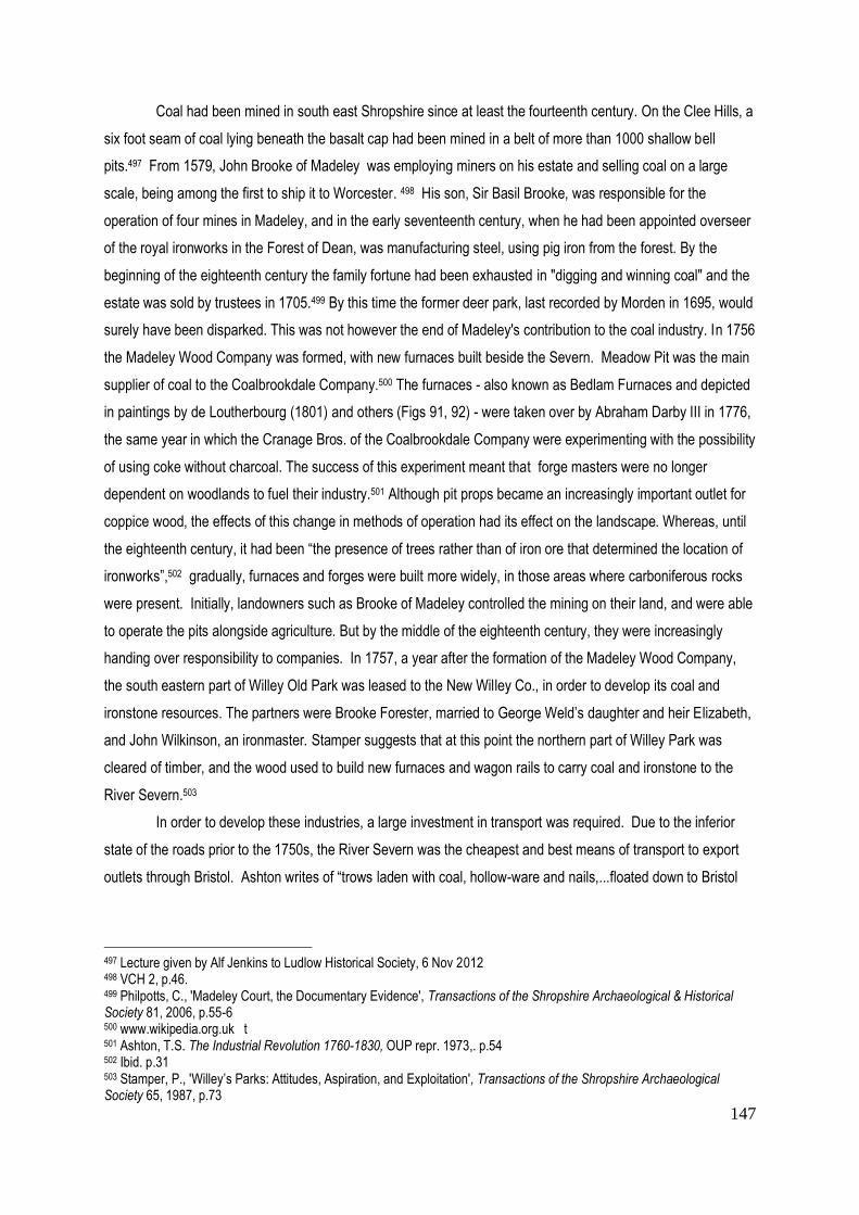
147
Coal had been mined in south east Shropshire since at least the fourteenth century. On the Clee Hills, a
six foot seam of coal lying beneath the basalt cap had been mined in a belt of more than 1000 shallow bell
pits.497 From 1579, John Brooke of Madeley was employing miners on his estate and selling coal on a large
scale, being among the first to ship it to Worcester. 498 His son, Sir Basil Brooke, was responsible for the
operation of four mines in Madeley, and in the early seventeenth century, when he had been appointed overseer
of the royal ironworks in the Forest of Dean, was manufacturing steel, using pig iron from the forest. By the
beginning of the eighteenth century the family fortune had been exhausted in "digging and winning coal" and the
estate was sold by trustees in 1705.499 By this time the former deer park, last recorded by Morden in 1695, would
surely have been disparked. This was not however the end of Madeley's contribution to the coal industry. In 1756
the Madeley Wood Company was formed, with new furnaces built beside the Severn. Meadow Pit was the main
supplier of coal to the Coalbrookdale Company.500 The furnaces - also known as Bedlam Furnaces and depicted
in paintings by de Loutherbourg (1801) and others (Figs 91, 92) - were taken over by Abraham Darby III in 1776,
the same year in which the Cranage Bros. of the Coalbrookdale Company were experimenting with the possibility
of using coke without charcoal. The success of this experiment meant that forge masters were no longer
dependent on woodlands to fuel their industry.501 Although pit props became an increasingly important outlet for
coppice wood, the effects of this change in methods of operation had its effect on the landscape. Whereas, until
the eighteenth century, it had been “the presence of trees rather than of iron ore that determined the location of
ironworks”,502 gradually, furnaces and forges were built more widely, in those areas where carboniferous rocks
were present. Initially, landowners such as Brooke of Madeley controlled the mining on their land, and were able
to operate the pits alongside agriculture. But by the middle of the eighteenth century, they were increasingly
handing over responsibility to companies. In 1757, a year after the formation of the Madeley Wood Company,
the south eastern part of Willey Old Park was leased to the New Willey Co., in order to develop its coal and
ironstone resources. The partners were Brooke Forester, married to George Weld’s daughter and heir Elizabeth,
and John Wilkinson, an ironmaster. Stamper suggests that at this point the northern part of Willey Park was
cleared of timber, and the wood used to build new furnaces and wagon rails to carry coal and ironstone to the
River Severn.503
In order to develop these industries, a large investment in transport was required. Due to the inferior
state of the roads prior to the 1750s, the River Severn was the cheapest and best means of transport to export
outlets through Bristol. Ashton writes of “trows laden with coal, hollow-ware and nails,...floated down to Bristol
497 Lecture given by Alf Jenkins to Ludlow Historical Society, 6 Nov 2012 498 VCH 2, p.46. 499 Philpotts, C., 'Madeley Court, the Documentary Evidence', Transactions of the Shropshire Archaeological & Historical Society 81, 2006, p.55-6 500 www.wikipedia.org.uk t 501 Ashton, T.S. The Industrial Revolution 1760-1830, OUP repr. 1973,. p.54 502 Ibid. p.31 503 Stamper, P., 'Willey’s Parks: Attitudes, Aspiration, and Exploitation', Transactions of the Shropshire Archaeological Society 65, 1987, p.73

148
and dragged back upstream with their cargoes of bar iron, clay, and West Indian produce”.504 The building of
canals, on the other hand, was an expensive venture, largely undertaken by extremely rich landowners such as
the Duke of Bridgewater, or by joint venture companies formed by landowners seeking an investment. From
1763, after the end of the Seven Years War, canal building experienced a boom, with the Wolverhampton Canal
linking the Midlands to the Severn opening in 1768. Industrialists such as Josiah Wedgwood invested in their
construction, the latter sponsoring the Grand Junction Canal of 1777.
Wedgwood was also involved in road improvement 505, a venture that attracted the interest of local
landowners. Although the first Turnpike Act had been introduced in 1663, to enable the turnpiking of the Great
North Road, there was no real improvement in Shropshire’s roads until the 1760s, when the majority of turnpike
roads in that region were built - Thomas Telford being employed as surveyor on the London-Holyhead road that
passed through Shrewsbury. Many industrialists and landowners invested in the Turnpike Trusts, participating
actively on the boards that were run by independent individuals, in order to supervise the upgrading of roads and
to collect the tolls that were required to maintain them.506 Thus they were able to influence the new routes to their
own advantage, particularly after the Highways Act of 1773 when it became easier for those with influence to
divert or even stop up a public highway inconveniently routed through their property. 507 Wrigley has calculated
that between 1690-1840 road usage over long distances by both commercial and private enterprises increased
at least two to threefold. 508 The building of roads inevitably impacted on deer parks, sometimes cutting through
them and contributing to their closure. To what extent the deer park survived the changes brought about by
industrialisation and improvements in infrastructure will be one of the principal topics explored during the
following pages.
Agricultural improvements
While the growth of the iron industry was being enhanced by the requirements of the Seven Years War
1757-1763 (Willey Furnace was principally involved in the production of armaments), the increase in population
dating from the middle of the eighteenth century demanded an expansion in arable production. Wrigley has
estimated that between 1600-1800 the population of England rose from 4.2 million to 8.7 million while those
working on the land fell from c.70% of the population to less than 40%. 509 In the expanding industrial centres in
the vicinity of Shropshire, the population increases were concentrated in towns such as Birmingham and
Manchester. 510 Efforts made in the county to raise agricultural production by draining marshland, particularly in
the Weald Moors, and cultivating former wastelands, have already been noted in the previous chapter. In the
504
Stamper, P., 'Willey’s Parks'., op cit. p.35 505
ibid., pp.65-6 506
www.geog.port.ac.uk 507
Gregory, op cit., p.77 508 Wrigley,Energy & the English Industrial Revolution, op cit. p.31 509 ibid. p.33 510 ibid. p.62 In 1700 the population figures were: Birmingham: 8-9,000; Manchester: 8-9,000; whereas in 1750 Birmingham: 24,000 and Manchester: 18,000

149
later eighteenth century, however, the zeal to improve farming methods was driven by what Tarlow has identified
as a "moral value and social desirability" that went beyond the concern for economic returns.511
Agricultural improvements, such as marling and the introduction of crops such as turnips, were a
feature of the so-called ' agricultural revolution' that led to the prosperity of arable farmers in the eastern
counties such as Norfolk, but had much less impact in Shropshire where pasture and stock raising still
predominated. As already noted, the northern plains had provided grazing for cattle since the Middle Ages, while
sheep had flourished on the southern hills, and timber and coppice had provided building material, firewood, and
eventually pit props. Shropshire had never grown arable crops on the scale that was seen in Eastern England.
Nevertheless, knowledge of the new methods gradually spread throughout the country, through farmers’ clubs
and journals such as The Farmer’s Magazine (1776) and The Farmer’s Journal (1806), with the result that
different regions became more specialised, with the Midlands concentrating on cattle and horses. Between 1790-
1812 wheat prices outstripped the price of oak, leading to the felling of many mature trees that were needed to
build ships to serve in the French Wars, during which a field of wheat was, according to Daniels, considered a
“patriotic spectacle”; 512 while Tarlow writes, "to maximise the potential of the earth, i.e. its capacity to provide for
the needs of Man, was not only economic optimalisation, but also a religious and moral duty".513
However, landowners both new and old had to accept the “idea of progress” before changes in the
management of the countryside could be expected.514 Most probably still believed in the value of tradition.
Some, possibly only a small minority in Shropshire, would have read the writings of Horace Walpole and Thomas
Whately, and became engaged in the aesthetic debate that characterised the second half of the eighteenth
century. Even if the controversy surrounding the landscapes of Capability Brown and his followers escaped the
notice of many of the local landowners, there was nevertheless an interest in the aesthetic improvement of
gardens and wider estates. While Brown commanded fees that were beyond the reach of all but the richest
landowners, the landscape designer William Emes was considered an acceptable substitute. But the hilly,
wooded, rock strewn landscape of much of southern Shropshire did not in any case offer the ideal terrain for a
Brownian landscape, and it is not surprising that the aesthetics of Humphry Repton and the Picturesque
Movement found particular favour in that region. The debate on the nature of the Picturesque and the Sublime,
promoted as it was by two local squires and neighbours, Uvedale Price and Richard Payne Knight; was
significant in determining the future development of the ‘park’ in Shropshire. In the following pages, the survival
of the park will be examined within the context of both aesthetic and agricultural ‘improvements’, in order to
discover what became of the deer park and the deer.
511 Tarlow, op cit. p.35 512 Daniels, S., ‘The Political Iconography of Woodland in later Georgian Engand’ in The Iconography of Landscape, Cambridge 1988, p.48 513
Tarlow, op cit., p.36 514 Daniels, op cit., p.46

150
Cartographic evidence
As in the preceding chapter, county and estate maps continue to be an important research tool. Until the
establishment of the Ordnance Survey at the beginning of the nineteenth century, the county map was still the
product of private enterprise. 515 This accounts for a marked difference in the quality and reliability of the various
maps. All were dependent on a series of processes guided by relative skills, local knowledge, and financial
security. In the first place, not all surveyors were professionals and as instruments became more accurate, not all
could afford the £125 that was the estimated cost of equipment for a surveyor by the end of the eighteenth
century.516 Whereas Saxton had employed a method known as “survey by traverse”, literally pacing out roads
and tracks, those surveys undertaken after 1750 were largely based on trigonometrical methods, which, when
accompanied by new tools, constituted something of a cartographic revolution. The new technique involved
establishing a level baseline and using a theodolite to measure distances between intervisible high points.517 In
Shropshire, the main points of reference were the Wrekin and the Clee Hills. Once the surveyor had gathered
his information, which in the case of a county map might take several years, the material was passed on to a
draftsman whose job it was to edit the information and transfer it to a copper plate. During this part of the
process, certain features of the landscape may well have been lost. However, the decision as to what was
eventually published, the numbers and quality of the map, rested with the publishers who in most cases were
based in London. Copper plates were very expensive, and were consequently used as many times as possible -
at a rough estimate, between several hundred and several thousand prints might be taken. Demand for maps
varied from one region to another, but sales initially depended on a subscription list, composed of local gentry,
clergy, industrialists, and sometimes booksellers, who were required to pay something in the region of two
guineas in advance to ensure publication.518
County maps were produced as single sheets or bound into folios or atlases; more expensive versions
were folded and mounted on linen or occasionally on canvas with rollers. In order to encourage the wealthier
subscribers, coats of arms were sometimes displayed and the names of property owners inserted on the map.
These subscribers demanded a high level of accuracy, not only in the depiction of their properties but also in that
of such features as roads of various sorts. Unfortunately, this sometimes led to the depiction of parks that had
not been completed, as in the case of Knyff and Kip engravings a century earlier, together with roads and later
canals that “anticipate reality”.519 In order to try and promote greater accuracy, the Society for Arts (later to
become the Royal Society for Arts) introduced a prize for any accurate survey at 1:1 scale that included
measured road distances, navigable rivers, and was certified as accurate by two county gentry. Between 1759-
1809 thirteen prizes were awarded for new county surveys, including a map of Shropshire published by Robert
515
Macnair, A. & Williamson, T., William Faden & Norfolk’s Eighteenth Century Landscape, Windgather Press 2010, p.1. 516 ibid., p.27 517
Ibid. p.p.23 518 ibid. pp.33-36 519
ibid., p.30

151
Baugh in 1808, supported by Thomas Telford (Surveyor of Works) and Robert Darwin, father of Charles, which
received a prize of 15 guineas.520
Although accuracy can never be guaranteed, the introduction of better theodolites, accurate to one
sixtieth of a degree, together with the achromatic lens, patented in 1785, and designed to limit spherical
distortion, meant that by the end of the eighteenth century England led the field in surveying instruments, even
though France had always been ahead in undertaking a national survey, begun as early as 1747 as a
government sponsored project, with the whole of France successfully mapped by 1818.521 England had to wait
for the Board of Ordnance (set up in 1791 but only called the Ordnance Survey from 1854) to have a government
sponsored body that between 1799 -1811 made data available to private companies. The Board was originally a
supplier of munitions, with map production as a subsidiary role, inevitably focused on military strategy and the
threat of invasion from France. Consequently, the first county to be mapped was Kent, but the aim was to cover
the whole of England.
With the publication of the 1833 one inch to the mile OS maps, the future of the private surveyor and
publisher was threatened. The distinguished publisher William Faden, who by 1800 owned rights to three
quarters of the county maps, was careful to maintain a good relationship with the Society for Arts and the Board
of Ordnance, and published the first OS survey of Kent in 1801.522 Although Faden did not complete a map for
Shropshire, the county was fortunate enough to have the maps of several other private county map-makers:
Thomas Kitchin (1764 & 1777), John Cary (1787 & 1805), Charles Smith (1801), Robert Baugh (1808) and the
Greenwood Bros. (1827). Being the first county surveys to appear, following Morden’s revisions of the county
map of 1695, these maps are relatively late when compared with those of other counties: Budgen’s Survey of
Sussex 1724; Senex’s Survey of Surrey 1729; Henry Beighton’s Survey of Warwickshire 1728. This being the
case, we might expect a higher level of accuracy.523 In terms of this thesis, it is important to remember that
agricultural improvements were essentially recorded in map form,524 and it is particularly useful to compare the
various depictions of parks and infrastructure with the first OS Surveyors’ drawings completed between 1814-17
and the OS maps of 1833 and later 1879-81 (see Table 3 ).
Thomas Kitchin (1719-1784) was apprenticed to Emanuel Bowen (whose map of 1751 has been
referred to in the previous chapter), and in 1739 he married Bowen’s daughter. Together, they published The
Large English Atlas (1749-60),525 an attempt to cover the whole of England with large maps 27” x 20”, the
borders engraved with historical and topographical details. Between 1747-83 they produced a further 170 maps
for The London Magazine526. The Large English Atlas was a great commercial success, running to seven
520 Macnair, A. & Williamson, T.,op cit., pp.16-18 521 ibid. p.41 522 ibid., pp 49-59 It is worth noting that the county maps are usually known by the names of their publishers rather than the surveyors who undertook the original collection of data. 523 ibid., p.8 524 Gregory, J., op cit., p.74 525 Described as “by far the most important eighteenth-century English atlas to be published before John Cary’s New and Correct English Atlas (1787)” Hodson, County Atlases, vol. 2, p.97, quoted Delano-Smith & Kain, op cit. p.107 526 www.foldingmaps.co.uk

152
editions over a period of 30 years. The Shropshire maps of 1764 and 1777 reveal a marked discrepancy in the
parks shown, with the later version bearing more relation to those of subsequent map makers. Although the
parks of 1777 are shown as paled, suggesting that they are deer parks, they are not individually named and
therefore can only be identified in relation to nearby towns and villages. Kitchin became a cartographer of
considerable repute, and from 1773 served as hydrographer to the king. It is difficult to know how familiar he
was with Shropshire, being primarily based in London, as were also Henry Teesdale and Charles Smith (1801).
Smith’s maps were considered by contemporaries as the best ever issued, containing much information,
depicted at large scale, and finely engraved.527 He must have been in competition with John Cary (1754-1835),
who also worked in London, and began his career as engraver, cartographer and globe maker, with the
publication of his New and Correct English Atlas of 1776. As the title suggests, Cary prided himself on his
accuracy and detail, which he considered to be more important than decorative embellishment. The map
historian R.V. Tooley describes Cary’s work as an engraver as “...elegant and exact with fine clear lettering and
great delicacy of touch”. In 1794 he was commissioned by the Postmaster General to carry out a survey of
England’s roads, which led to Cary’s New Itinerary, published in 1798. His New Universal Atlas of 1808, re-
issued many times, is said to have set the standard for all subsequent cartographers and he was among the
earliest to work for the OS prior to 1805.528 Indeed, Delano-Smith considers Cary’s county atlas to be in the
same category of excellence as that of Saxton.529
The importance of infrastructure and features relating to the growth of industrialisation in eastern
Shropshire were reflected for the first time in Baugh’s county map published in 1808 on nine sheets at a scale of
one inch to the mile. Baugh, unlike his predecessors, was a local man, born in Montgomeryshire in 1748, where
he was the parish clerk of Llanymynech near Oswestry. He taught himself skills in surveying and during the
second half of the eighteenth century worked for Thomas Telford on the building of the Holyhead road. This
association with the great engineer, who successfully recommended his county map to the Society for Arts for a
prize, no doubt facilitated its sale. Baugh claimed that his map was based on an entirely new survey, and it
certainly shows an increased number of parks – some 24 as opposed to Cary’s 12 only three years previously .
His technique features hatchuring for slopes, shading for parkland, and traditionally accepted symbols for
mansions, mills and coal pits.530 In his introduction to the reprinting of Baugh’s map by the Shropshire
Archaeological Society, Trinder suggests that it was probably intended as a traveller’s map, and was almost
certainly a couple of years out-of-date by the time it appeared, which would account for certain omissions.
Nevertheless, Trinder considers that what is shown is generally accurate, and this includes turnpike roads,
distinguished from ordinary parish roads, and a representation of the emerging canal system, including an
extension at Ellesmere that was never completed.531 Like all maps, Baugh’s county map has to be treated with
some circumspection, in the knowledge that there are inaccuracies, such as the depiction of castles that had
527 www.foldingmaps.co.uk 528
www.geographicus.com 529
Delano-Smith & Kain op cit. p. 108 530 Trinder, B., Robert Baugh’s Map of Shropshire 1808, Shropshire Archaeological Society, 1983 531 ibid. pp 4-6

153
long been abandoned at Caus, Corfham, and Shrawardine.532 Where deer parks are concerned, it seems
reasonable to assume that the c. 24 examples of parks that Baugh shows enclosed with a firm line or boundary,
were or had recently been intended for keeping deer . This is borne out by the fact that his map also includes at
least six parks that are not enclosed with his customary hard-line boundary, some of which had been recently
landscaped. It will require closer examination of more detailed maps or alternative documentary evidence to
show how many of the deer parks still contained deer, or were re-stocked with deer at a later date.
After Baugh’s map of 1808, the next county map to be produced for Shropshire was that of Greenwood
& Co., a publishing firm based in the West End of London that produced maps of 35 counties between 1817-
1831. Christopher Greenwood and his younger brother John have been described as the last of the private
surveyors working in the eighteenth-century tradition.533 Although they were operating at the same time as the
new Board of Ordnance and had access to the triangulation data used by the Board,534 and indeed to the OS
Surveyor’s drawings where these had already been completed, they were perhaps too dependent on evidence
provided by local surveyors and landowners. Existing estate maps that were already out of date may have been
the source of inaccuracies.535 In addition, the Greenwood maps were produced more rapidly than Baugh’s, in a
finally unsuccessful attempt to outpace their government-sponsored competitors, and to satisfy their many
subscribers, some of whom were seeking to acquire the whole collection. Shropshire was the 29th county map in
the series, published in 1827 under the patronage of the Lord Lieutenant, the Earl of Powis, at a price of three
guineas to subscribers, who according to advertisements numbered “upwards of 21,000”.536 Since subscribers
were traditionally landowners, both aristocratic, gentry, and those aspiring to this class, Greenwood continued to
record country houses, together with their parks, gardens and plantations. Relatively little attention is paid to
industrial features, which in the case of Shropshire had by now assumed considerable importance. On the other
hand, the maps reflect the interest in turnpike roads, shared by the many landowners actively involved in turnpike
trusts, and also show canals and the emerging railway network serving the East Shropshire coalfields. The maps
were available in a choice of formats – “plain sheets, coloured, mounted on rollers, folded in a case”.537 This
suggests that considerable attention was paid to their collectability, reminiscent of the maps produced in Tudor
and Stuart England that graced the walls of the aristocracy. Greenwood’s maps are quite old-fashioned in
appearance, when compared with the first Ordnance Survey Maps. Like those that preceded them, they contain
some errors and omissions, in relation to minor roads and inaccurate place names, but the Greenwood county
map of Shropshire has one advantage over Baugh in that the information, having been put together more
quickly, can be confidently dated to 1826-27.538 It includes some 16 parks, apparently enclosed which would still
532 Trinder, B.,op cit.,. p.8 533 Delano-Smith & Kain, op cit. p.98 534 ibid. p.99 Information published by William Mudge and Isaac Dalby as An Account of the Operations carried on For Accomplishing A Trigonometrical Survey of England & Wales, 1799-1811 535 Trinder, B. Introduction to Greenwood’s Map of the County Of Salop 1827, reproduced by Transactions of the Shropshire Archaeological & Historical Society 7, 1993, pp.101-102. 536 ibid. 537 ibid . 538.ibid.
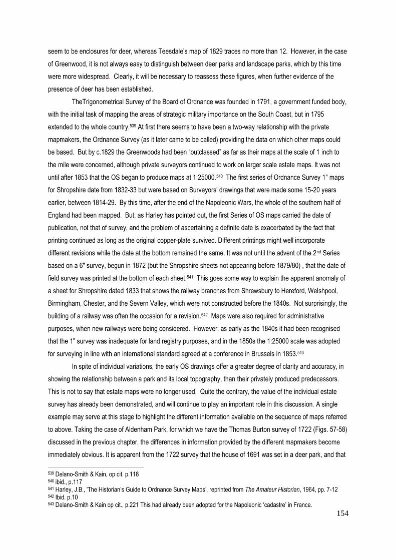
154
seem to be enclosures for deer, whereas Teesdale’s map of 1829 traces no more than 12. However, in the case
of Greenwood, it is not always easy to distinguish between deer parks and landscape parks, which by this time
were more widespread. Clearly, it will be necessary to reassess these figures, when further evidence of the
presence of deer has been established.
TheTrigonometrical Survey of the Board of Ordnance was founded in 1791, a government funded body,
with the initial task of mapping the areas of strategic military importance on the South Coast, but in 1795
extended to the whole country.539 At first there seems to have been a two-way relationship with the private
mapmakers, the Ordnance Survey (as it later came to be called) providing the data on which other maps could
be based. But by c.1829 the Greenwoods had been “outclassed” as far as their maps at the scale of 1 inch to
the mile were concerned, although private surveyors continued to work on larger scale estate maps. It was not
until after 1853 that the OS began to produce maps at 1:25000.540 The first series of Ordnance Survey 1" maps
for Shropshire date from 1832-33 but were based on Surveyors’ drawings that were made some 15-20 years
earlier, between 1814-29. By this time, after the end of the Napoleonic Wars, the whole of the southern half of
England had been mapped. But, as Harley has pointed out, the first Series of OS maps carried the date of
publication, not that of survey, and the problem of ascertaining a definite date is exacerbated by the fact that
printing continued as long as the original copper-plate survived. Different printings might well incorporate
different revisions while the date at the bottom remained the same. It was not until the advent of the 2nd Series
based on a 6" survey, begun in 1872 (but the Shropshire sheets not appearing before 1879/80) , that the date of
field survey was printed at the bottom of each sheet.541 This goes some way to explain the apparent anomaly of
a sheet for Shropshire dated 1833 that shows the railway branches from Shrewsbury to Hereford, Welshpool,
Birmingham, Chester, and the Severn Valley, which were not constructed before the 1840s. Not surprisingly, the
building of a railway was often the occasion for a revision.542 Maps were also required for administrative
purposes, when new railways were being considered. However, as early as the 1840s it had been recognised
that the 1" survey was inadequate for land registry purposes, and in the 1850s the 1:25000 scale was adopted
for surveying in line with an international standard agreed at a conference in Brussels in 1853.543
In spite of individual variations, the early OS drawings offer a greater degree of clarity and accuracy, in
showing the relationship between a park and its local topography, than their privately produced predecessors.
This is not to say that estate maps were no longer used. Quite the contrary, the value of the individual estate
survey has already been demonstrated, and will continue to play an important role in this discussion. A single
example may serve at this stage to highlight the different information available on the sequence of maps referred
to above. Taking the case of Aldenham Park, for which we have the Thomas Burton survey of 1722 (Figs. 57-58)
discussed in the previous chapter, the differences in information provided by the different mapmakers become
immediately obvious. It is apparent from the 1722 survey that the house of 1691 was set in a deer park, and that
539 Delano-Smith & Kain, op cit. p.118 540 ibid., p.117 541 Harley, J.B., 'The Historian’s Guide to Ordnance Survey Maps', reprinted from The Amateur Historian, 1964, pp. 7-12 542 Ibid. p.10 543 Delano-Smith & Kain op cit., p.221 This had already been adopted for the Napoleonic ‘cadastre’ in France.

155
Fig 93. Aldenham Park, Baugh 1808
Fig 94. Aldenham Park, Greenwood 1827

156
Fig 95. Aldenham Park, OS drawing 1817
Fig 96. Aldenham Park OS 1833-35

157
there was a formal garden, orchards, and kitchen garden, connected to the park by avenues and rides. The
Baugh map of 1808 (Fig 93) shows an extremely simplified version, the only avenue depicted being that of the
approach road to the house. The enclosure of the park appears as a firm black line, bordered by the turnpike
road from Shrewsbury to Morville to the south, and by the river diverted into three pools to the north. There is a
sketchy indication of trees, but no sign of the former garden. A very basic sketch map of the boundaries of the
park made in 1792 (Fig 78) and accompanied by a written description,544 shows that by this date the boundaries,
whether pales, quickset hedge, or in some places "Chinese railing", were not in a fit state to contain deer.
Comparing Baugh’s version with the later depiction by Greenwood (1827) (Fig 94), the park appears to have
been extended further north beyond the river. In Greenwood’s version, the avenue leading to the house meets a
further avenue from the west at right angles, a simplified version of what was there a hundred years earlier in the
Burton survey. An Ordnance Surveyor’s drawing of the same area also shows a double avenue leading to the
house as in 1722, together with a series of planted rides both around and through the park. It seems that many
of the avenues, although now an old-fashioned feature, had survived. However, the park immediately south of
the three ponds had been subdivided, with the section to the west named as Great Acorn Coppice . In the
drawing of 1817 by the surveyor Bell 545 (Fig 95), Park House appears to the west for the first time, with its own
approach avenue beyond the boundary of the park. These details have all been transferred to the 1833 OS 1:1
scale map, which provides more clarification in terms of hatchuring, and names Mor Brook, the river forming the
southern boundary of the park (Fig 96). One question that arises from a comparison of all these county maps
with Burton’s survey of 1722 is the fact that the chain of pools depicted by Burton as running from north to south
appear on all the subsequent maps as lying to the north of the park and running from northwest to southeast.
There is no trace on the modern 1:25000 OS map of Burton’s pools, although there are fishponds marked to the
north of the park. The maps reveal little information as to whether or not the park was stocked with deer. One
thing that is particularly noteworthy in the context of this thesis is that by 1833 the park area, which by then lay
principally to the west of the house and drive, appears to have been enclosed with a pale. During the course of
the following pages, it will be necessary to establish how much importance can be attached to the depiction of
the pale by the various cartographers.
Improvement and the 'landscape designer'
In the previous chapter, the agricultural improvements introduced in the seventeenth century by forward
looking landowners such as John Weld of Willey were discussed in some detail. Until the mid-eighteenth century
‘improvement’ was largely understood, certainly in Shropshire, as agricultural improvement, undertaken in the
interests of increasing the economic and particularly the rental value of the estate. Aesthetic considerations were
secondary and took place only as and when finances permitted. In the introduction to this chapter, reference has
been made to Tarlow's extended study on the nature of improvement in the eighteenth century, in which she
544 SA 1093/160/4 Rough Plan of present boundaries by J. Powell, Aug 1792 545
The Shropshire collection of Surveyors' drawing are not included in the numbered collection in the British Library, the
originals are in Shropshire Archives.

158
refers to a concept of improvement that amounted to an ideology and embraced the aesthetic as well as the
agricultural aspects of the estate.546 Other scholars have also noted a desire within fashionable society to be
recognised as an 'improver'. Daniels has drawn attention to "the patriotism of landscape improvement: its
allegiance to various geographical identities, local and national".547 This may well mean that an aesthetic that
suits the topography of one part of the country may prove unacceptable in another.
In the 1770s, when Capability Brown had already completed much of his best work, Walpole and
Whateley were writing of a “tastefully improved Nature”.548 What this involved in their eyes, was the removal of
anything unsightly in the landscape - in Whateley's words: “the business of a gardener... is to shew all the
advantages of the place upon which he is employed; to supply its defects, to correct its faults, and to improve its
beauties. For all these operations the objects of nature are still his only materials.”549 The following pages will
look at the 'landscaping' of parks in Shropshire in the second half of the eighteenth century as “ part of a general
desire for improvement....”550, in the belief that commitment to this ideology had a significant impact on the
survival or otherwise of the deer park.
There is little doubt that the introduction of the ha-ha, often attributed to Bridgeman but probably used
earlier in France, marked a change that was already underway in the concept of the park. The sense of
separation between garden and park was visually removed by the sunken fence, even though grazing animals,
whether deer or cattle, were still physically restrained from entering the garden itself. The result was an opening
up of views into the landscape beyond, a process that can be traced back to the formal landscapes devised by
London and Wise. A good example of this inclusion of the agricultural estate within a new concept of the park is
provided by Eyre’s Bridgeman-inspired design for Houghton Hall in Norfolk, the home of Robert Walpole, prime
minister and father of Horace Walpole. For Horace Walpole, the full potential of embracing the parts of the
landscape outside the sunken fence was achieved by his hero, William Kent, who “leaped the fence, and saw
that all nature was a garden”. This much quoted line, read in context, points to the importance attributed to
“distant view.... perspective, light and shade,” qualities that had previously been understood as the attributes of
landscape painting.551 In Kent's landscapes, classical buildings were more important than deer, although these
could be accommodated where they already existed. By 1760, however, Kent had been succeeded by
Capability Brown, whose designed landscapes enabled the deer to approach and be seen from the house.
Walpole was not an admirer of the new Brownian style that was prepared to sweep away existing features,
leaving the mansion in isolation; he commented: “the method of living is now totally changed, and yet the same
546
Tarlow, op cit. pp. 190-192 547 Daniels, S., Humphry Repton: landscape gardening and the geography of Georgian England, Yale 1999, p.104 548 Walpole, op cit. pp15-19 549
Whateley, T., Observations on Modern Gardening,1770, quoted Turner, op cit. p.68 550 Turner, T., Capability Brown and the eighteenth century English landscape, Phillimore Press 1999, Intro. 551 Walpole, op cit., pp. 43-44
159
Fig 97. Tong Park, Capability Brown, destroyed 1954
Fig 98. Tong Castle & Park, Baugh 1808
Fig 99. Tong Castle & Park, OS 1833

160
superb palaces are still created, becoming a pompous solitude for the owner, and a transient entertainment for a
few travellers”.552 Petworth (Sussex) is cited as an example of the new style. Even though today the deer are
able to come right up to the house, Walpole observed that in his day “a garden of oaks 200 years old.....a
fragment of improved nature” had been preserved in the immediate vicinity of the house,553 to offer protection
from the elements.
There are no landscapes designed by William Kent in Shropshire. There was however a highly
significant landscape, The Leasowes , (now in Warwickshire, but in the eighteenth century in Shropshire), which
from the time that its owner William Shenstone settled there in 1741, was transformed from a modest farm into a
landscape described by Samuel Johnson in 1777as “the envy of the great and the admiration of the skilful; a
place to be visited by travellers, and copied by designers.” 554 Shenstone, who was both poet and landscape
designer, was inspired by the Arcadian poets to seek a ‘natural' style. The visitor to The Leasowes was required
to follow a prescribed route that encircled the estate, offering views of waterfalls, lakes, a grotto, garden buildings
and urns. According to Stamper, The Leasowes was one of “the most visited landscape gardens in the
country,"555 but there is no evidence that it ever contained deer. Here, local landowners were introduced to a new
aesthetic ambition, far more radical than the creation of avenues. Although The Leasowes hardly outlived the
death of Shenstone in 1763, it had a profound influence on later designers.
During the second half of the eighteenth century, Capability Brown undertook a number of commissions
in the Midlands. The first of these was Croome Court (Warwickshire) where he was invited by Lord Deerhurst in
1750 to design a new house and landscape setting on what was a marshy and unpromising site. Brown
approached the problem in a practical way, laying culverts from the house down to what was to become a lake.
On 14th November 1752 Lord Deerhurst wrote: “Mr Brown has done very well by me, and indeed I think has
studied both my Place and my Pocket.”556 It was probably a recommendation such as this that led to a
commission from George Durant who, after making a fortune in Havana, bought the Tong estate in the early
1760s. In 1765 Brown supplied him with various plans and elevations for a new house and park.557 However, it
seems unlikely that Brown was ultimately responsible for the Gothic mansion that replaced the Vernons’ house of
c.1500 - a stone relief of the mansion lies in the churchyard of Tong church (Fig.51) - since it is so different in
style from his Palladian building at Croome Park. The Tong mansion was pulled down in 1954 when the M54
motorway bisected Tong Park, Brown’s only surviving landscape in the county.558 A nineteenth-century
photograph shows the lake and vista to the church created by Brown (Fig97). There is no evidence to suggest
that Durant reintroduced any deer which, as shown on the estate plan of 1739, had already disappeared before
that date. The Brown landscape was shown on Baugh's map of 1808, but without a hard line boundary; nor is It
identified as an enclosure by Greenwood in 1827. An OS Surveyor’s drawing of 1817 shows a small tongue of
552 Walpole, op cit., p.54 553 ibid., p.56 554 Johnson, S., ‘Lives of the Poets’, in The Works of Samuel Johnson, Troy, New York, 1903, Vol 11, P.80 555
Stamper, P. Historic Parks & Gardens, op cit. pp 43-44 556 Warw. CRO CR125 (153) quoted Stroud, D., Capability Brown, Faber & Faber 1975, p.57 557
Stroud, D., op cit. p.148 558
Pevsner, Shropshire, op cit. p.659

161
surviving woodland between the castle and the road to Kelsall, and this is recorded on the OS map of 1833 (Figs
98-99 ).
Tong can therefore be identified as one of the earliest examples, certainly in Shropshire, of a new
‘landscape park’ in which deer no longer had any role. One of the main reasons for their rejection, and one that
cannot be over-emphasised, is their potential to destroy newly planted parks by gnawing the trees and pulling
down any branches within reach. Added to this is the need to provide solid and expensive boundary walls or
pales; a ha-ha being no more than an invitation to the deer to jump out. Consequently, in the second half of the
eighteenth century the concept of a park without deer gained hold. As the following pages will demonstrate, there
were a considerable number of these in Shropshire, in which lakes and carefully arranged trees and walks were
the main feature. However, a distinction needs to be made between the newly created landscape park in which
deer had no role, and those that were effectively survivors from earlier deer parks that were 'landscaped' in the
latest fashion. In the latter, the deer were probably retained, as in the case of Petworth referred to above, which
was painted along with its deer by J. M. W.Turner in c.1848.559 Most parks were grazed, whether by deer,
sheep, cattle or horses, and as Fletcher has observed, deer are the most efficient in creating a smooth short
cut.560 However, as far as the newly planted landscapes were concerned, the grazing value of deer would rightly
have been offset by the threat they presented to the ornamental trees. The ha-ha was used by Brown to keep the
deer out of the garden itself, and he took considerable pains to retain mature trees wherever possible, many of
these being survivors from an original deer park.561
There is, however, one Brownian landscape on the borders of Shropshire where major improvements to
a pre-existing deer park included the accommodation of deer. At much the same time as he was providing plans
for Tong, Brown was in contact with Sir Henry Bridgeman (later lst Earl of Bradford) concerning plans for Weston
Park ( now in Staffordshire) , a few miles north of Tong. The first contract, dated September 1765, included
making a ha-ha “to sweep round the south side of the house, and to be of sufficient length to ‘keep out the deer’;
together with preparation for planting ‘all the trees and shrubs that may be deemed necessary for ornament or
use’.” 562 Five years later, In 1770, Brown entered into partnership with Henry Holland the Younger, and in 1772
celebrated with a gift of venison Holland’s announcement of his engagement to Brown’s daughter Bridget.563
Brown’s partnership with Holland was reflected in a commission from the Hon. Thomas Harley concerning a new
house and landscape on his estate at Berrington (Herefordshire) on the south Shropshire border. Considerable
work was undertaken there, with the construction of a lake and a ha-ha that involved earth moving and the
planting of a large number of new native trees. There is no evidence that deer were ever introduced into the
559 Petworth Park from the House, J.M.W.Turner, c.1828 560
Fletcher, op cit. pp.185-6 561 ibid., p.90 562 Stroud, D., op cit. p.148 Stroud suggests that the deer might have come from the Hampton Court herd 563 ibid. p.168

162
park. Brown is said to have visited Berrington twice in 1780, eventually sending his assistant, Spyers, to
undertake a survey on his behalf.564
There may have been several reasons why Capability Brown did not undertake more commissions in
Shropshire. Possibly, it was too far away to justify his travel at a time when he was busy elsewhere. It seems
more likely, however, that the canny Shropshire gentry were not prepared to dip into their pockets for the kind of
fees that Brown commanded. The garden historian David Jacques has pointed out that in the Midlands Brown
only took on significant commissions from the higher echelons of society, his work at Trentham being one
example. Brown did, however, visit an old friend living at the rectory in Church Stretton on the edge of the Long
Mynd, a theologian named John Mainwaring. Brown had met him at St. John’s Cambridge and Mainwaring was
responsible for Brown receiving a commission to carry out plans for a wilderness in the Fellows’ Garden at St.
John’s College. After delivering this plan to his friend, Brown visited Lord Clive at Oakly Park, and produced
some initial plans for a scheme that was never completed in its original form .
In spite of the absence of examples of Brown's work in Shropshire, his influence may be detected in the
work of the landscape designer William Emes, sometimes described as a follower of Brown, who undertook the
greater part of his work in the Midlands and Welsh Borders, and is said by Jacques to have been popular with
the gentry as "an acceptable alternative to Brown." 565 William Emes (1729-1803) was appointed head gardener
at Kedleston Hall, Derbyshire in 1756 and stayed there until 1760, when he set up as an independent landscape
designer.566 His success in the Midlands dates from the late 1760s and early 1770s; but he later undertook
projects as far away as Holkham Hall in Norfolk where in 1784 he was commissioned to extend the lake.567 By
the 1790s, Emes had become quite wealthy, and was able to enjoy semi retirement in Hampshire, entrusting his
Midlands commissions to his pupil and subsequent partner, John Webb. 568 Emes is mainly recognised for his
skill in creating serpentine lakes and walks, digging ha-has, planting clumps and individual specimen trees – all
skills attributed to Brown, although a closer examination of his drawings is needed to establish whether Emes
achieved the same level of spatial elegance in the combination of these elements.569 It is outside the scope of
this thesis to make such a comparison, but there is no doubt that Emes was frequently employed by landowners
in Shropshire, perhaps because he was, as Wilde confirms, “reliable, reasonably priced, always in the area, and
not without initiative in saving threatened landscape features.”570 In other words, Emes was neither as expensive
nor as challenging as Brown, in the eyes of local landowners.
Emes owed his reputation in Shropshire largely to the patronage of Robert Clive (1725-74), later Lord
Clive of India. The Clive family had been in Shropshire since the reign of Henry II, and the family home was at
Styche Hall where Robert Clive spent his childhood. He appears to have been something of a tearaway, and at
564 Stroud, D., op cit. p.189 During his busiest years, Brown had at least two men who worked for him as surveyors, John Spyers and Samuel Lapidge. 565 Jacques D., Georgian Gardens: the reign of nature, B.T. Batsford, 1983, p.86 566 Wilde, W., 'Not Just a Pupil of Brown', Country Life, Oct. 1987 pp.152-156 567 Jacques, op cit., p.116 568 ibid., p.142 569 Wilde, op cit.p.154 570 ibid.pp.152-156

163
Fig 100. Estate Plan of Walcot, 1730 SA875/2 (photocopy)
Fig 102 Walcot park, Baugh 1808
Fig 101. Walcot estate buildings, William Chambers 1764-7

164
Fig 103 A Map of Walcot Demesne with Sundry Woodlands, Messuages, Farms etc.. 1822 SA552/8/748
Fig 104 Walcot Park, Greenwood 1827

165
the age of seventeen was sent out to India where he joined the East India Company. Having distinguished
himself there as a soldier in the wars against the French and their Indian allies, he managed to amass a
considerable fortune in commerce. Between 1762-3 he employed William Chambers to rebuild Styche Hall, and
the new mansion is shown on Baugh’s map of 1808 surrounded by a small enclosed park. There is no evidence
that this ever contained deer, and judging from the 1833 OS map, the wooded enclosure was later separated
from the garden and divided into compartments.
After a second spell in India, where he led the victorious army at the Battle of Plassey, Clive returned to
England and in 1764 bought the estate of Walcot Park for £90,000. 571 Once again, it was William Chambers who
was called in to enlarge and transform the house, retaining the core of the old Elizabethan mansion. Chambers
was also responsible for building a distinguished set of stable buildings 572 (Fig 101). At the time of Clive’s
purchase, the three storey mansion was “surrounded by an extensive deer park”.573 An estate plan of 1730,
drawn up when the estate still belonged to John Walcot, shows a deer park to the west of the house, with a
double row of trees marking the boundary, and images of deer grazing (Fig 100).574 At that time, the deer park
encompassed the whole of the high ground to the west of the formal gardens, and its southern boundary lay
along the ridge of Pigeon House Bank, a wooded valley running northeast. 575 Rocque's map of 1752, which
precedes the rebuilding of the house by Clive, gives a very general image of an enclosed deer park that is
depicted on Baugh's map of 1808, by which time the new lake is in place (Fig 102). It is difficult to determine
from the sequence of maps alone how long deer survived on the Clive estates, although documentary evidence
discussed later in the chapter offers intriguing hints. An estate plan of Walcot dated 1822 suggests that by that
time the emphasis was on developing the woodlands and farms. Although there are some surviving avenues and
rides, the Hill appears to have been planted with conifers, and mixed woodland is confined to specific woods,
named as Hoar Wood, Tongley Wood, Red Wood and Stepple Wood (Fig 103) .576 The OS drawing of 1816 that
predates the estate plan suggests that a deer park was still present, whereas Greenwood’s county map of 1827
is less specific, recording what appears to be a landscaped park, with surviving fragments of woodland (Fig 104).
There is no firm evidence to show to what extent William Emes was involved in designing the lakes at
Walcot. Stamper suggests that he was working at Walcot and Oakly Park in 1774, “directing, planning and
laying out, and supplying trees and shrubs”, and that he is likely to have been responsible for the design of the
great lake.577 A drawing of c.1801, completed in some detail, shows the Walcot lake and islands, together with
the bridge carrying the approach road to the house There is no comparable drawing for Oakly Park, which had
been bought by Clive in 1767 on his second return from India. Mention has already been made of Capability
Brown’s visit to Oakly in 1772, and it seems entirely feasible that Brown’s plans may have been handed over to
Emes after Robert Clive’s death in 1774. In any case, the continuing work both at Walcot and Oakly Park must
571
Parish, J., A Short History of Walcot, handbook 1991 572 Pevsner, Shropshire, op cit. p.671 573 Parish, J., op cit. 574 SA 875/2 Map of Walcot 1730 (photocopy) 575 HER Shropshire 576
SA 552/8/748 A Map of Walcot Demesne with Sundry Woodlands, Messuages, Farms etc. 1822 577 Stamper, Historic Parks & Gardens of Shropshire, op cit.p.55

166
Fig 105. Map of Lythwood Hall & gardens, Wm Emes 1776, SA4068/6
Fig 106. Plan for Dudmaston Hall gardens, Wm Emes 1777, (hanging in house)

167
have been agreed by his son, Edward, the 2nd Lord Clive. The avenues at Oakly pre-date Emes’s intervention,
and it seems that he was more involved with providing trees and shrubs for the garden, which was probably
enclosed within the deer park in 1772 when Clive commissioned Haycock to rebuild the house,578 in order to
prevent deer damaging the new ornamentals which formed part of an arboretum. Greenwood’s map of 1827 is
the only one that clearly shows the garden within the park, but even today there is evidence of a ditch on this
boundary. Whatever the extent of Emes’s intervention at Oakly Park, the surrounding deer park appears to have
survived, even as its role changed. First mentioned as a ‘new park’ in the Calendar of Patent Rolls of 1490,579
probably used as a deer farm to supply the royal forests of Bringewood Chase, Baugh’s map of 1808 shows it
reduced on its northern boundaries from its medieval 900 acres, only to expand again right up to the Bromfield –
Ludlow turnpike road before Greenwood’s map of 1827. An estate map of 1760, held in private hands and
reproduced by Lovelace, 580 shows a series of tree-lined rides, including the Duchess Walk that led to a
pheasantry in the south (Fig 84). Documentary evidence referred to later in this chapter raises doubts as to
whether there were actually deer in the park after the end of the eighteenth century.
During the 1770s and ‘80s, many of Emes's plans remained unexecuted: Lythwood Hall 1776,
Dudmaston 1777, and The Hill, Cheswardine 1783. In all these cases, the parks probably incorporated
surviving fragments of medieval deer parks, but unlike those at Walcot and Oakly, they were not incorporated in
the proposed schemes. Lythwood is particularly intriguing, since it is recorded by Cantor, who found evidence in
the Calendars of Letters Patent of the Abbot of Shrewsbury being granted licence to impark in 1346.581 It has
already been shown that Lythwood Forest was an important source of timber for building. But it does not appear
on Saxton's or Speed's county maps, and Stamper suggests that imparkment never took place. Nevertheless, it
seems possible that Lythwood Hall, the eighteenth-century home of Joshua Blakeway, was built on the site of a
medieval park. The Emes plan of 1776 is in colour 582 (Fig105) and depicts what is clearly a pleasure garden and
park, with Emes's characteristic serpentine lake, and a circular walk bounded by trees that hugs the perimeter in
a manner reminiscent of Shenstone’s Leasowes. There is a small seat installed on an elevated piece of ground,
offering a fine view of the park. Almost certainly, this was intended to be a small landscape park, with no
provision for deer; the attached written ‘reference’ refers to “an undressed Path through Dingle and Woods” and
a “Small Inclosure to be kept as Pleasure Garden with Green House if required.” There is also a more practical
note, to the effect that the “dotted line in red ink, Sunk Fences, may serve to convey the Rain Waters into the
Canal”. The plan shows a couple of agricultural fields outside the park boundary, confirming a separation
between the ornamental and purely agricultural aspects of the property. It seems likely that Joshua Blakeway
was unable to afford to carry out Emes’s plan, but Thomas Parr, who inherited in 1804, implemented at least
part of it. In 1815, Parr’s Pool was surveyed by a Mr Hitchcock, who described an estate of 218 acres
“surrounded by park-like lawns of c.70 acres... Kitchen garden with lofty walls planted with fruit trees. A
578 Pevsner, Shropshire, op cit. p.448 579 HER Shropshire 580 Lovelace, D., Bringewood Chase, unpublished Report, April 2005 op cit. 581 Cal.Pat. 1345-8, 73, quoted Cantor, op cit. 582 SA 4068/6 A Plan of Demesne Land at Lithwood, the Seat of Joshua Blakeway Esq., with alterations by Wm Emes 1776

168
greenhouse, pleasure ground and shrubbery. Ornamental pieces of water both in front and back of the house...
2 lodges."583 There also appears to have been a raised garden house or viewing platform, and a ha-ha, traces of
which remain. There is no reference here to the presence of deer at Lythwood, although Greenwood's map of
1827 indicates a possible enclosure on the hill above the house.
In 1777 Emes was commissioned by William Whitmore, the descendant of a Londoner who had begun
to build up a Shropshire estate in the seventeenth century, 584 to produce a plan for Dudmaston, the estate he
had inherited two years previously on the south eastern border of the county. It had been in the ownership of the
Wolryche family since 1403, and Whitmore’s son subsequently took the name of Wolryche-Whitmore. The
house had been built in the Queen Anne style in c.1695, probably by the architect Francis Smith of Warwick.585
Whitmore set about modernising the estate, which retained fragments of Morfe Forest. The plan provided by
Emes included an area “intended for sheep pasture”586, not deer, and a lake that was not completed before 1818.
There was also a plantation or orchard indicated to the south of the house, and shelterbelts to the southwest.587
(Fig 106) It is unlikely that the plan was ever carried out; rather, it seems that Frances Wolryche, together with
her gardener Walter Wood (known by her as the Planter), undertook the planting of the Dingle in the southeast of
the park which does not appear on the Emes plan. Wood had been working at The Leasowes until 1763 and
borrowed Shenstone’s ideas for a picturesque circuit walk, introducing waterfalls, rustic bridges, and a hermitage.
Dudmaston figures for the first time on Baugh’s county map of 1808. There is no enclosure indicated, although
there is a reference to a Hay in the northwest that might indicate a former deer park.
Another surviving plan by Emes is his 1783 proposal for The Hill, (replaced by the present Cheswardine
Hall in 1875),588 which includes perimeter walks or rides, with shelterbelts of trees, and in this case a small pond
in the characteristic sausage-shape that Emes favoured. The house is set in what is described as sheep
pasture, but there is no evidence of the deer that had been grazing the park from medieval times until at least
1695.
In most of the schemes designed by Emes, serpentine rides replaced the more old-fashioned avenues
that predominated at places such as Oakly Park. These enabled the family and their guests to enjoy a circuit
round the park either on foot or by carriage, and offered an opportunity to point out to guests the improvements
that had been made. Visiting the grounds and interiors of country houses had become a popular feature of social
life. Girouard observes, that “walking round a garden or driving round a park, whether one’s own or somebody
else’s, loomed large in the ample leisure time of people in polite society.” This, he goes on to suggest, was
instrumental in the disappearance of “axial planning, and straight avenues, canals or walks.... in favour of circular
583 www.berryman.uk.com 584 Stamper, Historic Parks & Gardens, op.cit. p.19 585 Pevsner, Shropshire, op cit. p.254 586 National Trust Handbook, Dudmaston, p.18 587 Emes Plan of 1777 hanging in the house at Dudmaston Hall. 588 SA 3747/4 Plan of Demesne Lands at The Hill, the Seat of Henry Jervis Esq., with some Alterations by Wm Emes 1783 Unfortunately, this is a rather poor copy of the original held in the PRO.

169
planning.” While following a circuit, visitors were diverted by different “happenings”, whether in the form of vistas,
temples, seats, inscriptions, etc. By 1760, Stowe (Bucks) had two circuits, one for walking and one for riding,
with 30 different garden buildings to attract the visitor; while Stourhead (Wilts) had a circuit planned round the
lake, with a series of grottoes and temples.589
Hawkstone Park was one of the first estates in Shropshire to actively encourage polite visitors, with
walks laid out along the crest of Terrace Hill before 1748, when they were admired by Phillip Yorke in the earliest
known description of the park.590. As already noted in the previous chapter, Sir Rowland Hill, Lord Mayor of
London, had bought the Hawkstone estate in 1549, but it was his eighteenth-century descendants who carried
out the transformation of the landscape from the medieval deer park, recorded by Cantor, to an outstanding
example of a picturesque landscape park. The changes had begun in 1699 when the hall was rebuilt and the
estate extended, but it was Sir Rowland Hill (d. 1783) who seems to have been responsible for the improvement
of the grounds between 1719-23.591 It is difficult to know at what point deer were reintroduced at Hawkstone, or
whether indeed they had always survived in the area surrounding the medieval Red Castle, but the Hawkstone
deer park does not appear on any of the county maps before Rocque, and that does little more than confirm the
topography, showing the medieval Red Castle on its hill to the west. There is however the suggestion of a
boundary to the park, and to the vineyard within it, which would necessarily have had to be protected from deer,
if they were indeed present. A letter of Feb 28 1763 from Thomas Bell, estate agent to his master Thomas Hill,
refers to a delay in re-erecting a paddock fence for deer: "There is nothing done yet to making the Paddock fence
to keep in dear, it will not only take a Great Deale of timber and be expensive otherways but I feare they will leap
the Wall already built and I apprehend it will be attended with other Inconveniences. So that upon the whole I
wish it were to remain as it is at least until there is a further consideration about it...”.592 Bell does not indicate
whether this work was eventually undertaken, or whereabouts in the park it was, but Cary’s map of 1787
suggests the existence of a deer park. This seems to be confirmed by Baugh’s map of 1808 , although this does
not show either the walks referred to above that were already in place by 1748 or the grotto of 1765. The only
additional feature to figure on Baugh’s map of 1808 is the obelisk to the south of the park that was not added
until 1795 593 (Fig 107). Prior to this, the second Baronet, Sir Richard Hill (1733-1809) had extended the park
once again, and in 1783 invited William Emes to create Hawk Lake, a mile-long artificial water piece that formed
the northern boundary of the park, “supplying a deficiency visitors had discerned in the view.”594 This lake
appears on Baugh’s map, but the more detailed map of Greenwood (1827) clearly shows hill top walks, obelisk,
and grotto, in addition to the lake (Fig 108). Such was the landscape described in a visitor’s guide, published by
Thomas Rodenhurst in 1784 which will be discussed later in the chapter.
589 Girouard, M., Life in the English Country House, op cit., p.210 590 HER Shropshire 591 Pevsner,Shropshire, op cit. p.290 592 SA 112/12/Box 23/216 1750-71 Correspondence from Thomas Bell, estate agent to Thomas Hill 593 Pevsner, Shropshire, op cit. p.292 594 ibid., p.292

170
Fig 107 Hawkstone Park, Baugh 1808
Fig 108. Hawkstone Park, Greenwood 1827

171
In many ways, William Emes had been left behind by the 1780s – a practical landscape maker, capable
of carrying out projects that encompassed lakes, shelterbelts, even walks and rides, but not one to consider the
metaphysical aspects of nature that inspired the later landscape of Hawkstone Park, introducing a new concept -
that of the Picturesque. By this time, deer had increasingly become superfluous to the park, with Walcot the
only surviving deer park to be 'landscaped' and still retain its deer. It seems that the deer disappeared from
Hawkstone some time in the 1770s, but they reappeared in the 1830s, with the OS map of 1889 clearly marking
a large area as deer park, with a ranger’s lodge, while other artificial features had disappeared.
The predominance of perimeter rides and walks, as made popular by Shenstone in the 1740s, suggests
very powerfully how parks were used, once they had lost their function as deer parks. John Byng, Viscount
Torrington, makes frequent use of such parks when riding through the country in the last decade of the
eighteenth century. He seems to take it for granted that one may ride through a park at will, although it is
important to remember that not only was he a member of the aristocracy, and no doubt welcome as such, but the
parks he visited were only the larger sites owned by fellow aristocrats! When visiting Woburn in 1789, he points
out that although it is only open on a Monday, it is possible to enjoy the rides at any time of the year; indeed, he
writes, “..the having an evergreen, dry, side of the park, for a winter ride, and a contrast to the damp green
shades of the opposite part, is truly delectable.”595 This suggests that different areas of the park were specifically
designed to be enjoyed at different times of the year. Byng particularly commends those houses built on the
edge of a park for the pleasure of riding and walking. At Woburn he found large numbers of deer which, he
suggests, “..might surely be tamed like sheep, and led as easily to slaughter, without being shot at, badly
wounded, and half of their flesh spoil’d”. As far as Byng was concerned, his enjoyment of the deer was purely
aesthetic and lay in watching them “sporting” with their fawns.596 By the second half of the eighteenth century,
landowners and their guests seem to have expected more variety in a park than the traditional deer park had
offered, and where money was available, were prepared to invest in the current fashion for landscape
improvement that would confirm their status as an 'improver'. In Mansfield Park (1814), Jane Austen writes of
her heroine, Miss Crawford, as she assessed Mr Bertram as a potential suitor: “She looked about her with due
consideration, and found almost everything in his favour, he possessed a park, a real park five miles round....”597
There is no suggestion in the novel that this park was stocked with deer.
The developing role of the land agent
As already noted in previous chapters, agricultural improvements such as the draining of the Weald
Moors had already begun in Shropshire in the later Middle Ages, and the floating of meadows was being
practised by John Weld at Willey in the seventeenth century. But, as Tarlow has pointed out, the speed of
595 Ed: C. Bruyn Andrews, The Torrington Diaries – a selection from the tours of the Hon. John Byng 1781-1794, Eyre & Spottiswoode 1954, p.216 596 ibid. p.216 597 Austen, J., Mansfield Park, repr. Dent, London 1963, p.35
172
improvement accelerated in the eighteenth century, when it acquired a "moral value" and became socially
desirable. Efforts to increase productivity and improve the management of the estate, the introduction of new
breeds, were all seen - alongside an appreciation of the aesthetic value of the park, to which these breeds
contributed - as the duty of a progressive landowner.598
Within this context, the work of the private surveyor was transformed, as the survey became something
more than a visual record of the demesne, and was required to serve as “a medium for signalling its potential for
change and improvement...” 599 In Shropshire, this increasingly professional approach to the role of the surveyor
may best be demonstrated through the work of John Probert, a man of obscure humble origins who became
through his own efforts “surveyor, valuer, land agent, administrator, land owner, mine operator, collector..” 600
R.J. Sylvester has been unable to discover much about his early years which were spent in the Border country of
Wales and Shropshire. There is little doubt, however, that Probert owed his success to the patronage of the
major local landowners, John Mytton, Lord Clive, and eventually the Earl of Powis, often working on the same
estates as William Emes. In 1762 he was already undertaking a valuation of the Styche Hall estate for Richard
Clive, always emphasising the potential for improvement, and in the same year he worked on a timber
assessment at Walcot that included the number of oak trees and a valuation of bark and timber. From the 1760s
he worked on the Mytton estate at Halston, where the landscape improvements undertaken by John Mytton may
have been associated with William Emes, although there is no surviving plan.601 The original Halston Hall had
been rebuilt on a new site at the end of the seventeenth century. Work on the landscape was undertaken while
the architect Robert Mylne was remodelling the house (Fig 109). A surviving Memorandum book presumed to
have been written by the steward (probably John Probert), describes the saloon being “wainscott’d with
remarkable beautiful grain’d oak, which came from Oakley Park near Ellesmere...” 602 The same document
contains an account of the excavation of the New River, begun in 1773 and finished in 1775, with a second
phase undertaken between April 1777-78: “The bason or Channel of the first piece of water was done by
taskwork, where there was 18415 square yards of solid Earth dug and Wheeled out, at the average rate of two
pence to three pence a yard”; this cost £168-7-4d while the second phase cost a further £96.5.9d. "Other jobs
included "sloping and levelling the sides, brick surfs, a waste for the discharge of the superfluous water, turfing
the edges..... wheelbarrows, picks, plank, falling wood, grubbing up roots and carriage..” Such an enterprise,
involving a total cost of £530 would not have been undertaken lightly and very probaby involved Emes, although
Stamper suggests that it was designed by a local surveyor, Thomas Slater.603 What cannot be overlooked, is the
importance attached to such improvements. Tarlow maintains that activities such as enclosure and drainage
were undertaken, not only because they increased profit, but because "they were the right, progressive projects
598
Tarlow, op cit., p.35 599 Silvester, R.J., ‘John Probert of Copthorne: A Georgian land agent’,op cit.,p.56 600 ibid., p.66 601 Stamper, Historic Parks & Gardens, op cit. p.56 602 SA 6000/3192 Memorandums Relating to the different Parts of the Halston Estate,1780 603 Stamper, op cit. p.56

173
Fig 109. Halston Halll, Robert Mylne 1776-77
Fig 110. Halston Park, Greenwood 1827
Fig 111. Halston Park, OS Surveyor’s drawing, 1827

174
to be engaged with". 604 There is no suggestion in the Memorandum that deer ever featured in Halston Park;
there is however a reference in October 1780 to boundaries being set for huntsmen questing for hares. A late
Surveyor’s drawing of 1827 605 completed for the OS map of 1833 shows a heavily wooded area with serpentine
rides and two lakes reminiscent of those at Walcot, and depicted more formally by Greenwood in the same year
(Figs 110, 111).
From 1765 Probert had leased Copthorne House (near Shrewsbury) at a fixed rent and made a small
park with a grotto and lake, aspiring to the "role of a gentleman in local society".606 By 1770 he had completed
some 40 commissions in the space of 11 years.607 His association with Lord Clive and the Earl of Powis had
developed to the point where in May 1770 he became their land agent, receiving a salary of £100 plus a retainer
of £50 and travelling expenses of £25, eventually running an agency from his home at Copthorne and employing
and training surveyors to work for him.608 Probert’s existing surveys/valuations throw light on the remarkable
acquisition of property undertaken on behalf of Lord Clive, amounting to 19,320 acres in the hundred of Clun,
described as including “many valuable Commons.. (providing) as fine a sporting country as any in England”, with
plenty of game in the Forest of Clun and the Hills.609 Gregory has pointed to the need to consolidate large tracts
of land, in order to make improvement practical, there being little advantage in dealing with small, scattered
estates.610 Most of the land leased on the Clive estate was farmed as arable or pasture, but in the parish of
Bicton, there were some 200 acres that might be “laid under water at Pleasure and the whole of the land very
improvable Great part of which having not as yet been cultivated.” This is a reference to the custom of “floating”,
described in the previous chapter, and increasingly used in the eighteenth century to “improve” land for the
production of an early crop of hay. In this same document, much of the woodland is described as being of little
use to the tenant, although in Kempton (part of the Walcot demesne) the 100 acre Short Wood was divided
among 16 tenants and it is noted that “this is a good Spring Coppice with many Saplins and some Black Pole
and Young Timber at 15 years growth worth about six shillings per acre.”611
By the time of Clive's death in 1774, Probert had not only bought property for himself, but also invested
in various mining ventures in both Shropshire and Wales. He had leased additional land on the Mytton’s estate at
Shrawardine, where the former deer park appears to have been already disparked. It is interesting to note that
Probert's proposals for increasing tenants’ rents from Lady Day 1806 excluded those where he considered
improvements to have been made. This included his own land where he observed that there had been at “very
great expense in draining, manuring and carrying soil to this land and (he) has converted the chief part of it from
poor tillage to valuable pasture.” 612 It is evident that Probert invested considerable sums in land improvement.
604Tarlow, op cit. p.66 605
This map does not form part of the BL numbered collection 606 Silvester, op cit., pp. 63-64 607 Ibid. pp 54-56 608 Ibid. p.57 609 SA 552/8/101/1 610 Gregory, op cit. p.69 611 SA 552/8/101/1 612 SA 552/8/5

175
Sylvester calls attention to a document of 1787 in which Probert claimed to have spent a further £400 on farms in
Cardiganshire, “opening watercourses” to “float land”.613 After 1800, however, Probert appears to have spent
less time handling estate affairs himself, delegating much of the administration to his assistant Robert Wilding.
He had already built himself a summer house in Aberystwyth which had become the favoured resort of the
Shropshire gentry. By 1805 there was a regular coach running from Ludlow once a week, and leading
landowners such as Lord Berwick of Attingham Hall, Sir Richard Hill of Hawkstone and Lord and Lady Clive of
Oakly were among the regular visitors. Probert’s aspirations to be regarded as one of the gentry led him to rent
the castle and to create walks round this picturesque ruin for the benefit of visitors to the town. In his later years,
he seems to have become increasingly aware of aesthetic ideas that were currently being debated, commenting
on the Mytton’s Merioneth estate at Mawddwy, “it might not be amiss if some notice was taken of some of the
natural beauties of this wild mountainside – cataracts, cascades, etc., winding horse paths”.614 Such
observations, seeming to reflect the Picturesque theories of Repton or Price, suggest that Probert was more in
touch with current ideas than his colleague William Emes, to whom Probert referred disparagingly in 1771 as “a
layer out of lands and pleasure grounds”.615
Humphry Repton & the aesthetics of the Picturesque
Nevertheless, Shropshire landowners, as already noted, were not overly impressed by the work of
Capability Brown, and indeed preferred the proposals of William Emes. Having, in some cases, already laid out
their money to implement his plans, one might well expect a certain reluctance towards adopting the new ideas
of the Picturesque. The term 'picturesque' had been introduced in the early years of the eighteenth century
meaning "like a picture";616 it is therefore frequently used in relation to the landscape park inspired, like much of
the work of William Kent, by the paintings of Claude Lorrain and Nicolas Poussin. But in the second half of the
eighteenth century the issue becomes more complicated, the Picturesque (with a capital P) having to be
understood in relation to opposing aesthetic ideals concerning the Beautiful and the Sublime. Edmund Burke,
writing in 1757, proposed that a feeling of awe amounting to terror was an essential element of the Sublime, and
this feeling was embodied in the work of a painter such as Salvator Rosa, whose rugged landscapes displaced
those of Lorrain in the popular imagination617 (Fig 112). The controversy surrounding the Picturesque has a place
in any examination of the deer park at this period - particularly in Shropshire where the debate was taken up by
two local landowners - since in adopting a more 'natural' landscape than that of Brown it would seem to offer a
favourable habitat for deer.
One of the advantages perceived by local supporters of the Picturesque was indeed its compatibility with the
rugged topography of South Shropshire - the value of a 'natural' landscape, respecting local climate and soil
613 Silvester, op cit. p.65 614 NLW Powis Castle/16107 quoted Sylvester, p 67. 615 Silvester, op cit., p.61 616
Chambers Dictionary, reprinted 1998 617
Burke, E., A Philosophical Enquiry into the Origin of our Ideas of the Sublime and Beautiful, London 1757. The subtle
differences perceived between the Picturesque and the Sublime lie outside the remit of this thesis.

176
Fig 112. Salvator Rosa, The Ruined Bridge
Fig 113. Hawkstone Crags

177
conditions, being one of their principal tenets. Writing a guide to Hawkstone Park in 1784, Thomas Rodenhurst
describes a landscape that by then had become the height of fashion, with walks of more than ten miles leading
past craggy rocks, a hermitage inhabited by a hermit, a vineyard laid out like a fortification, an Elysian Hill, an
Awful Precipice, a menagerie, and a gothick greenhouse alongside the ruins of the Red Castle. It was a
landscape, inspired by painters such as Salvator Rosa, evoking feelings of awe not dissimilar to those inspired
by De Loutherburg's painting of the industrial landscape in Coalbrookdale. After visiting Hawkstone ten years
earlier, Dr Johnson had recalled in somewhat exaggerated language “its prospects, the awfulness of its shades,
the horrors of its precipices, the verdure of its hollows and the loftiness of its rocks" commenting, "above is
inaccessible altitude, below a horrible profundity” 618 (Fig 113). The variety of features to be experienced at
Hawkstone at that period may well justify its claim to be an early example of a ‘picturesque’ landscape, in which
deer would have contributed to the scenic value of the park. It was certainly conceived with a very different idea
of nature from that embraced by Brown and his followers. What they saw as the merits of a 'tamed' nature, came
to be viewed as 'artificial', to be replaced by a more rugged landscape. The ensuing debate, in which opposing
opinions engaged with considerable invective, had a notable effect on the development of the Shropshire
landscape park at the end of the eighteenth century.
Pursuing his chosen career in the shadow of the French Revolution, Repton spoke of “the prevailing
rage for agriculture”, reflecting that “if the improvement of places... is to be computed by the rule of pounds,
shillings and pence, it would certainly be better to cut down all the trees, kill the deer and plough up the park”.619
His aim, however, was to convince the landowner of the aesthetic value of the estate seen as a whole. Humphry
Repton (1752-1818) considered himself the successor to Brown but dismissed the “numerous herd of foremen
and gardeners” who followed Brown,620 among whom he undoubtedly included Emes who had frequently
provided plans for the same Shropshire estates on which Repton later worked. Repton, whose early career was
spent in Norfolk, had taught himself the skills needed to become a “landscape gardener”. It was he who invented
the term, to express what he saw as the combination of “landscape painter” and “practical gardener”. This was
to become a term of abuse, directed at him by two members of the Shropshire/Herefordshire gentry, Richard
Payne Knight and Uvedale Price. However, his attackers were probably more provoked by his publications than
by his landscape projects, which to some extent reflected their own ideas. In a letter written to William Windham
in 1790, Repton described his work as “an art of scenic and social improvement” 621. As a self-styled improver,
Repton was in tune with the patriotic spirit of the time.
During his years in Norfolk, Repton had practised his drawing skills, and decided to adopt an entirely
unique way of presenting his ideas for his commissions. Instead of relying on instrumental measuring, as Brown
had done, he stressed the importance of “the eye to observe and the hand to delineate”622 His Red Books, with
618 ‘The Works of Samuel Johnson, quoted Stamper, Historic Parks & Gardens, op cit. p. 52 619 Repton, Fragments, op cit. pp 46-48, quoted Daniels, S., The Political Iconography of Woodland, op. cit. pp.68-69 620 Daniels, S., op cit., p.16 621 BL Add. MS 37917 fol. 154, quoted Daniels, p.22 622 Daniels, op cit.p.35

178
Fig 114. Downton Castle
Fig 115. Downton Gorge

179
their overlays offering ‘before and after views’, were intended as a “record of work in progress”, an “album of
views”, with watercolour used to enhance the pastoral qualities of the scene. The format of the Red Books
offered a highly successful sales technique, incorporating both theoretical and practical information. As well as
being directed towards the individual landowner, the books were sold to a list of subscribers.623 The technique
did however have its detractors. William Marshall, initially a supporter of Repton, wrote in 1796 of his distrust of
the “illusionism” of the Red Book, in which the unimproved view is presented as “a scene without spirit or
animation while to the other every master-stroke of Mr R’s pencil is given”.624 As with the early seventeenth-
century depiction of the formal garden by Knyff & Kip, it is important to remember for whom these books were
made. In the course of his career, before he was disabled by an accident in 1811, Repton undertook some 300
commissions in 46 counties. This activity was only made possible by the improved state of the roads and the
greater frequency of coaches. Repton used the journey to write his reports and letters. Daniels suggests that he
covered 5-600 miles a month, for which he was paid five guineas a day plus expenses, the charges varying
according to the distances.625
Repton was involved with five or six estates in Shropshire, and prepared Red Books for Ferney Hall
(1789), Shavington Hall (1792), Attingham Park (1797), and Longner Hall (1803), although his schemes were
only carried out, at least in part, at Longner and Attingham. He does not appear to have introduced any new
deer parks. This is not to say, that Repton was not appreciative of deer. On the contrary, he writes warmly of the
traditional deer parks where deer were visible and people invited in, as opposed to those parks enclosed by
modern aspiring landowners where fences were built to exclude the public. He showed deer grazing as part of
the pastoral landscape in several Red Books, including those of Felbrigg (Norfolk1793),626 Welbeck (Cambs
1795)627 and Attingham (1797). However, it is worth noting that he advised keeping parks small and distinct from
the working farm, in order that the two might viably co-exist.628
One of Repton’s earliest commissions came from a London barrister, Samuel Phipps, whom Repton
may have met through his contacts at Lincoln’s Inn.629 In 1789 he was invited to Ferney Hall near Ludlow, an
estate that Phipps had bought two years previously, very close to that of Payne Knight at Downton. It seems that
Repton, being unfamiliar with the hilly, rock-strewn landscape of the area, decided to visit Knight and ask his
advice. He described Downton as “... one of the most beautiful and romantic valleys that the imagination can
conceive”630, and it seems that at this stage the two men found much to share in their appreciation of picturesque
scenery (Figs 114, 115). All this was to change when Knight saw Repton’s plans for Ferney, which he believed
had been compromised by a client who, in his opinion, “only employed an improver, to be like the rest of the
623
Daniels, op cit, p.11 624 Marshall, W., Monthly Review, Jan 1796, quoted Daniels, p.130 625 Daniels, op cit. p.37 626 Ibid., p.75 showing engraving of Felbrigg Hall (1793) 627 Repton, H., Sketches & Hints on Landscape Gardening, 1794 628 Daniels, op cit., p.131 629. ibid., p.109 630 Repton, Sketches & Hints,op cit., quoted Daniels, p.109
180
world, and have his grounds laid out in the newest fashion.”631 Phipps, on the other hand, appears to have been
particularly pleased by the low cost of Repton’s project. Accepting Knight’s criticism, Repton turned to him again
for advice; but after visiting Ferney again in 1790, the scheme finally came to nothing, due to the ill health and
subsequent death of Samuel Phipps.
The consequences of this encounter between Repton and Knight reached out beyond the immediate
region, becoming the source of a debate on the nature of the Picturesque It revived a fresh interest in the
traditional rural landscape that embraced the deer park, and for that reason requires some further scrutiny. In
1794 Knight published a didactic poem The Landscape, addressed to his close neighbour Uvedale Price, in
which he directly attacked Brown and his followers, addressed as: “yon fantastic band,/ With charts,
pedometers, and rules in hand...”.632 In order to pander to what Knight called the “purse-proud vanity” of the
landowner, he accused the designer of feeling obliged to provide a grand approach to the mansion that
subsequently stood alone in “solitary pride”, surrounded by “shaven lawns”, “starv’d plantations”, and “insipid
shrubberies”. If the aim of such a stripping of the natural landscape is to “shew th’extent of his employer’s
ground." Knight continued, "why not rather at the porter’s gate,/ Hang up the map of all my lord’s estate.”633
Knight would in fact have preferred to return to the earlier formal landscapes that at least were confined to the
garden, and did not impinge on the wider landscape of pasture and woodland, thereby allowing deer to "browse
the woodland thorns". This approach was to have significant implications for the future of the deer park. For
Knight, deer are evidently among those elements that constitute the Picturesque landscape, together with
ancient trees even when decayed, overgrown quarries, and the ruins of ancient abbeys and castles, offering not
only variety but also “th’appearance of neglect”. Deer contribute to the painterly qualities of landscape,
something that the improver was counselled to seek out.
At the same time, those considering improvements were to be guided by the nature of the local climate
and soil, preferring indigenous trees to an infinite variety of exotics, and taking into account the potential value of
timber. In The Landscape Knight particularly criticised Repton’s designs for Tatton Park, in which he detected a
Brownian style, incompatible with discussions they had had previously at Ferney.634 Repton was understandably
upset by Knight’s attack, particularly since the poem was widely read, and responded by declaring that the
landscape advocated by Knight would reduce the country to wildness, (a reference to the political situation in
France), and was “wholly inappropriate as a model for landscape gardening".
Uvedale Price, to whom The Landscape was dedicated, was a close neighbour of Knight and had been
discussing aesthetic ideas with him before the publication of the poem. Whereas Knight was descended from a
family of ironmasters, the Price family had been landowners at Foxley - a 400 acre estate on a tributary of the
Wye on the Herefordshire border - since Uvedale’s great grandfather, a lawyer, had left his birthplace in North
631 Knight, The Landscape, a didactic poem, In three books; Addressed to Uvedale Price, Esq., 1794, 2nd ed. p.103 quoted Daniels, p.109 632 ibid. 633 ibid.ll pp.168-70 634 Daniels, op cit., p.111 Repton had never rejected Brown as an influence, and was by this time less inclined to recognise the correspondence between landscape painting and landscape gardening.
181
Wales. Both Uvedale and his father went on the Grand Tour in 1767-8, and the latter bought paintings by the
renowned Salvator Rosa. By 1770 Uvedale was a member of the Society of Dilettantes, a committed Whig, and
a Herefordshire magistrate and sheriff.635 Both father and son were passionately interested in tree planting and
woodland management, and saw the estate at Foxley as a place for “experimentation and modernisation”. A
Survey carried out in 1770 by Nathaniel Kent reveals that 50% of the estate was woodland. Four years later, the
acreage had been increased to 3,537 from which Price derived an income of £2,461, largely by selling timber to
the Navy, and coppice for barrel hoops and hop poles.636 Since woodland management was the chief
preoccupation of the estate, it seems unlikely that deer would have been any more welcome in the Price woods
than they are in managed forestry today.
With his cultured background, Uvedale Price sought to place the debate about the nature of the
Picturesque within the context of estate management. His main disagreement with Knight, with whom he
remained on good terms until 1805, was the latter's insistence on placing the Picturesque in a separate
“aesthetic category”,637 somewhere between the Sublime and the Beautiful, as defined by Burke.638 Both Knight
and Price were undoubtedly influenced by their local landscape. Price, in particular, stressed the importance of
“ruggedness” and “roughness” as a quality of picturesque landscape, hating the smoothness and levelling of
ground which both he and Knight saw as a feature of Brownian landscape.639 Price’s Essay on the Picturesque
was published in June 1794, four months after Knight’s poem, and initiated the debate on the relationship
between art and landscape that was to be taken up by other contemporary writers such as William Marshall and
William Mason. Price and Knight had not planned to publish together, with the result that Price thought that
many of his ideas had been stolen by Knight. Although Knight’s Landscape was perhaps the more radical in its
ideas, it was Price’s essay that had the more lasting impact as “a primer of estate improvement”.640 Importantly
for the future of the estate, Price suggested that “local knowledge and connection validate the landowner
undertaking improvement himself”.641 In saying this, he must have had in mind his own work at Foxley, but there
seems little doubt that such a statement, together with the condemnation of Brown and his followers must have
encouraged many landowners to dispense with the services of an ’improver’ and take on the task themselves.
The impact of this debate on the future development of the park was probably less marked in other
parts of the country, but it was sufficiently public to affect Repton's professional career. Faced with the threat of
diminishing commissions, he responded with A Letter to Uvedale Price Esq., written in the same year 1794
during a journey to Derbyshire. In it, he felt obliged to defend the reputation of Brown, stressing the importance
635 Watkins, C. & Cowell, B., A Biography of Uvedale Price (1747-1829): decoding the Picturesque, Boydell Press 2012 p .34
636 ibid., p.54 637 Daniels, op cit. p.123 638 Burke, op cit. In 1801, Johnson’s Dictionary had defined the Picturesque as “what is pleasing to the eye; what strikes the viewer as singular; what appeals with the force of a painting; what is expressible in a painting or would afford a good subject for painting”. 639 Daniels, op cit. pp 122-3 640 ibid., p.115 641 Watkins & Cowell, op cit. p.88

182
Fig 116. Attingham Hall ‘ des. George Steuart 1784
Fig 118. Attingham deer park, Estate plan 1842 Fig 117. Repton’s Cedars of Lebanon

183
of beauty in a designed landscape rather than picturesqueness, and commenting on the value of 'movement',
which could be provided by the presence of deer. Price had suggested in his essay, that the effect of deer in
groups was, when compared with that of sheep, “comparatively meagre and spotty; but their wild appearance,
their lively action, their sudden bounds, and the intricacy of their branching horns, are circumstances in the
highest degree picturesque.”642 Repton responded in his letter, denying that deer were “meagre and spotty” in
groups, and adding as a footnote, that “the continual moving and lively agitation observable in herds of deer, is
one of the circumstances which painting cannot represent, but it is not less an object of beauty and cheerfulness
in park scenery.”643 Here, possibly for the first time in the landscape controversy, was an allusion to the
picturesque quality of deer. To some degree, Repton and Price seem to be in agreement on this point, although
there is no reference in Price’s writing to suggest that he maintained deer at Foxley. However, he always
stressed that greater variety, one of the essential elements of the picturesque, was to be found in “unimproved
parks and forests” where rough bushes might protect the growth of young trees,644 and by inference, deer and
their young. It seemed as if the deer park had regained its traditional value in the context of the picturesque.
Humphry Repton continued to accept commissions in Shropshire as late as 1803. His work at
Attingham (1797) follows closely on the publications referred to above, and was to some extent a riposte to
Payne Knight and Price. Following a visit to Garnons in Herefordshire, Repton called on Lord Berwick at
Attingham. Berwick’s father had commissioned the architect George Steuart to build a new mansion in 1784 to
replace the former Tern Hall. It was located in a park landscaped by the Irish architect Thomas Leggett in the
1770s.645 (Fig 116) Passing tourists on the turnpike road from Shrewsbury, from which the mansion was visible,
commented on it as “a flat, ill-drained site”. John Byng was unable to find a good word for it, calling the Hall a
“great tasteless seat” and the landscape “in most deplorable taste: trees in clumps; water designed and not
finished;” 646 Lord Berwick offered Repton 100 guineas for two visits, and invited John Nash, who by this time
was in partnership with Repton, to carry out improvements to the house. In the Red Book that Repton prepared
for Attingham, the overlay shows deer grazing in the park. Repton wrote: “In spite of the wild theories of picture-
gardeners, Attingham will be a lasting monument of Lord Berwick’s taste, in having committed its improvements
to the rational plans of a Landscape-gardener.” 647
At least some of Repton's plans were carried out, and survive to this day; these include Rookery Wood,
adjacent to the house, which is shown on a Repton map of 1806 held in the private archive, probably designed to
block views of the stables and other offices from the house. The Cedars of Lebanon, planted in a key position in
front of the house when viewed from the park (Fig 117), are shown by receipts in the archive to have been
642 Price, U., Essay on the Picturesque, 1794, p.60 643 Repton, H., A Letter to Uvedale Price Esq., 1794, p.7 (footnote) 644 ibid. p.288-9 645 Pevsner, Shropshire,op cit. p.126-129 646 Byng, J., The Torrington Diaries,Vol III, quoted Stamper op cit., p.60 647
Daniels, op cit. p.132

184
Fig 119. Attingham deer park, Baugh 1808
Fig 120. Attingham Park, OS Survey 1833
Fig 121 River Tern, Attingham

185
bought from a nursery in London.648 Important for Repton, was the area between the house and the highroad,
clearly visible to passing tourists. Since there was no possibility of moving the newly turnpiked road, new
approach
roads were created with an entrance arch by Nash, leading the visitor through the deer park. What particularly
provoked Price was Repton’s treatment of the River Terne, where he took down an old mill, built a new weir, and
embanked and altered the course of the river to ensure its constant flow. Price’s essay on Artificial Water,
published while Repton was preparing his plans, was particularly critical of Brown’s smooth unplanted banks.
Repton’s illustrations for his Red Book show the new banks grazed by both cattle and deer, which he believed
would ensure over time a 'natural' edge to the river 649 (Fig 121). The deer park, although not recorded by Cantor,
is believed by the National Trust (present owners of Attingham) to date from medieval times. It first appears in
the map records in Rocque’s map of 1752, with both Baugh and Greenwood subsequently depicting it as an
enclosure and showing the newly created version of the river. The Baugh map of 1808 suggests that the park
surrounded the house, with a much larger enclosure than that which the deer enjoy today (Fig 119).
The acceptance of his plans for Attingham, in spite of criticism from Price, could be seen as a triumph
for Repton, but by the time he published his second treatise, Observations on the Theory and Practice of
Landscape Gardening (1803), he had come some way towards accommodating the views of the Picturesque.
He admitted in his Red Book for Stanage Park (Radnorshire) that the “picturesque scenery of Downton”
compared more than favourably with “the meagre efforts of art which are attributed to the school of Brown”.650
Working with his son John Adey, Repton had by this time developed an interest in history and antiquarianism.
His final project in Shropshire, at Longner Hall, gave him the opportunity to work for an “ancestral squire”, Robert
Burton, with Nash redesigning the house. Repton did not approve of Nash choosing a new site for what had
been an Elizabethan mansion, a fragment of which survived from the sixteenth century. Repton designed a new
terraced garden as the setting for the tomb of Burton’s ancestor, which still has pride of place today, raised
above carefully managed views of the Welsh mountains in the distance. In the Red Book for Longner (which
remains in the private possession of the family), Repton expressed his feelings concerning “the rapid
encroachments of Commerce on Nobility, and the extinction of Gentry and Yeomanry from the Kingdom, when
every ironmaster becomes a landlord, and every shopkeeper a country squire.”651 Repton could not resist a
swipe at Payne Knight, the former ironmaster. By 1806, however, Repton considered that their differences had
been resolved, and Knight effectively withdrew from the controversy some two years later, whereas Price, by that
time Deputy Superintendent of the Forest of Dean, continued his invective against Repton even after the latter’s
death.
648
Pers comm: Bob Thurston, Head Park & Estate Warden for the National Trust, Attingham. 649 Daniels op cit., p.132 650Repton, H., Red Book for Stanage, quoted Daniels. p.135 651 Repton,H., Red Book for Longner, quoted Daniels, p.138

186
The impact on the deer park and the deer
The picturesque landscape was ultimately rooted in the traditions and responsibilities of landed
property.652 The debate had been initiated and sustained by landowning families privy to current cultural trends
and improvements. But by the end of the eighteenth century, the idea of a rugged untamed nature existing as
part of a well managed estate had spread among what Daniels refers to as the "middling gentry".653 The
aesthetic preoccupations discussed in the preceding pages were not irrelevant to the development of the deer
park; on the contrary, they created a climate of ideas in which the deer park might have been expected to
flourish. The more 'natural' landscape that replaced the carefully contrived planting of ornamental trees by Brown
and his followers was less vulnerable to browsing by deer, which had posed a threat to the Brownian landscape.
Significantly, no new deer parks were created in Shropshire between the years 1760-1780. Nevertheless, it has
become evident that both Repton and Price were generally in agreement as to the contribution that deer might
make to a lively picturesque landscape. Yet in spite of the publicity afforded to their views by the numerous
publications already discussed, there is evidence of a decline in the number of deer parks by the early years of
the nineteenth century. The reasons for this seem to have been both social and economic.
From the economic point of view, the cost of maintaining and feeding deer over the winter cannot be
overstressed. Once again, the management of Walcot Park offers a telling example. In 1771 Probert undertook
a valuation of both the Walcot and Oakly estates that serves to throw some light on the problems associated with
the maintenance of deer. In his introduction, he wrote that “the late Lord Clive, in order to establish his Family in
Shropshire, purchased large Estates in that County and expended above Twenty Thousand pounds in making a
good House at Walcot and in enlarging the Park there to near Eight hundred acres”(my italics)654 . Walcot Park
comprised in effect 754 acres, with woods and plantations and about 600 head of deer. Probert provided detailed
information as to the expenses and outgoings of this very large deer park. These included:
“Keeping up the Fences, particularly the sunk Fence between the Lawn & Park,
in which the stone goes yearly to decay... £20
Herbage eaten by the Deer £260
Hay & Corn for the Deer in Winter £196
Keepers Wages including the Keep of the Horses, Dogs & Servants £92
Total Cost: c. £1016 including Tythes and Parochial Taxes
Probert calculated that these outgoings (£1016) “supposing the Deer continued" would be reduced to £150 if
“the Deer (were) destroy’d and the Park made a Ley”.655 One of the reasons for the high cost of maintenance
was probably the fact that, as the same document observes, Walcot was “so cold and wet in Winter” that it was
difficult to find a tenant. An interesting note is appended to the Walcot accounts of 27 September 1796
652 Daniels op cit. p.115 653.ibid, p.135 654 SA 552/18/1/13 Walcot 1771 655 SA 552/18/1/13 Walcot 1771 op cit.
187
concerning the killing of a buck “that was not likely to stand the winter”; the result of this culling was half a buck
sent to Montgomery, and the other half kept for "the young ladies at Walcot." 656
Documentary evidence confirms that the ' landscaping' of Walcot Park accommodated its stock of deer,
and that the deer were still being intensively managed in the second half of the eighteenth century, in order to
provide venison for the family and for gifting. Clive’s son Edward, who had inherited on his father’s death in 1774,
clearly enjoyed his venison. Surviving accounts of venison killed on the Walcot estate between 1795-97,
prepared by the gamekeeper Thomas Hickman, show that a total of 18 brace of bucks were killed in 1795 of
which at least 13 were for his lordship. The only individual to receive venison from the estate, aside from the Lord
Chancellor and Lord Lavington, both of whom had a share in a stag killed in 1796, was in fact Richard Payne
Knight of Downton Castle. In addition to social contacts, a buck was regularly provided, as shown in 1795 and
1796, for Shrewsbury Races and for the Bailiff’s Feast at Bishops Castle. The elections of 29 May 1796 at
Ludlow and Bishops Castle, where Clive held a parliamentary seat, also required the gift of a buck. This
demonstration of his status in the community may well explain Clive’s continued maintenance of the deer park in
spite of the heavy costs involved. F. Leach (1891), refers to the park formerly containing deer, adding “these
were however taken to Powis Castle in the severe winter of 1814.”657
Such adverse conditions must have severely threatened the survival of deer in other local parks. As far
as Oakly Park was concerned, the work undertaken by Emes on the garden and arboretum already described
above, had necessitated the building of a pale and ditch to keep out either wild deer or surviving deer from the
park. In Probert's Memorandum, the “Park & Paddocks, + Bromfield Wood & Shortwood” valued at £550, are
described as “lately enclosed and now under a State of Cultivation and Improvement.” In addition, Probert found
it difficult to assess the cost of “Repairs of the several Buildings/Park Pales... as all the Fence around the Park is
old and exceedingly ruinous”, but estimated the cost at £75. In total, the outgoings for Oakly Park amounted to
£610658 which bearing in mind the figure quoted above for the maintenance of deer at Walcot, suggests there
were probably no longer deer at Oakly.
Although no new deer parks were created by the fashionable landscape gardeners of the eighteenth
century, Brown, Emes and Repton, they did not destroy them where they still existed. However, the assembled
map data, focusing on Rocque (1752), Baugh (1808), and Greenwood (1827) (see Table 3 ), suggest an overall
decline in numbers: c.24 were recorded by Morden in 1695 but only c.16 by Greenwood in 1827. These figures
do not, however, provide the whole picture; in fact, c.11 of Morden’s parks had disappeared by the beginning of
the nineteenth century, leaving c.13 surviving or re-opened medieval parks. In addition to these, there were no
more than about four parks newly created during the course of the eighteenth century. The evidence offered
above suggests that these were largely created before 1752 and are consequently recorded for the first time by
656
SA 552/13/1/4 Account of Venison killed at Walcot in 1795,1796, and part of 1797, by Thos. Hickman 657 Leach, F., The County Seats of Shropshire, 1891 658
SA 552/18/1/13

188
Rocque. They include Apley, Boreatton, Henley, Ludford. However, in each case there is at least tentative
evidence of an earlier park on or near the site. These examples apart, what is particularly striking is that
Rocque's map suggests that about 10 medieval parks were surviving in 1752, and of these Acton Burnell,
Chetwynd, Longnor, Loton, Oakly , Oteley, Shawbury and Willey (New Park) are all recorded by Greenwood in
1827 - the only exceptions being Frodesley and Hawkstone, probably not stocked with deer at the time. Acton
Burnell and Oteley deer parks were actually extended during the course of the period. Among the c.16 enclosed
parks shown by Greenwood is that of Belswardine which reappears after a period of dormancy.
At this point it is assumed that sufficient evidence has been assembled to conclude that Morden and
Baugh – and indeed Rocque, and Greenwood – were depicting deer parks, as previously understood, when they
recorded a park enclosed with pales, usually shown in the form of a hard line; but this does not necessarily mean
that it actually contained deer at the time when the map in question was surveyed. Baugh's map also depicts six
"unenclosed" landscape parks - that is to say, areas with token trees and lakes but no clear park boundary - and
these can be confirmed by the first OS Surveyors’ drawings.(1814). They include Dudmaston, Halston,
Millichope, Shavington, Sundorne, Tong, all of which have been ' landscaped' in the course of the eighteenth
century. Certain newly built mansions and associated landscape parks, such as Buntingsdale Hall (1721) and
Davenport House (1719-26), both fine brick houses by Francis Smith of Warwick, seem to have been overlooked
by the mapmakers. Although the selection of parks shown by the private mapmaker was almost certainly
influenced by the desire to please a particular owner, who may well have also been a subscriber, the same
cannot be said of the Ordnance Survey. More likely, there may have been some confusion over the distinction
between deer park and landscape park, particularly once the fashion for Brownian landscape parks had been
overtaken by the desire for something more 'natural'. Although many eighteenth-century landscape parks had no
former history as deer parks, the casualties in terms of lost medieval deer parks were sometimes the result of
landscaping : Tong landscaped by Capability Brown, Kinlet and Condover by unrecorded local designers.
With the exception of Attingham and Walcot, the parks that were revived and re-stocked were relatively
small in size. This suggests that in addition to their aesthetic appeal, deer were still reared for the provision of
venison, and this in itself justified the re-stocking of a park. Clive of Walcot was clearly not the only landowner
who enjoyed eating venison and being able to offer it as a mark of status to his guests. Those who maintained
eighteenth-century deer parks were, generally speaking, established families such as the Actons of Aldenham,
the Harnages of Belswardine, the Charltons of Ludford, Rowland Hunt of Boreatton Hall ; only Forester of Willey
and Dothill, and Thomas Knight of Henley Hall might be considered aspiring gentry, the latter a member of the
same family of forgemasters as Payne Knight of Downton. It would be reasonable to assume that the established
families were more conservative in their view of rural life, and at a time of extreme social unrest and instability
provoked by the uprising of the middle classes in France,659 anxious to retain traditional features of aristocratic
rural society such as the deer park. It certainly seems that most of the surviving deer parks were held by well
established families.
659 The "tiers etat" or 'third estate', the instigators of the French Revolution of 1795, comprised those citizens who were not members of the aristocracy or clergy: principally lawyers, and latterly the commercial classes, but not the peasantry.

189
Fig 122. Ludford deer park, Baugh 1808
Fig 123. Ludford Park, OS Survey 1833
Fig 124. Ludford Park, interpreted Stamper

190
This did not however preclude their taking an interest in the aesthetic improvement of their estates. As
already noted, many Shropshire landowners were loath to call in an expensive designer, and believed they
could take on the role themselves. It is perhaps significant that many of the parks containing deer, mentioned
above as recorded by mapmakers for the first time in the eighteenth century, were created either by the
landowner himself or by an unnamed local designer, often in association with the rebuilding of the mansion. This
was already the case in the first half of the eighteenth century, when Sir Edward Blount of Mawley Hall is
credited with designing and directing the building of his new mansion (1728-33).660 At Sundorne Castle, the
eighteenth-century home of the Corbet family, Anne Corbet was probably involved in the design of the park. In
1743 the Corbets inherited the Haughmond estate and ten years later enclosed the surviving medieval deer park
on Haughmond Hill. But Sundorne remained essentially a landscape park. The abbey ruins are reputed to have
been painted white as a picturesque feature, and by 1800 a five mile carriage drive had been created round the
perimeter to offer a better view of the park.661 A Survey of the abbey ruins undertaken in 2002 found evidence of
three viewing platforms, one in the corner of the former medieval enclosure. It seems that the Corbets were
consciously creating a fashionable picturesque landscape. Baugh's map of does not suggest a deer park and
Haughmond Abbey is not yet included in the estate in 1808, whereas Greenwood's map of 1827 shows not only
the carriage circuit and the abbey itself but also a separate enclosure on Holly Hill which may well be the
surviving medieval deer park of the abbey.
The newly created deer park at Ludford, already mentioned in the previous chapter, is recorded by
Rocque in 1752 and subsequently appears consistently on all the county maps after 1800, which is to say, those
of Charles Smith (1801), Cary (1805), Baugh (1808) but not Greenwood (1827). The park was always separated
from the house, located on the western side of the road leaving Ludlow travelling south, probably originally
enclosed from a part of Mortimer Forest, but by 1833 the OS map suggests that it was no longer enclosed. The
will of William Lechmere Charlton dated 7 September 1805 bequeathed to his wife, in addition to Ludford House,
“all the provision for housekeeping in the house and such of the liquors as she may have occasion to use and his
stock of deer in the park.”662 By 1827 when Greenwood made his map, these deer may well have been released
into the forest (Figs 122-124).
Dothill Park, which was acquired as part of the Forester estate, had as we have seen in the previous
chapter, acquired elaborate formal gardens by around 1734 created by an unknown designer. The deer park,
created after 1626 663and at that time extending to about 179 acres, may be that recorded by Rocque as an
enclosure, although he shows no sign of the formal gardens. The enclosure reappears on Baugh’s map of 1808;
but this may well be a misinterpretation of local evidence, since an estate map of 1776 made for George Forester
by W. Dutton and J. Hand shows the former park area, divided into fields of arable and pasture (Figs 85-87).
660 Pevsner, Shropshire, op cit. p.398 661
www.discovershropshire.org.uk 662 SA 11/406 ill of Nicholas Lechmere Charlton of Ludford Park, 7 Sept 1805 663 SA 1224/1/1

191
Fig 125. Acton Burnel l Castle with C13th crenellations
Fig 126 . Sham Castle, Acton Burnell 1779-80
Fig 127. Gothic deer barn, Bishop’s Auckland (Durham) c.1760
192
Lower Park is devoted to arable, as is Middle Park, and the former Upper Park is indicated as pasture.664 A later
estate plan of 1804 defines in pencil two small areas of about 16 acres as ‘park’, the rest being largely given
over to barley.665
Another deer park that appears to have been revived in the second half of the eighteenth century is
Henley Park (c.1770), probably dating from the time when Thomas Knight bought the estate from the Powys
family. 666 Knight immediately set about modernising the house which had been rebuilt in 1725. It seems likely,
however, that the park represented the re-use of a parcel of land that was enclosed from woodland in 1575
when the earlier house was built. It is shown as an enclosure, first by Rocque, and then by Baugh , at which
time it surrounded the house. However, by 1827 it was reduced in size and lay south of and separate from the
house. 667 At that time it was about 51 acres and contained around 70 fallow and red deer. Stamper refers to a
lodge on the slopes of Clee Hill, listed as of the eighteenth century, but according to Hussey, possibly of an
earlier date,668 which might indicate an earlier deer park. There is also evidence on the ground of an eighteenth-
century summer house and deer shelter. A boundary ditch of 1800-37 was discovered in 2007 during a survey
undertaken for a pipeline route.669 Nothing remains of the deer park today.
In the middle of the eighteenth century the medieval walled park of Acton Burnell was landscaped in
deference to contemporary fashion, in so far as a shell house was built around 1750 on the slopes of the hill
south of the hall, followed by the Sham Castle of 1779-80, a gothic style viewing tower in the tradition of the
hunting lodge or retreat, and presumably intended to provide picturesque views of the park. (Fig 126) While
being unashamedly 'sham', its round turrets and crenellated roofs evoke the ruins of the original Acton Burnell
Castle, crenellated in the late thirteenth century when its fortifications were a mark of status rather than a
necessary part of the defences (Fig 125). The construction of Sham Castle at the end of the eighteenth century
underlines the fact that historic revivalism was a feature of the Picturesque landscape, with examples of gothic
eye-catchers becoming common in eighteenth-century landscape parks, such as Rousham and Stowe. It was
even adopted for deer shelters such as the one at Bishop's Auckland, built in the style of a gothic castle 670 (Fig
127). Shortly after the new hall at Acton Burnell was built in 1804, the old road running across the front of the
mansion was closed, and the park, though reduced in overall size, was extended north to the Acton Burnell-
Acton Pigott road. 671
664 SA1224/1/5 George Forester’s Dothill Estate, made by Wm Dutton & J. Hand, 1776 665 SA 1224/1/7 Estate Plan 1804 666 Pevsner, Shropshire, op cit., p.296 667 HER Shropshire 668 Stamper, Historic Parks & Gardens, op cit., p.19 669
HER Shropshire 670 Fletcher, op cit. pp. 228-229. It was at this time, that deer began to acquire their own "castles" for winter shelter and feeding. An outstanding example at Bishop's Auckland, Co. Durham, was built in c.1760 by Bishop Trevor at a cost of £379. It features castellated walls surrounding a large courtyard, with a large central tower. Fletcher suggests that the tower was either used to allow visitors to watch the deer being fed, or to facilitate their culling. Another example of the same period survives at Sudbury Hall, Derbyshire, which acquired a Tudor gatehouse and crenellations that give it the appearance of a medieval fort I have not been able to find any deer sheds in Shropshire that approach this ambitious level of design. 671 HER Shropshire

193
Fig 128. Boreatton Hall and deer park, Baugh 1808
Fig 129. Boreatton Hall and deer park, Greenwood 1827

194
Variations in location and size over time have already been observed in the parks of Frodesley,
Longnor, and Loton, all of which began their lives as medieval deer parks and have been discussed in detail in
previous chapters. Distance from the house appears to have increaingly become an issue, and was dealt with in
various ways. Reference has already been made to the relocation of Frodesley Park with the building of an
Elizabethan hunting lodge; the enclosure had disappeared prior to Baugh’s map of 1808, although what may
have been surviving fragments of the park on the hill above the lodge were recorded by Greenwood in 1827. No
evidence has been found of deer being maintained at that time; indeed they had probably escaped into the
surrounding hills. The original deer park at Longnor was, as already noted, disparked after the Civil War and
relocated in some 43 acres adjacent to a new house around 1670, while Loton was revived by the middle of the
eighteenth century on a site of 300 acres separated from the house by a road. Chetwynd, recorded as a
medieval park by Cantor, is another survivor with a complex history. It does not appear on the county maps until
Rocque shows an enclosure in 1752. A park on a new site south of the road was subsequently depicted by
Baugh, and this same area is confirmed by the 1814 OS surveyor’s drawing. A further deer park with evidence
of medieval origins was Oteley Park, lying east of the mere at Ellesmere and probably synonymous with that
recorded by Cantor as Ellesmere Park. It appears consistently on the county maps from Saxton through the
nineteenth century, but in c.1826 a new approach road was built through the park from the south and the park
was extended in a northerly direction to cover 135 acres.672 The history of Willey’s three parks has already been
discussed above, each successive park being re-sited due to the acquisition of new land, industrial development
and the creation of a new road, and finally the building of New Willey Hall in the nineteenth century. Stamper
confirms that a third park of 270 acres was created after 1811 when Cecil Weld Forester, who had married the
Duke of Rutland’s daughter, inherited his cousin’s estates and needed a mansion and setting worthy of his
status (Fig 56). Its creation involved the closing of four local roads and the demolition of the hamlet of Hangstree
Gate. The park was reduced to 150 acres within 50 years, and from this time there were probably no more
deer.673
Generally speaking, more deer parks were reduced in size during the eighteenth century than were
extended, and those located at a distance from the house were relocated wherever possible. There were very
few exceptions: the deer park at Acton Burnell had always been located in relation to the medieval castle, and
remained so even after the building of the new mansion. Cleobury Mortimer park, a medieval hunting park in the
middle of Wyre Forest, enjoyed by the Mortimer family before their fall from power, was still recorded by Baugh in
1808, but its role as a deer park was almost certainly at an end by the middle of the seventeenth century when it
was leased out as a source of timber.674 The only park to be recorded by Greenwood in 1827 that survived for
some two hundred years although always at some distance from the associated hall was Boreatton Park,
believed to be of post-medieval origin,675 owned by Rowland Hunt, Sheriff of Shropshire in 1672. By 1827, the
672 VCH 1, p.494 673 Stamper, Willey’s Parks, op cit. p.73 674 HER Shropshire 675 ibid.

195
Hall appears to have acquired a landscaped garden, but no attempt was made to relocate the park. In 1880 a
new mansion was built within the park, suggesting that it was appreciated for its aesthetic qualities as well as for
the venison it produced (Figs 128, 129).
Conclusion
Looking at the material assembled in this chapter, based on cartographic comparison and supported
wherever possible by documentary evidence, one thing is clear: there was a marked decline in the number of
deer parks recorded over the course of the eighteenth century. There is no single explanation for the survival of
some parks and the disappearance of others. 'Landscaping' a park did not necessarily mean excluding the deer,
as the example of Walcot has shown. On the other hand, deer were not compatible with carefully designed
ornamental planting. At a local level, factors contributing to survival appear to have included location, size and
ownership, with the social and economic status of the owner ultimately determining whether the maintenance of
a deer park (seen to be expensive) was either viable or socially desirable. The development of the coal and iron
industry in south eastern Shropshire did not favour the survival of parks in that area, and at the same time
contributed to the demand for agricultural products to feed the growing population in the industrial towns to the
north of the county. Ever present were the economic problems of a country frequently at war with the French. In
1816 Repton referred to the break-up of his profession due to the French Wars, writing of "plantations felled,
parks ploughed up, homes abandoned..."676 Repton was undoubtedly given to exaggeration; a number of deer
parks did survive in Shropshire. But the desire to 'improve' included the ploughing up of former wasteland and in
some cases deer parks, in the interest of increasing agricultural production and rents. As already seen through
the work of the land agent, John Probert, in the period after 1760 pride of ownership was increasingly
demonstrated through efficient estate management. A number of landlords, such as Viscount Hill of Hawkstone
and Lord Berwick of Attingham, who for one reason or another spent periods of time abroad, left their estates in
the hands of agents such as John Probert.677 Nevertheless Hill, for one, considered it worthwhile improving his
estate and maintaining his deer park. So Repton's observations have to be read with this in mind. While
travelling Telford’s newly constructed Holyhead road, he observed with sadness how many long established
families had abandoned “the venerable home of (their) ancestors” 678 to spend their time in watering places such
as Bath and Aberystwyth. John Byng, who met Repton during his travels in the Midlands, also commented on
this state of affairs, writing in 1790: "I cannot help deploring, in my old style, the desertion of the country by
gentlemen, and good yeomanry.... since the increase of luxury, and turnpike roads, and that all gentlemen have
the gout, and all ladies the bile, it has been found necessary to fly to the bath, and to sea-bathing for relief; there
the gaiety, and neat houses make them resolve upon fixing on these spots; whilst the old mansion being
676 Repton, Fragments on the Theory & Practice of Landscape Gardening, op cit., p.17 677 Probert was not the only land agent to acquire a large house and land. James Loch (1812 -55), agent to the 2nd Marquess of Stafford, head of the Leveson-Gower family of Lilleshall, built up his employer's fortune by investing a £17,500 annual income from an Ellesmere inheritance to invest in other estates and increase rentals 678 Repton, op cit. p.47

196
deserted, and no longer the seat of hospitality, and the resort of sportsmen, is left to tumble down.”679 Although
some landowners built town houses in Ludlow to allow their families to enjoy its social life, those who had
invested so much in the improvement of the ancestral seat, both in aesthetic and agricultural terms, were not
about to abandon it. Indeed, the decline of the deer park was probably in part due to the demand for arable land
and the heavy taxes imposed to pay for the French wars, but it was also the result of what Daniels describes as
"a tale of cultural disintegration". 680 What I would suggest is that a new generation of 'middling gentry', like John
Probert, were airing their social aspirations at Aberystwyth, seeking to enter polite society by frequenting spas
and seaside resorts and entertaining lavishly at home. Deer parks may no longer have seemed so important to
such eighteenth-century landowners. But the evidence accumulated in this chapter shows that, nevertheless,
some Shropshire landowners, particularly those whose families had inhabited their estates over many
generations, chose to retain the deer park, perhaps with an eye to its conservation for future generations.
Whatever the reason, the situation changed in the second half of the nineteenth century, something to be
explored in the following chapter.
679 Ed: Bruyn Andrews, The Torrington Diaries, op cit., p.272 680 Daniels, op cit., p.47

197
Chapter 4 The Reinvention of the Deer Park 1830 - c.1900
Introduction
The evidence of the previous chapter suggests a steady decline in the number of deer parks over the
course of the eighteenth century, so it comes as something of a surprise to detect an increase countrywide
during the second half of the nineteenth century. Based on the figures recorded by E.P. Shirley in 1867 and
those of Joseph Whitaker in 1892, the number of deer parks in the country as a whole rose from 335 to 389.681
Clearly, it will be necessary to examine the sources behind these figures, and to establish what the facts were in
Shropshire. Most importantly, however, they offer a challenge that has been largely ignored by contemporary
historians, but which lies at the very heart of this thesis: to discover what lies behind the reinvention of a
landscape feature that might well have become irrelevant to an increasingly industrialised nation.
The nineteenth century, dominated by the long reign of Queen Victoria (1837- 1901 ), offers a number
of social paradoxes. The industrial revolution, initiated on the banks of the River Severn, shifted during the
nineteenth century to the prospering cities of Liverpool, Manchester and Birmingham, their populations growing
due to the development of the textile and metal working industries, and their greater accessibility to export outlets
through the spread of the railway system in the 1840s and 1850s. But alongside these advances in technology,
the Victorians appear to have been drawn to what was already a growing interest in medievalism, and a
corresponding revival, particularly in the arts and architecture, of the trappings and ethos of the Middle Ages,
which reached its peak in the middle of the nineteenth century.682 One of the topics to be explored during the
course of the following pages is the possible connection between medieval revivalism and a renewed interest in
the deer park.
The industrial context
Following the French Revolution and subsequent wars with France, and prior to the Crimean War of
1854, England enjoyed a period of stability, enshrined in the figure of the young Queen Victoria (1837-1901).
The wealth of the country stemmed from its expanding industrial base and its exploitation of the riches of its
empire. As described in the previous chapter, the advent of the Industrial Revolution in Shropshire's eastern coal
mining region had brought the county to the forefront of the national economy. In 1800 the engineer Telford had
written: "the number of blast furnaces between Ketley and Willey exceeds any within the space within the
Kingdom".683 The iron industry experienced a boom during the Napoleonic Wars, but after 1815, demand fell.
Nevertheless, in spite of competition from the northern industrial towns, it recovered in the 1830s, and
Shropshire's eastern coalfield remained a centre of industrial activity until well into the 1870s. In 1830, when this
chapter begins, it was producing 10% of all England's pig iron and this had doubled to 20% by 1860 - in spite of
the fact that the nine major iron-making partnerships responsible for the great boom at the end of the eighteenth
681 Shirley, E.P., Some Account of English Deer Parks: with notes on the management of deer,John Murray, London 1867 682 Girouard, M., The Return to Camelot: chivalry and the English gentleman, Yale University Press, 1981 683 quoted in Trinder, B., The Industrial Revolution in Shropshire,op cit., p.55

198
century had been reduced to six.684 Of these, three are of particular interest here, since their resources were
uncovered on estates that formerly supported deer parks. The New Willey Company had already been shut down
in 1804. The Madeley Wood Company, originally set up with two furnaces alongside the Severn in 1757, had
been taken over by Abraham Darby III of Coalbrookdale in 1776. 685 Madeley Wood not only made profits from
its coal trade, but set up a new iron-making site on Blists Hill that continued in production until 1912.686 The
Coalbrookdale partnership, the major investment of the Darby family, was also able to restructure and continued
to smelt iron until 1883, before finally closing its forges in 1886, just two years before the closure of the Lilleshall
Company's Lodge Furnaces687, probably one of the greatest industrial success stories of nineteenth-century
Shropshire. By 1870 the output of coal from the Lilleshall estates was 400,000 tons, together with 105,000 tons
of ironstone, and 5,000 tons of brick clay, employing a work force of three thousand men.688 Even in today's
terms, this was a lot of workers looking for jobs when the works closed in 1888.
As early as 1862, J. Randall wrote of Broseley in his book The Severn Valley: "Grasslands occupy the
place of forge and furnace, garden plots and game coverts extend over old works." 689 Trinder attributes the
decline of the Shropshire iron industry to lack of investment by local landowners, who continued to live from their
estate rentals, and preferred to invest in the building of roads, canals, and eventually railways that benefited their
estates, rather than in industries such as iron-making. The Leveson-Gowers of Lilleshall, who had acquired the
former monastic site and deer park after the Dissolution, were an exception; their involvement in (and
presumably financial support of) the expanding Lilleshall Company almost certainly contributed to its success.
Some of the ironmasters had interests in other parts of the country, such as John Onions of Broseley who had an
ironworks at Brierley, Staffordshire. Nevertheless, for some fifty years there was a lot of new money being made
on the eastern side of Shropshire, and as a result, new landowners emerged with a need to establish their
status in society. . It is suggested by G.C.Baugh, that although such incomers were considered "worthy" of public
office, they were "too recently landed " to be accepted into local aristocratic society.690 It may well be, that
maintaining a deer park was still in the nineteenth century part of a bid to achieve that entree.
The development of agriculture
In spite of the role played by the eastern coalfield, It is important to remember, that throughout the
nineteenth century the greater part of Shropshire was still a rural community, dependent, whether as landowners,
tenant farmers or agricultural workers, on the management of the landed estates. But, as already noted, the
nature of farming income and profit had always varied widely in the different regions, where geology, soil, and
available irrigation determined whether pasture grazing or arable crops predominated. In his survey of English
Agriculture 1850-1851, James Caird included a map showing England divided between corn crops in the east
684 Trinder, The Industrial Revolution, op cit. p.244 685 ibid. p.39 686 ibid. p.236 687 ibid. p.396 688 ibid. p.239 689 Randall, J., The Severn Valley, pp. 160-1, quoted Trinder, op cit. p.247 690VCH 4, GC.Baugh & R.C. Hill, 'Large Estates 1750-1875', p.212

199
and mixed farming and grazing in the west. A further line running right through Shropshire, and dividing it from
northwest to southeast, exposed the difference in wages between the farming regions of the west and the
industrial regions of the eastern borders, where wages were 37% higher.691 Caird does not appear to have
visited Shropshire, so there is no detailed account of existing agricultural conditions in the county, but his general
conclusions throw light on the average state of prices in England in 1850-51 as compared with the findings of
Arthur Young in 1770. In the intervening 80 years, the rental value of arable land had risen by 100%, while the
price of wheat had increased by no more than 15%. Labourers' wages had on average risen by only 34%
(although these varied in different parts of the country), while the cost of renting a cottage had increased by
100%. The price of the labourer's staple food, bread, remained unchanged, whereas butter had increased
100%, meat about 70%, and wool 100%.692 Taking into account the improved stock, larger cows and heavier
sheep with more wool, it is not difficult to understand what type of farming was more profitable, with a growing
urban population demanding more and better food. Shropshire had never been a corn-growing country like East
Anglia, and therefore was less susceptible to the fluctuating wheat prices that caused so much misery and unrest
among many farming communities in the late1870s. 693 The livestock farmers of northeast Shropshire were able
to benefit from the increased demand for their meat and dairy products, while the building of the railways from
the 1850s provided easier access to their urban markets
After the end of the Crimean War (1854-6) and the American Civil War (1861-4), imports of corn from
overseas became more readily available, contributing to the lowering of the price of home-grown wheat. By
1880, due to the increase in imports of meat, and following a run of wet seasons and bad harvests, the price of
livestock also fell, and those farmers who had the initiative and the capital to invest turned to milk production
which was not affected by imports. Sheep were badly affected, with prices for wool - once the source of
Shropshire's riches - falling as steeply as those for wheat.694 It is worth noting that when a tenant was due to
leave the Apley Park estate in 1858, the acreage of the wheat fields was surveyed prior to valuation. There were
eight named fields, ranging from 5 to 16 acres each - a total of 70 acres, the value of which was to be divided
with the tenant on his departure.695 This suggests that wheat was being grown at Apley with some success at
that time; less than 20 years later, after the purchase of the estate by W.H. Foster, the emphasis seems to have
switched to livestock, with a variety of different breeds being sold at market, and their prices recorded in a farm
account dated 11th April 1876. The total price received, which included 50 head of bullocks, cows, calves,
heifers, and 3 bulls, was £1593.2.6d, The range of breeds covered Herefordshire, Shorthorn, 1 Scotch, and an
Alderney cow, presumably to provide the family with milk and butter.696 Alongside his cattle, Foster maintained
an updated version of the former medieval deer park.
691 Caird, J., English Agriculture in 1850-51, 2nd ed:, Longman, Brown, Green & Longmans, London 1852 692 ibid. Letter LII p.475 693Perren, R., Agriculture in Depression, 1870-1940, The Economic History Society, 1995: Perren maintains that although the Corn Laws were repealed in 1846, free trade did not cause a problem for the next 30 years, due to the Crimean and American Civil Wars preventing the import of grain from Russia or America. 694 ibid., pp 3-7 695 SA4752/15/81/3 Apley Park wheatfields 1858 696 SA4752/36/33 Sale of stock at Apley Farm 1876

200
Although Shropshire was not principally involved in grain production, the county boasted a number of
progressive agriculturists such as TC. Eyton (d.1880) of Eyton Hall and William Wolryche Whitmore of
Dudmaston, recognised for their experimental approach to increasing yields by using new forms of fertiliser.
Considerable rebuilding of farms took place: indeed, on the Marquess of Stafford's Lilleshall estate, a number of
model farms had been built as early as 1817-19 at Honnington Grange and Leasowes Farm, Crudgington, under
the stewardship of his agent John Loch.697 Millichope Park in South Shropshire boasted a model farm
by1836,designed by Haycock in red brick, and crowned with a pigeon loft. But such undertakings required
considerable investment. There were only a limited number of landowners with sufficient capital to invest in new
farming techniques and new farm buildings. By the second half of the nineteenth century, many farms were no
longer profitably maintained and sales were inevitable. According to Perren, Shropshire, along with Lancashire,
Staffordshire and Cheshire, were the counties in which the level of rental income was best sustained.698 These
were the counties that were less involved in grain production, and consequently, in the case of Shropshire, the
effects of recession were less severe. Circumstances elsewhere must indeed have been dire. They certainly did
not favour the farm workers, whose numbers in England's rural areas fell by 23% between 1871-1911. Perren
has established, that by 1911, 6.5 million men worked in industry, as compared with only 1.3 million in
agriculture.699
The impact of historic revivalism in architecture and the arts
The profits sustained from industry and from agriculture in the first half of the nineteenth century, before
the effects of recession took their toll, were invested in the building of new mansions, with a growing emphasis
on medieval revivalism . The fashion for building castles in the gothic style can in fact be traced back to the latter
years of the eighteenth century, when Horace Walpole built his 'medieval' mansion at Strawberry Hill, and wrote
Castle of Otranto (1764), a gothic novel that claimed to be the work of a medieval Italian monk. Walpole's
deception was followed by the publication in 1777 of the poet Thomas Chatterton's poems, said to be the work of
Thomas Rowley, a fifteenth-century monk. Two years later the Sham Castle appeared in the deer park of Acton
Burnell. Girouard has pointed out that the building of 'castles' had already reached its peak in the 1820s, but their
popularity derived from the fact that they "stood for tradition, authority or military glory" and invoked "romance,
dashing deeds, ancient lineage, and lavish hospitality in baronial halls". 700 If one event can be said to celebrate
that spirit, it was the Eglinton Tournament.
For a generation brought up on the novels of Walter Scott, the Eglinton Tournament of 1839 701 was
heralded as an event of national significance, a symbolic revival of chivalric ideals. Arranged by Lord Eglinton, a
697 Pevsner, Shropshire, op cit. pp. 299, 331. 698 Perren, op cit. p.19 699 ibid., p.28 700 Girouard, M., The Return to Camelot, op cit., p.44 701 the last tournament had been held in 1624.
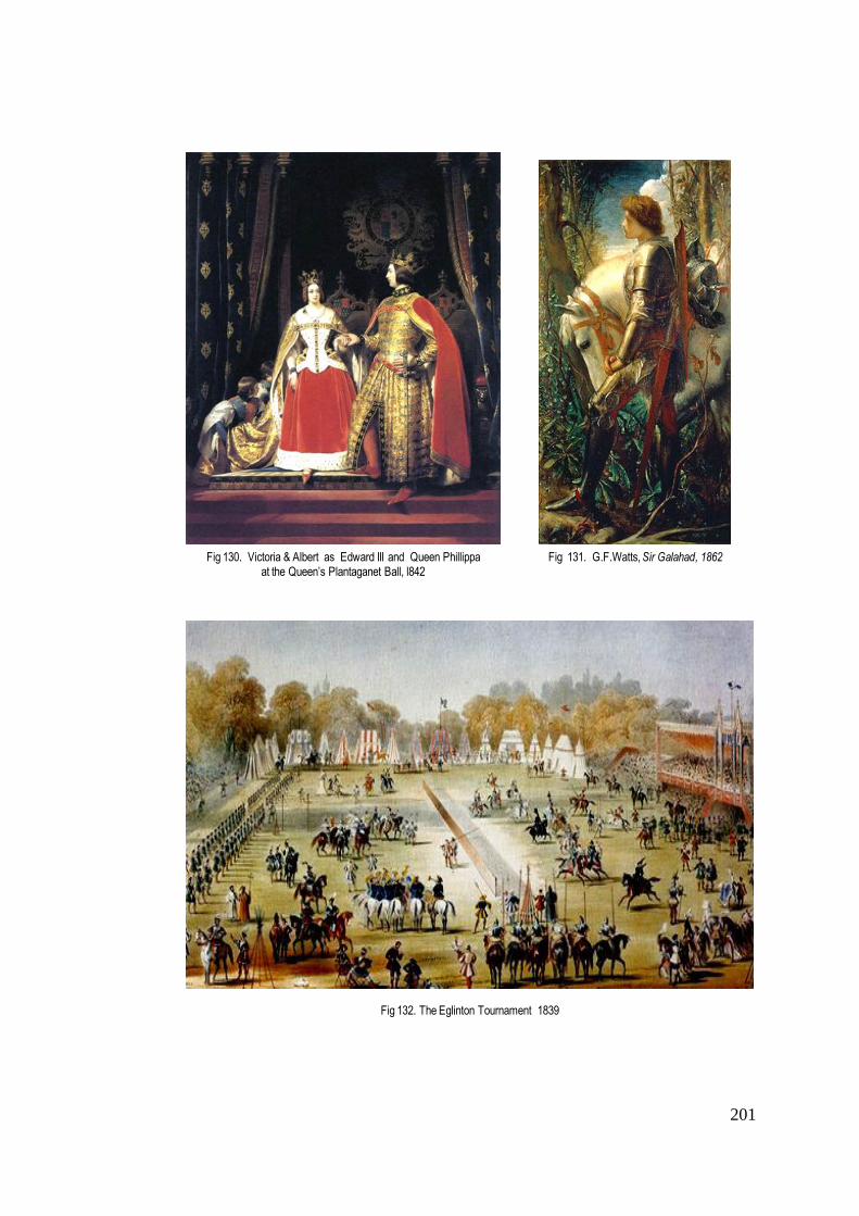
201
Fig 132. The Eglinton Tournament 1839
Fig 130. Victoria & Albert as Edward III and Queen Phillippa
at the Queen’s Plantaganet Ball, l842Fig 131. G.F.Watts, Sir Galahad, 1862
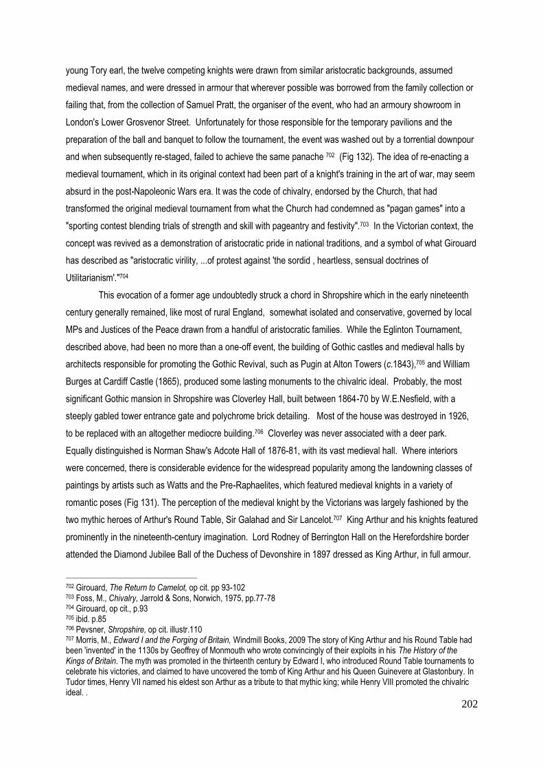
202
young Tory earl, the twelve competing knights were drawn from similar aristocratic backgrounds, assumed
medieval names, and were dressed in armour that wherever possible was borrowed from the family collection or
failing that, from the collection of Samuel Pratt, the organiser of the event, who had an armoury showroom in
London's Lower Grosvenor Street. Unfortunately for those responsible for the temporary pavilions and the
preparation of the ball and banquet to follow the tournament, the event was washed out by a torrential downpour
and when subsequently re-staged, failed to achieve the same panache 702 (Fig 132). The idea of re-enacting a
medieval tournament, which in its original context had been part of a knight's training in the art of war, may seem
absurd in the post-Napoleonic Wars era. It was the code of chivalry, endorsed by the Church, that had
transformed the original medieval tournament from what the Church had condemned as "pagan games" into a
"sporting contest blending trials of strength and skill with pageantry and festivity".703 In the Victorian context, the
concept was revived as a demonstration of aristocratic pride in national traditions, and a symbol of what Girouard
has described as "aristocratic virility, ...of protest against 'the sordid , heartless, sensual doctrines of
Utilitarianism'."704
This evocation of a former age undoubtedly struck a chord in Shropshire which in the early nineteenth
century generally remained, like most of rural England, somewhat isolated and conservative, governed by local
MPs and Justices of the Peace drawn from a handful of aristocratic families. While the Eglinton Tournament,
described above, had been no more than a one-off event, the building of Gothic castles and medieval halls by
architects responsible for promoting the Gothic Revival, such as Pugin at Alton Towers (c.1843),705 and William
Burges at Cardiff Castle (1865), produced some lasting monuments to the chivalric ideal. Probably, the most
significant Gothic mansion in Shropshire was Cloverley Hall, built between 1864-70 by W.E.Nesfield, with a
steeply gabled tower entrance gate and polychrome brick detailing. Most of the house was destroyed in 1926,
to be replaced with an altogether mediocre building.706 Cloverley was never associated with a deer park.
Equally distinguished is Norman Shaw's Adcote Hall of 1876-81, with its vast medieval hall. Where interiors
were concerned, there is considerable evidence for the widespread popularity among the landowning classes of
paintings by artists such as Watts and the Pre-Raphaelites, which featured medieval knights in a variety of
romantic poses (Fig 131). The perception of the medieval knight by the Victorians was largely fashioned by the
two mythic heroes of Arthur's Round Table, Sir Galahad and Sir Lancelot.707 King Arthur and his knights featured
prominently in the nineteenth-century imagination. Lord Rodney of Berrington Hall on the Herefordshire border
attended the Diamond Jubilee Ball of the Duchess of Devonshire in 1897 dressed as King Arthur, in full armour.
702 Girouard, The Return to Camelot, op cit. pp 93-102 703 Foss, M., Chivalry, Jarrold & Sons, Norwich, 1975, pp.77-78 704 Girouard, op cit., p.93 705 ibid. p.85 706 Pevsner, Shropshire, op cit. illustr.110 707 Morris, M., Edward I and the Forging of Britain, Windmill Books, 2009 The story of King Arthur and his Round Table had been 'invented' in the 1130s by Geoffrey of Monmouth who wrote convincingly of their exploits in his The History of the Kings of Britain. The myth was promoted in the thirteenth century by Edward I, who introduced Round Table tournaments to celebrate his victories, and claimed to have uncovered the tomb of King Arthur and his Queen Guinevere at Glastonbury. In Tudor times, Henry VII named his eldest son Arthur as a tribute to that mythic king; while Henry VIII promoted the chivalric ideal. .

203
Both Queen Victoria and Prince Albert took the idea of medieval chivalry very seriously (Fig 130): in 1844 Albert
was painted in armour by Robert Thorburn as a gift for the queen, the first of several portraits in which he
appeared as a medieval knight. It was Prince Albert, in his role as Chairman of the Royal Commission on the
Fine Arts, who was responsible for the medieval decoration of the Houses of Parliament,708 while Pugin
introduced a Medieval Hall into the glazed structure of the 1851 Exhibition. Girouard has credited the writer
Thomas Carlyle, a radical opponent of Utilitarianism, with the role of adapting the ideals of chivalry to Victorian
life.709 There is much of interest to be gleaned from Girouard's analysis of the Victorian idea of chivalry as a code
of behaviour for gentlemen, in which a gentleman is seen as the equivalent of a knight 710 It would surely not be
too far-fetched to suggest that the Victorian obsession with historic revivalism may well have been a contributing
factor in the renewal of interest in the deer park.
It was not long before the Victorian garden responded to the revivalist spirit of the architecture. Under
the influence of the horticulturist and writer John Claudius Loudon, whose Encyclopaedia of Gardening was
published in 1822, followed by a spate of gardening journals,711 the message spread that the new gardening
should look to historical precedent for its inspiration . Both Repton and Price had accepted the idea of retaining a
formal element of the garden in the vicinity of the house; but from the 1840s, "the revival of architectural and
formal styles" - whether borrowed from the Italian Renaissance garden or the French formal garden - was the
recognised way of "making the garden as a whole into a work of art."712 In spite of many technical innovations,-
such as the invention by Loudon of curved glazing bars that enabled ambitious greenhouse construction, 713 the
preoccupation with historicism prevailed. Increasingly, raised terraces with elaborate parterres looked out over
the surrounding parkland, separated only by a stone balustrade. The most famous example of such a garden in
Shropshire was created at Oteley between 1832-35 in the Italian style by Charles Kynaston Mainwaring,
reputedly after a trip to Italy (Figs 133, 134). Four broad terraces stretched to either side of a central axis leading
down to the mere. At the end of one of the upper terraces was a belvedere that looked out across the gardens. It
was joined by a Swiss Cottage (1851) and by 1855, an italianate campanile that may have served as an
observatory714 but certainly offered a view of the deer park which, as will become apparent later, was not only
maintained but actually extended during the course of the nineteenth century.
For those landowners who preferred the Elizabethan and Jacobean style of gardening, in tune with a
newly gothicised house, W.A. Nesfield (d.1881) was the most fashionable architect, with his pseudo- historic
708 Girouard, The Return to Camelot, op cit. pp.115-116 709 ibid.,. p.130 "Carlyle's ideal was a governing hero or heroes, or at least a governing class near enough to heroism to rise above self-interest and dedicate itself to governing justly." 710 ibid. p.60 711 The Gardeners' Magazine flourished between 1826-43; The Gardeners' Chronicle, founded by Joseph Paxton and John Lindley first appeared in 1841 712 Elliott,B., Victorian Gardens, Batsford Books,1886, p.33 713 Paxton's Great Exhibition Hall of 1851 was the culmination of technical invention and its showcase for the nation. It nevertheless contained a Medieval Court designed by Pugin. 714 Stamper, Historic Parks & Gardens, op cit. p.81

204
Fig 134. Oteley Park, early C20th postcard n.d.
Fig 135. Apley Park gardens , Edward Milner (Country Life, May 1907)
Fig 133. Oteley Park gardens, (Leighton 1901)
205
parterres surviving at Holkham Hall (Norfolk) and Blenheim (Oxfordshire). In Shropshire, following the
destruction of Cloverley Hall, where he had designed a garden, there is no surviving evidence of his work;
however, in 1865 he is known to have produced designs for elaborate formal gardens at Willey Park, which
included a parterre and a terraced walk, but these were never implemented.715
The fashion for terraces set the house on a platform above the surrounding parkland, offering views, but
at the same time establishing a physical separation between house and park, in contrast to the eighteenth-
century use of the ha-ha. Working as a garden designer in the 1870s, Edward Milner (d.1884), a pupil of Paxton,
envisaged the landscape and garden as a single entity. Although less well known than his son Henry Ernest
Milner, his approach was reflected in the latter's The Theory and Practice of Gardening (1890). Brent Elliott
sums up his approach: "the landscape gardener was conceived of as a counterpart to creative nature,
transforming the landscape through an understanding of the underlying principles of geological change."716 This
does not mean that Milner disregarded the terrace as a principal component of garden design. On the contrary,
for him the terrace reflected the hand of the designer, whereas the landscape beyond explored existing
geological features. In Shropshire, Edward Milner's work is demonstrated in his collaboration with John Webb at
Apley Park, where the garden acquired a status equal if not superior to that of the deer park, which was
increasingly shared with grazing cattle (Fig 135).
Cartographic and literary evidence
Cartographic evidence, an important research tool used throughout this thesis in tracing the survival of
the deer park, becomes not only more reliable, but more widely available over the course of the nineteenth
century. The year 1836 was marked by the Tithe Commutation Act, which effectively replaced tithes paid in kind
with money payments based on the yearly price of wheat, oats and barley . To assist in the valuation of tithes to
be paid in each parish, a series of Tithe Award maps were produced to show the boundaries of the tithe area
and the nature of each field. 717 Harley considers these maps to be of maximum importance during the period
prior to 1850, because of their large scale and field by field detail. However, as he points out, their accuracy
needs to be checked against the evidence of more modern maps such as the 6" OS Survey.of 1879-81.718 In the
case of Shropshire, the Tithe Awards, dating mainly from 1841-8 have been copied for most parishes by Henry
Foxall. Generally speaking, they have proved most useful when trying to trace long disappeared medieval deer
parks, rather than those of the nineteenth century, since what is described as a 'park' may or may not have
contained deer by the time the survey was made. What they do indicate, however, is the nature of each
individual parcel of land, whether arable, pasture, or waste.
715 Stamper, Historic Parks & Gardens, op cit p.82-3 716 Elliott, op cit. p.172 717 Delano Smith & Kain, op cit. pp. 134-5 718 Harley, J.B., Maps for the Local Historian, op cit., pp, 29-39

206
Thomas Moule (1784-1851) , was one of the last private mapmakers, his county maps being published
by George Virtue of London in 1830, and in atlas form, as The County Maps of Old England in 1836 719 What is
immediately striking about Moule's maps, published in the same era as the 1833 OS Survey, is their quaint
resemblance to the seventeenth- century county maps of Speed, in terms of their decorative presentation. A
closer examination of the pilasters, armorial bearings and cartouches that frame the map, reveals an historic
'revivalism' borrowed from both the gothic and the classical. Although Moule insisted that he was no longer
indebted to the patronage of the aristocracy or the Crown, a portrait of William IV appears as the frontispiece to
his atlas. His stated aim was "to produce a work of obvious utility at a reasonable price, so as to place it within
reach of every class". With this in mind, the maps were published in parts at "1s plain or 1s. 6d. coloured".720
This price, so much cheaper than those maps produced by subscription in the eighteenth century, was made
possible by the invention of the paper-making machine and improvements in the intaglio engraving process.721
During the space of thirty years ,Moule wrote and published books on antiquities, heraldry and genealogy,
Elizabethan architecture and Roman villas. He was even involved in the production of plates for The Illustrations
of the Work of Walter Scott (1834).722 What is particularly interesting about the old fashioned presentation of his
maps, is that it clearly appealed to a certain rural conservatism, found among the country aristocracy and gentry.
As far as Moule's map for Shropshire is concerned, it is evident that he was not interested in the effects of
industrialisation on the landscape. Instead, he chose to foreground the parks of the landed estates, coloured
them in green and enclosed them with what appears to be a pale. On the basis of other evidence, this does not
necessarily mean that they were all parks containing deer - indeed very few were. It is worth noting, that out of
more than 70 parks indicated (some very small), Moule used the word 'Park' in conjunction with only nine
examples, six of which reappear on the 1881 1st edition of the OS Survey.723
As already observed, the advent of the OS map introduced a more scientific approach to map making,
and with it a much greater accuracy, undoubtedly improved with the increase in scale represented by the 1st
edition of the six inches to the mile scale maps that appeared in the 1880s. On the 1881 edition for Shropshire,
the word 'Deer Park' appears emphatically in ten cases: Apley; Attingham; Boreatton; Eyton; Hawkstone;
Henley; Longnor; Loton; Mawley; Oteley. An exception is Chetwynd Park where (Deer Park) appears in
brackets. The reason for this can only be surmised. Documentary evidence will be consulted to determine
whether 'Deer Park' means that the park was actually stocked with deer; and whether In the case of Chetwynd
Park, the brackets might indicate that there were no deer in the park at the time of its survey. However,
documentary evidence suggests otherwise: the park appears to have been consistently stocked between 1867-
1892.
719 Moule,T., The County Maps of Old England, Geo. Virtue, London 1836, repr. Studio Editions, 1990 720 Moule, T.,The English Counties, 1830, Preface I iv; 721 Barron, R., Introduction to Moule, County Maps, op cit., p.11 722 ibid. p.11 723 Moule refers to the following: Apley Park; Boreatton Park; Chetwynd Park; Condover Park; Hawkstone Park; Loton Park; Moor Park; Oakly Park; Oteley Park. Of these, Moor Park is not believed to have ever had deer.
207
From the second half of the nineteenth century, there was a widespread increase in writing on deer
parks and the maintenance of deer, which would seem to reflect a wider interest in deer parks, and possibly
suggest the emergence of landholders less conversant than their predecessors with the breeding and
maintenance of deer. Among those recording and publishing contemporary observations on deer parks in
England were Evelyn Philip Shirley (1867), Francis Leach (1891) Joseph Whitaker (1892) and S. Leighton
(1901). In the preface to his book Some Account of English Deer Parks - with Notes on the Management of Deer
(1867), Shirley maintained that his evidence was based on a list of queries that he had circulated to all
landowners, concerning the acreage of their deer parks, the number and management of their deer, and the
original date and history of the park. As a result of his enquiry, he was able to include a total of 335 deer parks in
England that were still stocked with deer, of which Tatton Park in Cheshire was believed to be the largest at
2,500 acres. Shirley admitted to the possibility of omissions - presumably, some of the landowners did not
bother to reply! A simple comparison of his data with those of Whitaker 25 years later suggests that the number
of deer parks countrywide had actually increased by over 50 to a surprising total of 389. However, a few
examples taken at random show both losses and gains. For example, in Gloucestershire, where Shirley recorded
23 existing deer parks, the highest number in the country, (with the exception of the 28 in the various ridings of
the large county of Yorkshire), seven are absent from Whitaker's later list, while four additional ones have been
added, leaving a total of 20. Shropshire, with a total of 9 deer parks recorded by Shirley, conforms with the
average number, alongside counties such as Norfolk (9), Berkshire (9), Derbyshire (9), Cheshire (8). In the case
of Norfolk, it appears to be the smaller parks that have come and gone. Rackheath, created in 1854, is recorded
by Shirley but does not reappear in Whitaker, who records the addition of Catton Park (30 acres) and Dudwick
Deer Paddock (10 acres, with c.24 deer).724 The question of small parks or paddocks containing seemingly
excessively large numbers of deer will be addressed later in this chapter.
In Shropshire, the nine deer parks recorded by Shirley in 1867 are Acton Burnell; Apley; Attingham;
Boreatton; Chetwynd; Hawkstone; Longnor; Loton and Oteley. The parks vary considerably in size, from only 40
acres at Longnor to the largest, 1200 acres at Hawkstone, said by Shirley to have been restocked in 1830 after
being disparked in 1770. Among new or 'modern' parks, Shirley includes Attingham, presumably revived after
Repton's landscaping of the estate; Apley, which he calls "comparatively modern"; and Chetwynd (already
referred to above), recorded as a new park post 1803 and differentiated from what he calls the "original park"
dating back to at least 1281.725 All the names indicated by Shirley appear on the 1881 OS map, designated as
'deer parks', with the exception of Acton Burnell, which may well have experienced some fluctuations in its stock
over the course of the century, due to the financial difficulties of its owner, to which reference will be made later;
indeed, Shirley describes Acton Burnell as an "existing" deer park, but does not produce any numbers of stock or
acreage.
During the intervening years, between the publication of Shirley's book in 1867 and that of Francis
Leach in 1891, the price of wheat had almost halved. After a series of poor harvests and wet weather, 1891 saw
724 Whitaker, A Descriptive List of the Deer-Parks and Paddocks of England op cit. p.104 725 Shirley, E.P. op cit., pp. 201-204
208
very severe weather at the beginning of the year, with many rivers frozen, followed by a wet summer and winter.
The price of livestock as recorded was low.726 Nevertheless, according to the numbers noted by Leach in his The
Country Seats of Shropshire (1891), the deer parks continued to be well stocked. By this time, the 1881 1st
edition of the OS had been published, but it is unlikely that Leach would have had access to it, and he was
almost certainly acting independently. The Shropshire parks referred to by Leach differ only a little from those
recorded more than 20 years earlier by Shirley: Acton Burnell; Apley; Attingham; Chetwynd; Hawkstone; Henley;
Longnor; and Otelely.(see Table 3 at the end of this chapter ) Of these, Acton Burnell - recorded by Shirley only
as "existing", is now reported by Leach as extending to 5-600 acres and to be "plentifully stocked with deer".727
Attingham is similarly large, at a well-stocked 600 acres, while Apley Deer Park has been extended from 245 to
over 400 acres, presumably since its acquisition by W.H. Foster.728
Joseph Whitaker's Descriptive List of the Deer-Parks and Paddocks of England (1892) has been used
in this thesis to mark a certain defining date, against which to compare other statistics for numbers of deer parks
and deer. His research includes the names of owners, the acreage of parks, the type of fencing and water
supply, the topography of the park, and most importantly, the number of deer, whether fallow or red, together
with their weight. Whitaker's Survey allows us to make a comparison between what was happening in
Shropshire at the end of the nineteenth century and what was happening elsewhere - focusing on the adjacent
counties of Herefordshire, Staffordshire, Worcestershire and Gloucestershire. As far as deer parks are
concerned, Whitaker suggests that the highest acreage in 1892 was in Staffordshire, with 17 parks covering a
total of almost 6,000 acres, followed by Gloucestershire with 20 parks covering 3,800 acres; Herefordshire with
14 parks covering c.3,800 acres; Shropshire with 12 parks covering 3,300 acres and Worcestershire with 11
parks covering 2,077acres. A similar order in the numbers of deer stocked might well be expected, but this is not
the case. Gloucestershire boasts 3,003 fallow and 533 red deer; followed by Herefordshire with 2,255 fallow and
60 red deer; Worcestershire, with the smallest acreage, 2,053 fallow and 30 red deer; Staffordshire with 1,631
fallow and 185 red; and finally, Shropshire with 1,439 fallow and only a handful of red deer, confined to Oteley
Park. These discrepancies may possibly be explained by the varied nature of the terrain in the different counties,
and the extent to which the parks were shared with other grazing animals. Badminton Park (Glos.), its 986 acres
described by Whitaker as "good feeding land" without any fern, boasted 1,300 fallow and 430 red deer (the
largest number in any park in England) grazed alongside horses, cattle and sheep. The need to diversify during
the later years of the nineteenth century is reflected in the presence of cattle, sheep and also rabbits in the
Shropshire parks of Chetwynd and Loton, both an average size of 200-250 acres. Goats are also a feature of
parks in Staffordshire and Herefordshire: in Bagots Park (Staffs) a herd of goats shared its 800 acres with 150
fallow and 20 red deer; while Ingestre Park (Staffs), with its well wooded but high lying 217 acres, had 26 goats
grazing alongside 70 fallow and 9 red deer.
726 Stratton, J.M., Agricultural Records A.D.220-1977, John Baker, London 1969. pp.126-7 727 Leach, F.,op cit., p.219 728 ibid., p.109
209
Whitaker also recorded the introduction of more exotic grazers sharing the park with the deer. Hampton
Court Park (Herefordshire), a hilly park of only 140 acres shared its grazing between 170 fallow deer, cattle,
horses, rabbits, and 6 Cashmere goats. Scottish cattle were occasionally raised on some 150 acres at
Cherington Park (Glos.) alongside 126 fallow deer, while Winterfold Park (Worc.) supported West Highland cattle
alongside 34 fallow deer on only 52 acres. Smaller parks seem to have been used for a greater range of stock:
at Dunstall Park (Staffs), 60 acres was shared between 40 fallow deer, Indian bulls (water buffalo?), and black
and white Jacob's Sheep. Geese were a specialised branch of poultry breeding, that proved profitable on small
acreages.729 On the 116 acre deer park at Spetchley (Worc) were two lakes, one of eight acres, that supported
Canada and Egyptian geese, while 200 fallow and 30 red deer were reared alongside other game - pheasants,
partridges, hares, rabbits, even foxes, badgers and otters.
The 12 deer parks in Shropshire listed by Whitaker are Acton Burnell, Attingham, Apley Boreatton,
Chetwynd, Hawkstone, Henley, Longnor, Loton, Mawley, Oteley, and the mysterious Manor House Park, which
will be discussed later. In the light of contemporary nineteenth-century OS cartographic evidence, it will be
necessary to consider whether Whitaker's numbers are more or less accurate than those of other nineteenth
century observers. In the introduction to his list, he maintains that he sent out more than 1,200 circular letters
inviting answers to specific questions. By so doing, he claims to have discovered more than 50 parks not
mentioned by Shirley, while admitting that others may still have eluded him.730 During the course of this chapter,
the importance of Whitaker's research will be examined and any omissions noted.
The journals of Sir Baldwin Leighton(1805-1871)
A source of invaluable information concerning the management (or mismanagement ) of estates during
the nineteenth century is the contemporary diary of Sir Baldwin Leighton (1805-1871) of Loton. Existing journals
and letters referred to in previous chapters have been predominantly written by land agents and stewards, with
the notable exception of the seventeenth-century journal of John Weld of Willey Park. The Leightons, however,
were and remain a long established Shropshire family, originally from the village of Leighton, who moved to
Loton Hall in the seventeenth century. A deer park was first recorded by Bowen in 1751, although an earlier
origin has already been proposed (above p.22). Sir Baldwin Leighton was a respected agriculturist and
president of The Salop Agricultural Society. In September 1867, he held a 'harvest home' at Loton, and
addressed his tenants and farm workers about the improvements he had noted in the county - the upgraded
roads, the prevalence of agricultural machines in the neighbourhood, and the improved diet including more
vegetables and meat that had led to better health among the rural community.731 Sir Baldwin, himself an
agricultural improver, had little patience for those landlords who through their own indulgence caused the ruin of
the family estate. The decline of the Mytton family of Halston, and consequently of their estates, was recounted
729 Thirsk, op cit. p.190 730 Whitaker, J, op cit. p.4 731 Walsh, V.J., 'The Diary of a Country Gentleman: Sir Baldwin Leighton Bart. 1805-71' in Transactions of the Shropshire Archaeological & Historical Society 59, 1971-2, pp. 140-1

210
in his diary of September 1844. He had heard that young John Mytton had been betting on the St.Leger, and
expressed fears that the family property would be lost. In 1847 Halston was indeed put up for sale, a Mr Wright
of Manchester paying only c.£45 an acre for the 2,083 acres of land.732 By 1850 Leighton wrote that Childe of
Kinlet, who had been borrowing money for many years, "now only keeps a butler and a boy".733 After losing
money in the hands of his son, William Lacon Childe, the estate was £150,000 in debt by 1862, with Childe
borrowing further to pay the interest charges.734 Similarly, the 3,000 acres of Shavington Park, part of the
estates of 2nd Earl of Kilmorey (d.1880) were mortgaged from 1863; by 1874 the debts amounted to £180,000,
and in 1885 the 3rd Earl was forced to sell the estate for £125,000.735 Sir Edward Smythe of Acton Burnell was
another squire who by 1850 was "supposed to be very embarrassed" - probably accounting for the absence of
deer from the park when Shirley was recording in 1867. Even Lord Powis, with estates of 5-6,000 acres, was,
Leighton believed, likely to be destroyed by the reduction of rents, leaving him only £7-800 p.a. to spend, "the
rest going to pay the charges on the property."736
Writing in 1863, Sir Baldwin commented on rumours he had heard concerning financial difficulties
experienced by Viscount Hill at Hawkstone. In 1894 the 3rd Lord Hill was declared bankrupt. Sir Baldwin also
singled out Attingham as one of those estates that had gone through hard times in the first half of the nineteenth
century, due to the extravagance of the then Lord Berwick who between 1827-32 lived in Italy, the contents of
the mansion having been sold to pay his debts, which were not cleared until 1861.737 Writing in his diary in 1869,
Sir Baldwin commented that "during the last half century Attingham has with the exception of a few years been a
shut up house ........and will be the case again if young Dick Hill becomes the possessor of the property." 738 This
seems to explain why Shirley made no mention of deer stocks there in1867. Similar circumstances accounted
for the decline of the Apley estate, where T.C. Whitmore spent so much money sustaining his social life and
controlling the parliamentary borough of Bridgnorth that he was reputed to have been left with only £4-5,000 a
year, his only "extravagances" , "a large game preserve and 300 head of deer".739 After the estate was sold in
1867 to W.H. Foster of Apley Forge Ironworks, its fortunes were restored. When Sir Baldwin visited Apley in
December 1870, he was able to observe new farm buildings being erected. 740 By 1891-2 the deer park had
been increased from the 245 acres recorded by Shirley to 420 acres, but with the herd reduced from 200 to
150.(see Table 3 ). Forester of Willey was one of the few landowners commended by Sir Baldwin for always
having lived below his income and spent his money on increasing his estates, but even he had experienced
difficulty in letting his farms. In the prevailing economic climate, Sir Baldwin himself proposed in 1850 to reduce
half his rents, depending on the quality of the farm in question, leaving the other half as a corn rent related to the
732 Walsh, V.J.,op cit., p.145 733 There is no further evidence of a deer park at Kinlet after Greenwood's map of 1827. 734 Baugh, G. & Hill,R.C. 'Large Estates 1750-1875' VCH 4, op cit., p.209 735 ibid. p.209 736 Walsh, op cit., p.136 737 Baugh, op cit., p.207 738 Walsh ,op cit., p.147 Richard Hill had been forced to leave the army because of debts, and married a 'lady of the town'' 739 Baugh, op cit., p.208 740 Walsh, op cit., p145

211
average price of corn over the previous three years. Interestingly, he noted that prices were no lower than in
1834-5, but that farmers lacked confidence.741 During these difficult times, Sir Baldwin managed to maintain his
own deer park at Loton at a constant c.250 acres. Whitaker reported that the 100 fallow deer that grazed
alongside cattle, sheep and rabbits, produced a venison that was "small but very fine, like Welsh mutton is to
ordinary mutton".742 Once again, the eating of venison seems to have been an important factor in maintaining the
deer park.
Sir Baldwin Leighton's observations, however acrimonious his relations with certain families may have
been - calling Lady Hill "the granddaughter of a cotton spinner" - confirm that well before the end of the
nineteenth century, a considerable number of the old aristocratic landowners had been obliged to relinquish a
part if not all of their estates.
Deer park management
By the beginning of the nineteenth century, deer were being reared in considerable numbers. Fletcher,
who is one of the few contemporary writers to have researched the subject of nineteenth century deer
husbandry, quotes a contribution made by the Earl of Clarendon of Grove Park (Herts) to the General View of the
Agriculture of Hertfordshire (1803), in which he states that he treats deer like any other animal that is
"husbanded". This meant, that following the rutting season, the weak deer (those that would be unlikely to
survive the winter) were selected for overwintering in a well-littered shed where they were kept warm and fed on
pea-straw, hay, and sometimes clover hay cut into chaff, to which salt might be added if the deer found it
unpalatable. During the first week in March, this diet was replaced with oil-cake, "half a cake each day, with
chaff", which fattened them quickly so that they were all ready to be culled by May. In that month, a brace of
deer sold for 15 guineas - his lordship generally fattened 9 brace each season, which raised his stock over the
winter to 350 head of deer on 250 acres. To feed this number required 32 loads of hay, which was reduced by
supplying browse of ash, elm and Scotch pine, said to improve the flavour of the venison.743
One of the questions raised throughout this thesis has concerned the value attached to deer - whether
they were considered as an ornamental feature that enhanced the picturesque quality of the parkland, or as an
aspect of husbandry, the farming of venison. The overall impression conveyed by Shirley's recommendations is
that the deer park was to be treated as an ornamental addition to the estate. In his ideal park, part timber, part
grass and part coppice, as described in his Account of English Deer Parks (1867), some shelter for does and
fawns was to be provided by rough grass and ferns, while deer sheds offered additional protection. He
emphasised the value of variety, the "beauty and gracefulness" of the park being enhanced by the "echo and
sound" provided by its contrasting elements 744 - the first time that sounds have been noted as part of an
aesthetic appreciation of the park. He also stressed the importance of a park being "well fenced with walls made
741 Walsh, op cit., p.137 742 Whitaker, op cit., p.126 743 General View of the Agriculture of Hertfordshire, Section VI Deer, pp.213-4 Quoted Fletcher,op cit., pp.232-3 744 Shirley, op cit., p.234

212
of rough stone and lime, or else of bricks and earth-lome, or else with poles made of oak plankes". Fencing was
a feature that, he believed, might contribute to the aesthetic appearance of the park, over and beyond
safeguarding the deer. Shirley preferred "upright oak paling, with transverse bars at the top, ... by far the most
picturesque..." Although he admitted that this was expensive to erect, it would last for 100 years, and allow
travellers to see into the park. Alternatively, oak posts with ash pales might be set in a whitethorn hedge, while
iron fencing was recommended for the internal divisions of the park (it is noted, that HIll & Smith of Staffordshire
had invented a "patent notched bar" to keep the whole structure in place).745
Looking at the nine Shropshire parks that Shirley recorded, a wide variety of enclosure methods were
proposed and later specified in more detail by Whitaker. They ranged from old stone walls at Loton, Chetwynd
and Longnor, to a mixture of fencing and iron hurdles at Hawkstone, Apley and Oteley. Although an expensive
option, it is not surprising to find iron fencing used in Shropshire, given the presence of the iron industry, but
where they exist, they will date from the nineteenth century and might well be associated with newly stocked or
revived parks. At Apley, according to Shirley, "a comparatively modern" park set in the former industrial region,
there are still traces today of iron fencing set into the top of a low stone wall as part of the boundary to the park.
On the other hand, where timber was plentiful, oak was still an important component of the fence. As late as
1922, a specification was drawn up for the erection of a park fence at Attingham, pegged top and bottom with
oak pegs; with the addition of galvanised netting wire to be set into the ground over the whole length of the
fence. The specification includes the provision of timber from the estate, or alternatively, the contractor to be
given timber in lieu plus an additional twenty-five per cent.746 A document such as this suggests the continued
existence of a deer park at Attingham, but as a general rule, the survival of fencing (as at Apley Park today),
does not necessarily mean that a deer park continued to be stocked.
One of the most interesting aspects of Shirley's book are his observations concerning the management
of the deer park, particularly in winter, and the stocking ratios that he considered appropriate. Records show that
1867 was a rather wet year, with a poor harvest. Wheat prices were high, at 64s.5d, a quarter, compared with
49s.11d the previous year. There were less than the usual number of lambs born, due to bad weather and heavy
snow in March, and for the first time tinned meat was imported from Australia.747 This was the context in which
Shirley recommended that the ideal stocking ratio for a deer park should be one deer to one acre, less if sheep
were grazing alongside the deer.748 On the Attingham estate, Lord Berwick's agent, T.Henry Burd, wrote to his
employer in January 1902, to reassure him that, following a malicious report concerning his deer sent to an
inspector of the Society for Protection of Cruelty to Animals, he was able to confirm that no more deer had died,
and that his "head of deer" was not in danger of getting too low - "very probably they would do better if they were
reduced.", he comments. 749 Since there is no evidence of a bad winter that year (1901-2), the agent's
recommendation was probably in accordance with a culling policy already agreed between them. Nevertheless,
745 Shirley, op cit, pp.238-9 746 SA112/7B/3/4/2/1 Aug 1922 Specification for the Erection of Park Fence at Attingham 747 Stratton, op cit., p.115 748 Shirley, op cit., p.240 - Cattle and horses would have eaten different grasses from deer. 749 SA112/21/5/8/1/3/7Letter to Lord Berwick from T.Henry Burd, Jan21 1902

213
there was always the danger of losing deer in the winter, as Lord Berwick, writing in 1909 to his gamekeeper,
Joseph Cartwright, reminded him: "last year rather more fawns were killed than I intended", given the winter
losses he predicted. Berwick asked for more precise information on numbers, and gave permission for "a dozen
fawns" ("dark ones not light") to be culled. He planned for some of the older does to be killed later in the season.
From the same letter, it is evident that the venison from the estate was customarily offered as gifts to the tenants.
In the previous year, all the tenants had received such gifts, but that year (1909) they were to be limited to what
appear to be eleven chosen recipients, possibly because of reduced stocks. 750
In most of the Shropshire deer parks, the stocks shown by Shirley were lower than those
recommended, with the exception of Longnor Park, which by 1867 at only 40 acres was accommodating 60
fallow deer. However, in this case, Shirley noted that although the same stock had been retained there for at
least 70 years, they were very healthy. As a general rule, he believed that the introduction of new blood
improved both the health and appearance of a herd. It is interesting to note that the present herd at Longnor
greatly exceeds this number. It seems that the low-lying park - described by Whitaker as being "well timbered"
and with natural water - offers the deer some protection from the harshest effects of wind and snow since they
have no designated shelter. In terms of surviving such conditions, Shirley suggested that black and dark deer
were the hardiest - a distinction that appears to have been disputed by Lord Berwick in a letter to his
gamekeeper giving permission for 'dark' fawns to be culled but not light ones. 751 There seems, however, to be
no evidence to suggest that one colour is hardier than another, and Lord Berwick may simply have preferred the
lighter deer. In any case, Shirley recognised that all deer required additional food in winter. This could be hay,
chestnuts, acorns, beech mast, beans and Indian corn, as well as the holly and ivy that deer were known to
enjoy. At Chetwynd Park, he noted that deer were given refuse left over from the threshing machine.752
The value attached to deer is demonstrated by the number of statutes, noted above, that were
introduced for their protection, dating from the first Game Act of 1389753, with punishments for infringing them
ranging from substantial fines to transportation and even death for those who stole deer from a royal or private
park. These conditions prevailed in the nineteenth century, and the special protection afforded to deer was not
lifted until the Deer Act of 1963 and the Theft Act of 1968.754 The Game Act of 1831 permitted the sale of
venison for the first time since 1603 when James I made it illegal. But however much the law may have been
flouted, and Fletcher suggests that it always had been, its repeal in 1831 almost certainly had some impact on
the farming of deer for venison. The consumption of venison remained a "demonstration of status" throughout
the nineteenth century, with gifting of venison a sign of "conspicuous wealth" that increased at election time!
Some idea of the esteem in which it was still held is reflected in the upholding of the English Royal Warrant, an
arrangement that was introduced in medieval times, when the citizens of London agreed to commute their right
750 SA112/21/2/2/6/2 Letter to Jos.Cartwright from Lord Berwick, August 1909 751 In a letter of Aug 23 1909 to his gamekeeper, Lord Berwick of Attingham gives permission for half a dozen fawns to be killed, but "dark ones not light". 752 Shirley, op cit. pp.241-5 753
Fletcher, op cit., pp.139-142 754 Langton, ed: Forests & Chases 1500 - 1850, op cit. p.7.
214
to hunt in the royal forests, in return for 18 bucks and 18 does that were culled from Eltham and Windsor Forests
and gifted to City dignitaries. By 1773 these included all Offices of State, Church, and Judiciary, together with
senior officers and servants of the royal household - so many beneficiaries, in fact, that all royal forests were
required to contribute. During the reign of Queen Victoria, the royal household alone required 60 brace of fat
bucks and 60 brace of does, with the result that the Doe Warrant of 1839 amounted to a total of 756 deer. This
practice continued until Mrs Thatcher finally put a stop to it in the 1970s.755
Deer park creation and survival at the end of the nineteenth century, including some omissions
Writing in 1891, Leach agreed with Shirley as to the picturesque qualities of the deer park, describing
Hawkstone as "a delightfully attractive resort for lovers of nature"756. ."Add(ing) to its charms, the graceful deer
are to be seen bounding through the hollows and up the hill sides; herds of shaggy Scotch cattle graze upon the
plains and numberless wild rabbits race about on every side."757 It is evident that by this time, Hawkstone Park
had been restocked. Boreatton Park, on the other hand, is not mentioned by Leach; this appears to be an
oversight. It has already been noted that a new house was built in the park in 1880, and it is shown as a deer
park on the 1881 OS map. It was recorded by Whitaker in 1892 as having 140 acres and 70 fallow deer. Nor
does Leach mention Loton Park, which Shirley described as an 'existing' park of 260 acres with 100 head of
fallow deer. 758 A series of OS maps from 1833-1950s mark this as a 'deer park'. Eyton Park does not appear on
any county map before the 1881 OS Survey where it is also marked as a 'deer park'. The probable absence of
deer can be explained by the fact that, according to Leach, the animals had been sold in February 1881 to the
Earl of Derby at Knowsley.759 T.C. Eyton (1809-80), owner of the park, a distinguished agriculturist and
naturalist, friend of Charles Darwin, who had introduced a natural history museum on the estate, had probably
stocked the park with deer. His death in 1880 must have led to the deer being sold. In the case of Ludford Park,
Leach describes a large park, lying to the west of the mansion and separated by the Ludlow-Leominster road, as
being "well stocked with deer".760 The Tithe Award map of 1847, however, shows the park already subdivided.
Neither Shirley nor Whitaker mention this former deer park, and it appears as agricultural land and plantations on
the OS 1881 map, with one field named Deerhouse Bank suggesting evidence of its former function. It is more
than likely that Leach was confusing the area with the surrounding Mortimer Forest where wild deer were
plentiful. A similar situation may have been recorded at Oakly Park, which Leach noted as reduced from 900 to
400 acres; although some fine trees survived from its eighteenth-century avenues. There is no cartographic
evidence to suggest that it was still a deer park at this time.
755 Fletcher, op cit., p.208 756 Leach, op cit., p.7 757 ibid. p,10 758 Shirley, op cit. p.203 759 Leach, op cit.,, p.275 760 ibid., p.39

215
There are few references to the creation of new parks at the end of the nineteenth century, either from
Leach or his contemporary, Whitaker, and those that were made and can be confirmed from other sources were
very small. Shirley suggests, that small parks were best for observing deer 761, presumably meaning at close
hand. The only 'new' park mentioned by Leach is Henley Park (Fig136), described as an enclosure of 80 acres
stocked with 70 fallow deer, "small, but unsurpassed for natural beauty.. (containing) a number of magnificent
oaks".762 Most likely, this was a revival of an earlier park recorded by both Rocque and Baugh. Archaeological
evidence uncovered in 2008, while investigating a pipeline, revealed a substantial ditch 270 metres south of
Henley Hall, suggesting the boundary of an earlier deer park, which was probably restocked by Thomas Knight
in the nineteenth century.763 The Tithe Award Map of the 1840s shows an area south of the house, but almost
certainly visible from it, divided into two lots: Dovehouse Leys and The Park (Fig 138). The estate was bought by
Edmund Thomas Wedgwood Wood in 1884, and improvements to both house and garden were carried out by
him and his son, John Baddeley Wood. 764 Stamper refers to a series of descending pools made with Pulhamite
rockwork, and an overall redesign of the garden "using straight lines and hard surfaces", which was in place by
1900. 765 The focus on the garden restoration does not in this case explain why the deer park became separated
from the house, since the park is marked on the 1881 OS map, as being already clearly separated from the hall
by two fields (Fig 137). Given the number of sizeable trees in the landscape, it would hardly have been visible
from the house at this stage. According to Whitaker, Henley Park was reduced from 80 acres (the original park
size?), as recorded by Leach in 1891 to 51 acres the following year, although the number of deer was not
reduced. This relatively large number in a small area suggests that they were almost certainly being farmed. In
spite of Shirley's recommendation that red and fallow deer should be kept separately, since he believed that red
deer would kill the fallow, the Victoria County History records that a herd of red deer had been established in
Henley Park in 1892, and in 1907 there were 35 red deer and 40 fallow deer.766 If, as seems likely, it was
retained as a source of venison for the household and for gifting, it was almost certainly also a means of trying to
establish a social position among local aristocratic landowners, which, as already suggested, was difficult if not
impossible for a newcomer to achieve. In terms of local prestige, it is worth noting, that no owner of Henley Hall
was appointed to the office of High Sheriff of Shropshire until John Baddeley Wood acquired the post in 1897.767
Writing in 1934, Weyman noted that the " deer park and terraces with the River Ledwych running through the
Park add immensely to its charm, and even the old Pigeon House (extant 1615) adds very much to its
picturesqueness".768
The only other example of a newly created park among the 12 deer parks recorded by Whitaker in
Shropshire in 1892 is Manor House Park, not mentioned elsewhere and described by him as a small deer park
761 Shirley, op cit, p.246 762 Leach, op cit.,p.375 763 www.search.shropshirehistory.org.uk 764 Weyman, Henry T., 'Henley Hall', Transactions of the Shropshire Archaeological & Historical Society 48, 1934-5, p.206 765 Stamper, Historic Parks & Gardens, op cit., p.105 766
VCH Shropshire 1, p.494 767 www.wikipedia.org.uk 768 Weyman,op cit., p.206.
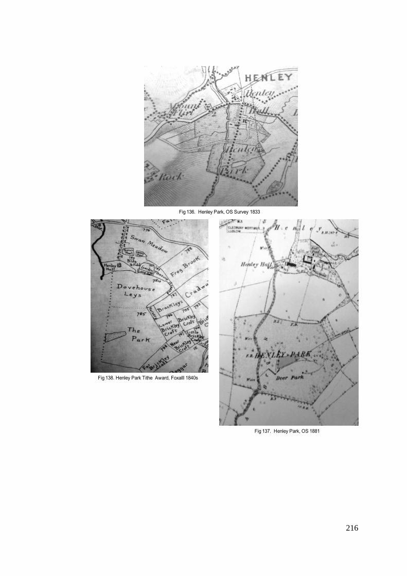
216
Fig 136. Henley Park, OS Survey 1833
Fig 137. Henley Park, OS 1881
Fig 138. Henley Park Tithe Award, Foxalll 1840s

217
of 9 acres," to be increased to 15 acres", with 39 fallow deer and a half acre pond, situated on "beautiful
undulating land, ...on high ground between two rivers". This description suggests that the deer park was in the
process of being enlarged, but even so, the numbers of deer recorded indicate a very high stocking rate, which
again may suggest that the deer were farmed. Stamper identified this site in his 1993 Survey as Cherrington
Manor, near Newport, quoting Whitaker as his source. 769 However, there appears to be no evidence to
substantiate this: the OS map of 1881 (Fig 139) shows Cherrington as a moated site, with a small wooded
enclosure and fishpond, but it is not located "between two rivers" and there is nothing to suggest that there was a
deer park. The owner of Manor House Park is identified by Whitaker as a Miss Mary Ann Hall, who does not
appear in Kelly's Trade Directory of 1891 as living in Cherrington. However, there is a Miss Hall of Manor House,
Ashford Carbonell, Ludlow, listed among Whitaker's subscribers, and recorded in Kelly's Trade Directory as a
Miss Mary Ann Hall of this address . Her connection with Ashford Carbonell is confirmed by a conveyance
document of 1862, in which for the sum of £1,400 "parcels of land in Ashford Carbonell" are conveyed to Mary
Ann Hall of Ashford House (later renamed Manor House).770 She must have been a lady of considerable means,
as three years later she not only bought a house with garden and orchards in the neighbouring village of Ashford
Bowdler, but also the Bridge Inn and further land in her own village.771 Her tombstone in Ashford Carbonell
churchyard states that she died in 1916 at the age of 88. Fifteen years earler, she had conveyed "messuages
and lands" in Ashford Carbonell and Ashford Bowdler to William Downes Hall, a relative.772 The Tithe Award map
of Ashford Carbonell, although made some 50 years before her residency, seems to confirm the possible
location of this park (Fig 140), but there is no further evidence, either documentary or cartographic, as to how
long Miss Hall maintained the deer park, or indeed the Chinese geese that Whitaker also records there. He
probably included Miss Hall's deer park in his directory because she was one of his subscribers. Whatever the
case, in spite of all her property, Miss Hall may have felt that a deer park was the final touch needed to complete
her estate and establish her social credentials locally; or it may be that this small deer park, with its "splendid
oak and elm timber, and fine views..." 773 was stocked purely for her enjoyment. However, the high numbers of
stock seem to indicate, as suggested above, that she was also breeding deer for venison.
It seems that Miss Hall was not the only lady to have maintained a deer park in the second half of the
nineteenth century. Neither Whitaker, nor indeed any of his predecessors, mention a deer park in the vicinity of
Sunniside, Coalbrookdale, a house that belonged to the Darby family, as part of the considerable landholding
acquired by Francis Darby before his death in 1850. His estate was settled on his younger daughter, Adelaide,
who recorded in her private journal, that her father had inherited, when he came of age in 1804, the house, The
769 Stamper, Report 1993, op cit., p.529 770 SA 1578/1/2/17 5 November 1862 Conveyance of land and tithe rentcharge in the parish of Ashford Carbonell 771 SA 1578/1/1/47 29 September 1865 Conveyance 772 SA 1578/1/1/50 1901 Abstract of deeds 773 SA 1578/1/1/50 1901 Abstract of deeds.p.129
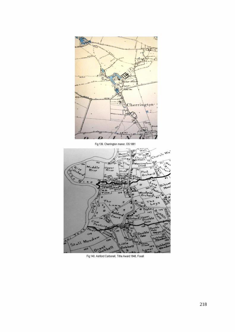
218
Fig 139. Cherrington manor, OS 1881
Fig 140. Ashford Carbonell, Tithe Award 1848, Foxall

219
White House, later known as Sunniside, together with "the deer park and a modest number of acres around."774
The Victoria County History confirms that "during the sisters' time a deer herd was maintained in Sunniside's
grounds," introduced into the county by Deborah Darby.775 Stamper has reproduced a photograph of Sunniside
taken about 1860 that shows a small deer park, with deer, in front of the house. 776 This deer park is not
mentioned by Shirley or Whitaker, and there is no further evidence as to the number of deer stocked, or for how
long.
As the nature of society changed, there were increasingly opportunities for other affluent newcomers to
benefit. Chetwynd Park had been the seat of the Pigott family for two and a half centuries until 1803 when it was
sold to the Burton Borough family of ironmasters from Derby. By 1865, J.C. Burton Borough had acquired a
sufficient fortune to rebuild not only the Hall, but also the local church, replacing one of 1735 that stood next to
his house.777 The deer park, originally of medieval origin, was enlarged and restocked during the same period,
and was recorded by Shirley, Leach and Whitaker, at a consistent c.210 acres. It fell into decline in the twentieth
century and in 1988 was bought by Newport and District Agricultural Society, who restored the park, with part of
it becoming an agricultural showground.
In spite of the considerable fortunes acquired in the Shropshire coal and iron industries in the early
years of the nineteenth century, only four of the 12 deer parks recorded by Whitaker as existing in 1892 had
been acquired or created by 'new money' . Among the former industrialists mentioned by Whitaker, were the
Blounts of Mawley Hall. They had been in residence since the seventeenth century, when, as successful
ironmasters from Worcestershire, they had acquired estates in Shropshire. As a royalist, Sir Edward Blount was
made 4th Baronet and built a new mansion in the Palladian style in 1730, an outstanding example of English
baroque architecture that avoided the nineteenth-century desire to 'medievalise' (Fig 141). It seems that a deer
park may have existed there prior to 1552 when the park pale was removed.778 However, Mawley appears as a
deer park on the OS Surveys of 1833 (Fig 142) and 1881 where it is depicted as a 'Deer Park'. Whitaker records
a park at Mawley of 92 acres with 100 fallow deer. This may well have been revived from an earlier park. The
reason for re-stocking the park was most likely to have been the need to supply the Blounts' luxurious dinner
parties, served on the most elegant and fashionable silverware with cutlery brought from Italy.779
Another industrialist, already mentioned above, W.H. Foster of Apley Forge Ironworks, originally from
Staffordshire, purchased the Apley estate in 1867, when a deer park of 245 acres supporting 200 fallow deer
was recorded by Shirley and appeared as a 'deer park' on the 1881 OS Survey map. Here, a neo-Gothic
mansion, complete with turrets and battlements, had been built by John Webb for the Whitmore family in c.1811-
1820. It is effectively a complete sham, since what appears to be the east end of a chapel is no more than part
774 Transcribed, Labouchère, Rachel, Adelaide Darby of Coalbrookdale: her private journal 1833-1861, Ironbridge Gorge Museum Trust., p. 119 775 VCH 2, Telford 776 Stamper, Historic Parks & Gardens, op cit., p.112 777 Pevsner, Shropshire, op cit., p.198 778 VCH 1, pp.492-4 779 Hussey, C., 'Mawley Hall', Country Life,28, 2 July 1910

220
Fig 141. Mawley Hall, Country Life July 1910
Fig 142. Mawley Deer Park, OS Survey 1833
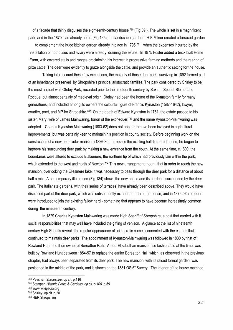
221
of a facade that thinly disguises the eighteenth-century house 780 (Fig 89 ). The whole is set in a magnificent
park, and in the 1870s, as already noted (Fig 135), the landscape gardener H.E.Milner created a terraced garden
to complement the huge kitchen garden already in place in 1795.781 , when the expenses incurred by the
installation of hothouses and aviary were already draining the estate. In 1875 Foster added a brick built Home
Farm, with covered stalls and ranges proclaiming his interest in progressive farming methods and the rearing of
prize cattle. The deer were evidently to graze alongside the cattle, and provide an authentic setting for the house.
Taking into account these few exceptions, the majority of those deer parks surviving in 1892 formed part
of an inheritance preserved by Shropshire's principal aristocratic families. The park considered by Shirley to be
the most ancient was Oteley Park, recorded prior to the nineteenth century by Saxton, Speed, Blome, and
Rocque, but almost certainly of medieval origin. Oteley had been the home of the Kynaston family for many
generations, and included among its owners the colourful figure of Francis Kynaston (1587-1642), lawyer,
courtier, poet, and MP for Shropshire.782 On the death of Edward Kynaston in 1781, the estate passed to his
sister, Mary, wife of James Mainwaring, baron of the exchequer,783 and the name Kynaston-Mainwaring was
adopted . Charles Kynaston Mainwaring (1803-62) does not appear to have been involved in agricultural
improvements, but was certainly keen to maintain his position in county society. Before beginning work on the
construction of a new neo-Tudor mansion (1826-30) to replace the existing half-timbered house, he began to
improve his surrounding deer park by making a new entrance from the south. At the same time, c.1800, the
boundaries were altered to exclude Blakemere, the northern tip of which had previously lain within the park,
which extended to the west and north of Newton.784 This new arrangement meant that in order to reach the new
mansion, overlooking the Ellesmere lake, it was necessary to pass through the deer park for a distance of about
half a mile. A contemporary illustration (Fig 134) shows the new house and its gardens, surrounded by the deer
park. The Italianate gardens, with their series of terraces, have already been described above. They would have
displaced part of the deer park, which was subsequently extended north of the house, and in 1875, 20 red deer
were introduced to join the existing fallow herd - something that appears to have become increasingly common
during the nineteenth century.
In 1829 Charles Kynaston Mainwaring was made High Sheriff of Shropshire, a post that carried with it
social responsibilities that may well have included the gifting of venison. A glance at the list of nineteenth
century High Sheriffs reveals the regular appearance of aristocratic names connected with the estates that
continued to maintain deer parks. The appointment of Kynaston-Mainwaring was followed in 1830 by that of
Rowland Hunt, the then owner of Boreatton Park. A neo-Elizabethan mansion, so fashionable at the time, was
built by Rowland Hunt between 1854-57 to replace the earlier Boreatton Hall, which, as observed in the previous
chapter, had always been separated from its deer park. The new mansion, with its raised formal garden, was
positioned in the middle of the park, and is shown on the 1881 OS 6" Survey. The interior of the house matched
780 Pevsner, Shropshire, op cit. p,116 781 Stamper, Historic Parks & Gardens, op cit. p.100, p.69 782 www.wikipedia.org 783 Shirley, op cit. p.28 784 HER Shropshire
222
its exterior, with the ceiling beams of its two-storey entrance hall supported by heraldic beasts, a neo-Jacobean
staircase, and neo-Jacobean ceiling in the dining room.785 With so much insistence on historic revivalism, the
maintenance of the deer park was surely a necessary complement.
Conclusion
The evidence assembled above seems to suggest that the majority of deer parks that survived or were
even extended in the later nineteenth century belonged to well established families, with new parks created by
new money being essentially small. With the price of grain falling from the 1870s, followed by that of meat,
landowners were lucky if their estate had additional resources, in the form of coal, iron ore, stone or clays786 -
which was more often the case in the eastern part of Shropshire. As agricultural rents were forced down, many
landowners, encumbered with mortgages and debts inherited from their predecessors, found it increasingly
difficult to sustain expenses incurred in maintaining their parliamentary seats and their often costly urban
lifestyles. In such circumstances, the maintenance of a deer park seems hard to justify, but it is evident that
some considered the expense worthwhile. Webster has underlined the importance of upholding a landowner's
position by continuing the customary practice of agents distributing on their behalf "gifts of venison, cider, and
even puppies and plants to local landowners, stewards, and other influential people."787
The preceding pages have shown that during the second half of the nineteenth century the number of
surviving deer parks remained fairly constant, with Shirley recording 9 in 1867 and Whitaker 12 in 1892, and the
OS Survey of 1881 confirming 11. Additional small deer parks were created at places such as Sunniside; while
those at Apley and Oteley were actually extended in parallel with the remodelling of the houses and gardens.
Apley, along with others already discussed, had been acquired with new money from industry. But the greater
number, such as Acton Burnell, Attingham, Longnor, Loton and Oteley remained in the hands of the local
aristocracy. Local politics ensured that the Corbets, the Smythes, the Leightons and the Kynaston-Mainwarings,
dominated the list of County Sheriffs, while the new industrialists barely featured in that post before the last
decade of the nineteenth century. The survival of the deer park at certain well-established landed estates, and
the tradition of gifting venison would not have passed unnoticed by those who sought a position in society. But in
spite of such social presssures, it has only been possible to trace a handful of new parks, and these were all
conspicuously small, ranging from only nine acres at Manor House, as recorded by Whitaker. There is evidence,
on the other hand, of former parks being re-stocked with deer, at Loton in 1826, at Hawkstone after 1830 and at
Mawley Hall after 1850.
It is difficult to estimate to what extent the pervading spirit of historic medievalism contributed to the
revival of interest in the deer park. When, after a period of Georgian sobriety, the new Victorian mansions began
to be built once again in the gothic or neo-Elizabethan style, the deer park was very possibly seen as a
785 Pevsner, Shropshire, op cit., p.135 786 Mingay, G.E., op cit., p.29 787 Webster, S., 'Estate Improvement and the Professionalism of Land Agents on the Egremont Estates in Sussex and Yorkshire, 1770-1835', Rural History 18:1, 2007, p.55

223
necessary attribute in perpetuating the old chivalric traditions. To a certain extent this was all a sham, the very
concept of chivalry being a fantasy based on the mythic figures of King Arthur's Round Table, whereas in reality
the knights of the Crusades - and particularly those of the Marches - had been brutal and warlike, seeking to
increase their possessions by attacking those of their neighbours. But this scarcely mattered; "castles were
picturesque; they were romantic; they stood for tradition, authority or military glory....(they) suggested romance,
dashing deeds, ancient lineage, and lavish hospitality in baronial halls."788 Perceived in this way, loyalty to
Queen and country could be affirmed through the revival of old traditions, by introducing a medieval hall
decorated with heraldic shields and armour, together with an array of deer heads and antlers to complete the
scene.The motives of individual landowners were probably extremely diverse, based on the social and economic
conditions in which they found themselves. But, where their financial position allowed, they continued to take
pride in their deer park, in gifting and eating venison which had always been associated with "hierarchical
structures",789 and that tradition continued up to the time of the First World War which, with the decimation of the
labour force, marked the beginning of the end of the country house and its park. However, when Mrs Beeton's
Book of Household Management, first published in 1861, was reprinted in 1912, it contained no less than 10
recipes for venison.
788
Girouard, The Return of Camelot, op cit., p.44 789 .Fletcher, op cit., p.20

224
Table 3: Parks 1752 - 1892 Rocque 1752 Baugh 1808 Greenwood
1827 OS Surveyors Drawings 1814-1817
OS Survey 1833 1:1 *
OS Survey 1881 1:6”
Whitaker 1892
Acton Burnell DP DP DP DP 18!5 DP DP 280a. 180 fallow
Adderley P P P
Aldenham DP DP DP DP 1817 DP P
Apley Park DP DP DP DP? 1815 DP DP 420a. 150 fallow
Ashford Carbonel 9 acres 39 fallow
Attingham DP DP DP DP DP 600a. 200 fallow
Belswardine DP DP P
Boreatton DP DP DP DP 140a. 70 fallow
Buildwas DP? DP ? DP? P P
Cheswardine P P P
Chetwynd DP DP DP DP 1815-29 DP (DP) 211a. 115 fallow
Cleobury Mortimer DP DP
Combermere DP DP
Condover DP DP DP DP 1815 DP P
Cound DP P P P P
Dothill DP
Dudmaston LP LP LP 1814 LP LP
Ferney P P LP
Frodesley DP
Halston Hall DP DP DP 1827 P P
Hanmer Hall DP
Hawkstone DP DP? LP DP 999a. 300 fallow
Henley DP DP DP DP 51a. C100 fallow
High Ercall DP?
Kinlet LP LP
Linley Hall P LP LP LP
Longnor DP DP (new site) DP DP 1815 DP DP 50a. C25 deer
Loton DP DP DP DP DP 250a.c.100 fallow
Ludford DP DP DP?
Lythwood P
Mawley DP DP 92a. C.100 fallow
Millichope P LP P P P
Moor Park P P P P P
Oakly DP DP DP P P
Oteley DP DP DP DP DP 130a. 90 fallow
Pitchford DP P P P
Rowton P P
Shavington LP LP LP LP LP
Shawbury DP DP
Stanage DP
Sundorne P LP LP P
Teddesley x2 DP
Tong P LP LP P 1817 P P
Walcot DP DP DP? P LP
Willey DP DP DP DP 1815 P P
Totals: c.25 c.24 16 c.12 11 12
Legend: Parks marked in bold indicate first recording on a county map. DP = deer park P = park almost certainly not stocked with deer LP = landscaped park

225
Conclusion
The period on which this thesis has focused, c.1500-c.1914, encompasses the full range of activities
associated with the deer park, from hunting in its various forms to the farming of venison, and the aesthetic
appreciation of the place of deer in the park. During the course of the previous chapters, the high and low points
in the survival of the deer park have been attributed to social, economic and political conditions, both at a
national and local level. There have been periods when a park appears to have lain dormant, in some cases for
decades or even, as in the case of Hawkstone Park, for centuries, being regenerated again when circumstances
have made it viable. New ownership has sometimes accounted for a revival of interest in a specific deer park, or
more often, the periods of park prosperity may have related to the swings and roundabouts of mainstream
agriculture. Reference has been made to Thirsk's identification of three phases prior to the present day, when a
'disjuncture' in mainstream farming took place as a result of "a serious imbalance between supply and demand"
for grain and meat.790 A boom in the creation or expansion of deer parks might well have been anticipated during
such periods, when, in contrast to periods of population growth, there was little incentive to create arable land.
But evidence has shown that the survival of deer parks does not necessarily coincide with such periods. Rather,
when the financial security of the landowner was under threat, deer parks were not created; and the ability to
make money depended not only on national but also on local circumstances, ranging from the physical
properties of the estate to the changing face of local society and its aspirations.
Since the end of the Middle Ages, Shropshire had seen increasing numbers of gentry and successful
merchants purchasing estates, and opportunities multiplied during the sale of land by the Crown after the
Dissolution of the Monasteries in the sixteenth century. But the county suffered particularly heavily during the
Civil War of the mid-seventeenth century, during which time many deer parks were laid waste and deer
destroyed. As evidence has shown, those that survived needed to be repaired and re-stocked after the
Restoration of Charles II in 1660, and a number of parks were newly created or revived by members of the
aristocracy returning from exile abroad . The eighteenth century, on the other hand, witnessed a marked decline
in the survival of deer parks. The evidence points to a new aesthetic approach reflected in the term 'landscape
park' that, in recognising the tendency of deer to destroy planting, did not encourage the creation of any new
deer parks. This trend was reversed during the course of the nineteenth century, when a number of small but
well stocked parks were newly created and others revived.
Maps, both the county map from 1577 onwards and the individual estate map, have been a vital tool in
the search to identify deer parks in Shropshire. But attention has constantly been drawn to the caution with which
the evidence of the map has to be treated, an approach justified by the number of omissions that have been
noted - for example, Longnor and Loton parks, both believed to be of medieval origin, do not appear on any
county map before the middle of the eighteenth century. Some doubts have also been raised as to the reliability
of the graphic representation of pales as an indication of whether the park was actually stocked with deer. It has
790 These were the years 1350-c.1500 following the Black Death, when deer park numbers fell; the period c.1650-1750 when population numbers stagnated ; and that of 1879-1939 when farming prices slumped in the face of foreign competition. Thirsk, J., Alternative Agriculture - a History from the Black Death to the Present Day, OUP 1997, p.3

226
been difficult to establish just how many parks never contained deer; but it has been shown that the introduction
of the landscape park in the eighteenth century marked a decline in their presence. With the advent of the OS
maps in the nineteenth century, the desire to please a particular landowner or subscriber disappeared, and the
greater accuracy of survey techniques lends support to the view reached in this thesis, that in the second half of
the nineteenth century what is labelled a 'deer park' on the OS map did indeed contain deer at the time of survey.
It has been possible to corroborate this evidence with the help of the increasing number of books written about
deer and deer parks in the nineteenth century, to which reference has been made in the preceding chapter.
The estate map, along with the journals of landowners and stewards, have proved of vital importance in
revealing the state of local agriculture and the improvements introduced to make the estate a viable source of
income. As pointed out, the deer park had to sustain its viability during those periods when population growth,
and particularly urban demand, encouraged the cultivation of corn and the rearing of livestock. It was therefore
not a space devoted uniquely to deer. Ever since medieval times, the park had been compartmentalised to
enable its multiple use. The earliest estate maps have shown how parts of the park would be protected from
deer, in order to grow coppice and timber, and frequently deer were grazed alongside sheep and horses, the
latter much in demand in times of war. In some cases, the conversion of deer park to stud almost certainly
accounted for the early disappearance of the deer.
An attempt has been made in the course of the preceding chapters to establish the point at which
aesthetic considerations determined the location and survival of the deer park. The suggestion, upheld by a
number of scholars, that medieval parks were part of 'designed landscapes', cannot be entertained in
Shropshire before the thirteenth century. Prior to this date, the owners of deer parks in the county, a band of
aggressive earls and barons, have been shown to be preoccupied with the sport of hunting as an exercise and
preparation for the skills of war. Furthermore, the medieval park was frequently located at some distance from
the residence. It has been shown that the idea of the park as a setting for the house began to appear in
Shropshire in the sixteenth century, with the building of houses such as Plaish Hall (1570), Upton Cressett
(1580) and Condover Hall (1586) with their contemporary deer park settings. But even when the park was not
adjacent to the house, by the beginning of the eighteenth century its aesthetic appeal was recognised in the
planting of avenues connecting house with park. Research has confirmed that Shropshire never enjoyed the full
benefits of the Brownian park, which in such outstanding examples as Petworth Park (Sussex) and Croome Park
(Worc) enabled the deer to approach the house. However, Repton's principal work at Attingham Park brought the
deer park into view as an aesthetic component of the designed landscape, where they remain to this day.
Although the survival of deer parks has not entirely depended on their being adjacent to the house; a certain
proximity has proved to be an advantage.
The question most often raised during the course of this thesis has been what motivated the landowner
to retain the deer park and the deer, once hunting no longer took place within the park. Given the expense and

227
Fig 143 Attingham, National Trust estate plan 2013
Fig 144. Attingham Park 2013

228
labour involved in maintaining the animals over winter, it is clear that other values came into play. A variety of
reasons have been put forward, of which perhaps the most important has always been the status attached to
owning a deer park, which persists to this day. Aside from the picturesque qualities that it might offer, the owner
of a deer park had the privilege of not only eating, but most importantly of gifting venison, an indication of an
enviable position in society. In medieval times, the king bestowed venison on his closest favourites as a reward
for services rendered in war or at court. The gifting of venison continued long after hunting had ceased within the
precincts of the enclosed park. Attention has been drawn to the large quantities of venison consumed by the
royal household during the reign of Queen Victoria. Research put forward in this thesis shows that the farming of
venison has always played a role in the survival of the deer park. What has also become clear, is that to farm
venison did not require a large park; indeed in the nineteenth century, it is evident that many of the newly created
parks were less than fifty acres in size, and an assumption has been made that the deer were generally farmed.
However, It has been suggested over the preceding pages that the attention paid to deer was due to something
beyond the pragmatism of preserving a valued source of food. The special status attributed to the deer is
reflected in the ritual of its killing and dismemberment. It has already been noted that Queen Elizabeth I presided
at both the selection of the stag to be pursued and at its final demise and butchering. The iconic animal
represented in paintings by artists such as Dürer was the red deer and not the fallow. Fletcher has drawn
attention to the fact, that the red deer, twice the size of the fallow, was the real prize of the medieval and Tudor
hunt.791 But the fallow, being unknown in England before the arrival of the Normans, was considered more
exotic, proved more tractable and ultimately more picturesque in its parkland setting. Historically, the fallow deer
has always predominated in Shropshire, although Whitaker found evidence of "a few" red deer at Oteley Park in
addition to the 90 fallow deer.
Visiting the three deer parks that have survived and are still stocked with deer today has shown that
traditional values have played a major part in their survival,. Two are in private hands, Loton Park and Longnor
Park, while Attingham Park was given to the National Trust by Lord Berwick in 1947 . In conclusion, it seems
appropriate to consider to what extent, if at all, the maintenance of deer has changed, and what makes it
worthwhile maintaining these parks in the eyes of their owners, given the cost of feeding and maintaining the
deer and repairing park walls and boundaries. In the case of Attingham Park, (a National Trust property) , a
large number of visitors are attracted by the spectacle of a herd of fallow deer grazing in the setting of a Repton
landscape, largely unchanged since, as already noted, the nineteenth-century Lord Berwick had no money to
spend on adopting new fashions (Fig 144). The park still contains many ancient oaks, while the horse chestnuts
are believed to have been on Repton's original planting list. What is now known as Repton's Wood lies within the
precinct of the deer park, although it was originally fenced off to prevent it being spoiled by the deer. In recent
791 Whitaker, op cit., p.15
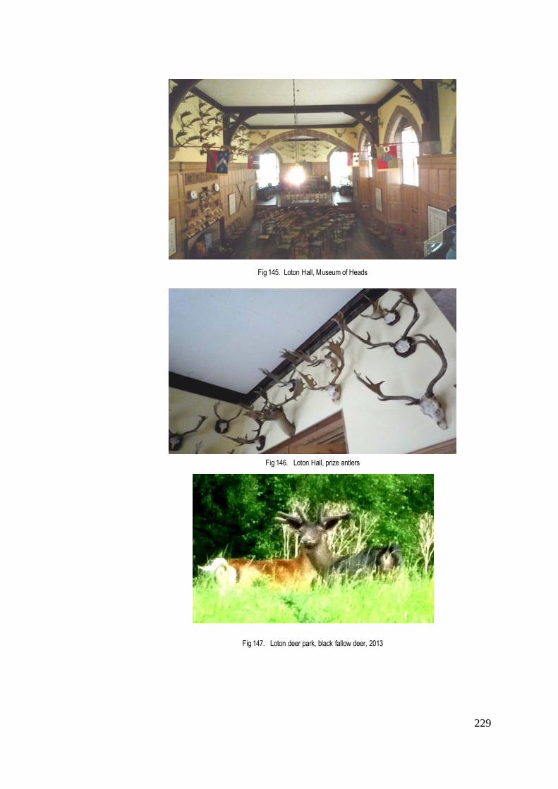
229
Fig 145. Loton Hall, Museum of Heads
Fig 146. Loton Hall, prize antlers
Fig 147. Loton deer park, black fallow deer, 2013

230
years, they have been allowed in, producing a browsing line, but the fencing has been replaced by the existing
management, whose intention it is to restore the park to its ancient boundaries 792 (Fig 143). Funding for
the management of the park is provided by the National Trust, supported by the many visitors, who are also
encouraged to buy fresh venison sold in the NT shop.
Modern deer management has shown that deer have to be culled on a yearly basis, in order to restrict
numbers and maintain the health of the herd. It is generally undertaken in August, and the prickets (one year old
males) are the first to be culled. This is the practice followed at both Longnor and Loton parks. At Loton, Sir
Michael Leighton still maintains around 300 descendants of the fallow deer that have been in this 300 acre park
since it was revived in its present position in the early eighteenth century 793 (Fig 147). The terrain was originally
common grazing, with bracken used by the does to hide their fawns, but very few trees. Sir Michael has planted
10,000 trees, both deciduous and conifers, the latter enclosed as patches of woodland inaccessible to the deer,
which were described by Whitaker in 1892 as "small but very fine, like Welsh mutton is to ordinary mutton."794 Sir
Michael maintains that no new blood has ever been introduced and is not needed. The deer are small but
certainly appear very healthy and lively, much more shy of the visitor than those at either Attingham or Longnor.
Sir Michael attributes their improved health to the disappearance of some five to six thousand rabbits that were
killed off by myximitosis. Salt licks are provided for the deer throughout the year to supplement their mineral
intake; during the course of the winter, beginning when the first frosts have destroyed the best grass, the deer
consume about four wagonloads of beet, but are not offered any shelter. Sir Michael has pointed out, that
without culling the herd would quickly double in size. With a herd of some 300 fallow deer, 90 bucks were culled
over the winter of 2012-13. In order to cover the cost of feeding, of repairing about eight miles of stone walling,
and of cutting the grass once a year to allow it to regenerate, Sir Michael has introduced vintage car racing on
the 40 miles of tarmac roads built in the park by the army during their occupation in WW2, when the deer
population was reduced to 36.
The deer park at Longnor is very much smaller, at only c.50 acres, which includes a small extension
added by Mr.Valentine Nicholson in the last thirty years (Figs 148-150). It would surprise the nineteenth-century
writers, Shirley and Whitaker, to know that the park is stocked with around .200 fallow deer, a number way
beyond their recommendation. However, grass is plentiful, the Cound Brook provides a constant water supply,
and Mr Nicholson feeds the deer daily in winter months with a supply of beet, as at Loton. Shelter belts of trees
have been planted round the perimeter of the park, and nettles are left to provide hiding places for the young
fawns. In spite of their numbers, the deer appear healthy and lively, and none were lost during the last winter.
Again, as at Loton, no new blood has been introduced in the last thirty years at least, although the occasional
wild deer has joined the herd from outside, entering the park through a deer leap. Some years ago, a
792 Pers. comm. Bob Thurston, Head Park & Estate Warden, on a visit conducted on behalf of the Royal Forestry Society in June 2008. 793 Pers. comm. Sir Michael Leighton at a meeting that took place at Loton Park in June 2013, at which time he also provided me with a tour of his Heads Museum. 794 Whitaker, op cit. p.135

231
Fig 148. Longnor Hall, south facade & deer park 2014
Fig 149. Longnor deer park 2014
Fig 150. Longnor deer park, OS Survey 1881

232
red stag joined the herd and attempted to kill the fallow bucks. Mr Nicholson maintains that it is not possible to
rear red and fallow deer together, which raises questions as to how this was managed in the nineteenth century,
when, as reported by Whitaker,there were as many as 150 red deer alongside 200 fallow at Chartley Park in
Staffordshire.795
At a recent visit to Longnor Park, Mr Nicholson offered the unexpected information that a herd of red
deer had been introduced some thirty years ago by Mr Philip Miles at Hinton Hall near Pontesbury, about seven
miles from Shrewsbury. A telephone conversation with the owner confirmed that he still maintained a herd of 80
red deer in an enclosure of only 30 acres. He insisted that this was not a deer park as such, since he had
simply decided to fence in a couple of fields of permanent pasture, previously grazed by cattle and sheep. The
original red stags came from Powys Castle, but recently the occasional stag has got in from the wild.796 Due to
the large numbers of the present herd, it is necessary to feed them hay, silage, beet when available, and "very
expensive nuts".797 This is clearly not a commercial enterprise, and Mr Miles admits to the red deer trashing his
plantation. The hinds are culled over a long period, beginning in August, and around 40 (half the present herd)
will be culled in 2014 and the venison sold. Mr Miles's preference for red deer seems to be rooted in his earlier
love of stalking, and he describes the red deer as an "indigenous wild beast", a phrase that recalls the iconic
image of the deer already noted.
Owing to his relatively recent acquisition of the deer, Mr Miles is less aware than the other owners of
upholding historic tradition. Mr Nicholson values his park at Longnor as a "work of art", which he is privileged to
retain. Sir Michael Leighton, when asked why he continues to maintain Loton deer park , replied simply: "it's
always been there". His pride in his deer park rivals his pride in his descent from a Welsh princess, and the
display of the heraldic emblems and family trees of all those who have married into the family. Although hunting
no longer takes place in the park, an ongoing collection of trophies, prize antlers ( or heads) decorate the walls of
his Museum of Heads, located in the nineteenth century extension of the hall that was built as a double storey
theatre. Sir Michael believes his 'heads' to be the best in the country (Figs 145-146 ). Mr Nicholson also has a
peripheral interest in antlers that he believes he might sell for medical uses and help to fund the cost of the
upkeep of the park. According to Fletcher, antlers have been used as wall decoration since the sixteenth
century, and were a feature of Henry VIII's Hampton Court. In Victorian times, importance was attached to their
size and the number of their points. The strength of this obsession is reflected in the publication in 1897 of J.G.
Millais' British Deer and their Horns, and the popularity of red deer, already noted above, may possibly have
owed something to the value of their record breaking antlers.798 This seemingly insignificant detail appears to
indicate a continuing interest in the chivalric aspect of the deer park, in which the trophies to be collected and the
sense of competition involved still reverberate with the spirit of the medieval tournament that the Victorians saw
fit to revive.
795 Pers. comm. Mr A. Nicholson at a meeting at Longford Park on 19th June 2014. 796 Mr Miles maintains that wild red deer not only exist on Exmoor, but also in North Norfolk, from Thetford Chase and as far east as the Broads. 797 Pers. comm. Philip Miles, 20th June 2014. 798 Fletcher, op cit., p.241

233
Scholars generally agree that in the study of landscape, the detailed examination of individual regions is the best
way of shedding light on the wider picture. Prior to this thesis, very few scholars have studied the deer park in
Shropshire, a remote but historically significant part of the borderland between England and Wales. The history
of the spatial development, survival and demise of the deer park within the wide variety of different terrains that
make up the county, reflects the aspirations of a society descended from Norman barons and Welsh outlaws.
From serving as a hunting ground in which to practise the skills of war, the deer park has been transformed over
time into a place of recreation, an aesthetic feature of the estate, and a source of deer husbandry. But it has
never lost its prestige as a symbol of social success. In Shropshire, to own a deer park is to have arrived.
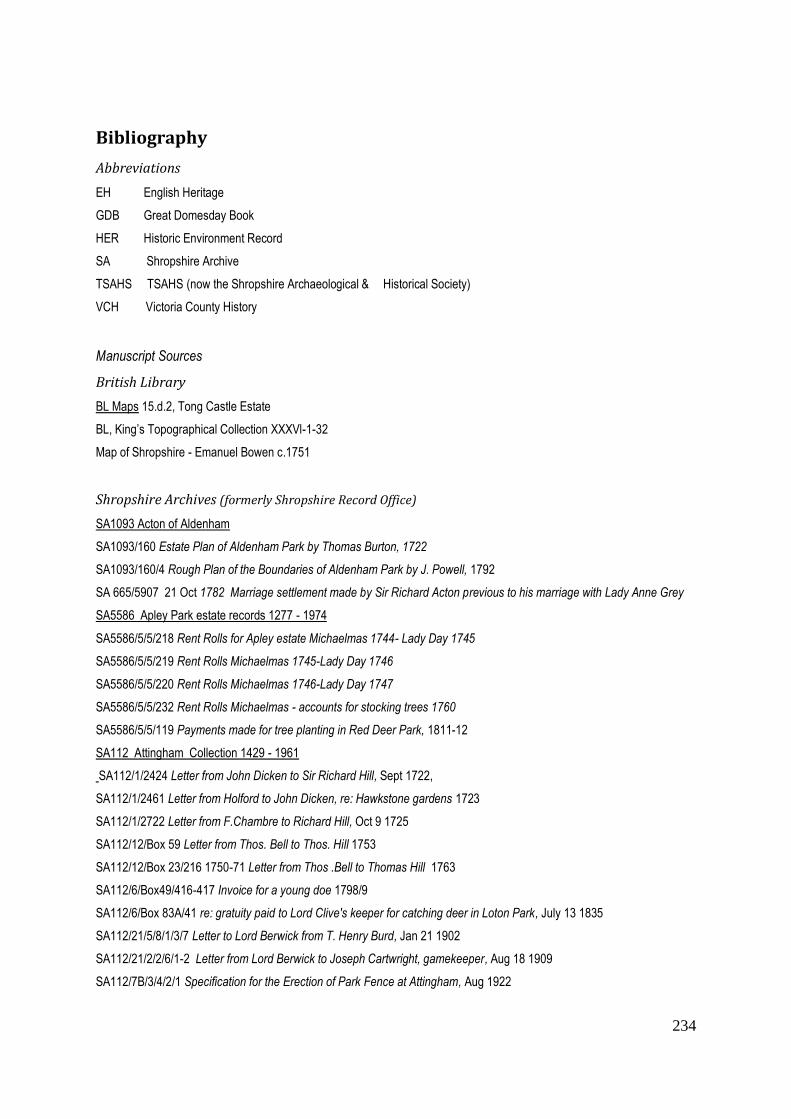
234
Bibliography
Abbreviations
EH English Heritage
GDB Great Domesday Book
HER Historic Environment Record
SA Shropshire Archive
TSAHS TSAHS (now the Shropshire Archaeological & Historical Society)
VCH Victoria County History
Manuscript Sources
British Library
BL Maps 15.d.2, Tong Castle Estate
BL, King’s Topographical Collection XXXVl-1-32
Map of Shropshire - Emanuel Bowen c.1751
Shropshire Archives (formerly Shropshire Record Office)
SA1093 Acton of Aldenham
SA1093/160 Estate Plan of Aldenham Park by Thomas Burton, 1722
SA1093/160/4 Rough Plan of the Boundaries of Aldenham Park by J. Powell, 1792
SA 665/5907 21 Oct 1782 Marriage settlement made by Sir Richard Acton previous to his marriage with Lady Anne Grey
SA5586 Apley Park estate records 1277 - 1974
SA5586/5/5/218 Rent Rolls for Apley estate Michaelmas 1744- Lady Day 1745
SA5586/5/5/219 Rent Rolls Michaelmas 1745-Lady Day 1746
SA5586/5/5/220 Rent Rolls Michaelmas 1746-Lady Day 1747
SA5586/5/5/232 Rent Rolls Michaelmas - accounts for stocking trees 1760
SA5586/5/5/119 Payments made for tree planting in Red Deer Park, 1811-12
SA112 Attingham Collection 1429 - 1961
SA112/1/2424 Letter from John Dicken to Sir Richard Hill, Sept 1722,
SA112/1/2461 Letter from Holford to John Dicken, re: Hawkstone gardens 1723
SA112/1/2722 Letter from F.Chambre to Richard Hill, Oct 9 1725
SA112/12/Box 59 Letter from Thos. Bell to Thos. Hill 1753
SA112/12/Box 23/216 1750-71 Letter from Thos .Bell to Thomas Hill 1763
SA112/6/Box49/416-417 Invoice for a young doe 1798/9
SA112/6/Box 83A/41 re: gratuity paid to Lord Clive's keeper for catching deer in Loton Park, July 13 1835
SA112/21/5/8/1/3/7 Letter to Lord Berwick from T. Henry Burd, Jan 21 1902
SA112/21/2/2/6/1-2 Letter from Lord Berwick to Joseph Cartwright, gamekeeper, Aug 18 1909
SA112/7B/3/4/2/1 Specification for the Erection of Park Fence at Attingham, Aug 1922

235
SA3320 Title Deeds of the Childe Family of Shropshire 12th Century - 19th Century
SA3320/10p/1 Deeds of the Childe Family, 1727
SA1987 Darby of Coalbrookdale (Labouchère) 1654 - 1917
SA1987/46/1 Letter from Abiah Darby, June 1763,
SA5460 Cressett Deeds 1400 - 1939
SA5460/5/2/2 Particulars of Cound Moor and the timber there, post 1622,
SA5460/3/14 Prenuptial Settlement between Robert Cressett and Catherine Berkley, October 16 1652
SA5460/8/2/2 Request to the King Charles for Cressett's release, n.d.
SA5460/4/1/10 Lease concerning Upton Cressett Park, March 20 1672/3
SA5460/5/1/3/1 Rent Accounts 1692-4
SA5460/9/3/1 Warrant appointing Edward Cressett to post of gamekeeper, Dec 7 1695
SA5460/4/1/13 re:Jon Shipman, 1699
SA5460/3/20 re: Upton Cressett Park, July 29 1695
SA5460/4/8/25 Lease on Cound Hall assigned to Edward Cressett, March 20 1731
SA1578 Hall Collection 18th Century - 19th Century
SA1578/1/2/17 Conveyance of land and tithe rent charge in the Parish of Ashford Carbonell, November 5 1862
SA 1578/1/1/47 Conveyance of further properties, September 29 1865,
SA1578/1/1/47 Abstract of deeds conveyed to Wm Downes Hall, 1901
SA6000 Halston estate (ex Shropshire Public Library Deeds) Deeds Collection
SA 6000/13192 Memorandums Relating to the different Parts of the Halston Estate 1758-1780
SA972 Lilleshall Collection (formerly Sutherland Estate Collection)
SA972/7/2/1/2 Lilleshall Park, Surveyed by Wm Cartwright 1679
SA972/7/3 Map of Lilleshall Park by Thos. Burton, 1720
SA11 Ludford Park Collection 1500 - 1866
SA11/383 Letter from Jos. Cox to Dame Mary Charlton of Ludford Hall, Feb 22 1725
SA11/382 Evidence concerning Sir Blunden Charlton in dispute with his son, n.d. c.1730s
SA11/386-387 Responses of Sir Blunden Charlton, n.d. c.1730s
SA11/388 Complaint filed against Sir Blunden Charlton, Easter Term 4 George II 1731
SA11/406 Copy Will of Nicholas Lechmere Charlton of Ludford Park and of Hanley Castle co. Worcs. Relating to his death in
1763, September 7 1805.
SA4752 Nock Deighton Collection
SA4752/15/81/3 Survey of Apley Park wheatfields, 1858
SA4752/36/33 Record of Sale of Stock at Apley Farm 1876
SA20 Oakly Park Collection 1200 - 1823
SA20/6/127 Assignment of the Office of Keeper, Oakly Park, Jan 30 Eliz I (1588)
SA20/6/128 Granting of a Lease to Charles Foxe, July 32 Eliz I (1590)
SA20/6/130-1 Duties to maintain deer in Oakly Park, 14 July 15 Jas. I (1617)
SA20/6/132 Survey of Oakly Park by John Woodward, 3 Chas.1 (1627)
SA552 Powis Collection (archives relating to the Walcot Estate)
SA552/13/1/4 Account of Venison killed at Walcot in 1795,1796. and part of 1797,by Thos. Hickman

236
SA552/18/4/88a Timber Accounts & Papers 1816-1820
SA552/8/748 A Map of Walcot Demesne with Sundry Woodlands, Messuages, Farms etc., 1822
SA552/4/15/2/3/6/21 Drawing of a fence made of iron hurdles, c.1850
SA552/8/101/1 Survey of Lord Clive's estates, by John Probert c.1760
SA552/8/1/13 Survey of Lord Clive's estates, by John Probert, 1771
SA552/10/64 Payments made to Thos Hickman, gamekeeper for watching at night, Nov 1781 & March 1782
SA552/8/5 Proposals by John Probert for increasing rents from Lady Day 1806
SA552/18/1/16 Valuation of the Walcot Estate c.1810
SA875/2 Map of Walcot 1730 (photocopy)
SA1514 Shropshire Deeds and Papers of the Smythe family of Acton Burnell 12th Century - 1914
SA1514/147 Sale and transfer of Langley Parks to Francis Smythe, March 1655
SA1514/562 Lease of 1 year granted by Sir Edward Smythe to Wm Dicconson, June 13 1688
SA1514/614 Entitlement of Sir Edward Smyth to Langley Park, 28 April 1730
SA1037/21/8 Letter from H. Brigges to Thos. Lutwyche, November 1732
SA1224 Willey Estate - Forester papers (seen with the permission of Lady Forester)
SA1224/3/6 Copy Lease, 12 Dec 24 Henry VIII, 1532
SA1224/3/11 Granting of Forest of Shorlet to John Earl of Warwick, 1547
SA1224/7/1 Survey of the manor of Willey, 1618
SA1224/3/187 Particular of Willey, c.1618
SA1224/1/9 The Manor of Willey & Posnall, property of John Weld, 1618
SA1224/1/Box 163 John Weld's Memo Book, 1619-20 & 1631
SA1224/1/11 Survey of New Park, Dec 1674
SA1224/1/12 Survey of the Ould Parke at Willey, by Geo. Coke, C17th
SA1224/1/13 Sketch map of the Park, with trees marked showing varieties, 1828
SA1224/1/1 Map of Dothill Park c.1734
SA1224/1/2 Map of the Gardens, Walks, Orchard, Bowling Green, Courts etc. belonging to Dothill House 1734
SA1224/1/3 Map of Dothill, Park, House, Gardens - estate of Wm Forester, by T.F.Pritchard 1756
SA1224/1/4 Map of Dothill Demesne showing field names and acreage, 1764
SA1224/1/5 Plan of George Forester's Dothill Estate made by Walter Dutton & J. Hand, 1776
SA1224/7/11 Estates capable of improvement, 1793
SA1224/1/7 Estate Plan, 1804
Assorted Maps held in Shropshire Archives
SA927/7/3/1 Explanation accompanying Map of the Weald Moors, 1579
SA212/466/12 A Map of Kenwick Park- part of the manor of Ellesmere, n.d.C17th
SA212/466/4 Blackmeare Park, n.d c.C17th
SA212/466/7 Map of Tilstocke Park, n.d. c.C17th
SA972/7/3/1 Map of Lubstree Park, 1597
SA4296/1 Map of Morfe Forest, 1613
SA6344B Survey of the Manor of Buildwas, 1650
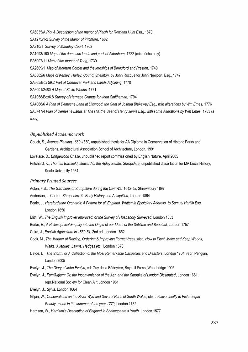
237
SA6035/A Plot & Description of the manor of Plaish for Rowland Hunt Esq., 1670.
SA1275/1-2 Survey of the Manor of Pitchford, 1682
SA210/1 Survey of Madeley Court, 1702
SA1093/160 Map of the demesne lands and park of Aldenham, 1722 (microfiche only)
SA6007/11 Map of the manor of Tong, 1739
SA2609/1 Map of Moreton Corbet and the lordships of Beresford and Preston, 1740
SA6802/6 Maps of Kenley, Harley, Cound, Sheinton, by John Rocque for John Newport Esq., 1747
SA665/Box 59.2 Part of Condover Park and Lands Adjoining, 1770
SA6001/2480 A Map of Stoke Woods, 1771
SA1058/Box6.8 Survey of Harnage Grange for John Smitheman, 1794
SA4068/6 A Plan of Demesne Land at Lithwood, the Seat of Joshua Blakeway Esq., with alterations by Wm Emes, 1776
SA3747/4 Plan of Demesne Lands at The Hill, the Seat of Henry Jervis Esq., with some Alterations by Wm Emes, 1783 (a
copy)
Unpublished Academic work
Couch, S., Avenue Planting 1660-1850, unpublished thesis for AA Diploma in Conservation of Historic Parks and
Gardens, Architectural Association School of Architecture, London, 1991
Lovelace, D., Bringewood Chase, unpublished report commissioned by English Nature, April 2005
Pritchard, K., Thomas Barnfield, steward of the Apley Estate, Shropshire, unpublished dissertation for MA Local History,
Keele University 1984
Primary Printed Sources
Acton, F.S., The Garrisons of Shropshire during the Civil War 1642-48, Shrewsbury 1897
Anderson, J. Corbet, Shropshire: its Early History and Antiquities, London 1864
Beale, J., Herefordshire Orchards: A Pattern for all England. Written in Epistolary Address to Samuel Hartlib Esq.,
London 1656
Blith, W., The English Improver Improved, or the Survey of Husbandry Surveyed, London 1653
Burke, E., A Philosophical Enquiry into the Origin of our Ideas of the Sublime and Beautiful, London 1757
Caird, J., English Agriculture in 1850-51, 2nd ed. London 1852
Cook, M., The Manner of Raising, Ordering & Improving Forrest-trees: also, How to Plant, Make and Keep Woods,
Walks, Avenues, Lawns, Hedges etc., London 1676
Defoe, D., The Storm: or A Collection of the Most Remarkable Casualties and Disasters, London 1704, repr. Penguin,
London 2005
Evelyn, J., The Diary of John Evelyn, ed: Guy de la Bédoyère, Boydell Press, Woodbridge 1995
Evelyn, J., Fumifugium: Or, the Inconvenience of the Aer, and the Smoake of London Dissipated, London 1661,
repr.National Society for Clean Air; London 1961
Evelyn, J., Sylva, London 1664
Gilpin, W., Observations on the River Wye and Several Parts of South Wales, etc., relative chiefly to Picturesque
Beauty, made in the summer of the year 1770, London 1782
Harrison, W., Harrison’s Description of England in Shakespeare’s Youth, London 1577

238
Johnson, S., The Works of Samuel Johnson, repr. Pafraets Co.Troy, New York, 1903
Langley, B., A Sure Method of Improving Estates, London 1740
Leach, F., County Seats of Shropshire, Shrewsbury 1891
Leighton, S., Shropshire Houses Past and Present, George Bell & Son, London 1901
Leland, J., The Itinerary of John Leland in or about the Year 1535-43, Parts 1-XI, repr. Bibliobazaar, George Bell & Son,
London 1908
Manwood, J., A Treatise of the Laws of the Forest, London 1615
Markham, G., Cheap and Good Husbandry, London 1618, repr. Da Capo Press, Amsterdam 1969
Markham, G., The Whole Art of Husbandry contained in Four Books, London 1631
Millais, J.G.' British Deer and their Horns, London 1897
Mollet, A., Le Jardin de Plaisir,Stockholm1651, English version London 1670
Moule, T., The County Maps of Old England, London 1836, repr. Studio Editions, London 1990
Norden, J., The Surveyor’s Dialogue, London 1618, ed: Netzloff, M., Ashgate U.S.A. 2010
Payne Knight, R., The Landscape: a Didactic Poem, London 1794
Payne Knight, R., An Analytical Inquiry into the Principles of Taste, London 1806
Price, U., Essay on the Picturesque, As Compared with the Sublime and the Beautiful, London 1810
Randall, J., History of Madeley: including Ironbridge, Coalbrookdale, & Coalport, Madeley 1880
Repton, H., Letter to Uvedale Price, London 1794
Repton, H., Sketches & Hints on Landscape Gardening, 1794
Repton, H., Fragments on the Theory & Practice of Landscape Gardening, London 1816
Shirley, E.P., Some Account of English Deer Parks - with Notes on the Management of Deer, London 1867
Switzer, S., Ichnographica Rustica – Vol 1: The Nobleman, Gentleman & Gardener’s Recreation, London, 1718
Thorn, F. & C.,eds.,Domesday Book. Shropshire (25) repr. Phillimore, Chichester 1986
Walpole, H., The History of the Modern Taste in Gardening, Strawberry Hill 1771, repr. Ursus Press, New York 1995
Whitaker, A Descriptive List of the Deer-Parks and Paddocks of England, London 1892
Secondary Sources: Articles, Reports, and Extracts from compiled works
Baigent, E., 'Mapping the Forests and Chases of England and Wales, c.1530 to c.1670', in Forests and Chases of
England and Wales c.1500-c.1850, ed: Langton J. & Jones G., St. John's College Research Centre,
Oxford 2008, pp. 21-28
Beswick, P. & Rotherham, I.D. eds: ‘Ancient Woodlands: their archaeology and ecology; a coincidence
of interest’, Landscape Archaeology & Ecology 1, pp.1-113, Landscape Conservation Forum, 1993
Bettey,J.H., 'The Development of Water Meadows in Dorset', Agricultural History Review 25, 1977, pp 37-43
Birrell, J., ‘Deer and Deer Farming in Medieval England’, Agricultural History Review 40:2, 1993, pp.112-126
Bowden, M., ‘Hopton Castle, Shropshire’ English Heritage Research News 3, Spring 2005
Coates, B.E., ‘Parks in Transition: medieval deer-park to modern landscape park’, Transactions of the
Hunter Archaeological Society 9, 1969, pp.133-149
Collinson, N.H. & Smithers R., ‘Climate Change & Woodlands Biodiversity’, Landscapes 3:2, Oct 2002, pp.29-38

239
Coulton, B., ‘Moreton Corbet Castle: a house and its family’, Transactions of the Shropshire Archaeological and Historical
Society 70 , 1995, pp.184-9
Cromarty, R., ‘Sir Walter and Sir Richard Leveson of Lilleshall’ Transactions of the Shropshire Archaeological & Historical
Society 76, 2001, pp 55-71
Daniels, S., ‘The Political Iconography of Woodland in later Georgian England’ in ed: Cosgrove, The Iconography
of Landscape, Cambridge University Press, Cambridge 1988, pp.43-82
Daniels, S., 'What Landscape Means to Me', Landscapes 12: 2, Dec 2012, pp.84-94
Daniels, S. & Watkins, C., ‘Picturesque Landscaping & Estate Management: Uvedale Price at Foxley, 1770-1829’,
Rural History 2:2, Oct 1991, pp. 141-165
Fretwell, K., 'Lodge Park, Gloucestershire: a rare surviving deer course and Bridgeman layout', Garden History 23:2,
Winter 1995, pp.133-134
Fryer, H., ‘Humphry Repton’s Commissions in Herefordshire’, Garden History 22: 2, Winter 1994, pp.162-174
Gregory, J., 'Mapping Improvement: reshaping rural landscapes in the eighteenth century', Landscapes 6:1, 2005,
pp.62-82
Hooke, D., ‘Pre-Conquest Woodland: its distribution and usage’, Agricultural History Review.37:2,1989, pp.113-129
Hussey, C ., 'Mawley Hall, Shropshire: the seat of Sir Walter Sodington Blount, Bt.', Country Life, 2 July 1910, pp.18-27
Jackson-Stopps, G., 'Aldenham Park, Salop - 1', Country Life, 23 June 1977, pp.1734-1737
Jancey, E.M., 'An Eighteenth-Century Steward and his Work', Transactions of the Shropshire Archaeological & Historical
Society 56, 1957, pp.34-48
Jones, G., 'Swanimotes, Woodmotes, and Courts of Free Miners'',in Forests and Chases of England and Wales
c.1500-c.1850, ed: Langton J. & Jones G., St. John's College Research Centre, Oxford 2008, pp.41-48
Jones, Rotherham & McCarthy, ‘Deer or the New Woodlands?’ Journal of Practical Ecology & Conservation, special
publication 1, 1996, pp.11-26
Lamb, H.H., ‘The Early Medieval Warm Epoch and Its Sequel’, Palaeogeography, Palaeoclimatology, Palaeoecology 1,
1965, pp.13-37
Liddiard, R., ‘The Landscapes of Domesday Book’, Landscapes 4:1, Spring 2003, pp.3-21
Liddiard, R. & Williamson, T., ‘There by Design? Some reflections on medieval elite landscapes’, Archaeological Journal
65, 2008, pp.520-535
McQuinton, J.R., 'Farmers' Revolt: the North Shropshire by-election of 1876', Transactions of the Shropshire Archaeological
& Historical Society 59, 1971, pp.170-180
Mileson, S.A., ‘The Importance of Parks in C15th Society’ in Clark, L., ed. The Fifteenth Century V, Boydell &
Brewer,Woodbridge 2005, pp.19-37
Overton, Mark, 'Agricultural Revolution? Development of the agrarian economy in early modern England', in A.R.H. Baker &
D. Gregory eds, Explorations in Historical Geography. Interpretative Essays, Cambridge 1984 p.122
Phillpotts, C., 'Madeley Court, the Documentary Evidence',Transactions of the Shropshire Archaeological & Historical
Society 81, 2006, p.54
Prince, H., 'Victorian Rural Landscapes' in ed: Mingay, G.E., The Victorian Countryside, Routledge & Kegan Paul, 1981,
pp.17-29
Rackham, O., ‘Pre-existing Trees & Woods in Country House Parks’, Landscapes 5:2, Autumn 2004, pp.1-14
240
Silvester, R.J., ‘John Probert of Copthorne: a Georgian land agent’, Transactions of the Shropshire Archaeological &
Historical Society, 84, 2009, pp.51-71
Stamper, P., ‘Shropshire’s Historic Parks & Gardens’, Report no: 41, Archaeology Unit Shropshire, 1993
Stamper, P., 'Willey’s Parks: attitudes, aspiration, and exploitation', Transactions of the Shropshire Archaeological &
Historical Society 65, 1987, pp. 70-73
Taylor, C. 'Ravensdale, Derbyshire, and Medieval Deer Coursing', Landscape History 26, 2004, pp.37-57
Trinder, B. Introduction to Greenwood’s Map of the County Of Salop 1827, reproduced by Transactions of the Shropshire
Archaeological & Historical Society 7, 1993, pp.101-102.
Wade Martins, S. & Williamson T., ‘Roots of Change: farming and the landscape in East Anglia, c.1700-1870’, British
Agricultural History Society (Supplement), 1999, pp.1-209
Wall, T., ‘The verdant landscape: the practice and theory of Richard Payne Knight at Downton Vale’, in Daniels, S., &
Watkins, C., The Picturesque Landscape: visions of Georgian Herefordshire, Nottingham University Dept. of
Geography, 1994, pp.49-65
Walsh, V. J., 'The Diary of a Country Gentleman: Sir Baldwin Leighton Bt. (1805-1871), Transactions of the Shropshire
Archaeological & Historical Society 59, 1971, pp.127-158
Watts, S., 'A Gentry Estate over Seven Centuries: Haughton, Shifnal', Transactions of the Shropshire Archaeological &
Historical Society 73, 1998, pp.44-51
Watts, S., ‘The Significance of Colonisation in Two North Shropshire Parishes’, Midland History 25, June 2000, pp.61-77
Webster, S., 'Estate Improvement and the Professionalism of Land Agents on the Egremont Estates in Sussex and
Yorkshire, 1770-1835', Rural History 18:1, 2007, pp.47-69
Weyman, H. T. 'Henley Hall', Transactions of the Shropshire Archaeological & Historical Society 48, 1934-5, pp.201-206
Wilde, W., 'Not Just a Pupil of Brown', Country Life Oct.1987, pp.152-156; and June 1988, pp.84-85
Williamson, T., ‘Questions of Preservation and Destruction’ in Everson, P. and Williamson, T. eds., The Archaeology &
Landscape: Studies presented to Christopher Taylor, Manchester University Press, 1998, pp.1-24
Williamson, T., 'Designed Landscapes: the regional dimension', Landscapes 5:2, Aut. 2004, pp.16-25
Secondary Sources: Books
Adams, W.Howard, Nature Perfected, Abbeville Press, New.York. 1991
Andrews, M., The Search for the Picturesque, Stanford University Press, Stanford C.A.1989
Ashton, T.S., The Industrial Revolution 1760-1830, Oxford University Press, Oxford 1968
Austen, J., Mansfield Park, J.M. Dent & Sons Ltd., London 1963
Bruyn Andrews, C. ed., John Byng, the Torrington Diaries, Eyre & Spottiswoode, London 1934-8
Burtscher, M., The Fitzalans, Earls of Arundel & Surrey, Lords of the Western Marches 1267-1415,
Logaston Press, Herefordshire 2008
Cantor, L.M., The Medieval Parks of England: a gazetteer, Loughborough University Press, 1983
Chambers, D., The Planters of the English Landscape Garden, Yale University Press, New Haven & London,1993
Cook, H. & Williamson,T., eds., Water Meadows: history, ecology & conservation, Windgather Press, Bollington 2007
Cosgrove, D., The Palladian Landscape, Leicester University Press, Leicester 1993
Cosgrove, D. & Daniels, S., eds., The Iconography of Landscape, Cambridge University Press, Cambridge 1988

241
Creighton, O. H., Designs upon the Land, Boydell Press, Woodbridge 2009
Daniels, S;, Humphry Repton – landscape gardening & the geography of Georgian England, Yale University Press, New
Haven & London 1999
Delano-Smith, C. & Kain, R.J.P., English Maps, A History, The British Library, London 1999
Dixon Hunt, J., Garden and Grove: the Italian Renaissance Garden in the English imagination: 1600-1750, J.M.Dent & Sons
Ltd., London 1986
Edwards, D. & Williamson, T., Norfolk Country Houses from the Air, Sutton Publishing Ltd., Stroud 2000
Ekwall, E., The Concise Oxford Dictionary of English Place Names, 4th ed: Oxford University Press, Oxford 1960
Elliott, B., Victorian Gardens, B.T.Batsford Ltd, London 1986
Farrow, W.J., The Great Civil War in Shropshire 1642-49, bux publishers, Shrewsbury 1926
Fletcher, J. Gardens of Earthly Delight: the history of deer parks, Windgather Press, Bollington 2011
Foss, M., Chivalry, Jarrold & Sons, Norwich 1975
Foxall, H.D.G., Shropshire Field-Names, Shropshire Archaeological Society, Shrewsbury 1980
Gelling, M., Place Names in the Landscape,J.M. Dent & Sons Ltd., London 1984
Girouard, M., Life in the English Country House, Yale University Press, New Haven & London, 1979
Girouard, M., The Return to Camelo:, chivalry and the English gentleman, Yale University Press, New Haven London 1981
Gloag, J., Mr Loudon's England, Oriel Press, London 1970
Harley, J.B., The Historian’s Guide to Ordnance Survey Maps, Blackfriars Press, Leicester 1964
Harley, J.B., The New Nature of Maps, John Hopkins University Press, Baltimore 2001
Harris, F. & Hunter, M. eds., John Evelyn and His Milieu, British Library, London 2003
Harrison, R. Pogue, Forests: the shadow of civilization, University of Chicago Press, Chicago 1992
Hayman, R., Trees Woodlands and Western Civilization, Bloomsbury Publishing, Hambledon & London, 2003
Henderson, P., The Tudor House and Garden, Yale University Press, New Haven & London 2005
Hill, T., The Historic Landscape of Upper Corvedale, Cressage, Shrewsbury 2009
Hooke, D., The Landscape of Anglo-Saxon England, Leicester University Press, London & Washington 1998
Hooke, D., England’s Landscape: The West Midlands, Collins, Glasgow 2006
Jacques, D., Georgian Gardens: the reign of nature, B.T. Batsford Ltd., London 1983
Kerridge, E., The Farmers of Old England, Allen & Unwin, London 1973
Labouchère, Rachel, Adelaide Darby of Coalbrookdale: her private journal 1833-61, Ironbridge Gorge Museum Trust
Lamb, H.H., Climate, History & the Modern World, 2nd ed., Routledge, London 1995
Langton, J. & Jones, G., eds., Forests & Chases of England and Wales c.1500-c.1850, St.John’s College
Research Centre, Oxford 2008
Leslie, M. & Raylor,T., eds. Culture and Cultivation in Early Modern England: writing and the land,
Leicester University Press, London & Washington 1992
Liddiard, R., Castles in Context, Windgather Press, Bollington 2005
Liddiard, R., ed. The Medieval Park: new perspectives, Windgather Press, Bollington 2007
Lieberman, M., The March of Wales 1067-1300, University of Wales Press, Cardiff 2008
Lloyd, D., The Concise History of Ludlow, Merlin Unwin Books, Ludlow 1999
Macnair, A. & Williamson, T., William Faden and Norfolk’s 18th Century Landscape, Windgather Press, Bollington 2010

242
McRae, A., God Speed the Plough: the representation of agrarian England, 1500-1660, Cambridge Univ. Press,
Cambridge 1996
Mileson, S.A., Parks in Medieval England, Oxford University Press, Oxford & New York 2009
Mingay, G.E., Rural Life in Victorian England, Lund Humphries, London 1976
Monmonier, M., How to Lie with Maps, 2nd ed:, Chicago University Press, Chicago & London 1996
Morris, C. ed., The Illustrated Journeys of Celia Fiennes 1685-c.1712, Alan Sutton Publishing Ltd., Stroud 1995
Morris, M., A Great and Terrible King: Edward I and the forging of Britain, Windmill Books, London 2009
Mowl, T., Elizabethan Jacobean Style, Phaidon Press Ltd., London 1993
Mowl, T. & Earnshaw B., Architecture without Kings: the rise of Puritan Classicism under Cromwell,
Manchester University Press, Manchester 1995
Mowl, T., Horace Walpole: the great outsider, John Murray, London 1996
Pastoureau, E., L'Ours, histoire d'un roi déchu, Editions du Seuil, Paris 2007
Perren, R., Agriculture in Depression, 1870-1940, The Economic History Society, Cambridge University Press,
Cambridge 1995
Pevsner, N., & Newman, J., The Buildings of England: Shropshire, Yale University Press, New Haven & London 2006
Pevsner, N., The Buildings of England: Staffordshire, Yale University Press, New Haven & London 1974
Platt, C., Medieval England: a social history & archaeology from the Conquest to 1600AD, Routledge & Kegan Paul,
London 1978
Pomeranz, K., The Great Divergence:, China, Europe, and the making of the modern world economy, Princeton
University Press, Princeton NJ 2000
Porter, S., Destruction in the English Civil Wars, Alan Sutton Publishing Ltd., Stroud 1974
Rackham, O., Trees and Woodland in the British Landscape, J.M.Dent & Sons Ltd., London 1976
Rackham, O., The History of the Countryside, J.M.Dent & Sons Ltd., London 1986
Rackham, O., Woodlands, Collins, London 2006
Reed, M., The Age of Exuberance 1500-1700, Routledge, London 1987
Riden, P., A Gazetteer of Charcoal-Fired Blast Furnaces in Great Britain in Use since 1660, Merton Priory Press,
Cardiff 1993
Rotberg, R. I. & Rabb, T., Climate & History, Princeton University Press, Princeton 1981
Rowley, T., The Shropshire Landscape, Hodder & Stoughton, London 1972
Rowley, T., The Welsh Border: archaeology, history and landscape, Tempus Publishing, Stroud, revised 2001
Salter, M., The Castles and Moated Mansions of Shropshire, Folly Publications, Malvern 1988
Stamper, P., Historic Parks and Gardens of Shropshire, Shropshire Books, Shrewsbury 1996
Stenton, D. M., English Society in the Early Middle Ages, Pelican History of England 3, London 1951
Stratton, J.M., Agricultural Records AD 220-1977, John Baker Publishers Ltd., London 1969
Strong, R., The Renaissance Garden in England, Thames & Hudson, London 1979,
Stroud, D., Capability Brown, Faber & Faber, London 1975
Stuart -Thomas, G., Trees in the Landscape, Jonathan Cape, London1983
Tarlow, S., The Archaeology of Improvement in Britain, 1750-1850, Cambridge Studies in Archaeology, Cambridge 2012
Tate, W.E., The Parish Chest, a study of the records of parochial administration in England, Cambridge University Press,
3rd ed:, Cambridge 1969

243
Thirsk, J., The Restoration, Problems & Perspectives in History, Longman 1976
Thirsk, J., England's Agricultural Regions and Agrarian History, 1500-1750, Studies in Economic & Social History, Macmillan
Education, London 1987
Thirsk, J., Alternative Agriculture: a history from the Black Death to the present day, Oxford University Press, Oxford 1997
Thomas, K., Man & the Natural World – changing attitudes in England 1500-1800, Penguin, London 1984
Thomas, K., The Ends of Life: roads to fulfilment in Early Modern England, Oxford University Press, Oxford 2009
Train, C., The Sheepe Hath Payed for All – the Ludlows of Shrewsbury, Ludlow Historical Research Group, Ludlow 2000
Trevelyan, G.M., Illustrated English Social History: 1, Pelican, London 1964
Trinder, B., The Industrial Revolution in Shropshire, Phillimore & Co Ltd., 2nd ed:, Chichester 1981
Trinder, B., Robert Baugh’s Map of Shropshire 1808, Shropshire Archaeological Society, Shrewsbury 1983
Turner, R., Capability Brown and the Eighteenth-century English Landscape, Phillimore & Co. Ltd., repr. 2006
Vera, F., Grazing Ecology and Forest History, CABI Publishing Wallingford Oxon, 2000
Watkins, C. & Cowell, B., A Biography of Uvedale Price 1747-1829: decoding the picturesque, Boydell Press,
Woodbridge 2012,
Whitehead, G. K., Hunting and Stalking Deer in Britain through the Ages, B.T.Batsford Ltd. London 1980
Williamson, T., Polite Landscapes: gardens and society in eighteenth-century England,Alan Sutton Publishing, Stroud 1995
Williamson, T., Rabbits, Warrens & Archaeology, Tempus Publishing, Stroud 2007
Wolschke-Bulmahn, J., ed:, Nature & Ideolog, natural garden design in the twentieth century, Dumbarton Oaks,
Washington DC 1997
Wrigley, E.A., Chance & Chang: the character of the Industrial Revolution, Cambridge University Press, Cambridge 1988
Wrigley, E.A., Energy & the English Industrial Revolution, Cambridge University Press, Cambridge 2010
VCH Shropshire, Vol. 2, Religious Houses
VCH Shropshire, Vol. 4, Agriculture, OUP, 1949
VCH Shropshire, Vol. 8, Condover & Ford Hundreds
VCH Shropshire, Vol.10, Wenlock Liberty & Borough
Websites
www.heritagegateway.org.uk
www.shropshirehistory.org.uk
www.discovershropshire.com

244
Fig 151. Gillded wooden stag, C5th BC
Pazyryk (Russia) burial site


