draft (6/1/2010) six-year (2011-2016) program...
TRANSCRIPT

DRAFT (6/1/2010)
Six-Year (2011-2016)Transportation Improvement
Program (TIP)
Dan Pike, MayorTed Carlson, Public Works Director
City Council MembersCity Council MembersGene Knutson - 2nd Ward, 2010 Council President
Stan Snapp - 4th Ward; 2010 Council President Pro Tempore Terry Bornemann - 5th Ward, 2010 Mayor Pro Tempore
Jack Weiss – 1st WardBarry Buchanan - 3rd Ward
Michael Lilliquist – 6th Ward; Seth Fleetwood - At Large
Transportation Commission Discussion: May 11, 2010Public Works Advisory Board Discussion: May 11, 2010
City Council Public Hearing: May 24, 2010City Council Work Session: June 7, 2010
Adopted June __, 2010
Prepared by Chris Comeau, AICP
Transportation Planner

Transportation Planning Documents
The 2011-2016 Transportation Improvement Program (TIP) is available from the Public Works Department at2nd floor, Bellingham City Hall, 210 Lottie Street
or on the City of Bellingham web site at:
http://www.cob.org/pw/index.htm
The Transportation Element of the 2006 Bellingham Comprehensive Plan is available on 2006 Bellingham Comprehensive Plan is available on
the City of Bellingham web site at:
http://www.cob.org/services/neighborhoods/community-planning/comprehensive-plan.aspx
Public Works Transportation Planning staff may be contacted by telephone at (360) 778-7900or by email, as listed below.
Chris Comeau, AICP, Transportation Planner ................. [email protected]
Brent Baldwin, AICP, Development Manager ................ [email protected]

State Law Requirements for Six-Year Transportation
Improvement Program (TIP)
RCW 35.77.010Perpetual advanced six-year plans for coordinated transportation program expenditures -- Nonmotorized transportation -- Railroad right-of-way.
(1) The legislative body of each city and town, pursuant to one or more public hearings thereon, shall prepare and adopt a comprehensive transportation program for the ensuing six calendar years. If the city or town has adopted a comprehensive plan pursuant to chapter 35.63or 35A.63RCW, the inherent authority of a first-class city derived from its charter, or chapter 36.70ARCW, the program shall be consistent with this comprehensive plan. The program shall include any new or enhanced bicycle or pedestrian facilities identified pursuant to RCW 36.70A.070(6) or other applicable changes that promote nonmotorized transit.
The program shall be filed with the secretary of transportation not more than thirty days after its adoption. Annually thereafter the legislative body of each city and town shall review the work accomplished under the program and determine and town shall review the work accomplished under the program and determine current city transportation needs. Based on these findings each such legislative body shall prepare and after public hearings thereon adopt a revised and extended comprehensive transportation program before July 1st of each year, and each one-year extension and revision shall be filed with the secretary of transportation not more than thirty days after its adoption. The purpose of this section is to assure that each city and town shall perpetually have available advanced plans looking to the future for not less than six years as a guide in carrying out a coordinated transportation program. The program may at any time be revised by a majority of the legislative body of a city or town, but only after a public hearing.
The six-year plan for each city or town shall specifically set forth those projects and programs of regional significance for inclusion in the transportation improvement program within that region.
(2) Each six-year transportation program forwarded to the secretary in compliance with subsection (1) of this section shall contain information as to how a city or town will expend its moneys, including funds made available pursuant to chapter 47.30RCW, for nonmotorized transportation purposes.
(3) Each six-year transportation program forwarded to the secretary in compliance with subsection (1) of this section shall contain information as to how a city or town shall act to preserve railroad right-of-way in the event the railroad ceases to operate in the city's or town's jurisdiction.

Funding Source Definitions
NOTE: All funding sources listed below are affected by changing economic conditions and annual funding levels and eligibility criteria may change.
• City Street: Public Works Street Fund comprised of motor vehicle gas tax and 42.5% of the total sales tax collected by the City of Bellingham.
• Real Estate Excise Tax (REET): Comprised of 1/2 of 1% of the total real estate revenue for a given year. REET funding is divided into first ¼ and second ¼ and can be used for limited types of transportation projects.
• Federal: Federal Highway Administration, Federal Transit Authority, or U.S. Department of Transportation administered grant funding programs.
• Federal American Reinvestment and Recovery Act (ARRA): One-time federal economic stimulus funding provided for transportation projects.
• Federal Highway Bridge Program (HBP): Provides federal funds for structural repair • Federal Highway Bridge Program (HBP): Provides federal funds for structural repair or replacement. Project oversight at the State level by the Bridge Replacement Advisory Committee (BRAC).
• Federal Surface Transportation Program (STP): Provides federal funds to maintain and expand eligible arterial street systems.
• Federal Surface Transportation Program Enhancements (STP-E): Provides federal funds to enhance facilities for alternative transportation modes on eligible street systems.
• State: State administered grant funding programs or State educational institutions such as Western Washington University (WWU), Whatcom Community College (WCC), and Bellingham Technical College (BTC).
• WSDOT: Washington State Department of Transportation biennium budget - State Funding administered through WSDOT.
• Washington Transportation Improvement Board (TIB): State grant funding for arterials, sidewalks, and safety measures.
• Private & Other (Partnerships): Transportation Impact Fees, Whatcom County, Whatcom Transportation Authority, private business investment, private mitigation, etc.
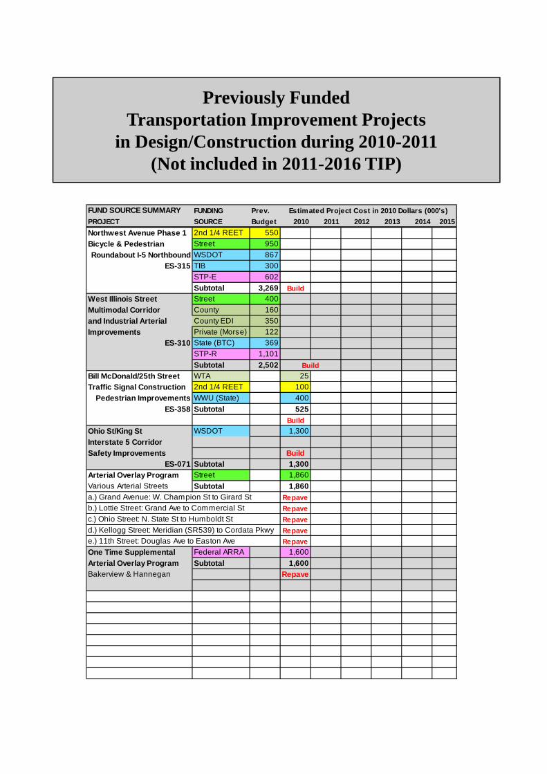
Previously FundedTransportation Improvement Projects
in Design/Construction during 2010-2011(Not included in 2011-2016 TIP)
FUND SOURCE SUMMARY FUNDING Prev. Estimated Project Cost in 2010 Dollars (000's)
PROJECT SOURCE Budget 2010 2011 2012 2013 2014 2015
Northwest Avenue Phase 1 2nd 1/4 REET 550
Bicycle & Pedestrian Street 950
Roundabout I-5 Northbound WSDOT 867ES-315 TIB 300
STP-E 602
Subtotal 3,269 Build
West Illinois Street Street 400
Multimodal Corridor County 160
and Industrial Arterial County EDI 350
Improvements Private (Morse) 122ES-310 State (BTC) 369
STP-R 1,101
Subtotal 2,502Bill McDonald/25th Street WTA 25Traffic Signal Construction 2nd 1/4 REET 100
Build
Traffic Signal Construction 2nd 1/4 REET 100
Pedestrian Improvements WWU (State) 400
ES-358 Subtotal 525Build
Ohio St/King St WSDOT 1,300
Interstate 5 CorridorSafety Improvements Build
ES-071 Subtotal 1,300Arterial Overlay Program Street 1,860Various Arterial Streets Subtotal 1,860
Repave
Repave
Repave
Repave
Repave
One Time Supplemental Federal ARRA 1,600
Arterial Overlay Program Subtotal 1,600Bakerview & Hannegan Repave
c.) Ohio Street: N. State St to Humboldt Std.) Kellogg Street: Meridian (SR539) to Cordata Pkwye.) 11th Street: Douglas Ave to Easton Ave
a.) Grand Avenue: W. Champion St to Girard Stb.) Lottie Street: Grand Ave to Commercial St

Transportation Improvement Projects 2011-2016 (Page 1)
FUNDING Previous PROJECT
No. PROJECT DESCRIPTION SOURCE Budget 2011 2012 2013 2014 2 015 2016 TOTALS
1 Annual Pavement Resurfacing Street n/a 2,046 2,250 2,475 2,725 3,000 3,300 15,796
Meador-Kansas-Ellis 2nd 1/4 REET 5502 Bicycle Lanes & Sidewalks Street 200
Bike-Ped Bridge Whatcom Crk State TIB 175 BuildES-413 Subtotal 925 925
Northwest Ave/McLeod Rd 2nd 1/4 REET 2503 Multimodal Roundabout State TIB 1,610
Southbound Interstate 5 Federal STRS 780 BuildES-360 Subtotal 2,640 2,640
4 McLeod Road Sidewalk ES-434 2nd 1/4 REET 250 BuildN. side: Northwest to Rusley Subtotal 250 250
5 Eliza Avenue Connector Street 250Eliza Ave to Bellis Fair Pkwy Subtotal 250 250
James Street 2nd 1/4 REET 1006 Bridge Replacement Street 624
ER-009 Federal BRAC 2,495 BuildSubtotal 3,119 100 3,219
James Street Phase 1 2nd 1/4 REET 100 100 1007 Multimodal Corridor Street 100 500 500 500 300
Improvements ES-318 Unknown 700
Cost Estimates (000's) 2010 Dollars
FUNDED UNFUNDED
Improvements ES-318 Unknown 700
(Woodstock to Orchard) Subtotal 100 100 500 600 600 1,000 2,900
Bellingham Waterfront District 1st 1/4 REET 1,000 1,000 1,000 1,000 1,000 1,000 6,000
8 1st 1/4 REET 500a) Cornwall Avenue Bridge Street 1,515
Demolition/Reconstruction Federal 6,700 WF-1001 (WA227) Unknown 13,285
Subtotal 8,715 13,285 22,000
b) Central Avenue 2nd 1/4 REET 450Roeder to W. Chestnut Unknown 2,050
WF-1004 Subtotal 450 2,050 2,500
c) Wharf Street Roundabout 2nd 1/4 REET 483
State/Forest & Blvd/Wharf Unknown 2,717 WF-1008 Subtotal 483 2,717 3,200
d) BNSF Railroad Relocation 1st 1/4 REET 450Utility Relocation WF-1002 State 5,000
Track Relocation WF-1010 Unknown 9,550Subtotal 450 5,000 9,550 15,000
e) C Street - WF-1006 Unknown 2,600Phase 1: Roeder to Maple Subtotal 2,600 2,600
f) C Street Unknown 1,300Phase 2: Roeder to Bancroft Subtotal 1,300 1,300
10,098 1,000 1,000 6,000 32,502 1,000 1,000 52,600
17,132 3,396 3,850 9,075 35,827 5,000 4,300 78,580
Page 1 Waterfront District Subtotal
Page 1 TIP Subtotal
Transportation Improvement Projects 2011-2016 (Page 2)
FUNDING Previous PROJECTNo. PROJECT DESCRIPTION SOURCE Budget 2011 2012 2013 2014 2 015 2016 TOTALS
8 Page 1 Waterfront District Subtotal 10,098 1,000 1,000 6,000 32,502 1,000 1,000 52,600g) Granary Avenue Unknow n 2,380
C Roeder to Bloedel Subtotal 2,380 2,380o h) Bloedel Avenue Unknow n 840n Chestnut to Commercial Subtotal 840 840t i) Commercial Green Loop Unknow n 2,240i Bloedel to Bloedel Subtotal 2,240 2,240n j) South Cornwall Avenue Unknow n 2,800u Wharf St to Park Area Subtotal 2,800 2,800e k) F Street Unknow n 1,820d Roeder to Maple Subtotal 1,820 1,820
0 0 0 0 10,080 0 0 10,080
10,098 1,000 1,000 6,000 42,582 1,000 1,000 62,680Boulevard to Cornwall 1st 1/4 REET 150
9 Overwater Pedestrian Walkway Federal STP-E 2,139(Boulevard Park to Waterfront) Greenw ays 3 100 3,900(WA251) - Parks Department Unknow n 2,000
Subtotal 2,389 3,900 2,000 8,289
Cost Estimates (000's) 2010 Dollars
FUNDED UNFUNDED
Bellingham Waterfront District Continued from Page 1
Waterfront District Grand Total
Page 2 Waterfront District Subtotal
Subtotal 2,389 3,900 2,000 8,289N.Samish Way Pedestrian Safety Street 100
10 Flashing Crosswalks & Median StateAbbott St & Consolidation Ave Unknow n 400
Subtotal 100 400 500West Horton Road Multimodal Street 300 500 500 500
11 Corridor Improvements-Phase 1 Private 812(Cordata Park to Aldrich Rd) Unknow n 1,000 1,000 1,000
ES-399 Subtotal 812 300 1,500 1,500 1,500 5,612James Street Phase 2 Street 200 500 500
12 Multimodal Improvements PrivateES-318 (Orchard to Telegraph) Unknow n 1,500 1,500 1,500
Subtotal 1,700 2,000 2,000 5,700Barkley Boulevard Private
13 Arterial Safety & Circulation Unknow n 400(Howe to Woburn) Subtotal 400 400Birchwood Ave-James Street Street
14 Multimodal Arterial Corridor Privateand Bay-to-Baker Trail Greenw ays 3
Unknow n 1,500 1,500 1,500Subtotal 1,500 1,500 1,500 4,500
17,132 3,396 3,850 9,075 35,827 5,000 4,300 78,580
3,201 0 4,000 300 17,580 5,000 5,000 35,081
20,333 3,396 7,850 9,375 53,407 10,000 9,300 113,661Pages 1 & 2 TIP Subtotal
Page 2 TIP Subtotal
Page 1 TIP Subtotal

Transportation Improvement Projects 2011-2016 (Page 3)
FUNDING Previous PROJECTNo. PROJECT DESCRIPTION SOURCE Budget 2011 2012 2013 2014 2 015 2016 TOTALS
WWU Lincoln Creek Multimodal State/WWU 1,84515 Transportation Center Federal 1,943
(Not a City Project; No City Funds) Unknow n 6,250Subtotal 3,788 6,250 10,038
Non-Motorized 16 Transportation Options* Unknow n 500 500 500 1,500
Note* There is currently no funding for this catego ry and the Transportation Commission w ill re-priori tize the non-motorized project list for this category during the Comprehensive Plan update process.Transit Enhancement Options*
17 Unknow n 1,000 1,000 1,000 3,000Note* There is currently no funding for this catego ry and the City w ill further define the scope of th is project.
17,132 3,396 3,850 9,075 35,827 5,000 4,300 78,580
3,201 0 4,000 300 17,580 5,000 5,000 35,081
3,788 0 0 0 1,500 1,500 7,750 14,538
24,121 3,396 7,850 9,375 54,907 11,500 17,050 128,199
Cost Estimates (000's) 2010 Dollars
FUNDED UNFUNDED
TIP GRAND TOTAL
2011-2016 PROJECT FUNDING SOURCE SUMMARIES
Page 1 TIP Subtotal
Page 2 TIP Subtotal
Page 3 TIP Subtotal
Previous
Budget 2011 2012 2013 2014 2015 2016 TOTALS
2,439 2,296 2,850 3,275 3,925 4,300 4,300 23,385
1,100 1,000 1,000 1,000 1,000 1,000 1,000 7,100
1,983 100 100 100 100 2,383
3,630 5,000 8,630
15,081 15,081
912 3,900 4,812
50,582 7,200 11,750 69,532
25,145 3,396 7,850 9,375 55,607 12,500 17,050 130,923
TOTAL FUNDING BY SOURCE
TOTAL FEDERAL FUNDS
FUNDED UNFUNDED
TOTAL PRIVATE/OTHER
TOTAL UNKNOWN FUNDS
Cost Estimates (000's) 2010 Dollars
TOTAL STREET FUNDS
TOTAL 1st 1/4 REET FUNDS
TOTAL 2nd 1/4 REET FUNDS
TOTAL STATE FUNDS
TOTAL PROGRAM FUNDS


Project #1: Annual Arterial Pavement Resurfacing Program(Goal: 5% of Arterial Street Network Per Year)
PROJECT NARRATIVE
This program maintains existing arterial streets and bicycle lanes to protect the initial investment in the street and to ensure an adequate quality driving and riding surface at an optimized life-cycle cost. Where possible, the City may combine pavement resurfacing with the addition of bicycle lanes on the arterial street. Approximately 5% of the City’s arterial streets require resurfacing each year.
TRANSPORTATION IMPACT FEES COLLECTED Maintenance – Not Eligible
MULTIMODAL TRANSPORTATION BENEFITS
Adding bicycle lanes to an arterial street, where possible, when pavement resurfacing occurs expands the citywide bicycle network and increases bicycle safety.
TRANSPORTATION IMPACT FEES COLLECTED Maintenance – Not Eligible
RIGHT-OF-WAY ACQUISITION NECESSARY No
PROJECT STATUS
Active and on-Going 2011 through 2016; Goal 5% of arterial street network per year

Project #2: Meador-Kansas-EllisBicycle Lanes, Sidewalks, Bike-Ped Bridge
(On-Street Portion of Whatcom Creek Trail)
PROJECT NARRATIVE
This project will provide the final on-street connection for the long planned Whatcom Creek Trail system between Lake Whatcom and Bellingham Bay. In 2009, the Parks Department completed the trail section between Racine Street and beneath Interstate 5 along the creek. This project will provide on-street bicycle and pedestrian facilities between Meador Avenue and Ellis Street. Right-of-way and narrow bridges over Whatcom Creek create challenges, but bicycle facilities will be included where physically possible.
PROJECT STATUS (ES-413)
Construction scheduled for late 2010 with completion anticipated in Spring 2011.
TRANSPORTATION IMPACT FEES COLLECTED Yes
RIGHT-OF-WAY ACQUISITION NECESSARY No
IOWA ST
JAM
ES S
T
OHIO ST
N STA
TE ST
MEADOR AVE
S IN
TERSTA
TE 5
N IN
TERSTA
TE 5
IRO
N S
T
ELL
IS S
T
FRASER ST
KIN
G S
T
MO
ORE S
T
GRANT S
T
L INCO
LN S
T
HUM
BO
LDT S
T
YORK ST
KANSAS ST
EXIT
254
OFF R
AM
P
EXPRESS D
R
FRANKLI
N S
T
EXIT 254 ON RAMP
GRANT S
T
IOWA ST
HUM
BO
LDT S
T
ELL
IS S
T
KIN
G S
T
IRON S
T
FRASER ST
FRANKLI
N S
T
¯
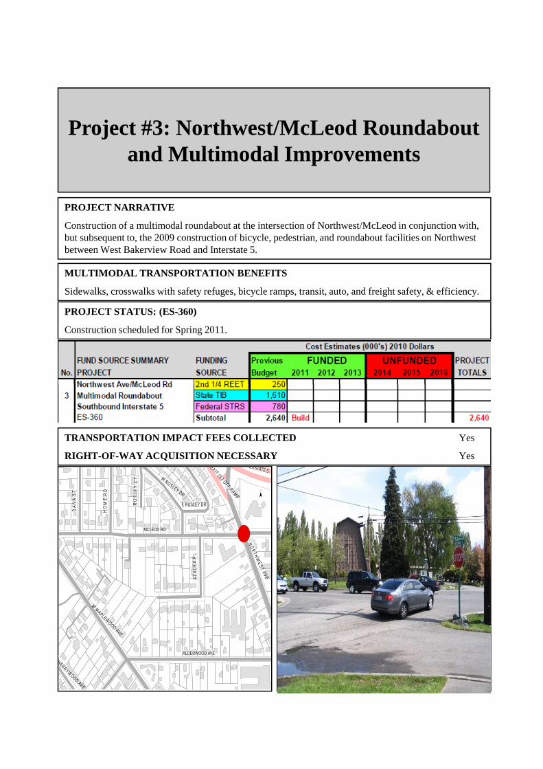
Project #3: Northwest/McLeod Roundabout and Multimodal Improvements
PROJECT NARRATIVE
Construction of a multimodal roundabout at the intersection of Northwest/McLeod in conjunction with, but subsequent to, the 2009 construction of bicycle, pedestrian, and roundabout facilities on Northwest between West Bakerview Road and Interstate 5.
PROJECT STATUS: (ES-360)
Construction scheduled for Spring 2011.
MULTIMODAL TRANSPORTATION BENEFITS
Sidewalks, crosswalks with safety refuges, bicycle ramps, transit, auto, and freight safety, & efficiency.
TRANSPORTATION IMPACT FEES COLLECTED Yes
RIGHT-OF-WAY ACQUISITION NECESSARY Yes
k
MCLEOD RD
ALDERWOOD AVE
NO
RTH
WE
S T AV E
W MAPLEWOOD AVE
AZ
AL
EA
PL
DA
NA
ST
HO
ME
RD
W RUSLEY DR
RU
SL E
Y C
T
E RUSLEY DR
S INTERSTATE 5
EX IT 257 OFF RAMP
CHERRYWOOD AVE
N INTERSTATE 5
¯

Project #4: McLeod Road Sidewalk
PROJECT NARRATIVE
Construct curb, gutter and sidewalk on the north side of McLeod Road between Northwest Road and West Rusley Drive. This sidewalk project will tie into the pedestrian facilities being built for the Northwest/McLeod roundabout, as well as the roundabout and pedestrian and bicycle facilities on Northwest on the north side of Interstate 5.
PROJECT STATUS (ES-434)
Construction scheduled for Spring 2011 in conjunction with McLeod/Northwest Roundabout
MULTIMODAL TRANSPORTATION BENEFITS
Sidewalk to merge with sidewalks and pedestrian crossings at Northwest/McLeod roundabout.
TRANSPORTATION IMPACT FEES COLLECTED Yes
RIGHT-OF-WAY ACQUISITION NECESSARY Unknown
k
MCLEOD RD
ALDERWOOD AVE
NO
R T HW
E S T A V E
W MAPLEW OOD AVE
AZ
AL
EA
PL
DA
NA
ST
HO
ME
RD
W RUSLEY DR
RU
SL E
Y C
T
E RUSLEY DR
S INTERSTATE 5EX IT 257 O FF R AM P
CHERRYW OOD AVE
N INTERSTATE 5
¯
NorthwestRAB Phase 2
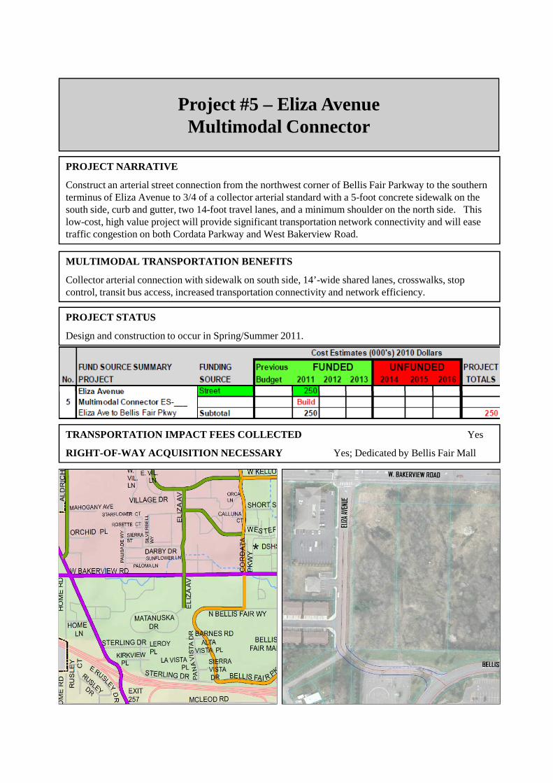
Project #5 – Eliza Avenue Multimodal Connector
PROJECT NARRATIVE
Construct an arterial street connection from the northwest corner of Bellis Fair Parkway to the southern terminus of Eliza Avenue to 3/4 of a collector arterial standard with a 5-foot concrete sidewalk on the south side, curb and gutter, two 14-foot travel lanes, and a minimum shoulder on the north side. This low-cost, high value project will provide significant transportation network connectivity and will ease traffic congestion on both Cordata Parkway and West Bakerview Road.
PROJECT STATUS
Design and construction to occur in Spring/Summer 2011.
MULTIMODAL TRANSPORTATION BENEFITS
Collector arterial connection with sidewalk on south side, 14’-wide shared lanes, crosswalks, stop control, transit bus access, increased transportation connectivity and network efficiency.
TRANSPORTATION IMPACT FEES COLLECTED Yes
RIGHT-OF-WAY ACQUISITION NECESSARY Yes; Dedicated by Bellis Fair Mall

Project #6: James Street Bridge Replacement
PROJECT NARRATIVE
Two weight-restricted and deteriorating bridges over Squalicum Creek tributaries will be replaced with new bridge spans. The new bridges will include be constructed to urban secondary arterials standards with sidewalks, bicycle lanes, and turn lanes to match with those being planned for James Street Phase 1 Multimodal Corridor Improvements.
PROJECT STATUS (ER-009)
On-going engineering and design with bridge reconstruction expected in 2012.
MULTIMODAL TRANSPORTATION BENEFITS
Sidewalks, bicycle lanes, turn lanes for future east-west arterial connection.
E SUNSET DR
N INTER STATE 5
S INTERSTATE 5
TELEGRAPH RD
IRO
N G
AT
E R
D
DIVISION STE MCLEOD RD
MIDWAY LN
WO
BU
RN
ST
BA
KE
RV
IEW
SP
UR
RA
CIN
E S
T
SQUALICUM PKWY
HA
MM
ER
DR
BAKER ST
DE
EM
ER
RD
JAM
ES
ST
RE
ET
RDW ORCHARD DR
WOODSTOCK WAY
ROWAN LN
BIRCHWOOD AVE
6TH ST
E ORCHARD DR
7TH ST
ALPINE WAYAMANDA LN
FRUITLAND DR
COOLIDGE DR
PR
IMR
OS
E L
N
MASONRY WAYGILBERT DR
SP
UR
RID
GE
LN
JAM
ES
ST
RE
ET
RD
¯
TRANSPORTATION IMPACT FEES COLLECTED Yes
RIGHT-OF-WAY ACQUISITION NECESSARY Yes
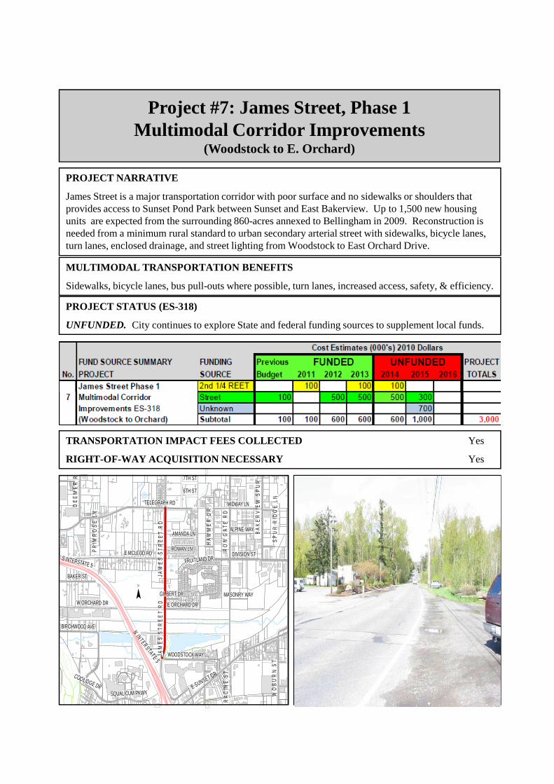
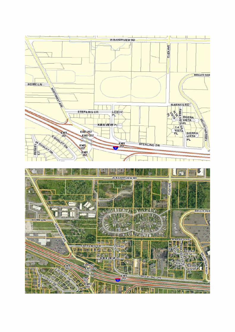
Project #7: James Street, Phase 1Multimodal Corridor Improvements
(Woodstock to E. Orchard)
PROJECT NARRATIVE
James Street is a major transportation corridor with poor surface and no sidewalks or shoulders that provides access to Sunset Pond Park between Sunset and East Bakerview. Up to 1,500 new housing units are expected from the surrounding 860-acres annexed to Bellingham in 2009. Reconstruction is needed from a minimum rural standard to urban secondary arterial street with sidewalks, bicycle lanes, turn lanes, enclosed drainage, and street lighting from Woodstock to East Orchard Drive.
PROJECT STATUS (ES-318)
UNFUNDED. City continues to explore State and federal funding sources to supplement local funds.
MULTIMODAL TRANSPORTATION BENEFITS
Sidewalks, bicycle lanes, bus pull-outs where possible, turn lanes, increased access, safety, & efficiency.
E SUNSET DR
N INTER STATE 5
S INTERSTATE 5
TELEGRAPH RD
IRO
N G
AT
E R
D
DIVISION STE MCLEOD RD
MIDWAY LN
WO
BU
RN
ST
BA
KE
RV
IEW
SP
UR
RA
CIN
E S
T
SQUALICUM PKWY
HA
MM
ER
DR
BAKER ST
DE
EM
ER
RD
JAM
ES
ST
RE
ET
RDW ORCHARD DR
WOODSTOCK WAY
ROWAN LN
BIRCHWOOD AVE
6TH ST
E ORCHARD DR
7TH ST
ALPINE WAYAMANDA LN
FRUITLAND DR
COOLIDGE DR
PR
IMR
OS
E L
N
MASONRY WAYGILBERT DR
SP
UR
RID
GE
LN
JAM
ES
ST
RE
ET
RD
¯
TRANSPORTATION IMPACT FEES COLLECTED Yes
RIGHT-OF-WAY ACQUISITION NECESSARY Yes

Project #8 (a, b, c, d, e, f)Waterfront District Multimodal Improvements
PROJECT NARRATIVE: Construction of arterial street and/or bridge connection(s) to provide primary access to the Waterfront Restoration site, including facilities for pedestrians and bicycles. Bridge(s) will need to be constructed to allow future relocation of the BNSF railroad main line from its existing location and to allow adequate width for future double tracking.
PROJECT STATUS: Construction uncertain pending master plan & additional funding for all projects.
TRANSPORTATION IMPACT FEES COLLECTED Yes
RIGHT-OF-WAY ACQUISITION NECESSARY Yes
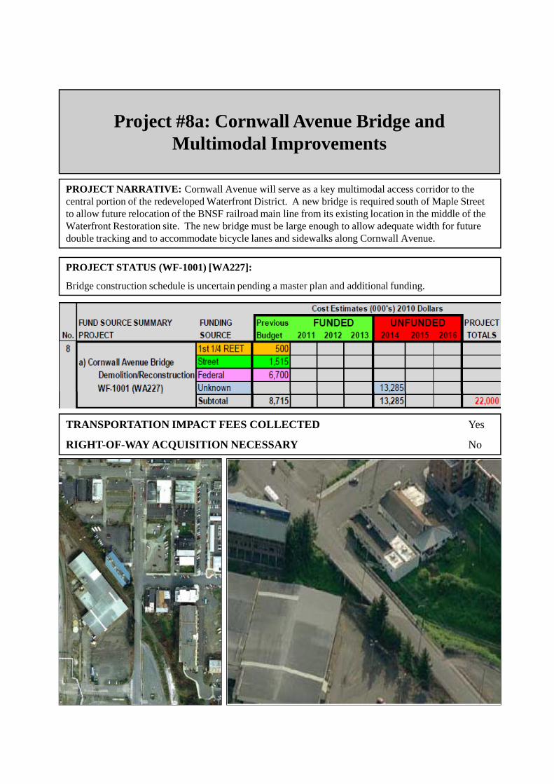
Project #8a: Cornwall Avenue Bridge and Multimodal Improvements
PROJECT NARRATIVE: Cornwall Avenue will serve as a key multimodal access corridor to the central portion of the redeveloped Waterfront District. A new bridge is required south of Maple Street to allow future relocation of the BNSF railroad main line from its existing location in the middle of the Waterfront Restoration site. The new bridge must be large enough to allow adequate width for future double tracking and to accommodate bicycle lanes and sidewalks along Cornwall Avenue.
PROJECT STATUS (WF-1001) [WA227]:
Bridge construction schedule is uncertain pending a master plan and additional funding.
TRANSPORTATION IMPACT FEES COLLECTED Yes
RIGHT-OF-WAY ACQUISITION NECESSARY No

Project #8b: Central AvenueMultimodal Improvements
PROJECT NARRATIVE: Central Avenue will serve as a key multimodal access corridor to the northern portion of the redeveloped Waterfront District and will be one of only two access points while the Cornwall Bridge is under construction. The existing portion of Central Avenue is built over the water and the underlying superstructure will require reconstruction. A new traffic signal will be constructed at the Central/Roeder intersection with left turn lanes.
PROJECT STATUS (WF-1004):
Construction schedule is uncertain pending a master plan and additional funding.
MULTIMODAL TRANSPORTATION BENEFITS
Sidewalks, bicycle lanes if possible, traffic signal, turn lanes, increased access, safety, & efficiency.
TRANSPORTATION IMPACT FEES COLLECTED Yes
RIGHT-OF-WAY ACQUISITION NECESSARY No

Project #8c: Wharf RoundaboutMultimodal Improvements
PROJECT NARRATIVE: Wharf Street will serve as a key multimodal access corridor to the southern portion of the redeveloped Waterfront District and will be one of only two access points while the Cornwall Bridge is under construction. The existing intersection of Wharf/Boulevard/State/Forest will be reconstructed as a multimodal roundabout to improve safety, efficiency, and access for all transportation modes, including freight.
PROJECT STATUS (WF-1008):
Construction schedule is uncertain pending a master plan and additional funding.
MULTIMODAL TRANSPORTATION BENEFITS
Sidewalks, crosswalks with safety refuges, bicycle ramps, transit, auto, and freight safety, & efficiency.
TRANSPORTATION IMPACT FEES COLLECTED Yes
RIGHT-OF-WAY ACQUISITION NECESSARY No

Project #8d: Railroad Relocation
PROJECT NARRATIVE: This project will relocate the existing single railroad main line from the middle of the Waterfront District redevelopment site to the east and up against the embankment separating the CBD from the Waterfront District. This relocation will provide for second track (siding) through the area, and will remove 3 at-grade railroad crossings, which will increase safety and accessibility for bicycle, pedestrian, transit, and auto modes. The relocated railroad tracks will run beneath the new Cornwall Avenue Bridge and the existing Chestnut-Bay Bridge.
PROJECT STATUS: Utility Relocation (WF-1002); RR Track Relocation (WF-1010)
Construction schedule is uncertain pending a master plan and additional funding.
MULTIMODAL TRANSPORTATION BENEFITS
Railroad track relocation will increase the amount of developable land/density, which may benefit transit and non-motorized modes and should enhance arterial access, safety, & efficiency for all modes.
TRANSPORTATION IMPACT FEES COLLECTED Non-City, Not Eligible
RIGHT-OF-WAY ACQUISITION NECESSARY Yes

Project #8e: C Street, Phase 1Multimodal Improvements
(Roeder Ave to Maple Ave)
PROJECT NARRATIVE: C Street, Phase 1 will serve as a key multimodal access corridor to the Marine Trades Area of the redeveloped Waterfront District. The existing minimum standard street access will be improved to industrial collector arterial standards, including sidewalks, shared travel lanes, crosswalks, and a new traffic signal at C St/Roeder Ave.
PROJECT STATUS (WF-1006):
Construction schedule is uncertain pending a master plan and additional funding.
MULTIMODAL TRANSPORTATION BENEFITS
Sidewalks, crosswalks, bicycle access, transit, auto, and freight safety, & efficiency.
TRANSPORTATION IMPACT FEES COLLECTED Yes
RIGHT-OF-WAY ACQUISITION NECESSARY No
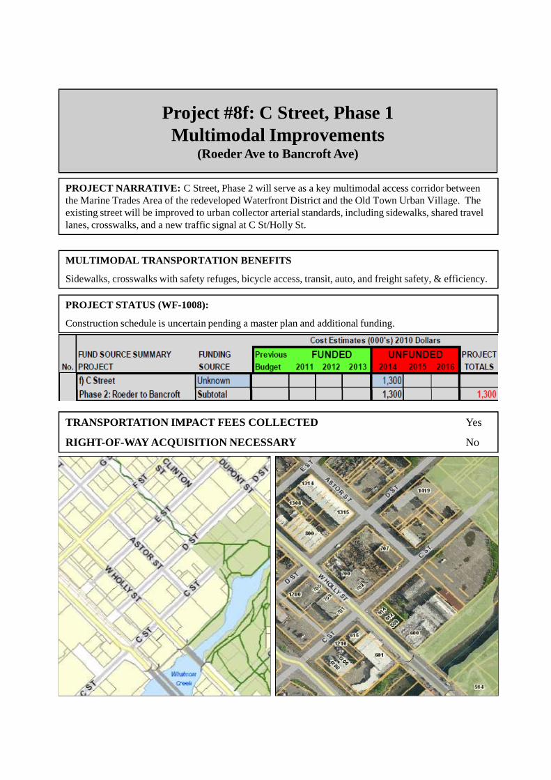
Project #8f: C Street, Phase 1Multimodal Improvements
(Roeder Ave to Bancroft Ave)
PROJECT NARRATIVE: C Street, Phase 2 will serve as a key multimodal access corridor between the Marine Trades Area of the redeveloped Waterfront District and the Old Town Urban Village. The existing street will be improved to urban collector arterial standards, including sidewalks, shared travel lanes, crosswalks, and a new traffic signal at C St/Holly St.
PROJECT STATUS (WF-1008):
Construction schedule is uncertain pending a master plan and additional funding.
MULTIMODAL TRANSPORTATION BENEFITS
Sidewalks, crosswalks with safety refuges, bicycle access, transit, auto, and freight safety, & efficiency.
TRANSPORTATION IMPACT FEES COLLECTED Yes
RIGHT-OF-WAY ACQUISITION NECESSARY No

Project #8g: Granary AvenueMultimodal Improvements
(Roeder Avenue to Bloedel Avenue)
PROJECT NARRATIVE: A new arterial connection will be constructed immediately south of the historic Granary building from Roeder Avenue to Bloedel Avenue and will serve as the primary multimodal access corridor to the northern portion of the redeveloped Waterfront District when Central Avenue is closed to vehicle traffic. A new traffic signal with left-turn lanes will be constructed at the Granary/Roeder intersection, which will need to be coordinated with the signal at C St/Roeder Avenue.
PROJECT STATUS (WF-10__):
Construction schedule is uncertain pending a master plan and additional funding.
MULTIMODAL TRANSPORTATION BENEFITS
Sidewalks, crosswalks, bicycle lanes, traffic signal, turn lanes, increased access, safety, & efficiency.
TRANSPORTATION IMPACT FEES COLLECTED No: Unfunded
RIGHT-OF-WAY ACQUISITION NECESSARY No

Project #8h: Bloedel AvenueMultimodal Improvements
(Chestnut Street to Commercial Street)
PROJECT NARRATIVE: A new arterial connection will be constructed from the Chestnut Street right-of-way to the Commercial Street right-of-way and will serve as the primary north-south multimodal arterial corridor between the Whatcom Waterway and Commercial Street in the first phase of redevelopment of the Waterfront District. A future phase will construct the remainder of Bloedel Avenue to connect with the Laurel Street right-of-way and Cornwall Avenue .
PROJECT STATUS (WF-10__):
Construction schedule is uncertain pending a master plan and additional funding.
MULTIMODAL TRANSPORTATION BENEFITS
Sidewalks, crosswalks, bicycle lanes, turn lanes, bus pull-outs where possible, increased access, safety, & efficiency.
TRANSPORTATION IMPACT FEES COLLECTED No: Unfunded
RIGHT-OF-WAY ACQUISITION NECESSARY No

Project #8i: Commercial Green LoopMultimodal Improvements
(Bloedel Avenue to Bloedel Avenue)
PROJECT NARRATIVE: A new arterial loop connection will be constructed west of Bloedel Avenue with park greens in the center of the loop. The Commercial Green Loop will serve as the primary western multimodal access in the early phases of the long-term redevelopment of the Waterfront District.
PROJECT STATUS (WF-10__):
Construction schedule is uncertain pending a master plan and additional funding.
MULTIMODAL TRANSPORTATION BENEFITS
Sidewalks, crosswalks, bicycle lanes, bus pullouts where possible, turn lanes, increased access, safety, & efficiency.
TRANSPORTATION IMPACT FEES COLLECTED No: Unfunded
RIGHT-OF-WAY ACQUISITION NECESSARY No

Project #8j: South Cornwall AvenueMultimodal Improvements(Wharf Street to Park Area)
PROJECT NARRATIVE: A new southwestern extension of Cornwall Avenue will be constructed from Wharf Street to the general vicinity of a new park area near the Boulevard Park to Cornwall Avenue Overwater Pedestrian Walkway (Project #9). The Cornwall Avenue extension will serve as the primary multimodal access to the southern portion of the Waterfront District in the early phases of the long-term redevelopment.
PROJECT STATUS (WF-10__):
Construction schedule is uncertain pending a master plan and additional funding.
MULTIMODAL TRANSPORTATION BENEFITS
Sidewalks, crosswalks, bicycle lanes, increased access, safety, & efficiency.
TRANSPORTATION IMPACT FEES COLLECTED No: Unfunded
RIGHT-OF-WAY ACQUISITION NECESSARY No

Project #8k: F StreetMultimodal Improvements
(Roeder Avenue to Maple Street)
PROJECT NARRATIVE: A new F Street arterial connection will be constructed southwest of Roeder Avenue to the Maple Street right-of-way. This southwestern extension of F Street will serve as one of the primary multimodal access corridors for the Marine Trades Area in the early phases of the long-term redevelopment of the Waterfront District.
PROJECT STATUS (WF-10__):
Construction schedule is uncertain pending a master plan and additional funding.
MULTIMODAL TRANSPORTATION BENEFITS
Sidewalks, crosswalks, bicycle lanes, traffic signal improvements, turn lanes, increased access, safety, & efficiency.
TRANSPORTATION IMPACT FEES COLLECTED No: Unfunded
RIGHT-OF-WAY ACQUISITION NECESSARY No

Project #9: Boulevard Park to Cornwall Avenue Overwater Pedestrian Walkway
PROJECT NARRATIVE
This Parks Department project will construct a 2,360 linear foot overwater pedestrian and bicycle boardwalk extension of the South Bay trail at Boulevard Park to the new community park planned for the Cornwall Avenue landfill site as part of the Bellingham Waterfront District redevelopment. Construction is proposed in 2013, but $2,800,000 in additional funding will be required.
PROJECT STATUS (WA251) – Parks Department
The Parks Department is completing preliminary project design and feasibility and is seeking additional funding. A design consultant will be hired to complete engineering design and project permitting.
MULTIMODAL TRANSPORTATION BENEFITS
Pedestrian and bicycle connection between Fairhaven and Waterfront District.
TRANSPORTATION IMPACT FEES COLLECTED Parks Project, Not Eligible
RIGHT-OF-WAY ACQUISITION NECESSARY No
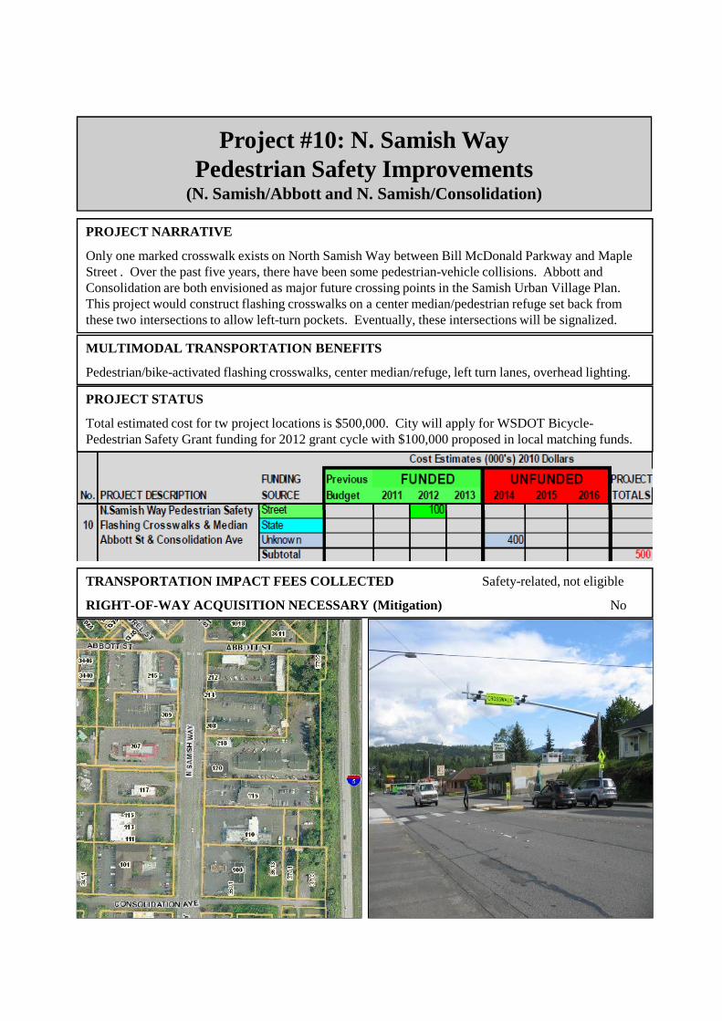
Project #10: N. Samish WayPedestrian Safety Improvements
(N. Samish/Abbott and N. Samish/Consolidation)
PROJECT NARRATIVE
Only one marked crosswalk exists on North Samish Way between Bill McDonald Parkway and Maple Street . Over the past five years, there have been some pedestrian-vehicle collisions. Abbott and Consolidation are both envisioned as major future crossing points in the Samish Urban Village Plan. This project would construct flashing crosswalks on a center median/pedestrian refuge set back from these two intersections to allow left-turn pockets. Eventually, these intersections will be signalized.
PROJECT STATUS
Total estimated cost for tw project locations is $500,000. City will apply for WSDOT Bicycle-Pedestrian Safety Grant funding for 2012 grant cycle with $100,000 proposed in local matching funds.
MULTIMODAL TRANSPORTATION BENEFITS
Pedestrian/bike-activated flashing crosswalks, center median/refuge, left turn lanes, overhead lighting.
TRANSPORTATION IMPACT FEES COLLECTED Safety-related, not eligible
RIGHT-OF-WAY ACQUISITION NECESSARY (Mitigation) No

Project #11: West Horton RoadMultimodal Corridor Extension, Phase 1;
(Horton terminus to Aldrich Road)
PROJECT NARRATIVE
The annexation of 125 acres to the south, including approximately 350 residential units and a new elementary school, the City’s purchase of 20-acres for Cordata Park with vehicle access to parking from Horton requires that West Horton Road be extended and constructed as a secondary urban arterial street with sidewalks, bicycle lanes, and turn lanes from the current terminus to Aldrich Road. Significant environmental constraints will require mitigation and perhaps alternative design for pin-pile sidewalks. Dedicated left-turn lanes will be needed at the intersection of W. Horton/Aldrich.
PROJECT STATUS
City will conduct feasibility study and explore all possible funding sources for reconstruction.
MULTIMODAL TRANSPORTATION BENEFITS
Sidewalks, bicycle lanes, bus pull-outs where possible, turn lanes, increased access, safety, & efficiency.
TRANSPORTATION IMPACT FEES COLLECTED Yes
RIGHT-OF-WAY ACQUISITION NECESSARY (Mitigation) Yes

Project #12: James Street, Phase 2Multimodal Corridor Improvements;
(E. Orchard Drive to Telegraph Road)
PROJECT NARRATIVE
James Street is a major transportation corridor with poor surface and no sidewalks or shoulders that provides access to Sunset Pond Park between Sunset and East Bakerview. Up to 1,500 new housing units are expected from the surrounding 860-acres annexed to Bellingham in 2009. Reconstruction is needed from a minimum rural standard to urban secondary arterial street with sidewalks, bicycle lanes, turn lanes, enclosed drainage, and street lighting from East Orchard Drive to Telegraph Road.
PROJECT STATUS
City continues to explore all possible funding sources for reconstruction.
MULTIMODAL TRANSPORTATION BENEFITS
Sidewalks, bicycle lanes, bus pull-outs where possible, turn lanes, increased access, safety, & efficiency.
E SUNSET DR
N INTER STATE 5
S INTERSTATE 5
TELEGRAPH RD
IRO
N G
AT
E R
D
DIVISION STE MCLEOD RD
MIDWAY LN
WO
BU
RN
ST
BA
KE
RV
IEW
SP
UR
RA
CIN
E S
T
SQUALICUM PKWY
HA
MM
ER
DR
BAKER ST
DE
EM
ER
RD
JAM
ES
ST
RE
ET
RDW ORCHARD DR
WOODSTOCK WAY
ROWAN LN
BIRCHWOOD AVE
6TH ST
E ORCHARD DR
7TH ST
ALPINE WAYAMANDA LN
FRUITLAND DR
COOLIDGE DR
PR
IMR
OS
E L
N
MASONRY WAYGILBERT DR
SP
UR
RID
GE
LN
JAM
ES
ST
RE
ET
RD
¯
TRANSPORTATION IMPACT FEES COLLECTED Yes
RIGHT-OF-WAY ACQUISITION NECESSARY Unknown

Project #13: Barkley BoulevardArterial Safety & Circulation Improvements
(Howe Place to Woburn Street)
PROJECT NARRATIVE
Construct a new eastbound through/right-turn lane from Howe Place to Woburn Street to enhance safety, reduce existing traffic congestion, and accommodate additional infill development in the Barkley Urban Village. This arterial enhancement will provide additional safety for both bicyclists and vehicles crossing Woburn Street, will reduce the significant amount of existing eastbound traffic congestion that backs up along Barkley from the intersection each day, and will benefit regional transportation circulation for all modes in the northeastern portion of Bellingham.
PROJECT STATUS
Unfunded, private partnerships being pursued.
MULTIMODAL TRANSPORTATION BENEFITS
Sidewalks, bicycle lanes, improved safety, reduced congestions, regional circulation benefits.
TRANSPORTATION IMPACT FEES COLLECTED Yes
RIGHT-OF-WAY ACQUISITION NECESSARY Yes

Project #14: Birchwood Ave to James StMultimodal Arterial Connector beneath I-5
PROJECT NARRATIVE
Construct a multimodal arterial connection (pedestrian, bicycle, transit, automobile) from the corner of Birchwood Avenue/Squalicum Parkway generally along the former railroad bed (north of Bug Lake), through the railroad tunnel beneath Interstate 5, to a new intersection at James St/E. Orchard Dr. This new east-west arterial connection will enhance regional transportation circulation for all modes between rapidly-growing northern Bellingham, St Joseph’s Hospital, and central Bellingham. Construction of this arterial street will ease pressure on the Interstate interchanges at Meridian and Sunset.
PROJECT STATUS
Project feasibility is being studied to determine physical space available, environmental issues, construction challenges, and possible combination of on- and off-street bike/pedestrian paths.
MULTIMODAL TRANSPORTATION BENEFITS
Sidewalks, bicycle lanes, bus pull-outs if possible, separated multi-use non-motorized trail.
TRANSPORTATION IMPACT FEES COLLECTED Yes
RIGHT-OF-WAY ACQUISITION NECESSARY Yes

Project #15: Lincoln Creek Transportation Center (WWU/WTA)
PROJECT NARRATIVE: The Lincoln Creek Transportation Center is located along the Interstate 5 corridor within a quarter mile from Exit 252. Approximately 7.8 acres are being redeveloped for public transportation-related improvements to serve Whatcom County, including potential future capacity to serve 800 vehicles. WWU and Whatcom Transportation Authority (WTA) are working together to improve and enhance this site. WWU provides on-going site maintenance and serves as the lead partner. WTA provides 15 minute service within Bellingham and 8 round-trips daily from Bellingham to Mount Vernon. The City of Bellingham is not a funding partner for this project.
PROJECT STATUS
Phase 1: Financed by WWU; transit pull-out, lighting, and new site entry (completed 2004).
Phase 2: Financed by FTA & WWU; NEPA study (completed 2006), stream restoration (completed 2007), and storm water detention vaults.
Phase 3: Re-grading, paving and safety improvements.
Phase 4: Lincoln Street frontage improvements.
Phase 5: Increase parking capacity from 530 to 800 vehicles.
TRANSPORTATION IMPACT FEES COLLECTED Non-City, Not Eligible
RIGHT-OF-WAY ACQUISITION NECESSARY No
34T
H S
T
ASHLEY AV
4 6T
H S
T
47T
H S
T
EXIT 252
ELWOOD AV
N S
AM
I SH
WY
BYRON AV
ELW OOD AV
BYRON AV
MIL
TO
N S
T
J ER
OM
E S
T4 3
RD
ST
CONSOLIDATION AV
BLU
E
BE
RR
Y L
N
PU
GE
T S
T
SA
LMO
NB
ER
RY
LN
NE
VA
DA
ST
DUMAS AV32ND S
T
ALLEN AVE
S 3
7 TH
ST3 5
TH
ST
S 4
2 ND
ST
L IN
CO
L N S
T
I-5
PROJECT SITE

Project #16: Non-MotorizedTransportation Options
PROJECT NARRATIVE: There is currently no 2nd Quarter REET funding for this project category and the Bellingham Transportation Commission will re-prioritize the non-motorized project list for this category during the Comprehensive Plan update process.
PROJECT STATUS: Construction depends on funding and city-wide priority.
TRANSPORTATION IMPACT FEES COLLECTED Not until funding is secured
MULTIMODAL TRANSPORTATION BENEFITS
Sidewalk connections, flashing crosswalks, and bicycle facilities to benefit the city-wide non-motorized transportation network.
Not until funding is secured
RIGHT-OF-WAY ACQUISITION NECESSARY Undetermined

Project #17: Transit Enhancement Options
PROJECT NARRATIVE: While there is currently not a funding source for this project, the intent is to enhance capital facilities and capacity for public transit in order to decrease traffic congestion and reliance on single occupant private automobiles, consistent with the Bellingham Comprehensive Plan Transportation Element goals and policies.
PROJECT STATUS: Construction depends on funding and city-wide priority.
TRANSPORTATION IMPACT FEES COLLECTED Transit not eligible
MULTIMODAL TRANSPORTATION BENEFITS
Additional transit capacity will reduce traffic congestion to benefit the city-wide transportation network.
RIGHT-OF-WAY ACQUISITION NECESSARY No