draft eelgrass protection
TRANSCRIPT


Draft Eelgrass Protection & Management Plan (EPMP) for
Richardson’s Bay
Coastal Policy Solutions
coastalpolicysolutions.comPresentation by: Rebecca Schwartz Lesberg, President, Coastal Policy SolutionsPresentation to: Richardson’s Bay Regional Agency (RBRA) Board of Directors

Coastal Policy Solutions
Outline:• About Richardson’s Bay (RB)• Environmental importance of eelgrass• Existing boundaries in RB• What is the EPMP? Why are we doing it?• What is in the draft report?• EPMP Framework
• Development of the EPMP• Summary of stakeholder feedback• Spatial Analysis• Plan Elements – Proposed Eelgrass
Protection Zone; monitoring and adaptive management; future moorings
• Final thoughts/next steps• Discussion

Coastal Policy Solutions
About Richardson’s Bay• 3,000-acre bay in Marin Co• Ancestral home of Coast Miwok • Today: Sausalito, Mill Valley,
Tiburon, Belvedere, Marin Co• Large ships anchoring since at
least 1890s• 19th/20th shoreline development
(marinas, industry, residences) = loss of historic bayland habitats
Photo: Sausalito Historical Society http://www.sausalitohistoricalsociety.com/sausalito-history

Coastal Policy Solutions
About Richardson’s Bay• Today: critical natural resource
bc of remaining eelgrass beds• 10s of 1000s of
migratory/waterbirds (Globally Important Bird Area)• Pacific herring, marine mammals
(harbor seals, porpoises)• Overlap between designated
Anchoring Area and eelgrass beds = natural resource conflict
Photo: Surf Scoters in Richardson’s Bay, courtesy of Audubon CA

Coastal Policy Solutions
Environmental Importance of Eelgrass• Seagrass, flowering plant• Shallow water bays and
estuaries• Habitat for baby fish, Dungeness
crab, food for birds• Spawning habitat for herring• Last commercial fishery in SFB• Reduces erosion, stabilizes
shoreline, sequesters carbon, reduces ocean acidification
Eelgrass covered in herring eggs.Photo: California Department of Fish and Wildlife

Coastal Policy Solutions
https://www.sfchronicle.com/local/environment/article/Underwater-meadows-of-California-seagrass-found-16065560.php

Coastal Policy Solutions
Threats Facing Eelgrass:• Human activity: shoreline
development, dredging, anchoring
• Climate change: changes in salinity, temperature, depth (sea level rise)
• Water quality: nutrient overload, contamination, turbidity• Probably not as big of an issue in
Richardson’s Bay – water quality testing shows pretty good WQ

Coastal Policy Solutions
Eelgrass in Richardson’s Bay:• Second largest bed in SF, variable in size
(~300-800 acres)• Ongoing damage: Up to 80 acres
removed due to anchor scour or “crop circles”1, approx. 2x size of Alcatraz Island
• Anchor scour is a threat to eelgrass regardless of length of stay/occupancy (though longer generally = worse scour) and the bed needs protection even from visiting vessels
• Certain anchor/mooring techniques can reduce damage, but to adequately protect need to move anchoring activities out of the eelgrass bed
1Kelly, J. J., Orr, D., & Takekawa, J. Y. (2019). Quantification of damage to eelgrass (Zostera marina) beds and evidence-based management strategies for boats anchoring in San Francisco Bay. Environmental management, 64(1), 20-26.Photo courtesy of Audubon California

Coastal Policy Solutions
Existing Boundaries in RB
Jurisdictional Boundaries Use Boundaries

Coastal Policy Solutions
What is the EPMP? Why are we doing it?• RBRA June 2020 Transition Plan,
Policy Direction #5: • “…develop eelgrass protection
measures and consider specific eelgrass restoration funding and projects”
• “The potential designation of up to four zones in RB for varying levels of vessel usage and eelgrass restoration and protection”
• Coastal Policy Solutions retained to implement Policy Direction #5 through development of an EPMP

Coastal Policy Solutions
EPMP – What is in it?1. Introduction: • Background• About RB• Eelgrass in RB• Regulatory/Policy Context
2. EPMP Framework• Development of the EPMP• Summary of stakeholder feedback• Spatial Analysis• Plan elements

Coastal Policy Solutions
Development of EPMP
Policy review
Spatial analysis
Stakeholder Engagement

Coastal Policy Solutions
Development of EPMP1. Policy review• McAteer Petris Act• San Francisco Bay Plan• RB Special Area Plan• CA Eelgrass Mitigation Policy• BCDC Enforcement Committee
direction• RBRA June Transition Plan

Coastal Policy Solutions
Development of EPMP1. Policy review2. Spatial analysis• GIS Analysis: eelgrass frequency
distribution, herring spawning

Coastal Policy Solutions
Development of EPMP1. Policy review2. Spatial analysis3. Stakeholder engagement

Coastal Policy Solutions
Development of EPMP1. Policy review2. Spatial analysis3. Stakeholder engagement
• Five 1.5 hr Zoom listening sessions• Targets: environmental groups,
scientists, elected officials, marina operators, resource/regulatory agencies, RB mariners
• 40+ people, 20+ organizations• No mariner participation in listening
sessions despite robust, targeted outreach
• Reviewed 2018/2019 community feedback from mariners

Coastal Policy Solutions
Development of EPMP1. Policy review2. Spatial analysis3. Stakeholder engagement
• Targeted outreach to mariners: • Links shared at three RBRA meetings,
posted to social media, and shared directly with key members of the mariner community.
• Mariner-focused Zoom listening sessions held on three separate occasions (two during the day, including during and after free lunch provided by Sausalito Presbyterian Church, and one in the evening).
• Email address set up where people could email their thoughts directly to project consultants. No emails were received.
• Significant input rec’d during Mooring Feasibility Study – reviewed here.

Summary of Stakeholder Feedback
Three main themes:
1. Threats to RB to consider during EPMP development
2. Uses to consider during EPMP development
3. Additional Feedback
Coastal Policy Solutions
Photo credit: Marin Independent Journal

Summary of Feedback by Theme (1 of 3): Threats
Sea level rise and other impacts of climate change
Damage from anchors, chains,
and other ground tackle
Loss of maritime culture,
herring/fishing culture
Natural fluctuation in eelgrass
determining static boundaries
Public safety Marine debris Shading and other impacts from docks
Lack of awareness about importance
of eelgrass
Stormwater runoff/water
quality
Regulatory burdens on marina operators
Coastal Policy Solutions
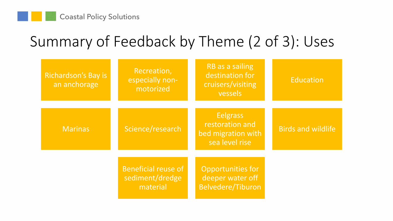
Summary of Feedback by Theme (2 of 3): Uses
Richardson’s Bay is an anchorage
Recreation, especially non-
motorized
RB as a sailing destination for cruisers/visiting
vessels
Education
Marinas Science/research
Eelgrass restoration and
bed migration with sea level rise
Birds and wildlife
Beneficial reuse of sediment/dredge
material
Opportunities for deeper water off
Belvedere/Tiburon
Coastal Policy Solutions

Summary of Feedback by Theme (3 of 3): Add’l
Vessel enforcement will be key to success
Should include monitoring on
ecological scale (10 years+)
Mooring program: Need for spatial analysis, not just
planning
Partnerships important
Don’t make marina operation harder
Eelgrass restoration and
bed migration with sea level rise
Include an alternatives
analysis
Coastal Policy Solutions
Safer, better for eelgrass; should be
considered now rather than a
separate planning process down the
line; visitor-serving, revenue generating
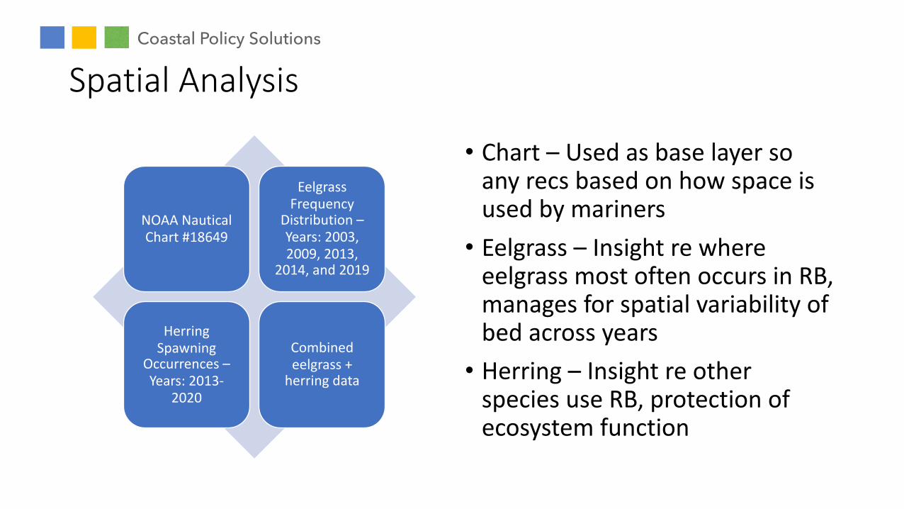
Spatial Analysis
NOAA Nautical Chart #18649
Eelgrass Frequency
Distribution –Years: 2003, 2009, 2013,
2014, and 2019
Herring Spawning
Occurrences –Years: 2013-
2020
Combined eelgrass +
herring data
• Chart – Used as base layer so any recs based on how space is used by mariners• Eelgrass – Insight re where
eelgrass most often occurs in RB, manages for spatial variability of bed across years• Herring – Insight re other
species use RB, protection of ecosystem function
Coastal Policy Solutions

Figure 6- Eelgrass frequency distribution in Richardson's Bay (2003-2019)
Eelgrass Occurrence Frequency
Notes:
Data are derived from side-scan sonar surveys conducted by Merkel and Associates in years 2003, 2009, 2013, 2014, and 2019.
The data layer exhibits the average extent of mapped eelgrass during survey years, regardless of cover class (percent cover/density).
Eelgrass Frequency
Distribution –Years: 2003, 2009, 2013,
2014, and 2019

Notes:
Each purple polygon represents one spawning event. Multiple spawning events occur during each year. Areas of darker purple indicate repeated spawning events.
Eelgrass Frequency
Distribution –Years: 2003, 2009, 2013,
2014, and 2019
Herring Spawning
Occurrences –Years: 2013-
2020

Notes:
The same eelgrass and herring data were used again, this time overlayed to provide a view of combined spatial use. Showed very similar patterns of use.
Eelgrass Frequency
Distribution –Years: 2003, 2009, 2013,
2014, and 2019
Combined eelgrass +
herring data

Plan Elements
1. Proposed Eelgrass Protection Zone/No Anchoring Area
2. Monitoring and adaptive management
3. Future possible mooring program
Coastal Policy Solutions

Plan Elements – Proposed Eelgrass Protection Zone/No Anchoring Area
Description:
• EPZ/NAA proposed northwest of a line from Channel Marker 4 to Audubon Sanctuary
• Protects 90% of eelgrass from anchor damage
• Using existing boundaries/markers keeps things simple
• ONLY applies to anchoring; all other activities (kayaking, sailing, motoring, fishing, marinas, recreation, etc.) unaffected
Coastal Policy Solutions

Major changes:
• Reduces 72 hr Anchorage Area by ~2/3
• Reduces 10 hr anchoring (Belvedere water) by ~ 1/3
• Limits the number of boats the anchorage can support at one time
• Expands area available for non-anchoring activities (e.g., recreation)
• No change to shore access (Turney St.) but removes anchoring in area closest to boat ramp
Coastal Policy Solutions
Plan Elements – Proposed Eelgrass Protection Zone/No Anchoring Area

Considerations:
• Proposed EPZ/NAA aligns closely with 5 ft MLLW contour – many transiting vessels can not anchor in such shallow water
• Majority of “Safe and Seaworthy” vessels already outside EPZ/NAA
• Boats can be anchored more closely together than they are; likely to meet demand for 72 hr anchorage
Coastal Policy Solutions
Plan Elements – Proposed Eelgrass Protection Zone/No Anchoring Area
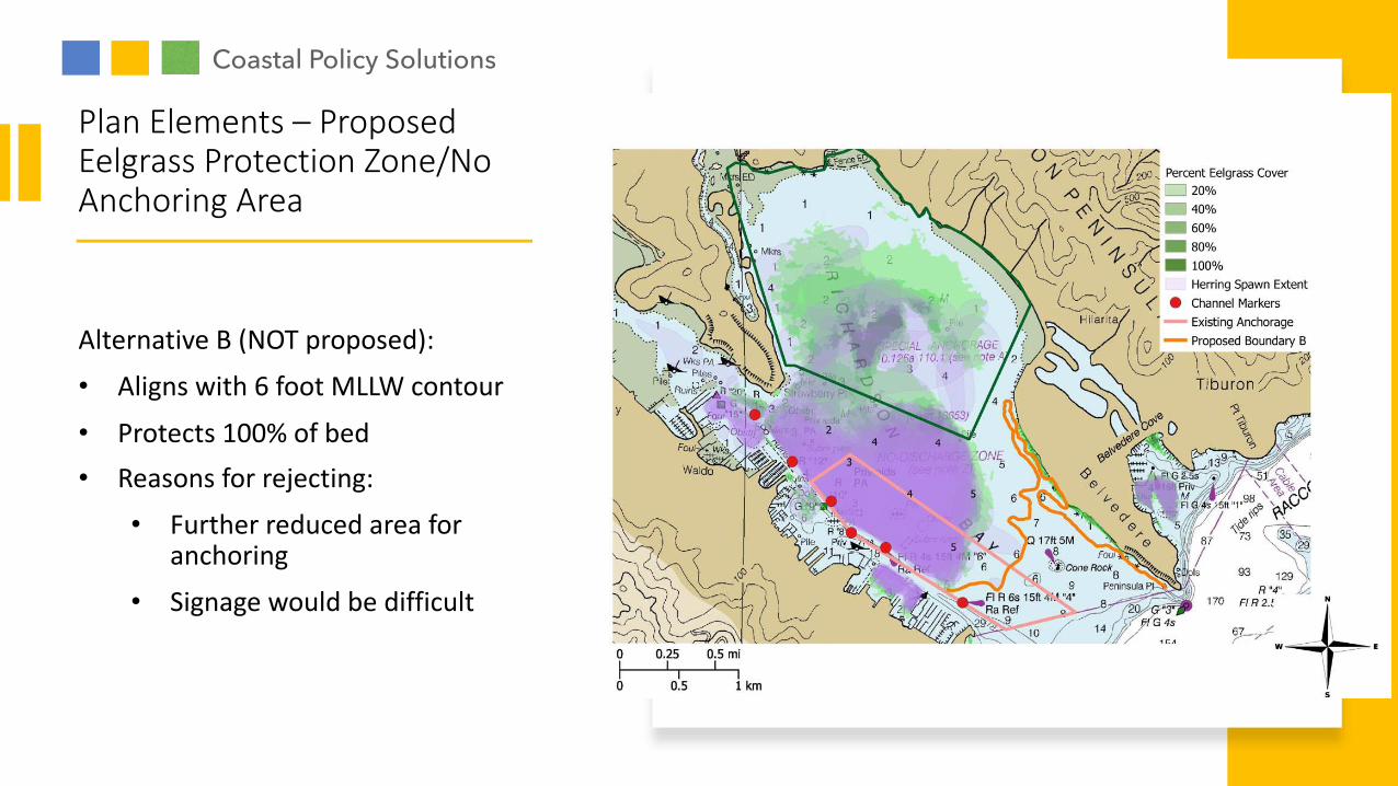
Alternative B (NOT proposed):
• Aligns with 6 foot MLLW contour
• Protects 100% of bed• Reasons for rejecting:
• Further reduced area for anchoring
• Signage would be difficult
Coastal Policy Solutions
Plan Elements – Proposed Eelgrass Protection Zone/No Anchoring Area

Proposed (pending funding):• Annual – Aerial photography & GIS of
anchorage area, quantify damage/regrowth; longer of 10 years or 80% recovery
• Every 3 years – Sidescan sonar (or equivalent) bathymetric mapping, quantify density & spatial extent; continue until 80% recovery then decrease to every 5 years
• Water Quality – Continue twice/year monitoring with RWQCB
• Five Year Adaptive Management Review – Shift accordingly to ensure 90% of bed protected, may increase/decrease EPZ/NAA
Coastal Policy Solutions
Plan Elements – Monitoring & Adaptive Management

• EPMP consistent with future mooring efforts in consideration of 2019 Mooring Study
• Transitioning anchorage à mooring program has many benefits:• Higher density of boats
• Improved public safety
• Revenue generating• Protect bayfloor from anchor
scour• Easier enforcement of time limits
• No Mooring Program proposed here
Coastal Policy Solutions
Plan Elements – Possible Future Mooring Program

Final Thoughts/Next Steps: Feedback, requested changes