draft public meeting no 3 final alts 10 03 06 craig edits
TRANSCRIPT

New Meadows Lake Tidal Restoration Feasibility Study
October 3, 2006 Final Public Meeting
Sponsored by: Sponsored by: Sponsored by: Sponsored by: With funding provided by:With funding provided by:With funding provided by:With funding provided by:

Study Goal & ObjectivesTo develop and evaluate the feasibility of technical alternatives for improving water quality and enhancing ecological resources in New Meadows Lake through increased tidal exchange.
Public InvolvementPublic Involvement • A key component of the study process and any ultimate A key component of the study process and any ultimate
decision-making process.decision-making process.• Tonight is the final public forum held during the study.Tonight is the final public forum held during the study.• The first public forum was held on June 27, 2005.The first public forum was held on June 27, 2005.• The second public forum was held on March 23, 2006.The second public forum was held on March 23, 2006.• The purpose of tonight’s forum is to present results and The purpose of tonight’s forum is to present results and
conclusions from the Study and solicit feedback.conclusions from the Study and solicit feedback.

Study ProgressStudy ProgressStudy ProgressStudy Progress
1. Selection and Evaluation of Final Alternatives

1. Selection and Evaluation of Final Alternatives
2. Evaluation of Potential Benefits
3. Study Findings
Jet Analysis
Final Alternatives

Development of Project AlternativesDevelopment of Project Alternatives• Development and Evaluation of “Conceptual”
Alternatives– Simplified Modeling of Five Conceptual Alternatives
• Development and Evaluation of “Preliminary” Alternatives– Refined Modeling Approach (“Upper and Lower Lakes”)– Six Preliminary Alternatives were Evaluated to Provide
Information on a Broad Range of Alternatives
• Three Final Alternatives Incorporating Five of the Preliminary Alternatives– Similar Preliminary Alternatives Combined as Final Alternatives

Final Alternative 1: Wider/Deeper CulvertFinal Alternative 1: Wider/Deeper Culvert
• Preliminary Alternative 2• Existing Culvert Alignment, 2x
Width with Invert Set 4.5-ft Below Existing Invert
• Higher High Tides in L NML (+1.5 ft) • Lower High Tides in L NML (-3.5 ft) • Increased Tidal Range in L NML (7.0 ft)• Increased Tidal Range in U NML (3.2 ft)
• 29 Acres of Restored Intertidal Habitat

Final Alternative 1Final Alternative 1

Final Alternative 2: Wider and Final Alternative 2: Wider and Deeper CulvertDeeper Culvert
• Preliminary Alternatives 4 & 5• 24-ft Wide Box Culvert, Invert
Set 7.5-ft Below Existing Invert
• Higher High Tides in L NML (+2.0 ft) • Lower High Tides in L NML (-5.9 ft) • Increased Tidal Range in L NML (10.0 ft)• Increased Tidal Range in U NML (3.1 ft)
• 37 Acres of Restored Intertidal Habitat
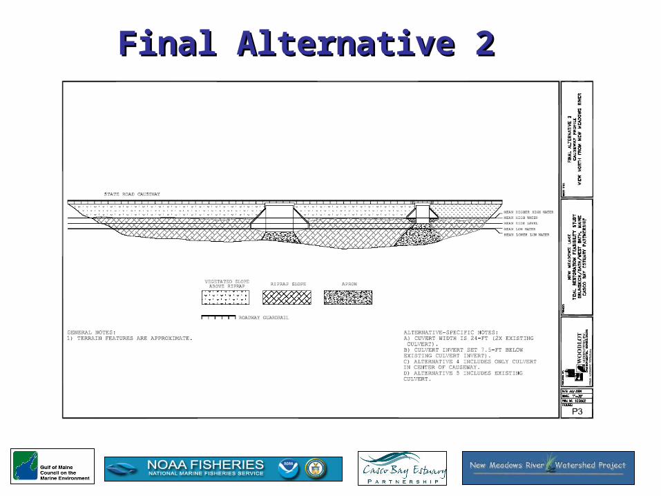
Final Alternative 2Final Alternative 2

Final Alternative 3: Two Larger Final Alternative 3: Two Larger Culverts or Bridge at New LocationCulverts or Bridge at New Location
• Two 24-ft Wide Box Culverts or Bridge with Invert Set 7.5-ft Below Existing Invert
• Higher High Tides (~ +2.6 ft) in L NML• Lower Low Tides (~ -7.1 ft in LNML)• Increased Tidal Range in L NML (~11.7 ft) • Increased Tidal Range in U NML (3.3 ft)
• 42 Acres of Restored Intertidal Habitat
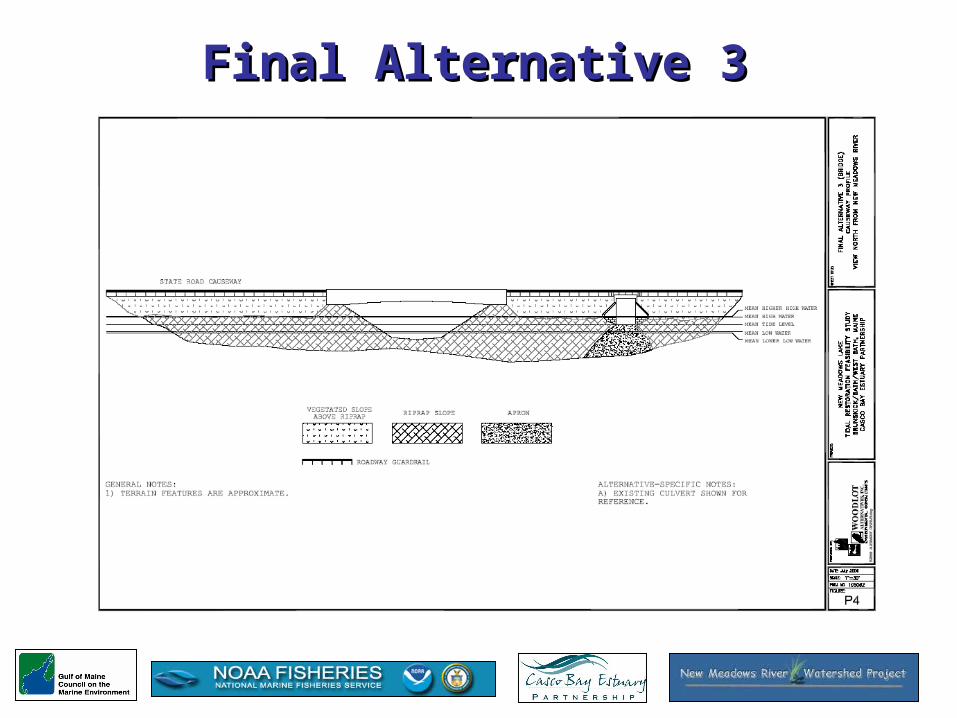
Final Alternative 3Final Alternative 3
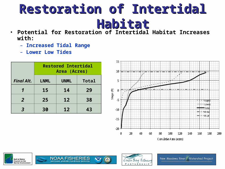
Restoration of Intertidal HabitatRestoration of Intertidal Habitat• Potential for Restoration of Intertidal Habitat Increases with:
– Increased Tidal Range– Lower Low Tides
Final Alt.
Restored Intertidal Area (Acres)
LNML UNML Total
1 15 14 29
2 25 12 38
3 30 12 43

Water QualityWater Quality• Potential for Improved Water Quality
Related to Increased Tidal Exchange
– Study Analysis Suggest that a “Jet” will not Propagate into the “Deep Hole”
– Temperature Data Suggests Recirculation of Water Between Lower New Meadows Lake and New Meadows River (“Slug”, as shown in blue)
– Study Results Suggest that Study Spatial Limits (New Meadows Lake) are Not Sufficient To Evaluate Potential Water Quality Benefits

Water Quality (cont.)Water Quality (cont.)• Recommendations
– Extend Study Limits Seaward (to Thomas Bay?)– Obtain Water Temperature Data Within Larger Study Area,
Including Vertically-Stratified Measurements– Obtain Water Temperature Data a Longer Period (i.e., April –
October)
-20
-15
-10
-5
0
5
10
08/01
/05
08/11
/05
08/21
/05
08/31
/05
09/10
/05
09/20
/05
09/30
/05
10/10
/05
Date
Tem
pera
ture
Dif
fere
nce
(F)
-5
0
5
10
15
20
25
30
35
Sta
ge, N
ew M
eado
ws
Riv
er (
ft)
Temperature Difference (°F), Lake-River
River Stage (ft)
• All of the Final Alternatives would restore substantial areas of intertidal habitat in Lower New Meadows Lake.
• The potential for restoration of intertidal habitat in Upper Lake is limited by the geometry of the channel under the US Route 1 Bridge.
• In general, increasing tidal exchange in the lake will result in improved water quality.
• The volume of tidal exchange and increased tidal range associated with Final Alternative 3 would provide the best opportunity to prevent the formation of stratified conditions in Lower New Meadows Lake.
• Following on this, there is a high likelihood that water quality would also improve in Upper New Meadows Lake.
• Primary constraints on the implementation of the Final Alternatives include socio-economic factors and cost.
Summary of ConclusionsSummary of Conclusions

What’s Next? What’s Next?
The New Meadows River Watershed Steering Committee will meet next Tuesday to assess and recommend areas for further study.
Possible topics for study include:
• How might salt marsh habitat & vegetation around the lake respond to implementation?
• How might low lying areas (i.e. wells or septic systems) be impacted by implementation?
• Need for detailed topography & elevation data • Socio-economic impacts • Are there additional topics we should study?

Comments/Questions?