draft report on shelter response strategy and plan for
TRANSCRIPT

Draft Report on
SHELTER RESPONSE STRATEGY AND PLAN FOR EARTHQUAKE DISASTERS FOR KATHMANDU VALLEY, NEPAL
Report prepared as part of the project “Risk Mapping and Shelter Response Planning for Kathmandu, Nepal” under the “Risk Mapping for Shelter Response” program of the Global Emergency Shelter Cluster (ESC)
Prepared by:
NATIONAL SOCIETY FOR EARTHQUAKE TECHNOLOGY-NEPAL (NSET) Sainbu VDC, Ward No. 4, Bhaisepati Residential Area, Lalitpur GPO Box: 13775, Kathmandu, Nepal Tel: +977-1-5591000, 5592522 Fax: +977-1-5592692, 5592693 e-mail: [email protected] URL: www.nset.org.np
October 2010
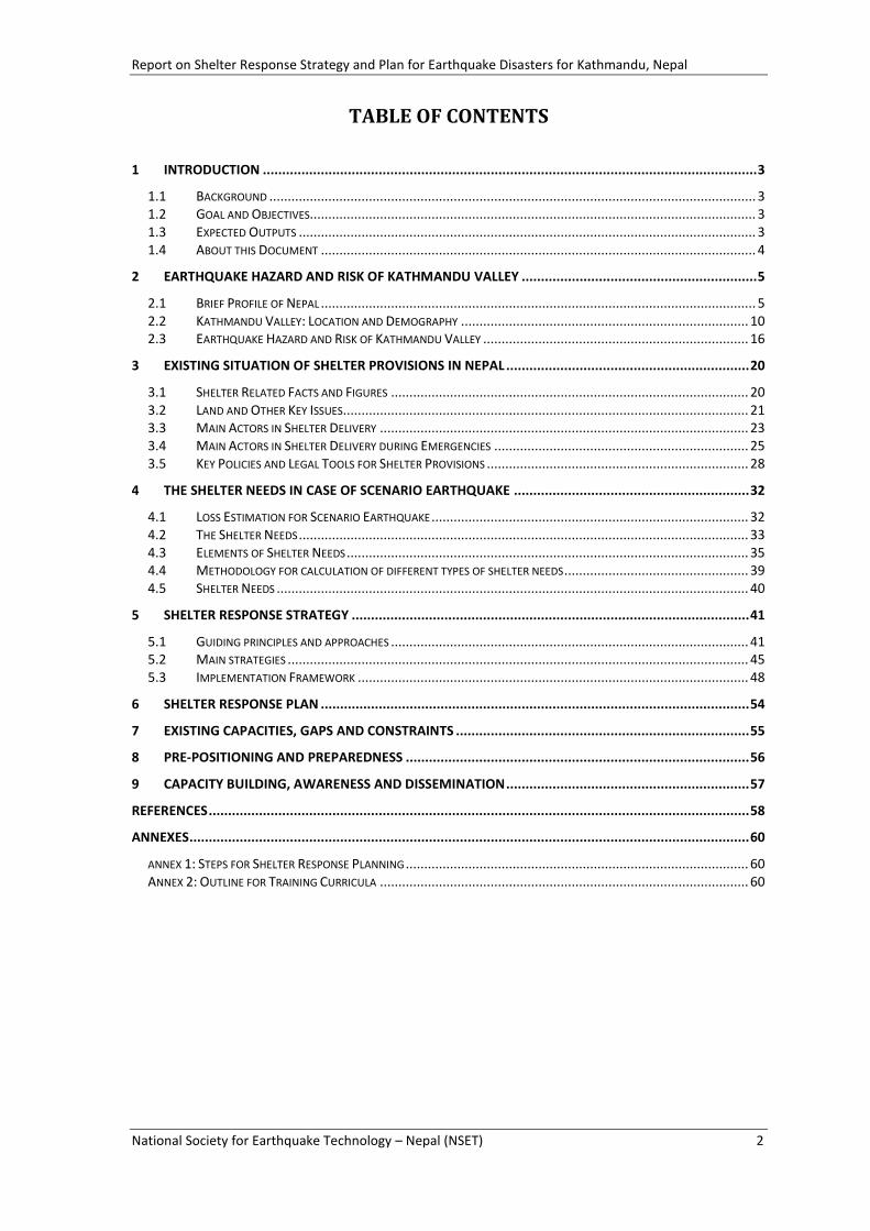
Damage of Houses and Emergency Shelters in Eastern Nepal during 1988 Earthquake Disaster
(Photo Source: Department of Information, GoN)
Report on Shelter Response Strategy and Plan for Earthquake Disasters for Kathmandu, Nepal
National Society for Earthquake Technology – Nepal (NSET) 2
TABLE OF CONTENTS
1 INTRODUCTION ................................................................................................................................ 3
1.1 BACKGROUND .................................................................................................................................... 3 1.2 GOAL AND OBJECTIVES......................................................................................................................... 3 1.3 EXPECTED OUTPUTS ............................................................................................................................ 3 1.4 ABOUT THIS DOCUMENT ...................................................................................................................... 4
2 EARTHQUAKE HAZARD AND RISK OF KATHMANDU VALLEY ............................................................. 5
2.1 BRIEF PROFILE OF NEPAL ...................................................................................................................... 5 2.2 KATHMANDU VALLEY: LOCATION AND DEMOGRAPHY .............................................................................. 10 2.3 EARTHQUAKE HAZARD AND RISK OF KATHMANDU VALLEY ........................................................................ 16
3 EXISTING SITUATION OF SHELTER PROVISIONS IN NEPAL ............................................................... 20
3.1 SHELTER RELATED FACTS AND FIGURES ................................................................................................. 20 3.2 LAND AND OTHER KEY ISSUES .............................................................................................................. 21 3.3 MAIN ACTORS IN SHELTER DELIVERY .................................................................................................... 23 3.4 MAIN ACTORS IN SHELTER DELIVERY DURING EMERGENCIES ..................................................................... 25 3.5 KEY POLICIES AND LEGAL TOOLS FOR SHELTER PROVISIONS ....................................................................... 28
4 THE SHELTER NEEDS IN CASE OF SCENARIO EARTHQUAKE ............................................................. 32
4.1 LOSS ESTIMATION FOR SCENARIO EARTHQUAKE ...................................................................................... 32 4.2 THE SHELTER NEEDS .......................................................................................................................... 33 4.3 ELEMENTS OF SHELTER NEEDS ............................................................................................................. 35 4.4 METHODOLOGY FOR CALCULATION OF DIFFERENT TYPES OF SHELTER NEEDS .................................................. 39 4.5 SHELTER NEEDS ................................................................................................................................ 40
5 SHELTER RESPONSE STRATEGY ....................................................................................................... 41
5.1 GUIDING PRINCIPLES AND APPROACHES ................................................................................................. 41 5.2 MAIN STRATEGIES ............................................................................................................................. 45 5.3 IMPLEMENTATION FRAMEWORK .......................................................................................................... 48
6 SHELTER RESPONSE PLAN ............................................................................................................... 54
7 EXISTING CAPACITIES, GAPS AND CONSTRAINTS ............................................................................ 55
8 PRE-POSITIONING AND PREPAREDNESS ......................................................................................... 56
9 CAPACITY BUILDING, AWARENESS AND DISSEMINATION ............................................................... 57
REFERENCES ............................................................................................................................................ 58
ANNEXES ................................................................................................................................................. 60
ANNEX 1: STEPS FOR SHELTER RESPONSE PLANNING ............................................................................................. 60 ANNEX 2: OUTLINE FOR TRAINING CURRICULA .................................................................................................... 60

Report on Shelter Response Strategy and Plan for Earthquake Disasters for Kathmandu, Nepal
National Society for Earthquake Technology – Nepal (NSET) 3
1 INTRODUCTION
1.1 BACKGROUND
This report on Shelter Response Strategy and Plan for Earthquake Disasters for Kathmandu Valley, Nepal has been prepared by National Society for Earthquake Technology – Nepal (NSET). The response strategy and plan has been prepared as part of Risk Mapping for Shelter Response Project being implemented with the support from UN Habitat, Global Risk Identification Programme (GRIP) of UNDP/BCPR, IFRC and ProVention Consortium; and under the Global Emergency Shelter Cluster of the UN/IASC context. The strategy and plan is expected to guide organized and systematic shelter response in case of a major disaster event like a major earthquake.
The work has been carried out under the broad guidance and leadership of the Department of Urban Development and Building Construction (DUDBC) of the Government of Nepal which is the responsible government institution for urban development and shelter planning. In addition, five municipality offices within Kathmandu Valley; three District Development Committees (DDCs); and other national, international organizations and UN agencies were involved in the strategy and plan development process.
The process of strategy and plan formulation builds upon the experiences and achievements made so far. The Disaster Preparedness and Response Plan Framework (DPRF) for Lalitpur Sub Metropolitan City developed by NSET with the support from UNICEF; The Contingency Plan for Emergency Shelter developed by DUDBC for the IASC; the risk assessments carried out by JICA during Study on Earthquake Disaster Mitigation for Kathmandu Valley; the earthquake scenario of Kathmandu Valley prepared by NSET are some of such key past works which guided the present work. The work also tries to utilize the rich experiences of recent disaster response from around the world specifically the experiences from India, Pakistan and Indonesia. Also, it tries to look the immediate shelter response, transitional shelter response and long-term housing reconstruction and rehabilitation into a logical continuum and try to address the inter-linkage between all three phases.
1.2 GOAL AND OBJECTIVES
The goal of the programme is:
Improved capacity to predict and address post-disaster shelter recovery needs and shelter planning.
The specific objectives are:
Conduct earthquake risk assessment using simplified tool such as RADIUS for effective pre-disaster and post-disaster shelter planning;
Develop guide and strategy for addressing shelter needs which will help the contingency planning process by shelter related stakeholders; and
Develop guidelines and training materials for shelter response planning and strategy development based on the experiences to replicate these activities in other cities.
1.3 EXPECTED OUTPUTS
Similar projects are implemented in Tijuana (Mexico) and Maputo (Mozambique). Based on the lessons and experiences of the three cities the project aims to develop consolidated methodology for shelter response strategy and planning as well as to develop comprehensive

Report on Shelter Response Strategy and Plan for Earthquake Disasters for Kathmandu, Nepal
National Society for Earthquake Technology – Nepal (NSET) 4
training curricula on risk assessment and shelter response planning. Hence, following are the expected outputs from the projects:
a) Earthquake risk assessment and loss estimation done for Kathmandu Valley
b) Main strategies identified for shelter response in case of major disaster event for Kathmandu Valley
c) Shelter response plan developed for Kathmandu Valley
d) Methodology for shelter response planning and template for shelter response plan developed based on the experiences of Kathmandu, Tijuana and Maputo
e) Guidelines and training curricula developed
1.4 ABOUT THIS DOCUMENT
Structure of the Document
Intended User of the Document
Process of preparation and finalization of this document

Report on Shelter Response Strategy and Plan for Earthquake Disasters for Kathmandu, Nepal
National Society for Earthquake Technology – Nepal (NSET) 5
2 EARTHQUAKE HAZARD AND RISK OF KATHMANDU VALLEY
2.1 BRIEF PROFILE OF NEPAL
Nepal lies in between 8004' to 88012' East longitude and 26022' to 30027' North latitude. It has an area of 147,181 sq. Km. extending roughly 885 km. from east to west and varies from 145-241 km north-south. The country is land locked surrounded by India from East, West and South, and China from the North.
Nepal lies in the middle portion of the Hindu Kush Himalayan (HKH) Region. Combination of rugged topography, steep slope, active tectonic process and intense monsoon rain has made this fragile environment vulnerable to various hazards and disasters. It is one of the most disaster-prone countries in the world. Nepal has been experiencing several natural events such as floods, avalanches, landslides, hailstorms, droughts and earthquakes causing loss of lives and properties. Earthquake, fire, storm, flood, landslides, heavy rain, drought epidemic are the main hazard types listed-out in the Natural Calamity (Relief) Act 1982 of Nepal. The country also lies in high seismic prone areas and large-scale earthquakes were frequent in the history of the country. Every year floods damage roads, other infrastructures and ruins fertile agricultural lands. Floods also create the situation demanding emergency evacuation and relocation of people. Landslides have also similar effect on people. Every year a significant proportion of GDP is lost because of natural disasters.
Geography and Climate
Elevation of the country decreases from north to south. It displays extreme variations in natural environment ranging from tropical plain to alpine heights. It has a unique altitudinal variation from 60 meters from mean sea level at Jhapa in the south to 8,848 meters at Mt. Everest in the north, quite a big variation in such a small country within a short horizontal distance of 90 to 120 Km. Due to the east-west orientation of the mountain ranges, the country has a tropical climate in the south and temperate and alpine climates in the north. Accordingly, there are many different forest types in Nepal. Temperature goes on decreasing from south to north with increasing altitude.
Report on Shelter Response Strategy and Plan for Earthquake Disasters for Kathmandu, Nepal
National Society for Earthquake Technology – Nepal (NSET) 6
Nepal can be divided into three major river systems from east to west: the Koshi River, the Gandaki River and the Karnali River. All ultimately become major tributaries of the Ganges River in northern India. After plunging through deep gorges, these rivers deposit their heavy sediments and debris on the plains, thereby nurturing them and renewing their alluvial soil fertility. Once they reach the Terai Region, they often overflow their banks onto wide floodplains during the summer monsoon season, periodically shifting their courses.
Climatic conditions in Nepal vary from region to region. Summer and late spring temperatures range from about 28 degrees Celsius in the hilly region of the country to more than 40 degrees in the Terai. In winter, average maximum and minimum temperatures in the Terai range from a brisk 7 degrees to a mild 23 degrees. The central valleys experience a minimum temperatures often falling below the freezing point and a chilly 12 degrees maximum. Much colder temperatures prevail at higher elevation. The Kathmandu Valley, at an altitude of 1,310 meters, has a mild climate, ranging from 19 to 27 degrees in the summer, and 2 to 20 degrees in the winter with occasional temperatures below freezing point. The annual rainfall in Kathmandu generally exceeds 1,300 mm. Most part of the country average between 1,500 and 2,500 mm in annual rainfall. About 80% of the rain falls during the monsoon period, approximately from the end of June to the middle of September.
The country is traditionally classified into three major geographic regions, notably, Mountain, Hill, and Terai regions. Brief description is given in the following sections.
Mountain Region: These are high mountains in the northern part of the country. The altitude is typically higher than 4,877 m above mean sea level (msl). This region contains 9 of the 14 highest peaks of the world, and it occupies about 15 percent of the country's land surface. Winters are long, cold and severe, while summers are short and cool. Snow/Ice avalanche, debris flow resulting from slope processes and glacier lakes outburst flood (GLOF), are the natural hazards typical for this region. The effects of some of these forms of hazards extend several kilometers downstream, and hence create risk.
Hill Region: The Hill Region covers about 68 percent of the total land area of the country. It is formed by hills, valleys, plateaus and gorges. The Mahabharat Range (up to 4877 amsl) and the Shiwalik (Churia) Range (up to 1,500 amsl) are the two prominent landforms that dictate slope processes in this area. This region mainly suffers from landslide, debris flow, flood, fire, hailstorm, and heavy rains in the form of cloudbursts. This region hosts a large part of population in many villages and towns located on the hill slopes, valleys, and the flood plain terraces. Some of the dense populated valleys in this region are Kathmandu and Pokhara
The region has temperate type of climate with warm summers and cool winters. It experiences the cycle of winter and summer seasons.
Terai Region: The southern part of the country between altitudes from 60 meters to the lower range of mountain region is the Terai region. The lowland Terai occupies about 17 percent of the total land area of the country. It includes the fertile plains formed by the chain of historical floods. The region is known as the breadbasket for the country. A dense forest as a belt is extended east west in this region. Most of the time it experiences sub tropical type of climate. Mainly the region suffers from floods, heavy rain, drought and fires.
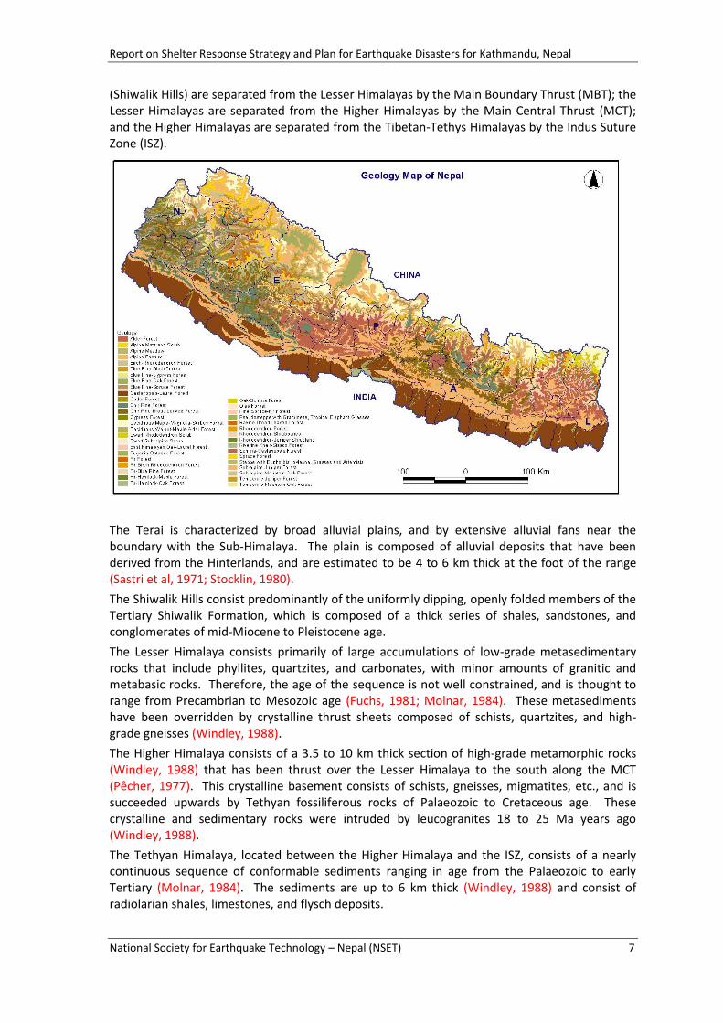
Geology
Nepal can be divided into five major tectonic provinces from south to north separated by major thrusts and faults. These provinces are elongated in a general east-west direction. From south to north these include: the Terai, the Sub-Himalaya (Shiwalik Hills), the Lesser Himalaya, the Higher Himalaya, and the Tibetan-Tethys Himalaya. These tectonic zones nearly correspond to the currently used five-fold classification of physiography of Nepal into Terai, Shiwalik, Middle Mountain, High Mountain, and High Himalaya. The Terai and Indo-Gangetic Plain is separated from the Sub-Himalaya (Shiwalik Hills) by the Himalayan Frontal Fault (HFF); the Sub-Himalayas
Report on Shelter Response Strategy and Plan for Earthquake Disasters for Kathmandu, Nepal
National Society for Earthquake Technology – Nepal (NSET) 7
(Shiwalik Hills) are separated from the Lesser Himalayas by the Main Boundary Thrust (MBT); the Lesser Himalayas are separated from the Higher Himalayas by the Main Central Thrust (MCT); and the Higher Himalayas are separated from the Tibetan-Tethys Himalayas by the Indus Suture Zone (ISZ).
The Terai is characterized by broad alluvial plains, and by extensive alluvial fans near the boundary with the Sub-Himalaya. The plain is composed of alluvial deposits that have been derived from the Hinterlands, and are estimated to be 4 to 6 km thick at the foot of the range (Sastri et al, 1971; Stocklin, 1980).
The Shiwalik Hills consist predominantly of the uniformly dipping, openly folded members of the Tertiary Shiwalik Formation, which is composed of a thick series of shales, sandstones, and conglomerates of mid-Miocene to Pleistocene age.
The Lesser Himalaya consists primarily of large accumulations of low-grade metasedimentary rocks that include phyllites, quartzites, and carbonates, with minor amounts of granitic and metabasic rocks. Therefore, the age of the sequence is not well constrained, and is thought to range from Precambrian to Mesozoic age (Fuchs, 1981; Molnar, 1984). These metasediments have been overridden by crystalline thrust sheets composed of schists, quartzites, and high-grade gneisses (Windley, 1988).
The Higher Himalaya consists of a 3.5 to 10 km thick section of high-grade metamorphic rocks (Windley, 1988) that has been thrust over the Lesser Himalaya to the south along the MCT (Pêcher, 1977). This crystalline basement consists of schists, gneisses, migmatites, etc., and is succeeded upwards by Tethyan fossiliferous rocks of Palaeozoic to Cretaceous age. These crystalline and sedimentary rocks were intruded by leucogranites 18 to 25 Ma years ago (Windley, 1988).
The Tethyan Himalaya, located between the Higher Himalaya and the ISZ, consists of a nearly continuous sequence of conformable sediments ranging in age from the Palaeozoic to early Tertiary (Molnar, 1984). The sediments are up to 6 km thick (Windley, 1988) and consist of radiolarian shales, limestones, and flysch deposits.
Report on Shelter Response Strategy and Plan for Earthquake Disasters for Kathmandu, Nepal
National Society for Earthquake Technology – Nepal (NSET) 8
The Himalaya is said to be the most active and fragile mountain range in the world. The Himalaya is still rising and its rocks are under constant stress as the northward –moving Indian Plate pushes against the more stable Tibetan block. This pressure forces the Himalaya to rise and move horizontally southward along major thrusts. The active nature of the range is also manifested by in frequent earthquakes. Moreover the inherently weak geological characteristics of the rocks make the Himalaya fundamentally very fragile. Triggering factors such as rainfall and earthquakes make the mountains highly vulnerable to landslides and other mass wasting processes. The combination of weak geology and a monsoonal climate makes each physiographic zone of Nepal unique in its vulnerability to landslides; at present the most active parts of the Himalayas are the Shiwalik and the Mahabharat ranges.
A better understanding of the geological nature of the terrain and the interplay of various triggering factors will greatly help in the development of safe infrastructures, mitigation of natural hazards, and the control of environmental degradation.
Administrative Divisions
Nepal is administratively divided into five Development Regions (Eastern Development Region, Central Development Region, Western Development Region, Mid-western Development Region and Far-western Development Region), and 75 administrative districts. Districts are further divided into smaller units, called Village Development Committee (VDC) and Municipalities. The urban centers with relatively high population and with public facilities are designated as Municipalities. Kathmandu is the capital city of the country. Currently there are 3,915 VDCs and 58 Municipalities in the country. Each VDC is composed of 9 wards (the smallest administrative unit of the country) and Municipality ward ranges from 9 to 35 wards.
Demography
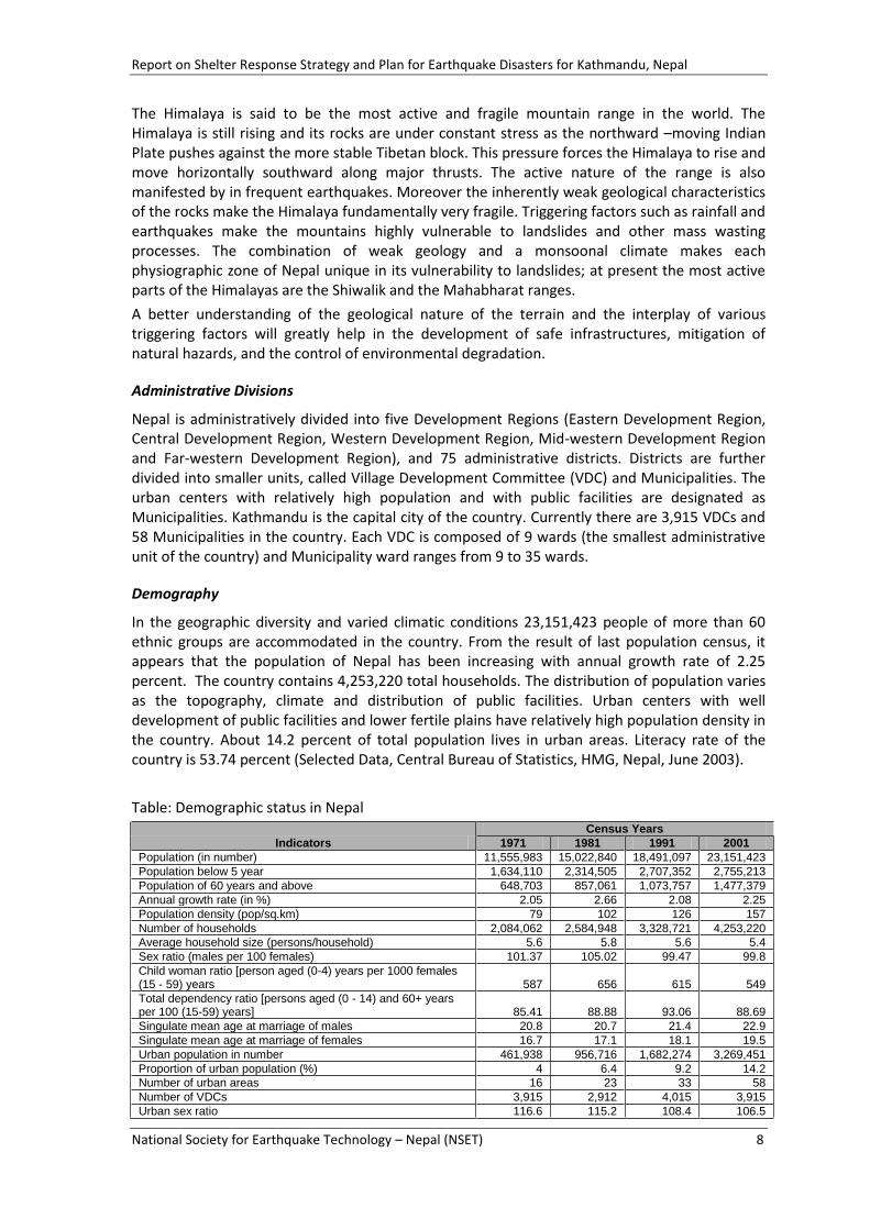
In the geographic diversity and varied climatic conditions 23,151,423 people of more than 60 ethnic groups are accommodated in the country. From the result of last population census, it appears that the population of Nepal has been increasing with annual growth rate of 2.25 percent. The country contains 4,253,220 total households. The distribution of population varies as the topography, climate and distribution of public facilities. Urban centers with well development of public facilities and lower fertile plains have relatively high population density in the country. About 14.2 percent of total population lives in urban areas. Literacy rate of the country is 53.74 percent (Selected Data, Central Bureau of Statistics, HMG, Nepal, June 2003).
Table: Demographic status in Nepal
Indicators
Census Years
1971 1981 1991 2001
Population (in number) 11,555,983 15,022,840 18,491,097 23,151,423
Population below 5 year 1,634,110 2,314,505 2,707,352 2,755,213
Population of 60 years and above 648,703 857,061 1,073,757 1,477,379
Annual growth rate (in %) 2.05 2.66 2.08 2.25
Population density (pop/sq.km) 79 102 126 157
Number of households 2,084,062 2,584,948 3,328,721 4,253,220
Average household size (persons/household) 5.6 5.8 5.6 5.4
Sex ratio (males per 100 females) 101.37 105.02 99.47 99.8
Child woman ratio [person aged (0-4) years per 1000 females (15 - 59) years 587 656 615 549
Total dependency ratio [persons aged (0 - 14) and 60+ years per 100 (15-59) years] 85.41 88.88 93.06 88.69
Singulate mean age at marriage of males 20.8 20.7 21.4 22.9
Singulate mean age at marriage of females 16.7 17.1 18.1 19.5
Urban population in number 461,938 956,716 1,682,274 3,269,451
Proportion of urban population (%) 4 6.4 9.2 14.2
Number of urban areas 16 23 33 58
Number of VDCs 3,915 2,912 4,015 3,915
Urban sex ratio 116.6 115.2 108.4 106.5

Report on Shelter Response Strategy and Plan for Earthquake Disasters for Kathmandu, Nepal
National Society for Earthquake Technology – Nepal (NSET) 9
Total literacy rate in % 13.9 23.3 39.6 54.1
Literacy rate of males in % 23.6 34 54.5 65.5
Literacy rate of females in % 3.9 12 25 42.8
Crude birth rates (per 1000) 41.3 39.6 41.6 32.6
Crude death rates (per 1000) 21.4 13.5 13.3 10
Infant mortality rates (per 1000 live births) na 147 97 64.4
Maternal mortality rate (per 100,000 live births) na na 515 539**
Total fertility rate (children per woman) 6.3 5.3 5.1 4.1
Life expectancy at birth (years) 41 49.5 54.2 60.4
Life expectancy at birth for males (years) 42 50.9 55 60.1
Life expectancy at birth for females (years) 40 48.1 53.5 60.7
Total economic activity rates (%) 59.33 65.13 56.56 58.21
Total agriculture holdings (' 000) 1,721 22 2,736 3,364
Area of holdings ('000 ha) 1,654 2,464 2,597 2,654
Average holding size (area in ha/holding) 0.97 1.13 0.95 0.79
* Not a census year ** Reference data refer to the year 1996
Source: CBS, Population Profile of Nepal Population Census of Nepal, Agricultural Census of Nepal, Demographic and Health Surveys of Nepal (http://www.cbs.gov.np/Population/PopulationProfileofNepal.pdf) access on 30 June 2008.)
Economy
The economy of this country is mainly based on agriculture but the contribution of non-agricultural activities is gradually increasing in GDP. Over 58 percent of total population of working age reported usually economically active in 2001 (Nepal in Figures, Central Bureau of Statistics, HMG, Nepal, 2003). In the Terai, the main agricultural region, rice is the chief crop; other food crops include pulses, wheat, barley, and oilseeds. In the lower mountain valleys, rice is produced during the summer, and wheat, barley, oilseeds, potatoes, and vegetables are grown in the winter. Corn, wheat, and potatoes are raised at higher altitudes, and terraced hillsides are also used for agriculture. Large quantities of medicinal herbs, grown on the Himalayan slopes, are sold worldwide.
Transportation and communication difficulties have hindered the growth of industry and trade. Hydropower is the main source of electricity in Nepal, and there are plans to further develop the potential of the nation's rivers. Nepal's trade is overwhelmingly with India. In recent years, significant deforestation and a growing population have greatly affected the country.
Disaster Profile
Nepal faces a variety of natural hazards, which every year cause significant number of casualties and loss of properties. Disasters caused by flood, landslide, earthquake, epidemics, fire, drought, famine, hailstorm, and few other hydro-meteorological events are most frequent. In one hand, the fragile Himalayan geology, mountainous topography and excessive monsoonal rainfall are primary factors for various hazard events in Nepal. On the other hand, high population growth with haphazard migration and encroachment into marginal land, ecologically sensitive areas, deforestation, agricultural activities in steep slopes, lack of disaster awareness and preparedness have contributed to turning the hazard events into disasters with large number of casualties and huge loss of properties.
According to the Disaster Information Management System (DIMS) using DesInventar, compiled and operated by NSET with initial support from UNDP Nepal, there have been total 15,388 events of large, medium and small size disasters throughout the country. These events have caused death of around 27,256 people in the last 37 years (1971-2007). A summary of the DesInventar database (Table 1) is presented below which clearly explains that Nepal is suffering from frequent natural disasters.

Report on Shelter Response Strategy and Plan for Earthquake Disasters for Kathmandu, Nepal
National Society for Earthquake Technology – Nepal (NSET) 10
Table 1: Summary of Disaster Events during 1971 – 2007 in Nepal (Source: DesInventar Database, NSET)
Event Data-cards
(Events) Population
Deaths Population
Affected
No. of Buildings Damaged / Destroyed
Flood 2,720 2,936 3,367,974 154,104
Landslide 2,184 3,987 479,972 25,451
Earthquake 94 873 4,539 89,020
Fire, Forest Fire 3,978 1,125 228,456 66,395
Epidemics 3,129 15,741 461,952 -
Drought 152 - 1,512 -
Cold Wave 192 298 1,453 -
Heat Wave 31 25 261 -
Famine 20 2 83,902 -
Avalanche 90 217 1,012 28
Other Hydro-meteorological
2,123 1,166 281,661 9,144
Others 675 886 13,868 1,781
Total 15,388 27,256 4,926,562 345,923
A recent study (UNDP/BCPR, 2004) ranked Nepal, in terms of relative vulnerability to earthquakes, as the eleventh most at risk country in the world, and thirtieth with respect to floods. Another report (World Bank, 2005) classifies Nepal as one of the global ‘hot-spots’ for natural disasters.
2.2 KATHMANDU VALLEY: LOCATION AND DEMOGRAPHY
Location
Kathmandu Valley, the capital of Nepal, stands at an elevation of approximately 1,300m and lies in Hills region of the country. It is located between latitudes 27032’13” and 27049’10” North and longitudes 85011’13” and 85031’18” East. Being a valley it is bowl shaped and surrounded by the Mahabharata mountain range on all four sides. Bagmati, Bishnumati, Dhobikhola, and Tukucha the main rivers wind through the city.
The valley has three administrative districts namely Kathmandu, Lalitpur and Bhaktapur. The districts are further divided into smaller units called Municipalities and Village Development Committees (VDC). It consists of five municipalities: Kathmandu Metropolitan City, Lalitpur Sub-metropolitan City, Bhaktapur Municipality, Kirtipur Municipality, Madhyapur Thimi Municipality and 98 VDCs. The total area of three districts is 899 km² whereas the area of the valley as a whole is 665 km². The valley encloses the entire area of Bhaktapur District, 85% of Kathmandu district and 50% of Lalitpur district. A VDC consists of 9 wards and the municipalities consist from 9 to 35 wards. The list of all municipalities and VDCs within the three districts and those within Kathmandu Valley is included in Annex 1.

Report on Shelter Response Strategy and Plan for Earthquake Disasters for Kathmandu, Nepal
National Society for Earthquake Technology – Nepal (NSET) 11
Kathmandu Valley is connected to other parts of the country by two major highways: Prithvi and Tribhuvan from the south-west towards India and Arniko from north-east towards China. It is also accessible by the Tribhuvan International Airport located about 2.5 km from the city center, offering domestic and international flights.
Climate: Kathmandu Valley has a temperate climate, a mild climate most of the year. Summer temperatures range from 19-27°C and in winter temperatures are between 2 and 20°C. Kathmandu experiences all four seasons a year - spring, summer, autumn and winter. Spring is from March through May, and the summers from June to September are hot and humid. Autumn starts towards the end of September and remains till November. Kathmandu’s winter usually begins in December - the period is fairly chilly and lasts until February. During the rainy monsoon season between June and August, there is an average rainfall of between 7.8-14.7 inches (200-375mm) in Kathmandu.
Geological Condition: Rugged and fragile geophysical structure, very high peaks, high angle of slopes, complex geology, variable climatic conditions and active tectonic processes make Nepal including the valley very vulnerable to various types of natural disasters. Although floods and Landslides are the most recurrent, earthquakes remain a major concern.
Report on Shelter Response Strategy and Plan for Earthquake Disasters for Kathmandu, Nepal
National Society for Earthquake Technology – Nepal (NSET) 12
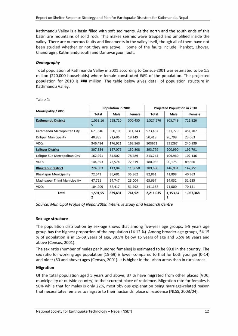
Kathmandu Valley is a basin filled with soft sediments. At the north and the south ends of this basin are mountains of solid rock. This makes seismic wave trapped and amplified inside the valley. There are numerous faults and lineaments in the valley itself, though all of them have not been studied whether or not they are active. Some of the faults include Thankot, Chovar, Chandragiri, Kathmandu south and Danuwargaun fault.
Demography
Total population of Kathmandu Valley in 2001 according to Census-2001 was estimated to be 1.5 million (220,000 households) where female constituted ##% of the population. The projected population for 2010 is ### million. The table below gives detail of population structure in Kathmandu Valley.
Table 1:
Source: Municipal Profile of Nepal 2008, Intensive study and Research Centre
Sex-age structure
The population distribution by sex-age shows that among five-year age groups, 5-9 years age group has the highest proportion of the population (14.12 %). Among broader age groups, 54.15 % of population is in 15-59 years of age, 39.5% below 15 years of age and 6.5% 60 years and above (Census, 2001).
The sex ratio (number of males per hundred females) is estimated to be 99.8 in the country. The sex ratio for working age population (15-59) is lower compared to that for both younger (0-14) and older (60 and above) ages (Census, 2001). It is higher in the urban areas than in rural areas.
Migration
Of the total population aged 5 years and above, 37 % have migrated from other places (VDC, municipality or outside country) to their current place of residence. Migration rate for females is 50% while that for males is only 22%, most obvious explanation being marriage-related reason that necessitates females to migrate to their husbands' place of residence (NLSS, 2003/04).
Municipality / VDC Population in 2001 Projected Population in 2010
Total Male Female Total Male Female
Kathmandu District 1,059,165
558,710 500,455 1,527,576 805,749 721,826
Kathmandu Metropolitan City 671,846 360,103 311,743 973,487 521,779 451,707
Kirtipur Municipality 40,835 21,686 19,149 50,418 26,799 23,663
VDCs 346,484 176,921 169,563 503671 251267 240,839
Lalitpur District 307,884 157,076 150,808 393,779 200,990 192,791
Lalitpur Sub Metropolitan City 162,991 84,502 78,489 213,744 109,960 102,136
VDCs 144,893 72,574 72,319 180,035 90,175 89,860
Bhaktapur District 224,503 113,845 110,658 289,680 146,931 142,751
Bhaktapur Municipality 72,543 36,681 35,862 82,861 41,898 40,963
Madhyapur Thimi Municipality 47,751 24,747 23,004 65,667 34,032 31,635
VDCs 104,209 52,417 51,792 141,152 71,000 70,151
Total 1,591,552
829,631 761,921 2,211,035 1,153,671
1,057,368
Report on Shelter Response Strategy and Plan for Earthquake Disasters for Kathmandu, Nepal
National Society for Earthquake Technology – Nepal (NSET) 13
The proportion of migration is somewhat higher in urban areas relative to rural areas (46 % versus 35 %) and increases with level of household consumption. Among rural areas, Terai has a higher share of migrants than Hills and Mountains.
Urbanization
Urbanization is taking place rapidly. According to the 2001 census, 14.2% of the population live in 58 municipalities and in the next 10 years, this figure is expected to increase to 24% (NPC 2003). The urban population is growing at an average rate of 6.8% per annum against the national population growth rate of 2.3% per annum is the highest growth rate in the South Asia which is quite alarming.
Natural disasters causing loss of properties and houses, environmental degradation and low socio-economic development have attracted huge population in urban centers particularly in Kathmandu Valley for better income opportunities, education, health, safety and other services.
The influx of population from various parts of the country has lead to haphazard urban development and exerted pressure on the infrastructures and the basic services making inadequate. When disaster strikes, the lager and more unplanned the city, the more difficult it is to organize and respond to disaster by the city dwellers and governments.
One-third of its residents live in slum dwellings and 18,000 people are squatters (without land rights).
Cultural and Socio-economic aspect
Densely populated for millennia, Kathmandu’s present demography is very cosmopolitan although Newars, the indigenous people of Kathmandu Valley, still comprise a large segment of the population.
According to a 1991 census, population of Newars is about 42% in the valley, and its breakdown is 40% in Kathmandu District, 64% in Bhaktapur, and 50% in Lalitpur. Newar are a culturally dominant community. Newar has notable features in terms of social cohesion and settlement patterns. These features are the key factors in thinking about disaster mitigation activities. Old city core areas, which are regarded to be vulnerable to earthquake disasters, are Newar settlements. Kathmandu’s culture has been inspired by the convergence of Hindu and Buddhist traditions and traditional customs, festivals, art, and literature are religious in character.
Settlement Characteristics
The urbanization and city development in Kathmandu Valley can be categorized into five broad categories.
1. City cores / old settlements
2. Urban areas (newer than core cities)
3. Newly developed sub-urban areas
4. Rural areas
5. Slum dwellings / squatter settlements
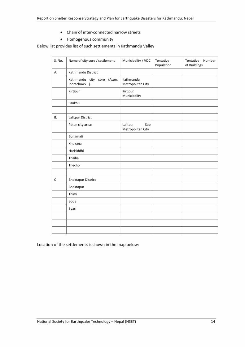
1. City cores / old settlements
Kathmandu Valley consists of many old settlements with high population density and traditional buildings. These old settlements are scattered in different locations within the valley: in the municipalities and in the VDCs. A few examples of such old settlements are: Asan, Bhaktapur, Patan, Bungmati, Harisiddhi, Khokana etc. Main characteristics of such settlement are:
Old buildings made of brick in mud or adobe construction
Houses in row
Report on Shelter Response Strategy and Plan for Earthquake Disasters for Kathmandu, Nepal
National Society for Earthquake Technology – Nepal (NSET) 14
Chain of inter-connected narrow streets
Homogenous community
Below list provides list of such settlements in Kathmandu Valley
S. No. Name of city core / settlement Municipality / VDC Tentative Population
Tentative Number of Buildings
A. Kathmandu District
Kathmandu city core (Ason, Indrachowk…)
Kathmandu Metropolitan City
Kirtipur Kirtipur Municipality
Sankhu
B. Lalitpur District
Patan city areas Lalitpur Sub Metropolitan City
Bungmati
Khokana
Harisiddhi
Thaiba
Thecho
C Bhaktapur District
Bhaktapur
Thimi
Bode
Byasi
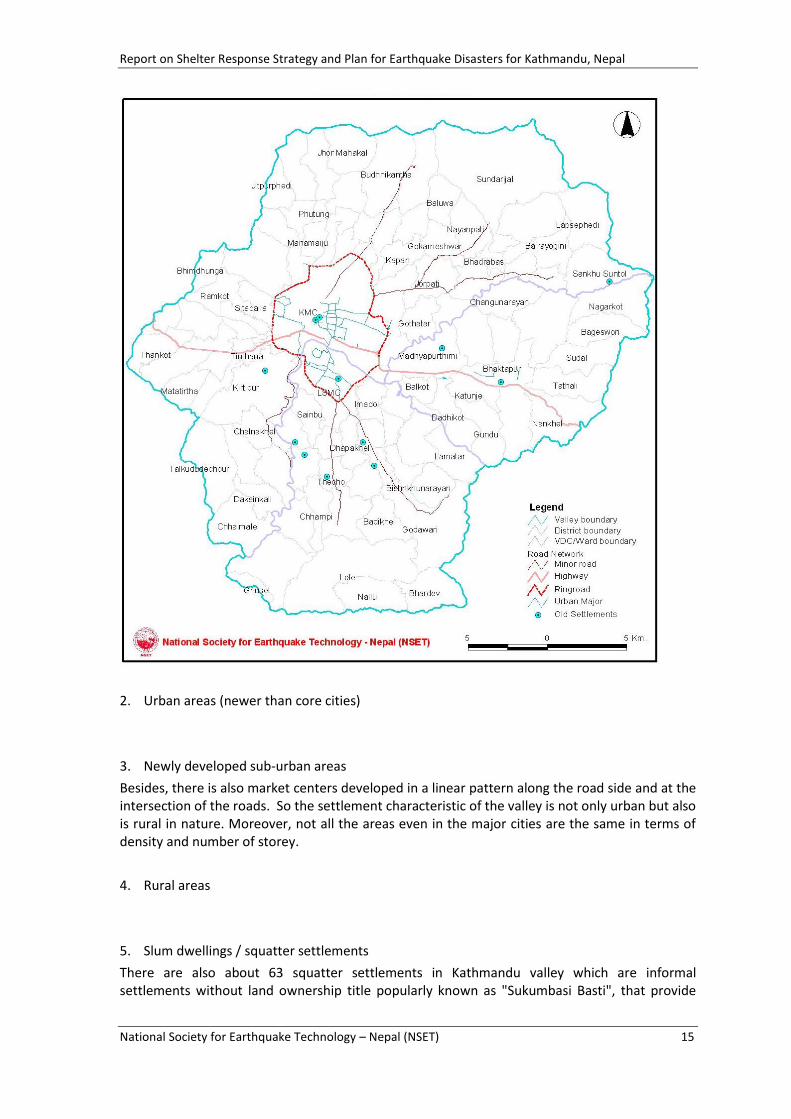
Location of the settlements is shown in the map below:
Report on Shelter Response Strategy and Plan for Earthquake Disasters for Kathmandu, Nepal
National Society for Earthquake Technology – Nepal (NSET) 15
2. Urban areas (newer than core cities)
3. Newly developed sub-urban areas
Besides, there is also market centers developed in a linear pattern along the road side and at the intersection of the roads. So the settlement characteristic of the valley is not only urban but also is rural in nature. Moreover, not all the areas even in the major cities are the same in terms of density and number of storey.
4. Rural areas
5. Slum dwellings / squatter settlements
There are also about 63 squatter settlements in Kathmandu valley which are informal settlements without land ownership title popularly known as "Sukumbasi Basti", that provide

Report on Shelter Response Strategy and Plan for Earthquake Disasters for Kathmandu, Nepal
National Society for Earthquake Technology – Nepal (NSET) 16
housing for about 2,600 families or nearly 15,000 people. Most of these informal settlements are on government land such as sides of the roads or highway, river bank.
2.3 EARTHQUAKE HAZARD AND RISK OF KATHMANDU VALLEY
Seismicity
Geologically Nepal sits astride the boundary between the Indian and the Tibetan plates. The Indian plate is continuously moving or subducting under the Tibetan plate at a rate thought to be about 3 cm per year. The existence of the Himalayan Range with the world's highest peaks is evidence of the continued tectonic activities beneath the country. As a result, Nepal is very active seismically.
The most recent earthquake felt in Kathmandu was a swarm of 3.9 to 4.2 Richter magnitude event which awakened the city dwellers on 6 July 1993 between 3 and 4 am. The epicenters were located about 40 km north of Kathmandu. Although these were small events, they created a panic among the population as many believed them to be pre-cursor to a larger event. A house collapsed about 8 hours after the event, killing one person and burying others. The building collapse was linked to the shaking although the building was fairly old and weak.
The great Bihar-Nepal earthquake occurred in 1934 with a magnitude of 8.4. The epicentre for this event has been located in the eastern Nepal about 240 km away from Kathmandu. The Valley experienced intensities of IX-X in the Modified Mercalli scale. The majority of the reported destruction from the earthquake occurred in Kathmandu Valley and along the eastern Terai (the plains bordering northern India). A total of 8519 persons were reported dead and more than 80 000 houses damaged in the country. Kathmandu Valley's share of this was 4296 persons dead and 12 397 houses totally destroyed. Seventy percent of the then-standing houses in the Valley were affected. This event confirmed that, because of its geological characteristics, Kathmandu Valley is susceptible to enhanced damage during an earthquake event.
The 1988 (magnitude Ms 6.6) Udayapur earthquake occurred in the vicinity of the Terai and Siwalik Hills 165 km to the south-east of Kathmandu. The damage was concentrated in the plains of the Terai in a pattern similar to the 1934 earthquake. Kathmandu and Bhaktapur districts were declared earthquake-affected areas. A few very old buildings were damaged in Kathmandu while several houses collapsed in Bhaktapur. Several people were injured, mainly because of the resulting panic. Some deaths were also reported in the Valley.
Earlier major earthquakes were reportedly felt in the Kathmandu Valley in 1255, 1408, 1681 and 1810 with intensities (Modified Mercalli) of approximately IX to X.
Active Faults in the Valley
Ongoing neo-tectonic activity within the Kathmandu Valley is demonstrated by the presence of active faults that displace sediments of Pleistocene to Holocene age. Five such faults have been identified during the seismic hazard mapping study undertaken by the National Building Code Development Project.
The Thankot fault is a well-defined dip-slip (normal) fault that strikes north-northwest, and truncates the toe of an alluvial fan (downward to the northeast) on the southern slopes of the Chandragiri Range. The total length of this fault is 8 km. An apparently conjugate fault- Basigaon Fault, with an opposite down-throw but similar strike and a length of 3 km, is located nearby. This is about 5 km from the central Lalitpur and about 8 km from the Kathmandu City centre.
Another dip-slip fault was identified in the flood plain of the Bagmati River in the Pharping area about. The western side of this north-striking fault is down thrown.
Report on Shelter Response Strategy and Plan for Earthquake Disasters for Kathmandu, Nepal
National Society for Earthquake Technology – Nepal (NSET) 17
A fault that runs along the northern foothills of Kirtipur-Chobhar Ridge, about 5 km from the centre of Kathmandu, is believed to have been reactivated after the mid-Pleistocene, tilting the otherwise almost horizontal mid-Pleistocene lake-bed sediments southward. This is interpreted to be a dip-slip fault with the northeastern side down thrown.
The Bungamati fault is also within 5 km from Lalitpur. It strikes north-northeast from the channel of the Bagmati River to the village of Sunakothi and has an interpreted length of 6.1 km. Although the sense of displacement is not clear, it appears to be a right lateral strike-slip fault.
These faults are believed to be capable of generating a maximum of a 6.6 Richter event. However there has not been any detailed study carried out to quantify these faults as to their activity.
Other active faults have been identified outside the Valley but within distances of 20 to 50 km from Kathmandu. The Kalphu Khola Fault to the northwest of the Valley is interpreted as being capable of generating earthquake with a maximum possible magnitude of 6.9 Richter while the Kulikhani Fault, lying to the south, has been assigned the maximum earthquake magnitude of 6.9. Similarly, the Sunkosi-Rosi Fault, which lies about 35 km southeast of Kathmandu, has been assigned a maximum earthquake magnitude of 7.1. Any major earthquake along these faults are also sure to affect the Valley.
Rock/Soil Types
Kathmandu Valley is an infilled lake basin that appears to have been formed during the Quaternary period, primarily by rising of the Mahabharat Lekh, the mountain range that forms the southern boundary of the Valley. This uplift is believed to have resulted in the damming of the southward flowing valley drainage, causing the formation of a lake, and the subsequent deposition of layers of river and lake sediments that are at least 450 m thick in total. The lake subsequently drained out via a gorge along the Bagmati River.
The topography of the Kathmandu Valley rim is rugged. It is characterised by steep valleys and ridges. The present land surface over most of the basin shows characteristic flat-topped terraces at different levels. These have resulted from the various historic levels of the Bagmati River system.
The unconsolidated sediments of the Kathmandu Valley vary widely in composition. In general, the sediments in the northern half of the Valley consist of typical river-bed layered deposits of clays, silts, sands, and gravels, while those in the southern half are mainly lake-bed deposits of clays and silts, usually sandwiched between thin layers of coarser sediments. The detailed picture is far more complex, with considerable local variation over short distances.
Such a composition of the valley sub-surface makes it susceptible to damage during an earthquake. Many observers have likened the soil conditions of Kathmandu Valley to those of Mexico City which is notorious for susceptibility to damage during an earthquake.
Potential Secondary Hazards in the Kathmandu Valley
The identification of active faults in the Kathmandu Valley indicates that there are both primary and secondary earthquake hazards in the Valley since these features can be the sources of strong ground motion as well as surface rupture. The following three main types of likely secondary seismic hazards that have been identified for Kathmandu Valley are considered in detail: surface fault rupture, soil liquefaction and earthquake-induced landslide. A fourth potential secondary seismic hazard, soil amplification, has also been suspected.
Maj. General B.S. Rana described in his book on the 1934 earthquake the effects of the 1934 earthquake which suggest widespread liquefaction occurred in Kathmandu Valley. He describes heavy development of fissures in roads and in paddy field with water ejecting from these fissures. At some places the height of the fountain of water ejected from the ground reportedly
Report on Shelter Response Strategy and Plan for Earthquake Disasters for Kathmandu, Nepal
National Society for Earthquake Technology – Nepal (NSET) 18
reached 3-4 m. It supports the recent assessment that the valley sediments are susceptible to liquefaction during a major earthquake.
Soil amplification is generally regarded capable of creating problems during earthquakes in the Valley. It is apparent that areas underlain by thick successions of Kalimati clay are likely to suffer the most damage.
Potential loss in Kathmandu Valley during a large seismic event
There have been number of studies conducted for earthquake loss estimation for Kathmandu Valley. The following are the main earthquake risk assessments carried out so far.
Earthquake Scenario of Kathmandu Valley prepared by Kathmandu Valley Earthquake Risk Management Project (KVERMP) of NSET in 1997
Study on Earthquake Disaster Mitigation (SEDM) for the Kathmandu Valley in 2002 by JICA
Cross-Cutting Theme Initiative for Kathmandu Metropolitan City (KMC) in 2003 by UNESCO, NSET and KMC
Out of the three studies, the risk assessment carried out during SEDM by JICA is assumed to be a more comprehensive study in terms of field data collection, geographical coverage, use of GIS tools and involvement and interaction with key stakeholders [Ramesh 2008]. Hence, the risk assessment results of this study have been used in this shelter response planning work. The summary of the study results is as presented below:
Building Damages
Around 20% of the total buildings were heavily damaged. Higher rates of damage were seen in weak building types such as earthen-mud, stone and adobe. Lower percentages were experienced in BC or RC buildings, but even many of these were damaged due to low engineering standards, and weathering by moisture and inadequate foundations. Many houses collapsed with bricks, iron, timber, furniture and dust. The number of damaged buildings was much greater in urban areas than rural areas, with almost half of the buildings in the whole Valley experiencing some kind of damage.
Casualties
Most of the death toll of 18,000 resulted from the collapse of houses. Specifically half of the deaths and injuries were concentrated in the urban areas of Kathmandu Municipality. Most corpses remained in the debris of buildings for a number of days and the capacity for proper cremations was overtaxed. Most of the 147,000 injuries were caused by building collapse and objects falling from buildings or within buildings (such as furniture). Over half of the deaths and injuries consisted of older people, children and women. A significant number of visitors to Kathmandu, including tourists, were killed and injured.
Fire, Blockage and Debris
Although fires broke out in tens of places, most did not spread due to the primarily inflammable building materials. One of the serious problems was that buildings along roads and highways collapsed onto the roadway and blocked access at many places, especially in the recently developed core and commercial areas. The debris of buildings was mostly reused for reconstruction, and the materials caused weakness of the reconstructed buildings. Already retrofitted schools were safe and generally suffered only slight damage.
Medical Care and Hospitals
Serious injuries requiring hospital care reached 53,000 and other injuries were another 94,000. Limited resources of doctors, nurses, medicines and other resources or facilities were critical. Assistance from abroad helped significantly, but it arrived several days after the earthquake.

Report on Shelter Response Strategy and Plan for Earthquake Disasters for Kathmandu, Nepal
National Society for Earthquake Technology – Nepal (NSET) 19
Homeless, Refugees, Shelters
Around 500,000 people were left homeless and they gathered in shelters or open spaces, searching for their families and relatives. Many affected people were forced to use river water for drinking and washing. Space in shelters and materials were limited and insufficient for serving all the homeless people. Almost 10,000 people stayed at shelters for a long time. Not only people in the shelters but also many others complained about the government’s inadequate preparation and management of the crisis.
Education and schools
Sixty percent of the public schools were damaged, because their buildings were very poor and vulnerable. Over 40,000 children were affected. Many remaining schools were used as shelters for a long time for the people who lost their houses or they could not be used at all.
Infrastructure (Roads, Bridges and Airport)
Fortunately, there were not too many incidents of damage or cracks in highways and roads, except blockage by collapsed buildings in dense areas. In the western mountainsides, slope failures occurred, causing blockage and suspension of access to and from India. In lower land, several bridge failures occurred due to liquefaction. Difficult access between big settlements was the most significant problem for at least a few days, the most important days for emergency response. The airport also suffered slight damages. Except for recovering from the suspension of power, the airport’s functionality recovered in a few days and it was activated for transportation of necessary materials and resources from outside of the Valley.
Water Supply and Sewage
Damages to water pipelines affected a total of 80% of the users in municipal areas. All available water supply trucks tried to move among the dwellings to compensate for the loss of supplies from broken pipelines. But the lack of access in the narrow streets hindered truck access. Insufficient supplies to municipal people lasted a very long time.
Power Supply
Damage to power lines was concentrated in Kathmandu Municipality. Many power cables, mainly lower voltage lines, were cut by the shaking of the ground and supporting poles. Since electricity is the most important lifeline facility, emergency efforts were focused on their recovery by the management of NEA (Nepal Electricity Authority). The recovery of electric power provided the suffering people with enhanced ability to promote rehabilitation, rescue/relief and recovery activities.
Communication and Information
a) Telecommunications
Telecommunications stopped completely, and the earliest information of the tragedy was transmitted by satellite phone to the world. After several days, most of the telecommunications had been recovered and mobile phones played an important role.
b) Media (TV, FM-radio and newspaper)
Power failure caused a suspension to broadcasting. Half of the FM radio stations had their own home power generator, and after recovering power the next day, they continued to broadcast safety information, information about relief supplies for victims, and requests for volunteers in the Valley. As for newspapers, damage to the buildings was moderate, but facilities and equipment for printing suffered seriously.

Report on Shelter Response Strategy and Plan for Earthquake Disasters for Kathmandu, Nepal
National Society for Earthquake Technology – Nepal (NSET) 20
3 EXISTING SITUATION OF SHELTER PROVISIONS IN NEPAL
3.1 SHELTER RELATED FACTS AND FIGURES
Housing stock, demand and deficit
In 1991, Nepal had population of 18.5 million for a total estimated housing stock of 3 million dwelling units of which 2.7 million were in rural areas and 0.3 million in urban areas (National Housing Survey, 1991). According to the census 2001, there were 4.2 million housing stock for 22.7 million populations. This reveals that the ratio of the housing stock and the population has not changed significantly since 1991.
The NHS had estimated the housing need of 144,880 units and supply of 122,135 units, resulting in the housing deficit of 22,745 units every year. In addition, 0.76 % in urban areas and 2.4 % in rural areas are damaged by natural calamities. About 7% of the families are estimated to be homeless (NPC 1987). Yearly percentage increase in number of dwelling units is just 4.0 %
The shelter model developed by UNCHS for Nepal shows a need of 2.5 million units during 1992-2006. Of the total, 434000 units are required in urban areas (17%) and the rural needs 2.1 million units (83%). In Kathmandu Valley, with household size of 5 till 2011 and 4.5 from 2011 to 2021, the total dwelling units needed till 2021 will be about 4,35,662, i. e. 15% of the total population of 2001 (16,18,159) in the valley (KVTDC, 2000).
There is a total upgrading need of 732000 units during the 15 year planning period of which 60000 units are in urban areas. People going for rental housing generally compromise with spaces, physical condition of the building and other facilities to bring down the cost. The building conditions of squatter settlements are poor with lack of habitable spaces inside the building and open spaces and other amenities outside the building.
The housing demand in the valley includes not only the ever increasing population but also for those who are living in squatter settlements and staying in insufficient housing spaces in the core area and in rental housing.
Housing standard
There is no minimum standard on housing either in terms of floor area or construction materials. Land can be divided into parcels that are small enough to be affordable. However, minimum of 20 ft frontage and 748 sq. ft. of land area is being practiced in urban areas after the decision made in one of the cases by the Supreme Court.
The occupancy rate in urban and rural areas was 6.0 and 6.1 respectively in 2001.
A dwelling size is measured by number of rooms and its surface area. In 1991, the average size of the dwelling unit was found to be 867.5 sq. ft. and the area occupied by per person was 134.7 sq. ft and 158.2 sq. ft. in urban and rural areas respectively (NHS 1991). The average size of the dwelling unit declined to 604 sq. ft. in 1995/96 and 531sq.ft. in 2003/04 (NLSS 2003/04). Average number of rooms per household is 3.7 in the country. While urban households have one more room than rural households on average (4.5 versus 3.5). Households from the richest consumption quintile have two more rooms on average relative to those households from the poorest quintile indicating greater degree of crowding in poorer households.
Typology/Tenure of households
Household occupants are broadly categorized into owners, renters and squatters. About 86.1 % of households reside in their own housing units, 6.7 % are renters and 7.21 % squatters (NHS 1991).
Report on Shelter Response Strategy and Plan for Earthquake Disasters for Kathmandu, Nepal
National Society for Earthquake Technology – Nepal (NSET) 21
The proportion of renters has increased from 6.7 % to 8.9 % in the decade (census 2001). In urban areas, a significant percentage of households are in rental accommodation (24 %) and the proportion is 33 % in the Kathmandu valley urban areas alone (NLSS 2003/04).
There is a growing phenomenon of squatter settlements in both rural and urban areas. The squatter settlements in Kathmandu is increasing at the rate of 12-13 % representing 2.9 % of the total population of Kathmandu at present. In Kathmandu about 60 % of squatting is on public land like sides of the roads or highway, river bank etc. and remaining 40 % in public buildings such as temple sites and rest houses which are sheds constructed by the ancestors for performing social and religious functions (Rabenau, 1990).
Housing construction
Construction of a house also falls in the domain of owner builder as housing as a whole is the responsibility of an individual. More than 90 % of the houses are built by this process. This process normally takes years and even decades and housing itself is a stepwise never ending process. The owner builders' efforts in housing production are characterized by a high degree of informality. In municipal areas, after registering the plot and obtaining building permit from the municipality, the owner builder makes own decisions supported by advise from friends, neighbors and occasionally from professionals. S/he deals with the building material suppliers and small contractors on personal basis. S/he manages to do as much as to keep the cost down by organizing most activities himself. In addition, the owner builder has to provide most of the infrastructure before the government infrastructure reaches there much later.
Building materials
The most common building materials for wall are bricks, stones and tree branches and for roofing C. G. I. Sheet, R.C.C., tiles/slates, and straw/thatch. 48 % of the housing units are walled by mud-bonded bricks/stones. Other materials include wood and tree branches (19 %), cement bonded bricks/stones and concrete (18 %) and others (16 %). The quality of the dwelling unit is very much related with the household consumption. Richer households are more likely to wall their housing with either cement/concrete or bricks/stones while poorer households wall them with bricks/stones and other materials.
3.2 LAND AND OTHER KEY ISSUES
Land Management
Land is the most important factor related to shelter. Open land /space are quite valuable for evacuation of the people during disasters and afterwards.
Availability of vacant or open lands is not a problem in scattered and rural settlements. Such lands are also available even in the city core as the open spaces are the characteristic of urban fabric of Kathmandu Valley. However, they are being encroached by the neighboring people.
Land management in Nepal is centralized. Land is either privately owned or belongs to the central government. Most of the government structures occupy public land. All forest lands fall under pubic land category. Land not registered belongs to the government. Land not important from agricultural production or vulnerable and marginalized land such as land along the river banks were used to be the government. But with the increasing commercial value of such land and due the lack of proper documentation most of them have already registered over the years particularly in Kathmandu. Despite of this, few such lands are still remained. Either public or private vacant land/space can be used for emergency shelter response. However, it is not possible to utilize privately owned in transitional and rehabilitations stage except for the owners themselves. The government either can use some of its land such as forest land or can acquire land required in transitional stage.

Report on Shelter Response Strategy and Plan for Earthquake Disasters for Kathmandu, Nepal
National Society for Earthquake Technology – Nepal (NSET) 22
As per Land Acquisition Act Government can acquire land for development purposes by giving compensation to the land owners. But due to high price of the land and limitation of financial resource with lengthy and complex acquisition process, it is not desirable unless it is absolutely essential. Considering the area of land required in rehabilitation stage, shelter response through land acquisition does not seem possible.
Land pattern is very much irregular in shape and size. Most of the land does not have adequate access to basic infrastructure facilities. In many instances, chunk of land is blocked due to the lack of vehicular access. Land recording and mapping system is not very good. Land use is not effective. In the absence of a consolidated land information system as a whole, getting information on the availability of the land for shelter response in later stage is also not easy.
National land use management system and relevant legislation
Land use regulations and development are a function of both the City and national governments. Large-scale infrastructure within the City is under the central government’s jurisdiction. However, city roads, solid waste management, street lighting, and such are operated and promoted by City government. Land use management, though not currently existing in an integrated form, is the responsibility of the City government.
Housing Finance and Affordability
Since housing is the individual's responsibility, it is predominantly owner-financed type, which means families acquire land directly, organize and manage the housing construction and finances the whole process in the absence of institutional finance. Regular government employees can borrow loan from the Employee’s Provident Fund though it covers only a small fraction of the total construction cost.
People get financial support from friends and relatives as there is a culture of helping a person who is building a house in a form of a loan with no interest or with very nominal interest rate. Moreover, commercial banks and financial institutions also have started providing loan for housing. After the establishment of the first Nepal Housing Development Finance Company in 1992 followed by other financial institutions, both government and private commercial banks also provide wider range of housing loans on various schemes for individual as well as for developers with long term repayment period. People generally keep land on mortgage to get loan. Few banks provide loans for all income groups offering individual loan of NRs 300,000 to 500,000 with payback period of five years, on the conditions that the borrowers’ income should be three times that of the monthly installment of repayments.
It is difficult to say the cost of a housing unit precisely as there is no systematic documentation system as a whole. Moreover, the cost of an individual housing unit varies widely ranging from NRs 600 /sq ft to 2000/sq. ft. as it depends on various factors. However, the records in planned housing area give some idea in this regard. The cost of dwelling units which includes flat, duplex or individual house in the planned housing of the valley vary depending on the total plinth area, style and material used including infrastructure and other facilities within the complex. Almost all the private sector developed housing prices ranges from NRs. 600,000 to as high as NRs. 5,200,000. The booking rate and individual unit clearly indicate the market demand of planned housing units.
The house price to income ratio for Kathmandu is 10.6, i.e., housing price is ten times the annual income of household in average (KMC, 2000).
Other Basic Services/Infrastructure
Access to basic infrastructure services in Nepal is not satisfactory. Overall, 37 % of the households have access to electricity in their dwellings. Urban rural difference is large, 87 % versus 27 % and so is the gap between the poorest and the richest, 78 % versus 10 %. Only 6% of
Report on Shelter Response Strategy and Plan for Earthquake Disasters for Kathmandu, Nepal
National Society for Earthquake Technology – Nepal (NSET) 23
households in the country have access to telephones, but the distribution is highly pro-urban and pro-rich. Statistics indicate that 22 % of the urban population still does not have access to drinking water. Both the quality and quantity of the supplied water is a problem. Similarly only 12 % of the households have access to sanitary (sewerage system – liquid wastes connected to underground drains) concentrating 54 % in the urban areas. Access to garbage disposal (solid waste collected by public and private collector) facility is worse than the sanitary system. Only 8 % of the households have garbage collection or disposal facility. The proportion of households with proper toilet facility in their dwellings is 39 %. Distribution across the urban- rual and rich- poor is highly skewed, similar to the other amenities.
In the core area of Kathmandu, 64 % have temporary access for vehicle and 26% have poor sanitary condition (Joshi and Regmi 1988) where as about 30-35 % of the houses built outside the compact settlement during the last two decades do not have any road access for emergency vehicle (MOPE, 1999)
The shelter supported infrastructures like road, electricity, water supply, telecommunication and sewerage are provided by the government. The capital cost is borne by the government and the operational cost on partial cost recovery basis. The cost recovery ratio varies widely from 10 % to 100 %. There is almost 100% cost recovery in electricity and telecommunication, 50 % in water supply and very little in waste management and road.
3.3 MAIN ACTORS IN SHELTER DELIVERY
Ministry of Physical Planning and Works (MPPW)
Ministry of Physical Planning and Works (MPPW) (the then Ministry of Housing and Physical Planning, MHPP) is the responsible for overall urban development and shelter planning of the country. However, it was only in the seventh plan (1985-1990) that shelter and urban development got focus in the national development context. Ministry of Physical Planning and Works (MPPW) established in 1988, Department of Urban Development and Building Construction (DUDBC) with its 26 divisional offices and Town Development Executive Committee (TDEC) are the government institutions responsible for overall urban development and shelter planning of the country. Various initiatives have been implemented in the past in this regard. National Shelter Policy 1996 and various legislations such as Building Act, Joint Apartment Act, National Building Code etc. have been formulated and approved by the government. Similarly, various urban development plans like master plans, land use plans, physical development plans and programs have been prepared and implemented for the urban development and shelter.
The role of central government in shelter delivery is of a facilitator as defined in the National Shelter Policy of 1996. The government has initiated a number of land development schemes. The government and public enterprises have built staff quarters for their employees. But as the rate of planned developments of land, housing construction and provision of different amenities is lower than the pace of urbanization; it does not have significant impact in the housing situation of the country.
Kathmandu Valley Town Development Committee (KVTDC)
The Kathmandu Valley Town Development Committee (KVTDC) was created to meet the need for coordination among agencies of HMG and local bodies for systematic and sustainable development of the Valley. The Minister or the State Minister for Housing and Physical Planning chairs the Council, and the Vice-Chairman of the National Planning Commission serves as vice-chair. Additional members include representatives of other ministries, mayors, chairmen of district and village level committees, and others.
The KVTDC is significant because it can potentially play a big role in reducing seismic risk in the Kathmandu Valley and it is composed of representatives of each level of government. It

Report on Shelter Response Strategy and Plan for Earthquake Disasters for Kathmandu, Nepal
National Society for Earthquake Technology – Nepal (NSET) 24
provides a potential model for inter-governmental and inter-institutional collaboration, as it unites diverse institutions toward a common goal and is attuned to a decentralizing mode of government. It is empowered to coordinate, implement and enforce land use and development planning and to regulate construction.
Local Government
There are also main two entities at local level to look into the shelter delivery and disaster management separately as in the central level.
Municipalities, the Local Government under the Ministry of Local Development (MLD) also has the similar role like the central government in shelter delivery. It is more focused on providing service utilities for shelter and regulatory works such as compliance of building code, by-laws, issuing building permit etc within its jurisdiction.
Municipality and Town Development Executive Committee (TDEC) are the main institutions involved in issuing building permits and enforcing the building by-laws. TDEC approves the plans and the Municipality verifies the implications of new construction to neighbors mainly with respect to property boundary demarcations and access. They notify the neighbors about the new constructions and when neighbors do not file any complaints within a specified time, a building permit is granted. In addition to the municipalities, MPPW through its department DUDBC is linked with divisional offices and Town Development Executive Committee (TDEC) are responsible for the development of urban development plans and programs including shelter within their jurisdiction.
MoHA has its own network to cope with natural disasters at local level and is integrated by 75 Chief District Officers, one in each of the administrative districts, who act as the crisis manager in the event of natural disasters. There are also DDCs and VDCs at local level.
I/NGOs
There are many I/NGOs like NRCS, IFRC in emergency shelter response and UN Habitat, UNDP as facilitator in transitional and rehabilitation shelter response. There are also other NGOs like NSET who are playing a very important role in disaster preparedness aspect. However, there are very few NGOs in shelter delivery and also are concentrated on building safety, health and sanitation rather than delivering shelter as a structure.
Private Sector/Housing Producers and Suppliers
Private sector like housing producers and suppliers have not yet involved directly in disaster shelter response. But they have a very powerful role in shelter or housing delivery.
The involvement of private sector in housing can be categorized into two types.
One group is basically a land developer, who consolidates a sizable area of land purchased from the various private land holders, develops road and sells plots for housing. The development of housing plot is limited to the road development only. Since, they do not follow any standard for road width and turning radius despite of high land price, this does not have been able to create a very positive impact in housing development. This is yet to be regularized. The other group of private sector is emerging professionally and commercially in producing housing in the capital. There are about 5-8 such entrepreneur housing companies in housing sector who have established housing as an industry. More than 2000 dwelling units have already been delivered and more are in the process.
Construction material suppliers can play a key role in pre-positioning of shelter materials and housing producers in quick delivery of shelters in transitional as well as in rehabilitation shelter response.

Report on Shelter Response Strategy and Plan for Earthquake Disasters for Kathmandu, Nepal
National Society for Earthquake Technology – Nepal (NSET) 25
Community Organizations
Community organizations and community itself play a vital role in all the three stages of shelter response. Nepal has not been able to use their strength due to lack of awareness and inadequate capacity.
Moreover, there are no community organizations like self-help housing group as in other countries which can be tapped in transitional and rehabilitation shelter repose.
Research and Academic Institutions
Research aspect has always been very weak in all sectors in Nepal. There are few shelter related institutions in public and private. Academic institutions have not been used till now. Though, there is no significant works noticed so far, research in disaster preparedness such as earthquake resilient technology is in progress. There is also a great potential in using the academic institutions in research.
3.4 MAIN ACTORS IN SHELTER DELIVERY DURING EMERGENCIES
Ministry of Home Affairs (MOHA)
The Ministry of Home Affairs (MOHA), through its Disaster Management Section under the Planning and Special Services Division, is the national agency responsible for disaster management in Nepal. Formulation of national policies and their implementation, preparedness and disaster mitigation, immediate rescue and relief works, data collection and dissemination, collection and distribution of funds and resources are the vital functions of the Ministry. Its network to cope with natural disasters is integrated by 75 Chief District Officers, one in each of the administrative districts, who act as the crisis manager in the event of natural disasters. The main functions of the department are to co-ordinate and carry out emergency preparedness and disaster management activities with concerned agencies in an effective and efficient manner.
The Nepal Army and Nepal Police play important roles in rescue operations. Police officials collect first-hand information of a disaster and inform concerned officials. In the event of a catastrophic disaster, Nepal Police establish command posts to facilitate rescue operations. Moreover, Nepal Police personnel collect most of the disaster data and information.
More recently, MoHA is in the process of establishing National Emergency Operation Centre (NEOC) for coordination during disaster as recommended by the National Strategy for Disaster Risk Management in Nepal.
Ministry of Physical Planning and Works (MPPW)
Specific roles related to mitigation, disaster preparedness, response, recovery, and reconstruction have not been allocated to governmental entities, including local entities, and non-governmental entities. However, post-disaster responsibility for rehabilitation and reconstruction has been shouldered by the MPPW after the 1988 earthquake and by the National Planning Commission, NPC, following the 1993 flood and landslide disaster. Since then MPPW through its department DUDBC has been engaged in various activities including implementation of Building code and most recently taking lead in preparation of the Contingency Plan for Emergency Shelter 2008.
So, there are two ministries at central level working in their own way MoHA in emergency shelter and MPPW in transitional and rehabilitation shelter response. But in recent time various initiatives are taking place in more coordinated manner with other stakeholders as well.
These roles and assignments should be formalized before a major disaster strikes again, so that the responsible entities can prepare and plan how to carry out their role effectively.
Report on Shelter Response Strategy and Plan for Earthquake Disasters for Kathmandu, Nepal
National Society for Earthquake Technology – Nepal (NSET) 26
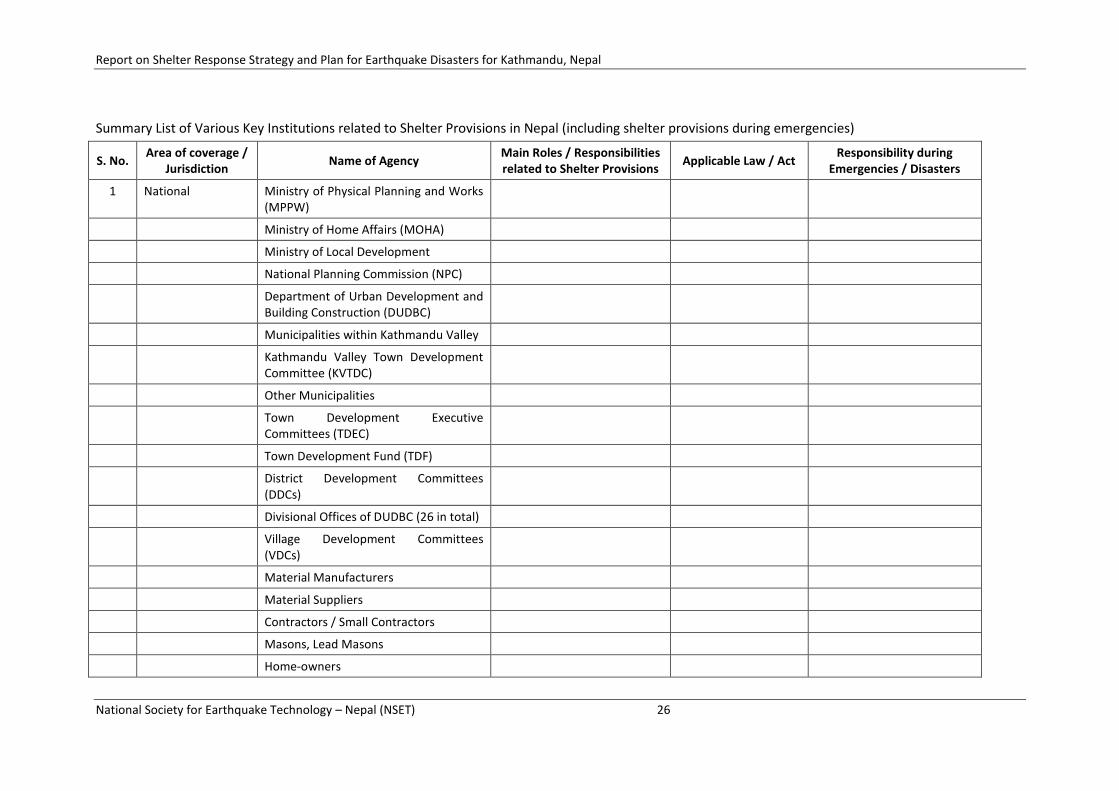
Summary List of Various Key Institutions related to Shelter Provisions in Nepal (including shelter provisions during emergencies)
S. No. Area of coverage /
Jurisdiction Name of Agency
Main Roles / Responsibilities related to Shelter Provisions
Applicable Law / Act Responsibility during
Emergencies / Disasters
1 National Ministry of Physical Planning and Works (MPPW)
Ministry of Home Affairs (MOHA)
Ministry of Local Development
National Planning Commission (NPC)
Department of Urban Development and Building Construction (DUDBC)
Municipalities within Kathmandu Valley
Kathmandu Valley Town Development Committee (KVTDC)
Other Municipalities
Town Development Executive Committees (TDEC)
Town Development Fund (TDF)
District Development Committees (DDCs)
Divisional Offices of DUDBC (26 in total)
Village Development Committees (VDCs)
Material Manufacturers
Material Suppliers
Contractors / Small Contractors
Masons, Lead Masons
Home-owners
Report on Shelter Response Strategy and Plan for Earthquake Disasters for Kathmandu, Nepal
National Society for Earthquake Technology – Nepal (NSET) 27
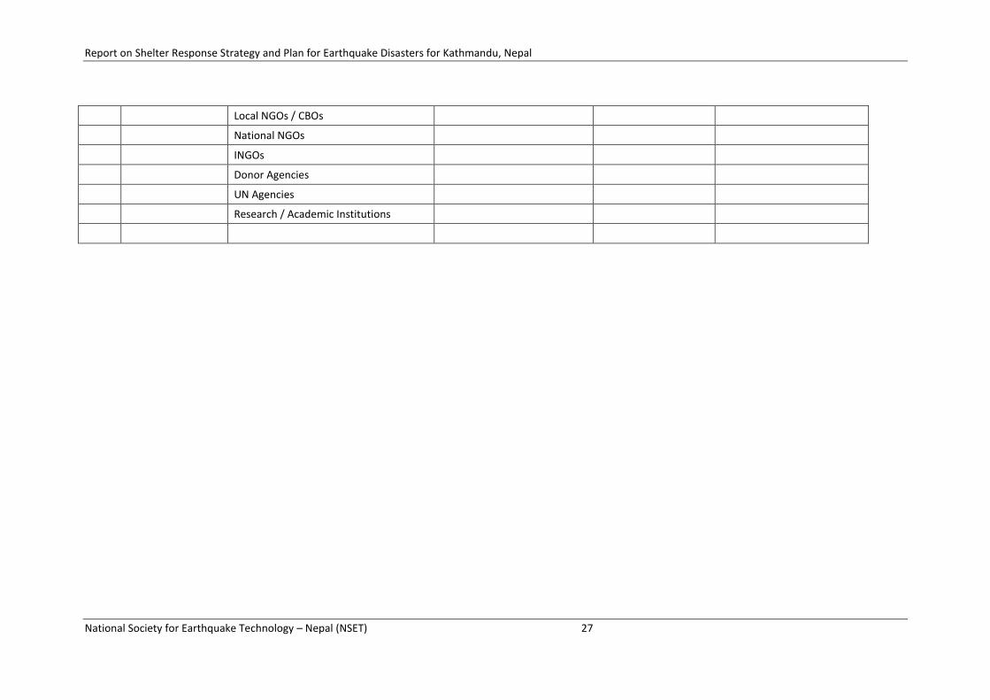
Local NGOs / CBOs
National NGOs
INGOs
Donor Agencies
UN Agencies
Research / Academic Institutions
Report on Shelter Response Strategy and Plan for Earthquake Disasters for Kathmandu, Nepal
National Society for Earthquake Technology – Nepal (NSET) 28
3.5 KEY POLICIES AND LEGAL TOOLS FOR SHELTER PROVISIONS
National Shelter Policy
The National Housing Policy was approved by the Government of Nepal in 1996 as per special directive 'Shelter is a basic need for all and government will work towards setting the conditions so that , over time this need is satisfied for all households' enshrined in the Constitution of the Kingdom of Nepal 1990. The feeling and essence of the directive has not changed in the new constitution also.
The housing policy has been framed as per the Global Strategy for Shelter adopted by the United Nation in 1990. It emphasises the role of the government as an enabler and facilitator and encourages the private sector, both formal and informal, in the production of adequate dwelling units. It also recognises that housing is a process rather than a product and recommends a holistic approach for overall development of the housing sector.
There are three broad strategies of the housing policy; the first one is to increase the shelter production and upgrading, the second emphasises on the promotion of mobilisation of effective allocation of financial resources in the sector and the third strategy to improve the organisational set up. In addition, the policy has spelled out a number of specific housing programmes and projects to meet shelter objectives and policies. However the policy has remained silence on the disaster aspect including the shelter response in post disaster period.
Local Self -Governance Act of 1999,
A more recent Act, the Local Self -Governance Act of 1999, bestows the disaster relief functions on the local bodies (District Development Committees, Village Development Committees and Municipalities) based on the principle of subsidiarity. This act contradicts with old Natural Calamity Relief Act, 1982 as it grants authority to the District Administration and that the reliefs act to the local bodies. This contradiction has prevented more effective relief operations at the local level. The heavy toll exacted by disasters may be partly attributed to the lack of a comprehensive disaster risk management policy and an adequate institutional framework.
Inadequate coordination among government agencies involved in disaster management and the absence of clear-cut descriptions of roles and responsibilities of those agencies compounded with a scarcity of human and financial resources reduces the country's capacity to manage reduce risk.
Natural Calamity Relief Act, 1982
Natural Calamity Relief Act 1982 is the most prominent legal framework which defines the official disaster management system at central, regional, district, and local levels. The NCRA establishes a Central Disaster Relief Committee (CDRC) under the chairmanship of the Minister, MoHA to formulate and implement policies and programmes related to natural disaster relief work. It is also responsible for necessary coordination with the international communities. It mobilizes funds from the Prime Minister Fund nationally and international donor agencies.
The Central Disaster Relief Committee (CDRC) oversees the disaster response system. Headed by the Minister of Home Affairs, CDRC consists of the Minister of Health, the Minister of Physical Planning and Works, secretaries of other ministries, representatives from the Royal Nepalese Army and the Nepal Police, the Director Generals from the Department of Mines & Geology and from the Department of Hydrology & Meteorology, as well as representatives from the Social Welfare Council, the Nepal Red Cross Society, and the Nepal Scouts. Following a disaster, CDRC meets as required to address the needs of the affected population. The committee is also involved in coordination of rehabilitation efforts. At the district level, the District Disaster Relief Committee (DDRC) is the active agency for coordinating relief support. This committee, chaired by the Chief District Officer, consists of representatives from public sector organizations, such as the District Health Office, the Nepal Red Cross Society, and similar agencies. DDRC is responsible for coordinating the district level relief

Report on Shelter Response Strategy and Plan for Earthquake Disasters for Kathmandu, Nepal
National Society for Earthquake Technology – Nepal (NSET) 29
efforts, including medical support and distribution of food and other essential supplies. The CDRC and the District Disaster Relief Committees (DDRC) function on a permanent basis, while local and regional levels committees are only constituted in times of a disaster. As the name suggests this act emphasizes only on the reuse and relief aspects.
National Strategy for Disaster Risk Management for Nepal
The Government of Nepal has prepared a Draft of National Strategy for Disaster Risk Management for Nepal (NSDRMN) and is in the process of approval. The draft has envisaged a ‘Disaster Resilient Nepal’ and provides a policy, institutional and legal guidance in the area of disaster risk management planning and implementation in Nepal to achieve the vision.
The National Strategy is in line with Hyogo Framework of Action (HFA) 2005-2015, a consensus document adopted at the UN World Conference on Disaster Reduction, Kobe in 2005 and UN “Cluster approach” principle which calls all the institutions for coordination effort. Though the strategy is focused on earthquakes risk reduction, the institutional and legal frameworks are valid for any disaster risk reduction.
The strategy envisages a National Commission for Disaster Risk Management (NCDRM) as the highest level institution chaired by the Prime Minister, vice-chaired by Opposition Leader in the Parliament with ministers, Chief of the Army Staff, Chief of the police departments and representatives of the civil society as members. The strategy suggests a similar institutional structure as the District Authority for Disaster Risk Management (DADRM) and Municipal Authority for Disaster Risk Management (MADRM) at district and municipal level.
It also proposes National Authority for Disaster Risk Management (NADRM) for the planning and implementation of DRM plans and programmes at the national level with DADRM and MADRM at district and municipal level.
National Disaster Management Act 2007
Council concept - semi-government institution, representative members from various government and other organizations
A draft of National Disaster Management Act, 2007 has been prepared to provide a legal basis for instituting a disaster management system in the country and is in the process of approval. The Act establishes the ‘Disaster Management Council (DMC)’ an apex body with three separate committees for preparedness, rescue and relief and rehabilitation and reconstruction at national level. The DMC is chaired by the Prime Minister, vice-chaired by the Home Minister with participation of various relevant ministries and organizations to provide direction to disaster risk management in the country. The Act further defines the institutional set-ups with ‘District Disaster Management Committee (DDMC)’ and ‘Local Disaster Management Committee (LDMC)’ at regional and local level for disaster response activities. It also spells out the roles and responsibilities of other organizations including army, police, I/NGOs, private sectors, CBOs and general public.
Report on Shelter Response Strategy and Plan for Earthquake Disasters for Kathmandu, Nepal
National Society for Earthquake Technology – Nepal (NSET) 30
National Action Plan 1996
The Ministry of Home Affairs prepared a National Comprehensive Plan on Disaster Management in 1996. This plan emphasizes the improvement of national capacity for disaster management and institutional structures. The plan also focuses on hazard mapping, risk assessment, rehabilitation of the victims and the reconstruction of damaged infrastructures, vulnerability analysis and so on. As the objectives of the plan are very wide, keeping in view resource constraints, it may take a long time to attain all the objectives and needs timely revision for the full implementation of the task.
Contingency Plan for Emergency Shelter 2008
The Department of Urban Development and Building Construction (DUDBC) under the Ministry of Physical Planning and Works with the support from UNOCHA, IFRC and UN-HABITAT, has prepared a draft of Contingency Plan for Emergency Shelter as disasters preparedness activities to meet the emergency shelter needs during emergencies.
As per the plan MoHA is the executing agency and The International Federation of Red Cross and Red Crescent Societies (IFRC) is the convener of the emergency shelter cluster during natural disasters at national and international level.
The plan has identified the activities to be undertaken before, during and after emergency in two types of disaster scenario, earthquakes and the floods. It has also defined the major responsibility of the various organizations during this period. SPHERE standards and Guidelines for shelter are to be followed. The plan is in line with the existing implementing arrangements.
Urban Policy 2007
The Ministry of Physical Planning and Works (MPPW) has recently formulated National Urban Policy. Object number 2 of the policy talks about the Disaster Risk Planning by providing a policy framework for vulnerability reduction at local level planning like road net work, open spaces.
Building By Laws, National Building Code
There are two construction control systems Building By Laws and National Building Code being practiced in Nepal in urban centers.
Collapse of buildings and houses has been the single largest cause of human death and economic losses resulting in from earthquakes in Nepal also. Effective enforcement of earthquake resistant building codes and control system can reduce the loss significantly. Realizing this fact, the National Building Code (NBC) has been developed in 1992 to improve the structural safety of buildings to reduce impact of earthquakes in life and livelihood of the people.
It is almost 14 years since the code is developed but implementation has not been effective. Only 2 municipalities Kathmandu and Lalitpur out of 58 have implemented it and 2 more municipalities have just started. Implementation of NBC is not only a technical issue. It also includes social, legal and institutional aspect such as lack of awareness, lack of institutional mechanism for implementation and inadequate capacity of implementing authorities. Despite of many constraints and challenges implementation of NBC is a key factor in reducing the disaster risk and hence very important. Therefore there is a need to go ahead about implementing NBC with various pragmatic and innovative ideas.
Other Relevant National Policies and Legislation on Shelter and Disaster
A number of other national policies, plans, programs and acts have also been formulated and developed during the last 20 years related to shelter and disaster management in Nepal. The following provides the most relevant policy and legal framework that assign roles and responsibilities to different disaster management entities.
• Local Administration Act, 1971

Report on Shelter Response Strategy and Plan for Earthquake Disasters for Kathmandu, Nepal
National Society for Earthquake Technology – Nepal (NSET) 31
• HMG Rules for allocation of functions, second amendment, 1996
• Local Self Governance Act, 1999
• Kathmandu Valley Town Development Act, 2000
• Building Act, 1998
• National Strategy for Disaster Risk Management for Nepal
• National Disaster Management Act
• Contingency Plan for Emergency Shelter
• National Shelter Policy
• Urban Policy
• Building By-Laws, National Building Code
• National Action Plan 1996

Report on Shelter Response Strategy and Plan for Earthquake Disasters for Kathmandu, Nepal
National Society for Earthquake Technology – Nepal (NSET) 32
4 THE SHELTER NEEDS IN CASE OF SCENARIO EARTHQUAKE
4.1 LOSS ESTIMATION FOR SCENARIO EARTHQUAKE
As described earlier in Chapter 2, the results of “Study on Earthquake Disaster Mitigation for Kathmandu Valley, Nepal (SEDM)” have been used for potential losses in case of a scenario earthquake in Kathmandu Valley. The loss estimation by SEDM was carried out in 2000-2002 and hence it reflects the possible situation in 2001. Obviously, there have been significant changes in population and number of buildings in Kathmandu Valley from 2002 to 2009. Therefore, the loss estimation figures need to be updated to represent current population and number of buildings. An effort has been made to update the loss estimation figures during the present study. However, the update is limited just to extrapolate the loss estimations by using increased figures in population and buildings, the rest information such as proportion of building typologies, infrastructures has been kept same since doing detail survey of those was beyond the scope of this study. A summary of the updated loss estimation is as given below:
Table ##: Updated Loss Estimation Figures for Mid Nepal Earthquake
Municipality / VDC
Projected Population, Buildings and Impacts due to Scenario Earthquake in 2009
Population No. of
Buildings Death
Injury (Severe
and Moderate)
Building Damage
(Heavy and Partial)
Displaced Population
Kathmandu District
Kathmandu Metropolitan City (35 Wards)
956,364 187,137 14,585 120,717 87,193 291,232
Kirtipur Municipality
(19 Wards)
50,065 9,065 240 2,030 4,563 18,673
VDCs (Total 56 VDCs) 494,684 89,722 8,996 74,578 51,426 227,784
Kathmandu District Total 1,501,112 285,924 23,821 197,325 143,182 537,689
Lalitpur District
Lalitpur Sub Metropolitan City (22 Wards)
211,501 45,202 990 8,310 19,355 49,016
VDCs (Total 26 VDCs) 218,863 39,583 2,463 20,523 21,833 95,224
Lalitpur District Total 430,364 84,785 3,452 28,834 41,188 144,239
Bhaktapur District
Bhaktapur Municipality
(17 Wards)
82,574 12,381 271 2,287 5,836 25,011
Madhyapur Thimi Municipality (17 Wards)
64,770 10,423 147 1,249 4,359 17,656
VDCs (Total 16 VDCs) 139,371 24,065 925 7,759 11,996 53,944
Bhaktapur District Total 286,714 46,869 1,342 11,295 22,191 96,612
Total Valley 2,218,191 417,577 28,616 237,454 206,561 778,540
Loss estimation done by SEDM and detail of the calculation of updated loss estimation are included in Annex ## and Annex ## respectively.
Map showing intensity distribution in Kathmandu Valley
Maps showing distribution of death, injury, building damage and displaced population

Report on Shelter Response Strategy and Plan for Earthquake Disasters for Kathmandu, Nepal
National Society for Earthquake Technology – Nepal (NSET) 33
4.2 THE SHELTER NEEDS
All displaced population from the damaged houses i.e. a total of 778,540 people will require shelters after the earthquake. Experiences have shown that out of the total displaced population, some takes shelter with their families and friends, and some will prefer to live in their damaged houses or self managed temporary shelters nearby their house. Likewise, a fraction of population will migrate to other locations or their original cities and villages in search of better shelter. Hence, only a part of total displaced population will require shelters in planned shelter camps. The proportion of such different options may be worked out from the experiences of recent disasters in the region. The proportions thus worked out however, would just be preliminary figures for planning purposes, actual numbers need to be assessed after the actual disaster situation on site.
Deriving from the actual damage assessment of past earthquakes in other countries
We can work out such methodology based on the experiences of Pakistan, Gujarat, Bam, China, 1988 Nepal etc.
2005 Pakistan Earthquake
An earthquake measuring 7.6 on the Richter scale struck the northern areas of Pakistan on 8 October 2005 severely affecting Jammu Kashmir (AJK) and North West Frontier Province (NWFP). According to the early assessment by the Asian Development Bank (ADB) and the World Bank, the earthquake killed 73,338, injured 128,000 and destroyed 203,579 housing units, while 196,574 were damaged to various degrees. Losses to the housing sector represent 84 percent of the total housing stock in the affected Districts of AJK, and 36 percent of housing stock in the five affected Districts of NWFP, 51 % on an average. Census data indicates that about 788,000 (2005) housing units were in the affected area and total population 1947240(1998). The earthquake left an estimated 3.5 million people in need of shelter. Ten percent of the destroyed or damaged housing is found in urban areas. However, these figures grew later in view of severe after shocks and increased access to remote areas after the initial survey. The initial Rural Housing Damage Assessment was complemented with the second assessment to ensure inclusion of left out eligible private house owners which resulted in identifying an additional 90,000 cases. The fully destroyed housing units= 450,000 (250 % more than the early assessment) (ERRA 2007)
Reference: ERRA Annual Review 2006-7
Immediate shelter
Total affected people = 3.5 million
Affected families requiring emergency shelter = 500,000
(Seven persons per family on average)
Total affected houses = 400153 (196,574 damaged and 203,579 destroyed)
Total affected houses accommodating one family of HH size 7 in each house and addition 99847 families (a house unit containing more than one HH and floating population)
Shelter units required = 500,000 which increased during implementation (Early provision of shelter support, within 3 months of the disaster, to more than
550,000 displaced affected persons) + 10 %
Transitional shelter
By the end of March 2007 (within 17 months), people from 558 camps/shelter villages returned to their homes, thus left with only 48 camps ( 44 in AJK and 4 in NWFP) having total population of

Report on Shelter Response Strategy and Plan for Earthquake Disasters for Kathmandu, Nepal
National Society for Earthquake Technology – Nepal (NSET) 34
about 6006 families (31833 individuals). The left over population had specific problems like landless people, urban population and vulnerable.
Families having no problem in 558 camps = 70308 returned home (considering as reconstruction and rehabilitation)
Families having problem = 6006 (8% of the affected families) still requiring camp as emergency type of shelter.
Completion of around 92,000 compliant houses, with another 250,000 at various stages of construction
In urban areas 5640 pre-fabricated houses as an intermediary solution
Total new construction = 250, 000 + 5640 = 255,640 (64 % of the total affected)
Considering Retrofitted units = 92,000 houses (47 % of the damaged houses as
Rehabilitation and reconstruction)
Transitional shelter constructed = 255,640 units
Reconstruction of shelter
As of September 2007, some 349,806 houses have been reported at various stages of reconstruction for which an amount of Rs 49 billion has been disbursed by ERRA
Total no. of houses requiring reconstruction and rehabilitation for long term = 349,806 houses (77.8 % of the actual destroyed houses 450,000)
Rehabilitation and reconstruction = 110,000 units Repair/retrofitting houses (56 % of the damaged houses)
Total displaced population
Population taking shelter with families and friends
Population taking shelter in damaged houses or self managed temporary shelters nearby original houses
Migrated population
Actual population requiring shelter in planned shelter camps
Methodology for calculation of shelter needs

Report on Shelter Response Strategy and Plan for Earthquake Disasters for Kathmandu, Nepal
National Society for Earthquake Technology – Nepal (NSET) 35
4.3 ELEMENTS OF SHELTER NEEDS
Intermingling of various factors such as human activities, social structure, culture and political economy with climate, topography, geology, hydrology and natural resources over a period of time shape the human settlements. The disaster not only destroys people’s houses and habitat but also has impacts on these factors. Though shelter provision is the first step towards recovery but it cannot be seen as mere shelter. The reconstruction process is more complex than it seems. Hence shelter needs identification also requires integrating all the factors. These factors need to be considered in overall the socio-cultural and political economic context which refers to aspects like socio-cultural set up, gender and caste equity, ownership, access and delivery mechanisms for land and housing, governance mechanism etc.
Hence shelter needs is not only a quantitative term but it has both qualitative and quantitative parameters.
Situation Analysis
The shelter response strategy is highly influenced by the following prevailing condition of the particular area and the country at large.
Population – Total population of the area to be affected with age and sex ratio, density, vulnerable groups, population growth rate, percentage of the floating population, population at day and night, migration, and collection of all the disintegrated data as far as possible
Geographic Location – Nature of topography whether snowy, mountainous, hilly or plain area
Geological Condition – Nature of soil types, fold and faults, tectonic plates, seismic prone zone
Settlement Characteristics – Rural or urban, densely populated or scattered, high rise or low rise
Shelter – shelter/housing policy and guidelines, building typology based on tenureship (owner, renter, squatter) and materials (kuchha, semi-pakka, pakka) construction technology, construction materials (local or imported), housing standards, housing finance and affordability, land ownership, actors in shelter delivery and their roles
Cultural and Socio-economic aspect – Literacy rate, awareness level
Hazard, Risk and Vulnerability -
Damage assessment with grading/category
Shelter needs is directly proportional to the anticipated damages of the building and nature of damages in various post-disaster periods. An anticipated damage is calculated by risk assessment which gives a picture of the percentage of buildings likely to be collapsed, partial damaged, minor damaged and to withstand. Based on risk assessment identify the total number of shelters required with grading in all three stages of post disaster.
Immediate shelter needs
Identify total no of people/family requiring Immediate/emergency shelter by following categorization wherever applicable,
- Number of people who can be arranged in public buildings
- Number of people who can be accommodated with host families
- Number of people who may be provided with shelter in camps
- Number of people may be requiring external assistance for tents, plastics sheeting, tarpaulins blankets, mosquito nets in evacuation sites (open spaces)
Report on Shelter Response Strategy and Plan for Earthquake Disasters for Kathmandu, Nepal
National Society for Earthquake Technology – Nepal (NSET) 36
Transitional shelter needs
Identify the total number of households/families requiring transitional shelter with the following categories.
Number of shelters requiring minor repair or retrofitting to accommodate the family willing to stay in the same location.
Number of shelters that can be constructed from the materials salvaged from the rubble/debris and local materials or in combination partly by salvaged materials and some additional materials in the same location.
Number of shelters in relocation sites.
Number of families requiring shelter in tents or camps.
Reconstruction and rehabilitation shelter needs
Identify the total number of households/families requiring permanent shelter assistance with the following categories.
Number of shelters in relocation sites.
Number of shelters in the same location.
Shelter needs for floating population
Shelter needs for floating population, rental, and status of land ownership issue - ?
While implementing actual damage assessment is needed.
Climatic Consideration
Shelter needs in all three stages vary with the climatic condition and season of the disaster affected area. It is more critical in emergency period.
Plastic tent – summer and rainy season
Winterized tent – winter
Appropriately ventilated tent - hot summer
For e.g. in Kathmandu – shelter needs may vary with season whether it is rainy (June – August), winter (Nov-Feb) and spring (March – May and Sep – October). Plastic tents may be enough for rainy season while winterized tent (two layers) is required in winter.
Typology
Immediate shelter
Tarpaulin, plastic sheets, tents, bed sheets, blankets wooden poles and even cots, camps, public buildings, host families
Transitional
Tents, prefabricated units, shelter of local materials, salvaged materials
Reconstruction and rehabilitation
Local materials
In the immediate aftermath, the immediate need of the people is to protect themselves from the elements like sun, rain, cold, snow depending upon the geo-climatic situation. So people put up some sort of emergency shelter on their own such as tarpaulin, plastic sheets, tents, bed sheets, blankets wooden poles and even cots to fulfill the basic minimum shelter requirements. Experience

Report on Shelter Response Strategy and Plan for Earthquake Disasters for Kathmandu, Nepal
National Society for Earthquake Technology – Nepal (NSET) 37
shows that external aid takes time to reach to the affected people. When they reach they respond usually also with tents, tarpaulin and prefabricated materials for shelters. Sometimes the affected people are evacuated to safe buildings and also to camps. So there is not much variation in the typology of immediate shelter either put by the people or by the aid agencies. The requirement of people gradually changes to transitional shelters which not only protect from the vagaries of nature but provide safe and protected space to rebuild their lives until the long term sustainable solutions can be put in place.
Tents have also been used not only as emergency shelter but also as transitional shelters. For example, in past in post–earthquake responses in Turkey (1976, 1999), Italy (1980, 2002) and Mexico (1985). (Unnati, 2008) These simple tents can’t withstand harsh winter. However winterized tents are also available now these days. Living inside the tent is also not comfortable in very hot climate. Tents provide minimal weather protection and there is a feeling of physical vulnerability. So use of tents as shelter depends on the climatic condition and the level of acceptance. After 2 months of earthquake in Bam, 2003, prefabricated shelters were put up but only a small number of families moved into them. (UNOCHA reports)
One of the options for transitional shelter is to provide prefabricated shelters. This also has advantage and disadvantage. These can be erected and provided rapidly, a common design be applied for large masses. They can be made of variety of industrial materials and the structures come in ready for assembly form. However, they are comparatively costly difficult to maintain. They also have low acceptability and do not serve the primary purpose of weather protection.
Another type of transitional type of shelter is from the materials salvaged from the rubble/debris and local materials or in combination partly by salvaged materials and additional materials. Past experience suggest that such type of shelter is most suitable when built by the affected families themselves as they fulfill the social, cultural, climatic and functional needs more effectively giving higher level of satisfaction. (Unnati, 2008)
Planning and Development Approach
Immediate
- Identify safe evacuation sites in more smaller level as possible for camps - Integrate with other thematic clusters - facilitate host communities providing shelters for the affected people
Transitional
- Adopt in-situ concept where ever possible
- Adopt relocation concept (mass shelters or temporary planned or self-settled camps) only for those who cannot be accommodated in in-situ.
Reconstruction and Rehabilitation
- Adopt ‘Built Back Better’ concept wherever possible in post disaster planning for vulnerability reduction at planning level. E.g. widening of road etc
- Consider also the ground reality particularly in densely urbanized area.
Development and disaster can be looked as complementary to each other. It is a known fact that development can bring disaster, but at the same time disaster also provides the opportunity for development. Planning for post disaster period is a great opportunity to achieve vulnerability reduction in planning by adoption of the ‘Built Back Better’ concept wherever possible. For example, widening of road or planning for satellite town. But ground reality option should not be ignored. There may be no possibility of widening of road in core urban area or planning any spaces due to lack of open spaces in such areas.

Report on Shelter Response Strategy and Plan for Earthquake Disasters for Kathmandu, Nepal
National Society for Earthquake Technology – Nepal (NSET) 38
Shelter Construction Approach
Immediate
- Shelters to be provided by the state and humanitarian agencies - In-situ, community and state as provider as well as facilitator
Transitional
- Relocation or in-situ, each characterized by several features
- Owner driven or contractor driven, each characterized by several features
Reconstruction and Rehabilitation
- Relocation or in-situ
- Owner driven or contractor driven
Relief and rehabilitation requirements are by and large similar after most earthquakes given the destruction caused to and by buildings though each area is unique in its locational circumstances. Various approaches on intermediate shelter as well as on permanent shelter have been adopted in post disaster rehabilitation programs in both developed and developing countries.
Depending upon the local situation two options can be adopted in transitional shelter: relocation or in-situ owner driven housing, each of which is further characterized by several features.
In-situ Owner-driven –financial compensation and technical assistance by the government with people given full responsibility of reconstruction
In-situ Owner-driven – NGOs as just facilitator, material and technical assistance provided, people given reconstruction responsibility
In-situ Owner-driven – NGOs active participation in reconstruction with training and engaging local masons, owner involved in decision making and construction
In-situ Contractor-driven – reconstructed in-situ by Construction Company in the same location with large NGOs involvement, but minimal owner’s participation,
Relocation contractor-driven – reconstruction by Construction Company in new site and handed over to the owner, with large NGOs and private sector involvement,
Standards and Guidelines for Shelter Design
Follow SPHERE Standards for immediate and transitional shelter response.
Immediate
- I -
Transitional
- Relocation
- In-situ
Reconstruction and Rehabilitation
-
(Chapter 4 - Shelter of SPHERE Standards data to be verified from PK and Gujarat earthquake)
Shelter Policy – Disaster aspect is not mentioned in the policy. Hence it has to be reflected when updated.
Culture and gender Consideration- Dashain/Tihar festival

Report on Shelter Response Strategy and Plan for Earthquake Disasters for Kathmandu, Nepal
National Society for Earthquake Technology – Nepal (NSET) 39
4.4 METHODOLOGY FOR CALCULATION OF DIFFERENT TYPES OF SHELTER NEEDS
Emergency shelter (immediate), transitional shelter, housing reconstruction
Shelter Needs
Quantitative
Quantity - No of Sheller units or total population requiring shelter
Risk Assessment – prediction before earthquake
Damage Assessment - actual after earthquake
Qualitative
Situation analysis
International standard based on humanitarian charter
Elements of shelter Needs (Quantitative and Qualitative)
Methodology of shelter Needs
Quantitative
Shelter needs in terms of quantity can be calculated in two ways
Deriving from the ‘scenario earthquakes’ set by the previous Earthquake Risk Assessment studies
Deriving from the actual damage assessment of past earthquakes in other countries
Deriving from the ‘scenario earthquakes’ set by the previous Earthquake Risk Assessment studies
Many risk assessment studies set a series of earthquake scenarios based on the historical earthquake catalogue, recent seismicity, and tectonic aspects in and around country and city, to assess the potential damages. The seismic intensity and liquefaction potential are calculated, based on the earthquake model and subsurface ground properties of the area.
The estimated damage of the area of particular point of time calculated by the study is projected with the present day data.
For Kathmandu Valley
There have been various risk assessment studies done for the Kathmandu Valley also. Among them, Study on Earthquake Disaster Mitigation (SEDM) for the Kathmandu Valley in 2002 by JICA is the most comprehensive one. It has set the following four scenario earthquakes.
Reoccurrence of 1934 Bihar-Nepal Earthquake (magnitude 8.4)
Mid Nepal Earthquake (magnitude 8.0)
North Bagmati Earthquake (magnitude 6.0)
KV Local Earthquake (magnitude 5.7)
The reoccurrence of a similar earthquake was modelled and the damage was estimated in both times at the time of occurrence and at present for effective comparison.
The shelter response strategy and plan for Kathmandu Valley has been based on the 1934 earthquake, as the earthquake of maximum magnitude that the valley can experience is reoccurrence of a similar to1934 Bihar-Nepal Earthquake,

Report on Shelter Response Strategy and Plan for Earthquake Disasters for Kathmandu, Nepal
National Society for Earthquake Technology – Nepal (NSET) 40
The JICA Study has estimated about 18, 00 death with a scenario earthquake of MMI VII. However, Kathmandu Valley Earthquake Risk Management Project (KVERMP) in 1997 by NSET has estimated a damage of 60% building stock and 40,000 deaths in a scenario earthquake of intensity IX MMI.
Based on this estimated damage from scenario earthquake and considering the present day data the anticipated total loss and damage of shelter as of 2007/8 is …………… Various shelter needs for Kathmandu Valley can be calculated as follows.
Immediate shelter needs
Since all the households of both destroyed houses and damaged houses require shelter, the immediate shelter needs will be the total number of damaged houses. In addition floating population, additional households living in a house also need to be considered. Hence in the case of 1934 scenario earthquake as of 2007/8 the immediate shelter required is estimated to be ………..approximately
Transitional shelter Needs
Reconstruction and Rehabilitation shelter needs
Qualitative
4.5 SHELTER NEEDS
Number of different types of shelter needed in different locations
Need methodology for calculating number of shelters required based on the damage assessment results
o Different types of shelters required – emergency shelter
o Number of shelters / 10,000 or 20,000 buildings or
o Number of shelters / number of affected populations or
o Number of shelters / number of damaged buildings etc.
We can work out such methodology based on the experiences of Pakistan, Gujarat, Bam, China, 1988 Nepal etc.
Use SPHERE standards as the minimum required area
Seasonal and other variations of shelter requirements
o e.g. Dashain, Tihar etc.

Report on Shelter Response Strategy and Plan for Earthquake Disasters for Kathmandu, Nepal
National Society for Earthquake Technology – Nepal (NSET) 41
5 SHELTER RESPONSE STRATEGY
5.1 GUIDING PRINCIPLES AND APPROACHES
Moving from the relief toward comprehensive reconstruction and rehabilitation that meets the needs of the affected population calls for a common framework; to be adopted by all organizations and institutions involved, to ensure speed, consistency, inclusion and equity across rehabilitation efforts. Based on post disaster reconstruction experience in developed and developing countries, various guiding principles have been formulated. These principles are embedded in a rights- based approach and reflect the articulated priorities of the affected communities in a participatory and people-centered manner. These principles also outline key areas that may be shared and adhered to by all parties when planning and implementing recovery activities.
Cross-country experience from other disaster-hit areas suggests the following general and specific principles to be followed in the shelter response strategy of a country:
The following general and specific principles that suit the Nepalese context have also formed the basis to this shelter response strategy and plan for Kathmandu Valley.
General Principles
Quick and efficient shelter provision is the key factor towards the successful recovery/ rehabilitation of the affected population after a disaster to prevent them from being exposed to other threats. This is possible only with the development of Shelter Response Strategy and plan in advance.
Shelters are not merely a product but a process. Hence the process is also very important.
The government is primarily responsible for disaster response including the shelter response strategy and plan. The government takes the lead for coordination of shelter during natural disasters.
Disaster management is a complex task with various issues often interlinked with each other. Hence it requires the combined efforts of all stakeholders at various levels from policy makers to community and individual level. No single organization can effectively manage earthquake risk or manage an earthquake disaster. Various ministries, local governments, and other sectors of society must participate individually and collectively in an inter-institutional, open planning process that includes;
a) Assignment of responsibilities,
b) Creation and strengthening of sustainable mechanisms for cooperation, and
c) Development and implementation of policies and plans.
Specific Principles
Focus on the most vulnerable and socially disadvantaged groups
Giving priority to the most vulnerable groups
Integrating opportunities for reducing vulnerabilities
The earthquake increases the vulnerability of all, but specially those who are already disadvantaged. They include women, the disabled, female-headed households, children and orphans, the displaced, the elderly and others who have special needs and are unable to claim support. A large percentage of total deaths and injuries are among women and children.
Report on Shelter Response Strategy and Plan for Earthquake Disasters for Kathmandu, Nepal
National Society for Earthquake Technology – Nepal (NSET) 42
Recovery programming needs to give priority to the most vulnerable groups, by focusing on
disaggregated data collection, assessment and differential impact analysis and giving attention to recovery solutions that are affordable and accessible by people with special needs. Recovery programmes also needs to integrate opportunities for reducing vulnerabilities and minimizing disadvantages.
Restore capacities to manage the recovery process
o Restoring the institutional capacity of governments, local in particular by appropriate institutional, policy and legal frameworks to minimize losses from disaster in future
o Empowering communities
Institutions particularly the local authorities and communities are very important in recovery process as they can become quickly operational after disaster. In order to effectively manage the recovery process, it is essential to empower communities, restore the capacities of local and national authorities, and determine the root causes and vulnerabilities that make societies disaster-prone. Restoring of the capacity includes appropriate institutional, policy and legal frameworks which ensues the minimization of future human, material and environmental losses from disasters. Along with local and national institutions, encourage and empower all levels of civil society to participate in and manage the recovery process.
Rapid rebuilding of people's livelihoods
o enabling the affected population to quickly re-engage in various economic activities
o Creating income opportunities in the provision of shelter itself,
o Facilitating the return of the displaced
Rebuilding of people lives is another important aspect of post-disaster recovery. Providing shelter, restoring basic services, facilitating the return of the displaced and creating income opportunities and jobs enable the affected population to quickly re-engage in economic activity. Accelerate the revitalization of the local economy – revival of production, trade and the creation of income and employment opportunities in support of people’s own initiatives. This
will prevent dependencies and help disaster victims lead self-determined lives.
Secure human development gains and progress in poverty reduction
o not cutting the funding from social sector development or poverty reduction allocated in other areas to disaster areas
o secure previous development gains in poverty reduction
Disasters like earthquake can reverse hard-won gains in poverty reduction and human development, risking a downward spiral of decline. Recovery planning must attempt to re-establish and secure previous development gains. In addition, the poor in areas not affected by the disaster should not lose out due to increased allocation of public resources to the earthquake-affected areas at the expense of the rest of the country. Hence resource mobilization efforts need to focus on
Report on Shelter Response Strategy and Plan for Earthquake Disasters for Kathmandu, Nepal
National Society for Earthquake Technology – Nepal (NSET) 43
seeking alternatives (additional resource mobilization by national and the international community) to budget cuts in social sector development and/or
poverty reduction.
Reduce disaster risk
o preventing effectively the recurrence of disasters for future development
o rebuilding housing and infrastructure more resilient to future earthquakes and other disaster
o Not to simply replacing damages and losses
o including activities beyond physical structures like awareness, training and other preparedness program at the community and government levels
Recovery and rehabilitation is not simply replacing damages and losses, but goes beyond that. It is also effectively preventing the recurrence of disasters for future development. So while rebuilding housing and infrastructures, efforts needs to be geared up making them more resilient to future earthquakes and other disaster. Beyond physical structures, rehabilitation and
reconstruction also needs to include activities like awareness, training and other preparedness program at the community and government levels as well as environmental restoration and protection concerns.
Engage the private sector and civil society
o involving in disaster resilient housing designs
o Engaging in micro-finance activities
o Encouraging in procurement of goods and services
o Mobilizing volunteers during the recovery phase
o engaging the business community to mobilize funds for relief and reconstruction
Private investments - both human and financial, from the affected people themselves, their relatives and friends, community and other sources are important complementary inputs to the recovery process. Hence encourage the engagement of the private construction sector in earthquake resilient housing designs by giving compensatory rates and private financial institutions in micro-insurance, micro- credit and micro-enterprise. Similarly engage the business community to mobilize funds for relief and reconstruction as the private sector also has considerable procurement capacity to meet the demands of the affected population for goods and services. Mobilization of the volunteers from NGOs, political parties, religious groups and youth organizations also adds value to the recovery process.
Independence and self-sufficiency
o giving full access to impartial information on all assistance
o assessing all needs and capacities of the affected population,
o encouraging active participation of the affected communities
o developing community and beneficiary consultation mechanisms
o helping in building consensus on recovery priorities, roles, responsibilities and resources

Report on Shelter Response Strategy and Plan for Earthquake Disasters for Kathmandu, Nepal
National Society for Earthquake Technology – Nepal (NSET) 44
Involvement of the affected communities in all phases of recovery process is the key factor in achieving independence and self-sufficiency. Recovery programming must be based upon a participatory assessment of the needs and capacities of the affected population, so that local knowledge, skills, materials and methods, local initiative, resources and capacities are fully
understood and used to the maximum extent. To ensure community participation, develop community and beneficiary consultation mechanisms involving decision-makers, technicians and local actors and building consensus on recovery priorities, roles, responsibilities and resources. All affected
populations, in particular vulnerable groups, need to be given full access to impartial information on all assistance and recovery efforts.
Transparency and accountability
o developing a functional judicial system and an independent monitoring system
o Putting in place effective information and communication system adequately inform about the overall design of the recovery program, time frames, entitlements, sources of technical help and avenues for articulating their concerns and grievances.
o inviting the independent media and NGOs to inform the authorities about the gaps in relief and recovery
Transparency and accountability is the critical aspect for smooth recovery. A functional judicial system and an independent monitoring system are the keys to ensuring transparency. Achieve transparency also through open processes and wide dissemination of information on all aspects of the recovery process. A well-
informed citizenry plays a vital role in holding governments and other actors accountable. An effective information and communication strategy needs to be put in place at various levels so that affected people are adequately informed of the overall design of the recovery program, time frames, entitlements, sources of technical help and avenues for articulating their concerns and grievances. Invite the independent media and NGOs to inform the authorities about the gaps in relief and recovery.
Subsidiarity and decentralization
o Placing planning, implementation and monitoring as close to the affected people as possible.
o Transferring the tasks to the lowest institutional or social level that is capable of completing them
o Sharing responsibilities among various stakeholders
The principle of subsidiarity and decentralization is transferring the tasks to the lowest institutional or social level that is capable of completing them and thus an important vehicle for sharing responsibilities at various levels and among various stakeholders. This empowers local levels, instills a sense of ownership and fosters participation. Take decisions on plans, design and implementation as close to the affected people as possible, to ensure community ownership and empowerment and to ensure solutions are locally appropriate.
Report on Shelter Response Strategy and Plan for Earthquake Disasters for Kathmandu, Nepal
National Society for Earthquake Technology – Nepal (NSET) 45
Coordination
o Maintaining information exchange and coordination mechanisms established among various agencies during emergency phase to the recovery process
o To avoid duplication and overlap
o To continue consensus building
Effective coordination among government agencies, civil society, cooperation agencies, donor and lending institutions agencies is extremely important right from the reuse and relief to the reconstruction and rehabilitation process to maximize the recovery efforts at the beneficiary level. Ensure full and effective coordination among all agencies based on comprehensive information exchange, flexibility in administrative procedures and uniformity of policies. This helps in
avoiding duplication of tasks, building consensus on various issues, defining priorities, ensuring uniformity of policies, agreeing upon coherent strategies and approaches to recovery. Continue and enhance the information exchange and coordination mechanisms established during the emergency until
reconstruction.
5.2 MAIN STRATEGIES
Damage and Needs Assessment
Effective and timely post-disaster rehabilitation and recovery occurs where the following strategies is observed.
1. Shelter Strategies (Main Strategies for Shelter Provisions)
Build Back Better
Different types of shelters – Shelter typologies
The following are the types of shelters used in different phases of post disaster situation.
Immediate shelter
Tarpaulin, plastic sheets, tents, bed sheets, blankets wooden poles and even cots, camps, public buildings, host families
In the immediate aftermath, the immediate need of the people is to protect themselves from the elements like sun, rain, cold, snow.
Allow all the available options depending upon the local situation.
Respond according to the geo-climatic condition.
Evacuate to safe public buildings and also to camps
Facilitate the host families
Transitional
Tents, prefabricated units, local materials, salvaged materials
The requirement of people gradually changes to transitional shelters which not only protect from the vagaries of nature but provide safe and protected space to rebuild their lives until the long term sustainable solutions can be put in place.
Tents have also been used not only as emergency shelter but also as transitional shelters. For example, in past in post–earthquake responses in Turkey (1976, 1999), Italy (1980, 2002) and Mexico (1985). (Unnati, 2008) These simple tents can’t withstand harsh winter. However winterized tents are also available now these days.

Report on Shelter Response Strategy and Plan for Earthquake Disasters for Kathmandu, Nepal
National Society for Earthquake Technology – Nepal (NSET) 46
Living inside the tent is also not comfortable in very hot climate. Tents provide minimal weather protection and there is a feeling of physical vulnerability. So use of tents as shelter depends on the climatic condition and the level of acceptance. After 2 months of earthquake in Bam, 2003, prefabricated shelters were put up but only a small number of families moved into them. (UNOCHA reports)
One of the options for transitional shelter is to provide prefabricated shelters. This also has advantage and disadvantage. These can be erected and provided rapidly, a common design be applied for large masses. They can be made of variety of industrial materials and the structures come in ready for assembly form. However, they are comparatively costly difficult to maintain. They also have low acceptability and do not serve the primary purpose of weather protection.
Another type of transitional type of shelter is from the materials salvaged from the rubble/debris and local materials or in combination partly by salvaged materials and additional materials. Past experience suggest that such type of shelter is most suitable when built by the affected families themselves as they fulfill the social, cultural, climatic and functional needs more effectively giving higher level of satisfaction. (Unnati, 2008)
Reconstruction and rehabilitation
Local materials
Building typologies
In-situ vs. relocation
Depending upon the local situation two options can be adopted in transitional shelter, relocation or in-situ reconstruction, each of which is further characterized by several features.
In-situ
In-situ Owner-driven –financial compensation and technical assistance by the government with people given full responsibility of reconstruction
In-situ Owner-driven – NGOs as just facilitator, material and technical assistance provided, people given reconstruction responsibility
In-situ Owner-driven – NGOs active participation in reconstruction with training and engaging local masons, owner involved in decision making and construction
In-situ Contractor-driven – reconstructed in-situ by Construction Company in the same location with NGOs involvement, but minimal owner’s participation,
Relocation
Relocation contractor-driven – reconstruction by Construction Company in new site and handed over to the owner, with large NGOs and private sector involvement,
Extend to the earthquake-affected communities a range of choice in shelter reconstruction from complete and partial relocation to in-situ reconstruction. Communities, through a participatory process of decision-making exercise their option. Selection of new site is made with the involvement of local authority and the NGO/Agency involved.

Report on Shelter Response Strategy and Plan for Earthquake Disasters for Kathmandu, Nepal
National Society for Earthquake Technology – Nepal (NSET) 47
Encourage most households to rebuild in-situ on their original plot of land to minimize:
Resistance of the population at attempts at relocation Demands on government to sustain livelihoods in new locations and to build new physical and social infrastructure Demands on, and costs to, the government to identify and acquire land and issues of land ownership and availability
Relocate settlements only when necessary. Relocation of some settlements is inevitable. These should be limited to circumstances where the risks of exposure or contributory effects to hazards remain very high due to topography; soil conditions and other environmental and risk factors.
Acknowledge the role of DANA before implementing
Approaches – participatory
Greater local participation and contributions to the reconstruction effort reduce social tensions and lead to more sustainable development efforts. The majority of reconstruction efforts should be undertaken by affected people themselves. While relief and charity are important in the immediate aftermath of a natural disaster, they should be replaced as soon as possible with efforts to foster ownership and involvement of the people.
Different models for reconstruction
The long term reconstruction and rehabilitation shelter strategy should comprise a variety of reconstruction models based on various activities and modes of assistance. This is responsive to individual preferences. They include o Owner-driven rebuilding (reconstruction or repairs) with cash grants – a model
well suited to the 90% of rural affectees to either replace a destroyed house with a new core unit, or to repair a damaged house. This maximizes household ownership. Simultaneously it mobilizes tens of thousands of mostly self-standing reconstruction and rehabilitation efforts, thereby not burdening government administrative capacity with a large volume of contract management.
o Rebuild with familiar methods and easily accessible materials. To be sustainable, promotion of hazard resistant standards and designs must relate to use of readily available materials, familiar modes of construction, and cultural preferences in design.
o Set up material banks to enable the beneficiaries to get cement and steel at affordable price. Building materials should be procured by the government at reduced price by directly negotiating with the manufacturers, and provide exemption from the incidence of sales tax.
Many of these options operate in parallel as households have a continuum of needs and are not all starting at the same point.
Flow charts
Damage Assessment / Classifications

Report on Shelter Response Strategy and Plan for Earthquake Disasters for Kathmandu, Nepal
National Society for Earthquake Technology – Nepal (NSET) 48
Damage Assessment and Retrofitting
Promote hazard-resistant construction standards and designs. The collapse of approximately 200,000 buildings, predominantly housing, was due largely to the lack of any seismic consideration in their design and their poor quality of construction and maintenance. Reconstruction of affected areas should emphasize seismic safety. The Government has decided to reconstruct all the houses, public buildings, and related structures with seismic- and cyclone-resistant technology. As demonstrated by the earthquake, Gujarat is vulnerable to seismic hazard, with a large part of the state falling in seismic zone IV and V. In addition, the state faces the recurrent threat of cyclone. A sustainable mitigation strategy for these disaster risks would require application of hazard resistant technology in the reconstruction and retrofitting of houses through a program of technical training and guidance and active dissemination of these construction technologies among people and also an institutionalized mechanism for technical inspections and quality audits.
2. Main Approaches of Shelter Provisions
Shelter provision should be looked into a continua – pre-disaster planning, emergency shelter (immediate shelter), transitional shelter, long-term permanent reconstruction and rehabilitation
Participatory
Utilize the role of survivors
5.3 IMPLEMENTATION FRAMEWORK
Government
Government – donor link
Private sector
NGO, Civil Society
Chief Executing Agency
Every government is a legitimate body to work for the well being of its people. Hence the ultimate/overall implementation of the Shelter Response Strategy and Plan for Kathmandu Valley is the responsibility of Government of Nepal.
Immediate Shelter Response Plan
The government takes the lead for the overall emergency shelter response plan during disasters which are within the national capacities.
The government appeals The International Federation to convene the emergency shelter cluster plan after major disasters, which exceed the capacity of the Government on a national level
Transitional and Reconstruction and Rehabilitation shelter Response Plan
The government takes the lead for Transitional and Reconstruction and Rehabilitation Shelter Response Plan for the specific needs wherever required particularly when it comes as a state responsibility for social justice.

Report on Shelter Response Strategy and Plan for Earthquake Disasters for Kathmandu, Nepal
National Society for Earthquake Technology – Nepal (NSET) 49
The government gets support from UNHABITAT or other UN system and international organizations, bilateral donor agencies, civil society, NGOs, private sector in accordance with their specific mandate and area of specialization for Transitional and Reconstruction and Rehabilitation Shelter Response
Key Elements of Implementation Mechanism
The key elements of the implementation mechanisms include the following:
Institutional set-up
Nepal is in the transitional stage regarding the institutional set for Disaster Management including shelter response strategy and plan. MoHA is playing the lead role at the moment. It is entrusted by the Natural Calamity Relief Act, 1982 to carry out all the disaster related activities in the country. Emergency operation Centers for coordination during disaster are being established under MoHA. However disaster relief functions has also been the responsibility of the local government municipalities and VDCs as per Local Self -Governance Act, 1999 under its jurisdiction. The Act establishes the Ministry of Local Development with responsibility as the guiding and initiating institution for local bodies. The Ministry of Local Development is in the position to facilitate and instruct local bodies to prepare for disaster management, and also to lead HMG in the support of local bodies on their behalf. Therefore, the Ministry of Local Development is the responsible central government organisation today for disaster management as well as MOHA. This dual responsibility has resulted in coordination problem to carry out the relief operations more effectively at the local level. Moreover, these institutions do not have the adequate skill, knowledge, financial and human resources capacity to manage reduce risk. This all call for a comprehensive disaster risk management policy and an adequate institutional framework.
Realizing this fact, various efforts have been initiated in this direction including the formulation of the two main drafts of National Strategy for Disaster Risk Management for Nepal and National Disaster Management Act 2007. They are in the process of approval. Though both of them are the landmark in the history of development of disaster management in the country, they are not in consistent in the concept of institutional set up. The strategy envisages a National Commission at the highest level with a similar institutional structure at the local level and proposes authority for the planning and implementation where as the Act establishes the Council as an apex body with three separate committees for preparedness, rescue and relief and rehabilitation and reconstruction at national level, regional and local level. In addition, due to the recent political change with new federal republican concept, the institutional set may need to be modified in the near future.
Immediate Shelter Response
Identify the exiting institutional set-ups at various level which automatically activates during disasters such as National Steering Committee, Technical Advisory Board, central authorities, local authorizes etc
Assess the capacities of the institutions in terms of coordination, mandate, resource- skill, knowledge, human etc
Reform the existing institutions wherever needed
Form National Steering Committee to provide strategic guidance and monitor results comprising representative members from line ministries, government, private sector, civil society etc

Report on Shelter Response Strategy and Plan for Earthquake Disasters for Kathmandu, Nepal
National Society for Earthquake Technology – Nepal (NSET) 50
Establish high level body like Disaster Management/Relief Commission at central level within days of the disaster to coordinate the massive rescue and relief operation including immediate shelter if there is no such set-up
Give mandate to streamline the relief operation in collaboration with local governments, relevant ministries, NGOs, Red Crescent and other international agencies
Commissioner, the chief of the commission, directly reports to the executive head of the state/Prime Minister
Advise all the ministries and departments including armed forces to function through the commissioner
Establish coordination cells as focal points for information and assistance at critical places like in PM’s secretariat, cabinet division, ministry of Foreign Affairs
Constitute different monitoring committees for foreign aid, local resources mobilization, field observation as needed from the cabinet level to supervise the relief work of the government to ensure the relief assistance reaches those in need without delay
Establish other institutional set-ups at various levels up to local level as needed
Build up the capacities of those institutions for disaster management along with communities, CBOs and civil societies
Transitional and Reconstruction and Rehabilitation shelter Response
Identify the institutions like Reconstruction and Rehabilitation Authority if already existing or designate who can take up the responsibility to serve as the main interface with international lending institutions, organizations as well as with national authorities and philanthropic organizations on the affected areas.
Assess their capacities and reform them wherever needed
Create a new if there is no such set-up
Form Technical Advisory Board within the structure of the national institutional set-up for the formulation, planning and implementation of the reconstruction and rehabilitation, members include government, representatives from academia and national research institutes, experts etc, supported by IASC for Reconstruction and Rehabilitation Cluster working on thematic activities
Develop joint management structures with key partners for field based implementations
Involve local authorities, CBOs, NGOs, UN system, private sector, in the day to day operations with clear cut division of labour to build the capacity of communities to plan, set priories, and make decisions
Institutional Arrangements- who is the owner of the strategy and the plan? Who is the actor?
Government agency lead or the executing body
Government and donor link – government driven
Donor plan vs government plan- Role
Private Sector- materials /corporate, suppliers traders
NGOs , Civil Society
Mapping the Capacity of each actor for 3 phases, Distribution system, shelter provision in immediate/transitional /permanent shelter

Report on Shelter Response Strategy and Plan for Earthquake Disasters for Kathmandu, Nepal
National Society for Earthquake Technology – Nepal (NSET) 51
Procurement of the materials for the 3 phases- local production, import rural, provisional – identify the supplier, prier agreement-negotiate rate with supplier for yearly basis, simply procurement process cessation of authority- DUDBC
Decentralization and devolution
Concordance with National strategy
Preposition- Contingency Plan – shelter to be included and mechanism and material should be prepositioned.
Capacity building – government and private sector and NGOs to raise at certain level
Inventory + repackage + monitoring and tracking + distribution + transparency + record Keeping + proof of delivery/reporting mechanism
Box- Cases of PK and/Gujarat
Finance Mechanisms/ Shelter finance /Financial Management
Manage through a series of controls at various levels
Monitor, record, analyzed, report all the financial transactions,
Post the approved budgets and expenditures publicly in the affected areas and publish in the web site
Perform internal and external audit in UN or other donor funded projects
Engage third party organizations and institutions to monitor aid effectiveness
Loan/grant from donor
From government, Prime Minister Relief Fund
WB/ Global Fund
Monitoring and Evaluation Mechanisms
To ensure effective monitoring and to foster accountability and transparency
Adopt multi-stakeholder monitoring mechanism of the activities
Include on-site surveillance, regular reporting, and financial expenditure tracking, in monitoring activities
Develop results indicators jointly
Review of the overall progress activities regularly by the National Steering Committee
Employ Community level committees to monitor
Keep registering of the complains and grievances to get feedback
Get support from national and international teams of volunteers
Programmatic Interventions
Reconstruction and Rehabilitation
Technical support for earthquake-resistant reconstruction
o Local authorities, construction companies, masons, community leaders, affected people

Report on Shelter Response Strategy and Plan for Earthquake Disasters for Kathmandu, Nepal
National Society for Earthquake Technology – Nepal (NSET) 52
o illustrated brochures, demonstration videos, informational meetings and demonstration houses
o Appropriate designs for rehabilitating damaged houses and reconstructing new ones.
Promoting earthquake-safer construction of community shelter
o Training of masons, engineers, local builders and contractors to develop local capacity for hazard-safer construction, orientation on the basics of such construction, on-the-job training
o Model houses using local materials and resources, demonstrations at the site of tent villages and in the affected localities.
o Other awareness-raising activities to reach wider audiences, Audiovisual in local languages, pamphlets and brochures for literate people, community meetings.
o A national shelter policy with provisions for disaster risk reduction.
Establishment of reconstruction centers
o to support local authorities, communities and households rebuilding their houses,
o To provide direct technical advice on earthquake-resistant building technologies.
o Staffed by both national technical staff and supported by an international expert as necessary
Support to self-help housing rehabilitation
o Tool kits, specific hazard-reducing building supplies such as wire mesh and/or polypropylene strips, GCI sheeting, light steel sections
o Appropriate financial incentives.
o Technical advice on retrofitting to repairable structures.
o Special arrangements to assist vulnerable groups
Support to housing, land and property
o Resolution mechanisms for residents not possessing legal titles to their land with a team of consultants and legal experts.
Technical workshops on appropriate hazard resistant building technologies
o National actors from government, the military, private sector, NGOs, affected communities and the international community jointly compare and review appropriate technologies
Technical support services regarding future urban development
o Direct technical advice to the local authorities in developing a strategy for urban planning with micro-finance
o strategies for urban redevelopment planning
o Enhancement of the management capacities of local authorities in urban planning and delivery services in housing reconstruction.
Retrofitting of hazard vulnerable but undamaged houses
o Appropriate retrofitting technologies for the widest possible application with demonstration on select housing units,
o Appropriate incentives and financial services to support retrofitting.
Return of the internally displaced Support to self-help housing rehabilitation
o A plan to facilitate the return of internally displaced persons to their places of origin or habitual residences with their participation
Report on Shelter Response Strategy and Plan for Earthquake Disasters for Kathmandu, Nepal
National Society for Earthquake Technology – Nepal (NSET) 53
Action Plan
Matrix of Activities vs Institutions
Priority Actions defined
Monitoring and Evaluation
Report on Shelter Response Strategy and Plan for Earthquake Disasters for Kathmandu, Nepal
National Society for Earthquake Technology – Nepal (NSET) 54
6 SHELTER RESPONSE PLAN
Emergency Shelter (Immediate Shelter)
Emergency shelter needs in different locations
Possible emergency shelter sites and their capacities
Types of emergency shelters
Transitional shelters
Possible needs for transitional shelter
Types / designs of transitional shelter
Mode of providing transitional shelter
Linkage with recovery
Permanent Housing Reconstruction
Detail damage assessment
Types of recommended / compliant housing technologies
Mode of financial assistance for housing reconstruction
Technical support and assistance
Compliance assurance mechanism
Rural and urban reconstruction

Report on Shelter Response Strategy and Plan for Earthquake Disasters for Kathmandu, Nepal
National Society for Earthquake Technology – Nepal (NSET) 55
7 EXISTING CAPACITIES, GAPS AND CONSTRAINTS
3. Mapping out capacities of each actor for all 3 phases
Manufacture within country, supplies from outside – existing demand, supply, capacity
o Pakistan produce GI sheets, plastic sheets etc.
Identify the suppliers and negotiate the rate for the current year (and other details)
Concurrence with national strategy
Cessation of authority and simplifying it

Report on Shelter Response Strategy and Plan for Earthquake Disasters for Kathmandu, Nepal
National Society for Earthquake Technology – Nepal (NSET) 56
8 PRE-POSITIONING AND PREPAREDNESS
Report on Shelter Response Strategy and Plan for Earthquake Disasters for Kathmandu, Nepal
National Society for Earthquake Technology – Nepal (NSET) 57
9 CAPACITY BUILDING, AWARENESS AND DISSEMINATION
Government, Private sector, NGOs
Inventory, repacking, monitoring, distribution, transportation, proof of delivery, reporting mechanism
Capacity building- awareness raising necessary to resolve any conflict in future
SEDM-JICA good for KV – update this transitional
Damage grade- retrofitting, damage beyond repair, partial repair, partial collapsed- 50% retrofitting, 50% beyond repair, empirically jane, assumptions garne, Iran/Bam – repair and retrofitting
Immediate – no difference in urban and rural only in transitional
Pre-disaster –strategy – may change in post disaster
Reconstruction
Transitional - Kitchen first and horizontal expansion
Report on Shelter Response Strategy and Plan for Earthquake Disasters for Kathmandu, Nepal
National Society for Earthquake Technology – Nepal (NSET) 58
REFERENCES
Reports from Pakistan:
o UNDP Early Recovery
o WB Preliminary Damage and Needs Assessment
o ERRA Housing Strategy
o Gujarat: Housing Reports
o HPN Network Paper on Housing - Jennifer Duyne
o SPHERE Handbook
o Shelter After Disasters
o HAZUS – Shelter Methodology
1. CBS (Central Bureau of Statistics), 2004; Nepal Living Standard Survey 2003/04, Vol I & II, CBS, National Planning Commission Secretariat, Government of Nepal, Kathmandu
2. CBS (Central Bureau of Statistics), ICIMOD (International Centre for Integrated Mountain Development) and SNV-Nepal (The Netherland Development Organisation) 2003; Mapping Nepal Census Indicators 2001and Trends, CBS, ICIMOD and SNV-Nepal, Kathmandu
3. DUDBC (Department of Urban Development and Building Construction), IFRC and UNHabitat 2008; Contingency Plan for Emergency Shelter, DUDBC, MPPW, GoN, Kathmandu Nepal
4. JICA (Japan International Cooperation Agency) and MoHA (Ministry of Home Affairs) 2002; The Study on Earthquake Disaster Mitigation (SEDM) for the Kathmandu Valley, Vol I, II, and III, MoHA, GoN (Government of Nepal), Kathmandu.
5. KMC (Kathmandu Metropolitan City), 2000; Cities Date Book, KMC, Kathmandu
6. KMC (Kathmandu Metropolitan City), 2001; Ward Profile of Kathmandu Valley Mapping Program, KMC, Kathmandu
7. KVTDC (Kathmandu Valley Town Development Committee), 2000; Development Plan of Kathmandu Valley -2020, KVTDC, Ministry of Physical Planning and Works, Kathmandu, Government of Nepal, Kathmandu, Nepal
8. MDMHR (Ministry of Disaster Management and Human Rights) and UNDP 2006; Towards a Safer Sri Lanka: A Road Map for Disaster Risk Management, Disaster Management Centre, MDMHR, GoSL
9. NCDM (Nepal Centre for Disaster Management) and Oxfam GB-Nepal for MoHA and National Planning Commission 2007; Draft of Disaster Management Act 2007, NDCM and Oxfam, Kathmandu
10. Parajuli, B. 2007; ‘Access to Land in Nepal, Low-Income Housing Development’ in Shelter for the Urban Poor: Proposals for improvements–Inspired by World Urban Forum III (Ed) Karin Grundstrom and Annette Wong Jere, Housing Development and Management (HDM), Lund University, Sweden
11. Rabenau, B. 1990; Issues in Housing Development, UDLE (Urban Development Through Local Effort)
12. ADB/WB (Asian Development Bank/World Bank), 2005; Pakistan 2005 Earthquake: Preliminary Damage and Needs Assessment, Islamabad, Pakistan
13. adpc (Asian Disaster Preparedness Center), 2000; Post Disaster Damage Assessment and Need Analysis- Reporting, adpc, Bangkok, Thailand
14. DUDBC (Department of Urban Planning and Building Construction) 2008; Contingency Plan for Emergency Shelter (Draft), DUDBC, MPPW, GoN
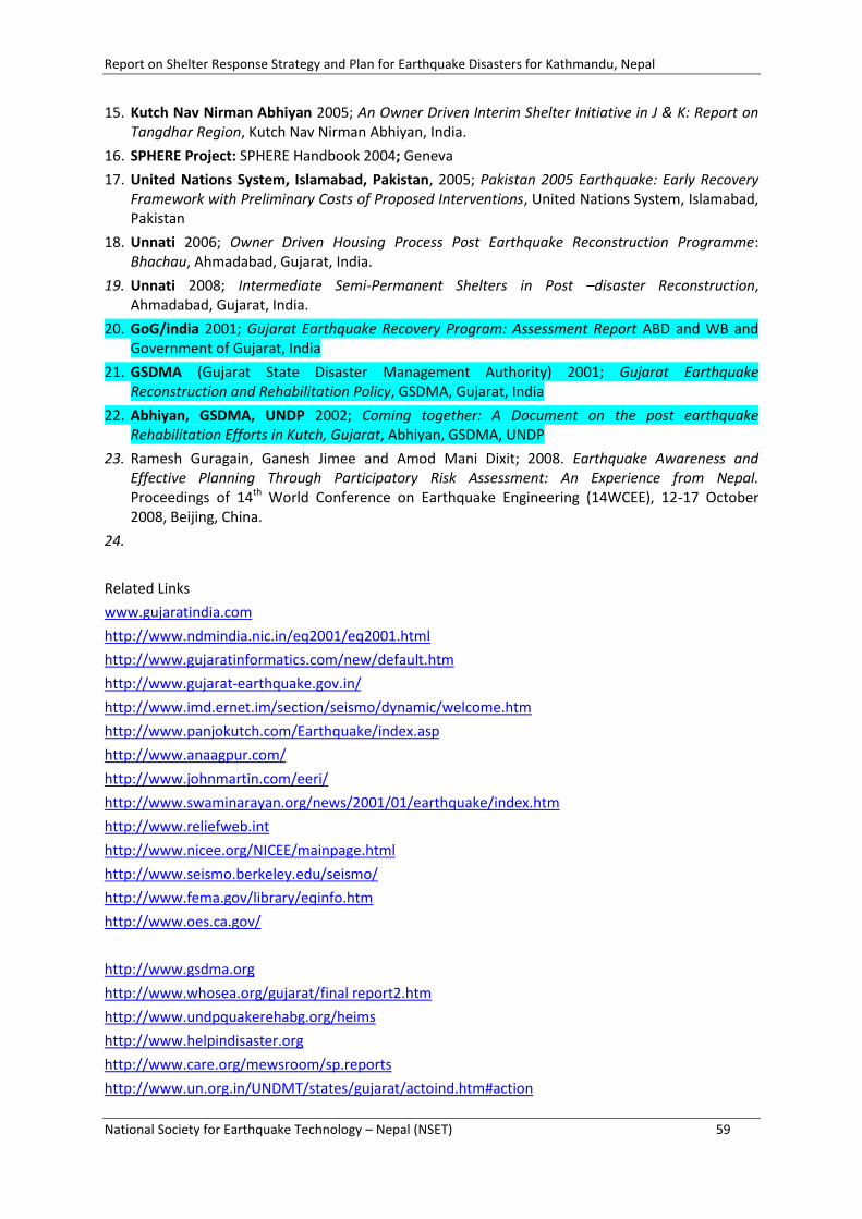
Report on Shelter Response Strategy and Plan for Earthquake Disasters for Kathmandu, Nepal
National Society for Earthquake Technology – Nepal (NSET) 59
15. Kutch Nav Nirman Abhiyan 2005; An Owner Driven Interim Shelter Initiative in J & K: Report on Tangdhar Region, Kutch Nav Nirman Abhiyan, India.
16. SPHERE Project: SPHERE Handbook 2004; Geneva
17. United Nations System, Islamabad, Pakistan, 2005; Pakistan 2005 Earthquake: Early Recovery Framework with Preliminary Costs of Proposed Interventions, United Nations System, Islamabad, Pakistan
18. Unnati 2006; Owner Driven Housing Process Post Earthquake Reconstruction Programme: Bhachau, Ahmadabad, Gujarat, India.
19. Unnati 2008; Intermediate Semi-Permanent Shelters in Post –disaster Reconstruction, Ahmadabad, Gujarat, India.
20. GoG/india 2001; Gujarat Earthquake Recovery Program: Assessment Report ABD and WB and Government of Gujarat, India
21. GSDMA (Gujarat State Disaster Management Authority) 2001; Gujarat Earthquake Reconstruction and Rehabilitation Policy, GSDMA, Gujarat, India
22. Abhiyan, GSDMA, UNDP 2002; Coming together: A Document on the post earthquake Rehabilitation Efforts in Kutch, Gujarat, Abhiyan, GSDMA, UNDP
23. Ramesh Guragain, Ganesh Jimee and Amod Mani Dixit; 2008. Earthquake Awareness and Effective Planning Through Participatory Risk Assessment: An Experience from Nepal. Proceedings of 14th World Conference on Earthquake Engineering (14WCEE), 12-17 October 2008, Beijing, China.
24.
Related Links
www.gujaratindia.com
http://www.ndmindia.nic.in/eq2001/eq2001.html
http://www.gujaratinformatics.com/new/default.htm
http://www.gujarat-earthquake.gov.in/
http://www.imd.ernet.im/section/seismo/dynamic/welcome.htm
http://www.panjokutch.com/Earthquake/index.asp
http://www.anaagpur.com/
http://www.johnmartin.com/eeri/
http://www.swaminarayan.org/news/2001/01/earthquake/index.htm
http://www.reliefweb.int
http://www.nicee.org/NICEE/mainpage.html
http://www.seismo.berkeley.edu/seismo/
http://www.fema.gov/library/eqinfo.htm
http://www.oes.ca.gov/
http://www.gsdma.org
http://www.whosea.org/gujarat/final report2.htm
http://www.undpquakerehabg.org/heims
http://www.helpindisaster.org
http://www.care.org/mewsroom/sp.reports
http://www.un.org.in/UNDMT/states/gujarat/actoind.htm#action

Report on Shelter Response Strategy and Plan for Earthquake Disasters for Kathmandu, Nepal
National Society for Earthquake Technology – Nepal (NSET) 60
ANNEXES
ANNEX 1: STEPS FOR SHELTER RESPONSE PLANNING
ANNEX 2: OUTLINE FOR TRAINING CURRICULA
1. Basic Concepts: Hazard, vulnerability, risk and related socio-economics
2. Cases of Gujarat, Pakistan and others
3. RADIUS and other RA methodologies
4. From Risk to Shelter Needs
5. Details on Shelters: typology and defining factors
6. Elements of Shelter Strategy
Need
Typologies
Responsibility
Institutional mechanism and responsibilities
7. Process
Flow chart of shelter strategy development
8. Shelter Response Plan
Elements
Responsibility of planning (who prepares!)
Who owns / implements
9. Possible fall backs on Shelter Strategy (SS) and Shelter Planning (SP)
10. Local Contextualization