draft scope for the modification of the catalum spdes ... · catalum spdes permit environmental...
TRANSCRIPT

DRAFT SCOPE FOR THE MODIFICATION
OF THE
CATALUM SPDES PERMIT
ENVIRONMENTAL IMPACT STATEMENT
Lead Agency:
New York State Department of Environmental Conservation
Applicant:
New York City Department of Environmental Protection
April 2014

Draft Scope
Modification of the Catalum SPDES Permit 1 April 2014
DRAFT SCOPE FOR THE MODIFICATION OF THE CATALUM SPDES PERMIT
ENVIRONMENTAL IMPACT STATEMENT
TABLE OF CONTENTS
1.0 OVERVIEW ................................................................................................................. 3
1.1 PROJECT IDENTIFICATION ................................................................................................ 4
1.2 PROJECT BACKGROUND ................................................................................................... 6
1.3 WATER SUPPLY SYSTEM OPERATION .............................................................................. 7
1.4 REGULATORY BACKGROUND ......................................................................................... 10
1.5 CATALUM SPDES PERMIT ............................................................................................. 13
1.6 THE PROPOSED ACTION ................................................................................................. 14
1.7 PURPOSE AND NEED FOR THE PROPOSED ACTION .......................................................... 29
1.8 LOCAL, STATE AND FEDERAL PERMITS AND APPROVALS .............................................. 30
1.9 PRIOR STUDIES .............................................................................................................. 30
2.0 SCOPE OF THE ENVIRONMENTAL IMPACT STATEMENT ........................ 34
2.1 ENVIRONMENTAL REVIEW ............................................................................................. 34
2.2 DESCRIPTION OF THE PROPOSED ACTION ....................................................................... 35
2.3 SUMMARY OF PROPOSED METHODOLOGIES FOR ENVIRONMENTAL ANALYSES ............. 36
2.3.1 Ashokan Reservoir and Ashokan Release Channel/Lower Esopus Creek ................ 37
2.3.2 Kensico Reservoir ..................................................................................................... 55
2.4 CUMULATIVE IMPACTS .................................................................................................. 67
2.5 ALTERNATIVES ANALYSIS ............................................................................................. 67
2.5.1 The No Action Alternative ......................................................................................... 68
2.5.2 Ashokan Reservoir Alternatives ................................................................................ 69
2.5.3 Alternatives along the Catskill Aqueduct .................................................................. 71
2.5.4 Alternatives at Kensico Reservoir ............................................................................. 72
2.6 MITIGATION ................................................................................................................... 73
2.7 GROWTH INDUCEMENT .................................................................................................. 74
2.8 UNAVOIDABLE IMPACTS AND IRRETRIEVABLE AND IRREVERSIBLE COMMITMENT OF
RESOURCES ................................................................................................................... 74
LIST OF TABLES
Table 1: Elements of the Proposed Action and Related Turbidity Control Measures ............ 15
Table 2: Historical Use of the Ashokan Release Channel ...................................................... 22
Table 3: Catskill Turbidity Control Analysis Framework ...................................................... 28
Table 4: Historical Alum Use at Kensico Reservoir ............................................................... 69
Draft Scope
Modification of the Catalum SPDES Permit 2 April 2014
LIST OF FIGURES
Figure 1: Water Supply System…………………………………………………..………9
Figure 2: Kensico Reservoir……………………………………………………………...11
Figure 3: Ashokan Reservoir and Ashokan Release Channel/Lower Esopus Creek……. 12
Figure 4: Catskill Aqueduct Stop Shutters……………………………………………… .19
Figure 5: Ashokan Reservoir and Ashokan Release Channel/Lower Esopus Creek
Study Area… ……………………………………………………………….….38
Figure 6: Kensico Reservoir Study Area..…………………………………………….…..56
ATTACHMENTS
Attachment A: New York State Department of Environmental Conservation Interim Ashokan
Release Protocol dated September 27, 2013, as part of the Order on Consent
dated October 4, 2013

Draft Scope
Modification of the Catalum SPDES Permit 3 April 2014
1.0 OVERVIEW
The New York City (City) Water Supply System is one of the largest surface water storage and
supply complexes in the world, with watersheds covering 1,972 square miles. It is the primary
drinking water source for approximately half the population of New York State, including over
eight million residents of the City and an additional one million residents of upstate counties.
The City‟s water supply from this system is of very high quality and generally meets all
applicable federal and state standards. Comprised of three separate but interconnected water
supplies, the cascading arrangement and detention times of the reservoirs allow pollutants to
settle out as water flows through the system. The source waters are generally of high quality
because of the relatively pristine landscape, and many pollutants are prevented from entering the
reservoirs at all through the New York City Department of Environmental Protection‟s (DEP‟s)
implementation of extensive watershed protection initiatives. The water supply, therefore,
requires little treatment.
While natural conditions and DEP‟s watershed protection programs generally ensure the
excellence of the City‟s water supply, DEP must also manage episodic water quality events
associated with turbidity,1 typically produced by storm events, as well as bacterial and algal
problems that sometimes occur in the system. To manage these events and protect water quality,
DEP has the ability to apply water treatment chemicals to the water leaving upstate reservoirs
and in the aqueducts. Treating water quality disruptions upstream when necessary, close to the
source of the problem, helps prevent migration of contaminants further downstream and
potentially into the distribution system. Aluminum sulfate (alum) and sodium hydroxide are used
for turbidity control. In the past, water leaving the upstream reservoirs has also been occasionally
treated with chlorine for isolated instances of elevated levels of bacteria and algae. Downstream
of the watershed, at Kensico Reservoir and Hillview Reservoir, prior to entering the distribution
system, the water supply is treated continuously with chlorine for disinfection, fluoride for
fluoridation, sodium hydroxide for pH control, and orthophosphate to control leaching of lead
and copper from residential plumbing systems.
Episodic turbidity is more prevalent in the City‟s Catskill System, comprised of Schoharie and
Ashokan Reservoirs, which have watersheds characterized by a natural landscape with steep
slopes, clay-rich soils, and erodible stream beds. Storm events within the Catskill System have
the potential to disturb the clay-rich stream banks and channels in the Schoharie and Ashokan
watersheds. Unlike the Catskill System, the Delaware System watershed has a moderately sloped
landscape, more sand and gravel deposits with less clay, and its streams are less erosive due their
1 Turbidity is an optical property of water influenced by the presence of higher concentrations of suspended particles that make
water opaque or cloudy. This matter normally consists largely of suspended clay, silt, organic and inorganic material and
microscopic organisms. Turbidity is of concern primarily due to its potential impact on public health by making disinfection
less effective, as the cloudiness could interfere with chlorine and ultraviolet-light disinfection, and potential contaminants may adhere to, or be encapsulated by the suspended particles.

Draft Scope
Modification of the Catalum SPDES Permit 4 April 2014
characteristic geomorphology. In addition, the cascading configuration of the Delaware System
reservoirs tends to further ameliorate turbidity levels as the water travels through the system to
Kensico Reservoir (the increased travel time allows for particles that may cause turbidity to settle
out). Accordingly, the Delaware System is not prone to the same turbidity events as the Catskill
System.
In the Catskill System, water is supplied to Ashokan Reservoir from Schoharie Reservoir via the
Shandaken Tunnel and upper Esopus Creek. Ashokan Reservoir is divided into two basins: west
and east, which feed the Catskill Aqueduct and ultimately Kensico Reservoir in Westchester
County. Kensico Reservoir receives water from both the Catskill and Delaware Systems and is
the terminal raw water reservoir for these systems. From here, water is treated and flows
downstream to the City‟s distribution system (see Section 1.3).
The dual basins of Ashokan Reservoir help to settle out the suspended particles in the water as it
flows in sequence through each basin. Water from the upper Esopus Creek enters Ashokan‟s
west basin where particles can settle out before entering Ashokan Reservoir‟s east basin through
spillage over or transfer through the dividing weir. The two-basin design of the reservoir
typically allows for sufficient detention and settling time to address turbid runoff. This two-basin
design is critical to protecting downstream drinking water quality because it allows drinking
water to be delivered to the Catskill Aqueduct from either basin, depending on water quality.
However, in most instances, water of higher quality is obtained from the east basin.
1.1 Project Identification
In June 2012, DEP requested a modification to the New York State Department of
Environmental Conservation (NYSDEC) Catskill Influent Chamber State Pollutant Discharge
Elimination System (SPDES) Permit (Catalum SPDES Permit), to incorporate measures to
control turbidity in water diverted from Ashokan Reservoir and to postpone dredging of alum
floc2 at Kensico Reservoir until completion of certain infrastructure projects (Proposed Action).
The proposed permit modification is subject to environmental review under the State
Environmental Quality Review Act (SEQRA). This Environmental Impact Statement (EIS) will
evaluate the potential for significant adverse environmental impacts to occur from
implementation of the turbidity control measures proposed to be incorporated into the Catalum
SPDES Permit (Turbidity Control Measures), as well as from the postponement of dredging.
Implementation of the turbidity control measures analyzed in this EIS would allow DEP to
continue to provide reliable, clean, and safe drinking water while reducing reliance on chemical
treatment of the water supply, specifically the use of alum, during episodic turbidity events. DEP
uses a number of measures, including ongoing implementation of existing watershed protection
2 Floc or flocculent is a soft, loosely combined mass formed in a fluid through precipitation or aggregation of
suspended particles. In this case, it is the combination of aluminum hydroxide solids plus entrained solids.
Draft Scope
Modification of the Catalum SPDES Permit 5 April 2014
programs and a number of operational techniques to manage turbidity. In addition, the use of
engineering/infrastructure projects currently under design and/or construction would also help to
control turbidity events. As outlined below, some of these elements do not require environmental
review, because either they are part of routine operations or they have previously undergone
environmental review; the remaining elements will be the subject of analysis in this EIS (see
Section 1.6 for further details). In addition, all of these measures will be considered together to
determine whether there is a potential for significant adverse cumulative impacts. The
cumulative review will include those elements that have not undergone environmental review
together with DEP‟s existing water supply system operations, and the operation of the additional
engineering and infrastructure projects.
The elements that do not require further environmental review are listed below and are further
described in Section 1.6:
1. Selective diversion and withdrawal from DEP‟s reservoirs;
2. Existing watershed management programs;
3. Drawdown of Ashokan Reservoir‟s west basin;
4. Use of the Operations Support Tool (OST) for reservoir management;
5. Improvements to stop shutters along the Catskill Aqueduct;
6. Use of the Catskill and Delaware Interconnection at Shaft 4; and
7. Use of the Croton Water Filtration Plant.
The elements that are the subject of this EIS are:
1. Use of the Ashokan Release Channel3 under the Interim Ashokan Release Protocol (IRP)
dated September 27, 20134;
2. Dredging of alum deposits in Kensico Reservoir resulting from use of alum at Kensico
Reservoir; and
3. Delay of dredging of alum deposits in Kensico Reservoir to a future year (2024).
This EIS will also evaluate alternatives to the Proposed Action including a No Action
Alternative, which is the continued use of alum at historic levels to control turbidity at Kensico
Reservoir without the turbidity control benefits of DEP‟s turbidity control measures. This EIS
will also evaluate alternatives related to operation of the Catskill Aqueduct, including options to
discharge water from the Catskill Aqueduct prior to its reaching the Kensico Reservoir,
3 The Ashokan Release Channel is a concrete-lined channel from Ashokan Reservoir that releases water to the lower
Esopus Creek which ultimately flows to the Hudson River. 4 The Interim Ashokan Release Protocol (see Attachment A) included in the Order on Consent dated October 4,
2013 provides for community releases (those that would provide environmental, recreational, and economic
benefits to the lower Esopus Creek and surrounding community); discharge mitigation releases that would
enhance flood mitigation; and operational releases intended primarily to protect water quality (and which also
further the potential for flood mitigation).
Draft Scope
Modification of the Catalum SPDES Permit 6 April 2014
reasonable structural alternatives to operation of the Ashokan Release Channel, and reasonable
alternatives for operation of the Kensico Reservoir. This EIS will also identify measures to
mitigate or minimize the potential for any identified significant adverse impacts of the Proposed
Action, as required. The EIS will also compare the environmental impacts of the use of alum and
subsequent floc deposition in Kensico Reservoir versus impacts to lower Esopus Creek due to
implementation of DEP‟s turbidity control measures and other identified alternatives.
This EIS will also evaluate the potential for significant adverse impacts from the proposed
modification of the existing Catalum SPDES Permit to incorporate the Interim Ashokan Release
Protocol for the use of the Ashokan Release Channel. The Protocol may be refined by DEP and
NYSDEC based on experience with operating under the Interim Ashokan Release Protocol or as
a result of these EIS analyses.
The Catalum SPDES Permit (Number NY0264652) was administratively renewed without
modifications in July 2011. This EIS will support a future modification of the Catalum SPDES
Permit. NYSDEC will be the Lead Agency for this EIS. DEP will work with NYSDEC to
prepare this EIS consistent with the requirements of SEQRA, as set forth in 6 NYCRR Part 617
authorized by Article 8 of the Environmental Conservation Law, and the City Environmental
Quality Review (CEQR) process, as set forth in Executive Order 91 of 1977 and its amendments,
as applicable. Public Scoping will be the first step in the process to prepare an EIS under
SEQRA. Scoping provides an early opportunity for the public and other agencies to be involved
in the EIS process. It will provide the opportunity for the public to identify those issues
warranting consideration in the EIS, and to facilitate public and agency comment on the
methodologies proposed to be used to assess the potential effect of the project. Public scoping
will also allow the public to comment on the range of reasonable alternatives that have the
potential to meet the purpose and need of the Proposed Action. This Draft Scope has been
prepared to describe the Proposed Action, present the proposed framework for the EIS analysis,
and discuss the procedures to be followed in the preparation of the EIS.
1.2 Project Background
DEP, on behalf of the City, operates a system of 19 reservoirs and three controlled lakes that
provide more than one billion gallons of drinking water per day to over eight million residents of
the City, and approximately 125 million gallons per day (MGD) for one million residents in
Westchester, Putnam, Ulster, and Orange Counties. The City‟s source water is impounded in
watersheds in the upstate Catskill, Delaware, and Croton Systems, and flows by gravity through
three aqueducts into balancing reservoirs, and ultimately through the City‟s distribution system
(see Section 1.3 for more detail). Management of the City‟s water supply system is a dynamic,
interdependent, and interactive process, with many individual watersheds, reservoirs, aqueducts,
and facilities that are monitored, operated, and controlled to meet federal and state regulatory
requirements, and other criteria. A key feature of the system is its operational flexibility, which
allows DEP to selectively divert water from different reservoirs to meet water quality criteria and
water supply needs.

Draft Scope
Modification of the Catalum SPDES Permit 7 April 2014
This flexibility is important since geologic conditions in the Catskill watershed can cause
episodic changes to water quality as a consequence of events, such as extreme storms, which can
erode the naturally occurring silt and clay deposits present in the watershed‟s relatively steep
slopes, stream banks, and channels. Such events result in elevated turbidity levels in the water of
the Catskill System, and occasionally in the diversions to Kensico Reservoir where it combines
with water from the Delaware System. Under normal conditions, water from the Catskill and
Delaware Systems is treated by DEP to meet drinking water quality standards as it leaves
Kensico Reservoir and at Hillview Reservoir prior to entering the distribution system. For the
upstream watersheds, current watershed management programs and operational practices are
typically adequate to maintain compliance with federal and state requirements; however, under
unusual circumstances, such as episodic turbidity resulting from high flow events, water
treatment chemicals are needed. To manage these events and protect water quality, DEP has the
ability to apply water treatment chemicals - alum and sodium hydroxide for turbidity control - in
the Catskill Aqueduct prior to the water flowing into Kensico Reservoir. The New York State
Department of Health (NYSDOH) regulates the use of these chemicals, and NYSDEC regulates
associated flows into the water bodies receiving these chemicals under the SPDES permit
program.
In contrast to the Catskill and Delaware Systems, the quality of water provided by the Croton
watershed does not meet regulatory criteria for filtration avoidance under the Surface Water
Treatment Rule (SWTR). Therefore, the City is constructing a water filtration plant (which was
subject to a separate environmental review) that is in startup and testing mode and anticipated to
be online by the end of 2014 (Croton Water Filtration Plant). Once completed, filtered Croton
water will be available along with the City‟s Catskill/Delaware systems to meet water supply
demand. The Croton Water Filtration Plant will reduce reliance on the Catskill and Delaware
supplies and enhance the flexibility of the entire water supply system to respond to water quality
events.
1.3 Water Supply System Operation
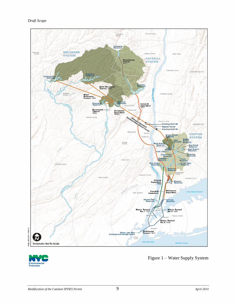
As mentioned above, the City‟s water is supplied from three large surface water systems; the
Catskill System, the Delaware System, and the Croton System (see Figure 1). Historically,
approximately 40% of the City‟s average demand is provided by the Catskill System, 50% by the
Delaware System, and 10% by the Croton System. During drought conditions, the Croton
System yield is sufficient to meet roughly up to 30% of the City‟s demand. Water from both the
Catskill and Delaware systems is normally routed through Kensico Reservoir before being
conveyed through the Delaware and Catskill aqueducts to Hillview Reservoir and, via City
tunnels, to the water distribution system. Water from the Croton System is conveyed to the City
via the New Croton Aqueduct to Jerome Park Reservoir.
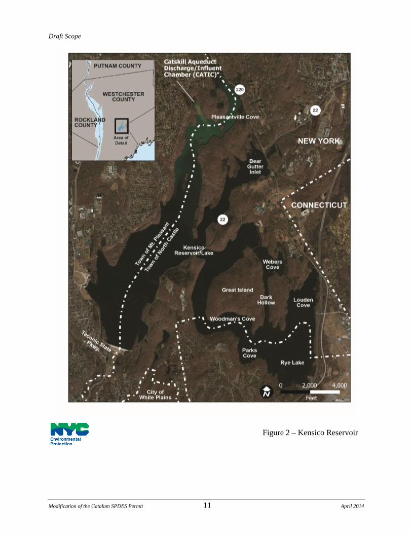
Kensico Reservoir is a key component of the City‟s multiple barrier water treatment process,
providing residence time for particles from the Catskill and Delaware water to settle out prior to

Draft Scope
Modification of the Catalum SPDES Permit 8 April 2014
withdrawal for water supply (see Figure 2). Water from the Catskill and Delaware aqueducts
enters Kensico Reservoir from Ashokan Reservoir at the Catskill Influent Chamber (CATIC),
and from the Rondout and West Branch reservoirs at Delaware Shaft 17 (DEL 17).
Draft Scope
Modification of the Catalum SPDES Permit 9 April 2014
Figure 1 – Water Supply System

Draft Scope
Modification of the Catalum SPDES Permit 10 April 2014
Catskill System water from Ashokan Reservoir can also be released from the system via the
Ashokan Release Channel and/or can also enter the lower Esopus Creek as a result of spillage
over the east basin spillway into the 1.4 mile spillway channel. Water from the Ashokan Release
Channel converges with the water from the east basin spillway channel at a point referred to as
the spillway confluence, and from there flows to the lower Esopus Creek and ultimately the
Hudson River, 29.3 miles downstream (see Figure 3).
1.4 Regulatory Background
The two major federal statutes that apply to the City‟s Water Supply System operation are the
federal Safe Drinking Water Act (SDWA) and the Clean Water Act (CWA). While the SDWA
primarily regulates the quality of drinking water that is delivered to the consumers, the CWA
focuses on maintaining the quality of surface water resources for designated uses. As per the
CWA, discharges of pollutants to waters of the U.S. require permits under the National Pollutant
Discharge Elimination System (NPDES) program, implemented in New York State under the
SPDES program.
In 1989, the United States Environmental Protection Agency (USEPA) promulgated the Surface
Water Treatment Rule (SWTR) pursuant to the SDWA. The SWTR requires filtration of all
surface water supplies unless the water supplier meets certain water quality, disinfection, and
control criteria that would allow the water supplier to obtain a waiver of the filtration
requirement from the USEPA or delegated state agency. Beginning in 1993, under a series of
successive Filtration Avoidance Determinations (FADs), the USEPA has determined that the
City‟s Catskill and Delaware supplies satisfy the requirements for unfiltered surface water
systems. The most recent FAD, issued in 2007 (2007 FAD) establishes requirements for
continued watershed protection efforts through 2017. A core requirement for filtration
avoidance is a watershed control program that can identify, monitor, and control activities
in the watershed that may have an adverse effect on source water quality. DEP‟s watershed
control program includes measures to control turbidity in its Catskill Water Supply System;
those measures that are proposed to be incorporated into the modified Catalum SPDES Permit
are described in more detail below.
Draft Scope
Modification of the Catalum SPDES Permit 11 April 2014
Figure 2 – Kensico Reservoir

Draft Scope
Modification of the Catalum SPDES Permit 12 April 2014
The 2007 FAD required DEP‟s development and submittal of Phase III of the Catskill Turbidity
Control Study, an engineering analysis of potential turbidity reduction measures, including
interim measures that are both feasible and cost effective for the Ashokan Reservoir. The
potential measures included: (1) an in-reservoir baffle for the Ashokan Reservoir‟s east basin; (2)
a new release structure from the Ashokan Reservoir‟s west basin; (3) a new intake structure for
the east basin; (4) raising the dividing weir, thereby increasing storage capacity of the west basin;
and (5) modified system operations. Subsequent to submittal of the Phase III report, DEP was
required to develop a plan with appropriate interim milestones for implementation of the selected
turbidity reduction measures. The 2007 FAD also required that DEP implement those selected
turbidity reduction measures, as detailed in Section 2.3.11 of its 2006 Long-Term Watershed
Protection Program, and the milestones therein.
Figure 3 – Ashokan Reservoir and Ashokan Release Channel/Lower
Esopus Creek

Draft Scope
Modification of the Catalum SPDES Permit 13 April 2014
1.5 Catalum SPDES Permit
Following a series of several heavy rainfall events in upstate New York in 2005 and 2006, and
the subsequent emergency repair operations at Schoharie Reservoir that necessitated the
emergency release of abnormally high volume of water to upper Esopus Creek, highly turbid
water entered Kensico Reservoir, and NYSDEC issued emergency authorizations allowing DEP
to add alum to the water in the Catskill Aqueduct to control turbidity (See section 2.5.1).
Following the expiration of these emergency authorizations, DEP applied for, and after
environmental review, NYSDEC issued SPDES Permit Number NY0264652 on January 1, 2007
for a period of five (5) years through December 31, 2011 to allow alum treatment for the
diversions through the Catskill Aqueduct into Kensico Reservoir. In 2011, the Catalum SPDES
Permit was administratively extended through December 31, 2016. This permit allows DEP to
apply alum in the Catskill Aqueduct when NYSDOH concurs, based on DEP input, that a
potential public health hazard associated with the diversions of turbid water from Kensico
Reservoir is imminent.
The Catalum SPDES Permit provides effluent limits and also contains a compliance schedule
that requires DEP to meet specific milestones related to alum addition at Kensico Reservoir and
turbidity control in the Catskill System. These include:
Preparation of a report that analyzes alternatives to minimize the area of floc deposition
resulting from addition of alum and sodium hydroxide, identifies a chosen alternative,
and describes how and when the chosen alternative would be implemented;
Preparation of a bathymetric/benthic report for the purpose of establishing a scientific
basis for the quantity of alum floc deposits that must be removed from the receiving
water to meet the narrative water quality standard for suspended, colloidal and settleable
solids in the Kensico Reservoir;
Preparation of an engineering report describing the information gathered during the
removal of alum floc deposits and for the purpose of guiding future dredging activities;
Development of a program to reduce the amount and duration of alum use by evaluating
and implementing structural, operational, and erosion control measures to reduce
turbidity in waters flowing into the Catskill Aqueduct and to protect the water supply,
fishery, and recreational uses within both the Ashokan Reservoir basin and Kensico
Reservoir;
Identification and implementation of any short- and long-term structural measures that
will achieve the above goals; and
Submittal of a report detailing the short and long term structural modifications evaluated
in the Phase III Catskill Turbidity Control Study and implementation of approved

Draft Scope
Modification of the Catalum SPDES Permit 14 April 2014
structural alternatives.
As part of its ongoing program review, and to meet Catalum SPDES requirements, DEP has
explored these and a number of additional engineering and operational alternatives to the
addition of alum at CATIC at historic levels.
1.6 The Proposed Action
The existing five-year Catalum SPDES Permit for alum addition in the Catskill Aqueduct
upstream of Kensico Reservoir was administratively renewed and expires in December 2016.
DEP seeks to modify the Catalum SPDES Permit to incorporate measures to control turbidity in
water diverted from Ashokan Reservoir and to postpone dredging of alum floc at Kensico
Reservoir until the completion of certain infrastructure projects. This EIS will describe the
benefits to the water supply and assess the potential for significant adverse impacts from
operation of the Ashokan Release Channel under the Interim Ashokan Release Protocol dated
September 27, 2013 and from the postponement of dredging of alum floc at Kensico Reservoir.
The EIS will also take into account implementation of DEP‟s turbidity control measures as a
whole. Feasible recommended mitigative measures for alum use, as well as for use of the
Ashokan Release Channel, if mitigation is determined necessary in the EIS, will be incorporated
into a modified Catalum SPDES Permit.
DEP‟s turbidity control measures are intended to minimize the need for chemical addition
through the use of operational, engineering, and other non-treatment measures, while also
minimizing the potential for significant adverse impacts to the environment. As indicated in
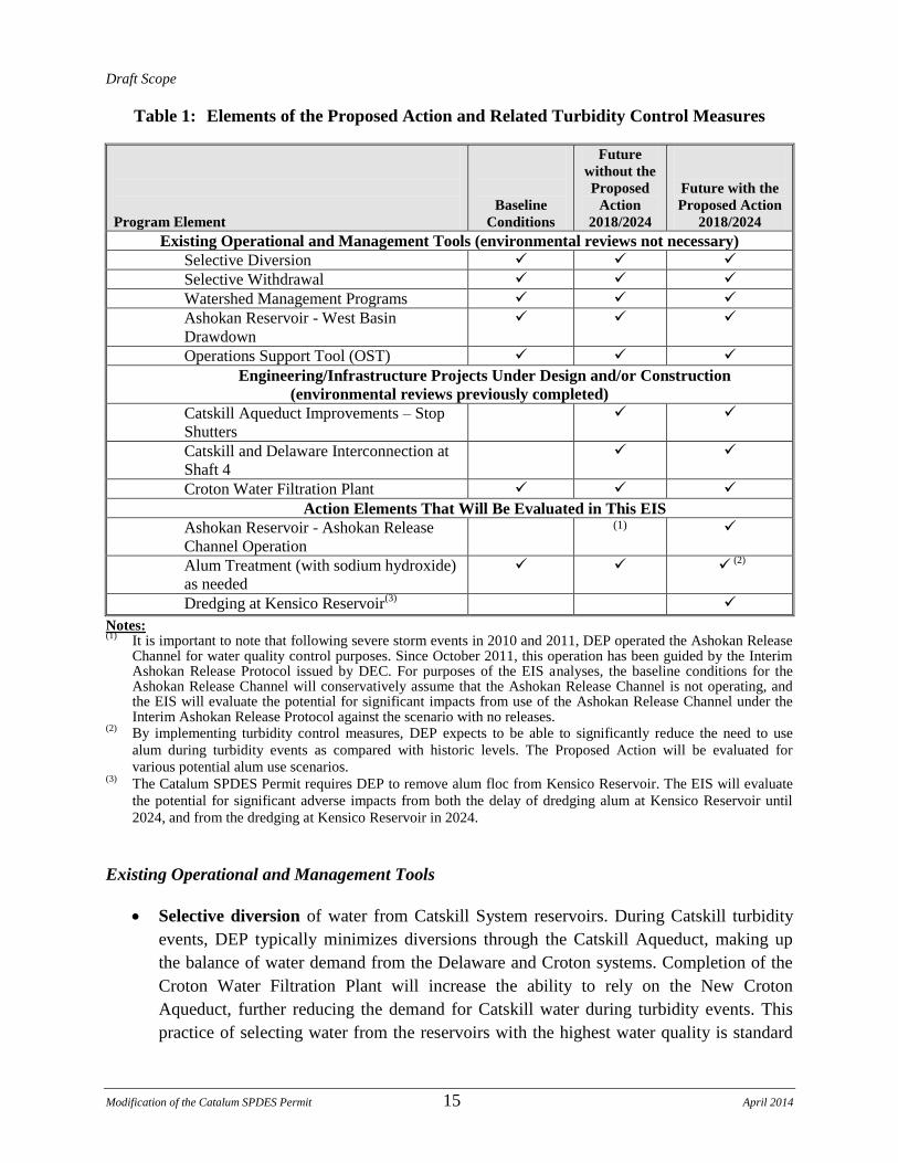
Table 1, DEP has already implemented certain such measures; while others are under design
and/or construction, and are planned to be operational in the next few years. Many of these
elements either do not require environmental review, or have also already undergone separate
environmental reviews because of their independent utility and will be implemented by DEP by
2018. While these measures are not the focus of this EIS, their implementation would be
considered as part of the operating assumptions for this environmental review. Table 1 identifies
the elements of the proposed modification of the Catalum SPDES Permit and other measures
DEP can employ to address turbidity entering Kensico Reservoir, and is followed by a more in-
depth discussion of each and status of applicable environmental reviews.
Draft Scope
Modification of the Catalum SPDES Permit 15 April 2014
Table 1: Elements of the Proposed Action and Related Turbidity Control Measures
Program Element
Baseline
Conditions
Future
without the
Proposed
Action
2018/2024
Future with the
Proposed Action
2018/2024
Existing Operational and Management Tools (environmental reviews not necessary) Selective Diversion Selective Withdrawal Watershed Management Programs Ashokan Reservoir - West Basin
Drawdown
Operations Support Tool (OST) Engineering/Infrastructure Projects Under Design and/or Construction
(environmental reviews previously completed) Catskill Aqueduct Improvements – Stop
Shutters
Catskill and Delaware Interconnection at
Shaft 4
Croton Water Filtration Plant Action Elements That Will Be Evaluated in This EIS
Ashokan Reservoir - Ashokan Release
Channel Operation (1)
Alum Treatment (with sodium hydroxide)
as needed
(2)
Dredging at Kensico Reservoir(3)
Notes: (1) It is important to note that following severe storm events in 2010 and 2011, DEP operated the Ashokan Release
Channel for water quality control purposes. Since October 2011, this operation has been guided by the Interim Ashokan Release Protocol issued by DEC. For purposes of the EIS analyses, the baseline conditions for the Ashokan Release Channel will conservatively assume that the Ashokan Release Channel is not operating, and the EIS will evaluate the potential for significant impacts from use of the Ashokan Release Channel under the Interim Ashokan Release Protocol against the scenario with no releases.
(2) By implementing turbidity control measures, DEP expects to be able to significantly reduce the need to use
alum during turbidity events as compared with historic levels. The Proposed Action will be evaluated for
various potential alum use scenarios. (3) The Catalum SPDES Permit requires DEP to remove alum floc from Kensico Reservoir. The EIS will evaluate
the potential for significant adverse impacts from both the delay of dredging alum at Kensico Reservoir until
2024, and from the dredging at Kensico Reservoir in 2024.
Existing Operational and Management Tools
Selective diversion of water from Catskill System reservoirs. During Catskill turbidity
events, DEP typically minimizes diversions through the Catskill Aqueduct, making up
the balance of water demand from the Delaware and Croton systems. Completion of the
Croton Water Filtration Plant will increase the ability to rely on the New Croton
Aqueduct, further reducing the demand for Catskill water during turbidity events. This
practice of selecting water from the reservoirs with the highest water quality is standard
Draft Scope
Modification of the Catalum SPDES Permit 16 April 2014
DEP operating practice and known as selective diversion. An independent environmental
review of this in-system operational DEP procedure is not warranted, as this activity
qualifies as a Type II Action in accordance with 6 NYCRR § 617.5(c)(20).5
Selective withdrawal of water from various levels within the reservoirs. In addition to
the operational flexibility provided by differences in water quality between reservoirs,
some reservoir gatehouses are equipped with stop shutters located at varying elevations
within each reservoir, allowing DEP to draw water preferentially from the depth
containing water of the highest quality. DEP‟s standard operation practice of selective
withdrawal is implemented within the Ashokan Reservoir to prevent turbid water
resulting from episodic events from being carried through the system. An independent
environmental review of this in-system operational DEP procedure is not warranted, as
this activity qualifies as a Type II Action in accordance with 6 NYCRR § 617.5(c)(20).
Watershed Management Programs. DEP‟s Watershed Management Program includes
adoption of best management practices for a wide range of watershed activities,
implementation of Watershed Rules and Regulations to protect the watershed from
certain potential sources of contamination, a comprehensive Land Acquisition Program
(LAP) to preserve environmentally sensitive lands in the watershed, and a Stream
Management Program that provides technical and financial assistance to communities for
stream management planning and implementation to help prevent the worsening of
natural geologic conditions in the watershed. DEP‟s 2010 Forest Management Plan
(FMP) is also being implemented and provides a broad-based set of forest management
activities that could be undertaken on currently owned or future acquired City water
supply lands to manage, improve, and regenerate the forests, and further protect water
quality in the watershed. Collectively, these programs help to prevent activities that could
exacerbate turbidity levels of water entering the water supply system. Independent
environmental reviews of individual watershed/stream management projects are
undertaken as required (e.g. environmental reviews of DEP‟s LAP to support a permit
renewal, and the FMP, which is a comprehensive resource management plan). Since
these projects have been implemented by DEP under the FAD, have independent utility,
and were previously evaluated in environmental reviews on a project-specific basis as
required, further review in this EIS is not warranted.
5 A Type II action under 6 NYCRR § 617.5(c) (20) is routine or continuing agency administration and management,
not including new programs or major reordering of priorities that may affect the environment.
Draft Scope
Modification of the Catalum SPDES Permit 17 April 2014
Diversion management at Ashokan Reservoir to transfer water from the reservoir’s
west basin to the east basin via the dividing weir (west basin drawdown). The
two-basin design of Ashokan Reservoir allows DEP to operate the west basin of the
Ashokan Reservoir as a settling basin, while the east basin is used for diversions to the
Catskill Aqueduct (see Figure 3). Alternatively, the Catskill Aqueduct may take
diversions from the west basin whenever water quality is acceptable. The extent of the
turbidity events in the Catskill System can be reduced through management of the
existing facilities at Ashokan Reservoir using two methods. First, during or in
anticipation of storm events, DEP can divert water from the west basin to the Catskill
Aqueduct in order to develop or maintain a void in the west basin to capture and settle
any influx of turbid water associated with the event. This void allows the west basin to
absorb some or all of the inflow during a storm event, thereby reducing the transfer of
turbid water across the dividing weir to the east basin. Second, during storm events where
turbid waters entering the west basin are likely to spill into the east basin, the dividing
weir gates are sometimes opened in advance to minimize spill over the dividing weir.
Both of these methods reduce turbidity levels entering the Catskill Aqueduct and
eventually Kensico Reservoir, thus reducing the need for alum addition. An independent
environmental review of this in-system operational DEP procedure is not warranted, as
this activity qualifies as a Type II Action in accordance with 6 NYCRR § 617.5(c)(20).
Implementation of an Operations Support Tool (OST), OST is a computer-based,
near-real-time management tool to allow for improved management of DEP‟s reservoir
diversions. OST was the recommended alternative of the 2008 Phase III Implementation
Plan for the Catskill Turbidity Control Study, described in Section 1.9 below. OST allows
DEP to optimize operations while balancing water supply, water quality, and
environmental objectives. OST integrates DEP‟s monitored water quality and measured
water quantity data with modeling tools to provide timely and robust guidance to
operations staff, improve DEP‟s ability to implement and refine the rules used to manage
the water supply system, and minimize the need for alum application. OST models the
quantity of water in the water supply system and quality of the water in the reservoirs to
predict short-term and long-term turbidity levels within each reservoir of the Catskill
System. This allows DEP to simulate operation of the system in a “look-ahead” mode and
test the predicted effects of today‟s decisions on the range of water quality and reservoir
storage levels in the coming weeks or months. At Ashokan Reservoir, this capability is
used to support refinement and implementation of long-term operating rules, as well as
modifications to short-term operations. At Kensico Reservoir, OST could further improve
DEP‟s current ability to forecast diversion turbidity levels and minimize the need for
alum application without compromising water quality. An independent environmental
review of this in-house DEP management tool is not warranted, as this activity qualifies
as a Type II Action in accordance with 6 NYCRR § 617.5(c)(20).
Draft Scope
Modification of the Catalum SPDES Permit 18 April 2014
Engineering/Infrastructure Projects under Design and/or Construction
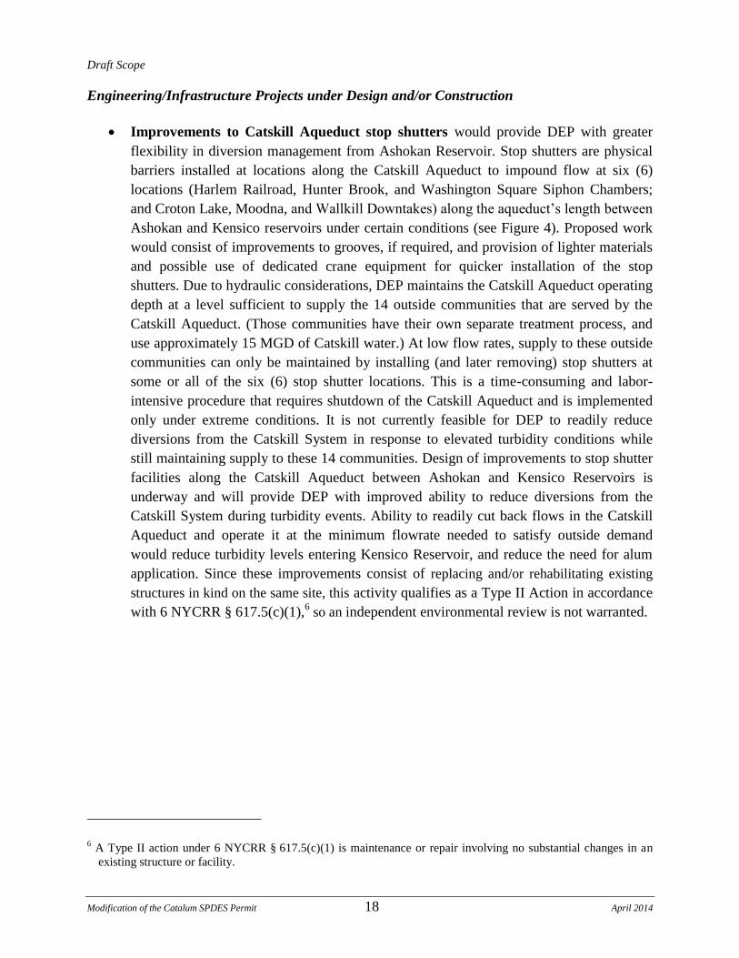
Improvements to Catskill Aqueduct stop shutters would provide DEP with greater
flexibility in diversion management from Ashokan Reservoir. Stop shutters are physical
barriers installed at locations along the Catskill Aqueduct to impound flow at six (6)
locations (Harlem Railroad, Hunter Brook, and Washington Square Siphon Chambers;
and Croton Lake, Moodna, and Wallkill Downtakes) along the aqueduct‟s length between
Ashokan and Kensico reservoirs under certain conditions (see Figure 4). Proposed work
would consist of improvements to grooves, if required, and provision of lighter materials
and possible use of dedicated crane equipment for quicker installation of the stop
shutters. Due to hydraulic considerations, DEP maintains the Catskill Aqueduct operating
depth at a level sufficient to supply the 14 outside communities that are served by the
Catskill Aqueduct. (Those communities have their own separate treatment process, and
use approximately 15 MGD of Catskill water.) At low flow rates, supply to these outside
communities can only be maintained by installing (and later removing) stop shutters at
some or all of the six (6) stop shutter locations. This is a time-consuming and labor-
intensive procedure that requires shutdown of the Catskill Aqueduct and is implemented
only under extreme conditions. It is not currently feasible for DEP to readily reduce
diversions from the Catskill System in response to elevated turbidity conditions while
still maintaining supply to these 14 communities. Design of improvements to stop shutter
facilities along the Catskill Aqueduct between Ashokan and Kensico Reservoirs is
underway and will provide DEP with improved ability to reduce diversions from the
Catskill System during turbidity events. Ability to readily cut back flows in the Catskill
Aqueduct and operate it at the minimum flowrate needed to satisfy outside demand
would reduce turbidity levels entering Kensico Reservoir, and reduce the need for alum
application. Since these improvements consist of replacing and/or rehabilitating existing
structures in kind on the same site, this activity qualifies as a Type II Action in accordance
with 6 NYCRR § 617.5(c)(1),6 so an independent environmental review is not warranted.
6 A Type II action under 6 NYCRR § 617.5(c)(1) is maintenance or repair involving no substantial changes in an
existing structure or facility.
Draft Scope
Modification of the Catalum SPDES Permit 19 April 2014
Figure 4 – Stop Shutter Repair Locations
Draft Scope
Modification of the Catalum SPDES Permit 20 April 2014
Installation of an Interconnection of the Catskill and Delaware Aqueducts near
Shaft 4 of the Delaware Aqueduct in Gardiner, New York would allow greater
flexibility of the use of the Delaware System during Catskill turbidity events. DEP plans
to implement a connection between the Catskill Aqueduct and the Delaware System‟s
Rondout-West Branch Tunnel at Shaft 4 in Gardiner, NY where the aqueducts currently
cross, but are separated by a vertical distance of nearly 600 feet and are not connected.
The proposed Shaft 4 Interconnection has independent utility and would allow DEP to
move water from the Delaware Aqueduct via the Shaft 4 Interconnection into the Catskill
Aqueduct to supply water to users in the City and certain downstream communities.
During turbidity events, the Shaft 4 Interconnection would allow water from the
Delaware System to be diverted to the Catskill Aqueduct, thereby allowing reduction or
elimination of diversions from the Catskill System. The existing Shaft 4 facility is an
approximately 4,500 square-foot, partially buried valve chamber located on property
owned by DEP. The proposed facility is being designed with a new subsurface flow and
pressure control structure to allow the transfer of between 50 MGD and 365 MGD of
pressurized water from the Delaware Aqueduct into the unpressurized Catskill Aqueduct,
by installing new valves and flow control devices. In addition, the Shaft 4
Interconnection would ensure continuity of water provision to select downstream Catskill
System communities by the Delaware System, both with and without the installation of
stop shutters, in the event that the Catskill System is unavailable due to elevated turbidity
events or other repair needs. The planned facility is also expected to allow modest
increases in the maximum diversion rate out of Rondout Reservoir, thus further reducing
the amount of Catskill water that may be required during elevated turbidity conditions. In
2010, DEP issued a separate Negative Declaration for environmental impacts for the
Shaft 4 Interconnection.
In addition to these specific turbidity control elements, the Croton Water Filtration Plant will be
able to treat and deliver up to 290 MGD to the City‟s distribution system. This will substantially
reduce reliance on the amount of water needed from the Catskill System during turbidity events,
and will enhance the flexibility of the system to respond to water quality events. DEP expects
that implementation of the Proposed Action, in conjunction with filtered Croton water that will
be used to supplement the City‟s Catskill/Delaware System, will result in reduced need for alum
addition in the future. In summer 2004, DEP issued its Notice of Completion of a Final EIS
(FEIS) and findings statement for the Croton Water Filtration Plant.
Subjects of the EIS Analyses
As discussed above, the turbidity control measures that are currently being implemented or under
construction would be analyzed as part of the operating assumptions for this environmental
review, which would focus on the following components:

Draft Scope
Modification of the Catalum SPDES Permit 21 April 2014
Release management at Ashokan Reservoir to release up to a combined 1,000 MGD
of water from the reservoir to the lower Esopus Creek via the Ashokan Release
Channel (Ashokan Release Channel operation) and through uncontrolled spills over
the east basin spillway, as per the Interim Ashokan Release Protocol. During, or in
anticipation of storm events, water can be released to create a void in Ashokan
Reservoir‟s west basin for storage of turbid inflows. Releases flow from the Ashokan
Release Channel to lower Esopus Creek and converge with the east basin spillway
channel about 3,500 feet downstream of the Olive Bridge Dam. The combined flows
ultimately discharge into the Hudson River at Saugerties.
In March 2006, DEP began operating the Ashokan Release Channel more regularly. The
Ashokan Release Channel was activated on several occasions between March 2006 and
the present time at durations of several days to several months (see Table 2). In 2006,
approximately 450 MGD was released for a few days during testing of a berm installed
by DEP at the Ashokan Field Campus. The Ashokan Release Channel was also used in
2006 during an emergency project associated with maintenance and repair of the Gilboa
Dam at Schoharie Reservoir (located upstream of Ashokan Reservoir). After 2006, DEP
began to utilize the Ashokan Release Channel for turbidity control. From 2006 to October
2010, the Ashokan Release Channel flows occasionally exceeded 300 MGD (310 MGD
max). Prior to February 2011, the release was limited to approximately 600 MGD
because only two of the four 48-inch valves used for this purpose were operational. When
the original four valves were replaced, release capacity to the Ashokan Release Channel
increased to approximately 1,200 MGD. However, through its ongoing efforts with the
Ashokan Release Working Group (ARWG) described below, and as restricted in the
Interim Ashokan Release Protocol, DEP has committed to releasing no more than 600
MGD into the Esopus Creek through the Ashokan Release Channel. In addition, under
the Interim Ashokan Release Protocol, the combined discharge from the spillway and
Ashokan Release Channel cannot exceed 1,000 MGD, and when the volume of water
spilling over the east basin spillway is greater than 1,000 MGD, the Ashokan Release
Channel would not be activated. These limits are set based on flood stage elevations
downstream.
In October 2010, as a result of several large storm events that increased the turbidity of
water entering Ashokan Reservoir‟s west basin, DEP began releasing water through the
Ashokan Release Channel (releases) incrementally to a maximum release rate of 600
MGD. This was done to minimize the amount of turbid water entering into the Ashokan
Reservoir‟s east basin, and ultimately prevent this turbid water from being diverted to
Kensico Reservoir. This release was continued through February 1, 2011.

Draft Scope
Modification of the Catalum SPDES Permit 22 April 2014
Table 2: Historical Use of the Ashokan Release Channel7
Dates Rate (MGD)(1) Purpose
2006 March 15
th through March 22
nd 245
These releases were associated with emergency work at Gilboa Dam that
required a void in Ashokan Reservoir or work at Ashokan Reservoir.
May 30th through June 1
st 170 November 3
rd through November 8
th 80 November 14
th through November 16
th 110 November 22
nd through November 30
th 238 December 15
th through December 18
th 258 2007
May 2 through May 8th 128
For water quality purposes following a significant storm event to assist in
avoiding alum treatment. 2008 February 26
th through March 4
th 212 These releases were for water quality purposes with added benefit of improved
spill mitigation. March 13th through April 14
th 210
September 21st through December 31
st 11 This extended Release accommodated repair work in the Ashokan Reservoir
gatehouse. 2009
January 1st through January 9
th 12 This extended Release accommodated repair work in the Ashokan Reservoir
gatehouse. February 2
nd through February 6
th 214 These releases were for water quality purposes with added benefit of improved
spill mitigation. February 9th through February 19
th 221 2010 January 6
th through January 24
th 239
These releases were for water quality purposes with the added benefit of
improved spill mitigation. January 27
th through March 22
nd 333 April 7
th though April 13
th 239 April 16
th through April 19
th 59
October 8th through December 31
st 428 These releases were for water quality purposes with the added benefit of
improved spill mitigation.
7 This is recorded historical use. It is likely the Ashokan Release Channel was used sporadically prior to 2006.
Draft Scope
Modification of the Catalum SPDES Permit 23 April 2014
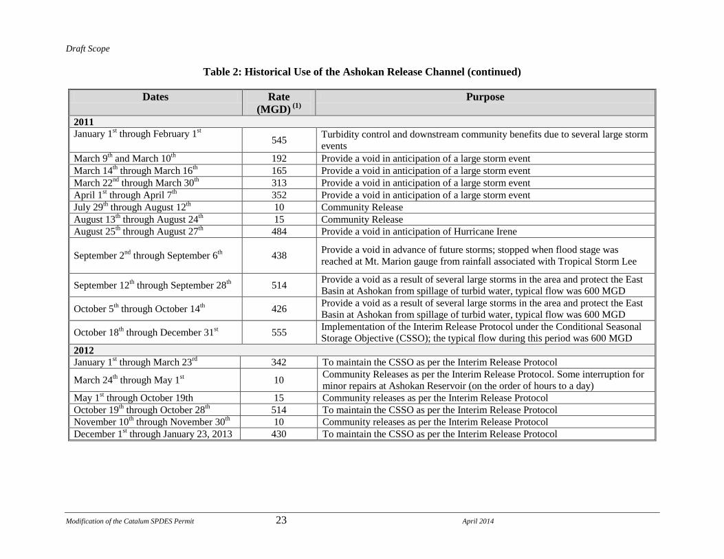
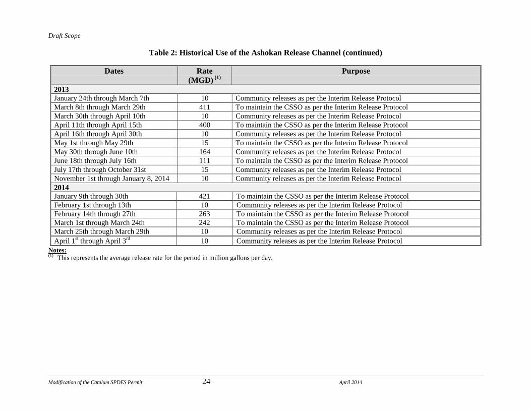
Table 2: Historical Use of the Ashokan Release Channel (continued)
Dates Rate
(MGD) (1)
Purpose
2011 January 1
st through February 1
st
545 Turbidity control and downstream community benefits due to several large storm
events
March 9th and March 10
th 192 Provide a void in anticipation of a large storm event March 14
th through March 16
th 165 Provide a void in anticipation of a large storm event
March 22nd
through March 30th 313 Provide a void in anticipation of a large storm event
April 1st through April 7
th 352 Provide a void in anticipation of a large storm event
July 29th through August 12
th 10 Community Release
August 13th through August 24
th 15 Community Release
August 25th through August 27
th 484 Provide a void in anticipation of Hurricane Irene
September 2nd
through September 6th 438
Provide a void in advance of future storms; stopped when flood stage was
reached at Mt. Marion gauge from rainfall associated with Tropical Storm Lee
September 12th through September 28
th 514
Provide a void as a result of several large storms in the area and protect the East
Basin at Ashokan from spillage of turbid water, typical flow was 600 MGD
October 5th through October 14
th 426
Provide a void as a result of several large storms in the area and protect the East
Basin at Ashokan from spillage of turbid water, typical flow was 600 MGD
October 18th through December 31
st 555
Implementation of the Interim Release Protocol under the Conditional Seasonal
Storage Objective (CSSO); the typical flow during this period was 600 MGD 2012 January 1
st through March 23
rd 342 To maintain the CSSO as per the Interim Release Protocol
March 24th through May 1
st 10
Community Releases as per the Interim Release Protocol. Some interruption for
minor repairs at Ashokan Reservoir (on the order of hours to a day) May 1
st through October 19th 15 Community releases as per the Interim Release Protocol
October 19th through October 28
th 514 To maintain the CSSO as per the Interim Release Protocol
November 10th through November 30
th 10 Community releases as per the Interim Release Protocol
December 1st through January 23, 2013 430 To maintain the CSSO as per the Interim Release Protocol
Draft Scope
Modification of the Catalum SPDES Permit 24 April 2014
Table 2: Historical Use of the Ashokan Release Channel (continued)
Dates Rate
(MGD) (1)
Purpose
2013
January 24th through March 7th 10 Community releases as per the Interim Release Protocol
March 8th through March 29th 411 To maintain the CSSO as per the Interim Release Protocol
March 30th through April 10th 10 Community releases as per the Interim Release Protocol
April 11th through April 15th 400 To maintain the CSSO as per the Interim Release Protocol
April 16th through April 30th 10 Community releases as per the Interim Release Protocol
May 1st through May 29th 15 To maintain the CSSO as per the Interim Release Protocol
May 30th through June 10th 164 Community releases as per the Interim Release Protocol
June 18th through July 16th 111 To maintain the CSSO as per the Interim Release Protocol
July 17th through October 31st 15 Community releases as per the Interim Release Protocol
November 1st through January 8, 2014 10 Community releases as per the Interim Release Protocol
2014 January 9th through 30th 421 To maintain the CSSO as per the Interim Release Protocol
February 1st through 13th 10 Community releases as per the Interim Release Protocol
February 14th through 27th 263 To maintain the CSSO as per the Interim Release Protocol
March 1st through March 24th 242 To maintain the CSSO as per the Interim Release Protocol
March 25th through March 29th 10 Community releases as per the Interim Release Protocol
April 1st through April 3
rd 10 Community releases as per the Interim Release Protocol
Notes: (1) This represents the average release rate for the period in million gallons per day.
Draft Scope
Modification of the Catalum SPDES Permit 25 April 2014
To better understand concerns associated with use of the Ashokan Release Channel and
predict the potential for impacts associated with future releases, the Ashokan Release
Working Group (ARWG) was established on December 17, 2010. The ARWG consists
of representatives from Ulster County, local municipalities, DEP, state and federal
regulatory agencies, landowners, environmental groups, and other stakeholders.8
One of the goals of the ARWG was to assist with the development, implementation, and
review of an assessment of the potential for ecological, physical, and economic impacts
resulting from the releases occurring between October 2010 and February 2011. Two
significant, large storm events in August and September of 2011, Hurricane Irene and the
remnants of Tropical Storm Lee, caused sudden and significant increases in stream flow
and turbidity levels, and contributed to changes in the conditions of the Esopus Creek. In
addition, input from the tributaries that were also affected by these storm events and
entered the Esopus Creek below the Olive Bridge Dam (e.g. Tongore Creek), and from
the Sawkill and Plattekill subwatersheds below the spillway confluence also contributed
to changes in the conditions of the Esopus Creek. Following these storms, DEP used the
Ashokan Release Channel to protect water quality in Ashokan Reservoir to aid in
reducing the level of turbidity in the water entering the Catskill Aqueduct and Kensico
Reservoir, and responded to requests from downstream municipalities and Ulster County
to create a void in the Reservoir for potential flood attenuation. Due to these historic rain
events, in addition to the use of the Ashokan Release Channel, DEP applied alum to treat
the remaining turbid water at the Pleasantville Alum Plant just upstream of Kensico
Reservoir. As a result, the studies that had been originally planned for an evaluation to
study the effects of the October 2010 to February 2011 releases will be incorporated into
this environmental review to assist in evaluation of the proposed use of the Ashokan
Release Channel under the Interim Ashokan Release Protocol. Information gathered
during the study, undertaken in coordination with ARWG, will be used to provide
information for this EIS.
In addition, the NYSDEC issued the Interim Ashokan Release Protocol for use of the
Ashokan Release Channel, dated September 27, 2013 (Interim Ashokan Release
Protocol). As stated previously, this Interim Ashokan Release Protocol provides for
community, discharge mitigation, and operational releases “…to enhance benefits to the
8 The Ashokan Release Working Group consists of representatives from the Ashokan Foundation, City of Kingston,
County of Ulster, Esopus Creek Conservancy, Federated Sportsman of Ulster County, Lower Esopus Watershed
Partnership, New York City Department of Environmental Protection, New York Public Interest Research Group,
New York State Department of Environmental Conservation, New York State Department of Health, RCAP
Solutions, Riverkeeper, Towns of Hurley, Marbletown, Olive, Saugerties and Ulster, United States Environmental
Protection Agency and the Village of Saugerties.

Draft Scope
Modification of the Catalum SPDES Permit 26 April 2014
community, improve flood attenuation, and provide better water quality” (See
Attachment A). The goal is to use the releases as an additional opportunity to provide
benefits to downstream communities to the greatest extent practicable without
compromising DEP‟s water supply system operations. These additional benefits were
identified by the ARWG, who requested community releases to benefit the environment
and recreational use of the lower Esopus Creek, and discharge mitigation to further
alleviate downstream flooding, where possible, and create a void in Ashokan Reservoir‟s
west basin for attenuating large storm events in the upper portions of the watershed.
Therefore, the Interim Ashokan Release Protocol establishes community releases, or year
round minimum releases, for summer and winter, and sets a Conditional Seasonal Storage
Objective (CSSO)9 rule curve that specifies water elevation goals within Ashokan
Reservoir for every month of the year. Generally, this curve will establish a seasonally
variable void in Ashokan Reservoir that balances water supply best practices with the
likelihood of increased flood attenuation. In addition, the Interim Ashokan Release
Protocol enables operational releases for turbidity control to be conducted should they be
necessary. The use of the Ashokan Release Channel in accordance with the Interim
Ashokan Release Protocol is a part of the Proposed Action, and DEP modeling has
projected that use of the Ashokan Release Channel in this manner has the potential to
allow DEP to reduce alum application at Kensico Reservoir under most scenarios. An
assessment of the potential for significant adverse impacts from operation of the release
channel under the Interim Ashokan Release Protocol will be included in this EIS.
As a result of Hurricane Irene and Tropical Storm Lee, geomorphic conditions of the
lower Esopus Creek have changed (e.g. increased erosion of the streambank at locations
along the creek), and the assessment for the lower Esopus Creek will focus on a
reasonable worst case scenario - the potential for significant adverse impacts associated
with releases in general, assuming a baseline condition of pre-release conditions (e.g. no
use of the Ashokan Release Channel).
Alum Treatment in accordance with the Catalum SPDES Permit. Implementation of the
Proposed Action suggests that DEP will be able to significantly reduce the need to use
alum during turbidity events compared to historic levels. The Proposed Action will be
evaluated for various potential alum use scenarios.
9 A CSSO is a reservoir management technique that enhances flood mitigation by maintaining a void within a
reservoir in accordance with time of year, drought conditions, weather and storm predictions and availability of
connected supply sources.
Draft Scope
Modification of the Catalum SPDES Permit 27 April 2014
While not a turbidity control measure, part of the Proposed Action includes
dredging at Kensico Reservoir in accordance with the Catalum SPDES Permit. DEP is
currently working with NYSDEC to define the areal extent of alum floc in Kensico
Reservoir associated with the use of alum since 2005, and to develop a dredging program
to remove these floc deposits. To support this effort, DEP has conducted bathymetric
studies, obtained sediment cores, collected benthic data, and prepared model simulations
to characterize the potential areal extent and depth of historical floc deposits. It is
expected that dredging of these and any future alum floc deposits will commence in
2024. In 2007, DEP issued a lead agency letter and Part I of the Environmental
Assessment Form for the proposed dredging at Kensico Reservoir; however, the proposed
environmental review was suspended, and material previously gathered would be utilized
as part of this study. Based on information currently available to DEP, an assessment of
the potential for significant adverse impacts from delaying dredging of alum deposits at
Kensico Reservoir to 2024 and from dredging the alum deposits in 2024 will be included
in this EIS. If details of the proposed dredging program are modified prior to
commencement of dredging activity in 2024 (e.g. quantities of dredged materials,
dredging plan, need and design/operational information for a dewatering facility, if
required), a supplemental environmental review will be conducted in the future, if
required.
As noted above, a number of DEP‟s turbidity control measures either do not require, or
have already undergone a separate, independent environmental review. However, these
elements would be incorporated into the operating assumptions for analyses for this EIS
since their usage contributes to the need for use of the release channel and the quantities
of alum floc to be dredged in 2024. These assumptions are laid out in Table 1 and a
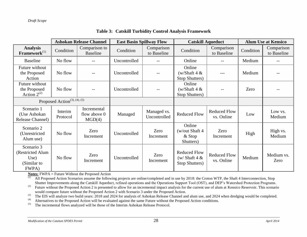
summary of the framework for analysis of Catskill turbidity is presented in Table 3.
Draft Scope
Modification of the Catalum SPDES Permit 28 April 2014
Table 3: Catskill Turbidity Control Analysis Framework
Ashokan Release Channel East Basin Spillway Flow Catskill Aqueduct Alum Use at Kensico
Analysis
Framework(1)
Condition
Comparison to
Baseline Condition
Comparison
to Baseline Condition
Comparison
to Baseline Condition
Comparison
to Baseline
Baseline No flow -- Uncontrolled -- Online -- Medium --
Future without
the Proposed
Action
No flow -- Uncontrolled --
Online
(w/Shaft 4 &
Stop Shutters)
--- Medium --
Future without
the Proposed
Action 2(2)
No flow -- Uncontrolled --
Online
(w/Shaft 4 &
Stop Shutters)
-- Zero --
Proposed Action(3), (4), (5)
Scenario 1
(Use Ashokan
Release Channel)
Interim
Protocol
Incremental
flow above 0
MGD(4)
Managed Managed vs.
Uncontrolled Reduced Flow
Reduced Flow
vs. Online Low
Low vs.
Medium
Scenario 2
(Unrestricted
Alum use)
No flow Zero
Increment Uncontrolled
Zero
Increment
Online
(w/out Shaft 4
& Stop
Shutters)
Zero
Increment High
High vs.
Medium
Scenario 3
(Restricted Alum
Use)
(Similar to
FWPA)
No flow Zero
Increment Uncontrolled
Zero
Increment
Reduced Flow
(w/ Shaft 4 &
Stop Shutters)
Reduced Flow
vs. Online Medium
Medium vs.
Zero
Notes: FWPA = Future Without the Proposed Action (1) All Proposed Action Scenarios assume the following projects are online/completed and in use by 2018: the Croton WTP, the Shaft 4 Interconnection, Stop
Shutter Improvements along the Catskill Aqueduct, refined operations and the Operations Support Tool (OST), and DEP‟s Watershed Protection Programs. (2) Future without the Proposed Action 2 is presented to allow for an incremental impact analysis for the current use of alum at Kensico Reservoir. This scenario
would compare future without the Proposed Action 2 with Scenario 3 under the Proposed Action. (3) The EIS will analyze two build years: 2018 and 2024 for analysis of Ashokan Release Channel and alum use, and 2024 when dredging would be completed. (4) Alternatives to the Proposed Action will be evaluated against the same Future without the Proposed Action conditions. (5) The incremental flows analyzed will be those of the Interim Ashokan Release Protocol.
Draft Scope
Modification of the Catalum SPDES Permit 29 April 2014
Three scenarios for the Proposed Action will be evaluated against the baseline conditions, each
of which prioritizes operation of one of the major components of the Water Supply System that
affect turbidity: use of the Ashokan Release Channel, alum addition at Kensico Reservoir, and
use of the east basin spillway. When each of these major components is prioritized, the
incremental use of the remaining components and the resulting flow in the Catskill Aqueduct
varies, as noted in Table 3. For example, baseline conditions assume no use of the Ashokan
Release Channel with flow over the east basin spillway, the Catskill Aqueduct is on line, and the
potential need to add alum at historical levels. Under Scenario 1, when the Ashokan Release
Channel is operated in accordance with the Interim Ashokan Release Protocol, flow over the east
basin spillway is reduced, the Catskill Aqueduct may be operated at a reduced flow, and alum
use at Kensico Reservoir is expected to be low. The potential for significant adverse impacts of
the incremental changes between baseline conditions and this operating scenario (identified in
the “Comparison to Baseline” column), and Scenarios 2 and 3 will be analyzed for each of the
components and presented in the EIS.
1.7 Purpose and Need for the Proposed Action
The proposed modification of the Catalum SPDES Permit would allow DEP to continue to
provide reliable, clean, and safe drinking water, while potentially reducing reliance on alum
treatment during episodic turbidity events. The practice of applying chemicals to drinking water
supplies is long standing, well accepted, and practiced widely throughout the United States. The
primary objective of DEP in applying alum (and sodium hydroxide) is to judiciously protect
public health and meet drinking water standards. DEP will continue to balance water supply
requirements with the need to minimize the potential for impacts of these chemicals on aquatic
organisms.
If DEP continues its ongoing turbidity control measures as described previously, modeling has
suggested that DEP will be able to significantly reduce, or potentially eliminate, its reliance on
alum during turbidity events.
The proposed modification of the Catalum SPDES Permit also includes the postponement of
dredging alum floc at Kensico Reservoir until after DEP completes the construction of the
Rondout-West Branch Bypass Tunnel and its connection to the Delaware Aqueduct. During the
connection period, the Delaware Aqueduct will be shut down, and DEP would be more heavily
reliant upon the water in the Catskill System to meet its daily demand. More reliance on the
water in the Catskill System increases the likelihood that the City will need to add alum to
reduce turbidity in the Kensico Reservoir while the final connection project is completed. Per the
Order of Consent dated October 4, 2013, NYSDEC and the City therefore agreed that the
dredging design should not commence until this infrastructure project is complete.
Draft Scope
Modification of the Catalum SPDES Permit 30 April 2014
1.8 Local, State and Federal Permits and Approvals
The approvals required to implement the Proposed Action would include the modification of the
existing Catalum SPDES Permit. Implementation of the Proposed Action would also require
additional discretionary actions and approvals from federal, state and local agencies. All
anticipated permits will be identified in the EIS. These actions and approvals may include:
Federal
Joint United States Army Corps of Engineers (USACE)/NYSDEC Permit application for
dredging at Kensico Reservoir; and
USACE Nationwide/Individual Wetland Permit for the for a potential dewatering facility
at Kensico Reservoir for dredging
State (NYSDEC)
Modification of the existing Catalum SPDES Permit;
State Pollution Discharge Elimination System (SPDES) General Permit for Construction
Activities (Erosion & Sediment Control for construction) for a potential dewatering
facility at Kensico Reservoir for dredging;
State Pollution Discharge Elimination System (SPDES) for Discharge Activities for a
potential dewatering facility at Kensico Reservoir for dredging;
Protection of Waters Permit for a potential dewatering facility at Kensico Reservoir for
dredging;
Potential Air Permit for a potential dewatering facility at Kensico Reservoir for dredging
Local
Local permits and approvals may be required for new construction, such as site plan approvals,
and building permits in the affected areas, possibly including:
Potential Westchester County and Mt. Pleasant, NY site plan approvals for a potential
dewatering facility at Kensico Reservoir
1.9 Prior Studies
As part of its ongoing program review and to meet requirements of the 2007 FAD, the following
studies of the Catskill System have been completed to examine engineering and operational

Draft Scope
Modification of the Catalum SPDES Permit 31 April 2014
modifications to address turbidity. The results of these studies will be used in the EIS, where
applicable, to describe and evaluate the Proposed Action and its alternatives.
Phase I Catskill Turbidity Control Study, December 2004
The goal of this study was to review historical water quality and physical data for
Schoharie Reservoir and the Shandaken Tunnel diversions, review state and federal
regulatory programs affecting these water supply system facilities, and provide a
screening-level evaluation of the feasibility and effectiveness of six alternatives for
potentially improving water quality in the Catskill System. The alternatives considered
were: (1) construction of a multi-level intake in Schoharie Reservoir; (2) placement of an
in-reservoir turbidity curtain; (3) placement of an in-reservoir baffle; (4) modifications to
Schoharie Reservoir‟s operating policy; (5) construction of engineered treatment
(coagulation, flocculation, and settling) facilities; and (6) turbidity removal options
downstream at Ashokan Reservoir. The multi-level intake, baffle, modified operations,
and Ashokan Reservoir options were selected for further study. Other options were
eliminated due to feasibility and effectiveness.
Phase II Final Report Catskill Turbidity Control Study, September 2006
The goal of the Phase II study was to identify and evaluate feasible, effective, and cost-
effective measures for reliably improving turbidity and temperature control in diversions
from Schoharie Reservoir to Esopus Creek. The study included conceptual design and
performance evaluation for three alternatives (Schoharie multi-level intake, Schoharie
baffle, and modification of Schoharie operating rules) identified in the Phase I study as
having reasonable potential to improve turbidity and temperature control in Schoharie
Reservoir diversions.
Phase II Implementation Plan, December 2006
The goal of this implementation plan was to present DEP‟s final recommendations and
guidelines for further development and implementation of turbidity and temperature
control measures at Schoharie Reservoir. The plan was based on the analyses presented in
the Phase II Final Report. The plan recommends implementation of modified operating
rules at Schoharie supported by the development of an Operations Support Tool (OST).
Additional supporting analysis was submitted in July 2009.
Phase III Final Report Catskill Turbidity Control Study, December 2007
The goal of this study was to identify and evaluate feasible, effective, and cost-effective
measures for reliably reducing peak turbidity levels entering Kensico Reservoir from the
Catskill Aqueduct, thereby reducing the frequency and duration of alum application
events. The Phase III study focused on Ashokan Reservoir and provides a comprehensive
Draft Scope
Modification of the Catalum SPDES Permit 32 April 2014
analysis of engineering and structural alternatives at the Ashokan Reservoir that may
reduce turbidity levels entering the Catskill Aqueduct. The alternatives considered were:
(1) construction of a new west basin outlet structure; (2) installation of dividing weir crest
gates; (3) east basin diversion wall and channel improvements; (4) Upper Gate Chamber
Modifications; (5) construction of a new east basin multi-level intake; and
(6) improvements to the Catskill Aqueduct in combination with modified operations.
Phase III Value Engineering Report, April 2008
A value engineering (VE) study was conducted on behalf of DEP and the City of New
York Office of Management and Budget (OMB) to review and evaluate the Catskill
Turbidity Control Study Phase III Final Report. A group of 13 engineers, modelers, and
cost estimators convened from January 28 to February 1, 2008 to review the Phase III
Report and provide suggestions on the proposed alternatives, recommend additional
alternatives, and reconcile cost estimates. The outcome of the VE evaluation was
incorporated into the Phase III Implementation Plan. Official responses to VE comments
were provided in the Conceptual Design Value Engineering Responses Report dated
October 2008.
Phase III Implementation Plan, July 2008
DEP submitted a Draft Phase III Implementation Plan for the Catskill Turbidity Control
Study to the USEPA, NYSDOH, and NYSDEC. The 2008 Phase III Implementation Plan
presented DEP‟s proposed plan for implementing operational and structural measures that
will improve turbidity control in the Catskill System by reducing turbidity levels entering
Kensico Reservoir, and is based on engineering analyses conducted during Phase III of
the Catskill Turbidity Control Study. The implementation plan makes two major
recommendations: (1) modifications to the operating rules at Ashokan Reservoir
(supported by OST) by (a) drawing down the west basin during low turbidity periods and
(b) operating the Ashokan Release Channel to redirect turbid water; and (2)
improvements to the Catskill Aqueduct including its interconnection to the Delaware
Aqueduct at Shaft 4 of the Delaware Aqueduct, and improving stop shutters in the
Catskill Aqueduct, allowing for the reduction of flow within the Catskill Aqueduct during
periods of elevated turbidity.
Turbidity Control Alternatives Analysis, February 2011
The Turbidity Control Alternatives Analysis report provides a summary of system
modeling and analyses conducted in order to assess the performance of the turbidity
control alternatives recommended in the Phase III Implementation plan, specifically:
Operation of the Ashokan Release Channel
Routine deployment of Catskill Aqueduct stop shutters
Draft Scope
Modification of the Catalum SPDES Permit 33 April 2014
Operation of the proposed Shaft 4 Interconnection.
The modeling work in this report used a state-of-the-art linked water system/water quality
model (OASIS-W2) over an extended (61-year) simulation period to evaluate the
alternatives individually and in various combinations. The performance of each
alternative was evaluated based on simulated daily turbidity levels in diversions from
Ashokan and Kensico Reservoirs, the frequency and duration of alum treatment events,
and the mass of alum used during treatment events. The modeling results indicated that
these alternatives could significantly reduce the expected frequency and duration of alum
treatment.
The following additional studies were conducted specifically to meet requirements described
previously for the Catalum SPDES Permit
Feasibility of Minimizing the Area of Alum Floc Deposition in Kensico Reservoir
Technical Report, October 2007
The goal of this study was to develop a mixing zone analysis that identifies the spatial
and temporal pattern of floc deposition in Kensico Reservoir, a discussion of how the
various alternatives for minimization of floc deposition would be implemented, the area
and depth of floc that would result from each alternative, identification of the chosen
alternative, and an implementation schedule for the chosen alternative.
Evaluation of Turbidity Reduction Potential through Watershed Management in the
Ashokan Basin, July 2008
The goal of this evaluation was to analyze the potential effectiveness of enhancing
existing Ashokan Basin Watershed management and protection programs as measures for
reducing elevated turbidity in the Ashokan Reservoir.
Impacts of Dredging the Estimated Area of Alum Floc Deposition in Kensico Reservoir,
September 2008
The goal of this study was to define the location and quantity of the alum floc in Kensico
Reservoir; quantify the impact of the alum floc on Kensico Reservoir‟s ecology; identify
the cost, schedule, and potential for environmental impacts of dredging the alum floc; and
provide a summary of impact comparisons. The potential for alum floc and dredging
impacts was focused on, but not limited to, the benthic community.
In addition, DEP has evaluated the benefit of many watershed protection programs for
bacteriological and algal control as part of the FAD. DEP has also, in association with
emergency work at Gilboa Dam that necessitated use of the Ashokan Release Channel to accept
flows from Ashokan Reservoir, conducted studies of natural resources along lower Esopus Creek

Draft Scope
Modification of the Catalum SPDES Permit 34 April 2014
downstream of the Ashokan Release Channel and upstream of the spillway confluence. The
natural resource studies included a benthic and fish survey at representative sites upstream and
just downstream of the spillway confluence with the east basin spillway channel in
September 2009. In the summer of 2006 and the spring and summer of 2009, natural resource
and stream geomorphology surveys were conducted in lower Esopus Creek from the Ashokan
Release Channel discharge to Mill Pond Dam at the Ashokan Center. These included surveys of
vegetation, wetlands, and aquatic and terrestrial resources at locations along both sides of lower
Esopus Creek. In the spring of 2009, field surveys were conducted along Esopus Creek to
identify herptiles (amphibians and reptiles), birds, bats, and other mammals. Additional field
surveys were conducted in the spring of 2010, and wetlands were again visually analyzed in the
summer of 2011. Color photographs of selected specimens were taken to document the species
presence in the study area. Prior to the field survey, existing data (NYS Atlas, the most up to date
range maps, and other published sources) were consulted to determine a potential list of species
in the study area.
Prior Environmental Reviews
DEP has conducted several previous environmental reviews on design, construction, and
operation of a number of Catskill turbidity control measures, as described previously. In
addition, on September 30, 1997, DEP issued a Draft Environmental Impact Statement (DEIS)
for the Treatment of New York City‟s Delaware, Catskill, and Croton Reservoir Systems for the
Control of Bacteria, Turbidity, Algae, and Zebra Mussels. That DEIS presented a detailed
analysis of the potential for impacts of bacteriological, turbidity, algae, and zebra mussel control
programs throughout the Water Supply System. However, as DEP continued to evaluate its
original program, implement its Watershed Protection Program, and work with USEPA and
NYSDEC, the Final EIS (FEIS) was not issued. The DEIS evaluated copper sulfate application at
three reservoirs of the Delaware System (Cannonsville, Pepacton, and Rondout), as well as at
Ashokan Reservoir of the Catskill System. While facilities exist at these locations for copper
sulfate application, copper sulfate was only added periodically at some of the reservoirs until the
mid-1990s, and has not been applied since 1996. While use of copper sulfate was evaluated
previously, it is not part of the Proposed Action, as DEP has no current plans to use copper
sulfate.
2.0 SCOPE OF THE ENVIRONMENTAL IMPACT STATEMENT
2.1 Environmental Review
This Draft Scope has been prepared to facilitate participation in the environmental review of the
Proposed Action, offering an opportunity for the public and interested agencies to provide
comment. After receiving and considering comments on this Draft Scope, NYSDEC, as Lead
Agency, will prepare and issue a Final Scope of Work. Then DEP, working cooperatively with
the DEC, will prepare the DEIS in accordance with the State Environmental Quality Review Act

Draft Scope
Modification of the Catalum SPDES Permit 35 April 2014
(SEQRA) and implementing regulations set forth in 6 NYCRR Part 617. And as DEP is a New
York City agency, the DEIS will also conform with the City Environmental Quality Review
(CEQR) process as set forth in Executive Order 91 of 1977 and its amendments.
The DEIS described in this Draft Scope will examine the full range of potential environmental
impacts related to both short-term construction activities and long-term operational changes that
may result from implementation of the Proposed Action. The DEIS will evaluate the potential for
significant adverse impacts of the Proposed Action in 2018, when two DEP projects – the Shaft 4
Interconnection and the Croton Water Filtration Plant – that will reduce the potential need for
alum addition will be on line and in 2024, when the dredging of alum at the Kensico Reservoir is
planned and the Rondout West Branch Tunnel is anticipated to be repaired. In addition, the
potential effects of delaying dredging until 2024 would be evaluated. The DEIS will also address
alternatives, including the No Action alternative (comprised of continuing use of alum at historic
levels at CATIC), and propose mitigation strategies for any identified significant adverse
impacts, to the extent practicable.
This EIS will also review DEP‟s existing studies of the potential effects of climate change on the
City‟s water supply to better understand areas of potential future concern.
The format of the DEIS and methodologies that will be used to assess the potential
environmental impacts of the Proposed Action will follow SEQR guidelines. In addition to
SEQR, DEP, as a City agency and the agency responsible for undertaking this action, is subject
to requirements of the City Environmental Quality Review (CEQR). The City‟s 2014 CEQR
Technical Manual provides the suggested methodologies for conducting an environmental
review under CEQR, outlining a structured approach to addressing the potential for significant
adverse impacts. This Draft Scope follows the approaches identified in SEQRA to the extent
applicable, and the 2014 CEQR Technical Manual methodologies that will be applied in cases
where State methodologies are either not applicable or less stringent.
The DEIS will present an assessment of the potential for impacts from the Proposed Action. The
level of detail provided for a particular impact area will be dependent on both the potential for
the Proposed Action to create an impact to the resource, and the quality and detail of available
data. The proposed studies and analyses will be evaluated under several scenarios: Baseline
Conditions (which assumes no operation of the Ashokan Release Channel), Future without the
Proposed Action (which does not include use of the Ashokan Release Channel), and Future with
the Proposed Action (including use of the Ashokan Release Channel) for the analysis years of
2018 and 2024, thus providing the basis for identifying potential short- and long-term impacts.
The study areas and assessment methodologies proposed to determine the potential for impacts
associated with the Proposed Action are described below.
2.2 Description of the Proposed Action
This section of the EIS will provide:
A detailed description of the Proposed Action – modification of the Catalum SPDES

Draft Scope
Modification of the Catalum SPDES Permit 36 April 2014
Permit
History of turbidity control in the Catskill System
A description of the regulatory framework for DEP‟s operation of the Catskill System
(e.g. Federal Safe Drinking Water Act (SDWA) and Filtration Avoidance Determination
requirements, NYSDEC SPDES permits, and NYSDEC dredging permits).
A statement of the Purpose and Need for the Proposed Action, and
A description of the alternatives considered.
Major components of the Proposed Action consist of: (1) continuing existing practices; and
(2) implementing additional operational and physical improvements to DEP‟s Water Supply
System. See Section 1.6 for a further description of the Proposed Action. As DEP‟s operation of
the Water Supply System is dynamic, elements of the Proposed Action may be used in various
combinations and at varying levels. For example, some turbidity control mechanisms may be
implemented independently of each other as a result of modeling or other investigations that will
inform DEP‟s decisions about which turbidity control elements to use under a specific set of
conditions. Also, the Interim Ashokan Release Protocol for use of the Ashokan Release Channel
contains provisions for use of the Ashokan Release Channel at different flows under certain
conditions, including community releases that are dependent on season and drought conditions
(interim rates that currently range from 4 to 15 MGD); turbidity control (up to 1,000 MGD
maximum flow from a combination of the Ashokan Release Channel and spill over the east
basin); and operation of the Ashokan Reservoir under a Conditional Seasonal Storage Objective
(CSSO). See Attachment A for details of the Interim Ashokan Release Protocol.
Given the dynamic operation of the Water Supply System, the EIS will present the potential for
significant adverse impacts from the Proposed Action for several scenarios, all of which could be
possible during what would be considered reasonable worst case scenario (RWCS) weather
events, and other natural occurrences that affect the City‟s Water Supply System on a regular
basis. It will also compare use of the Ashokan Release Channel at flows indicated under the
Interim Ashokan Release Protocol to those typically observed in the lower Esopus Creek from
storm events that result in spillage over the east basin spillway of Ashokan Reservoir.
2.3 Summary of Proposed Methodologies for Environmental Analyses
This section will summarize the methodologies to be used to evaluate the potential for significant
adverse environmental impacts of the Proposed Action. In this section, the Baseline Conditions,
Future without the Proposed Action, and Future with the Proposed Action scenarios will be
defined for the two primary study areas that have the potential for significant adverse impacts:
(1) Ashokan Reservoir and the Ashokan Release Channel/lower Esopus Creek; and (2) Kensico
Reservoir.
Draft Scope
Modification of the Catalum SPDES Permit 37 April 2014
2.3.1 Ashokan Reservoir and Ashokan Release Channel/Lower Esopus Creek
The study area associated with Ashokan Release Channel flows will be the vertical and
horizontal area along the length of lower Esopus Creek from the Ashokan Reservoir to the
confluence of lower Esopus Creek with the Hudson River (an approximately 30-mile reach of
stream). This area has the potential to be inundated for a prolonged period, as compared to a
typical hydrologic spill event over the east basin spillway. The increment would be defined as
the vertical and horizontal area along the lower Esopus Creek between that which would
typically be inundated during natural flows including spills over the east basin spillway and the
area that would be inundated under the implementation of the Interim Ashokan Release Protocol.
This would include those areas that would be inundated for a greater period of time under the
Interim Ashokan Release Protocol as compared to a natural spill event. The potential for positive
and negative significant impacts associated with all release levels provided under the Interim
Ashokan Release Protocol will be evaluated for each impact category as described in the
following sections.
2.3.1.1 Land Use, Zoning, and Public Policy
Elements of the Proposed Action that have the potential to affect land use and zoning (e.g. flood
zone, area proposed for rezoning) within the lower Esopus Creek study area will be assessed.
The analysis will also consider consistency of the Proposed Action with, and its potential for
adverse effects on, applicable public policies within the study area. The land use, zoning, and
public policy assessment will include a description of Baseline Conditions, and conditions in the
Future without the Proposed Action and the Future with the Proposed Action scenarios.
Baseline Conditions
The Baseline Conditions assessment will consist of the following steps:
Map and describe existing land uses, zoning, and recent trends in the study area;
Identify and describe predominant land use and zoning patterns in the study area based on
existing information included in geographic information systems (GIS) for the area and
compiled field surveys; and
Describe relevant public policies that apply to the study area including the Coastal Zone
Management Act (CZMA) of 1972 (16 U.S.C. §§1451-1464; the New York State Coastal
Zone Management Program, including the location of any Significant Coastal Fish and
Wildlife Habitats; any Local Waterfront Revitalization Programs (LWRP) within or
adjacent to the study area; and local plans, such as those associated with projects like new
development or recreational programs and floodplain ordinances, if applicable.

Draft Scope
Modification of the Catalum SPDES Permit 38 April 2014
Figure 5 – Lower Esopus Creek Study Area
Draft Scope
Modification of the Catalum SPDES Permit 39 April 2014
Future without the Proposed Action
The Future without the Proposed Action analysis will identify future development projects in the
lower Esopus Creek study area that could affect land use and zoning patterns and trends by 2018
and 2024. The analysis will identify specific development projects, plans for public
improvements, and pending zoning actions or other public policy actions within the study area as
they relate to the Proposed Action. Based on these changes, future land use and zoning
conditions in the Future without the Proposed Action will be assessed and described.
Future with the Proposed Action
This component of the Land Use, Zoning, and Public Policy analysis will assess and describe the
compatibility of the Proposed Action and its potential for significant adverse impacts on land use
and open space, and relevant trends in the study area. The assessment will also include
consistency of the Proposed Action with recognized public policies in the study area, such as
waterfront or zoning plans along the lower Esopus Creek.
2.3.1.2 Socioeconomic Conditions
Socioeconomic impacts can occur when a proposed action directly or indirectly displaces
economic activities in an area. To the extent that elements of the Proposed Action have the
potential to affect socioeconomic conditions within the lower Esopus Creek study area, the
potential for impacts will be assessed.
Baseline Conditions
This portion of the Socioeconomic Conditions analysis will identify and describe existing
socioeconomic conditions in the study area using available data from local and state agencies and
other sources, such as the local chambers of commerce. This section will present data on
recreational activities and related industries and tourism near lower Esopus Creek that may be
impacted by the Proposed Action.
Future without the Proposed Action
This analysis will identify future changes in the study area that could affect socioeconomic
conditions by 2018 and 2024 (e.g. potential changes to the recreational use of the lower Esopus
Creek). Based on these changes, the socioeconomic conditions of the Future without the
Proposed Action will be described.
Future with the Proposed Action
This component of the Socioeconomic Conditions analysis will assess and identify the potential
for impacts to socioeconomic conditions from the Proposed Action. This will include an
assessment of the effects on tourism and fish-related business, agriculture, and local business

Draft Scope
Modification of the Catalum SPDES Permit 40 April 2014
operations as a result of the Proposed Action through public surveys, interviews, and the use of
the IMPLAN input-output modeling system to assess indirect and induced impact of any
specifically-identified direct changes in income or employment that are projected as a result of
releases to lower Esopus Creek.10
This assessment would include analyses of potential impact on
economic output, employment, earnings, and local taxes in communities near lower Esopus
Creek, as applicable.
2.3.1.3 Community Facilities and Services
It is not anticipated the Proposed Action would impact community facilities and services, such as
schools, libraries, hospitals, and police and fire departments within the lower Esopus Creek study
area. If, during the analysis, it is determined that such facilities and services could be affected,
the EIS will identify and estimate the existing demand and any additional demand on community
facilities or services that may be generated by the Proposed Action.
2.3.1.4 Open Space and Recreation
Elements of the Proposed Action that have the potential to affect open space and recreation
within the lower Esopus Creek study area will be assessed. The open space and recreation
assessment will include a description of Baseline Conditions, and conditions in the Future
without the Proposed Action and the Future with the Proposed Action scenarios.
Baseline Conditions
The Baseline Conditions assessment will consist of the following steps:
Map and describe existing open spaces and recreation areas and recent trends in the study
area;
Identify and describe predominant open space patterns and recreational activities in the
study area (e.g. fishing, boating, bathing beaches and marinas) based on existing
information included in GIS for the area and compiled field surveys; and
Describe relevant public policies that apply to the study area, including the Coastal Zone
Management Act (CZMA) of 1972 (16 U.S.C. §§1451-1464 and local plans, if
applicable.
10 IMPLAN is an econometric modeling system that is widely used to estimate the impact of changes in income to,
spending by or employment in a given industry within a given geographic area (for example, in this case, Ulster
County). The current version, IMPLAN 3.0, was released in November 2009.
Draft Scope
Modification of the Catalum SPDES Permit 41 April 2014
Future without the Proposed Action
The Future without the Proposed Action analysis will identify future development projects in the
study area that could affect open space and recreational activity patterns and trends by 2018 and
2024. The analysis will identify specific development projects, plans for public improvements,
and pending actions within the study area as they relate to the Proposed Action. Based on these
changes, future open space and recreational conditions in the Future without the Proposed Action
will be assessed and described.
Future with the Proposed Action
This component of the Open Space and Recreation analysis will assess and describe the
compatibility of the Proposed Action on open space and recreation, relevant trends in the study
area, and the consistency of the Proposed Action with recognized plans. The open space analysis
will describe any impacts to fishing, boating, or other recreational activities during use of the
Ashokan Release Channel under the Interim Protocol.
2.3.1.5 Critical Environmental Areas
Critical Environment Areas (CEAs) are specific geographic areas designated by local agencies
and DEC. There are numerous criteria that must be met to have an area designated as a CEA,
including the following:
A benefit or threat to human health;
A natural setting (fish and wildlife habitat, forest and vegetation, open space and areas of
important aesthetic or scenic quality);
Agricultural, social, cultural, historic, archeological, recreation, or educational value; or
An inherent ecological, geological, or hydrological sensitivity to change that may be
adversely affected by any change.
There are no CEAs within the lower Esopus Creek study area. Therefore, a CEA assessment is
not required.
2.3.1.6 Historic and Cultural Resources
Historic and cultural resources are districts, buildings, structures, sites, and objects of historical,
aesthetic, cultural, and archaeological importance. Historic resources include:
Properties listed on, or formally determined to be eligible for inclusion in, the State
and/or National Register of Historic Places (S/NR);
Properties contained within a district listed on, or formally determined to be eligible for,
the S/NR;

Draft Scope
Modification of the Catalum SPDES Permit 42 April 2014
Properties recommended by the New York State Board of Historic Preservation or
National Historic Landmarks; and
Properties not identified by one of the programs listed above, but that meet eligibility
requirements.
Typically, existing databases and correspondence from the State Historic Preservation Office
(SHPO) of the New York State Office of Parks, Recreation, and Historic Preservation (OPRHP),
local plans, and information from the Land Use, Zoning, and Public Policy analysis will be used
to identify potential historic and cultural resources.
An area known as the Ashokan Field Campus (AFC) is located between the Ashokan Release
Channel at Ashokan Reservoir and the confluence with the east basin spillway channel. In May
of 1999, a Phase 1 Cultural Resource Investigation Report11
was issued for the SUNY Ashokan
Campus as part of a separate DEP project (the proposed relocation of a site driveway across
Esopus Creek). Findings in the May 1999 Phase 1 report concluded that the locality of the
project area is of regional historic significance. There is also a covered bridge located just
downstream of the main AFC campus that is designated by SHPO as a historic structure. As part
of ongoing work at the AFC, it is anticipated that the abutments for the covered bridge will be
repaired to ensure its integrity and increase its useful lifespan. Steps will be taken, through
coordination with SHPO to ensure that the historic aspects of the bridge are not compromised by
this work. Any work and mitigation efforts will be evaluated under the separate project and
summarized in this EIS.
With respect to archaeological resources, there is not expected to be new ground disturbance in
the lower Esopus Creek study area, with the exception of the AFC between the Ashokan Release
Channel and confluence with the Ashokan Reservoir east basin spillway channel. During their
ownership of the property, AFC personnel have identified and documented two findings of
significance on and in the vicinity of the campus. After consulting the OPHRP site files, both of
these findings were recorded with the state, and a test pit examination was conducted that
determined no further testing for the project area surrounding the AFC was recommended.
In the event that excavation is required in a potentially sensitive cultural resource area along
other reaches of the Creek, a Phase I survey will be conducted. Depending on the results of the
Phase I survey and consultation with SHPO, additional studies would be undertaken as
necessary.
11 NYCDEP, Archaeological Reconnaissance for the Proposed Relocation of a Driveway across Esopus Creek at the
SUNY New Paltz Ashokan Field Campus, Town of Olive, Ulster County – A Stage 1 Cultural Resource
Investigation Report, May 18, 1999.
Draft Scope
Modification of the Catalum SPDES Permit 43 April 2014
2.3.1.7 Aesthetic (Visual) Resources
Visual resources are important public view corridors, vistas, and natural or built features. It is not
anticipated that the Proposed Action will result in construction of above grade structures;
however, if there is a potential for visual impacts within the lower Esopus study area, they will
be assessed in the EIS. At the lower Esopus Creek, visual changes to the water from turbidity or
erosion identified as part of the other assessments will be discussed.
If a visual resources assessment is required, a field reconnaissance will be conducted to
determine whether existing or proposed elements of the Proposed Action will be visible along
sensitive view corridors. If there is a view corridor that may be impacted, representative sites
from within this visually sensitive area will be selected for visual simulations. This information
will be used to determine whether changes resulting from the Proposed Action would create a
substantial change in the views from affected resources as compared to the Future without the
Proposed Action conditions.
2.3.1.8 Water Resources and Water Quality
For purposes of the lower Esopus Creek assessment in the EIS, water resources will include
surface water (rivers, streams, and ponds) and groundwater. As part of the water resource
analysis, water quality will be evaluated. Water quality refers to the physical, chemical, and
biological characteristics of water. As the Proposed Action involves management of water
resources and has the primary goal of providing drinking water that is safe and meets applicable
standards, the Proposed Action has the potential to affect water resources and water quality. The
Proposed Action includes modified operations at Ashokan Reservoir and improvements to the
Catskill Aqueduct to reduce the frequency of downstream turbidity events at Kensico Reservoir.
The EIS will summarize these modifications in the context of the potential for impacts to
downstream hydrology and water quality in the lower Esopus Creek from the release of water
from the Ashokan Release Channel and the transfer of turbidity to Kensico Reservoir (see
section 2.3.2 for Kensico Reservoir).
Baseline Conditions
Water Quality
The Proposed Action, particularly the operation of the Ashokan Release Channel, has the
potential to cause hydrologic and water quality impacts to the lower Esopus Creek below the
Ashokan Reservoir extending to the confluence of lower Esopus Creek with the Hudson River,
30 miles downstream. As part of the Baseline Conditions analysis, a summary of available water
quality data collected during various periods from the Ashokan Release Channel and sites along

Draft Scope
Modification of the Catalum SPDES Permit 44 April 2014
the lower Esopus Creek will be presented.12
In addition, other methods employed for turbidity
control in Ashokan Reservoir, the Ashokan Release Channel, and lower Esopus Creek will be
identified, mapped, and described.
Flow
In order to determine baseline flow conditions within lower Esopus Creek associated with both
releases under the Interim Ashokan Release Protocol and flows over the east basin spillway,
information gathered from DEP flow records at Ashokan Reservoir and the USGS stream gage at
Mt. Marion from 1970 to the present will be analyzed, and a flood frequency analysis will be
performed. Statistical analyses will be conducted for various seasons both with and without
Ashokan Reservoir releases. The results of the statistical analyses, along with a comparison of
spill and release data will be presented to determine the frequency of high-flow events under
various Ashokan Reservoir operational scenarios and different Catskill Aqueduct flow diversion
scenarios. This information will be used to develop typical seasonal flow and potential flood
conditions for the lower Esopus Creek for comparison to flows associated with release
operations under the Interim Ashokan Release Protocol.
Future without the Proposed Action
The Future without the Proposed Action will assume no operation of the Ashokan Release
Channel. The analysis will include a description of anticipated changes to water resources and
the water quality of the lower Esopus Creek in the future (2018 and 2024) without the Proposed
Action. These include changes to the study area that will be implemented in these years (e.g.
future development projects along lower Esopus Creek, plans for public improvements, and other
public policy actions within the Ashokan Reservoir and lower Esopus study area that could affect
these water sources).
Future with the Proposed Action
Water Quality
The water quality assessment under the Future with the Proposed Action will evaluate water
quality changes associated with operation of the Ashokan Release Channel at up to 600 MGD to
meet operational objectives or to follow a Conditional Seasonal Storage Objective (CSSO), as
outlined in the Interim Ashokan Release Protocol. The water quality analysis will focus primarily
on in-stream turbidity and suspended solids measurements collected by DEP since January 2011.
These data will be evaluated using a regression analysis to help identify, where possible due to
the complexities of stream sediment processes, potential correlation between turbidity in the
12 Since implementation of the Interim Release Protocol, DEP has collected weekly turbidity information at three
sites on the lower Esopus when the Release Channel is operational. If Ashokan is spilling, DEP adds a sample
from below the spillway and one from below the spillway confluence.
Draft Scope
Modification of the Catalum SPDES Permit 45 April 2014
lower Esopus Creek and the quality and quantity of the water being discharged from either the
east basin spillway or Ashokan Release Channel at specific water quality monitoring locations
along the Creek. Turbidity and Total Suspended Solids data at specific water quality monitoring
stations would also be plotted using a regression analysis. Data will be grouped and analyzed
according to characteristics (e.g., similar flow conditions) and summary statistics or graphical
representations will be presented. Other water quality parameters related to the operation of the
Ashokan Release Channel will be analyzed in a similar manner where available and comparable
(e.g., dissolved oxygen (DO), pH, and temperature). The length of turbid events predicted to
occur under the IRP would also be compared with the typical duration and levels of natural
turbidity to evaluate potential changes resulting from use of the Release Channel.
Flow
The flow assessment under the Future with the Proposed Action will involve review and analysis
of total flow entering the lower Esopus Creek from the Ashokan Reservoir spillway and/or the
Ashokan Release Channel. It will include an assessment of how releases compare to flows
observed in the lower Esopus, superimposing flows from the reservoir against those typically
observed at the stream gage at Mt. Marion in the absence of reservoir releases under both storm
and non-storm events. In addition to the variation in and distribution of flows, the typical
duration over which various flows are observed both with and without Ashokan Release Channel
operation will be analyzed and presented. Additional analyses will be conducted using HEC-
RAS, a hydraulic model for natural and constructed channels, to establish approximate potential
water surface elevations within lower Esopus Creek with total releases from Ashokan Reservoir
up to 600 MGD, and to estimate the approximate extent of any potentially inundated area along
lower Esopus Creek associated with operation of the Ashokan Release Channel under different
flow conditions. Existing stream discharge and stage data, where available, along with observed
high water marks and topographic surveys, will be used to calibrate the model. In some areas, to
support model development for the analysis, stage measurements will be collected during future
Ashokan Release Channel discharges for model calibration.
The HEC-RAS model will be used to develop water surface and velocity rating curves for
specified sections along lower Esopus Creek. Existing aerial survey data, supplemented by
existing field surveys, will be used in conjunction with HEC-RAS modeling results to delineate
the extents of the inundated area for Ashokan Release Channel discharges up to 600 MGD, as
compared to storm flows without releases (where the water would spill uncontrolled over the east
basin spillway and enter the lower Esopus Creek).
The hydraulic model will be used in conjunction with field assessments conducted as part of
other assessments to estimate the bankfull flow rate within lower Esopus Creek from the
Ashokan Release Channel to the spillway confluence and downstream to the Hudson River.

Draft Scope
Modification of the Catalum SPDES Permit 46 April 2014
Bankfull indicators13
will be identified in the field, and the hydraulic model will subsequently be
used to determine if flows resulting from the releases will reach water surface elevations
associated with these indicators. A HEC-HMS model, a hydrologic model to simulate the
precipitation and runoff flows from various storm events in a watershed, will be used to support
the hydraulic modeling effort by approximating peak storm discharges through the lower Esopus
Creek. Drainage areas for the various sub-watersheds will be delineated based upon USGS
topography (streamstats) or best available topography. The hydrologic analysis will consider
base Ashokan Release Channel discharges up to 600 MGD, including flows specified under the
Interim Ashokan Release Protocol, as well as storm flows up to the 100-year event.
2.3.1.9 Natural Resources
For purposes of the lower Esopus Creek assessment in the EIS, natural resources include:
(a) aquatic resources; (b) stream channel geomorphological characteristics; (c) wetland
resources; and (d) wildlife. Aquatic resources include all organisms that live in water, and in
particular, benthic organisms, invertebrates, and vertebrate (fish) species. Stream channel
geomorphology is the channel alignment and bank structure within lower Esopus Creek.
Wetlands resources within the study area are palustrine (all freshwater non-tidal wetlands
dominated by trees, shrubs, perennial emergent vegetation, and emergent mosses and lichens),
including ponds that are within the zone of inundation associated with the Releases. Wildlife
includes birds, mammals, reptiles, and amphibians, including threatened or endangered species,
as well as those of special concern.
Baseline Conditions
Baseline Conditions for natural resources along lower Esopus Creek are available for areas
upstream of the spillway confluence, as described below. As described earlier, in the summer of
2006, the spring and summer of 2009, and the spring of 2010, natural resource surveys were
conducted in lower Esopus Creek from the Ashokan Release Channel discharge to Mill Pond
Dam. These included surveys of vegetation, wetlands, aquatic and terrestrial resources, and
stream geomorphology at locations along the lower Esopus Creek. These surveys, existing local
policies relevant to the protection of natural resources in the area and data on historical
discharges to the Ashokan Release Channel from Ashokan Reservoir will be summarized in the
EIS to describe Baseline Conditions in the lower Esopus study area.
For areas downstream of the spillway confluence to the Hudson River, Baseline Conditions will
be described to the greatest extent practicable from field analyses. In addition, any existing
studies, data, and published reports will be utilized. Since the releases are ongoing and have been
13 Bankfull indicators are field identifiers that show the approximate location of the water surface elevation during
bankfull flow (the maximum amount of water a channel can carry without overflowing). These types of indicators
are generally the edge of the channel where woody vegetation, such as alder, begins.

Draft Scope
Modification of the Catalum SPDES Permit 47 April 2014
since the end of August 2011, Baseline Conditions will be determined using various methods
based on the particular resources described in the following sections.
a. Aquatic (Fish and Benthic) Resources
At six sites, primarily upstream of and near the spillway confluence, fish survey data from the
lower Esopus Creek were obtained in September 2009. Benthic macroinvertebrates were
surveyed at the same six representative sites. Station location, survey time/date, and water
quality parameters (pH, dissolved oxygen, conductivity, turbidity and temperature) were
recorded at each sampling location. Fish were captured at the six sampling locations along lower
Esopus Creek by electrofishing using a small float-mounted electrofisher, and through the use of
a small seine, where appropriate. All fish captured were measured; identified; examined for
physical condition, abnormalities, wounds, and external parasites; and returned live to the water.
For fish populations at the confluence of the lower Esopus Creek and the Hudson River,
specifically those listed as threatened or endangered, electrofishing records associated with
studies by DEP and the NYSDEC will be used in conjunction with other study information and
available literature to describe the presence of these populations in the vicinity of the Hudson
River confluence, spawning seasons, and preferred habitat.
b. Stream Channel Geomorphology
The baseline channel-forming flows will be estimated in the lower Esopus Creek based on a
flood frequency analysis of the east basin spillway volumes, estimated flows generated from
within the watershed of the lower Esopus Creek below the east basin spillway using flow
modeling, and flood frequency analysis of the Mt. Marion stream gage discharge record. Flow
modeling will be applied and used for comparisons with the other methods in suggesting the
extent of Ashokan Reservoir and east basin spillway influence on overall stream discharge.
Historical aerial photography will be used to identify historical stream channel alignment and
migration zones to characterize baseline migration rates and associated hydrologic conditions.
The historical aerial photo analysis methodology will minimally include digitizing the center line
of the lower Esopus Creek from the Ashokan Reservoir to the Hudson River using available
orthorectified (geometrically corrected) aerial photographs. Geometrically corrected aerial
imagery for the Esopus Creek exists for 1994, 2001, 2004, and 2009, allowing for 15 years of
time series assessment. This georeferenced imagery will allow for overlay analysis in GIS to
compare channel alignments over shorter time steps. The digitized centerlines for each time
period will be overlaid to determine historical channel migration zones, and to estimate average
annual migration rates between time steps in terms of feet per year at outside sections of creek
bends.

Draft Scope
Modification of the Catalum SPDES Permit 48 April 2014
c. Wetlands
In July 2006, 18 wetlands were identified and delineated along lower Esopus Creek between the
area of the Ashokan Release Channel and Mill Pond Dam. In 2010, an additional 29 wetlands
were identified between Mill Pond Dam and the spillway Confluence. All work was completed
in accordance with the U.S. Army Corps of Engineers Wetlands Delineation Manual
(Environmental Laboratory, 1987) and the U.S. Army Corps of Engineers Interim Regional
Supplement: Northcentral and Northeast Region (U.S. Army Corps of Engineers, 2012). 14
Between the Ashokan Release Channel and spillway confluence, field surveys, existing
information, and mapping will be used to describe existing wetlands. The USGS 7.5-minute
quadrangle map (Ashokan, NY), U.S. Fish and Wildlife Service (USFWS) National Wetland
Inventory (NWI) mapping, NYSDEC freshwater wetland mapping, the Ulster County NY Soil
Survey, aerial photography, and the July 2006 freshwater wetlands survey will be reviewed and
described.
For areas downstream of the spillway confluence, a desktop review of existing information and
mapping will be performed following DEP Riparian Corridor Land Cover Mapping Protocol.
Existing data sources will include U.S. Fish and Wildlife Service, National Wetland Inventory
mapping, NYSDEC freshwater wetland mapping and aerial imagery from 2009, the Ulster
County NY Soil Survey, county or municipal wetland mapping, if available, and aerial mapping
using video from spring 2010 DEP fly-overs conducted to assess the condition of the Creek. In
addition, there is Google Earth imagery from October 7, 2011, about five weeks after Hurricane
Irene. This information will be compared to similar imagery from April 2010 to identify any
large-scale changes in the Creek during these time periods.
d. Wildlife
In the spring of 2009, field surveys were conducted along Esopus Creek upstream of Mill Pond
Dam to identify herptiles (amphibians and reptiles), birds, bats, and other mammals. Surveys
were performed under a New York State Fish and Wildlife License (No. 652) and were
performed ethically (ASMACUC 1998) using widely-accepted methodologies. Herptiles were
inventoried by nine methods: time-constrained searches, pitfall tarps, turtle traps, incidental
observation, nighttime call surveys, timed dip-net sweeps, funnel traps, egg-mass surveys, and
PVC artificial habitats. Birds were identified using Avian Transect Survey (AST), Targeted
Search (TS), and incidental observations. Bats were inventoried using mist-net surveys, and all
other mammals were identified using live trapping, pitfall trapping, track and scat identification,
incidental observation, and spotlight survey. Color photographs of selected specimens were
taken to document the species presence in the study area. Prior to the field survey, existing data
14 Note that the regional supplement used was published in 2009 and revised in January 2012.

Draft Scope
Modification of the Catalum SPDES Permit 49 April 2014
(NYS Atlas, the most up to date range maps, and other published sources) were consulted to
determine a potential list of species in the study area (NYSDEC 2007). Information on protected
species was also obtained and will be summarized in the EIS.
Downstream of Mill Pond Dam, a desktop survey will be conducted, including coordination with
the Department of Environmental Conservation (DEC) New York Natural Heritage Program and
the United States Fish and Wildlife Service (New York Field Office) regarding the potential for
impacts to avian and herptile species, including all state or federally-listed species, in order to
describe Baseline Conditions.
Future without the Proposed Action
Discussion of anticipated changes to natural resources in the lower Esopus study area for the
Future without the Proposed Action in 2018 and 2024 will be provided based on potential future
activities in the Creek that could affect the natural resources community in lower Esopus Creek.
These include changes associated with work at the Ashokan Field Campus (AFC), future
development projects along lower Esopus Creek, plans for public improvements, and other
public policy actions such as changed zoning or land use designations within the Ashokan
Reservoir and lower Esopus study area that could affect these natural resources. In the Future
without the Proposed Action, the EIS analysis will assume continued Baseline Conditions (no
use of the Ashokan Release Channel).
Future with the Proposed Action
For natural resources along lower Esopus Creek, the HEC-RAS model described in Section
2.3.1.8 (Water Resources and Water Quality) will be used to identify areas of inundation from
use of a the Ashokan Release Channel up to 600 MGD. The potential for impacts from the
Proposed Action on natural resources will be determined by identifying the: (1) existing
characteristics and how these may change from increased inundation, increased duration of
inundation, and turbidity levels; (2) potential for impacts of the Proposed Action on natural
resources from inundation and turbidity levels; and (3) recovery potential for representative
species. The studies that will be carried out for each natural resource to identify the positive and
negative impacts of releases under the Interim Ashokan Release Protocol are described in greater
details in the following sections.
a. Aquatic (Fish and Benthic) Resources
Factors that could contribute to impaired fish and benthic macroinvertebrate community
assessments can vary since, in every system, many such factors exist - both known and unknown
- often interacting with each other in a complex manner. To estimate the potential for impacts,
the six sites sampled upstream of and just below the spillway Confluence in 2009 will be
resampled. In addition, sampling will be conducted at four DEC-established stations located
Draft Scope
Modification of the Catalum SPDES Permit 50 April 2014
along lower Esopus Creek, downstream of the spillway confluence. All sampling will be
conducted in accordance with NYSDEC-approved protocols.
The data obtained in the fish and macroinvertebrate sampling efforts will be compiled, and
metrics recommended for use in data analysis by the USEPA (1999) and/or used by the
NYSDEC‟s Stream Biomonitoring Unit (NYSDEC SBU 2009) will be computed. These metrics
summarize particular aspects of community structure. For fish, these metrics include the total
number of individuals, total number of species, total number of native species, total number of
pioneering species, and total number of intolerant species. In the case of macroinvertebrates, the
metrics are total taxa richness, EPT richness (the number of mayfly (Ephemeroptera), stonefly
(Plecoptera), and caddisfly (Trichoptera) taxa - the most sensitive macroinvertebrate groups)),
Hilsenhoff Biotic Index (a measure of organic pollution), and Percent Model Affinity (a measure
of the degree of similarity to what the SBU considers a model NYS stream community).
NYSDEC‟s SBU protocols will be used to derive a Biological Assessment Profile score from the
four metrics, and to use that score to make an assessment of the overall health of the benthic
community. In addition, the SBU‟s Impact Source Determination protocol, used to identify the
source of impacts to stream communities, will be followed. Part of the data analysis will include
application of information on the effects of turbidity on fish and benthic macroinvertebrates that
is obtained in literature search. Secondly, information on fish stocking in lower Esopus Creek
obtained from the Federated Sportsmen of Ulster County will be used in analysis of the fish data.
Finally, for federally- or state-listed threatened or endangered fish populations at the confluence
of the lower Esopus Creek and the Hudson River, a literature review will be performed to
identify the types and nature of the potential for impacts, if any, on these populations under the
Interim Ashokan Release Protocol.
b. Stream Channel Geomorphology
Using the results of the aerial photography analysis, previous site visits, documented reports of
actively eroding stream banks, and the 2010 and 2011 helicopter-based reconnaissance video and
photos, several sites will be selected for an initial baseline stream channel geomorphic survey
assessment: (1) to identify current channel cross-sectional morphology and bank and streambed
composition, and (2) for future evaluation of changes in channel morphology and composition
from stream bank and/or bed erosion and deposition. These assessments will include up to (10)
stream channel cross-section topographic surveys monumented with capped rebar for repeated
surveys; stream Bank Erosion Hazard Index assessments (BEHI), the use of monumented
surveys, bank pins, and qualitative assessments (e.g. Pfankuch,1975) to monitor bank erosion;
and where appropriate, stream bed and bank sediment characterization. The number and
locations of these assessment sites will depend on the channel migration analysis and an initial
field reconnaissance. Each cross-section monument will be surveyed into an established

Draft Scope
Modification of the Catalum SPDES Permit 51 April 2014
benchmark, and a cross-sectional survey will be performed so that a time series assessment of
changes in channel morphology can be assembled.
Each monitored stream channel cross section will also receive an evaluation of bank
characteristics and flow distribution in the channel to predict the potential risk for bank erosion
from the releases under the Interim Ashokan Release Protocol against assumed baseline
conditions. This approach will apply Rosgen‟s BANCS (Bank Assessment for Non-point source
Consequences of Sediment) model to assess the potential for stream bank erosion and predict
possible stream bank erosion (Rosgen, 2006). Alternative or additional assessments may be
adopted as needed to address specific concerns or limitations of the BANCS model, such as that
of Pfankuch (1975).
Due to the concern that Ashokan Reservoir releases can lead to excess sediment deposition,
locations of potential deposition will be identified based on the hydraulic modeling analysis that
may identify stream segments that are particularly prone to deposition of fine sediment and sand
entrained from lower Esopus Creek eroding banks, and the potential for significant adverse
impacts resulting from potential deposition will be evaluated.
c. Wetlands
Based on the hydrologic mapping conducted along the entire reach of the lower Esopus Creek
(see section 2.3.1.8 above), the anticipated inundation areas under the Interim Ashokan Release
Protocol will be investigated for wetlands using current federal delineation methods. The
analysis of the potential for impacts related of the Proposed Action will compare newly collected
data to existing data along the lower Esopus Creek. Upstream of the spillway confluence,
baseline conditions were established during the 2006, 2009, and 2010 studies, and all 47
wetlands in this location will be revisited to look for changes in wetland extent or characteristics
that could potentially be related to operation of the Ashokan Release Channel. Downstream of
the spillway confluence, a photographic survey was conducted prior to the fall 2011 storm events
to document vegetative communities, stresses, and erosion that will be used to describe baseline
conditions. From this, additional wetlands will be selected, as described below, in order to
identify potential impacts that may occur from operation of the Ashokan Release Channel under
the Interim Ashokan Release Protocol. Since a significant amount of data is not available
downstream of the spillway confluence, this portion of the analysis will be qualitative. The
qualitative assessment will include analysis of two wetlands outside the zone of influence for
comparison to sites that will potentially be inundated. The 47 wetland areas identified upstream
of the spillway confluence and up to ten (10) sample sites within areas of inundation downstream
of this point (including two sites meant to serve as controls) will be delineated in order to verify
potential impacts. Upstream, the re-delineation will be limited to areas of observed changes to
boundaries or vegetative composition. Global Positioning System (GPS) data from previous
studies will be used to determine if boundaries have changed. Downstream, the 10 selected

Draft Scope
Modification of the Catalum SPDES Permit 52 April 2014
sample sites will be photographed and delineated. As with prior studies, all wetland surveys will
be completed during the growing season and would be in accordance with methods outlined by
the U.S. Army Corps of Engineers. Wetland data and boundary points will be marked and
located using a GPS. The GPS data will be transferred onto relevant site mapping using the U.S.
State Plane 1983, New York East coordinate system. The Regional Supplement Data Forms will
be used to document detailed vegetation, hydrology, and soils data at a specific location
established within the wetland complex for comparison. Wetland function and value assessments
will be performed at each re-delineated wetland using the methods outlined in The Highway
Methodology Workbook Supplement, Wetland Functions and Values: A Descriptive Approach,
USACE New England Division (NEDEP-360-1-30a 1995).15
As with the wetlands downstream of the spillway confluence, floodplain forests will be initially
identified using aerial imagery. This will establish Baseline Conditions prior to the fall storm
events for comparison. From this, and based on the zone of inundation associated with operation
of the Ashokan Release Channel under the Interim Ashokan Release Protocol identified in the
Hydrologic and Hydraulic Assessment (Section 2.3.1.8), selected forested floodplain areas
between the Ashokan Release Channel and spillway confluence will be sampled using transects
of 500-foot intervals. Due to the steep terrain that exists along the portion of the lower Esopus
Creek upstream of the spillway confluence, floodplain forests are not located in this area, and
surveys will be located downstream of this point. Up to ten (10) transects are planned based on
the results of the inundation models, including two sites meant to serve as controls. The transects
would be established perpendicular to the stream and will be flagged and mapped with a GPS.
The transect data will include the tree species, diameter (dbh), location along the transect,
condition, any observed stresses, and streambank stability. Combined with the limits of
inundation, this work will identify potential impacts to the floodplain forest that will be
described based on the species present and their tolerance to inundation.
d. Wildlife
To evaluate the potential for, and extent of any predicted impacts to herptiles, avifauna, bats, and
other mammals, findings of the hydraulic analysis (see Section 2.3.1.8) and Wetland studies (this
section, analysis c) will be considered. If it is determined that releases under the Proposed Action
do not exceed normal flood events known for the lower Esopus Creek, herptile, avian, bat, and
other mammal studies may not be required. Unless the aforementioned studies indicate that
15 An assessment methodology of the U.S. Army Corps of Engineers, New England referred to as „The Highway
methodology Workbook Supplement, Wetland Functions and Values: A Descriptive Approach” that involves
performing a functions and values assessment at each wetland community provides a review of the thirteen (13)
functions and values that are considered by the USACE Regulatory Branch for any Section 404 wetland permit.
The wetland evaluation should be qualitative description of the physical characteristics along with a determination
of the principal functions and values exhibited by the wetland system.
Draft Scope
Modification of the Catalum SPDES Permit 53 April 2014
detailed studies for endangered/threatened and other wildlife impacts are appropriate, the wildlife
studies would be limited to general observations made during the wetland analysis. These
observations would be included in the Highway Method assessment. If either the hydraulic or
wetland studies identify probable impacts to these resources, herptile and avian surveys would be
conducted along areas susceptible to higher water surface elevations or locations of impacted
habitat, and would be completed in consultation with the U.S. Fish and Wildlife Service and
NYSDEC according to standard threatened and endangered species protocols.
2.3.1.10 Hazardous Materials
Hazardous materials are solids, liquids, and gases that can harm people, other living organisms,
property, or the environment. To the extent that elements of the Proposed Action require new
construction, cause soil disturbance, or result in generation, storage, or transportation of
hazardous materials, the potential for impacts from the Proposed Action on hazardous materials
will be assessed. There is not expected to be new in-ground disturbance within the lower Esopus
Creek study area with the exception of the area associated with the AFC. There are hazardous
materials (lead paint and asbestos-containing materials) thought to be present on site at the AFC.
A separate hazardous materials assessment is being conducted in association with other work at
that site. The results of the study, including the methods in which the materials will be properly
handled and disposed, will be summarized in this EIS.
Although it is not anticipated there would be additional ground disturbance associated with the
Proposed Action, there may be erosion that could disturb hazardous materials if they exist along
the banks and floodplain of lower Esopus Creek. Should the other studies conducted as part of
this assessment, most specifically the hydraulic and hydrologic (Section 2.3.1.8) and geomorphic
studies (Section 2.3.1.9) show the potential for streambank erosion, these locations would be
evaluated for the presence of hazardous materials in accordance with applicable American
Society Testing Materials and NYSDEC protocols.
2.3.1.11 Infrastructure and Energy
The operation of the Proposed Action is not expected to have a potential effect on water
consumption or sewage generation rates or electrical demand within the lower Esopus Creek
study area. This EIS would analyze any potential impacts to municipal water and wastewater
systems and private wastewater systems. To the extent that there is a change associated with the
Proposed Action, including an increase in DEP‟s ability to provide high quality drinking water, it
will be evaluated in the EIS.
2.3.1.12 Solid Waste
Solid waste impacts are analyzed based on quantities produced in the lower Esopus Creek study
area and demand for services. The Proposed Action is not expected to have an effect on solid

Draft Scope
Modification of the Catalum SPDES Permit 54 April 2014
waste services. To the extent that there is a change associated with the Proposed Action, it will
be evaluated in the EIS.
2.3.1.13 Transportation
Any vehicle trips anticipated to be associated with operation of Ashokan Release Channel will be
below traffic screening thresholds and not warrant further analysis. The Proposed Action is not
expected to generate additional parking demand or substantially increase, decrease, or otherwise
change pedestrian traffic flows or transit riders in the study area. Therefore, the Proposed Action
is not expected to have an effect on parking, pedestrians, or transit services, or warrant accident
analyses in the lower Esopus Creek study area. If further analysis is required, the change in
traffic (delay and level of service) at key locations will be evaluated and described, and the
potential for impacts to occur will be based on a comparison to the Future without the
Proposed Action.
2.3.1.14 Air Quality
It is anticipated that there will be no new stationary or mobile air emission sources associated
with operation of the Ashokan Release Channel and very few vehicle trips. Therefore, any air
sources associated with the operation of the Ashokan Release Channel will be below air quality
screening thresholds and not warrant further analysis. In the event the Proposed Action could
potentially impact air quality, an analysis of each source of emissions will be conducted. For
stationary sources, a screening-level analysis followed, if necessary, by detailed dispersion
analyses to evaluate compliance with applicable air quality standards will be conducted. The
same will be done for mobile sources, if applicable. Estimated short-term and annual pollutant
concentrations will be added to appropriate background levels, and total pollutant concentrations
will be compared with the National Ambient Air Quality Standards (NAAQS). The change in air
quality for criteria pollutants at property boundary receptors (for stationary sources) and
sidewalk receptors (for mobile sources) will also be analyzed, where applicable.
2.3.1.15 Greenhouse Gas Emissions
Greenhouse gases (GHGs) are gases in the atmosphere that can absorb and then emit radiation.
There are numerous primary GHGs, which include: water vapor, carbon dioxide, methane,
nitrous oxide, and ozone. Historically, the burning of fossil fuels (gasoline, fuel oil, coal, and
natural gas) has contributed to an overall increase in the amount of carbon dioxide in the
atmosphere. The emissions of carbon are directly associated with the amount of energy
consumption. Given the importance of global climate change impacts and SEQRA and CEQR‟s
mandate to address adverse environmental impacts, it is suggested to include a discussion of
GHG emissions in certain instances. However, given the nature of the Proposed Action,
operation of the Ashokan Release Channel would not result in sources of GHG emissions
requiring quantitative assessment.
Draft Scope
Modification of the Catalum SPDES Permit 55 April 2014
2.3.1.16 Noise
It is anticipated that there will be no new stationary or mobile noise emission sources associated
with operation of the Ashokan Release Channel and very few vehicle trips. Therefore, any noise
sources associated with the operation of the Ashokan Release Channel will be below noise
screening thresholds, and not warrant further analysis.
2.3.1.17 Public Health
The Proposed Action includes operation of the Ashokan Release Channel to reduce the need for
chemical addition to control episodic turbidity events, and does not warrant examination of the
potential for impacts to public health. If appropriate, the potential for adverse public health
effects will be identified from other impact analyses prepared for the EIS and summarized.
2.3.1.18 Construction Analysis
There are no construction activities anticipated with use of the Ashokan Release Channel.
Therefore, a construction analysis is not warranted.
2.3.1.19 Environmental Justice
The NYSDEC issued Commissioner Policy 29 (CP 29) – Environmental Justice and Permitting
(EJ Policy) on March 19, 2003. The EJ Policy sets forth guidelines for evaluation of
disproportionate adverse environmental impacts on minority or low-income populations. Maps
of the lower Esopus Creek study area were prepared to identify any Potential Environmental
Justice (PEJ) areas (minority and low-income communities) based on NYSDEC criteria. As there
are no PEJ areas within the lower Esopus Creek study area, an EJ assessment is not warranted.
2.3.2 Kensico Reservoir
The study area for Kensico Reservoir will include a one quarter mile study area around the
Catskill Influent Chamber (CATIC) site and a potential location for a dewatering facility near
West Lake Drive, as well as a 400-ft radius on either side of a temporary pipeline that would be
installed between the CATIC site and the West Lake Drive site (see Figure 6). Several studies
were undertaken by DEP related to the potential amount of alum floc in Kensico Reservoir, the
potential dredging and dewatering system that would be required to remove that amount of alum floc,
and the potential effects of dredging the reservoir near CATIC. The EIS will use results from these
studies to assess the potential for significant adverse effects of the Proposed Action. For purposes of
the EIS analysis, it is assumed that alum floc removal is anticipated to begin in 2024. The
assessment of proposed dredging included in the EIS will be based on information available to
DEP at this time. If there are substantial changes in the future, (e.g. the amount of material that
will be removed, the type and duration of dredging activities), an additional environmental review
of the proposed dredging will be undertaken.

Draft Scope
Modification of the Catalum SPDES Permit 56 April 2014
Figure 6 – Kensico Reservoir Creek Study Area
Draft Scope
Modification of the Catalum SPDES Permit 57 April 2014
2.3.2.1 Land Use, Zoning, and Public Policy
While not expected, elements of the Proposed Action that have the potential to affect land use
and zoning within the Kensico Reservoir study area will be assessed. The analysis will also
consider consistency of the Proposed Action with, and its potential for adverse effects on,
applicable public policies within the study area. The land use, zoning, and public policy
assessment will include a description of Baseline Conditions, and conditions in the Future
without the Proposed Action and the Future with the Proposed Action scenarios.
Baseline Conditions
The Baseline Conditions assessment will consist of the following steps:
Map and describe existing land uses, zoning, and recent trends in the study area;
Identify and describe predominant land use and zoning patterns in the study area based on
existing information included in GIS for the area and compiled field surveys; and
Describe relevant public policies that apply to each study area including Coastal Zone
Management Act (CZMA) of 1972 (16 U.S.C. §§1451-1464), the New York City
Watershed Rules and Regulations (NYC WR&R), and local plans if applicable.
Future without the Proposed Action
The Future without the Proposed Action analysis will identify future development projects in the
study area that could affect land use and zoning patterns and trends by 2018 and 2024. The
analysis will identify specific development projects, plans for public improvements, and pending
zoning actions or other public policy actions within the study area as they relate to the Proposed
Action. Based on these changes, future land use and zoning conditions in the Future without the
Proposed Action will be assessed and described.
Future with the Proposed Action
This component of the Land Use, Zoning, and Public Policy analysis will assess and describe the
compatibility of the Proposed Action with land use and open space and relevant trends in the
study area, and the consistency of the Proposed Action with recognized public policies, such as
zoning.
2.3.2.2 Socioeconomic Conditions
Socioeconomic impacts can occur when a proposed action directly or indirectly displaces
economic activities in an area. It is not expected that the Proposed Action would have the
potential to affect socioeconomic conditions within the Kensico Reservoir study area. To the
extent that elements of the Proposed Action have the potential to affect socioeconomic
Draft Scope
Modification of the Catalum SPDES Permit 58 April 2014
conditions within the Kensico Reservoir study area, the potential for impacts will be assessed by
identifying and describing existing socioeconomic conditions in the study area using available
data from local and state agencies and other sources, such as the local chambers of commerce;
analyzing future changes in the study area that could affect socioeconomic conditions by 2018
and 2024; and analyzing the potential for impacts on economic output, employment, earnings,
and local taxes in communities near Kensico Reservoir, as applicable.
2.3.2.3 Community Facilities and Services
It is not anticipated the Proposed Action would impact community facilities and services in the
Kensico Reservoir study area. If, during the analysis, it is determined that such facilities and
services could be affected, the EIS will identify and estimate the existing demand and any
additional demand on community facilities or services that may be generated by the Proposed
Action.
2.3.2.4 Open Space and Recreation
It is not expected that the Proposed Action would have the potential to affect open space and
recreation within the Kensico Reservoir study area. To the extent that elements of the Proposed
Action have the potential to affect open space and recreation, the potential for impacts will be
assessed by identifying and describing: existing open spaces and recreation areas, and recent
trends and relevant public policies that apply to open space in the study area; any future
development projects in the study area that could affect open space and recreational activity
patterns and trends by 2018 and 2024; the compatibility of the Proposed Action on open space
and recreation and relevant trends in the study area; and the consistency of the Proposed Action
with recognized plans, including any impacts to fishing, boating, or other recreational activities
during dredging activities at Kensico Reservoir, or other operations (e.g. dewatering plant).
2.3.2.5 Critical Environmental Areas (CEAs)
There are CEAs in the Kensico Reservoir Study Area. Elements of the Proposed Action that have
the potential to affect CEAs within the Kensico Reservoir study area will be assessed. The CEA
assessment will include a description of Baseline Conditions, and conditions in the Future
without the Proposed Action and the Future with the Proposed Action scenarios.
Baseline Conditions
The Baseline Conditions assessment will consist of the following steps:
Map and describe existing CEAs in the study area; and
Identify and describe predominant criteria that resulted in the CEA designation.
Draft Scope
Modification of the Catalum SPDES Permit 59 April 2014
Future without the Proposed Action
The Future without the Proposed Action analysis will identify future development projects in the
study area that could affect CEAs by 2018 and 2024. The analysis will identify specific
development projects, plans for public improvements, and pending actions within the study area
as they relate to the Proposed Action. Based on these changes, any future planned CEA
designations in the Future without the Proposed Action will be assessed and described.
Future with the Proposed Action
This component of the CEA analysis will assess and describe the compatibility of the Proposed
Action on CEAs. The analysis will describe any impacts to CEAs during dredging activities, or
other operations (e.g. dewatering plant).
2.3.2.6 Historic and Cultural Resources
This analysis will assess and describe the compatibility of the Proposed Action with historical
and cultural resources in the Kensico Reservoir study area. It will also identify the potential for
impacts to these resources from dredging and from construction and operation of the potential
dewatering facility. Existing databases and correspondence from the State Historic Preservation
Office (SHPO) of the New York State Office of Parks, Recreation, and Historic Preservation
(OPRHP), local plans, and information from the Land Use, Zoning, and Public Policy analysis
will be used to identify potential historic and cultural resources.
It is not expected that the Proposed Action would have the potential to affect cultural resources
within the Kensico Reservoir study area. However, in the event that excavation is required in a
potentially sensitive cultural resource area, a Phase I survey will be conducted. A Phase I
archaeological survey involves background investigation, site inspection, and limited subsurface
investigations to determine if a site has possible historical and archaeological potential, with
Phase IA focusing on the background investigation through a document search and Phase IB
focusing on site investigation. If the Phase I investigation identifies areas where the Proposed
Action could have a potential impact, future phases of examination will be identified and
completed.
2.3.2.7 Aesthetic (Visual) Resources
Visual resources are important public view corridors, vistas, and natural or built features. One
element of the Proposed Action, the Kensico Reservoir dredging and dewatering facility will
result in use and construction of above grade structures in the Kensico Reservoir study area. A
field reconnaissance will be conducted to determine whether these proposed elements of the
Proposed Action will be visible along sensitive view corridors. If there is a view corridor that
may be impacted, representative sites from within this visually sensitive area will be selected for
visual simulations. This information will be used to determine whether changes resulting from

Draft Scope
Modification of the Catalum SPDES Permit 60 April 2014
the Proposed Action would create a substantial change in the views from affected resources as
compared to the Future without the Proposed Action conditions.
2.3.2.8 Water Resources and Water Quality
For the Kensico Reservoir assessment in this EIS, water resources include surface waters,
wetlands, and floodplains. The Kensico Reservoir is designated Class AA and currently meets its
designated use as an unfiltered drinking water supply. In 2006, technical investigations were
performed to determine the approximate location and depth of the alum floc depositions in
Kensico Reservoir. These investigations were summarized in a report submitted in October 2007
that included a bathymetric survey, a sub-bottom sonar survey, sediment sampling, current
velocity measurements, computational fluid dynamics modeling, and benthic investigations. The
EIS will provide a summary of these investigations and the potential for impacts to Kensico
Reservoir. The Proposed Action also includes dredging at Kensico Reservoir. The EIS will
present the estimated quantity of alum that will be dredged and the potential for impacts to water
quality in Kensico Reservoir.
Baseline Conditions
As part of the Baseline Conditions analysis, water quality, particularly turbidity, in the Catskill
System (Schoharie Reservoir, Esopus Creek, Ashokan Reservoir, and Kensico Reservoir) will be
described. The causes of turbidity, including geological conditions, and the history of turbidity
events and alum addition will be discussed. In Kensico Reservoir, the areas of alum floc
deposition will be identified and described.
Future without the Proposed Action
The EIS will include a discussion of anticipated changes to water resources and water quality in
the Future without the Proposed Action in 2018 and in 2024 that will include actions within the
Kensico Reservoir study area that could affect water sources or water quality. The historical
turbidity events record will be used to determine future reasonable worst case conditions,
including recent longer term turbidity events. However, it will also include the Croton Water
Filtration Plant that, once online, will allow DEP to minimize use of the Catskill System during
these turbidity events.
In the Future without the Proposed Action, the EIS water resources and water quality analysis
will assume that the Proposed Action would not be implemented, the existing Catalum SPDES
Permit for alum addition at CATIC would not be modified to allow for releases into the Lower
Esopus under a revised Interim Ashokan Release Protocol. Thus, the Future without the
Proposed Action would assume alum addition at Kensico Reservoir. In addition, the Future
without the Proposed Action for Kensico Reservoir will also assume that dredging to remove the
existing alum deposits has not yet been completed.
Draft Scope
Modification of the Catalum SPDES Permit 61 April 2014
Future with the Proposed Action - Kensico Reservoir
The EIS will analyze the Proposed Action to determine the extent to which alum and other
chemical additions at Kensico Reservoir can be minimized. In particular, Ashokan Reservoir
management (West Basin drawdown and Ashokan Release Channel Operation) and Catskill
Aqueduct improvements (Shaft 4 Interconnection and Stop Shutter Improvements) are expected
to reduce the turbidity level in water entering Kensico Reservoir and the need for alum
treatments.
A number of operational scenarios will be evaluated to determine the effects of different
turbidity control measures on turbidity levels, alum use, and effects of dredging. The model will
be run under scenarios with and without the use of the Ashokan Release Channel, and with Shaft
4 interconnection and/or installing stop shutters in the Catskill Aqueduct to determine the effects
of different operational scenarios on turbidity entering Kensico Reservoir. A modeling program
called OASIS-W2 simulates system operation decisions made by water managers, as well as in-
reservoir water quality and turbidity transport, using defined system operation rules/preferences
and the historical hydrologic record as an indicator of potential future hydrologic conditions. The
OASIS-W2 model will be used to predict the potential for impacts of the Proposed Action on
turbidity and alum use. Daily turbidity levels and alum dosages to Kensico Reservoir will be
estimated for Kensico Reservoir using the OASIS-W2 model. In addition, a sub-model extension
to OASIS-W2 will estimate the potential depth and areal deposition of alum floc in Kensico
Reservoir at CATIC from future alum addition. For selected turbidity events, OASIS-W2
deposition analysis will be supported by high-resolution deposition modeling using the Kensico
Reservoir three dimensional model developed for DEP, which estimates turbidity transport and
deposition in the Kensico Reservoir by solving fluid dynamics equations in three dimensions.
In addition, the EIS will summarize results of laboratory tests on water samples obtained from
Kensico Reservoir to characterize the fate of alum under various conditions (i.e. pH,
temperature, and dissolved oxygen). These results will be used in conjunction with model output
to describe the potential of the Proposed Action‟s effects on water quality, and to describe the
potential of the Proposed Action‟s effects on natural resources within the reservoir (see
Section 2.3.2.9). The assessment of alum use at Kensico Reservoir will address two types of
potential impact on the water quality at Kensico Reservoir: (1) the physical effects of turbidity,
alum floc, and dredging, and (2) the potential for changes in water quality from potentially
suspended aluminum on particles in the water column and any from potential temporary increase
in turbidity from dredging.
The area of alum floc will be described under future conditions. Previous alum floc modeling
conducted by DEP assumed higher flow rates of Catskill water to Kensico Reservoir. With the
Croton Water Filtration Plant on line, the Shaft 4 Interconnection, and more frequent use of
installing stop shutters in the Catskill Aqueduct, these flows can be minimized as well as the use
of alum and the area and amount of floc deposition.

Draft Scope
Modification of the Catalum SPDES Permit 62 April 2014
2.3.2.9 Natural Resources
For the Kensico Reservoir assessment, natural resources include vegetation, wildlife, and benthic
and aquatic resources. Vegetation includes trees, shrubs, and herbaceous plants, and wildlife
includes threatened or endangered species. Aquatic resources include fish.
The Proposed Action has the potential to affect alum treatment and resultant alum deposition in
Kensico Reservoir, which has the potential to impact aquatic resources within Kensico
Reservoir. Numerous species of aquatic macrophytes, invertebrates, and vertebrate species reside
in, and may be transported between, the streams and reservoirs that comprise the City‟s water
supply system. Therefore, it is not possible to directly evaluate the risks to every species in the
reservoirs and streams. However, the EIS analysis will assess the potential for impacts from the
Proposed Action on species that are considered to represent critical components of trophic levels
(position in a food web) and trophic functions within Kensico Reservoir.
Potential effects of the Proposed Action on the benthic community would be related to
degradation of physical habitat from the accumulation of alum floc over the substrate or
disturbance from dredging. Physical effects would be dependent upon the frequency and duration
of alum use and the thickness of the alum deposit; and, for dredging, upon the duration of
dredging activities, time of year, type of dredging equipment used, dredge operating parameters,
and the rate of recolonization of the dredged area. Potential effects on fish can also be caused by
exposure to aluminum, and can be species and life stage specific, and affect food web
relationships, feeding, and growth.
Baseline Conditions
Vegetation and Wildlife
The Baseline Conditions assessment will summarize existing vegetation and wildlife in the study
area based on 2007 studies, updated to reflect any recent changes to vegetation and wildlife in
the study area.
Benthic Resources
Benthic samples were collected near the CATIC in November 1997 (after the 1996 alum
addition) and in April and July 2007 (after the 2006 alum addition). Sampling was conducted
from Pleasantville Cove, south to the end of Big Peninsula, and west to the cove containing the
Catskill Upper Effluent Chamber. Sample locations were selected based on substrate type,
Kensico Reservoir depth and flow patterns, and in locations inside and outside the floc
depositional area. In addition to the benthic samples, in 2007, water quality measurements (i.e.
dissolved oxygen, pH, conductivity, and temperature) were obtained for both surface and
near-bottom waters at each sampling station. Sediment was also analyzed for total aluminum and
percent moisture, percent organic carbon, percent solids, and grain size at sixteen stations not
Draft Scope
Modification of the Catalum SPDES Permit 63 April 2014
previously sampled for these variables. In addition, bathymetric studies were conducted in
Kensico Reservoir to define the depth of sediment and estimated depth and areal extent of
historical alum deposition.
Benthic samples were also collected near DEL 17 in August 2009 to document the existing
baseline conditions in a Kensico Reservoir area where alum has not been applied. Seventeen (17)
samples were collected near the outlet at Shaft 17, in Webers Cove, Dark Hollow, and Rye Lake.
At each sample location, two benthic grab samples and one sediment sample (for grain size
analysis) were collected. Water quality parameters (pH, dissolved oxygen, conductivity, and
temperature) were recorded.
Results of the sampling will be summarized in the EIS and used in conjunction with modeling
conducted for the EIS to describe the existing benthic conditions in the Kensico Reservoir inside
and outside the alum floc deposition area.
Kensico Reservoir Fish
In August 2006, DEP conducted a hydroacoustic survey of fish distribution in the Kensico
Reservoir, while NYSDEC conducted a gill netting survey to study species composition and
relative abundance of fish. A hydroacoustic survey is a general term for the application of sound
in water to detect the presence, relative abundance, distribution, and size of fish. A gill net
survey is the collection of fish using a vertical panel of mesh netting (gill net) to capture a
diversity of fish species. The net is deployed in a straight line, either along the bottom of a lake
or floating at the surface, and forms a curtain that fish become entangled in. For the Kensico
Reservoir, results from the hydroacoustic survey and the gill net data, and additional available
NYSDEC data (e.g. biological surveys) will be evaluated and used, to the extent practicable, to
characterize the existing open water (pelagic) fish community in the Kensico Reservoir.
Future without the Proposed Action
The EIS will include a description of anticipated changes to vegetation and wildlife in the
Kensico Reservoir Study Area, and to the aquatic community in Kensico Reservoir at CATIC
that could affect these resources in the Future without the Proposed Action in 2018 and 2024. In
the Future without the Proposed Action, the EIS benthic analysis will assume that the Proposed
Action would not be implemented and the existing Catalum SPDES Permit for alum addition
would not be modified for use of the Ashokan Release Channel under a revised Interim Ashokan
Release Protocol. Thus, the future without the Proposed Action for Kensico Reservoir will
assume that dredging to remove the alum deposits has not yet occurred.
Draft Scope
Modification of the Catalum SPDES Permit 64 April 2014
Future with the Proposed Action
Vegetation and Wildlife
While not expected, the Future with the Proposed Action assessment will describe the potential
for impacts to vegetation and wildlife in the Kensico Reservoir study area from dredging.
Benthic
Benthic invertebrates experience a direct habitat effect in the area of alum deposition, which will
provide the basis for the assessment. Modeling results will be used to predict the potential depth
and areal extent of alum distribution near CATIC compared to that in the Future without the
Proposed Action. The assessment of physical effects will emphasize the potential for effects on
habitat and benthic invertebrate species compared from alum deposits, and from dredging near
CATIC. The assessment will address the physical effects of dredging alum floc on benthic
invertebrates, and the recovery potential for species. Results of this analysis will be included in
the EIS.
Fish
As described in Section 2.3.2.8, modeling results that provide the estimated concentrations of
aluminum in the water column under selected alum addition scenarios and water quality
parameters (pH, conductivity, dissolved oxygen) will be used to assess the potential for impacts
on two (2) basic fish groups: open water pelagic species (trout and alewife) and shoreline species
(bass and other panfish). These two fish groups are found throughout the Kensico Reservoir,
include the major species pursued by anglers, and are also the ecologically important species in
the fish community. For both fish groups, spatial relationships by life stage will be compared
with the concentration of aluminum and the distribution of alum turbidity and alum deposits, and
include expected movement patterns of these species. For both fish groups, their food web
relationships will be discussed in terms of effects on life stage food resources and the ability of
these species to utilize alternative prey at various life stages. Finally, life stage specific toxicities
will be presented using available literature, including that described in the 1996 EIS and
Gensemer and Playle (1999) The potential physical effects of dredging on these fish groups will
be evaluated. Results of these analyses will be included in the EIS.
2.3.2.10 Hazardous Materials
To the extent that elements of the Proposed Action require new construction; cause soil
disturbance; or result in generation, storage, or transportation of hazardous materials; the
potential for impacts from the Proposed Action on hazardous materials will be assessed.
Chemicals used in chemical treatment such as alum, sodium hydroxide, sodium hypochlorite,
and sodium metabisulfite in the Kensico Reservoir study area will be described in the EIS,
including how these chemicals will be stored and transported.
Draft Scope
Modification of the Catalum SPDES Permit 65 April 2014
Dredged material associated with the dredging of alum deposits at Kensico Reservoir will
require testing and characterization for proper management in accordance with NYSDEC
requirements. A description of dredging activities, control measures to limit the potential for
impacts due to dredging, and planned testing and management of dredged materials will be
described in the EIS.
2.3.2.11 Infrastructure and Energy
The operation of the Proposed Action is not expected to have a potential effect on water
consumption or sewage generation rates, public water supply, or electrical demand in the
Kensico Reservoir Study area, though there may be an increase during dredging and dewatering
activities. To the extent that there is a change associated with the Proposed Action, including an
increase in DEP‟s ability to provide high quality drinking water, it will be evaluated in the EIS
2.3.2.12 Solid Waste
Solid waste impacts are analyzed based on quantities produced in the study area and demand for
services. The Proposed Action is not expected to have an effect on solid waste services. Dredge
spoils are not classified as solid waste under current regulations. However, management of the
dredged material and any minor changes associated with additional solid waste generation from
employees associated with the operations will be evaluated in the EIS.
2.3.2.13 Transportation
It is likely that vehicle trips associated with operation of the Proposed Action will be below
traffic screening thresholds and not warrant further analysis – including anticipated vehicular
trips associated with dredging and dewatering activities. The Proposed Action is not expected to
generate additional parking demand or substantially increase, decrease, or otherwise change
pedestrian traffic flows or transit riders in the study area. Therefore, the Proposed Action is not
expected to have an effect on parking, pedestrians or transit services, or warrant accident
analyses. If further analysis is required, the change in traffic (delay and level of service) at key
locations will be evaluated and described, and the potential for impacts to occur will be based on
a comparison to the Future without the Proposed Action.
2.3.2.14 Air Quality
The proposed dredging at Kensico Reservoir may include a temporary emergency generator, or
hook-up for a portable generator, which would only be used during short-term conditions
including emergencies and maintenance testing. Dredging and associated dewatering activities
may include air emission generating equipment. As the generators and any air emission
generating equipment would be used infrequently or on a limited basis during dredging, they
would not be expected to result in significant air emissions. Therefore, no significant adverse air
quality impacts from these operations on the surrounding community are expected.
Draft Scope
Modification of the Catalum SPDES Permit 66 April 2014
It is anticipated that there will be no other new stationary sources associated with the Proposed
Action and very few vehicle trips, and that an air sources associated with the operation of the
Proposed Action will be below air quality screening thresholds and not warrant further analysis.
In the event the Proposed Action could potentially impact air quality, an analysis of each source
of emissions will be conducted. For stationary sources, a screening-level analysis followed, if
necessary, by detailed dispersion analyses to evaluate compliance with applicable air quality
standards will be conducted. The same will be done for mobile sources, if applicable. Estimated
short-term and annual pollutant concentrations will be added to appropriate background levels,
and total pollutant concentrations will be compared with the NAAQS, where applicable. The
change in air quality for criteria pollutants at property boundary receptors (for stationary sources)
and sidewalk receptors (for mobile sources) will also be analyzed, where applicable.
2.3.2.15 Greenhouse Gas Emissions
Dredging or dewatering activities or construction of a dewatering facility in the Kensico
Reservoir study area would not result in sources of GHG emissions requiring quantitative
assessment.
2.3.2.16 Noise
It is likely that vehicle trips and any stationary noise emission sources associated with the
operation of the Proposed Action will be below noise screening thresholds, and not warrant
further analysis. Kensico Reservoir dredging activities may include the use of an emergency
generator. Dredging and any dewatering activities may include noise emission generating
equipment. Since the emergency generators and any noise emission generating would be used
infrequently and for a limited duration, and given the distance to nearby sensitive uses, dredging
and dewatering at Kensico Reservoir would not be expected to result in any significant stationary
noise impacts. Therefore, no further analysis is warranted. In the event the Proposed Action
could potentially impact noise conditions, the types and locations of additional noise sources that
would be introduced will be described. Based on these new sources, changes in noise levels
because of the Proposed Action will be predicted.
2.3.2.17 Public Health
The Proposed Action is expected to reduce the need for chemical addition to control episodic
events and not warrant examination of the potential for impacts to public health in the Kensico
Reservoir study area. If appropriate, the potential for adverse public health effects will be
identified from other impact analyses prepared for the EIS and summarized.
2.3.2.18 Construction Analysis
A dewatering facility for dredging at Kensico Reservoir may require some short-term
construction activity. Construction activities required for the Proposed Action are expected to be
Draft Scope
Modification of the Catalum SPDES Permit 67 April 2014
short term (less than 2 years) and temporary, and are not expected to result in significant adverse
impacts. However, should an analysis of these construction activities be warranted, the
methodologies discussed below will be used to determine the potential for impacts.
If required, a detailed description of the proposed construction program will be provided in the
EIS, including a timeline showing the major proposed activities. This timeline will outline a
description of likely activities and corresponding location through each stage of construction,
including potential storage areas, potential staging and parking areas, truck routes, sequencing,
and techniques to minimize impacts during construction. Potential construction period issues that
would be evaluated include: possible impacts to natural resources; traffic and parking; air quality
conditions from a possible temporary generator; increases in noise levels; sediment and erosion
control in the immediate area of the project site; and impacts on water supply service. Unlike the
potential for impacts from the operation of a project which are permanent, potential impacts from
construction are temporary. Where there is the potential for significant adverse impacts during
construction, the determination of the significance of impacts from construction activities would
be based on an assessment of the predicted intensity, duration, geographic extent, and the
number of people who would be affected by the predicted impacts. Where potentially significant
adverse impacts are identified for each of the technical areas, mitigation measures would be
explored and, if feasible, mitigation for any impacts would be presented.
2.3.2.19 Environmental Justice
Maps of the Kensico Reservoir study area were prepared to identify any Potential Environmental
Justice (PEJ) areas (minority and low-income communities) based on NYSDEC criteria. There
are no PEJ areas within the Kensico Reservoir study area; therefore, an EJ assessment is not
warranted.
2.4 Cumulative Impacts
The EIS will provide an assessment of the potential cumulative impacts from the Proposed Action
on the Water Supply System, lower Esopus Creek, and Kensico Reservoir. The cumulative
assessment will be based on the combination of the proposed operational practices in the Catskill
and Delaware Systems that are part of the Proposed Action, including any overlapping or
cumulative effects of multiple study areas used in the analyses, and previous environmental
reviews, as applicable.
2.5 Alternatives Analysis
The purpose of an alternatives analysis in an EIS is to examine reasonable alternatives to the
Proposed Action that achieve the goals and objectives of the Proposed Action and reduce,
mitigate, or eliminate potential impacts resulting from the Proposed Action. In addition to
evaluating impacts of the Proposed Action, the EIS will consider alternatives that may avoid or
minimize those potential impacts.

Draft Scope
Modification of the Catalum SPDES Permit 68 April 2014
DEP has rigorously analyzed a range of measures in its Catskill Turbidity Control Study, which
has resulted in DEP‟s operations of the Catskill System. The EIS will consider a range of
alternatives to the Proposed Action, including the No Action alternative and reasonable
operational alternatives, summarized below.
A description and evaluation of each Alternative will be provided at a level of detail sufficient to
permit a comparative assessment of each alternative discussed.
2.5.1 The No Action Alternative
DEP has the ability to apply alum to its Catskill System to control turbidity events and ensure the
safe operation of its water supply system, and also as required to meet federal and state
regulatory turbidity limits for unfiltered surface water supplies - less than five nephelometric
turbidity units (NTUs)16
at the Kensico Reservoir Catskill Lower Effluent Chamber and
Delaware Shaft 18. The existing control measures are effective in managing turbidity from the
Catskill System to Kensico Reservoir. However, during extreme storm events, such events can
result in water with high turbidity levels being transferred from Ashokan Reservoir to Kensico
Reservoir via the Catskill Aqueduct, resulting in the need for alum treatment. Alum controls
turbidity by coagulating suspended particulate matter so it can more readily settle out of the
water column. The use of sodium hydroxide in conjunction with the use of alum during Catskill
Aqueduct turbidity events has been found to improve the efficacy of controlling turbidity levels
in the aqueduct discharge to Kensico Reservoir. Currently, these chemicals are added only to the
Catskill System, within the Catskill Aqueduct upstream of Kensico Reservoir, at alum dosing
facilities located at the Pleasantville Alum Plant. In general, storm events of the magnitude
necessary to threaten water quality in Kensico Reservoir are relatively infrequent over the
historical record, though they have occurred more frequently in the recent past. Accordingly,
turbidity in the Catskill Aqueduct is typically low (on average less than five NTUs). The decision
to apply alum is complex, and depends not solely on turbidity levels in the Catskill System, but
also on other factors, including the overall system status (e.g., how much water is needed from
the Catskill System), and the time of year and extent of stratification in Kensico Reservoir.
As shown below in Table 4, between 1987 and 2011, alum was added at CATIC to control
turbidity entering Kensico Reservoir on 10 occasions, ranging in duration from 11 to 260 days, at
doses ranging from five to seven parts per million (ppm) for 11 days in 2011, to seven to 23 ppm
for 260 days in 2011. Weather events in 2009 and 2010 and Tropical Storms Lee and Irene in
2011 resulted in the need for DEP to add alum.
16 NTUs are used to measure turbidity levels, and are a measure of the scattering of light as it passes through the
water.
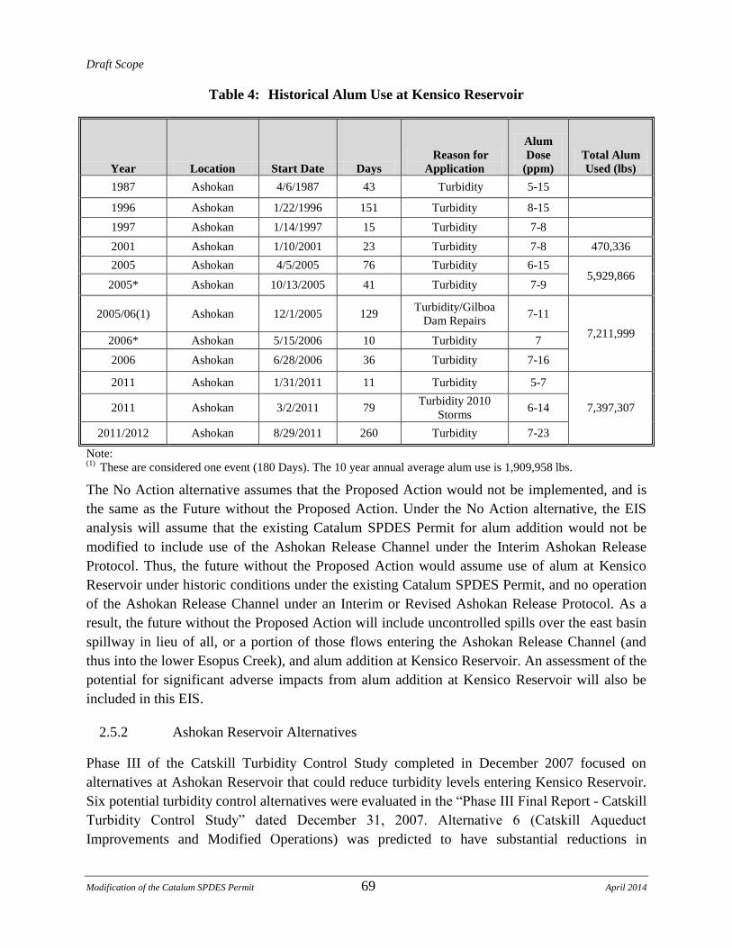
Draft Scope
Modification of the Catalum SPDES Permit 69 April 2014
Table 4: Historical Alum Use at Kensico Reservoir
Year Location Start Date Days
Reason for
Application
Alum
Dose
(ppm)
Total Alum
Used (lbs)
1987 Ashokan 4/6/1987 43 Turbidity 5-15
1996 Ashokan 1/22/1996 151 Turbidity 8-15
1997 Ashokan 1/14/1997 15 Turbidity 7-8
2001 Ashokan 1/10/2001 23 Turbidity 7-8 470,336
2005 Ashokan 4/5/2005 76 Turbidity 6-15 5,929,866
2005* Ashokan 10/13/2005 41 Turbidity 7-9
2005/06(1) Ashokan 12/1/2005 129 Turbidity/Gilboa
Dam Repairs 7-11
7,211,999 2006* Ashokan 5/15/2006 10 Turbidity 7
2006 Ashokan 6/28/2006 36 Turbidity 7-16
2011 Ashokan 1/31/2011 11 Turbidity 5-7
7,397,307 2011 Ashokan 3/2/2011 79 Turbidity 2010
Storms 6-14
2011/2012 Ashokan 8/29/2011 260 Turbidity 7-23
Note: (1)
These are considered one event (180 Days). The 10 year annual average alum use is 1,909,958 lbs.
The No Action alternative assumes that the Proposed Action would not be implemented, and is
the same as the Future without the Proposed Action. Under the No Action alternative, the EIS
analysis will assume that the existing Catalum SPDES Permit for alum addition would not be
modified to include use of the Ashokan Release Channel under the Interim Ashokan Release
Protocol. Thus, the future without the Proposed Action would assume use of alum at Kensico
Reservoir under historic conditions under the existing Catalum SPDES Permit, and no operation
of the Ashokan Release Channel under an Interim or Revised Ashokan Release Protocol. As a
result, the future without the Proposed Action will include uncontrolled spills over the east basin
spillway in lieu of all, or a portion of those flows entering the Ashokan Release Channel (and
thus into the lower Esopus Creek), and alum addition at Kensico Reservoir. An assessment of the
potential for significant adverse impacts from alum addition at Kensico Reservoir will also be
included in this EIS.
2.5.2 Ashokan Reservoir Alternatives
Phase III of the Catskill Turbidity Control Study completed in December 2007 focused on
alternatives at Ashokan Reservoir that could reduce turbidity levels entering Kensico Reservoir.
Six potential turbidity control alternatives were evaluated in the “Phase III Final Report - Catskill
Turbidity Control Study” dated December 31, 2007. Alternative 6 (Catskill Aqueduct
Improvements and Modified Operations) was predicted to have substantial reductions in
Draft Scope
Modification of the Catalum SPDES Permit 70 April 2014
turbidity levels and resultant alum addition and is part of the Proposed Action. The other five
alternatives are described below and will be included summarized in the EIS alternatives
analyses.
1) Ashokan Reservoir Alternative 1 – West Basin Outlet
This alternative would involve construction of a new outlet structure in the west basin,
consisting of a gated weir discharging to Esopus Creek downstream of the Olive Bridge
Dam. The west basin outlet would be operated as a preventative measure, used to create a
void in the west basin pending high flow, high turbidity forecasted conditions.
Conceptual designs were evaluated for single weir and multi-level outlet structures, with
capacities of 2,000, 4,000, and 6,000 MGD.
2) Ashokan Reservoir Alternative 2 – Dividing Weir Crest Gates
The Phase III study evaluated options for temporarily increasing storage in the west
basin. This would involve installation of inflatable gates to allow turbid inflows to be
stored for a longer period of time before being transferred to the east basin and carried
downstream.
3) Ashokan Reservoir Alternative 3 – East Basin Diversion Wall and Channel
Improvements
Improvements to the east basin diversion wall would involve extending the height and
length of the diversion wall that directs flow from the west basin into the east basin to
help prevent turbid water that overtops the dividing weir from “short-circuiting” towards
the east basin Upper Gate Chamber intake. The analysis includes consideration of three
alternative wall lengths as well as potential improvements to the adjacent east basin
spillway channel.
4) Ashokan Reservoir Alternative 4 – Upper Gate Chamber Modifications
Improvements at the Upper Gate Chamber would be implemented mainly to provide
enhanced multi-level withdrawal capability. This capability currently exists in a limited
capacity. The improvements would allow for greater flexibility in choosing optimal
elevations and would allow for greater ease of operation.
5) Ashokan Reservoir Alternative 5 – East Basin Intake
Alternative 5 would include construction of a new intake towards the center of the east
Basin to provide an alternative withdrawal location potentially less susceptible to
elevated turbidity conditions. Evaluated designs included a single level intake as well as a
multi-level intake.

Draft Scope
Modification of the Catalum SPDES Permit 71 April 2014
In addition to the alternative previously evaluated as part of Phase III of the Catskill Turbidity
Control Study, the following additional alternatives would be evaluated as part of the EIS. Some
of the following alternatives have been evaluated previously, for example as part of the Value
Engineering review of the Catskill Turbidity Control Study, while others have not been formally
evaluated.
6) Ashokan Reservoir Alternative 6 – Changed Release Channel Operation
This alternative will evaluate potential effects of different operation scenarios under the
Interim Ashokan Release Protocol that may increase community release flows
downstream of Ashokan Reservoir and/or increase the capacity of and flows through the
Ashokan Release Channel.
7) Ashokan Reservoir Alternative 7 – Bypass of Low Turbidity Upper Esopus Creek Water
directly to the Ashokan East Basin
Alternative 7 would include construction of a bypass tunnel or other structural
improvement to enable routing Ashokan reservoir inflow from the upper Esopus Creek
directly to the East Basin.
8) Ashokan Reservoir Alternative 8 – Bypass of Upper Esopus directly to the lower Esopus
Creek
Alternative 8 would include construction of a bypass tunnel or other structural
improvement to enable routing Ashokan reservoir inflow from the upper Esopus Creek
around or through the reservoir, discharging to the lower Esopus Creek below the
reservoir.
2.5.3 Alternatives along the Catskill Aqueduct
In addition to alternatives at Ashokan Reservoir, the following alternatives for operation of the
Catskill Aqueduct that include options to discharge water from the Catskill Aqueduct prior to its
reaching the Kensico Reservoir will be evaluated in the EIS.
1) Catskill Aqueduct Alternative 1 – Use of the Hudson River Drainage Chamber
This alternative would involve reconstruction and modifications to the existing
Moodna/Hudson River Tunnel drainage chamber to allow for discharges of turbid water
from the Catskill Aqueduct directly into the Hudson River on the east side of the Hudson
River near the borders of Putnam and Dutchess Counties. The existing Moodna/Hudson
River Tunnel drainage chamber was designed to drain water from the Catskill Aqueduct
for purposes of inspecting the Catskill Aqueduct, and has never been used. Modification
Draft Scope
Modification of the Catalum SPDES Permit 72 April 2014
to the drainage chamber to accommodate up to 600 MGD of flow from the Catskill
Aqueduct will be evaluated.
2) Catskill Aqueduct Alternative 2 – Use of the Croton Lake Siphon
This alternative would involve use of the blow-off at the downtake shaft of the Croton
Lake Siphon to allow for discharges of turbid water from the Catskill Aqueduct directly
into the Croton Reservoir.
3) Catskill Aqueduct Alternative 3 – Use of the Rondout Pressure Tunnel
This alternative would involve modification of the Rondout Pressure Tunnel Siphon
Drain in order to allow for discharges of turbid water from the Catskill Aqueduct to
Rondout Creek that leads to the Hudson River after its confluence with the Wallkill
River.
4) Catskill Aqueduct Alternative 4 – Use of the Wallkill Pressure Tunnel Siphon Drain or
the Wallkill Blow-off Chamber
This alternative would involve use of either the Wallkill Pressure Tunnel Siphon Drain,
with modification, or the Wallkill Blow-off Chamber to allow for discharges of turbid
water from the Catskill Aqueduct to the Wallkill River that leads to the Hudson River
after its confluence with Rondout Creek.
2.5.4 Alternatives at Kensico Reservoir
The existing Catalum SPDES Permit includes a condition that required DEP to develop a report
to analyze alternatives that minimize the area of floc deposition resulting from the addition of
alum and sodium hydroxide at the CATIC. These alternatives were evaluated in the technical
report “Feasibility of Minimizing the Area of Alum Floc Deposition in Kensico Reservoir” dated
October 2007. To analyze the present deposition patterns and the potential benefits of structural
alternatives, a computational fluid dynamics computer model of Kensico Reservoir near the
CATIC was developed and six alternatives were analyzed. These alternatives are described
below and will be included in the EIS alternatives analyses.
1) Kensico Reservoir Alternative 1 – Perforated Target Baffle
This alternative would involve installation of a perforated vertical baffle wall to dissipate
the energy of water as it enters the CATIC cove and make the flow leaving the cove
uniform, thereby reducing the area of floc deposition.

Draft Scope
Modification of the Catalum SPDES Permit 73 April 2014
2) Kensico Reservoir Alternative 2 – Sedimentation Basin
This alternative would involve installation of two baffles on the east bank and one baffle
on the west bank of the cove to interrupt the high velocity current and increase particle
residence time in the area near the CATIC inlet.
3) Kensico Reservoir Alternative 3 – Perforated Baffle Wall
This alternative would involve installation of a perforated baffle wall perpendicular to the
general flow direction. The purpose of this influent control alternative is to make the flow
uniform before it leaves the cove as opposed to allowing the more narrow higher velocity
current to project the alum floc into the open area.
4) Kensico Reservoir Alternative 4 – Submerged Weir
This alternative would involve use of a submerged weir to act as a baffle to make flow
uniform, and to trap large particles that settle quickly. The submerged weir creates more
uniform flow from the cove into the open area of Kensico Reservoir.
5) Kensico Reservoir Alternative 5 – Boom and Silt Curtains
This alternative would involve use of an oil boom and two silt curtains to create a large
settling basin. The boom would float on the water surface and be 4 feet deep, allowing
water to pass underneath. The silt curtains would be full-depth and assumed
impermeable. The oil boom would partially break the high velocity current along the east
bank of the CATIC Cove, creating a more uniform outgoing flow pattern from the cove.
In this manner, the boom and silt curtains would form a large and enclosed settling basin.
6) Kensico Reservoir Alternative 6 – Large Settling Basin
This alternative represents a combination of concepts evaluated in Kensico Reservoir
Alternatives 3 and 4. For this alternative, a perforated wall would be placed upstream to
homogenize inflow, and an effluent weir would be placed in the open area of the cove to
control outflow, making the cove and part of the open area a large settling basin. The
arrangement would be designed to mimic a formal water treatment plant settling basin.
2.6 Mitigation
Where potential significant adverse impacts are identified in the EIS analyses, reasonable and
practicable measures that have the potential to avoid, mitigate, or minimize these impacts will be
identified. A summary of these findings and a timeframe for implementation, if available, will be
presented in the EIS. Where impacts cannot be mitigated, they will be identified as unavoidable
significant adverse impacts.
Draft Scope
Modification of the Catalum SPDES Permit 74 April 2014
2.7 Growth Inducement
The Proposed Action is not anticipated to alter regional growth patterns, impact residential
settlement patterns, or affect growth in employment centers. Growth inducement aspects of the
proposed actions need to be addressed “where applicable and significant.” Growth inducement
impacts are not anticipated, and, if any, will be treated in the context of land use impacts.
2.8 Unavoidable Impacts and Irretrievable and Irreversible Commitment of Resources
The proposed project may result in adverse impacts that are unavoidable. These unavoidable
impacts will be specifically documented in the EIS. The EIS will also disclose the commitment
of resources that the project may require which are irretrievable and adverse effects that are
irreversible.

Draft Scope
Modification of the Catalum SPDES Permit 75 April 2014
ATTACHMENTS
Attachment A: New York State Department of Environmental Conservation Interim Ashokan
Release Protocol dated September 27, 2013, as part of the Order on Consent
dated October 4, 2013
New York State Department of Environmental Conservation/New York City Department
of Environmental Protection (DEC/DEP) Interim Release Protocol (IRP) for the Ashokan
Reservoir
September 27, 2013
Introduction: DEC and DEP have agreed to implement a revised Interim Release Protocol
(IRP) for the Ashokan Reservoir to enhance benefits to the community, improve flood
attenuation, and provide better water quality on an interim basis and recognize that it may be
modified or terminated as additional modeling and impact assessments are performed and as
additional information becomes available.
The IRP is considered interim as it may be revised as a result of lessons learned during its
implementation, or through a modification to SPDES permit #3-9903-00023/00006: SPDES No.:
NY-0264652 issued by the DEC after an appropriate public process.
1. Community Release Protocol:
a. Purpose: to provide environmental, recreational and economic benefits to the lower
Esopus Creek in a manner that will not adversely impact water supply.
b. Minimum Flow: DEP will make releases from the Ashokan Reservoir through the
Ashokan Reservoir Release Channel at the rates prescribed in the following table.
Release Criteria 1 Summer (May 1 – Oct
31)
Winter (Nov 1 – Apr
30)
Normal Hydrologic
Condition
15 MGD 10 MGD
Turbidity >30NTU 10 MGD 4 MGD
Turbidity >100 NTU 0 MGD 0 MGD
Drought Warning Condition 10 MGD 4 MGD
Turbidity >100 NTU 0 MGD 0 MGD
Drought Condition 0 0
Note 1: Hydrologic Condition is based on the combined storage in the Cannonsville,
Pepacton and Neversink Reservoirs.
c. Turbidity: When substantial contrast in turbidity exists with varying depths in the
West Basin of the Ashokan Reservoir, DEP will make reasonable efforts to make
releases from the elevation with the least turbidity.

Draft Scope
Modification of the Catalum SPDES Permit 76 April 2014
d. Action Stage Shutdown: The community release shall be shutdown when the
USGS gage on the Esopus Creek at Mount Marion (Lower Esopus) is within 1 foot
of the "Action Stage" (18') and is forecasted to reach "Action Stage", as predicted on
the National Weather Service‟s (NWS‟s) Advanced Hydrologic Prediction Service
web page.
2. Spill Mitigation Release Protocol:
a. Purpose: In order to enhance flood mitigation provided by the Ashokan Reservoir,
DEP will utilize the established Conditional Seasonal Storage Objective (CSSO)
rule curve depicted in Figure 1. Consistent with good practices for water supply
reservoirs, and in order to ensure that sufficient resources are available during an
extended dry period to support water supply needs, it is essential to ensure that the
Ashokan Reservoir is filled on or around June 1st every year. To accomplish this,
the CSSO must be limited and ramped. For the duration of the IRP DEP shall
endeavor, to the maximum extent possible without impacting water supply
reliability, to maintain reservoir levels at the CSSO, thus creating a high probability
of maintaining a ten (10) percent void space from October 14 through March 15 to
help mitigate flooding events. In determining the releases needed to maintain the
CSSO, DEP will consider the following parameters in the evaluation: forecasted
inflows over the next seven (7) days including inflow from snow water equivalent as
forecast by the National Weather Service‟s (NWS) Hydrological Ensemble
Forecasting System (HEFS), anticipated diversions over the next seven (7) days, and
the current usable reservoir storage. Based on any projected seven (7) day storage
surplus, DEP will calculate total release volumes to progress toward the CSSO and
allocate those volumes over the upcoming seven 7-day period. In making releases,
DEP will consider reasonable requests from Ulster County for a release modification
related to a downstream agricultural or recreational concern, within the limitations
of the release works for the Ashokan Reservoir Release Channel and subject to DEC
concurrence. Spill Mitigation releases are designed to help mitigate the effects of
potential for flooding immediately below the Ashokan Reservoir to the lower
Esopus Creek communities.
b. Maximum Flow: The maximum flow from the Release Channel shall not exceed
600 MGD. DEP will throttle releases as necessary so the combined flow for
Ashokan spill and Ashokan Reservoir Release Channel discharge does not exceed
1,000 MGD. In addition, DEP will shutdown the Release Channel when the USGS
gage on the Esopus Creek at Mount Marion (Lower Esopus) is within 1 foot of the
"Action Stage" (18') and is forecasted to reach "Action Stage", as predicted on the
NWS‟s Advanced Hydrologic Prediction Service web page. DEP shall endeavor to
achieve the CSSO in a manner that minimizes the need for maximum flow, large
volume releases.
c. Turbidity: When substantial contrast in turbidity exists with varying depths in the
West Basin of the Ashokan Reservoir, DEP will make reasonable efforts to make
releases from the elevation with the least turbidity. The frequency of intake changes

Draft Scope
Modification of the Catalum SPDES Permit 77 April 2014
shall be limited to no more than once per week.
i. Dates: July 1 through May 1
Turbidity Duration Comments
0-30 NTU Unlimited
>30-60 NTU 12Days At the end of the 12 day discharge provide a release of
200 MGD for 36 hours of water with a turbidity of 30
NTU or less (or best available water that is
substantially lower in turbidity from the reservoir)
prior to resuming additional Spill Mitigation Releases
> 60 NTU 5 Days At the end of the 5 day discharge provide a release of
200 MGD for 36 hours of water with a turbidity of 30
NTU or less (or best available water that is
substantially lower in turbidity from the reservoir)
prior to resuming additional Spill Mitigation Releases
d. Ramping Rates: All changes in water release rates will be conducted in accordance
with the following schedule:
i. Flow Increases:
1. For flows greater than 0 and up to 80 MGD: 20 MGD/hr
2. For flows greater than 80 MGD and up to 200 MGD: 40 MGD/hr
3. For flows greater than 200 MGD: 40 MGD/half-hour
ii. Flow Decreases:
1. For flows greater than 200 MGD: 40 MGD/half-hour
2. For flows from 200 to 80 MGD: 40 MGD/hr
3. For flows from 80 to 0 MGD: 20 MGD/hr
e. Void Target: Conditional Seasonal Storage Objective (CSSO) as per
Figure 1

Draft Scope
Modification of the Catalum SPDES Permit 78 April 2014
3. Operational Release Protocol:
a. Purpose: to prevent or mitigate the spilling of more turbid west basin waters into the
east basin of the Ashokan Reservoir in order to protect water quality and enhance the
flood mitigation benefit that the reservoir already provides to the lower Esopus
Creek communities.
b. Maximum Flow: The release will be throttled as necessary so the combined flow
for Ashokan spill and Ashokan Reservoir Release Channel discharge does not
exceed 1,000 MGD. In addition, shutdown when the USGS gage on the Esopus
Creek at Mount Marion (Lower Esopus) is within 1 foot of the "Action Stage" (18')
and is forecasted to reach "Action Stage", as predicted on the NWS‟s Advanced
Hydrologic Prediction Service web page.
Because the Lower Esopus Creek is used for various recreational and agricultural
purposes, it may be necessary, at times, to limit the flow rate to be protective of
those uses. Therefore, for the period from June 1 through October 1, the maximum
flow rate through the release channel for operational releases shall be limited to no
more than 300 MGD unless a larger release rate is necessary to prevent overspill of
poor quality water from the West Basin into the East Basin of the Ashokan
Reservoir.
c. Void Target: to be determined based on current and predicted hydrologic conditions
to protect water quality and ensure reservoir refill.
Figure 1
Ashokan Reservoir Storage
50
60
70
80
90
100
110
6/1
7/1
8/1
9/1
10/1
11/1
12/1 1/
12/
13/
14/
15/
16/
1
Date
As
ho
kan
Re
se
rvo
ir U
sa
ble
Sto
rag
e [
%]
Conditional Seasonal Storage Objective (CSSO)
Note: The CSSO is in effect from July 1st through May 1
st
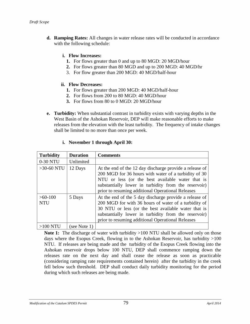
Draft Scope
Modification of the Catalum SPDES Permit 79 April 2014
d. Ramping Rates: All changes in water release rates will be conducted in accordance
with the following schedule:
i. Flow Increases:
1. For flows greater than 0 and up to 80 MGD: 20 MGD/hour
2. For flows greater than 80 MGD and up to 200 MGD: 40 MGD/hr
3. For flow greater than 200 MGD: 40 MGD/half-hour
ii. Flow Decreases:
1. For flows greater than 200 MGD: 40 MGD/half-hour
2. For flows from 200 to 80 MGD: 40 MGD/hour
3. For flows from 80 to 0 MGD: 20 MGD/hour
e. Turbidity: When substantial contrast in turbidity exists with varying depths in the
West Basin of the Ashokan Reservoir, DEP will make reasonable efforts to make
releases from the elevation with the least turbidity. The frequency of intake changes
shall be limited to no more than once per week.
i. November 1 through April 30:
Turbidity Duration Comments
0-30 NTU Unlimited
>30-60 NTU 12 Days At the end of the 12 day discharge provide a release of
200 MGD for 36 hours with water of a turbidity of 30
NTU or less (or the best available water that is
substantially lower in turbidity from the reservoir)
prior to resuming additional Operational Releases
>60-100
NTU
5 Days At the end of the 5 day discharge provide a release of
200 MGD for with 36 hours of water of a turbidity of
30 NTU or less (or the best available water that is
substantially lower in turbidity from the reservoir)
prior to resuming additional Operational Releases
>100 NTU (see Note 1)
Note 1: The discharge of water with turbidity >100 NTU shall be allowed only on those
days where the Esopus Creek, flowing in to the Ashokan Reservoir, has turbidity >100
NTU. If releases are being made and the turbidity of the Esopus Creek flowing into the
Ashokan reservoir drops below 100 NTU, DEP shall commence ramping down the
releases rate on the next day and shall cease the release as soon as practicable
(considering ramping rate requirements contained herein) after the turbidity in the creek
fell below such threshold. DEP shall conduct daily turbidity monitoring for the period
during which such releases are being made.
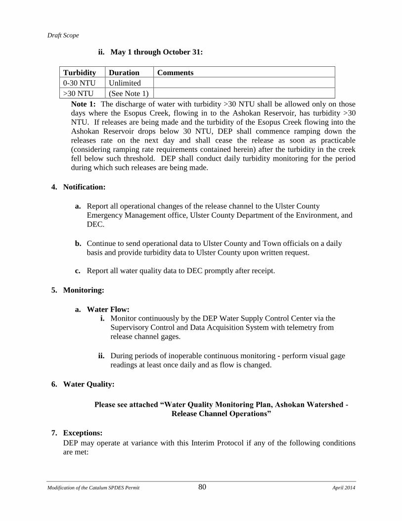
Draft Scope
Modification of the Catalum SPDES Permit 80 April 2014
ii. May 1 through October 31:
Turbidity Duration Comments
0-30 NTU Unlimited
>30 NTU (See Note 1)
Note 1: The discharge of water with turbidity >30 NTU shall be allowed only on those
days where the Esopus Creek, flowing in to the Ashokan Reservoir, has turbidity >30
NTU. If releases are being made and the turbidity of the Esopus Creek flowing into the
Ashokan Reservoir drops below 30 NTU, DEP shall commence ramping down the
releases rate on the next day and shall cease the release as soon as practicable
(considering ramping rate requirements contained herein) after the turbidity in the creek
fell below such threshold. DEP shall conduct daily turbidity monitoring for the period
during which such releases are being made.
4. Notification:
a. Report all operational changes of the release channel to the Ulster County
Emergency Management office, Ulster County Department of the Environment, and
DEC.
b. Continue to send operational data to Ulster County and Town officials on a daily
basis and provide turbidity data to Ulster County upon written request.
c. Report all water quality data to DEC promptly after receipt.
5. Monitoring:
a. Water Flow:
i. Monitor continuously by the DEP Water Supply Control Center via the
Supervisory Control and Data Acquisition System with telemetry from
release channel gages.
ii. During periods of inoperable continuous monitoring - perform visual gage
readings at least once daily and as flow is changed.
6. Water Quality:
Please see attached “Water Quality Monitoring Plan, Ashokan Watershed -
Release Channel Operations”
7. Exceptions:
DEP may operate at variance with this Interim Protocol if any of the following conditions
are met:
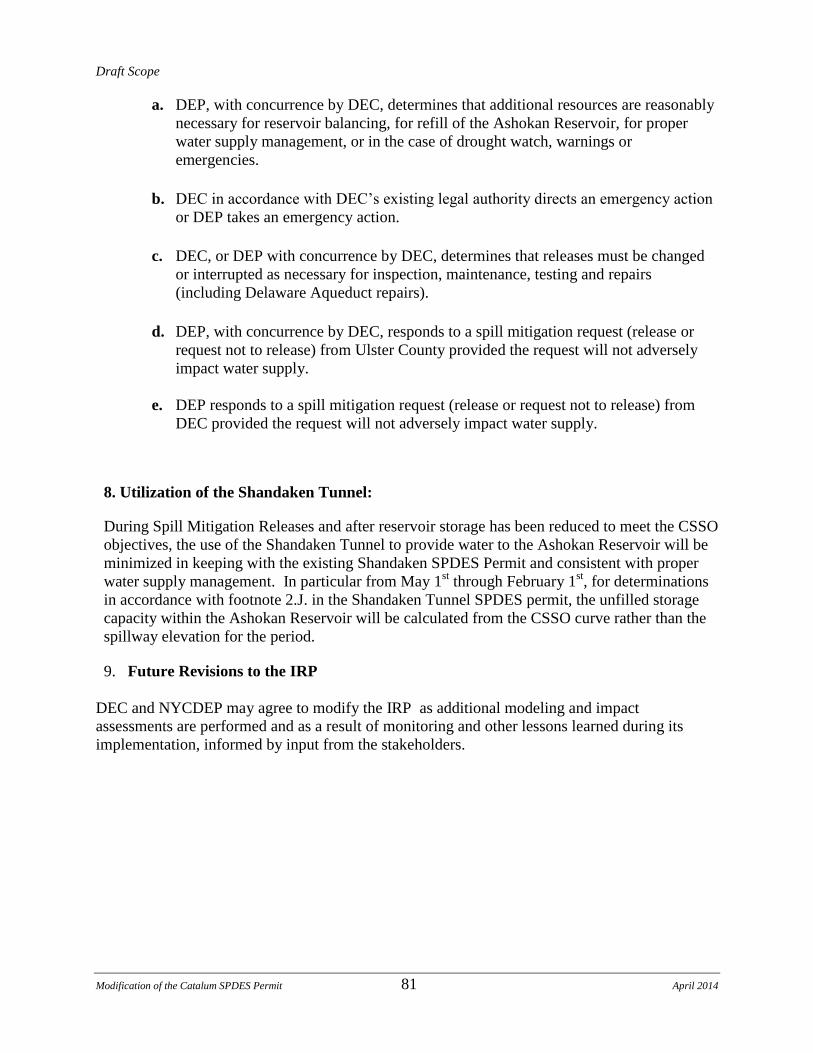
Draft Scope
Modification of the Catalum SPDES Permit 81 April 2014
a. DEP, with concurrence by DEC, determines that additional resources are reasonably
necessary for reservoir balancing, for refill of the Ashokan Reservoir, for proper
water supply management, or in the case of drought watch, warnings or
emergencies.
b. DEC in accordance with DEC‟s existing legal authority directs an emergency action
or DEP takes an emergency action.
c. DEC, or DEP with concurrence by DEC, determines that releases must be changed
or interrupted as necessary for inspection, maintenance, testing and repairs
(including Delaware Aqueduct repairs).
d. DEP, with concurrence by DEC, responds to a spill mitigation request (release or
request not to release) from Ulster County provided the request will not adversely
impact water supply.
e. DEP responds to a spill mitigation request (release or request not to release) from
DEC provided the request will not adversely impact water supply.
8. Utilization of the Shandaken Tunnel:
During Spill Mitigation Releases and after reservoir storage has been reduced to meet the CSSO
objectives, the use of the Shandaken Tunnel to provide water to the Ashokan Reservoir will be
minimized in keeping with the existing Shandaken SPDES Permit and consistent with proper
water supply management. In particular from May 1st through February 1
st, for determinations
in accordance with footnote 2.J. in the Shandaken Tunnel SPDES permit, the unfilled storage
capacity within the Ashokan Reservoir will be calculated from the CSSO curve rather than the
spillway elevation for the period.
9. Future Revisions to the IRP
DEC and NYCDEP may agree to modify the IRP as additional modeling and impact
assessments are performed and as a result of monitoring and other lessons learned during its
implementation, informed by input from the stakeholders.
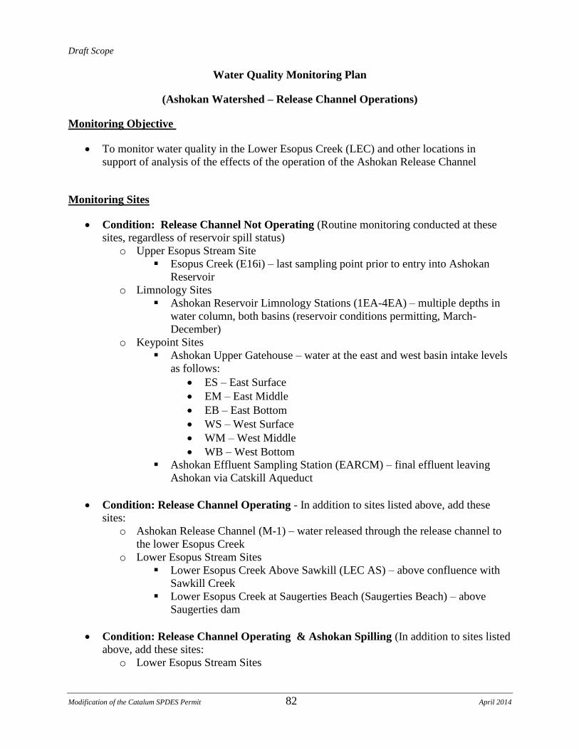
Draft Scope
Modification of the Catalum SPDES Permit 82 April 2014
Water Quality Monitoring Plan
(Ashokan Watershed – Release Channel Operations)
Monitoring Objective
To monitor water quality in the Lower Esopus Creek (LEC) and other locations in
support of analysis of the effects of the operation of the Ashokan Release Channel
Monitoring Sites
Condition: Release Channel Not Operating (Routine monitoring conducted at these
sites, regardless of reservoir spill status)
o Upper Esopus Stream Site
Esopus Creek (E16i) – last sampling point prior to entry into Ashokan
Reservoir
o Limnology Sites
Ashokan Reservoir Limnology Stations (1EA-4EA) – multiple depths in
water column, both basins (reservoir conditions permitting, March-
December)
o Keypoint Sites
Ashokan Upper Gatehouse – water at the east and west basin intake levels
as follows:
ES – East Surface
EM – East Middle
EB – East Bottom
WS – West Surface
WM – West Middle
WB – West Bottom
Ashokan Effluent Sampling Station (EARCM) – final effluent leaving
Ashokan via Catskill Aqueduct
Condition: Release Channel Operating - In addition to sites listed above, add these
sites:
o Ashokan Release Channel (M-1) – water released through the release channel to
the lower Esopus Creek
o Lower Esopus Stream Sites
Lower Esopus Creek Above Sawkill (LEC AS) – above confluence with
Sawkill Creek
Lower Esopus Creek at Saugerties Beach (Saugerties Beach) – above
Saugerties dam
Condition: Release Channel Operating & Ashokan Spilling (In addition to sites listed
above, add these sites:
o Lower Esopus Stream Sites

Draft Scope
Modification of the Catalum SPDES Permit 83 April 2014
Ashokan Spill (ASP) – Ashokan Reservoir spill channel below spillway
Lower Esopus Creek Confluence (ASP M-1 CONF) – below confluence
of Ashokan Reservoir release channel release flow and Ashokan Reservoir
spill channel
Monitoring Frequency and Analytes
Condition: Release Channel Not Operating (Routine monitoring at these sites)
Site Type Sites Analytes Frequency
Upper Esopus
Creek
E16i turbidity, temperature
total suspended solids
Weekly
Monthly
Limnology 1EA-4EA turbidity, temperature
total suspended solids
2x/Month*
Monthly*
Keypoints EARCM turbidity, temperature
total suspended solids
5Days/Week
Monthly
Keypoints ES, EM, EB,
WS,WM,WB
turbidity, temperature Weekly
* Reservoir conditions permitting (March – December)

Draft Scope
Modification of the Catalum SPDES Permit 84 April 2014
Condition: Release Channel Operating (In addition to sites listed above, add these
sites)
Site Type Sites Analytes Frequency
Keypoints M-1 turbidity, temperature, total
suspended solids
Weekly
Lower Esopus
Creek
LEC AS,
Saugerties Beach
turbidity, temperature, total
suspended solids
Weekly
Condition: Release Channel Operating & Ashokan Spilling (In addition to sites listed
above, add these sites
Site Type Sites Analytes Frequency
Lower Esopus
Creek
ASP, ASP M-1
CONF
turbidity, temperature, total
suspended solids
Weekly