draft snake hells canyon subbasin...
TRANSCRIPT
Draft
Snake Hells CanyonSubbasin Summary
June 1, 2001
Prepared for the Northwest Power Planning Council
Subbasin Team LeaderDave Statler, Nez Perce Tribe
Writing Team MembersDarin Saul, ecopacificAnne Davidson, ecopacificCraig Rabe, ecopacific
ContributorsAsotin CountyAsotin County Conservation DistrictAsotin County Noxious Weed BoardBureau of Land ManagementIdaho Department of Fish and WildlifeNatural Resources Conservation Service, ClarkstonNez Perce TribeOregon Department of Fish and WildlifeWashington Department of Fish and WildlifeTim Tate, Washington State University
DRAFT: This document has not yet been reviewed or approved by the NorthwestPower Planning Council

Snake Hells Canyon Subbasin Summary ii 6/1/01 Draft
Snake Hells Canyon subbasin Summary
TABLE OF CONTENTS
INTRODUCTION ............................................................................................................................. 1
SUBBASIN DESCRIPTION........................................................................................................... 3GENERAL DESCRIPTION................................................................................................................... 3
Subbasin Location.................................................................................................................. 3Climate ................................................................................................................................... 3Topography ............................................................................................................................ 4Geology .................................................................................................................................. 4Soils ........................................................................................................................................ 9Hydrology............................................................................................................................. 11Water Quality ....................................................................................................................... 15Vegetation............................................................................................................................. 19Land Use .............................................................................................................................. 22Protected Areas..................................................................................................................... 30
FISH AND WILDLIFE STATUS ......................................................................................................... 34Fish....................................................................................................................................... 34Wildlife ................................................................................................................................. 55
HABITAT AREAS AND QUALITY .................................................................................................... 63Fish....................................................................................................................................... 63Wildlife ................................................................................................................................. 66
WATERSHED ASSESSMENT............................................................................................................ 69LIMITING FACTORS ....................................................................................................................... 72
Fish....................................................................................................................................... 72Wildlife ................................................................................................................................. 79
ARTIFICIAL PRODUCTION .............................................................................................................. 83Idaho Department of Fish and Game................................................................................... 83Lower Snake River Compensation Program........................................................................ 86
EXISTING AND PAST EFFORTS ....................................................................................................... 88EXISTING MANAGEMENT .............................................................................................................. 91
Federal Government ............................................................................................................ 91Federal Agencies with responsibilities in the Snake Hells Canyon subbasin...................... 92Tribal Government ............................................................................................................... 96State Government ................................................................................................................. 97Local Government .............................................................................................................. 107Other Entities and Organizations ...................................................................................... 110
EXISTING GOALS, OBJECTIVES, AND STRATEGIES ...................................................................... 111FEDERAL GOVERNMENT.............................................................................................................. 111
National Marine Fisheries Service and Federal Caucus................................................... 111Basinwide Salmon Recovery Strategy (from Federal Caucus 2000) ................................. 113US Fish and Wildlife Service Goal for Anadromous Salmonids........................................ 114

Snake Hells Canyon Subbasin Summary iii 6/1/01 Draft
USFS and BLM (PACFISH)............................................................................................... 115TRIBAL GOVERNMENT ................................................................................................................ 118
Nez Perce Tribe.................................................................................................................. 118STATE GOVERNMENT.................................................................................................................. 120
Idaho Department of Fish and Game................................................................................. 120Idaho Conservation Data Center (CDC). .......................................................................... 125Idaho Soil and Water Conservation Districts .................................................................... 127Washington Department of Fish and Wildlife.................................................................... 128Oregon Department of Fish and Wildlife........................................................................... 132
TRIBAL AND STATE ..................................................................................................................... 141Snake River Subbasin Goals (from WDFW et al. 1990) ................................................... 141
COUNTY GOVERNMENT............................................................................................................... 142Asotin County Conservation District ................................................................................. 142Nez Perce Soil and Water Conservation District............................................................... 143
OTHER GOALS, OBJECTIVES AND STRATEGIES............................................................................ 144The Hells Canyon Initiative................................................................................................ 144
RESEARCH, MONITORING, AND EVALUATION ACTIVITIES .......................................................... 145STATEMENT OF FISH AND WILDLIFE NEEDS................................................................................ 147
Combined Aquatic and Terrestrial Needs.......................................................................... 147Fisheries / Aquatic Needs................................................................................................... 147Wildlife / Terrestrial Needs ................................................................................................ 152
REFERENCES ............................................................................................................................ 156
APPENDICES .............................................................................................................................. 167Appendix A - Wildlife species of the Snake Hells Canyon subbasin .................................. 168Appendix B - Attributes of Idaho subwatersheds as they relate to bull trout threats (lowerSnake Hells Canyon subbasin) ........................................................................................... 175Appendix C - Attributes of Idaho subwatersheds as they relate to bull trout threats (upperSnake Hells Canyon subbasin) ........................................................................................... 176Appendix D - Noxious weed species occurrence in the counties partially contained by theSnake Hells Canyon subbasin . .......................................................................................... 177

Snake Hells Canyon Subbasin Summary iv 6/1/01 Draft
List of Figures
Figure 1. Location of the Snake Hells Canyon subbasin in the Blue Mountain Ecoprovince ........2Figure 2. Location and major features of the Snake Hells Canyon subbasin..................................5Figure 3. Precipitation patterns in the Snake Hells Canyon subbasin.............................................6Figure 4. Topography and elevation in the Snake Hells Canyon subbasin.....................................7Figure 5. Geology of the Snake Hells Canyon subbasin.................................................................8Figure 6. Soils of the Snake Hells Canyon subbasin.....................................................................10Figure 7. Average daily flows measured at Hells Canyon Dam gage #13290450 (1966-1997)...12Figure 8. Flow in the Snake (Hells Canyon and Anatone gages) and contributing flow from four
main tributaries..................................................................................................................13Figure 9. Daily Flow Fluctuations at Hells Canyon Dam for 3 days in March 2001 ...................14Figure 10. Percent Contribution of Flow from Hells Canyon Dam at various points in the Snake
Hells Canyon subbasin ......................................................................................................14Figure 11. Minimum, mean and maximum daily flows at Hells Canyon Dam gage #13290450 for
5 days in May 2001. ..........................................................................................................15Figure 12. Stream temperatures recorded at Washington Department of Ecology site #35A150 on
the mainstem Snake River above the confluence of the Clearwater River (1992-1999) ..18Figure 13. Current land cover patterns in the Snake Hells Canyon subbasin ...............................20Figure 14. Land ownership in the Snake Hells Canyon subbasin.................................................23Figure 15. Land use patterns in the Snake Hells Canyon subbasin...............................................24Figure 16. Historical and current mining areas in the Snake Hells Canyon subbasin ..................29Figure 17. Areas in the Snake Hells Canyon subbasin that are managed and/or protected using a
conservation-based strategy ..............................................................................................32Figure 18. Adult returns of wild fall chinook salmon past Lower Granite Dam (1975-1999)
(BLM 2000a).....................................................................................................................37Figure 19. Fall chinook distribution in the Snake Hells Canyon subbasin ...................................38Figure 20. Adult returns of wild spring/summer chinook past Lower Granite Dam (1975-1999)
(BLM 2000a; 2000b).........................................................................................................42Figure 21. Spring chinook distribution in the Snake Hells Canyon subbasin...............................43Figure 22. Numbers of Snake River sockeye passing Lower Granite Dam (1975-1999).............44Figure 23. Sockeye salmon distribution in the Snake Hells Canyon subbasin .............................45Figure 24. Steelhead distribution within the Snake Hells Canyon subbasin.................................47Figure 25. The length (total length) frequency distributions of sturgeon sampled from the Hells
Canyon reaches of the Snake River, 1997-99 (Tuell and Everett 2001) 1982-84 (Lukens1985), and 1972-75 (Coon et al. 1977) and the percent of the populations < 92 cm,between 92 and 183 cm, and >183 cm..............................................................................50
Figure 26. Relative distribution of white sturgeon between Lower Granite Dam and theconfluence of the Salmon River (1997-2000) (J. Hesse, NPT, personal communication,May, 2001). .......................................................................................................................52
Figure 27. Bull trout distribution in the Mid-Snake subbasin.......................................................54Figure 28. Smolt-to-adult survival rates (bars; SAR) and smolts/spawner (solid line) for wild
Snake River spring and summer chinook. (from Petrosky et al. in press) ........................73Figure 29. Upland restoration projects occurring outside of the Asotin Creek Watershed ..........90

Snake Hells Canyon Subbasin Summary v 6/1/01 Draft
List of Tables
Table 1. 303d listed stream segments Snake Hells Canyon subbasin...........................................17Table 2. Land management agencies of the Snake Hells Canyon subbasin. ................................25Table 3. Changes in population in counties partially contained by the Snake Hells Canyon
subbasin 1990-2000 (U.S. Census Bureau 2000)..............................................................28Table 4. Areas in the Snake Hells Canyon subbasin managed and/or protected using a
conservation-based strategy ..............................................................................................33Table 5. Fish species currently inhabiting the Snake Hells Canyon subbasin ..............................34Table 6. General life history stages of listed key salmonid species occurring in the Snake Hells
Canyon subbasin (from BLM 2000a; IDEQ and ODEQ 2001) ........................................35Table 7. Salmonid life history stages and their general occurrence in the Snake Hells Canyon
subbasin (from BLM 2000a; M. Hanson, ODFW, personal communication, April 19th,2001)..................................................................................................................................35
Table 8. Number of fall chinook redds counted upriver from Lower Granite Dam, 1986-1999.An empty cell indicates no searches were conducted in the corresponding river ormethod, and year (A.P. Garcia, USFWS, Ahsahka, Idaho; unpublished data. Data fromthe Clearwater basin and the Salmon River provided by the Nez Perce Tribe)................40
Table 9. Population abundance estimates reported for white sturgeon between Lower GraniteDam (Rkm 108) and Hells Canyon Dam (Rkm 398)........................................................48
Table 10. Listed wildlife species of the Snake Hells Canyon subbasin (WDFW ODFW . ..........56Table 11. Thirteen road-associated factors with deleterious impacts on wildlife (Wisdom et al
2000)..................................................................................................................................82Table 12. BPA-funded Columbia River Basin Fish and Wildlife Program activities (Columbia
Basin Fish and Wildlife Authority 1999; Bonneville Power Administration andNorthwest Power Planning Council 1999; Pacific States Marine Fisheries Commission2001)..................................................................................................................................88
Table 13. Non BPA-funded fish and wildlife activities within the Snake Hells Canyon subbasin(Shaw 1997; Oregon Department of Environmental Quality et al. 2000; U. S. ForestService 1990).....................................................................................................................89
Table 14. BPA-funded Columbia River Basin Fish and Wildlife Program research, monitoring,and evaluation activities ..................................................................................................145
Table 15. Non BPA-funded Columbia River Basin Fish and Wildlife Program research,monitoring, and evaluation activities ..............................................................................146

Snake Hells Canyon Subbasin Summary 6/1/01 Draft1
Snake Hells Canyon Subbasin Summary
Introduction
The Snake Hells Canyon Subbasin Summary has been developed as part of the rolling provincialreview process developed by the Northwest Power Planning Council (NWPPC) in February 2000in response to recommendations by the Independent Scientific Review Panel (ISRP) and theColumbia Basin Fish and Wildlife Authority (CBFWA). This summary is an interim documentthat provides context for project proposals during the provincial reviews while a more extensivesubbasin plan is developed.
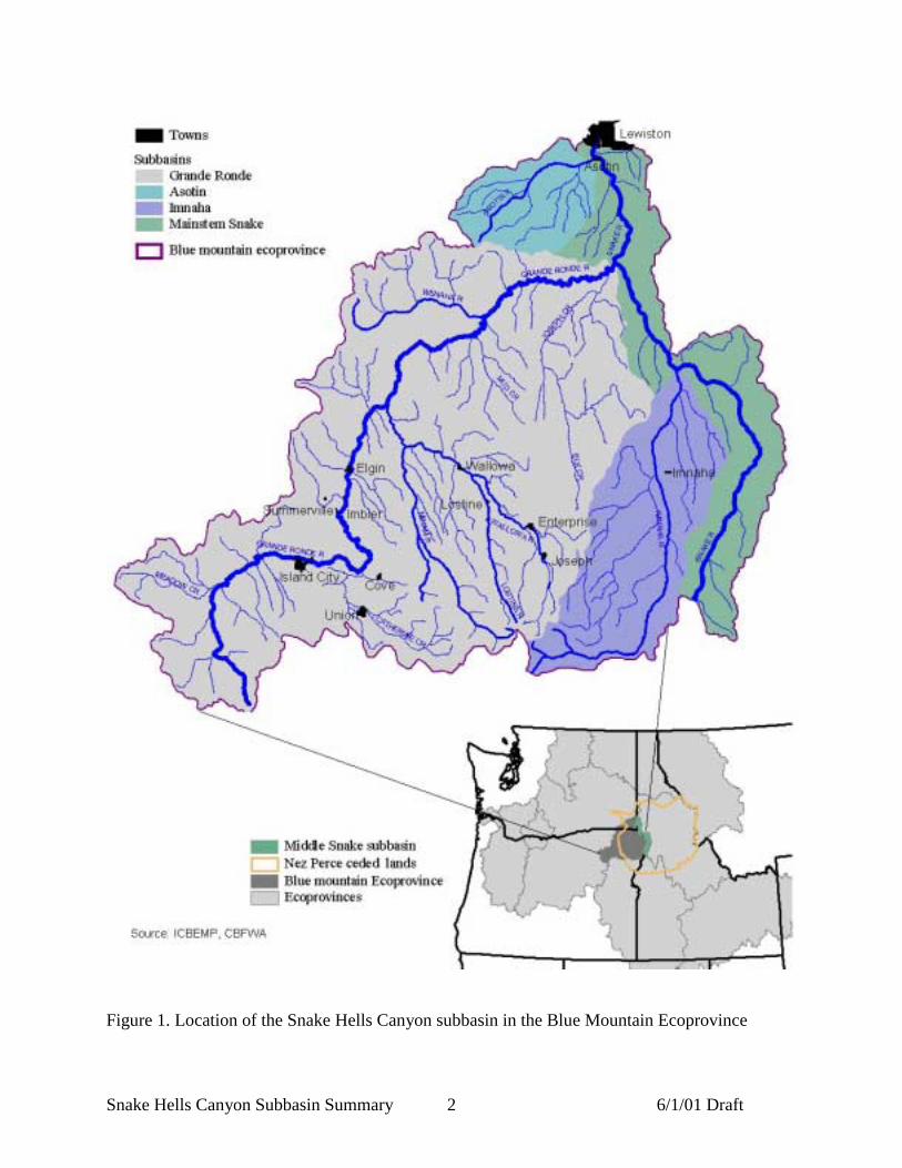
The Snake Hells Canyon subbasin is on one of four subbasins within the BlueMountain Ecoprovince, one of the eleven ecoprovinces in the Columbia basin (Figure 1). Theprocess of developing a Subbasin Summary was initiated as part of the provincial reviewprocess, at a March 27, 2001 meeting in La Grande, Oregon.
This document forms a foundation for future assessment and planning efforts in thesubbasin. It is our hope that this summary will enable those working to protect and restore fishand wildlife in the subbasin to move forward to fill data gaps and more effectively implementprojects without needing to intensively research and integrate past data.
Snake Hells Canyon Subbasin Summary 6/1/01 Draft2
Figure 1. Location of the Snake Hells Canyon subbasin in the Blue Mountain Ecoprovince

Snake Hells Canyon Subbasin Summary 6/1/01 Draft3
Subbasin Description
General DescriptionSubbasin Location
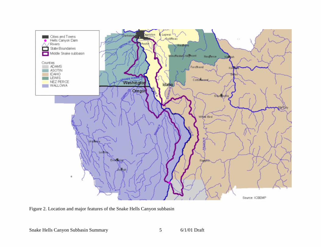
The Snake Hells Canyon subbasin includes the mainstem of the Snake River and the smalltributaries that flow into it, as the Snake flows from Hells Canyon dam to the mouth of theClearwater River at Lewiston, a length of 109 miles (RM 247 to RM 138) (Figure 2). The SnakeRiver forms the border between Oregon and Idaho for the upper 71 miles of the subbasin and theborder between Washington and Idaho for the lower 38 miles. The subbasin contains 924 squaremiles, or 591,519 acres. About 58% of this area falls in Idaho, 28% is in Oregon and theremaining 14% is in Washington. The subbasin contains part of five counties: Adams, Idaho, andNez Perce in Idaho; Asotin in Washington; and Wallowa in Oregon. The lower portion of thesubbasin contains the town of Asotin and portions of Clarkston and Lewiston, the remainder ofthe subbasin is either rural or undeveloped. The Salmon, the Imanaha, the Grande Ronde, AsotinCreek, and the Clearwater rivers are major tributaries that join the Snake in the Snake HellsCanyon subbasin. These rivers drain a combined area of 19,280 square miles (12,339,200 acres) and dramatically influence the water quality and hydrologic conditions in the Snake River. Alsoincluded in this document are discussions of Ten Mile and Couse creeks, two Snake Rivertributaries occurring in Asotin County that are also discussed in the Asotin Creek subbasinsummary (Johnson et al. in preparation).
Archeological evidence suggests that the Snake Hells Canyon subbasin has beeninhabited by American Indians for the last 7,100 to 10,000 years. The subbasin’s realitively mildwinters, lush forage and plentiful wildlife made it a particularly attractive home. It wasconsistently inhabited by the Nez Perce and frequently visted by the Shoshone-Bannock,Northern Paiute and Cayuse Indians. The canyon’s rock walls were an ideal canvas for ancientpictographs and the inaccessibility of the subbasin has aided in their preservation. The uniquegeology and inaccessibility of the subbasin have made it a place of extreme cultural significance(Wallowa-Whitman National Forest 1999). The entire subbasin is within the lands ceded by theNez Perce tribe to the federal government under the Treaty of 1855, and the tribe maintainstreaty rights to fish, roots and berries, hunting and the right to pasture horses and livestock in thisarea (Figure 2).
ClimateClimatic conditions in the Snake Hells Canyon subbasin are moderated by marine air moving upthe Columbia River from the Pacific Ocean, however the 300 mile distance from the coast andthe barrier provided by the Cascade mountains introduce many continental characteristics(Moseley and Bernatas 1991). Summers in the river canyon tend to be hot (mean temperatures of80 - 90° F, with maximums often > l00° F) and winters milder (mean temperatures > 30° F). Atmid-elevations and on the upper plateau temperatures are cooler, with moderately severe wintersand warm summers (Cassier 1995). Precipitation comes in the form of short intense summerstorms and longer milder winter storms (IDEQ and ODEQ 2001). Between 1961 and 1990 theaverage annual precipitation measured near Lewiston was 12.4 inches. The maximum annualprecipitation recorded at this location during the same time period was 15.4 inches. Precipitationpatterns do not change dramatically as you follow the river upstream: measurements taken atWeiser, a small town 225 miles upstream from Lewiston and 109 miles upstream from HellsCanyon Dam, indicate little change in precipitation patterns from those measured at Lewiston.
Snake Hells Canyon Subbasin Summary 6/1/01 Draft4
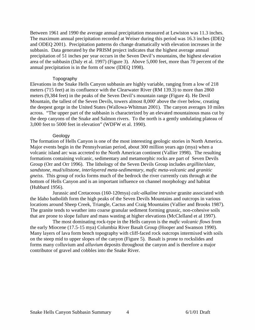
Between 1961 and 1990 the average annual precipitation measured at Lewiston was 11.3 inches.The maximum annual precipitation recorded at Weiser during this period was 16.3 inches (IDEQand ODEQ 2001). Precipitation patterns do change dramatically with elevation increases in thesubbasin. Data generated by the PRISM project indicates that the highest average annualprecipitation of 51 inches per year occurs in the Seven Devil’s mountains, the highest elevationarea of the subbasin (Daly et al. 1997) (Figure 3). Above 5,000 feet, more than 70 percent of theannual precipitation is in the form of snow (IDEQ 1998).
TopographyElevations in the Snake Hells Canyon subbasin are highly variable, ranging from a low of 218meters (715 feet) at its confluence with the Clearwater River (RM 139.3) to more than 2860meters (9,384 feet) in the peaks of the Seven Devil’s mountain range (Figure 4). He DevilMountain, the tallest of the Seven Devils, towers almost 8,000' above the river below, creatingthe deepest gorge in the United States (Wallowa-Whitman 2001). The canyon averages 10 milesacross. “The upper part of the subbasin is characterized by an elevated mountainous mass cut bythe deep canyons of the Snake and Salmon rivers. To the north is a gently undulating plateau of3,000 feet to 5000 feet in elevation” (WDFW et al. 1990).
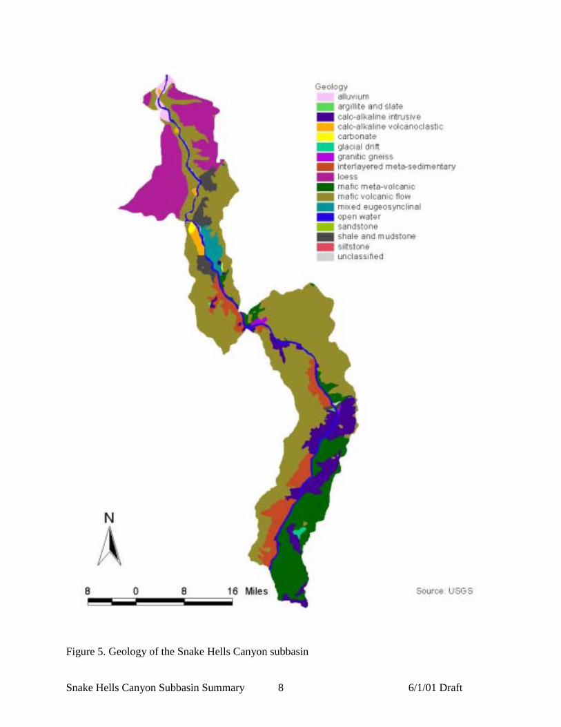
GeologyThe formation of Hells Canyon is one of the most interesting geologic stories in North America.Major events begin in the Pennsylvanian period, about 300 million years ago (mya) when avolcanic island arc was accreted to the North American continent (Vallier 1998). The resultingformations containing volcanic, sedimentary and metamorphic rocks are part of Seven DevilsGroup (Orr and Orr 1996). The lithology of the Seven Devils Group includes argillite/slate,sandstone, mud/siltstone, interlayered meta-sedimentary, mafic meta-volcanic and graniticgneiss. This group of rocks forms much of the bedrock the river currently cuts through at thebottom of Hells Canyon and is an important influence on channel morphology and habitat(Hubbard 1956).
Jurassic and Cretaceous (160-120mya) calc-alkaline intrusive granite associated withthe Idaho batholith form the high peaks of the Seven Devils Mountains and outcrops in variouslocations around Sheep Creek, Triangle, Cactus and Craig Mountains (Vallier and Brooks 1987).The granite tends to weather into coarse granular sediment forming grussic, non-cohesive soilsthat are prone to slope failure and mass wasting at higher elevations (McClelland et al 1997).
The most dominating rock-type in the Hells canyon is the mafic volcanic flows fromthe early Miocene (17.5-15 mya) Columbia River Basalt Group (Hooper and Swanson 1990).Many layers of lava form bench topography with cliff-faced rock outcrops intermixed with soilson the steep mid to upper slopes of the canyon (Figure 5). Basalt is prone to rockslides andforms many colluvium and alluvium deposits throughout the canyon and is therefore a majorcontributor of gravel and cobbles into the Snake River.
Snake Hells Canyon Subbasin Summary 6/1/01 Draft5
Figure 2. Location and major features of the Snake Hells Canyon subbasin

Snake Hells Canyon Subbasin Summary 6/1/01 Draft6
Figure 3. Precipitation patterns in the Snake Hells Canyon subbasin

Snake Hells Canyon Subbasin Summary 6/1/01 Draft7
Figure 4. Topography and elevation in the Snake Hells Canyon subbasin
Snake Hells Canyon Subbasin Summary 6/1/01 Draft8
Figure 5. Geology of the Snake Hells Canyon subbasin

Snake Hells Canyon Subbasin Summary 6/1/01 Draft9
The most important events to shape Hells Canyon began about 13 million years ago when lavaflows to the south dammed the Snake River, forming paleo-Lake Idaho, 150 miles long and 50miles wide (Orr and Orr 1996). During this time the Snake River was a tributary to the SalmonRiver north of Oxbow dam. The mountain building of the Northern Rockies, which begansometime in the past 6 million years and still continues, uplifted the mountains to their currentelevations causing rivers and streams to rapidly incise the landscape, forming the many canyonsand gorges throughout the region (Orr and Orr 1996). Headward erosion of the Snake River inthe southward direction cut through the lava dam, emptying Lake Idaho about two million yearsago. The enormous amount of water spilling into the Snake River greatly increased thedowncutting of the Hells Canyon, undercutting the Salmon River, making it a tributary to theSnake River at the same time (Vallier 1998).
The over-steepened side slopes of Hells Canyon caused many landslides to occur,forming many colluvial and alluvial fans near the base of the canyon. Wind-blown loess andvolcanic ash have been deposited in the area and now mantle the ridges and summits on bothsides of the canyon (USDA Forest Service 1981a). During the late Pleistocene (14.5ka) theBonneville flood swept down through the Snake River, further steepening canyon slopes,creating terraces and depositing gravels (Vallier 1998).
SoilsSoils within Hells Canyon influence erosion and sedimentation into the Snake River and it’stributaries, influencing water quality and habitat. The primary factor governing soil developmentis the deep canyon itself, with steep continuous slopes that often continue well over a mile fromthe river to the crest of the mountain ridges on either side, ascending through several soilclimatic regimes. Vegetation and soil development within the canyon are heavily influenced bythe east/west facing canyon sides receiving different precipitation, and the north/south slopeaspects caused by many ephemeral streams receiving sunlight differently.
Soils in the canyon commonly contain varying amounts of coarse angular gravels,cobbles, silt and ash (USDA Forest Service 1981a). Many rock outcrops interrupt the soillandscape on the mid-slopes of the west facing Idaho side and along the upper slopes of the eastfacing Oregon side of the canyon. The intermittent outcrops and coarse material can inhibiterosion from surface runoff and reduce sediment transport.
Grassland soils called Mollisols are the dominant soil type in Hells Canyon (Figure6). There are many variations of this soil, because it forms over the wide variety of conditionsthat exist throughout the canyon. However, the most common sub-type forms in a semi-aridenvironment and contains a clay-rich subsurface horizon. The grassland soils near Lewiston,Idaho at lower elevation with less precipitation are noted for having lime hardpans with somesoils having natric or sodic horizons. In the higher elevations along the ridges of the CraigMountains on the Idaho side of the canyon, clay rich grassland soils grade into Alfisols. Thesesoils often have an organic litter layer that protects them from surface erosion when leftundisturbed.
In the area of the Seven Devils Mountains above 7,000 feet elevation, coldtemperatures and recently exposed bedrock have severely restricted soil development andsubmature, coarse-grained, grussic soils called Inceptisols formed from granite and on the glacialtill found in the area (USDA Forest Service 1981b). These soils are non cohesive and prone toslope failure. Volcanic ash deposited over the whole region accumulated deep enough in theupper elevations on the Oregon side to form ashy soils called Andisols. These soils have a widevariety of properties and erodibility is difficult to assess.

Snake Hells Canyon Subbasin Summary 6/1/01 Draft10
Figure 6. Soils of the Snake Hells Canyon subbasin
Snake Hells Canyon Subbasin Summary 6/1/01 Draft11
Erosion and Erosion Hazards within Hells CanyonFew studies of soils and soil erosion have taken place in Hells Canyon and information on theerosion characteristics and processes of soils is therefore limited. Soils identified in the canyonare highly erodible (high K-factors) because of high silt/fine sand texture along with highconcentrations of volcanic ash. However, surface erosion processes, such as rill and sheeterosion, are not as common in the canyon as in other nearby watersheds due to the undisturbedprotective cover of grassland and shrub steppe vegetation along with forest canopies on manynorth facing side slopes (Art Kreger, Soil Scientist, USDA Forest Service, PersonalCommunication 5/2/01). Within the side slopes of the many draws on the Oregon side of thecanyon in the bench topography, evidently some soil creep has taken place because deep currentsoils overly horizons of dark organic rich topsoil from past grassland soils (Art Kreger, SoilScientist, USDA Forest Service, Personal Communication 5/2/01).
Unlike soil erosion, the many hazards associated with geology in the Hells CanyonNational Recreation Area have long been studied (Vallier 1994; 1998). Erosion processes takingplace in the canyon consist mainly of various forms of mass wasting, with rock and debris flowsbeing the most prevalent. Sustained rainfalls and shaking from the many earthquakes that takeplace in and around Hells Canyon increase the likelihood of landslides occurring (Vallier 1994).
Because of the continuous steep slopes on either side of the canyon, landslides anddebris flows can travel down slope great distances and often reach the bottom. The colluvium atthe bottom of many steep slopes is often unstable and subject to movement at anytime, and is asource for sedimentation into streams. Undercutting by stream erosion or road construction hasincreased instability and movement on these deposits (Vallier 1994).Rockslides in Hells Canyon and large falling rocks are an imminent danger to travelers in theHells Canyon National Recreation Area. Rock falls occur without warning at anytime almost ona daily basis. Rocks falling onto power line roads have been known to leave indentations in theroads (Vallier 1994).
Although the many gravel bars, alluvial fans, river terraces and landslides haveoccupied the Hells Canyon area for many thousands of years, sedimentation from fine materialfrom more recent modern influences is still a large concern.
HydrologyHydrological features of the Snake Hells Canyon subbasin may best be described by dividing thereach into two sections: the lower section, which extends below the confluence of the SalmonRiver to the Clearwater River and the upper section, which extends upriver from the confluenceof the Salmon to Hells Canyon Dam.
The lower section flows 50 miles from the mouth of the Salmon River (river mile188) to the mouth of the Clearwater River (river mile 138). This segment of river is regulated byHells Canyon Dam (river mile 247.0), and large contributing tributary rivers, which include theClearwater and Grande Ronde rivers. Lower order tributaries joining the Middle Snake in thisreach include Asotin Creek, Tammany Creek, Redbird Creek, and several other streams, many ofwhich flow only during periods of runoff. The Clearwater River contributes approximately 30%of the total flow of the Snake at that point. Water discharge records are from a U.S. GeologicalService (USGS) discharge station located 1.2 mile downriver from the Grande Ronde River(period of record 1958-1997) (Figure 8). The average annual discharge is 35,900 cfs; highestdaily mean is 191,000 cfs (maximum 195,000 cfs - June 18, 1974); and lowest daily mean is6,630 cfs (minimum 6,010 - September 2, 1958). High flows average 80,000-140,000 cfs, and

Snake Hells Canyon Subbasin Summary 6/1/01 Draft12
mean low flows generally range from 8,000-15,000 cfs. Stream flows follow a pattern of lowflows during the late summer and fall months and high flows in the spring and early summermonths. The lowest portion of the subbasin includes several miles of the Lower GraniteReservoir, which extends upstream to Asotin at RM 146.8. With three major dams upstream—Brownlee, Oxbow and Hells Canyon—water levels fluctuate daily and weekly to generatepower, and are seasonally impacted to moderate flooding and provide water for irrigation.
The upper section of the Middle Snake flows 58.8 miles from Hells Canyon Dam(river mile 247.0) to the mouth of the Salmon River (river mile 188.2). This segment of river isdam regulated by Hells Canyon dam (river mile 247.0). The largest tributary in this riversegment is the Imnaha River (river mile 191.7). Water discharge records are from a USGSdischarge station located 0.6 mile downriver from Hells Canyon Dam (period of record 1966-1997). The average annual discharge is 20,650 cfs; highest daily mean is 98,100 cfs (maximum103,000 - January 2, 1997); and lowest daily mean is 4,360 cfs (minimum 4,360 cfs - May 8,1977) (Figure 7).
Figure 7. Average daily flows measured at Hells Canyon Dam gage #13290450 (1966-1997)
Mean high flows generally range from 60,000-80,000 cfs, and mean low flowsgenerally range from 7,000-10,000 cfs. Currently, Hells Canyon Dam discharge is maintained at10,000 cfs minimum discharge during fall chinook salmon spawning/incubation periods. Streamflows follow a pattern of low flows during the late summer and fall months and high flows in thespring and early summer months.

Snake Hells Canyon Subbasin Summary 6/1/01 Draft13
More than 95% of total inflow into the subbasin down to the Salmon River iscontributed from upstream flows through Hells Canyon Dam (Figure 8) (IDEQ and ODEQ2001). These flows are heavily influenced by upriver water uses. The Hells Canyon complexprovides irrigation storage for more than 3.5 million acres of lands upstream of Brownlee Damfor a total estimated annual consumptive use of 6-8 million acre-feet (IDEQ and ODEQ 2001).Currently, high flows are not usually as high as those recorded in the early 1900s and in mostareas average low flows are not generally as low. Although the volume of water that passesthrough the subbasin annually has not changed substantially, the timing of flows has been alteredby Hells Canyon Dam complex.
0
10000
20000
30000
40000
50000
60000
70000
80000
90000
100000
1/1/
01
2/1/
01
3/1/
01
4/1/
01
5/1/
01
6/1/
01
7/1/
01
8/1/
01
9/1/
01
10/1
/01
11/1
/01
12/1
/01
Flow
(cfs
)
Hells CanyonImnahaSalmonGrande RondeAnatoneClearwater
Figure 8. Flow in the Snake (Hells Canyon and Anatone gages) and contributing flow from fourmain tributaries
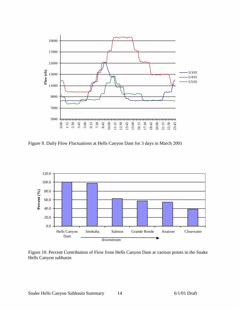
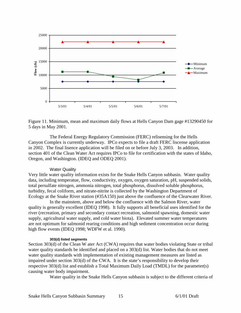
Water releases through Hells Canyon Dam cause the Snake to flucuate dramatically each daydue to the effects of power peaking (Figure 9, Figure 10, Figure 11) (USGS 2001). These effectsare most pronounced above the confluence with the Salmon River (Kern 1976). Above theSalmon River, these fluctuations cause severe enough disturbances to vegetation to prevent theestablishment of more than early successional plants within the zone of fluctuations. The flow ofthe Salmon River moderates the impacts of the flow enough to allow more complex vegetativecommunities below the confluence (Kern 1976).
Snake Hells Canyon Subbasin Summary 6/1/01 Draft14
5000
7000
9000
11000
13000
15000
17000
19000
0:00
1:15
2:30
3:45
5:00
6:15
7:30
8:45
10:0
0
11:1
512
:30
13:4
5
15:0
0
16:1
5
17:3
0
18:4
5
20:0
0
21:1
522
:30
23:4
5
Flow
(cfs
)
5/3/015/4/015/5/01
Figure 9. Daily Flow Fluctuations at Hells Canyon Dam for 3 days in March 2001
0.0
20.0
40.0
60.0
80.0
100.0
120.0
Hells CanyonDam
Imnhaha Salmon Grande Ronde Anatone Clearwater
Perc
ent (
%)
downstream
Figure 10. Percent Contribution of Flow from Hells Canyon Dam at various points in the SnakeHells Canyon subbasin
Snake Hells Canyon Subbasin Summary 6/1/01 Draft15
0
5000
10000
15000
20000
25000
5/3/01 5/4/01 5/5/01 5/6/01 5/7/01
Flow
(cfs
)
MinimumAverageMaximum
Figure 11. Minimum, mean and maximum daily flows at Hells Canyon Dam gage #13290450 for5 days in May 2001.
The Federal Energy Regulatory Commission (FERC) relisensing for the HellsCanyon Complex is currently underway. IPCo expects to file a draft FERC liscense applicationin 2002. The final lisence application will be filed on or before July 3, 2003. In addition,section 401 of the Clean Water Act requires IPCo to file for certification with the states of Idaho,Oregon, and Washington. (IDEQ and ODEQ 2001).
Water QualityVery little water quality information exists for the Snake Hells Canyon subbasin. Water qualitydata, including temperatue, flow, conductivity, oxygen, oxygen saturation, pH, suspended solids,total persulfate nitrogen, ammonia nitrogen, total phosphorus, dissolved soluble phosphorus,turbidity, fecal coliform, and nitrate-nitrite is collected by the Washington Department ofEcology at the Snake River station (#35A150) just above the confluence of the Clearwater River.
In the mainstem, above and below the confluence with the Salmon River, waterquality is generally excellent (IDEQ 1998). It fully supports all beneficial uses identified for theriver (recreation, primary and secondary contact recreation, salmonid spawning, domestic watersupply, agricultural water supply, and cold water biota). Elevated summer water temperaturesare not optimum for salmonid rearing conditions and high sediment concentration occur duringhigh flow events (IDEQ 1998; WDFW et al. 1990).
303(d) listed segmentsSection 303(d) of the Clean W ater Act (CWA) requires that water bodies violating State or tribalwater quality standards be identified and placed on a 303(d) list. Water bodies that do not meetwater quality standards with implementation of existing management measures are listed asimpaired under section 303(d) of the CWA. It is the state’s responsibility to develop theirrespective 303(d) list and establish a Total Maximum Daily Load (TMDL) for the parameter(s)causing water body impairment.
Water quality in the Snake Hells Canyon subbasin is subject to the different criteria of
Snake Hells Canyon Subbasin Summary 6/1/01 Draft16
three states (Table 1). Idaho, Washington and Oregon each use different methodologies todetermine what constitutes a water quality violation. In the reach between Oregon and Idaho, theriver must meet the criteria of both states due to the water mixing at the state line in the middleof the river (IDEQ and ODEQ 2001).
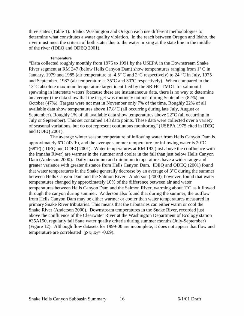
Temperature“Data collected roughly monthly from 1975 to 1991 by the USEPA in the Downstream SnakeRiver segment at RM 247 (below Hells Canyon Dam) show temperatures ranging from 1° C inJanuary, 1979 and 1985 (air temperature at -4.5° C and 2°C respectively) to 24 °C in July, 1975and September, 1987 (air temperature at 35°C and 30°C respectively). When compared to the13°C absolute maximum temperature target identified by the SR-HC TMDL for salmonidspawning in interstate waters (because these are instantaneous data, there is no way to determinean average) the data show that the target was routinely not met during September (82%) andOctober (47%). Targets were not met in November only 7% of the time. Roughly 22% of allavailable data show temperatures above 17.8°C (all occurring during late July, August orSeptember). Roughly 1% of all available data show temperatures above 22°C (all occurring inJuly or September). This set contained 148 data points. These data were collected over a varietyof seasonal variations, but do not represent continuous monitoring” (USEPA 1975 cited in IDEQand ODEQ 2001).
The average winter season temperature of inflowing water from Hells Canyon Dam isapproximately 6°C (43°F), and the average summer temperature for inflowing water is 20°C(68°F) (IDEQ and ODEQ 2001). Water temperatures at RM 192 (just above the confluence withthe Imnaha River) are warmer in the summer and cooler in the fall than just below Hells CanyonDam (Anderson 2000). Daily maximum and minimum temperatures have a wider range andgreater variance with greater distance from Hells Canyon Dam. IDEQ and ODEQ (2001) foundthat water temperatures in the Snake generally decrease by an average of 3°C during the summerbetween Hells Canyon Dam and the Salmon River. Anderson (2000), however, found that watertemperatures changed by approximately 10% of the difference between air and watertemperatures between Hells Canyon Dam and the Salmon River, warming about 1°C as it flowedthrough the canyon during summer. Anderson also found that during the summer, the outflowfrom Hells Canyon Dam may be either warmer or cooler than water temperatures measured inprimary Snake River tributaries. This means that the tributaries can either warm or cool theSnake River (Anderson 2000). Downstream temperatures in the Snake River, recorded justabove the confluence of the Clearwater River at the Washington Department of Ecology station#35A150, regularly fail State water quality criteria during summer months (July-September)(Figure 12). Although flow datasets for 1999-00 are incomplete, it does not appear that flow andtemperature are correleated (ρ x1,x2= -0.09).

Snake Hells Canyon Subbasin Summary 6/1/01 Draft17
Table 1. 303d listed stream segments Snake Hells Canyon subbasinListingState Segment 303d listed
parameters Designated beneficial uses
IdahoSnake River-Hells Canyon Damdownstream to confluence withClearwater River
not listedcold water biota salmonid spawningprimary contact recreation domesticwater supply
Idaho Divide Creek SedimentIdaho Wolf Creek SedimentIdaho Getta Creek SedimentIdaho Cottonwood Creek Sediment
Idaho Deep CreekMetalsSedimentpH
Idaho Tammany Creek Sediment
OregonSnake River-Hells Canyon Damdownstream to WashingtonBorder
mercury,temperature
public/private domestic water supplyindustrial water supply irrigationalwater, livestock watering salmonidrearing and spawning resident fish andaquatic life watercontact recreationwildlife and hunting fishing, boating,aesthetics anadromous fish passagecommertial navigation and transport
WashingtonSnake River- confluence withClearwater River to one mileupstream
temperature
water supply (domestic, industrial,agricultural) stock watering fish andshellfish wildlife habitatrecreationcommerce and navigation

Snake Hells Canyon Subbasin Summary 6/1/01 Draft18
0
5
10
15
20
25
30
10/5
/92
2/5/
93
6/5/
93
10/5
/93
2/5/
94
6/5/
94
10/5
/94
2/5/
95
6/5/
95
10/5
/95
2/5/
96
6/5/
96
10/5
/96
2/5/
97
6/5/
97
10/5
/97
2/5/
98
6/5/
98
10/5
/98
2/5/
99
6/5/
99
10/5
/99
2/5/
00
6/5/
00
Date
Figure 12. Stream temperatures recorded at Washington Department of Ecology site #35A150 onthe mainstem Snake River above the confluence of the Clearwater River (1992-1999)
SedimentThe Snake River below Hells Canyon Dam is sediment-deficient due to the operation of theHells Canyon Hydroelectric Dam Complex, and would benefit from added sediment (USDAForest Service 1999). The three upriver dams trap suspended sediment and bedload, whilefluctuating water levels increase rates of streambank erosion. The entrapment of sediments hasretarded recruitment and/or development of new sand bars and silt deposits, which providesubstrate for riparian growth (Kern 1976).
Total Disolved Gas (TDG)The Snake River is not currently listed as limited by TDG in Oregon or Idaho, although IDEQand ODEQ (2001) recommends listing for the 2002 303(d) list for both Oregon and Idaho. BothOregon and Idaho have a TDG criterion of 110% TDG. Idaho Power Company has beenmonitoring TDG below Hells Canyon Dam and has found that at all spill levels the criterion wasexceeded from below Hells Canyon Dam to at least RM 180 (IPCo, 1999b). A declining trend inTDG occurred with distance from the dam, and t a direct relationship exists between distance tocompliance with the criterion and the amount of spill (IDEQ and ODEQ 2001).
MercuryThe State of Oregon lists the upper half of the Snake River (above the Salmon River confluence)as water quality limited due to mercury contaminants, which may pose threats to humans throughfish consumption (IDEQ and ODEQ 2001). Only one sample has been collected within thereach, and that sample only included two fish tissue samples. All other samples used were fromsites upstream of Hells Canyon Dam. The major source of mercury is assumed to originate fromBrownlee Reservoir and upstream tributary flows (IDEQ and ODEQ 2001). The one data point
= exceeds State water quality criteria

Snake Hells Canyon Subbasin Summary 6/1/01 Draft19
available shows mercury levels at 0.15 mg/kg dry weight fish tissue, which is below the levelused by the Oregon Division of Health to establish a mercury fish tissue advisory (IDEQ andODEQ 2001).
Point Sources of Water PollutionNo known point sources of water pollution exist between Hells Canyon Dam and the SalmonRiver (IDEQ and ODEQ 2001).
VegetationThe flora of the Snake Hells Canyon subbasin is exceptionally diverse (Figure 13). This reflectsthe complex topography, varied soil conditions, and the dispersal corridors provided by theSnake and Salmon rivers. The area is home to many rare and endemic species of plants(Mancuso and Moseley 1994). The canyon grasslands of the subbasin are particularlydistinctive. Canyon grasslands are rare within the Columbia Basin and despite years ofdisturbance the Hells Canyon grasslands are among the most intact in terms of its nativegrassland species component (USDA Forest Service 1999).
The vast majority of canyon grassland communities are representative of the bluebunchwheatgrass (Agropyron spicatum) habitat type series (Tisdale 1986). The healthiest bluebunchwheatgrass communities in the subbasin are found in steep areas with limited livestockaccessibility and water availability. In these areas, the vegetation is characterized by widelyspaced clumps of bunchgrass with coverage values usually between 15 and 25 %. Areas of rockand bare ground are common, often with a coverage of more than 50%. Native grassland forbsusually make up less than 20% of the coverage in the community. Common native forbs includearrowleaf balsamroot (Balsamorhiza sagittata), desert parsleys (Lomatium spp.), lupines(Lupinus spp.), Snake River phlox (Phlox colubrina), harsh paintbrush (Castiileja hispida),deerhom (Clarkia pulchella), tall annual willowweed (Epilobium paniculatum), cleavers (Galiumaparine), prickly-pear cactus (Opuntia polyacantha) , and narrow-leaved skullcap (Scutellaria.angustifolia). Except for scattered gray rabbitbrush (Chrysothumnus numeosus) plants, shrubsare very uncommon or absent. Sand dropseed and red three-awn (Aristida longiseta) havebecome disclimax species on some river benches, bars, and toeslope areas. Bluebunchwheatgrass communities are particularly susceptible to invasion by yellowstar thistle (Centaureasolstitialis) the most problematic and widespread noxious weed species in the Snake HellsCanyon subbasin. In severely infested areas, yellowstar thistle coverage has been documented atmore than 50%. In these areas native vegetation was almost non-existant (Mancuso and Moseley1994).
At slightly higher elevations or on mesic aspects, Idaho fescue (Festuca idahoensis)usually dominates grasslands. Idaho fescue grassland sites appear less susceptible to invasion byyellow starthistle than blue bunchgrass communites, but are commonly invaded by sulphurcinquefoil (Potentilla recta) and other noxious weeds. Grasslands on mesic aspects, in canyondraws and at higher elevation are often interspersed with shrubfields. Common shrub speciesinclude ninebark (Physocarpus malvaceus), snowberry (Symphoricarpus albus), rose (Rosaspp.), oceanspray (Hokniiscus discolor)and hackberry (Celtic reticulata) (Mancuso and Moseley1994).

Snake Hells Canyon Subbasin Summary 6/1/01 Draft20
Figure 13. Current land cover patterns in the Snake Hells Canyon subbasin

Snake Hells Canyon Subbasin Summary 6/1/01 Draft21
Other common canyon native grasses that are sometimes community dominants in the subbasininclude Sandberg’s bluegrass (Poa sandbergii), prairie Junegrass (Koeleria cristata), sanddropseed (Sporobolus cryptandrus), and red threeawn (Aristida longiseta). Introducedcheatgrass (Bromus tectorum) and Kentucky bluegrass (Poa pratensis) are also very common,particularly on disturbed sites (Mancuso and Moseley 1994).
Between 2,000 and 4,800 feet coniferous tree species begin to occur in the subbasin;at lower elevations these trees occur on northern aspects and in draws. Ponderosa pine (Pinusponderosa) is the community dominant at lower elevations. As conditions become more mesicDouglas-fir (Pseudotsuga menziesii), lodgepole pine (Pinus contorta), Englemann spruce (Piceaenglemannii) and grand fir (Abies grandis) increase in prominence. Sub-alpine fir (Abieslasiocarpa) occurs in the wettest and coldest portions on the subbasin (Mancuso and Moseley1994). There is no true alpine timberline in the Snake Hells Canyon subbasin; subalpine-fir andwhite bark pine (Pinus albicaulis) krummholz grow on even the highest of the Seven DevilsMountains (Bingham 1987).
Riparian vegetation along the Snake River is often sparse or nonexistent and isprimarily associated with the areas immediately adjacent to the mean high water zone (IDEQ1998). Common vegetative species in this area include Hackberry (Celtis reticula), willow,cudweed sage, sawatch knotweed, poison ivy (Rhus radicans) and mockorange (Philadelphialewisii). The grass community is predominantly annual bromes (Bromus spp.) sedges (Carexspp.), bluebunch wheatgrass, (Agropyron spiciatum) and Idaho fescue (Festuca idahoensis)(USDA Forest Service 1999). Steep gradient tributary streams often have narrow riparian zonesthat typically vary from 25 feet to 200 feet and are confined by steep side slopes. The lowerelevation riparian areas are dominated by white alder, river alder, water birch, black cottonwood,Rocky Mountain maple, serviceberry, mockorange, elderberry, dogwood, and oceanspray. Athigher elevations Douglas fir, grand fir, Engelmann spruce, subalpine fir, and willows are morecommon in the riparian areas. Low gradient streams with meadows commonly have rushes,sedges, willows, and alders. These meandering streams are very sensitive to overuse bylivestock. Overgrazing, can convert riparian vegetation to shallow rooted species such asKentucky bluegrass; and reduce palatable shrub species such as willow.
Larger tributaries, with year-round flow, support white alder (Alnus rhombifolia)cottonwood (Populus trichocarpa) and scattered ponderosa pine (Pinus ponderosa) (Mancusoand Moseley 1994). Riparian communities in the subbasin have been heavily impacted byaggressive nonnative species including bur chervil (Anthriscus scandecina), teasel (Dipsacussylvestris), black locust (Robinia pseudo-acacia), box elder (Acer negundo) and European corn-salad. (Valerianella locusta) (USDA Forest Service 1999).
The subbasin supports a number of rare plant species. MacFarlane’s four-o’clock isthe only plant species listed under the Endangered Species Act known to occur in the subbasin.Spalding’Catchfly has recently been proposed for listing and has been documented to occur justoutside the subbasin boundaries, as of yet undetected populations may occur within the subbasin(USDA Forest Service1999). Eight species of Palouse and/or Camas Prairie regional endemicshave identified as occurring as occurring in the subbasin; green-band mariposa lily, broad-fruitmariposa lily, Idaho hawksbeard, Palouse goldenweed, spacious monkeyflower, Spalding silene,purple thick-leaved thelypody and plumed clover (USDA Forest Service 1999). Two rarespecies found in the subbasin are disjunct from their main population centers. Fern-leaved desert-parsley is disjunct from the eastern base of the Cascades, and Wolf’s currant from the southernRockies (Mancuso and Mosely 1994).

Snake Hells Canyon Subbasin Summary 6/1/01 Draft22
Land UseThe majority of the Snake Hells Canyon subbasin is publicly owned, with nearly half under U.S.Forest Service management (Figure 14). Three National Forests manage land in the subbasinincluding Wallowa-Whitman, Payette and Nez Perce. Wallowa-Whitman National Forestmanages the greatest acreage of any management agency in the basin having jurisdiction over46.6% of the subbasin and 96.5% of the Forest Service lands (Table 2). Ranching and grazing,recreation, timber harvest, transportation, mining, urban development, and agriculture areprimary land uses considered to potentially affect, or historically have affected, terrestrial andaquatic resources in the subbasin (Figure 15).
Ranching and GrazingThe horses of the Nez Perce Indians were the first domestic livestock grazed within the SnakeHells Canyon subbasin; this land use is thought to have occurred as early as 1730. When theNez Perce War ended, around 1879, Euro-American settlers began grazing large livestock herds,primarily in the valley bottoms and lower slope areas. By 1900 more than 100 families wereraising livestock along the Snake River between Battle Creek and the confluence with theImnaha River. This period is considered the peak of livestock grazing by homesteaders in thearea. The remoteness of the area made obtaining supplies and getting animals to market difficultand when livestock prices declined many of the 160-acre homesteads reverted to federalownership or were purchased and consolidated into larger livestock operations.
The preference for raising cows or sheep has changed a number of times. At first,cattle predominated, but large losses were incurred during the drought and bitter cold years of1884-1886 and many ranchers began to try sheep. Cattle-to-sheep ratios were 80 to 20 percent in1915. During World War I and II the grazing of sheep in the subbasin again increased due togovernment encouragement to increase the supply of wool for uniforms and meat for the troops.In 1940, cattle to sheep ratios on the HCRNA were 30 to 70 percent. Due to the potential fordomestic sheep to spread fatal bacterial pneumonia to bighorn sheep, domestic sheep grazingwas eliminated on the Oregon portion of HRCNA on August 2, 1995 (USDA Forest Service1999). Grazing by domestic sheep continues on the Idaho portion of the HCRNA and onprivately owned rangelands.
Overgrazing has negatively impacted both terrestrial and aquatic habitat in thesubbasin. Livestock grazing has aided the establishment of cheatgrass and other non-nativevegetation species, reduced the quanity and quality of riparian vegetation, and increased erosionand stream bank failures. Most of this damage occurred in the late 1800s and early 1900s.Sheep and cattle allotments on the Snake and Imnaha portions of the HRNCA peaked in 1920with approximately 108,000 animal unit months (AUMs). This was reduced to 38,260 AUMSpermitted on the same approximate area in 1998 (USDA Forest Service 1999). Livestockgrazing continues to be one of the main land uses at Craig Mountain and throughout privatelyowned lands in the subbasin. Recently, strategies have been implemented to reduce negativeimpacts of grazing in the subbasin, including rotation of pastures, riparian fencing, and overallreduction of livestock numbers. Since the mid-1900s and especially in the past 20 yearslivestock grazing impacts have been significantly reduced (USDA Forest Service 1999).

Snake Hells Canyon Subbasin Summary 6/1/01 Draft23
Figure 14. Land ownership in the Snake Hells Canyon subbasin

Snake Hells Canyon Subbasin Summary 6/1/01 Draft24
Figure 15. Land use patterns in the Snake Hells Canyon subbasin

Snake Hells Canyon Subbasin Summary 6/1/01 Draft25
Table 2. Land management agencies of the Snake Hells Canyon subbasin.
Land Management Agency Acres Percent of totalsubbasin area
Bureau Of Land Management 21052 3.56Dept Of Defense 64 0.01
Nez Perce 532 0.09Payette 9547 1.61Wallowa Whitman 275326 46.55Forest Service
Total Forest Service 285405 48.25Private 249672 42.21
Idaho 28695 4.85Oregon 111 0.02Washington 3632 0.61State
Total State 32439 5.48Tribal Land 35 0.01Water 2852 0.48
RecreationThe Hells Canyon area of the Middle-Snake subbasin is a world-renowned recreationaldestination in large part due to the unique whitewater rafting opportunities it presents. Otherrecreation opportunities provided by the subbasin include hiking, horseback riding, camping,sightseeing, mountain biking, limited all terrain vehicle riding, snowmobiling, swiming,powerboating, photography, wildlife watching, hunting and fishing (USDA Forest Service 1999).The Snake River portion of the HCRNA received an average of 32,415 visitors per year between1995-1997. Sight seeing was the primary reason for visits to the HCRNA (30%) followed byfishing (12%) (USDA Forest Service 1999). Recreational activities peak in the summer seasonwith heavy usage observed between Memorial Day weekend and Labor Day weekend.Recreational use of the subbasin is expected to increase, mirroring increases in nearbypopulations and the population of the country as a whole (USDA Forest Service 1999; IDEQ andODEQ 2001).
Snowmobiling is a substantial use within the HCRNA. The total area on the HCRNAdedicated to motorized over-snow use is approximately 40,786 acres, which is 6.25 percent ofthe total land base. There are approximately 132 miles of groomed trails.
Timber HarvestTimber harvest on the Forest Service managed lands in the subbasin has been relatively limited.The designation of the HCRNA in 1975 legally prevented even aged timber harvest, includingclearcutting or seed tree harvests. Regulations adopted in 1994 restricted the commercial harvestof timber on the HCNRA to that which will enhance ecosystem health, wildlife habitat, orrecreational and scenic uses, reduce the risk of harm posed by hazard tress, or to respond tonatural events, including fire, flood, earthquake, volcanic eruption, high winds and disease orinsect infestation. In addition to these restrictions forest openings created by logging must beless than 2 acres in size. No timber harvest is permitted on the wilderness portion of theHCRNA (USDA Forest Service 1999).
Timber harvest before the 1975 HCRNA designation has impacted the ecosystem tosome degree. Ponderosa pine forests, western larch forests, and large trees have declined in partdue to historic timber harvest. There has been a corresponding increase in mid-seral stands of

Snake Hells Canyon Subbasin Summary 6/1/01 Draft26
Douglas-fir and grand/white fir, however the changes in forest structure exhibited on theHCRNA are thought to be less severe than those in other parts of the subbasin and throughoutthe Columbia Basin (USDA Forest Service 1999).
Many of the privately owned forested lands in the subbasin have been harvested. Theextent and impact of this harvest has been studied on the Craig Mountain area. Prior to itspurchase by BPA in 1992, the Peter T. Johnson Wildlife Mitigation Unit was owned by the PeneLand Company and heavily logged in around 1986: “most of the valuable and larger trees wereremoved, leaving predominantly smaller, submerchantible, diseased, lower-value, and shade-tolerant species such as grand fir. Because of these past logging activities, poletimber standscomprised mainly of lodgepole pine can be found over much of the upland plateau within theWMU. The mid-1980’s entry also affected the understory plant community, encouraging shade-tolerant grand fir regeneration along with assorted brush species, native grasses, and somenoxious weeds” (Narowlski 1996). Selective harvest has resulted in the loss of the ponderosapine-dominated, open, park-like forest that probably historically characterized Craig mountainand many of the forested lands in the subbasin (Mancuso and Mosely 1994).
Forest management activities taking place after the establishment of the Idaho ForestPractices Act (FPA) have had a lesser impact on fish habitat. The principal concerns with currentand past forest management activities are increased sediment from roads, loss of riparian shade,and loss of riparian trees that provide for large woody debris recruitment to stream channels.Carefully designed, constructed and maintained roads minimize sediment input to streams. Inaddition, locating roads outside of riparian areas helps maintain stream shade. The FPA containsa number of rules on roads and stream shading related to the concerns above.
TransportationThe only state highway within the subbasin is Highway 129, located in Asotin County,connecting Clarkston, Washington and Enterprise, Oregon. Traffic volume in 1999 betweenAsotin and Clarkston was 5600 vehicles per day at Critchville Rd. However, this quickly dropsto 640 vehicles per day at Fairgrounds Rd. on the south end of Asotin city limits (WSDOT2000).
No rail service has ever been available in the subbasin (K. Frederickson, WashingtonState Department of Transportation, Rail Office, personal communication, May, 2001; T. Long,Idaho Department of Transportation, Lewiston Office, personal communication, May, 2001),although the Camas Prairie Line follows the north shore of the Snake River in Washington intoClarkston and Lewiston where it continues along the south shore of the Clearwater River. Eventhough the Camas Prairie Line is not located within the subbasin and is not heavily used, it doesprovide transportation of goods, especially dryland crops, out of the area (K. Frederickson,Washington State Department of Transportation, Rail Office, personal communication, May,2001).
There are 735 miles of existing forest service roads on the HCNRA, of which 533 arecurrently open to travel. 50 percent have natural surfaces, 4 percent have improved pit run, 12percent have a crushed rock surface, 6 percent have been surface treated and less than 1 % havean asphalt concrete surface. The highest road density areas in the HCRNA fall outside the SnakeHells Canyon subbasin.
About 88 percent of the HCNRA is accessible by trail. An extensive trail systemfeatures 925 miles of trail, with approximately 361 miles of trail occurring within the HellsCanyon wilderness. Trail use in higher elevation areas is limited to summer, while most lowerelevation trails are used year round. Trails on the HCRNA evolved from Indian travel routes, big
Snake Hells Canyon Subbasin Summary 6/1/01 Draft27
game migration routes, and later, for access for grazing, mining and fire control. Because trailsblazed by early users were not constructed for current patterns and levels of use, erosion affectssome trails on steep grades.
Areas with low road density are associated with special management designation suchas the Hells Canyon Wilderness Area, Hells Canyon National Recreation Area, and areas withoutextensive historic logging activity. Road density ranges from 0 miles to over 5 miles of road persquare mile for the various subwatersheds (IDEQ 1998).
MiningIn the 1860s gold was discovered on the river bars of the Snake Hells Canyon subbasin, whichled to European settlement of the region. Placer mining for these deposits turned out to berelatively unsuccessful, but hundreds of rock piles still dot the river corridor as evidence of theattempt (USDA Forest Service 1999). Some of these tailings still pose a sedimentation problemduring peak flows (Mancuso and Moseley 1994). Later efforts focused on hard rock mining.Minerals excavated from the subbasin include gold, silver, copper, iron, and lead (Figure 16).Historic mining operations were widespread, but currently only sand, gravel and stone areexcavated from the subbasin. These operations occur in the lower subbasin within 20 linearmiles of Lewiston.
AgricultureCultivated land comprises 41, 639 acres, or 7%, of the subbasin with small grain crops in thelower twenty miles of the subbasin composing the vast majority of the regions agriculture (referto Figure 15). Small grains are grown on a three-year dryland crop rotation of wheat, barley anda legume, oil, or fallow crop; therefore, each crop in the rotation comprises about one third of theacreage. Soft white, hard red spring and hard red winter are the three classes of wheat. Bothfeed and malt barley are grown.
The legumes and oilseed crops are evenly divided into approximately 1/6th of the totalrotation each. More variety in crops is found traveling from west to east as precipitationincreases. The fallow rotation is only found on the western edge of the subbasin where a lack ofadequate moisture prevents continuous cultivation. Legume crops include peas, lentils, andgarbanzo beans with the latter of the two being the most common crops. Oilseed crops includemustard, flax, spring and winter rape seed, and spring and winter canola seed with the latterbeing the most prevalent. Traditionally, most of the legume-oilseed rotation was planted inlegumes; however, poor prices for these crops has caused a shift towards more oilseedproduction, which is now equal to and will soon overtake legumes (S. O’Connell, ColumbiaGrain Growers, personal communication, May, 2001).
As the fertilizer costs increase, associated with the higher price for natural gas,farmers are applying commercial fertilizers with much more scrutiny. This has led to an increasein malt barley production, which has a lower protein content, requiring less nitrogen than feedbarley. There is also a trend toward reduced tillage practices for the benefit of both soilconservation as well as savings in labor, time, and wear on equipment (L. Smith, University ofIdaho Cooperative Extension, Nez Perce County, personal communication, May, 2001).
In the upper subbasin agriculture activity is associated with small hay fields in thecanyons located on bars and benches to larger hay fields located in the upland prairie, meadows,or plateau areas. Large dryland farming occurs north of the Salmon River (Camas Prairie) and inthe lower portion of the Snake Hells Canyon subbasin on the upland plateau areas (refer toFigure 15).

Snake Hells Canyon Subbasin Summary 6/1/01 Draft28
Urban DevelopmentPopulations in all five of the counties partially contained in the Snake Hells Canyon subbasinincreased between 1990 and 2000 (Table 3). This population increase is reflected both in moreresidents inhabiting the lower subbasin towns of Asotin, Lewiston and Clarkston and greaterrecreational pressure from the residents of neighboring communities. In the upper half of thesubbasin, some residential housing with septic systems exists, but the density is very low (IDEQand ODEQ 2001).
Table 3. Changes in population in counties partially contained by the Snake Hells Canyonsubbasin 1990-2000 (U.S. Census Bureau 2000).
Change 1990-2000County Population 1990 Census Population 2000 Census
Number Percent
Asotin 17,605 20,551 2,946 16.7Idaho 13,783 15,511 1,728 12.5Nez Perce 33,754 37,410 3,656 10.8Adams 3,254 3,476 222 6.8Wallowa 6,911 7,226 315 4.6

Snake Hells Canyon Subbasin Summary 6/1/01 Draft29
...........................................................................................................................................................
Figure 16. Historical and current mining areas in the Snake Hells Canyon subbasin

Snake Hells Canyon Subbasin Summary 6/1/01 Draft30
Diversions, Impoundments, and Irrigation ProjectsIdaho Power operates the Hells Canyon Dam Complex (Hells Canyon, Oxbow, and BrownleeDams). This complex has significant hydrologic effects downstream. There are numerous smallwater rights (less than .02 cfs) used for irrigation, livestock, and domestic use. The USFS and BLMare currently filing on many springs and creeks in accord with Snake River Adjudication protocols.
BarriersAlthough the original Federal Energy Regulatory Commission license for Hells Canyon Damincluded fish passage, no fish passage was ever built. Hells Canyon Dam blocks all fish passage outof the subbasin. No man-made barriers are known to occur on tributaries to the Mid-Snake River.
Natural barriers to salmonid migration, such as low flows or high gradients, have beenidentified on many of the small tributaries that drain into the Snake River on the Idaho side.Specifically, in the lower portion of the subbasin, natural barriers (falls) occur on Captain JohnCreek (RM 5.8), and the South Fork of Captain John Creek (RM 1.7) (BLM 2000b). Low flowbarriers have been documented on Madden Creek, a tributary to Captain John Creek, and aresuspected to occur at the mouth of Corral Creek when Snake River flows are low (BLM 2000b). Inthe upper portion of the subbasin (above the Salmon River confluence) natural barriers have beenidentified in Dry Creek, Wolf Creek (≈0.75 mi. upstream from the confluence with the SnakeRiver), Getta Creek (during periods of low flow), and Highrange Creek (steep gradient and lowflows) (BLM 2000a).
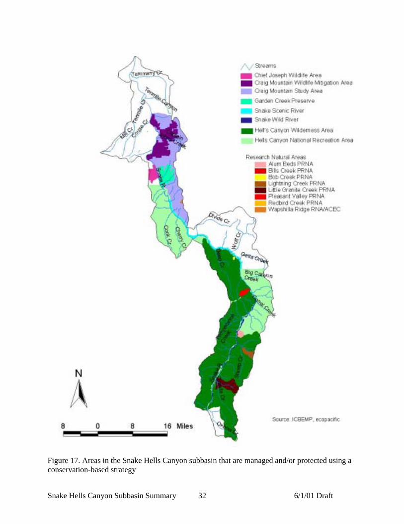
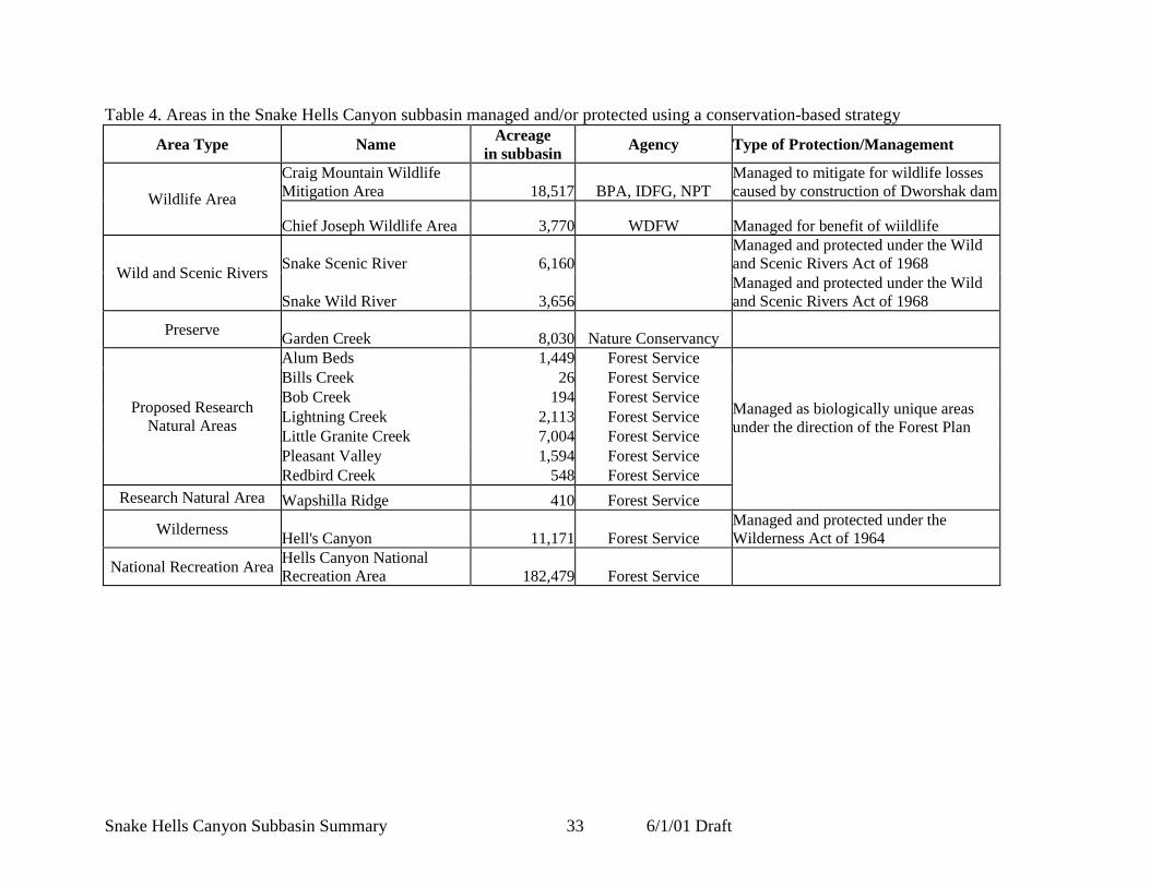
Protected AreasMuch of the Snake Hells Canyon subbasin is protected by some kind of management designation(Figure 17; Table 4).
Hells Canyon National Recreation AreaEstablished in 1975, Hells Canyon National Recreation Area (HCNRA) encompasses 652,488acres, of which 194,132 acres are designated as wilderness and 33,000 are privately owned(Wallowa-Whitman 1996) (Figure 17; Table 4). HRNCA is administered as part of the Wallowa-Whitman National Forest.
Wild and Scenic Snake RiverApproximately 67.5 miles of the Snake River in Hells Canyon National Recreation Area weredesignated in 1975 as a component of the National Wild and Scenic Rivers System. In this reach theriver is managed to preserve its free-flowing character and unique environment while providing forcontinued public use (USDA Forest Service 2001).
The 31.5-mile section of the river between Hells Canyon Dam and Upper PittsburgLanding is designated wild under the Wild and Scenic Rivers Act. This act defines wild as "freeof impoundments and generally accessible only by trail" representing "vestiges of primitiveAmerica." The 36-mile section of river downstream from Upper Pittsburg Landing to mile 180.2is designated scenic, which is defined as "free of impoundments with shorelines and watershedstill largely primitive, and shorelines largely undeveloped, but accessible in places by roads." Anadditional 4.2 miles of the river from mile 180.2 North to the HCNRA boundary at the Oregon-Washington line is recommended for scenic designation (USDA Forest Service 2001).The Wild and Scenic Snake River corridor extends approximately one-quarter mile back fromthe high water mark on each shore. The river corridor itself is not wilderness and wildernessregulations do not apply (USDA Forest Service 2001)..

Snake Hells Canyon Subbasin Summary 6/1/01 Draft31
Craig MountainThe Craig Mountain study area is approximately 125,000 acres in size. The study area itself is notlegally protected but has been inventoried because of its many rare plant and animal inhabitants.The area has multiple managers including the Nez Perce tribe, the Bureau of Land Management,Idaho Department of Lands, the Nature Conservancy, and private. The Craig Mountain study areacontains the 60,000-acre Craig Mountain Wildlife Mitigation Area purchased by the BonnevillePower Administration (BPA) in 1992 as partial mitigation for wildlife habitat losses resulting fromthe construction of Dworshak dam on the Clearwater river. The Nez Perce Tribe, Idaho Departmentof Fish and Game, and BPA agreed to provide for the protection and enhancement of wildlifehabitat through management of the area (Cassier 1995). The pileated woodpecker, yellow warbler,black-capped chickadee, river otter, elk, and white-tailed deer, are species that have been identifiedas having been negatively affected by the construction of Dworshak dam in the Clearwater andthese species are given special management attention on the Craig Mountain Wildlife MitigationArea (Cassirer 1995).
Chief Joseph Wildlife AreaThe Chief Joseph Wildlife Area is 9,735 acres in size and is located in Asotin County Washington.Elevations range from 825 feet to 4,913 feet at Mt. Wilson, the highest point in the vicinity. Thearea is comprised primarily of Bluebunch wheatgrass grasslands with riparian woodlandssurrounding streams and springs. The area provides important elk, mule deer, bighorn sheep, gamebird and non-game habitat (WDFW 2001).
Research Natural AreasResearch natural areas are natural ecosystems that provide benchmarks for comparison with areasinfluenced by humans. These areas provide research areas for ecological studies and preserve genepools for threatened and endangered plants and animals. Seven areas are proposed for designationas Research Natural Areas in the Snake Hells Canyon subbasin. These areas were selected torepresent particular plant associations, geological formations, or other needs outlined in state naturalheritage plans. According to the Forest Plan”Proposed RNAs will be protected from uses whichwould reduce their suitability for RNA designation. Since their designation no logging has occurredin the proposed RNAs. Once officially established, an RNA management plan will be written andintegrated into the Forest Plan (USDA Forest Service 1999).
Snake Hells Canyon Subbasin Summary 6/1/01 Draft32
Figure 17. Areas in the Snake Hells Canyon subbasin that are managed and/or protected using aconservation-based strategy
Snake Hells Canyon Subbasin Summary 6/1/01 Draft33
Table 4. Areas in the Snake Hells Canyon subbasin managed and/or protected using a conservation-based strategy
Area Type Name Acreagein subbasin Agency Type of Protection/Management
Craig Mountain WildlifeMitigation Area 18,517 BPA, IDFG, NPT
Managed to mitigate for wildlife lossescaused by construction of Dworshak damWildlife Area
Chief Joseph Wildlife Area 3,770 WDFW Managed for benefit of wiildlife
Snake Scenic River 6,160Managed and protected under the Wildand Scenic Rivers Act of 1968Wild and Scenic Rivers
Snake Wild River 3,656Managed and protected under the Wildand Scenic Rivers Act of 1968
Preserve Garden Creek 8,030 Nature ConservancyAlum Beds 1,449 Forest ServiceBills Creek 26 Forest ServiceBob Creek 194 Forest ServiceLightning Creek 2,113 Forest ServiceLittle Granite Creek 7,004 Forest ServicePleasant Valley 1,594 Forest Service
Proposed ResearchNatural Areas
Redbird Creek 548 Forest ServiceResearch Natural Area Wapshilla Ridge 410 Forest Service
Managed as biologically unique areasunder the direction of the Forest Plan
Wilderness Hell's Canyon 11,171 Forest ServiceManaged and protected under theWilderness Act of 1964
National Recreation Area Hells Canyon NationalRecreation Area 182,479 Forest Service
Snake Hells Canyon Subbasin Summary 6/1/01 Draft34
Fish and Wildlife Resources
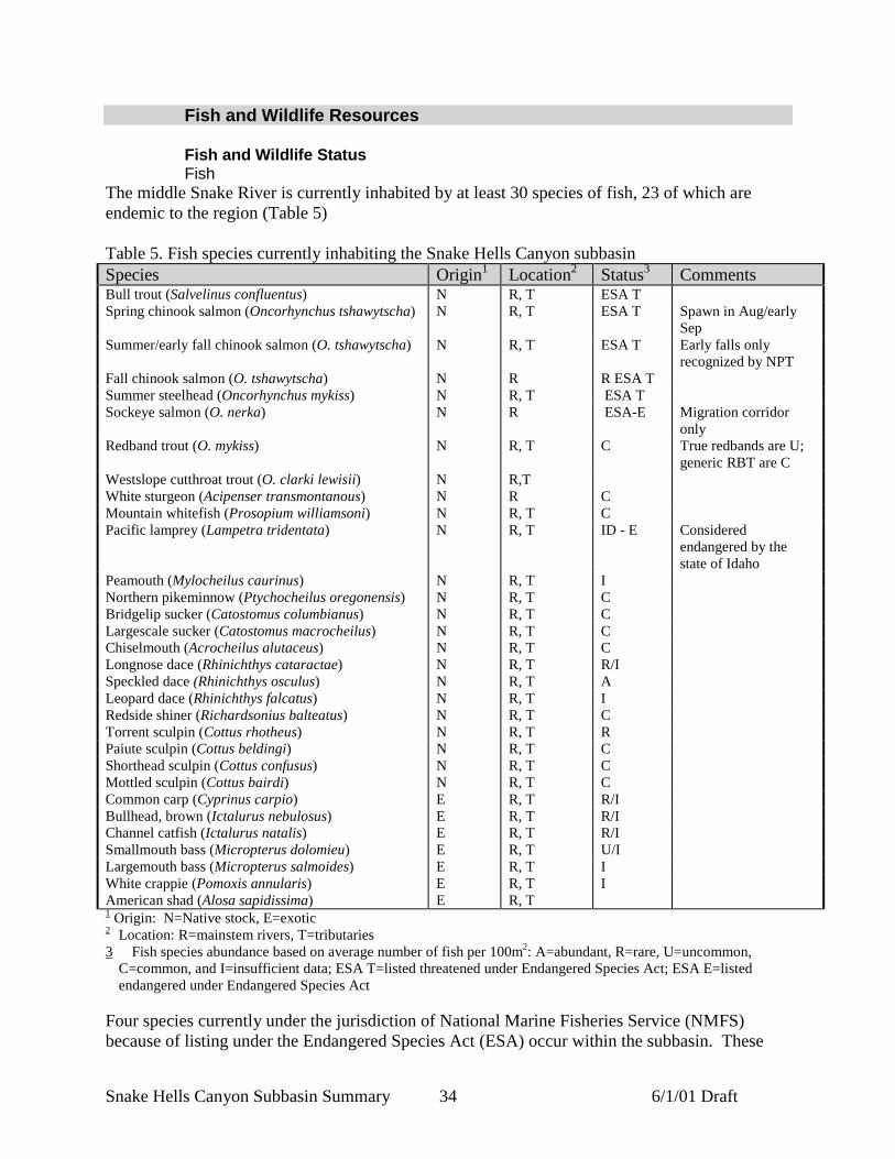
Fish and Wildlife StatusFish
The middle Snake River is currently inhabited by at least 30 species of fish, 23 of which areendemic to the region (Table 5)
Table 5. Fish species currently inhabiting the Snake Hells Canyon subbasinSpecies Origin1 Location2 Status3 CommentsBull trout (Salvelinus confluentus) N R, T ESA TSpring chinook salmon (Oncorhynchus tshawytscha) N R, T ESA T Spawn in Aug/early
SepSummer/early fall chinook salmon (O. tshawytscha) N R, T ESA T Early falls only
recognized by NPTFall chinook salmon (O. tshawytscha) N R R ESA TSummer steelhead (Oncorhynchus mykiss) N R, T ESA TSockeye salmon (O. nerka) N R ESA-E Migration corridor
onlyRedband trout (O. mykiss) N R, T C True redbands are U;
generic RBT are CWestslope cutthroat trout (O. clarki lewisii) N R,TWhite sturgeon (Acipenser transmontanous) N R CMountain whitefish (Prosopium williamsoni) N R, T CPacific lamprey (Lampetra tridentata) N R, T ID - E Considered
endangered by thestate of Idaho
Peamouth (Mylocheilus caurinus) N R, T INorthern pikeminnow (Ptychocheilus oregonensis) N R, T CBridgelip sucker (Catostomus columbianus) N R, T CLargescale sucker (Catostomus macrocheilus) N R, T CChiselmouth (Acrocheilus alutaceus) N R, T CLongnose dace (Rhinichthys cataractae) N R, T R/ISpeckled dace (Rhinichthys osculus) N R, T ALeopard dace (Rhinichthys falcatus) N R, T IRedside shiner (Richardsonius balteatus) N R, T CTorrent sculpin (Cottus rhotheus) N R, T RPaiute sculpin (Cottus beldingi) N R, T CShorthead sculpin (Cottus confusus) N R, T CMottled sculpin (Cottus bairdi) N R, T CCommon carp (Cyprinus carpio) E R, T R/IBullhead, brown (Ictalurus nebulosus) E R, T R/IChannel catfish (Ictalurus natalis) E R, T R/ISmallmouth bass (Micropterus dolomieu) E R, T U/ILargemouth bass (Micropterus salmoides) E R, T IWhite crappie (Pomoxis annularis) E R, T IAmerican shad (Alosa sapidissima) E R, T1 Origin: N=Native stock, E=exotic2 Location: R=mainstem rivers, T=tributaries3 Fish species abundance based on average number of fish per 100m2: A=abundant, R=rare, U=uncommon,
C=common, and I=insufficient data; ESA T=listed threatened under Endangered Species Act; ESA E=listedendangered under Endangered Species Act
Four species currently under the jurisdiction of National Marine Fisheries Service (NMFS)because of listing under the Endangered Species Act (ESA) occur within the subbasin. These

Snake Hells Canyon Subbasin Summary 6/1/01 Draft35
species include Snake River fall chinook salmon and spring/summer chinook salmon, listed asthreatened on May 22, 1992 (Federal Register, Vol. 57, 14653), Snake River sockeye salmon,listed as endangered on November 20, 1991 (Federal Register, Vol. 56, 58619), and Snake Riversummer steelhead, listed as threatened on October 17, 1997 (Federal Register, August 18, 1997,Vol. 62, 43937). Bull trout, under the jurisdiction of the U. S. Fish and Wildlife Service(USFWS) was also listed under the ESA on July 10, 1998 (Federal Register, June 10, 1998, Vol.63, 31647). Sensitive species occurring in the subbasin, as defined by the Bureau of LandManagement, include redband trout, white sturgeon, westslope cutthroat trout, and Pacificlamprey (BLM 2000a).
A variety of key fish species use the Snake Hells Canyon subbasin during variousstages of their lives (Table 6 and Table 7). Not included in the table are sockeye salmon, aspecies that uses the mainstem Snake River (below the confluence with the Salmon River) onlyduring downstream and upstream migration.
Table 6. General life history stages of listed key salmonid species occurring in the Snake HellsCanyon subbasin (from BLM 2000a; IDEQ and ODEQ 2001)
Life HistoryStage
Fall ChinookSalmon1
Spring/SummerChinook Salmon
SteelheadTrout
BullTrout
Adult Migration August-October April-July September-May August-SeptemberSpawning September 15 to
April 15August 1 to July 15 February 1 - July 15 September 1 - April 1
Adult/Sub- AdultRearing
N/A N/A N/A Year-long
AdultOverwintering
N/A N/A November-March Winter
Incubation andEmergence
October-April August-April March-July September-March
Rearing Young-of-Year:May-August
1 Year:Tributary Streams
1-3 Years 2-3 Years
Smolt Emigration June-August April-July April-July N/A1/ Occur in mainstem Snake River only.
Table 7. Salmonid life history stages and their general occurrence in the Snake Hells Canyonsubbasin (from BLM 2000a; M. Hanson, ODFW, personal communication, April 19th, 2001)Species Life history OccurrenceFall chinook Spawning/rearing Mainstem SnakeSpring/summer chinook Spawning/rearing Accessible tributaries (i.e. Granite and Sheep Creeks)Spring/summer chinook Rearing (limited) Mainstem SnakeSummer steelhead Spawning/rearing Accessible tributariesBull trout Rearing (subadult and
adult)Mainstem Snake
Bull trout Overwintering Mainstem SnakeBull trout Spawning/early
rearingAccessible tributaries (i.e. Granite and Sheep creeks)
Westslope cutthroat trout(resident forms)
Spawning/rearing Granite and Sheep Creeks
White sturgeon Spawning/rearing Mainstem Snake
Snake Hells Canyon Subbasin Summary 6/1/01 Draft36
Fall Chinook SalmonThroughout the early 1900’s, Snake River fall chinook salmon remained stable at high levels ofabundance (NMFS 2000a). Although historical abundance of Snake River fall chinook isspeculative, adult escapement estimates suggest a decline in abundance by as many as threeorders of magnitude since the 1940’s, and perhaps by another order of magnitude from pristinelevels (NMFS 2000a). During the period 1938-1949 wild runs of Snake River fall chinookaveraged 72,000 fish. During the 1950’s runs averaged 29,000 fish (Irving and Bjornn 1981).Construction of the Hells Canyon Complex (1958-1967) and the Lower Snake River Dams(1961-1975) eliminated or severely degraded 530 miles of spawning habitat. Currently, fallchinook spawn from Asotin to Hells Canyon Dam and in the tail races below the four SnakeRiver dams, and in the lower Clearwater, Grande Ronde, Imnaha, and Tucannon Rivers.
Fall chinook populations in the Snake Hells Canyon subbasin are currentlyconsidered to be depressed (Quigley and Arbelbide 1997b) but are showing considerableimprovement following restoration efforts. Returning wild fall chinook salmon counts from1975 through 1980 averaged 600 fish per year (Waples et al. 1991). Counts of wild adult fallchinook past Lower Granite Dam from 1981 to 1999 averaged 904 fish per year (Figure 18).
Snake River fall chinook were historically distributed from the mouth of the SnakeRiver to a natural barrier at Shoshone Falls, Idaho, River Mile 615 (Haas 1965). Swan FallsDam was the first impoundment to inundate spawning and rearing habitat in 1901, eliminating385 miles of habitat in the upper river (Tiffan et al. 1999). Following construction of Swan FallsDam, most spawning occurred in the 30-mile reach from the dam to Marsing, Idaho. From thelate 1950’s through the mid-1970’s, the development and completion of the Snake Riverhydrosystem reduced available fall chinook spawning and rearing areas in the free-flowing riverreach to 99.4 miles (from Lower Granite Dam at RM 148 to Hells Canyon Dam at RM 247(Figure 19) (Tiffan et al. 1999).
Snake River fall chinook salmon mostly exhibit an “ocean-type” (Healey 1991) lifehistory, and unlike other anadromous fish in the Mid-Snake maintain a full reliance uponmainstem habitat during all freshwater stages. Fry emerge in the spring, grow rapidly andmigrate out of the Snake River primarily during July and August as subyearlings (Connor et al.in press). The timing of fall chinook salmon life history events and growth are regulated by watertemperature (Connor et al. In review), thus the Snake River ESU of fall chinook salmon can bedivided into four tributary races based on life history timing differences fostered by watertemperature. The four races, in order of fry emergence timing are the upper reach Snake River,lower reach Snake River, lower Grande Ronde River and lower Clearwater River (W.P. Connor,US Fish and Wildlife Service, personal communication, April 2001). The mainstem run up toHells Canyon Dam consists of hatchery-reared stock, natural fish (fish born to hatchery-rearedparents that spawned in the wild), and wild fish (Blankenship and Mendel 1997).
Fall chinook salmon spawning in the Snake Hells Canyon subbasin primarily occursin mid-November, but may occur in late October and early December (Rondorf and Miller 1993;1994; 1995). Groves and Chandler (1999) determined that redd depths for Snake River fallchinook salmon ranged between 0.2 – 6.5 m., mean water column velocity ranged from 1.3 – 6.8feet/second, and substrate-level water velocity ranged from 0.3 – 6.6 feet/second. Substrate sizesused for spawning ranged between 1.0 – 5.9 inches (Groves and Chandler 1999). Spawning wasdetermined to initiate when water temperatures dropped below 16.0° C, and terminated whentemperatures approached 5.0°C.
Post-emergence rearing life history forms are most commonly associated with littoralhabitat (BLM 2000a), which is generally characterized by sandy substrate (Tiffan et al. 1999).

Snake Hells Canyon Subbasin Summary 6/1/01 Draft37
Mid-Snake juveniles grow rapidly. Peak numbers of subyearling fall chinook were beach-seinedduring April in the Hanford Reach (Columbia River), in May in McNary Reservoir (ColumbiaRiver), and in June in the Middle Snake River (Rondorf and Miller 1995). Results show thatMiddle Snake River subyearling chinook salmon attained a larger size more quickly thanColumbia River subyearlings (Rondorf and Miller 1995).
0
200
400
600
800
1000
1200
1975 1977 1979 1981 1983 1985 1987 1989 1991 1993 1995 1997 1999Year
Figure 18. Adult returns of wild fall chinook salmon past Lower Granite Dam (1975-1999)(BLM 2000a).
Snake River fall chinook salmon initiate a protracted downstream migration in thelate spring (June) and early summer (July) as subyearlings (2.7-3.9 inches in length) (Rondorfand Miller 1993). Late emigration of hatchery fish to Lower Granite Dam may be affected by anumber of factors including fall chinook salmon size at time of release, river flow, and watertemperature at time of release (Rondorf and Miller 1993; 1994; 1995). Late emigration timing isdetrimental to production since smolt survival to Lower Granite Dam decreases as summer flowdecreases, summer water temperature increases and passage date at the dam increases (Connor etal. 1998, Connor 1999). Studies have shown that outmigrating fall chinook juveniles are capableof moving substantial distances during the day as well as at night, swimming actively only at lowwater velocities and rarely drifting passively (Rondorf and Miller 1993; 1994; 1995). Duringtheir migration, subyearlings have a biological requirement for food in the juvenile migrationcorridor/rearing area. Prey resources in reservoirs differ from those in free-flowing reaches (e.g.,terrestrial insects and zooplankton predominate in reservoirs versus aquatic insects in the free-flowing river).

Snake Hells Canyon Subbasin Summary 6/1/01 Draft38
Figure 19. Fall chinook distribution in the Snake Hells Canyon subbasin

Snake Hells Canyon Subbasin Summary 6/1/01 Draft39
The majority of fall chinook redds constructed between 1996 and 1999 upriver ofLower Granite Dam occurred in the mainstem Snake (Garcia 2000) (Table 8). Results from 1994and 1995 redd count surveys indicate that the majority of spawning had shifted downstream tosites above the Grand Ronde River, as compared to counts made from 1988-1993 (Rondorf andTiffan 1997). Mainstem redds counted in 1999 accounted for 64% of the total, compared to 61%in 1998, 31% in 1997, and 55% in 1996 (Table 8). Redd counts in 1999 were the highestrecorded since annual searches began in 1986 (Garcia 2000). The increase in returns between1998-2000 may be attributable to supplemental releases of juvenile fish in previous years (G.Mendel, personal communication, May, 2001).
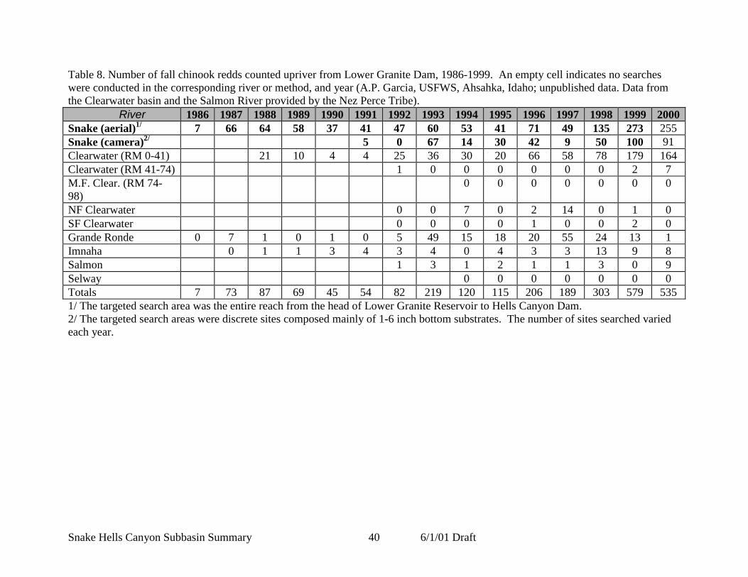
Snake Hells Canyon Subbasin Summary 6/1/01 Draft40
Table 8. Number of fall chinook redds counted upriver from Lower Granite Dam, 1986-1999. An empty cell indicates no searcheswere conducted in the corresponding river or method, and year (A.P. Garcia, USFWS, Ahsahka, Idaho; unpublished data. Data fromthe Clearwater basin and the Salmon River provided by the Nez Perce Tribe).
River 1986 1987 1988 1989 1990 1991 1992 1993 1994 1995 1996 1997 1998 1999 2000Snake (aerial)1/ 7 66 64 58 37 41 47 60 53 41 71 49 135 273 255Snake (camera)2/ 5 0 67 14 30 42 9 50 100 91Clearwater (RM 0-41) 21 10 4 4 25 36 30 20 66 58 78 179 164Clearwater (RM 41-74) 1 0 0 0 0 0 0 2 7M.F. Clear. (RM 74-98)
0 0 0 0 0 0 0
NF Clearwater 0 0 7 0 2 14 0 1 0SF Clearwater 0 0 0 0 1 0 0 2 0Grande Ronde 0 7 1 0 1 0 5 49 15 18 20 55 24 13 1Imnaha 0 1 1 3 4 3 4 0 4 3 3 13 9 8Salmon 1 3 1 2 1 1 3 0 9Selway 0 0 0 0 0 0 0Totals 7 73 87 69 45 54 82 219 120 115 206 189 303 579 5351/ The targeted search area was the entire reach from the head of Lower Granite Reservoir to Hells Canyon Dam.2/ The targeted search areas were discrete sites composed mainly of 1-6 inch bottom substrates. The number of sites searched variedeach year.
Snake Hells Canyon Subbasin Summary 6/1/01 Draft41
Spring Chinook SalmonHistorically, Snake River spring and summer chinook spawned in virtually all accessible andsuitable habitat in the Snake River system (Fulton 1968). A substantial proportion of ColumbiaBasin spring/summer chinook were estimated to have originated in the Snake River Basin in thelate 1800’s, with total production probably exceeding 1.5 million in some years (NMFS 2000a).By the mid-1900’s however, the abundance of adult spring/summer chinook salmon had declinedconsiderably. Fulton (1968) estimated that an average of 125,000 adults per year entered theSnake River tributaries from 1950 through 1960. Adult counts at dams show that this value hascontinued to decline since the 1960’s.Currently, the number of naturally spawning spring/summer chinook salmon in the Snake HellsCanyon subbasin are at all time lows, with an overall downward trend (
Figure 20). Most chinook salmon stocks in the remaining accessible habitat areseverely depressed and at risk (BLM 2000a; 2000b).
Stream-type chinook were historically widely distributed, occupying an estimated46% of the Columbia River basin, and occurring as far up the Snake River as Shoshone Falls(RM 615) (Haas 1965). Current distribution of spawning and rearing populations of native fishhas been reduced to 0.2% of the historical range and 0.8% of the historical range respectively(Figure 21) (BLM 2000b).
Below the confluence with the Salmon River, Asotin Creek is the only tributarystream used by chinook salmon for spawning, while a limited amount of rearing may occur inlower reaches of some of the larger tributaries (i.e. Captain John Creek) (BLM 2000b; WDFW etal. 1990). Above the Salmon confluence, Granite and Sheep creeks are the only tributaries usedfor spawning, albeit very minimally (BLM 2000a). Limited juvenile rearing may occur in lowertributaries when stream conditions are suitable.
The highly variable life histories of stream-type chinook allow the species to adapt toa wide range of environmental conditions. Adult spring chinook salmon destined for the SnakeRiver and its tributaries enter the Columbia River in early spring, pass Bonneville Dam fromMarch through May and reach the Snake River by late April (BLM 2000b). They arrive atstaging areas from late May to early July, and spawn from August to mid-September (IDFG1992 cited in BLM 2000b). Spawning adults are typically ages four to five (spending 2-3 yearsin the ocean), although may return to the subbasin as three to six year-olds. Fry emerge fromFebruary to April, rear through the summer in the natal stream, and then migrate downstreaminto the mainstem or larger tributary (i.e. Captain John or Asotin Creek) where they willoverwinter. Spring chinook outmigrate as age 1+ juveniles, passing Lower Granite Dam fromlate April through June.

Snake Hells Canyon Subbasin Summary 6/1/01 Draft42
0
5000
10000
15000
20000
25000
30000
35000
40000
45000
1975 1977 1979 1981 1983 1985 1987 1989 1991 1993 1995 1997 1999Year
Figure 20. Adult returns of wild spring/summer chinook past Lower Granite Dam (1975-1999)(BLM 2000a; 2000b).
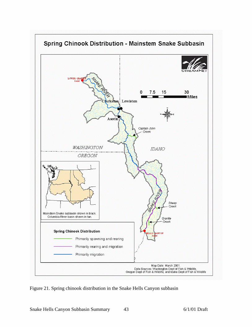
Snake Hells Canyon Subbasin Summary 6/1/01 Draft43
Figure 21. Spring chinook distribution in the Snake Hells Canyon subbasin

Snake Hells Canyon Subbasin Summary 6/1/01 Draft44
Sockeye SalmonHistoric runs of anadromous sockeye adults at the mouth of the Columbia River may havenumbered more than two million before the turn of the century. The number of Snake Riversockeye adults returning to Redfish Lake in the upper Salmon subbasin has ranged from zero toeight fish since 1990 (Figure 22). An intensive, captive brood-stock program has been initiated toconserve the remaining population.
The Snake Hells Canyon subbasin provides a migratory corridor for adult andjuvenile sockeye salmon during July-August and April-June, respectively (Figure 23). Thisportion of the subbasin is designated critical habitat for fish en route to the upper Salmonsubbasin (refer to Huntington et al. in press).
0
100
200
300
400
500
600
1975 1977 1979 1981 1983 1985 1987 1989 1991 1993 1995 1997 1999Year
Figure 22. Numbers of Snake River sockeye passing Lower Granite Dam (1975-1999)
Steelhead TroutSteelhead occurring in the Snake Hells Canyon subbasin are typical A-run steelhead from themid-Columbia and Snake basins. Most adults (60%) return from the ocean after one year ofmarine rearing (ODFW 2001). Two-salt and occasionally three-salt fish comprise the remainderof returns to the Snake. Females generally predominate with a 60/40 sex ratio on average(ODFW 2001). Returning adults range in size from 45 to 91 cm in length, and average 1.4 to 6.8kg.
Adults generally enter the Columbia river from May through August, and enter theirnatal streams from September through April (ODFW 2001). Adults utilize accessible andsuitable habitat throughout the subbasin for spawning. Spawning is initiated in March in lowerelevation habitat and continues through early June in higher elevation, snowmelt-dominatedhabitat.
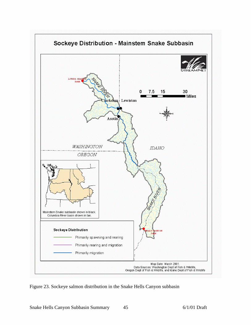
Snake Hells Canyon Subbasin Summary 6/1/01 Draft45
Figure 23. Sockeye salmon distribution in the Snake Hells Canyon subbasin

Snake Hells Canyon Subbasin Summary 6/1/01 Draft46
Most naturally produced smolts migrate after rearing for two years (ODFW 2001). Amuch lower percentage migrates after one or three years. Smolt out-migration from the basinsextends from late winter until late spring. Peak smolt movement is associated with increases inflow, generally occurring between mid-April and mid-May.
Juveniles utilize a wide array of habitats throughout the Middle Snake, and aregenerally ubiquitous where other salmonids occur including areas adjacent to hatchery smoltrelease locations (ODFW 2001). Areas below the Salmon River confluence (excluding theClearwater River, Grande Ronde River, and Imnaha River) containing spawning and rearingsteelhead include Asotin Creek, Ten Mile Creek, Couse Creek, Captain John Creek, Jim Creek,and Cook Creek (Figure 24) (BLM 2000b). Asotin Creek, Captain John Creek, Ten Mile Creekand Couse Creek are considered to have the highest potential production by the CottonwoodBureau of Land Management (BLM 2000b). Other tributaries (below the Salmon confluence)with limited use (often rearing only) include Tammany Creek, Tenmile Creek, Corral Creek,Cache Creek, Cottonwood Creek, and Cherry Creek (BLM 2000b).
In Idaho, some of the larger tributaries above the Salmon River confluence withknown spawning and rearing populations of summer steelhead include Divide Creek, WolfCreek, Getta Creek, Kirkwood Creek, Sheep Creek, and Granite Creek (refer to Figure 2) (BLM2000a). Granite Creek and Sheep Creek are considered to be priority watersheds by theCottonwood Bureau of Land Management (BLM 2000b). Larger tributaries utilized forspawning and rearing in Oregon include Somers Creek, Temperence Creek and Saddle Creek.Other Idaho and Oregon tributaries used by steelhead include (Idaho) Dry Creek, HighrangeCreek, Big Canyon Creek, West Creek, Kurry Creek, Klopton Creek, Corral Creek, Kirby Creek,Kirkwood Creek, Sheep Creek, Bernard Creek, Three Creek, Granite Creek, Deep Creek,(Oregon) Deep Creek, Cougar Creek, Salt Creek, Sand Creek, Rush Creek, Sluice Creek, BattleCreek, Stud Creek, and Hells Canyon Creek.
Steelhead harvest in the Snake Hells Canyon subbasin has been restricted to hatcheryfish only since 1979 (ODFW 2001). It is not anticipated that consumptive fisheries for wildsteelhead will be reinstated in the foreseeable future (ODFW 2001). Adult hatchery steelheadreturns of fish produced from the LSRCP and IPC hatchery programs have allowed harvestopportunities beginning in 1986. Oregon punch card estimates of hatchery fish harvest rangedfrom 1,116 to 2,444 fish for the 1991-92 through 1993-94 fishing seasons. Angler effort hastended to follow the availability of hatchery fish with effort being high in high return years andlow in low return years (ODFW 2001).

Snake Hells Canyon Subbasin Summary 6/1/01 Draft47
Figure 24. Steelhead distribution within the Snake Hells Canyon subbasin
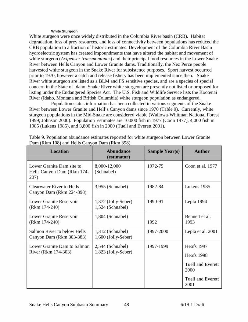
Snake Hells Canyon Subbasin Summary 48 6/1/01 Draft
White SturgeonWhite sturgeon were once widely distributed in the Columbia River basin (CRB). Habitatdegradation, loss of prey resources, and loss of connectivity between populations has reduced theCRB population to a fraction of historic estimates. Development of the Columbia River Basinhydroelectric system has created impoundments that have altered the habitat and movement ofwhite sturgeon (Acipenser transmontanus) and their principal food resources in the Lower SnakeRiver between Hells Canyon and Lower Granite dams. Traditionally, the Nez Perce peopleharvested white sturgeon in the Snake River for subsistence purposes. Sport harvest occurredprior to 1970, however a catch and release fishery has been implemented since then. SnakeRiver white sturgeon are listed as a BLM and FS sensitive species, and are a species of specialconcern in the State of Idaho. Snake River white sturgeon are presently not listed or proposed forlisting under the Endangered Species Act. The U.S. Fish and Wildlife Service lists the KootenaiRiver (Idaho, Montana and British Columbia) white sturgeon population as endangered.
Population status information has been collected in various segments of the SnakeRiver between Lower Granite and Hell’s Canyon dams since 1970 (Table 9). Currently, whitesturgeon populations in the Mid-Snake are considered viable (Wallowa-Whitman National Forest1999; Johnson 2000). Population estimates are 10,000 fish in 1977 (Coon 1977), 4,000 fish in1985 (Lukens 1985), and 3,800 fish in 2000 (Tuell and Everett 2001).
Table 9. Population abundance estimates reported for white sturgeon between Lower GraniteDam (Rkm 108) and Hells Canyon Dam (Rkm 398).
Location Abundance(estimator)
Sample Year(s) Author
Lower Granite Dam site toHells Canyon Dam (Rkm 174-207)
8,000-12,000(Schnabel)
1972-75 Coon et al. 1977
Clearwater River to HellsCanyon Dam (Rkm 224-398)
3,955 (Schnabel) 1982-84 Lukens 1985
Lower Granite Reservoir(Rkm 174-240)
1,372 (Jolly-Seber)1,524 (Schnabel)
1990-91 Lepla 1994
Lower Granite Reservoir(Rkm 174-240)
1,804 (Schnabel)1992
Bennett el al.1993
Salmon River to below HellsCanyon Dam (Rkm 303-383)
1,312 (Schnabel)1,600 (Jolly-Seber)
1997-2000 Lepla et al. 2001
Lower Granite Dam to SalmonRiver (Rkm 174-303)
2,544 (Schnabel)1,823 (Jolly-Seber)
1997-1999 Heofs 1997
Heofs 1998
Tuell and Everett2000
Tuell and Everett2001

Snake Hells Canyon Subbasin Summary 49 6/1/01 Draft
In 1972-75, 86 percent and in 1982-84, 80 percent of the population was comprised ofwhite sturgeon less than 92 cm. In addition, the proportion of white sturgeon between 92 and183 cm, which were heavily harvested until 1970, comprised 4 and 18 percent of the populationssampled in the 1970’s and 1980’s, respectively (Figure 25; Coon Et. al 1977; Lukens 1985). Incontrast, of the white sturgeon collected during 1997-99, only 57 percent were less than 92 cm,while 30 percent ranged between 92 and 183 cm. (Tuell and Everett 2001).

Snake Hells Canyon Subbasin Summary 50 6/1/01 Draft
0
5
10
15
20
25
30
1972-75
86% 4% 10%
92 cm 183 cm
0
5
10
15
20
25
30
1982-8492 cm 183 cm
80% 18% 2%
0
5
10
15
20
25
30
0 25 50 75 100 125 150 175 200 225 250 275 300
Total Length (cm)
1997-9992 cm 183 cm
57%30% 13%
Figure 25. The length (total length) frequency distributions of sturgeon sampled from the HellsCanyon reaches of the Snake River, 1997-99 (Tuell and Everett 2001) 1982-84 (Lukens 1985),and 1972-75 (Coon et al. 1977) and the percent of the populations < 92 cm, between 92 and 183cm, and >183 cm

Snake Hells Canyon Subbasin Summary 51 6/1/01 Draft
The following information is summarized from the ICRB Aquatic Component Report(Quigley and Arbelbide 1997). The white sturgeon becomes sexually mature at 10 to 15 yearsand spawning intervals may be 4 to 11 years. The fish spawns during May and June in rockybottoms near rapids and lays up to two million eggs. A fish at one year is 9 inches in length; 5years is 20 inches in length; 15 years is 40 inches in length (15 to 20 pounds); and 25 to 60 yearsis 6 to 9 feet in length. Females grow faster than males, particularly in weight after 14 years. TheIdaho record for a white sturgeon is 1,500 pounds, caught on a set line in the Snake River in1898. The rod and reel record is 394 pounds, caught in the Snake River in 1956.
The white sturgeon is a bottom feeder and feeds on most anything, dead or alive.Young feed largely on larval forms of aquatic insects, crustaceans, and mollusk. Fish form a highpercentage of the diet of larger sturgeon. The sturgeon spends a large percentage of time in deeppools with poor light. “Sturgeon holes” may often range from 30 to 100 feet in depth. Becauseof poor light conditions the sturgeon utilizes four barbels on the snout for touching and smelling.
Substrate size and water velocity influence selection of spawning areas by whitesturgeon. Spawning generally occurs in water over 3 meters in depth and over cobble substrate.In the Columbia River system, reproduction has been greater during years of high f lowscompared with years of low flow (Hanson et al. 1992). Adults and juveniles prefer deep-poolhabitat with a fine bottom substrate. Adults tend to move downstream in the summer and fallmonths and upstream in the winter and spring months. Fish tend to stay in shallower waterduring the spring and summer and move to deeper waters during the winter.
White sturgeon are only found in the mainstem Snake River. The Hells Canyon reachalong the Oregon-Idaho border contains the highest densities of Snake River white sturgeon(BLM 2000b). Key habitats are generally associated with the deep holes occurring betweenHells Canyon and Lower Granite Dams. Relative distribution of fish from Lower Granite tomouth of Salmon River is shown in Figure 26 (Tuell and Everett 2001).

Snake Hells Canyon Subbasin Summary 52 6/1/01 Draft
0
5
10
15
20
25
110 115 120 125 130 135 140 145 150 155 160 165 170 175 180 185 190
River Mile
% o
f Cat
ch
1997-00
Figure 26. Relative distribution of white sturgeon between Lower Granite Dam and theconfluence of the Salmon River (1997-2000) (J. Hesse, NPT, personal communication, May,2001).
Bull TroutSeveral subpopulations of bull trout occur upstream of the reservoir influence of Lower GraniteDam, and migrants from these groups have the capability of freely moving to and from LowerGranite Reservoir. These groups include fish from Asotin Creek, Grande Ronde, Imnaha andSalmon rivers. The USFWS has found little evidence to suggest these populations use habitatassociated with the FCRPS in the Lower Snake River.
The Snake Hells Canyon subbasin occurs within the historic native range of bulltrout. However, historic abundance and trend data are scarce because bull trout were considereda nuisance fish (IDEQ 1998). Bull trout are also difficult to detect during surveys because theyhide and tend to be nocturnal. Therefore, they are often missed or underestimated duringelectrofishing and daytime snorkel surveys (IDEQ 1998). Survey and abundance measures arefurther limited by the fact that fluvial bull trout may occupy a portion of a stream for only alimited amount of time.
The lack of information regarding migratory phases of bull trout has led to themisidentification of fluvial fish as resident fish (Hemmingsen et al. 2001a). Managementimplications resulting from this confusion may underestimate the importance of maintainingmigratory habitat crucial for the connectivity between various populations. Recent efforts, in anattempt to address these management issues, are currently underway. The Oregon Department ofFish and Wildlife has initiated studies to determine the distribution of juvenile and adult bulltrout and their respective habitats, and is also studying fluvial and resident life history patterns.

Snake Hells Canyon Subbasin Summary 53 6/1/01 Draft
While results are still preliminary, ODFW has documented radio-tagged Grande Ronde fish inthe Middle Snake as far down as RM 146, just upstream from Asotin, WA (e.g. Hemmingsen etal. 2001a; Hemmingsen et al. 2001b; USFWS 2000), although documenting the extent andduration of their residence in the mainstem currently represents a research need (M. Hanson,ODFW, personal communication, April 19, 2001). In the lower reaches of the Imnaha River,large migrant sized bull trout are incidentally caught by steelhead anglers each year, and ODFWbelieves these fish are migrants that use the Snake River seasonally (B. Knox, ODFW, personalcommunication, 2000). Fluvial bull trout are occasionally captured at the Idaho Fish and Gamesmolt trap near Lewiston (Basham, in litt. 2000), but the catch rates have been no more than 1bull trout annually. Bull trout are also often caught in the steelhead fishery during the winterfrom the mouth of the Grande Ronde to Asotin (G. Mendel, WDFW, personal Communication,May, 2001).
Below the Salmon River confluence, the only known tributary providing spawningand early rearing is the Grande Ronde River and Asotin Creek in Washington (Figure 27) (BLM2000b; IDEQ 1998) (refer to Johnson et al. and Nowak et al. in press). Captain John Creek inIdaho, and Asotin Creek are considered to be medium priority watersheds since they producersof forage fish for bull trout (i.e. rainbow trout/steelhead). Other Snake River tributaries are alsoproducers of forage fish; however, production is often limited because of small size, low flows,steep gradient, and fish passage barriers (IDEQ 1998).
Above the Salmon River confluence, the only known tributaries containing spawningand rearing bull trout are Sheep Creek and Granite Creek (BLM 2000a; Buchanan et al. 1997;Clearwater Basin Technical Advisory Team 1998). Data is lacking for population size,movement, and/or life histories of bull trout utilizing this portion of the subbasin. Mediumpriority watersheds (those which are producers of forage fish for bull trout) in the subbasininclude Divide Creek, Getta Creek, and Kirkwood Creek (IDEQ 1998). Medium prioritywatersheds occurring in Oregon include Saddle Creek and Temperance Creek (IDEQ 1998).Other Snake River tributaries are also producers of forage fish; however, anadromous productionis limited because of small size, low flows, steep gradient, and fish passage barriers.
Redband TroutLittle information exists on redband trout due to the difficulty in morphologically distinguishingjuveniles from anadromous juvenile rainbow trout (steelhead). Non-anadromous rainbow troutoccurring within the Snake Hells Canyon subbasin may be divided into two groups; one groupwhich evolved in sympatry with steelhead and the other allopatric, or those which evolvedoutside the historical range of steelhead (BLM 2000b). The sympatric form, or non-anadromoussteelhead, are considered to be historically derived or associated with steelhead (BLM 2000b).The Cherry, Cook and Deep creeks all provide several miles of rainbow habitat above naturalmigratory fish barriers. Cherry, Cook and McGraw creeks are believed to contain pure strains ofredband trout (USDA Forest Service 1999).
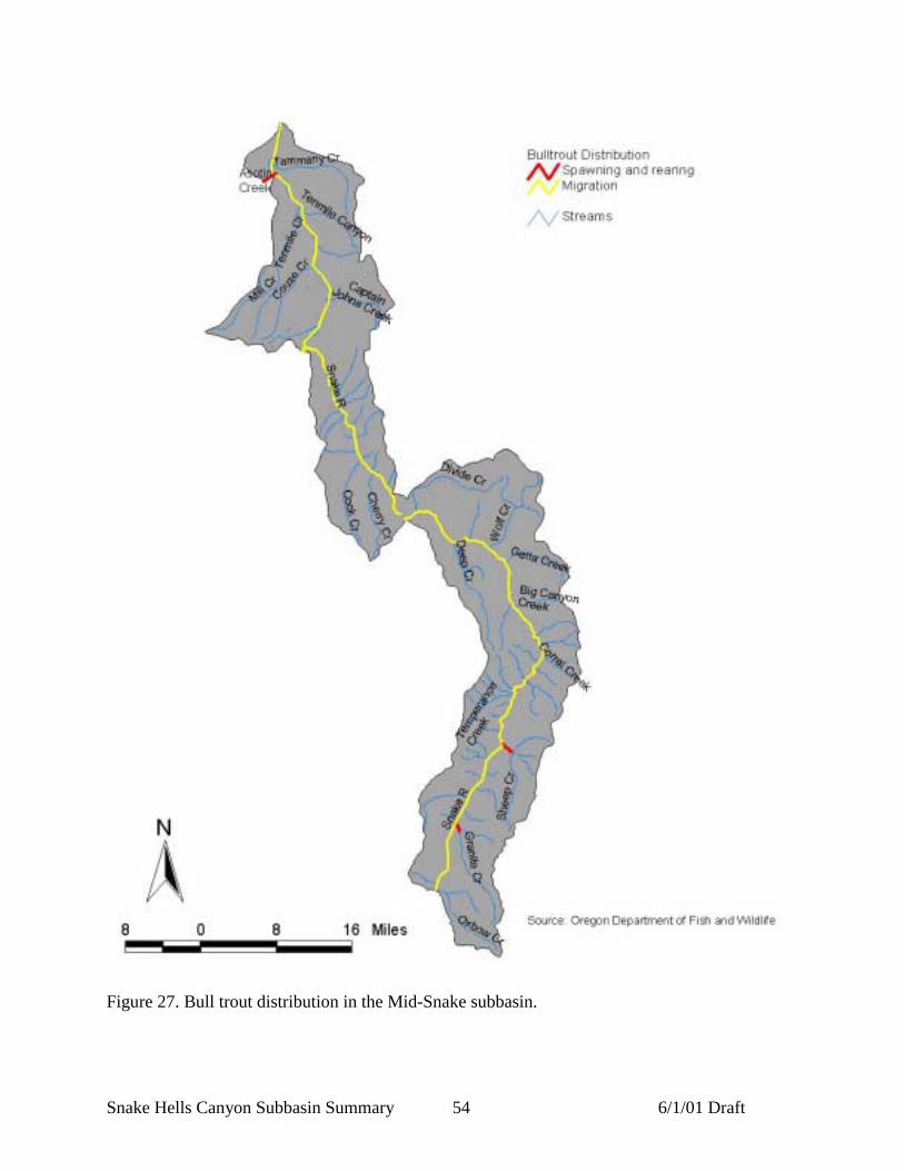
Snake Hells Canyon Subbasin Summary 54 6/1/01 Draft
Figure 27. Bull trout distribution in the Mid-Snake subbasin.

Snake Hells Canyon Subbasin Summary 55 6/1/01 Draft
Wildlife
The complex topography, varied soil conditions, and diverse vegetative communities of theSnake Hells Canyon subbasin make it an ideal home for a large number of wildlife species.A list of vertebrate species, excluding fish, that potentially occur in the area, was developed aspart of the 1995 Wildlife Inventory of Craig Mountain (Cassirer 1995). The list was compiledusing wildlife data from the BLM, The Nature Conservancy, Washington Department ofWildlife, Oregon Department of Fish and Wildlife, U. S. Forest Service (USFS) Hells CanyonNational Recreation Area, regional publications, searches of the Idaho Conservation Data Centerdatabase, Oregon Natural Heritage Program database, and University museums (Cassirer 1995).During the subbasin summary process the Craig Mountain species list was reviewed and updatedby regional biologists, additions and deletions were made to account for the fact that the Craigmountain study area does not include the entire Snake Hells Canyon subbasin and also containsareas outside of the subbasin. A total of 269 vertebrate species other than fish were thought tooccur within the Snake Hells Canyon subbasin during all or part of the year including 179 bird,66 mammal, 10 amphibian, and 14 reptile species (Appendix A).
Most of the wildlife species of the Snake Hells Canyon subbasin are thought to havehealthy and stable populations but there are many exceptions. Of the 269 non-fish vertebratespecies in the subbasin, 43 are special status species, in Idaho, Oregon, or Washington; or arelisted by the U. S. Fish and Wildlife Service, USFS and/or BLM (Table 10).
The composition of the wildlife community has been altered since the historic period.Some native species, including marten, sharptailed grouse, and white-tailed jackrabbits havebeen, or may have been extirpated from the subbasin. Wild turkey, chukar, gray partridge,european starlings, and bull frogs have been introduced to the subbasin either intentionally orunintentionally and have become well-established (Cassirer 1995).
The large number of wildlife species that occur in the Snake Hells Canyon subbasinmakes management on a species by species basis impractical. Wildlife management in thesubbasin is conducted in an ecosystem-based framework with the goal of providing a variety ofwildlife habitat conditions in all vegetative communities. Representatives from the three broadterrestrial habitat types present in the subbasin were selected as target species because of theirability to serve as indicators of ecosystem health and representatives of larger wildlife guilds.Species of special concern, managed species, and groups of species with many membersexperiencing population declines were also considered. The management focal species selectedin this document reflects those considered in the Hells Canyon National Recreation Area(HCRNA) Comprehensive Management Plan, and the Craig Mountain Wildlife Inventory(USDA Forest Service 1999, Cassirer 1995).

Snake Hells Canyon Subbasin Summary 56 6/1/01 Draft
Table 10. Listed wildlife species of the Snake Hells Canyon subbasin (WDFW ODFW .
Species IdahoState
OregonState
WashingtonState
US ForestService
BLM Federal
Accipiter gentilis Northern Goshawk SOC1-Undetermined Sensitive-Critical Canidate Sensitive Sensitive SOCAegolius funereus Boreal Owl SOC-Priority Sensitive-Undetermined N/A N/A Sensitive N/AAscaphus truei Tailed Frog N/A2 Sensitive-Vulnerable N/A N/A N/A N/ABucephala albeola Bufflehead N/A Sensitive-Undetermined N/A N/A N/A N/ABufo boreas Western Toad SOC-Undetermined Sensitive-Vulnerable N/A Sensitive Sensitive SOCBufo regalis Ferruginous Hawk N/A Sensitive-Critical Threatened N/A N/A SOCBufo swainsoni Swainson's Hawk N/A Sensitive-Vulnerable N/A N/A N/A N/AChaetura vauxi Vaux's swift N/A N/A Canidate N/A N/A N/AChrysemys picta Painted Turtle N/A Sensitive-Critical N/A N/A N/A N/AContopus borealis Olive-sided Flycatcher N/A Sensitive-Vulnerable N/A N/A N/A SOCDolichonyx oryzivorus Bobolink N/A Sensitive-Vulnerable N/A N/A N/A N/ADiadophis punctatus Ringneck Snake SOC-Undetermined N/A N/A N/A Sensitive N/ADrycopus pileatus Pileated Woodpecker N/A Sensitive-Vulnerable Canidate N/A N/A N/AEmpidonax trailii Willow flycatcher N/A N/A N/A N/A N/A SOCEuderma maculatum Spotted Bat SOC-Undetermined N/A N/A N/A Sensitive N/AFalco peregrinus anatum American Peregrine
FalconEndangered Endangered Endangered N/A N/A SOC
Glaucidium gnoma Northern Pygmy-owl SOC-Undetermined Sensitive-Critical N/A N/A N/A N/AGulo gulo Wolverine SOC-Priority Threatened Canidate Sensitive Sensitive N/AHaliaeetus leucocephalus Bald Eagle Endangered Threatened Threatened N/A N/A ThreatenedLanius ludovicianus Loggerhead Shrike SOC-Priority N/A Canidate N/A Sensitive SOCLasionycteris noctivagans Silver-haired Bat N/A Sensitive-Undetermined N/A N/A N/A N/ALepus townsendii White-tailed Jackrabbit N/A Sensitive-Undetermined N/A N/A N/A N/A
Lynx canadensis Lynx SOC-Undetermined N/A Threatened N/A Sensitive ThreatenedMartes americana American Marten N/A Sensitive-Vulnerable N/A N/A N/A N/AMelanerpes lewis Lewis' woodpecker N/A N/A Canidate N/A N/A N/AMyotis ciliolabrum Western Small-footed
MyotisN/A Sensitive-Undetermined N/A N/A Sensitive N/A
Myotis evotis Long-eared Myotis N/A Sensitive-Undetermined N/A N/A Sensitive N/A
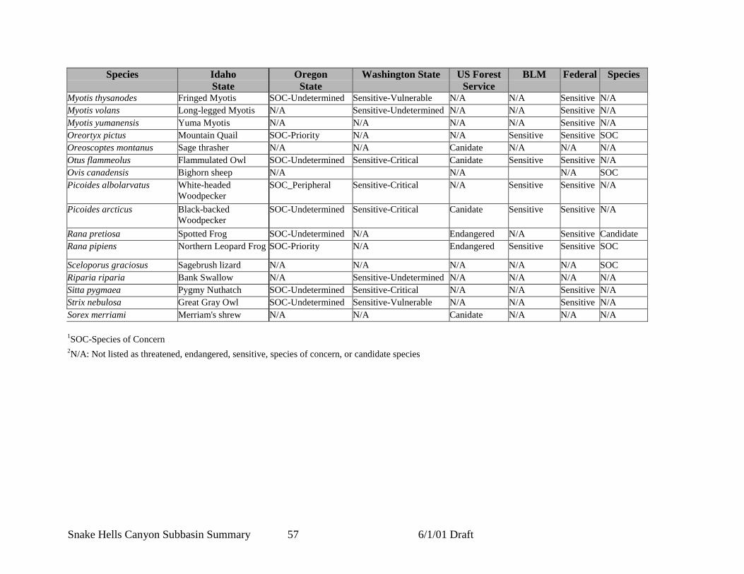
Snake Hells Canyon Subbasin Summary 57 6/1/01 Draft
Species IdahoState
OregonState
Washington State US ForestService
BLM Federal Species
Myotis thysanodes Fringed Myotis SOC-Undetermined Sensitive-Vulnerable N/A N/A Sensitive N/AMyotis volans Long-legged Myotis N/A Sensitive-Undetermined N/A N/A Sensitive N/AMyotis yumanensis Yuma Myotis N/A N/A N/A N/A Sensitive N/AOreortyx pictus Mountain Quail SOC-Priority N/A N/A Sensitive Sensitive SOCOreoscoptes montanus Sage thrasher N/A N/A Canidate N/A N/A N/AOtus flammeolus Flammulated Owl SOC-Undetermined Sensitive-Critical Canidate Sensitive Sensitive N/AOvis canadensis Bighorn sheep N/A N/A N/A SOCPicoides albolarvatus White-headed
WoodpeckerSOC_Peripheral Sensitive-Critical N/A Sensitive Sensitive N/A
Picoides arcticus Black-backedWoodpecker
SOC-Undetermined Sensitive-Critical Canidate Sensitive Sensitive N/A
Rana pretiosa Spotted Frog SOC-Undetermined N/A Endangered N/A Sensitive CandidateRana pipiens Northern Leopard Frog SOC-Priority N/A Endangered Sensitive Sensitive SOC
Sceloporus graciosus Sagebrush lizard N/A N/A N/A N/A N/A SOCRiparia riparia Bank Swallow N/A Sensitive-Undetermined N/A N/A N/A N/ASitta pygmaea Pygmy Nuthatch SOC-Undetermined Sensitive-Critical N/A N/A Sensitive N/AStrix nebulosa Great Gray Owl SOC-Undetermined Sensitive-Vulnerable N/A N/A Sensitive N/ASorex merriami Merriam's shrew N/A N/A Canidate N/A N/A N/A 1SOC-Species of Concern2N/A: Not listed as threatened, endangered, sensitive, species of concern, or candidate species
Snake Hells Canyon Subbasin Summary 58 6/1/01 Draft
Forest associated speciesBats
The Middle-Snake subbasin provides extremely important habitat for many species of bats, someof which are listed species. Townsend’s big-eared bats are year round residents of the SnakeHells Canyon subbasin which contains nursery, foraging and hibernating habitat. Populations ofTownsend’s big-eared bats are thought to be decreasing in the subbasin and across the westernUnited States; they are listed as a USFWS species of concern, and as sensitive or canidate inOregon, Washington and Idaho. One of six significant maternity colonies of Townsend’s big-eared bats documented to occur in Oregon lies entirely within the HCNRA (USDA ForestService, 1999). Recent wildlife surveys on the HCRNA and in the Craig mountain area bothdetected the species along the Snake River corridor. Townsend’s big-eared bats feed primarily onmoths, most commonly at the edge of mesic forests. However, they have been documented to usewide range of habitats including desert areas and prairies. The species is dependent on relativelycool mines, caves, or abandon buildings for raising young and hibernation (Cassirer 1995). FewTownsend’s big-eared bats maternity colony sites, hibernacula and day roosts have been locatedor identified (USDA Forest Service, 1999).
Maternity colonies of Yuma myotis and little brown myotis have been identified incaves and abandoned mines along the Snake River corridor (USDA Forest Service 1999). Bigbrown bats, silver-haired bats and fringed myotis and have been located in the timber sections ofthe subbasin (USDA Forest Service1999; Cassirer 1995). Hoary and silver-haired bats areknown to be migratory species that probably don’t winter in the subbasin (USDA ForestService1999).
Late and Old-Growth SpeciesThe northern goshawk is associated with mature and old-growth forests, particularly during thenesting season. The goshawk nests in large diameter green trees in close proximity to wateroften foraging over very large areas. Prey species important to goshawk depend on the snagsdowned logs and vegetative layering found in old growth habitat (USDA Forest Service 1999).
A number of goshawk nests are monitored on the HCRNA, some for more than 20years. Nest occur predominantly in mature mixed conifer stands, activity at the nests varies fromyear to year (USDA Forest Service 1999). Northern goshawks are occasionally observed in theupland forest on Craig Mountain during the breeding season, and likely nest in the area (Cassirer1995). A goshawk nest and adult goshawk were observed in 1992 in the deer creek drainage(IDCDC, 2001). Goshawks also use the river corridors during migration. Forest habitat withsuitable nesting and foraging qualities may be a primary factor affecting goshawk populations atCraig Mountain (Cassirer 1995). In addition to northern goshawks, there are at least 20 animalspecies that occur within the subbasin, express a definite preference for late and old growthhabitat (USDA Forest Service 1999).
Primary Cavity ExcavatorsThe pileated woodpecker, the largest woodpecker in North America is one of the most sensitiveprimary cavity nesters because of its large size (USDA Forest Service 1999). They excavatelarge cavity nests usually in dead ponderosa pine or larch trees greater than 22 in diameter at anaverage height of 45 feet (Cassirer 1995). They forage primarily on ants and beetle larvae inlogs, standing dead trees, and live trees. They forage primarily in mature grand fir forests andmaintain year-round territories. The HCNRA provides large amounts of unharvested forest
Snake Hells Canyon Subbasin Summary 59 6/1/01 Draft
much of it with high densities of snags and down wood habitat. In these areas populations ofprimary excavators are thought to be near natural population levels (USDA Forest Service 1999).
Pileated woodpeckers are widespread throughout the upland forest at Craig Mountain,at varying densities. The abundance of pileated woodpeckers on Craig Mountain may be relatedto the presence of dead, diseased, and dying standing and down trees as well as to the presence ofmature forest habitats. Management of upland forest habitats, particularly distribution andabundance of snags, mature trees, replacement snags, and woody debris will be important inaffecting pileated woodpecker and other primary excavator species population densities. Viablepopulations of primary excavators are essential for maintaining populations of secondary cavityusers (Cassirer 1995).
Secondary Cavity NestersFlammulated owls are associated mainly with ponderosa pine forests. It spends summers in thesubbasin and winters in Mexico. A secondary cavity nester it nests in cavities created bynorthern flickers and pileated woodpeckers. Snag densities and abundance of mature or oldgrowth Douglas-fir and ponderosa pine forest are important components of flammulated owlhabitat (Cassirer 1995). Flammulated owl habitat has declined across most of the subbasin since1900, as it has for much of the Columbia Basin (Wisdom et al 2000).
Grassland Associated SpeciesFerruginous Hawk
Breeding habitat for the ferruginous hawk (Buteo regalis) occurs within the subbasin, although itis at the edge of their range. Ferruginous hawks are dependent on native prairie ecosystems andprey population densities. As a higher order predator the health of ferruginous populations canbe indicative of the health of prey populations and in many cases the ecosystem as a whole.Fragmentation and conversion of the subbasins native prairie ecosystems to agriculture, hasreduced their ability to support ferruginous hawks and their prey. Source habitats for breedingferruginous hawks has declined by between 20 and 60% for most watersheds in the subbasin,similar declines in habitat availability have occurred over much of the Columbia Basin (Wisdomet al. 2000).
No recent documentation of Ferruginous hawks nesting in the subbasin was located,this seems consistent with the region wide trend. Many of the 200 ferruginous hawk nestingterritories that have been identified in eastern Washington have been vacant for years (Watsonand Pierce 2000). Ferruginous hawks are susceptible to human disturbance and have beendocumented to abandon nest sights in response (Csuti 1997).
Wetland Dependent SpeciesMany of the wetland dependent species in the subbasin have experienced population declines;this mirrors a worldwide trend. Of the 10 amphibian species thought to occur in the subbasin,the tailed frog, the western toad, the northern leopard frog and spotted frog are species of specialconcern. Intensive amphibian surveys have only been conducted for small portions of thesubbasin. Survey’s were conducted on Craig mountains wetland areas and riverine habitatsassociated with Captain John’s Creek during the summer of 1994 and 1995. Breedingpopulations of long-toed salamanders were identified in upper elevation ponds and in the oxbowsand slow moving areas of Captain Johns creek. Tailed frogs were identified in a pristine area ofthe south fork of Captain Johns creek. Pacific tree frog eggs and tadpoles were found in many of
Snake Hells Canyon Subbasin Summary 60 6/1/01 Draft
the upper elevation wet meadows and adults were heard vocalizing along the Snake. Two pondscontaining spotted frog tadpoles were located along the Snake in the area of Limekiln rapids.Western toads also were found breeding in wetland areas along the mainstem snake. AdultSpotted frogs were found in lower Deer and Captain Johns creek but these areas probably do notcontain suitable breeding habitat (Llewellyn and Peterson 1998).
The American bullfrog, native to eastern North America from Canada to the Gulf ofMexico, has been introduced to many areas west of the Rocky Mountains. Numerous studieshave shown that the bullfrog out-competes native amphibians due to its aggressive behavior andrapid growth rate (Corkran and Thomas 1996). Bullfrog predation is considered a major factor inthe decline of many native amphibian species (Csuti et al. 1997). Bullfrogs were found in lowdensities in the lower Salmon river subbasin but were not found during surveys of the CraigMountain portion of the Snake Hells Canyon subbasin (Llewellyn and Peterson 1998). Bullfrogsare thought to occur in the Washington portion of the subbasin (Washington Department of Fishand Wildlife 1999b).
Threatened, Endangered and Sensitive SpeciesBald eagle
Bald eagles are listed as a threatened species by the USFWS and the states of Oregon andWashington; they are listed as endangered in Idaho. Populations were historically numerous inthe area but have declined as a result of declining salmon runs, pesticides, poisons, and illegalshootings. Large trees and rock outcroppings adjacent to the water are important for nesting,roosting and perching. Bald eagle monitoring has been conducted on the HCRNA since 1979.Recent winter counts along the Snake River and Hells Canyon Reservoir portion on the HCRNAhave ranged from three in 1989 to 18 in 1998, with a generally increasing trend. These surveysindicate that Eagles concentrate below Hells Canyon Dam to feed on fish that have passedthrough the turbines, no nests were found (USDA Forest Service 1999). Nearly all bald eaglesobserved in the Craig mountain area were perched in mature ponderosa pine trees along theSalmon and Snake rivers. One historical bald eagle nest was reported in the subbasin near themouth of Captain John Creek (Cassirer 1995).
Canada LynxThe current population status and distribution of the Canada lynx in the Snake Hells Canyonsubbasin is unknown (USDA Forest Service 1999). The lynx was recently listed federally asthreatened. Preferred habitat for the lynx consists of high elevation (> 4500’) stands of cold andcool forest types with a mosaic of structural stages for foraging and denning (Wisdom et al.2000). The upper elevations of the subbasin may contain suitable lynx habitat but the secretivenature of the lynx makes it difficult to establish species presence or absence. The IdahoConservation Data Center and the Oregon Natural Heritage database have no records of lynxsightings in the subbasin (IDCDC 2001). The Oregon Department of Fish and Wildlifeconsiders the lynx extirpated from the state although occasional observances still occur. Recentsurveys by the Forest Service did not detect the species in the subbasin (USDA Forest Service1999).
WolverineWolverines are typically found in open forests at higher elevations and in alpine areas (Csuti1997). The Idaho Conservation Data Center database documents three wolverine sightings justoutside the subbasin. In 1987 a Wolverine carcass was found near Rapid River, tracks were

Snake Hells Canyon Subbasin Summary 61 6/1/01 Draft
observed from a helicopter in the same area in 1998. In 1993 a wolverine was observed onprivate land near the Slate Creek Ranger district in the Salmon River drainage. Forest Servicebiologists verified the presence of the wolverine on the HCRNA through winter track counts andbait stations with cameras, although they are extremely rare. (USDA Forest Service 1999).
WolfWolves are thought to have been extirpated from the area in 1900. No confirmed sightings havebeen documented since. Suitable habitat probably exists in the subbasin and wolf populationsmay eventually reestablish from neighboring populations in central Idaho (USDA Forest Service1999).
Peregrine FalconPeregrine falcon populations in the US dramatically declined primarily due to DDT inducedreproductive failure. Protection as an endangered species under ESA and captive breedingprograms resulted in the recovery of peregrine falcon populations and the delisting of the speciesin 1999. Peregrines nests almost exclusively on cliffs often on a ledge overhang or small cave,the subbasin contains many ideal sites. Captive raised peregrines have been released in thesubbasin a number of times including a release on the Chief Joseph Wildlife Area and multiplereleases in Hells Canyon (WDFW 2001; IDCDC 2001). A natural peregrine falcon nest hasrecently been observed in Hells Canyon (USDA Forest Service 1999).
Game SpeciesThe subbasin is also home to many valuable game species. Game species harvested in the SnakeHells Canyon subbasin in 1999 included mule and white-tailed deer, Rocky Mountain elk, blackbear, cougar, turkey, pheasant, California quail, chukar partridge, Hungarian partridge, forestgrouse, snipe, and mourning dove. Trapped furbearers include beaver, coyote, mink, muskrat,otter, skunk, raccoon, and weasel (Washington Department of Fish and Wildlife 1999c; OregonDepartment of Fish and Wildlife 2000b).
ElkThough historically abundant, elk in the Hells Canyon area declined dramatically around thetime of Euro-American settlement. They are thought to have been extirpated or at very lownumbers by 1910. Transplants from the Yellowstone area in 1912, and hunting regulations led tothe recovery of elk in northeast Oregon (USDA Forest Service 1999). Elk re-colonized theHCRNA in the late 1940s. Elk populations in the area increased to exceed the OregonDepartment of Fish and Wildlife Management Objective of 5,000 wintering elk for the SnakeRiver unit in 1987. Elk populations in the unit have declined somewhat since that time and wereestimated at 3,100 in 2001(ODFW unpublished data). Increased predation is considered theprimary reason for this decline (USDA Forest Service 1999). The Hells Canyon Wildernesssupports the majority of the elk in the subbasin. In 1993 less than 3% of the elk counted were onprivate land and no damage reports have been received in recent years (ODFW unpublisheddata). Elk are considered a barometer for healthy habitats for themselves and other big gamespecies such as mule deer, white-tailed deer, bear and cougar (USDA Forest Service 1999).
Bighorn SheepRocky Mountain bighorn sheep are native to Hells Canyon and were historically very abundant(Bailey 1936). Bighorn sheep were the most frequently recovered ungulate bones inarchaelogical investigation of Native American campsites in Hells Canyon (Randolph and
Snake Hells Canyon Subbasin Summary 62 6/1/01 Draft
Dahlstrom 1977) corroborating anecdotal information that bighorns were historically morecommon than deer (Odocoileus hemionus) along the Snake River above Pittsburg landing. Bythe mid 1940’s bighorns were extirpated from Hells Canyon by a combination of overhunting,competition with livestock for forage, and diseases contracted from domestic sheep (Smith 1954,Johnson 1980; ODFW 1992; IDFG et al 1997).
Big horn sheep habitat consists of steep rocky open terrain with abundantbunchgrasses. Lambing occurs on steep cliffs, which helps the young avoid predation (USDAForest Service 1999).
Bighorn reintroductions to the Mid-Snake subbasin began in 1971 and are ongoing(USDA Forest Service 1999). Between 1971 and 2001, 250 bighorns were released into thesubbasin; these animals originated from 9 different bighorn sheep populations, and formed theBlack Butte, Redbird, Upper Hells, Canyon, Lower Hells Canyon and Lower Imnaha herds(IDFG et al 1997). As of March 2001, the bighorn metapopulation is estimated at about 280sheep in 7 herds (ewe groups): 3 in Idaho, 3 in Oregon, and one in Washington (Hells CanyonBighorn Sheep Restoration Committee, unpubl. data). Bighorn hunting permits are in highdemand but their issue is carefully controlled by the wildlife management agencies of thesubbasin. Between 1971 and 1996, 94 bighorn sheep permits were issued for the five herds thatrange into the subbasin through auction and lottery. These permits resulted in the harvest ofresulting in the harvest of 87 bighorns (IDFG et al 1997).
The primary factor limiting the success of transplants and the restoration of bighornsin the mid-Snake and throughout much of the U.S. is disease. The disease causing high rates ofmortality in bighorns is pneumonia, which has likely been introduced by livestock, particularlydomestic sheep, and possibly other species such as domestic goats (Coggins 1988, Cassirer et al.1996, Martin et al. 1996, Miller 2000). Pasturella haemolytic and multicida bacteria have beenidentified as the primary causes of pneumonia in bighorns. Bighorn sheep population die offs inthe subbasin occurred in 1977-1972, 1983-1984, 1991 and 1995-1996 (IDFG et al 1997). ThePasturella caused die off during the winter of 1995-96 reduced the Black Butte herd fromapproximately 220 bighorn sheep to 52 (WDFW 1999a). All domestic sheep grazing in theMiddle Snake portion of the HCRNA was stopped in 1995 to improve conditions for bighornsheep (USDA Forest Service 1999). Domestic sheep continue to be grazed in some areas of thesubbasin and may influence bighorn sheep populations on both private and public lands. Forexample, members of a herd of 150 domestic sheep sometimes trespass on to the adjacent ChiefJoseph Wildlife Area. A barrier fence was constructed in the spring of 1999 in an effort to limitcontact between domestic sheep and bighorns (WDFW 1999a).
In 1997 a cooperative interagency project “The Hells Canyon Initiative” was initiatedto accelerate the restoration of bighorns to the mid-Snake, Imnaha, lower Salmon, and GrandeRonde subbasins. Continuous bighorn habitat across these subbasins suggests that historicallybighorn sheep moved between herds throughout this area. The goal of the Hells CanyonInitiative is to restore self-sustaining populations of bighorns to suitable habitat. Impetus forestablishing the Initiative included the tremendous potential of the area to support bighorn sheepand the recent elimination of most public land domestic sheep grazing allotments. (Hells CanyonBighorn Sheep Restoration Committee 1997). Specifically the initiative seeks to increase thenumber of bighorns from the current 800 to 2000 within these four subbasins by 2007. Signatorsto a 1997 Memorandum of Agreement establishing the Hells Canyon Initiative are the statewildlife agencies of Idaho, Oregon, and Washington, the U.S. Forest Service, the Bureau of LandManagement, and the Foundation for North American Wild Sheep.
Snake Hells Canyon Subbasin Summary 63 6/1/01 Draft
Forest GrouseRuffed grouse, and blue grouse are native galliformes that inhabit forested areas in the subbasin(Appendix D). Ruffed grouse are closely associated with riparian areas throughout the entireyear. Blue grouse breed in open foothills and are closely associated with streams, springs, andmeadows. Much of the food they require comes from the succulent vegetation or insects in theseareas. During spring and summer, blue grouse use stream bottoms and areas with gentle slopes.In the fall they migrate to higher elevations where they spend the winter feeding on fir needles.Large fir trees are a food source for wintering blue grouse and are required for roost sites. Bluegrouse exhibit strong site fidelity to their wintering areas in true fir (Abies spp.) and Douglas fir(Pseudotsuga menziesii) forests (Larsen and Nordstrom 1999).
Mountain QuailMountain quail were historically abundant in northwestern shrub and riparian communities. Thespecies has experienced dramatic population declines throughout its range primarily due to lossof habitat. Remnant populations remain in the riparian stringers and shrubby uplands of theSnake River corridor. In the spring these populations migrate to higher elevation open forests tobreed. Mountain quail were reported in the South Fork of Captain John in October, 1992(Cassirer 1995). Because of their secretive nature and reliance on brushy habitats that areusually associated with riparian zones, they are not capable of extensive movements away fromsuitable patches of habitat. Once these habitats are degraded or removed, mountain quail becomeisolated from other habitat that may be available (Larsen and Nordstrom 1999). Craig Mountaincould be considered as a potential release site for reintroduction/augmentation in the Idaho Stateconservation strategy currently being developed for mountain quail.
Introduced GalliformesWild turkey, ring-necked pheasant, California quail, chukar partridge, and Hungarian partridgeare species that have been introduced to the region to provide recreational activities. Thesespecies are popular game species that have effectively naturalized in the Snake Hells Canyonsubbasin, and wildlife managers in the basin work to maintain their populations. Theindustrialization of agricultural practices and the reduction in cheatgrass prominence due toyellow star thistle invasion has reduced the subbasin’s suitability for these species and theirpopulations over the last two decades (Washington Department of Fish and Wildlife 2000c).
The ringneck pheasant is the primary upland game bird species in southeastWashington. The annual pheasant harvest peaked in the subbasin during 1980s at nearly 36,000birds. By 1999, the pheasant harvest had declined 82% to 6,554 (Washington Department of Fishand Wildlife 2000c). Factors impacting pheasant harvest include pheasant populationabundance, hunter participation, and weather during the hunting season. Dramatic decline in thepheasant harvest is a direct reflection of pheasant abundance. Hunter effort increases and hunternumbers decline as pheasant populations decline. The loss of both riparian andshrubsteppe/grassland habitat has resulted in a decline in the pheasant population within thesubbasin (Washington Department of Fish and Wildlife 2000c).
Habitat Areas and QualityFish
Critical habitat was designated for Snake River spring/summer chinook salmon and Snake Riverfall chinook salmon on December 28, 1993 (Federal Register, Vol. 58, 68543), effective on

Snake Hells Canyon Subbasin Summary 64 6/1/01 Draft
January 27, 1994. The Snake Hells Canyon subbasin provides designated critical habitat for bothfall chinook and spring/summer chinook salmon. Critical habitat was designated for Snake Riversummer steelhead trout on February 16, 2000 (Federal Register, Vol. 65, No. 32, 7764), effectiveon March 17, 2000. Critical habitat for bull trout has not yet been designated, but the SnakeHells Canyon subbasin is included in proposed critical habitat.
Currently the mainstem Middle Snake River provides upstream and downstreampassage (migration corridor) for all anadromous and many resident salmonids. It is used by fallchinook and white sturgeon to support all of their life history stages of (BLM 2000a; WDFW etal. 1990). Subadult bull trout also use the mainstem for rearing and overwintering, whereasjuvenile spring chinook utilization is less common.
Tributary habitat within the subbasin is limited in both quantity and quality. TheForest Service, BLM, IDFG, WDFW and ODFW have surveyed tributary creeks within theSnake Hells Canyon subbasin. Steep gradient, poor pool-riffle structure, limited spawninggravel, limited summer stream flows, and natural anadromous/resident fish barriers are believedto limit productivity in most of these creeks. A total of 409.4 miles of fish-bearing streams wereidentified in the USFS Hells Canyon National Recreational Area (Wallowa-Whitman NationalForest 1999). Nearly all fish-bearing tributaries had high water quality, with good streamsidecover and little stream bank instability (USDA Forest Service 1999).
Fall ChinookPrior to impoundment, the mainstem snake and the lower reaches of several tributaries providedkey spawning and rearing habitat for fall chinook (Rondorf and Tiffan 1997). The upper reachesof the mainstem Snake River, particularly near the town of Marsing, Idaho (river mile 390;approximately 144 miles upstream of Hells Canyon Dam) (Haas 1965), were the primary areasused by fall chinook salmon, with only limited spawning activity reported downstream fromriver mile 272 (NMFS 2000a). Access to spawning areas upstream of Hells Canyon Dam wasblocked starting in 1955 by a three-dam complex. After construction of the dams, the areasavailable for spawning included 104 miles of free-flowing Snake River downstream of HellsCanyon Dam, and associated tributaries including the Imnaha, Salmon, Grande Ronde andClearwater (Rondorf and Tiffan 1997). An estimated 80 percent of the Snake River drainageformerly used by fall chinook salmon for spawning and rearing has been eliminated due tohabitat changes or lack of access (USDA Forest Service 1999).
Based on a total effective area model, in 1993 the predicted suitable (that whichsuccessfully met slope, depth, velocity, substrate and scour criteria) spawning habitat in theMiddle Snake was determined to be 9% of shallow-water transitional, 0% of shallow-water-lateral, and 6% of deep-water transitional (Rondorf and Tiffan 1995). The estimates, whencompared to fall chinook production, suggest that known spawning sites are probablyunderseeded (Rondorf and Tiffan 1995).
Fall chinook spawning substrate quality, measured at index reaches throughout theSnake Hells Canyon subbasin, is generally high, although some studies have documented graveltoo large for spawning (Rondorf and Tiffan 1996). Percent fines in the substrate, fines by depthand surface fines vary by year and site, but overall are not considered to inhibit cobble utilizationor incubation success (BLM 2000a; Rondorf and Tiffan 1995; 1996).
Spring ChinookSpring/summer chinook habitat in the Snake Hells Canyon subbasin has been severely degradedover the past century. Even before mainstem dams were built, habitat was lost or severely

Snake Hells Canyon Subbasin Summary 65 6/1/01 Draft
damaged in the high-elevation streams used for chinook spawning and rearing (Fulton 1968).Construction and operation of irrigation dams and diversions, inundation of spawning areas byimpoundments, and siltation and pollution from sewage, farming, logging, and mining allcontributed to reductions in habitat quantity and quality (Fulton 1968). Habitat loss followingcompletion of the Columbia/Snake hydropower/water storage system further contributed tohabitat losses, as many primary spawning and rearing areas were no longer accessible (NMFS2000a).
Chinook habitat in the Snake Hells Canyon subbasin consists of the mainstem Snake,which is used primarily for migration, and its associated tributaries. In addition to a migrationroute, the mainstem snake provides rearing and staging habitat for spring chinook produced inthe other subbasins. The amount of rearing is unknown (WDFW et al. 1990).
Excluding the four primary tributaries (Clearwater River, Grande Ronde River,Imnaha River, and Salmon River), the only tributaries known to contain habitat that supportsspawning and rearing life history phases of spring/summer chinook are Granite Creek, and SheepCreek (BLM 2000b; BLM 2000a; IDEQ 1998). Accessible tributary streams may be used byjuvenile spring/summer chinook for rearing when conditions are suitable, or when conditions inthe mainstem become unsuitable (BLM 2000b; BLM 2000a).
SteelheadBelow the confluence of the Salmon River, the quality of steelhead habitat in the Snake HellsCanyon subbasin is highest in Asotin Creek, Ten Mile Creek, and Couse Creek (refer also toJohnson et al. in press). Above the confluence with the Salmon, steelhead habitat quality ishighest in Granite Creek, and Sheep Creek. These areas are generally larger tributaries, andprovide access to suitable spawning and rearing habitat during respective life history stages.
Habitat in the mainstem snake is primarily used for upstream and downstreammigration, but may also facilitate rearing life history forms of steelhead. Adult steelhead alsowinter in the mainstem Snake River (BLM 2000b).
Although steelhead are considered to occupy the widest array of habitat types of anyanadromous salmonid in the Interior Columbia River basin, an estimated 7,737 river miles ofhistorically occupied habitat has been eliminated or is no longer accessible (NPPC 1986).Within the Snake Hells Canyon subbasin, habitat is restricted to that occurring between HellsCanyon Dam and Clarkston, Washington, much of which has been modified to some degree byvarious land use activities. Coarse scale assessments conducted for the Northwest PowerPlanning Council (1990) identified low flow levels (dewatering), high temperatures, lack of highquality pools, passage impediments, and streambank degradation as negatively affectingsteelhead habitat in various tributaries to the Snake Hells Canyon.
Bull TroutThe quality of available bull trout habitat in the Snake Hells Canyon subbasin is variable. Bulltrout use mainstem Snake habitat for migration and subadult foraging and rearing life historyphases (year-long). The water quality of the mainstem Lower Snake River (below the SalmonRiver confluence) is generally excellent (IDEQ 1998). It fully supports all beneficial usesidentified for the river (recreation, primary and secondary contact recreation, salmonid spawning,domestic water supply, agricultural water supply, and cold water biota) (IDEQ 1998). Elevatedsummer water temperatures are not optimum for salmonid rearing conditions and high sedimentconcentration occur during high flow events (IDEQ 1998). The potential exists for fluvial bulltrout populations from the Grande Ronde, Imnaha, and Salmon Rivers to use the mainstem

Snake Hells Canyon Subbasin Summary 66 6/1/01 Draft
Snake River. Data is lacking for population size, movement, and/or life histories of bull troututilizing the Snake River.
The water quality of the main stem Snake River above the confluence with theSalmon River is generally excellent (IDEQ 1998). It fully supports all beneficial uses identifiedfor the river (recreation, primary and secondary contact recreation, salmonid spawning, domesticwater supply, agricultural water supply, and cold water biota) (IDEQ 1998). The potential existsfor fluvial bull trout populations from the Grande Ronde, Imnaha, and Salmon Rivers to use themainstem Snake River. Data is lacking for population size, movement, and/or life histories ofbull trout utilizing the Snake River.
Habitat quality for bull trout in secondary tributaries feeding the Snake River belowthe Salmon River confluence is considered marginal (BLM 2000b). Low flows, elevated levelsof deposited sediment, high summer water temperatures, poor instream cover, and low numbersof high quality pools limit potentially usable bull trout habitat (BLM 2000b). The only tributarycontaining habitat that supports bull trout spawning and early rearing in the lower Middle Snakeis Asotin Creek (refer to Johnson et al. in preparation).
Granite and Sheep creeks are the only tributary streams occurring above the SalmonRiver that provide spawning and early rearing habitat for bull trout in that portion of the SnakeHells Canyon subbasin (BLM 2000a). Both are fourth order drainages that occur within the HellsCanyon Wilderness, and thus have a proportionate amount of undisturbed habitat. Granite Creekflows into the Snake River at river mile 239.7, while Sheep Creek enters the Snake at river mile229.4. Granite Creek contains approximately seven miles of stream which are used by fluvialbull trout, while Sheep Creek contains around six miles (IDEQ 1998). No documentation of anyresident bull trout population exists for either creek. Habitat in the two streams supportsspring/summer chinook salmon, rainbow/steelhead trout, cutthroat trout, and bull trout. Nobrook trout occur in either drainage. Past monitoring efforts by IDFG have documentedrelatively low bull trout numbers within the monitored stream segments. During 1998 no bulltrout were observed at the trend monitoring stations (IDEQ 1998).
White SturgeonThe upstream and downstream dams have considerable influence over the nature of sturgeonhabitat. The upstream reservoirs have shifted the timing, natural flow patterns and temperatureregimes of the Middle Snake reach (Coon 1978). Flows have been increased through the fall,winter and early spring to meet power demands, effectively emptying the reservoirs prior tospring runoff. Spring peaks have been reduced and spread out over a longer duration. Thesechanges may decrease quality spawning and incubation habitat (BLM 2000b). Bedload,suspended solids and nutrients are trapped behind upstream impoundments, creating a deficit todownstream reaches. Overall however, sturgeon spawning and rearing habitat is considered tobe good.
WildlifeWildlife species composition and numbers naturally fluctuate as weather conditions,competition, predation, and parasitism and other environmental processes alter vegetative andwildlife communities. Manipulation of these natural processes by humans has moved somehabitat conditions in the Snake Hells Canyon subbasin outside the natural range of variability(USDA Forest Service 1999). Habitats for wildlife have become increasingly fragmented,simplified in structure, and infringed on or dominated by exotic plants (Quigley and Arbelbide1997b).
Snake Hells Canyon Subbasin Summary 67 6/1/01 Draft
GrasslandsOutstanding representations of several Pacific Northwest bunchgrass communities occur withinthe subbasin. The remnants of relatively undisturbed grassland communities have beendocumented at Craig Mountain and on the HCRNA (Mancuso and Mosely 1994; USDA ForestService 1999). These communities serve as important ecological benchmarks as most remainingnative grassland communities in the Columbia Basin have been significantly altered. Grasslandsof relatively undisturbed condition tend to be found in places where rugged topography, distancefrom water, and general inaccessibility combined to limit livestock use (Mancuso and Mosely1994). In heavily grazed areas weeds, including yellow-star thistle have become well established(Mancuso and Mosely 1994). Vegetation data collected during 1994, in disturbed grassland siteson Craig mountain, often found yellow-star thistle cover values of 50% or greater, with onlytrace amounts of native plant species (Mancuso and Mosely 1994).
ForestThe most substantial alterations to forest communities in the subbasin have been in the reductionof seral and fire resistant species including ponderosa pine, western larch, western white pine andwhitebark pine. The current dominance of the region by midseral stands of Douglas-fir andgrand fir are a result of a management history that discriminated against early seral stands(Mancuso and Mosely 1994). White pine once occurred at Craig Mountain, but it apparently hasbeen extirpated from the area (Cassirer 1995). Western white pine was only ever a smallcomponent on forests in the HCRNA, but the extent of its occurrence has been reduced due toblister rust infestations and fire suppression (USDA Forest Service 1999). Selective logging andfire suppression has reduced the extent of ponderosa pine forests in the subbasin (USDA ForestService 1999; Mancuso and Mosely 1994). Forests in the subbasin that have been logged tend tohave smaller patches with more abrupt edges between seral types than would have occurredunder natural disturbance regimes. This has aided the expansion of edge dependent speciesincluding the brood parasitic brown-headed cowbird (Mancuso and Mosely 1994).
RiparianRiparian areas contain the most biologically diverse habitats in the subbasin because of theirvariety of structural features and close proximity to water (Knutson and Naef 1997). Thiscombination of habitat features provides a wide array of habitats for numerous terrestrial speciesand riparian zones are used by more species than any other habitat (Quigley and Arbelbide1997b). Riparian areas are listed as a Priority Habitat by the Washington Department of Fishand Wildlife (WDFW 2001). Riparian areas in the forested regions of the subbasin are inrelatively healthy condition, although in some areas they have been impacted by logging or roadconstruction. Overgrazing has, impacted many of the narrow shrubby riparian zones thatsurround the steep gradient Snake tributaries (Cassirer 1995; USDA Forest Service 1999).Hackberry is an important food source for many wildlife species in the subbasin, reducedrecruitment has been observed in grazed hackberry communities along the Snake River (USDAForest Service). Reductions in sediment input to the subbasin as a result of the operation ofHells Canyon dam have reduced the prevalence of bars and beaches that support ripariancommunities along the Snake River (USDA Forest Service 1999). Non-native plant species werefound to comprise 42% of the plant species in white alder, and 45% tall shrub riparian habitatssampled at Craig Mountain. These percentages are the highest of any habitats sampled.Riparian conditions in many areas of the subbasin have improved since the listing of salmon as a

Snake Hells Canyon Subbasin Summary 68 6/1/01 Draft
threatened species in 1992. These improvements are primarily the result of efforts to restrict andmonitor cattle grazing, establishment of stream buffer zones and improvements in harvest,burning and road construction techniques (USDA Forest Service 1999).
Wetland AreasSprings, seeps and other wetland areas occur throughout the subbasin. These areas provideimportant habitat for many species in the subbasin. Fifty-four ponds and other wet areas wereidentified in a recent survey of the Craig Mountain area. Wetlands were most common in themid-elevation areas with 80% of the wetlands identified occurring between 4100 to 5100 feet.Of the 54 wetlands identified 29 had been altered through human disturbance, 7 were man made,and 18 were in a natural state (Llewellyn and Peterson 1998). Wetland areas are very attractiveto wildlife, livestock, and recreationists, which sometimes results in damage to these sensitiveareas. Some wetland areas in the region have been damaged by road construction, and to a lesserdegree by timber management (USDA Forest Service 1999). Wetland areas in the agriculturalsection of the subbasin have been reduced through draining and filling (Black et al. 1997).Wetlands are listed as a Priority Habitat by the Washington Department of Fish and Wildlife(WDFW 2001b).
Agricultural areasAgricultural and Urban areas support relatively limited wildlife populations but some speciesthrive here. Magpies, squirrels, raccoons, and starlings are well adapted to these sites and theirnumbers have increased with increasing development in the subbasin. Agricultural areas supportmany small birds and mammals and their predators including coyotes and red-tailed hawks(Csuti et al. 1997). The Conservation Reserve Program (CRP) has helped to increase thequantity and quality of wildlife habitat in the agricultural portions of the subbasin. Asotin countyhas increased the acreage enrolled in the CRP program dramatically in recent years to27,994acres in 1999 (Washington Department of Fish and Wildlife 1999c). Nez Perce County contains9,042 acres of CRP lands (U.S. Department of Agriculture 2000). Planting native vegetation andhas increasingly become a priority of the program. Recent increases in southeasternWashington’s deer populations have been attributed to the increase in CRP lands (WashingtonDepartment of Fish and Wildlife 2000).
Special Habitat AreasCaves
Natural caves, are abundant within the subbasin. Cave types vary from rock shelters, solutiontubes in limestone formations, and fault-block and talus caves where lithic breakdown hasoccurred. There are also occasional ‘‘tree-cast’’ and superceded stream caves within andbetween basalt flows (USDA Forest Service 1999). Caves provide critical habitat particularlyfor bat species in the subbasin. The number of caves has not changed from historic to currenttimes but recreation related disturbance may be reducing their ability to support bats (Wisdom etal 2000). The HCNRA contains 16 caves on the national significant caves list (1999). Caves arelisted as a Priority Habitat by the Washington Department of Fish and Wildlife (WDFW 1999b).
AspenAspen stands are a small but disproportionately important habitat component. Aspen is generallyassociated with wet or moist sites, including seeps, meadows, and streams. The WashingtonDepartment of Fish and Wildlife has listed Aspen habitats greater than 2 acres as priority habitats(WDFW 1999b). Aspen habitat in the subbasin is found in small scattered patches, generally

Snake Hells Canyon Subbasin Summary 69 6/1/01 Draft
associated with meadows or moist conifer forests (USDA Forest Service 1999). Overgrazingand fire suppression have contributed to the decline of this habitat across the region and likely inthe Snake Hells Canyon subbasin (Quigely and Arbelbide 1997b).
Late and Old growth HabitatRecent large stand replacing fires have reduced late and old growth forest habitats in thesubbasin. Twenty five percent of the late and old growth habitats on the HCRNA have burnedsince 1970. A continued high incedence of stand replacing fires can be expected unless the highfuel loads present in dense stands of mid-seral species can be reduced. Despite these losses lateand old structure forests are estimated to comprise about 30% of the HCRNA and in most partsof the HCRNA are considered above the natural range of variability (USDA Forest Service1997). On many of the privately owned lands in the subbasin timber harvest combined with thealtered fire regime has reduced the extent of late and old structural forests below that presenthistorically (Quigley and Arbelbide 1997). Late and old growth habitat in the subbasin is mostcommonly found along cool, moist stream bottoms or on north-facing slopes where infrequent orlow intensity fires have allowed late and old-growth characteristics to develop.
SnagsStanding dead tree snags and down woody debris provide impotant habitat for many wildlifespecies. In the HCRNA 62, bird and mammal species use snags for nesting and shelter and 179species make some use of dead and down material. Snags and woody debris were found to beabundant in many forest areas of the Craig Mountain area and on the HCRNA (USDA ForestService 1999; Cassirer 1995). The construction of Lower Granite Dam in the Lower SnakeSubbasin resulted in the inundation of many mature trees and snags in the riparian zones of thelower Snake Hells Canyon subbasin (USACE 2001).
Watershed Assessment
Four primary types of documents are addressed in this section: watershed assessments, biologicalassessments, TMDLs, and broad scale plans for resource management within the Snake HellsCanyon subbasin. Watershed assessments provide information for planning and implementation.Biological assessments most often address potential impacts of proposed land use activities onsensitive species. TMDLs are required water bodies listed as impaired on the §303(d) list. TheTMDL process includes a watershed assessment, and potentially a load allocation andimplementation plan.
Bureau of Land Management (BLM) (2000a). Snake River Subbasin: Biological Assessment ofOngoing and Proposed Bureau of Land Management Activities on Sockeye Salmon, FallChinook Salmon, Spring/Summer Chinook Salmon, Steelhead Trout, Bull Trout, and BLMSensitive Species.A biological assessment, at the 4th code HUC scale, for the Snake River subbasin (from theconfluence of the Salmon River, up to Hells Canyon Dam). The BLM is required by theESA to identify and evaluate ongoing and proposed BLM activities and programs within thesubbasin. The programs are assessed in relation to the flora and fauna they may potentiallydisturb.
Snake Hells Canyon Subbasin Summary 70 6/1/01 Draft
Bureau of Land Management (BLM) (2000b). Lower Snake River Subbasin: BiologicalAssessment of Ongoing and Proposed Bureau of Land Management Activities on SockeyeSalmon, Fall Chinook Salmon, Spring/Summer Chinook Salmon, Steelhead Trout, Bull Trout,and BLM Sensitive SpeciesA biological assessment, at the 4th code HUC scale, for the lower Snake River subbasin. TheBLM is required by the ESA to identify and evaluate ongoing and proposed BLM activitiesand programs within the subbasin. The document provides a comprehensive examination ofthe current and historic status of various fish species in the HUC. The programs are assessedin relation to the listed fish species they may potentially disturb.
Columbia River Inter-Tribal Fish Commission (1996a). Wy-Kan-Ush-Mi Wa-Kish-Wit: Spirit ofthe Salmon. Vol. I. Emphasizes cultural, legal, biological, and institutional contexts for fishrestoration in the Columbia Basin and provides recommendations.
Columbia River Inter-Tribal Fish Commission (1996b). Wy-Kan-Ush-Mi Wa-Kish-Wit: Spirit ofthe Salmon. Vol. II: Subbasin Plans. Specific subbasin breakdown for fish populationstatus/goals, problems impacting fish, ongoing actions, and recommended actions includinglaw enforcement, instream flow and passage, watershed management for water quality,riparian restoration, range management, forest management, mining impact reduction, andartificial production
Interior Columbia Basin Ecosystem Management Project (ICBEMP) – Initiated by the ForestService and Bureau of Land Management to respond to several critical issues in the interiorColumbia Basin, including forest and rangeland health, anadromous fish concerns, andterrestrial species concerns, provides a comprehensive assessment for USFS and BLM-administered lands in Oregon (USDA and USDI 2000). Several assessments derived fromthis project and conducted by the Project’s Science Integration Team include Source Habitatsfor Terrestrial Vertebrates of Focus in the Interior Columbia Basin: Broad-scale Trends andManagement Implications (Wisdom, et al 1998), An Assessment of Ecosystem Components inthe Interior Columbia Basin and Portions of the Klamath and Great Basins (Quigley andArbelbide 1997), and An Integrated Scientific Assessment for Ecosystem Management in theInterior Columbia Basin and Portions of the Klamath and Great Basins (Quigley et al.1996). These assessments characterize historical and current conditions and associatedtrends, and document accelerated changes in vegetation patterns, fish and wildlifedistributions, and terrestrial and aquatic ecosystem processes that have occurred in the pastcentury.
Idaho Department of Environmental Quality (1998). Lower Snake River subbasin, Snake Riversubbasin, Lower Salmon River subbasin and Little Salmon River subbasin bull trout problemassessment.In 1995, Idaho Governor Phil Batt initiated development of a conservation plan to restorebull trout populations in Idaho. This problem assessment and conservation strategy for theLower Snake and Snake River subbasins is consistent with the first phase of the Governor'sConservation Plan. The goal of this assessment is to provide Watershed Advisory Group(WAG) members with a scientific framework on bull trout ecology, threats to bull trout, bulltrout distribution and abundance, habitat conditions, and watershed characteristics in the

Snake Hells Canyon Subbasin Summary 71 6/1/01 Draft
above listed subbasin. The assessment provides the WAG with lists of important sub-watersheds and priority management actions to maintain or enhance bull trout populationsand habitats.
Idaho Department of Environmental Quality and Oregon Department of Environmental Quality(2001). Draft Sub-Basin Assessment for the Snake River--Hells Canyon Total MaximumDaily Load (TMDL). This assessment includes the upper half of the Snake Hells Canyonsubbasin in its discussion of Hells Canyon, and makes a preliminary problem statement forthe Snake River - Hells Canyon TMDL.
Nez Perce Tribe (1999). Salmon Habitat Recovery Plan with Multi-Species Habitat Strategy.This plan outlines habitat recommendations for salmonids and other vertebrate species Itanalyzes Imnaha River water quantity, water quality, stream structure, substrate, and habitatfeatures. Appendices include social and economic infrastructure, land use history, andvegetation.
Nowakowski, M. J. (1978). Soil Depth and Elevation as a Basis for Predicting Three SteppeHabitat Types of Wallowa County, Oregon. M.S. Thesis. Botany Department, WashingtonState University. This thesis studies three steppe habitat types by measuring aspect, slope,elevation and soil depth, and vegetation coverage, frequency and productivity. Soil depthand elevation were the best indicators of habitat types.
United States Forest Service (1994). Upper Grande Ronde Watershed Analysis. Watersheds 85and 86. LaGrande Ranger District, Wallowa-Whitman NF. This analysis provides adescription of the dominant physical, biological, and human dimension features,characteristics and uses of the watershed that assess ecosystem function and condition inwatersheds 85 and 86 in the Upper Grande Ronde River system. The assessment alsoprovides a framework for managing upland and riparian landscapes, analyze cumulativeeffects, and to guide planning, management, restoration, and monitoring activities.
Washington Department of Fish and Wildlife (WDFW), Confederated Tribes of the UmatillaIndian Reservation, Idaho Department of Fish and Game, Nez Perce Tribe, OregonDepartment of Fish and Wildlife, Shoshone-Bannock Tribes of Fort Hall (1990). Snake RiverSubbasin (mainstem from mouth to Hells Canyon Dam) Salmon and Steelhead ProductionPlan. developed in response to the need for an Integrated System Plan, as part of theNorthwest Power Planning Council’s Fish and Wildlife Program. The plan provided thebasis for salmon and steelhead production strategies, documented current and potentialproduction, summarized agency and Tribal management goals and objectives, documentedcurrent management efforts, identified problems and opportunities associated with increasingsalmon and steelhead numbers, and presented preferred and alternative managementstrategies.
Washington Department of Fish and Wildlife (1993). 1992 Washington State Salmon andSteelhead Stock Inventory. Olympia. This report documents the current conditions ofWashington's naturally reproducing anadromous salmonid populations.

Snake Hells Canyon Subbasin Summary 72 6/1/01 Draft
Washington Department of Fish and Wildlife (1998). 1998 Washington State Salmonid StockInventory: Bull Trout/Dolly Varden. This report identifies wild salmonid stocks, assesses theircurrent status, and describes limiting factors.
Limiting Factors
FishGeneral Discussion
It is generally accepted that hydropower development on the lower Snake River and ColumbiaRiver is the primary cause of decline and continued suppression of Snake River salmon andsteelhead (IDFG 1998; CBFWA 1991; NPPC 1992; NMFS 1995 and 1997; NRC 1995; Williamset al. 1998). However, less agreement exists about whether the hydropower system is theprimary factor limiting recovery (Marmorek et al. 1998). This limiting factor keeps yearlyeffective population size low and increases genetic and demographic risk of localized extinction.
Adult escapement of anadromous species remains low even given significant hatcheryproduction/reintroduction efforts. Low adult abundance has resulted in stocking at variable ratesbetween years, depending on the availability of brood fish (Walters et al. 2001). Smolt-to-adultreturn rates (SAR), from smolts at the uppermost dam to adults returning to the Columbia Rivermouth, averaged 5.2% in the 1960s before hydrosystem completion and only 1.2% from 1977-1994 (Petrosky et al. in press; Figure 28). This is below the 2%-6% needed for recovery(Marmorek et al. 1998).
In contrast to the decline in SAR, numbers of smolts per spawner from Snake Rivertributaries did not decrease during this period, averaging 62 smolts per spawner beforehydrosystem completion and 100 smolts per spawner afterward (Petrosky et al. in press; Figure28). In this summary both spawner escapement and smolt yield are measured at the uppermostmainstem dam (currently Lower Granite). The increase in smolts per spawner was due to areduction in density dependent mortality as spawner abundance declined. Accounting fordensity dependence, a modest decrease occurred in smolts per spawner from Snake Rivertributaries over this period, but not of a magnitude to explain the severe decline in life-cyclesurvival (Petrosky et al. in press).
The dams cause direct, indirect, or delayed mortality, mainly to emigrating juveniles(IDFG 1998; Nemeth and Kiefer 1999). As a result of this increased mortality, Snake Riverspring and summer chinook declined at a greater rate than downriver stocks, coincident withcompletion of the federal hydropower system (Schaller et al. 1999). Schaller et al. (1999)concluded that factors other than hydropower development have not played a significant role inthe differential decline in performance between upriver and downriver stocks. The Snake Riverstocks above eight dams survived one-third as well as downriver stocks migrating through 3dams for this time period after taking into account factors common to both groups (Schaller et al.1999; Deriso in press). The additional decline in productivity of upriver stocks relative todownriver stocks indicates this portion of the mortality is related to factors unique to upriverstocks. Patterns of Pacific Decadal Oscillation and salmon production would indicate that poorocean conditions existed for Columbia River salmon after the late 1970s (Hare et al. 1999).However, the natural fluctuations of ocean productivity affecting all Columbia River stocks, incombination with mortality as a result of the hydrosystem, appear to have caused the severedeclines in productivity and survival rates for the Snake River stocks. Temporal and spatial

Snake Hells Canyon Subbasin Summary 73 6/1/01 Draft
patterns of hatchery release numbers did not coincide with the differential changes in survivalrates between upriver and downriver stocks (Schaller et al. 1999). Harvest rates were drasticallyreduced in the early 1970s, in response to declines in upriver stream-type chinook abundance.Given that changes in smolts per spawner cannot explain the decreases in SAR or overallsurvival rates for Snake River stocks, it appears the altered migration corridor has had a stronginfluence on the mortality that causes these differences in stock performance.
The SAR and smolt per spawner observations (Figure 28) indicate that the overallsurvival decline is consistent primarily with hydrosystem impacts and poorer ocean (out-of-subbasin factors), rather than large-scale impacts within the subbasins between the 1960s andpresent (Schaller et al. 1999; Petrosky et al. in press). Because the smolt/spawner data representaggregate populations from a mix of habitat qualities throughout the Snake River basin, and arefrom a period after development, they do not imply there is no room for survival improvementwithin the Salmon, Clearwater, Grande Ronde and Imnaha subbasins. However, because oflimiting factors outside the subbasin, and critically reduced life-cycle survival for populationseven in pristine watersheds, it is unlikely that potential survival improvements within the SnakeRiver subbasins alone can increase survival to a level that ensures recovery of anadromous fishpopulations
0.0%
2.0%
4.0%
6.0%
8.0%
10.0%
1962 1967 1972 1977 1982 1987 1992 1997
Brood year
Sm
olt-t
o-ad
ult s
urvi
val (
SA
R)
0
50
100
150
200
Sm
olts
/spa
wne
r
Figure 28. Smolt-to-adult survival rates (bars; SAR) and smolts/spawner (solid line) for wildSnake River spring and summer chinook. The SAR describes survival during mainstemdownstream migration to adult returns whereas the number of smolts per spawner describesfreshwater productivity in upstream freshwater spawning and rearing areas (from Petrosky et al.in press)

Snake Hells Canyon Subbasin Summary 74 6/1/01 Draft
Fall ChinookSeveral factors have caused the decline of fall chinook salmon in the Snake Hells Canyonsubbasin. Hatcheries, hydropower development, habitat degradation, harvest and predation havebeen cited as posing particular threats to the Snake River stock of fall chinook (BLM 2000a).
HatcheriesThe wild component of the Snake River fall chinook Evolutionarily Significant Unit (ESU) iscurrently considered to be at some risk of extinction due in part to the influence of hatcheries(NMFS 2000a). The hatchery contribution to Snake River escapement has been estimated atgreater than 47 percent1 (Myers et al. 1998). The effectiveness of hatchery fish spawning in thewild has been considered to influence the growth rate of wild fall chinook (NMFS 2000a). TheNational Marine Fisheries service estimates the growth rate (lambda) of Snake River fall chinookto be between 0.94-0.86 (determined over a sixteen-year base period2). Extinction estimates 100years from now range from 0.40, assuming that hatchery fish spawning in the wild have notreproduced (i.e., hatchery effectiveness = 0), to 1.00, assuming that the hatchery fish spawning inthe wild have been as productive as wild-origin fish (hatchery effectiveness = 100%) (Tables B-5and B-6 in McClure et al. 2000b).
Hydropower/Water StorageFall chinook are particularly susceptible to the effects of hydroelectric development because ofinundation of its preferred spawning and rearing habitats in mainstem rivers and becausejuveniles migrate to the ocean in late spring, summer and fall during low summer flows and highwater temperatures (Mendel 1998). The changes to habitat, flow, and thermal regimes haveaffected spawn timing, spawning location, and outmigration success of fall chinook in the Mid-Snake subbasin.
Flow releases from Hells Canyon Complex were determined to play a significant rolein shaping flow and temperature regimes in the Snake River downstream to RM 167 during adultimmigration, spawning and egg incubation life history phases (Rondorf and Miller 1994;Rondorf and Tiffan 1995; 1996). Reservoir heating of water in upriver pools during summermonths and its subsequent release out of Hells Canyon Dam likely contribute to documentedhigher water temperatures above the confluence of the Salmon River (Rondorf and Tiffan 1996).These temperatures may exacerbate fall chinook immigration and spawning delays, whileaccelerating egg incubation and juvenile emigration (Rondorf and Tiffan 1996). Consequently,the fish from the Snake Hells Canyon subbasin arrive at Lower Granite Dam, on average, up to 4weeks later than they did before development of the Hells Canyon Complex and the Corps’ fourlower Snake River projects (NMFS 2000a). Johnson and Stangl (BLM 2000a) found that fallchinook fry emerging later than Mid-May may not be large enough to begin their downstreammigration as age=0 fish. Delays in chinook outmigration may also occur due to slack waterimpoundments (i.e. upper pool of Lower Granite Dam). Combined, the delays place juvenile
1 See Mendel (2000) for run composition at Lower Granite Dam. Initially, 67% of fish at Lower Granite Dam werehatchery origin, but with removal of hatchery fish at the dam this value was reduced to 47% hatchery escapementpast the dam.2 Estimates of median population growth rate, risk of extinction, and the likelihood of meeting recovery goals arebased on population trends observed during a base period beginning in 1980 and including 1996 adult returns.Population trends are projected under the assumption that all conditions will stay the same in the future.

Snake Hells Canyon Subbasin Summary 75 6/1/01 Draft
migrants in reservoirs during periods when water temperatures approach chinook salmon’sthermal tolerance (NMFS 2000a).
Studies examining smoltification timing suggest that the protracted emigrationexhibited by Snake Hells Canyon subbasin fall chinook may confer a survival disadvantage todownstream migration life history phases (Rondorf and Tiffan 1997). Gill ATPase followed atrend of increasing activity until late June, then a decline throughout the remainder of thesummer (Rondorf and Tiffan 1997). Similarly, subyearling chinook exhibited the most netdownstream movement at velocities of 6-18 inches/second early in the season, and lessmovement as the season progressed. This delay often places late arriving fall chinook inunsuitable reservoir environments, and may increase their susceptibility to predation.
Habitat degradationThe effects of the hydrosystem have considerably reduced fall chinook habitat. Preferredspawning and rearing habitats have been inundated, and water quality limited. Increasedsediment deposition in mainstem Snake River substrate may limit spawning and rearing success,although amounts appear to currently be at acceptable levels (BLM 2000a). Temperature andflow modifications have restricted spawning areas to those that will accumulate a minimum of960 thermal units from November 15 (spawning phase) to early May (emergence/early rearingphase) (BLM 2000a). These areas have generally shifted from upstream to downstream areasover the last seven years. Other factors that reduce egg-to-fry survival include redd disturbanceand excavation, bottom scour, and microbial infestation (see harvest section below) (BLM2000a). Poor water quality resulting from toxic spills (i.e. fuels, chemicals) may also adverselyaffect fall chinook productivity.
HarvestSnake River fall chinook were harvested up to a 70-80% exploitation rate in the lower ColumbiaRiver and the ocean (G. Mendel, WDFW, personal communication, May, 2001). Harvest on theSnake River stock was especially high during the years when they were mixed with particularlylarge returns of fall chinook salmon destined for the Hanford Reach of the mid Columbia River.The listing of fall chinook under the ESA and renegotiations under the Columbia River FisheryManagement Plan has substantially reduced the exploitation rate on the Snake River stock of fallchinook (G. Mendel, WDFW, personal communication, May, 2001).
Incidental harvest of Snake River fall chinook by steelhead fisherman has beendocumented in the Snake Hells Canyon subbasin (G. Mendel, WDFW, personal communication,May, 2001; BLM 2000a). The chance for hooking mortality or illegal harvest during the falldoes exist and may represent a minor threat to the population.
The presence of steelhead fishermen and recreational jet boaters on reaches usedduring fall chinook migration, spawning, and rearing life history phases may pose a harassmentor habitat disturbance threat to the species (BLM 2000a; 2000b). This threat is greatest duringspawning and incubation periods, as boaters can cause disturbance or mortality to spawning fishand/or physical harm to redds and incubating eggs (BLM 2000a; 2000b). Redds at highest riskare those constructed in shallow waters, however, maintenance of Snake River flows from HellsCanyon Dam reduces the overall threat.
Predation (applies to all anadromous salmonids)Predation of fall chinook in the Snake Hells Canyon subbasin constitutes a potential limitingfactor to chinook abundance. Studies of juvenile fall chinook loss to smallmouth bass predation
Snake Hells Canyon Subbasin Summary 76 6/1/01 Draft
in 1996 and 1997 determined that predation was greatest near hatchery release sites (i.e.Pittsburg Landing), directly after hatchery releases (Tiffan et al. 1999). The 1996-1997 study,which encompassed a 67 mile reach of the Snake River between Asotin, WA (RM 147) andHells Canyon Dam (RM 215), estimated there to be 256 smallmouth/mile measuring >175mm,with the greatest concentration of fish (254 fish/mile) occurring downstream from the confluenceof the Salmon River (Tiffan et al. 1999).
Despite smallmouth bass concentrations, predation on wild subyearling fall chinooksalmon by smallmouth bass in the Middle Snake reach was determined to be low and infrequent,yet may represent a small portion of the mortality encompassed in survival estimates of thejuvenile fall chinook outmigration to Lower Granite Dam (Tiffan et al. 1999). Predator-prey sizerelationships, such as those observed by Zimmerman (1997), may be related to the percentage ofmortality realized by predation losses of subyearling chinook. Smallmouth bass were found toconsume smaller chinook in the spring than did northern pikeminnow (see below), and consumedfar more subyearling chinook salmon in summer than yearling chinook salmon in spring(Zimmerman 1997). The size selectivity of smallmouth predation on chinook may reflect thedegree and timing of habitat overlap, as suggested by Tabor et al. (1993), who attributed highlevels of smallmouth bass predation on subyearling chinook salmon in the Colubia River to theoverlap of rearing habitat of subyearling chinook with the preferred habitats of smallmouth bassin summer. The consequence of size-selective predation would be increased vulnerability ofwild juvenile salmonids, which are smaller than chinook salmon and steelhead reared inhatcheries (Zimmerman 1997).
Predation of salmon smolts by northern pikeminnow also represents a potentiallimiting factor to survival, particularly within reservoirs. Pike minnow, a native predator, havebecome well adapted to the habitat created by river impoundment (Beamesderfer and Rieman1991). Petersen (1994) estimated the annual loss (between 1983-1986) of juvenile salmonids topredation by northern pikeminnow in John Day Reservoir to be 1.4 million, or approximately7.3% of all juvenile salmonids entering the reservoir, while Collis et al. (1995) estimated that 15to 20 million juvenile salmonids succumb to pike minnow predation annually. Within the SnakeHells Canyon subbasin however, the level of predation by pikeminnow is not considered to posea significant threat to outmigrating salmon due to the riverine nature of the reach. Shively et al.(1996) found that pikeminnow predation would be minimized at smolt bypass systems whenwater velocity was greater than 1 m/second and water depth exceeded 10 meters.
Other key piscivorous fish species, which may pose a potential limiting factor toanadromous salmonids, include walleye, channel catfish, pacific lamprey, yellow perch,largemouth bass, northern pike, and bull trout (NMFS 2000b). Although not necessarilyassociated with the Middle Snake reach, these species have been found to consume considerablenumbers of outmigrating subyearling chinook and steelhead, and are most closely associatedwith areas upstream and downstream of impoundments. Avian predator populations are alsoblamed for salmonid predation. These include the Caspian tern, double-crested cormorant, andthree species of gulls (NMFS 2000b). Marine mammals, specifically members of the orderpinnepedia, represent additional threats to chinook and steelhead (NMFS 200b).
Spring ChinookSimilar to the plight of fall chinook, spring/summer chinook production and/or populationstability in the Snake Hells Canyon subbasin is limited by hatcheries, hydropower development,habitat degradation, harvest and predation (BLM 2000b; BLM 2000a).

Snake Hells Canyon Subbasin Summary 77 6/1/01 Draft
HatcheriesThe wild component of the Snake River spring/summer chinook Evolutionarily Significant Unit(ESU) is currently considered to be at some risk of extinction due in part to the influence ofhatcheries (NMFS 2000a). Chinook salmon of hatchery origin comprise an estimated 80% of theColumbia River run (Lichatowich and Mobrand 1995).
The effectiveness of hatchery fish spawning in the wild has been considered toinfluence the growth rate of wild spring/summer chinook (NMFS 2000a). The National MarineFisheries service estimates the growth rate (lambda) of Snake River spring/summer chinook tobe between 0.96-0.80 (determined over a nineteen-year base period3). Extinction estimates 100years from now range from 0.0 for Johnson Creek4 and 0.78 for the Imnaha River, assuming thathatchery fish spawning in the wild have not reproduced (i.e., hatchery effectiveness = 0), to 0.0in Johnson Creek and 1.00 in the Imnaha River, assuming that the hatchery fish spawning in thewild have been as productive as wild-origin fish (hatchery effectiveness = 100%) (Tables B-5and B-6 in McClure et al. 2000b).
Hydropower/Water StorageConstruction and operation of the mainstem dams on the Columbia and Snake River areconsidered the major cause of the decline of anadromous fish (WDFW et al. 1990). BelowLower Granite Dam, outmigrating Middle Snake spring/summer chinook may experienceincreased mortality by 1) changes in water pressure and gas saturation between the top of thedam and the base of the dam, 2) the impact of the turbine blades as fish pass through the dam,and 3) exposure to predators at the base of the dam, particularly if the fish become stunnedduring dam passage (WDFW et al. 1990).
Currently the estimated direct survival of Snake River spring/summer chinook smoltsthrough the hydrosystem is between 40% and 60%, compared with an estimated survival rateduring the 1970’s of 5% to 40%. These improvements have occurred as a result of changes inthe operation and configuration of the Federal Columbia River Power System (FCRPS), whichinclude increased spill, barging, increased flow, changes in the operation of turbines, and newextended-length screens at McNary, Little Goose, and Lower Granite dams (NMFS 2000a).
Habitat DegradationSpring/summer chinook habitat within the Snake Hells Canyon subbasin , excluding the fiveprimary tributaries (Clearwater River, Asotin Creek, Grande Ronde River, Imnaha River andSalmon River), may limit key life history phases (BLM 2000b; BLM 2000a). Stream-typechinook habitat below the Salmon confluence has been degraded by road construction, timberharvest, development in riparian areas and floodplains, agriculture, livestock grazing, recreation,and water uses (i.e. irrigation, water diversions) (BLM 2000b). The effects of these land useshave reduced the water quality, water quantity, habitat diversity and quality, thereby limiting theamount and availability of migratory, spawning, and rearing habitat of spring/summer chinook.High flow events have also resulted in habitat degradation (BLM 2000b) by scouring spawningsubstrate, filling pool habitat, and in some cases exporting large organic material from respectivewatersheds.
3 Estimates of median population growth rate, risk of extinction, and the likelihood of meeting recovery goals arebased on population trends observed during a base period beginning in 1980 and including 1999 adult returns.Population trends are projected under the assumption that all conditions will stay the same in the future.4 Johnson Creek is a tributary to the Salmon River in Idaho

Snake Hells Canyon Subbasin Summary 78 6/1/01 Draft
Spring/summer chinook habitat in Granite and Sheep creeks is less limited than thatoccurring in other tributaries due to their wilderness designation. Similar to the lower portion ofthe subbasin, high flow events (such as those occurring in 1996) have caused severe channelscouring in some tributaries (BLM 2000a). Channel characteristics in the Middle Snake, such ashigh gradient tributaries and large stream size (i.e. mainstem Snake River), are also considered tolimit the amount of usable habitat by spring/summer chinook (NPPC 1990; BLM 2000a; 2000b).The mainstem Snake River has elevated summer water temperatures that are sub-optimal forrearing, while tributary streams may be either inaccessible due to excessive gradient or lowstream flows (BLM 2000b).
HarvestBecause harvest of wild chinook salmon has been curtailed in Idaho, Oregon, and Washington,the effects may not be considered a limiting factor to stream-type chinook within the Snake HellsCanyon subbasin . Out of basin harvest may however, limit overall production of the species inthe study reach.
Predation(Refer to fall chinook discussion).
SteelheadSince summer steelhead rely on tributaries for spawning and a majority of rearing, they are mostlimited by access and/or habitat suitability. A variety of land uses have impacted steelhead troutand their associated habitats with the subbasin. These include roads, timber harvest, livestockgrazing, mining, agriculture, and recreation. Many tributaries have elevated levels of sedimentand high summer water temperatures or low summer flows.
A formal limiting factors analysis has not been completed for Ten Mile and Cousecreeks, however local technical consensus has identified limiting factors for these twowatersheds. Since these two streams are similar to Asotin Creek in all aspects, excluding thelarge acreage of state and federal ownership found in the Asotin Creek watershed, technicalconsensus has identified temperature, low summer flows, sediment and lack of suitable habitatfor adults and juveniles to be limiting salmonid production. Recently the ACCD (Asotin CountyConservation District) has worked with WDFW to identify spawning and rearing steelhead inboth these streams (Mendel et al. 2001) resulting in habitat projects becoming a priority. Theseruns of steelhead are of wild origin and hatchery fish have never been released into these twostreams (refer to Johnson et al. in preparation).
Bull TroutThe primary factor limiting bull trout in the Snake Hells Canyon subbasin is a decline in theamount, quality, and availability of habitat. Bull trout habitat occurring below the Salmon Riverconfluence (i.e. Asotin Creek) is limited by the effects of land use and natural disturbance. Theother factor considered to limit bull trout production in the Snake Hells Canyon subbasin isattributed to the loss of the anadromous prey base upon which bull trout become particularlyreliant on during subadult and adult life history stages (Rieman and McIntyre 1993).
Because bull trout primarily use habitat in the mainstem Middle Snake during adultmigration (August-September) and/or subadult foraging, and rearing life history phases (year-long), isolation and degradation of habitat (respectively) are considered to be primary limitingfactors. Although currently undefined, the Imnaha/Snake River bull trout core population may be
Snake Hells Canyon Subbasin Summary 79 6/1/01 Draft
at risk if migratory connectivity is lost (M. Hanson, ODFW, personal communication, April 19,2001). Bull trout occurring in smaller mainstem tributary streams, such as Granite and Sheepcreeks, may be reliant upon the refounding capacity of fluvial fish (e.g. Rieman and McIntyre1993) originating from larger tributaries such as the Imnaha or Grande Ronde Rivers. While thisinteraction currently represents a data gap (M. Hanson, ODFW, personal communication, April19, 2001), studies have established the importance of the mainstem Snake as migration habitat(Buchanan et al 1997; Hemmingsen et al. 2001a; Hemmingsen et al. 2001b; USFWS 2000)connecting the lower Salmon River, the Imnaha River, Grande Ronde River, and upriver portionsof the Snake (BLM 2000b; BLM 2000a). Inadequate water quality (i.e. excessive streamtemperatures) or inadequate flow may jeopardize access to the smaller systems, and may limitpotential utilization of mainstem habitat (refer to Appendicies B and C).
White SturgeonAlthough sturgeon appear to be reproducing successfully in the middle section of the SnakeRiver, the population may be limited by reductions or losses of certain life history pathways.Critical habitat for sturgeon in the 4 to 15 year-old age class (three to six foot sturgeon) appearsto be restricting, as indicated by the excessively slow growth rates demonstrated by Coon (Coonet al. 1977; Coon 1978).
Hydroelectric projects have isolated Middle Snake sturgeon populations by restrictingtheir movements into or out of the reach. Downstream impoundments have dramatically affectedthe food base upon which white sturgeon have evolved with, as illustrated by the markeddecrease in anadromous and lamprey returns following construction of the lower four SnakeRiver dams (CBFWA 1999). The influence of upstream impoundments on flows may limitspawning and incubation success, alter thermal regimes, and decrease the amount of nutrientsflowing downriver. In addition, power peaking may have reduced the usable habitat for aquaticinsect larvae and freshwater mussels, which are also food for sturgeon.
WildlifeLoss of native prairie grasslands
The Snake Hells Canyon subbasin contains some of the healthiest grassland communitiesremaining in the Columbia Basin but has still been affected by the disturbances that haveeliminated most of these communities in the region (USDA Forest Service 1999).Approximately 41,639 acres of the subbasin that once contained native grasslands are nowcultivated (Figure 15). Native grasslands of the region evolved without the heavy grazingpressures that occurred on the Great Plains (Mancuso and Mosely 1994). Overgrazingparticularly in the late 1800s and early 1900s has led to alterations in the community structureand aided in colonization by exotic annual grasses and noxious weeds (USDA Forest Service1999).
Riparian degredationHeavy grazing has also impacted the health of the riparian communities in the subbasin.Poor shrub regeneration was observed in riparian and shrubby draw habitats in the CraigMountain area that were heavily used by livestock, this has reduced the suitability of these areasfor yellow warblers and other shrub nesting birds (Mancuso and Mosely 1994). Damage to thehackberry communities along the Snake River is particularly damaging because of the many birdand other small animals that feed on their berries (Mancuso and Mosely 1994). Grazing pressurehas aided in the colonization of the subbasins riparian zone by non-native species. Conditions in

Snake Hells Canyon Subbasin Summary 80 6/1/01 Draft
the riparian zones have generally improved due to protection and restoration resulting from the1992 listing of salmon as a threatened species (USDA Forest Service 1999).
The Hells Canyon hydroelectric dam complex has altered flow and interrupted sedimentprocesses within the mainstem Snake River. Historically, the upstream reaches of the SnakeRiver and its tributaries provided sediment for the development and maintenance of fluvial andalluvial features within Hells Canyon. Clear water releases from Hells Canyon complex dams arereducing the abundance, size, and special distribution of fluvial and alluvial features, includingbeaches, within Hells Canyon. A comparison of sandbars before and after the installation of theHells Canyon dam found that the surface area and number of beaches had declined by 75%.Resulting in fewer depositional sites where riparian communities can develop (USDA ForestService 1999).
The construction of Lower Granite Dam 34 miles downsteam of the mouth of theMiddle-Snake subbasin created a reservoir that extends into the subbasin as far as the town ofAsotin. This reservoir has impacted the quality of wildlife habitat in the lowest section of thesubbasin and may have impacted connectivity between wildlife populations in the Middle-Snakesubbasin and neighboring subbasins. Prior to the Dams construction, alluvial soils associatedwith the river valley supported diverse riparian habitat filled with trees and/ or shrubs. Riparianforests in these areas often consisted of large mature trees more than 100 year old, providingwildlife with abundant cover and important structural elements like snags. Most of these areaswere flooded when the reservoir filled, and riparian zones have been slow to reestablish at thenew water level due to poor soils, riprapped banks and water level fluctuations. Today less than50% of the area along the lower Snake River that used to support riparian forests continues to.Most existing riparian zones in the area are composed of young tree species or shrubs. Of the129 acres of riparian forest currently located along the area inundated by the four lower SnakeRiver dams 28 percent is located on Habitat Management Units (HMUs) administrated by theUSACE (USACE 2001).
Loss of Ponderosa Pine HabitatsPonderosa pine forests have decreased across the Columbia Basin with an even more significantdecrease in mature ponderosa pine. Loss of this habitat type is perhaps less pronounced in theSnake Hells Canyon subbasin than in other areas. This is primarily due to the large areasdesignated as wilderness where timber harvest is now precluded and the uneven-aged forestmanagement practices adopted on the HRCNA in 1975 (USDA Forest Service 1999).
Before the initiation of logging and fire suppression, much of the Craig Mountainuplands likely supported an open ponderosa pine Douglas-fir forest. This savanna-like structurewas maintained by regular underburning and contained relatively more shrubs than at present.North aspects and other cool/moist microsites were probably dominated by grand fircommunities, or more closed forests, such as Douglas-fir thickets. Fires resulted in mixed-severity burns and were less common compared to nearby parklike forest stands. Overall, firesresulted in a patterned landscape, with greater structural diversity and shrub abundance. Theextensive grand fir stands now in place are a response to management discriminating againstseral forest species (Johnson, pers. comm. 1994).
Noxious weedsThe introduction of non-native plant and animal species to the Snake Hells Canyon subbasin hasreduced its ability to support native wildlife and plant species. Introduced plants in the subbasinoften out compete native plant species and alter ecological processes reducing habitat suitability

Snake Hells Canyon Subbasin Summary 81 6/1/01 Draft
(Quigley and Arbelbide 1997). The Invaders database has documented the occurrence of 73 plantspecies legally designated as “noxious” by Idaho, Oregon or Washington state, in the five countiespartially contained in the Snake Hells Canyon subbasin (Appendix D). Not all of these 73 specieshave been documented to occur within the Snake Hells Canyon subbasin but many have. Becauseof their proximity to the subbasin the noxious weed species presented in Appendix D have thegreatest potential to establish in the subbasin and pose the greatest threat to its wildlife.Without exception, the worst weed infestations at Craig.Mountain are areas that have beensubjected to many years of chronic disturbance. The most ubiquitous disturbance factor has beenintensive livestock grazing. Road building has also been an important purveyor of weeds (
Table 11). The naturally open structure of the grassland vegetation, soils and relatedfactors, and geographic and climatic factors have likely contributed to the canyon grasslandsbeing somewhat predisposed to weed invasion, especially by species of Mediterranean origin. .Of the 650 plant species documented for Craig Mountain, about 150 (23%) are non-native, themajority of these non-native species are found in the grassland habitats (Mancuso and Mosely1994). Weedy species such as the annual bromes (Bromus spp.) and yellow starthistle are nearlyubiquitous within the canyon grasslands (Mancuso and Mosely 1994). Yellow-star thistle isconsidered the greatest threat to the habitat of the Black Butte bighorn sheep herd, despiteaggressive aerial application of herbicides yellow-star thistle in the area continues to expand(Washington Department of Fish and Wildlife 1999c).
Nutrient Flow ReductionSpawning salmon populations form an important link between the aquatic, riparian, andterrestrial communities. Anadromous salmon help to maintain ecosystem productivity and maybe regarded as a keystone species. Salmon runs input organic matter and nutrients to the trophicsystem through multiple levels and pathways including direct consumption, excretion,decomposition, and primary production. Direct consumption occurs in the form of predation,parasitism, or scavenging of the live spawner, carcass, egg, or fry life stages. Carcassdecomposition and the particulate and dissolved organic matter released by spawning fish delivernutrients to primary producers (Cederholm et al. 2000). Cederholm identified nine wildlifespecies that have (or historically had) a strong consistent relation ship with salmon; of these thecommon merganser, osprey, bald eagle, black bear, and northern river otter are thought to occurin the Snake Hells Canyon subbasin . Eighty-three other wildlife species were identified ashaving a recurrent or indirect relation ship with salmon, and many of these also occur in theSnake Hells Canyon subbasin (Cederholm et al. 2000). The golden eagle, bald eagle, peregrinefalcon, and bank swallow are among those that are state or federally listed/candidate species(Table 10).
Disturbance of CavesHuman caused disturbance at the cave sites in the subbasin is limiting their ability to support batsand the other wildlife species that depend on them. During winter, rising out of torpor requires alarge caloric output, and repeated disturbance can lead to starvation. The negative stigmasurrounding bats often leads to intentional harassment and even killing (Wisdom et al. 2000).Caves and mine shafts that are used for hibernation should be protected from disturbance fromNovember 1 to April 1 each year. Four important caves in Hells Canyon are gated, but at leastthree more are needed (USDA Forest Service 1999).
Protection of the natural vegetation around cave openings is also very important sinceit affects the microclimate of the habitat area. Forest vegetation provides a thermal buffer,

Snake Hells Canyon Subbasin Summary 82 6/1/01 Draft
keeping the caves cooler on hot days and warmer in cold weather. This is important due to thevery specific temperature requirements of many bat species, which cannot tolerate widetemperature fluctuations at hibernation or breeding sites (USDA Forest Service 1999).
RoadsEven though road densities in the subbasin are relatively low, the transportation system of theSnake Hells Canyon subbasin s is a potential limiting factor to wildlife populations. More than65 species of terrestrial vertebrates in the interior Columbia River basin have been identified asbeing negatively affected by road-associated factors (Wisdom et al. 2000). Road-associatedfactors can negatively affect habitats and populations of terrestrial vertebrates both directly andindirectly. Wisdom et al (2000) identified 13 factors that were consistently associated with roadsin a manner deleterious to terrestrial vertebrates (Table 11).
Table 11. Thirteen road-associated factors with deleterious impacts on wildlife (Wisdom et al2000).
Road-associated Factor Effect of Factor in Relation to Roads
Snag reductionReduction in density of snags due to their removal near roads, as facilitatedby road access
Down log reductionReduction in density of large logs due to their removal near roads, asfacilitated by road access
Habitat loss andfragmentation
Loss and resulting fragmentation of habitat due to establishment andmaintenance of road and road right-of-way
Negative edge effectsSpecific case of fragmentation for species that respond negatively toopenings or linear edges created by roads
Over-huntingNonsustainable or nondesired legal harvest by hunting as facilitated by roadaccess
Over-trappingNonsustainable or nondesired legal harvest by trapping as facilitated by roadaccess
PoachingIncreased illegal take (shooting or trapping) of animals as facilitated by roadaccess
Collection
Collection of live animals for human uses (e.g., amphibians and reptilescollected for use as pets) as facilitated by the physical characteristics of roadsor by road access
Harassment or disturbanceat specific use sites
Direct interference of life functions at specific use sites due to human ormotorized activities, as facilitated by road access (e.g. increased disturbanceof nest sites, breeding leks or communal roost sites)
CollisionsDeath or injury resulting from a motorized vehicle running over or hitting ananimal on the road
Movement BarrierPreclusion of dispersal, migration or other movements as posed by a roaditself or by human activites on or near a road or road network
Displacement or avoidanceSpatial shifts in populations or individual animals away from a road or roadnetwork in relation to human activities on or near a road or road network
Chronic negative interactionwith humans
Increased mortality of animals due to increased contact with humans, asfacilitated by road access
Snake Hells Canyon Subbasin Summary 83 6/1/01 Draft
Artificial Production
Idaho Department of Fish and GameThe Idaho Department of Fish and Game operates anadromous artificial production programs inthe subbasin for harvest mitigation, supplementation, and conservation. These anadromous fishartificial production programs conform to statewide fisheries policies and management goalsidentified in the 2001-2006 Fisheries Management Plan (IDFG 2001). Hatchery GeneticManagement Plans (HGMPs), specified in the National Marine Fisheries Service’s (NMFS) 2000Federal Columbia River Power System and 1999 Hatchery biological opinions, are beingprepared for all anadromous hatchery programs in Idaho. The complete HGMPs are not availablefor inclusion in this document.
Harvest Mitigation ProgramsChinook salmon and steelhead harvest mitigation is provided through hatchery programs fundedby the Idaho Power Company (IPC) and the USFWS-Lower Snake River Compensation Plan(LSRCP). The Idaho Department of Fish and Game operates hatchery programs funded by theIdaho Power Company; LSRCP authorized programs are operated by IDFG and the USFWS.The IDFG strongly emphasizes maintaining selective fisheries with the steelhead and chinooksalmon programs. All harvest mitigation fish production (also called reserve production) iscurrently externally marked with an adipose fin clip to enable selective fisheries and provide fororigin-specific stock monitoring and brood stock management at trapping and spawning sites.
Idaho Power Company provides funding for the operation of Oxbow, and RapidRiver fish hatcheries. Oxbow Fish Hatchery is in the Snake Hells Canyon subbasin at the HellsCanyon Complex. Rapid River Fish Hatchery is located on Rapid River, a tributary to the LittleSalmon River, a tributary to the Salmon River, near Riggins. Chinook salmon trapped at theOxbow (Snake River, Hells Canyon) facility are transferred to Rapid River Fish Hatchery forholding, spawning, incubation, and juvenile rearing.
The purpose of the IPC facilities is to mitigate for anadromous production habitat lostas a result of construction of the Hell’s Canyon complex dams on the Snake River. The annualmitigation objective for the IPC hatcheries is to release 400,000 pounds of steelhead smolts (atapproximately 4.5 fish per pound) and 4 million chinook salmon smolts. No adult returnobjectives are specified in the IPC mitigation agreement.
The LSRCP program in Idaho attempts to provide in-kind mitigation forspring/summer chinook salmon and steelhead losses associated with the construction of the fourlower Snake River hydroelectric projects. An extensive monitoring and evaluation program inthe basin documents hatchery practices and evaluates the success of the hatchery programs atmeeting LSRCP mitigation objectives and IDFG management objectives, and it monitors andevaluates the success of supplementation programs. The IDFG-LSRCP hatchery monitoring andevaluation program identifies hatchery rearing and release strategies that will allow the LSRCPprogram to meet its mitigation requirements and improve the survival of hatchery fish whileavoiding negative impacts to natural (including listed) populations. In some cases, particularlyin light of ESA requirements and Idaho Supplementation Study (ISS) plans, hatcheries may beused to enhance naturally reproducing populations.
To properly evaluate the LSRCP program, adult returns to facilities, spawning areas,and fisheries that result from hatchery releases are documented. IDFG's LSRCP program

Snake Hells Canyon Subbasin Summary 84 6/1/01 Draft
requires the cooperative efforts of its Hatchery Evaluation Study, Harvest Monitoring Project,and Coded Wire Tag Laboratory. The Hatchery Evaluation Study evaluates and providesoversight of certain hatchery operational practices (brood stock selection, size and number of fishreared, disease history, and time of release). Hatchery practices are assessed in relation to theireffects on adult returns, and recommendations for improvement of hatchery operations are made.The Hatchery Evaluation Study and IDFG's BPA-funded supplementation research projects arecontinuously coordinated because these programs overlap in several areas including: juvenileoutplanting, brood stock collection, and spawning (mating) strategies. LSRCP hatcheryproduction plays a substantial role in IDFG's supplementation research.
The Harvest Monitoring Project provides comprehensive harvest information, whichis key to evaluating the success of the LSRCP in meeting adult return goals. Numbers ofhatchery and wild/natural fish in the fisheryies and overall returns to the project area in Idahoare estimated. Data on the timing and distribution of the marked hatchery and wild stocks in thefishery are also collected and analyzed to develop LSRCP harvest management plans. Harvestdata provided by the Harvest Monitoring Project are coupled with hatchery return data toestimate returns from LSRCP releases. Coded-wire tags are used extensively to evaluatefisheries contribution of representative groups of LSRCP production releases. However, most ofthese fish serve experimental purposes as well, for evaluating hatchery-controlled variables suchas size, time, and location of release, rearing densities, and natural rearing.
Supplementation Programs.Two tiers of supplementation programs are carried out in the subbasin. Tier 1 supplementationconsists of intensive research projects approved within the NPPC Fish and Wildlife Program andfunded by BPA. Separate projects for steelhead (Steelhead Supplementation Studies in IdahoRivers) and chinook salmon (Idaho Supplementation Studies) supplementation are currentlyactive in the subbasin.
Brood stock and juvenile production for the Tier 1-supplementation programs aremanaged and maintained separate from other hatchery programs. Supplementation brood stocktypically consists of natural origin adult recruits and adult returns from prior supplementationbrood stocks. Adults from the reserve (or harvest mitigation) production programs may beincorporated into some supplementation brood stocks. The progeny of a supplementation broodstock are marked differently (pelvic fin clip or CWT-no fin clip) than reserve production fish. Ifa hatchery is at juvenile rearing capacity, the rearing of Tier 1 supplementation fish may displacesome reserve production.
Tier 2 supplementation actions are those not associated with the on-going intensiveevaluations. Returns of reserve production adults in some years may exceed a hatchery’s needwith respect to an egg-take goal. Excess adults or their progeny (eggs, fry, parr) have primarilybeen used in on-site and off-site tribal supplementation programs. Tier 2 supplementationactions are coordinated and agreed to among state and tribal co-managers. Hatcheries may beinvolved in rearing eggs or juveniles for Tier 2 supplementation. Attempts are being made toidentify unique marks for fish released as juveniles so they may be adequately monitored andmanaged when returning as adults. Rearing space priority at hatcheries, if at productioncapacity, is 1) reserve production, 2) Tier 1 supplementation production, and 3) Tier 2supplementation production.

Snake Hells Canyon Subbasin Summary 85 6/1/01 Draft
Conservation ProgramsThe IDFG Chinook Salmon Captive Rearing program is the primary artificial productionprogram in the Mid-Snake subbasin that addresses anadromous fish conservation. This programdiffers from typical artificial production programs in that fish culture, not propagation, is theprimary activity used to achieve program objectives. Hence production, as used in classicalhatchery terminology, is not an objective of the program. This program represents theapplication of two different captive culture strategies, brood stock and rearing, to achieveconservation and rebuilding objectives. This captive culture effort is consistent with Section9.6.4 (Artificial Propagation Measures) direction in the 2000 FCRPS Biological Opinion andwith sections III.C (biological objectives) and III.D (strategies) of the Northwest Power PlanningCouncil’s 2000 Columbia River Basin Fish and Wildlife Program.
The IDFG initiated a captive rearing research program for populations at high risk ofextinction to maintain metapopulation structure. Captive rearing is a short-term approach tospecies preservation. The main goal of the captive rearing approach is to avoid demographic andenvironmental risks of cohort extinction; maintaining the genetic identity of the breeding unit isan important but secondary objective. The strategy of captive rearing is to prevent cohortcollapse in the specified target populations by providing captive-reared adult spawners to thenatural environment, which in turn, maintain the continuum of generation to generation smoltproduction. Each generation of smolts, then, provides the opportunity for populationmaintenance or increase should environmental conditions prove favorable for that cohort. Acaptive rearing approach is most appropriate when the primary limiting factors depressing apopulation operate during the smolt to adult return life-cycle stage (outside of the subbasin). Inthis case, captive-rearing intervention for a portion of a cohort preempts exposure to externallimiting factors. Freshwater spawning and production for the cohort is maintained while limitingfactors external to the subbasin are addressed.
The captive rearing program was developed primarily as a way to maximize thenumber of breeding units that can be cultured while minimizing intervention impacts through thecollection and subsequent rearing of early life stages through adulthood. Only enough juvenilesor eggs are collected from target populations to provide an adequate number of spawners, about20, to ensure that acceptable genetic diversity can be maintained without additional naturalescapement. (According to the Stanley Basin Sockeye Technical Oversight Committee, it isreasonable to assume that 20 fish could encompass 95% of the genetic diversity of thepopulation.) However, this number remains somewhat speculative because of uncertaintiesassociated with the ability of the captive rearing approach to produce adults with the desiredcharacteristics for release into the wild (Fleming and Gross 1992, 1993; Joyce et al. 1993; Flaggand Mahnken 1995). Juveniles and/or eggs would be collected each year from cohorts of lowresiliency populations, those expected to return 10 or fewer spawning pair to their respectivespawning areas. In order to meet its objectives, the program must be able to produce an adequatenumber of adults with the proper morphological, physiological, and behavioral attributes tosuccessfully spawn and produce viable offspring in their native habitats.
Little scientific information regarding captive culture techniques for Pacificsalmonids was available at the inception of this program. Following Flagg and Mahnken’s(1995) work the IDFG captive rearing program was initiated to develop the technology forcaptive culture of chinook salmon and to monitor and evaluate captive-reared fish during boththe rearing and post-release/spawning phases. In addition to technology development, the IDFGprogram also addresses population dynamics and population persistence concerns. These
Snake Hells Canyon Subbasin Summary 86 6/1/01 Draft
population level concerns include 1) maintaining a minimum number of spawners in high-riskpopulations, and 2) maintaining metapopulation structure by preventing local extinction.
Lower Snake River Compensation ProgramThe Lower Snake River Compensation Program (LSRCP) was initiated in the early 1980s tomitigate for fish losses caused by construction and operation of the four lower Snake River damsand reservoirs for steelhead, trout and salmon. The program has also been directed by the ESAlistings of salmon and steelhead and the need to contribute to the recovery of those listedpopulations. The Lyons Ferry Complex is comprised of Lyons Ferry and Tucannon hatcheries,operated by WDFW, and a system of acclimation ponds throughout Southeastern Washington.The Nez Perce Tribe operates three acclimation facilities above Lower Granite Dam for fallchinook from Lyons Ferry Hatchery, two in the Snake River and one in the Clearwater River.These hatchery and acclimation facilities rear and release fish to compensate for 18,300 SnakeRiver fall chinook, 1,152 Tucannon River spring chinook, 4,656 Snake River summer steelheadand 67,500 angler days of recreation on resident fish. Management intent for each species isdifferent and will be discussed in each species section below. No rainbow trout, spring chinookor steelhead are released directly into the mid-Snake River.
Fall ChinookThe Lyons Ferry Hatchery (LFH) operation represents the sole fall chinook salmoncompensation effort under the LSRCP in the Snake River basin (Nez Perce Tribal Hatchery willbecome operational in 2002 or 2003), and utilizes native stock Snake River fall chinook for theprogram. These fish are part of the Snake River fall chinook Evolutionarily Significant Unit(ESU) and have been identified by NMFS as the appropriate stock for recovering the population.
While planning and designing the LSRCP facilities in the 1970s, the steep fallchinook decline caused concern that these fish might become extinct before mitigation facilitiescould be completed to maintain and enhance the run. A fall chinook egg bank program wasinitiated in 1976 to preserve genetic material for compensation of 18,300 adults. Productionreleases from LFH began in the mid 1980's with fish from the egg bank program. Recentreleases and returns have increased while maintaining the genetic integrity of the stock.
Current management objectives for LFH are driven by the ESA and the ColumbiaRiver Fish Management Plan. Those include 1) maintain genetic integrity of LFH / Snake Riverstock, 2) produce 900,000 yearling smolts (450,000 on-station release: 450,000 for three equalreleases at Pittsburg Landing, Capt. John, and Big Canyon acclimation sites above LowerGranite Dam), and produce subyearlings as possible for release at Lyons Ferry Hatchery andabove Lower Granite Dam, and 3) reduce stray hatchery fish escaping above Lower Granite Damto maintain the genetic integrity of Snake River fall chinook. The program producessubyearlings, even though their survival is lower than for yearlings, to mimic the natural lifehistory of Snake River fall chinook.
Evaluation of the program has included 1) tagging all releases by WDFW and aportion of those released above Lower Granite Dam, and monitoring adult returns to LFH andLGR, 2) determining the most effective release strategy between barging or direct streamreleases, 3) determining adult fall back rate at IHR and LGR and providing the recommendationsfor the best trapping location of broodstock, and 4) experiments with cryopreserved semen.Evaluation work conducted in the early 1980's showed a nearly 11 fold survival advantage ofreleasing yearling smolts versus subyearling smolts at LFH. This work has supportedmanagement decisions to release yearling smolts to increased available broodstock, with

Snake Hells Canyon Subbasin Summary 87 6/1/01 Draft
subyearling released occurring after baseline production is achieved. Ongoing evaluations arebeing conducted by the NPT and USFWS with fall chinook released above LGR, while WDFWmonitors hatchery operations and adult returns to the lower Snake River below LGR.
Future PlansThe WDFW has released subyearlings from LFH for the past three years, concurrently with thesubyearling releases above LGR from Tribal facilities. WDFW is proposing continued LFHsubyearling releases rather than solely releasing fish above LGR. Low broodstock numbers havebeen an obstacle to program success which has been influenced by the following: 1) a smallfounding population, 2) low smolt to adult survival of sub-yearling and yearling fall chinook inthe main stem corridor, and 3) removing stray Columbia River chinook from the broodstockduring the late 1980s and early 1990s. However, recent increases in total smolt releases havehad a positive effect on the number of adults returning to the Snake River basin. Spawningpractices at LFH and trapping operations at LGR have maintained the genetic integrity of thestock. Production and Monitoring and Evaluation for FY2002 will not change significantly frompast years, but will continue to focus on maximizing smolt-to-adult survival, and maintainingstock integrity.
Summer SteelheadAnnually, approximately 60,000-120,000 hatchery summer steelhead smolts have been rearedand released into the Snake River near LFH. The original intent of these releases was to buildbroodstock returns to LFH to support the mitigation program, return adults to meet the LSRCPgoal, and reestablish successful steelhead fisheries. Although maintaining populations of wildsteelhead in the basin was and is a management intent of the co-managers, no specificsupplementation goals for Snake River populations were identified. Stocks of fish released intothe river generally have been Wells (1983-86), Wallowa (1984-89) and Lyons Ferry (1987-present), with incidental releases of Clearwater, Oxbow and Skamania stocks occurringinfrequently in the past. However, during the life of the LSRCP program, wild populationsthroughout the Snake River basin generally declined (except for run years 1999 and 2000).
The LSRCP program is successfully returning adult hatchery origin steelhead whichmeet or exceed LSRCP goals, and these fish have created and supported successful sportfisheries within the Snake River basin and some of its tributaries. Releases of summer steelheadfor the Washington portion of the Snake River decreased in 2000, but currently have not beenagreed to through the CRFMP negotiation process. Decreased releases of the LFH stock into theSnake resulted from a management response following the NMFS determination that the LFHstock constitutes a jeopardy to the listed natural populations (April 2, 1999 Biological Opinionissued by NMFS). Concurrent with this mitigation success has been increasing concern withpossible effects of hatchery returns on wild populations as they return to their release site, orstray into adjacent subbasins which support natural populations.
Future PlansPast evaluations have focused on increasing the survival of hatchery reared steelhead andassessing the contribution of LFH released fish to Columbia and Snake basins fisheries. Areas ofconcern include stray rates of hatchery stock steelhead into tributary rivers, the degree ofincidental hooking mortality on natural adults, whether hatchery steelhead are contributing to thedecline in wild populations, and whether a more appropriate stock for compensation andproposed supplementation in the basin is available. Evaluations will continue to monitor Snake

Snake Hells Canyon Subbasin Summary 88 6/1/01 Draft
River steelhead releases and harvest, and focus on ways to minimize effects of the compensationprogram on natural populations, such as size and time of release or other release strategies thatmay decrease the potentially negative interactions between hatchery and wild fish. Further, theevaluation programs will continue to assess the potential for mitigation fisheries (identified in theoriginal LSRCP legislation and consistent with the NWPPC recognition of the value of “HarvestHatcheries”) where possible. In addition, expanded genetic evaluation of hatchery and naturallyproduced steelhead has begun to more fully describe the genetic stock structure within the basin,and possibly the availability of an acceptable locally adapted broodstock for use in the program.
Idaho Power CompanyThe Idaho Power Company has fall chinook mitigation requirements that include releasing fallchinook smolts from Lyons Ferry Hatchery into Hells Canyon. The first releases of subyearlingfall chinook are to occur in the spring of 2000.
Nez Perce TribeThe Nez Perce Tribe has a hatchery under construction in the Clearwater River that should beoperational by 2002 or 2003. It will release large numbers of spring chinook and fall chinooksalmon into the Clearwater Basin.
Existing and Past EffortsBPA Funded Activities
Table 12. BPA-funded Columbia River Basin Fish and Wildlife Program activities (ColumbiaBasin Fish and Wildlife Authority 1999; Bonneville Power Administration and Northwest PowerPlanning Council 1999; Pacific States Marine Fisheries Commission 2001)Project BPA # Sponsor Duration
Habitat EnhancementCraig Mountain WMA grassland and forestrestoration- prescribed burning
9205700trust fund
IDFG 2002-ongoing
Craig Mountain WMA tree and shrub plantings 9205700trust fund
IDFG 1994-pngoing
Craig Mountain WMA noxious weed spraying andbio-control
9205700trust fund
IDFG 1994-pngoing
Craig Mountain WMA grass planting, food [lots,irrigation improvements for wildlife
9205700trust fund
IDFG 1994-pngoing
Artificial PropagationNPTH construction and operation NPT 2000-
ongoing

Snake Hells Canyon Subbasin Summary 89 6/1/01 Draft
Table 13. Non BPA-funded fish and wildlife activities within the Snake Hells Canyon subbasin(Shaw 1997; Oregon Department of Environmental Quality et al. 2000; U. S. Forest Service1990)Project Funding/Lead Agency Status
Habitat EnhancementWildlife Habitat Improvements- Forest Restoration IDFG 1993-
ongoingProjects that address temperature and sedimentation inagricultural lands in Washington
Asotin CCD 1996-ongoing
Artificial ProductionIdaho Power Co. fall chinook mitigation IPC 2001-
ongoin
LSRCP steelhead and fall chinook production WDFW 1985-ongoing
LSRCP fall chinook acclimation and releases NPT 1995-ongoing
Idaho Power and IDFG IDFG
NRCS Tammany Creek PL-566 Supplemental Watershed Protection Plan/EnvironmentalAssessment
The Tammany Creek PL-566 Supplemental Watershed Protection Plan/EnvironmentalAssessment was developed by the Idaho NRCS to supplement the original Tammany CreekWatershed Protection Plan/EA completed in 1986 and currently under implementationencompassing 34,160 acres in Nez Perce County, Idaho. Tammany Creek enters the SnakeRiver just south of the city of Lewiston, about 4 miles south of the confluence of the Snake andClearwater Rivers. The Watershed Sponsors include the Nez Perce Soil and Water ConservationDistrict, Nez Perce County Commissioners, Nez Perce Tribe, Idaho Department of Fish andGame, Idaho Department of Environmental Quality, and the Idaho Soil ConservationCommission
The supplemental plan provides P.L. 566 financial and technical assistance to allow forthe implementation of land treatment -measures on private non-irrigated cropland, AFOs, countyroads, and on riparian zones along Tammany Creek and its tributaries. The primary objective ofthe supplemental plan is to reduce the maximum mid-summer stream temperature in TammanyCreek by 2 degrees centigrade to help maintain the optimum temperature for anadromous andresident cold-water fish. To achieve this objective, conservation practices are being installed toenhance and protect riparian vegetation, which in turn will reduce stream temperatures throughincreased stream shading. Enhanced riparian vegetation will also reduce streambank erosion,improve fish cover, and improve the overall efficiency of the Tammany Creek riparian system tofilter and retain sediment and associated nutrients and bacteria.
The planned action will also reduce off-site sediment yields from 169,940 tons to 56,080tons per year, a 67 percent reduction. This reduction will enhance the quality of water enteringthe Snake River and improve anadromous and resident fish habitat. Implementation of theSupplemental Watershed Protection Plan/EA will provide the treatment necessary to removeTammany Creek (17060103-021) from the Idaho 303(d) list.

Snake Hells Canyon Subbasin Summary 90 6/1/01 Draft
Projects in Washington Agricultural Land (From Brad Johnson, Asotin County ConservationDistrict (ACCD)
In the Washington portion of the subbasin, riparian projects to reduce sedimentation andtemperature and improve bank stability include fencing streams to reduce direct animal pressureon streambanks and allow for natural reproduction of riparian areas; alternative waterdevelopments with fencing projects to allow animals sources of water without utilizing thestream; and tree planting in areas where instream structures have been installed by ACCD andwhere floods or human impacts have devastated the vegetation. During the period from 1996 –2000, the ACCD has utilized $33,099 in Washington State funding to install 26,410 feet ofriparian fencing. Alternative water developments and riparian revegetation projects have beenidentified by landowners and the District to be implemented beginning in 2001. These types ofprojects have not been completed prior to 2001 because funds have not been available forprojects in the Snake River Basin.
Uplands in Washington (From Brad Johnson, Asotin County Conservation District)Most of the sediment delivered to Snake River and its tributaries in Washington comes from theupland agricultural areas. Best Management Practices (BMPs) can be installed to reduce theamount of soil leaving these areas. BMPs targeted to improve water quality and fish habitatinclude upland sediment basins designed to catch sediment, terraces to direct runoff to sedimentbasins or grassed water ways and filter strips, strip cropping, and direct seeding of cropsreducing summer-fallow acres and reducing erosion by 95% on those acres (Figure 29). A totalof $142,376 of Washington State funds were targeted to upland practices from 1996 – 2000through the Asotin County Conservation District.
Upland Projects Outside Asotin Creek Watershed
1996 - 2000
31%
21%15%
11%
6%
16%
5 YRDirect SeedPastureBasinsTerracesOther
Figure 29. Upland restoration projects occurring outside of the Asotin Creek Watershed
Ten Mile Creek and Couse Creek in Washington (From Brad Johnson, Asotin County ConservationDistrict)
Currently ACCD is working with landowners in the headwaters of Ten Mile and Couse Creeksto reduce sedimentation through Best Management Practices (BMPs). Ten Mile and CouseCreeks lie outside the Asotin Creek watershed boundary and have not benefited from BPAfunding. The ACCD has worked with the Washington State Conservation Commission (WCC),Salmon Recovery Funding Board (SRFB) and Federal USDA Programs to implement projects

Snake Hells Canyon Subbasin Summary 91 6/1/01 Draft
for water quality and habitat improvements. While goods things are being accomplished in thesewatersheds, only 14% of the dollars received by ACCD, or $176,000 have been spent outside theAsotin Creek Watershed. This is compared to $1,098,960 available for projects inside the AsotinCreek watershed.
Funding for riparian and instream projects and continued upland practices are neededin both of these drainages. Having technical participation coupled with data supportingspawning and rearing steelhead we believe that utilizing BPA funds for habitat restoration inthese watersheds is a priority.
USDA in Washington (From Brad Johnson, Asotin County Conservation District)Another important factor in Asotin County are USDA sponsored programs. A total of 26,793acres of marginal crop and pasture lands have been enrolled in the Conservation ReserveProgram (CRP). The Environment Quality Incentives Program (EQIP), targeted to the uplands,has also proven to be a popular program. The majority of funds have been used to implement anadditional 1,522 acres in direct seeding over five years. Other projects implemented throughEQIP include grassed waterways, sediment basins and pasture/hayland planting.
Present Subbasin Management
Existing Management
Multiple agencies and entities are involved in management and protection of fish and wildlifepopulations and their habitats in the Snake Hells Canyon subbasin . Federal, state, and localregulations, plans, policies, initiatives, and guidelines are part of this effort. The NPT, ODFW,WDFW and IDFG share co-management authority over the fisheries resource. Federalinvolvement in this arena stems from Endangered Species Act responsibilities and frommanagement responsibilities for federal lands, most notably the Hells Canyon NationalRecreation Area. Numerous federal, state, and local land managers are responsible formultipurpose land and water use management, including the protection and restoration of fishand wildlife habitat. Management entities and their associated legal and regulatoryunderpinnings for resource management and protection and species recovery are outlined below.
Federal GovernmentAs a result of the federal government’s significant role in the Columbia Basin, not only throughthe development of the federal hydropower system but as a land manager, and its responsibilitiesunder Section 7(a) of the Endangered Species Act (ESA), several important documents havebeen published in the last year that will guide federal involvement in the Snake Hells Canyonsubbasin and Blue Mountain Province. These documents are relevant to and provideopportunities for states, tribes, local governments, and private parties to strengthen existingprojects, pursue new or additional restoration actions, and develop the institutional infrastructurefor comprehensive fish and wildlife protection. The key documents include the FCRPSBiological Opinion, the federal All-H paper entitled, Conservation of Columbia Basin Salmon:A Coordinated Federal Strategy for the Recovery of the Columbia-Snake River Basin Salmon,and the Interior Columbia Basin Ecosystem Management Project (ICBEMP). All are brieflyoutlined below.

Snake Hells Canyon Subbasin Summary 92 6/1/01 Draft
FCRPS Biological Opinion (BiOp)This biological opinion written by NMFS and the Fish and Wildlife Service (FWS) regarding theoperation of the federal hydropower system on the Columbia River fulfills consultationrequirements with the U.S. Army Corps of Engineers (USACE), the Bureau of Reclamation(USBR), and the Bonneville Power Administration (BPA) under Section 7 of the ESA.Significantly, BiOp concluded that off-site mitigation in tributaries is necessary to continue tooperate the hydropower system.
Federal Caucus All-H PaperThe Basinwide Salmon Recovery Strategy (also known as the All-H paper) is a framework forbasin-wide salmon recovery and identifies strategies for harvest management, hatchery reform,habitat restoration, and hydropower system operations. This strategy outlines specific actions tobe taken by the federal government, and proposes additional actions for tribal, state and localgovernments, which together will prevent extinction of these 12 species and lead to their ultimaterecovery. Its biological goals are to halt the decline in salmon populations within five to tenyears, and establish increasing trends in abundance within 25 years.
ICBEMP (http//:www.icbemp.gov)This document is a framework for management of federal lands over the interior ColumbiaBasin, and was produced by the primary federal land management agencies, including the ForestService (USFS) and the Bureau of Land Management (BLM). Significantly, this document (ifapproved) will affect how these federal agencies prioritize actions and undertake and fundrestoration activities. The Interior Columbia Basin Ecosystem Management Project (ICBEMP) isa regional-scale land-use plan that covers 63 million acres of federal lands in Oregon,Washington, Idaho, and Montana (www.icbemp.gov). The BLM and USFS released aSupplemental Draft Environmental Impact Statement for the ICBEMP Project in March 2000.The EIS focuses on the critical broad scale issues related to landscape health, aquatic andterrestrial habitats, human needs, and products and services. If approved, ICBEMP will replacethe interim management strategies, providing for longer-term management of lands east of theCascades. As ICBEMP is implemented, subbasin and watershed assessments and plans willtarget further habitat work (NMFS 2000).
Federal Agencies with responsibilities in the Snake Hells Canyon subbasinBonneville Power Administration
The BPA is a federal agency established to market power produced by the federal dams in theColumbia River basin. As a result of the Northwest Power Act of 1980, BPA is required tospend power revenues to mitigate the damage caused to fish and wildlife populations and habitatfrom federal hydropower development. The BPA provides funding for fisheries enhancementprojects to mitigate for the damage caused to the Snake River’s fisheries from the completion ofthe four lower Snake River Dams. These funds are provided and administered through theLower Snake River Compensation Plan (LSRCP).
Columbia Basin Fish and Wildlife AuthorityThe CBFWA is made up of Columbia Basin fish and wildlife agencies (state and federal) and theColumbia Basin tribes. CBFWA’s intent is to coordinate management among the variousagencies and agree on goals, objectives and strategies for restoring fish and wildlife in theColumbia Basin.

Snake Hells Canyon Subbasin Summary 93 6/1/01 Draft
Farm Services Agency (FSA)FSA is a department within the U.S. Department of Agriculture that ensures the well-being ofAmerican agriculture, the environment, and the American public through efficient and equitableadministration of farm commodity programs, farm ownership, operating and emergency loans,conservation and environmental programs, emergency and disaster assistance, domestic andinternational food assistance and international export credit programs. Conservation programpayments that FSA administers include Conservation Reserve Program (CRP) and theEnvironmental Quality Incentives Program. Technical assistance for these programs is providedby NRCS. Delivery of programs is completed through county offices usually located at thecounty seat.
Farm Services Agency - WashingtonThe Farm Services Agency (FSA) administers U.S. Department of Agriculture farm commodityprograms, operating and emergency loans; conservation and environmental programs;emergency and disaster assistance; domestic and international food assistance and internationalexport credit programs. Conservation program payments that FSA administers include the CRPand the Environmental Quality Incentives Program (EQIP). Technical assistance for theseprograms is provided by the NRCS. Delivery of programs is completed through the ClarkstonField Office co-located with the NRCS and the ACCD in Clarkston, WA.
Natural Resource Conservation Service - WashingtonThe NRCS’s major purpose is to provide consistent technical assistance to private land users,tribes, communities, government agencies, and conservation districts. The NRCS assists indeveloping conservation plans, provides technical field-based assistance including projectdesigns, and encourages the implementation of conservation practices to improve water qualityand fisheries habitat. Programs include the CRP, River Basin Studies, Forestry IncentiveProgram, Wildlife Habitat Improvement Program, EQIP and Wetlands Reserve Program.
Natural Resource Conservation Service - IdahoNRCS is an agency of the U.S. Department of Agriculture with professionally staffed fieldoffices in Clearwater, Idaho, Latah, Lewis, and Nez Perce Counties. The agency’s majorpurpose is to provide consistent technical assistance to private land users, tribes, communities,government agencies, and conservation districts. NRCS assists in developing conservation plans,provides technical field-based assistance including project designs, and encourages theimplementation of conservation practices to improve water quality and fisheries habitat.Programs include Conservation Reserve Program, Public Law 566 (Small watershed program),River Basin Studies, Forestry Incentive Program, Wildlife Habitat Improvement Program,Environmental Quality Incentives Program, and Wetlands Reserve Program.
Lower Snake River Compensation Plan (from USACE 2001)The Fish and Wildlife Compensation Plan for the Lower Snake River project was authorized bythe Water Resources Development Act of 1976 (Public Law 94-587, 94th Congress 2d Session),and was approved October 22, 1976. The Water Resources Development Act of 1986 (PublicLaw 99-662, 99th Congress, 2d Session), approved November 17, 1986, modified the project tothe Lower Snake River Fish and Wildlife Compensation Plan (LSRCP), in accordance with therecommendations contained in the report of the Chief of Engineers dated March 6, 1985.
The facilities and lands of the LSRCP are primarily located in the upper, middle, andlower subbasins of the Snake River drainage, in Washington, Oregon, and Idaho. The remaining
Snake Hells Canyon Subbasin Summary 94 6/1/01 Draft
facilities and lands are located in the Upper Columbia, Yakima, and Mid-Columbia subbasins,east of the Cascade Mountain Range in Washington and Oregon. The project consists of fishhatcheries, satellite fish facilities, a fish laboratory, wildlife habitat areas and development areas,and lands with fishing and hunting access. Some development is located on existing Federallands, but the majority is on additionally-acquired lands and easements. The project is designedto compensate for the loss of wildlife habitat and anadromous and resident fisheries caused bythe construction of the four lower Snake River dams (Ice Harbor, Lower Monumental, LittleGoose, and Lower Granite).
Natural Resource Conservation ServiceNRCS provides consistent technical assistance to private land users, tribes, communities,government agencies, and conservation districts. NRCS assists in developing conservationplans, provides technical field-based assistance including project designs, and encourages theimplementation of conservation practices to improve water quality and fisheries habitat.Programs include Conservation Reserve Program, Public Law 566 (Small watershed program),River Basin Studies, Forestry Incentive Program, Wildlife Habitat Improvement Program,Environmental Quality Incentives Program, and Wetlands Reserve Program.
National Marine Fisheries ServiceThe NMFS is part of the National Oceanic and Atmospheric Administration (NOAA) which isunder the U.S. Department of Commerce. NMFS has ESA administration and enforcementauthority for anadromous fish. NMFS reviews ESA petitions, provides regulations andguidelines for activities that affect listed species, and develops and implements recovery plansfor listed species in the subbasin. NMFS is also involved in primary research on anadromousand marine species to provide knowledge required for fisheries management.
NMFS developed the recent FCRPS Biological Opinion and the Basinwide SalmonRecovery Strategy which contain actions and strategies for habitat restoration and protectionthroughout the Columbia River basin. Agencies are identified to lead fast-start efforts in specificaspects of restoration on non-federal lands. Federal land management will be implemented bycurrent programs that protect aquatic habitats (PACFISH, ICBEMP). Actions within the FCRPSBiological Opinion are intended to be consistent with or compliment the Northwest PowerPlanning Council’s amended Fish and Wildlife Program and state and local watershed planningefforts.
Northwest Power Planning CouncilThe Northwest Power Planning Council was created by Congress under the Northwest PowerAct of 1980. The intent was to give citizens a stronger voice in determining issues related tohydropower and fish and wildlife in the Columbia River basin. The Northwest Power PlanningCouncil is made up of eight members, twith the governors of Idaho, Oregon, Washington, andMontana each appointing two members. The Northwest Power Planning Council has threeprincipal mandates:
• 20 year electric power plan to use all available resources to ensure adequate and reliableenergy and lowest possible economic and environmental costs,
• Development of a program to protect and rebuild fish and wildlife populations affectedby the hydropower system,
• Educate and involve the public in the Councils decision making process.

Snake Hells Canyon Subbasin Summary 95 6/1/01 Draft
U.S. Army Corps of EngineersThe USACE has major responsibility for river and harbor development. The Federal WaterPollution Control Act of 1972 gave the USACE authority to enforce section 404 of the Actdealing with discharge of dredged or fill material into waters of the US, including wetlands.Amendments to the Act in 1977 exempted most farming, ranching, and forestry activities from404 permit requirements. The Act was amended again in 1987 to modify criminal and civilpenalties and add administrative penalties. The USACE is also responsible for flood protectionby such means as building and maintaining levies, channelization of streams and rivers (also fornavigation), and regulating flows and reservoir levels. The USACE is also responsible for theoperation of some federal dams, including fish passage on dams in the Columbia and SnakeRivers. The Corps manages properties and levees where the Lower Granite Dam (on the SnakeRiver) pool inundates the Snake River up to Asotin.
U.S. Bureau of Land ManagementThe BLM administers federal lands in the West not claimed by the end of the homesteading eraof the 19th century, and not set aside as National Forests, National Parks, or other special federalland use designations. The BLM took over the functions of the Grazing Service (established in1934 by the Taylor Grazing Act) and the General Land Office in 1946 when these agencies weremerged to form the BLM. Lands administered by the BLM consist primarily of dry grass landsand desert within the intermountain West. These lands are currently managed for multiple useunder authority of the Federal Land Policy and Management Act (FLPMA) of 1976. Primarycommodity uses of these lands are grazing and mining. Wildlife, wilderness, archaeological andhistoric sites, and recreation are also managed on BLM lands. The BLM is also responsible formineral leasing on all public lands including the outer continental shelf.
U.S. Bureau of Reclamation (USBR)The primary activity of the USBR is providing irrigation water for the arid West. This wasaccomplished through an aggressive dam building and reservoir creation program. Although nolonger building dams, the USBR continues to run many large dams and irrigation projects in thewestern United States. The BOR is also involved in multiple use resource management on itslands and facilities, including recreation and wildlife conservation.
U.S. Environmental Protection AgencyFormed in 1970, the USEPA administers the Federal Air, Water, and Pesticide Acts. EPA setsnational air quality standards, which require states to prevent deterioration of air quality in ruralareas below the national standards for that particular area (depending on its EPA classification).The EPA also sets national water quality standards (Total Maximum Daily Load or TMDL) forwater bodies that the states must enforce. These standards are segregated into “point” and“nonpoint” source water pollution, with point sources requiring permitting. Althoughcontroversial, most farming, ranching, and forestry practices are considered nonpoint sources andthus do not require permitting by the EPA. The EPA provides funding through Section 319 ofthe CWA for TMDL implementation projects. Section 319 funds are administered by theODEQ, IDEQ and WDOE in each of their states respectively.
U. S. Fish and Wildlife ServiceThe USFWS administers the ESA for resident fish and wildlife species. The USFWS alsoenforces the Lacey Act (1900) to prevent interstate commerce in wildlife taken illegally, andenforcement of the North American Migratory Bird Treaty Act. The USFWS distributes monies

Snake Hells Canyon Subbasin Summary 96 6/1/01 Draft
to state fish and wildlife departments raised through the federal tax on the sale of hunting andfishing equipment under the authority of the Pitman-Robertson Federal Aid in the Fish andWildlife Restoration Act (1937) and the Dingle-Johnson Act. The USFWS also manages anational system of wildlife refuges and provides funding that emphasizes restoration of riparianareas, wetlands, and native plant communities through the Partners in Wildlife Program.
The USFWS administers the Lower Snake River Fish and Wildlife CompensationPlan (LSRCP) which was authorized by the Water Resources Development Act of 1976, PublicLaw (P.L.) 94-587, to mitigate and compensate for fish and wildlife resource losses caused bythe construction and operation of the four lower Snake River dams and navigation lock projects.The fishery resource compensation plan identified the need to replace adult salmon and steelheadand resident trout fishing opportunities, and the size of the anadromous program was based onestimates of salmon and steelhead adult returns to the Snake River basin prior to the constructionof the four lower Snake River dams. A summary document describing the LSRCP and its role inindividual subbasins has been compiled and submitted under separate cover to the ISRP andCBFWA (U.S. Fish and Wildlife Service 2001a).
U. S. Forest ServiceThe USFS was established under the Organic Act of 1897 and is responsible for the managementof all National Forests and National Grasslands in the United States. The multiple use mandateof the USFS was emphasized in the Multiple Use Sustained Yield Act of 1960, and the forestplanning process used for over the last 20 years was established under the Forest and RangelandRenewable Resources Planning Act (RPA) of 1974, and the National Forest Management Act(NFMA) of 1976. The National Forests of the Columbia Basin are currently preparing to updatetheir forest plans based on the preferred alternative of the ICBEMP.
U. S. Geological SurveyThe USGS monitors hydrology, and maps soil, geological and geomorphological features. TheUSGS also carries on the fish and wildlife research for the country formerly done by theUSFWS.
United States v. OregonThe November 9, 1987 Columbia River Fish Management Plan was an agreement resulting fromthe September 1, 1983 Order of the United States District Court for the District of Oregon(Court) in the case of United States et al. v, Oregon, Washington et al., (Case No. 68-513). Thepurpose of the management plan was to provide a framework within which the parties couldexercise their sovereign powers in a coordinated and systematic manner in order to protect,rebuild, and enhance upper Columbia River fish runs while providing harvests for both treatyIndian and non-Indian fisheries. The agreement established goals (rebuild weak runs and fairlyshare harvest), means (habitat protection, enhancement, artificial production and harvestmanagement), and procedures (facilitate communication and resolve disputes) to implement theplan. Many production activities are guided by the U.S. vs Oregon, agreements, which create aframework within which fish and wildlife restoration proceeds. The legal obligation to providetreaty harvest must be followed as well as Endangered Species Act requirements.
Tribal GovernmentNez Perce Tribe
The Nez Perce Tribe is responsible for managing, protecting, and enhancing treaty fish andwildlife resources and habitats for present and future generations. Tribal government
Snake Hells Canyon Subbasin Summary 97 6/1/01 Draft
headquarters are located in the Clearwater River subbasin in Lapwai, with offices in Kamiah andOrofino. The Nez Perce Tribe has treaty reserved fishing, hunting and gathering rights pursuantto the 1855 Treaty with the United States. Article 3 of the 1855 treaty states, in part:
“The exclusive right of taking fish in all the streams where running throughor bordering said reservation is further secured to said Indians; as also theright of taking fish at all usual and accustomed places in common withcitizens of the Territory; and of erecting temporary buildings for curing,together with the privilege of hunting, gathering roots and berries, andpasturing their horses and cattle upon open and unclaimed land.”
The Nez Perce Tribe individually and/or jointly (with state and federal agencies) implements fishand wildlife restoration and mitigation activities throughout areas of interest and influence innorth-central Idaho. These lands include but are not limited to the entire Clearwater subbasin inwhich the Nez Perce Tribe held aboriginal title.
The Tribe’s Department of Fisheries Resources Management has offices inEnterprise, OR and Orofino and Lapwai ID responsible for conducting fisheries management inthe Snake Hells Canyon subbasin . The vision of the Department is to manage fisheriesresources to provide for healthy, self-sustaining populations of historically present species, andto manage and promote healthy ecosystem processes and rich species biodiversity. Inherent inthis vision is the desire to provide for harvestable fish populations.
Nez Perce Tribal fish and wildlife activities relate to all aspects of management,including recovery, restoration, mitigation, enforcement, and resident fish programs. Nez PerceTribal policies and plans applicable to subbasin management include the Wy-Kan-Ush-Mi Wa-Kish-Wit: Spirit of the Salmon (Columbia River Inter-tribal Fish Commission 1996a, 1996b), theNez Perce Fish and Wildlife Code, Reports to General Council, and Nez Perce Tribe ExecutiveCommittee Resolutions.
State GovernmentIdaho Department of Agriculture
“The Idaho State Department of Agriculture (ISDA) serves the state’s agricultural communitythrough a wide variety of services. ISDA provides technical assistance, financial assistance,laboratory testing, national and international marketing, inspection, and licensing programs”(ISDA Web Page 2000).
ISDA is composed of several divisions: Agriculture Inspection Division, AgricultureResources Division, Animal Industries Division, Plant Industries Division, and the Division ofMarketing and Support Services. Through its divisions, ISDA administers several programs thatare important for natural resource in the subbasin. Such programs include those that monitorpesticide use and application: pesticide licensing, certification and training; pesticide registration,disposal, and environmental toxicology; pesticide record keeping; and pesticide investigations.Programs dealing directly with natural resources include the Groundwater Program, WildlifeLaboratory, Noxious Weed Control, Noxious Weed Free Forage and Straw CertificationProgram, and a chemical container recycling program (ISDA Web Page 2000).
Idaho Department of Environmental Quality““The Department of Environmental Quality (IDEQ) is responsible for protecting human healthand preserving the quality of Idaho’s environment. IDEQ administers a number of core federal

Snake Hells Canyon Subbasin Summary 98 6/1/01 Draft
environmental protection programs, which support a broad range of activities: these includeidentification of problem areas; regulation of facilities that generate air, water and hazardouswaste pollution; air and water quality monitoring; clean-up of contaminated sites; and providingeducation and technical assistance to businesses, local and state government agencies, and Idahocitizens. IDEQ implements regulations adopted by the Idaho Board of Environmental Quality”(IDEQ Strategic Plan 2001 – 2006). The closest IDEQ office is located in Lewiston. IDEQ iscomposed of several divisions, each with a different responsibility and set of goals. Theseinclude:
1. Waste management and remediation2. Water quality3. Air quality
IDEQ has identified four agency priorities to be included in its 2002 – 2007 Strategic Plan; ofthese, three seem relevant to the Snake Hells Canyon subbasin (Jim Bellatty, IDEQ, personalcommunication, March 28, 2001):
1. Improve ground water quality in degraded areas and protect all ground water2. Improve the surface water quality in areas identified as not supporting their beneficial
uses or where the state believes threatened or endangered species exist3. Improve environmental quality in areas subject to past or present mining activities
The IDEQ administers several programs designed to monitor, protect, and restore water qualityand aquatic life uses. These include BURP monitoring, 305(b) water quality assessments, 303(d)reports of impaired waters and pollutants, TMDL assessments, pollutant reduction allocations,and implementation plans, bull trout recovery planning, 319 nonpoint source pollutionmanagement, antidegradation policy, water quality certifications; municipal wastewater grantsand loans, NPDES inspections, water quality standards promulgation and enforcement, generalground water monitoring and protection, source water assessments, and specific watershedmanagement plans identified by the legislature. The Idaho Board of Environmental Qualityoversees direction of the agency to meet responsibilities mandated through Idaho Code,Executive Orders, court orders, and agreements with other parties.
Idaho Department of Fish and GameUnder Title 36 of the Idaho Code, the Idaho Department of Fish and Game is responsible forpreserving, protecting, perpetuating and managing fish and wildlife in the state of Idaho, and forproviding continued supplies of fish and wildlife for hunting, fishing, and trapping. IDFGmanagement plans and policies relevant to fish and wildlife and their habitat in the Snake HellsCanyon subbasin include the A Vision for the Future: Idaho Department of Fish and GamePolicy Plan, 1990-2005; the Idaho Department of Fish and Game Strategic Plan (IDFG 2001);State of Idaho Wildlife Conservation and Restoration Program Comprehensive Program. (IDFG2001a); the Idaho Department of Fish and Game Five Year Fish Management Plan: 2001-2006;White-tailed Deer, Mule Deer and Elk Management Plan (Idaho Department of Fish and Game1999); the Black Bear Management Plan 2000-2010 (Idaho Department of Fish and Game1998); the Nongame Plan 1991-1995; the Upland Game Plan 1991-1995; the Waterfowl Plan1991-1995; the Moose, Sheep and Goat Plan 1991-1995; the Mountain Lion Plan 1991-1995 andthe Furbearer Plan 1991-1995.

Snake Hells Canyon Subbasin Summary 99 6/1/01 Draft
Idaho Conservation Data CenterIdaho Conservation Data Center (CDC), located within the IDFG, was initially established in1984 (as Idaho Natural Heritage Program) through a cooperative effort involving IDFG, IdahoDepartment of Parks and Recreation, and The Nature Conservancy. In 1987 the programmerged with the IDFG. The name was changed to Idaho Conservation Data Center in 1992. TheIdaho CDC is part of an expanding international network of Natural Heritage Programs.Through the leadership of The Nature Conservancy similar heritage programs have beenestablished (primarily within state government) throughout North America. Programs within thenatural heritage network collect and maintain information on the status of rare, threatened, andendangered plant and animal species; exemplary ecological reference and natural areas; andterrestrial and aquatic habitats and plant communities using standardized methods and protocolsin the framework of an integrated, relational data management system (The Nature Conservancy1982; The Nature Conservancy et al. 1996).
Idaho Department of LandsThe Idaho Department of Lands (IDL) is charged with managing state owned lands as well asproviding other services to residents and businesses in Idaho dealing with land management.IDL is composed of five Bureaus: Administration, Fire Management, Forest Management, ForestAssistance, and Lands (IDL Web Page 2000).
“The Fire Management Bureau is responsible for protecting six million acres ofprivate, state, and federal forest lands in Idaho. It also provides technical assistance to local firedepartments throughout the state” (IDL Web Page 2000).
“The Forest Management Bureau coordinates and administers forest products sales,forest improvement, forest inventory, and measurement of all designated forest products fromendowment lands” (IDL Web Page 2000). Revenue from the sale of forest products fromendowment lands are used for the support of Idaho public schools.
“The Forest Assistance Bureau coordinates and administers Urban/Community forestmanagement, Service Forestry assistance to small forest landowners, the Idaho Forest PracticesAct, and the Insect and Disease Program to protect state and private forest of Idaho” (IDL WebPage 2000).
The Lands, Range, and Minerals Division has responsibility for range managementand surface leasing of state lands as well as administering weed control and water rights filings.It also manages Public Trust Lands, which are those below high water mark of navigable waterbodies. Other responsibilities of this division include land sales and exchanges, mineral leasing,lake protection, and the regulation of oil and gas exploration (IDL Web Page 2000).
Idaho Department of Parks and RecreationThe IDPR was initiated by Idaho Code 67-4219. The department was charged to formulate andexecute a long range, comprehensive plan and program to acquire, plan, protect, operate,maintain, and wisely develop areas of scenic beauty, recreational utility, or historic,archaeological, or scientific interest.
Idaho Forest Products Commission“The Idaho Forest Products Commission (IFPC) was created in 1992 by an act of the IdahoLegislature. The purpose of the commission is to “promote the economic and environmentalwelfare of the state by providing a means for the collection and dissemination of information

Snake Hells Canyon Subbasin Summary 100 6/1/01 Draft
regarding the management of the state’s public and private forest lands and the forest productsindustry.” IFPC provides a variety of statewide communications activities, educational programsand informational materials to educate specific audiences such as decision makers, educators andstudents as well as the general public about the need for proper forest management” (IFPC WebPage 2000). IFPC goals include
1. Increase public understanding that Idaho’s forests are a renewable source of importantconsumer products and environmental values
2. Provide and disseminate information about economic and environmental aspects oftimber management practices
3. Promote public support for Idaho’s forest products industry4. Help achieve and maintain a healthy forest products industry through responsible forest
stewardship5. Advocate balanced use of forest resources (IFPC Web Page 2000)
Idaho Geological Survey“The Idaho Geological Survey is the special public service and research agency at the Universityof Idaho mandated by law to collect and disseminate geologic and mineral data for the state.”The Survey studies and reports on the general geology, environmental geology and geologicalhazards, metallic and nonmetallic deposits, surface and ground water, and energy resources inthe state. Staff geologists conduct this applied research with a strong emphasis on producinggeologic maps. The information is made available through oral and written communication andin publications. The Survey is governed by an Advisory Board, whose members represent themining industry, public agencies, higher education, and earth sciences (IGS Web Page 2000).
Idaho Rangeland Resource Commission “The Idaho Rangeland Resource Commission (IRRC) was created by House Bill No. 910,Chapter No. 14, Title No. 58, Idaho Code. IRRC provides programs that result in an informedpublic that understands and supports balanced, responsible management of Idaho’s economicallyvital private and public rangelands.” Goals of the IRRC include (IRRC Web Page 2000)
1. To increase public understanding that Idaho’s rangelands are a renewable resource ofimportant consumer products and environmental values
2. To provide and disseminate information about the economic and environmental aspectsof grazing management practices
3. To promote support for Idaho’s livestock industry4. To help achieve and maintain an healthy livestock industry through responsible rangeland
stewardship5. To advocate balanced use of rangeland resources
IRRC is a flagship for the industry’s important long-term information and educationneeds through implementation of their mission statement. (IRRC Web Page 2000).
Idaho Soil and Water Conservation Districts ( from Title 22, Chapter 36 Idaho Code, and Schnepfand Hasselstrom. (1995). Idaho Soil Conservation Districts Supervisors’ Handbook)
Soil and water conservation districts are non-regulatory subdivisions of Idaho State government.A board of five or seven supervisors, who are local residents, and who serve without pay,

Snake Hells Canyon Subbasin Summary 101 6/1/01 Draft
governs each. All supervisors are elected officials and must be landowners (including urbanproperty owners located within district boundaries) or farm operators in the district to which theyare elected. Soil and water conservation districts develop and implement programs to protectand conserve natural resources on nonfederal lands. Districts organize technical advisorygroups for projects and call upon local, state, tribal and federal agency specialists, industryrepresentatives, and interested individuals.
Districts receive limited funds from local (county) and state (general fund)government. Districts may receive other funds for local project work through the Water QualityProgram for Agriculture program (ISCC) and other funding agencies, institutions, ororganizations. Working cooperatively, with other entities, districts provide technical assistanceto agriculturists and other private landowners based on long standing agreements with the USDANatural Resources Conservation Service, Idaho Soil Conservation Commission, and other federaland state agencies. Specific conservation districts are described in entries in alphabetical orderin this section
Idaho Soil Conservation Commission“The Idaho Soil Conservation Commission (SCC) was created in 1939 from Idaho legislationoriginated to deal with the soil erosion crisis of the Dust Bowl. Today the Commission’spurpose is to provide support and service to Idaho’s 51 Soil Conservation districts for the wiseuse and enhancement of soil, water and related resources. The Commission consists of fivemembers appointed to five-year terms by Idaho’s Governor. The Commission has a 25-memberstaff responsible for water quality program delivery and administrative programs. Most staffwork through a District in the field, providing technical assistance directly to Idaho land ownersand assisting with projects” (SCC Web Page 2000).
“Responsibilities of the Commission are: organize Districts and provide assistance,coordination, information and training to District supervisors; ensure that Districts functionlegally and properly as local subdivisions of state government; administer general fundsappropriated by the Idaho Legislature to Districts so they can install resource conservationpractices; provide technical assistance personnel to Districts administering water quality projectsand conducting soil surveys; and provide timely educational information to Districts” (SCC WebSite 2000).
Oregon Department of Environmental QualityThe ODEQ is responsible for implementing the Clean Water Act and enforcing state waterquality standards for protection of aquatic life and other beneficial uses. The mission of theODEQ is to lead in the restoration and maintenance of Oregon's quality of air, water and otherenvironmental media. With regard to watershed restoration, the Department is guided by Section303(d) of the Federal Clean Water Act and Oregon statute to establish total maximum daily loads(TMDLs) of pollutants and implement water quality standards as outlined in OregonAdministrative Rules 340-041. The ODEQ focuses on stream conditions and inputs andadvocates for other measures in support of fish populations (Don Butcher, ODEQ, personalcommunication February 2, 2001).
Oregon Department of Fish and WildlifeOregon Department of Fish and Wildlife is responsible for protecting and enhancing Oregon’sfish and wildlife and their habitats for present and future generations. ODFW co-managesfishery resources in the subbasin with the NPT. Management of fish and wildlife and their
Snake Hells Canyon Subbasin Summary 102 6/1/01 Draft
habitats in and along the Snake Hells Canyon subbasin is guided by ODFW policies,collaborative efforts with affected tribes, and federal and state legislation. Direction for ODFWfish and wildlife management and habitat protection is based on the amendments and statutespassed by the Oregon Legislature through the 2001 session. For example, OregonAdministrative Rule (OAR) 635 Division 07 – Fish Management and Hatchery Operation setsforth policies on general fish management goals, the Natural Production Policy, the Wild FishManagement Policy, and other fish management policies. OAR 635 Division 008 – Departmentof Wildlife Lands sets forth management goals for each State Wildlife Area, OAR Divisions 068-071 set deer and elk seasons, and OAR Division 100 – Wildlife Diversity Plan sets outlineswildlife diversity program goals and objectives, identifies species listings, establishes survivalguidelines, and creates other wildlife diversity policy. OAR Division 400 – Instream WaterRights Rules provides guidelines for inflow measurement methodologies, establishes processesfor applying for instream water rights, and sets forth other instream water rights policies. OARDivision 415 - Fish and Wildlife Habitat Mitigation Policy establishes mitigation requirementsand recommendations, outlines mitigation goals and standards, and provides other mitigationguidelines. Another pertinent ODFW policy is the Oregon Guidelines for Timing of In-WaterWork to Protect Fish and Wildlife Resources (ODFW 1997b). Vision 2006 is a six-year strategicoperational plan providing guidance for the Department in the next six years. In addition tothese OAR’s, ODFW has a variety of species-specific plans (discussed below).
♦ Mule Deer Management PlanThe goal of ODFW’s Mule Deer Management Plan (ODFW 1990) is to manage mule deerpopulations to provide optimum recreational benefits to the public, and to be compatible withhabitat capability and primary land uses. The plan summarizes the life history of mule deerand their management in Oregon, lists concerns and the strategies to be used in addressingidentified problems, and provides management direction to inform the interested public ofhow mule deer will be managed.
♦ Elk Management PlanThe goal of ODFW’s Elk Management Plan (ODFW 1992) is to protect and enhance elkpopulations in Oregon to provide optimum recreational benefits to the public and to becompatible with habitat capability and primary land uses. The plan summarizes the lifehistory of elk and their management in Oregon. The plan also lists concerns and thestrategies to be used in addressing identified problems and provides management direction toinform the interested public of how elk will be managed.
♦ Bighorn Sheep Management PlanODFW’s Bighorn Sheep Management Plan (ODFW 1992) summarizes the history and statusof Oregon’s bighorn sheep and presents a means by which they will be restored to remainingsuitable habitat. The plan serves as a guide for transplanting efforts, assists concernedresource management agencies with wildlife planning efforts, and provides managementdirection for Oregon’s bighorn sheep program. The plan describes 16 bighorn sheepmanagement concerns and recommends strategies to address these concerns.
♦ Cougar Management PlanThe three goals of ODFW’s Cougar Management Plan (ODFW 1993) are 1) recognize thecougar as an important part of Oregon’s wildlife fauna, valued by many Oregonians, 2)

Snake Hells Canyon Subbasin Summary 103 6/1/01 Draft
maintain healthy cougar populations within the state and into the future, and 3) conduct amanagement program that maintains healthy populations of cougar and recognizes thedesires of the public and the statutory obligations of the Department. The plan summarizesthe life history of cougar and their management in Oregon. The plan also lists concerns andthe strategies to be used in addressing identified problems. Management direction isprovided to inform the interested public of how cougar will be managed.
♦ Black Bear Management PlanThe three goals of ODFW’s Black Bear Management Plan (ODFW 1987) are 1) recognizethe black bear as an important part of Oregon’s wildlife fauna, valued by many Oregonians,2) maintain healthy black bear populations within the state and into the future, and 3) conducta management program that maintains healthy populations of black bear and recognizes thedesires of the public and the statutory obligations of ODFW. The plan summarizes the lifehistory of black bear and their management in Oregon. The plan lists concerns and thestrategies to be used in addressing identified problems and provides management direction toinform the interested public of how black bear will be managed.
♦ Migratory Game Bird Program Strategic Management PlanThe mission of ODFW’s Migratory Game Bird Program Strategic Management Plan (ODFW1993) is to protect and enhance populations and habitats of native migratory game birds andassociated species at prescribed levels as determined by national, state, and flyway plans)throughout natural geographic ranges in Oregon and the Pacific Flyway to contribute toOregon’s wildlife diversity and the uses of those resources. Strategies are described thatassist in the development of specific operational plans to achieve the program mission andintegrate with other state and federal agencies and private organizations. The plan mandatesthe formation and implementation of more specific operational plans, especially in regard tohabitat programs and biological surveys.
♦ Oregon Wildlife Diversity PlanODFW’s Oregon Wildlife Diversity Plan (ODFW 1993) provides policy direction for themaintenance and enhancement of the vertebrate wildlife resources in Oregon. The planidentifies goals and objectives for maintaining a diversity of non-game wildlife species inOregon, and provides for coordination of game and non-game activities for the benefit ofall species.
Oregon Department of ForestryThe ODF enforces the Oregon Forest Practices Act (OFPA) regulating commercial timberproduction and harvest on state and private lands. The OFPA contains guidelines to protect fishbearing streams during logging and other forest management activities. These guidelines addressstream buffers, riparian management, road maintenance, and construction standards.
Oregon Department of TransportationThe Oregon Department of Transportation (ODT) maintains highways that cross streams in thesubbasin. Under the initiative of the Oregon Plan for Salmon and Watersheds, efforts to improveprotection and remediation of fish habitat impacted by state highways are ongoing.
Snake Hells Canyon Subbasin Summary 104 6/1/01 Draft
Oregon Division of State LandsOregon Division of State Lands regulates the removal and filling of material in waterways.Permits are required for projects involving 50 cubic yards or more of material. Permitapplications are reviewed by the ODFW and may be modified or denied based on projectimpacts on fish populations.
Oregon House Bill 3609This legislation directs the development of plans for fully seeded, sustainable production ofnatural anadromous fish runs in Oregon river subbasins above Bonneville Dam throughconsultation among state and tribal entities. Adopted plans will be based on sound science andadaptive management, incorporate M&E and objectives and outcomes benefiting fish andwildlife, and be consistent with State of Oregon efforts to recover salmonid populations underthe ESA.
Oregon Plan (http//:www.oregon-plan.org)Passed into law in 1997 by Executive Order, the Oregon Plan for Salmon and Watersheds andthe Steelhead Supplement to the Oregon Plan outlines a statewide approach to ESA concernsbased on watershed restoration and ecosystem management to protect and improve salmon andsteelhead habitat in Oregon. The Oregon Plan Monitoring Program, successfully implemented incoastal watersheds, provides the necessary approach for rigorous sampling design to answer keymonitoring questions, which will be applied to the Mid-Snake Subbasin. The Oregon WatershedEnhancement Board (OWEB) facilitates and promotes coordination among state agencies,administers a grant program, and provides technical assistance to local Watershed Councils andothers to implement the Oregon Plan through watershed assessments and restoration actionplans.
Oregon Land Conservation and Development CommissionThe Land Conservation and Development Commission in Oregon regulates land use on astatewide level. County land use plans must comply with statewide land use goals, butenforcement against negligent counties appears minimal. Effective land use plans and policiesare essential tools to protect against permanent fish and wildlife habitat losses and degradation,particularly excessive development along streams, wetlands, floodplains, and sensitive wildlifeareas.
Oregon Plan for Salmon and WatershedsPassed into law in 1997, the Oregon Plan for Salmon and Watersheds outlines a statewideapproach to ESA concerns based on watershed restoration and ecosystem management to protectand improve salmon and steelhead habitat in Oregon. The Oregon Watershed EnhancementBoard facilitates coordination among state agencies, administers a grant program, and providestechnical assistance to local watershed councils and others to implement the Oregon plan.
Oregon Senate Bill 1010Under this plan, which was developed by the Oregon Department of Agriculture, county-specificagricultural water quality issues are identified and addressed through a committee process.Landowners are encouraged to develop a farm plan to meet the intent of the strategy. Effortswill reduce water pollution from agricultural sources and protect beneficial uses of watersheds.These plans are then incorporated in the Total Maximum Daily Load (TMDL) as a section of theWater Quality Management Plan (WQMP).

Snake Hells Canyon Subbasin Summary 105 6/1/01 Draft
Oregon State PoliceThe Fish and Wildlife Division of the Oregon State Police (OSP) is responsible for enforcementof fish and wildlife regulations in the State of Oregon. The Coordinated Enforcement Program(CEP) ensures effective enforcement by coordinating enforcement priorities and plans by andbetween OSP officers and ODFW biologists. OSP develops yearly Actions Plans to guideprotection efforts for critical species and their habitats. Action Plans are implemented throughenforcement patrols, public education, and agency coordination. Voluntary and informedcompliance is the cornerstone of the Oregon Plan concept. The need for continued fishprotection is a priority in accordance with Governors Excecutive Order 99-01.
Oregon Water Resource DepartmentThe Oregon Water Resources Department (OWRD) regulates water use in the subbasin inaccordance with Oregon Water Law. Guidelines for water appropriation determine themaximum rate and volume of water than can legally be diverted. Statutes for waterappropriation (ORS 537) govern the use of public waters; Water Right Certificates pertinent tothe different lands within the subbasin specify the maximum rate and/or volume of water that canbe legally diverted. Oregon water law is based on the prior appropriation doctrine, which resultsin water being distributed to senior water right holders over junior water right holders duringtimes of deficiency. The law also requires diverted water be put to beneficial use without waste.WRD acts as trustee for in-stream water rights issued by the state of Oregon and held in trust forthe people of the state. The Water Allocation Policy (1992) tailors future appropriations to thecapacity of the resource, and considers water to be “over-appropriated” if there is not enoughwater to meet all demands at least 80% of the time (80% exceedence). The OWRD is a partnerin the Oregon Plan and has developed streamflow restoration priorities for fish.
Washington Department of EcologyThe WDE’s mission is to protect, preserve, and enhance Washington’s environment and promotethe wise management of air, land, and water for the benefit of current and future generations.The agency monitors and sets regulatory standards for water quality within theWashingtonportion of the subbasin.
In addition to regulating water quality, the WDE is responsible for water resourcemanagement, instream flow rule development, shoreline management, floodplain management,wetland management, and providing support for watershed management in the Snake HellsCanyon subbasin .
Washington Department of Fish and WildlifeThe WDFW is responsible for preserving, protecting, and perpetuating populations of fish andwildlife. Washington State laws, policies or guidance that WDFW uses to carry out itsresponsibilities include:
Hydraulic Code (RCW 75.20.100-160):This law requires that any person, organization, or government agency that conducts anyconstruction activity in or near state waters must comply with the terms of a HydraulicProject Approval permit issued by WDFW. State waters include all marine waters and freshwaters. The law’s purpose is to ensure that needed construction is done in a manner thatprevents damage to the state’s fish, shellfish, and their associated habitat(s).

Snake Hells Canyon Subbasin Summary 106 6/1/01 Draft
Strategy to Recover Salmon (part of Extinction is not an Option):The strategy is intended to be a guide, and it articulates the mission, goals, and objectives forsalmon recovery. The goal is to restore salmon, steelhead, and trout populations to healthyharvestable levels and improve those habitats on which the fish rely. The early action planidentifies specific activities related to salmon recovery that state agencies will undertake inthe 1999-2001 biennium and forms the first chapter in a long-term implementation plancurrently under development. The early actions are driven by the goals and objectives of theStrategy. Many of the expected outcomes from the early actions will directly benefit regionaland local recovery efforts.
The Bull Trout and Dolly Varden Management Plan:Describes the goal, objectives, and strategies to restore and maintain the health and diversityof self-sustaining bull trout and Dolly Varden stock and their habitats.
The Wild Salmonid Policy for Washington:Describes the direction the WDFW will take to protect and enhance native salmonid fish.The document includes proposed changes in hatchery management, general fishmanagement, habitat management, and regulation/enforcement.
The Draft Steelhead Management Plan:Describes the goals, objectives, policies, and guidelines to be used to manage the steelheadresource.
Washington Priority Habitats and Species (PHS):A guide to management of fish and wildlife "critical areas" habitat on all State and privatelands as they relate to the Growth Management Act of 1990. The recommendations addressupland as well as riparian habitat and place emphasis on managing for the most criticalspecies and its habitat.
Specific wildlife species management or recovery plans, (e.g., Blue Mt. Elk HerdManagement Plan 2000, Statewide Elk Management Plan, Bighorn Sheep Herd andStatewide Management Plan, Black Bear, State Ferruginous Hawk Recovery Plan, BaldEagle Recovery Plan).
The Draft Snake River Wild Steelhead Recovery Plan: This plan is an assessment of problems associated with the continuing decline in naturalsteelhead populations within the Snake River basin and includes recommendations to reversethe decline. The WDFW manages fisheries and fish populations to provide diverserecreational opportunity and conserve or enhance indigenous populations.
The Lower Snake River Compensation Plan:This program is funded by BPA and the USFWS through the LSRCP office, and the WDFWadministers and implements the Washington portion of the program. The program mitigatesfor the loss of fish populations and recreational opportunities resulting from construction ofthe four lower Snake River dams. Specific mitigation goals include “in-place” and “in-kind”replacement of adult salmon and steelhead. The WDFW developed implementation plans aspart of the LSRCP program.

Snake Hells Canyon Subbasin Summary 107 6/1/01 Draft
The WDFW Snake River Fishery Management and Evaluation Plan (FMEP):A plan required by NMFS for all fisheries in the Snake River and its tributaries inWashington. The plan is an assessment of fisheries effects on listed anadromous salmonids.
WDFW Enforcement ProgramThe WDFW Enforcement Program enforces state laws concerning illegal harvest, fishpassage, water surface screening requirements and stream hydraulics permitting. These statelaws are normally in direct support of the protection provisions of the ESA for listed species.In the Asotin subbasin, officers patrol streams for closed season harvest or taking ofprotected species listed under both state law and the federal ESA, such as spring chinooksalmon, fall chinook, summer steelhead, and bull trout. Officers also monitor for illegalhabitat modification, alteration and destruction activities on area streams and ensure workoccuring within the ordinary high water area of streams is conducted under authority of andin accordance with appropriate state hydraulic project approval (HPA) permits.
Washington Department of EcologyThe WDOE’s mission is to protect, preserve, and enhance Washington’s environment andpromote the wise management of air, land, and water for the benefit of current and futuregenerations. The agency monitors and sets regulatory standards for water quality within thesubbasin.
In addition to regulating water quality the WDOE is responsible for water resourcemanagement, instream flow rule development, shoreline management, floodplain management,wetland management, and providing support for watershed management in the Asotin Creeksubbasin.
The WDOE regulates surface and ground water quality within the Asotin Creeksubbasin. The 1972 Federal Clean Water Act authorizes and requires states to establish waterquality standards for specific pollutants. Every two years, the WDOE is required to list inSection 303(d) of the Clean Water Act those water bodies that do not meet surface water qualitystandards. The WDOE utilizes data collected by agency staff as well as data from tribal, state,local governments, and industries to determine whether or not a waterbody is listed on the 303(d)list. Total Maximum Daily Loads must be completed for every parameter that exceeds statewater quality standards on listed water bodies.
The WDOE proposes several changes to surface water quality standards and theclassification system. The revised standards must be applied so that they support the same usescovered under the current classification structure. Changes to the surface water quality standardswill affect many programs, including monitoring, permits, TMDLs, and the 303(d) list.
Washington Department of Natural ResourcesThe main goal of the WDNR is to maximize monetary returns from state lands in order to fundschool construction. This type of management often reduces the habitat value for wildlife onWDNR lands. The WDNR also enforces and monitors logging practice regulations on privatelands.
Local GovernmentAsotin County
Asotin County has enacted strong policies and ordinances to provide for the preservation of localstreams and their riparian areas. These local regulations will, in turn, aid in the preservation andrestoration of fish populations. The following is an overview of local regulations.

Snake Hells Canyon Subbasin Summary 108 6/1/01 Draft
Asotin County Shorelines Master Program (1994):The Shorelines Master Program (Program) is responsible for protecting the classified Shorelinesof Statewide Significance. Its paramount objectives are to protect and restore the valuable naturalresources that shorelines represent and to plan for and foster all reasonable and appropriate usesthat are dependant upon a waterfront location or that offer opportunities for the public to enjoythe states shorelines.
The Program is based on specific goals and objectives directed towards specific landuses that are within 200 feet of the ordinary high water mark. The Program offers a cooperativebalance by local and statewide interests in the management and development of the shorelineareas by requiring local governments to plan and regulate shoreline development. The program isessentially a shoreline comprehensive plan with a distinct environmental orientation applicableto shoreline areas and customized to local circumstances.
Asotin County Zoning Ordinance (April 2001):Asotin County has three separate zones within the areas of the Asotin Creek subbasin: Ag-Transition, Rural Residential, and Agricultural. To minimize development impacts within thesubbasin, Asotin County designated minimum lot sizes for each zone. The Ag-Transitionzone, 5 percent of the watershed, has a minimum lot size of one acre. The Rural Residentialzone, approximately 25 percent of the watershed, consists of a five 5-acre minimum lot size.The Agricultural zone, 70 percent of the watershed, is comprised of 40-acre minimums.
Flood Damage Prevention Ordinance (1988):The intent of this ordinance is to restrict or prohibit uses which may be dangerous to health,safety, and property due to water or erosion hazards. The ordinance also is intended tocontrol the alteration of the natural floodplain and stream channel, which would help keepthe stream channel within the riparian areas. Filling, grading, and dredging within thefloodplain are also addressed and monitored by Asotin County.
Critical Areas Ordinance (1988):This ordinance is primarily an overlay of the above stated programs and ordinances inrecognizing the sensitivity of the shorelines, floodplains, riparian areas, and wetlands, andminimizes the impacts from development.
Asotin County Noxious Weed Board“The primary function of the Asotin County Noxious Weed Control Program is to providetechnical assistance to the citizens of the county in developing effective control strategy’s indealing with their noxious weed problems and encourage people to be good land stewards.”
Performance Objectives1. Develop and maintain an accurate and comprehensive noxious weed inventory – with
special emphasis toward locating and destroying new invading species.2. Develop an effective educational program to be disseminated as required to schools and
all user groups as necessary.3. Weed control staff will strive to be current with the latest techniques in noxious weed
control methods.4. Weed control staff will maintain response to public need as the top priority.

Snake Hells Canyon Subbasin Summary 109 6/1/01 Draft
5. Every effort will be made to facilitate landowners in achieving compliance with RCW17.10.
Currently the County has a three-quarter-time position working on an important resourceissue within the county. Getting everyone to understand and take responsibility for weedissues within the county and do their part to reduce the associated damages from the invasionof noxious weeds. Funding for the program is through local county tax revenues, either froma county general fund or by weed assessment. Since 1986, more than $100,000 from bothstate and county funds have been utilized for Yellowstar Thistle control measures.
Asotin County Conservation DistrictThe ACCD is Asotin County's designated lead agency for watershed planning andimplementation. The ACCD is responsible for the implementation and management of theAsotin Creek Model Watershed Plan and the Washington State Salmon Recovery Act withinAsotin County. The primary function of the ACCD is to assist landowners and others whoparticipate in making land use decisions. This takes the form of encouraging proper use andtreatment of renewable resources and making available the necessary technical and financialassistance. ACCD also identifies resource conservation issues and provides opportunities forsolving these issues. ACCD’s goal is to maintain and improve the quality of the resource base,protect and improve the quality of the environment, provide planning and financial assistance tolandowners and provide a comprehensive Information & Education (I&E) Program. ACCD’sMission: "To advocate, educate and assist people in responsible land management andagricultural practices that conserve and improve air, soil and water quality and fish and wildlifehabitat for present and future generations."
The ACCD works with local landowners, growers, and others to enact voluntaryagricultural and other BMP’s on private lands and has “Memorandum of Understandings”(MOU’s) with the Natural Resource Conservation Service (NRCS), Farm Service Agency(FSA), Asotin County Commissioners, U.S. Forest Service Pomeroy Ranger District andDepartment of Ecology (DOE). Other partners include local schools, landowners, citizens,Washington Conservation Commission (WCC), Washington Department of Fish & Wildlife(WDFW), Nez Perce Tribe, Nez Perce Salmon Corps, U.S. Fish and Wildlife Service, andNational Marine Fisheries Service. Without these partnerships completing prioritized habitatprojects could not be accomplished.
Idaho CountyWith a land area of 8,503 square miles, Idaho County is larger than some Eastern states.Although over half of the county lies within the Clearwater subbasin, the southern and westernportions of the county drain into the Salmon and Snake Rivers. The county seat is the town ofGrangeville. Idaho County was established in 1864 by the First Idaho Territorial Legislature,with the county seat at Florence. In 1875 the county seat was moved to the town of MountIdaho, and in 1902 to Grangeville.
Nez Perce CountyNez Perce County has a land area of 855 square miles with the county seat located at Lewiston atthe confluence of the Clearwater and Snake Rivers. The county was established in 1864 by theIdaho Territorial Legislature, and named for the Nez Perce Indians. Nez Perce county was one

Snake Hells Canyon Subbasin Summary 110 6/1/01 Draft
of the original four counties in Idaho in 1863 from which all 44 counties have been derived. Thepresent boundaries of the county were set in 1911.
Nez Perce County government is composed of the following departments:auditor/recorder, commissioners, coroner, court services, district court, emergency management,general roads, juvenile detention, noxious weeds, planning/building, sheriff, veterans services,assessor, computer services, county services, DARE, elections, extension office, jail,maintenance, personnel, prosecuting attorney, and Treasurer.
Oregon Soil and Water Conservation DistrictsThe various soil and water conservation districts are responsible for protecting and promoting thenatural resources within their boundaries. Soil and Water Conservation Districts within theSnake Hells Canyon subbasin include the Wallowa County SWCD. ORS 568.225 stipulates theneed for conservation of renewable natural resources. ORS 568.210 to 568.808 and 569.900 to568.933 authorize the SWCDs to participate in effectuating the policy set forth in ORS 568.225.
Wallowa CountyCounty commissioners have established Comprehensive Plans for land use within Wallowacounty. While this plan provides detailed information for the rest of the county strategies, itmake no reference to the portion of the county within the Snake Hells Canyon subbasin .
Wallowa County Weed Control DistrictThe mission of the Wallowa County Weed Control District is to “Work cooperatively to promoteand implement noxious weed control in Wallowa County; to contain existing weed populationsand eradicate new invaders; to raise the value of the land economically and biologically; toimprove the health of the community, promote stewardship, preserve natural resources, andprovide examples and leadership for other counties in effective vegetation management.” TheDistrict is supervised by the Wallowa County Weed Board who’s purpose is “to act as theadvisory board to the Wallowa County Court on issues and decisions regarding the control ofnoxious weeds.” Some of the actions conducted by the District include county weed inventory,reviewing yearly herbicide application records, prioritize weed control efforts, coordinatingcontrol efforts, seek funding for weed control efforts, road shoulder weed control, weed controleducation, and conduct an annual weed tour (Wallowa County Weed Control District StrategicPlan 1999).
Other Entities and OrganizationsThe Nature Conservancy
The Nature Conservancy protects the lands and waters which plant and animals species need tosurvive. The conservancy is instrumental in purchasing lands for habitat protection, workingwith agencies with similar objectives, and has been involved in the Snake Hells Canyon subbasin. The Nature Conservancy owns and manages the Garden Creek Preserve in the Idaho portion ofthe subbasin.
Columbia River Basin ForumFormerly called The Three Sovereigns, the Columbia River Basin Forum is designed to improvemanagement of fish and wildlife resources in the Columbia River Basin. The process is an effortto create a new forum where the federal government, Northwest states and tribes could betterdiscuss, coordinate, and resolve basinwide fish and wildlife issues under the authority of existing

Snake Hells Canyon Subbasin Summary 111 6/1/01 Draft
laws. The Forum is included as a vehicle for implementation of the Basinwide Salmon RecoveryStrategy.
Existing Goals, Objectives, and Strategies
The Snake Hells Canyon subbasin has diverse populations of fish and wildlife and unique areasof habitat that are of economic and ecological significance to the people of Oregon, Idaho,Washington, and the Northwest, and of special cultural significance to members of the Nez PerceTribe. The overall goal for the Snake Hells Canyon subbasin is to restore and/or maintain thehealth and function of the ecosystem to ensure continued viability of these importantpopulations. Numerous federal, state, and local entities are charged with maintenance andprotection of the natural resources of the Snake Hells Canyon subbasin .
Federal GovernmentNational Marine Fisheries Service and Federal Caucus
The goal of the NMFS with respect to the Snake Hells Canyon subbasin is to achieve therecovery of the salmon resource. This requires the development of watershed-wide properlyfunctioning habitat conditions and a population level that is viable according to standards andcriteria identified by NMFS in two key documents: Matrix of Pathways and Indicators (NMFS1996); Viable Salmonid Populations (McElhany et al. 2000). Actions which contribute to theseobjectives include moisture retention on crop lands, development of riparian vegetation,restoration of streamflow and appropriate hydrologic peak flow conditions, passageimprovements and screening, and many other activities. By virtue of Section 7 responsibilities,any federal action requires consultation with NMFS. The recovery planning framework andeffort will build upon existing conservation measures and develop additional critical informationuseful to fish and wildlife managers.
The Basinwide Strategy for Salmon Recovery developed by the federal caucus (2000)identifies immediate and long-term actions in the hydropower, hatchery, harvest, and habitatarenas. Importantly for this summary, it commits federal assistance to local efforts in these areasand is quite specific to the Snake Hells Canyon subbasin . These goals are outlined below.
Habitat GoalThe habitat goals of the Basinwide Salmon Recovery Strategy include protecting high qualityhabitats , restoring degraded habitats and connecting them to other functioning habitats, andpreventing further degradation of of tributary and estuary habitat and water quality. Near-term(5- 10 year) objectives for tributary habitat within the Snake Hells Canyon subbasin include:
Objective 1. Restore and increase tributary flows to improve fish spawning, rearing, andmigration.
Objective 2. Screen diversions, combine diversions, and rescreen existing diversions to complywith NMFS criteria to reduce overall mortality.
Objective 3. Reduce passage obstructions to provide immediate benefit to migration,spawning, and rearing.
Strategy 1. Federal agencies, state, and other to address all flow, passage, and screeningproblems over the next 10 years in the Snake Hells Canyon subbasin .
Action 1.1. USBR to implement actions in the Upper Snake Hells Canyon subbasinin 2001
Snake Hells Canyon Subbasin Summary 112 6/1/01 Draft
Action 1.2. BPA to expand on measures under the NWPPC program to complementUSBR’s actions.
Action 1.3. NMFS to provide USBR with passage and screening criteria andmethodologies for determining instream flows that satisfy ESArequirements.
Strategy 2. BPA funds protection of currently productive non-federal habitat, especiallyif at risk of being degraded.
Action 2.1. BPA and NMFS will develop criteria and priorities by June 2001.Action 2.2. Protect habitats through conservation easements, acquisitions, or other
means.Action 2.3. BPA works with non-profit land conservation organizations and others to
achieve habitat protection objectives.Strategy 3. Increase tributary flows through innovation actions.
Action 3.1. Establish a water brokerage as a transactional strategy for securingflows.
Action 3.2. Develop a methodology acceptable to NMFS for ascertaining instreamflows that meet ESA requirements.
Strategy 4. Action agencies to coordinate efforts and support off-site habitatenhancement measures undertaken by others
Action 4.1. Support development of state/tribal 303(d) lists and TMDLs by sharingwater quality and biological monitoring information.
Action 4.2. Participate in TMDL coordination or consultation meetingsAction 4.3. Build on and use existing data management structures to improve data
sharing.Action 4.4. Share technical expertise and training with federal, state, tribal, regional,
and local entities.Action 4.5. Leverage funding resources through cooperative projects, agreements,
and policy developmentThe program for tributary habitat is premised on the idea that securing the health of thesehabitats will boost productivity of listed stocks.
Hatchery GoalThe overarching goal for hatchery reform is reduced genetic, ecological, and management effectsof artificial production that are adverse on the natural population. Objectives relevant to theSnake Hells Canyon subbasin includeObjective 1. Manage the number of hatchery-produced fish that escape to spawn naturally.Objective 2. Employ hatchery practices that reduce unwanted straying of hatchery fish into the
Snake Hells Canyon subbasin (i.e. appropriate acclimation in target streams).For naturally spawning populations in critical ESU habitats, non-ESU hatchery-origin fish do not exceed 5%; ESU hatchery fish do not exceed 5%-30%.
Objective 3. Mark hatchery-produced fish to distinguish natural from hatchery fish onspawning grounds and in fisheries.
Objective 4. Design and conduct fishery programs so fish can be harvested without undueimpacts on weaker stocks.
Research Monitoring and Evaluation GoalIdentified trends in abundance and productivity in populations of listed anadromous salmonids.
Snake Hells Canyon Subbasin Summary 113 6/1/01 Draft
Objective 1. Conduct population status monitoring to determine juvenile and adult distribution,population status, and trends.
Objective 2. Monitor the status of environmental attributes potentially affecting salmonidpopulations, their trends, and associations with salmonid population status.
Objective 3. Monitor the effectiveness of intended management actions on aquatic systems,and the response of salmonid populations to those actions.
Objective 4. Assess quality of available regional databases, in terms of accuracy andcompleteness, which represent habitat quality throughout the basin.
Objective 5. Monitor compliance of management actions toward proper implementation andmaintenance.
Strategy 1. Conduct Tier 1 sampling to monitor broad-scale population status and habitatconditions.
Strategy 2. Conduct Tier 2 monitoring to obtain detailed population assessments andassessments of relationships between environmental characteristics andsalmonid population trends.
Strategy 3. Conduct Tier 3 monitoring to establish mechanistic links betweenmanagement actions and fish population response.
Basinwide Salmon Recovery Strategy (from Federal Caucus 2000)Federal Caucus goals
! Conserve species. Avoid extinction and foster long-term survival and recovery ofcolumbia basin salmon and steelhead and other aquatic species.
! Conserve ecosystems. Conserve the ecosystems upon which salmon and steelheaddepend.
! Assure tribal fishing rights and provide non-tribal fishing opportunities. Restore salmonand steelhead populations over time to a level that provides a sustainable harvestsufficient to allow for the exercise of meaningful tribal fishing rights and provide non-tribal fishing opportunities.
! Balance the needs of other species. Ensure that salmon and steelhead conservationmeasures are balanced with the needs of other native fish and wildlife species and do notunduly impact upriver interests.
! Protect historic properties. Consistent with the requirements of the national historicpreservation act and other applicable law, assure that effects of recovery measures onhistoric properties are identified and addressed in consultation with all interested andaffected parties.
! Consider resources of cultural importance to tribes. In implementing recovery measures,seek to preserve resources important to maintaining the traditional culture of basin tribes.
Biological Objectives! Maintain and improve upon the current distribution of fish and aquatic species, and halt
declining population trends within 5-10 years.! Establish increasing trends in naturally-sustained fish populations in each subregion
accessible to the fish and for each ESU within 25 years.! Restore distribution of fish and other aquatic species within their native range within 25
years (where feasible).! Conserve genetic diversity and allow natural patterns of genetic exchange to persist.

Snake Hells Canyon Subbasin Summary 114 6/1/01 Draft
Ecological Objectives! Prevent further degradation of tributary, mainstem and estuary habitat conditions and
water quality.! Protect existing high quality habitats.! Restore habitats on a priority basis.
Water Quality Objective! In the long term, attain state and tribal water quality standards in all critical habitats in the
Columbia River and Snake River basins.
Socio-Economic Objectives! Select actions to restore and enhance fish and their habitat that achieve the biological and
ecological objectives at the least cost.! Mitigate for significant social and economic impacts and explore creative alternatives for
achieving these objectives.! Seek adequate funding and implementation for strategies and actions.! Coordinate restoration efforts to avoid inefficiency and unnecessary costs.! Restore salmon and steelhead to population levels that will support tribal and non-tribal
harvest.! Select actions that consider or take into account tribal socio-economic or cultural
concerns.
Strategies for Habitat:! Protection: to prevent further degradation of habitat conditions and water quality for all
life stages.! Restoration: to increase the amount of high quality habitat and high water quality for
spawning, rearing, and migration.! Complexity: to restore the complexity and range of habitat conditions for all life stages.
Strategies for Harvest:! Fishery management: to manage fisheries in a manner that prevents overharvest and does
not thwart recovery efforts.! Sustainable fisheries: to provide sustainable fisheries for the meaningful exercise of tribal
fishing rights and non-tribal fishing opportunities consistent with the recovery effort.
Strategies for Hatcheries:! Hatchery reform: reduce potentially harmful hatchery practices.! Conservation hatchery actions: use "safety net" program on an interim basis to avoid
extinction while other recovery actions take place; use hatcheries in a variety of ways andplaces to aid recovery.
US Fish and Wildlife Service Goal for Anadromous SalmonidsThe action agencies shall determine the presence of, and use by, bull trout in the mainstemSnake River, and shall implement monitoring and studies to provide critical information on bulltrout distribution, timing, and usage of the Lower Snake River dams and reservoir system. Ifthe information from these studies warrants consideration of additional modifications to facilitiesor operations, as determined by the Service in consultation with the action agencies, then theService will work with the action agencies to implement these measures, as appropriate, or to
Snake Hells Canyon Subbasin Summary 115 6/1/01 Draft
reinitiate consultation, if necessary. (This includes Bull Trout use in the Snake above theClearwater River, although the document did not consider the Snake Hells Canyon subbasin inany detail).
Goal: Protect, restore, and enhance native anadromous and resident fish populations in theSnake River basin.
Objective 1. Reverse declining trends of bull trout populations in the Snake River basin.Strategy 1.1 Monitor population size and trends.Strategy 1.2 Determine bull trout distribution in the Snake River basinStrategy 1.3 Identify and implement habitat improvement projects.Strategy 1.4 Eradicate and control non-native char populations in the Snake River basin.Strategy 1.5 Evaluate bull trout populations for presence of pathogens
Objective 2. Increase natural production of anadromous salmonids to meet carrying capacitiesof the basin.
Strategy 2.1 Determine the various anadromous salmonid carrying capacities for theSnake basin.
Strategy 2.2 Evaluate supplementation efforts to rebuild fall chinook salmon populationsin Snake River Basin.
Strategy 2.3 Monitor spawning distribution of fall chinook salmon in the Snake River.Strategy 2.4 Monitor natural fall chinook salmon emergence and growth in the Snake
River basin.Strategy 2.5 Evaluate natural fall chinook salmon juvenile emigration survival to Lower
Granite Dam.Strategy 2.6 Determine if gravel recruitment or inter-gravel flow are limiting fall chinook
salmon production.Strategy 2.7Develop a systematic plan for sampling wild, natural, and feral fish populations forpathogens that potentially would affect wild fish, attempts to restore stock, and hatchery fishreleased into the system.
USFS and BLM (PACFISH)Fish and Fish Habitat Goals
1. Restore water quality that provides for stable and productive riparian and aquaticecosystems.
2. Restore stream channel integrity, channel processes, and sediment regimes under whichriparian and aquatic ecosystems developed.
3. Restore instream flows supporting healthy riparian and aquatic habitats, stable andeffectively functioning stream channels, and rerouted flood discharges.
4. Restore natural timing and variability of the water table elevation in meadows andwetlands.
5. Restore diversity and productivity of native and desired non-native plant communities inriparian zones.
6. Restore riparian vegetation through a) providing large woody debris characteristic ofnatural aquatic and riparian ecosystems, b) providing adequate summer and winterthermal regulation within the riparian and aquatic zones, c) achieving rates of surface

Snake Hells Canyon Subbasin Summary 116 6/1/01 Draft
erosion, bank erosion, and channel migration characteristic of those under which thecommunities developed.
7. Restore riparian and aquatic habitats necessary to foster the unique genetic fish stocksthat evolved within the specific geo-climatic region.
8. Restore habitat to support populations of well-distributed native and desire non-nativeplant, vertebrate, and invertebrate populations that contribute to the viability of riparian-dependent communities.
Fish and Fish Habitat Objectives (Riparian Management Objectives - RMO)Objective 1. Establish Pool Frequencies dependent on width of wetted stream (Table x)
Table x Pool Frequency goals for various stream widths (number of pools per mile)Width 10 20 25 50 75 100 125 150 200# pools 96 56 47 26 23 18 14 12 9
Objective 2. Comply with state water quality standards in all systems (max < 68°F)Objective 3. Establish large woody debris in all forested systems (> 20 pieces/mi, > 12 in
diameter, > 35 ft length).Objective 4. Ensure > 80% bank stability in non-forested systemsObjective 5. Reduce bank angles (undercuts) in non-forested systems (> 75% of banks with <
90% angle).Objective 6. Establish appropriate width/depth ratios in all systems (< 10, mean wetted width
divided by mean depth).
General Riparian Area ManagementObjective 1. Identify and cooperate with federal, tribal, and state and local governments to
secure instream flows needed to maintain riparian resources, channel conditions,and aquatic habitat
Objective 2. Fell trees in Riparian Habitat Conservation Areas when they pose a safety risk.Keep felled trees on site when needed to meet woody debris objectives.
Objective 3. Apply herbicides, pesticides, and other toxicants/chemicals in a manner to avoidimpacts that are inconsistent with attainment of Riparian Management Objectives(RMOs).
Objective 4. Locate water drafting sites to minimize adverse effects on stream channel stability,sedimentation, and in-stream flows.
Watershed and Habitat RestorationObjective 1. Design and implement watershed restoration projects in a manner that promotes the
long-term ecological integrity of ecosystems, conserves the genetic integrity ofnative species, and contributes to attainment of RMOs.
Objective 2. Cooperate with federal, state, and tribal agencies, and private landowners todevelop watershed-based CRMPs or other cooperative agreements to meet RMOs.
Fisheries and Wildlife RestorationObjective 1. Design and implement fish and wildlife habitat restoration and enhancement
activities in a manner that contributes to attainment of the RMOs.Objective 2. Design, construct, and operate fish and wildlife interpretive and other use-
enhancement facilities in a manner consistent with attainment of RMOs.

Snake Hells Canyon Subbasin Summary 117 6/1/01 Draft
Objective 3. Cooperate with federal, state, and tribal wildlife management agencies to identifyand eliminate wild ungulate impacts inconsistent with attainment of RMOs.
Objective 4. Cooperate with federal, state, and tribal fish management agencies to identify andeliminate impacts associated with habitat manipulation, fish stocking, fish harvest,and poaching that threaten the continued existence and distribution of native fishstocks inhabiting federal lands
USDA Natural Resources Conservation ServiceThe following is from the Natural Resources Conservation Service Strategic Plan 2000 – 2005(USDA Natural Resources Conservation Service 2000)
Goal 1. Enhance natural resource productivity to enable a strong agricultural and naturalresource sector.
Objective 1.1. Maintain, restore, and enhance cropland productivity.Objective 1.2. Maintain, restore, and enhance irrigated land.Objective 1.3. Maintain, restore, and enhance grazing land productivity.Objective 1.4. Maintain, restore, and enhance forestland productivity.
Goal 2. Reduce unintended adverse effects of natural resource development and use to ensure ahigh quality environment.
Objective 2.1. Protect farmland from conversion to non-agricultural uses.Objective 2.2. Promote sound urban and rural community development.Objective 2.3. Protect water and air resources from agricultural non-point sources ofimpairment.Objective 2.4. Enhance animal feeding operations to protect the environment.Objective 2.5. Maintain, restore, or enhance wetland ecosystems and fish and wildlifehabitat.
Goal 3. Reduce risks from drought and flooding to protect individual and community health andsafety.
Objective 3.1. Protect upstream watersheds from flood risks.Objective 3.2. Protect watersheds from the effects of chronic water shortages and risksfrom drought.
Goal 4. Deliver high quality services to the public to enable natural resource stewardship.Objective 4.1. Deliver services fairly and equitably.Objective 4.2. Strengthen the conservation delivery system.Objective 4.3. Ensure timely, science-based information and technologies.
Strategies• NRCS will work with the conservation partnership to achieve stated goals and objectives.
Detailed lists of strategies pertaining to individual goals and objectives are presented in theNatural Resources Conservation Service Strategic Plan, 2000 – 2005 (USDA NaturalResources Conservation Service 2000).

Snake Hells Canyon Subbasin Summary 118 6/1/01 Draft
Tribal GovernmentNez Perce TribeNez Perce Tribe Fisheries and Watershed Program
The Fisheries and Watershed program vision focuses on protecting, restoring, and enhancingwatersheds and treaty resources within the ceded territory of the Nez Perce Tribe under theTreaty of 1855 with the United States Federal Government. These activities are accomplishedusing a holistic approach, which encompasses entire watersheds, ridge top to ridge top,emphasizing all cultural aspects. The result of our work strives toward maximizing historicecosystem productive health, for the restoration of anadromous and resident fish populations.(General Council Report 1999)
Goals• Restore anadromous fishes to the rivers and streams that support the historical, cultural
and economic practices of the Nez Perce Tribe (CRITFC 1995).• Emphasize restoration strategies that rely on natural production and healthy river systems
(CRITFC 1995).• Protect Tribal sovereignty and treaty rights (CRITFC 1995).• Reclaim the anadromous fish resource and the environmenmt upon which it depends for
future generations (CRITFC 1995).• Conserve, restore and recover native resident fish populations including sturgeon,
westslope cutthroat trout, and bull trout (NPT DFRM 2000).• Restore anadromous fish in rivers and streams at levels to support the historical, cultural,
and economic practices of the tribes.• Restore degraded stream and riparian habitat in order to create healthy river systems
Habitat Objectives (CRITFC 1995)• Increase anadromous and resident fish populations through tribal, federal, and state
coordinated supplementation, management, and habitat restoration.• Restrict or eliminate land management activities such as logging, road builing, grazing,
and mining that are harming the health of riparian ecosystems including water qualitydegradation, stream habitat degradation, loss of riparian vegetation, streambankdestabilizaion, and altered hydrology.
• Improve water quality including reducing temperatures (for cold water biota T<60F),sedimentation, and agricultural runoff.
• Restore riparian ecosystems• Restore in-stream habitat to natural conditions.• Restore spawning and rearing habitat
Habitat Strategies• Coordinate habitat protection and restoration as co-managers with federal, state, and local
agencies.• Develop watershed assessments to help prioritize restoration work, resource
management, and planning efforts.• Continue and implement projects designed to restore hillslope hydrology.• Reduce sedimentation, cobble embeddedness, stream temperature to CRITFC water
quality standards for streams supporting cold water biota.
Snake Hells Canyon Subbasin Summary 119 6/1/01 Draft
• Continue and implement projects designed to protect and restore riparian areas, restorewetlands and floodplain areas, and restore the hydrologic connectivity between terrestrialand aquatic ecosystems.
• Continue and implement projects to reduce grazing impacts on stream systems andriparian areas.
• Implement projects that investigate the impacts of invasive exotic plants and participatein coordinated control efforts.
• Implement projects to restore areas impacted by mining activity.• Continue and implement projects to reduce road densities• Inventory and evaluate natural and artificial passage barriers.• Provide passage for aquatic species as a part of developing sustainable and productive
aquatic ecosystems.• Develop a monitoring and evaluation program to determine the extent and quality of
habitat available to anadromous and resident fishes.• Continue and expand monitoring to evaluate the success of restoration projects.• Coordinate monitoring programs at the subbasin scale in order to facilitate data sharing.• Use data from all monitoring and evaluation efforts to improve watershed-scale planning,
decision-making, as well as refine management and restoration practices.• Inventory riparian and wetland areas• Acquire lands for improved habitat protection, restoration, and connectivity and for
mitigation of lost fisheries/wildlife habitat
Management Objectives• Restore and recover historically present fish species.• Provide for harvestable, self-sustaining populations of anadromous and resident fish
species in their native habitat.• Manage salmon and steelhead for long-term population persistence.• Manage aquatic resources for healthy ecosystem function and rich species biodiversity.• Implement and enforce existing federal laws for protection of water quality, habitat and
aquatic resources.• Protect and enhance treaty fishing rights and fishing opportunities.• Provide optimum tributary stream flows to meet life stage specific habitat requirements
of resident and anadromous fish species and all other aquatic species.• Provide optimum mainstem river flows for anadromous fish passage and water spill at
mainstem dams to maximize fish survival.• Integrate aquatic habitat and species management with terrestrial species management.• Maintain a natural smolt-to-adult survival rate of 2 to 6% for salmon and steelhead.• Meet federal fisheries mitigation responsibilities for LSRCP program.• Provide for Tribal hatchery production needs in federal and state managed facilities.• Address key limiting survival factors at mainstem hydroelectric facilities.• Coordinate with the National Marine Fisheries Service and U.S. Fish and Wildlife
Service to fund and implement actions identified in the Biological Opinions, and toimplement other emergency actions that address imminent risk to listed salmon,steelhead, and bull trout populations.
• Develop conservation hatcheries for supplementation of ESA listed fish populations.

Snake Hells Canyon Subbasin Summary 120 6/1/01 Draft
Nez Perce Tribal Fisheries/Conservation Enforcement (from Vigg, 2000)
Goals:• Protect and enhance anadromous salmon & steelhead fishery resources.• Protect and enhance sturgeon, resident fish, and wildlife resources.• Protect and enhance fish and wildlife habitats, watersheds, and the entire natural
ecosystem, as a whole.• Protect Nez Perce cultural resources, including enforcement of ARPA and NAGPRA,
Antiquities Act, and other related laws.• Enhance the ability of tribal members to gather various natural products for traditional
uses such as fuel, food, medicine, and for ceremonial purposes.• Protect and ensure the safety of tribal members exercising Treaty Rights.• Coordinate with tribal, state and federal enforcement entities and regional fish and
wildlife managers to align NPT Fisheries/Conservation Enforcement with high priorityresource protection needs.
Objectives:• Provide enhanced enforcement of laws and rules for the protection of anadromous fish,
wildlife, and their habitats--with an emphasis on depleted populations on the Nez PerceReservation and ceded lands, including stocks listed under the Endangered Species Act.
• Improve cost-effectiveness of fisheries and habitat enforcement efforts via improvedcoordination with other Columbia Basin conservation enforcement and regulatoryagencies through appropriate coordination mechanisms.
• Optimize voluntary compliance of laws and rules to protect Columbia Basin fishes andtheir critical habitats--via increased public involvement and deterrence of illegalactivities.
• Maximize the annual and long-term efficacy of conservation enforcement efforts throughthe development of annual operation and 5-year strategic plans for Nez Perce fisheries,wildlife and critical habitat--within the framework of a comprehensive watershed andecosystem management plan.
• Maximize the accountability of the enhanced conservation law enforcement program andachievement of results for the protection of fish & wildlife and their critical habitats viamonitoring and evaluation (M&E) of the efficacy of the program in terms of qualitativeand quantitative performance criteria.
• Enhance the prosecution success rate by increased levels of technical and legal support ofstate, tribal and federal prosecution processes relative to fisheries cases made as a resultof the increased conservation enforcement within the Nez Perce Jurisdiction.
State GovernmentIdaho Department of Fish and GameOverall Department Goals
GOAL I. Preserve, protect, perpetuate, and manage Idaho’s 500+ fish and wildlife species, assteward of public resources.
Objective 1. Minimize the number of Idaho species identified as threatened or endangeredunder provisions of the Endangered Species Act of 1973, as amended.
Snake Hells Canyon Subbasin Summary 121 6/1/01 Draft
Strategy 1.1.1: Protect, preserve, and perpetuate fish and wildlife resources for theirintrinsic and ecological values, as well as their direct benefit to humans.
Strategy 1.1.2: Actively support and participate in efforts to protect or enhance the qualityof water in Idaho’s lakes, rivers, and streams.
Strategy 1.1.3: Advocate land management practices that protect, restore and enhance fishand wildlife habitat, especially habitats such as wetlands and riparian areasthat benefit a wide variety of fish and wildlife species.
Strategy 1.1.4: Be an advocate for wildlife and wildlife users in legislation, land and wateruse activities, policies, or programs that result in significant andunwarranted loss of fish and wildlife habitat or populations, and encourageproject designs that eliminate or minimize such losses.
GOAL II. Increase opportunities for Idaho citizens and others to participate in fish- and wildlife-associated recreation.
Objective 1. Emphasize recreational opportunities associated with fish and wildlife resources.Strategy 2.1.1: Support hunting, fishing, and trapping as traditional and legitimate uses of
Idaho’s fish and wildlife resources.Strategy 2.1.2: Manage fish and wildlife resources for recreational and other legitimate
benefits that can be derived primarily by residents of Idaho.Strategy 2.1.3: Manage fish and wildlife to provide a variety of consumptive and
nonconsumptive recreational opportunities as well as scientific andeducational uses.
Strategy 2.1.4: Manage wildlife at levels that provide for recreational opportunity but donot result in significant damage to private property.
Strategy 2.1.5: Use the best available biological and social information in making andinfluencing resource decisions.
Overall Fisheries Bureau GoalsGOAL I. To provide viable fish populations now and in the future for recreational, intrinsic,
and aesthetic uses.Objective 1. Provide the diversity of angling opportunities desired by the public, within
guidelines for protection of existing fish populations.Strategy 1.1.1. Develop and implement statewide fisheries programs.Strategy 1.1.2. Operate fish hatcheries to provide eggs and fish for the angling public.Strategy 1.1.3. Prepare and distribute information to the general public about fishing areas,
rules, and techniques for angling.Strategy 1.1.4. Maintain and enhance the quality of fish habitat so natural production of
fish can be maintained.Strategy 1.1.5. Provide access sites and related facilities for the boating and fishing public.
GOAL II. To preserve Idaho’s rare fishes to allow for future management options.Objective 1. Maintain or restore wild populations of game fish in suitable waters.
Strategy 2.1.1. Provide technical expertise to the Executive and Legislative branches, IdahoNorthwest Power Planning Council representatives, Idaho Fish and GameCommission and to the citizens of Idaho.
Strategy 2.1.2. Work closely with other regulatory agencies to provide adequate passage foranadromous fish to and from Idaho and the ocean environment.

Snake Hells Canyon Subbasin Summary 122 6/1/01 Draft
Strategy 2.1.3. Assist in recovery of rare species through captive rearing projects,supplementation, and protection.
Strategy 2.1.4. Provide input to land management agencies on how fishery resources maybe affected by various proposed activities.
Strategy 2.1.5. Conduct periodic surveys of Idaho anglers to determine their preferencesand opinions.
Objective 2. Maintain and improve habitats, including water quantity and water quality, topreserve aquatic fauna.
Strategy 2.2.1. Provide technical guidance to land management agencies and privatelandowners to minimize impacts to aquatic habitats from their activities.
Strategy 2.2.2. Coordinate with Natural Resources Policy Bureau, Department of WaterResources, and the Division of Environmental Quality to develop minimumstream flows and lake levels, water quality standards, and riparian habitatstandards that maintain or improve habitats.
GOAL III. To maintain and increase sport fishing participation.Objective 1. To educate anglers and potential anglers on the enjoyment, value, and satisfaction
of fishing as a lifetime sport.Strategy 3.1.1. Conduct periodic surveys of Idaho anglers to determine their opinions and
preferences.Strategy 3.1.2. Provide expertise to Departmental information and education specialists,
and the news media about sport fishing activities.Strategy 3.1.3. Develop more user friendly fishing rules brochures for easier compliance of
fishing rules.Strategy 3.1.4. Provide technical data in non-technical language, or in other non-technical
forums, to anglers for better understanding of fish biology.
Statewide Fisheries Management Goals (from Idaho Department of Fish and Game 2001).Goal 1. Increase sport-fishing opportunities in Idaho.
Strategy 1.1. Develop fishing ponds in areas where stream-fishing opportunity is limitedby conservation efforts on native fishes
Goal 2. Provide a diversity of angling opportunities of types desired by the public.Strategy 2.1. Practice current public review process for developing management plans
and regulations.
Goal 3. Maintain or enhance the quality of fish habitat.Strategy 3.1. Use spatial databases to assist in prioritization of habitat improvement
projects.Strategy 3.2. Coordinate with other agencies and landowners to develop comprehensive
conservation and restoration plans.
Goal 4. Fully utilize fish habitat capabilities by increasing populations of suitable fish speciesto carrying capacity of the habitat.
Strategy 4.1. Control non-native brook trout where interactions with native salmonidslimit the survival and production of native salmonid populations.

Snake Hells Canyon Subbasin Summary 123 6/1/01 Draft
Goal 5. Maintain or restore wild native populations of fish in suitable waters and historichabitats.
Strategy 5.1. Implement restrictive fishing regulations where warranted.Strategy 5.2. Assess population/metapopulation dynamics of fluvial populations of
salmonids.Strategy 5.3. Improve understanding and knowledge about current distribution and
population status of native nongame species and the role they play inecological communities through research and monitoring.
Stragegy 5.4. Develop species management or conservation plans for native fishesincluding plans that address fish assemblages containing native sport andnongame fish.
Anadromous Fish Management GoalsIdaho’s overall anadromous fisheries goal is to recover wild Snake River salmon and steelheadpopulations and restore productive salmon and steelhead fisheries. Idaho believes long-termdirection must improve in-river conditions enough to provide sustainable 2% to 6% smolt-to-adult survival to achieve recovery (Idaho’s comments to NMFS on draft supplemental BiologicalOpinion for the FCRPS from Governor Batt, April 3, 1998, as included in Idaho Department ofFish and Game (1998). Specific goals and strategies of IDFG (Idaho Department of Fish andGame 2001), to meet the overall Idaho anadromous fisheries goal, are as follows.
Goal 1. Maintain genetic and life history diversity and integrity of both naturally-andhatchery-produced fish.
Strategy 1.1. Prepare genetic management and conservation plans for wild salmon andsteelhead populations using known genetic diversity and genetic structuredata.
Strategy 1.2. Maintain and establish wild production refugia for salmon and steelheadpopulations.
Strategy 1.3. Minimize harvest impacts on protected naturally reproducing fish stocksthrough selective fisheries on marked fish and harvest regulations.
Strategy 1.4. Establish facilities for captive culture of salmon and steelhead populationslikely to become extirpated in the near-term future.
Strategy 1.5. Monitor appropriate population parameters to assess population status,trends, and persistence.
Strategy 1.6. Establish captive populations for stocks or populations likely to becomeextinct in the near-term future.
Strategy 1.7. Preserve genetic diversity through gamete cryopreservation.
Goal 2. Rebuild naturally reproducing populations of anadromous fish to utilize existing andpotential habitat at an optimal level.
Strategy 2.1. Use appropriate and proven supplementation techniques to restore andrebuild populations outside of wild production refugia.
Strategy 2.2. Achieve and maintain production level in wild populations at 70% of parrcarrying capacity.
Strategy 2.3. Minimize harvest impacts on protected naturally producing fish throughselective fisheries on marked fish and harvest regulations.

Snake Hells Canyon Subbasin Summary 124 6/1/01 Draft
Strategy 2.4. Continue selective sport fisheries, based on adipose fin-clips, to safeguardnaturally produced fish while providing fishing opportunity for surplushatchery fish.
Strategy 2.5. Implement proven hatchery intervention where necessary and ecologicallyprudent to provide a safety net for selected populations at risk.
Strategy 2.6. Balance genetic and demographic risks of unproven hatchery interventionstrategies with risk of extinction.
Strategy 2.7. Implement proven nutrient fertilization programs where feasible inconjunction and coordination with on-going studies and coordinated withappropriate land management agencies.
Goal 3. Achieve equitable mitigation benefits for losses of anadromous fish to utilize existingand potential habitat at an optimal level.
Strategy 3.1. Improve survival associated with juvenile and adult migration through thefederal hydroelectric system by strengthening the scientific foundation fromwhich management alternatives are considered and assessed.
Strategy 3.2. Pursuant to the current configuration of federal dams and reservoirs, takemore aggressive actions to address significant sources of direct and delayeddiscretionary mortality while providing risk assessment to judgeeffectiveness of actions within the context of environmental variability.
Strategy 3.3. Maintain current mitigation hatchery programs at design capacity to fulfillmitigation harvest objectives.
Strategy 3.4. Mark all hatchery harvest production to maximize harvest potential.Strategy 3.5. Reduce potential ecological impacts of hatchery produced fish on wild fish.Strategy 3.6. Produce fish that maintain optimum survival to adults through disease
control, fish culture practices, and release strategies.
Goal 4. Improve overall life cycle survival sufficient for delisting and recovery by addressingkey limiting factors identified in all "H;s" of hydropower, habitat, harvest, andhatchery effects.
Strategy 4.1. Safeguard naturally produced fish while providing fishing opportunity forsurplus hatchery fish by externally marking hatchery production (e.g. adiposefin clip).
Strategy 4.2. Balance genetic and demographic risks of unproven hatchery intervention
Resident Fish ManagementObjective 1. Where desirable and feasible, some lakes will be maintained as fishless. Fishless
lakes will allow for maintenance of natural conditions for native fauna withinalpine ecosystems.
Strategy 1. Coordinate with other agencies on data availability and identify additionaldata gaps.
Objective 2. Maintain genetic integrity of wild native stocks of fish and naturally managed fishwhen using hatchery supplementation.
Objective 3. Wild native populations of resident and anadromous fish species will receivepriority consideration in management decisions.

Snake Hells Canyon Subbasin Summary 125 6/1/01 Draft
Strategy 1. By 2003, ascertain the genetic purity status of wild westslope cutthroat troutstocks in the subbasin to aid in the prioritization of fishery managementdecisions.
Action 1. Conduct DNA-based genetic inventories of westslope cutthroat stocks.Action 2. Evaluate “natural” introgression rates between native rainbow trout and
westslope cutthroat stocks in the subbasin.Strategy 2. By 2005, evaluate the current status of all major bull trout metapopulations
within the subbasin.Action 1. Summarize trends in bull trout densities for all available general parr
monitoring sites with existing data and expand field sample locations asneeded to provide sufficient statistical power for effective monitoring.
Action 2. Estimate effective population sizes of bull trout stocks residing in all 4th
code HUCs within the subbasin using DNA sampling and linkagedisequilibrium techniques.
Action 3. Validate accuracy of genetically derived bull trout EPS estimates in asub-sample of HUCS using density estimates, maturity schedules, andlongevity.
Action 4. Evaluate bull trout extinction risk (PVA) using existing literatureguidelines and EPS estimates.
Action 5. Conduct DNA genetic inventory of a random sample of subbasin bulltrout populations to assess brook trout introgression rates and identifyunique bull trout stocks.
Strategy 3. By 2005, determine the status and distribution of redband trout in thesubbasin.
Action 1. Describe the basic life history, geographic distribution and habitatutilization of redband populations in sympatry and allopatry withsteelhead populations.
Action 2. Collect baseline genetic profiles and relationships of populations withinand outside the subbasin.
Action 3. Develop strategies to protect, improve and restore degraded habitat.
Strategy 4. By 2005, determine the status and distribution of white sturgeon populationsin the subbasin.
Action 1. Describe the population size, age structure, and recruitment.Action 2. Determine the connectivity with Salmon River sturgeon populations.Action 3. Evaluate the effects of tribal harvest on the population.Action 4. Protect, improve and restore habitat.Action 5. Develop plan to ensure population viability.
Idaho Conservation Data Center (CDC).The CDC works with federal, state, and private agencies and organizations to maintain highquality information on the conservation of biological diversity. CDC staff contribute toconservation planning efforts within the subbasin through dissemination and synthesis ofinformation on the distribution and abundance of species populations and habitats. Availabilityof high quality information on biological diversity allows proactive conservation planning andreduces administrative delays related to fulfillment of regulatory procedural requirements.
Snake Hells Canyon Subbasin Summary 126 6/1/01 Draft
Goal 1. Maintain biodiversity information within the Idaho portion of the subbasin.Objective 1. Maintain high quality, accurate, and timely information on the occurrence of rare,
threatened, and endangered plant and animal species.Strategy 1. Conduct appropriate population inventory monitoring work for priority
species.Strategy 2. Maintain and develop sufficient funding to provide adequate facilities and
staffing for the acquisition, maintenance, and dissemination of informationon species populations.
Objective 2. Maintain high quality, accurate, and timely information on the distribution,abundance, and ecological status of plant and animal habitats, representativeecological reference areas, and plant communities.
Strategy 1. Conduct appropriate inventories of, and monitor, priority plant and animalhabitats and plant communities.
Action 1. Inventory and map the current and potential distribution of ponderosapine-dominated plant communities within the subbasin. Inventory, map,and gather population data for ponderosa pine associated wildlife andplant species.
Action 2. Inventory and map the distribution of canyon grasslands within thesubbasin.
Action 3. Inventory and map the distribution of whitebark pine communitieswithin the subbasin.
Action 4. Investigate fire disturbance and stand dynamic processes in whitebarkpine-dominated forest and woodlands of the subbasin.
Strategy 2. Serve as an information repository for ecological data regarding thedistribution, composition, and structure of vegetation within the subbasin.
Action 1. Acquire existing data sets where possible and compile meta-datainformation according to national standards.
Strategy 3. Develop and disseminate descriptive information on high quality referencestand structure, composition, and ecological functions.
Strategy 4. Maintain and develop sufficient funding to provide adequate facilities andstaffing for the acquisition, maintenance, and dissemination of informationon plant and animal habitats, representative ecological reference areas, andplant communities.
Goal 2: Assist with conservation actions within the subbasin.Objective 1. Assist with species and ecosystem conservation management actions within the
subbasin.Strategy 1. Provide recommendations for conservation site selection and management.
Protect high quality, representative stands of priority plant associations andhabitats.
Action 1. Inventory and prepare conservation plans for high quality, representativestands of canyon grasslands within the subbasin.
Action 2. Inventory and prepare conservation plan for high quality, representativestands of sagebrush steppe within the subbasin.

Snake Hells Canyon Subbasin Summary 127 6/1/01 Draft
Action 3. Acquire lands when opportunities arise for improved habitat protection,restoration, and connectivity for priority plant communities and formitigation of lost wildlife habitat (land purchases, land trusts,conservation easements, landowner cooperative agreements, exchanges).
Strategy 2. Provide recommendations for the establishment and management ofecological reference areas.
Action 1. Monitor use of existing reference areas to assure consistency with themaintenance of ecologic values.
Action 2. Identify candidate sites for the establishment of ecological referenceareas based on current needs assessments. Periodically updateecological reference area needs assessments.
Action 3. Establish and maintain permanent baseline monitoring systems forpriority ecosystems and species.
Strategy 3. Provide recommendations for species conservation and management.Prepare and update species conservation management plans.
Idaho Soil and Water Conservation DistrictsThe following descriptions of existing goals, objectives, and strategies are not separated into fishand wildlife conservation/restoration categories. Each action agency described conducts work onwatershed scales, emphasizes natural resource conservation, fish and wildlife protection, habitatimprovement, and has Clean Water Act priorities in particular nonpoint source pollution. Thesegroups serve, although not exclusively, private land ownership in Idaho State. Standards andspecifications for agricultural Best Management Practices (BMPs) to reduce nonpoint pollutionand conserve soil and water derive from the U.S. Natural Resources Conservation Service FieldOffice Technical Guide. Other standards and specifications derive from partnership agencieswith relative expertise in the project. The following sections do not represent entire documentsbut have been paraphrased, except where noted, for use in this review.
(Idaho SWCD Annual Work Plan/Five Year Resource Conservation Plan, 2001)Goals
• Encourage and promote BMPs to reduce soil erosion, and enhance water quality• Improve water quality on 303(d) listed streams• Improve fish and wildlife habitat
Objectives• Enhance education and information program• Coordinate with NRCS and other state and federal agencies engaged in conservation
Strategies• Encourage and provide assistance for conservation planning on private lands• Encourage and provide assistance for riparian and upland BMP implementation• Design and implement road treatments in cooperation with Idaho County Road Department• Design and implement animal waste treatment plans, riparian and crop management plans,
and septic system plans through the CWA Section 319 program and Div II-wide WQPAproject.

Snake Hells Canyon Subbasin Summary 128 6/1/01 Draft
Washington Department of Fish and WildlifeThe WDFW recommends the following fish goals and objectives for the mid Snake Riversubbasin:
Goals:1. Protect, restore, and enhance the abundance and distribution of wild summer steelhead,
spring and fall chinook salmon, bull trout and other indigenous fish in the subbasin toprovide non-consumptive fish benefits including cultural or ecological values.
2. Maintain, enhance or restore sustainable fishery and harvest opportunities foranadromous and resident fish.
3. Maintain or enhance genetic and other biological characteristics of naturally and hatcheryproduced anadromous and resident fish.
Objective 1. Increase native fall chinook salmon to sustainable and harvestable levels.Determine the wild escapement goal to meet this objective and assist with effortsto meet the LSRCP goal to return an average of 18,3000 hatchery produced fallchinook annually to the Snake River basin.
Objective 2. Increase native summer steelhead to sustainable and harvestable levels. Refinethe wild fish escapement goal and needs. Meet the LSRCP mitigation goals forharvest and fishing opportunity.
Objective 3. Restore and maintain the health and diversity of bull trout and other residentsalmonids to sustainable and harvestable levels. Determine the spawningescapement goal and population needs of resident fish.
Objective 5. Maintain LSRCP trout mitigation for resident trout and maintain or increasestream fishing opportunities for trout.
Strategy 1. Protect, enhance or restore the abundance and distribution of indigenous fish.• Evaluate or refine methods to establish recovery goals, escapement goals and
desired future conditions or other goals. Refine methods for determiningcarrying capacities for salmonids in streams within the basin to establishbiologically sound restoration and target goals.
• Establish wild/natural fish goals for recovery, escapement, desired futurecondition and harvest implementation plans.
• Provide protection for federal and state threatened and sensitive fish species inresource management plans.
• Enforce federal, state, tribal and local land use regulations to protect fishhabitats.
• Increase enforcement of laws and fishing regulations pertaining to illegal takeof fish (all life stages).
Strategy 2. Protect, enhance or restore water quality to improve the survival, abundance anddistribution of anadromous and resident fish• Reduce stream temperatures by restoring or enhancing riparian vegetation,
floodplain function and increasing hypothetic and instream flows.• Increase water quality monitoring and enforcement of existing regulations to
maintain or enhance water quality. Use the Clean Water Act, Section 401,

Snake Hells Canyon Subbasin Summary 129 6/1/01 Draft
and the Washington Fish and Forests regulations to protect and restore waterquality and fish habitat.
• Complete the Total Maximum Daily Load (TMDL) process and implementmeasures to remove streams from 303d listings under the Clean Water Actand improve water quality.
• Support timely updates and resource inventories related to local land use plansto prevent further development and degradation of floodplains, wetlands,riparian buffers and other sensitive areas.
• Properly maintain, relocate or eliminate forest, public and private roads inriparian or other sensitive areas.
• Implement the Conservation Reserve Enhancement Program (CREP),Continuous Conservation Reserve Program (CCRP), Wetland ReserveProgram and other pertinent federal, state, tribal and local programs alongriparian and other sensitive areas.
• Monitor and evaluate efforts to improve water quality and use the data toassist in management decisions.
• Use existing programs to reduce sediment delivery to stream channels fromroads, agriculture, logging, and other land use activities.
Strategy 3. Protect, enhance and restore instream and riparian habitat to improve thesurvival, abundance and distribution of anadromous and resident fish.• Enforce federal, state, tribal and local land use regulations to protect fish
habitats.• In the short term, plant native vegetation, construct pools and place woody
debris in streams to increase channel complexity and provide pools and coverfor fish.
• Over the long term, modify land use to improve stream sinuosity, channelstability, width/depth ratio, pool frequency, size and quality, and large woodydebris recruitment in the stream to provide benefits to fish habitat quantity andquality.
• Reduce sediment deposition in area streams by reducing erosion and sedimentdelivery to waterways.
• Improve watershed conditions to reduce high water events and reduceinstream substrate scour, deposition or movement.
• Improve floodplain function to improve stream channel stability, hypotheticflows and instream habitat diversity.
• Improve or eliminate stream fords and other substrate disturbances.• Monitor and evaluate the quantity and quality of fish habitat in the basin to
provide baseline information and to assess the success of managementstrategies.
• Monitor and evaluate efforts to protect, enhance and restore instream andriparian habitats and utilize the data to assist in management decisions.
• Identify, prioritize and protect critical habitat to improve production andsurvival of indigenous fish.

Snake Hells Canyon Subbasin Summary 130 6/1/01 Draft
Strategy 4. Protect, enhance and restore instream flows to improve passage conditions andincrease rearing habitat for anadromous and resident fish.• Evaluate the location and timing of dewatered or flow limited stream reaches
and prioritize them for instream water flow restoration and enhancementactivities.
• Refine and/or determine flows needed for salmonid migration and rearing.• Increase stream flows by improving the efficiency of irrigation systems and
conversion of conserved water to instream flows.• Increase stream flows by lease and/or purchase of water rights.• Increase monitoring of water use and instream flows. Use collaborative
efforts or enforcement of existing regulations and water rights to increaseavailable instream water.
• Modify state water laws to allow water users to transfer water for instreamuse and to provide adequate protection downstream.
• Evaluate efforts to protect, enhance and restore instream flows
Strategy 5. Restore or enhance upstream or downstream passage for resident andanadromous fish.• Identify and evaluate passage or screening needs within the basin and
prioritize implementation of restoration.• Modify or remove culverts, bridges, grade controls and water diversion
structures as necessary to improve passage.• Implement screening of all diversions (pump and gravity) to meet State and
NMFS criteria. Achieve compliance with state screening and passage laws.• Operate and maintain all fish passage facilities to ensure proper function and
efficient passage of fish.• Monitor river conditions and operation of passage facilities to ensure
adequate fish passage.
Strategy 6. Use artificial production, as necessary, to maintain, restore or enhanceindigenous fish populations and harvest opportunities.• Evaluate the need for further hatchery supplementation or augmentation for
bull trout, steelhead, spring chinook, resident trout, etc. Complete theartificial production Master Plan or HGMP for the subbasin before increasinghatchery production. Implement artificial production plans (Master Plan orHGMP).
• Continue existing LSRCP hatchery production and releases for fall chinookand steelhead to restore endemic populations and/or to provide harvestopportunities.
• Modify LSRCP production programs as needed to minimize their potentialeffects on wild salmonid populations and to address ESA concerns.
• Evaluate acclimation benefits and costs for hatchery fall chinook. Completelong-term planning for the use of acclimation.

Snake Hells Canyon Subbasin Summary 131 6/1/01 Draft
Strategy 7. Implement artificial production practices that minimize adverse effects on fishhabitat and maintain the viability and stock characteristics of hatchery fish.• Monitor hatchery facility discharges to ensure they are within NPDES permit
requirements.• Use IHOT genetics guidelines for broodstock selection, mating and rearing.• Monitor the health and disease status of hatchery fish.
Strategy 8. Monitor and evaluate hatchery programs to ensure they are successful andminimize adverse effects on listed or other indigenous species.• Continue to monitor and evaluate the performance of the LSRCP spring
chinook supplementation program.• Continue to monitor and evaluate the LSRCP captive brood program for
spring chinook salmon.• Continue to monitor and evaluate the performance of the LSRCP steelhead
program.• Continue to monitor and evaluate the recreational and tribal fisheries in the
basin and the contribution by hatchery programs.• Conduct baseline genetic monitoring and evaluation of hatchery populations
in the subbasin.
Strategy 9. Maintain or enhance fishery and harvest opportunities for anadromous andresident salmonids.• Maintain the congressionally mandated Lower Snake River Compensation
Plan (LSRCP) harvest mitigation for steelhead, fall chinook and residenttrout in Washington.
• Continue hatchery production and releases of steelhead from Lyons FerryHatchery to provide harvest and recreational fishing opportunities and meetmitigation goals.
• Modify LSRCP production programs as needed to minimize their potentialeffects on wild salmonid populations. Continue to manage steelhead sportfisheries to maximize recreational opportunity within the basin throughconsumptive and non-consumptive fisheries, while protecting wildpopulations through regulations and sanctuary area closures.
• Continue hatchery production and releases of rainbow trout in area ponds andlakes to provide harvest and recreational fishing opportunities to providemitigation for lost fishing opportunities.
• Monitor the hatchery programs to ensure they are successful and that theyhave minimal effects on indigenous species.
• Monitor and assess the effects of fishing seasons on the survival ofindigenous species.
Strategy 10. Maintain warmwater or other fisheries as appropriate withoutconflicting with indigenous fish needs.• Assess distribution, abundance and biological characteristics of
nonindigenous fish within the basin.

Snake Hells Canyon Subbasin Summary 132 6/1/01 Draft
• Evaluate non-indigenous fisheries.• Develop a fishery management plan for non-indigenous fish.• Monitor the fishery and adjust the plan, regulations, etc. as necessary.
Strategy 11. Monitor and evaluate the productivity, abundance, distribution, and genetic andother biological characteristics of indigenous anadromous and resident fish toprovide baseline data and to assess the success of management strategies.• Conduct redd and carcass surveys to monitor and determine adult salmonid
spawning escapements.• Evaluate the need for additional trapping or counting facilities.• Conduct biological surveys to monitor and evaluate juvenile anadromous and
resident fish distribution, abundance, condition, habitat use, life history, etc.• Continue baseline genetic and biological monitoring and evaluation of
indigenous salmonid populations in the subbasin.
Strategy 12. Improve out-of-basin survival of migratory fish.• Support efforts to improve passage and survival of migrant fish downstream
of the subbasin.• Support research within the Columbia River basin to fully understand the
role of native and introduced predators on indigenous fish.• Conduct monitoring of migratory fish to determine survival rates, timing and
distribution outside the basin.
Oregon Department of Fish and WildlifeODFW’s vision is that “Oregon’s fish and wildlife are thriving in healthy habitats due tocooperative efforts and support by all Oregonians” (ODFW 2000). The vision for the Mid-Snakesubbasin is to improve habitat health and function for the enhancement and productivity of wildspring chinook salmon, summer steelhead, native resident trout, and numerous wildlife species(ODFW 1990).
Oregon Wildlife Diversity Plan (1993)The goal of the Oregon Wildlife Diversity Plan is to maintain Oregon’s wildlife diversity byprotecting and enhancing populations and habitats of native non-game wildlife at self-sustaininglevels throughout natural geographic ranges. To accomplish this goal, the Plan relies upon thefollowing objectives and strategies:
Objective 1. Protect and enhance populations of all existing native non-game species at self-sustaining levels throughout their natural geographic ranges by supporting themaintenance, improvement or expansion of habitats and by conducting otherconservation actions.
Strategy 1.1: Maintain existing funding sources and develop new sources of public, long-term funding required to conserve the wildlife diversity of Oregon.
Strategy 1.2: Identify and assist in the preservation, restoration and enhancement ofhabitats needed to maintain Oregon’s wildlife diversity and non-consumptiverecreational opportunities.

Snake Hells Canyon Subbasin Summary 133 6/1/01 Draft
Strategy 1.3: Monitor the status of non-game populations on a continuous basis as neededfor appraising the need for management actions, the results of actions, andfor evaluating habitat and other environmental changes.
Objective 2. Restore and maintain self-sustaining populations of non-game species extirpatedfrom the state or regions within the state, consistent with habitat availability,public acceptance, and other uses of the lands and waters of the state.
Strategy 2.1: Identify, establish standards and implement management measures requiredfor restoring threatened and endangered species, preventing sensitive speciesfrom having to be listed as threatened or endangered, and maintaining orenhancing other species requiring special attention.
Strategy 2.2: Reintroduce species or populations where they have been extirpated as maybe feasible.
Objective 3. Provide recreational, educational, aesthetic, scientific, economic and culturalbenefits derived from Oregon’s diversity of wildlife.
Strategy 3.1: Develop broad public awareness and understanding of the wildlife benefitsand conservation needs in Oregon.
Strategy 3.2: Increase or enhance opportunities for the public to enjoy and learn aboutwildlife in their natural habitats.
Strategy 3.3: Seek outside opportunities, resources and authorities and cooperate withother agencies, private conservation organizations, scientific and educationalinstitutions, industry and the general public in meeting Program Objectives.
Strategy 3.4: Maintain and enhance intra-agency coordination through dissemination ofProgram information, development of shared databases and coordination ofactivities that affect other Department divisions and programs; identifyactivities within other programs which affect the Wildlife Diversity program,and develop mutual goals.
Objective 4. Address conflicts between non-game wildlife and people to minimize adverseeconomic, social, and biological impacts.
Strategy 4.1: Assist with non-game property damage and nuisance problems withoutcompromising wildlife objectives, using education and self-help in place oflandowner assistance wherever possible.
Strategy 4.2: Administer the Wildlife Rehabilitation Program.Strategy 4.3: Administer the Scientific Taking Permits Program.Strategy 4.4: Administer Wildlife Holding and other miscellaneous permits.Strategy 4.5: Provide biological input to the Falconry Program for the establishment of
raptor-capture regulations.Strategy 4.6: Update the Wildlife Diversity Plan every five years.
Oregon Black Bear Management Plan (ODFW 1987)The overriding goal of the Oregon Black Bear Management Plan is to protect and enhance blackbear populations in Oregon to provide optimum recreational benefits to the public and to becompatible with habitat capability and primary land uses. To accomplish this goal, the planrelies upon the following objectives and strategies:

Snake Hells Canyon Subbasin Summary 134 6/1/01 Draft
Objective 1. Determine black bear population characteristics.Strategy 1.1: Implement or cooperate in research to learn more about black bear ecology in
Oregon, develop accurate populations estimates and provide a measurementof population trend.
Objective 2. Determine black bear harvest levels.Strategy 2.1: Obtain improved harvest information through use of combination report
card/tooth envelope.Strategy 2.2: Monitor black bear harvest and implement harvest restrictions if necessary.Strategy 2.3: Develop an educational program to alert black bear hunters of the need for
improved black bear population information.Strategy 2.4: If necessary, initiate mandatory check of harvested black bear.
Objective 3. Continue current practice of allowing private and public landowners to takedamage causing black bear without a permit.
Strategy 3.1: The Department will not seek any changes in current statutes.Strategy 3.2: Continue to work with other agencies and private landowners in solving
black bear depredation problems.Strategy 3.3: Explore the possibility of using sport hunters for damage control.
Oregon’s Cougar Management Plan (ODFW 1993a)The goals of Oregon’s Cougar Management Plan are to:1. Recognize the cougar as an important part of Oregon’s wildlife fauna, valued by many
Oregonians.2. Maintain healthy cougar populations within the state into the future.3. Conduct a management program that maintains healthy populations of cougar and
recognize the desires of the public and the statutory obligations of the Department.
The preceeding goals will be accomplished through the following objectives and strategies:Objective 1. Continue to gather information on which to base cougar management.
Strategy 1.1: Continue to authorize controlled cougar hunting seasons conducted in amanner that meets the statutory mandates to maintain the species and provideconsumptive and non-consumptive recreational opportunities.
Strategy 1.2: Continue to study cougar population characteristics as well as the impact ofhunting on cougar populations.
Strategy 1.3: Continue to update and apply population modeling to track the overall cougarpopulation status.
Strategy 1.4: Continue mandatory check of all hunter-harvested cougar and evaluate theinformation collected on population characteristics for use in setting harvestseasons.
Strategy 1.5: Continue development of a tooth aging (cementum annuli) technique.
Objective 2. Continue to enforce cougar harvest regulations.Strategy 2.1: Continue to work with OSP to monitor the level of illegal cougar hunting
activity.Strategy 2.2: Implement appropriate enforcement actions and make the necessary changes
in regulations to reduce illegal cougar hunting.
Snake Hells Canyon Subbasin Summary 135 6/1/01 Draft
Strategy 2.3: Continue to inspect taxidermist facilities and records to discourage anddocument the processing of cougar hides lacking Department seals.
Objective 3. Document and attempt to eliminate potential future human-cougar conflicts.Strategy 3.1: Provide information to the public about cougar distribution, management
needs, behavior, etc.Strategy 3.2: Attempt to solve human-cougar conflicts by non-lethal methods.Strategy 3.3: Consider additional hunting seasons or increased hunter numbers in areas
where human-cougar conflicts develop.Strategy 3.4: Manage for lower cougar population densities in areas of high human
occupancy.
Objective 4. Manage cougar populations through controlled hunting seasons.Strategy 4.1: Base regulation modifications on population trends, as annual fluctuations in
the weather can greatly influence recreational cougar harvest.Strategy 4.2: Continue to regulate cougar hunting through controlled permit seasons.
Objective 5. Continue to allow private and public landowners to take damage-causing cougarwithout a permit.
Strategy 5.1: No changes will be sought to existing damage control statutes.Strategy 5.2: Continue to work with landowners to encourage reporting of potential
damage before it occurs, with the goal of solving complaints by other thanlethal means.
Strategy 5.3: Continue to emphasize that damage must occur before landowners or agentsof the Department may remove an offending animal.
Strategy 5.4: Encourage improved livestock husbandry practices as a means of reducingcougar damage on domestic livestock.
Strategy 5.5: Continue to work with other agencies to solve cougar depredation problems.
Objective 6. Manage deer and elk populations to maintain the primary prey source for cougar.Strategy 6.1: Work with landowners and public land managers to maintain satisfactory
deer, elk and cougar habitat.Strategy 6.2: Evaluate the effects of human activities and human disturbance on cougar.Strategy 6.3: Take action to correct problems in areas where human access is detrimental
to the welfare of cougar or their prey base.
Mule Deer Management Plan (ODFW 1990)The goals of the Oregon Department of Fish and Wildlife Mule Deer Management Plan are:1. Increase deer numbers in units that are below management objectives and attempt to
determine what factors are contributing to long term depressed mule deer populations.2. Maintain population levels where herds are at management objectives.3. Reduce populations in the areas where deer numbers exceed population management
objectives.
Population objectives were set by Oregon Department of Fish and Wildlife Commission actionin 1982 and are to be considered maximums.
Snake Hells Canyon Subbasin Summary 136 6/1/01 Draft
Objective 1. Set management objectives for buck ratio, population level/density and fawn:doeratio benchmark for each hunt unit and adjust as necessary.
Strategy 1.1: Antlerless harvest will be used to reduce populations which exceedmanagement objectives over a two or three year period or to address damagesituations.
Strategy 1.2: Harvest tag numbers are adjusted to meet or exceed objectives within 2-3bucks/100 does.
Strategy 1.3: Population trends will be measured with trend counts and harvest data andmay include population modeling.
Strategy 1.4: Update Mule Deer Plan every five years.
Objective 2. Hunter opportunity will not be maintained at the expense of meeting populationand buck ratio management objectives.
Oregon’s Elk Management Plan (ODFW 1992)The primary goal of Oregon’s Elk Management Plan is to protect and enhance elk populations inOregon to provide optimum recreational benefits to the public and to be compatible with habitatcapability and primary land uses. This goal will be accomplished through the followingobjectives and strategies:
Objective 1. Maximize recruitment into elk populations and maintain bull ratios atManagement Objective levels. Establish Management Objectives for populationsize in all herds, and maintain populations at or near those objectives.
Strategy 1.1: Maintain bull ratios at management objectives.Strategy 1.2: Protect Oregon’s wild elk from diseases, genetic degradation, and increased
poaching which could result from transport and uncontrolled introduction ofcervid species.
Strategy 1.3: Determine causes of calf elk mortality.Strategy 1.4 Monitor elk populations for significant disease outbreaks, and take action
when and were possible to alleviate the problem.Strategy 1.5: Establish population models for aiding in herd or unit management decisions.Strategy 1.6: Adequately inventory elk populations in all units with significant number of
elk.
Objective 2. Coordinate with landowners to maintain, enhance and restore elk habitat.Strategy 2.1: Ensure both adequate quantity and quality of forage to achieve elk population
management objectives in each management unit.Strategy 2.2: Ensure habitat conditions necessary to meet population management
objectives are met on critical elk ranges.Strategy 2.3: Minimize elk damage to private land where little or no natural winter range
remains.Strategy 2.4: Maintain public rangeland in a condition that will allow elk populations to
meet and sustain management objectives in each unit.Strategy 2.5: Reduce wildlife damage to private land.
Objective 3. Enhance consumptive and non-consumptive recreational uses of Oregon’s elkresource.

Snake Hells Canyon Subbasin Summary 137 6/1/01 Draft
Strategy 3.1: Develop a policy that outlines direction for addressing the issues of tagallocation to private landowners and public access to private lands inexchange for compensation to private landowners.
Strategy 3.2 Increase bull age structure and reduce illegal kill of bulls while maintainingrecreational opportunities.
Strategy 3.3 Adjust levels of hunter recreation in all units commensurate withmanagement objectives.
Strategy 3.4 Identify, better publicize, and increase the number of elk viewingopportunities in Oregon.
Oregon’s Bighorn Sheep Management Plan (ODFW 1992)The primary goal of Oregon’s Bighorn Sheep Management Plan is to restore bighorn sheep intoas much suitable unoccupied habitat as possible. The following objectives and strategies havebeen developed to accomplish this goal:
Objective 1. Maintain geographical separation of California and Rocky Mountain subspecies.Strategy 1.1: California bighorn will be used in all sites in central and southeast OregonStrategy 1.2: Coordinate transplant activities with adjacent states.Strategy 1.3: Continue to use in-state sources of transplant stock while seeking transplant
stock from out of state.Strategy 1.4: Historic areas of bighorn sheep range containing suitable habitat will be
identified and factors restricting reintroduction will be clearly explained forpublic review.
Objective 2. Maintain healthy bighorn sheep populations.Strategy 2.1: Bighorn sheep will not be introduced into locations where they may be
reasonably expected to come into contact with domestic or exotic sheep.Strategy 2.2: Work with land management agencies and private individuals to minimize
contact between established bighorn sheep herds and domestic or exoticsheep.
Strategy 2.3: Work with land management agencies to locate domestic sheep grazingallotments away from identified present and proposed bighorn sheep ranges.
Strategy 2.4: Maintain sufficient herd observations to ensure timely detection of diseaseand parasite problems.
Strategy 2.5: Promote and support aggressive research aimed at reducing bighornvulnerability to diseases and parasites.
Strategy 2.6: Bighorn individuals that have known contact with domestic or exotic sheepwill be captured, quarantined, and tested for disease. If capture is impossible,the bighorn will be destroyed before it has a chance to return to a herd andpossibly transmit disease organisms to others in the herd.
Strategy 2.7: Bighorns of questionable health status will not be released in Oregon.
Objective 3. Improve bighorn sheep habitat as needed and as funding becomes available.Strategy 3.1: Monitor range condition and use along with population characteristics.
Objective 4. Provide recreational ram harvest opportunities when bighorn sheep populationlevels reach 60 to 90 animals.
Snake Hells Canyon Subbasin Summary 138 6/1/01 Draft
Strategy 4.1: To reduce possibility of black-market activity, all hunter-harvested horns willbe permanently marked by the Department.
Strategy 4.2: Do not transplant bighorns on those areas where some reasonable amount ofpublic access is not possible.
Strategy 4.3: Consider land purchase in order to put such land into public ownership.
Objective 5. Conduct annual herd composition, lamb production, summer lamb survival,habitat use and condition, and general herd health surveys.
Strategy 5.1: Maintain sufficient herd observations so as to ensure timely detection ofdisease and parasite problems. This will include mid- to late-summer, earlywinter, and later winter herd surveys.
Strategy 5.2: Initiate needed sampling and collections when problems are reported toverify the extent of the problem. Utilize the best veterinary assistance.
Strategy 5.3: Promote and support an aggressive research program aimed at reducingbighorn vulnerability to disease and parasites.
Strategy 5.4: Continue to test bighorns for presence of diseases of importance to bothbighorn sheep and livestock.
Strategy 5.5: Monitoor range condition and use along with population characteristics.Strategy 5.6: Conduct population modeling of all herds.Strategy 5.7: Determine herd carrying capacity after consultation with the land manager.Strategy 5.8: Investigate lamb production and survival as an indication of a population at
carrying capacity.
Oregon Migratory Game Bird Program Strategic Management Plan (ODFW 1993)The primary goal of the Oregon Migratory Game Bird Program Strategic Management Plan is toprotect and enhance populations and habitats of native migratory game birds and associatedspecies at prescribed levels throughout natural geographic ranges in Oregon and the Pacificflyway to contribute to Oregon’s wildlife diversity and the uses of those resources. Thefollowing objectives and strategies are designed to accomplish this goal:
Objective 1. Integrate state, federal, and local programs to coordinate biological surveys,research, and habitat development to obtain improved population information andsecure habitats for the benefit of migratory game birds and other associatedspecies.
Strategy 1.1: Establish an Oregon Migratory Game Bird Committee to providemanagement recommendations on all facets of the migratory game birdprogram.
Strategy 1.2: Use population and management objectives identified in Pacific FlywayManagement Plans and Programs.
Strategy 1.3: Develop a statewide migratory game bird habitat acquisition, development,and enhancement plan based on flyway management plans, ODFW Regionalrecommendations, and other state, federal, and local agency programs.
Strategy 1.4: Implement a statewide migratory game bird biological monitoring program,including banding, breeding, production, migration, and wintering areasurveys based on population information needs of the flyway and state.
Strategy 1.5: Develop a statewide program for the collection of harvest statistics.

Snake Hells Canyon Subbasin Summary 139 6/1/01 Draft
Strategy 1.6: Prepare a priority plan for research needs based on flyway managementprograms.
Strategy 1.7: Annually prepare and review work plans for wildlife areas that are consistentwith policies and strategies of this plan.
Strategy 1.8: Develop a migratory game bird disease contingency plan to addressresponsibilities and procedure to be taken in the case of disease outbreaks inthe state. It will also address policies concerning “park ducks”, captive-reared, and exotic game bird releases in Oregon.
Objective 2. Assist in the development and implementation of the migratory game birdmanagement program through information exchange and training.
Strategy 2.1: Provide training for appropriate personnel on biological survey methodology,banding techniques, waterfowl identification, habitat development, diseaseproblems, etc.
Objective 3. Provide recreational, aesthetic, educational, and cultural benefits from migratorygame birds, other associated wildlife species, and their habitats.
Strategy 3.1: Provide migratory game bird harvest opportunity.Strategy 3.2: Regulate harvest and other uses of migratory game birds at levels compatible
with maintaining prescribed population levels.Strategy 3.3: Eliminate impacts to endangered or threatened species.Strategy 3.4: Reduce impacts to protected or sensitive species.Strategy 3.5: Provide a variety of recreational opportunities and access, including viewing
opportunities, throughout the state.Strategy 3.6: Provide assistance in resolving migratory game bird damage complaints.Strategy 3.7: Develop opportunities for private, public, tribal, and industry participation
inmigratory game bird programs including, but not limited to, conservation,educational, and scientific activities.
Strategy 3.8: Disseminate information to interested parties through periodic programactivity reports, media releases, hunter education training, and otherappropriate means.
Objective 4. Seek sufficient funds to accomplish programs consistent with the objectivesoutlined in the plan and allocate funds to programs based on managementpriorities.
Strategy 4.1: Use funds obtained through the sale of waterfowl stamps and art to fund allaspects of the waterfowl management program as allowable under ORS497.151.
Strategy 4.2: Develop annual priorities and seek funding through the Federal Aid inWildlife Restoration Act.
Strategy 4.3: Solicit funds from “Partners in Wildlife” as appropriate.Strategy 4.4: Seek funds from a variety of conservation groups such as Ducks Unlimited
and the Oregon Duck Hunter’s Association.Strategy 4.5: Solicit funds form the Access and Habitat Board as appropriate and based on
criteria developed by the Board and the Fish and Wildlife Commission.
Snake Hells Canyon Subbasin Summary 140 6/1/01 Draft
Strategy 4.6: Pursue funds from other new and traditional sources, such as corporatesponsors and private grants.
ODFW’s Fish Goals, Objectives and StrategiesOregon’s Trout Plan
The primary goal identified in Oregon’s Trout Plan is to Achieve and maintain optimumpopulations and production of trout to maximize benefits and to insure a wide diversity ofopportunity for present and future citizens. To achieve this goal, the following objectives andstrategies have been developed:
Objective 1. Maintain the genetic diversity and integrity of wild trout stocks throughoutOregon.
Strategy 1.1: Identify wild trout stocks in the state.Strategy 1.2: Minimize the adverse effects of hatchery trout on biological characteristics,
genetic fitness, and production of wild stocks .Strategy 1.3: Establish priorities for the protection of stocks of wild trout in the state.Strategy 1.4: Evaluate the effectiveness of trout management programs in providing the
populations of wild trout necessary to meet the desires of the public.
Objective 2. Protect, restore and enhance trout habitat.Strategy 2.1: Continue to strongly advocate habitat protection with land and water
management agencies and private landowners.
Objective 3. Provide a diversity of trout angling opportunities.Strategy 3.1: Determine the desires and needs of anglers.Strategy 3.2: Use management alternatives for classifying wild trout waters to provide
diverse fisheries.Strategy 3.3: Conduct an inventory of public access presently available to trout waters in
the state.
Objective 4. Determine the statewide management needs for hatchery trout.Strategy 4.1: Summarize information on the current hatchery program and determine
necessary changes.Strategy 4.2: Increase the involvement of the STEP program in the enhancement of trout.Strategy 4.3: Publicize Oregon's trout management program through the ODFW office of
Information and Education.
Oregon’s Steelhead PlanThe first goal of Oregon’s Steelhead Plan is to sustain healthy and abundant wild populations ofsteelhead. The following objectives will be used to achieve this goal:
Objective 1. Protect and restore spawning and rearing habitat.Objective 2. Provide safe migration corridors .Objective 3. Protect wild populations of steelhead from overharvest.Objective 4. Protect wild populations of steelhead from detrimental interactions with hatchery
fish .

Snake Hells Canyon Subbasin Summary 141 6/1/01 Draft
Objective 5. Monitor the status of wild steelhead populations so that long-term trends inpopulations can be determined.
The second goal of Oregon’s Steelhead Plan is to provide recreational, economic, cultural andaesthetic benefits from fishing and non-fishing uses of steelhead. The following objectives willbe used to achieve this goal:
Objective 6. Provide for harvest by Treaty Tribes without overharvesting wild fish.Objective 7. Provide recreational angling opportunities reflecting the desires of the public
while minimizing impacts on wild fish.Objective 8. Increase non-angling uses of steelhead that provide recreation.
The third goal of Oregon’s Steelhead Plan is to involve the public in steelhead management andcoordinate ODFW actions with Tribes and other agencies. The following objectives will be usedto achieve this goal:
Objective 9. Increase awareness of issues facing steelhead management and ODFW'smanagement programs.
Objective 10. Provide a forum for public input on steelhead management.Objective 11. Coordinate ODFW steelhead management activities with other habitat and
fisheries managers.
Oregon’s Warmwater Game Fish PlanThe primary goal of Oregon’s Warmwater Game Fish Plan is to provide optimum recreationalbenefits to the people of Oregon by managing warmwater game fishes and their habitats. Thefollowing objective and strategies were developed by ODFW to achieve this goal:
Objective 1. Provide diversity of angling opportunityStrategy 1.1: Identify the public's needs and expectation for angling opportunity.Strategy 1.2: Choose management alternatives for individual waters of groups of waters,
and incorporate the alternatives in management plans subject to periodicpublic review.
Strategy 1.3: Design management approaches to attain the chosen alternative.Strategy 1.4: Constantly remind the public of the consequences of unlawful transfers of
fishes in order to reduce the incidence of the introductions.Strategy 1.5: Inform the public as to why ODFW chooses particular management
strategies, in order to establish a positive perception of warmwater game fish.Strategy 1.6: Use existing state and federal laws and regulations to deal with illegal
introductions.
Tribal and StateSnake River Subbasin Goals (from WDFW et al. 1990)Habitat Protection Objectives and Strategies
1. Restore stocks of fish historically produced in the Snake River mainstem2. Achieve optimum fish production from existing habitat3. Contribute to Northwest Power Planning Council’s doubling goal4. Restore historic fisheries (tribal and non-tribal) within subbasin

Snake Hells Canyon Subbasin Summary 142 6/1/01 Draft
5. Contribute to Columbia River and ocean tribal and non-tribal fisheries6. Protect indigenous genetic resources of salmonid stocks7. Comport with tribal treaty-reserved rights to fish8. Comport with Pacific Salmon Treaty and United States vs. Oregon production agreements,
the Lower Snake River Compensation Plan, and with other applicable laws and regulations9. Prevent further loss of habitat and enhance existing habitat10. Provide improved passage conditions for migration, spawning and rearing habitat in the
mainstem11. Establish minimum streamflow for migrations, spawning and rearing in the mainstem12. Protect riparian zones from degradation by domestic livestock, forestry and agricultural
practices, and by urban, and commercial development13. Protect fish habitat from point and non-point source pollution, including sediments
Strategies1. Implement measures in Section 403 of the Columbia River Fish and Wildlife Program, and
construct adequate fish bypass screens at Lower Monumental and Ice Harbor Dams2. Reviw and develop data and criteria for minimum flow requirements in mainstem Snake3. Develop a riparian protection plan. A more comprehensive, subbasin-wide, riparian
protection strategy is needed. This strategy should be a joint effort of all local, county, state,tribal and federal government units in the subbasin. This should included a subbasin-wideerosion and sediment-control strategy
4. Identify potential impacts of mainstem dredging operations and develop guidelines fordisposal of dredge spoils
County GovernmentAsotin County Conservation District
The indigenous salmonid fish species most actively targeted for management in the AsotinCounty watersheds are spring chinook salmon, bull trout, and summer steelhead. Only steelheadare known to exist in the Asotin County portion of the Snake Hells Canyon subbasin (excludingAsotin Creek, which is covered in a separate summary document). The goal for these species isto restore sustainable, naturally producing populations to support tribal and non-tribal harvestand cultural and economic practices while protecting the biological integrity and geneticdiversity of these species in the watersheds where they are found.
Objective 1. Reduce pre-spawner adult mortality.Strategies:
1. Implement riparian planting projects for long-term LWD recruitment and shade.2. Increase habitat complexity by adding LWD into in-stream projects.3. Increase pool quantity and quality, decrease width/depth ratio by in-stream
structures, and long-term natural floodplain and channel restoration.4. Increase sinuosity to return river to natural form.
Objective 2. Increase incubation success.Strategies:
1. Continue upland cost-share for sediment reduction projects.2. Construct in-stream structures designed to scour and sort spawning gravels.3. Implement riparian plantings for streambank stabilization and LWD recruitment.4. Design riparian management plans for alternative water and fencing projects.

Snake Hells Canyon Subbasin Summary 143 6/1/01 Draft
5. Increase sinuosity to return river to natural form.
Objective 3. Increase juvenile salmonid survival.Strategies:
1. Implement in-stream habitat restoration according to sound fluvial geomorphicprincipals.
2. Increase pools w/LWD to improve over-winter survival of juveniles.3. Decrease width and increase stream depth.4. Identify cool water refugia and protect and restore in-stream and riparian habitat.5. Construct off-channel rearing areas from springs and add LWD component for
habitat complexity.6. Implement riparian plantings for shade, cover, and LWD recruitment.7. Design riparian management plans with fencing and off-site watering.8. Increase sinuosity to return river to natural form.
Nez Perce Soil and Water Conservation District
(From the Nez Perce SWCD Resource Conservation Plan 2001)Goals
• Develop watershed based resource plans for watersheds within the NPSWCD boundaries.• Cooperate and coordinate in developing watershed plans for watersheds located within
multiple conservation districts.• Implement BMPs identified in the watershed plans on all land uses.• Coordinate technical/financial resources for the implementation of BMPs on private lands.• Reduce erosion and improve water quality and fisheries habitat on cropland, forestland, and
rangeland resources.• Assist landowners, communities, and tribes in meeting state, local, and federal regulations
including the Clean Water Act, Endangered Species Act, and NEPA regulations.• Improve the condition fisheries habitat including riparian and wetland areas.• Improve grazing land and cropland productivity.• Establish fish and wildlife habitat, water quality and resource condition monitoring
programs.• Develop and promote public awareness programs to promote good stewardship.
Objectives• Develop one watershed based resource plan annually.• Conduct one meeting annually to coordinate watershed efforts and technical/financial
resources for BMP implementation with local stakeholders.• Implement 50% of the identified BMPs to improve priority fish habitats within 10 years.• Reduce erosion and identified pollutants by 60% in identified priority areas within 10 years.• By 2010, water quality will be improved to meet TMDL standards in identified watersheds.• By 2010, improve riparian and wetland areas to proper functioning condition.• By 2015, improve rangeland condition from “fair” to “good”.• By 2015, reduce cropland and urban erosion to “T”.• By 2005, complete 25% of the identified animal feeding operation improvements.• By 2005, 50% of the streams within the District will be monitored for stream temperature.

Snake Hells Canyon Subbasin Summary 144 6/1/01 Draft
• By 2005, develop volunteer-based stream assessment or improvement projects on 5 streams.• By 2005, implement water quality/fisheries habitat education program targeting the urban
public.
Strategies• Assess watershed conditions and identify priority areas for treatment.• Monitor resource conditions and implement additional monitoring sites with landowners.• Install BMPs to improve water quality and fisheries habitat on cropland, rangeland,
forestland, and urban resources including roads and stormwater sources.• Identify priority fish habitat enhancement/restoration or protection areas and implement
identified BMPs.• Inventory, assess and install BMPs on riparian and wetland areas.• Identify priority erosion control and water quality improvement areas.• Conduct on-site investigations, feasibility analysis and complete designs for identified BMPs.
Inventory, plan and develop alternatives, and develop BMPs for private landowners, units ofgovernment, and local interest groups for problems identified in watershed plans.
• Identify and obtain commitments from volunteer groups to implement stream monitoring orimprovement projects.
• Protect and restore freshwater habitats for key species. Restore and increase the connectionsbetween rivers and their floodplains and riparian zones.
• Coordinate with local conservation partners to implement public awareness/educationcampaign.
Other Goals, Objectives and StrategiesThe Hells Canyon InitiativeGoal:
1. To restore self-sustaining populations of Rocky Mountain bighorn sheep to suitable habitatwithin the Hells Canyon ecosystem, including the Snake Hells Canyon subbasin
Management actions:1. Eliminate potential for contact between bighorns and domestic sheep through purchase or
retirement of public land grazing allotments and education of private landowners.2. Acquire land or conservation easements on private lands providing bighorn habitat within
the project area.3. Transplant bighorns into suitable vacant habitat.4. Control noxious weeds.
Research goals:1. Identify factor(s) limiting bighorn population growth.2. Evaluate the roles of habitat, density, and nutrition in contributing to disease outbreaks in
bighorns.3. Identify the organisms responsible for disease outbreaks.4. Investigate the potential for increasing bighorn immunity to introduced diseases.

Snake Hells Canyon Subbasin Summary 145 6/1/01 Draft
Research, Monitoring, and Evaluation Activities
Research, monitoring, and evaluation activities within the Snake Hells Canyon subbasin thatcompliment fish and wildlife projects are provided in Table 14 and Table 15.
Table 14. BPA-funded Columbia River Basin Fish and Wildlife Program research, monitoring,and evaluation activitiesCompleted Monitoring and Evaluation Projects BPA # Sponsor DurationUpstream Passage, Spawning, and Stock Identification ofFall Chinook in the Snake River, 1991 through 1993
199204600 WDFW 1991-93
Vegetation Description, Rare Plant Inventory, andVegetation Monitoring for Craig Mountain Idaho
199206900 IDFG 1993
Wildlife Inventory, Craig Mountain, Idaho 199206900 IDFG 1993-94Forest Inventory—Peter T. Johnson Wildlife MitigationUnit—Craig Mountain Idaho
199206900 IDFG 1993-94
Spawning Distribution of Fall Chinook Salmon in the SnakeRiver
199801003 USFWS 1998-2000
Ongoing Monitoring and Evaluation Projects BPA # Sponsor DurationMonitoring and Evaluation Of Yearling Snake River FallChinook Released Upstream Of Lower Granite Dam
199801004 NPT 1998-present
Evaluate Rebuilding the White Sturgeon Population in theLower Snake Basin
199700900 NPT 1997 topresent
Idaho Natural Production Monitoring and Evaluation 199107300 IDFG 1984 topresent
Dworshak Wildlife Mitigation Trust 9205700 IDFG 1992 topresent
Idaho Natural Production Monitoring and Evaluation (BPA No. 199107300). This is an ongoingproject to monitor trends in spring/summer chinook salmon and steelhead trout populations inthe Salmon, Clearwater and lower Snake River drainages. Project goals include establishing along-term parr monitoring database, estimating adult escapement in key tributaries, evaluatingegg-to-parr survival in streams treated with habitat improvement structures, monitoring stock-recruitment trends, and estimating smolt-to-adult survival (Jody Brostrom, IDFG, PersonalCommunication, May 14, 2001).
Dworshak Wildlife Mitigation Trust (BPA No. 9205700) The 78,679 acre Craig MountainWildlife Management Area (CMWMA) is located south of Lewiston, Idaho, just north and eastof the confluence of the Snake and Salmon rivers. The 60,000 acre Peter T. Johnson WildlifeMitigation Unit was purchased by Bonneville Power Administration (BPA) under terms of the1992 Dworshak Dam Wildlife Mitigation Agreement among BPA, the State of Idaho, and theNez Perce Tribe. Because of its size and elevational ranges the CMWMA provides a uniquelaboratory to study and manage wildlife and habitats on an ecosystem basis.

Snake Hells Canyon Subbasin Summary 146 6/1/01 Draft
From 1992 to 1994, IDFG and other entities conducted an exhaustive andunprecedented survey of baseline wildlife and wildlife habitat conditions on the CMWMA.Surveys included rare plants, various habitat types, timber volumes, sensitive wildlife species,target wildlife species, wildlife communities, big game aerial surveys, undesirable plants (noxiousweeds), amphibians and reptiles, aquatic macroinvertebrates and physical structures. All data hasbeen or is currently being entered into the IDFG Geographic Information System (GIS). Culturalresource surveys have been conducted in areas where ground-breaking activities have taken place.
Management of the CMWMA is directed at restoring habitats impacted by pastlogging and grazing activities, providing biologically diverse plant and wildlife communities,and providing for opportunities for wildlife-associated recreation and solitude. Target species ofwildlife specifically identified include elk, white-tailed deer, river otter, pileated woodpecker,yellow warbler, and black-capped chickadee. A-run steelhead and spring and fall chinook occurin the major streams on the CMWMA and in the Snake and Salmon mainstems. Specialmanagement direction is provided to protect and provide habitat for these species. Under the1992 Dworshak Wildlife Mitigation Agreement, IDFG is responsible for monitoring andevaluating the effect of management activities on wildlife and wildlife habitat on the Peter T.Johnson Wildlife Mitigation Unit (Jody Brostrom, IDFG, Personal Communication, May 14,2001).
Table 15. Non BPA-funded Columbia River Basin Fish and Wildlife Program research,monitoring, and evaluation activities
Project Funding/Lead Agency StatusHells Canyon Initiative Multiple/IDFG ongoingCreel census of steelhead trout sport fisheries are conductedduring open seasons for each. The results of the surveys includeestimated angler participation (hours fished) and harvest. Harvestcan be cataloged by specific hatchery contribution (marked fishonly). Angler use and harvest vary from year to year.
IDFG, LSRCP/WDFW 1982-Present
Snake Hells Canyon Subbasin Summary 147 6/1/01 Draft
Statement of Fish and Wildlife Needs
Combined Aquatic and Terrestrial Needs1. Acquire lands when opportunities arise for improved habitat protection, restoration, and
connectivity and for mitigation of lost fish and wildlife habitat (land purchases, land trusts,conservation easements, landowner cooperative agreements, exchanges).
2. Protect existing pristine and key fish and wildlife habitats directly threatened by subdivision,recreation, or extractive resource uses.
3. Develop and implement BMPs on agricultural, mining, grazing, logging and developmentactivities to protect, enhance, and/or restore fish and wildlife habitat, streambank stability,watershed hydrology, and floodplain function.
4. Synthesize historic and existing fish and wildlife resource data to determine what is knownabout the subbasin, and identify gaps for more efficient and meaningful assessment,monitoring and evaluation work.
5. Develop and implement comprehensive and consistent subbasin databases related to bothaquatic and terrestrial resources and establish a centralized data repository. This willpromote more effective resource management.
6. Coordinate M&E efforts at the subbasin and provincial scale to maximize effectiveness andminimize redundancy.
7. Continue ongoing, and establish new, monitoring and evaluation programs for fishsupplementation, habitat restoration and improvement, habitat baseline conditions, waterquality and water quantity improvements, conditions and trends. These M&E activities arecritical to evaluating the effectiveness of projects in improving habitat, watershed health andenhancing production of target species.
8. Investigate effects of potential loss or lack of nutrients due to declines in anadromoussalmonid populations, and coordinate and evaluate nutrient enhancement alternatives.
9. Continue and enhance the cooperative/shared approach in research, monitoring andevaluation between tribal, federal, state, local and private entities to facilitate restoration andenhancement measures. Protection and restoration of fish and wildlife populations andhabitat will not be successful without the interest and commitment by all.
10. Continue to develop watershed assessments at multiple scales to facilitate integrated resourcemanagement and planning efforts.
11. Develop Federal Recovery Plans for threatened and endangered species to provide recoveryguidance for state, tribal and local entities as required by law.
Fisheries / Aquatic NeedsGeneral
1. Continue ongoing mitigation programs to provide sport and tribal fisheries.2. Ensure natural river strategy alternative is implemented as required for recovery of listed
anadromous species.3. Improve and maintain quality control of fish marking programs.
Water Quality1. Continue coordinated temperature monitoring throughout the subbasin. Identify spatial and
temporal gaps, establish additional flow and temperature gauging stations and upgradeexisting ones to provide real-time data, and expand longitudinal profiles. Fish distributionand habitat quality are highly influenced by water temperature. This parameter most be

Snake Hells Canyon Subbasin Summary 148 6/1/01 Draft
monitored in both wilderness and managed watersheds to provide baselines to evaluatepopulation recovery and watershed restoration activities.
2. Reduce stream temperature, sediment and embeddedness to levels meeting appropriatestandards for supporting self-sustaining populations of aquatic species. This is the core ofthe objectives of the TMDL process.
3. Restore and augment streamflows at critical times using (but not limited to) water rightleases, transfers, or purchases, and improved irrigation efficiency.
4. Reduce impacts from agriculatural sediment, fertilizer, pesticide loading, confined animaloperations, stormwater and road runoff and wastewater effluent.
Habitat / Passage1. Protect and restore riparian and instream habitat structure, form and function to provide
suitable holding, spawning and rearing areas for anadromous and resident fish.2. Protect, restore and create riparian, wetland, and floodplain areas within the subbasin and
establish connectivity.3. Investigate connectivity between populations and the role of natural and artificial barriers in
population isolation.
Aquatic Habitat Enhancement1. Replace or remove culverts based on past or ongoing assessments.2. Appropriate target areas and actions should include those which will
• Restore, protect, and create riparian, wetland and floodplain areas within the subbasin• Restore in-stream habitat to conditions that provide suitable holding, spawning, and
rearing areas for anadromous and resident fish• Reduce stream temperature, sediment and embeddedness levels to levels meeting
appropriate state standards• Restore and augment streamflows at critical times using (but not limited to) water right
leases, transfers, or purchases, and improved irrigation efficiency• Reduce stream temperatures where appropriate and when feasible• Reduce sediment, fertilizer and pesticide loading from agricultural practices• Reduce the impacts of confined animals with regard to waste and sediment production• Reduce stormwater, road, and urban/suburban sewage impacts to aquatic resources• Address streambank instability issues where they are defined or can be shown to be a
potential problem
Genetic Conservation1. Continue gene conservation efforts (cryopreservation) for fall chinook salmon and steelhead
in the subbasin.2. Develop gene conservation efforts (cryopreservation) to preserve genetic diversity within the
geographic population structure for bull trout and cutthroat trout.
Hatchery-Wild Interactions1. Continue and expand investigations of interactions between hatchery and wild chinook,
steelhead, and resident fish.2. Quantify the types and extent (amount) of straying by chinook and steelhead occurring
within subbasins, within the Blue Mountain Province, and within designated ESU's.

Snake Hells Canyon Subbasin Summary 149 6/1/01 Draft
3. Complete a province-wide chinook salmon genetic assessment which will provide a baselinefor monitoring hactchery introgression into wild populations.
4. Continue and expand genetic profiling to define steelhead sub-populations within thesubbasin to determine geographic structure, gene flow, genetic similarity and hatcheryintrogression into wild populations.
5. Mark all hatchery fish to aid in investigations of interactions between hatchery and wildsalmonids and to provide for future selective harvest opportunities.
Resident Fish1. Assess the status of native species that have received little attention to date. In particular,
westslope cutthroat trout, bull trout, sand roller and Pacific lamprey appear to be well belowhistoric population levels. Collect life history, distribution, abundance by life stage, geneticand homing behavior attributes.
2. Determine habitat requirements, distribution, and limiting factors of sand roller.3. Monitor impacts of illegal, incidental, sport and tribal harvest on resident native populations.4. Determine distribution of introduced non-native species and their effects on native fish,
including predation and competition. Control numbers and distribution of exotic specieswhere feasible.
Bull Trout1. Collect life history, distribution, and homing behavior information of bull trout within the
subbasin, and relevant core areas.2. Evaluate connectivity and the degree of interchange between populations throughout the
subbasin.3. Monitor core populations to establish trends and measure population response to restoration.4. Continue presence/absence surveys to locate bull trout populations.
Redband Trout1. Investigate the existence, life history, genetics of redband trout in the subbasin. Include
populations in allopatry and sympatry with steelhead, identifying genetic and spatialsegregation and overlap using current DNA-marker and GIS technology.
Pacific Lamprey1. Conduct a presence/absence surveys to determine if lampetra (spp.) occur in the subbasin.2. Depending on survey results, develop and implement a plan to
• Determine habitat requirements and limiting factors for Pacific lampreyproduction in the subbasin
• Assess the rehabilitation potential of Pacific lamprey in the subbasin• Assess the rehabilitation process for Pacific lamprey in the subbasin.
Chinook Salmon (Includes all races unless specifically noted)1. Gather improved population status information for wild, natural and hatchery chinook
salmon including life history characteristics, juvenile and adult migration patterns, juvenilerearing areas, adult holding areas, survival factors, smolt-to-adult survival, adult spawnerabundance, distribution, timing and parentage, spawning success, and spawner to spawnerratios. Improvements should include maximizing the use of spatial technology (GIS) in datacollection. A mechanism is through continued and expanded Idaho Supplementation Studiesand Idaho Natural Production Monitoring Program within Idaho.

Snake Hells Canyon Subbasin Summary 150 6/1/01 Draft
2. Calculate returns per spawner from index surveys to determine if this relationship isimproving as smolt passage facilities are modified at Columbia River dams.
3. Monitor spring chinook by examining population trends and develop modeling andmonitoring tools to determine out-of-basin impacts to Middle Snake chinook
4. Continue evaluating reintroduction efforts for fall chinook salmon.5. Complete genetic profiling within the subbasin to determine population structure, gene flow
and genetic similarity to support integration of hatchery recovery/conservation and harvestaugmentation goals.
6. Continue natural production monitoring (i.e. returns per spawner) in order to gaugeimprovements resulting from hatchery programs, habitat improvements, and smolt passagefacilities at Columbia River dams. Look for ways to better integrate existing chinookmonitoring with basin research projects.
7. Continue LSRCP hatchery monitoring and evaluation to determine hatchery reared chinookperformance and spawning ground surveys and provide for applied adaptive management.
8. Continue and enhance gene conservation efforts through expansion of the germplasmrepository.
9. Continue gene conservation efforts (cryopreservation) for spring and summer chinooksalmon in the subbasin.
10. Quantify mortality rates and straying of adult chinook salmon from Lower Granite Dam tonatural production areas.
11. Complete NEOH planning and implementation of facility needs in the Snake Hells Canyonsubbasin to meet production changes resulting from ESA listings and to meet subbasingoals.
12. Externally mark all hatchery fish to facilitate determination of run composition at LowerGranite Dam and determination of hatchery and wild escapements and progress towardsNMFS recovery standards.
Summer Steelhead1. Complete genetic profiling within the subbasin to determine population structure, gene flow
and genetic similarity to support integration of hatchery recovery/conservation and harvestaugmentation goals.
2. Continue Natural Production Monitoring through the implementation of the following:• Collect population status information for wild steelhead including adult spawner
abundance, spawner to spawner ratios, spawning locations, and spawning timing• Validate index areas for summer steelhead to ensure they are appropriate measures of
productivity• Calculate returns per spawner from index surveys to determine if this relationship is
improving as smolt passage facilities are modified at Columbia River dams. Consideralternative approaches to assessing population status
• Continue and expand efforts to quantify juvenile abundance and smolt-to-adult returnrates (SAR) of wild/natural and hatchery reared steelhead within the subbasin through theSmolt Monitoring Project Studies
• Monitor adult movement to determine if and where passage impediments exist within thebasin for summer steelhead
• Investigate distribution and abundance of redds, diversity of life history traits, and geneticcomposition of wild steelhead
Snake Hells Canyon Subbasin Summary 151 6/1/01 Draft
3. Continue gene conservation efforts (cryopreservation) for steelhead to preserve geneticdiversity within the subbasin.
4. Redevelop hatchery broodstock as necessary to meet hatchery conservation and harvestaugmentation goals.
5. Determine anadromous/resident life history relationship for O. mykiss.6. Continue and expand monitoring of hatchery supplementation and interactions with natural
fish.7. Gather improved wild, natural, and hatchery A-run and B-run steelhead population status
information including tributary specific life history characteristics, juvenile and adultmigration patterns, juvenile rearing areas, adult holding areas, survival factors, smolt-to-adultsurvival, adult spawner abundance, distribution, timing and parentage, spawning success, andspawner to spawner ratios. Improvements should include maximizing the use of spatialtechnology (GIS) in data collection. A mechanism is through continued and expanded IdahoSupplementation Studies and Idaho Natural Production Monitoring Program within Idaho.
8. Determine the efficacy of using dorsal fin erosion to identify un-marked hatchery steelhead.9. Evaluate the effects of hooking mortality on wild steelhead in the Snake River.
Monitoring, Evaluation and Assessment1. Develop appropriate intensity and spatial distribution of monitoring to estimate parr carrying
capacity to compliment and enhance Natural Production Monitoring.2. Refine aquatic life beneficial use monitoring and assessment methods to better focus
restoration efforts.3. Continue Nez Perce Tribal Hatchery Monitoring and Evaluation to determine hatchery
chinook performance, natural production responses, competitive interactions, harvestmanagement and provide for applied adaptive management.
4. Continue Lower Snake River Compensation Hatchery Monitoring and Evaluation todetermine hatchery chinook and steelhead performance, natural production responses,competitive interactions, harvest management and provide for applied adaptive management.
5. Establish or continue monitoring and evaluation efforts for all new or existing projects(respectively). Efforts should be consistent and repeatable between entities and coordinatedat a subbasin scale so as to maximize effectiveness and minimize redundancy.
6. Continue to develop and update watershed assessments at multiple scales (i.e. transect, reach,watershed) to facilitate integrated resource management and planning efforts. Ensure thatdatabases used for the development of assessments are sufficiently maintained and availableto relevant entities.
7. Establish a centralized data repository.8. Develop Federal Recovery Plans for threatened and endangered species to provide recovery
guidance for state, tribal and local entities.9. Continue coordinated temperature monitoring throughout the subbasin10. Periodically conduct longitudinal temperature profiles (such as FLIR) to better monitor
temperature changes, while conducting long-term annual monitoring at point sites.11. Upgrade existing gaging stations or construct new stations to improve access to real-time
streamflow and water temperature data and monitor improvement in flows and temperaturesas habitat projects are completed
12. Continue WDFW monitoring of LSRCP fall chinook releases and returns and evaluatedirect stream releases vs acclimated releases.

Snake Hells Canyon Subbasin Summary 152 6/1/01 Draft
13. Develop monitoring, evaluation and coordination of the Idaho Power Co. fall chinookmitigation program and returns to the subbasin. Evaluate direct stream releases and thepotential need for acclimation.
Enforcement / Education1. Better educate the public on issues and policies important to natural resource restoration,
protection, and enhancement to encourage meaningful public participation.2. Continue and improve enforcement of laws and codes related to protection of fish, wildlife
and their habitats, through coordinated conservation enforcement activities, includingincreased efforts for in and out-of-season poaching and in road closure areas.
3. Continue compliance and effectiveness monitoring on federal and private land use activities(i.e. mining, grazing, logging). Continue or implement enforcement of controls to ensure theprotection of aquatic and terrestrial resources.
Wildlife / Terrestrial NeedsGeneral
1. Construct a detailed GIS-based wildlife habitat map by watershed for the entire subbasin.This would include providing personnel and equipment to search available databases forexisting coverages, digitizing existing wildlife information currently not available in GISformat, and identifying key areas.
2. Research broad ecological relationships and identify limiting factors for focal and otherwildlife species within the subbasin.
3. Fund the establishment of techniques, surveys, and programs to assess the health and trend ofwildlife, wildlife habitat, and overall biodiversity in the subbasin. Existing surveys andinformation are inadequate to assess distribution, abundance, or trends of most plant andanimal species in the subbasin, making it difficult to protect species or to evaluate progresstoward goals stated in this summary.
4. Address and mitigate hydropower impacts on loss of wildlife and wildlife habitat within thebasin, based on species-specific habitat units.
5. Continue long-term landbird monitoring.6. Assess predator impacts on big game and gain insight into predator/prey dynamics.7. Cooperate on threatened, endangered, and sensitive species recovery or conservation strategy
efforts in the subbasin.8. Acquire lands when opportunities arise for improved habitat protection, restoration, and
connectivity and for mitigation of lost wildlife habitat (land purchases, land trusts,conservation easements, landowner cooperative agreements, exchanges).
9. Implement and (where applicable) continue noxious weed control programs.10. Assist landowners with land holdings and easements for restoration and enhancement of
wildlife habitat.11. Mitigate hydropower impacts on loss of wildlife and wildlife habitats, including indirect
impacts caused by the introduction of cheap power and water to the subbasin.12. Participate in threatened, endangered, and sensitive species recovery or conservation strategy
efforts in the subbasin.13. Monitor use of existing reference areas to assure consistency with the maintenance of
ecologic values.14. Identify candidate sites for the establishment of ecological reference areas based on current
needs assessments. Periodically update ecological reference area needs assessments.
Snake Hells Canyon Subbasin Summary 153 6/1/01 Draft
15. Establish and maintain permanent baseline monitoring systems for priority ecosystems andspecies.
Ponderosa pine communities1. Inventory and map the current and potential distribution of ponderosa pine-dominated plant
communities within the subbasin. Inventory, map, and gather population data for ponderosapine associated wildlife and plant species.
2. Acquire lands when opportunities arise for improved habitat protection, restoration, andconnectivity for ponderosa pine communities and for mitigation of lost wildlife habitat forponderosa pine associated species (land purchases, land trusts, conservation easements,landowner cooperative agreements, exchanges).
3. Work with landowners and managers to restore ponderosa pine communities4. Create and maintain large diameter snags in ponderosa pine communities.5. Participate in a cooperative stewardship program to foster ponderosa pine protection.6. Prepare a conservation plan for the protection of ponderosa pine-dominated old growth
forest.
Whitebark pine communities1. Inventory and map the distribution of whitebark pine communities within the subbasin.2. Investigate fire disturbance and stand dynamic processes in whitebark pine-dominated forest
and woodlands of the subbasin.
Native prairie and grassland ecosystems1. Inventory and map the distribution of canyon grasslands within the subbasin.2. Prepare a plan for the conservation of high quality, representative stands of native prairie and
canyon grassland within the subbasin.3. Acquire lands when opportunities arise for improved habitat protection, restoration, and
connectivity for native prairie ecosystems and for mitigation of lost wildlife habitat for nativeprairie ecosystem associated species (land purchases, land trusts, conservation easements,landowner cooperative agreements, exchanges).
4. Work with landowners and managers to restore native prairie ecosystems5. Support native plant nurseries and seedbanks6. Support continued restoration of native prairie flora (i.e. sharp-tail grouse) and fauna
(Spalding’s catch fly).
Classified Wetlands1. Continue wetland inventory in watersheds throughout the subbasin.2. Acquire lands when opportunities arise for improved habitat protection, restoration, and
connectivity for classified wetlands and for mitigation of lost wildlife habitat for classifiedwetland associated species (land purchases, land trusts, conservation easements, landownercooperative agreements, exchanges).
3. Protect, restore and create wetland and riparian habitat particularly in lower elevationriparian areas.
4. Participate in a cooperative stewardship program to foster classified wetland communityprotection.
Snake Hells Canyon Subbasin Summary 154 6/1/01 Draft
Bighorn Sheep1. Identify factors limiting the bighorn population and implement management measures to
increase population size. 2. Conduct research into survival and productivity relative to environmental and physiological
factors. 3. Protect bighorn sheep from acquiring diseases from domestic sheep and goats and maintain
habitat connectivity (purchase or retirement of domestic sheep allotments on public lands,land purchases, land trusts, conservation easements, landowner cooperative agreements,exchanges).
Noxious weeds1. Monitor the spread of and evaluate the effectiveness of noxious weed control programs.2. Continue control programs for noxious weeds to restore natural habitat conditions and
communities for wildlife species.3. Develop an information and education stewardship program for noxious weeds.
Loss of legacy resources1. Work with landowners and managers to retain late successional habitats on state, and private
lands (land exchanges, conservation easements).2. Develop and implement active management prescriptions to restore and promote late
successional habitats.3. Develop an information and education stewardship program to foster late seral community
protection
Roads1. Reduce road densities through closures, obliteration, and reduced construction.2. Support planned road closures on public land and encourage closure of other roads.3. Improve enforcement of road closures.
Loss of Nutrients1. Implement programs to reintroduce anadromous fish carcasses to the ecosystem.2. Support cooperative efforts that benefit both anadromous fish and wildlife populations.
Site specific needsAdditonal needs for specific tributaries or reaches have been identified by individual agencies.Refer to Asotin Creek subbasin summary (in preparation) for a more in depth discussion of:
Ten Mile Creek• Need riparian revegetation to reduce stream temperatures (Brad Johnson, Personal
Communication, Asotin County Conservation District, May 9, 2001)• Need projects to improve steelhead habitat (Brad Johnson, Personal Communication,
Asotin County Conservation District, May 9, 2001)• Need implementation of upland BMPs to control erosion (Brad Johnson, Personal
Communication, Asotin County Conservation District, May 9, 2001)
Couse Creek• Need riparian revegetation to reduce stream temperatures (Brad Johnson, Personal
Communication, Asotin County Conservation District, May 9, 2001)

Snake Hells Canyon Subbasin Summary 155 6/1/01 Draft
• Need projects to improve steelhead habitat (Brad Johnson, Personal Communication,Asotin County Conservation District, May 9, 2001)
• Need implementation of upland BMPs to control erosion (Brad Johnson, PersonalCommunication, Asotin County Conservation District, May 9, 2001)

Snake Hells Canyon Subbasin Summary 156 6/1/01 Draft
References
Anderson, J. J. 2000. Heat Budget of Water Flowing Through Hells Canyon and the Effect ofFlow Augmentation on Snake River Water Temperature.http://www.cbr.washington.edu/papers/jim/Srheatbudget.html (5/9/01)
Ashe, B.; Concannon, K.; Johnson, D. B.; Zollman, R. L.; Bryson, D. and Alley, G. (2000).Northeast Oregon Hatchery Project (NEOH) Spring Chinook Master Plan. Nez PerceTribe.
Bailey, V. 1936. The mammals and life zones of Oregon. North Am. Fauna, No. 55. U.S. Dep.Agric., Bur. Biol. Surv, Washington, D.C. 416 pp.
Beamesderfer, R. C., and B. E. Rieman. (1991). Abundance and distribution of northernsquawfish, walleyes, and smallmouth bass in John Day Reservoir, Columbia River.Transactions of the American Fisheries Society 120:439-447.
Bennett, D.L., T.L. Dresser, T.S. Curet, K.B. Lepla, and M.A. Madsen. 1993. Lower GraniteReservoir in-water disposal test: Results of the fishery, benthic and habitat monitoringprogram-year 4 (1991). Completion report. U.S. Army Corps of Engineers, WallaWalla,WA.
Bergstedt, R. A., and J. G. Seelye. 1995. Evidence for lack of homing by sea lampreys.Transactions of the American Fisheries Society 124:235-239.
Black, A. E.; Strand, E.; Watson, C.; Wright, R. G.; Scott, J. M. and Morgan, P. (1997 updated in2001). Land Use History of the Palouse Bioregion: Pre-European to Present. U. S.Geological Survey. http://biology.usgs.gov/luhna/palouse/fnluhna.html.
Bureau of Land Management (BLM) (2000a). Snake River Subbasin: Biological Assessment ofOngoing and Proposed Bureau of Land Management Activities on Sockeye Salmon, FallChinook Salmon, Spring/Summer Chinook Salmon, Steelhead Trout, Bull Trout, and BLMSensitive Species. Cottonwood, ID:
Bureau of Land Management (BLM) (2000b). Lower Snake River Subbasin: BiologicalAssessment of Ongoing and Proposed Bureau of Land Management Activities on SockeyeSalmon, Fall Chinook Salmon, Spring/Summer Chinook Salmon, Steelhead Trout, BullTrout, and BLM Sensitive Species. Cottonwood, ID:
Cassirer, F.E. (1995). Wildlife Inventory , Craig Mountain Mitigation Area, Idaho. Idaho Dept.of Fish and Game, Non-game and Endangered Wildlife Program, Lewiston Idaho
Cassirer, E. F., L. E. Oldenburg, V. L. Coggins, P. Fowler, K. Rudolph, D. L. Hunter, and W. J.Foreyt. (1996). Overview and preliminary analysis of Hells Canyon bighorn sheep die-off, 1995-96. Bienn. Symp. North. Wild Sheep and Goat Council 10:78-86.
Cederholm, C. J.; Johnson, D. H.; Bilby, R. E.; Dominguez, L. G.; Garrett, A. M.; Graeber, W.H.; Greda, E. L.; Kunze, M. D.; Marcot, B. G.; Palmisano, J. F. (2000). Pacific Salmonand Wildlife-Ecological Contexts, Relationships, and Implications for Management.Olympia: Washington Department of Fish and Wildlife.
Snake Hells Canyon Subbasin Summary 157 6/1/01 Draft
Coggins, V. L. 1988. The Lostine Rocky Mountain bighorn sheep die-off and domestic sheep.Bienn. Symp. North. Wild Sheep and Goat Council 6: 57-64.
Collis, K., R.E. Beaty, and B.R. Crain. (1995). Changes in catch rate and diet of northernsquawfish associated with the release of hatchery-reared juvenile salmonids in aColumbia reservoir. North American Journal of Fisheries Management 15:346-357.
Columbia River Inter-Tribal Fish Commission (1996a). Wy-Kan-Ush-Mi Wa-Kish-Wit: Spirit ofthe Salmon. Vol. I.
Columbia River Inter-Tribal Fish Commission (1996b). Wy-Kan-Ush-Mi Wa-Kish-Wit: Spirit ofthe Salmon. Vol. II: Subbasin Plans.
Columbia Basin Fish and Wildlife Authority (CBFWA). (1991). Integrated system plan forsalmon and steelhead production in the Columbia River basin. Columbia Basin SystemPlanning for the Northwest Power Planning Council, 91-16. Portland, OR.
Connor, W. P. and several coauthors. In press. Early Life History Attributes and RunComposition and of Wild Subyearling Chinook Salmon Recaptured after MigratingDownstream Past Lower Granite Dam. Northwest Science 75:000-000.
Connor, W. P., H. L. Burge, R. Waitt, and T. C. Bjornn. In review. Snake River fall chinooksalmon early life history, condition, and growth as affected by dams. Submitted 2February, 2001 to the North American Journal of Fisheries Management.
Coon, J.C. and R.R. Ringe, and T.C. Bjornn. 1977. Abundance, growth and movements ofwhite sturgeon in the mid-snake river. Research Technical Completion Report Project B-026-IDA. Idaho Water Resources Research Institute. University of Idaho. Moscow, ID.
Coon, J. C. (1978). Movement, distribution, abundance and growth of white sturgeon in theMiddle Snake River. Dissertation. University of Idaho, Moscow.
Corkran, C.C. and C.R. Thoms (1996). Amphibians of Oregon Washington and BritishColumbia. Lone Pine Publishing. Edmonton, Alberta. 175 pp.
Crawford, J. A. and Coggins, V. L., Eds. (2000). The Reestablishment of Columbian Sharp-Tailed Grouse into Oregon. Oregon State University; Oregon Department of Fish andWildlife.
Csuti, B., J. A. Kimerling, T. A. O’Neil, M. M. Shaughnessy, E. P. Gaines, M. M. P. Huso.(1997). Atlas of Oregon Wildlife: Distribution, Habitat, and Natural History. Corvalis:Oregon State University Press.
Daly, C., G.H. Taylor, and W.P. Gibson. 1997. The PRISM approach to mapping precipitationand temperature, In reprints: 10th Conf. on Applied Climatology, Reno, NV, AmericanMeteorological Society, 10-12.
Deriso, R.B. In press. Bayesian analysis of stock survival and recovery of spring and summerchinook of the Snake River basin. In Incorporating Uncertainty into Fishery Models.Edited by J.M. Berksen, L.L. Kline, and D.J. Orth. American Fisheries Society.Bethesda, MD.
Federal Caucus (2000). Basinwide Salmon Recovery Strategy. Fromhttp://www.salmonrecovery.gov/overview.shtml on May 12, 2001.

Snake Hells Canyon Subbasin Summary 158 6/1/01 Draft
Fulton, L. A. (1968). Spawning areas and abundance of chinook salmon, Oncorhynchustshawytscha, in the Columbia River basin – past and present. U.S. Fish and WildlifeService, Special Scientific Report, Fisheries 571:26.
Garcia, A. P. (2000). Spawning distribution of fall chinook salmon in the Snake River. AnnualReport to Bonneville Power Administration. Project No. 9801003.
Groves, P. A. and J. A. Chandler (1999). Spawning habitat used by fall chinook salmon in theSnake River. North American Journal of Fisheries Management 19:912-922.
Haas, J. B. (1965). Fishery problems associated with Brownlee, Oxbow, and Hells Canyon Damson the middle Snake River. Fish Commission of Oregon, Investigational Report Number4, Portland, OR 97208-3621.
Hanson, D.L., T.G. Cochnauer, J.D. DeVore, H.E. Forner, Jr., T.T. Kisanuki, D.W., Kolhorst, P.Lumley, G. McCabe, A.A. Nigro, S. Parker, D. Swartz, and A. Van Vooren. (1992).White sturgeon management framework plan. Pacific States Marine FisheriesCommission, Portland, Oregon.
Hare, S.R., Mantua, N.J., and Francis, R.C. 1999. Inverse production regimes: Alaska and WestCoast Pacific salmon. Fisheries (Bethesda), 24: 6-14.
Healey, M.C. (1991). Life history of chinook salmon (Oncorhynchus tshawytscha). Pages 311-393 in Groot, C. and L. Margolis, editors. Pacific salmon life histories. University ofBritish Columbia Press, Vancouver, B.C.
Hells Canyon Bighorn Sheep Restoration Committee. 1997. Restoration of bighorn sheep toHells Canyon: The Hells Canyon Initiative. Bureau of Land Management TechnicalBulletin no. 97-14. 62pp.
Hemmingsen, A.R., S.L. Gunckel, J.K. Shappart, B.L Bellerud, D.V. Buchanan, and P.J. Howell(2001a). Bull trout life history, genetics, habitat needs, and limiting factors in central andnortheast Oregon. 1997 Annual Report prepared for the Bonneville PowerAdministration, Portland, OR.
Hemmingsen, A.R., B.L Bellerud, S.L. Gunckel, and P.J. Howell (2001b). Bull trout life history,genetics, habitat needs, and limiting factors in central and northeast Oregon. 1998Annual Report prepared for the Bonneville Power Administration, Portland, OR.
Hoefs, N.J. 1997. Phase Two: Multi-year study plan to evaluate potential means ofrebuildingsturgeon populations in the Snake River between Lower Granite and HellsCanyon Dams. Nez Perce Tribe Department of Fisheries Resource Management andBonneville Power Administration. Contract Number 97-AM-30423, Project 97-09.Portland, OR.
Hoefs, N.J. 1998. Evaluation of potential means of rebuilding sturgeon populations in the SnakeRiver between Lower Granite and Hells Canyon dams. 1997 Annual Report. Report toBonneville Power Administration. Contract Number 97-AM-30423, Project 9700900.Portland, OR.
Hohle, J. 2001. Idaho Soil Conservation Commission, personal communication
Hubbard, C. R. (1956). Geology and Mineral Resources of Nez Perce County. Moscow: IdahoBureau of Mines and Geology.
Snake Hells Canyon Subbasin Summary 159 6/1/01 Draft
Huntington, C. et al. (in preparation). Draft Subbasin Summary for the Salmon River, ID.Prepared for the Columbia Basin Fish and Wildlife Authority Mountain Snake ProvincialReview.
Idaho Conservation Data Center. 2001.http://www2.state.id.us/fishgame/info/cdc/cdc.htm
Idaho Conservation Partnership Strategic Plan. 2001-NRCS, ISCC, RC&D, IASCD, IDEQ, IDA.Boise, ID.
Idaho Department of Environmental Quality (IDEQ). 1998. Lower Snake River subbasin, SnakeRiver subbasin, Lower Salmon River subbasin and Little Salmon River subbasin bulltrout problem assessment. Prepared for the State of Idaho by the Clearwater Basin BullTrout Technical Advisory Team, Lewiston, Idaho. 72p.
Idaho Department of Environmental Quality and Oregon Department of Environmental Quality(2001). Draft Sub-Basin Assessment for the Snake River--Hells Canyon Total MaximumDaily Load (TMDL).
Idaho Department of Fish and Game. 1991a. Bighorn Sheep Species Management Plan, 1991-1995. Boise, Idaho. 37 pp.
Idaho Department of Fish and Game. (1991b). A Vision for the Future. Idaho Department of Fishand Game Policy Plan 1990-2005. Boise, Idaho. 33 pp.
Idaho Department of Fish and Game, Oregon Department of Fish and Wildlife, WashingtonDepartment of Fish and Wildlife, U.S. Forest Service, Bureau of Land Management,Foundation of North American Wild Sheep (1997). Restoration of the Bighorn Sheep toHells Canyon, The Hells Canyon Initiative. Technical Bulletin No. 97-14 .
Idaho Department of Fish and Game (IDFG). (1998). Idaho’s anadromous fish stocks: Theirstatus and recovery options. Technical Report 98-13. Idaho Department of Fish andGame. Boise, ID.
Idaho Department of Fish and Game (2001a). Six-Year Fisheries Management Plan 2001-2006.Idaho Fish and Game, Boise, Idaho.
Idaho Department of Fish and Game (2001b). Idaho Department if Fish and Game StrategicPlan.
Idaho Department of Lands (IDL). Website accessed May, 2001. < http://gis.idl.state.id.us/>
Idaho Forest Products Commission (IFPC). Website accessed May, 2001.<http://www.idahoforests.org/index.html>
Idaho Geological Survey (IGS). Website accessed May, 2001. < http://www.idahogeology.org/>
Idaho Rangeland and Resource Commission (IRRC). Website accessed May, 2001.
< http://www.irrc.state.id.us/>
Idaho Soil Conservation Commission (ISSC). Website accessed May, 2001.<http://www.scc.state.id.us/>
Idaho Soil and Water Conservation District. (2001). Annual work plan and five year resourceconservation plan. Grangeville, ID.
Irving, J. S., and T. C. Bjornn (1981). Status of Snake River fall chinook salmon in relation to
Snake Hells Canyon Subbasin Summary 160 6/1/01 Draft
the Endangered Species Act. Idaho Cooperative Fishery Research Unit, University of Idaho,Moscow, for U.S. Fish and Wildlife Service.
Johnson, B. et al. (in preparation). Draft Subbasin Summary for Asotin Creek. Prepared for theColumbia Basin Fish and Wildlife Authority Blue Mountain Provinicial Review.
Johnson, R.L. 1980. Re-introduction of bighorn sheep in Washington. Proc. bienn. symp.North. wild sheep and goat council. 2:106-112.
Kern, John L. (1976). Inventory of Riparian Habitats and Associated Wildlife along theColumbia and Snake Rivers. US Army Corp of Engineers.
Knutson, K. L. and Naef, V. L. (1997). Management Recommendations for Washington'sPriority Habitats: Riparian. Washington Department of Natural Resources.http://www.wa.gov/wdfw/hab/ripxsum.htm.
Larsen, E. M. and Nordstrom, N., Eds. (1999). Management Recommendations for Washington'sPriority Species, Volume IV: Birds. Olympia: Washington Department of Fish andWildlife.
Lepla, K.B. 1994. White sturgeon abundance and associated habitat in Lower GraniteReservoir, Washington. Thesis. University of Idaho. Moscow, ID.
Lepla, K.B., J. A. Chandler, and P. Bates. 2001. Status and habitat use by white sturgeonassociated with the Hells Canyon Complex. In progress. Idaho Power Company, Boise,ID.
Lichatowich, J. A. and Mobrand, L. E. (1995). Analysis of Chinook Salmon in the ColumbiaRiver from an Ecosystem Perspective. Portland: Bonneville Power Administration,Division of Fish and Wildlife.
Llewellyn, R. L. and Peterson, C. R., (1998). Distribution Relative Abundance and HabitatAssociations of Amphibians and Reptiles on Craig Mountain, Idaho. Idaho Bureau ofLand Management. Technical Bulletin No. 98-15.
Lukens, J.R. 1985. Hells Canyon White Sturgeon Investigations. Idaho Department of Fish andGame, River and Stream investigations, Job Performance Report, Project No. F-73-R-7.Idaho Fish and Game, Boise, ID.
Mamorek, D.R. and C.N. Peters (ed,’s). and 26 co-authors). (1998). Plan for analyzing
and testing hypothesis (PATH): preliminary decision analysis report on Snake Riverspring/summer Chinook. Draft report compiled and edited by ESSA Technologies Ltd.,Vancouver, B.C.
Mancuso, M. and R. Moseley (1994). Vegetation Description, Rare Plant Inventory, andVegetation Monitoring for Craig Mountain, Idaho
Martin, K. D., Schommer, T., and V. L. Coggins. 1996. Literature review regarding thecompatibility between bighorn and domestic sheep. Bienn. Symp. North. Wild Sheep andGoat Council 10:72-77.
McClelland, D. E.; Foltz, R. B.; Wilson, W. D.; Cundy, T.; Heinemann, R.; Saurbier, J. andSchuster, R. L. (1997). Assessment of the 1995 and 1996 Flood on the ClearwaterNational Forest. Part I. U. S. Forest Service, Northern Region.
Snake Hells Canyon Subbasin Summary 161 6/1/01 Draft
McClure, B. Sanderson, E, E. Holmes, C. Jordan, P. Kareiva, and P. Levin. (2000). RevisedAppendix B of standardized quantitative analysis of the risks faced by salmonids in theColumbia River basin. National Marine Fisheries Service, Northwest Fisheries ScienceCenter, Seattle, Washington. September.
McElhany, P., M.H. Ruckelshaus, M.J. Ford, T.C. Wainwright, and E.P. Bjorkstedt. (2000).Viable salmonid populations and the recovery of evolutionarily significant units. U.S.Department of Commerce, NOAA Tech. Memo. NMFS-NWFSC-42; 156 p.
Miller, M. W. 2000. Pasteurellosis. In Infectious Diseases of Wild Mammals, 3rd edition, E. S.Williams and I. K. Barker, (eds.). Iowa State University Press, Ames, Iowa.
Myers, J.M., R.G. Kope, G.J. Bryant, D. Teel, L.J. Lierheimer, T.C. Wainwright, W.S. Grant,F.W. Waknitz, K. Neely, S.T. Lindley, and R.S. Waples. (1998). Status review ofchinook salmon from Washington, Idaho, Oregon, and California. National MarineFisheries Service, Northwest Fisheries Science Center, Seattle Washington. NOAATechnical Memorandum NMFS-NWFSC-35.
Narolski, S. W. 1996 Forest Inventory Peter J. Johnson Wildlife Mitigation Unit Craig Mountain,Idaho, Final Report. Idaho Department of Fish and Game.
National Marine Fisheries Service (NMFS) (2000a). Endangered Species Act – Section 7Consultation Biological Opinion, Reinitiation of Consultation on Operation of theFederal Columbia River Power System, Including the Juvenile Fish TransportationProgram, and 19 Bureau of Reclamation Projects in the Columbia Basin. Prepared forU. S. Army Corps of Engineers, Bonneville Power Administration, Bureau ofReclamation, National Marine Fisheries Service.
National Marine Fisheries Service (NMFS ) (2000b). White Paper: Predation on salmonidsrelative to the Federal Columbia River Power System. Seattle, Washington. 68 pp.
National Marine Fisheries Service (NMFS). (1997). In Digital Studios. Salmon Conflict.
Position Statements. Response of National Marine Fisheries Service, (R. Jones) to questionnairefor Internet project. CyberLearning Collection. http://www.cyberlearn.com. Ron. S.Nolan, Aptos, CA Posted March 22, 1997.
National Marine Fisheries Service (NMFS) (1996). Making Endangered Species ActDeterminations of Effect for Individual or Grouped Actions at the Watershed Scale(matrix). NMFS Environmental and Technical Service Division.
National Marine Fisheries Service (NMFS). (1995). Endangered Species Act Section 7
Consultation. Biological Opinion. Reinitiation of Consultation on 1994-1998 operation of thefederal Columbia River power system and juvenile transportation program in 1995 andfuture years. March 2, 1995. National Marine Fisheries Service. Northwest Region.
National Research Council. 1995. Upstream: salmon and society in the Pacific northwest.Prepublication copy. National Research Council, National Academy of Sciences.Washington, D.C.
Nemeth, D. J. and R. B. Kiefer.1999. Snake River Spring and Summer Chinook Salmon: TheChoice For Recovery. Fisheries
Snake Hells Canyon Subbasin Summary 162 6/1/01 Draft
Northwest Power Planning Council (NPPC). (1992). Columbia basin fish and wildlife
program – strategy for salmon, volumes 1 and 2. Northwest Power Planning Council, Portland,OR.
Northwest Power Planning Council (NPPC) (1990). Presence/absence database from NorthwestPower Planning Council’s subbasin planning process unpublished, (StreamNet Library)
Northwest Power Planning Council (NPPC) (1986). Compilation of information on salmon andsteelhead losses in the Columbia River basin. Appendix D in 1987 Columbia River basinfish and wildlife program. NWPPC, Portland, Oregon.
Nowak, C. et al. (in preparation). Draft Subbasin Summary for the Grande Ronde River.Prepared for the Columbia Basin Fish and Wildlife Authority Blue Mountain ProvinicialReview.
Oregon Department of Fish and Wildlife. 1992. Oregon’s bighorn sheep management plan,1992 - 1997. Portland, OR. 30pp. http://www.nps.gov/rivers/snake.html
Oregon Department of Fish and Wildlife (1999). 1999 Game Bird Hunting Statistics. Portland.
Oregon Department of Fish and Wildlife (2000a). Oregon Department of Fish and WildlifeSensitive Species. Available http://ocelot.tnc.org/nhp/us/or/amph.htm.
Oregon Department of Fish and Wildlife (2000b). Oregon Fish and Wildlife Commission packet
for Furbearer Trapping and Hunting Regulations for 2000-01 and 2001-02. Oregon Departmentof Fish and Wildlife. Portland.
Oregon Department of Fish and Wildlife (2001). Fisheries Management and Evaluation Plan:Snake River Summer Steelhead ESU Summer Steelhead and Trout Sport Fisheries inGrande Ronde Basin, Imnaha Basin, and Snake River.
Orr, Elizabeth L. and William N. Orr 1996. Geology of the Northwest. McGraw Hill PublishingCompany. 409 pp.
Petersen, J. H. (1994). The importance of spatial pattern in estimating predation on juvenilesalmonids in the Columbia River. Transactions of the American Fisheries Society123:924-930.
Petrosky, C.E., Schaller, H.A. and Budy, P. In press. Productivity and survival rate trends in thefreshwater spawning and rearing stage of Snake River chinook salmon (Oncorhynchustshawytscha). Can. J. Fish. Aquat. Sci. Accepted March 2001.
Quigley, T. M. and Arbelbide, S. J., Eds. (1997a). An Assessment of Ecosystem Components inthe Interior Columbia Basin and Portions of the Klamath and Great Basins: Vol. II.Portland: U. S. Department of Agriculture, Forest Service.
Quigley, T. M. and Arbelbide, S. J., Eds. (1997b). An Assessment of Ecosystem Components inthe Interior Columbia Basin and Portions of the Klamath and Great Basins: Vol. III.Portland: U. S. Forest Service.
Randolph, J. E., and M. Dahlstrom. 1977. Archaeological test excavations at Bernard Creekrockshelter. University of Idaho Anthropological Research Manuscript Series, No. 42,Laboratory of Anthropology, University of Idaho, Moscow. 12pp.

Snake Hells Canyon Subbasin Summary 163 6/1/01 Draft
Rondorf, W. and W. H. Miller (1993). Identification of the spawning, rearing and migratoryrequirements of fall chinook salmon in the Columbia River Basin. 1991 Annual Report,prepared for the U. S. Department of Energy, Bonneville Power Administration. Portland,OR 97208-3621.
Rondorf, W. and W. H. Miller (1994). Identification of the spawning, rearing and migratoryrequirements of fall chinook salmon in the Columbia River Basin. 1992 Annual Report,prepared for the U. S. Department of Energy, Bonneville Power Administration. Portland,OR 97208-3621.
Rondorf, W. and W. H. Miller (1995). Identification of the spawning, rearing and migratoryrequirements of fall chinook salmon in the Columbia River Basin. 1993 Annual Report,prepared for the U. S. Department of Energy, Bonneville Power Administration. Portland,OR 97208-3621.
Rondorf, W. and K. F. Tiffan (1996). Identification of the spawning, rearing, and migratoryrequirements of fall chinook salmon in the Columbia River basin. 1994 Annual Report,prepared for the U. S. Department of Energy, Bonneville Power Administration. Portland,OR 97208-3621.
Rondorf, W. and K.F. Tiffan. 1997. Identification Of The Spawning, Rearing, And MigratoryRequirements Of Fall Chinook Salmon In The Columbia River Basin. USGS for BPAProject number 9 l-029
Schaller, H.A., Petrosky, C.E. and Langness, O.P. 1999. Contrasting patterns of productivityand survival rates for stream-type chinook salmon (Oncorhynchus tshawytscha)populations of the Snake and Columbia rivers. Can. J. Fish. Aquat. Sci 56: 1031-1045.
Schnepf, C. and Hasselstrom, K. (1995). Idaho soil conservation districts supervisor’s handbook.79 p. Boise, ID.
Shively, R.S., T.P. Poe, M.B. Sheer, and R. Peters. (1996). Criteria for reducing predation bynorthern squawfish near juvenile salmonid bypass outfalls at Columbia River Dams.Regulated Rivers: Research and Management 12:493-500.
Smith, D. R. 1954. The bighorn sheep in Idaho: its status, life history, and management. IdahoDep. of Fish and Game, Wildlife Bull. No. 1. 154pp.
Tabor, R.A., R.S. Shively, and T.P. Poe. (1993). Predation on juvenile salmonids by smallmouthbass and northern squawfish in the Columbia River near Richland, Washington. NorthAmerican Journal of Fisheries Management 13:831-838.
Tiffan, K. F., D. W. Rondorf, W. P. Connor, H. L. Burge (1999). Post-release attributes andsurvival of hatchery and natural fall chinook salmon in the Snake River. Annual Report1998 to Bonneville Power Adminstration, Portland, OR (downloaded from BPA websiteMay, 2001 http://www.efw.bpa.gov/cgi-bin/efw/FW/publications.cgi
Tisdale, E.W. 1986. Canyon grasslands and associated shrublands of west-central Idaho and adjacent areas. Bulletin No. 40. Forest, Wildlife and Range Experiment Station,University of Idaho, Moscow. 42 p.
Tuell, M.A. and S.R. Everett. (2000). Evaluation of potential means of rebuilding sturgeonpopulations in the Snake River between Lower Granite and Hells Canyon dams. 1998

Snake Hells Canyon Subbasin Summary 164 6/1/01 Draft
Annual Report. Report to Bonneville Power Administration. Contract Number 97-AM-30423, Project 9700900. Portland, OR.
Tuell, M.A. and S.R. Everett. (2001). Draft. Evaluation of potential means of rebuildingsturgeon populations in the Snake River between Lower Granite and Hells Canyon dams.1999 Annual Report. Report to Bonneville Power Administration. Contract Number 97-AM-30423, Project 9700900. Portland, OR.
US Army Corps. of Engineers (2001) Lower Snake River Compensation Plan.http://www.nww.usace.army.mil/html/pub/pi/navigation/lsrfwcp.htm on May 12, 2001.Middle Snake District.
US Census Bureau (2000). United States Census 2000. http://www.census.gov/.
U. S. Department of Agriculture (2000). Conservation Reserve Program. Farm Service Agency.http://www.fsa.usda.gov/crpstorpt/10approved/DEFAULT.HTM.
USDA Forest Service, 1981a. Appendix for final environmental impact statement: Hells CanyonNational Recreation Area.
USDA Forest Service, 1981b. Final environmental impact statement and comprehensivemanagement plan : Hells Canyon National Recreation Area.
USDA Forest Service (1993). Wild and Scenic Snake River Recreation Management PlanIntroduction: Summary Draft Environmental Impact Statement. Wallowa-WhitmanNational Forest.
USDA Forest Service (1996). Hells Canyon National Recreation Area ComprehensiveManagement Plan: Draft Environmental Impact Statement. Wallowa-Whitman NationalForest.
USDA Forest Service (1999). Hells Canyon National Recreation Area ComprehensiveManagement Plan: Revised Draft Environmental Impact Statement. Wallowa-WhitmanNational Forest
USDA Forest Service (2000). Forest Roads: A synthesis of information.http://www.fs.fed.us/news/roads/science.pdf
USDA Forest Service 2001. Hells Canyon NRA. http://www.fs.fed.us/r6/w-w/hcnra.htm#snakeon May 12, 2001. Wallowa Whitman National Forest.
USDA Forest Service and Bureau of Land Management (2001). Interior Columbia BasinEcosystem Management Project. http://www.icbemp.gov/.
US Fish and Wildlife Service. 2000. Biological Opinion: Effects to Listed Species fromOperations of the Federal Columbia River Power System.http://www.r1.fws.gov/finalbiop/BiOp.pdf on May 12, 2001
USGS. 2001. http://waterdata.usgs.gov/nwis-w/OR/data.components on May 15, 2001.
Vallier, Tracy L. 1994. Geologic Hazards in Hells Canyon, Eastern Oregon and Western Idaho.Denver, CO: U.S. Geological Survey Open-File Report 94-213.
Vallier, Tracy L. 1998. Islands and Rapids: A geologic story of Hells Canyon. Confluence Press,

Snake Hells Canyon Subbasin Summary 165 6/1/01 Draft
Vallier, T. L. and Brooks, H. C., Eds. (1986). Geology of the Blue Mountains Region of Oregon,Idaho, and Washington: Geologic implications of Paleozoic and Mesozoic paleontologyand biostratigraphy, Blue Mountains province, Oregon and Idaho. Denver, CO: U. S.Geological Survey Professional Paper 1435.
Vigg, S. 2000. Nez Perce Tribal Conservation Enforcement Multi-Year Strategic Plan, FY2000-2004.
Wallowa-Whitman. 2001. Hells Canyon of the Snake River.http://www.nps.gov/rivers/snake.html on April 22, 2001.
Walters, J., J. Hansen, J. Lockhart, C. Reighn, R. Keith, and J. Olson. 2001. Idahosupplementation studies five year report 1992-1996. Project Report, Idaho Departmentof Fish and Game Report 99-14, to Bonneville Power Administration, Contract DE-BI19-89BP01466, Portland, Oregon.
Waples, R.S., R.P. Jones Jr., B.R. Beckman, and G.A. Swan. (1991). Status review for SnakeRiver fall chinook. NOAA Tech. Memo, NMFS F/NWC-201, U.S. Department ofCommerce, National Oceanic and Atmospheric Administration, National MarineFisheries Servi ce, Washington, DC. 73p.
Washington Department of Fish and Wildlife (WDFW), Confederated Tribes of the UmatillaIndian Reservation, Idaho Department of Fish and Game, Nez Perce Tribe, OregonDepartment of Fish and Wildlife, Shoshone-Bannock Tribes of Fort Hall (1990). SnakeRiver Subbasin (mainstem from mouth to Hells Canyon Dam) Salmon and SteelheadProduction Plan.
Washington Department of Fish and Wildlife (1999a). 1999 Game Status and Trend Report.Olympia: Washington Department of Fish and Wildlife.
Washington Department of Fish and Wildlife (1999b). Priority Habitats and Species.http://www.wa.gov/wdfw/hab/phspage.htm.
Washington Department of Fish and Wildlife (1999c). Washington GAP Analysis Project 1999,Vertebrate Distribution Models. http://www.wa.gov/wdfw/wlm/gap/vdm.htm.
Washington Department of Fish and Wildlife (2001). Chief Joseph Wildlife Areahttp://www.wa.gov/wdfw/lands/r1cjoe.htm
Washington State Department of Transportation (WSDOT) (2000). Annual Traffic Report 1999.
Watson, J. W., and D. J. Pierce. 2000. Migration and winter ranges of ferruginous hawks fromWashington. Annual Report. Washington Department of Fish and Wildlife, Olympia,Washington, USA.
Williams et al. (1998). Response to the questions of the Implementation Team regardingjuvenile salmon transportation in the 1998 season. ISAB Report 98-2. February 27,1998. Independent Scientific Advisory Board. Northwest Power Planning Council andNational Marine Fisheries Service, Portland, OR.
Wisdom, M. J., R. S. Holthausen, D. C. Lee, B. C. Wales, W. J. Murphy, M. R. Eames, C. D.Hargis, V. A. Saab, T. D. Rich, F. B. Samson, D. A. Newhouse and N. Warren. (2000).Source habitats for terrestrial vertebrates of focus in the Interior Columbia Basin: Broad

Snake Hells Canyon Subbasin Summary 166 6/1/01 Draft
scale trends and management implications. U. S. Department Agric., For. Serv., PacificNorthwest Res. Stat. Gen. Tech. Rep. PNW-GTR-xxx, Portland.
Zimmerman, M.P., and D.L. Ward. (1997). Index of predation on juvenile salmonids by northernsquawfish in the lower Columbia River basin from 1994-1996. In: D.L. Ward (ed.),Evaluation of the northern squawfish management program. Final report of research,1990-1996. Bonneville Power Administration, Portland, Oregon.

Snake Hells Canyon Subbasin Summary 167 6/1/01 Draft
Appendices

Snake Hells Canyon Subbasin Summary 168 6/1/01 Draft
Appendix A - Wildlife species of the Snake Hells Canyon subbasin
Amphibians and ReptilesLong-toed salamander Ambystoma macrodactylumTiger salamander Ambystoma tigrinumTailed frog Ascaphus trueiWestern toad Bufo boreasRubber boa Charina bottaePainted turtle Chrisemys pictaRacer Coluber constrictorWestern rattlesnake Crotalus viridisRingneck snake Diadophis punctatusIdaho giant salamander Dicamptodon aterrimusNorthern alligator lizard Elgaria coeruleaWestern skink Eumeces skiltonianusNight snake Hypsiglena torquataShort-horned lizard Phrynosoma douglassiGopher snake Pituophis cateniferPacific tree frog Pseudacti regillaBullfrog Rana catesbeianaNorthern leopard frog Rana pipiensSpotted frog Rana pretiosaSagebrush lizard Sceloporus graciosusWestern fence lizard Sceloporus occidentalisGreat Basin spadefoot toad Spea intermontanaWestern terrestrial garter snake Thamnophis elegansCommon garter snake Thamnophis sirtalis
BirdsCooper's Hawk Accipiter cooperiiNorthern Goshawk Accipiter gentilisSharp-shinned hawk Accipiter striatusNorthern Saw-whet Owl Aegolius acadicusWhite-throated Swift Aeronautes saxatilisChukar Akctoris chukarGrasshopper Sparrow Ammodramus savannarumAmerican wigeon Anas americanaGreen-winged teal Anas creccaMallard Anus platyrhynchosGolden Eagle Aquila chrysaetosGreat Blue Heron Ardea herodiasShort-eared Owl Asio flammeus

Snake Hells Canyon Subbasin Summary 169 6/1/01 Draft
Long-eared Owl Asio otusRuffed Grouse Bonasa umbellusCanada Goose Branta canadensisBufflehead Bucephala albeolaCommon goldeneye Bucephala clangulaRed-tailed Hawk Buteo jamaicensisRough-legged Hawk Buteo lagopusFerruginous Hawk Buteo regalisSwainson's Hawk Buteo swainsoniPine Siskin Cardeuelis pinusAmerican Goldfinch Cardeuelis tristisCommon Redpoll Carduelis flammeaCassin's Finch Carpodacus cassiniiHouse Finch Carpodacus mexicanusPurple Finch Carpodacus pupureusBrown Creeper Certhia americanaVaux'sSwift Chaetura vauxiLark Sparrow Chondestes grammacusCommon Nighthawk Chordeiles minorNorthern Harrier Circus cyaneusNorthern Flicker Colaptes auratusOlive-sided Flycatcher Contopus borealisWestern Wood-Pewee Contopus sordidulusAmerican Crow Corvus brachyrhnchosCommon Raven Corvus coraxBlue Jay Cyanocita cristataBlue Grouse Dendrogapus obscurusBobolink Dolichonyx oryzivorusPileated Woodpecker Dryocopus pileatusHammond's Flycatcher Empidonax hammondiiDusky Flycatcher Empidonax oberholseriCordilleran Flycatcher Empidonax occidentalisWillow Flycatcher Empidonax trailliiHomed Lark Eremophilia alpestrisBrewer's Blackbird Euphagus cyanocephalusMerlin Falco columbusPrairie Falcon Falco mexicanusAmerican Kestrel Falco sparveriusCommon Snipe Gallinago gallinagoNorthern Pygmy-Owl Glaucidium gnomaBald Eagle Haliaeetus leucocephalus
Snake Hells Canyon Subbasin Summary 170 6/1/01 Draft
Barn Swallow Hirundo rusticaYellow-breasted Chat Icteria virensNorthern Oriole Icterus galbulaDark-eyed Junco Junco hyemalisRing-billed Gull Larus delawarensisRosy Finch Leucosticte arctoaRed Crossbill Loxia curvirostraWhite-winged Crossbill Loxia leucopteraWild Turkey Meleagris gallopavoLincoln's Sparrow Melospiza lincolniiSong Sparrow Melospiza melodiaCommon merganser Mergus merganserBrown-headed Cowbird Molothrus aterClark's Nutcracker Nucifraga columbianaMountain Quail Oreortyx pictusOsprey Pandion haliaetusBlack-capped Chickadee Parus atricaphillusMountain Chickadee Parus gambeliChestnut-backed Chickadee Parus rufescensSavannah Sparrow Passerculus sandwichensisFox Sparrow Passerella iliacaLazuli Bunting Passerina amoenaGray Jay Perisoeus canadensisCommon Poorwill Phalenoptilus nuttalliiRing-necked Pheasant Phasianus colchicusBlack-headed Grosbeak Pheuticus melanocephalusBlack-billed Magpie Pica picaWhite-headed Woodpecker Picoides albolarvatusBlack-backed Woodpecker Picoides arcticusPine Grosbeak Pinicola enucleatorRufous-sided Towhee Pipilo erythrophthalmusWestern Tanager Piranga ludovicianaSnow Bunting Plectrophenax nivalisVesper Sparrow Pooecetes gramineusBank Swallow Riparia ripariaRock Wren Salpinctes obsoletusSay's Pheobe Sayornis sayaRed-breasted Nuthatch Sitta canadensisWhite-breasted Nuthatch Sitta carolinensisPygmy Nuthatch Sitta pygmueBurrowing Owl Speotyto canicularia
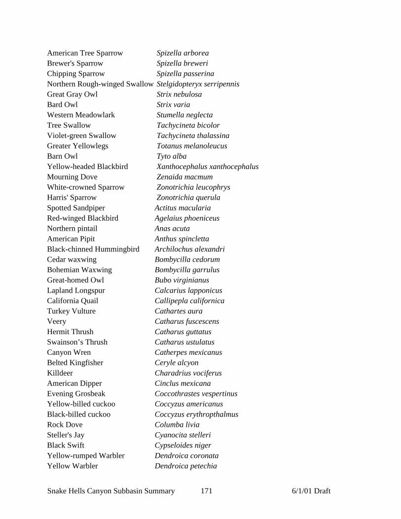
Snake Hells Canyon Subbasin Summary 171 6/1/01 Draft
American Tree Sparrow Spizella arboreaBrewer's Sparrow Spizella breweriChipping Sparrow Spizella passerinaNorthern Rough-winged Swallow Stelgidopteryx serripennisGreat Gray Owl Strix nebulosaBard Owl Strix variaWestern Meadowlark Stumella neglectaTree Swallow Tachycineta bicolorViolet-green Swallow Tachycineta thalassinaGreater Yellowlegs Totanus melanoleucusBarn Owl Tyto albaYellow-headed Blackbird Xanthocephalus xanthocephalusMourning Dove Zenaida macmumWhite-crowned Sparrow Zonotrichia leucophrysHarris' Sparrow Zonotrichia querulaSpotted Sandpiper Actitus maculariaRed-winged Blackbird Agelaius phoeniceusNorthern pintail Anas acutaAmerican Pipit Anthus spinclettaBlack-chinned Hummingbird Archilochus alexandriCedar waxwing Bombycilla cedorumBohemian Waxwing Bombycilla garrulusGreat-homed Owl Bubo virginianusLapland Longspur Calcarius lapponicusCalifornia Quail Callipepla californicaTurkey Vulture Cathartes auraVeery Catharus fuscescensHermit Thrush Catharus guttatusSwainson’s Thrush Catharus ustulatusCanyon Wren Catherpes mexicanusBelted Kingfisher Ceryle alcyonKilldeer Charadrius vociferusAmerican Dipper Cinclus mexicanaEvening Grosbeak Coccothrastes vespertinusYellow-billed cuckoo Coccyzus americanusBlack-billed cuckoo Coccyzus erythropthalmusRock Dove Columba liviaSteller's Jay Cyanocita stelleriBlack Swift Cypseloides nigerYellow-rumped Warbler Dendroica coronataYellow Warbler Dendroica petechia

Snake Hells Canyon Subbasin Summary 172 6/1/01 Draft
Townsend’s Warbler Dendroica townsendiGray Catbird Dumetella carolinenisPeregrine Falcon Falco peregrinusCommon Yellowthroat Geothylpis trichasCliff Swallow Hirundo pyrrhonotaVaried Thrush Ixoreus naeviusNorthern Shrike Lanius excubitorLoggerhead Shrike Lanius ludovicianusHerring Gull Larus argentatusCalifornia Gull Larus californicusLewis' Woodpecker Melanerpes lewisNorthern Mockingbird Mimus polyglottosTownsend’s Solitaire Myadestes townsendiMacGillivray’s Warbler Oporomis tolmieiSage Thrasher Oreoscoptes montanusFlammulated Owl Otus flammeolusWestern Screech Owl Otus kenniwttiHouse Sparrow Passer domesticusGray Partridge Perdix perdixDowny Woodpecker Picoides pubescensHairy Woodpecker Picoides villosusRuby-crowned Ringlet Regulus calendulaGolden-crowned Ringlet Regulus satrapaBroad-tailed Hummingbird Selasophomus platycercusRufous Hummingbird Selasphorus rufusAmerican Redstart Setophaga ruticillaMountain Bluebird Sialia currucoidesWestern Bluebird Sialia mexicanaWilliamson's Sapsucker Sphyrapicus thyroideusCalliope Hummingbird Stellula calliopeEuropean Starling Sturnus vulgarisRed-naped Sapsucker Syhympicus nuchalisHouse Wren Troglodytes aedonWinter Wren Troglodytes troglodytesAmerican Robin Turdus migratoriusEastern Kingbird Tyrannus tyrannusWestern Kingbird Tyrannus verticalisNashville Warbler Venniwra ruficapillaOrange-Crowned Warbler Vermivora celataWarbling Vireo Vireo gilvusRed-eyed Vireo Vireo olivaceus

Snake Hells Canyon Subbasin Summary 173 6/1/01 Draft
Solitary Vireo Vireo solitatiusWilson’s Warbler Wilsonia pusilla
MammalsMoose Alces alcesPallid bat Antrowus pallidusCoyote Canis latransBeaver Castor canadensisElk Cervus elaphusSouthern red-backed vole Clethrionomys gapperiBig brown bat Eptesicu fuscusPorcupine Erethizon dorsatumSpotted bat Euderma maculataYellow-pine chipmunk Eutamias anwenusRed-tailed chipmunk Eutamius ruficaudusMountain lion Felis concolorLynx Felis lynxBobcat Felis rufusNorthern flying squirrel Glaucomys sabrinusLittle brown myotis Iuyotis lucifugusSilver-haired bat Lasionycteris noctivagansHoary bat Lasiurus cinereusSnowshoe hare Lepus americanusWhite-tailed jackrabbit Lepus townsendiiRiver otter Lutra canadensisYellow-bellied marmot Marmota flaviventrisMarten Martes americanaStriped skunk Mephitis mephitisPygmy shrew Microsorex hoyiLong-tailed vole Microtus longicaudusMontane vole Microtus montanusHouse mouse Mus musculusErmine Mustela ermineaLong-tailed weasel Mustela frenataMink Mustela visionCalifornia myotis Myotis californicusSmall-footed myotis Myotis ciliolabrumLong-eared myotis Myotis evotisFringed myotis Myotis thysanodesLong-legged myotis Myotis volansYuma myotis Myotis yumanensisBushy-tailed woodrat Neotoma cinerea

Snake Hells Canyon Subbasin Summary 174 6/1/01 Draft
Mule deer Odocoileus hemionusWhite-tailed deer Odocoileus virginianusMuskrat Ondatra zibethicusBighorn sheep Ovis canadensisGreat basin pocket mouse Perognathus parvusDeer mouse Peromyscur maniculatusWestern pipistrelle Pipstrellus hesperusTownsend’s big-eared bat Plecotus townsendiiRaccoon Procyon lotorWestern harvest mouse Reithrodontomys megalotisCoast mole Sapanus orariusMasked shrew Sorex cinereusDusky shrew Sorex monticolusWater shrew Sorex palustrisPreble’s shrew Sorex prebliiVagrant shrew Sorex vagransMerriam’s shrew Sortx merriamiColumbian ground squirrel Spermophilus columbianusGolden-mantled ground squirrel Spermophilus lateralisSpotted sunk Spilogale gracilisMountain cottontail Sylvilagus nuttalliiRed squirrel Tamiasciurus hudsonicusBadger Taxidea taxusNorthern pocket gopher Thomomys talpoidesBlack bear Ursus americanusRed fox Vulpes vulpesWestern jumping mouse Zapus princeps

Snake Hells Canyon Subbasin Summary 175 6/1/01 Draft
Appendix B - Attributes of Idaho subwatersheds as they relate to bull trout threats (lower Snake Hells Canyon subbasin)(reproduced from Idaho Department of Environmental Quality 1998)
Bull Trout Distribution Threats to Bull Trout
Current(Since 1985)
Historic(Prior to1985)
Sub-Watershed Name
(5th, 6th, and 7th code HUC)
HUC Code Area ofSub-
Watershed(Acres)
a=approx.
Ownershiplist in order of
most ownership1=USFS2=BLM3=COE4=IDL5=IDFG6=Plum Creek7=Potlatch8=Other
SER=Spawning / Early RearingSAR=Sub Adult and Adult RearingSNF=Surveyed Not FoundDNP=Documented Not PresentSSR=Suspected Spawning/RearingSNP=Suspected Not PresentUKN=Unknown
Passage Barrier
C=CulvertD=DamI=Irrigation Diversion
(include number that occur)
Illegal Harvest
H=Hi impactL=Low impactN=No impact
Brook Trout
Y=YesN=No
U=Unknown
Roads
Miles/Sq Mile
TimberHarvestPercent Cut
0-15%15-25%25-50%50-75%
75-100%
Snake River 0000 455,040 8,1,5,2,4 SAR SAR L Y 1-3/m2 <5%
Tammany Creek 0101 20,500 a 8Private
SNF SNF N N >3/m2 0%
Tenmile 0202 8,320 a 8 SNF SNF N N 1-3/m2 0%
Redbird Creek 0201 5,760 a 8,5 SNF SNF N N <1/m2 0%
Captain John Creek 0302 16,720 5,2,4,8 SNF SNF N N 1-3/m2 0-15%%
Corral Creek 0403 5,120 a 2,5,8 SNF SNF N N 1-3/m2 <5%
Cottonwood Creek 0501 5,760 a 1,2,4,5,8 SNF SNF N N <1/m2 0%
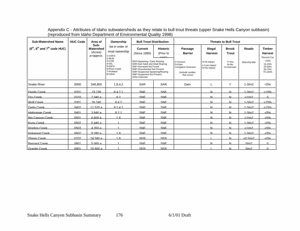
Snake Hells Canyon Subbasin Summary 176 6/1/01 Draft
Appendix C - Attributes of Idaho subwatersheds as they relate to bull trout threats (upper Snake Hells Canyon subbasin)(reproduced from Idaho Department of Environmental Quality 1998)
Bull Trout Distribution Threats to Bull Trout
Current(Since 1985)
Historic(Prior to1985)
Sub-Watershed Name
(5th, 6th and 7th code HUC)
HUC Code Area ofSub-
Watershed(Acres)
a=approx.
Ownershiplist in order of
most ownership1=USFS2=BLM3=COE4=IDL5=IDFG6=Plum Creek7=Potlatch8=Other
SER=Spawning / Early RearingSAR=Sub Adult and Adult RearingSNF=Surveyed Not FoundDNP=Documented Not PresentSSR=Suspected Spawning/RearingSNP=Suspected Not PresentUKN=Unknown
Passage Barrier
C=CulvertD=DamI=Irrigation Diversion
(include number that occur)
Illegal Harvest
H=Hi impactL=Low impactN=No impact
Brook Trout
Y=YesN=No
U=Unknown
Roads
Miles/Sq Mile
TimberHarvestPercent Cut
<15%15-25%25-50%50-75%
75-100%
Snake River 0000 348,800 1,8,4,2 SAR SAR Dam L Y 1-3/m2 <5%
Divide Creek 0201 19,738 8,4,2,1 SNF SNF N N 1-3/m2 <10%Dry Creek 0103 7,040 a 8,2 SNF SNF N N <1/m2 0Wolf Creek 0301 26,740 8,4,2 SNF SNF N N 1-3/m2 <15%Getta Creek 0402 11,520 a 8,2,4,1 SNF SNF N N 1-3/m2 <15%Highrange Creek 0401 3,840 a 8,2,1 SNF SNF N N 1-3/m2 <5%Big Canyon Creek 0501 6,600 a 1,8 SNF SNF N N <1/m2 <5%Kurry Creek 0502 5,440 a 1 SNF SNF N N 1-3/m2 <5%Klopton Creek 0503 4,350 a 1 SNF SNF N N <1/m2 <5%Kirkwood Creek 0602 9,280 a 1,8 SNF SNF N N 1-3/m2 <5%Sheep Creek 0702 24,580 a 1,8 SER SER L N <0.5/m2 <5%Bernard Creek 0801 5,060 a 1 SNF SNF N N 0/m2 0Granite Creek 0901 20,800 a 1 SER SER L N 0/m2 0
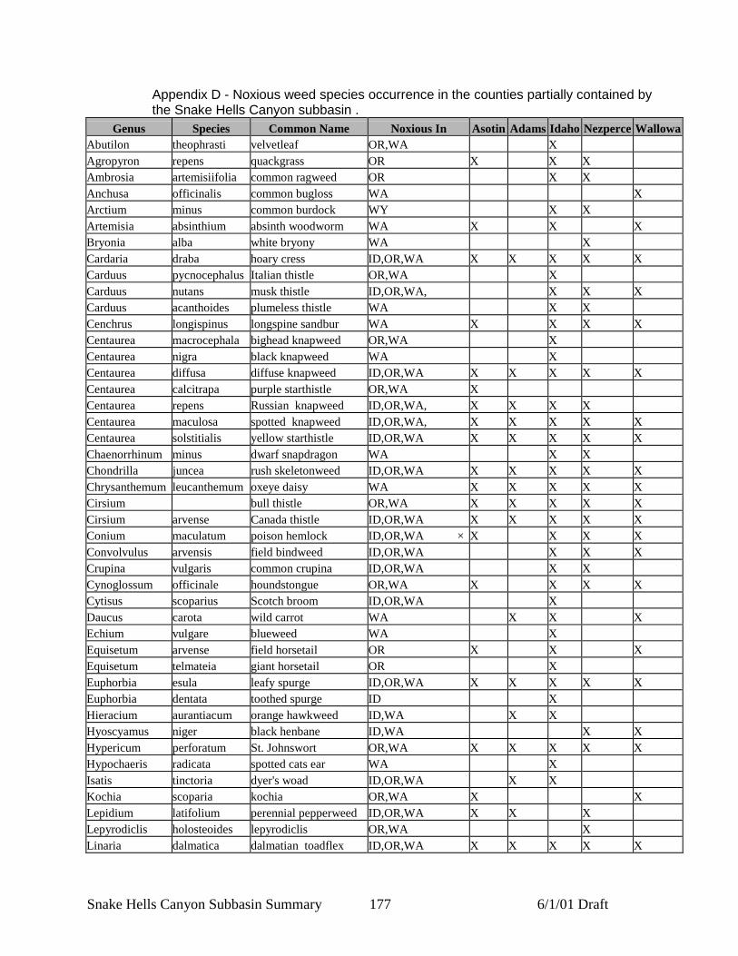
Snake Hells Canyon Subbasin Summary 177 6/1/01 Draft
Appendix D - Noxious weed species occurrence in the counties partially contained bythe Snake Hells Canyon subbasin .
Genus Species Common Name Noxious In Asotin Adams Idaho Nezperce WallowaAbutilon theophrasti velvetleaf OR,WA XAgropyron repens quackgrass OR X X XAmbrosia artemisiifolia common ragweed OR X XAnchusa officinalis common bugloss WA XArctium minus common burdock WY X XArtemisia absinthium absinth woodworm WA X X XBryonia alba white bryony WA XCardaria draba hoary cress ID,OR,WA X X X X XCarduus pycnocephalus Italian thistle OR,WA XCarduus nutans musk thistle ID,OR,WA, X X XCarduus acanthoides plumeless thistle WA X XCenchrus longispinus longspine sandbur WA X X X XCentaurea macrocephala bighead knapweed OR,WA XCentaurea nigra black knapweed WA XCentaurea diffusa diffuse knapweed ID,OR,WA X X X X XCentaurea calcitrapa purple starthistle OR,WA XCentaurea repens Russian knapweed ID,OR,WA, X X X XCentaurea maculosa spotted knapweed ID,OR,WA, X X X X XCentaurea solstitialis yellow starthistle ID,OR,WA X X X X XChaenorrhinum minus dwarf snapdragon WA X XChondrilla juncea rush skeletonweed ID,OR,WA X X X X XChrysanthemum leucanthemum oxeye daisy WA X X X X XCirsium bull thistle OR,WA X X X X XCirsium arvense Canada thistle ID,OR,WA X X X X XConium maculatum poison hemlock ID,OR,WA × X X X XConvolvulus arvensis field bindweed ID,OR,WA X X XCrupina vulgaris common crupina ID,OR,WA X XCynoglossum officinale houndstongue OR,WA X X X XCytisus scoparius Scotch broom ID,OR,WA XDaucus carota wild carrot WA X X XEchium vulgare blueweed WA XEquisetum arvense field horsetail OR X X XEquisetum telmateia giant horsetail OR XEuphorbia esula leafy spurge ID,OR,WA X X X X XEuphorbia dentata toothed spurge ID XHieracium aurantiacum orange hawkweed ID,WA X XHyoscyamus niger black henbane ID,WA X XHypericum perforatum St. Johnswort OR,WA X X X X XHypochaeris radicata spotted cats ear WA XIsatis tinctoria dyer's woad ID,OR,WA X XKochia scoparia kochia OR,WA X XLepidium latifolium perennial pepperweed ID,OR,WA X X XLepyrodiclis holosteoides lepyrodiclis OR,WA XLinaria dalmatica dalmatian toadflex ID,OR,WA X X X X X

Snake Hells Canyon Subbasin Summary 178 6/1/01 Draft
Genus Species Common Name Noxious In Asotin Adams Idaho Nezperce WallowaLinaria vulgaris yellow toadflax ID,OR,WA X X X XLythrum salicaria purple loosestrife ID,OR,WA, X XMatricaria maritima scentless chamomile WA XMilium vernale spring millet grass ID XMirabilis nyctaginea wild four o'clock WA XMyriophyllum brasiliense parrotfeather WA XOnopordum acanthium Scotch thistle ID,OR,WA X X X X XPanicum miliaceum wild proso millet OR X XPhalaris arundinacea reed canary grass WA X X X XPolygonum sachalinense giant knotweed OR,WA X XPolygonum cuspidatum Japanese knotweed OR,WA X XPotentilla recta sulfur cinquefoil OR,WA X XRubus discolor Himalaya blackberry OR X X X XSalvia sclarea clary sage WA X XSalvia pratensis meadow sage WA X XSalvia aethiopis Mediterranean sage OR,WA X XSecale cereale cultivated rye WA X XSenecio jacobaea tansy ragwort ID,OR,WA XSilene latifolia white catchfly WA X X X XSolanum rostratum buffalobur ID,OR,WA X X X XSolanum elaeagnifolium silverleaf nightshade ID,OR,WA X XSonchus arvensis perennial sowthistle ID,WA XSorghum halepense Johnsongrass ID,OR,WA × X XTaeniatherum caput-medusae medusahead OR X X XTamarix spp. tamarix complex WA XTanacetum vulgare common tansy WA X XTorilis arvensis field hedge-parsley WA XTribulus terrestris puncturevine ID,OR,WA × X X X XXanthium spinosum spiny cocklebur OR,WA X X X X
W:\files\province\blue\subsum\010601SnakeHell.doc