drainage disruption caused by a previously...
TRANSCRIPT

DRAINAGE DISRUPTION CAUSED BY A PREVIOUSLY UNIDENTIFIED LARGE PREHISTORIC BEDROCK SLUMP
ON SANTA CRUZ ISLAND, CALIFORNIA
BRUCE CARTER
Pasadena City College, 1570 East Colorado Boulevard, Pasadena, CA 91106; [email protected]
Abstract—A large bedrock slump on Santa Cruz Island lies on the south side of the linear, fault-controlledcentral valley just west of Stanton Ranch. The slump block measures about 2,300 x 700 m and has droppedabout 120–170 m. Slumping occurred approximately parallel to foliation within the Santa Cruz IslandSchist. Although its age is poorly constrained, the headscarp and the upper portion of the slump block areexcellently preserved although most of the toe of the slump has been removed by stream erosion. The slideblocked the original drainage along the axis of the valley producing the “hanging valley” just west of theslump and resulting in an abrupt 120-m drop of the valley floor at Cascada. This happened when a newoverflow path around the slump mass about 500 m to the north placed the stream across resistant rocks ofthe Santa Cruz Island Volcanics. Subsequent north-side-up displacement on the north branch of the SantaCruz Island fault has raised the elevation of the upper part of the drainage above Cascada. There has beenabout 1 km of left-lateral slip on the Santa Cruz Island fault since this stream displacement. The moderndrainage pattern on this part of the island has resulted from a combination of fault slip and large-scale masswasting processes.
Keywords: drainage anomalies, landslide, Santa Cruz Island fault, Santa Cruz Island Schist
INTRODUCTION
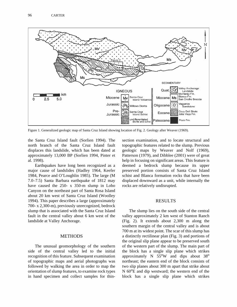
Santa Cruz Island, the largest of the CaliforniaChannel Islands, is located about 42 km south of theSanta Barbara coast. The island consists of twoeast-west ridges separated by a central valley withthe Santa Cruz Island fault running through it. Thefault is a major east-west left-lateral transversestructure (Fig. 1) that forms a distinct lithologicboundary between Miocene Santa Cruz IslandVolcanics and Monterey Formation on the northand pre-Jurassic plutonic and metamorphic rocksand a sequence of Tertiary clastic and volcaniclasticrocks on the south (Rand 1933, Weaver 1969,Dibblee 1982, Pinter et al. 1998). In the central andeastern part of the island, the fault includes northand south branches on opposite sides of the valley.Fault-line features suggest relatively recentdisplacement on the high-angle north branch of thefault (Patterson 1979, Pinter and Sorlien 1991); thesouth branch appears to be a lower-angle fault thathas not been as recently active. Several levels ofmarine terraces suggest that the entire island iscurrently undergoing uplift (Pinter et al. 1998).
The recent faulting and uplift of the island hasproduced rugged terrain that includes many steepunstable slopes that are highly prone to mass-wasting processes (Brumbaugh et al. 1982,Renwick et al. 1982, Jackson 1987). Between 1904and 1983, annual rainfall in the central valley hasranged between 16 and 142 cm (Brumbaugh 1983),and it undoubtedly was even higher during parts ofthe late Pleistocene and early Holocene (Chaneyand Mason 1930, Johnson 1977, Junak et al. 1995).The intermittently high rainfall, coupled with thedestructive effects of heavy grazing by introducedanimals (sheep, cattle, and pigs), has producedconsiderable loss of soil on steep slopes due tosmall soil flows and slumps (Brumbaugh et al.1982, Renwick et al. 1982, Brumbaugh 1983).Large landslides (1,000–100,000 m2) are present insome of the areas of heavily eroded soils, and areparticularly abundant on slopes underlain by thethin-bedded shales of the Miocene MontereyFormation on the eastern third of the island(Weaver and Nolf 1969). Near Valley Anchorage,a large (700- x 1500-m) landslide of MontereyFormation shale crosses the active north branch of
96 CARTER
the Santa Cruz Island fault (Sorlien 1994). Thenorth branch of the Santa Cruz Island faultdisplaces this landslide, which has been dated atapproximately 13,000 BP (Sorlien 1994, Pinter etal. 1998).
Earthquakes have long been recognized as amajor cause of landslides (Hadley 1964, Keefer1984, Pearce and O’Loughlin 1985). The large (M7.0–7.5) Santa Barbara earthquake of 1812 mayhave caused the 250- x 350-m slump in LoboCanyon on the northeast part of Santa Rosa Islandabout 20 km west of Santa Cruz Island (Woolley1994). This paper describes a large (approximately700- x 2,300-m), previously unrecognized, bedrockslump that is associated with the Santa Cruz Islandfault in the central valley about 6 km west of thelandslide at Valley Anchorage.
METHODS
The unusual geomorphology of the southernside of the central valley led to the initialrecognition of this feature. Subsequent examinationof topographic maps and aerial photographs wasfollowed by walking the area in order to map theorientation of slump features, to examine rock typesin hand specimen and collect samples for thin-
section examination, and to locate structural andtopographic features related to the slump. Previousgeologic maps by Weaver and Nolf (1969),Patterson (1979), and Dibblee (2001) were of greathelp in focusing on significant areas. This feature isdeemed a bedrock slump because its upperpreserved portion consists of Santa Cruz Islandschist and Blanca formation rocks that have beendisplaced downward as a unit, while internally therocks are relatively undisrupted.
RESULTS
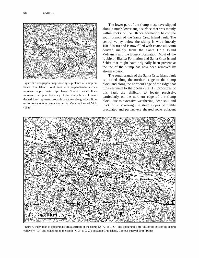
The slump lies on the south side of the centralvalley approximately 2 km west of Stanton Ranch(Fig. 2). It extends about 2,300 m along thesouthern margin of the central valley and is about700 m at its widest point. The scar of this slump hasa distinctly rectilinear plan (Fig. 3) and portions ofthe original slip plane appear to be preserved southof the western part of the slump. The main part ofthe block has a single slip plane which strikesapproximately N 55oW and dips about 38o
northeast; the eastern end of the block consists oftwo slip planes about 300 m apart that strike aboutN 60oE and dip westward; the western end of theblock has a single slip plane which strikes
Figure 1. Generalized geologic map of Santa Cruz Island showing location of Fig. 2. Geology after Weaver (1969).

BEDROCK SLUMP CAUSES DRAINAGE DISRUPTION 97
approximately north-south and dips eastward. Thecentral and western parts of the block have droppedapproximately 100–120 m vertically and theeastern part has dropped up to 170 m from the topof the headscarp. Elsewhere in the area, for about 2km west and 3 km east of the slump, the crest of theridge on the south side of the central valley is quitelinear and lies consistently about 750 m south of thesouthern margin of the valley floor (Fig. 4). Thecrest of the slump block along most of its length isalso linear, and is consistently about 350 m closerto the valley axis, whereas the top of the headscarpnow lies 150–700 m south of the likely position ofthe pre-slump crest of the ridge (Fig. 4). Lookingsouthward at topographic profiles along the axis ofthe central valley and the ridgelines to the southgives an excellent perspective of the extent of thisslump (Figs. 4 and 5).
The upper part of the slump occurred in pre-Jurassic rocks of the Santa Cruz Island Schist(Weaver and Nolf 1969). This is a fine-grained
quartz-albite-chlorite schist produced bygreenschist-grade metamorphism of mostlyvolcanic and sedimentary rocks (Dibblee 1982).The schist is greenish gray but typically weathersto a dark rusty brown color, and displays a strongfoliation due to the abundance of chlorite.Although the orientation of the foliation isvariable, it mostly strikes about east-west in theslump area and has a steep northward dip (Weaverand Nolf 1969). It is evident that the upper part ofthe slump broke off sub-parallel to foliation in theschist. The common deep weathering of the schistresults in very clay-rich material that undoubtedlyfacilitated the sliding. No actual slip-plane surfaceswere found despite careful examination of outcropsaround the periphery of the slump. However, schiston or close to the slip planes is notably morebrecciated and pervasively sheared than it iselsewhere, except immediately adjacent to thesouth branch of the Santa Cruz Island fault, whereshearing is also prominent.
Figure 2. Topographic map of bedrock slump and area, including traces of the north and south branches of the Santa Cruz Islandfault (modified from Patterson 1979) and location of Fig. 7. Contour interval of 50 ft (16 m).
98 CARTER
The lower part of the slump must have slippedalong a much lower angle surface that was mainlywithin rocks of the Blanca formation below thesouth branch of the Santa Cruz Island fault. Thecentral valley below the slump is wide (mostly150–300 m) and is now filled with coarse alluviumderived mainly from the Santa Cruz IslandVolcanics and the Blanca Formation. Most of therubble of Blanca Formation and Santa Cruz IslandSchist that might have originally been present atthe toe of the slump has now been removed bystream erosion.
The south branch of the Santa Cruz Island faultis located along the northern edge of the slumpblock and along the northern edge of the ridge thatruns eastward to the ocean (Fig. 1). Exposures ofthis fault are difficult to locate precisely,particularly on the northern edge of the slumpblock, due to extensive weathering, deep soil, andthick brush covering the steep slopes of highlybrecciated and pervasively sheared rocks adjacent
Figure 3. Topographic map showing slip planes of slump onSanta Cruz Island. Solid lines with perpendicular arrowsrepresent approximate slip planes. Shorter dashed linesrepresent the upper boundary of the slump block. Longerdashed lines represent probable fractures along which littleor no downslope movement occurred. Contour interval 50 ft(16 m).
Figure 4. Index map to topographic cross sections of the slump (A–A’ to G–G’) and topographic profiles of the axis of the centralvalley (W–W’) and ridgelines to the south (X–X’ to Z–Z’) on Santa Cruz Island. Contour interval 50 ft (16 m).
BEDROCK SLUMP CAUSES DRAINAGE DISRUPTION 99
to the fault. Previous maps have shown this faultrunning continuously from the ridge above StantonRanch westward across the slump block (Weaverand Nolf 1969, Patterson 1979, Dibblee 2001).Careful mapping of lithologies, shear zones andslope morphology suggests that the fault trace onthe slump block is displaced about 200 mnorthward on the east end of the block (Fig. 2). Thefault trace could not be located west of theprojected western end of the block. This fault,which shows little evidence of Quaternarydisplacement, appears to dip moderately southwardin this area. The one dip measurement of 35o justeast of the slump (Weaver and Nolf 1969) couldnot be verified, but in several places both the mappattern and shear zones in rocks immediatelyadjacent to the fault suggest a southward dip of lessthan 45o. Since the slump block must have slidnorthward along a low angle surface that may havebeen sub-parallel to the fault plane and about 350m of its northern edge was subsequently removedby erosion, the fault trace now shows lessseparation than the total movement of the slumpblock.
DISCUSSIONEarthquake-Triggered Slumping
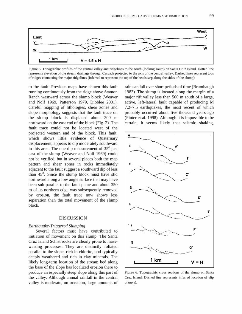
Several factors must have contributed toinitiation of movement on this slump. The SantaCruz Island Schist rocks are clearly prone to mass-wasting processes. They are distinctly foliatedparallel to the slope, rich in chlorite, and typicallydeeply weathered and rich in clay minerals. Thelikely long-term location of the stream bed alongthe base of the slope has localized erosion there toproduce an especially steep slope along this part ofthe valley. Although annual rainfall in the centralvalley is moderate, on occasion, large amounts of
rain can fall over short periods of time (Brumbaugh1983). The slump is located along the margin of amajor rift valley less than 500 m south of a large,active, left-lateral fault capable of producing M7.2–7.5 earthquakes, the most recent of whichprobably occurred about five thousand years ago(Pinter et al. 1998). Although it is impossible to becertain, it seems likely that seismic shaking,
Figure 5. Topographic profiles of the central valley and ridgelines to the south (looking south) on Santa Cruz Island. Dotted linerepresents elevation of the stream drainage through Cascada projected to the axis of the central valley. Dashed lines represent topsof ridges connecting the major ridgelines (inferred to represent the top of the headscarp along the sides of the slump).
Figure 6. Topographic cross sections of the slump on SantaCruz Island. Dashed line represents inferred location of slipplane(s).
100 CARTER
probably from an earthquake along the northbranch of the Santa Cruz Island fault, triggered thisslump. On nearby Santa Rosa Island, a smallerslump with evidence of more recent slip has beenattributed to shaking from the 1812 Santa Barbaraearthquake (Woolley 1994).
Cascada OriginOne of the puzzling features of the drainages
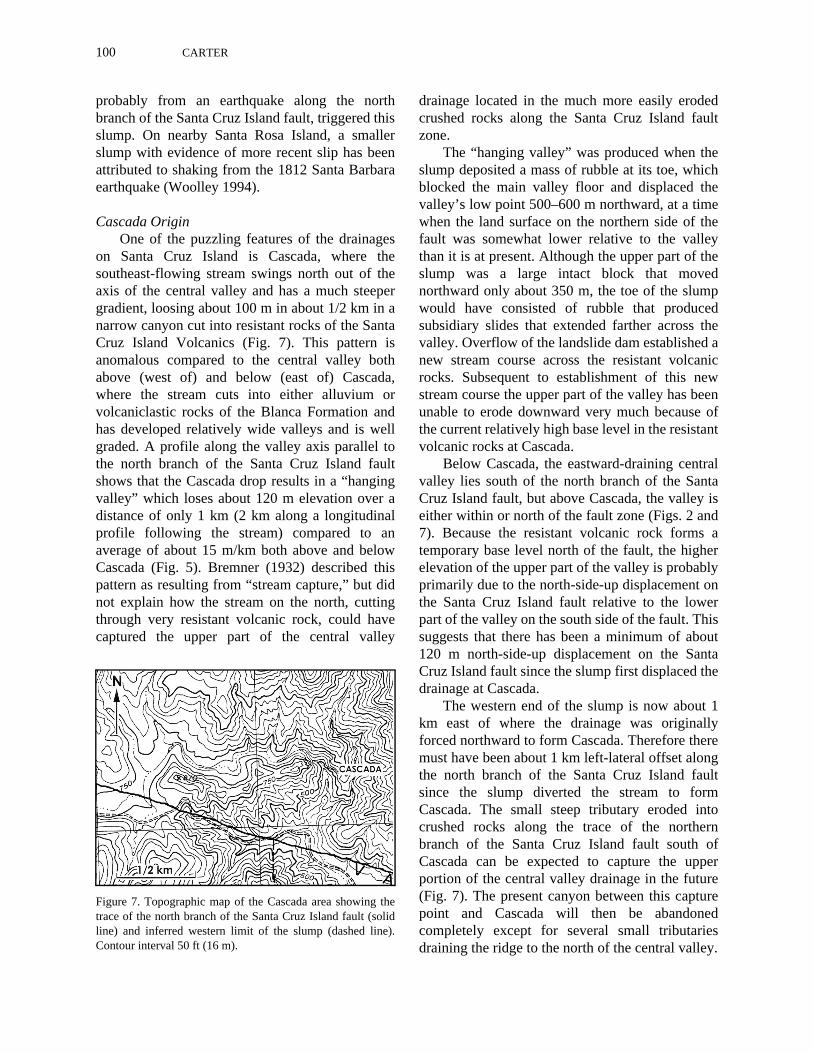
on Santa Cruz Island is Cascada, where thesoutheast-flowing stream swings north out of theaxis of the central valley and has a much steepergradient, loosing about 100 m in about 1/2 km in anarrow canyon cut into resistant rocks of the SantaCruz Island Volcanics (Fig. 7). This pattern isanomalous compared to the central valley bothabove (west of) and below (east of) Cascada,where the stream cuts into either alluvium orvolcaniclastic rocks of the Blanca Formation andhas developed relatively wide valleys and is wellgraded. A profile along the valley axis parallel tothe north branch of the Santa Cruz Island faultshows that the Cascada drop results in a “hangingvalley” which loses about 120 m elevation over adistance of only 1 km (2 km along a longitudinalprofile following the stream) compared to anaverage of about 15 m/km both above and belowCascada (Fig. 5). Bremner (1932) described thispattern as resulting from “stream capture,” but didnot explain how the stream on the north, cuttingthrough very resistant volcanic rock, could havecaptured the upper part of the central valley
drainage located in the much more easily erodedcrushed rocks along the Santa Cruz Island faultzone.
The “hanging valley” was produced when theslump deposited a mass of rubble at its toe, whichblocked the main valley floor and displaced thevalley’s low point 500–600 m northward, at a timewhen the land surface on the northern side of thefault was somewhat lower relative to the valleythan it is at present. Although the upper part of theslump was a large intact block that movednorthward only about 350 m, the toe of the slumpwould have consisted of rubble that producedsubsidiary slides that extended farther across thevalley. Overflow of the landslide dam established anew stream course across the resistant volcanicrocks. Subsequent to establishment of this newstream course the upper part of the valley has beenunable to erode downward very much because ofthe current relatively high base level in the resistantvolcanic rocks at Cascada.
Below Cascada, the eastward-draining centralvalley lies south of the north branch of the SantaCruz Island fault, but above Cascada, the valley iseither within or north of the fault zone (Figs. 2 and7). Because the resistant volcanic rock forms atemporary base level north of the fault, the higherelevation of the upper part of the valley is probablyprimarily due to the north-side-up displacement onthe Santa Cruz Island fault relative to the lowerpart of the valley on the south side of the fault. Thissuggests that there has been a minimum of about120 m north-side-up displacement on the SantaCruz Island fault since the slump first displaced thedrainage at Cascada.
The western end of the slump is now about 1km east of where the drainage was originallyforced northward to form Cascada. Therefore theremust have been about 1 km left-lateral offset alongthe north branch of the Santa Cruz Island faultsince the slump diverted the stream to formCascada. The small steep tributary eroded intocrushed rocks along the trace of the northernbranch of the Santa Cruz Island fault south ofCascada can be expected to capture the upperportion of the central valley drainage in the future(Fig. 7). The present canyon between this capturepoint and Cascada will then be abandonedcompletely except for several small tributariesdraining the ridge to the north of the central valley.
Figure 7. Topographic map of the Cascada area showing thetrace of the north branch of the Santa Cruz Island fault (solidline) and inferred western limit of the slump (dashed line).Contour interval 50 ft (16 m).

BEDROCK SLUMP CAUSES DRAINAGE DISRUPTION 101
AgeAlthough no good evidence of the absolute age
of the slump has been recognized, a fewgeneralizations can be made. The slump cuts thesouth branch of the Santa Cruz Island fault, butthere is little indication that this branch of the faulthas undergone displacement during Quaternarytime (Patterson 1979, Pinter et al. 1998). There is norecognizable deposit of landslide rubble present inthe central valley at the toe of the slump, suggestingthat the small intermittent stream in the valley hasnow removed nearly all of the landslide rubble. Thestream channel has eroded the base of the slump,which is one of the steepest slopes of its sizeanywhere in the central valley. This process haseroded back the toe of the slump by about 250 m.
Several geomorphic features suggest arelatively young age of the slump. The slip plane isexcellently preserved in the central part of theslump. The ridge top of the slump block is alsoremarkably well-preserved and, when compared tothe top of the ridge both east and west of the slump,it gives a clear indication of the magnitude of totallateral as well as vertical slip.
Since the slump diverted the drainage,movement on the north branch of the Santa CruzIsland fault has produced at least 120 m of north-side-up and 1 km of left-lateral displacement.These numbers compare with best estimates ofcurrent displacement rates of 0.1–0.2 mm/yr north-side-up and 0.8 mm/yr left-lateral movement(Pinter et al. 1998). If these rates are typical oflong-term rates, this suggests that the slumporiginally diverted the drainage as early as about1.2 my BP and as recently as 0.6 my BP.
CONCLUSIONS
Major fault zones in many areas have producednumerous striking tectonic landforms, some ofwhich demonstrate the sense and magnitude of slipon the faults. Features along the Santa Cruz Islandfault such as deflected drainages, offset streams,shutter ridges and back-facing scarps have beenextensively described previously. This studydocuments larger-scale geomorphic featuresincluding slumps and drainage anomalies whichare also related to the presence of a major faultzone but which have not been previously
described, probably because their scale is muchlarger. When studying a major fault zone such asthe Santa Cruz Island fault, it may be important tolook at the larger-scale geomorphology, which cansometimes give additional insights on the interplayof tectonics and the tectonic landforms developedalong the fault zone.
ACKNOWLEDGMENTS
J. Gordon was particularly helpful in setting uplogistical support and in discussions of thegeological problems on Santa Cruz Island. D.Douglass and G. Lewis gave their support andencouragement, especially in discussions in thefield. Special thanks to L. Laughrin, University ofCalifornia Natural Reserve System, for his supportand encouragement on Santa Cruz Island.
REFERENCES
Bremner, C. 1932. Geology of Santa Cruz Island,Santa Barbara County, California. SantaBarbara Museum of Natural HistoryOccasional Papers 1:1–33.
Brumbaugh, R. 1983. Hillslope gullying andrelated changes, Santa Cruz Island, California[Ph.D. dissertation]. University of California,Los Angeles, CA, 192 pp.
Brumbaugh, R., W. Renwick and L. Loeher. 1982.Effects of vegetation change on shallow land-sliding, Santa Cruz Island, California. Pages397–402. In: Dynamics and Management ofMediterranean-type Ecosystems: An Interna-tional Symposium. U.S. Department of Agri-culture, Pacific Southwest Forest and RangeExperimental Station, General TechnicalReport PSW-58, Berkeley, CA.
Chaney, R. and H. Mason. 1930. A Pleistoceneflora from Santa Cruz Island, California.Carnegie Institute of Washington PublicationNo. 415:1–24.
Dibblee, T.W. 1982. Geology of the ChannelIslands, southern California. Pages 27–39. In:Fife, D.L. and J.A. Minch (eds.), Geology andMineral Wealth of the California TransverseRanges. South Coast Geological Society, SantaAna, CA.

102 CARTER
Dibblee, T.W. 2001. Geologic Map of WesternSanta Cruz Island, Santa Barbara County,California. Minch, J.A. (ed.); DibbleeGeological Foundation, Santa Barbara, CA.
Hadley, J.B. 1964. Landslides and relatedphenomena accompanying the Hebgen Lakeearthquake of August 17, 1959. Pages 107–138.In: The Hebgen Lake, Montana earthquake ofAugust 17, 1959. U.S. Geological Survey,National Park Service, Coast and GeodeticSurvey, and U.S. Forest Service. U.S.Geological Survey Professional Paper 435.
Jackson, P.J. 1987. Effects of debris slides ondistribution of grassland species: Santa CruzIsland, California [Master’s thesis]. Universityof California, Santa Barbara, CA.
Johnson, E. 1977. The late Quaternary climate ofcoastal California: evidence for an ice agerefugium. Quaternary Research 8:154–179.
Junak, S., T. Ayers, R. Scott, D. Wilken and D.Young. 1995. A flora of Santa Cruz Island.Santa Barbara Botanic Garden and CaliforniaNative Plant Society, Santa Barbara, CA, 397pp.
Keefer, D.K. 1984. Landslides caused byearthquakes. Geological Society of AmericaBulletin 95:406–421.
Patterson, R.H. 1979. Tectonic geomorphologyand neotectonics of the Santa Cruz Island fault,Santa Barbara County, California [Master’sthesis]. University of California, SantaBarbara, CA, 140 pp.
Pearce, A.J. and C.L. O’Loughlin. 1985.Landsliding during a M 7.7 earthquake:Influence of geology and topography. Geology13:855–858.
Pinter, N. and C.C. Sorlien. 1991. Evidence forlatest Pleistocene to Holocene movement on
the Santa Cruz Island fault, California.Geology 19:909–912.
Pinter, N., S.B. Lueddecke, E.A. Keller and K.R.Simmons. 1998. Late Quaternary slip on theSanta Cruz Island fault, California. GeologicalSociety of America Bulletin 110:711–722.
Rand, W.W. 1933. Preliminary report on thegeology of Santa Cruz Island, Santa BarbaraCounty, California. pp. 214–219. In: Report ofthe California State Mining Bureau 27.
Renwick, W., R. Brumbaugh and L. Loeher. 1982.Landslide morphology and processes on SantaCruz Island, California. Geografiska Annaler64 (A):149–159.
Sorlien, C.C. 1994. Faulting and uplift of theNorthern Channel Islands. Pages 281–296. In:Halvorson, W.L. and G.J. Maender (eds.), TheFourth Channel Islands Symposium: Updateon the Status of Resources. Santa BarbaraMuseum of Natural History, Santa Barbara,CA.
Weaver, D.W. (editor). 1969. Geology of thenorthern Channel Islands, southern Californiaborderland. Pacific Section, AmericanAssociation of Petroleum Geologists SpecialPublication, 200 pp.
Weaver, D.W. and B. Nolf. 1969. Geology ofSanta Cruz Island (map). In: Weaver, D.W.(ed.) Geology of the northern Channel Islands,southern California borderland. PacificSection, American Association of PetroleumGeologists Special Publication, scale 1:24,000.
Woolley, J.J. 1994. Lobo Canyon landslide: SantaRosa Island, California. Pages 297–302. In:Halvorson, W.L. and G.J. Maender (eds.), TheFourth Channel Islands Symposium: Updateon the Status of Resources. Santa BarbaraMuseum of Natural History, Santa Barbara,CA.