draw 7 park: creation of a recreational site - umb.edu
TRANSCRIPT

1
Assembly Square/ Draw Seven Park: Updating the Recreational Site
Image: Google Map
Chris Cumming & Himanshu Dubey
EEOS 476
Final Paper Submitted to Dr. Anamarija Frankic
Assembly
Square Mall
Draw 7
Park

2
Table of Contents
Introduction
Geography: Site Location
Background
History of Mystic River
History of Assembly Square
Assembly Square Redevelopment
Funding/Cost for the Site Redevelopment
Draw Seven Park
Tour Guide
What Currently Exists at Draw Seven Park
Project Goals/Objectives
Methodology
Possible solutions to the site
Salt Marshes
Seagrass Beds
Oyster Reefs
Importance of recreational areas
Transportation
Stormwater Drainage
Recreational Options
Noise reduction
Access
Rules and regulations
Conclusion
Acknowledgements
Appendix
Images
Tables
Bibliography
3
Introduction
Geography: Site Location
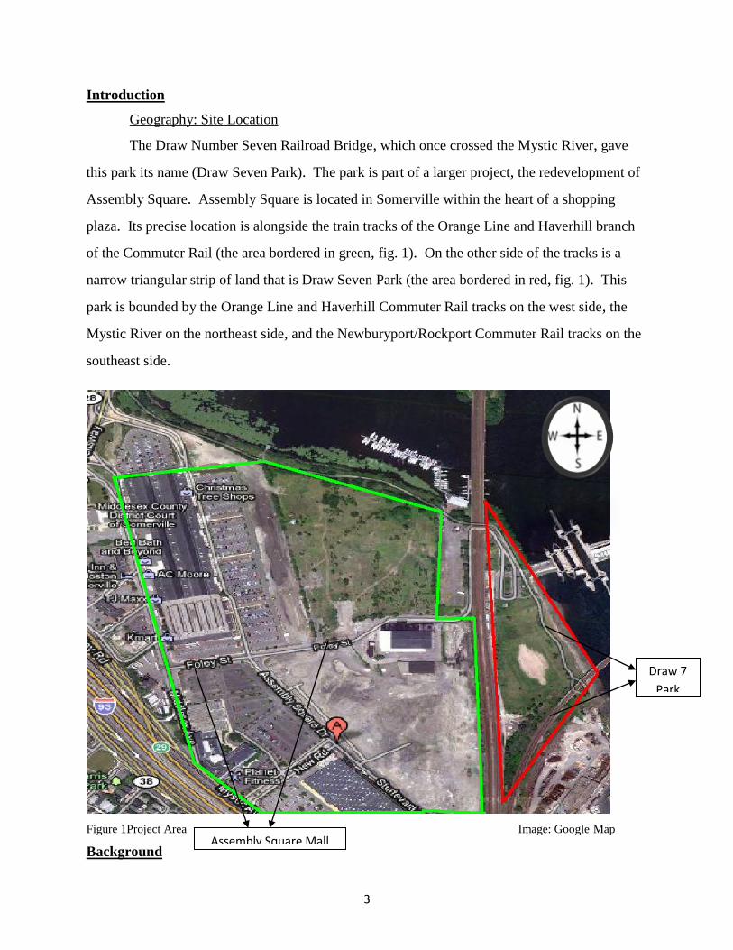
The Draw Number Seven Railroad Bridge, which once crossed the Mystic River, gave
this park its name (Draw Seven Park). The park is part of a larger project, the redevelopment of
Assembly Square. Assembly Square is located in Somerville within the heart of a shopping
plaza. Its precise location is alongside the train tracks of the Orange Line and Haverhill branch
of the Commuter Rail (the area bordered in green, fig. 1). On the other side of the tracks is a
narrow triangular strip of land that is Draw Seven Park (the area bordered in red, fig. 1). This
park is bounded by the Orange Line and Haverhill Commuter Rail tracks on the west side, the
Mystic River on the northeast side, and the Newburyport/Rockport Commuter Rail tracks on the
southeast side.
Figure 1Project Area Image: Google Map
Background Assembly Square Mall
Draw 7
Park

4
History of the Mystic River
The Mystic River Watershed, which covers about 76 square miles (200 km2) of land
flows from the Lower Mystic Lake and travels through the Boston-area communities of
Arlington, Medford, Somerville, Everett, Charlestown, Chelsea, and East Boston. The river joins
the Charles River to form inner Boston Harbor. Its watershed contains 44 lakes and ponds, the
largest of which is Spot Pond in the Middlesex Fells, with an area of 307 acres.
For hundreds of years, Native Americans lived and fished along the Mystic. One of the
Mystic area’s first European settlers was Massachusetts Bay Colony Governor John Winthrop.
He built his summer retreat, the Ten Hills Farm, on the banks of the Mystic. The weirs at the
river allowed both Native Americans, and later Colonists to catch alewives and fertilize their
crops. However, during the 1800s the factories replaced many farms, and the region attracted
many new residents. By 1865, the population of the area had tripled, and overfishing and
pollution had eliminated commercial fishing.1
In the 1840s, the shipbuilding on the Mystic had increased since the landing of the
earliest colonists. The Mystic by this time had become a major transportation route. Timber,
molasses for rum distilleries, and other products, were being transported via schooners and
sloops along the trade route between Medford and the West Indies. Later, railroads and then a
system of roadways replaced the River as a transportation route. Mills, brickyards and tanneries
along the river brought wealth, but some industries also polluted the Mystic watershed. Today, a
mix of houses, businesses, parks and abandoned factories border the River.
Until 1909 when the first dam (Craddock Locks) was built across the Mystic River
extensive salt marshes lined the banks of the Mystic. The dam converted salt marshes to
freshwater marshes and enabled development. The dam that currently lies east of Draw Seven
Park, Amelia Earhart, was built in 1966. It has three locks to allow the passage of boats, and is
equipped with pumps to push fresh water out to the harbor. There is also fish ladder, however, it
has never been functional.2
1 http://mysticriver.org/history-of-the-mystic/
2 http://www.answers.com/topic/mystic-river-1

5
History of the Assembly Square
Assembly Square is a mixed-use, smart growth development planned for 66.5 acres
(269,000 m2) along the Mystic River in Somerville, Massachusetts. The site is approximately
two miles (3 km) from downtown Boston and accessible via I-93 and Route 28/Middlesex Fells
Parkway. Consumers can also commute to the mall via Orange Line and Bus Route 90. The
history of the site revolves around these eight buildings:
Ford Motor Plant
East Somerville Locomotive Shop at 99 Foley Street
Sears Roebuck & Company Warehouse at 30-34 Sturtevant Street
Spaulding Brick Company Warehouse at 123 Foley Street
Spaulding Brick Company storage structure at 147 Foley Street
A two-story commercial building at 85 Foley Street
Three additional warehouses at 100 Sturtevant Street
Loews AMC Theater
The Assembly Square Mall has gone through lots of phases. The mall that currently
exists was originally the Ford Plant, which transformed into a supermarket distribution center
before being converted into the mall. The Ford plant was built in 1926, at roughly the same time
as McGrath Highway and the First National plant, on filled wetlands. The initiative for the
development of the Ford and First National sites came from the Boston & Maine Railroad, which
owned the land and built rail spurs to the plants. The arrival of the Ford plant was a major event,
commemorated by a special supplement to the Somerville Journal. The building was notable for
its use of natural daylight and was apparently also of interest from the outside. The building was
a long line of windows along the Middlesex Avenue, which allowed passersby to watch the
progress of cars moving along the assembly line. The plant was expanded in 1937 but was shut
down in 1958, after having been converted to production of the ill-fated Edsel.3
The East Somerville Locomotive Shop at 99 Foley Street was constructed ca. 1925 by the
Boston & Maine Railroad to service train engines. From 1933 to the present, the building has
been used for steel manufacturing by the L.E. Zurbach Steel Company and the Central Steel
3 http://mysticview.org/walking_tour_middlesex_ave2.php
6
Company. The two-story, brick building has pier and spandrel construction and a shallowly-
pitched gable roof. A two-story, brick addition was constructed along the west elevation in the
mid 20th-century and a send, single-story addition was constructed on the east elevation
sometime after 1990. Since construction, the building has been substantially altered through the
sealing of the original door and window openings and the application of continuous, vertical,
standing-seam metal siding.
The Sears Roebuck and Company Warehouse at 34 Sturtevant Street was constructed in
1941 to handle company cargo shipped via the adjacent Boston & Maine Railroad. The single-
story building is constructed of reinforced concrete with a brick surface and has a flat roof. The
west elevation has been refitted with modern doors, metal siding, windows, and entry canopies
to accommodate retail and office uses. One loading bay remains intact at the center of the
elevation. The former track-side (east) elevation retains thirteen bay openings and a concrete
loading platform, sheltered by a metal-clad wood canopy.
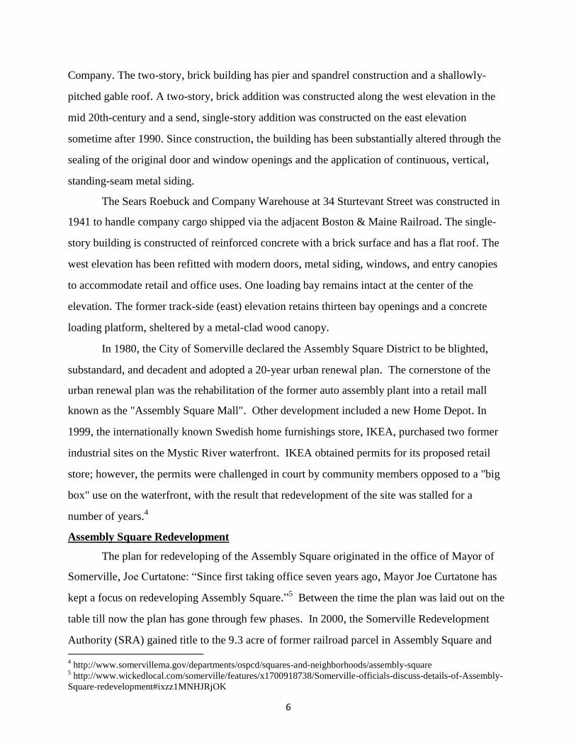
In 1980, the City of Somerville declared the Assembly Square District to be blighted,
substandard, and decadent and adopted a 20-year urban renewal plan. The cornerstone of the
urban renewal plan was the rehabilitation of the former auto assembly plant into a retail mall
known as the "Assembly Square Mall". Other development included a new Home Depot. In
1999, the internationally known Swedish home furnishings store, IKEA, purchased two former
industrial sites on the Mystic River waterfront. IKEA obtained permits for its proposed retail
store; however, the permits were challenged in court by community members opposed to a "big
box" use on the waterfront, with the result that redevelopment of the site was stalled for a
number of years.4
Assembly Square Redevelopment
The plan for redeveloping of the Assembly Square originated in the office of Mayor of
Somerville, Joe Curtatone: “Since first taking office seven years ago, Mayor Joe Curtatone has
kept a focus on redeveloping Assembly Square.”5 Between the time the plan was laid out on the
table till now the plan has gone through few phases. In 2000, the Somerville Redevelopment
Authority (SRA) gained title to the 9.3 acre of former railroad parcel in Assembly Square and 4 http://www.somervillema.gov/departments/ospcd/squares-and-neighborhoods/assembly-square
5 http://www.wickedlocal.com/somerville/features/x1700918738/Somerville-officials-discuss-details-of-Assembly-
Square-redevelopment#ixzz1MNHJRjOK

7
filed a Request for Proposal for the developers. At the same time, the City initiated an extensive
public planning process, producing the "2000 Planning Study" which set out a new vision for
Assembly Square as a 24-hour, mixed use district with residential, retail, office, cinema,
restaurant, hotel, and recreational open space uses. In 2002, the SRA and the City adopted a 20-
year extension of the urban renewal plan with the goal of transforming Assembly Square into the
lively, mixed-use district described in the 2000 Planning Study. Assembly Square was rezoned
to promote the mixed-use concept, and design guidelines and a design review committee were
created to provide additional assistance in helping foster the new vision.
In 2005, the Federal Reality Investment (FRIT) purchased the Assembly Square Mall and
other properties adjacent to the mall; 220,000-square-foot retail/industrial complex. In 2006,
FRIT redeveloped the mall and opened the newly refurbished mall as Assembly Square
Marketplace. Later that year, Mayor Curtatone decided to bring together FRIT and IKEA to
work together and come up with a reasonable redevelopment plan with a brand new vision. FRIT
and IKEA agreed to trade parcels, moving IKEA inland from its initial site and leaving the
waterfront open for FRIT to create pedestrian friendly, mixed-use development. This new plan
was welcomed by those who had previously opposed the IKEA development. The land swap was
executed in October 2009 solidifying the vision of the district.
The other part of the redevelopment plan includes an addition of a station to the Orange
Line (train line). The new station will give the Orange Line a grand total of 20 stops, along side
this, the station will serve as an attraction to residents/consumers, making living/shopping in the
newly redeveloped area commute friendly. The MBTA board just recently approved this
agreement with developer Federal Realty Investment Trust which enables construction of the
new station at Somerville’s Assembly Square, roughly halfway between existing stops at
Sullivan Square in Charlestown and Wellington in Medford. The agreement also gives the state
the real estate rights to build the station and entrances and realign tracks.

8
Funding/Cost for the Site Redevelopment
The project is expected to result in an estimated $1.36 billion construction investment in
the City to include new public and private infrastructure, publically accessible open space, public
facilities and public benefits. The project is forecasted to generate $24 million in annual
municipal tax revenue and $16.7 million in annual state tax revenue (gross). It’s expected to
generate an estimated 9,700 permanent jobs, 10,300 construction jobs, while retaining 590
existing permanent jobs.6 In the late 2008, FRIT announced that due to downfall in the economy
the value of the land had decreased so low that necessary financing for the project was very
limited. On the July 20, 2009, some of the regional politicians including, Governor Deval
Patrick along with Senator John Kerry, Congressman Michael E. Capuano, Mayor Joseph A.
Curtatone, and a few other selected officials, along with FRIT came together to decide that the
only way this project would be completed is with everyone’s 100% cooperation.
The beginning of the funding process for the project was a bit shaky, in his interview for
the Somerville Journal (city newspaper) Mayor Curtatone talked about the funding for the site:
“mayor [Curtatone tried] to steer the city toward borrowing $25 million to help redevelop
Assembly Square, [however] aldermen reacted skeptically, worried that the city [was]
underwriting the private developer.”7 Mayor later also mentioned that “if the city doesn’t put up
its own money, FRIT could potentially walk away from the project.” He referred to the
investor’s annual report in which the publicly traded company warned that it might have to forgo
its plans for Assembly Square if it does not receive the $25 million from the city. In the
company’s report FRIT stated, “If we do not receive adequate public funding… the project may
not provide a justifiable risk-adjusted return resulting in a temporary or permanent hold on the
project and a write-off of a portion of the project.”8
The Board of Alderman viewed this $25 million, which equaled to about 14% of the
city’s $178 million budget and over the course of bonds 30 year period, the amount would
6 http://www.somervillema.gov/departments/ospcd/squares-and-neighborhoods/assembly-square
7 8 http://www.wickedlocal.com/somerville/town_info/government/x401816925/Money-needed-for-Somervilles-
Assembly-Square-scrutinized#axzz1MXdwyhg4

9
actually come out to $ 50 million, slightly over the yearly budget of the city’s public schools. In
exchange for the city spending $ 25 million on roadways and a better stormwater drainage
system throughout the entire Assembly Square Site, FRIT has agreed to build three buildings and
also help pay for the MBTA new station development. The city projects that the property tax for
these three buildings would help pay off the bonds debts, “city officials have said that would
easily be accomplished even under conservative estimates. If the rest of the lot is developed, the
city would collect much more in its tax coffers.”9
In 2009, the Assembly on the Mystic River project received a $2 million GDI (Growth
District Initiative Grant for the City’s underground infrastructure; sewers, water, drainage, etc.
The Project also received the final approval from the City of Somerville and received
Infrastructure Investment Incentive bond funding of $ 50 million. Federal Stimulus American
Recovery & Reinvestment Act also gave $ 15 million for the roadway construction and off site
improvements.
State’s Infrastructure Investment Initiative (I-Cubed) Bond Program $50 million
Federal Stimulus (ARRA) Grant $15 million
State’s Growth District Initiative (GDI) Grant $2 million
Congressional Multi-Modal Earmark $6.29 million
Total Public Funds identified in 2009: $73 million
*Does not include public funds allocated for new MBTA Orange Line.10
The other part of redevelopment that by this time had not received much funding was the
new station on the Orange Line. The MBTA project is expected to cost an estimate of $53.7
million. The developer is expected to put in $15 million. State Representative Michael
Capuano, Democrat of Somerville, had previously already secured authorization for $25 million
in federal funds for the train stop, however the Congress itself has only provided $1 million and
9 http://www.wickedlocal.com/somerville/town_info/government/x401816925/Money-needed-for-Somervilles-
Assembly-Square-scrutinized#ixzz1Mq1wLCsB 10
http://www.somervillema.gov/departments/ospcd/squares-and-neighborhoods/assembly-square

10
does not seem to be in any rush to provide the remaining fund needed to start the project.11 On
the other hand, to keep the project from stalling any further, the state Department of
Transportation and the Boston Region Metropolitan Planning Organization have put a hold on
federal highway funds. The Executive Office of Housing and Economic Development, after
seeing the potential for thousands of construction and long term jobs, have also decided to put in
infrastructure money. So, the design of the MTBA Orange Line Station in Assembly Square is
at 100% engineering design and is expected to be ready for bid by spring 2011. Currently, $50
million is required to build the station including two head houses. To date, the funding sources
include:
Federal Transportation Earmark $1 million of the original $25 million
State (MPO) $10 million
State (Other Grant Sources) $18 million
Private Contribution $15 million
Congressional Multi-modal Earmark $6.26 million
Total funding as of 2009 $75.26 million12
Draw Seven Park: Tour Guide
Draw Seven Park, which is also projected to go underdevelopment, is a strip of land no
larger than size of baseball field. The only entrance to the site is located adjacent to the Winter
Hill Yacht Club. The entrance is a two-way paved road allowing visitors, employees of Amelia
Earhart Dam, and DCR faculties to visit the site while providing a parking space for about forty
cars. As mentioned earlier, the park is bounded by the Orange Line and Haverhill Commuter
Rail tracks on the west side, the Mystic River on the northeast side, and the Newburyport/
Rockport Commuter Rail tracks on the southeast side.
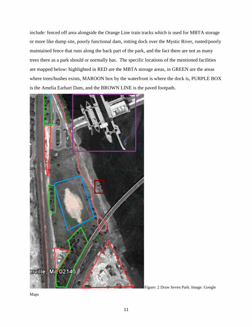
What Currently Exists at Draw Seven Park?
The park at the moment consists of a few positive and a few negative things, positive
things include: Amelia Earhart Dam, soccer goals, an open field, trees and bushes (a few), paved
footpaths, benches, fire hydrant, drainage pipe, and pavilion with picnic tables. Negative things
11
http://articles.boston.com/2011-02-13/news/29345290_1_construction-bids-economic-development-station 12
http://www.somervillema.gov/departments/ospcd/squares-and-neighborhoods/assembly-square
11
include: fenced off area alongside the Orange Line train tracks which is used for MBTA storage
or more like dump site, poorly functional dam, rotting dock over the Mystic River, rusted/poorly
maintained fence that runs along the back part of the park, and the fact there are not as many
trees there as a park should or normally has. The specific locations of the mentioned facilities
are mapped below: highlighted in RED are the MBTA storage areas, in GREEN are the areas
where trees/bushes exists, MAROON box by the waterfront is where the dock is, PURPLE BOX
is the Amelia Earhart Dam, and the BROWN LINE is the paved footpath.
Figure: 2 Draw Seven Park. Image: Google
Maps

12
Project Goals/Objectives
The priority of site was to give provide the community of Assembly Square and
surrounding areas, a recreational site, that will be environmental friendly, accessible, and safe.
The site would be transformed into a waterfront park, consisting of park like feature; play fields,
water fountains, benches, more trees along side the fences. Further details will be discussed in
the later part of the paper.
Our Approach
Our methodology was straight forward, visit the site during different seasons (later
winter, and early/mid spring) to check for environmental changes if any. Later visiting the site
with Ivey St. John, a person well acquainted with the area and highly active in city meetings
regarding the development of the site. However, most of our time was spent reviewing
documents on the internet, and books looking for examples of waterfront parks, and also how to
clean up rivers of their toxic wastes.
Possible solutions to the site
Draw Seven Park being a waterfront park, the first step to making the park fun, safe, and
attractive is to help clean up the Mystic River. Mystic River has a long history of industrial use
and continuing water quality problems. Some of the solutions for Mystic River include: salt
marshes, seagrass beds, and oyster reefs. However, out the three solutions salt marshes, and
seagrass beds are most ideal.
Salt Marshes
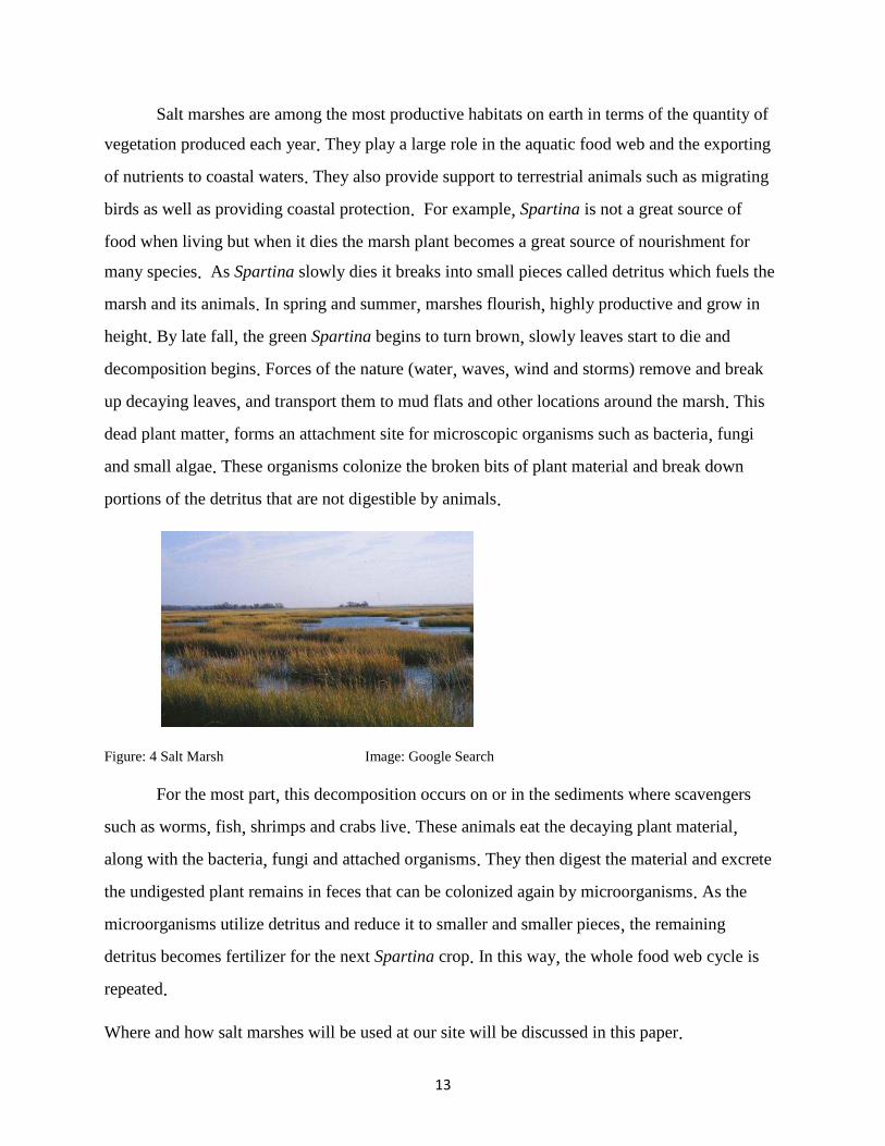
Salt marshes are coastal wetlands rich in marine life. They are also sometimes called
tidal marshes, because they grow in between low and high tide zones (see fig. 4 for an
example). Salt marsh plants cannot grow where waves are strong, but they thrive along low-
energy coasts. They also occur in estuaries, where freshwater from the land mixes with sea
water. Salt marshes generally consist of plants such as herbs, grasses, or low shrubs. They
come in various colors like gray, brown, and green, which makes it easier to identify them.
13
Salt marshes are among the most productive habitats on earth in terms of the quantity of
vegetation produced each year. They play a large role in the aquatic food web and the exporting
of nutrients to coastal waters. They also provide support to terrestrial animals such as migrating
birds as well as providing coastal protection. For example, Spartina is not a great source of
food when living but when it dies the marsh plant becomes a great source of nourishment for
many species. As Spartina slowly dies it breaks into small pieces called detritus which fuels the
marsh and its animals. In spring and summer, marshes flourish, highly productive and grow in
height. By late fall, the green Spartina begins to turn brown, slowly leaves start to die and
decomposition begins. Forces of the nature (water, waves, wind and storms) remove and break
up decaying leaves, and transport them to mud flats and other locations around the marsh. This
dead plant matter, forms an attachment site for microscopic organisms such as bacteria, fungi
and small algae. These organisms colonize the broken bits of plant material and break down
portions of the detritus that are not digestible by animals.
Figure: 4 Salt Marsh Image: Google Search
For the most part, this decomposition occurs on or in the sediments where scavengers
such as worms, fish, shrimps and crabs live. These animals eat the decaying plant material,
along with the bacteria, fungi and attached organisms. They then digest the material and excrete
the undigested plant remains in feces that can be colonized again by microorganisms. As the
microorganisms utilize detritus and reduce it to smaller and smaller pieces, the remaining
detritus becomes fertilizer for the next Spartina crop. In this way, the whole food web cycle is
repeated.
Where and how salt marshes will be used at our site will be discussed in this paper.

14
Seagrass Beds
Seagrasses beds are a type of submerged aquatic vegetation that have evolved from
terrestrial plants and have become specialized to live in the marine environment (see fig. 5).
Like terrestrial plants they also have leaves, roots, flowers, and generate their food via
photosynthesis. However, what makes them different from the terrestrial plants is that unlike
terrestrial plants seagrass and other submerged aquatic vegetation does not have strong stems, or
trunk which comes handy when fighting gravity. Instead, the seagrass has blades which allows
to them to flow with the water.
Figure: 5 Seagrass bed Image: Google Search
Seagrasses performs a variety of functions within our ecosystem, and have both
economic and ecological value. The high level of productivity, structural complexity, and
biodiversity in seagrass beds has led some researchers to describe seagrass communities as the
marine equivalent of tropical rainforests. While nutrient cycling and primary production in
seagrasses tends to be seasonal, annual production in seagrass communities exceeds that of
terrestrially cultivated areas.
The importance of lies in the fact that within seagrass communities, a single acre of
seagrass can produce over 10 tons of leaves per year. This vast biomass can provide food,
habitat, and nursery areas for a countless number of adults and juveniles vertebrates and
invertebrates. Further, a single acre of seagrass may support as many as 40,000 fish, and 50
million small invertebrates. Because seagrasses support such high biodiversity, and because they
are so sensitive to changes in water quality, they are recognized as important indicator species
that reflect the overall health of coastal ecosystems.
15
Where and how seagrass beds will be used at our site will be discussed later in the paper.
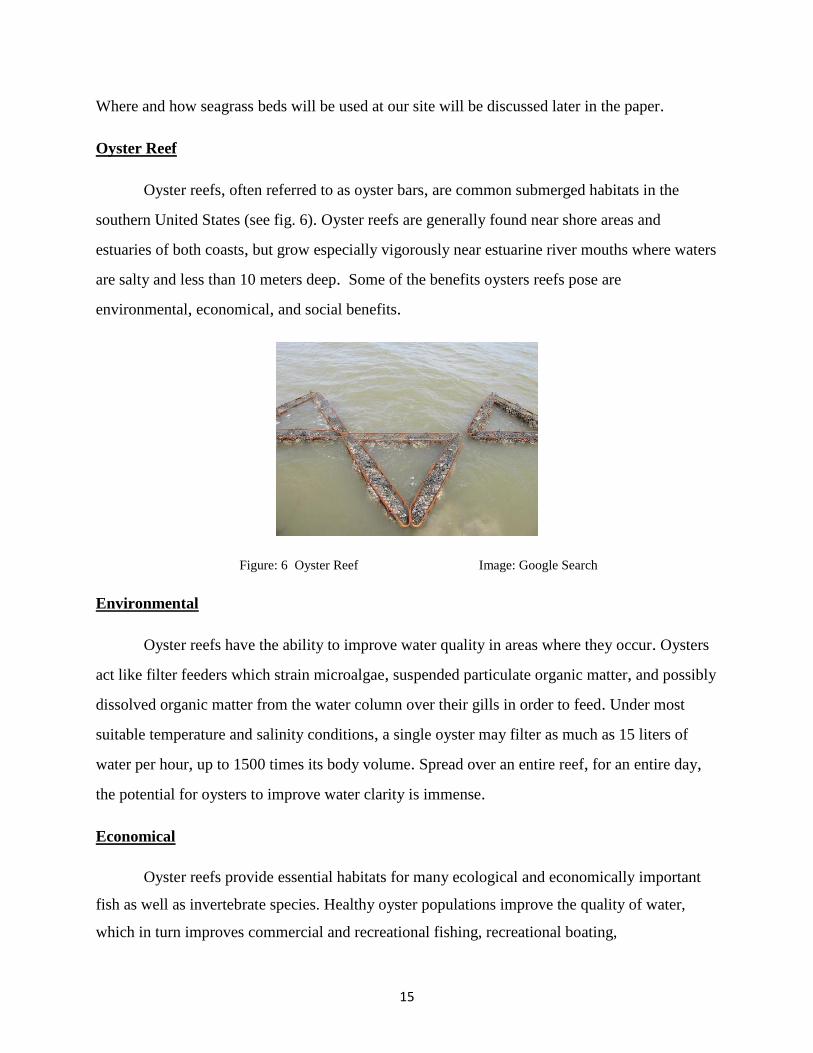
Oyster Reef
Oyster reefs, often referred to as oyster bars, are common submerged habitats in the
southern United States (see fig. 6). Oyster reefs are generally found near shore areas and
estuaries of both coasts, but grow especially vigorously near estuarine river mouths where waters
are salty and less than 10 meters deep. Some of the benefits oysters reefs pose are
environmental, economical, and social benefits.
Figure: 6 Oyster Reef Image: Google Search
Environmental
Oyster reefs have the ability to improve water quality in areas where they occur. Oysters
act like filter feeders which strain microalgae, suspended particulate organic matter, and possibly
dissolved organic matter from the water column over their gills in order to feed. Under most
suitable temperature and salinity conditions, a single oyster may filter as much as 15 liters of
water per hour, up to 1500 times its body volume. Spread over an entire reef, for an entire day,
the potential for oysters to improve water clarity is immense.
Economical
Oyster reefs provide essential habitats for many ecological and economically important
fish as well as invertebrate species. Healthy oyster populations improve the quality of water,
which in turn improves commercial and recreational fishing, recreational boating,

16
and ecotourism. The entire process is a cycle, if oyster reefs are restored the economy will
gradually come up again.
Social
Improved water clarity and overall cleaner water greatly increases recreational fishing,
boating and swimming. This allows locals and tourists to appreciate the environment around
them. In our case, the cleaner water would encourage the community members to come out in the
summer to go fishing or simply rent a boat at Boys & Girls Club and go boating with their kids.
17
Work Cited
Mystic River Watershed Association. (2011).Mystic river history . Retrieved from
http://mysticriver.org/history-of-the-mystic/
Mysticview Task Force, Initials. (2007). Middlesex avenue - part 2 of 2. Retrieved from
http://mysticview.org/walking_tour_middlesex_ave2.php
City of Somerville, Initials. (2011). Squares and neighborhoods - assembly square .
Retrieved from http://www.somervillema.gov/departments/ospcd/squares-and-
neighborhoods/assembly-square
Metzger, A. (2011, April 28). Money needed for somerville's assembly square scrutinized .
Retrieved from
http://www.wickedlocal.com/somerville/town_info/government/x401816925/Money
-needed-for-Somervilles-Assembly-Square-scrutinized#axzz1MXdwyhg4
Moskovitz, E. (2011, February 13). Assembly square station gets go-ahead, lifting hopes for
redevelopment of site into a riverfront complex . Retrieved from
http://articles.boston.com/2011-02-13/news/29345290_1_construction-bids-
economic-development-station
References
Smithsonian Marine Station, . (2002, June 28).Seagrass habitats . Retrieved from
http://www.sms.si.edu/irlspec/Seagrass_Habitat.htmhttp://www.dnr.sc.gov/marine/pub
/seascience/dynamic.html
Florida Department of Environmental Protection, . (2010, February 15). Salt Marshes. Retrieved
from http://www.dep.state.fl.us/coastal/habitats/saltmarshes.htmTaylor,
Peter. (2003) Salt Marsh Restoration: What Scientists Are Discovering Gulf of Maine Times.
Fall 2003; 7 (3),www.gulfofmaine.org/times/fall2003/science_insights.html (PDF)
Images
Figure I: Google Maps (Assembly Square, Somerville, MA)
Figure II: Google Maps (Assembly Square, Somerville, MA)
Figure III: Google Maps (Assembly Square, Somerville, MA)
Figure IV:
http://www.google.com/imgres?imgurl=http://science.kennesaw.edu/~jdirnber/oceanography/Le
cuturesOceanogr/LecSaltMarsh/salt_marsh.jpg

18
Figure V: http://www.sms.si.edu/irlspec/Seagrass_Habitat.htm
Figure VI: http://www.google.com/imgres?imgurl=http://www.treehugger.com/oyster-reefs.jpg