drilling results and resource update for …...drilling results and resource update for the rose...
TRANSCRIPT
DRILLING RESULTS AND RESOURCE UPDATE FOR THE
ROSE HILL GOLD PROJECT
HIGHLIGHTS
Initial infill and extensional drilling completed at Rose Hill near Coolgardie, 35km west of
Kalgoorlie-Boulder in the Western Australian goldfields
Rose Hill acquired as part of the asset swap with Northern Star Resources (ASX: NST) 1
Reverse circulation drilling totalled 12 holes for 1,200m to a maximum depth of 200m
Significant high grade results received include 2:
o 11m @ 8.79g/t Au from 43m (RHRC2006)
o 10m @ 6.28g/t Au from 28m (RHRC20001)
o 16m @ 4.10g/t Au from 93m (RHRC20012)
o 7m @ 7.26g/t Au from 27m (RHRC20009)
o 7m @ 3.76g/t Au from 45m (RHRC20007)
Drilling confirms high grade open cut and underground potential with mineralisation open
along strike and particularly at depth
Internal and independent review of acquired projects now complete
Mineral Resource estimate for Rose Hill stands at:
o 1.2Mt grading 2.49g/t Au for 95,200oz at a 0.7g/t Au cut-off grade 3
Further extensional and infill drilling programs planned at all projects in the second half 2020
Rose Hill joins Binduli and Teal as core satellite open cut and underground projects to
complement the base load Boorara gold project being assessed as part of the Feasibility
Study due for completion in the December Quarter 2020 4
Commenting on the Rose Hill results, Horizon Managing Director Mr Jon Price said:
“Rose Hill is certainly shaping up as a genuine contributor to our project pipeline demonstrating both
high grade open cut and underground potential with excellent widths and in close proximity to a
centralised processing plant being assessed at Boorara as part of the Feasibility Study. We now look
forward to further extensional and infill drilling at Rose Hill and our other core satellite projects to
complement the base load Boorara gold project.”
1 As announced to the ASX on 20 December 2019 2 See Table 2 and Competent Persons Statement on page 9 and JORC Tables on Page 17. 3 See Table 1 and Competent Persons Statement on Page 8, 14-15 and JORC Tables on Page 22. 4 See Forward Looking and Cautionary Statements on
Page 16
Page 2 of 35
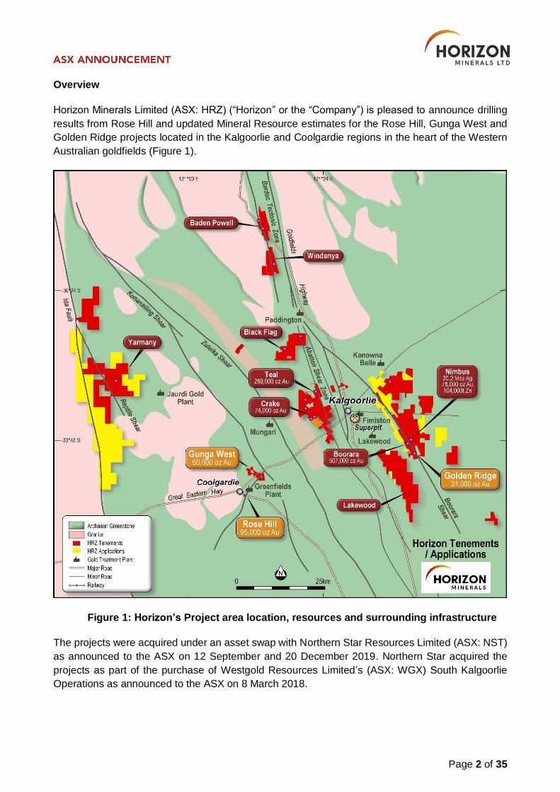
Overview
Horizon Minerals Limited (ASX: HRZ) (“Horizon” or the “Company”) is pleased to announce drilling
results from Rose Hill and updated Mineral Resource estimates for the Rose Hill, Gunga West and
Golden Ridge projects located in the Kalgoorlie and Coolgardie regions in the heart of the Western
Australian goldfields (Figure 1).
Figure 1: Horizon’s Project area location, resources and surrounding infrastructure
The projects were acquired under an asset swap with Northern Star Resources Limited (ASX: NST)
as announced to the ASX on 12 September and 20 December 2019. Northern Star acquired the
projects as part of the purchase of Westgold Resources Limited’s (ASX: WGX) South Kalgoorlie
Operations as announced to the ASX on 8 March 2018.
Page 3 of 35
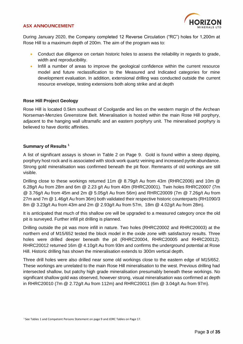
During January 2020, the Company completed 12 Reverse Circulation (“RC”) holes for 1,200m at
Rose Hill to a maximum depth of 200m. The aim of the program was to:
Conduct due diligence on certain historic holes to assess the reliability in regards to grade,
width and reproducibility.
Infill a number of areas to improve the geological confidence within the current resource
model and future reclassification to the Measured and Indicated categories for mine
development evaluation. In addition, extensional drilling was conducted outside the current
resource envelope, testing extensions both along strike and at depth
Rose Hill Project Geology
Rose Hill is located 0.5km southeast of Coolgardie and lies on the western margin of the Archean
Norseman-Menzies Greenstone Belt. Mineralisation is hosted within the main Rose Hill porphyry,
adjacent to the hanging wall ultramafic and an eastern porphyry unit. The mineralised porphyry is
believed to have dioritic affinities.
Summary of Results 1
A list of significant assays is shown in Table 2 on Page 9. Gold is found within a steep dipping,
porphyry host rock and is associated with stock work quartz veining and increased pyrite abundance.
Strong gold mineralisation was confirmed beneath the pit floor. Remnants of old workings are still
visible.
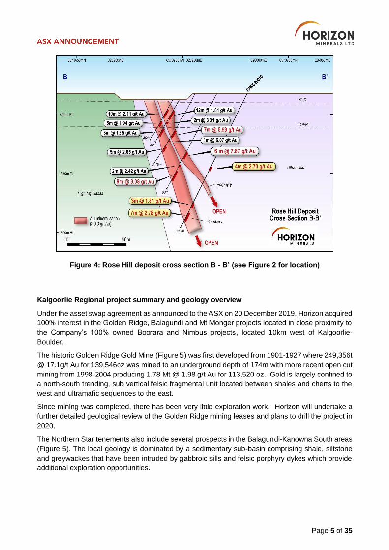
Drilling close to these workings returned 11m @ 8.79g/t Au from 43m (RHRC2006) and 10m @
6.28g/t Au from 28m and 6m @ 2.23 g/t Au from 40m (RHRC20001). Twin holes RHRC20007 (7m
@ 3.76g/t Au from 45m and 2m @ 5.05g/t Au from 56m) and RHRC20009 (7m @ 7.26g/t Au from
27m and 7m @ 1.46g/t Au from 36m) both validated their respective historic counterparts (RH1090/3
8m @ 3.23g/t Au from 43m and 2m @ 2.93g/t Au from 57m, 18m @ 4.02g/t Au from 28m).
It is anticipated that much of this shallow ore will be upgraded to a measured category once the old
pit is surveyed. Further infill pit drilling is planned.
Drilling outside the pit was more infill in nature. Two holes (RHRC20002 and RHRC20003) at the
northern end of M15/652 tested the block model in the oxide zone with satisfactory results. Three
holes were drilled deeper beneath the pit (RHRC20004, RHRC20005 and RHRC20012).
RHRC20012 returned 16m @ 4.10g/t Au from 93m and confirms the underground potential at Rose
Hill. Historic drilling has shown the mineralisation extends to 300m vertical depth.
Three drill holes were also drilled near some old workings close to the eastern edge of M15/652.
These workings are unrelated to the main Rose Hill mineralisation to the west. Previous drilling had
intersected shallow, but patchy high grade mineralisation presumably beneath these workings. No
significant shallow gold was observed, however strong, visual mineralisation was confirmed at depth
in RHRC20010 (7m @ 2.72g/t Au from 112m) and RHRC20011 (6m @ 3.04g/t Au from 97m).
1 See Tables 1 and Competent Persons Statement on page 9 and JORC Tables on Page 17.
Page 4 of 35
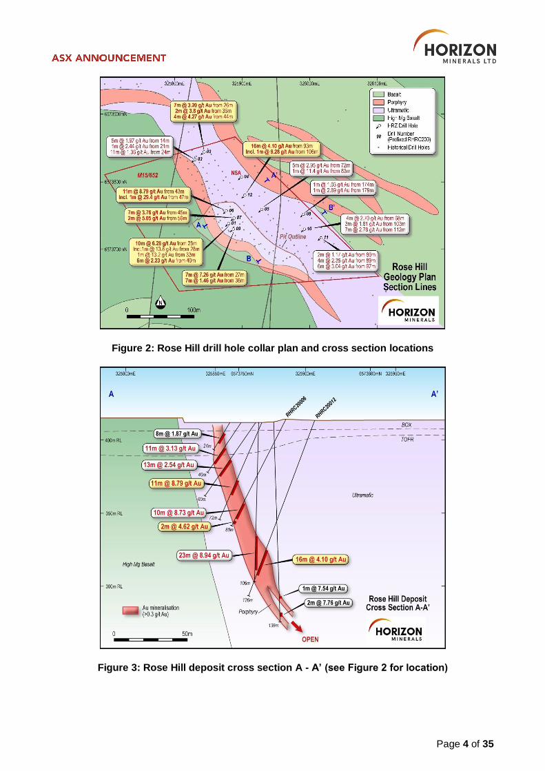
Figure 2: Rose Hill drill hole collar plan and cross section locations
Figure 3: Rose Hill deposit cross section A - A’ (see Figure 2 for location)
Page 5 of 35
Figure 4: Rose Hill deposit cross section B - B’ (see Figure 2 for location)
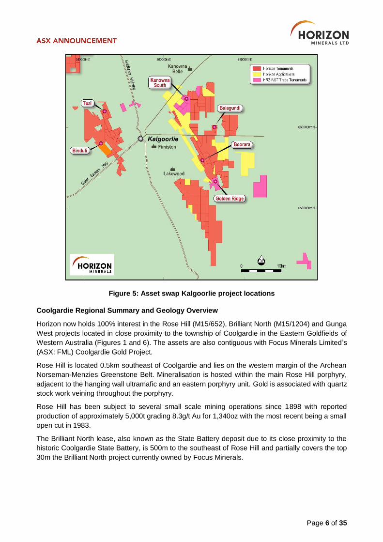
Kalgoorlie Regional project summary and geology overview
Under the asset swap agreement as announced to the ASX on 20 December 2019, Horizon acquired
100% interest in the Golden Ridge, Balagundi and Mt Monger projects located in close proximity to
the Company’s 100% owned Boorara and Nimbus projects, located 10km west of Kalgoorlie-
Boulder.
The historic Golden Ridge Gold Mine (Figure 5) was first developed from 1901-1927 where 249,356t
@ 17.1g/t Au for 139,546oz was mined to an underground depth of 174m with more recent open cut
mining from 1998-2004 producing 1.78 Mt @ 1.98 g/t Au for 113,520 oz. Gold is largely confined to
a north-south trending, sub vertical felsic fragmental unit located between shales and cherts to the
west and ultramafic sequences to the east.
Since mining was completed, there has been very little exploration work. Horizon will undertake a
further detailed geological review of the Golden Ridge mining leases and plans to drill the project in
2020.
The Northern Star tenements also include several prospects in the Balagundi-Kanowna South areas
(Figure 5). The local geology is dominated by a sedimentary sub-basin comprising shale, siltstone
and greywackes that have been intruded by gabbroic sills and felsic porphyry dykes which provide
additional exploration opportunities.
Page 6 of 35
Figure 5: Asset swap Kalgoorlie project locations
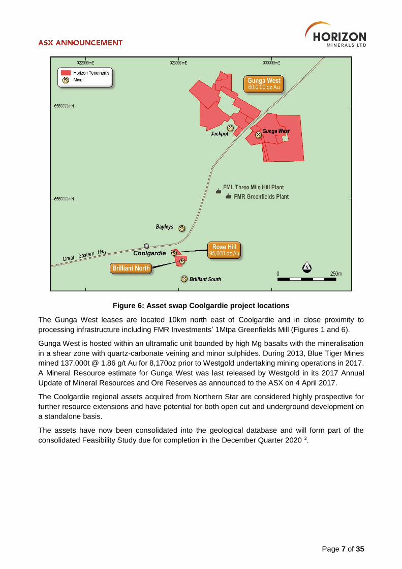
Coolgardie Regional Summary and Geology Overview
Horizon now holds 100% interest in the Rose Hill (M15/652), Brilliant North (M15/1204) and Gunga
West projects located in close proximity to the township of Coolgardie in the Eastern Goldfields of
Western Australia (Figures 1 and 6). The assets are also contiguous with Focus Minerals Limited’s
(ASX: FML) Coolgardie Gold Project.
Rose Hill is located 0.5km southeast of Coolgardie and lies on the western margin of the Archean
Norseman-Menzies Greenstone Belt. Mineralisation is hosted within the main Rose Hill porphyry,
adjacent to the hanging wall ultramafic and an eastern porphyry unit. Gold is associated with quartz
stock work veining throughout the porphyry.
Rose Hill has been subject to several small scale mining operations since 1898 with reported
production of approximately 5,000t grading 8.3g/t Au for 1,340oz with the most recent being a small
open cut in 1983.
The Brilliant North lease, also known as the State Battery deposit due to its close proximity to the
historic Coolgardie State Battery, is 500m to the southeast of Rose Hill and partially covers the top
30m the Brilliant North project currently owned by Focus Minerals.
Page 7 of 35
Figure 6: Asset swap Coolgardie project locations
The Gunga West leases are located 10km north east of Coolgardie and in close proximity to
processing infrastructure including FMR Investments’ 1Mtpa Greenfields Mill (Figures 1 and 6).
Gunga West is hosted within an ultramafic unit bounded by high Mg basalts with the mineralisation
in a shear zone with quartz-carbonate veining and minor sulphides. During 2013, Blue Tiger Mines
mined 137,000t @ 1.86 g/t Au for 8,170oz prior to Westgold undertaking mining operations in 2017.
A Mineral Resource estimate for Gunga West was last released by Westgold in its 2017 Annual
Update of Mineral Resources and Ore Reserves as announced to the ASX on 4 April 2017.
The Coolgardie regional assets acquired from Northern Star are considered highly prospective for
further resource extensions and have potential for both open cut and underground development on
a standalone basis.
The assets have now been consolidated into the geological database and will form part of the
consolidated Feasibility Study due for completion in the December Quarter 2020 2.
Page 8 of 35
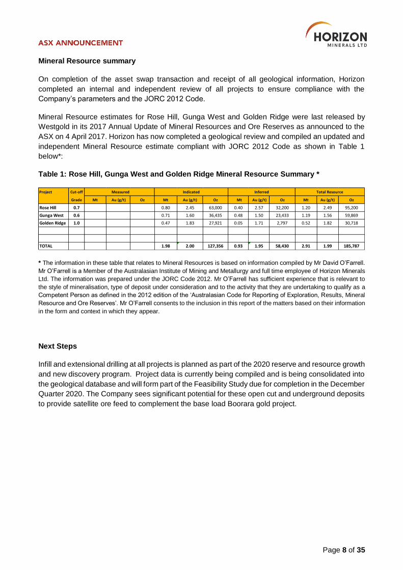
Mineral Resource summary
On completion of the asset swap transaction and receipt of all geological information, Horizon
completed an internal and independent review of all projects to ensure compliance with the
Company’s parameters and the JORC 2012 Code.
Mineral Resource estimates for Rose Hill, Gunga West and Golden Ridge were last released by
Westgold in its 2017 Annual Update of Mineral Resources and Ore Reserves as announced to the
ASX on 4 April 2017. Horizon has now completed a geological review and compiled an updated and
independent Mineral Resource estimate compliant with JORC 2012 Code as shown in Table 1
below*:
Table 1: Rose Hill, Gunga West and Golden Ridge Mineral Resource Summary *
* The information in these table that relates to Mineral Resources is based on information compiled by Mr David O’Farrell.
Mr O’Farrell is a Member of the Australasian Institute of Mining and Metallurgy and full time employee of Horizon Minerals
Ltd. The information was prepared under the JORC Code 2012. Mr O’Farrell has sufficient experience that is relevant to
the style of mineralisation, type of deposit under consideration and to the activity that they are undertaking to qualify as a
Competent Person as defined in the 2012 edition of the ‘Australasian Code for Reporting of Exploration, Results, Mineral
Resource and Ore Reserves’. Mr O’Farrell consents to the inclusion in this report of the matters based on their information
in the form and context in which they appear.
Next Steps
Infill and extensional drilling at all projects is planned as part of the 2020 reserve and resource growth
and new discovery program. Project data is currently being compiled and is being consolidated into
the geological database and will form part of the Feasibility Study due for completion in the December
Quarter 2020. The Company sees significant potential for these open cut and underground deposits
to provide satellite ore feed to complement the base load Boorara gold project.
Project Cut-off
Grade Mt Au (g/t) Oz Mt Au (g/t) Oz Mt Au (g/t) Oz Mt Au (g/t) Oz
Rose Hill 0.7 0.80 2.45 63,000 0.40 2.57 32,200 1.20 2.49 95,200
Gunga West 0.6 0.71 1.60 36,435 0.48 1.50 23,433 1.19 1.56 59,869
Golden Ridge 1.0 0.47 1.83 27,921 0.05 1.71 2,797 0.52 1.82 30,718
TOTAL 1.98 2.00 127,356 0.93 1.95 58,430 2.91 1.99 185,787
Measured Indicated Inferred Total Resource
Page 9 of 35
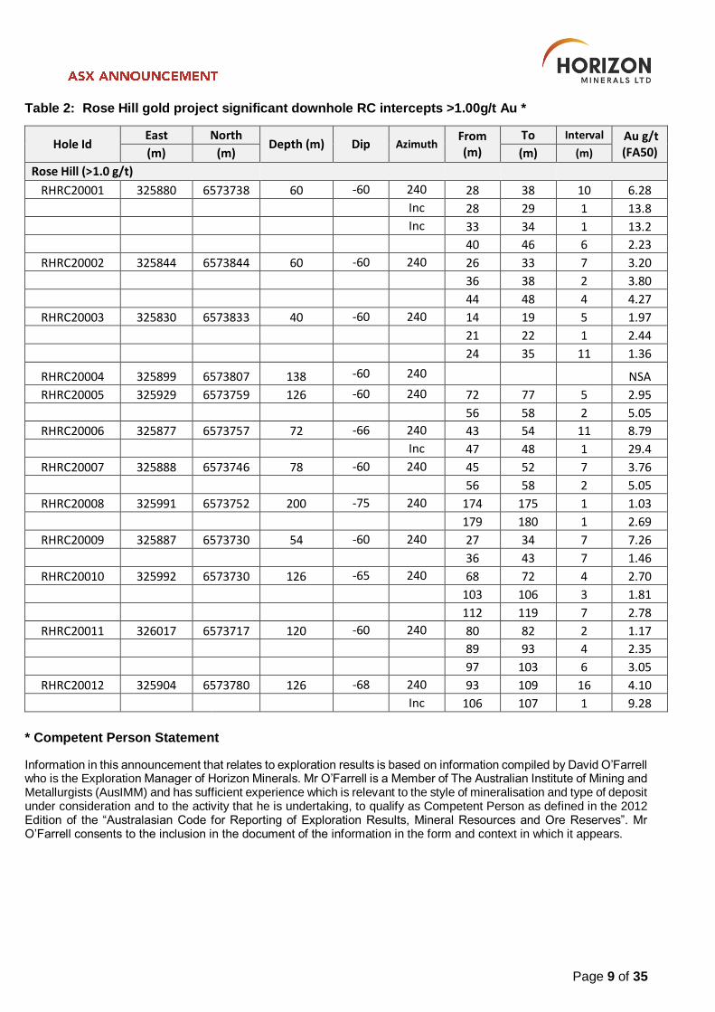
Table 2: Rose Hill gold project significant downhole RC intercepts >1.00g/t Au *
Hole Id East North
Depth (m) Dip Azimuth From (m)
To Interval Au g/t (FA50) (m) (m) (m) (m)
Rose Hill (>1.0 g/t)
RHRC20001 325880 6573738 60 -60 240 28 38 10 6.28
Inc 28 29 1 13.8
Inc 33 34 1 13.2
40 46 6 2.23
RHRC20002 325844 6573844 60 -60 240 26 33 7 3.20
36 38 2 3.80
44 48 4 4.27
RHRC20003 325830 6573833 40 -60 240 14 19 5 1.97
21 22 1 2.44
24 35 11 1.36
RHRC20004 325899 6573807 138 -60 240 NSA
RHRC20005 325929 6573759 126 -60 240 72 77 5 2.95
56 58 2 5.05
RHRC20006 325877 6573757 72 -66 240 43 54 11 8.79
Inc 47 48 1 29.4
RHRC20007 325888 6573746 78 -60 240 45 52 7 3.76
56 58 2 5.05
RHRC20008 325991 6573752 200 -75 240 174 175 1 1.03
179 180 1 2.69
RHRC20009 325887 6573730 54 -60 240 27 34 7 7.26
36 43 7 1.46
RHRC20010 325992 6573730 126 -65 240 68 72 4 2.70
103 106 3 1.81
112 119 7 2.78
RHRC20011 326017 6573717 120 -60 240 80 82 2 1.17
89 93 4 2.35
97 103 6 3.05
RHRC20012 325904 6573780 126 -68 240 93 109 16 4.10
Inc 106 107 1 9.28
* Competent Person Statement
Information in this announcement that relates to exploration results is based on information compiled by David O’Farrell who is the Exploration Manager of Horizon Minerals. Mr O’Farrell is a Member of The Australian Institute of Mining and Metallurgists (AusIMM) and has sufficient experience which is relevant to the style of mineralisation and type of deposit under consideration and to the activity that he is undertaking, to qualify as Competent Person as defined in the 2012 Edition of the “Australasian Code for Reporting of Exploration Results, Mineral Resources and Ore Reserves”. Mr O’Farrell consents to the inclusion in the document of the information in the form and context in which it appears.
Page 10 of 35
Listing Rule 5.8.1 Disclosures
The following information is based on a detailed review of the Rose Hill, Gunga West and Golden
Ridge Deposits as stated by Westgold in its 2017 Annual Update of Mineral Resources and Ore
Reserves. Much of the data relating to these resources has been obtained from Northern Star. Other
reports necessary to this release have come from WAMEX, online research and data packages from
companies who have previously held these project areas. All three projects areas have had a number
of resource calculations and reports completed in the past. The documentation of the drilling,
sampling, assaying, estimating methodology etc. has been in accordance with current JORC 2012
guidelines.
As part of the review, Horizon has undertaken its own resource modelling, using Micromine 2020
and ID2 to compare with the WGX resources. Site visits to all areas have also been conducted with
a view to checking drill holes and collars, pits and remnant stockpiles. Discussions with geologists
and miners involved in these projects when active have also contributed to a better understanding
of the historic work.
Geology and Geological Interpretation
The Rose Hill and Brilliant deposits lie on the western margin of the Archaean Norseman – Menzies
Greenstone Belt. Host rocks at Brilliant are a sequence of Archaean Basalts and Ultramafics, which
have been intruded by a suite of porphyry dykes (also described as granodiorites). The porphyries
host the bulk of the mineralisation, occurring in two orientations, steeply dipping (70 - 80°) with an
average width of 3 - 5m, or flatter dipping (20 - 40°) with widths of up to 2m. Mineralisation consists
of a stock work of quartz / sulphide micro-veining and albitic alteration of the porphyry. The Porphyry
is truncated by two NE trending faults that are associated with higher grades.
At Gunga West, the mineralisation is hosted within the Bonnie Vale Ultramafics which sit juxtaposed
against an eastern sequence of deformed felsic volcaniclastics sediments and gabbroic sills.
The Golden Ridge orebody is situated on the Boorara Shear within a lenticular northwest-southeast
trending sub vertical quartz-feldspar porphyry unit, which is assumed to be the lateral equivalent to
felsic schists which also host gold mineralisation in the Boorara area further to the north (Keats,
1987). The porphyry unit is fault bounded to the east by a package of chloritic serpentinised sheared
ultramafic and to the west by metasediments (shales, graphitic shales and cherts). The porphyry is
thought to be intrusive in the immediate vicinity of the mine area but extrusive (flow textures visible)
to the north towards Boorara.
Page 11 of 35
Sampling, Sub-sampling and Database
Samples were usually collected by a cone splitter off the RC rig with sampling protocols in place.
The samples were routinely taken on 1m intervals and weighed around 2.5kg. Duplicates were
regularly taken.
Database checks were completed and included checking for:
Checking for duplicate drill hole names and duplicate coordinates in the collar table.
Checking for missing drill holes in the collar, survey, assay and geology tables based on drill hole names.
Checking for survey inconsistencies including dips and azimuths <0o, dips >90o, azimuths >360o, negative depth values.
Checking for inconsistencies in the “From” and “To” fields of the assay and geology tables. The inconsistency checks included the identification of negative values, overlapping intervals, duplicate intervals, gaps and intervals where the “From” value is greater than “To” value.
Database checks were conducted within Microsoft Excel, Access and Micromine and Surpac Mining
Software. Data has been validated against WAMEX data but no checks have been made against
hardcopy data.
Sample Analysis Method
In house laboratory QAQC checks and standards, plus company inserted standards, duplicates and
blanks were regularly used and deemed acceptable. A lot of the historical work was directed to
areas that have subsequently been mined. The sample was then crushed and pulverised (90%
passing -75um) and split to either a 30g or 50g charge weight for fire assaying (AAS finish) to 0.01
ppm Au detection limit
Drilling Techniques
No drilling has been carried out at Rose Hill since the 2014 Metals X model was completed. Horizon
has recently undertaken due diligence drilling with results being compiled. At Gunga West the
majority of drill holes were RC with tight drill spacings of 12.5m (N) x 10m (E). At Golden Ridge the
RC drilling varied from 50m (N) x 30m (E) to 10m (N) x 5m (S). Drill holes were noted as being
surveyed in by RTK GPS. Downhole surveys of deeper drill holes were routinely taken.
Estimation Methodology
RC, RC/DDH and DD holes were used for the estimates. Only gold has been reported. The block
models were estimated using Inverse Distance Squared (ID2) and Ordinary Kriging. Mineralised lodes
or domains were created by joining and wire framing individual cross sections. Typically a nominal 0.2-
0.3g/t boundary interpretation was utilised. Internal dilutions were normally 2m. A soft boundary
estimate was employed for domains effected by changing strike orientations within the lode. Parent
block cells (~10m) were usually one half of the average drill spacing (~20m). Sub blocks (~5m) were
typically one half of the parent blocks.
DTM models of the surface, voids, oxidation and top of fresh rock were also created and used.
Page 12 of 35
Block Model and Optimisation
The domaining or interpretation strategy was based around previous estimation processes with all
domains re-interpreted. Mineralisation wireframes were guided by geology and geological
boundaries; however, wall alteration in adjacent units was often included in the domaining process.
Wireframes were snapped to honour all drilling. In cases a geological model was also created and
used in the estimation process.
Validation had been carried out using Surpac. This comprised statistical comparisons, comparing
composite grades against estimated grades in a spatial context. The resultant profile plots showed
a general smoothing of the composite data typical of the interpolation method.
Surpac macros were created to aid in testing the sample data for optimised block size, maximum
number of samples and maximum search. The latter 2 tests are for the first pass interpolations. The
test involves comparing the Kriging Efficiency against the Conditional Bias Slope at the point where
they are close to 1 and the results become static or flat.
Interpolation
Model validation was undertaken for all major domains. Block estimates compared well with the input
data on a domain by domain basis where there were sufficient informing samples. Some local under
and over-estimation was noted on sections.
Local search orientations were derived for each domain and search ellipses and min/max samples modified as per the interpolated pass number (1, 2 and 3). Bulk Density
Bulk density data for Rose Hill was based on historical estimates and claimed production records and are consistent with other similar deposits in the goldfields. Tonnes are estimated on a dry basis.
o Oxide: 1.8g/cm³ used for the material above the BOCO weathering profile
o Transition: 2.40g/cm³ used for the material between the BOCO and TOFR weathering profiles
o Fresh Rock: 2.75g/cm³ used for the fresh rock material below the TOFR weathering profile
At Golden Ridge, densities of 1.8 g/cm3, 2.25 g/cm3 and 2.7g/cm3 were used accordingly. Similar numbers were assigned at Gunga West. Horizon has not validated the density data, but due to extensive experience in the Kalgoorlie region the data is considered acceptable.
Resource Classification The resource classification is based on drill density, geological continuity and data quality. The resource at Rose Hill was downgraded from Indicated/Inferred (WGX 2017) to Inferred only to concur with JORC 2012 compliance. The resources at Golden Ridge and Gunga West remain in the Indicated/Inferred category as the drill density was particularly high around the pit areas.
Page 13 of 35
Cut-off Grade
Minimum cut off grades have been applied to Golden Ridge, Gunga West and Rose Hill. A top cut
was applied at Rose Hill to alleviate issues of local over estimation – an effect that may result from
large numbers of high grade assays “swamping” lower grade samples during the estimation process.
Similarly local under estimation may also occur with lower grade samples. Top cuts were typically
derived from analysis (grade histograms, log probability plots) and applied on a domain basis.
At Rose Hill, a distance based top cut was applied to all domains to limit the influence of high grades
being spread over large distances i.e. on the periphery of lodes or at depth where there are often
few informing samples. Samples with grades above 10g/t Au were removed from the estimate after
the range of the 2nd variogram structure had been passed (variable range dependent on domain).
Mining and Metallurgical Methods and Parameters and other modifying factors considered
Horizon will undertake optimisation studies, specifically for a potential open cut and underground
mine development in the future. Further drilling to increase resources and confidence is planned for
2020.
Metallurgical test work has been completed for all projects and further confirmatory work is planned.
In additional, Gunga West and Golden Ridge have been mined previously and the ore treated at a
number of conventional ore processing facilities. Mine to mill reconciliation data has been reviewed
supporting metallurgical recoveries >90%.
For further information, please contact:
Jon Price Michael Vaughan
Managing Director Media Relations – Fivemark Partners
Tel: +61 8 9386 9534 Tel: +61 422 602 720
Page 14 of 35
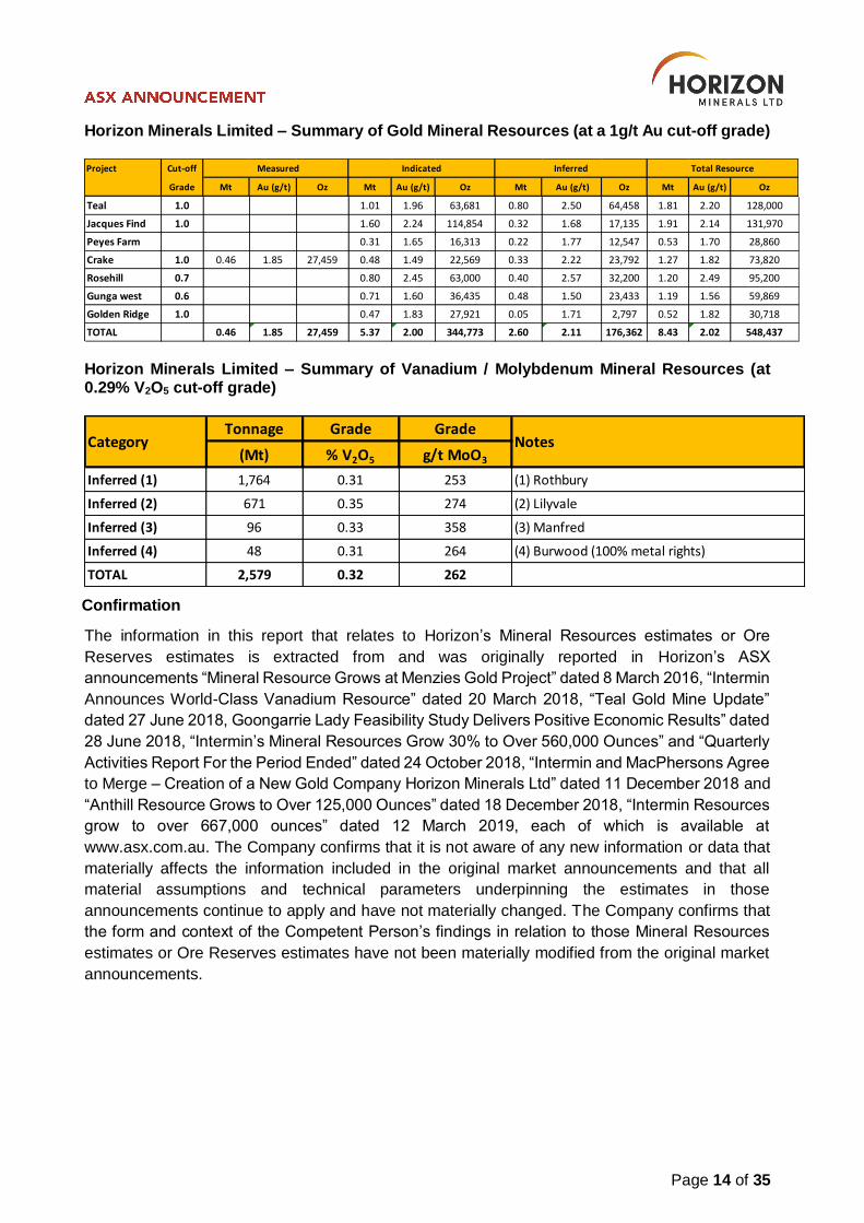
Horizon Minerals Limited – Summary of Gold Mineral Resources (at a 1g/t Au cut-off grade)
Horizon Minerals Limited – Summary of Vanadium / Molybdenum Mineral Resources (at 0.29% V2O5 cut-off grade)
Confirmation
The information in this report that relates to Horizon’s Mineral Resources estimates or Ore
Reserves estimates is extracted from and was originally reported in Horizon’s ASX
announcements “Mineral Resource Grows at Menzies Gold Project” dated 8 March 2016, “Intermin
Announces World-Class Vanadium Resource” dated 20 March 2018, “Teal Gold Mine Update”
dated 27 June 2018, Goongarrie Lady Feasibility Study Delivers Positive Economic Results” dated
28 June 2018, “Intermin’s Mineral Resources Grow 30% to Over 560,000 Ounces” and “Quarterly
Activities Report For the Period Ended” dated 24 October 2018, “Intermin and MacPhersons Agree
to Merge – Creation of a New Gold Company Horizon Minerals Ltd” dated 11 December 2018 and
“Anthill Resource Grows to Over 125,000 Ounces” dated 18 December 2018, “Intermin Resources
grow to over 667,000 ounces” dated 12 March 2019, each of which is available at
www.asx.com.au. The Company confirms that it is not aware of any new information or data that
materially affects the information included in the original market announcements and that all
material assumptions and technical parameters underpinning the estimates in those
announcements continue to apply and have not materially changed. The Company confirms that
the form and context of the Competent Person’s findings in relation to those Mineral Resources
estimates or Ore Reserves estimates have not been materially modified from the original market
announcements.
Project Cut-off
Grade Mt Au (g/t) Oz Mt Au (g/t) Oz Mt Au (g/t) Oz Mt Au (g/t) Oz
Teal 1.0 1.01 1.96 63,681 0.80 2.50 64,458 1.81 2.20 128,000
Jacques Find 1.0 1.60 2.24 114,854 0.32 1.68 17,135 1.91 2.14 131,970
Peyes Farm 0.31 1.65 16,313 0.22 1.77 12,547 0.53 1.70 28,860
Crake 1.0 0.46 1.85 27,459 0.48 1.49 22,569 0.33 2.22 23,792 1.27 1.82 73,820
Rosehill 0.7 0.80 2.45 63,000 0.40 2.57 32,200 1.20 2.49 95,200
Gunga west 0.6 0.71 1.60 36,435 0.48 1.50 23,433 1.19 1.56 59,869
Golden Ridge 1.0 0.47 1.83 27,921 0.05 1.71 2,797 0.52 1.82 30,718
TOTAL 0.46 1.85 27,459 5.37 2.00 344,773 2.60 2.11 176,362 8.43 2.02 548,437
Measured Indicated Inferred Total Resource
Tonnage Grade Grade
(Mt) % V2O5 g/t MoO3
Inferred (1) 1,764 0.31 253 (1) Rothbury
Inferred (2) 671 0.35 274 (2) Lilyvale
Inferred (3) 96 0.33 358 (3) Manfred
Inferred (4) 48 0.31 264 (4) Burwood (100% metal rights)
TOTAL 2,579 0.32 262
Category Notes
Page 15 of 35
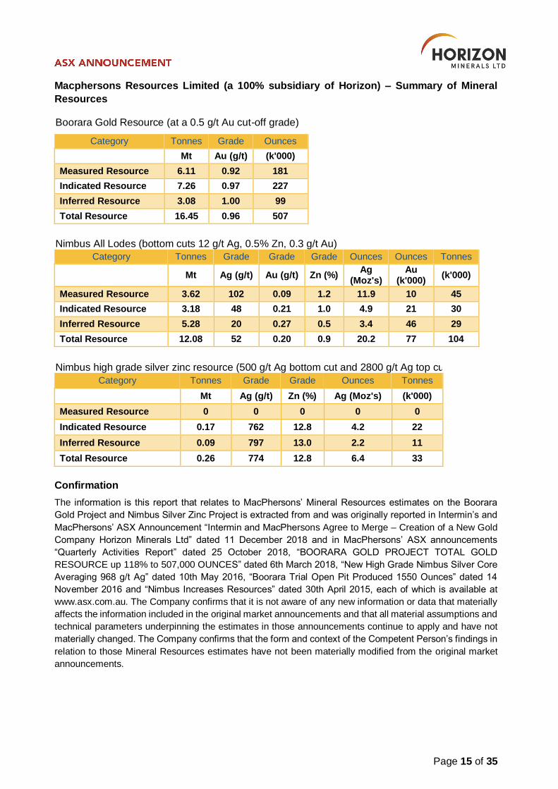
Macphersons Resources Limited (a 100% subsidiary of Horizon) – Summary of Mineral
Resources
Boorara Gold Resource (at a 0.5 g/t Au cut-off grade)
Category Tonnes Grade Ounces
Mt Au (g/t) (k'000)
Measured Resource 6.11 0.92 181
Indicated Resource 7.26 0.97 227
Inferred Resource 3.08 1.00 99
Total Resource 16.45 0.96 507
Nimbus All Lodes (bottom cuts 12 g/t Ag, 0.5% Zn, 0.3 g/t Au) Category Tonnes Grade Grade Grade Ounces Ounces Tonnes
Mt Ag (g/t) Au (g/t) Zn (%) Ag
(Moz's) Au
(k'000) (k'000)
Measured Resource 3.62 102 0.09 1.2 11.9 10 45
Indicated Resource 3.18 48 0.21 1.0 4.9 21 30
Inferred Resource 5.28 20 0.27 0.5 3.4 46 29
Total Resource 12.08 52 0.20 0.9 20.2 77 104
Nimbus high grade silver zinc resource (500 g/t Ag bottom cut and 2800 g/t Ag top cut)
Category Tonnes Grade Grade Ounces Tonnes
Mt Ag (g/t) Zn (%) Ag (Moz's) (k'000)
Measured Resource 0 0 0 0 0
Indicated Resource 0.17 762 12.8 4.2 22
Inferred Resource 0.09 797 13.0 2.2 11
Total Resource 0.26 774 12.8 6.4 33
Confirmation
The information is this report that relates to MacPhersons’ Mineral Resources estimates on the Boorara
Gold Project and Nimbus Silver Zinc Project is extracted from and was originally reported in Intermin’s and
MacPhersons’ ASX Announcement “Intermin and MacPhersons Agree to Merge – Creation of a New Gold
Company Horizon Minerals Ltd” dated 11 December 2018 and in MacPhersons’ ASX announcements
“Quarterly Activities Report” dated 25 October 2018, “BOORARA GOLD PROJECT TOTAL GOLD
RESOURCE up 118% to 507,000 OUNCES” dated 6th March 2018, “New High Grade Nimbus Silver Core
Averaging 968 g/t Ag” dated 10th May 2016, “Boorara Trial Open Pit Produced 1550 Ounces” dated 14
November 2016 and “Nimbus Increases Resources” dated 30th April 2015, each of which is available at
www.asx.com.au. The Company confirms that it is not aware of any new information or data that materially
affects the information included in the original market announcements and that all material assumptions and
technical parameters underpinning the estimates in those announcements continue to apply and have not
materially changed. The Company confirms that the form and context of the Competent Person’s findings in
relation to those Mineral Resources estimates have not been materially modified from the original market
announcements.
Page 16 of 35
Forward Looking and Cautionary Statements
Some statements in this report regarding estimates or future events are forward looking
statements. They include indications of, and guidance on, future earnings, cash flow, costs and
financial performance. Forward looking statements include, but are not limited to, statements
preceded by words such as “planned”, “expected”, “projected”, “estimated”, “may”, “scheduled”,
“intends”, “anticipates”, “believes”, “potential”, “could”, “nominal”, “conceptual” and similar
expressions. Forward looking statements, opinions and estimates included in this announcement
are based on assumptions and contingencies which are subject to change without notice, as are
statements about market and industry trends, which are based on interpretations of current market
conditions. Forward looking statements are provided as a general guide only and should not be
relied on as a guarantee of future performance. Forward looking statements may be affected by a
range of variables that could cause actual results to differ from estimated results, and may cause
the Company’s actual performance and financial results in future periods to materially differ from
any projections of future performance or results expressed or implied by such forward looking
statements. These risks and uncertainties include but are not limited to liabilities inherent in mine
development and production, geological, mining and processing technical problems, the inability
to obtain any additional mine licenses, permits and other regulatory approvals required in
connection with mining and third party processing operations, competition for among other things,
capital, acquisition of reserves, undeveloped lands and skilled personnel, incorrect assessments
of the value of acquisitions, changes in commodity prices and exchange rate, currency and interest
fluctuations, various events which could disrupt operations and/or the transportation of mineral
products, including labour stoppages and severe weather conditions, the demand for and
availability of transportation services, the ability to secure adequate financing and management’s
ability to anticipate and manage the foregoing factors and risks. There can be no assurance that
forward looking statements will prove to be correct.
Statements regarding plans with respect to the Company’s mineral properties may contain forward
looking statements in relation to future matters that can only be made where the Company has a
reasonable basis for making those statements.
This announcement has been prepared in compliance with the JORC Code (2012) and the current
ASX Listing Rules.
The Company believes that it has a reasonable basis for making the forward looking statements
in the announcement, including with respect to any production targets and financial estimates,
based on the information contained in this and previous ASX announcements.
Page 17 of 35
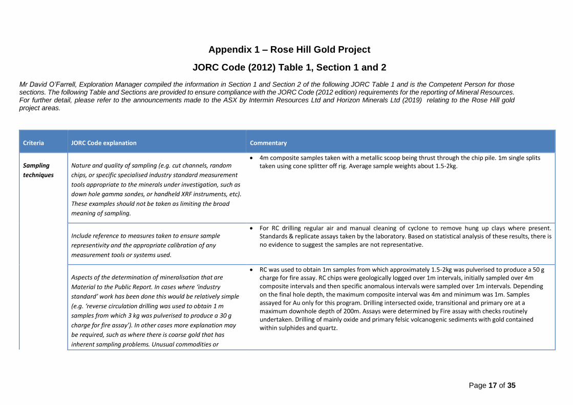
Appendix 1 – Rose Hill Gold Project
JORC Code (2012) Table 1, Section 1 and 2 Mr David O’Farrell, Exploration Manager compiled the information in Section 1 and Section 2 of the following JORC Table 1 and is the Competent Person for those sections. The following Table and Sections are provided to ensure compliance with the JORC Code (2012 edition) requirements for the reporting of Mineral Resources. For further detail, please refer to the announcements made to the ASX by Intermin Resources Ltd and Horizon Minerals Ltd (2019) relating to the Rose Hill gold project areas.
Criteria JORC Code explanation Commentary
Sampling
techniques
Nature and quality of sampling (e.g. cut channels, random
chips, or specific specialised industry standard measurement
tools appropriate to the minerals under investigation, such as
down hole gamma sondes, or handheld XRF instruments, etc).
These examples should not be taken as limiting the broad
meaning of sampling.
4m composite samples taken with a metallic scoop being thrust through the chip pile. 1m single splits taken using cone splitter off rig. Average sample weights about 1.5-2kg.
Include reference to measures taken to ensure sample
representivity and the appropriate calibration of any
measurement tools or systems used.
For RC drilling regular air and manual cleaning of cyclone to remove hung up clays where present. Standards & replicate assays taken by the laboratory. Based on statistical analysis of these results, there is no evidence to suggest the samples are not representative.
Aspects of the determination of mineralisation that are
Material to the Public Report. In cases where ‘industry
standard’ work has been done this would be relatively simple
(e.g. ‘reverse circulation drilling was used to obtain 1 m
samples from which 3 kg was pulverised to produce a 30 g
charge for fire assay’). In other cases more explanation may
be required, such as where there is coarse gold that has
inherent sampling problems. Unusual commodities or
RC was used to obtain 1m samples from which approximately 1.5-2kg was pulverised to produce a 50 g charge for fire assay. RC chips were geologically logged over 1m intervals, initially sampled over 4m composite intervals and then specific anomalous intervals were sampled over 1m intervals. Depending on the final hole depth, the maximum composite interval was 4m and minimum was 1m. Samples assayed for Au only for this program. Drilling intersected oxide, transitional and primary ore at a maximum downhole depth of 200m. Assays were determined by Fire assay with checks routinely undertaken. Drilling of mainly oxide and primary felsic volcanogenic sediments with gold contained within sulphides and quartz.
Page 18 of 35
Criteria JORC Code explanation Commentary
mineralisation types (e.g. submarine nodules) may warrant
disclosure of detailed information.
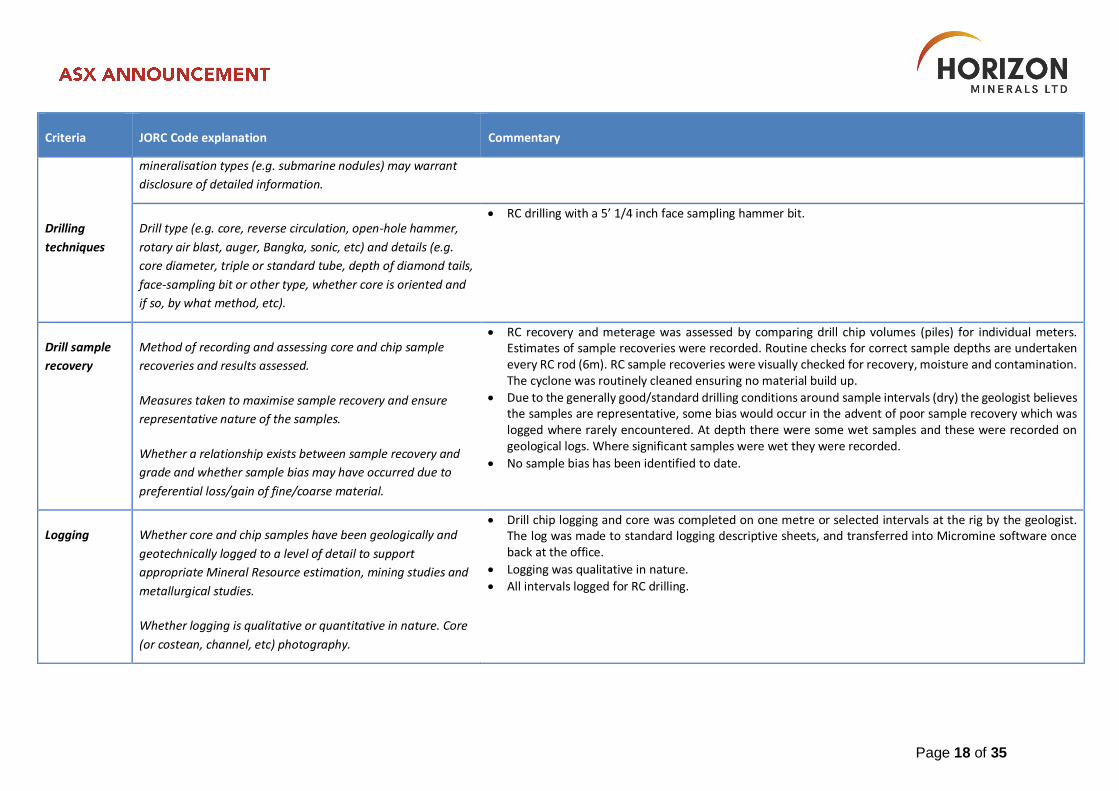
Drilling
techniques
Drill type (e.g. core, reverse circulation, open-hole hammer,
rotary air blast, auger, Bangka, sonic, etc) and details (e.g.
core diameter, triple or standard tube, depth of diamond tails,
face-sampling bit or other type, whether core is oriented and
if so, by what method, etc).
RC drilling with a 5’ 1/4 inch face sampling hammer bit.
Drill sample
recovery
Method of recording and assessing core and chip sample
recoveries and results assessed.
Measures taken to maximise sample recovery and ensure
representative nature of the samples.
Whether a relationship exists between sample recovery and
grade and whether sample bias may have occurred due to
preferential loss/gain of fine/coarse material.
RC recovery and meterage was assessed by comparing drill chip volumes (piles) for individual meters. Estimates of sample recoveries were recorded. Routine checks for correct sample depths are undertaken every RC rod (6m). RC sample recoveries were visually checked for recovery, moisture and contamination. The cyclone was routinely cleaned ensuring no material build up.
Due to the generally good/standard drilling conditions around sample intervals (dry) the geologist believes the samples are representative, some bias would occur in the advent of poor sample recovery which was logged where rarely encountered. At depth there were some wet samples and these were recorded on geological logs. Where significant samples were wet they were recorded.
No sample bias has been identified to date.
Logging Whether core and chip samples have been geologically and
geotechnically logged to a level of detail to support
appropriate Mineral Resource estimation, mining studies and
metallurgical studies.
Whether logging is qualitative or quantitative in nature. Core
(or costean, channel, etc) photography.
Drill chip logging and core was completed on one metre or selected intervals at the rig by the geologist. The log was made to standard logging descriptive sheets, and transferred into Micromine software once back at the office.
Logging was qualitative in nature.
All intervals logged for RC drilling.

Page 19 of 35
Criteria JORC Code explanation Commentary
The total length and percentage of the relevant intersections
logged.
Sub-sampling
techniques
and sample
preparation
If core, whether cut or sawn and whether quarter, half or all
core taken.
If non-core, whether riffled, tube sampled, rotary split, etc
and whether sampled wet or dry.
For all sample types, the nature, quality and appropriateness
of the sample preparation technique.
Quality control procedures adopted for all sub-sampling
stages to maximise representivity of samples.
Measures taken to ensure that the sampling is representative
of the in situ material collected, including for instance results
for field duplicate/second-half sampling.
Whether sample sizes are appropriate to the grain size of the
material being sampled.
4m composite and 1m RC samples taken.
RC samples were collected from the drill rig by scooping each 1m collection bag and compiling a 4m composite sample. Single splits were automatically taken off the rig cyclone splitter. Samples collected in mineralisation were all dry.
For HRZ samples, no duplicate 4m composites were taken in the field. 4m and 1m samples were analysed by SGS Mineral Services in Kalgoorlie.
Samples were consistent and weighed approximately 1.5-2.0 kg and it is common practice to review 1m results and then review sampling procedures to suit.
Once samples arrived in Kalgoorlie, further work including duplicates and QC was undertaken at the laboratory. HRZ has determined that there is sufficient drill data density to calculate a Mineral Resource Estimate with the current level of data.
Mineralisation is located in weathered and fresh porphyry. The sample size is standard practice in the WA Goldfields to ensure representivity
Quality of
assay data
and
laboratory
tests
The nature, quality and appropriateness of the assaying and
laboratory procedures used and whether the technique is
considered partial or total.
For geophysical tools, spectrometers, handheld XRF
instruments, etc, the parameters used in determining the
The 1m RC samples were assayed by Fire Assay (FA50) by SGS accredited Labs (Kalgoorlie) for gold only. Standard, blanks and duplicates were also submitted for QQA/QC purposes. The results were satisfactory.
No geophysical assay tools were used.
Laboratory QA/QC involves the use of internal lab standards using certified reference material, blanks, splits and replicates as part of the in-house procedures. QC results (blanks, duplicates, standards) were in line with commercial procedures, reproducibility and accuracy.
Page 20 of 35
Criteria JORC Code explanation Commentary
analysis including instrument make and model, reading times,
calibrations factors applied and their derivation, etc.
Nature of quality control procedures adopted (e.g. standards,
blanks, duplicates, external laboratory checks) and whether
acceptable levels of accuracy (ie lack of bias) and precision
have been established.
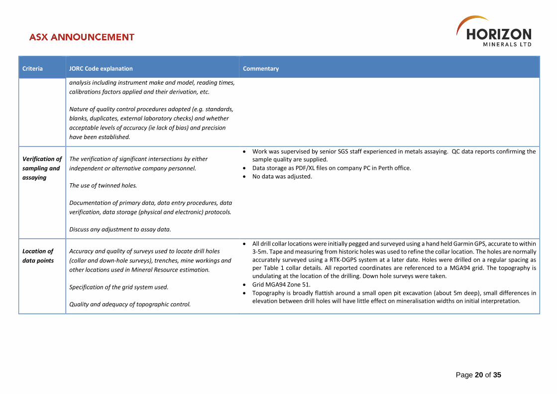
Verification of
sampling and
assaying
The verification of significant intersections by either
independent or alternative company personnel.
The use of twinned holes.
Documentation of primary data, data entry procedures, data
verification, data storage (physical and electronic) protocols.
Discuss any adjustment to assay data.
Work was supervised by senior SGS staff experienced in metals assaying. QC data reports confirming the sample quality are supplied.
Data storage as PDF/XL files on company PC in Perth office.
No data was adjusted.
Location of
data points
Accuracy and quality of surveys used to locate drill holes
(collar and down-hole surveys), trenches, mine workings and
other locations used in Mineral Resource estimation.
Specification of the grid system used.
Quality and adequacy of topographic control.
All drill collar locations were initially pegged and surveyed using a hand held Garmin GPS, accurate to within 3-5m. Tape and measuring from historic holes was used to refine the collar location. The holes are normally accurately surveyed using a RTK-DGPS system at a later date. Holes were drilled on a regular spacing as per Table 1 collar details. All reported coordinates are referenced to a MGA94 grid. The topography is undulating at the location of the drilling. Down hole surveys were taken.
Grid MGA94 Zone 51.
Topography is broadly flattish around a small open pit excavation (about 5m deep), small differences in elevation between drill holes will have little effect on mineralisation widths on initial interpretation.
Page 21 of 35
Criteria JORC Code explanation Commentary
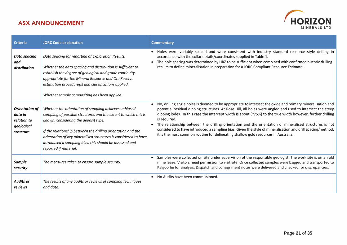
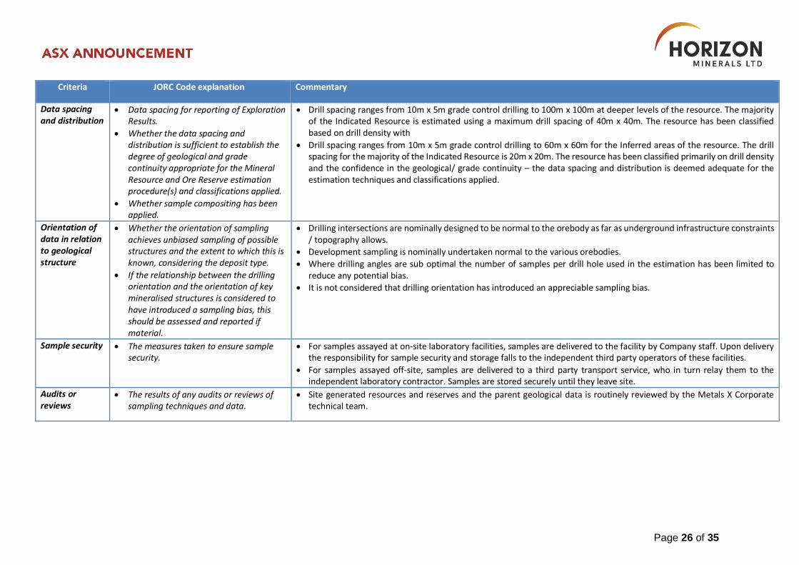
Data spacing
and
distribution
Data spacing for reporting of Exploration Results.
Whether the data spacing and distribution is sufficient to
establish the degree of geological and grade continuity
appropriate for the Mineral Resource and Ore Reserve
estimation procedure(s) and classifications applied.
Whether sample compositing has been applied.
Holes were variably spaced and were consistent with industry standard resource style drilling in accordance with the collar details/coordinates supplied in Table 1.
The hole spacing was determined by HRZ to be sufficient when combined with confirmed historic drilling results to define mineralisation in preparation for a JORC Compliant Resource Estimate.
Orientation of
data in
relation to
geological
structure
Whether the orientation of sampling achieves unbiased
sampling of possible structures and the extent to which this is
known, considering the deposit type.
If the relationship between the drilling orientation and the
orientation of key mineralised structures is considered to have
introduced a sampling bias, this should be assessed and
reported if material.
No, drilling angle holes is deemed to be appropriate to intersect the oxide and primary mineralisation and potential residual dipping structures. At Rose Hill, all holes were angled and used to intersect the steep dipping lodes. In this case the intercept width is about (~75%) to the true width however, further drilling is required.
The relationship between the drilling orientation and the orientation of mineralised structures is not considered to have introduced a sampling bias. Given the style of mineralisation and drill spacing/method, it is the most common routine for delineating shallow gold resources in Australia.
Sample
security
The measures taken to ensure sample security. Samples were collected on site under supervision of the responsible geologist. The work site is on an old
mine lease. Visitors need permission to visit site. Once collected samples were bagged and transported to Kalgoorlie for analysis. Dispatch and consignment notes were delivered and checked for discrepancies.
Audits or
reviews
The results of any audits or reviews of sampling techniques
and data.
No Audits have been commissioned.
Page 22 of 35
Appendix 2 – Rose Hill, Gunga West and Golden Ridge Gold Projects
JORC Code (2012) Table 1, Section 1, 2 and 3
Exploration results at Rose Hill, Gunga West and Golden Ridge were reported by Westgold Resources Ltd (owner of the SKO operations) and released to the ASX during in 2016 and 2017. There have been no material changes since then. Mr David O’Farrell, Exploration Manager of Horizon compiled the information in Section 1, Section 2 and Section 3 of the following JORC Table 1 and is the Competent Person for those sections
The following Table and Sections are provided to ensure compliance with the JORC Code (2012 edition) requirements for the reporting of Mineral Resources.
Section 1 Sampling Techniques and Data
Criteria JORC Code explanation Commentary
Sampling techniques
Nature and quality of sampling (eg cut channels, random chips, or specific specialised industry standard measurement tools appropriate to the minerals under investigation, such as down hole gamma sondes, or handheld XRF instruments, etc). These examples should not be taken as limiting the broad meaning of sampling.
Include reference to measures taken to ensure sample representivity and the appropriate calibration of any measurement tools or systems used.
Aspects of the determination of mineralisation that are Material to the Public Report.
In cases where ‘industry standard’ work has been done this would be relatively simple (eg ‘reverse circulation drilling was used to obtain 1 m samples from which 3 kg was
SKO is a long-term producing operation with a long history of drilling and sampling to support exploration and resource development.
Chips from the RC drilling face-sampling hammer are collected for assaying. Sample return lines are cleaned with compressed air each metre and the cyclone sample collector is cleaned following each rod. Samples are riffle split through a three-tier splitter with a split
~2.5kg sample (generally at 1m intervals) pulverised to produce a 30g charge analysed via fire assay. Diamond drill-core is geologically logged and then sampled according to geology (minimum sample length of 0.4 m to
maximum sample length of 1.5 m) – where consistent geology is sampled, a 1m length is used for sampling the core. The core is sawn half-core with one half sent off for analysis.
Samples have been collected from numerous other styles of drilling at SKO, including but not limited to RAB, aircore, blast-hole, sludge drilling and face samples.
Historical data includes DD, RC, RAB and aircore holes drilled between 1984 and 2010. Not all the historical drilling programmes at SKO are documented and many historical holes are assigned a drill type of ‘unknown’. Over 4,000 km of drilling has been completed on the SKO tenure.
Drilling by previous owners (e.g. Alacer Gold Corporation) has predominantly been RC, with minor DD and aircore drilling. RC drilling is used predominantly for defining and testing for near-surface mineralisation and utilises a face sampling
hammer with the sample being collected on the inside of the drill-tube. RC drill holes utilise downhole single or multi shot cameras. Drill hole collars were surveyed by onsite mine surveyors.
Diamond drilling is used for either testing / targeting deeper mineralised systems or to define the orientation of the host geology. Many of these holes had RC pre-collars generally to a depth of between 60 – 120m, followed by a diamond tail. The majority of these holes have been drilled at NQ2 size with minor HQ sized core. All diamond holes were surveyed
Page 23 of 35
Criteria JORC Code explanation Commentary
pulverised to produce a 30 g charge for fire assay’). In other cases more explanation may be required, such as where there is coarse gold that has inherent sampling problems. Unusual commodities or mineralisation types (eg submarine nodules) may warrant disclosure of detailed information.
during drilling with downhole cameras, and then at end of hole using a Gyro Inclinometer at 5 or 10 m intervals. Drillhole collars were surveyed by onsite mine surveyors.
Sample Recovery Sample recovery is generally good, and there is no indication that sampling presents a material risk for the quality of the
evaluation of any deposit at SKO.
Drilling techniques
Drill type (eg core, reverse circulation, open-hole hammer, rotary air blast, auger, Bangka, sonic, etc) and details (eg core diameter, triple or standard tube, depth of diamond tails, face-sampling bit or other type, whether core is oriented and if so, by what method, etc).
Method of recording and assessing core and chip sample recoveries and results assessed.
Historical data includes DD, RC, RAB and aircore holes drilled between 1984 and 2010. Not all the historical drilling programmes at SKO are documented and many historical holes are assigned a drill type of ‘unknown’. Over 4,000 km of drilling has been completed on the tenure.
Drilling by the most recent previous owners (Alacer Gold Corporation) has predominantly been RC, with minor DD and aircore drilling.
RC drilling is used predominantly for defining and testing for near-surface mineralisation and utilises a face sampling hammer with the sample being collected on the inside of the drill-tube. RC drill holes utilise downhole single or multi shot cameras. Drill hole collars were surveyed by onsite mine surveyors.
Diamond drilling is used for either testing / targeting deeper mineralised systems or to define the orientation of the host geology. Many of these holes had RC pre-collars generally to a depth of between 60 – 120m, followed by a diamond tail. The majority of these holes have been drilled at NQ2 size with minor HQ sized core. All diamond holes were surveyed during drilling with downhole cameras, and then at end of hole using a Gyro Inclinometer at 5 or 10 m intervals. Drill hole collars were surveyed by onsite mine surveyors.
Drill sample recovery
Method of recording and assessing core and chip sample recoveries and results assessed.
Measures taken to maximise sample recovery and ensure representative nature of the samples.
Whether a relationship exists between sample recovery and grade and whether sample bias may have occurred due to preferential loss/gain of fine/coarse material.
Sample recovery is generally good, and there is no indication that sampling presents a material risk for the quality of the evaluation of any deposit at SKO.
Page 24 of 35
Criteria JORC Code explanation Commentary
Logging Whether core and chip samples have
been geologically and geotechnically logged to a level of detail to support appropriate Mineral Resource estimation, mining studies and metallurgical studies.
Whether logging is qualitative or quantitative in nature. Core (or costean, channel, etc) photography.
The total length and percentage of the relevant intersections logged.
Drill chip logging was completed on one metre intervals at the rig by the geologist. The log was made to standard logging descriptive sheets, and transferred into Micromine computer once back at the office.
Logging was qualitative in nature.
Sub-sampling techniques and sample preparation
If core, whether cut or sawn and whether quarter, half or all core taken.
If non-core, whether riffled, tube sampled, rotary split, etc and whether sampled wet or dry.
For all sample types, the nature, quality and appropriateness of the sample preparation technique.
Quality control procedures adopted for all sub-sampling stages to maximise representivity of samples.
Measures taken to ensure that the sampling is representative of the in situ material collected, including for instance results for field duplicate/second-half sampling.
Whether sample sizes are appropriate to the grain size of the material being sampled.
NQ2 and HQ diameter core is sawn half core using a diamond-blade saw, with one half of the core consistently taken for analysis. Smaller sized core (LTK48 and BQ) are whole core sampled. The un-sampled half of diamond core is retained for check sampling if required.
SKO staff collected the sample in pre-numbered calico sample bags which are then submitted to the laboratory for analysis. Delivery of the sample is by a SKO staff member.
RC samples are collected at 1m intervals with the samples being riffle split through a three- tier splitter. The samples are collected by the RC drill crews in pre-numbered calico sample bags which are then collected by SKO staff for submission. Delivery of the sample to the laboratory is by a SKO staff member.
Upon delivery to the laboratory, the sample numbers are checked by the SKO staff member against the sample submission sheet. Sample numbers are recorded and tracked by the laboratory using electronic coding.
Sample preparation techniques are considered appropriate for the style of mineralisation being tested for – this technique is industry standard across the Eastern Goldfields.
Quality of assay data and laboratory tests
The nature, quality and appropriateness of the assaying and laboratory procedures used and whether the
Only nationally accredited laboratories are used for the analysis of the samples collected at SKO.
The laboratory dry and if necessary (if the sample is >3kg) riffle split the sample, which is then jaw crushed and pulverised (the entire 3kg sample) in a ring mill to a nominal 90% passing 75 microns. All recent RC and Diamond core samples are
Page 25 of 35
Criteria JORC Code explanation Commentary
technique is considered partial or total.
For geophysical tools, spectrometers, handheld XRF instruments, etc, the parameters used in determining the analysis including instrument make and model, reading times, calibrations factors applied and their derivation, etc.
Nature of quality control procedures adopted (e.g. standards, blanks, duplicates, external laboratory checks) and whether acceptable levels of accuracy (ie lack of bias) and precision have been established.
analysed via Fire Assay, which involves a 30g charge (sub-sampled after the pulverisation) of the analytical pulp being fused at 1050°C for 45 minutes with litharge. The resultant metal pill is digested in aqua regia and the gold content determined by atomic adsorption spectrometry – detection limit is 0.01 ppm Au.
Quality Assurance and Quality Control (QA/QC) samples are routinely submitted by SKO staff and comprise standards, blanks, assay pills, field duplicates, lab duplicates and repeat analyses. The results for these QA/QC samples are routinely analysed by Senior Geologists with any discrepancies dealt with in conjunction with the laboratory prior to the analytical data being imported into the database.
There is limited information available on historic QA/QC procedures. SKO has generally accepted the available data at face value and carry out data validation procedures as each deposit is re-evaluated.
The analytical techniques used are considered appropriate for the style of mineralisation being tested for – this technique is industry standard across the Eastern Goldfields.
Ongoing production data generally confirms the validity of prior sampling and assaying of the mined deposits to within acceptable limits of accuracy.
Verification of sampling and assaying
The verification of significant intersections by either independent or alternative company personnel.
The use of twinned holes.
Documentation of primary data, data entry procedures, data verification, data storage (physical and electronic) protocols.
Discuss any adjustment to assay data.
Original logging material has been sighted from Wamex reports where available. Assay work was supervised by senior staff experienced in metal assaying. Internal QC data reports confirming the sample quality were supplied monthly. No assay issues were noted in the reports I had read.
HRZ intends to complete Twin holes at Rose Hill in line with its due diligence drill program in January 2020. Twin drilling and general due diligence will also be undertaken at Golden Ridge and Gunga West later in the year.
Data storage as PDF/XL files on company PC in Perth and Site offices.
No data was adjusted.
Location of data points
Accuracy and quality of surveys used to locate drill holes (collar and down-hole surveys), trenches, mine workings and other locations used in Mineral Resource estimation.
Specification of the grid system used.
Quality and adequacy of topographic control.
Collar coordinates for surface RC and diamond drill-holes were generally determined by either RTK-GPS or a total station survey instrument
Recent surface diamond holes were surveyed during drilling with down-hole single shot cameras and then at the end of the hole by Gyro-Inclinometer at 5 or 10mm intervals. Holes not gyro-surveyed were surveyed using Eastman single shot cameras at 20m intervals. RC drill-holes utilised down-hole single shot camera surveys spaced every 15 to 30m down- hole.
Down-hole surveys for underground diamond drill-holes were taken at 15 – 30m intervals by Reflex single-shot cameras.
The orientation and size of the project determines if the resource estimate is undertaken in local or MGA 94 grid. Each project has a robust conversion between local, magnetic and an MGA grid which is managed by the SKO survey department.
Topographic control is generated from RTK GPS. This methodology is adequate for the resources in question.
Page 26 of 35
Criteria JORC Code explanation Commentary
Data spacing and distribution
Data spacing for reporting of Exploration Results.
Whether the data spacing and distribution is sufficient to establish the degree of geological and grade continuity appropriate for the Mineral Resource and Ore Reserve estimation procedure(s) and classifications applied.
Whether sample compositing has been applied.
Drill spacing ranges from 10m x 5m grade control drilling to 100m x 100m at deeper levels of the resource. The majority of the Indicated Resource is estimated using a maximum drill spacing of 40m x 40m. The resource has been classified based on drill density with
Drill spacing ranges from 10m x 5m grade control drilling to 60m x 60m for the Inferred areas of the resource. The drill spacing for the majority of the Indicated Resource is 20m x 20m. The resource has been classified primarily on drill density and the confidence in the geological/ grade continuity – the data spacing and distribution is deemed adequate for the estimation techniques and classifications applied.
Orientation of data in relation to geological structure
Whether the orientation of sampling achieves unbiased sampling of possible structures and the extent to which this is known, considering the deposit type.
If the relationship between the drilling orientation and the orientation of key mineralised structures is considered to have introduced a sampling bias, this should be assessed and reported if material.
Drilling intersections are nominally designed to be normal to the orebody as far as underground infrastructure constraints / topography allows.
Development sampling is nominally undertaken normal to the various orebodies.
Where drilling angles are sub optimal the number of samples per drill hole used in the estimation has been limited to reduce any potential bias.
It is not considered that drilling orientation has introduced an appreciable sampling bias.
Sample security The measures taken to ensure sample security.
For samples assayed at on-site laboratory facilities, samples are delivered to the facility by Company staff. Upon delivery the responsibility for sample security and storage falls to the independent third party operators of these facilities.
For samples assayed off-site, samples are delivered to a third party transport service, who in turn relay them to the independent laboratory contractor. Samples are stored securely until they leave site.
Audits or reviews
The results of any audits or reviews of sampling techniques and data.
Site generated resources and reserves and the parent geological data is routinely reviewed by the Metals X Corporate technical team.
Page 27 of 35
Section 2 Reporting of Exploration Results
Criteria JORC Code explanation Commentary
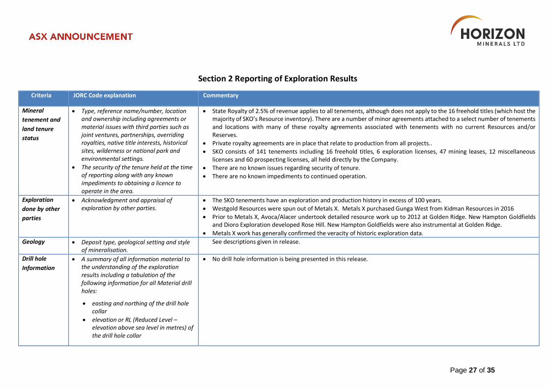
Mineral
tenement and
land tenure
status
Type, reference name/number, location and ownership including agreements or material issues with third parties such as joint ventures, partnerships, overriding royalties, native title interests, historical sites, wilderness or national park and environmental settings.
The security of the tenure held at the time of reporting along with any known impediments to obtaining a licence to operate in the area.
State Royalty of 2.5% of revenue applies to all tenements, although does not apply to the 16 freehold titles (which host the majority of SKO’s Resource inventory). There are a number of minor agreements attached to a select number of tenements and locations with many of these royalty agreements associated with tenements with no current Resources and/or Reserves.
Private royalty agreements are in place that relate to production from all projects..
SKO consists of 141 tenements including 16 freehold titles, 6 exploration licenses, 47 mining leases, 12 miscellaneous licenses and 60 prospecting licenses, all held directly by the Company.
There are no known issues regarding security of tenure.
There are no known impediments to continued operation.
Exploration
done by other
parties
Acknowledgment and appraisal of exploration by other parties.
The SKO tenements have an exploration and production history in excess of 100 years.
Westgold Resources were spun out of Metals X. Metals X purchased Gunga West from Kidman Resources in 2016
Prior to Metals X, Avoca/Alacer undertook detailed resource work up to 2012 at Golden Ridge. New Hampton Goldfields and Dioro Exploration developed Rose Hill. New Hampton Goldfields were also instrumental at Golden Ridge.
Metals X work has generally confirmed the veracity of historic exploration data.
Geology Deposit type, geological setting and style of mineralisation.
See descriptions given in release.
Drill hole
Information
A summary of all information material to the understanding of the exploration results including a tabulation of the following information for all Material drill holes:
easting and northing of the drill hole collar
elevation or RL (Reduced Level – elevation above sea level in metres) of the drill hole collar
No drill hole information is being presented in this release.
Page 28 of 35
Criteria JORC Code explanation Commentary
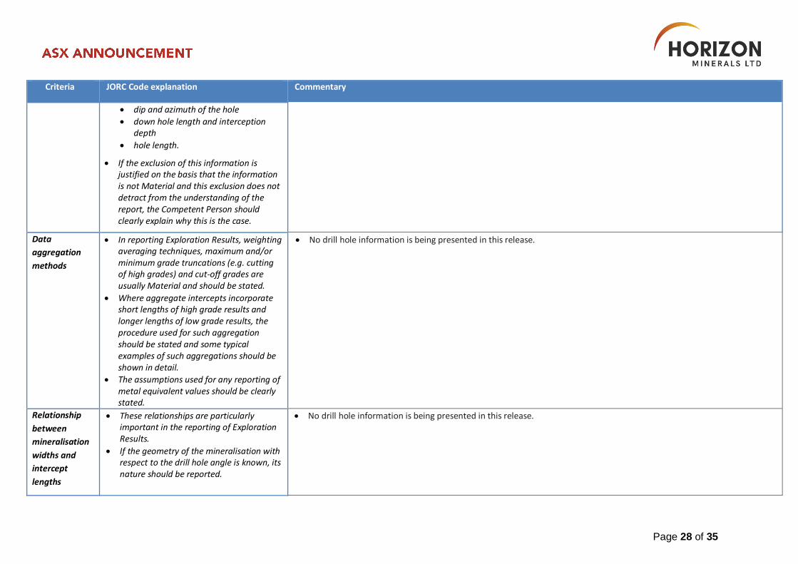
dip and azimuth of the hole
down hole length and interception depth
hole length.
If the exclusion of this information is justified on the basis that the information is not Material and this exclusion does not detract from the understanding of the report, the Competent Person should clearly explain why this is the case.
Data
aggregation
methods
In reporting Exploration Results, weighting averaging techniques, maximum and/or minimum grade truncations (e.g. cutting of high grades) and cut-off grades are usually Material and should be stated.
Where aggregate intercepts incorporate short lengths of high grade results and longer lengths of low grade results, the procedure used for such aggregation should be stated and some typical examples of such aggregations should be shown in detail.
The assumptions used for any reporting of metal equivalent values should be clearly stated.
No drill hole information is being presented in this release.
Relationship
between
mineralisation
widths and
intercept
lengths
These relationships are particularly important in the reporting of Exploration Results.
If the geometry of the mineralisation with respect to the drill hole angle is known, its nature should be reported.
No drill hole information is being presented in this release.
Page 29 of 35
Criteria JORC Code explanation Commentary
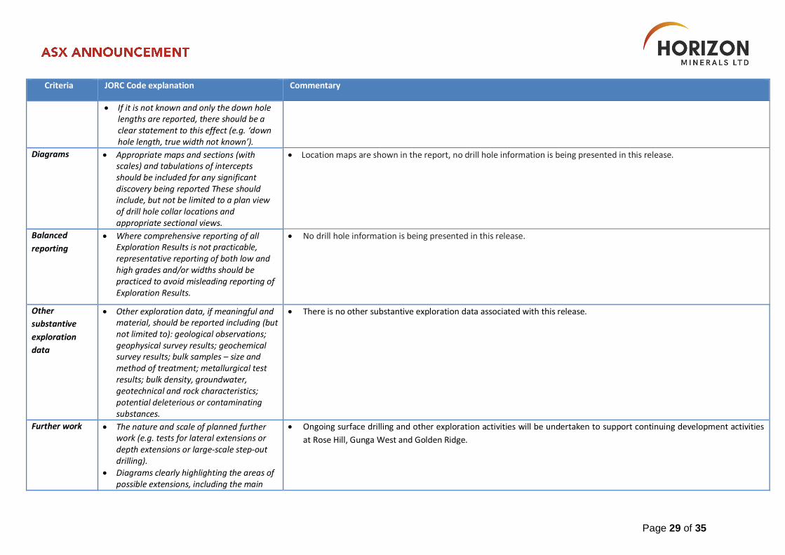
If it is not known and only the down hole lengths are reported, there should be a clear statement to this effect (e.g. ‘down hole length, true width not known’).
Diagrams Appropriate maps and sections (with scales) and tabulations of intercepts should be included for any significant discovery being reported These should include, but not be limited to a plan view of drill hole collar locations and appropriate sectional views.
Location maps are shown in the report, no drill hole information is being presented in this release.
Balanced
reporting
Where comprehensive reporting of all Exploration Results is not practicable, representative reporting of both low and high grades and/or widths should be practiced to avoid misleading reporting of Exploration Results.
No drill hole information is being presented in this release.
Other
substantive
exploration
data
Other exploration data, if meaningful and material, should be reported including (but not limited to): geological observations; geophysical survey results; geochemical survey results; bulk samples – size and method of treatment; metallurgical test results; bulk density, groundwater, geotechnical and rock characteristics; potential deleterious or contaminating substances.
There is no other substantive exploration data associated with this release.
Further work The nature and scale of planned further work (e.g. tests for lateral extensions or depth extensions or large-scale step-out drilling).
Diagrams clearly highlighting the areas of possible extensions, including the main
Ongoing surface drilling and other exploration activities will be undertaken to support continuing development activities
at Rose Hill, Gunga West and Golden Ridge.
Page 30 of 35
Criteria JORC Code explanation Commentary
geological interpretations and future drilling areas, provided this information is not commercially sensitive.
Section 3 Estimation and Reporting of Mineral Resources
Criteria JORC Code explanation Commentary
Database
integrity
Measures taken to ensure that data has not been corrupted by, for example, transcription or keying errors, between its initial collection and its use for Mineral Resource estimation purposes.
Data validation procedures used.
The database used for the estimation was extracted from Northern Star
As new data is acquired it passes through a validation approval system designed to pick up any significant errors before the information is loaded into the master database.
Site visits Comment on any site visits undertaken by the Competent Person and the outcome of those visits.
If no site visits have been undertaken indicate why this is the case.
Mr. O’Farrell regularly visits HRZ projects.
Geological
interpretation
Confidence in (or conversely, the uncertainty of) the geological interpretation of the mineral deposit.
Nature of the data used and of any assumptions made.
The effect, if any, of alternative interpretations on Mineral Resource estimation.
The use of geology in guiding and controlling Mineral Resource estimation.
The factors affecting continuity both of grade and geology.
The geological confidence in the data is high. High density drilling, alongside geological modelling and mineralisation interpretation has contributed to this confidence.
Now new assumptions were introduced by HRZ. Due diligence has been undertaken on all deposits prior to HRZ involvement. No major concerns were noted.
Page 31 of 35
Criteria JORC Code explanation Commentary
Dimensions The extent and variability of the Mineral Resource expressed as length (along strike or otherwise), plan width, and depth below surface to the upper and lower limits of the Mineral Resource.
The resources have a relatively large extent and display variability, a common trait in many eastern goldfield deposits. In the case of Gunga West and Golden Ridge, mining and production reconciliations have allowed a better assessment of in situ grade to be made.
Estimation and
modelling
techniques
The nature and appropriateness of the estimation technique(s) applied and key assumptions, including treatment of extreme grade values, domaining, interpolation parameters and maximum distance of extrapolation from data points. If a computer assisted estimation method was chosen include a description of computer software and parameters used.
The availability of check estimates, previous estimates and/or mine production records and whether the Mineral Resource estimate takes appropriate account of such data.
The assumptions made regarding recovery of by-products.
Estimation of deleterious elements or other non-grade variables of economic significance (eg sulphur for acid mine drainage characterisation).
In the case of block model interpolation, the block size in relation to the average sample spacing and the search employed.
Any assumptions behind modelling of selective mining units.
Any assumptions about correlation
Geological, mining as-built and mineralisation domains and a valid drill hole database were supplied by SKO personnel. The geological and mineralisation domains were used to control the interpolation as hard boundaries (mineralisation domains) and for the application of bulk density data (geological boundaries).
Statistical analysis was undertaken to determine the composite length (1m) and for the application of top-cuts.
The search ellipses applied were based on a combination of drill hole spacing and variographic analysis. Various minimum and maximum samples were used in the first search with a maximum of four samples per drill-hole allowed. Several passes were used each with increasing search ellipse sizes, all the blocks in the mineralised domains were informed in the first pass.
The block model was depleted using surfaces / domains generated by the SKO Survey. Validation of the models was completed by visual inspection, statistical comparisons and comparison with reconciliation data, with the final model achieving a satisfactory validation.
No deleterious elements were estimated as they are considered not material.
Page 32 of 35
Criteria JORC Code explanation Commentary
between variables.
Description of how the geological interpretation was used to control the resource estimates.
Discussion of basis for using or not using grade cutting or capping.
The process of validation, the checking process used, the comparison of model data to drill hole data, and use of reconciliation data if available.
Moisture Whether the tonnages are estimated on a dry basis or with natural moisture, and the method of determination of the moisture content.
Tonnage estimates are dry tonnes.
Cut-off
parameters
The basis of the adopted cut-off grade(s) or quality parameters applied.
The cut off grades used for the reporting of the Mineral Resources have been selected based on the style of mineralisation, depth from surface of the mineralisation and the most probable extraction technique.
Mining factors
or assumptions
Assumptions made regarding possible mining methods, minimum mining dimensions and internal (or, if applicable, external) mining dilution. It is always necessary as part of the process of determining reasonable prospects for eventual economic extraction to consider potential mining methods, but the assumptions made regarding mining methods and parameters when estimating Mineral Resources may not always be rigorous. Where this is the case, this should be reported with an explanation of the basis of the mining assumptions made.
Variable by deposit.
Page 33 of 35
Criteria JORC Code explanation Commentary
Metallurgical
factors or
assumptions
The basis for assumptions or predictions regarding metallurgical amenability. It is always necessary as part of the process of determining reasonable prospects for eventual economic extraction to consider potential metallurgical methods, but the assumptions regarding metallurgical treatment processes and parameters made when reporting Mineral Resources may not always be rigorous. Where this is the case, this should be reported with an explanation of the basis of the metallurgical assumptions made.
The majority of the SKO resource base comprises deposits that have some level of mining history and hence established metallurgical properties.
Environmental
factors or
assumptions
Assumptions made regarding possible waste and process residue disposal options. It is always necessary as part of the process of determining reasonable prospects for eventual economic extraction to consider the potential environmental impacts of the mining and processing operation. While at this stage the determination of potential environmental impacts, particularly for a greenfields project, may not always be well advanced, the status of early consideration of these potential environmental impacts should be reported. Where these aspects have not been considered this should be reported with an explanation of the environmental assumptions made.
The significant operational history at SKO has allowed for a consistent set of environmental assumptions to be applied to the mineral resource deposits in the region.
Page 34 of 35
Criteria JORC Code explanation Commentary
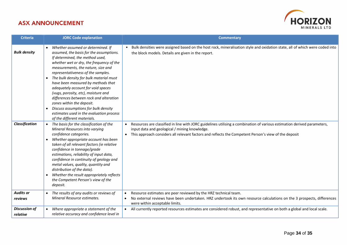
Bulk density Whether assumed or determined. If
assumed, the basis for the assumptions. If determined, the method used, whether wet or dry, the frequency of the measurements, the nature, size and representativeness of the samples.
The bulk density for bulk material must have been measured by methods that adequately account for void spaces (vugs, porosity, etc), moisture and differences between rock and alteration zones within the deposit.
Discuss assumptions for bulk density estimates used in the evaluation process of the different materials.
• Bulk densities were assigned based on the host rock, mineralisation style and oxidation state, all of which were coded into
the block models. Details are given in the report.
Classification The basis for the classification of the Mineral Resources into varying confidence categories.
Whether appropriate account has been taken of all relevant factors (ie relative confidence in tonnage/grade estimations, reliability of input data, confidence in continuity of geology and metal values, quality, quantity and distribution of the data).
Whether the result appropriately reflects the Competent Person’s view of the deposit.
Resources are classified in line with JORC guidelines utilising a combination of various estimation derived parameters, input data and geological / mining knowledge.
This approach considers all relevant factors and reflects the Competent Person’s view of the deposit
Audits or
reviews
The results of any audits or reviews of Mineral Resource estimates.
Resource estimates are peer reviewed by the HRZ technical team.
No external reviews have been undertaken. HRZ undertook its own resource calculations on the 3 prospects, differences were within acceptable limits.
Discussion of
relative
Where appropriate a statement of the relative accuracy and confidence level in
All currently reported resources estimates are considered robust, and representative on both a global and local scale.
Page 35 of 35
Criteria JORC Code explanation Commentary
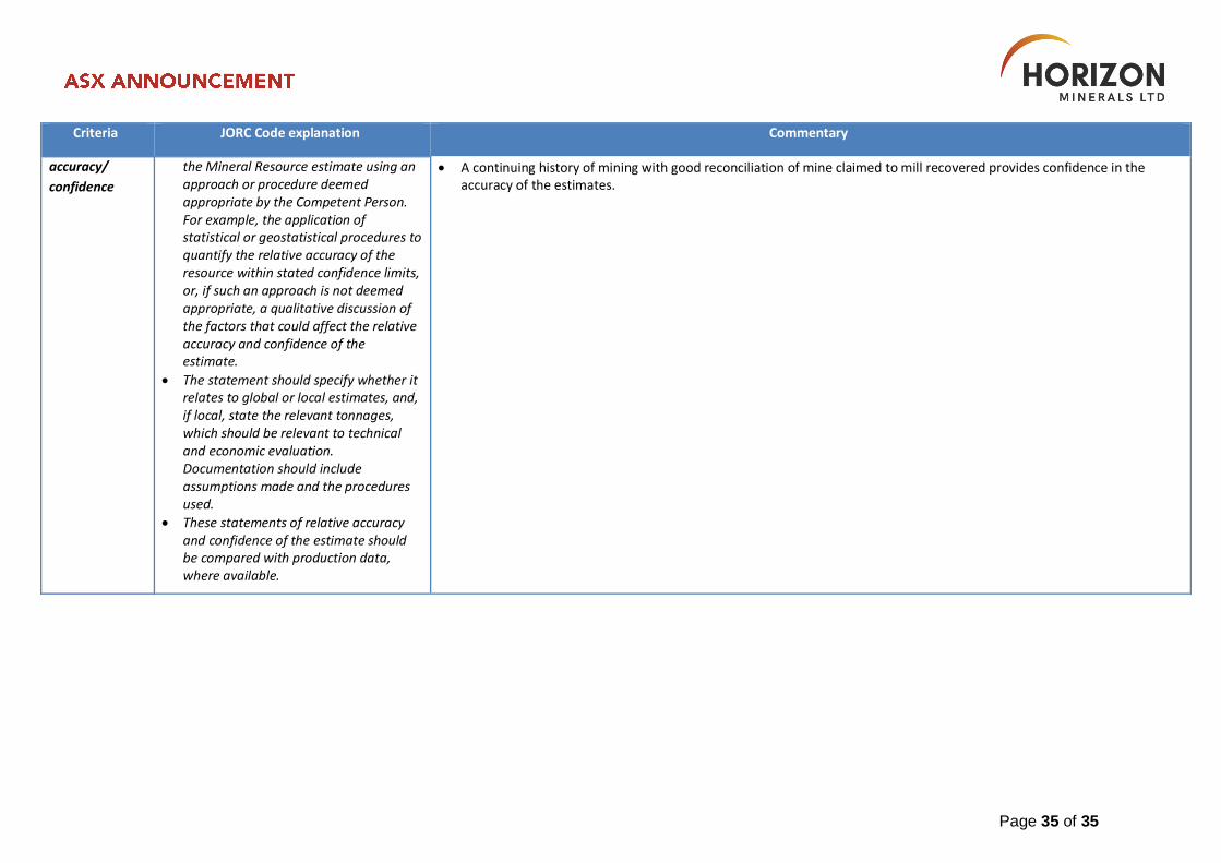
accuracy/
confidence
the Mineral Resource estimate using an approach or procedure deemed appropriate by the Competent Person. For example, the application of statistical or geostatistical procedures to quantify the relative accuracy of the resource within stated confidence limits, or, if such an approach is not deemed appropriate, a qualitative discussion of the factors that could affect the relative accuracy and confidence of the estimate.
The statement should specify whether it relates to global or local estimates, and, if local, state the relevant tonnages, which should be relevant to technical and economic evaluation. Documentation should include assumptions made and the procedures used.
These statements of relative accuracy and confidence of the estimate should be compared with production data, where available.
A continuing history of mining with good reconciliation of mine claimed to mill recovered provides confidence in the accuracy of the estimates.