ecological site f115by031mo - edit
TRANSCRIPT

Natural ResourcesConservation Service
Ecological site F115BY031MOLoamy Floodplain Forest
Accessed: 03/24/2022
General information
Figure 1. Mapped extent
MLRA notes
Classification relationships
Areas shown in blue indicate the maximum mapped extent of this ecological site. Other ecological sites likely occurwithin the highlighted areas. It is also possible for this ecological site to occur outside of highlighted areas if detailedsoil survey has not been completed or recently updated.
Major Land Resource Area (MLRA): 115B–Central Mississippi Valley Wooded Slopes, Western Part
The Central Mississippi Valley Wooded Slopes, Western Part (area outlined in red on the map) consists mainly ofthe deeply dissected, loess-covered hills bordering the Missouri and Mississippi Rivers as well as the floodplainsand terraces of these rivers. It wraps around the northeast corner of the Ozark Uplift, and constitutes the southernborder of the Pre-Illinoisan-aged till plain. Elevation ranges from about 320 feet along the Mississippi River nearCape Girardeau in the south to about 1,020 feet on the highest ridges near Hillsboro, MO in the east. Local reliefvaries from 10 to 20 feet in the major river floodplains, to 50 to 100 feet in the dissected uplands, with bluffs of 200to 350 feet along the Mississippi and Missouri Rivers. Underlying bedrock is mainly Ordovician-aged dolomite andsandstone, with Mississippian-aged limestone north of the Missouri River.
Terrestrial Natural Community Type in Missouri (Nelson, 2010):The reference state for this ecological site is most similar to a Riverfront Forest.
Missouri Department of Conservation Forest and Woodland Communities (MDC, 2006):The reference state for this ecological site is most similar to a Riverfront Bottomland Forest.
National Vegetation Classification System Vegetation Association (NatureServe, 2010):The reference state for this ecological site is most similar to a Fraxinus pennsylvanica - Celtis spp. - Quercus spp. -Platanus occidentalis Bottomland Forest (CEGL002410).

Ecological site concept
Associated sites
Similar sites
Table 1. Dominant plant species
Geographic relationship to the Missouri Ecological Classification System (Nigh & Schroeder, 2002):This ecological site occurs primarily in Land Type Associations of the following Subsections:Inner Ozark BorderOuter Ozark BorderMississippi River Hills
NOTE: This is a “provisional” Ecological Site Description (ESD) that is under development. It contains basicecological information that can be used for conservation planning, application and land management. Afteradditional information is collected, analyzed and reviewed, this ESD will be refined and published as “Approved”.
Loamy Floodplain Forests (green areas on the map) are widely distributed on the tributary floodplains of theMissouri and Mississippi Rivers. Sites are typically associated with a variety of upland drainageway, terrace andfootslope ecological sites in the secondary stream valleys. Soils are loamy and very deep, and are subject tofrequent flooding. The reference plant community is forest dominated by American elm, hackberry, sycamore,eastern cottonwood, and green ash.
F115BY015MO
F115BY041MO
R115BY042MO
Sandy/Loamy Floodplain ForestSandy/Loamy Floodplain Forests sometimes form a complex with this ecological site.
Clayey Floodplain ForestClayey Floodplain Forests are commonly adjacent to Loamy Floodplain Forests, but farther away fromthe main channel.
Ponded Floodplain PrairiePonded Floodplain Prairies are in the lowest former channel areas that have high seasonal water tableswith some ponding.
F115BY028MO Loamy/Gravelly Upland Drainageway ForestLoamy/Gravelly Upland Drainageway Forests are upstream, in narrow drainageways. The reference statewoodland community in the Upland Drainageways contains more upland species, such as white oak andmockernut hickory.
Tree
Shrub
Herbaceous
(1) Ulmus americana(2) Celtis occidentalis
(1) Vitis(2) Staphylea trifolia
(1) Carex(2) Laportea canadensis
Physiographic featuresThis site is on low floodplains with slopes of 0 to 3 percent. The site receives some runoff from higher floodplains,stream terraces and uplands. This site is subject to frequent flooding.
The following figure (adapted from Davis, 2004) shows the typical landscape position of this ecological site onfloodplains of major tributaries to the Missouri and Mississippi rivers. This site is within the area labeled as “3” onthe figure, and is typically adjacent to the river channel in these tributary systems.

Figure 2. Landscape relationships for this ecological site.
Table 2. Representative physiographic features
Landforms (1) Flood plain
Flooding duration Very brief (4 to 48 hours) to
long (7 to 30 days)
Flooding frequency Frequent
Ponding frequency None
Slope 0 – 3%
Water table depth 6 – 60 in
Aspect Aspect is not a significant factor
Climatic featuresThe Central Mississippi Valley Wooded Slopes, Western Part has a continental type of climate marked by strongseasonality. In winter, dry-cold air masses, unchallenged by any topographic barriers, periodically swing south fromthe northern plains and Canada. If they invade reasonably humid air, snowfall and rainfall result. In summer, moist,warm air masses, equally unchallenged by topographic barriers, swing north from the Gulf of Mexico and canproduce abundant amounts of rain, either by fronts or by convectional processes. In some summers, high pressurestagnates over the region, creating extended droughty periods. Spring and fall are transitional seasons when abruptchanges in temperature and precipitation may occur due to successive, fast-moving fronts separating contrasting airmasses.
The Central Mississippi Valley Wooded Slopes, Western Part experiences regional differences in climates, butthese differences do not have obvious geographic boundaries. Regional climates grade inconspicuously into eachother. The basic gradient for most climatic characteristics is along a line diagonally crossing the MLRA fromnorthwest to southeast. Both mean annual temperature and precipitation exhibit gradients along this line.
The average annual precipitation in most of this area is 38 to 48 inches. The average annual temperature is 53 to 57degrees F. Mean January minimum temperature follows the northwest-to-southeast gradient. However, mean Julymaximum temperature shows hardly any geographic variation in the MLRA. Mean July maximum temperatureshave a range of only two or three degrees across the area.
Mean annual precipitation varies along the same gradient as temperature. Seasonal climatic variations are morecomplex. Seasonality in precipitation is very pronounced due to strong continental influences. June precipitation, forexample, averages three to four times greater than January precipitation. Most of the rainfall occurs as high-intensity, convective thunderstorms in summer. Snowfall is common in winter.
During years when precipitation is normal, moisture is stored in the soil profile during the winter and early spring,when evaporation and transpiration are low. During the summer months the loss of water by evaporation andtranspiration is high, and if rainfall fails to occur at frequent intervals, drought will result. Drought directly affectsplant and animal life by limiting water supplies, especially at times of high temperatures and high evaporation rates.

Table 3. Representative climatic features
Climate stations used
Superimposed upon the basic MLRA climatic patterns are local topographic influences that create topoclimatic, ormicroclimatic variations. In regions of appreciable relief, for example, air drainage at nighttime may producetemperatures several degrees lower in valley bottoms than on side slopes. At critical times during the year, thisphenomenon may produce later spring or earlier fall freezes in valley bottoms. Higher daytime temperatures of barerock surfaces and higher reflectivity of these unvegetated surfaces create characteristic glade and cliff ecologicalsites. Slope orientation is an important topographic influence on climate. Summits and south-and-west-facing slopesare regularly warmer and drier than adjacent north- and-east-facing slopes. Finally, the climate within a canopiedforest ecological site is measurably different from the climate of the more open grassland or savanna ecologicalsites.
Source: University of Missouri Climate Center - http://climate.missouri.edu/climate.php;
Land Resource Regions and Major Land Resource Areas of the United States, the Caribbean, and the PacificBasin, United States Department of Agriculture Handbook 296 - http://soils.usda.gov/survey/geography/mlra/
Frost-free period (average) 177 days
Freeze-free period (average) 198 days
Precipitation total (average) 45 in
(1) CAPE GIRARDEAU MUNI AP [USW00003935], Chaffee, MO(2) ALTON MELVIN PRICE L&D [USC00110137], West Alton, IL(3) KASKASKIA RVR NAV LOCK [USC00114629], Ellis Grove, IL(4) BOONVILLE [USC00230817], Boonville, MO(5) ELSBERRY 1 S [USC00232591], Elsberry, MO(6) JEFFERSON CITY WTP [USC00234271], Jefferson City, MO
Influencing water featuresThis ecological site is typically in natural levee positions directly adjacent to a perennial stream. Stream levelstypically respond quickly to storm events, especially in watersheds where surface runoff is dominant. Short- tomedium- duration flooding is common in many areas, particularly during spring and early summer storm events.Constructed levees, often accompanied by stream channelization, have altered the hydrology and floodingdynamics in many places. Streambeds that are typically incised into the surrounding floodplain by as much as 10feet may be a sign of an alternative state.
Some soils in this ecological site have seasonal water tables in the winter and spring, generally receding with thefalling river levels in the early summer. In most areas the water table has a minimal effect on the vegetativecommunity.
This site is in the RIVERINE class of the Hydrogeomorphic (HGM) classification system (Brinson, 1993). Thestream hydrograph drives the inflows and outflows of RIVERINE wetlands. Water moves into floodplain wetlands assurface water during flood stage, or as groundwater exchange from the stream channel to the floodplain during highflow stages. As the flood stage recedes, surface and groundwater return to the channel. The direction of movementis horizontal. The direction is also bi-directional in the lateral axis across the floodplain, but is uni-directional on thelongitudinal axis parallel to the valley as water flows downhill along the valley gradient.
Soil featuresThese soils have no rooting restriction. They were formed under forest vegetation, with periodic depositional floodevents. Organic matter content is variable. Parent material is alluvium. They have silt loam surface horizons, and

Figure 7. Dameron series
Table 4. Representative soil features
loamy subsoils that may be skeletal with depth. Some soils are affected by seasonal wetness. Soil series associatedwith this site include Arenzville, Armiesburg, Coffeen, Dameron, Dockery, Dupo, Haymond, Jamesfin, Medway,Motark, Orion, Perche, Racket, Riley, Sensabaugh, Sharon, Wakeland, Wilbur, and Wirt.
The accompanying picture of the Dameron series shows dark, loamy alluvium, underlain by stratified very gravellysediments. Picture from Baker (1998).
Surface texture
Family particle size
Drainage class Poorly drained to
well drained
Permeability class Moderately slow to
moderate
Soil depth 72 in
Surface fragment cover <=3" 0 – 3%
Surface fragment cover >3" 0 – 3%
Available water capacity(0-40in)
5 – 8 in
Calcium carbonate equivalent(0-40in)
0%
Electrical conductivity(0-40in)
0 – 2 mmhos/cm
Sodium adsorption ratio(0-40in)
0
Soil reaction (1:1 water)(0-40in)
4.5 – 7.3
Subsurface fragment volume <=3"(Depth not specified)
0 – 50%
Subsurface fragment volume >3"(Depth not specified)
0 – 6%
(1) Silt loam
(1) Loamy
Ecological dynamicsInformation contained in this section was developed using historical data, professional experience, field reviews,and scientific studies. The information presented is representative of very complex vegetation communities. Keyindicator plants, animals and ecological processes are described to help inform land management decisions. Plantcommunities will differ across the MLRA because of the naturally occurring variability in weather, soils, and aspect.The Reference Plant Community is not necessarily the management goal. The species lists are representative and

State and transition model
are not botanical descriptions of all species occurring, or potentially occurring, on this site. They are not intended tocover every situation or the full range of conditions, species, and responses for the site.
The reference plant community is a forest dominated by an overstory of American elm and hackberry withsycamore, eastern cottonwood, green ash and other early successional species scattered throughout. Occasionally,bur oak, shellbark hickory, black walnut and other hardwood species may occur in later stages of development.Canopy height is 85 to 110 feet with a canopy closure of 80 to 100 percent.
Loamy Floodplain Riverfront Forests were a common natural community on the Missouri and Mississippi Riverfloodplains. They occur on natural levees and low floodplains that flood frequently. Flooding of these ecologicalsites commonly occurs annually or at least once every 3 years. Loamy sediments, originating from the loess and tillin the surrounding uplands, make up a significant portion of the alluvium in these floodplains.
The forest is dominated by flood tolerant, tree species such as elm, hackberry, sycamore, cottonwood and greenash. Young stands of these species tend to stabilize the low floodplain and continue to accumulate loamy materials.Consequently, these developing ecological sites tend to be near even aged. Young stands are often dense with asparse understory and ground flora.
Over the long term, these floodplains may become elevated and/or isolated and begin to accumulate more finesediments, becoming more stable and enduring. Oaks, shellbark hickory and black walnut begin to accumulate inthese later stages of succession. Catastrophic floods will often partially or completely knock down the earlier speciesand regenerate this site creating a mosaic of early to late successional floodplain forests.
These sites are very productive. Today most of these ecological sites have been cleared and converted toagriculture. While some cleared fields have retained a narrow strip of forest along the river, other sites are oftencleared right up to the bank. In such cases, flooding may cause severe stream bank erosion.
Uncontrolled grazing by domestic livestock in the remaining strips of forest is not uncommon and can causesignificant damage, killing trees and removing the ground cover, resulting in further de-stabilization and degradationof this ecological site as well. Carefully planned timber harvests can be tolerated in this system, but high grading ofthe timber will eventually degrade the ecological site.
Loamy Floodplain Forests, generally occurring as a rather narrow band of forests traversing the river edge, are anabundant floodplain forest type. These bands of forest still play an important role as a source of food and shelter formigrating birds and as a source for course woody debris for the adjacent stream systems.
A State and Transition Diagram is depicted in Figure 1follows. Detailed descriptions of each state, transition, plantcommunity, and pathway follow the model. This model is based on available experimental research, fieldobservations, professional consensus, and interpretations. It is likely to change as knowledge increases.

Figure 8. State and transition diagram for this ecological s
State 1

Reference
Community 1.1American Elm – Hackberry/Grape – American Bladdernut /Canadian Woodnettle – VirginiaWildrye
Community 1.2Bur Oak – Hackberry – Shellbark Hickory/Grape – American Bladdernut /Canadian Woodnettle– Virginia
State 2Managed Forest
Community 2.1Bur Oak – Sycamore/American Bladdernut/ Wildrye
Community 2.2
The historical reference state for this ecological site was old growth bottomland forest. Natural flooding cycles werethe primary processes affecting this ecologic site. Maximum tree age was likely 150 to 200 years. The understorywas complex, with multiple layers of shade-tolerant species. A highly diverse ground flora was also present. Vineswere common and went well into the canopy. Scattered open areas were common. A change to more frequent,higher-intensity floods on the modern landscape creates more frequent canopy gaps, and introduces or helps tomaintain more flood-tolerant species such as sycamore, eastern cottonwood, green ash and hackberry.
Over the long term, these floodplains may become more elevated and/or isolated and accumulate more finesediments, becoming more stable and enduring. Oaks, shellbark hickory and black walnut begin to accumulate inthese later stages of succession. Catastrophic floods will often partially or completely knock down the early speciesand regenerate this site creating a mosaic of early to late successional floodplain forests.
This community phase is characterized by frequent flood events which impact on the canopy structure and speciescomposition. Old growth species such as sycamore, eastern cottonwood, American elm and hackberry arecommon.
Forest overstory. The Overstory Species list is based on field surveys and commonly occurring species listed inNelson (2010).
Forest understory. The Understory Species list is based on field surveys and commonly occurring species listed inNelson (2010).
Over the long term, phase 1.1 may become more elevated and/or isolated and accumulate more sediments,becoming more stable and enduring. Oaks, shellbark hickory and black walnut begin to accumulate in these laterstages of succession.
Forest overstory. The Overstory Species list is based on Missouri field surveys and reports.
Forest understory. The Understory Species list is based on Missouri field surveys and reports.
Where this state remains, it has often been subjected to very selective timber harvests. While these forested areasmay resemble the reference state, the diversity of tree species has been selectively (removal of oak and walnut)altered. Reducing harvests and extending rotations will cause a transition to community phase 2.2. Eliminatingharvests, implementing selective thinning, and allowing long term succession may allow a return to the referencestate where hydrologic regimes are least altered.
This community phase has often been subjected to selective timber harvests. While these forested areas mayresemble the reference state (some old growth), the diversity of tree species has been selectively (removal of oakand walnut) altered.

Bur Oak – Sycamore – Black Walnut /American Bladdernut/ Wildrye
State 3Grassland
Community 3.1Tall Fescue/Red Clover
State 4High Graded/Grazed Forest
Community 4.1Sycamore – Green Ash/Buckbrush/ Greenbier – Wildrye
State 5Cropland
Community 5.1Corn, Soybeans, Wheat
Reducing harvests and extending rotations will cause a transition to this community phase. Eliminating harvests,implementing selective thinning, and allowing long term succession may allow a return to the reference state wherehydrologic regimes are least altered.
Many acres of this ecological site have been converted to non-native grasslands of tall fescue and red clover. Thisstate frequently transitions to a cropland state especially when commodity prices are high. A return to a near-reference state from this state is not recommended. Transitioning to a Managed Forest state is possible throughlong-term commitments of time and money.
This phase is well managed grassland, composed of non-native cool season grasses and legumes. Grazing andhaying is occurring. The effects of long-term liming on soil pH, and calcium and magnesium content, is most evidentin this phase. Studies show that these soils have higher pH and higher base status in soil horizons as much as twofeet below the surface, relative to poorly managed grassland and to woodland communities (where liming is notpracticed).
This state is subjected to uncontrolled grazing and high-graded timber harvests. The grazing will open up theunderstory and remove much of the diverse ground flora. This can lead to erosion of the topsoil during floods.Grazed units also often undergo timber harvest removing a wide variety of outstanding hardwood trees, furtherdiminishing the structural and compositional diversity. A return to the near-reference state will require a long-termcommitment including the elimination of grazing, planting of trees and perhaps shrub and herbaceous species, andvery limited targeted timber harvests and thinning.
This is the only phase associated with this state at this time. See the corresponding state narrative for details.
Many areas of this ecological site have been converted to row crop agriculture. A return to the near-reference stateis not practical from this state. Transitioning to a Managed Forest state may be possible through long-termcommitments of time and money.
This is the only phase associated with this state at this time. See the corresponding state narrative for details.
Additional community tablesTable 5. Community 1.1 forest overstory composition

Table 6. Community 1.1 forest understory composition
Common Name Symbol Scientific Name NativityHeight
(Ft)Canopy Cover
(%)Diameter
(In)Basal Area (Square
Ft/Acre)
Tree
bitternut hickory CACO15 Carya cordiformis Native – – – –
shellbark hickory CALA21 Carya laciniosa Native – – – –
sugarberry CELA Celtis laevigata Native – – – –
commonhackberry
CEOC Celtis occidentalis Native – – – –
green ash FRPE Fraxinuspennsylvanica
Native – – – –
Kentuckycoffeetree
GYDI Gymnocladus dioicus Native – – – –
black walnut JUNI Juglans nigra Native – – – –
Americansycamore
PLOC Platanus occidentalis Native – – – –
bur oak QUMA2 Quercus macrocarpa Native – – – –
American elm ULAM Ulmus americana Native – – – –
silver maple ACSA2 Acer saccharinum Native – – – –
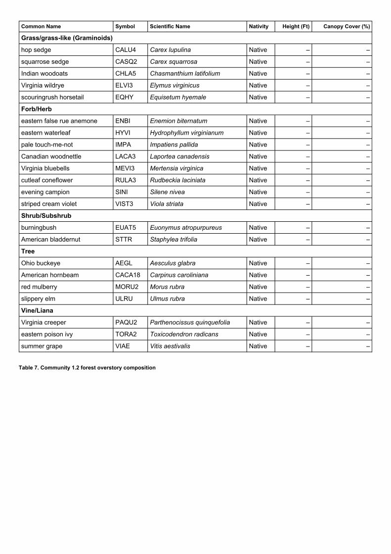
Table 7. Community 1.2 forest overstory composition
Common Name Symbol Scientific Name Nativity Height (Ft) Canopy Cover (%)
Grass/grass-like (Graminoids)
hop sedge CALU4 Carex lupulina Native – –
squarrose sedge CASQ2 Carex squarrosa Native – –
Indian woodoats CHLA5 Chasmanthium latifolium Native – –
Virginia wildrye ELVI3 Elymus virginicus Native – –
scouringrush horsetail EQHY Equisetum hyemale Native – –
Forb/Herb
eastern false rue anemone ENBI Enemion biternatum Native – –
eastern waterleaf HYVI Hydrophyllum virginianum Native – –
pale touch-me-not IMPA Impatiens pallida Native – –
Canadian woodnettle LACA3 Laportea canadensis Native – –
Virginia bluebells MEVI3 Mertensia virginica Native – –
cutleaf coneflower RULA3 Rudbeckia laciniata Native – –
evening campion SINI Silene nivea Native – –
striped cream violet VIST3 Viola striata Native – –
Shrub/Subshrub
burningbush EUAT5 Euonymus atropurpureus Native – –
American bladdernut STTR Staphylea trifolia Native – –
Tree
Ohio buckeye AEGL Aesculus glabra Native – –
American hornbeam CACA18 Carpinus caroliniana Native – –
red mulberry MORU2 Morus rubra Native – –
slippery elm ULRU Ulmus rubra Native – –
Vine/Liana
Virginia creeper PAQU2 Parthenocissus quinquefolia Native – –
eastern poison ivy TORA2 Toxicodendron radicans Native – –
summer grape VIAE Vitis aestivalis Native – –

Table 8. Community 1.2 forest understory composition
Common Name Symbol Scientific Name NativityHeight
(Ft)Canopy Cover
(%)Diameter
(In)Basal Area (Square
Ft/Acre)
Tree
black maple ACNI5 Acer nigrum Native – – – –
silver maple ACSA2 Acer saccharinum Native – – – –
sugar maple ACSA3 Acer saccharum Native – – – –
Ohio buckeye AEGL Aesculus glabra Native – – – –
bitternut hickory CACO15 Carya cordiformis Native – – – –
shellbark hickory CALA21 Carya laciniosa Native – – – –
American elm ULAM Ulmus americana Native – – – –
slippery elm ULRU Ulmus rubra Native – – – –
commonhackberry
CEOC Celtis occidentalis Native – – – –
green ash FRPE Fraxinuspennsylvanica
Native – – – –
black walnut JUNI Juglans nigra Native – – – –
Americansycamore
PLOC Platanus occidentalis Native – – – –
easterncottonwood
PODE3 Populus deltoides Native – – – –
Americanbasswood
TIAM Tilia americana Native – – – –

Common Name Symbol Scientific Name Nativity Height (Ft) Canopy Cover (%)
Grass/grass-like (Graminoids)
Virginia wildrye ELVI3 Elymus virginicus Native – –
nodding fescue FESU3 Festuca subverticillata Native – –
eastern narrowleaf sedge CAAM8 Carex amphibola Native – –
eastern woodland sedge CABL Carex blanda Native – –
rosy sedge CARO22 Carex rosea – – –
Indian woodoats CHLA5 Chasmanthium latifolium Native – –
Forb/Herb
bluntleaf waterleaf HYCA3 Hydrophyllum canadense Native – –
jewelweed IMCA Impatiens capensis Native – –
Canadian woodnettle LACA3 Laportea canadensis Native – –
smallspike false nettle BOCY Boehmeria cylindrica Native – –
Canadian honewort CRCA9 Cryptotaenia canadensis Native – –
wingstem VEAL Verbesina alternifolia Native – –
common blue violet VISO Viola sororia Native – –
cutleaf coneflower RULA3 Rudbeckia laciniata Native – –
Canadian blacksnakeroot SACA15 Sanicula canadensis Native – –
smooth hedgenettle STTE Stachys tenuifolia Native – –
smooth blue aster SYLA3 Symphyotrichum laeve Native – –
calico aster SYLA4 Symphyotrichum lateriflorum Native – –
white snakeroot AGAL5 Ageratina altissima Native – –
American hogpeanut AMBR2 Amphicarpaea bracteata Native – –
Canadian wildginger ASCA Asarum canadense Native – –
wild blue phlox PHDI5 Phlox divaricata Native – –
Canadian clearweed PIPU2 Pilea pumila Native – –
dotted smartweed POPU5 Polygonum punctatum Native – –
Greek valerian PORE2 Polemonium reptans Native – –
jumpseed POVI2 Polygonum virginianum Native – –
bristly buttercup RAHI Ranunculus hispidus Native – –
Fern/fern ally
rattlesnake fern BOVI Botrychium virginianum Native – –
Shrub/Subshrub
northern spicebush LIBE3 Lindera benzoin Native – –
roughleaf dogwood CODR Cornus drummondii Native – –
pawpaw ASTR Asimina triloba Native – –
calico aster SYLA4 Symphyotrichum lateriflorum Native – –
Animal communityWildlife Species (MDC 2006):
This ecological site is a dense, muti-layered forest, with snags and cavities and down dead wood that provideshabitat for many species requiring cool, rich, moist conditions.

Other information
Bird species associated with these mature forests include Great Blue Heron (colonies especially in large sycamoresand cottonwoods), Bald Eagle, Belted Kingfisher, Red-shouldered Hawk, Northern Parula, Louisiana Waterthrush,Wood Duck, Hooded Merganser, Kentucky Warbler, Hooded Warbler, Acadian Flycatcher, Barred Owl, PileatedWoodpecker, Cerulean Warbler, and Yellow-throated Warbler.
Reptiles and amphibians associated with this ecological site include small-mouthed salamander, central newt,midland brown snake, and gray treefrog.
Forestry (NRCS 2002, 2014):
Management: Field collected site index values average 87 for green ash, 91 for eastern cottonwood and 75 for silvermaple. Timber management opportunities are good to excellent. Create group openings of at least 2 acres. Largeclearcuts should be minimized if possible to reduce impacts on wildlife and aesthetics. Uneven-aged managementusing single tree selection or group selection cuttings of ½ to 1 acre are other options that can be used if clearcutting is not desired or warranted. Harvest methods that leave some mature trees to provide shade and soilprotection may be desirable. Where possible, favor swamp white oak, bur oak, black walnut, pecan, sycamore, andcottonwood. Maintain adequate riparian buffer areas.
Limitations: Wetness from flooding – short duration and/or high water table; Use of equipment may be restricted inspring and other excessively wet periods. Equipment use when wet may compact soil and damage tree roots. Treeplanting is difficult during spring flooding periods. Seedling mortality may be high due to excess wetness. Ridgingthe soil and planting on the ridges may increase survival.
Inventory data references
Other references
Loamy Floodplain Forest – Potential Reference – F115BY031MO
Plot DIGGCA03 – Jamesfin soilLocated in Marshall Diggs CA, Audrain County, MOLatitude: 39.07861Longitude: -91.63593
Plot GRCASP_KS10 – Haymond soilLocated in Graham Cave State Park, Montgomery County, MOLatitude: 38.905461Longitude: -91.588885
Plot GRCASP08 – Haymond soilLocated in Graham Cave State Park, Montgomery County, MOLatitude: 38.904649Longitude: -91.584279
Plot MAJUCA01 – Dockery soilLocated in Marshall Junction CA, Saline County, MOLatitude: 38.946022Longitude: -93.261057
Baker, John L. 1998. Soil Survey of Cooper County, Missouri. U.S. Dept. of Agric. Natural Resources ConservationService.
Brinson, M.M. 1993. A hydrogeomorphic classification for wetlands. Technical Report WRP-DE-4, U.S. Army Corpsof Engineers, Engineer Waterways Experiment Station, Vicksburg, MS.
Cowardin, L.M., V. Carter, F.C. Golet, & E.T. LaRoe. 1979. Classification of wetlands and deepwater habitats of the

Contributors
Acknowledgments
United States. U.S. Dept. of Interior, Fish & Wildlife Service, Office of Biological Services, Washington DC.
Davis, Keith O. 2004. Soil Survey of Cole County, Missouri. U.S. Dept. of Agric. Natural Resources ConservationService.
MDC, 2006. Missouri Forest and Woodland Community Profiles. Missouri Department of Conservation, JeffersonCity, Missouri.
Natural Resources Conservation Service. 2002. Woodland Suitability Groups. Missouri FOTG, Section II, SoilInterpretations and Reports. 30 pgs.
Natural Resources Conservation Service. Site Index Reports. Accessed May 2014.https://esi.sc.egov.usda.gov/ESI_Forestland/pgFSWelcome.aspx
NatureServe, 2010. Vegetation Associations of Missouri (revised). NatureServe, St. Paul, Minnesota.
Nelson, Paul W. 2010. The Terrestrial Natural Communities of Missouri. Missouri Department of Conservation,Jefferson City, Missouri.
Nigh, Timothy A., & Walter A. Schroeder. 2002. Atlas of Missouri Ecoregions. Missouri Department of Conservation,Jefferson City, Missouri.
University of Missouri Climate Center - http://climate.missouri.edu/climate.php; accessed June 2012
Land Resource Regions and Major Land Resource Areas of the United States, the Caribbean, and the PacificBasin, United States Department of Agriculture Handbook 296 - http://soils.usda.gov/survey/geography/mlra/
Fred YoungDoug Wallace
Missouri Department of Conservation and Missouri Department of Natural Resources personnel provided significantand helpful field and technical support in the development of this ecological site.
Rangeland health reference sheet
Indicators
Interpreting Indicators of Rangeland Health is a qualitative assessment protocol used to determine ecosystemcondition based on benchmark characteristics described in the Reference Sheet. A suite of 17 (or more) indicatorsare typically considered in an assessment. The ecological site(s) representative of an assessment location must beknown prior to applying the protocol and must be verified based on soils and climate. Current plant communitycannot be used to identify the ecological site.
Author(s)/participant(s)
Contact for lead author
Date
Approved by
Approval date
Composition (Indicators 10 and 12) based on Annual Production

1. Number and extent of rills:
2. Presence of water flow patterns:
3. Number and height of erosional pedestals or terracettes:
4. Bare ground from Ecological Site Description or other studies (rock, litter, lichen, moss, plant canopy are notbare ground):
5. Number of gullies and erosion associated with gullies:
6. Extent of wind scoured, blowouts and/or depositional areas:
7. Amount of litter movement (describe size and distance expected to travel):
8. Soil surface (top few mm) resistance to erosion (stability values are averages - most sites will show a range ofvalues):
9. Soil surface structure and SOM content (include type of structure and A-horizon color and thickness):
10. Effect of community phase composition (relative proportion of different functional groups) and spatialdistribution on infiltration and runoff:
11. Presence and thickness of compaction layer (usually none; describe soil profile features which may bemistaken for compaction on this site):
12. Functional/Structural Groups (list in order of descending dominance by above-ground annual-production or livefoliar cover using symbols: >>, >, = to indicate much greater than, greater than, and equal to):
Dominant:
Sub-dominant:
Other:
Additional:

13. Amount of plant mortality and decadence (include which functional groups are expected to show mortality ordecadence):
14. Average percent litter cover (%) and depth ( in):
15. Expected annual annual-production (this is TOTAL above-ground annual-production, not just forage annual-production):
16. Potential invasive (including noxious) species (native and non-native). List species which BOTH characterizedegraded states and have the potential to become a dominant or co-dominant species on the ecological site iftheir future establishment and growth is not actively controlled by management interventions. Species thatbecome dominant for only one to several years (e.g., short-term response to drought or wildfire) are notinvasive plants. Note that unlike other indicators, we are describing what is NOT expected in the reference statefor the ecological site:
17. Perennial plant reproductive capability: