ecological study report - tata power - largest power ... study report for mgr system of 4000 mw...
TRANSCRIPT

Ecological Study Report for
MGR System
of
4000 MW Imported COAL Fired Mundra Ultra Mega Thermal Power Project
Coastal Gujarat Power Limited, New Delhi (A wholly owned subsidiary of Power Finance Corporation Limited)
Chandralok Building,36, Janpath, New Delhi-110001
December 2006
1
INTRODUCTION
1. The Government of India has envisaged capacity addition of 100, 000 MW by 2012 to meet its Mission of Power to All. Achievement of this target also requires the development of large capacity projects at the national level to meet the requirements of a number of States.
2. Recognizing the fact that economies of scale leading to cheaper power can be secured through development of large size power projects, Ministry of Power, Central Electricity Authority (CEA), and Power Finance Corporation are working together for development of five ultra mega power projects under tariff based competitive bidding route. These projects will be awarded to developers on Build, Own Operate (BOO) basis. The ultra mega power projects each with a capacity of 4000MW would also have scope for further expansion.
3. CGPL proposed to set up a power plant near South of Tundawand village in Mundra taluka of Kutch district of Gujarat Coastal area with a capacity of 4000 MW. Proposed site is located at 220 49’ 48” N latitude and 690 30’ 58” E longitudes. The site is well connected with State Highways No. SH-50 (Via Anjar) and No. SH-6 (Via Gandhigram) and would be nearer to the proposed NH-8A (Delhi- Kandala). The nearest railway station is Adipur, which is 57 km away from the proposed site. Adipur railway station is well connected to multi terminal Mundra port through broad gauge railway system privately owned by M/s. Adani Group.
4. Coal for the project would be imported, sourced from countries like China, Indonesia, Australia and South Africa through cargo vessels of capacity of 125,000 MT to the nearest Mundra port.
5. Secondary and start up fuels are HFO and LDO which would be obtained fro Jamnagar/ Vadodara by rail/ road.
6. However, the existing facilities at Mundra port for storage and handling of coal would not be adequate. Hence, the facilities at the port are being proposed to be augmented to meet UMPP requirement. MGR rail link has been indicated to the developer for transportation of coal from the Mundra port to proposed power project site.
7. RITES feasibility study carried out for proposed transportation of coal to Mundra has been considered for present study. Seven to eleven train loads per day (depending upon rake type) is expected to meet the fuel requirement of UMPP.
8. The topography from Mundra port to proposed site is plain and flat terrain. Most of the land is barren. Some to the land is marshy also. The distance from Mundra coal yard area and project site is 21 km. Small Prosopis juliflora (Ganda bawal), other shrubby plants and very few of the commercial crops at Navinal, Siracha and Jarpara are the main habitation on the route of proposed MGR line.
9. Following are the objectives of the study:
a) Reconnaissance survey along the proposed MGR system b) To study the proposed activities along 21 Km long MGR (Merry Go Round) railway
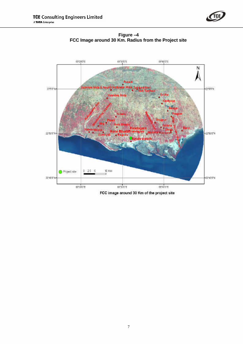
system. c) Survey of flora and fauna falling along 21 km MGR stretch d) Determine the impact of the proposed activities on existing ecology e) Management plan for restoring the existing ecology

2
f) To prepare a report on ecological impact
METHODOLOGY
10. The field survey was carried out in the last week of November’2006 to evaluate the ecological condition along MGR (Merry Go Round) system. The stretch of 21 km from the Mundra Port to proposed UMPP plant site was surveyed for existing ecological conditions. Surveyed route is shown in Drawing No. RITES/PFC-Mundra-plan/01 sheet 1 of1 Plan of the proposed MGR route.
11. Literature reviewed for collection of secondary data from Forest Working Plan of Kutch Forest Division and a study report on Sustainable Development Plan for Environmental Protection of Kutch by Gujarat Institute of Desert Ecology.
12. Satellite Imagery data has been used to derive the land use pattern of the study area.
13. Local public were also contacted for the existing flora and fauna and awareness of the proposed development
14. Impact has been assessed qualitatively
GENERAL FEATURE OF THE REGION
15. The great Rann of Kachchh consists of a vast expanse of tidal flats with saline efflorescence. Strata of northern strip of Kachchh belong to the Jurassic with recent alluvium of the low land and the Banni tract.
16. The soil is mostly sandy or sandy loam on the coastal tract where as in the other area of the district it is alluvial, sandy, swampy or black clay or loam.
17. The Rann of Kachchh remain flooded for about four months in rainy season with sea water driven up by the strong south west monsoon and fresh water brought down by the river Rann consists of a vast expense of tidal mudflats with saline efflorescence
TOPOGRAPHY OF THE STUDY AREA
18. The present study area falls in Kutchch peninsula. The topography of the area is such that the central portion forms the table land sloping on all sides. It is practically an undulating rocky area with small hills and with Rann of Kutch lying on the northern end, consisting of vast expense of tidal mud flats with salt-encrusted mud. The soil varies a great deal from place to place, along the coastline, there are alluvial soils and in some parts they are saline. Soil type indicates that area has high erodability. Elevation of the route varies from 10 m to 21m MSL . A typical topographic feature and vegetation of the route is shown in the following Figure – 1:

3
Figure -1 General Topography and Vegetation
LAND USE PATTERN OF THE STUDY AREA
19. Satellite image analysis was carried out for the generation of land use/ land cover map of the study region. The approach for satellite data analysis adopted the well-proven Image processing procedures. The analysis was preceded with a ground survey, which comprised of data collection of ground features along with the respective geographical position in terms of latitudes and longitudes.
20. The satellite data used has the below specifications:
? Satellite and Sensor: IRS P-6, LIS III (L-3) ? Date on which the image was taken: 26-November-05
21. In order to understand the land use and land features covering the entire study region, both False Composite and classified images have been derived. An FCC image depicts the land features such as the coastal boundaries, while the classified images show different land use classes listed above. The coverage statistics, the area covered by each land use class, are also derived for 5 km ,10km and 30 km through satellite data analysis and shown in following Tables and Figures:
Table - 1
LAND USE CLASSESS WITHIN 5 KM RADIUS Classes Area (Km2)
Scrub forest 1.326274637 Salt Pan 8.319278704 Mangrove 0.054819352 Built up area 14.78530965 Fallow land 18.88261409 Nallah 7.241459516

4
Agricultural land 5.15743997 Water Bodies 5.406779602 Barren hill 5.210490956 Marshy Land 12.89581038 Total 79.28027686
Table -2
LAND USE CLASSESS WITHIN 10 KM RADIUS Classes Area (Km2)
Scrub forest 2.829385891 Salt Pan 13.23445251 Mangrove 0.719725036 Built up area 44.29934123 Fallow land 70.77974062 Nallah 15.3839016 Agricultural land 33.14890827 Water Bodies 63.53651274 Barren hill 25.53697604 Marshy Land 46.71581362 Total 316.1847575
Table - 3
LAND USE CLASSESS WITHIN 30 KM RADIUS Classes Area (Km2)
Scrub forest 53.16239253 Salt Pan 32.66260757 Mangrove 6.764000647 Built up area 280.4018678 Fallow land 443.8271969 Nallah 84.7790115 Agricultural land 158.2316376 Water Bodies 515.5998752 Barren hill 414.0859303 Marshy Land 120.9942667 Total 2110.508787

5
Figure – 2 FCC Image around 5 Km. Radius from the Project site

6
Figure – 3 FCC Image around 10 Km. Radius from the Project site
7
Figure –4 FCC Image around 30 Km. Radius from the Project site

8
FLORA OF THE STUDY AREA
22. The forest type of the area falls under scrub forest as per the classification of Champion and Seth (1968). These forests are typical of arid and semi-arid zones of the earth where the total rainfall ranges from 25-100Cm. The vegetation presents a very open appearance so that the trees and shrubs are widely spaced. The bulk of the vegetation consist of co-dominant, spiny shrubs and trees capable of drought resistance.
23. The typical species found in these areas are shown in the following figure:
Figure – 5 Prosopis juliflora - A Dominant Species of the Area
Figure – 6
Dichrostachys cinerea Capparis decidua
24. Detailed information’s on ecological condition has been collected, which includes information on both flora and fauna communities. In present study, information has been collected on existing plant and animal species through survey and field studies. The information on distribution pattern of tree species has been collected to establish the interrelationship between species for prevailing environmental factors for post-development monitoring and management.

9
25. Plant communities are not static but always a dynamic entity. The vegetation cover may reflect the changes, which occurs in its structure, density, and composition. The most important characteristics of a community are its quantitative relationship between abundant and rare species. Characteristics of community in any ecosystem include the composition, structure, species diversity and growth trend of succession and other characteristics of the community, which is applied for the concept and realization of land management. To meet the objective of bio-diversity conservation with temporal & spatial changes, the monitoring of vegetation of an area is a necessary step.
26. A reconnaissance survey of the study area was planned during the study period November 2006 to establish the existing ecological condition of the study area. The information about forestland area of the villages was collected from District Census Hand Book Part II – Land use also. Prosopis juliflora is the dominant species of the terrestrial ecosystem of the study area.
27. Vegetation of the study area falls under “VI – B Northern Tropical Forest “ – sub – type C-I Desert Thorn Forest - (VI – Kachchh, Saurashtra, Gujarat).
28. The major agricultural crops cultivated in the area are Jowar (Sorghum bicolor), Bajara (Pennisetum typhoides ) wheat, cotton, castor etc. Fruit trees like sapota, mango, are also cultivated in some part of the district. The most dominant species which is found growing in almost all parts of the district is Phoenix robusta (Bell.) Bell. & Hook. f. locally known as Kharik. It is a commercial crop cultivated for its edible fruits.
29. There happens to be a significant diversity of crops in the study area. Among cereals, Bajra (Pennisetum typhoides) and Jowar (Sorghum bicolor) are mainly cultivated in this region. Proportionately Wheat (Triticum vulgare) is cultivated in lesser quantity. In pulses Mung and Mungphali (Arachis hypogaea) and cotton were observed.
30. The most dominant species which is found growing in almost all parts of the district is Phoenix robusta (Bell.) Bell. & Hook. f. locally known as Kharik. It is a export quality commercial crop cultivated for its edible fruits.Kharik Palm (Pheonix dactylifera), Chiku (Achrus sapota), Coconut (Cocus nucifera) Mango (Mangifera indica var). Kesar were the main cash crops cultivated in orchards. Of these Kharik Palm, Chiku were also reported in the coastal villages.
Figure – 7 Phoenix robusta (Bell.) Bell& Hookf Acrus sapota plantation
Photo No.:7 Phoenix robusta (Bell.) Bell& Hookf Photo No.:8 Acrus sapota plantation
31. However in inner villages the Coconut and Mango has reduced their majority significantly. Papita or Papaya (Carica papaya) was also observed in few orchards. Erand (Ricinus

10
communis) was observed to be cultivated for its oil yielding seeds. In vegetable crops Dudhi, and members of Cucurbitaceae family were observed along with Brinjal. In homestead areas Khatti and Mithi imli (Tamarindus indicus and Pithecolobium dulce), Jamun (Syzygium cumini) and Ber (Zizyphus mouritiana) were very common. Very few numbers of Artocarpus heterophyllus were also been observed.
MANGROVE VEGETATION
32. The intertidal region in the study area is though under influence of tide, possesses sandy substratum and hence is devoid of mangrove vegetation. Mangroves show a very dwarf appearance in the creeklets such as “kutri”(local name creek, which is at least 2.5 Km. away from the actual project site. Avicennia marina is the dominant species with Suaeda as a majour associate mangrove. Denis indica and Salvadora persica are the other associated species were recorded during the study period.
33. Mangroves, locally famous as “Cheriya” in this region and the mangrove areas are called “Cheriya vistar”. Avicennia marina, Salvadora perciaca, Seuda were very common in this area. According to information available from local forest office, few years back, Rhizophora mucronata and Ceriops tagal had been introduced in this region. The mangrove vegetation is seen from Mundra port up to Tunda-Vandh coast. However, in Tunda-Vandh, the Prosopis and Acacia spp. were predominantly observed just above the high tide line.
Figure – 8 Natural Vegetation of the study area
VEGETATION DENSITY:
34. Mangrove plant density varies considerably between creek and island in study area. Density of mangrove trees ranges from minimum of 525/ ha at Jarpara to a maximum of 1666/ha at Navinal Creek -1. Mangrove species were not reported along the proposed MGR rail route.
35. Highest mangrove tree density of 1666 per ha was recored at Navinal creek. Details of the vegetation characterstics falling alongthe route are given below.
Height (m) GBH (m) Station Tree
Density/Ha Mean Range Mean Range Adani 500 1.34 1- 4.5 0.32 0.2-0.59 Navinal cr-1 1666 3.28 1-6 0.53 0.1-1.05 Navinal cr-2 860 2.46 1-5.5 0.36 0.15-0.93

11
Height (m) GBH (m) Station Tree Density/Ha Mean Range Mean Range
Jarpara 525 1.85 1-2.5 0.26 0.2-0.36 Source: Gujarat Institute of Desert Ecology
36. This region receives very small amount of rain, in addition the soil texture is also sandy. Hence, the vegetation in this region is typically “scrub” type vegetation. The trees and shrubs of Prosopis and Acacia are predominantly reported in non-cultivated lands. Also members of Euphorbiaceae namely E. nivula and E. tirucalli were very commonly observed. Aloe vera was also observed at few places. The profusely grown Ficus benghlensis were observed near a dry water tank in Navinal village. Among the evergreen species Neem (Azadiracta indica) is the only species observed in significant number in the study area. Among shrubs- Cassia auriculiformis, locally called “Avar” is also observed predominantly along with Calotropis. In tress species, Eucalyptus, Casuarina, Delonix, Peltophorum, Nerium, Polyalthia, Thevetia were observed to be cultivated in homestead areas. A list of flora recorded in the study area is shown in the following Table:
Table - 4 List Of Flora Recorded In The Study Region
No. Name of Plant Family Habit Vernacular Name
1. Acacia auriculiformis Mimosaceae T
2. Acacia leucociphala Mimosaceae T Hermo baval
3. Acacia nilotica sub-species indica Mimosaceae T Babhul
4. Acacia senagal Mimosaceae T Gorad
5. Acrus sapota Sapotaceae T Chiku
6. Agave ingens Agavaceae H
7. Aloe vera H
8. Arachis hypogaea Papilionaceae H Mungphali
9. Artocarpus heterophyllus Moraceae T
10. Avicennia marina Avicenniaceae T Cheriya
11. Azadirachta indica Meliaceae T Nimda, Limdo, Neem
12. Bougainvillea spectabilis Nyctaginaceae C
13. Butea monosperma Fabaceae T Kesudo
14. Calotropis gigentia Asclepiadaceae S Dholo Akado
15. Calotropis procera Asclepiadaceae S Nano Akado
16. Carica papaya Carricaceae T Papita, Papaya
17. Cassia auriculiformis Caesalpiniaceae S Avar
18. Casuarina equisetifolia Casuarinaceae T Suru
19. Cocos nucifera Arecaceae T Nariyal
20. Cordia dichotoma Boraginaceae T Moto Gundo

12
No. Name of Plant Family Habit Vernacular Name
21. Cordia gharaf Boraginaceae S Liyar, Gundi,
22. Cynodon dactylon. Poaceae HG
23. Cyperous spp. Cypereceae H
24. Delonix regia Caesalpiniaceae T Gul Mohar
25. Derris indica Fabaceae T
26. Eucalyptus Spp. Myrtaceae T Nilgiri
27. Euphorbia nivulia Euphorbiaceae S Thor
28. Euphorbia tirucalli Euphorbiaceae T Kharsani, Thor
29. Ficus benghalensis Moraceae T vad
30. Ficus recemosa L. Moraceae T
31. Ficus religiosa L. Moraceae T Pipal
32. Ipomea fistulosa Convolvulaceae S Akari
33. Ipomoea sp. Convolvulaceae C
34. Leptadenia pyrotechnica Asclepiadaceae S Khip
35. Leucaena leucocephala Mimosaceae T
36. Mangifera indica L Anacardiaceae T Aam
37. Mimosops hexandra Sapotaceae T Rayan
38. Nerium odoratum Apocynaceae S Kanher
39. Peltophorum pterocarpum Caesalpiniaceae T
40. Pennisetum typhoides Poaceae HG Bajra
41. Phaseolus aureus Fabaceae H Mung
42. Pheonix dactylifera Arecaceae T Kharik Palm
43. Pithecolobium dulce Mimosaceae T
44. Polyalthia longifolia Annonaceae T
45. Portulaca indica Portulacaceae H
46. Prosopis chilensis Mimosaceae S Gando Baval
47. Prosopis chilensis Mimosaceae T Khijdo
48. Prosopis stephaniana Mimosaceae S Khijdi
49. Ricinus communis L. Euphorbiaceae S Erand
50. Samanea saman Mimosaceae T
51. Solanum melanogena Solanaceae H Baingan
52. Sorghum bicolor Poaceae HG Jowar

13
No. Name of Plant Family Habit Vernacular Name
53. Syzygium cumini Myrtaceae T Jamun
54. Tamarindus indicus L. Caesalpiniaceae T
55. Terminalia catapa Combretaceae T
56. Thevetia peruviana Apocynaceae S
57. Typha angustata H Panj
58. Zizyphus mauritiana Rhamnaceae S Ber
FAUNA OF THE STUDY AREA
37. Old records reveal that at the beginning of the 18th centaury Lion, Tiger and other animals relating to cat family was plentiful in Kachchh, but villages observed that most of these animals are not seen in the area.
38. Some of the common animals found in the study area are Fox, Mangoose,Nilgai (in Mundra forest) Rabbit etc,
39. In reptile’s cobra, monitor lizard, rat snake is reported by surrounding villagers at rare occasions.
40. A recent study reveals high avifaunal diversity at Mundra region and 140 species have been documented. Some of the birds sighted during the present study are Grey herons, Pond herons, large and small Egrets, Black Ibis etc. Following figures indicate about the presence of avifauna of the area.
Figure – 9
Avifaun of The Study Area
LIVESTOCK POPULATION
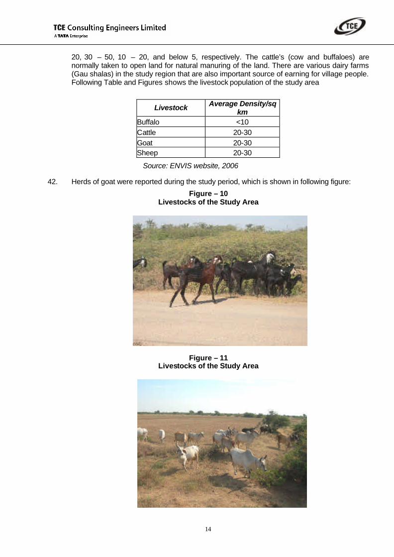
41. Cattle wealth occupies a pivotal place in the rural economy of any of the area. Bullocks & cows, buffalo, sheep, goats, horses, mules, donkeys, camels, pigs and poultry are the livestock reported. Livestock density of the area varies from 50 to 75 per square kilometer. Average density (per square kilometer) for buffalo, cattle, goat, and sheep varies from 10 –
14
20, 30 – 50, 10 – 20, and below 5, respectively. The cattle’s (cow and buffaloes) are normally taken to open land for natural manuring of the land. There are various dairy farms (Gau shalas) in the study region that are also important source of earning for village people. Following Table and Figures shows the livestock population of the study area
Livestock Average Density/sq km
Buffalo <10 Cattle 20-30 Goat 20-30 Sheep 20-30
Source: ENVIS website, 2006
42. Herds of goat were reported during the study period, which is shown in following figure:
Figure – 10 Livestocks of the Study Area
Figure – 11 Livestocks of the Study Area

15
MGR RAILWAY SYSTEM AND VEGETATION DESCRIPTION.
43. To describe the MGR railway route, MGR line is divided into four segments viz. A) Unloading bulb B) MGR load alignment Loading C) Loading and D) Loading terminal station @ Adani R & D railway yard. Proposed MGR railway route is shown in Drawing No. RITES/PFC-Mundra-plan/01 sheet 1 of1.
44. For the purpose of description of rail alignment, the starting point proposed at the entrance of unloading bulb is assumed as km 0.00. For in motion of coal rakes for unloading in the track hopper the train will have forward movement. Therefore a bulb type arrangement has been proposed in the unloading terminal. Unloading terminal station is partially on straight and curve and ends at km 5/692.
45. After unloading terminal station at km 5/692 the alignment is straight up to km 8/208. after this the alignment takes a the curve (no.6)with a curve of radius 500k meters up to km 8/477 and then the alignment is straight up to km 11/709, there after the alignment take a left hand curve (no.7) with curve of radius 500 meters up to km 11/798 and then straight up to km 13/641. after this the alignment takes right hand curve (no.8) with a curve of radius 500 meters up to km 13/657 after that the alignment takes is straight unto km 15/434 and takes a right hand curve (No.9) with curve of radius 500 meters up to km 15/685.Thereafter the alignment is straight up to km 18/590 and takes right hand curve (no.10) with a curve of radius of 500 meters up to km 18/634and than straight up to km 21/424. After this the alignment takes right hand curve (no.11) with a curve radius of 500 meters up to km 21/951 and then straight up to km 25/110. After this the alignment takes a left hand curve (no.12) with a curve of radius 500 meters up to km 25/507 where the alignment enters in to the loading bulb.
46. The alignment enters into a loading bulb with a curve (no.12) at km 25/110 with a curve radius of 500 meters up to km 25/507. There after the alignment Is straight up to km 25/784. After this the alignment takes a left hand curve (no.13) with a curve of radius 500 meters up to km 25/874 and than straight up to 26/595. After this the alignment takes a right hand curve (no.14) with a curve of radius 300 meters up to km 27/128 and than alignment straight up to 27/141. After this the alignment takes a right hand curve (no.15) with a curve of radius 300 meters up to km 27/670 and than alignment straight up to 28/372and takes right hand curve (no. 16) with a radius of curve 500 meters up to km 28/489 and than the alignment straight up to 28/993. After this the alignment takes a right hand curve (no.17) with a curve of radius 500 meters up to km 29/164 and meets the MGR bulb.
47. Existing Adani’s R & D rail yard has 5 lines for handling port traffic. It is proposed to bring the UMP POL rakes from Adipur station to Adani R & D rail yard for handling. Unloading line No. 1 and 2 shall be used for handling the loading and unloading coal rakes.
48. The proposed railway yard near Adani railway yard doesn’t have any vegetation. The Adani railway yard and vacant place for the MGR railway yard is shown in following photographs.

16
Figure – 12 Adani railway yard Place For Proposed Railway
Route Near Adani Railway Yard
49. Ideally in MGR system, the train needs not to be physically stopped as both loading and
unloading operations are in motion. The proposed MGR system is envisaged not to disturb village habitations, village roads, and ecology along the MGR line.
50. Photograph showing typical Vegetation near the MGR route near Adani railway yard at Mundra.
Figure – 13
Vegetation Along The MGR Route. Near Adani Railway Yard
51. There are 18 bridges proposed on the MGR route. One of them is planned over Nagavantahi Nadi also. Typical feature and vegetation under the proposed bridges is shown in following figure.

17
Figure – 14 Proposed Bridge At Nagvanthi Nadi
52. Proposed coal stack yard area was also surveyed during the study. Prosopis juliflora is the predominate species at the proposed project site coal stack yard. Existing features of the area is shown in following figure :
Figure – 15 Coal Stacking Yard
IMPACTS AND MANAGEMENT PLAN
53. Mangrove or other forested areas are not falling along the 100 wide route of MGR system. There may be cutting of some vegetation at certain stretches; the exact number can be ascertained after the finalization of the route. However, effort will be done to minimize the minimum shrub/trees felling.
54. Plantation is planned all along the available corridor of railway route. This will help in restoring the existing ecology of the route.

18
55. The above plantation will attenuate the noise generated due to operation of rail route.
CONCLUSION:
a) Predominent species along the route is reported to be Prsopis juliflora (Ganda bawal).
b) Mangrove species were not reported along the proposed MGR route.
c) No National park, wild life sanctuary, Biosphere Reserves, Bird sanctuary are falling along the rail route of proposed MGR system.
d) Ther is no Lakes, Reservoir, Dams coming in the way of MGR line. A small Bridge will be constructed on nagvanthi nadi.
e) Study area does not have Sensitive monuments and, Historical Places.
f) Mostly domestic and pet animals were report during the study. However, wild animals are also noticed by villagers at some of the accasions.
g) No significant wild life habitate disturbance is expected due to proposed MGR route and its activities.
h) During the lay down of MGR line, mainly local shrub plantation and some of the commercial specis of Phoenix robusta locally known as Kharik. , Chiku (Achrus sapota), Coconut (Cocus nucifera) Mango (Mangifera indica var) will be disturbed. However, proposed plantation along the MGR route will be helpful in compensating the loss of flora.
i) Plantation will be done all along the MGR route in consultation with local forest department.
j) Plant species native of the area shall be introduced. The preferred plant species will be heterogeneous in nature. Monocultures will be discouraged as much possible.