economic geology research institute - wits · pdf fileeconomic geology research institute ......
TRANSCRIPT

ECONOMIC GEOLOGY RESEARCH INSTITUTE HUGH ALLSOPP LABORATORY
University of the Witwatersrand Johannesburg
LOUIS DE LAUNAY AN OF THE WITWATWHAT HAS CHAN
AN EX LES RICHESSES MIN
ENTITLED: “WITWAT BY LOUIS D
SHA
IN
D THE DEBATE ON THE ORIGIN ERSRAND GOLD (1896-1903): GED IN A HUNDRED YEARS?
and
TRACT FROM: ĖRALES DE L’AFRIQUE (1903)
ERSRAND DISTRICT GEOLOGY” E LAUNAY (1860-1938)
RAD MASTER
FORMATION CIRCULAR No. 375

UNIVERSITY OF THE WITWATERSRAND JOHANNESBURG
LOUIS DE LAUNAY AND THE DEBATE ON THE ORIGIN OF THE WITWATERSRAND GOLD (1896-1903):
WHAT HAS CHANGED IN A HUNDRED YEARS?
and
AN EXTRACT FROM:
LES RICHESSES MINĖRALES DE L’AFRIQUE (1903)
ENTITLED: “WITWATERSRAND DISTRICT. GEOLOGY” BY LOUIS DE LAUNAY (1860-1938)
by
SHARAD MASTER
(Economic Geology Research Institute, School of Geosciences, University of the Witwatersrand, Private Bag 3, P.O. Wits 2050, Johannesburg, South Africa)
ECONOMIC GEOLOGY RESEARCH INSTITUTE INFORMATION CIRCULAR No. 375
December, 2003

LOUIS DE LAUNAY AND THE DEBATE ON THE ORIGIN
OF THE WITWATERSRAND GOLD (1896-1903): WHAT HAS CHANGED IN A HUNDRED YEARS?
and
AN EXTRACT FROM:
LES RICHESSES MINĖRALES DE L’AFRIQUE (1903)
ENTITLED: “WITWATERSRAND DISTRICT. GEOLOGY”
BY LOUIS DE LAUNAY (1860-1938)
ABSTRACT
Since its discovery in 1886, the Witwatersrand goldfield has proved itself to be the world’s greatest goldfield, with an estimated production of about 50 000 tonnes of gold up to the present day. The very first papers and accounts of the Witwatersrand goldfields were concerned mainly with the description of the physical location, extent, host rocks and economics of the goldfield, and a preoccupation with the projected continuation at depth of the gold-bearing conglomerate reefs. As mining and development of the goldfield progressed, the next group of papers was concerned with descriptions of individual mines and prospects, with the stratigraphy and structure of the gold-bearing formations, and with geological cartography, including maps and cross sections. By the mid-1890’s, sufficient information was available for the first major books on the Witwatersrand Basin to appear, as well as papers dealing specifically with the origin of the gold deposits.
Louis Auguste Alphonse de Launay (1860-1938) was an eminent professor at the Ecole des Mines in Paris, and one of the founders of the science of metallogeny. Aside from being a professor of geology, he was also a novelist, poet, essayist, historian and social commentator, and his published oeuvre runs into hundreds of works. In his 1896 book, Les Mines d’Or du Transvaal, De Launay was the first to examine critically all the physical evidence from the Witwatersrand gold-bearing reefs, and to present an objective and balanced overview of theories on the formation of the gold ores. He classified the ore genetic theories into three types: (1) (Modified) Placer Model - where the gold was of placer origin, being derived by erosion from pre-existing gold-bearing structures, and possibly being recrystallized after deposition in the conglomerate reefs; (2) Precipitation Model - in which gold and pyrite were deposited from solution during deposition of the conglomerates; and (3) Infiltration Model - where gold and pyrite were deposited from hydrothermal fluids which infiltrated the conglomerates after they were deposited. De Launay’s massive (540 pp.) 1896 book, based on several months of fieldwork in 1895, was written in French, and never translated into English. As a result, his ideas never received the kind of publicity that they deserved, and aside from a few brief references to his work, he seems to have been completely forgotten. De Launay republished his descriptions of the Witwatersrand deposits in his 1903 book Les Richesses Minérales de l’Afrique, with some alterations to take into account more recent developments.
In the hundred years since De Launay succinctly and objectively outlined the main theories for the origin of Witwatersrand gold, two rival positions have become entrenched - the Modified Placer Model, and the Hydrothermal Infiltration Model. The precipitation theory was already dismissed as early as 1898 by J.H. Hammond, who cited experiments that failed to show any precipitation of gold from seawater by natural reagents. The Modified Placer Model has been

outstandingly successful in predicting the location and continuation of payshoots (being dependant on sedimentary processes). The Hydrothermal Model, as developed in recent years explains the observed sedimentological controls on gold distribution in terms of epigenetic sulphidation of detrital iron oxides, and their replacement by pyrite and gold. The widespread occurrence of stratiform alteration zones characterised by pyrophyllite and chloritoid has been cited as evidence for large-scale acid metasomatism related to a major influx of hydrothermal fluid responsible for the gold mineralization. More recently, direct dating of gold particles by the Re-Os isotope method has indicated that the gold is around 3100 Ma old, older than the host Witwatersrand sediments, and is therefore of detrital origin. However, evidence has also been found for major hydrothermal remobilization and deposition of the noble metals (Au and PGE) between 2500 and 2200 Ma, to form the textural association hosting the gold mineralization. The consensus appears to be moving towards a vindication of the long-standing Modified Placer Model, originally enunciated by De Launay from 1896 to 1903, in which gold was originally concentrated in the reefs as a detrital heavy mineral, and was subsequently remobilized and re-precipitated during one or several later hydrothermal overprinting events.
____________oOo____________

LOUIS DE LAUNAY AND THE DEBATE ON THE ORIGIN OF THE WITWATERSRAND GOLD (1896-1903):
WHAT HAS CHANGED IN A HUNDRED YEARS?
CONTENTS Page
INTRODUCTION 1 LOUIS DE LAUNAY (1860-1938) 1 ORIGIN OF WITWATERSRAND GOLD – THE LAST 100 YEARS 2 REFERENCES 4
and
AN EXTRACT FROM:
LES RICHESSES MINĖRALES DE L’AFRIQUE (1903)
ENTITLED: “WITWATERSRAND DISTRICT. GEOLOGY” BY LOUIS DE LAUNAY (1860-1938)
CONTENTS
Page Note from the Translator 10 WITWATERSRAND DISTRICT. GEOLOGY 13 Character of the ores 14 General appearance of the conglomerate beds:
(1) along strike; and (2) transverse to the strike 20 Summary of observations on the auriferous conglomerates 24 Hypotheses on the formation of the auriferous conglomerates 27
___________oOo___________
Published by the Economic Geology Research Institute (Incorporating the Hugh Allsopp Laboratory)
School of Geosciences University of the Witwatersrand
1 Jan Smuts Avenue Johannesburg South Africa
http://www.wits.ac.za/geosciences/egri.htm
ISBN 1-86838-337-7

LOUIS DE LAUNAY AND THE DEBATE ON THE ORIGIN OF WITWATERSRAND GOLD (1896-1903): WHAT HAS CHANGED
IN A HUNDRED YEARS?
INTRODUCTION
Since its discovery in 1886 (Werdmüller, 1986), the Witwatersrand goldfield of South Africa has proved itself to be the world’s greatest goldfield, with an estimated production of about 50 000 tonnes of gold up to the present day (Pretorius, 1986; Frimmel, 2002). The very first papers and accounts of the Witwatersrand goldfields (Cohen, 1887; Cowen, 1887; Demaffey, 1887; Mathers, 1887; Jones, 1888; Jeppe, 1888; Collins, 1888; Holland, 1888) were concerned mainly with the description of the physical location, extent, host rocks and economics of the goldfield, as well as a pre-occupation with the projected continuation at depth of the gold-bearing conglomerate reefs. As mining and development of the goldfield progressed, the next group of papers involved descriptions of individual mines and prospects, and dealt with the stratigraphy and structure of the gold-bearing formations, and geological cartography, including maps and cross sections (Stanford, 1888; Schenk, 1888, 1889, 1890; Dorsey, 1889; Troye, 1889; Maidment, 1889; Mordaunt, 1889; Alford, 1889, 1890, 1891; Sawyer, 1889, 1894; Poole, 1890; Vautan, 1890; Edwards & Co., 1890; Curtis, 1890; Heim, 1891; De Launay, 1891, 1892a; Gibson, 1892; Abraham, 1892; Goldmann, 1892; Liddell, 1892; Reunert, 1893; Penning, 1893). By the mid to late 1890’s, sufficient information was available for the first major books on the Witwatersrand Basin to appear (Schmeisser, 1894; Demaret, 1895; Hatch and Chalmers, 1895; Goldmann, 1895, 1899; De Launay, 1896b; Ahrens, 1897; Denny, 1897; Bordeaux, 1898; Truscott, 1898), as well as papers dealing specifically with the origin of the gold deposits (Garnier, 1894, 1897; Cumenge, 1896a; Kuntz, 1896; Lodin, 1896; Krause, 1897; Becker, 1897, 1898; Wendeborn, 1897; Prister, 1898; Bleloch, 1899). The first detailed geochemical analyses of Witwatersrand conglomeratic gold ores were performed by Cumenge (1896b). By the early 1900’s, the emphasis was more on the technical aspects of deep mining and on the more mature developing gold mining industry, the continuity along strike and depth of the Witwaters-rand gold reefs having satisfactorily been proven (Denny, 1902; Liebenam, 1903).
LOUIS DE LAUNAY (1860-1938)
Louis Auguste Alphonse de Launay was an eminent professor at the Ecole des Mines in Paris, France, and one of the founders of the science of metallogeny. Aside from being a professor of geology, he was also a novelist, poet, essayist, historian and social commentator, and his published oeuvre runs into hundreds of works (Demay, 1939). De Launay was born in Paris in 1860 and was educated at the Lycée Condorcet (from 1872). His tertiary education was obtained at the Ecole Polytechnique in Paris (1879-1881), from where he graduated as a mining engineer. During his long and illustrious career, De Launay wrote more than a dozen books on geology and metallogeny (De Launay, 1892b, 1896b, 1897a, 1903, 1906, 1908a,b, 1911, 1920, 1921, 1922, 1933; Fuchs and De Launay, 1893). De Launay’s claim to fame as one of the pioneers of the science of metallogeny rests on his multi-volume treatises on metallogeny and applied geology (De Launay, 1892b, 1922, 1933; Fuchs and De Launay, 1893), and on his comprehensive accounts of the mineral resources of Africa and Asia (De Launay, 1903, 1911). De Launay was elected a Member of the French Academy of Sciences in 1912, and he died in Paris in 1938.
1

Louis de Launay first came to South Africa in 1895, when he visited the gold mines of the Witwatersrand and also the diamond mines of Kimberley. He wrote a popular account of his South African travels (De Launay, 1896e), and aside from his numerous publications concerning the Witwatersrand gold deposits (De Launay, 1891, 1892a, 1896a,b,c,d), he also published a book and papers on the diamondiferous kimberlites and mines of the Kimberley district (De Launay, 1897a,b, 1907). De Launay (1896a, b,c,d) was the first to examine critically all the physical evidence from the Witwatersrand gold-bearing reefs, and to present an objective and balanced overview of theories on the formation of the gold ores. He classified the ore genetic theories into three types: (1) (Modified) Placer Model - where the gold was of placer origin, being derived by erosion from pre-existing gold-bearing structures, and possibly being recrystallized after deposition in the conglomerate reefs; (2) Precipitation Model - in which gold and pyrite were deposited from solution during deposition of the conglomerates; and (3) Infiltration Model - where gold and pyrite were deposited from hydrothermal fluids which infiltrated the conglomerates after they were deposited. De Launay (1896b) stated that before he first came to the Witwatersrand he was personally in favour of the Modified Placer Model, but after considering all the arguments, he was inclined to favour the Precipitation Model, because he felt it had the least objections to it.
De Launay’s massive (540 pp.) 1896 book (De Launay, 1896b), based on several months of fieldwork in 1895, was written in French, and never translated into English. Even though an abridged English version of his earlier Annales des Mines article on the Witwatersrand ores (De Launay, 1896a) appeared in the Transactions of the Institution of Mining Engineers, his ideas never received the kind of publicity that they deserved, and aside from a few brief references to his work (e.g., Hammond, 1898; Prister, 1898), he seems to have been completely forgotten or overlooked. De Launay republished his descriptions of the Witwatersrand deposits in his 1903 book Les Richesses Minérales de l’Afrique, with some alterations and additions to take into account more recent developments. By the time of the appearance of the 1903 book, strong objections had been raised to the Precipitation Model, and some of De Launay’s earlier arguments had been criticed by Prister (1898). So, in a most remarkable turnaround (exceedingly rare in the history of science), De Launay (1903) withdrew his earlier endorsement of the Precipitation Model, and instead opted to simply place the facts concerning the three theories impartially before the reader, without choosing sides, and without reaching a conclusion. He was of the opinion that the three theories had given rise to so many objections, that in spite of all the attempts at explanation, the origin of the gold ores remained extremely obscure. He was not afraid to admit that the more he thought about the problem and the more he imagined the diverse and contradictory facts, the more he hesitated to favour one theory or another.
ORIGIN OF WITWATERSRAND GOLD - THE LAST 100 YEARS
In the hundred years since De Launay (1903) succinctly and objectively outlined the main theories for the origin of Witwatersrand gold, two rival positions have become entrenched - the Modified Placer Model and the Hydrothermal Infiltration Model. The precipitation theory was already dismissed as early as 1898 by Hammond, who cited experiments that failed to show any precipitation of gold from seawater by natural reagents. Johnson (1909) mentioned the three theories on the origin of Witwatersrand gold without acknowledging De Launay (1896a,b, 1903) as their source; thus effectively
2

Louis de Launay (1860-1938) about the time that he worked on the
Witwatersrand mines (after Demay, 1939)
Louis de Launay as he appeared in his later years
(after Demay, 1939)
illustrating that these theories had now become a part of the common knowledge concerning the Witwatersrand ores. The Modified Placer Model (e.g., Pretorius, 1975, 1976, 1981, 1991; Minter, 1976, 1999, Utter, 1980; Schidlowski, 1981; Nami, 1983; Reid et al., 1988; McLean and Fleet, 1990; Reimer and Mossman, 1990; Robb and Meyer, 1991; Els, 1991; Minter et al., 1993; Frimmel et al., 1993; Blenkinsop and Eriksson, 1995; Robb et al., 1997; Frimmel, 1997; James and Minter, 1999; Frimmel and Minter, 2002; Vollbrecht et al., 2002) has been outstandingly successful in predicting the location and continuation of payshoots (being dependant on sedimentary processes). Following from the somewhat polemical work of Graton (1930), the Hydrothermal Model, as developed in recent years (Phillips et al., 1987; Phillips and Myers, 1989; Myers et al., 1993; Phillips and Law, 1994, 1997, 2000) explains the observed sedimentological controls on gold distribution in terms of epigenetic sulphidation of detrital iron oxides and their replacement by pyrite and gold. The widespread occurrence of stratiform alteration zones characterised by pyrophyllite and chloritoid has been cited as evidence for large-scale acid metasomatism related to a major influx of hydrothermal fluid responsible for the gold mineralization (Barnicoat et al., 1997; Jolley et al., 1999). More recently, direct dating of gold particles by the Re-Os isotope method has indicated that the gold is around 3100 Ma old - older than the host Witwatersrand sediments, and is therefore of detrital origin (Schaefer et al., 2000; Kirk et al., 2001, 2002). However, Schaefer et al. (2000) also found evidence for major hydrothermal remobilization and
3

deposition of the noble metals (Au and PGE) between 2500 and 2200 Ma, to form the textural association hosting the gold mineralization.
The consensus appears to be moving towards a vindication of the long-standing Modified Placer Model (De Launay, 1896b, 1903), in which gold was originally con-centrated in the reefs as a detrital heavy mineral, and was subsequently remobilized and re-precipitated during one or several later hydrothermal overprinting events (Frimmel, 2002; Frimmel and Minter, 2002).
REFERENCES Abraham, F. (1892). Aufrichtige Geschichte der Goldminen des Witwatersrands
(Südafikanische Republik). Württembergischen Verein für Handelsgeographie in Stuttgart, Berlin, 1892, 51 pp. Abstr. in Zeitschrift für praktische Geologie, 1893, 164-166.
Ahrens, F.B. (1897). Die Goldindustrie der Südafrikanischen Republik (Transvaal). Samml. Chem. Vortr., Stuttgart, 2, 257-324, 15 illustr.
Alford, C.J. (1889). Witwatersrand goldfields, their geological features. Mining Journal, London, 1889, 1141-1142, map.
Alford, C.J. (1890). The geology of the Witwatersrand district. Witwatersrand Mining and Metallurgical Review, Johannesburg, 1(1), 1-6.
Alford, C.J. (1891). Geological Features of the Transvaal, South Africa. Edward Stanford, London, 69 pp.
Barnicoat, A., Henderson, I.H.C., Knipe, R.J., Yardley, B.W.D., Napier, R.W., Fox, N.P.C., Kenyon, A.K., Muntingh, D.J., Strydom, D., Winkler, K.S., Lawrence, S.R. and Cornford, C. (1997). Hydrothermal gold mineralization in the Witwatersrand basin. Nature, 386, 820-823.
Becker, G.F. (1897). The Witwatersrand Banket, with short notes on other gold-bearing puddingstones. 18th Ann. Rep. U.S. Geol. Survey, Washington, D.C., Part 5, 153-184.
Becker, G.F. (1898). Auriferous conglomerate of the Transvaal. Amer. J. Sci., 5, 193-208.
Bleloch, W. (1899). Rand conglomerates. Trans. Geol. Soc. S. Afr., 4 (8), 175-181. Blenkinsop, T.G. and Eriksson, K.A. (1995). Gold concentration in the Witwatersrand
reefs by footwall cannibalisation: implications for the source area problem and the syngenetic/epignetic debate. Econ. Geol., 90, 200-202.
Bordeaux, A. (1898). Les Mines de l’Afrique du Sud, Transvaal, Rhodésie, etc. Dunod, Paris, 211 pp.
Cohen, E. (1887). Ueber die goldführenden Conglomeraten in Südafrika. Mitteilungen der naturwissenschaftlichen Vereinigung für Neuvorpommern und Rügen, Greifswald, 19, 34-36. [Summary by A. W. Stelzner in N. Jahrbuch für Mineralogie, Geologie und Paläontologie, Jg. 1887, Referate, p. 133]
Collins, H. Ramsay (1888). Auriferous Conglomerate of the Transvaal and How toMine it. The Rupert Jones Collection, Johannesburg Public Library.
Cowen, C. (1887). Witwatersrand, Johannesburg, and other goldfields. Johannesburg, 12mo, 27 pp.
Cumenge, M.E. (1896a). Sur le mode de formation hypothétique des conglomérats aurifères du Witwatersrand (Transvaal). Compte Rendu de l’Académie des Sciences, Paris, 122, 346-348.
4

Cumenge, M.E. (1896b). Künstliche Darstellung von Gold führendem Conglomerat. Réunion de Saint-Etienne, Séance du 18 avril, 1896, 57-59. [Abstract by Krusch (1897). Gold-Conglomerat. Zeitschrift für praktische Geologie, 1897, p. 26.]
Curtis, J.S. (1890). The Banket deposits of the Witwatersrand. Engineering and Mining Journal, New York, 49, 200-201.
De Launay, L. (1891). Les mines d’or du Transvaal. Annales des Mines, Paris, Sér. 8, vol. xix, janvier 1891, p. 102-132. [Also, Nature, London, 19, 30 October 1891, 283-285.]
De Launay, L. (1892a). Note sur le développement des mines d’or du Transvaal (Witwatersrand). Annales des Mines, Paris, 9 (2), 107-110.
De Launay, L. (1892b). Formation des gîtes métallifères. Gauthier-Villars, Paris. De Launay, L. (1896a). Les mines d’or du Transvaal; districts du Witwatersrand,
d’Heidelberg et de Klerksdorp. Annales des Mines, Paris, 9 (ix), janvier 1896, 5-201. [Also, Trans. Inst. Min. Eng., Newcastle, 11, 1896, 378-462; N. Jahrbuch für Mineralogie, Geologie und Paläontologie, Jg. 1897 (1), p. 296]
De Launay, L. (1896b). Les Mines d’or du Transvaal. Librairie Polytechnique, Baudry et Cie, Paris and Liège, 540 pp.
De Launay, L. (1896c). Sur les caractères géologiques des conglomérats aurifères du Witwatersrand (Transvaal). Compte Rendu de l’Académie des Sciences, Paris, 122, 10 février, 1896, 260-262. [Also, N. Jahrbuch für Mineralogie, Geologie und Paläontologie, Jg. 1897 (1), p. 296.]
De Launay, L. (1896d). Sur le mode de formation des minerais aurifères du Witwatersrand (Transvaal). Compte Rendu de l’Académie des Sciences, Paris, 122, 10 février, 1896, 343-346. [Also, N. Jahrbuch für Mineralogie, Geologie und Paläontologie, Jg. 1897 (1), p. 296.]
De Launay, L. (1896e). Une excursion au Transvaal. Monde Moderne, mai 1896. De Launay, L. (1897a). Les Diamants du Cap. Librairie Polytechnique, Baudry et cie.,
Paris, 226 pp. De Launay, L. (1897b). Sur les roches diamantifères du Cap et leurs variations en
profondeur. Compte Rendu de l’Académie des Sciences, Paris, 125, 335-337. [Also, N. Jahrbuch für Mineralogie, Geologie und Paläontologie, Jg. 1898 (2), p. 254, 384.]
De Launay, L. (1903). Les Richesses Minérales de l’Afrique. Librairie Polytechnique Ch. Béranger, Paris and Liège, 395 pp.
De Launay, L. (1906). L’Histoire de la terre. Ernest Flammarion, Paris, 307 pp. De Launay, L. (1907). Sur la rencontre du granite dans le cheminée diamantifère de
Beers. Compte Rendu de l’Académie des Sciences, Paris, 9 décembre 1907. De Launay, L. (1908a). La conquète minérale. Ernest Flammarion, Paris, 389 pp. De Launay, L. (1908b). The World’s Gold: It’s Geology, Extraction, and Political
Economy. William Heinemann, London; G.P. Putnam’s Sons, New York, 244 pp. De Launay, L. (1911). Le géologie et les richesse minérales de l’Asie. Ch. Béranger,
Paris, 816 pp. De Launay, L. (1920). Où en est la géologie? Gauthier-Villars, Paris, 203 pp. De Launay, L. (1921). Géologie de la France. A. Colin, Paris, 501 pp. De Launay, L. (1922). Traité de Géologie et de Minéralogie appliquées a l’Art de
l’Ingenieur. Encyclopédie du génie civil & des travaux publics, Paris, 418 pp. De Launay, L. (1933). Cours de Géologie Appliquée. Librairie Polytechnique Ch.
Béranger, Paris and Liège, 468 pp. Demaffey, A. (1887). Les gisements métallifères du Transvaal. L’Afrique explorée et
civilisée, VIII (10), Oct. 1887, 292-307. [Summary by E. Cohen in N. Jahrbuch für Mineralogie, Geologie und Paläontologie, Jg. 1887, Referate, 112-113]
5

Demaret, L. (1895). L’or dans l’Afrique du Sud. Rev. Univ. Mines, Liège, 30, 1-40. Demay, A. (1939). L’oeuvre scientifique de Louis de Launay. http://www.annales.org/
archives/x/launay.html#1 Denny, G.A. (1897). The Klerksdorp Gold Field. Macmillan and Co., London, 247 pp. Denny, G.A. (1902). The Deep-Level Mines of the Rand. Crosby Lockwood and Son,
London, 170 pp. Dorsey, E.B. (1889). On the Witwatersrand gold fields. Report of the British
Association, London, Newcastle, 59, 592-594. Edwards, Dennis and Co. (1890). The Goldfields of South Africa, comprising the history,
extent, locality, and geological formation of the various goldfields, copiously illustrated. Cape Town, xxxviii + 914 pp.
Els, B.G. (1991). Placer formation during progradational fluvial degradation: the late Archean Middelvlei gold placer, Witwatersrand, South Africa. Econ. Geol., 86, 261-277.
Frimmel, H.E. (1997). Detrital origin of the apparently hydrothermal Witwatersrand gold - a review. Terra Nova, 9, 192-197.
Frimmel, H.E. (2002). Genesis of the world’s largest gold deposits. Science, 297, 1815-1817.
Frimmel, H.E., Le Roex, A.P., Knight, J. and Minter, W.E.L. (1993). A case study of the postdepositional alteration of the Witwatersrand Basal Reef gold placer. Econ. Geol., 88, 249-265.
Frimmel, H.E. and Minter, W.E.L. (2002). Recent developments concerning the geological history and genesis of the Witwatersrand gold deposits, South Africa. In: Goldfarb, R.and Nielsen, R. L. (Eds.), Global Exploration 2002 - Integrated Methods for Discovery. Spec. Publ. Soc. Econ. Geol., Littleton, 9, 17-45.
Fuchs, E. and De Launay, L. (1893). Traité des gîtes minéraux et métallifères, 2 volumes. Libriarie Polytechnique Baudry et cie., Paris, 823 + 1015 pp.
Garnier, J. (1894). Théorie de la formation aurifère du Witwatersrand. Nature, Paris, no. 1120, p. 394. [Also, C. - R. séan. Soc. Géogr. commer., 21 juin 1895, 277-279.]
Garnier, J. (1897). Gold and diamonds in the Transvaal and the Cape. Trans. geol. Soc. S. Afr., 2, 91-103, 109-120.
Gibson, W. (1892). The geology of the gold-bearing and associated rocks of the southern Transvaal. Q. J. Geol. Soc. London, 48, 404-437.
Goldmann, C.S. (1892). The Financial, Statistical and General History of the Gold and other Companies of the Witwatersrand. Effingham Wilson Argus, London.
Goldmann, C.S. (1895). South African Mines, their Position, Results and Developments, together with an Account of Diamond, Land and Kindred Concerns, with co-operation of Joseph Kitchin. Effingham Wilson and Co., London, Johannesburg. 3 volumes: Volume 1: Rand Mining Companies, Volume 2: Miscellaneous Companies, Vol. 3: Maps and Plans.
Goldmann, C.S. (1899). Map of the Witwatersrand Gold-fields. Scale 100 roods = 1 inch. Stanford’s Geographical Establishment, London.
Graton, L.C. (1930). Hydrothermal origin of the Rand gold deposits: Pt. 1- testimony of the conglomerates. Econ. Geol., 25, Suppl. No. 3, 185 pp.
Hammond, J.H. (1898). The genesis of the Witwatersrand Banket. In: Truscott, S.J. (Ed.), The Witwatersrand Goldfields Banket & Mining Practice. Macmillan and Co., London, 123-132.
Hatch, F.H. and Chalmers, J.A. (1895). The Gold Mines of the Rand. Macmillan and Co., London, 306 pp.
6

Heim, G. (1891). Die Goldfelder Südafrikas. Zeitschrift der Gesellschaft für Staatswissenschaften, Tübingen, 47, 485-498.
Holland, P. (1888). Examination of a quartz conglomerate from Witwatersrand (Transvaal). Chem. News, London, 57, 76-77.
James, C.S. and Minter, W.E.L. (1999). Experimental flume study of the deposition of heavy minerals in simulated Witwatersrand sandstone unconformity. Econ. Geol., 94, 671-688.
Jeppe, F. (1888). Die Witwatersrand-Goldfelder in Transvaal. Petermanns Geograph-ische Mitteilungen, Heft IX, 1888, 257-267.
Johnson, J. P. (1909). The Ore Deposits of South Africa. Part II. The Witwatersrand and Pilgrimsrest Goldfields and Similar Occurrences. Crosby Lockwood and Son, London, 51 pp.
Jolley, S.J., Henderson, H.C., Barnicoat, A.C. and Fox, N.P.C. (1999). Thrust-fracture network and hydrothermal gold mineralization: Witwatersrand basin, South Africa. In: McCaffrey, K.J.W., Lonergan, L. and Wilkinson, J.J. (Eds.), Fractures, Fluid Flow and Mineralization. Spec. Publ. Geol. Soc., London, 155, 153-165.
Jones, Beta (John Ballot) (1888). Banket Formation. Its Probable Origin and Present Position. Johannesburg.
Kirk, J., Ruiz, J., Chesley, J., Titley, S. and Walshe, J. (2001) A detrital model for the origin of gold and sulfides in the Witwatersrand basin based on Re-Os isotopes. Geochim. et Cosmochim. Acta, 65 (13), 2149-2159.
Kirk, J. Ruiz, J., Chesley, J., Walshe, J. and England, G. (2002). A major Archean, gold- and crust-forming event in the Kaapvaal Craton, South Africa. Science, 297, 1856-1858.
Krause, P.R. (1897). Über den Einfluss der Eruptivgesteine auf die Erzführung der Witwatersrand Conglomerate und der im dolomitischen Kalkgebirge von Lydenberg auftretenden Quartzflötze, nebst einer kurzen Schilderung der Gruben Bezirke von Pilgrimsrest und de Kaap. Zeitschrift für praktische Geologie, 1897, 12-25.
Kuntz, J. (1896). The Rand Conglomerates: how they were formed. Trans. Geol. Soc. S. Afr., 1 (6), 113-122.
Liebenam, W.A. (1903). Witwatersrand-Goldindustrie von Bergwirtschaftlichen Stand-punkten aus. Zeitschrift für praktische Geologie, 1903, 433-448.
Liddell, J.M. (1892). The Witwatersrandt gold-fields. Trans. Inst. Min. Eng., Newcastle, 3, 447.
Lodin, A. (1896). Sur le mode de formation des conglomérats aurifères. C.-R. Acad. Sci., Paris, 122, 637-640. [Also, N. Jahrb., Stuttgart, 1897 (2), 300]
Maidment, C. (1889). The first published geological map of the goldfields, Witwatersrand, South Africa. Scale 1 inch = 0.66 mile, with a pamphlet. Argus Co., Cape Town.
Mathers, E.P. (1887). The Gold Fields Revisited, being Further Glimpses of the Gold Fields of South Africa. P. Davis and Sons, Durban and Maritzburg, Natal, 352 pp. Reprinted by the State Library, Pretoria, 1970.
McLean, P.J. and Fleet, M.E. (1990). Detrital pyrite in the Witwatersrand reefs: evidence from truncated growth banding. Econ. Geol., 88, 311-323.
Minter, W.E.L. (1976). Detrital gold, uranium and pyrite concentrations related to sedimentology in the Precambrian Vaal Reef placer, Witwatersrand, South Africa. Econ. Geol., 76, 157-176.
Minter, W.E.L. (1999). Irrefutable detrital origin of Witwatersrand gold and evidence of eolian signatures. Econ. Geol., 94, 665–670.
7

Minter, W.E.L., Goedhart, M.L., Knight, J. and Frimmel, H.E. (1993). Morphology of Witwatersrand gold grains from the Basal Reef: evidence for their detrital origin. Econ. Geol., 88, 237–248.
Mordaunt, H.L. (1889). Plan of the goldfields, Witwatersrand, South African Republic, compiled by H.L. Mordaunt, Johannesburg. August, 1889. Scale 1 inch = 12 miles. James Wyld, London.
Myers, R.E., Zhou, T. and Phillips, G.N. (1993). Sulphidation in the Witwatersrand Goldfields: evidence from the Middelvlei Reef. Mineral. Mag., 57, 395-405.
Nami, M. (1983). Gold distribution in relation to depositional processes in the Proterozoic Carbon Leader placer, Witwatersrand, South Africa. In: Collinson, J.D. and Lewin, J. (Eds.), Modern and Ancient Fluvial Systems. Spec. Publ. Int. Assoc. Sedimentol., 6, 563-575.
Penning, W.H. (1893). Stanford’s [1888] map of the Transvaal goldfields, with the geology of the southern part. Scale 1 inch = 16 miles [with accompanying memoir]. Stanford, London.
Phillips, G.N. and Law, J.D.M. (1994). Metamorphism of the Witwatersrand gold fields: A review. Ore Geol. Rev., 9, 1-31.
Phillips, G.N. and Law, J.D.M. (1997). Hydrothermal origin for Witwatersrand gold. Soc. Econ. Geol. Newsletter, 31, 26-33
Phillips, G.N. and Law, J.D.M. (2000). Witwatersrand gold fields: geology, genesis and exploration. Soc. Econ. Geol. Rev. Ser., 13, 439-500.
Phillips, G.N. and Myers, R.E. (1989). Witwatersrand gold fields: Part II: an origin for Witwatersrand gold during metamorphism and associated alteration. In: Keays, R.R., Ramsay, W.R.H. and Groves, D.I. (Eds.), The Geology of Gold Deposits: The Perspective in 1988. Econ. Geol. Monogr., 6, 598-608.
Phillips, G.N., Myers, R.E. and Palmer, J.A. (1987). Problems with the placer model for Witwatersrand gold. Geology, 15, 1027-1030.
Poole, P.G. (1890). Map of the Klerksdorp gold-fields. Scale 1 inch = 350 Cape roods. Diggers’ News Co., Johannesburg.
Pretorius, D.A. (1975). The depositional environment of the Witwatersrand goldfields: a chronological review of speculations and observations. Minerals Sci. Eng., 7, 18-47. Reprinted in: Geokongress 77, Spec. Publ. Geol. Soc. S. Afr., 6 (1979), 33-55.
Pretorius, D.A. (1976). The nature of the Witwatersrand gold-uranium deposits, 29-88. In: Wolf, K.H. (Ed.), Handbook of Stratabound and Stratiform Ore Deposits, 7, Elsevier, Amsterdam, 657 pp.
Pretorius, D.A. (1981). Gold and uranium in quartz-pebble conglomerates. Econ. Geol., 75th Ann.Vol., 117-138.
Pretorius, D.A. (1986). The goldfields of the Witwatersrand Basin - Preface. In: Anhaeusser, C.R.and Maske, S. (Eds.), Mineral Deposits of Southern Africa, Vol. I. Geol. Soc. S. Afr., Johannesburg, 489-493.
Pretorius, D.A. (1991). The sources of Witwatersrand gold and uranium: a continued difference of opinion. In: Hutchinson, R.W. and Grauch, R.I. (Eds.), Historical Perspectives of Genetic Concepts and Case Histories of Famous Discoveries. Econ. Geol. Monogr., 8, ,139-163.
Prister, A. (1898). Notes on the origin and formation of the Witwatersrand auriferous deposits. Trans. Geol. Soc. S. Afr., 4 (2), 19-36.
Reid, A.M., Le Roex, A.P. and Minter, W.E.L. (1988). Composition of gold grains in the Vaal placer, Klerksdorp, South Africa. Mineral. Deposita, 23, 211-217.
Reimer, T.O. and Mossman, D.J. (1990). Sulphidization of Witwatersrand black sands: from enigma to myth. Geology, 18, 426-429.
8

Reunert, T. (1893). Diamonds and Gold in South Africa. J. C. Juta and Co., Cape Town, 242 pp.
Robb, L.J., Charlesworth, E.G., Drennan, G.R., Gibson, R.L. and Tongu, E.L. (1997). Tectono-metamorphic setting and paragenetic sequence of Au-U mineralisation in the Archaean Witwatersrand Basin, South Africa. Aust. J. Earth Sci., 44, 353-371.
Robb, L.J. and Meyer, F.M. (1991). A contribution to recent debate concerning epigenetic versus syngenetic mineralization processes in the Witwatersrand Basin. Econ. Geol., 86, 396-401.
Sawyer, A.R. (1889). The Witwatersrand gold-field. Mining at Johannesburg. Transactions of the North Staffordshire Institution of Mining Engineers, Newcastle-under-Lyme, 10 (3), 31 pp.
Sawyer, A.R. (1894). Remarks on the Banket formation at Johannesburg. Trans. Federal Institute of Mining Engineers, 1894, 360-367.
Schaefer, B., Pearson, B., Rogers, N. and Barnicoat, A. (2000). Re-Os isotope and PGE constraints on the timing and origin of gold mineralisation in the Witwatersrand Basin: a hybrid model. Abstr.,Goldschmidt 2000, Oxford, U.K., 5 (2), p. 881.
Schenck, A. (1888). Ueber Transvaal und die dortigen Goldfelder. Verh. Ges. Erdk., Berlin, 15, 130-140.
Schenk, A. (1889). Ueber das Vorkommen des Goldes in Transvaal. Zeitschrift der Deutsche geologischer Gesellschaft, Berlin, 41, 373-581.
Schenck, A. (1890). Ueber die Goldfelder Sud-afrikas. Verh. Naturh. Ver. Pr. Rheinl., Bonn, 47, 66-70. Also in Zeitschrift der Krystallographie, 20, p. 525.
Schidlowski, M. (1981). Uraniferous constitutents of the Witwatersrand conglomerates: ore-microscopic observations and implications for the Witwatersrand metallogeny. In: Genesis of Uranium- and Gold-bearing Precambrian Quartz-Pebble Conglom-erates. U.S. Geol. Surv. Prof. Paper, 1161-N, Washington, D.C., N1-N29.
Schmeisser, K. (1894). Über Vorkommen und Gewinnung der nutzbaren Mineralien in der südafrikanische Republik (Transvaal) unter besondere Berücksichtigung des Goldbergbaues. D. Reimer, Berlin, 151 pp.
Stanford, E. (1888). Stanford’s Map of the Transvaal Goldfields. Scale 1 inch = 16 miles. Stanford, London.
Troye, G.A. (1889). Troye’s Map of the Witwatersrand Goldfields. Scale 1: 91,250; Geological Section, Johannesburg.
Truscott, S.J. (1898). The Witwatersrand Goldfields Banket & Mining Practice. Macmillan and Co., London.
Utter, T. (1980). The rounding of ore particles from the Witwatersrand gold and uranium deposit (South Africa) as an indicator of their detrital origin. J. Sedim. Petrol., 50, 71-76.
Vautan, C. (1890). On the occurrence of gold in the Witwatersrand conglomerate. Witwatersrand Mining and Metallurgical Review, Johannesburg, 1 (7).
Vollbrecht, A., Oberthür, T., Ruedrich, R. and Weber, K. (2002). Microfabric analyses applied to the Witwatersrand gold- and uranium-bearing conglomerates: constraints on the provenance and post-depositional modification of rock and ore components. Mineral. Deposita, 37, 433-451.
Werdmüller, V.W. (1986). The Central Rand. In: Antrobus, E.S.A. (Ed.), Witwatersrand Gold - 100 Years. Geol. Soc. S. Afr., Johannesburg, 7-47.
Wendeborn, A. (1897). Störungen der Schichten zwischen Pretoria und Vereeniging im Transvaal und die daraus resultirenden Schlüsse über den Verbleib der goldhaltigen Conglomerate. Zeitschrift für praktische Geologie, 1897, 305-311.
___________oOo___________
9

AN EXTRACT FROM
LES RICHESSES MINÉRALES DE L’AFRIQUE (1903)
ENTITLED
“WITWATERSRAND DISTRICT. GEOLOGY”
by
LOUIS DE LAUNAY (1860-1938)
(Ingénieur en Chef des Mines,
Professeur à l’École supérieure des Mines, Paris, France)
Translated from the French by Sharad Master
[Note from the translator: The text was originally written in De Launay (1896, see Fig.
1), and was subsequently revised for the 1903 book. This extract is taken from De Launay (1903, pp. 54 -78 - see Fig. 2). This translation is dedicated to Mme. Ilona Ricardi (Harvard University Extension School), from whom I learned to read French, and to translate even the exasperatingly prolix and convoluted archaic constructions that were fashionable a hundred years ago. The numbering of the figures in the translated extract follows the numbering in the original book. I thank Lynnette Greyling for her help in reproducing the figures. Because of the vagaries of reproduction, the scales on the figures may vary from those originally published and referred to in the captions.
REFERENCES
De Launay, L. (1896). Les Mines d’Or du Transvaal. Librairie Polytechnique, Baudry et
Cie, Paris and Liège, 540 pp. De Launay, L. (1903). Les Richesses Minérales de l’Afrique. Librairie Polytechnique
Ch. Béranger, Paris and Liège, 395 pp. ]
10

Figure 1. Facsimile reproduction of the title page of de Launay’s 1896 book, Les Mines d’or du Transvaal.
11

Figure 2. Facsimile reproduction of the title page of de Launay’s 1903 book, Les Richesses Minérales de l’Afrique.
12

WITWATERSRAND DISTRICT. GEOLOGY The Witwatersrand ore deposits are composed, as we have already seen, of a series of auriferous conglomerate reefs, linked to the Hospital Hill Series. The detailed section of this assemblage, from the ancient granite, which forms a great massif north of Johannesburg, is as follows: Granite White quartzites of the Rand proper 350 metres Sandstones and ferruginous schists (black-shales) 470 m Quartzites in the footwall of the Rietfontein reefs or the Geldenhuis Valley c. 1200 m
North Reef, little exploited 0.15 to 0.30 mm RIETFONTEIN Quartzites 15 metres REEFS Quartzites, containing two exploited conglomerate reefs SERIES (Middle Reef and Middle Reef Leader) 1.30 m Quartzite 15 to 20 m Stable Reef, conglomerate with small pebbles 1.50 m Quartzites and argillites 250 m Magnetic sandstones, quartzites and schists, forming a series typical of the Hospital Hill 220 m Quartzites, with thin conglomerate beds 100 m Sericitic quartzites, forming the footwall of the Main Reef 700 to 800 m Red bar: reddish sandstone, a very constant marker bed under the Main Reef series 1 to 2 m North Reef, almost always unexploited 0.2 to 1 m Barren quartzite 15 to 20 m Main Reef, thick conglomerate bed (average tenor: 10-15 grams
[per ton] of gold) 1.5 to 8 m Barren quartzite, which occasionally pinches out at Crown Reef,
MAIN Bonanza, Jubilee, Village Main Reef, City and Suburban; attains REEF 2 to 3 m at Robinson, and is up to 20 m at Wemmer and SERIES Salisbury 0 to 20 m
Argillaceous band, frequently with quartz veins, in the footwall of the Main Reef Leader 0 to 0.1 m Main Reef Leader. Conglomerate (average tenor 10 to 35 grams [per ton]): the highest grades are commonly at the top of the Leader 0.30 to 1 m Barren quartzite with an unexploited middle reef 30 m South Reef. Quartzite, containing many conglomerate reefs, generally thin (0.02 to 0.1 m), with flattened pebbles, and with intervals of sandstone, which often pinch out. The richest part is commonly at the base, where one sometimes finds a secretion vein of white quartz (Crown Reef, etc.). This reef is the richest in the whole central Rand (average tenor: 15 to 40 grams [per ton]) 1.30 m
Quartzites 4 to 500 m Bird Reef 4 to 6 m Quartzites 4 to 500 m Kimberley Reef 110 to 20 m Quartzites 1200 m Elsburg Reef 20 m Quartzites 2500 m Lying on top of this sequence, with a discordance to the stratification, is the Black Reef Series, which in places rests on amygdaloidal diabase volcanic rocks of the Klipriviersberg. Economically, the most important reefs are: firstly, the Main Reef Leader and the South Reef, small thin beds, which, in general, do not exceed 1 to 1.5 m in thickness; then the Main Reef proper, a thick bed, initially neglected because of its low grades,
13

but being increasingly exploited as the extraction costs decline. It is in these three reefs that one finds most of the gold; but it is important not to forget, when one thinks of the future of the Witwatersrand, that the gold is also disseminated, in trace amounts that are more or less detectable, in many other beds, and therefore, the exploitability of an enormous quantity of supplementary ore is uniquely a question of the net cost. Character of the ores The ores which are characteristically exploited on the Witwatersrand are composed of conglomerates1 (and subordinately, thick sandstones or quartzites), having more or less rounded quartz pebbles enclosed in a siliceous matrix composed of small quartz grains, and containing grains of pyrite, with which the gold, appearing in a fine microscopic form always invisible to the naked eye, appeared to have been originally associated2 (Fig. 7).
Figure 7. Ore from the South Reef, Wemmer Mine (6th Level East), showing the total thickness of the auriferous bed, and the disposition of the quartz pebbles in a silicified and pyritic matrix. Sample 1462-13. Life size. In this siliceous cement, one finds accessory chloritoid, muscovite, and occasionally, zircon. These constituents are also present in the barren quartzites which separate the conglomerates, and they appear to have been cemented in the conglomerate by the same silica cement, through metamorphic actions. It is in this environment that one finds the pyrite grains, sometimes in distinctly crystalline form, sometimes broken or rounded. The size of the pebbles can be extremely different from one auriferous reef to another, without such variations indicating any relationship to gold grades; therefore one can find equal grades in a conglomerate with pebbles 6 or 10 cm in diameter, as sometimes found in the Kimberley Reef, and in a simple fine-grained quartzite, as in the Buffelsdoorn Reef; however, in any given bed, corresponding to a particular depositional period, and especially at a particular point in this bed, one can say that the pyrite and the gold is concentrated, in an almost constant manner, among the largest pebbles, and notably on the periphery of the pebbles.
1 These are the conglomerates which the Boers call banket, by comparison with an almond cake. 2 From the outcrops to about 15 or 20 m depth, the ordinary alteration of pyrite through oxidation, and its almost total disappearance through dissolution, has isolated free gold, frequently in the cavities of the pebbles, where it may be found free of its gangue because of this alteration. One may observe, in this regard, that the Witwatersrand has not experienced a phase of exploitation of placers, that oridinarily accompanies the development of a gold district. The very fine gold, unearthed by erosion, must have been, without doubt, entrained too little to have effected its mechanical concentration.
14

Figure 8. Ore of the Main-Reef Leader, Wemmer Mine. Life Size. Sample 1462-3. Q: pebbles of white, vitreous quartz. q: pebbles of dark quartzite. b: pebbles of bluish quartz. p: trains of pyrite in the cement of the quartzite. Moreover, that does not prevent the very real possibility of the existence of a simple quartzite, or a small pebble conglomerate containing gold, from being found within a few metres of an absolutely barren conglomerate with large pebbles; and of two neighbouring beds, with identical pebbles, having completely different gold grades. One often finds curious proof of this in the Main Reef and the Main Reef Leader, beds which are generally very similar: the Main Reef, which has pebbles the same size or even larger than those of the Leader, almost always has a much lower grade. I have mentioned, for the sake of completeness, the case of the auriferous quartzites; but by far the most common ore, especially in the old mines of the Central Rand, is a conglomerate with pebbles that vary in size from a nut to an egg, such as those shown in Figures 7 and 8. These pebble sizes, different from one bed to another, are characteristic to some extent for certain beds as follows: in the Kimberley Reef, the pebble sizes are enormous; in the Bird Reef, they are scarcely larger than a bird’s egg. In the auriferous conglomerates, which thus constitute the usual ores, one can observe, in summary, two very distinct parts which appear to have had completely different origins: (1) the pebbles, more or less voluminous, which, through some peculiarity of major interest, never contain either gold or pyrite1, that is to say in their
1 The rule is not absolute, and I cited a while ago an exception; but the rule is extremely general and microscopic examination only confirms this.
15

entire diameter, except along small fractures; and (2) the cement, where, by contrast, gold is concentrated with iron pyrite, silica and other secondary grains.
Figure 9. Ore with angular quartz pebbles from Balmoral (West Shaft). Sample 1472-2. The figure represents pebbles of hyaline quartz and fine dark grey quartzite (q) which stand out white against a siliceous cement with quartz grains and trains of pyrite (shown in black). Life size. Pebbles and cement are generally very intimately indurated; except in outcrops, where the dissolution of pyrite by the action of surface waters has disaggregated the rock, one always finds, when one breaks a fragment of the conglomerate, that the pebbles and the cement break together, following the same planar surface, where the pebbles then always stand out through their circular or elliptical sections, sometimes clear, sometimes dark, against the enveloping matrix (see, for example, Fig. 8). Speaking first about these pebbles: the pebbles of the auriferous conglomerates of the Main Reef series are always exclusively formed of vitreous blueish-white quartz, hyaline, smoky quartz, or a dull black, fine-grained quartzite; moreover, in certain reefs with large pebbles, either below or above the Main Reef, one finds boulders, often very large, of very coarse-grained quartzite, similar to that which surrounds the ores; one finds not even the slightest trace of the ancient rocks, such as gneiss, granite, granulite, etc. In certain conglomerates of great thickness and with large pebbles, which outcrop either in the lower parts of the series (reefs of the Geldenhuis Valley), or in the upper parts (Elsburg Reef, De Paaz Reef, Kimberley and Battery Reefs in the south), one also finds, subordinately, pebbles of white quartzite, similar to those which enclose the conglomerates in the hangingwall and the footwall; sometimes also pebbles of banded quartz, with black or dark blue stripes, often full of pyrite, which one can see
16
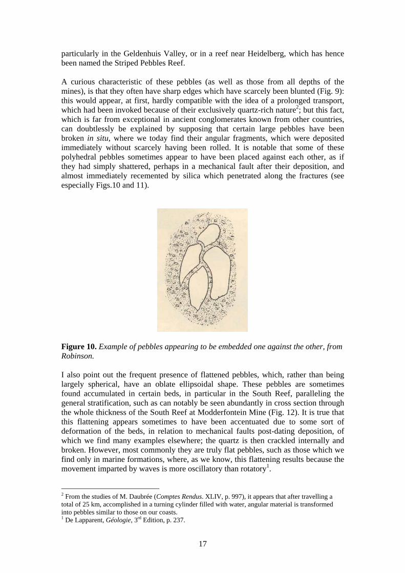
particularly in the Geldenhuis Valley, or in a reef near Heidelberg, which has hence been named the Striped Pebbles Reef. A curious characteristic of these pebbles (as well as those from all depths of the mines), is that they often have sharp edges which have scarcely been blunted (Fig. 9): this would appear, at first, hardly compatible with the idea of a prolonged transport, which had been invoked because of their exclusively quartz-rich nature2; but this fact, which is far from exceptional in ancient conglomerates known from other countries, can doubtlessly be explained by supposing that certain large pebbles have been broken in situ, where we today find their angular fragments, which were deposited immediately without scarcely having been rolled. It is notable that some of these polyhedral pebbles sometimes appear to have been placed against each other, as if they had simply shattered, perhaps in a mechanical fault after their deposition, and almost immediately recemented by silica which penetrated along the fractures (see especially Figs.10 and 11).
Figure 10. Example of pebbles appearing to be embedded one against the other, from Robinson. I also point out the frequent presence of flattened pebbles, which, rather than being largely spherical, have an oblate ellipsoidal shape. These pebbles are sometimes found accumulated in certain beds, in particular in the South Reef, paralleling the general stratification, such as can notably be seen abundantly in cross section through the whole thickness of the South Reef at Modderfontein Mine (Fig. 12). It is true that this flattening appears sometimes to have been accentuated due to some sort of deformation of the beds, in relation to mechanical faults post-dating deposition, of which we find many examples elsewhere; the quartz is then crackled internally and broken. However, most commonly they are truly flat pebbles, such as those which we find only in marine formations, where, as we know, this flattening results because the movement imparted by waves is more oscillatory than rotatory1. 2 From the studies of M. Daubrée (Comptes Rendus. XLIV, p. 997), it appears that after travelling a total of 25 km, accomplished in a turning cylinder filled with water, angular material is transformed into pebbles similar to those on our coasts. 1 De Lapparent, Géologie, 3rd Edition, p. 237.
17

In some cases also, the passage from the pebble to the surrounding cement is difficult to observe: one sees that the cement is continuous with the pebble, perhaps through secondary recrystallization at the expense of the edges of the pebble.
Figure 11. Ore from Main-Reef Leader, City and Suburban, 4th Level, showing the embedding of angular quartz fragments (Q) with a wavy coloration, and fine dark grey quartzite (q) in a matrix of slightly pyritic silicified cement (with pyrite shown in black). Sample 1463-4. Life size. The cement, which has cemented the pebbles together, also encloses the following: clearly visible iron pyrite, silica recrystallized in situ (either through the action of chemical precipitation, similar to that which led to the direct precipitation of crystallised pyrite, or through secondary processes), white mica and fairly abundant chloritoid, surrounded quartz grains with broken, indented or rounded outlines, and finally, gold. Under the microscope, one finds, in accessory amounts, some of those grains which are most resistant in crystalline rocks - rutile, zircon, etc.2 I have already said that, in general, the gold is not visible to the naked eye in the Transvaal ores; it is only very exceptionally that some free gold is crystallized, through secondary redissolution, either on a joint surface, where it forms a coating, or in a quartz vein, where it sometimes forms fairly large crystals3; but, except for chance finds like this, one can travel through all the sites of the mines of the Witwatersrand without seeing a trace of gold. Nevertheless, there does exist a certain proportion of free gold in these ores, and one can attest to its presence either through microscopic examination, or, very easily, by a simple assay by panning, which immediately isolates, just as in the ores from the depths, a tail of yellow native gold, accompanied by a train of pyrite, which itself is auriferous.
2 Note also the curious fact (which has been certified by several trustworthy accounts) that one finds small green diamonds in the conglomerates around Klerksdorp, 3 Several good specimens of these have been found at Jumpers, Wemmer, etc.
18

Figure 12. Ore of the South Reef from Modderfontein. Total thickness of the auriferous bed (leader). Sample 1477-1. Flattened quartz pebbles Q are shown in white against cement of small quartz grains and barely visible pyrite. Life size.
As far as the disposition of this auriferous pyrite is concerned, one should note the fairly common presence of pyritic zones, either parallel or oblique to the stratification, such as one can see in all the agitated sedimentary formations (Fig. 13). These zones are themselves formed, to a large extent, of subrounded to rounded pyrite grains, side by side with which, however, one can see finely divided crystals of pyrite penetrating into quartz grains, that is to say, crystallized in place.
Figure 13. Section through the Main Reef Leader on the 4th Level West of City and Suburban, showing the false pyritic stratifications (The beds are shown with their real inclination).
One is forced to conclude, therefore, that faulting has played a certain role in the present distribution of gold in the ores. It also appears to have resulted in the rounded or fragmented appearance of certain pyrite grains examined under the microscope. On the other hand, the crystalline pyrite with distinct facets, forming either isolated crystals, or secondary zones sometimes attached to quartz grains, is also quite common - it necessarily results from crystallization in place (through the action of the original fluids, or through secondary movements). Other than gold and iron pyrite, which may constitute up to 30% of its mass, the Witwatersrand ore is remarkably poor in other metals: this contributes to the ease of its treatment by potassium cyanide. Generally, one can say that in most of the mines, one never detects the presence of any metals, except for traces of silver and copper, the latter being sometimes visible among the zinc which precipitates gold from
19

cyanide solutions1. I have confirmed this fact myself, with the concentrates from Wemmer, which grade at 9 grams of gold per tonne, and which do not give the slightest trace of copper, zinc and lead; the analysis, done at the Ecole des Mines (Paris), showed only 0.04% arsenic. It is only in the secondary quartz veins, mentioned above, that one can sometimes find other metals: thus I was able to find galena and sphalerite at Buffelsdoorn, where there are also occurrences of arsenopyrite; chalcopyrite at Robinson; and crystals of pyrite and sphalerite at Croesus (Third Level East, on the South Reef). Mr Schmeisser has noted, in addition, the presence of some sphalerite at Alexandra Estate and Rietfontein, and traces of antimony in the West Rand. I will return soon to the gold grade of the ores, which is intimately connected to the economic part of this study; but before that, one should first examine the general appearance of the conglomerate beds, in order to be able to discuss the curious and obscure question of their origin. General appearance of the conglomerate beds: (1) along strike; and (2) transverse to the strike The conglomerate beds constitute (totally independant of their auriferous cement, which may be local), a formation of great extent, due to having being affected by a late fault, which has assumed, in the part which we observe today, the appearance of a syncline (see Fig. 5). That is a point which has been indicated before, and to which I will return. Studied initially in the direction of their outcrop, these conglomerates have a reputation for regularity, which may be justified to a certain extent for the economic yield, but which, if examined in detail, gives a very inaccurate idea of the geological disposition of these deposits. If we examine, effectively, either a gallery in any mine on the Rand, or one of its assay plans, on which is shown, in 10 m by 10 m areas, on the traces of the drives, the thickness and the grade of the ores, especially if we transform the figures on the assay plans, as shown in Figure 14, into a graphic trace, one can see immediately that the reputedly regular reefs change incessantly the dimensions concerning their grades, and their maximum thicknesses, which vary, over a strike length of 20 m, from a few centimetres to several metres. This irregularity, of which we have here an example, taken completely at random from one of the most justly famous mines on the Rand, is not an exception, but, on the contrary, is an absolutely general rule1. The contrary would be, furthermore, very surprising and almost without example in a geological formation, probably littoral2 or even fluviatile, such as our quartzites and conglomerates. 1 See, for example, at the United Main Reef Roodepoort . 1 In Figure 14, three curves are shown: one shows the variations in thickness at each point; the second shows the gold grade, according to laboratory assays; the third shows variations in the value, that is to say, the product of the thickness and the grade, the variations between these two parameters do not compensate at all, as one can sometimes affirm after some very limited observations. 2 The fact of the existence of conglomeratic beds which extend for kilometres in length, is true especially for the Transvaal, but is above all very difficult to reconcile with the limited extent of the present-day pebbles on our beaches. In certain cases these can be explained by the spreading of torrential deltas onto alluvial plains.
20

Aside from the variations in thickness of the beds, their pinchings and swellings, one can also see, every time that one goes to the trouble of making careful observations, bifurcations and local doublings of the reef into two reefs, which reunite after a short distance; the appearance of sandstone beds within the conglomerates, or, reciprocally, the progressive transformation of a sandstone into a conglomerate, etc. One finds these variations (which I have emphasised, and for which one does not need an excess of imagination concerning the Main Reef, or another such conglomerate bed), for more than 35 km along strike, from one end of the Rand to the other. The first impression, indeed, on visiting the mines of this region, is that it is very difficult, if not impossible, to distinguish one reef from another, and therefore, to correlate two parts of a distinct reef, especially if they have been separated by a fault (which can sometimes place two different reefs adjacent to each other), is very hypothetical, perhaps even justified solely by the desire to give the bed one is exploiting a good sounding name which is favourably known elsewhere. One reef, or auriferous conglomerate bed of the Witwatersrand, does not constitute, indeed, according to a tendency that is growing in Europe, an absolutely determined entity, constant in its appearance and immediately characterised wherever one finds it, by a distinctive sign. It is even often very difficult to make out the subtle distinction between what is mineralised and what is sterile, and for the same reason, to distinguish one ore from another. The absolute similarity of the quartzite beds, which surround the various conglomerates both in the hangingwall and in the footwall, is a good reason to be wary in making these connections. However, eventually, this impression tends to disappear soon when it is not accentuated, and one has understood for each reef a certain general well-defined idea to enable one to distinguish, without much error, one reef from another - not through an isolated sample, nor perhaps through a single face of an exposure, but by means of a certain length of galleries. I am very disposed to thinking that despite the discontinuities and lenticular disposition of such and such a reef found in isolation, and consequently, the impossibility of correlating precisely bed by bed from one end of the Rand to the other, the bundles of these reefs nevertheless give a certain continuity throughout the whole length of the gold workings. If we now look at the auriferous conglomerate beds in cross section, we see that in the whole of the northern region, from the east to the west of Johannesburg, they have an east-west strike, and a general dip, somewhat accentuated, to the south. This dip of the beds, as can be seen in Figures 15 and 16, is absolutely variable from one point to the next, between vertical and horizontal, and at certain special points, is locally reversed; nevertheless, with reference to a North-South section perpendicular to the axis of the syncline, it appears generally, as one can see, that the beds, encountered successively from North to South, dip more and more towards the horizontal, as they approach the axis of the syncline.
21

Figure 14. Graphic interpretation of an assay plan (Main Reef Leader at City and Suburban). N.B. : The upper curve is of the grade per tonne of ore and the adjacent figures the grade in grams per tonne of 1000 kg. The lower dark curve is of the thickness of the ore in cm, thickness also marked at different distances. The curve which encloses the hatched area represents the product at each point of the thickness and the grade, i.e., the value in cmg/t.
One characteristic feature, a direct consequence of such a disposition of the beds at depth in the basin (and the observation of which is of great importance for the industrial development of the country), is that the plunge of a bed shows in a section (and consequently, in a particular mine) a diminution of dip in a constant and rapid manner, such that, for example, a bed that outcrops with a dip of 70° to 80° dips at no more than 30° by the time it has reached a depth of 300 m (Figs. 17 to 22). The practical consequence of this fact is that to exploit a given length of a bed or reef, one needs to descend to a much shallower depth, in a vertical sense, than if the reef had maintained its original dip. Consequently, the work in the mines being necessarily limited to a certain depth (either because of physical impossibility due to the heat, or simply because of increased costs of extraction, or exhaustion), the quantity of ore
22

which may be extracted by hand is considerably increased1. This question, much discussed, of the limit to the depth of exploitation, is called, for concessions not enriched by the outcrops of their reefs, the question of deep levels.
Figures 15 and 16. The upper figure (15), shows the general form of the Main Reef, represented by 50 m isopachs. The scale in the sense of direction of the Reef (E-W) is a fifth of the scale along the dip (N-S), i.e., along the direction Oy and Oz. X indicates, in each concession, the deepest point reached by the workings. The lower figure (16), represents the curve of the variations in average grade in g/t in the mines which were milling ore during the first half of 1895. The portions shown with dashed lines correspond to mines which were not producing during this period. Another result connected with the change in dip of the beds at depth was a certain surprise for the first mining companies, which in wrongly assessing the shape of their auriferous lode, that is to say in a vertical sense, contented themselves with concessions that were too narrow in the direction of inclination of the reef, by supposing that such boundaries would nevertheless encompass the reef to the limits of its exploitability; when on the contrary, the still strongly payable reef, by virtue of its flattening dip, departed the concession and entered an adjacent one. Figures 17 to 22 illustrate a series of transverse cross-sections, at the same scale, going from West to East, through different points of the Witwatersrand. One sees generally the outline of the reefs curved in an extremely regular manner - which is, besides, natural for a rock sequence composed of a series of beds homogeneously and regularly superposed and, up to a certain point, independent, which submitting to an intense mechanical folding force, glide weakly against one another due to their curvature, as in a pack of playing cards which is inflected by pressing its two extremities.
1 On the contrary, the quantity of ore contained in a concession or claim is proportionally reduced as the beds approach horizontality, since the concession is limited by four vertical planes, following the four sides of the rectangle which defines it on the surface.
23

This gliding of strata one against the other is, without doubt, the cause of numerous argillitic bands, and of concentrations of minerals in geodes, produced by friction of two contiguous beds along a longitudinal fault; and it is equally possible to attribute to this cause the open fractures parallel to the strike of the beds which are commonly occupied by intrusive rocks or dykes (diabases, porphyries, etc.). Taken together, the transverse faults, either produced by crushing of beds thus curved, or forming later, are of limited importance in the Rand; but the beds may be considered, by comparison with those generally observed in Primary terrains, among the most regular. On this subject, it must be singularly noted, among the faults parallel to the strike of the beds, the abnormal number of reverse faults which are apparently as high as 70% (because we know the exact number), and give the sections through the orebodies the appearance of imbricate faults, in particular. Summary of observations on the auriferous conglomerates In summary, for the Main Reef series, the principle facts of observation, whose grouping may be conducive to a plausible explanation of the genesis of these enigmatic ores, are as follows1:
1. The gold ore is a conglomerate, or rarely, a quartzitic sandstone, of which the rounded clasts, pebbles and sand grains are, almost exclusively, formed of quartz, or in accessory amounts, quartzite; and of which the cement is constituted by pyritic and auriferous silica, together with metamorphic minerals chloritoid, muscovite, etc. The clasts may be well rounded or subangular, sometimes flattened, and may be dislocated in place;
2. The beds containing the gold in a more or less strong proportion, whether
exploitable or not, are separated by many thousands of metres of rocks consisting of quartzites and conglomerates, with rare intercalations of shales at the base, and without any beds of limestone;
3. These diverse auriferous conglomeratic beds present local constant variations
in thickness and in distance between each other. They are seen to thin out, sometimes bifurcating to enclose a mass of sandstone and re-uniting further; nevertheless, most of the time, a bed of conglomerate or sandstone, which appears suddenly, is but the enlargement of a bed previously marked by a simple indication (sandy layer or bed of disseminated clasts); and on the whole, the section presents a certain constancy, from one end of the auriferous zone to the other. The gold grade appears, on average, to be always localised in the same series of conglomerates, as far as one can judge from observations that are as yet incomplete;
4. The gold in the ores is often in a free state, but is always very fine and
invisible to the naked eye; it is constantly associated with pyrite, without 1 See for recent theories on the formation of the auriferous conglomerates: G. F. BECKER. The Witwatersrand Banket (Washington, 1897); JULIUS KUNZ (sic) (Trans. Geol. Soc. South Africa, v.I, p. 120); AUG. PRISTER. On the origin and formation of the Witwatersrand auriferous deposits (Trans. Geol. Soc. South Africa, May 1898); BORDEAUX. Mines d’or de l’Afrique du Sud (1898). I leave out, deliberately, those dealing with the Black Reef, of which the mode of formation is totally different.
24

apparently being bound with it; the gold grade is not necessarily proportional to the abundance of pyrite, and frequently one may observe under the microscope, gold crystals enclosed by pyrite. This pyrite, which easily forms up to 5 weight % of the rock, is generally remarkably pure, and contains only traces of copper, lead and zinc, with few exceptions;
Figures 17 to 22. Fig. 17: Transverse section of City and Suburban, through the main inclined shaft. Fig. 18: Transverse section of Geldenhuis Estate. Fig. 19: Section of Meyer and Charlton, through the two vertical shafts. Fig. 20: Section of Meyer and Charlton, through the main inclined shaft. Fig. 21: Section of George Goch West Mine, through the main inclined shaft. Fig. 22: Section of George Goch East Mine, through the transverse beds and the shafts.
25

5. Gold and pyrite are found, almost exclusively, in the cement to the quartz clasts, some of which are the same size as the pyrites. The quartz clasts never contain gold or pyrite, except extremely rarely in cracks, or in beds with a special character, as in those of Rip (sic);
6. The auriferous pyrite is in isolated grains, irregularly distributed in the
siliceous cement; frequently it forms trains of grains, rarely in continuous veinlets around fragments of quartz, which one observes frequently in the ores. The trains of pyritic grains may be either parallel to the stratification, or oblique to it and correspond to a false stratification of the sediments. This pyrite, examined with a loupe or a microscope, appears somewhat rounded or broken, notably in the case of parallel veinlets; quite frequently it is well crystallized, and presents acute angles with sharp edges, difficult to reconcile with prolonged wear;
7. There is a known global correlation between the dimensions of the clasts and
the gold grade, for a limited portion of these beds. The fine-grained sandstones are only very exceptionally auriferous, and only adjacent to certain bands of barely visible disseminated pebbles; in the conglomerates themselves, one finds particularly rich the beds with large pebbles, especially those which are found at the base of a layer;
In a particular bed, the ores that are reputed to be favourable for grade are those with clasts which are a bit large, fairly well spaced without being crowded, and in which the cement has a dark colour, due to the special nature of the quartz caused by an abundance of pyrite. However, from one bed to the next, especially when these beds are very close together, like the Main Reef Leader and the Main Reef, neither the appearance nor the pebble size allows one to predict the grade. Having identical appearances, the Main Reef, commonly very thick, is poor, while the Main Reef Leader is rich;
8. In a layer of conglomerate, the gold grade is not at all always concentrated at
the base, as in auriferous placers: either it is uniformly distributed through the whole mass, or it is localised in a bed, which may be in the upper part or the lower part of the layer; more commonly in the lower part;
9. Without this being an absolutely general rule, in a particular bed, the gold
grade per tonne appears to be so enriched when the thickness is reduced, that there is only a certain amount of gold which is distributed through the total thickness of a bed; a good example is a comparison of the thin and rich reefs of the Main Reef Leader and the South Reef, with the thicker and relatively poorer Main Reef intercalated between them;
10. A certain number of the reefs, commonly very rich, are found on contact with
beds of shale, intercalated between them and the quartzites (East Rand, Van Ryn, Modderfontein, Nigel, etc.).
26

Hypotheses on the formation of the auriferous conglomerates We will now try to see how these diverse facts may be reconciled into a single interpretation. As we have had occasion to say before, if we consider the mode of formation of the quartzites and conglomerates, independent of the gold which they contain, we believe that we are dealing here with deposits which are very extensive, and not just restricted to a small lacustrine basin, as has sometimes been imagined. These deposits were perhaps of marine origin1, having been laid down almost horizontally, and their current appearance and dip is due to later folding, which produced a large Northeast-Southwest syncline. Because the presence of gold is not, in any way, linked to the development of the conglomerates, but on the contrary, must constitute, by all appearances, a fairly local phenomenon, all the hypotheses which may be put forward to explain it may be reduced to three: did the gold form before, during or after the conglomerate? It must be said, that the three corresponding theories, which I will try to explain impartially and without reaching a conclusion, have given rise to all of the objections which the origin of these ores must continue to demand, and which, in spite of all the attempts at explanation, remains extremely obscure. I am not afraid to admit that the more I think about the problem and the more I imagine the diverse complex and contradictory facts, the more I hesitate to favour one theory or the other. The first hypothesis, which, because of its simplicity, immediately presents itself, and which I myself started to defend before having visited the Transvaal, is due to the detailed studies of Schmeisser, Goldmann, Becker, etc. This hypothesis invokes a placer during the Primary Period, which resulted from the erosion and mechanical degradation of large gold-bearing veins, followed by a recrystallization of pyritic and siliceous cements by metamorphism. It involved the erosion, during the epoch marked by the Hospital Hill series in the Witwatersrand, of auriferous veins, similar to those which, a little later, impregnated the schists of Barberton. Perhaps these same veins were eroded and their debris stratified almost in place, at the time that they were forming. In support of this theory, one can cite, aside from a certain vague similarity with Californian placers, the existence, as mentioned above, in the conglomerates of the Transvaal, of pyritic zones which form stratified beds, and the common presence of microscopic rounded pyrites, etc. The hypothesis in question explains very well why, in conglomerates with very large pebbles (Rip, etc.), there are absolutely sterile areas, adjacent to pockets very rich in gold, the mechanical degradation having been
1 The great extension of this phenomenon, of which we may recover traces on the opposite extremities of southern Africa, the regularity of the beds and the frequent presence of flattened pebbles, are more characteristic of a marine than of a lacustrine deposit. But the pebble deposits on the coast generally have but a limited width transverse to the coast. One may think also of the vast fluviatile formations, which torrential deltas spread across alluvial plains, such as those in Lombardy. In all the cases, the conglomerates would have extended, North and South of the Witwatersrand, far from their actual limits and would not have disappeared but for the effects of later erosion.
27

incomplete; while in other areas where very fine sediment was deposited, the water did not have enough energy to maintain the pyrite in suspension; and in an intermediate state the ground up sediment (which appears, however, to have been too fine to observe in reality), was, according to this idea, favourable for the simultaneous deposition of pyrite. Additionally, the constancy and regularity of these deposits, difficult to explain by any hypothesis, can, at a stretch, approach that which we can observe in the oldest auriferous alluvials in California. The presence of many superposed auriferous beds, separated by very fine-grained deposits, is equally a feature observable in these placers. Finally, in California, there are numerous cases known where a siliceous cement, together with crystalline pyrite, has bound together an alluvial gravel. The objections to this theory, on the contrary, are as follows: Initially, let us consider a particular layer, whose pebbles are mechanically degraded and rounded to the point where all clasts less resistant than quartz have been eliminated. This implies, necessarily, a torrential transport of at least 20 to 25 km, or a very prolonged comminution in place through the action of waves1. Although the associated pyrite was very fine, and consequently, was able to be suspended in the water, we find it difficult to explain why, if it is derived from the same rocks that provided the quartz, in the case of the torrents it was not deposited earlier, and in the case of the marine waves, why it is concentrated among the pebbles, instead of being in the finer sands, such as we can see today on certain beaches, where resistant minerals such as garnet, ferric oxides, tin oxides, corundum, rutile and pyrite itself are mechanically stratified. It is also difficult to explain why this pyrite is commonly crystalline. Yet if we admit, for example, the progressive deposition of a large marine delta, reworked and modified by waves and coastal currents, and if the quartz and the pyrite of the cement are derived from the weathering of the same veins, as we suppose, then why are the quartz pebbles so rarely auriferous? To this one may verily respond that the pyritic parts of the quartz, being most friable, were completely destroyed, and the fragments were broken following the veinlets of auriferous pyrite, which constituted the lines of least resistance, while the sterile parts were more resistant. But it is evidently more plausible to conclude that the pebbles and the pyrite were of different origins: the pebbles derived from quartz veins which, on their part, may have enclosed, by chance, some traces of pyrite, or even gold, such as are constantly found among the quartz veins of the Transvaal; this is sufficient to explain the presence (and I repeat: very rarely) of a little gold in the pebbles. Finally, the most serious objection is that the veins from which the auriferous pyrite must have been derived, are not known - they have not yet been found, despite the currently fairly complete exploration of the country. Yet, if the quartz pebbles apparently came from some tens of km away, it is quite improbable that the pyrite has been transported for 250 to 300 km, which separate Johannesburg from Barberton or Lydenburg (not counting that if the shales of Lydenburg are really contemporaneous 1 Beach sands are generally quartz-rich as a result of mechanical degradation; their pebbles represent equally a concentration of durable rocks of the coast, especially those that are silica-rich. We may note, besides, that the presence of pebbles, such as those in the Main Reef, necessarily supposes that the water which transported and concentrated them had a considerable velocity of at least 0.6 to 1 m per second.
28

with the Witwatersrand conglomerates, then the ore horizons which they contain are necessarily later than the Witwatersrand, and could not, therefore have provided detrital gold to produce the Witwatersrand ores). Because pyrite is stratified in pockets on our coast, at the foot of the chalk cliffs from which it is detached, about some 20 km appears to be the maximum distance which one may logically expect to find it transported1. Is it possible that after the time when they provided the pebbles for the conglomerates, the quartz veins were eroded completely to their roots? This idea is very much in agreement with the opinion that southern Africa has undergone an enormous amount of erosion, and with the general thesis, supported many times in this volume, of the disappearance of veins at a certain depth in the earth’s crust (generally attained in Africa), to give way to impregnations very directly derived from the pressure of intrusive magmas. One is not able to hide the fact that such an answer is not very satisfactory. The second hypothesis, that of the internal origin of the auriferous pyrite, at the time of deposition of the sediments, involves the following: on a beach where fragments of quartz, of whatever origin, were comminuted and rolled by the waves, the gold and iron sulphides (possibly brought from some vein system) were in dissolution in the water; these substances were then precipitated chemically, as the copper sulphides of the German Mansfeld, or the lead-bearing nodules in the sandstones of Commern and Mechernich in the Prussian Rhineland, or again the copper ores of Boleo associated with conglomerates, rounded in place by floods, which appear to have been deposited jumbled among the pebbles2. To account for the characteristic fact that the gold is almost exclusively in the conglomerates, and not in the intermediate sandstones, one may allow the influence of a certain mechanical preparation, during which the gold and pyrite were concentrated according to their densities among the largest pebbles, as happens in all the deposits of alluvial gold placers. Perhaps above all one needs to point out that the transition from a sandstone to a conglomerate in a series of sedimentary layers corresponds, either directly to a movement of the ground, or to a modification to the regime of the currents (which may be produced by a similar movement), and from this one may suppose that this movement may bring about, every time, an effusion of sulphurous or chlorinated spring waters, which would renew the metalliferous elements in solution in the water. This is how in Boleo, at three different intervals, the return of a conglomeratic formation determined the near simultaneous precipitation of copper. Similarly, in the ore deposits of Lake Superior, which, for a similar metal offer a great analogy with those of the Witwatersrand, the copper is concentrated in the cement of the conglomerate. It is not difficult to explain, according to this theory, the presence of crytalline pyrite adjacent to rounded pyrite, either due to a very probable recrystallization, or due to
1 Along a watercourse, which carries gold, the transport of gold may be over a relatively long distance; but surely it will not be spread out over a distance of 70 km and several kilometres wide. 2 The fact that pebbles of pyrite, always so friable, were able to resist, makes one think that they were rolled almost in place and not after the long transport that one would have to suppose if they had arrived with the quartz pebbles. On the other hand, the angular nature of many of these may perhaps be attributable to the same origin as those rare fragments which may be retrieved from a precipitate of silica gel charged with iron sulphides, which may be found throughout the waters in which they are embedded.
29

grains of pyrite having been directly precipitated, and then having escaped the action of the waves. Nothing prevents us from supposing that waters charged with metalliferous salts may have penetrated into the beds after they were deposited and covered by the sea, and circulating preferentially in the largest interstices, produced by the big pebbles, precipitated the metals among them, in the same way that the surfaces of pebbles produce a precipitating action on pebbles placed in ferruginous or calcareous waters, which are soon covered by rust or calcium carbonate, as is frequently observed. The precipitation of gold from solution is not too difficult to conceive, and it is not necessary to demonstrate the presence of organic reductants (of which, however, there exist examples at Buffelsdoorn, etc.): gold is precipitated from solution by all kinds of influences, among which one has an embarrassment of choices1. Finally, the primary origin of the gold may be attributed either to hot springs carrying dissolved gold and silica, as in those that we hold responsible for the formation of auriferous quartz veins, or even, as we have supposed, due to the destruction of veins of this type, but destruction here due to chemical dissolution, instead of being limited to a simple mechanical disintegration. A first objection to this hypothesis, is that it must be supposed that during the enormous lapse of time during which the Hosptial Hill series was formed, there was a frequent return in this sedimentary basin, of the iron sulphides and gold chlorides in solution, without the simultaneous intrusion of any intrusive rocks (such as in Lake Superior or at Boleo), which could help to explain this phenomenon. Also, we do not have good examples of this chemical precipitation of metallic sulphides in waters which are violently agitated and tossed around, which stir up the masses of pebbles. We are used to seeing most of these chemical precipitates forming in calm waters, concentrated by evaporation. Finally, the localisation of gold in the beds with large pebbles is but incompletely understood. The third theory, which although it appears attractive, may also have the greatest difficulties, supposes that the pyritic zones were later than the deposition of the beds of sands and stratified pebbles, and that we are dealing here with a deep hydrothermal deposit of a special type, where the metalliferous waters, instead of circulating as usual in fissures in the earth, were insinuated into the interstices between the pebbles which they traversed like a filter, precipitating the salts on their surfaces. It appears to have some great similarities with theories that we have for the origin of the cinnabar ores of Almaden, where mercury sulphide, accompanied by silica, hydrocarbons, and some iron sulphide appears to have impregnated porous sandstone beds along the whole length of certain stata. In the beds of sand and pebbles, we had a kind of layer in a large subterranean aquifer, which contained dissolved silica, iron sulphides and
1 One may consider, in support of this idea, a fact which Doctor Koch (in Schmeisser, loc.cit., p. 50) often insisted on, and which resulted from his microscopic observations: i.e., that the gold liberated from the conglomerates is not transported gold, but is gold crystallised by a secondary phenomenon, after having been in dissolution.
30

gold chlorides carried en masse like a gel1. In other words, the auriferous pyrite was a product of metamorphism, of the same type as the chloritoids and muscovites. In this way, the Witwatersrand ores simply represent a particular case of a class of auriferous pyritic deposits in South Africa, all of which we may consider to have resulted from subterranean impregnations, produced at depth under pressure by metalliferous waters derived from an intrusive magma (granitic), and which infiltrated, in the vicinity of this magma, into open spaces, notably in fractures in schistose beds, where we find them predominantly in the form of veins. One supposes that either during the intrusion of the Ancient granites, or during the period of the Black Reef2, or even later, a great period of sulphide emanations had affected the variable terrains in the diverse parts of South Africa. In this way, one only has to invoke a single episode of sulphide mineralization, rather than a whole series of events; one can account for the frequent localisation of the gold in the small conglomerates situated between the quartzites and the shales (the contact with a shaly bed being always favourable for the circulation of water), and one can explain equally why the auriferous zones are independent of the nature of the pebbles, to which we attribute only a role as a mechanical filter, so that any individual pebble has no reason to enclose the gold to itself. The localisation of the gold in the pebble beds is because the interstices between these pebbles were larger than between the grains of sand in the quartzites3, allowing for greater penetration of the ore fluids. If we admit a relationship (in my view, inexact) between the grade of the gold and the intrusive dykes which traverse the beds, or between the grade and the degree of dip of the beds, these phenomena would also be equally easy to understand4. Finally, this theory explains well the variations in grade, which we observe following the strike of the outcrops in passing from one concession to the next, and by contrast, the constancy of the rich or poor zones as we follow them down dip, while according to the placer hypothesis, the grade is supposed to be always be constant following the same line parallel to the ancient shoreline, and to diminish in a direction transverse to it1.
1 One may consider a derivation of this third theory, the hypothesis of Prister, which I previously referred to (loc. cit., p. 346), according to which the gold, separated by mechanical means in a marine placer, was redissolved and may have penetrated by descension into the underlying beds, where it was precipitated. 2 In the Rand, those who do not believe in the placer theory readily admit a relation between the gold and the intrusive rocks, which, indeed, sometimes contain pyrite or even auriferous pyrite, as is often found in all rocks of this type. I have argued (loc. cit., p. 324 and fig. 40), using diagrams, against this influence, which does not appear to me to exist. There is every chance that the intrusive rocks encountered on the Rand mines postdated the formation of the gold. However, a relation with much older intrusive magmas remains possible, and renders support to the third hypothesis, which is currently being developed. 3 The appearance of pyritic stratifications are therefore attributed to an infiltration of sulphide into the layering of a pre-existing sediment. 4 One generally observes, that in the rich zones on the Rand, such as those of Robinson and Ferreira, that it is not just one reef which is rich, but all of them. The theory of later enrichment is the one that explains most of these facts, which are difficult to understand if one wants the different successive orebodies to be independent of one another, formed either by mechanical separation, or by chemical sedimentation. 1 It is not necessary for the direction of the ancient coastline, or of the ancient watercourse, to have any connection with the present elongation of the syncline.
31

This hypothesis is, however, at fault, in not being able to explain why, in conglomerate beds with the same pebble size and identical physical structure, one bed is auriferous, while another bed, only a few metres away, is sterile. This hypothesis also cannot explain why the auriferous pyrite is confined to a certain number of beds, instead of being disseminated throughout, following the contingencies of the physical conditions of the conglomerate. In the case of ore beds, which are really veins, the metalliferous veins, oblique to the stratification, and passing from one bed to another, are always common. Here there are no such examples2. Finally, and this is the most serious objection, this theory does not allow us to understand the presence of rounded pyrites3, and cannot be reconciled with the general aspect of the pyrite grains, as they appear under the microscope.
-----------oOo-----------
2 We do not consider among these veins those consisting of white vein quartz with pyrite, which form as restricted lenticles, almost always sterile, among the ore horizons. 3 One may, it is true, ask if the rounded pyrites did not have a distinct and independent origin from that of the crystalline pyrite; but it appears to us to unnecessarily complicate the hypothesis, and that on the contrary, these two categories of pyrite have, in their orebodies, an intimate relationship.
32