educational register of geological sites - devon · for further information on berry head to...
TRANSCRIPT

Educational Register of Geological Sites
SITE
Name: Berry Head to Sharkham Point
Parish/Area: Brixham
Local Authority: Torbay
National Grid Ref: SX 937 568 - 936 546
OS Sheets: 1:50K, 202, 1:10K, SX95 NW, SW
Locality Description: 3km of Brixham coastline from Shoalstone Point southwards. Nature and Status of Site: Coastal exposure in foreshore and cliffs. The site is designated as a Site of Special Scientific Interest (SSSI), includes several Regionally Important Geological Sites (RIGS) and lies within the English Riviera Geopark. Berry Head is also designated as a National Nature Reserve (NNR). In order to safeguard key features of the site no geological specimens may be collected without permission from Torbay Coast and Countryside Trust and consent from natural England. Summary of Geological / Geomorphological Interest: Berry Head is a large headland of Devonian age limestone. Reaching a height of 195m, it is generally flat topped, with a series of cliffs, steep slopes and ledges reaching down to the sea. The marine caves under Berry Head display a variety of calcite and mud formations. At Shoalstone Beach the wave cut platforms exposes two sets of red sandstone filled fissures ‘dykes’ some of which are lined with large sparry calcite crystals. The fissures are cut into the Devonian Torquay Limestones and mark the initial stages of continental deposition in the Permo-Triassic basin of south west England on a basement of much older Palaeozoic rocks. Safety Considerations: Tide timetables should be consulted at all times and hard hats worn when near cliff faces. Educational Age Groups: Primary, Secondary, College/6th Form, University. Parking and Access: One of the best ways to view the geology of this coastline is by boat and cruises are available along this coast from Torquay, Paignton and Brixham Harbour. There is a mainline train station at nearby Paignton and bus services operate from here to Brixham and from Exeter to Brixham, for timetable details, visit www.traveline.org.uk. Alternatively, there is a small car park at Breakwater Beach (SX 932 567) from where a path can be followed to Shoalstone to view the northern section of the site. The complete length of the site (5km) can be viewed on foot from the South West Coast Path which runs directly through the site, with parking available at Sharkham Point and at Berry Head. Berry Head has an interpretation centre with toilet facilities and a designated viewpoint. A trip to Shoalstone can very easily be linked with a visit to Breakwater Quarry (see separate entry in Register) which can be viewed from the multi-story car park. For further information on Berry Head to Sharkham Point and other geological sites in Torbay, please visit the English Riviera Geopark website. The English Riviera Geopark team is happy to facilitate group visits to this and other sites located within the Geopark, which can be tailored to requirement. For more information contact

Educational Register of Geological Sites
Geopark Education and Community Officer on 01803 528841or email [email protected]. References BAKER, A. and PROCTOR, C. 1996, The caves of Berry Head. In: CHARMAN, D.J. et al.: 147-162. BEER, K. E. and SCRIVENER, R. C. 1982. Metalliferous mineralisation. In: DURRANCE, E. M. and LAMING, D. J. C. (eds): 117 - 147. BENTON, M.J., COOK, E. and TURNER, P. 2000.Permian and Triassic Red Beds and the Penarth Group of Great Britain. GCR Series No. 24, Joint Nature Conservation Committee, Peterborough, 337pp BRAITHWAITE, C.J.R. 1967. Carbonate environments in the Middle Devonian of South Devon, England. Sedimentary Geology 1: 283-320. CHARMAN, D.J., NEWNHAM, R.M. and CROOT, D.G. (eds) 1996. Devon and East Cornwall Field Guide. Quaternary Research Association: 224pp. GOLDRING, R. 1978. Devonian. In: MCKERROW, W.S. (ed.) The ecology of fossils – an illustrated guide. Duckworth, 384pp. HOUSE, M.R. 1963. Devonian ammonoid sucessions and facies in Devon and Cornwall. Quarterly Journal of the geological Society London 199: 1-27. HOUSE, M.R., RICHARDSON,J.B., CHALONER, W.G., ALLEN, J.R.L., HOLLAND, C.H. and WESTOLL, T.S. 1977. A correlation of the Devonian rocks of the British Isles. Geological Society of London Special Report 8: 110pp. LAMING, D. J. C. 1982. The New Red Sandstone. In: DURRANCE, E. M. and LAMING, D. J. C. (eds): 148 - 178. LEVERIDGE, B.E., SCRIVENER, R.C., GOODE, A.J.J. and MERRIMAN, R.J. 2003a, Geology of the Torquay district: a brief explanation of the geological map Sheet 350 Torquay, Sheet Explanation of the British Geological Survey, BGS, 34pp. LEVERIDGE, B.E., SCRIVENER, R.C., GOODE, A.J.J. and MERRIMAN, R.J. 2003b, Geology of the Torquay district: Sheet description of the British Geological Survey 1:50,00 Sheet 350 Torquay (England and Wales), BGS, 41pp.. LLOYD, W. 1933. The geology of the country around Torquay (2nd edition). Memoir of the geological survey, England and Wales, 169pp. MAYALL,M.J. 1979. Facies and sedimentology of part of the Middle Devonian limestones of Brixham, South Devon, England. Proceedings of the Geologist’s Association 90: 171-179. MOTTESHEAD, D.N., GILBERTSON, D.D. and KEEN, D.H. 1987. The raised beaches and shore platforms of Torbay: a re-evaluation. Proceedings of the Geologist’s Association 98: 241-257.
Educational Register of Geological Sites
PERKINS, J.W. 1971. Geology explained in south and east Devon. Devon and Charles, 192pp. PROCTOR, C. and SMART, P.L. 1991. A dated cave sediment record of pleistocene transgressions on Berry Head, Southwest England. Journal of Quaternary Science 6: 233-244. RICHTER D. 1966. On The New Red Sandstone Neptunian Dykes of the Tor Bay Area. (Devonshire). Proc. Geol. Assoc., 77, 173-186. SCRUTTON, C.T. 1977b. Facies variations in the Devonian limestones of eastern South Devon. Geological Magazine 114: 165-193. USSHER, W.A.E. 1903. The geology of the country around Torquay. Memoir of the geological survey, England and Wales, 142pp. PAGE, K.N. 2004. Torbay Local Geodiversity Action Plan (LGAP) ( www.countryside-trust.org.uk/ bappdfs/pagegeorev.pdf ).

Educational Register of Geological Sites
Detailed Geology: Berry Head to Sharkham (RIGS features): The coastline and adjacent disused quarries between Sharkham Point and Shoalstone Point on the north-west side of Berry Head, show a key section through the changing facies of the Middle Devonian ‘Brixham High’, including stratotypes for the Sharkham Point and Berry Head members of the Brixham Limestone Formation and the St. Mary’s Bay Member of the Nordon Formation. The Sharkham Point Member (early-mid Eifelian) at its type locality includes slaty mudstones with thin beds of shelly crinoidal limestone below, passing upwards through levels with interbedded tuff to thin bedded limestones with abundant stromatoporoids. The Berry Head limestone sequence is then interrupted by a wedge of dark slaty mudrocks of the St. Mary’s Bay Member of the Nordon Formation (late Eifelian-late Givetian), which at its type locality - St. Mary’s Bay itself – includes thin seams and lenticles of limestone with a shelly fauna including brachiopods, small solitary corals and rare trilobites and cephalopods. Carbonate sedimentation resumes with the Berry Head Member of the Brixham Limestone Formation, well exposed around the Berry Head itself, its type locality, which, although locally showing signs of tectonic distortion, includes a range of facies including bioclastic and stromatoporoid rich levels indicating a reef-like biogenic bank complex. [Marine Devonian site network]. The cliffs on the south side of Berry Head show spectacular structures in the Middle Devonian, Berry Head Member of the Brixham Limestone Formation, revealing several phases of deformation. These include gently inclined, northward verging, tight D1 folds refolded by steeply inclined D2 folds. . [Variscan Structures site network]. Sharkham Iron Mine is a remarkable but little known geological site. The deposit is characterised by hematite replacement of Devonian limestones, associated with limestone breccias and localised developments of botryoidal goethite, limonite and hematite. Some surfaces show patches and radiating crystals of white and pink barite. The source of the iron was almost certainly from Permian ‘red beds’ in the area, probably via circulating hot fluids migrating along fractures. The process of replacement is likely to be similar to that known in South Wales, where iron minerals replace zones in Lower Carboniferous limestones close to an unconformity with Triassic red-beds. Although the former opencast workings are largely filled in, good exposures remain in the coastal slope. [Mineralisation site network]
Devonian limestones of Berry Head include a remarkably sequence of caves with associated deposits, some of which lie below present sea-level, ranging form –15 OD to +29 OD. The caves provide a unique record of marine transgression with 3 levels of horizontal passage development, at –2 to +2 m, +5 to 9 m and 22 to 29 m OD, clearly related to former sea level stands. The morphology of the caves is also typical of passage development at the boundary between fresh and saline waters. Cave sediments are extensive and speleothems have been dated using Uranium series methods, indicating ages between around 107,000 and 332,000 years for the caves. Shoalstone Beach, to the west of Berry Head Quarry, where most of the caves have been recorded, includes a raised beach platform at +8.5 m O.D., clearly related to the intermediate level of cave development on Berry Head. The beach is marked by a cobble deposit suggesting an ancient storm deposit.. [Pleistocene/Quaternary site network].

Educational Register of Geological Sites
Shoalstone Beach (GCR site): The foreshore platform at Shoalstone Beach exposes a number of red sandstone filled fissures within the Devonian Torquay Limestone. The colour of the sandstone forming the dykes and its fine-grained nature immediately indicates that it is of Permo-Triassic age. The dykes constitute an anastomosing discordant or sometimes peneconcordant system in a complicated network. The thickness varies from a fraction of a centimetre to some metres. Close examination of the dykes shows a difference in colour and hardness between the two dyke systems. Paler coloured dykes belong to an older generation as they are in places cut by more vivid red dykes, the younger generation. Virtually all the younger dykes occupy the eastern end of the Shoalstone Beach section and occur in a N-S direction, although several E-W striking dykes are intercalated in the older dyke system. Petrographically the older dykes are composed of quartz crystals with some clay minerals and calcite cement. The quartz grains are very well-rounded, fine-medium grained and well sorted, suggesting an aeolian origin. Two types of sandstone can be found in the younger dykes. The first has no calcite cement and shows quartz grains with silica overgrowths and could be classified as crystalline sandstone. The second resembles the older dyke sandstone in that at least part of it consists of calcite cemented sandstone. Richter (1966) proposed that the cracks formed in the limestone were produced through two phases of tectonic activity. These cracks were infilled by sand probably through a combination of fluvial and aeolian activity. Cementation of this material by calcite then occurred through groundwater processes. During the second phase of tectonic activity new cracks were produced which were probably not infilled immediately by sand as evidenced by the presence of calcite lining some of the cracks. The phases of tectonic activity may have occurred during the late Stephanian or early Permian. __________________________________________________________________ Suggested Questions (Shoalstone). 1. Describe and identify the different rock types in this locality. 2. Determine the sequence of geological events or processes giving evidence to
substantiate your ordering. 3. There are two sets of dykes present. Separate and identify the two sets, listing
the various lithological and geomorphological differences.
(St Marys Bay) 4. Examine fossil material in loose blocks on the beach in St Marys Bay and
determine the likely environment of deposition. Comparison with faunas observed in the Devonian limestones elsewhere in the area is recommended. Please note that specimens should be left for others to see after completing this exercise, as their collection requires a consent from Ntural England (see above).

Educational Register of Geological Sites
Berry Head to Sharkham Point SSSI Sketch diagram showing St.Mary’s Bay – Berry Head from Sharkham Point to
the South
Adapted from Perkins. J, 1973. Geology Explained in South and East Devon. David & Charles: Newton Abbot
200 ft Marine-cut plateau Durl Head Berry Head Halftide Rock Mew Stone
St.Mary’s Bay Eroded Limestone Cliffs Sea Caves into soft Slates

Educational Register of Geological Sites
LOCATION PLAN
BERRY HEAD TO SHARKHAM POINT, SSSI BRIXHAM, TORBAY
National Grid Ref: SX 937 568 - 936 546
© Crown copyright. All rights reserved. Devon County Council Licence No. 100019783 2008
Approx. Extent of Site Scale 1: 40,000 Parking and Access • A number of bus services available from Paignton and
Exeter to Brixham, also a number of train services to Paignton, for timetable details, visit the traveline website.
• If travelling by car, use the small car park at Breakwater Beach to view sandstone dykes at Shoalstone. Otherwise, car parking is available at Berry Head and at Sharkham Point. From either location, the South West Coast Path allows access to areas on the plateau and sea cliff tops. There is also a designated viewpoint and an interpretation centre at Berry Head.

Educational Register of Geological Sites
SITE PLAN
BERRY HEAD TO SHARKHAM POINT BRIXHAM, TORBAY
National Grid Ref: SX 937 568 - 936 546
Main Points of Interest: • At Shoalstone Beach the wave cut platform exposes two sets of
red sandstone-filled fissures (sedimentary dykes). • The fissures are cut into the Devonian Torquay Limestone and
mark the initial stages of continental deposition in the Permo-Triassic basin of south west England.
Scale 1 : 5,000 Key Focal Point
© Crown copyright. All rights reserved. Devon County Council Licence No. 100019783 2008

Educational Register of Geological Sites
BERRY HEAD TO SHARKHAM POINT
The view south westwards from Berry Head, with Sharkham Head in the middle distance. Note cliffs of Middle Devonian limestones.
Tectonic features in of Middle Devonian limestones in the cliffs immediately SW of Berry Head (see also general view above). Note intense folding and calcite veining in
thin bedded limestones below stronger, thicker bedded limestones above.
Educational Register of Geological Sites
© K
evin
Pag
e ©
Kev
in P
age
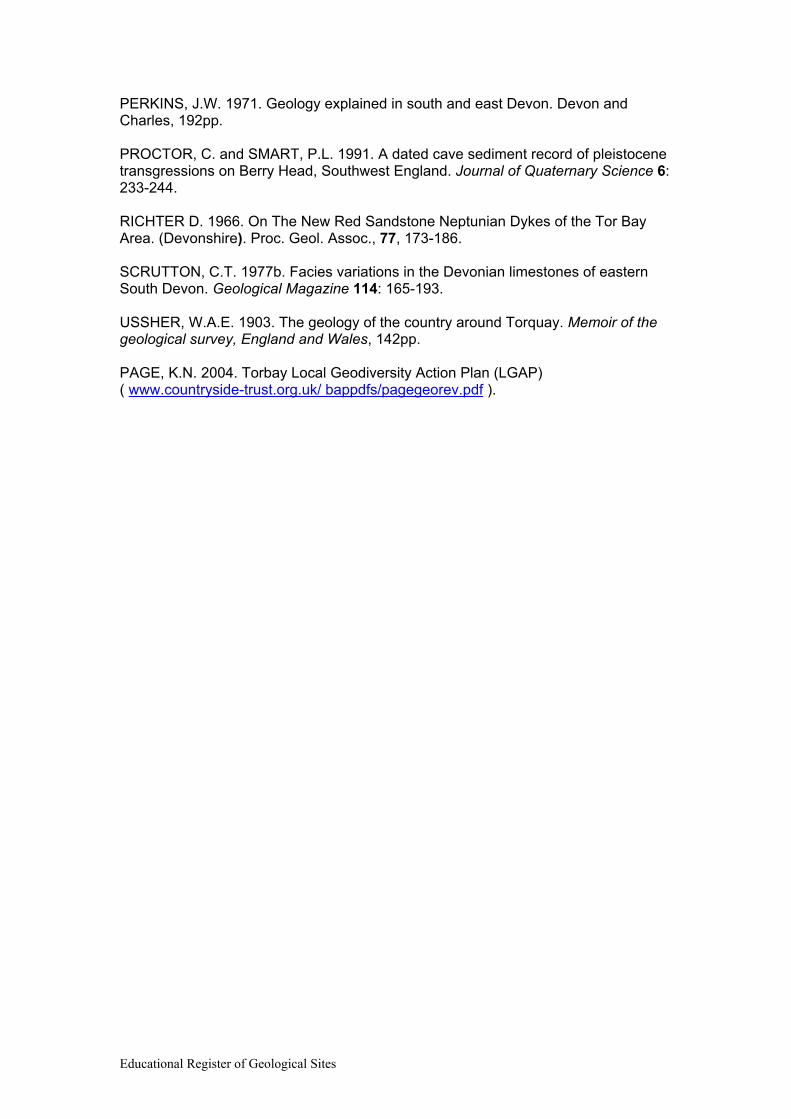
General view of Berry Head from the SW: Note cliffs of Middle Devonian limestone with well developed marine platform above (Neogene or early Pleistocene?)
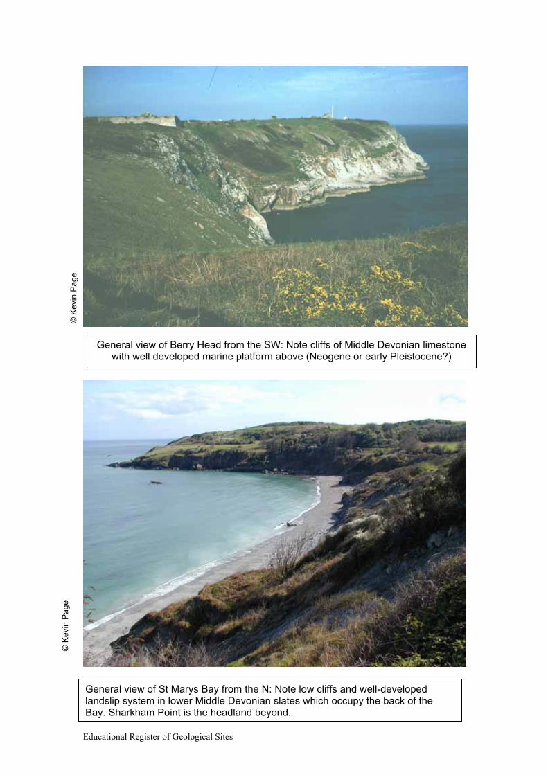
General view of St Marys Bay from the N: Note low cliffs and well-developed landslip system in lower Middle Devonian slates which occupy the back of the Bay. Sharkham Point is the headland beyond.

Educational Register of Geological Sites
© K
evin
Pag
e
Sharkham Iron Mine: Exposures of brecciated and mineralised Devonian rocks

Educational Register of Geological Sites
© K
evin
Pag
e
© K
evin
Pag
e
Middle Devonian limestones in Berry Head quarry: Note red Permian fissures (‘neptunian dykes’) in left hand part of rear face and pool which oscillates depending
on tide level as it is connected via cave systems to the sea.
Permian sediment-filled fissures (‘neptunian dykes’) on Shoalstone Beach
Educational Register of Geological Sites
© K
evin
Pag
e
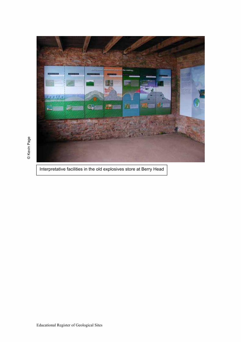
Interpretative facilities in the old explosives store at Berry Head