monaco—monitoring approach for geological co2 storage sites
TRANSCRIPT

MONACO—Monitoring Approachfor Geological CO2 Storage Sites Usinga Hierarchical Observation Concept
Claudia Schütze, Karin Bräuer, Peter Dietrich, Viktoria Engnath,Michael Gisi, Gunnar Horak, Carsten Leven, Alexander Lübben,Ingo Möller, Michael Nierychlo, Stefan Schlömer, Andreas Schuck,Ulrich Serfling, Arno Simon, Thomas Streil and Uta Sauer
Abstract The reliable detection and assessment of potential CO2 leakages fromstorage formations require the application of assurance monitoring tools at dif-ferent spatial scales. Such tools also play an important role in helping to establish arisk assessment strategy at carbon dioxide capture and storage (CCS) facilities.Within the framework of the MONACO project (“Monitoring approach for geo-logical CO2 storage sites using a hierarchical observation concept”), an integrative
C. Schütze (&) � P. Dietrich � U. SauerDepartment Monitoring and Exploration Technologies, UFZ – Helmholtz Centrefor Environmental Research, Permoserstraße 15, 04318 Leipzig, Germanye-mail: [email protected]
K. BräuerDepartment Catchment Hydrology, UFZ – Helmholtz Centre for Environmental Research,Permoserstraße 15, 04318 Leipzig, Germany
I. Möller � S. SchlömerDepartment 1.5 Resource Geochemistry, Federal Institute for Geosciences and NaturalResources (BGR), Stilleweg 2, 30655 Hannover, Germany
C. Leven � A. LübbenCenter for Applied Geoscience, University of Tübingen, Hölderlinstr. 12, 72076 Tübingen,Germany
A. Schuck � U. SerflingGGL Geophysik und Geotechnik Leipzig GmbH, Bautzner Straße 67, 04347 Leipzig,Germany
M. NierychloAXIO-NET GmbH, Osterstraße 24, 30159 Hannover, Germany
G. Horak � T. StreilSARAD GmbH, Wiesbadener Str. 20, 01159 Dresden, Germany
M. Gisi � A. SimonBruker Optik GmbH, Rudolf-Plank-Str. 27, 76275 Ettlingen, Germany
V. EngnathMapConcept Ltd., Gohliser Straße 13, 04105 Leipzig, Germany
© Springer International Publishing Switzerland 2015A. Liebscher and U. Münch (eds.), Geological Storage of CO2 – Long TermSecurity Aspects, Advanced Technologies in Earth Sciences,DOI 10.1007/978-3-319-13930-2_2
33

hierarchical assurance monitoring concept was developed and validated with theaim of establishing a modular observation strategy including investigations in theshallow subsurface, at ground surface level, and in the atmosphere. Numerousmethods and technologies from different disciplines (such as chemistry, hydro-geology, meteorology, and geophysics) were either combined or used comple-mentarily to one another, with results subsequently being jointly interpreted.Patterns of atmospheric CO2 distributions in terms of leakage detection can beobserved on large scales with the help of infrared spectroscopy or micrometeo-rological methods, which aim to identify zones with unexpected or anomalousatmospheric CO2 concentrations. On the meso-scale, exchange processes betweenground surface level and subsurface structures need to be localized using geo-physical methods and soil gas surveys. Subsequently, the resulting images andmaps can be used for selecting profiles for detailed in situ soil gas and geophysicalmonitoring, which helps to constrain the extent of leakages and allows us tounderstand controlling features of the observable fluid flow patterns. The toolsutilized were tested at several natural and industrial analogues with various CO2
sources. A comprehensive validation of the opportunities and limitations of allapplied method combinations is given and it shows that large spatial areas need tobe consistently covered in sufficient spatial and temporal resolutions.
1 Introduction
In recent years, global concerns about greenhouse gas emissions have stimulatedconsiderable interest in carbon capture and storage (CCS) as a climate changemitigation option which can be used to reduce man-made CO2 emissions. This isachieved by separating and capturing CO2 from emission sources, then injectingand storing it in the subsurface. While the public perception of CCS nowadays israther negative, the IPCC states that the majority of CCS deployment will occur inthe second half of this century (IPCC 2005). Therefore, techniques are needed tomeasure the amount of CO2 stored at a specific sequestration site, to monitor the sitefor leakages and storage integrity over time, and to verify that the CO2 is safelystored and not harmful to the host ecosystem (Hovorka 2008).
The IPCC also states that CO2 storage risks are comparable to those associatedwith similar industrial operations, such as underground natural-gas storage (UNEP2006). However, the greatest environmental risk associated with CCS technology isgradual leakage through undetected faults, fractures or wells, or the potential prob-lems caused by leakages due to injection well failure or leakages up through anabandoned well. These potential leakages could negate the initial environmentalbenefits of capturing and storing CO2 emissions and may have harmful effects onhuman health (Georgiou et al. 2007). Successful monitoring plans need to coverdifferent areas at different scales to enable detection of any significant irregularities, orCO2 migration paths and any leakages at the surface. The detection of atmosphericreleases is especially necessary to establish an early warning system and to plan
34 C. Schütze et al.

mitigating actions. Benson (2006) stated that an effective monitoring program shouldfirst of all focus on detecting whether or not emissions are occurring. Once any actualor possible emissions are detected, more detailed investigations are necessary forprecise localization and quantification. Therefore, a monitoring concept combiningappropriate methods is needed to gain timely information about the location ofmigration paths, seepages, and the CO2 distribution in the shallow subsurface.
2 Application of a Hierarchical Monitoring Approach
There are two distinct purposes for undertaking monitoring at CO2 storage sites: (1) toensure conformance by tracking the pressure buildup and CO2 inside the storagecomplex, thereby helping to indicate the long term security of the site (‘integritymonitoring’) and (2) to ensure containment by triggering timely control measures tomitigate any unexpected leakage, helping to demonstrate the current security situation,especially in the area surrounding the storage complex (‘assurance monitoring’)(Bourne et al. 2014). Several geochemical and geophysical (such as time lapse seis-mics) techniques allow for monitoring of the regional distribution of CO2 in the storagecomplexes, seal integrity and the pressure evolution in response to injection. They cantherefore be used to verify storage conformance and are valuable tools for integritymonitoring (IEA 2012). Assurance monitoring is used to compare pre- and post-injection properties to verify containment and the absence of any environmental effectsoutside the storage complex. These assurance monitoring tools must consider variousmonitoring zones (atmosphere, biosphere, ground surface, aquifer/vadose zone, andstorage formation), their lateral variabilities and transport-relevant flow paths.
The aim of the MONACO project was to apply and validate a near-surfacemonitoring concept covering different scales to enable reliable detection of CO2
migration and seepage. Our approach focuses on the development of assurancemonitoring techniques—especially in the atmosphere, at surface level and in thevadose zone or the saturated zone. Applied groundwater, soil, soil gas, and atmo-spheric monitoring tools provide data about environmental integrity at increasingdistances from the reservoir. Large-scale atmospheric monitoring methods areapplied to investigate air composition to help determine unexpected CO2 levels.Subsequently applied meso- and point-scale surface and near-surface monitoringtechniques focus on structural settings in the subsurface and CO2 interaction pro-cesses with the aim of identifying areas of risk for human beings and ecosystems.
According to Bourne et al. (2014), a successful monitoring plan complies withregulatory requirements (e.g., requirement to perform adequate pre-injection char-acterization and baseline monitoring), clearly defines monitoring objectives for riskassessment (risk based monitoring); selects appropriate monitoring tools for the site(site-specific monitoring); and continuously evaluates the monitoring systems(adaptive monitoring) (Bourne et al. 2014). Appropriate site monitoring requires asuitable and modular design to select the right tool, to meet the right need, at theright phase of the implementation (Fig. 1).
MONACO—Monitoring Approach for Geological CO2 Storage Sites … 35

Results and lessons learned from the MONACO approach were primarilyobtained by applying the integrative monitoring concept including the practicalfield work and the necessary data processing. Field work was carried out on severaltest sites with normal ambient CO2 conditions in the Altmark region (NorthernGermany) and on two natural CO2 degassing sites in the Cheb Basin (CzechRepublic) and Starzach (Baden-Württemberg, Germany).
The Cheb Basin (NW Bohemia) is a CO2 leaking natural analogue and is apromising location for directly investigating processes along preferential migrationpaths and verifying monitoring tools. Here, mantle-derived CO2 is emitted fromboth isolated gas vents (mofettes) and from extensive diffuse degassing zones. Thisis caused by a structural fault as preferential pathway (Weinlich et al. 1999). Thedegassing vents are in some cases characterized by vegetation anomalies. Similarconditions concerning enhanced natural CO2 exhalations were found at the Starzachsite which was used for CO2 mining in previous times.
By using a web based information system established within the MONACOproject, different web map services (WMS), digital elevation models, aerial pho-tographs, borehole information and processed monitoring data enable a compre-hensive database of these sites for data interpretation.
Fig. 1 Illustration of measurement, monitoring and verification (MMV) principles (Bourne et al.2014) and different monitoring zones to monitor CO2 accumulation, possible migration paths andCO2 leakages. The project MONACO considers near-surface monitoring zones and appliesmonitoring methods with different resolution and applicable at different scales
36 C. Schütze et al.

2.1 Tools for Large-Scale Monitoring—AtmosphericMonitoring
Methods applied at large scales can provide key information about CO2 leakageoccurrences and therefore help identifying potential areas for further meso-scaleinvestigation. The impact on the land surface and near-surface atmosphere causedby elevated CO2 concentrations may even alter spectral reflectance or emissivitycharacteristics and can be detected using remote sensing techniques. Examples ofsuch techniques include multi- and hyperspectral airborne remote sensing, as wellas ground-based remote sensing infrared or laser spectroscopy (Shuler and Tang2005).
Within a CCS site, atmospheric monitoring in the vicinity of the storage projectis designed to detect and quantify emissions from potential leakage sources (e.g.,permeable faults, abandoned wells). An effective atmospheric monitoring toolshould satisfy the following requirements: (1) be capable of large-scale observationwith sufficient spatial and temporal resolution, (2) fast application and rapid datainterpretation, and (3) have sufficient sensitivity to increased atmospheric CO2
concentrations and fluxes, triggering control mechanisms for subsequent steps.Sensors that can measure atmospheric CO2 anomalies over open paths which arehundreds of meters long are especially useful in helping us to obtain an initialoverview and first assessment of leakages, and provide the required information sothat further efficient observations can be made.
2.1.1 Open-Path Fourier-Transform Infrared (OP FTIR) Spectroscopy
A promising approach for detecting elevated CO2 concentrations along an openoptical path is the measurement of absorption loss using OP FTIR spectroscopy andopen-path tunable diode laser absorption spectroscopy (TDLAS) (Seto and McRae2011; Etheridge et al. 2011; Shuler and Tang 2005; Reiche et al. 2014). Theseground-based remote sensing methods are proven to be flexible long-path tech-niques for the characterization of larger areas, and are able to simultaneously detectvarious volatile atmospheric compounds relevant for environmental assessmentwith a single rapid measurement.
OP FTIR spectroscopy is based on the analysis of ambient (passive mode) orartificial infrared radiation (active mode) in the 700–4,000 cm−1 wave-numberrange along optical pathways (in km-range). Many greenhouse gas molecules (e.g.,CO2, H2O, CH4) have unique signatures (absorption or emission bands) in thespectral range under consideration. IR spectroscopy allows spatial characterizationof emissions and can be applied non-invasively as an automated surveillancemethod in large and potentially inaccessible areas. It is proven to be a powerfultechnique, enabling online monitoring of fugitive emissions for industrial, envi-ronmental and health applications (Griffith et al. 2002; Harig et al. 2006; Harig andMatz 2001; EN_15483 2008).
MONACO—Monitoring Approach for Geological CO2 Storage Sites … 37

The application of both active and passive ground-based OP FTIR spectroscopywas validated within this project as one possible method for achieving large-scalescanning of atmospheric composition, in terms of identifying areas of higherleakage vulnerability where detailed subsurface investigations (on meso- or point-scale levels) are subsequently required. Based on investigation of natural CO2
degassing sites and analysis of industrial emissions, OP FTIR spectroscopy proveditself to be a robust and suitable monitoring method. To ensure reliable results,certain ‘best practice’ recommendations have to be taken into account:
• OP FTIR spectroscopy is an optical technique. Hence, unobstructed opticalpathways to target zones are required. In denser industrial or urban areas, thisrestriction might pose a significant challenge.
• The measurements result in integral concentration values along the opticalpathway. The integrative character of the measurement needs to be consideredwhen designing monitoring schemes and when interpreting measurements withrespect to the localization and quantification of emissions.
• The detection of small scale sources (e.g., point emissions) might be chal-lenging. A dense grid of optical pathways (resulting in a large data amount) isrequired. However, when measuring along large distances, the ability to identifyemission sources improves with increasing concentration variations. The sen-sitivity of the method can also be increased when considering relative temporalvariability instead of absolute values.
• Site-specific influences including parameters such as principal wind direction,meteorological conditions, topographic influences, infrastructure, other artificialemission sources, and biological background need to be monitored prior to andduring atmospheric monitoring.
• Atmospheric dispersion effects can have a strong impact on the detectability ofCO2 anomalies. Mixture and dilution processes in the near-surface atmospherehave to be considered and can be simulated using atmospheric dispersionmodels, in order to assess observed data (Flesch et al. 2005; Gal et al. 2012;Leuning et al. 2008).
• Passives open-path measurements offer the chance of achieving robust surveysin various arbitrary measurement directions, which are useful for gaining anoverview. Furthermore, the large optical path lengths which can be achievedrepresent a key advantage when surveying large areas (several km2). However, apassive system is not best suited for the retrieval of high-precision quantitativegas concentration data. Reasons for this include: an undefined path length andwidth for long pathways, complex signal behavior due to the combined emissionand absorption behavior of the target gas, and problems caused by weak signalsdue to low temperature differences between the target gas and the backgroundenvironment.
• To improve quantitative analysis in the case where weak sources are present, theapplication of a robust active open-path spectrometer is recommended.
38 C. Schütze et al.

In contrast to weak passive IR-radiation emitted in the background, an activesource of radiation is used, which emits a constantly high signal level leading tooutstanding detection capabilities. Since the radiation path length is known, thespectrometer, by design, is sensitive to its own artificially emitted radiation only;high-precision gas concentration measurements are possible.
In our study, OP FTIR spectroscopy was evaluated and is considered to be asuitable tool for use as part of an early warning monitoring concept. A fullyautomated high resolution active OP FTIR spectrometer system was designedwithin the frame of the MONACO project, fulfilling the requirements for reliablelarge-scale atmospheric monitoring at CCS sites (Bruker 2014). Monitoring oper-ation and spectral analysis can be carried out permanently and automatically withhigh temporal resolution. While concentration retrieval is performed in real-time,reliable interpretation of concentration values with respect to stored CO2 leakagesmay require expert knowledge for each specific site. A combination with otheratmospheric monitoring techniques is recommended (Fig. 2).
Fig. 2 Validation of OP FTIR spectroscopy to identify atmospheric CO2 anomalies based onMONACO project results. a Passive monitoring equipment including passive OP FTIRspectrometer with stand-alone power supply and controlling notebook. b New active OP FTIRspectrometer system consisting of retroreflector (left) and open-path spectrometer with collimationoptics (right) with a maximum investigation distance of 600 m. c Results of passive monitoringscan at a natural carbon dioxide degassing site (Czech Republic). Zones with distinctly increasedatmospheric CO2 concentration can be observed in the direction of known soil gas anomalies(modified after Schütze et al. 2013; aerial photo: Google Earth 2014)
MONACO—Monitoring Approach for Geological CO2 Storage Sites … 39

2.1.2 Eddy Covariance Method
Looking back on more than 30 years of experience in micrometeorological andecological studies, the eddy covariance method (EC) has often and consistentlybeen proposed times as a potential suitable method for the monitoring of geologicCO2 storage sites (e.g., Leuning et al. 2008). The main reason for this is thetechnique’s capability to derive accurate gas fluxes as spatially-integrated expres-sions of the related exchange between the ground surface and the atmosphericboundary layer (spatial coverage range: from several hundred m2 to a few km2,temporal resolution: from several minutes to hours). However, previous studieshave also shown that a relatively high leakage rate would be required for leakagedetection via EC (Lewicki et al. 2009; Etheridge et al. 2011).
For technical and methodological comparisons, complementary near-surfaceCO2 monitoring methods were deployed, along with EC equipment—namely CO2
accumulation chambers, permanent soil CO2 monitoring stations and air CO2
monitoring sensors.All aspects considered, deduction of gas exchange rates using the EC method is
a complex statistical approach that is based on several restricting model assump-tions that form boundary conditions for the deployment of this method (Burba2013). Key constraints include:
• Topographical pre-conditions (necessity for a flat and homogeneous groundsurface, the measurement point (location of tower) represents an upwind area)
• Technical prerequisites (instruments are able to detect minimal variations at highfrequencies)
• Meteorological assumptions (fully turbulent flux, total vertical flow is negligi-ble, steady state conditions during the flux averaging interval, air flow con-vergences or divergences as well as atmospheric gravity waves are negligible,air density fluctuations do not exist or can be corrected, measurements capturethe boundary layer of interest).
The EC technique requires careful selection of the observation site and specialprecautions when undertaking technical handling of the essential instruments.Problems related to equipment setup include several sources of errors, e.g., selec-tion of the measuring height, a possible tilting of the instruments, effects of sensorseparation (namely distance between gas analyzer and anemometer), as well asdistortions caused by the installations themselves. Other technical and operationaldemands to be considered include:
• The installed technical equipment should be constructed and set up in a way thatdoes not disturb the existing nature of turbulence.
• The equipment must be environmentally robust and suitable for performing remoteoperations (e.g., low power consumption, assured power supply), while the setupand maintenance of system components (cleaning, calibration, replacements etc.)should be as easy as possible, in order to facilitate and ensure an accurate config-uration of the instruments and their performance during operation.
40 C. Schütze et al.

The demands the EC method imposes regarding instrumentation, survey designand implementation, as well as data processing, are still great. However, theinstrumental and data processing aspects of this approach have reached a high levelof maturity. This method can be classified as being robust and reliable, even if itstill benefits from technical processes concerning the instruments involved andsoftware applications. If the boundary conditions are met, the EC technique pro-duces accurate flux information on a medium scale with good temporal and spatialresolution. During the field experiments in our project, the instruments showed avery high availability and any system downtime was almost exclusively caused bycommon maintenance work or due to external factors, such as power cuts or datatransfer problems. The quality of the calculated flux data depended notably on theprevailing wind conditions and, in some cases, on the influence of air moisture(relative humidity >90 %, fog, drizzle, rain). Thus, the meteorological constraint“no wind = no flux data” can unfortunately be extended to mean “weak wind = poordata quality”. Nonetheless, typical data coverage in literature is in the range 65–75 % over the course of a year (Falge et al. 2001), although our experiments hadslightly better temporal coverage. As a rule of thumb, the general total EC mea-surement error seems to be between 5 and 20 %, while Baldocchi (2003) indicatesthat an error of less than 7 % occurs during the day and less than 12 % at night.
Currently, there is no overall agreement on a single, standardized methodologyfor the EC technique, although much work towards harmonization has already beencarried out by the international EC research community and its networks. Sinceeach observation site has its own characteristics, almost every EC experiment needsto consider different parameters. Thus, the applicability of EC technique remains, toa certain extent, a site-specific monitoring approach. Use of the EC methoddemands expert knowledge and it is presently not a “simple, transparent techniquefor day-to-day monitoring practice”.
If the monitoring concept focuses on CO2 fluxes on a medium scale, the ECtechnique has a unique position, despite the limitations mentioned above. It has thecapability to act as a methodological link between integral large-scale monitoringefforts on one hand, and small-scale approaches distributed over large areas on theother—even if some methodological developments still must be made in order toensure a logical combination of data from different scales.
However, with regard to CO2 storage practice, one important question arises: Atwhat stage of storage operations is the quantification of CO2 fluxes required? For allintents and purposes, extended baseline flux quantification, i.e., the identification ofthe natural background and its variability, is mandatory—otherwise, additional CO2
flux caused by potential leaks cannot be quantified. Furthermore, once leakage isdetected by any monitoring approach, flux quantifications are also needed in orderto obtain information on how much CO2 escapes from the storage site into theatmosphere and to identify potentially hazardous areas, initiate project remediationstrategies, and to verify the success of the corrective measures. In all other phases ofnormal storage operations, near-surface monitoring might routinely rely on otherindicators; indicators that can be more easily determined and in a more transparentway than the complex computation required for CO2 fluxes using the EC approach.
MONACO—Monitoring Approach for Geological CO2 Storage Sites … 41

Monitoring of CO2 concentrations instead of fluxes would, for example, cover suchan easy-to-use indicator. Strategically well-placed and fitted with elementary windsensors, simple air CO2 sensors can measure CO2 concentrations straightforwardly.They provide sufficient information to ensure continuous near-surface monitoringby identifying recurring data patterns including their normal variations on one hand,but also detect potential anomalies on the other.
Both OP FTIR spectroscopy and the EC technique have been validated in ourstudy as suitable monitoring techniques. They are near-surface atmosphere moni-toring methods that work on larger scales. However, it needs to be noticed thatgeologic CO2 storage is realized deep underground. It is therefore evident that itcannot cover all monitoring aspects of industrial CCS operations and must be anintegral part of a comprehensive monitoring concept consisting of methods that focuson other environmental compartments or on different temporal and spatial scales.
2.2 Tools for Meso-scale Monitoring—Surface-BasedMonitoring
Within our study, patterns of atmospheric CO2 variability were observed with thehelp of FTIR and EC methods. In zones of increased CO2 concentration, the sourceprocesses (man-made, natural) need to be clarified and the surface or near sub-surface areas should be monitored in detail. Ground-based deformation studies,geophysical methods such as electromagnetics (EMI), electrical resistivity tomog-raphy (ERT) and self-potential (SP), soil gas concentration, flux measurements andsoil moisture and temperature mapping are efficient methods for identifying near-surface structures which favor gas accumulation and migration applied in theMONACO approach. Combinations of various geophysical methods and soil-gasinvestigations (CO2 concentration and flux rate) provide insights into the physicalproperties of sediments (e.g. resistivity variations), structural features (e.g., sec-ondary traps) and transport processes (e.g., migration of fluids, CO2 solution). Suchan integrative approach derives information about preferential degassing pathways(e.g., Buselli and Lu 2001; Byrdina et al. 2009; Lamert et al. 2012; Pettinelli et al.2010; Schütze et al. 2012).
2.2.1 Geophysical Methods
The application of geophysical methods is motivated by two main processes. Firstly,CO2 (dissolved, volatile) in the pore space has an impact on physical sediment prop-erties (e.g., electrical resistivity). Secondly,fluidmovementmay induce dynamic, time-dependent processes (e.g., temporal variations in geophysical parameters, generation ofelectro-kinetic effects). Within the MONACO project the supposed variation in geo-physical parameters due to the presence of CO2 was investigated using a combinationof several geophysical methods—such as SP monitoring and mapping, EMI mapping,ERT survey and refraction seismic measurements.
42 C. Schütze et al.

The self-potential (SP) method measures a natural electrical potential field dis-tribution at the ground surface. It is used to map distinct anomalies or to monitortemporal changes caused by dynamic processes. For field applications, it is oftendifficult to separate the variously superimposed sources of SP signals in the measureddata induced by a combination of electrokinetic effects, electrochemical potentialdifferences and thermoelectric coupling effects. However, the determination ofstreaming potentials (electrokinetic effects) could be a possible parameter to featureCO2 migrations or could at least be an indicator for fluid transport in the subsurface(Byrdina et al. 2009; Revil et al. 1999a; Smaczny et al. 2010; Sprunt et al. 1994). Itmust be considered that SP anomalies are influenced by soil structure, rock variations,meteorological conditions and/or groundwater flow. Streaming potentials are sensi-tive to variations in hydrological parameters, which are expressed in considerabletime dependence (Ernstson and Scherer 1986). Furthermore, the effect of moreintense chemical reactions due to higher CO2 concentrations in the subsurface canencourage evolution of an increased electrochemical effect on the SP values(Zlotnicki and Nishida 2003). In our measurements, the observed anomalies arepotentially driven by gas flow associated with transport of a water phase within thepermeable zones (Fig. 3). These effects are also observed by Byrdina et al. (2009),Revil et al. (1999b), Sauer et al. (2014), Sandig et al. (2014). Following ‘bestpractice’ recommendations, the reliable identification of influencing subsurfaceproperties (e.g., porosity, gas or water saturations, conductivity) on the SP signalrequires additional geophysical methods (e.g., ERT) and environmental data (e.g.,soil gas concentration measurements) (Flechsig et al. 2008; Jardani et al. 2007).
Resistivity and electrical conductivity can act as geophysical indicators for thepresence of CO2 in pore space. Variations in resistivity depend on physical sedi-ment properties such as conductive mineral components, porosity, clay content,water saturation, and electrolyte concentration (Flechsig et al. 2008; Knödel et al.2007; Reynolds 2011). Recent field tests, laboratory experiments, and numericalsimulation studies show that electrical resistivity is highly sensitive to the presenceof CO2 (Bergmann et al. 2012; Börner et al. 2013; Kharaka et al. 2009; Lamert et al.2012). Gaseous CO2 intrusion into shallow groundwater systems generally causesincreased gas phase content in the soil pore space, which accordingly leads toincreased bulk resistivity. However, subsequent dissolution of CO2 in partly-groundwater saturated sediments leads to the occurrence of carbonic acid followedby generally decreased pH values and increased alkalinity. These circumstanceslead to decreased bulk resistivity.
Electromagnetic induction mapping (EMI) is a non-invasive method for mea-suring the apparent electrical conductivity. EMI methods are considered as being apromising approach for monitoring CO2 storage (Börner et al. 2010). Due to thesmall expected differences in electrical conductivity in the shallow subsurface,careful device calibration, operation, and interpretation is necessary. Our resultsindicate that EMI can be used as an appropriate tool for a fast and rough outlinesurvey of the recent main geological structures. For more detailed insights, thesubsequent application of geoelectrical investigations is recommended.
MONACO—Monitoring Approach for Geological CO2 Storage Sites … 43
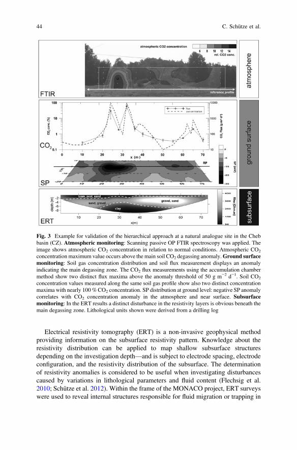
Electrical resistivity tomography (ERT) is a non-invasive geophysical methodproviding information on the subsurface resistivity pattern. Knowledge about theresistivity distribution can be applied to map shallow subsurface structuresdepending on the investigation depth—and is subject to electrode spacing, electrodeconfiguration, and the resistivity distribution of the subsurface. The determinationof resistivity anomalies is considered to be useful when investigating disturbancescaused by variations in lithological parameters and fluid content (Flechsig et al.2010; Schütze et al. 2012). Within the frame of the MONACO project, ERT surveyswere used to reveal internal structures responsible for fluid migration or trapping in
Fig. 3 Example for validation of the hierarchical approach at a natural analogue site in the Chebbasin (CZ). Atmospheric monitoring: Scanning passive OP FTIR spectroscopy was applied. Theimage shows atmospheric CO2 concentration in relation to normal conditions. Atmospheric CO2
concentration maximum value occurs above the main soil CO2 degassing anomaly.Ground surfacemonitoring: Soil gas concentration distribution and soil flux measurement displays an anomalyindicating the main degassing zone. The CO2 flux measurements using the accumulation chambermethod show two distinct flux maxima above the anomaly threshold of 50 g m−2 d−1. Soil CO2
concentration values measured along the same soil gas profile show also two distinct concentrationmaxima with nearly 100 %CO2 concentration. SP distribution at ground level: negative SP anomalycorrelates with CO2 concentration anomaly in the atmosphere and near surface. Subsurfacemonitoring: In the ERT results a distinct disturbance in the resistivity layers is obvious beneath themain degassing zone. Lithological units shown were derived from a drilling log
44 C. Schütze et al.
the shallow sedimentary layers. It turned out that the ERT method is a valuable toolfor monitoring temporal and spatial changes in resistivity patterns due to variationsin fluid transport processes. Furthermore, the analysis of resistivity anomalies iscrucial when it comes to understanding the observed SP patterns (Fig. 3).
Additional shallow refraction seismic investigations were validated in the projectas suitable method which helped us obtain supplementary structural informationfrom the seismic velocity models. This method yields high resolution imagesconcerning the structural geological setup and provides valuable data to minimizethe ambiguity of geophysical models.
2.2.2 Soil Gas Surveys
Surface-based measurements of CO2 concentration and CO2 flux provide reliableinsights in leakage processes, which can allow us to constrain the extent of potentialleakages and to understand the controlling features of the observable fluid flowpatterns (Schütze et al. 2012).
Reliable soil gas sampling requires a thorough sampling technique. The soil gasCO2 concentration is measured in shallow depths (minimum sampling depth 0.5 mbelow ground level) and the mixture of gas samples with fresh air have to beavoided. Flux measurements are typically based on the accumulation chambermethod (Chiodini et al. 1998). Both investigation techniques were validated at thetest sites in the Cheb Basin and Starzach. These techniques are considered to bevaluable tools for the mapping and quantifying of CO2 seepage to the surface viapreferential pathways. However, detailed soil flux and concentration investigationsof larger areas are time-consuming. Changes in meteorological conditions duringmeasurement need to be carefully considered during subsequent interpretation.
In different measuring campaigns during the project, we observed a high spatialvariance of the soil gas concentration and flux on small scales with respect to location,spatial extent and amplitude. Land use, meteorological and soil moisture conditionsespecially influence gas migration and seepage. Therefore, the joint interpretation ofsoil gas measurements with geophysical data and soil moisture/temperature data isimportant, to gain a realistic site-specific overview for risk analysis (Fig. 3).
2.2.3 Soil Parameter Measurements
Soil temperature and soil moisture are influencing parameters on geophysical andgeochemical parameters (SP, ERT, EMI and CO2 concentration) and, as animmediate response to meteorological conditions, must be considered when car-rying out data interpretation. These parameters can be mapped and monitored usingstandard devices such as temperature probes and soil moisture sensors based ontime domain reflectometry (TDR).
Results achieved from integrative measurement taken at our test site in the Chebbasin indicate that the hierarchical monitoring approach represents a successful
MONACO—Monitoring Approach for Geological CO2 Storage Sites … 45

multidisciplinary modular concept (Sauer et al. 2013; Schütze et al. 2013). Theapplication of OP FTIR spectroscopy in combination with soil gas surveys and ERTinvestigations has proven to be a valuable tool for comprehensive characterization ofthe atmospheric and near-surface CO2 distribution, as well as subsurface structuralfeatures (Fig. 3).
2.2.4 Ground-Based Deformation Studies
Precise measurements of ground deformation (uplift or subsidence) can be acquiredremotely using geodetic techniques e.g., radar satellites positioned above CO2 stor-age sites can be used to determine the surface-level impacts of injection. It can be seenthat the amount of geomechanical deformation caused as a result of CO2 injection islikely to be a function of the volume of CO2 injected (Verdon et al. 2013). Thesatellite-based Interferometric Synthetic Aperture Radar (InSAR) has proven to besuccessful for monitoring (to centimeter level degree of accuracy) volcanic andearthquake deformation (Zhao et al. 2012; Biggs et al. 2009) and was especiallyvaluable when used at the In Salah CCS site (Ringrose et al. 2013; White et al. 2014).
Differential Global Navigation Satellite System (DGNSS) observations wereevaluated within the project for high precision monitoring of surface deformationand movement. GNSS observations obtained from a four station reference networkwere post-processed using GNSS networking software. One of the reference sta-tions was replaced by a monitoring unit consisting of a GNSS receiver and a crankunit with a mounted GNSS antenna. By using the crank unit, the height of themonitoring station were adjusted to the required level. Monthly height adjustmentsthat were undertaken were recorded and compared with the height results obtainedby GNSS post-processing analyses. Applying a special filter for the determinationof coordinates for the monitoring station, the standard deviation of the time serieswas reduced down to 1 mm (height). Figure 4 shows the post-processing results,indicating the detectability level of the manual height changes of the crank unit.
Fig. 4 Post-processing results—monitoring station MONA, The manual height changes of thecrank unit are seen in the coordinate time series very clearly. Event #13 shows that the manualheight change was detected in its whole magnitude after around 15 h
46 C. Schütze et al.

The results of the analyses show that when using DGNSS measurements, surfacedeformations of even a few millimetres can be reliably detected. Compared to othersatellite based observation methods, permanent coordinate monitoring of a CCS site ispossible using the GNSS approach. Deformations can be detected within a few hours.
2.3 Tools for Small-Scale Monitoring—Subsurface in SituMonitoring
The distribution of geophysical indicators in conjunction with observed charac-teristic CO2 concentration and flux patterns is useful for identifying site locationsfor detailed in situ monitoring. These can then be used for a further detaileddetermination of the lithological setting and spatial distribution of the site’s per-meability, while simultaneously assessing the spatial and temporal migrationbehavior of CO2. Geophysical methods (e.g., ERT and seismics), in situ installa-tions (e.g., for CO2 concentration and flux measurements and isotope analysis ofsampling probes) are examples of monitoring tools which can be used to identifydeeper geological structures responsible for gas migration and trapping, and tocharacterize the CO2 source.
2.3.1 In Situ Measurements and Sampling
Direct Push technology (DP) is a minimally invasive and highly efficient tool usedfor in situ measurement of different physical and chemical parameters (e.g., elec-trical conductivity logging, hydraulic conductivity logging) and the installation ofmonitoring sensors into depths of up to 30 m in unconsolidated to weakly-con-solidated sediments (Leven et al. 2011; Zschornack and Leven 2012; Dietrich andLeven 2006). Direct Push can also be used for retrieving soil, gas and watersamples needed for chemical analysis. Soil samples provide especially valuablelithological information, which can be used to validate geophysical data.
2.3.2 In Situ Installations
At a field site in Starzach (Baden-Württemberg, Germany), a location withenhanced natural CO2 exhalation and which was used for CO2 mining in previoustimes, soil sensors designed to measure soil temperature (T), volumetric watercontent, and electrical conductivity (σ) were installed at two different depths (0.3and 0.6 m below ground level). The reason for doing so was to investigate theinfluence of mofettes (focused CO2 degassing) on soil parameters such as electricalconductivity and soil CO2 concentration at different locations with characteristiclow, intermediate, and high soil CO2 concentrations.
MONACO—Monitoring Approach for Geological CO2 Storage Sites … 47

Figure 5 shows the measured CO2 concentration at a depth of 0.5 m and some ofthe sensor data (T, σ) recorded at the site. The shallow sensors (0.3 m) exhibit ageneral trend of decreasing temperature and increasing electrical conductivity nearthe mofettes. In contrast, the deeper sensors show almost no variations. The fol-lowing processes could be responsible for the observed trends: (1) Movement ofgroundwater along the degassing channels, which reduces the soil temperature andwhich in general has a higher electrical conductivity than rain water infiltrating thesoil (Flechsig et al. 2010; Hölting and Coldeway 2013). (2) Higher dissolutioneffects in the soil near the mofettes. The higher amount of CO2 leads to moredissolution of CO2 in the soil water and the resulting increase in ion load occurs dueto reactions of the CO2 with the aquifer and soil matrix, causing an increase inelectrical conductivity.
Based on the project experiences, a network of soil sensors placed above a CO2
storage site can serve as a suitable monitoring tool. In the event of a leakage, thein situ sensors are able to identify subsurface areas of increased soil CO2 con-centrations. Although temperature and electrical conductivity could be detected inareas of increased CO2 concentration at our investigated field site, the hydrogeo-logical situation influencing the soil temperature is site-specific. Therefore, onlyelectrical conductivity can be recommended as a more general parameter forindicating areas with potential CO2 leakages.
To investigate the effect of variations in atmospheric parameters on intensity ofmass fluxes from the two mofettes, a hood-shaped metal sheet with an opening forfree gas outflow was placed over a mofette with an airtight seal. Gas fluxes out ofmofettes are mainly driven by advection and therefore are much stronger thandiffusive fluxes (Kämpf et al. 2013). The total amount of free gas outflow from asingle mofette was estimated by simultaneously measuring flow velocity, static
Fig. 5 Left Measured CO2 concentration in 0.5 m depth on a 3 × 3 m grid at the field site inStarzach. Location of two mofettes (circles), location of six soil sensors (A_1, A_2, B_1,B_2,C_1,C_2; _1 indicate depth 0.3 m; _2 indicate 0.6 m) (black crosses), sample locations (black dots).Right Measured soil temperature (T) and electrical conductivity (σ) with in situ sensors placed inareas with low soil CO2 concentration (10–30 vol%: soil sensors A_1 and A_2), intermediateconcentration (31–60 vol%: soil sensors B_1 and B_2) and high concentration (61–80 vol%: soilsensors C_1 and C_2)
48 C. Schütze et al.

pressure, and gas temperature. Measurements of the volumetric CO2 contentrevealed a concentration of almost 100 vol.%. The resulting mass flux of CO2 gas isshown in Fig. 6 for a period of 24 h compared with air temperature (Ta) andpressure (pa), recorded at a nearby meteorological station. Variations in thesemeteorological parameters have no obvious influence on mass flux. However, thetrend in air temperature correlates with the trend in mass flux. For smaller or morediffuse mass fluxes, changes in outside temperature and possibly also in air pressurecould have a larger impact on mass flux intensity (Vodnik et al. 2009; Chiodiniet al. 1998).
As a consequence, monitoring technologies should aim to measure small anddiffusive-dominated mass fluxes, where natural variations that occur due to atmo-spheric parameters are known, so that anomalies can be clearly detected.
The project partner SARAD GmbH developed a new device for in situ fluxmeasurements so that CO2 flow can be directly measured in the ground and overlarge measurement distances.
2.3.3 Analysis of Isotopic Composition
Studies of the isotope signature of the soil CO2 are essential to help distinguishbetween different CO2 sources and to characterize the origin of soil CO2.
The usefulness of analyzing the isotopic composition of soil CO2 was tested attwo sites with natural channel-like CO2 degassing with CO2 concentrations up to90 vol%. In the Cheb Basin, the deep source of CO2 (mantle derived) is confirmedby the isotope signature (Bräuer et al. 2008, 2011), whereas the origin of the CO2
degassing in Starzach is still under discussion.The measurement of the isotopic composition was validated to be an appropriate
method to characterize the origin of CO2 and was successfully used to confineclearly the boundaries of CO2 soil degassing from areas with degassing of deeporiginated CO2 in shallow subsurface (Fig. 7). However, it is a time-intensive,complex analysis method which requires profound expert knowledge.
Fig. 6 Left Calculated mass flux from a mofette at the field site. The mean mass flux is 92 kg/d.Right Outside temperature (Ta) and air pressure (pa) recorded at a nearby meteorological stationover 24 h. Mean Ta for this period is 14.4 °C and mean pa 1,013.4 mbar
MONACO—Monitoring Approach for Geological CO2 Storage Sites … 49

2.4 Validation of Methods for Atmospheric, Surfaceand Subsurface Monitoring
The methods applied for monitoring were evaluated by means of several criteria:robustness, availability, reliability, data accuracy, spatial resolution, spatial inte-gration, temporal resolution, and effort based on practical requirements (e.g.,equipment handling, data processing). For an assessment of the different monitoringtechniques, the applicability of methods was classified into three groups: (−) limitedcompliance, (o) acceptable compliance, (+) appropriate compliance (Table 1).
2.4.1 Evaluation and Conclusion
The effectiveness of monitoring methods for CO2 leakages depends on severalfactors including the contrast between the physical properties of CO2 and the porefluid displaced by CO2, the lithology and structure of the reservoir, pore fluidpressure and temperature, field setups and surveys, well spacing, and injectionpatterns (Hagrey et al. 2013; Hoversten and Myer 2000). All methods appliedwithin the MONACO project were evaluated and classified into three criteria:
• (o) Useful supplementing method: The application of methods is affiliated withvarious limitations with respect to the criteria and stand-alone application cannotguarantee suitable results. However, the method can provide additional infor-mation for joint interpretation.
Fig. 7 Project results of investigations at the Cheb Basin site. A natural degassing zone wasdetermined by increased CO2 soil gas concentration and decreased δ 13Cco2 values. The isotopicsignature with a δ 13Cco2 value of −2‰measured in the degassing area indicates the deep magmaticsource of CO2
50 C. Schütze et al.

Tab
le1
Validationof
integrativemetho
dsappliedin
theMONACO
project
MONACO—Monitoring Approach for Geological CO2 Storage Sites … 51

• (+) Appropriate method: Methods provide valuable information. However, theapplication has some restrictions/limitations, which have to be taken intoaccount for interpretation.
• (++) Favored method: Applications of methods are suitable and provide sig-nificant results concerning assurance monitoring.
This classification for the common assurance monitoring tasks is shown inTable 2.
OP FTIR spectroscopy and EC method are considered to be suitable tools as partof an early warning monitoring concept, enabling detection of diffuse or focusedCO2 degassing over larger scales. OP FTIR spectroscopy can supply information onthe distribution of CO2 concentration under natural air conditions as an inputparameter for the subsequent quantification of emission rates. The requirements forEC regarding wind conditions, instrumentation, survey design, implementation, anddata processing are still very high. If the measuring requirements are met, the ECtechnique can provide flux information on a medium scale with sufficient temporaland spatial resolution. In addition, continuous wind speed measurements in com-bination with air CO2 concentration registration at different heights, as well as CO2
concentration monitoring with a handheld infrared gas analyzer, have somepotential as an appropriate basic monitoring technique. However, due to the scale of
Table 2 Classification of the methods applied in MONACO project for nine pre-definedassurance monitoring tasks
52 C. Schütze et al.
CO2 storage, these atmospheric methods could only be an integral part of a com-prehensive monitoring concept consisting of methods that focus on other envi-ronmental domains or on different temporal and spatial scales.
Within the MONACO hierarchical approach the GNSS approach for detectingground deformation was tested. It was shown that GNSS is suitable for continuousmonitoring and investigation of contemporary ground surface deformation in mmrange. However, information about height variation is based on distinct measure-ments at monitoring stations and cannot provide extensive information such as thatobtained when using InSAR data.
Interpretation of various geophysical data can yield important informationregarding fluid flow and transport processes in permeable near-surface layers, as wellas structural and hydraulic properties. The selection of an appropriate method for thefulfillment of assurance monitoring tasks (such as detection of migration and pref-erential pathways, investigation of structural trapping) depends on site characteris-tics. The combination of geophysical methods, soil gas investigations and in situinstallations concerning e.g., chemical properties of the groundwater, soil gas com-position, soil gas ratios, and isotope ratios are necessary to improve the understandingof both gas migration processes and the resultant geophysical response functions, andto minimize ambiguities concerning the investigated geophysical parameter distri-bution. Furthermore, the influence of environmental conditions on geophysical andsoil gas parameters needs to be considered when attempting to establish ‘best prac-tice’ recommendation for CO2 storage monitoring concepts.
The results of the MONACO project demonstrated that a successful near-surfacemonitoring plan should base on a hierarchical approach to cover different areas atdifferent scales enabling a reliable detection of CO2 migration paths and anyleakages at the surface.
Acknowledgments This study was carried out within the framework of the “MONACO—Monitoring approach for geological CO2 storage sites using a hierarchical observation concept”(grant ID: 03G0785) research project. Financial support provided by the German Federal Ministryof Education and Research (BMBF) in the frame of the Priority Program “Geotechnologien” isgratefully acknowledged. We cordially thank our native speaker C. Higgins for proofreading themanuscript. The authors would also like to thank C. Seeger, J. Poggenburg, A. Schossland,H. Kotas, G. Schmidt, K. Faiß and C. Sandig for technical support and T. Foken (Univ. Bayreuth),G. Burba, G. Fratini, F. Griessbaum and P. Martin (LI-COR Biosciences, Lincoln, Bad Homburgetc.) for theoretical input, fruitful exchange and technical advice.
References
Baldocchi D (2003) Assessing the eddy covariance technique for evaluating carbon dioxideexchange rates of ecosystems: past, present and future. Glob Change Biol 9(4):479–492.doi:10.1046/j.1365-2486.2003.00629.x
BensonSM(2006)Monitoringcarbondioxide sequestration in deepgeological formations for inventoryverification and carbon credits. https://pangea.stanford.edu/research/bensonlab/presentations/Monitoring%20Carbon%20Dioxide%20Sequestration%20in%20Deep%20Geological%20Formations%20for%20Inventory%20Verification%20and%20Carbon%20Credits.pdf
MONACO—Monitoring Approach for Geological CO2 Storage Sites … 53

Bergmann P, Schmidt-Hattenberger C, Kiessling D, Rücker C, Labitzke T, Henninges J, BaumannG, Schütt H (2012) Surface-downhole electrical resistivity tomography applied to monitoringof CO2 storage at Ketzin, Germany. Geophysics 77:B253–B267. doi:10.1190/geo2011-0515.1
Biggs J, Anthony E, Ebinger C (2009) Multiple inflation and deflation events at Kenyanvolcanoes. East Afr Rift Geol 37(11):979–982. doi:10.1130/G30133A
Börner JH, Herdegren V, Börner R-U, Spitzer K (2010) Electromagnetic monitoring of CO2
storage in deep saline aquifers—laboratory experiments and numerical simulations. In:Workshop on electromagnetic induction in the earth, Giza, Egypt, 18–24 Sept 2010
Börner JH, Herdegen V, Repke J-U, Spitzer K (2013) The impact of CO2 on the electrical propertiesof water bearing porous media—laboratory experiments with respect to carbon capture andstorage. Geophys Prospect 61(s1):446–460. doi:10.1111/j.1365-2478.2012.01129.x
Bourne S, Crouch S, Smith M (2014) A risk-based framework for measurement, monitoring andverification of the Quest CCS project, Alberta, Canada. Int J Greenhouse Gas Control 26:109–126. doi:http://dx.doi.org/10.1016/j.ijggc.2014.04.026
Bräuer K, Kämpf H, Niedermann S, Strauch G, Tesař J (2008) Natural laboratory NW Bohemia:comprehensive fluid studies between 1992 and 2005 used to trace geodynamic processes.Geochem Geophys Geosyst 9(4, Q04018):1–30. doi:10.1029/2007gc001921
Bräuer K, Kämpf H, Koch U, Strauch G (2011) Monthly monitoring of gas and isotopecompositions in the free gas phase at degassing locations close to the Nový Kostel focal zone inthe western Eger Rift, Czech Republic. Chem Geol 290(3–4):163–176. doi:10.1016/j.chemgeo.2011.09.012
Bruker (2014) Open path air monitoring system. Bruker optics GmbH. http://www.bruker.com/products/infrared-near-infrared-and-raman-spectroscopy/remote-sensing/ops/overview.html.Accessed 24 July 2014
Burba G (2013) Eddy covariance method for scientific, industrial, agricultural and regulatoryapplications (Personal communication at EGU 2014, Apr 2014). Lincoln, NE
Buselli G, Lu K (2001) Groundwater contamination monitoring with multichannel electrical andelectromagnetic methods. J Appl Geophys 48(1):11–23. doi:10.1016/S0926-9851(01)00055-6
Byrdina S, Revil A, Pant SR, Koirala BP, Shrestha PL, Tiwari DR, Gautam UP, Shrestha K,Sapkota SN, Contraires S, Perrier F (2009) Dipolar self-potential anomaly associated withcarbon dioxide and radon flux at Syabru-Bensi hot springs in central Nepal. J Geophys Res 114(B10):1–14. doi:10.1029/2008jb006154
Chiodini G, Cioni R, Guidi M, Raco B, Marini L (1998) Soil CO2 flux measurements in volcanicand geothermal areas. Appl Geochem 13(5):543–552. doi:http://dx.doi.org/10.1016/S0883-2927(97)00076-0
Dietrich P, Leven C (2006) Direct push technologies. In: Kirsch R (ed) Groundwater geophysics,vol 548. Springer, Berlin, pp 347–366. doi:10.1007/3-540-29387-6_11
EN_15483 (2008) Ambient air quality—atmospheric measurements near ground with FTIRspectroscopy. European Standard, CEN, Brussels
Ernstson K, Scherer U (1986) Self-potential variations with time and their relation to hydrogeologicand meteorological parameters. Geophysics 51(10):1967–1977. doi:10.1190/1.1442052
Etheridge D, Luhar A, Loh Z, Leuning R, Spencer D, Steele P, Zegelin S, Allison C, Krummel P,Leist M, van der Schoot M (2011) Atmospheric monitoring of the CO2 CRC Otway project andlessons for large scale CO2 storage projects. Energy Procedia 4:3666–3675. doi:http://dx.doi.org/10.1016/j.egypro.2011.02.298
Falge E, Baldocchi D, Olson R, Anthoni P, Aubinet M, Bernhofer C, Burba G, Ceulemans R,Clement R, Dolman H, Granier A, Gross P, Grünwald T, Hollinger D, Jensen N-O, Katul G,Keronen P, Kowlaski A, Lai C, Law B, Meyers T, Moncrieff J, Moors E, Munger J, PilegaardK, Rannik Ü, Rebmann C, Suyker A, Tenhunen J, Tu K, Verma S, Vesala T, Wilson K, WofsyS (2001) Gap filling strategies for defensible annual sums of net ecosystem exchange. AgricFor Meteorol 107:43–69
Flechsig C, Bussert R, Rechner J, Schütze C, Kämpf H (2008) The Hartoušov Mofette Field in theCheb Basin, Western Eger Rift (Czech Republic): a comperative geoelectric, sedimentologicand soil gas study of a magmatic diffuse degassing structure. Z Geol Wiss 36(3):177–193
54 C. Schütze et al.

Flechsig C, Fabig T, Rücker C, Schütze C (2010) Geoelectrical investigations in the Cheb Basin/W-Bohemia: an approach to evaluate the near-surface conductivity structure. Stud GeophysGeod 54(3):443–463. doi:10.1007/s11200-010-0026-6
Flesch TK, Wilson JD, Harper LA (2005) Deducing ground-to-air emissions from observed trace gasconcentrations: a field trial with wind disturbance. J Appl Meteorol 44:475–484. doi:10.1175/JAM2214.1
Gal F, Brach M, Braibant G, Bény C, Michel K (2012) What can be learned from natural analoguestudies in view of CO2 leakage issues in carbon capture and storage applications? Geochemicalcase study of Sainte-Marguerite area (French Massif Central). Int J Greenhouse Gas Control10:470–485. doi:10.1016/j.ijggc.2012.07.015
Georgiou P, Quick H, Jenkins H, Hayes C, Jensen D, Kelly J, Tollner D, Vale D, Price R,Thomson K (2007) Between a rock and a hard place: the science of geosequestration,Australian Government response report of the House of Representatives Standing Committeeon Science and Innovation. Parliament of the Commonwealth of Australia, Canberra
Google Earth (2014) Hartousov 50.133494N 12.462030E, Date of image: 01 Jan 2004. Accessed13 Aug 2014
Griffith DWT, Leuning R, Denmead OT, Jamie IM (2002) Air–land exchanges of CO2, CH4 andN2O measured by FTIR spectrometry and micrometeorological techniques. Atmos Environ36:1833–1842. doi:10.1016/S1352-2310(02)00139-5
Hagrey SAa, Strahser M, Rabbel W (2013) Seismic and geoelectric modeling studies ofparameters controlling CO2 geostorage in saline formations. Int J Greenhouse Gas Control19:796–806. doi:10.1016/j.ijggc.2013.01.041
Harig R, Matz G (2001) Toxic cloud imaging by infrared spectrometry: a scanning FTIR system foridentification and visualization. Field Anal Chem Technol 5(1–2):75–90. doi:10.1002/fact.1008
Harig R, Matz G, Rusch P (2006) Infrarot-Fernerkundung für die chemische Gefahrenabwehr.Zivilschutz-Forschung. Zivilschutz-Forschung, vol 58. Bundesamt für Bevölkerungsschutzund Katastrophenhilfe, Bonn
Hölting B, Coldeway WG (2013) Hydrogeologie: Einführung in die Allgemeine und AngewandteHydrogeologie. Springer Spektrum, Berlin
Hoversten GM, Myer LR (2000) Monitoring of CO2 sequestration using integrated geophysicaland reservoir data. In: 5th international conference on greenhouse gas control technologies,Collingwood, Victoria, Australia, pp 305–310
Hovorka SD (2008) Surveillance of a geologic sequestration project: monitoring, validation,accounting. NETL webinar for the American Water Works Association
IEA (2012) Best practices for validating CO2 geological storage: observations and guidance fromthe IEAGHG Weyburn-Midale CO2 monitoring and storage project. Geoscience Publishing
IPCC (2005) Carbon capture and storage: Summary for policy makers and technical summary.Cambridge University Press
Jardani A, Revil A, Santos F, Fauchard C, Dupont JP (2007) Detection of preferential infiltrationpathways in sinkholes using joint inversion of self-potential and EM34 conductivity data.Geophys Prospect 55(5):749–760. doi:10.1111/j.1365-2478.2007.00638.x
Kämpf H, Bräuer K, Schumann J, Hahne K, Strauch G (2013) CO2 discharge in an active, non-volcaniccontinental rift area (Czech Republic): characterisation (δ13C, 3He/4He) and quantification of diffuseand vent CO2 emissions. Chemical Geology 339:71–83. doi:10.1016/j.chemgeo.2012.08.005
Kharaka YK, Thordsen JJ, Kakouros E, Ambats G, Herkelrath WN, Beers SR, Birkholzer JT,Apps JA, Spycher NF, Zheng L, Trautz RC, Rauch HW, Gullickson KS (2009) Changes in thechemistry of shallow groundwater related to the 2008 injection of CO2 at the ZERT field site,Bozeman. Montana. Environ Earth Sci 60(2):273–284. doi:10.1007/s12665-009-0401-1
Knödel K, Lange G, Voigt H-J (2007) Environmental geology-handbook for field methods andcase studies. Springer, Berlin
Lamert H, Geistlinger H, Werban U, Schütze C, Peter A, Hornbruch G, Schulz A, Pohlert M, KaliaS, Beyer M, Großmann J, Dahmke A, Dietrich P (2012) Feasibility of geoelectrical monitoringand multiphase modeling for process understanding of gaseous CO2 injection into a shallowaquifer. Environ Earth Sci 67(2):447–462. doi:10.1007/s12665-012-1669-0
MONACO—Monitoring Approach for Geological CO2 Storage Sites … 55

Leuning R, Etheridge D, Luhar A, Dunse B (2008) Atmospheric monitoring and verificationtechnologies for CO2 geosequestration. Int J Greenhouse Gas Control 2(3):401–414. doi:http://dx.doi.org/10.1016/j.ijggc.2008.01.002
Leven C, Weiß H, Vienken T, Dietrich P (2011) Direct-Push-Technologien – EffizienteUntersuchungsmethoden für die Untergrunderkundung. Grundwasser 16(4):221–234. doi:10.1007/s00767-011-0175-8
Lewicki JL, Hilley GE, Fischer ML, Pana L, Oldenburg CM, Dobeck L, Spangler L (2009)Detection of CO2 leakage by eddy covariance during the ZERT project’s CO2 releaseexperiments. Energy Procedia 1(1):2301–2306. doi:10.1016/j.egypro.2009.01.299
Pettinelli E, Beaubien S, Zaja A, Menghini A, Praticelli N, Mattei E, Di Matteo A, AnnunziatellisA, Ciotoli G, Lombardi S (2010) Characterization of a CO2 gas vent using various geophysicaland geochemical methods. Geophysics 75(3):B137–B146. doi:10.1190/1.3420735
Reiche N, Westerkamp T, Lau S, Borsdorf H, Dietrich P, Schütze C (2014) Comparative study toevaluate three ground-based optical remote sensing techniques under field conditions by a gastracer experiment. Environ Earth Sci 72(5):1435–1441. doi:10.1007/s12665-014-3312-8
Revil A, Pezard PA, Glover PWJ (1999a) Steaming potential in porous media: 1. Theory of thezeta potential. J Geophys Res 104(B6):2156–2202. doi:10.1029/1999JB900089
Revil A, Schwaeger H, Cathles LM, Manhardt PD (1999b) Streaming potential in porous media: 2.Theory and application to geothermal systems. J Geophys Res 104(B9):2156–2202. doi:10.1029/1999JB900090
Reynolds JM (2011) An introduction to applied and environmental geophysics. Wiley, BaffinsLane, Chichester, West Sussex POl9 IUD, England
Ringrose PS, Mathieson AS, Wright IW, Selama F, Hansen O, Bissell R, Saoula N, Midgley J(2013) The In Salah CO2 storage project: lessons learned and knowledge transfer. EnergyProcedia 37:6226-6236. doi:http://dx.doi.org/10.1016/j.egypro.2013.06.551
Sandig C, Sauer U, Bräuer K, Serfling U, Schütze C (2014) Comparative study of geophysical andsoil–gas investigations at the Hartoušov (Czech Republic) natural CO2 degassing site. EnvironEarth Sci 72(5):1421–1434. doi:10.1007/s12665-014-3242-5
Sauer U, Schütze C, Leven C, Schlömer S, Dietrich P (2013) An integrative hierarchicalmonitoring approach applied at a natural analogue site to monitor CO2 degassing areas. ActaGeotech 9(1):127–133. doi:10.1007/s11440-013-0224-9
Sauer U, Watanabe N, Singh A, Dietrich P, Kolditz O, Schütze C (2014) Joint interpretation ofgeoelectrical and soil-gas measurements for monitoring CO2 releases at a natural analogue.Near Surface Geophysics 12(2007):165–178. doi:10.3997/1873-0604.2013052
Schütze C, Sauer U, Beyer K, Lamert H, Bräuer K, Strauch G, Flechsig C, Kämpf H, Dietrich P(2012) Natural analogues: a potential approach for developing reliable monitoring methods tounderstand subsurface CO2 migration processes. Environ Earth Sci 67(2):411–423. doi:10.1007/s12665-012-1701-4
Schütze C, Dietrich P, Sauer U (2013) Diagnostic monitoring to identify preferential near-surfacestructures for CO2 degassing into the atmosphere: Tools for investigations at different spatialscales validated at a natural analogue site. Int J Greenhouse Gas Control 18:285–295. doi:10.1016/j.ijggc.2013.07.006
Seto CJ, McRae GJ (2011) Reducing risk in basin scale CO2 sequestration: a framework forintegrated monitoring design. Environ Sci Technol 45(3):845–859. doi:10.1021/es102240w
Shuler P, Tang Y (2005) Atmospheric CO2 monitoring systems. In: Thomas DC, Benson SM (eds)Carbon dioxide capture for storage in deep geologic formations—results from the CO2 captureproject geologic storage of carbon dioxide with monitoring and verification, vol 2. Elsevier,pp 1015–1030
Smaczny J, Clauser C, Klitzsch N, Blaschek R (2010) Numerical interpretation of self-potential(SP) data in the context of CO2 storage. Paper presented at the EGU 2010 (May 2-7, 2010),Vienna, Austria
Sprunt ES, Mercer TB, Djabbarah NF (1994) Streaming potential from multiphase flow.Geophysics 59(5):707–711. doi:10.1190/1.1443628
56 C. Schütze et al.

UNEP (2006) Can carbon dioxide storage help cut greenhouse emissions? A Simplified guide tothe IPCC’s Special report on carbon dioxide capture and storage
Verdon JP, Kendall J-M, Stork AL, Chadwick RA, White DJ, Bissell RC (2013) Comparison ofgeomechanical deformation induced by megatonne-scale CO2 storage at Sleipner, Weyburn,and in Salah. Proc Natl Acad Sci 110(30):E2762–E2771. doi:10.1073/pnas.1302156110
VodnikD,VidemšekU, PintarM,Maček I, PfanzH (2009) The characteristics of soil CO2fluxes at a sitewith natural CO2 enrichment. Geoderma 150(1–2):32–37. doi:10.1016/j.geoderma.2009.01.005
Weinlich FH, Bräuer K, Kämpf H, Strauch G, Tesař J, Weise SM (1999) An active subcontinentalmantle volatile system in the western Eger rift, Central Europe: gas flux, isotopic (He, C, andN) and compositional fingerprints. Geochimica et Cosmochimica Acta 63(21):3653–3671. doi:http://dx.doi.org/10.1016/S0016-7037(99)00187-8
White JA, Chiaramonte L, Ezzedine S, Foxall W, Hao Y, Ramirez A, McNab W (2014)Geomechanical behavior of the reservoir and caprock system at the in Salah CO2 storageproject. Proc Natl Acad Sci 111(24):8747–8752. doi:10.1073/pnas.1316465111
Zhao W, Amelung F, Dixon T (2012) Monitoring ground deformation on carbon sequestrationreservoirs in North America. In: Fringe 2011 workshop, Frascati, Italy, 2012. vol SP-697. ESA
Zlotnicki J, Nishida Y (2003) Review on morphological insights of self-potential anomalies onvolcanoes. Surv Geophys 24(4):291–338. doi:10.1023/B:GEOP.0000004188.67923.ac
Zschornack L, Leven C (2012) Minimal invasive methods. In: Kästner M, Braeckevelt M, DöberlG et al. (eds) Model-driven soil probing, site assessment and evaluation—guidance ontechnologies, vol 307. Sapienza Università Editrice Rome, Italy, pp 337–388
MONACO—Monitoring Approach for Geological CO2 Storage Sites … 57

http://www.springer.com/978-3-319-13929-6