elisabetta colucci webgis tools to disseminate **antonia ... · keywords: webgis, spatial analyses,...
TRANSCRIPT
57
* Politecnico di Torino - DAD (Department of Architecture and Design) - Viale Mattioli 39 - 10125 - Torino [email protected]
** Politecnico di Torino - DAD (Department of Architecture and Design) - Viale Mattioli 39 - 10125 - Torino [email protected]
*** Politecnico di Torino - DAD (Department of Architecture and Design) - Viale Mattioli 39 - 10125 - Torino [email protected]
Keywords: WebGIS, Spatial analyses, Landscape Heritage, UAV photogrammetry, Cultural He-ritage Database.
Abstract This research works is providing digital tools for knowledge, fruition, communication andpromotion of built heritage, in a framework of landscape heritage valorisation.
The application could be placed in a framework of established methods within a field of study,increased in the recent years, aimed at promoting the integration of processing digital methods andinformation dissemination.
The central aim of this work is to obtain and manage spatial information that can be helpful torepresent and promote the peculiar features of the Archaeological Mine Park of San Silvestro, usingproper acquiring techniques derived from Geomatics, regional data retrieved from the spatial datainfrastructures and archaeological data.
The use of innovative rapid mapping methods, the generation of orthophotos and DTMs-DEMs (DigitalTerrain Model-Digital Elevation Model), the harmonization of different sources, scales and referencesystem data, the integration of datasets that synthesizes the studies and the excavation activities ofthe parks over the years, have provided a large spatially referenced archive that testifies the historicalrichness of the site. Those information, if communicated via WebGIS, can help to highlight thememory values of a territory.
In addition to the opportunity to integrate multi-content and multi-source spatial data into a singleplatform, the Web-GIS project uses applications and solutions in order to promote the preservationof the memory of the territory and the historical identity of the place. It is widely known that reachingthe valorisation of a cultural heritage is possible only establishing and organizing stable structure,resources and networks.
*Elisabetta Colucci**Antonia Spanò
***Filiberto Chiabrando
WebGIS tools to disseminate archaeological landscape memory
Territorio Italia 2017, 2, 3; doi:10.14609/Ti_2_17_3e
1 | INTRODUCTIONThe most important aim of the proposed application was to lay the foundations of a WebGIS for theArchaeological Mine Park of San Silvestro. In addition to the opportunity to integrate multi-contentand multi-source spatial data into a single informative platform, the project uses applications andsolutions to support the preservation of the historical memory of the territory. Therefore, it works inthe well accepted framework of reaching the valorisation of a cultural heritage, establishing andorganizing stable structures, resources and networks. We can consider this project as an emblematiccase of how today the opportunity to share in the internet network the knowledge heritage aboutterritories and assets is needed and highly required. The innovative researches and applications about the Medieval Archaeology, took place in theArchaeological Park of San Silvestro over the years, and they underlined the archaeological evidencesconnected to the landscape resources in order to recreate the place history.Although the traditional use of digital resources, these researches have led to the enhancement andthe transformation of the territory, ensuring its fruition and sustainability.The site highlights, indeed, the strength bond between housing and structures of raw materialstransformation, that in the past were places of social and everyday life and extraction of mineralresources, and the landscape (Guideri, 2008). Since the mid 1980ies, the valorization of the wholearea of the Park has been made possible by the archaeological excavation at the Rocca of the Parkcarried out by the University of Siena. Nowadays, the Rocca and the mines of this territory are animportant example for knowing, from the archaeological point of view, the history of the mining workorganization during the Middle Ages (Semplici, 2011).The safeguard and preservation project of the site gave a significant contribute to the promotion ofother archaeological areas; tourism has developed and a new system of cultural and natural heritagewas born in order to enhance the memory preservation. Thanks to the research, which promotedthe area, arousing the interest of various fields of study and stakeholders of the territory, it waspossible to create and open the Archaeological Mine Park of San Silvestro; moreover, the publicinstitutions volition and the private funding rise to the possibility to start the project that today isself-supported thanks to the profits of the visit. The Park visit allows visitors to learn the history ofthis territory and the main mining extraction techniques used by different civilizations over thecenturies.This contribution will also highlight a summary analysis about the territory regulations, landscapeand territorial plans of the Tuscany Region, and their updating and integration have favoured the siteprotection. These planning regulations may also represent how innovation of geographicalinformation systems can contribute to the knowledge and protection of both territory and landscape.In addition to the cultural promotion and the economic and social development purposes, animportant role in this scenario derives from educational aims; these goals are pursued at severallevels: from the Park laboratories offered to the visitors, to the specialized archaeological formationof the students who have applied standard excavation methodology over the years, both forstratigraphic analyses of horizontal and vertical plane and for the investigation about stratigraphicunits of the walls (Bianchi, 1996).These educational purposes on the Park project have allowed the Geomatic Team of Politecnico diTorino to perform activities of survey in the Park area using innovative 3D techniques in order tovalorize the cultural and landscape heritage. Data acquired and the following cartographic products(Brocchini et al., 2017) have become part of the Web GIS project to ensure that, thanks to the datashared via web, the knowledge and the diffusion of its value can be pursued.Finally, the present study aims to underline the necessity to insert the archaeological landscapes
58 TERRITORIO ITALIA - Land Administration, Cadastre, Real Estate 02|2017
representation in a GIS, in order to enrich the regional geographical data infrastructures.
Other themes, in addition to technical advantages related to the territory government, derive also
from the will of involve communities into this scenario; these themes, like the Public Archaeology
(Serlorenzi et al., 2015), are the basis for future conservation.
2 | INNOVATIVE SYSTEMS FOR THE COMMUNICATION OF THE LANDSCAPE AND CULTURAL HERITAGE HISTORICALMEMORY
2.1 Use of GIS platform in archaeological and landscape domainIt is equally established that the use of IT tools such as GISs in relation to the adoption of data storage
systems relating to cultural and landscape heritage (CH, LH), as well as the innovations and
transformations that have taken place in digital mapping, have not come about because of a simple
consequence of technological development. It was the subject of a widespread reflection between
the late 1990s and the 2000s, that the integrated uses of the aforementioned technologies have
surely offered the opportunity to use new information, otherwise unavailable, and therefore the tools
themselves have been the subject of research (Scollar 1999, Wheatley and Gillings 2002).
An interesting contribution from the same years (Djindjian, 1998-2001), besides providing fascinating
statistical considerations on the geographic distribution of 150 GIS projects (also referring if research
institutes or public administrations guided them, or which type of DBMS and software tools were
used by the sample), provides a schematic classification of the needs which the GIS responds. It can
still be considered current.
The several independent information systems that continue to appear in the many application
proposals still today are four.
• Systems supporting rescue archaeology (aiming at site prediction to optimise efficiency and cost
of field sampling);
• the so-named intra-site GIS supporting excavation field archaeology; involving the realisation of
numerous drawings, graphics, maps, photographic recording, using 2D/3D reconstruction;
• systems supporting regional settlement studies, which concern relationships between landscape,
CH and communities, that require spatial analysis and modelling;
• Cultural Resource Management (CRM), of which the institutional role is to survey, protect, and
preserve the cultural heritage.
In the third millennium the methodological developments, even in terms of the affirmation of new fields
of study is bounded to the requirements and to the implementation of standards, to which the next
paragraph is related. It is possible, however, citing necessarily a few contributions among the many
significant, to outline some dominant research enhancements on managing digital resources about CH
and LH. Among the first ones there is the association between archaeological landscapes and risk
(D’Andrea 2000, Weldrake 2010); other resources are available for example through website of project
deepening and monitoring specific areas as Coastal Archaeological Resources Risk Assessment
(CARRA). In general, the basic assumption is the drafting of archaeological maps based on topographic
databases, reference systems and nominal scales complying with the standards of technical
cartography today available ((D’Andria et al., 2008). Another research sector presenting deep
developments is the one dealing with the introduction of third and fourth dimension inside GIS platform
with the aim to advanced 3D web-based repository of reality-based data. (Apollonio et al., 2012); for
the management of the entire 3D documentation process of the excavation with object oriented
strategy (Katsianis et al., 2008); for the use of stratigraphic analysis of elevations (Drap et al., 2012); or
combining the 3D component and the use of national and international spatial data infrastructures to
59Elisabetta Colucci, Antonia Spanò, Filiberto Chiabrando
WebGIS tools to disseminate archaeological landscape memory
60 TERRITORIO ITALIA - Land Administration, Cadastre, Real Estate 02|2017
link excavation data and source of materials (Sammartano et al., 2017).
The virtual archaeology is another emerging field that has subjected to an exceptional development;
both for the high need to communicate the results of studies in the form of perceptively immediate
and multimedia contents (e.g., Piñas Azpitarte, 2012), or focusing the land perspective (Spanò et al.,
2016).
A last major horizon of enhancements is the refinements of archaeological information systems (AIS)
in the domain of public archaeology (e.g. Serlorenzi et al., 2015). We are in the sphere of CRMs and web
projects funded with public resources are involved, which in Italy have the biggest reference in the
SITAR project,1 and which generally have to rely on the use of standards of each level, as well as having
specific ontologies for sharing historical AIS landscape.
2.2 Open source and proprietary softwareThe choice of the right tools to perform an activity is one of the key matter in any technical project;
nowadays, there are a lot of GIS software packages, both open-source and commercial, that allow
data management, visualization and maintenance.
GIS softwares include a wide range of applications, which enable the use of a combination of digital
maps and georeferenced data; in addition, a GIS should allow the creation, the discovery, the
maintenance and the delivery of spatial data from a data repository, ideally via one or more web
services.
While commercial packages usually offer products suitable for all of software categories, open-source
software focus on a single one. (Jafari Salim, 2014)
The open-source GIS software (Free and Open Source Software for Geospatial Applications, FOSS4G)
(Brovelli et al., 2016; Steiniger, Hunter, 2012) can be classified into several categories in relation to
the tools offered and the functions that are present, these are: data creation, data editing and data
storage; data integration from different sources; data analysis and query. In (Steiniger, Weibel, 2009
e l’Associazione Italiana per l’Informazione Geografica Libera, GFOSS) were defined the following GIS
software:
• Desktop GIS, “Mapping software that is installed and runs on a personal computer and allows
users to display, query, update, and analyze data about geographic locations and the information
linked to those locations” (ESRI 2012). Some examples are Quantum GIS, GRASS GIS, gvSIG, uDig,
Open Jump;
• Spatial Data Base Management Systems (SDBMS), like PostgreSQL, Spatial Lite e PostGIS;
• WebMap Servers, that are used in order to share maps dataset via web. In particular the software,
which supports the Open Geospatial Consortiums (OGC) WMS (Web Mapping Service) and WFS
(Web Feature Service) standards, that will be described in the next subparagraph;
• Server GIS and Web-GIS client, software which provides access to functionality via web protocols
(Geoserver, Map Server, Geo Network, Geo Node), in addition this server GIS can be related with
some viewers for allowing users to use, modify and analyze data (Frontends, pmapper, Open
Layers, Chamaleon, Map fish);
• Mobile GIS, GIS software which runs on a mobile platform (gvSIG Mobile, Quantum GIS for Android);
• Remote Sensing Software, which could be focused on the transformation of UAV or satellite data,
like Lidar data;
• GIS Libraries, used with Desktop GIS or Server GIS.
1 https://beniculturali.academia.edu/SITARProjectKnowledgeExperienceBase
61Elisabetta Colucci, Antonia Spanò, Filiberto Chiabrando
WebGIS tools to disseminate archaeological landscape memory
As regards the commercial solutions, today the key players in the GIS software market are Autodesk,
Bentley, ESRI Inc., GE, Pitney Bowes e Intergraph. For example, these are Autocad Map 3D
(https://www.autodesk.it/products/autocad-map-3d/free-trial), Bentley Map V8l
(https://www.bentley.com/it/products/product-line/asset-performance/bentley-map), GeoMedia Web
Map (https://www.hexagongeospatial.com/products/power-portfolio/geomedia-webmap), ESRI
ArcGIS (http://www.esri.com/arcgis/about-arcgis).
Currently, the diffusion and use of the GIS sw is rapidly increasing, as the bottom-up approach based
on user requests is profoundly different and often preferred by users with respect to the commercial
logics of integration of large analytical functions present in the sw solutions, often articulated in
different and sometimes complex packages, by the software houses.
2.3 Spatial Data Standards and Information Systems for CH The adoption of a European SDI was carried out through the INSPIRE2 project, the acronym for
Infrastructure for Spatial Information in Europe, whose directive came into force in 2007.
In Italy and wherever the widespread adoption of shared standards has been developed, both for
geographic data (ISO / TC211) and metadata (ISO19115), improved detection, localization, retrieval
and semantic interoperability of data.
The SDI affirmation also at local level has allowed the Italian Regions to provide environmental and
territorial data catalogues on which to base sector planning plans on the territory and to protect the
environment and landscape and provide related services research and sharing.
The systems for cataloguing and disseminating data from the local administration such as those
responsible for the protection of cultural heritage, employ geographic services and web platforms
similar to those used for basic and thematic general mapping.
They often use the Web Map Service (WMS) and WFS (Web Feature Service) services to display the
major regional map bases on which the regional cultural assets datasets can be navigated, classified
according to the defined standard of the Central Institute for the Catalog and the Documentation
(ICCD) of the Ministry of Cultural Heritage and Tourism (MiBACT).
The access to digital contents forms organized by cataloguing standards, using alphanumeric or
geographic retrievals (WebGIS) for aims of research, dissemination and enhancement of regional
heritage is undoubtedly an evolved and widely used method.
The directions undertaken by the Italian Ministry on these issues are, however, even more ambitious.
In the past the Carta del Rischio3 (the Risk Map), the GIS platform created by a long process of data
collection and digitalization in the ‘90s to respond to the need of conservation and protection of
Cultural Heritage, responded in its conversion to WebGIS (2002-2005) to the need for widespread
and homogeneous knowledge of the consistency of Heritage distributed across the territory and,
above all, of its state of integrity and risk. It also defines degrees of vulnerability in relation to
territorial danger.
At the same time, since 2004, the ICCD has launched the SIGECweb project, the general Catalog
Information System, which optimizes the functionality of the previous system, adopts the new
standards and implements the new subjects set up for cataloguing, integrating the “geographic” side
of ICT technologies and thus guaranteeing spatial reference of data. Data is retrievable and navigable,
thanks to the relationship between data and objects, also allowing statistical queries on big data.
The interoperability, as planned from the project phases, allows connection with other projects of the
2 http://inspire.ec.europa.eu
3 http://www.cartadelrischio.it/
Ministry. The integration with the “Vincoli in rete” project is currently under development, carried out by
the Istituto Superiore per la Conservazione ed il Restauro (ISCR), which in addition to being a bridge
between SigecWeb project and the Carta del Rischio, also integrates SITAP, the Information System of
the Direzione Generale Belle arti e Paesaggio. Confirming the interest and awareness of the need to use
standards, systems and languages that transcend national borders, many studies are currently underway
to direct systems towards internationally recognized standards, since the only available standard, CIDOC
CRM, is for museums.
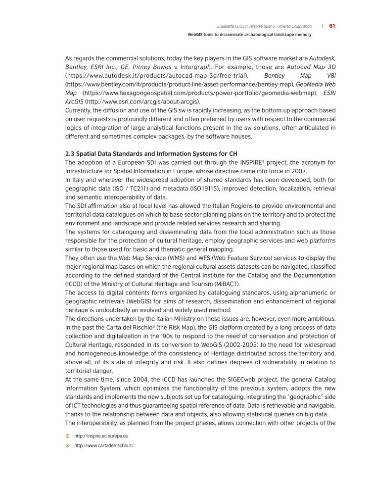
3 | ARCHAEOLOGICAL MINE PARK OF SAN SILVESTRO: TERRITORIAL AND HISTORICAL FRAMEWORKAs announced, the results of a study conducted on the Archaeological Mine Park of San Silvestro, in
the province of Livorno (in the hills of Campiglia Marittima), few kilometres far from the coast (San
Vincenzo), will be presented. The area of the Val di Cornia Parks, which is a system of archaeological
and natural parks, with the addition of museums, is located in in the south-west of Tuscany (Figure 1).
Figure 1 Municipality of Campiglia Marittima, Suvereto, Sassetta, San Vincenzo and Piombino.Dataset from Tuscany Region’s GEOscopio Geoportal - dataset scale 1:10000 (Colucci et al., 2017)
The San Silvestro Park was born as an instrument of protection and valorisation of a cultural deposit
(Francovich, 1994). The Rocca with the village has been discovered by the University of Siena
archaeologists, and the area is deeply marked by the history of many populations that, from the
Palaeolithic to the last century, settled in this area in search of minerals (for instance: copper, lead
and silver). The area is part of the landscape and it represents a high cultural value, subjected to the
requirements of ordinary maintenance and risk of deterioration. The park includes part of the mining
zone characterized by the presence of deposits of copper, lead, silver, iron, zinc incorporated in
metamorphic fragments of rock named skarn, made by the reaction between magmatic fluids and
62 TERRITORIO ITALIA - Land Administration, Cadastre, Real Estate 02|2017
63Elisabetta Colucci, Antonia Spanò, Filiberto Chiabrando
WebGIS tools to disseminate archaeological landscape memory
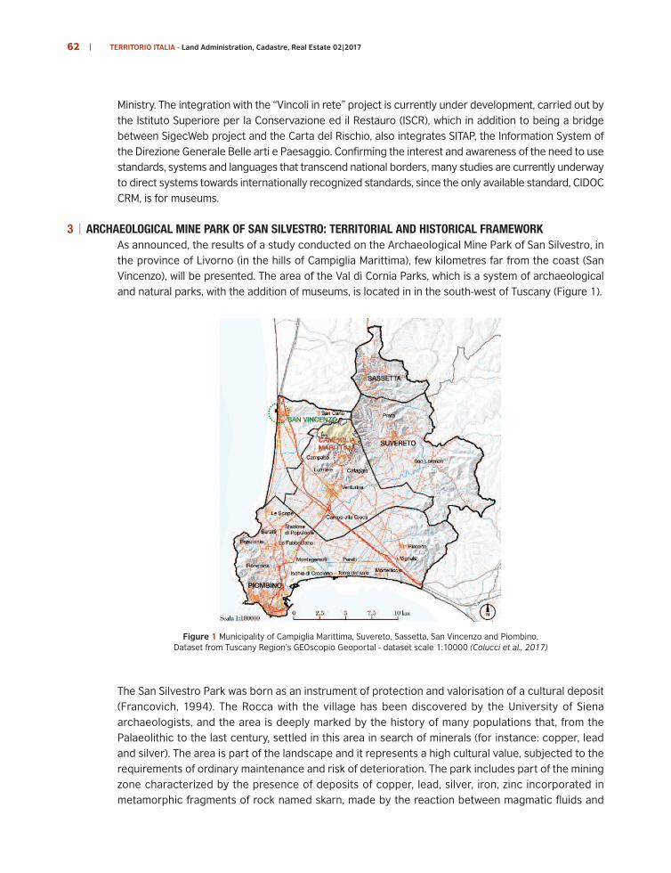
limestone.4 The presence of metals had a strong influence on the settlement: for hundreds of years,there was a stratification of extraction and processing of metals, ended in 1976. (Semplici 2011)The first way to valorise the mining and built heritage is their accessibility, so six different visitingpaths have been fulfilled. (Via del Temperino, Via delle Ferruzze, Via dei Filoni Porfirici, Via dei Lanzi,Via dei Manienti and Via delle Fonti, Figure 2).
Figure 2 Municipality of Campiglia Marittima, Suvereto, Sassetta, San Vincenzo and Piombino.
4 Metamorphic contact rock, rich of iron oxides and sulphides, formed thanks to a mesomatic reaction of interchange between anultrabasic magma and a silicified and rich of metals limestone (From dictionary item "Skarn", found in "encyclopedia Treccani).
64 TERRITORIO ITALIA - Land Administration, Cadastre, Real Estate 02|2017
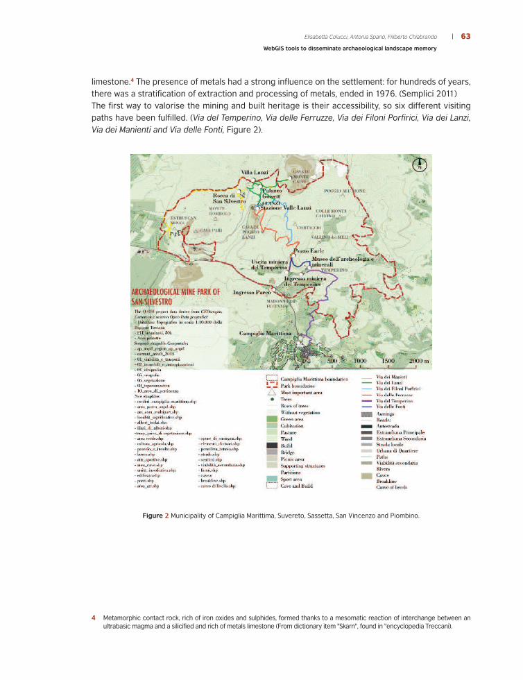
3.1 The birth of the Park and regulations that has favoured it The park was launched in 1996, after the archaeological excavation in the mediaeval mining villageof Rocca San Silvestro by Università di Siena, under the supervision of R. Francovich.Successively the Val di Cornia Park’s System was created, formed by: Archaeological museum ofPopulonia territory, museum of Castle and Piombino City, museums of the Campiglia Rocca,Archaeological Mine Park of San Silvestro, Archaeological Park of Baratti and Populonia, Coastal parkof Rimigliano, Coastal Park of the Sperpaia, Forest Park of Poggio Neri (Figure 3).
Figure 3 Val di Cornia Park’s System. Dataset from GEOscopio. - dataset scale 1:10000 (Colucci 2017)
The birth of the park system is also linked to the foresight of the regulations in Italy and in the TuscanyRegion, which over the years have evolved, increasing the protection of the landscape It is very important in fact to adopt research strategies for the smart and sustainable preservation ofthe cultural heritage, using methodologies and techniques to study and promote the sites andimplementing techniques for the preservation and communication of the memory, in order tointegrate protection and a sustainable development. From the 21st Century, in Italy, the landscape perception and the sensibility about its safeguard anddevelopment have increased more and more. The landscape, thanks to the Codice dei Beni Culturalie del Paesaggio5 and to the European Landscape convention (signed in Florence in 2000 and ratifiedby Italy from 2006), became object of the public policies and it has been proposed as a central themein the Piani Paesaggistici Regionali (PPR). Previously, the contents of PPR were introduced by the law1497/39 and then renewed by the “Galasso” law.6
5 D.lgs 42/2004
6 Legge 431/1985.
65Elisabetta Colucci, Antonia Spanò, Filiberto Chiabrando
WebGIS tools to disseminate archaeological landscape memory
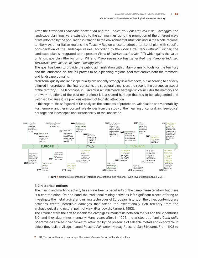
After the European Landscape convention and the Codice dei Beni Culturali e del Paesaggio, thelandscape plannings were extended to the communities using the promotion of the different waysof life adopted by the population in relation to the environmental situations and in the whole regionalterritory. As other Italian regions, the Tuscany Region chose to adopt a territorial plan with specificconsideration of the landscape values; according to the Codice dei Beni Culturali. Further, thelandscape plan is integrated to the present Piano di Indirizzo territoriale (PIT) which gains the valueof landscape plan (the fusion of PIT and Piano paesistico has generated the Piano di IndirizzoTerritoriale con Valenza di Piano Paesaggistico).The goal has been to provide the public administration with unitary planning tools for the territoryand the landscape: so, the PIT proves to be a planning regional tool that carries both the territorialand landscape domains.“Territorial quality and landscape quality are not only strongly linked aspects, but according to a widelydiffused interpretation the first represents the structural dimension, the second the perceptive aspectof the territory”.7 The landscape, in Tuscany, is a fundamental heritage which includes the memory andthe work traditions of the past generations; it is a shared heritage that has to be safeguarded andvalorised because it is a precious element of touristic attraction. In this regard, the safeguard of CH analyses the concepts of protection, valorisation and vulnerability.Furthermore, another important role derives from the study of the meaning of cultural, archaeologicalheritage and landscapes and sustainability of the landscape.
Figure 4 Normative references at international, national and regional levels investigated (Colucci 2017)
3.2 Historical notionsThe mining and marbling activity has always been a peculiarity of the campigliese territory, but thereis a contradiction. On one hand the traditional mining activities left significant traces offering toinvestigate the metallurgical and mining techniques of European history, on the other, contemporaryactivities create incredible damages that offend the exceptionally rich territory from thearchaeological and natural point of view. (Francovich, Farinelli, 1992).The Etrurian were the first to inhabit the campigliesi mountains between the VII and the V centuriesB.C. and they dug mines manually. Many years after, in 1005, the aristocratic family Conti dellaGherardesca arrived in San Silvestro, attracted by the presence of saleable metals and exportable incities; they built a village, named Rocca a Palmentum (today Rocca di San Silvestro). From 1108 to
7 PIT, Territorial Plan with Landscape Plan value. General Report of Landscape Plan

66 TERRITORIO ITALIA - Land Administration, Cadastre, Real Estate 02|2017
1330, the propriety of the mining territories passed to the Conti della Rocca, who reinforced theRocca and erected buildings, but the mines were negatively influenced by the difficulties in extractionand processing techniques and by the presence of an excess of different minerals in the subsoil.(Semplici, 2011).In the first ten years of the 16th century the territory was under the control of the Medici family;Cosimo I De Medici recruited in his mines specialized miners from the German, named “Lanzi” by localpopulation, and in 1568 the building for German miners Villa Lanzi was built.During the 18th century the territory could not ignore the industrial revolution, so a fervent extractionactivity began again in the campigliesi deposits, but this time the techniques changed considerably,thanks to the use of explosive. In the 20th century, the English society Etruscan Copper Estates Mineswanted to complete the Etrurian work begun two thousand years before and in a brief arc of time,from 1900 to 1908, it however left evidences on the territory. Despite this, the mines disappearedone more time for forty years and they opened again only after the Second World War.The extraction activity continued in the second half of the 20th century, but the mine closeddefinitively on October 1976, because of the excessive costs.
Figure 5 Figure 5 Two thousand years of history (Colucci 2017)
4 | THE WEBGIS PROJECT4.1 The spatial data and related harmonisationThe achieved WebGIS uses different data sources. The main base maps of the Web GIS have beengenerated using the regional datasets available from the regional SDI i.e. the Geoportale della RegioneToscana – GEOscopio. Also, the SDI use a WebGIS to visualize and share geographic data of theTuscany Region, so with the purpose to provide a geographic framework for the San Silvestro Park,the following datasets have been downloaded from this source:
• Integrazione del PIT con valenza di Piano Paesaggistico (Integration of PIT plan with landscape planvalue),
• PIT_invariant_50k,
• ISTAT surveys for demographics and industry sector,
• Topographical Database 10k_049_Livorno_2010; and 5k and 2k topographical databases.The second group of datasets was the archaeological data: the spatial archaeological informationwere provided by the Parchi della Val di Cornia and they include paths and mineral ancient sites ofthe park.
TERRITORIO ITALIA - Land Administration, Cadastre, Real Estate 02|2017
67Elisabetta Colucci, Antonia Spanò, Filiberto Chiabrando
WebGIS tools to disseminate archaeological landscape memory
Finally, as third group of data, the large scale spatial information were acquired during the TeamDIRECT fieldwork8 aimed to data collection. The results of the processing workflow, DSM andorthophotos products at the 1:1000 scale, have been inserted into the generated Database.In the first part of the aerial survey, a fixed wing drone (eBee by SenseFly) has been used, due to thelarge area coverage offered. A total of two high altitude flights (100-150 m) were performed and anortophoto and a DSM were generated, in order to provide an overview of the neighbourhood of thesite. The post-processing of the data was realized using the software Pix4D Mapper.Merging and sharing of geographical information via web (both in a local and in a global field) allowsto reach relevant aims:
• improve the effectiveness and efficiency of interactive works both in the public administrationand in the field of the ordinary relations among organizations and institutions (Campiglia Marittimamunicipality and other municipalities of Sistema dei Parchi della Val di Cornia);
• provide to everyone a tool that allow not only the data visualization, but also their manipulating;
• reach a great number of users who do not own a specific knowledge, in order to promote thediscovery of the park ensuring its safeguard and preservation;
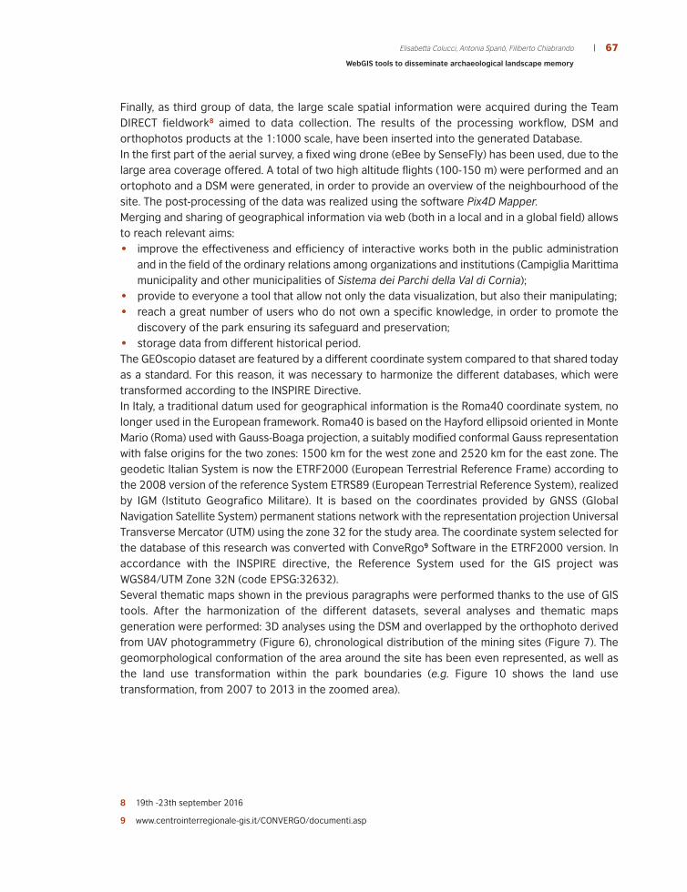
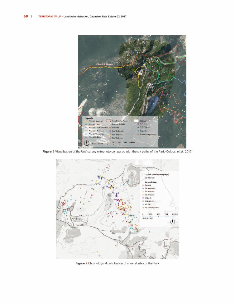
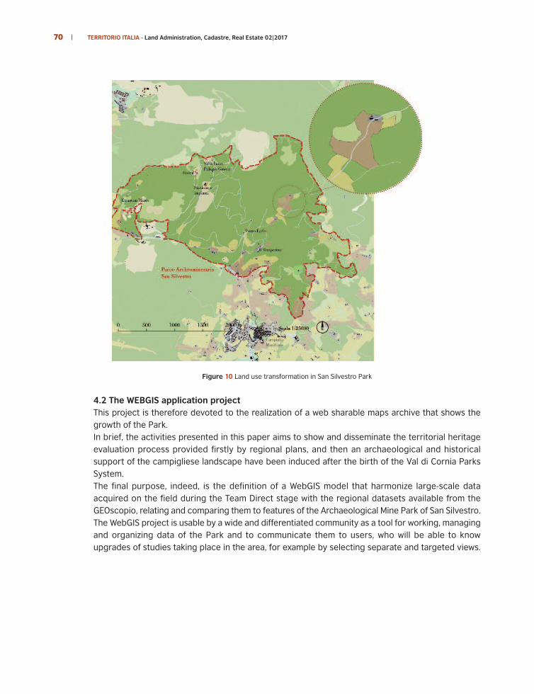
• storage data from different historical period.The GEOscopio dataset are featured by a different coordinate system compared to that shared todayas a standard. For this reason, it was necessary to harmonize the different databases, which weretransformed according to the INSPIRE Directive.In Italy, a traditional datum used for geographical information is the Roma40 coordinate system, nolonger used in the European framework. Roma40 is based on the Hayford ellipsoid oriented in MonteMario (Roma) used with Gauss-Boaga projection, a suitably modified conformal Gauss representationwith false origins for the two zones: 1500 km for the west zone and 2520 km for the east zone. Thegeodetic Italian System is now the ETRF2000 (European Terrestrial Reference Frame) according tothe 2008 version of the reference System ETRS89 (European Terrestrial Reference System), realizedby IGM (Istituto Geografico Militare). It is based on the coordinates provided by GNSS (GlobalNavigation Satellite System) permanent stations network with the representation projection UniversalTransverse Mercator (UTM) using the zone 32 for the study area. The coordinate system selected forthe database of this research was converted with ConveRgo9 Software in the ETRF2000 version. Inaccordance with the INSPIRE directive, the Reference System used for the GIS project wasWGS84/UTM Zone 32N (code EPSG:32632).Several thematic maps shown in the previous paragraphs were performed thanks to the use of GIStools. After the harmonization of the different datasets, several analyses and thematic mapsgeneration were performed: 3D analyses using the DSM and overlapped by the orthophoto derivedfrom UAV photogrammetry (Figure 6), chronological distribution of the mining sites (Figure 7). Thegeomorphological conformation of the area around the site has been even represented, as well asthe land use transformation within the park boundaries (e.g. Figure 10 shows the land usetransformation, from 2007 to 2013 in the zoomed area).
8 19th -23th september 2016
9 www.centrointerregionale-gis.it/CONVERGO/documenti.asp
68 TERRITORIO ITALIA - Land Administration, Cadastre, Real Estate 02|2017
Figure 6 Visualization of the UAV survey ortophoto compared with the six paths of the Park (Colucci et al., 2017)
Figure 7 Chronological distribution of mineral sites of the Park
69Elisabetta Colucci, Antonia Spanò, Filiberto Chiabrando
WebGIS tools to disseminate archaeological landscape memory
Figure 8 Orographic conformation of the territory
Figure 9 3D model of the site surroundings
70 TERRITORIO ITALIA - Land Administration, Cadastre, Real Estate 02|2017
Figure 10 Land use transformation in San Silvestro Park
4.2 The WEBGIS application project This project is therefore devoted to the realization of a web sharable maps archive that shows thegrowth of the Park. In brief, the activities presented in this paper aims to show and disseminate the territorial heritageevaluation process provided firstly by regional plans, and then an archaeological and historicalsupport of the campigliese landscape have been induced after the birth of the Val di Cornia ParksSystem. The final purpose, indeed, is the definition of a WebGIS model that harmonize large-scale dataacquired on the field during the Team Direct stage with the regional datasets available from theGEOscopio, relating and comparing them to features of the Archaeological Mine Park of San Silvestro. The WebGIS project is usable by a wide and differentiated community as a tool for working, managingand organizing data of the Park and to communicate them to users, who will be able to knowupgrades of studies taking place in the area, for example by selecting separate and targeted views.
71Elisabetta Colucci, Antonia Spanò, Filiberto Chiabrando
WebGIS tools to disseminate archaeological landscape memory
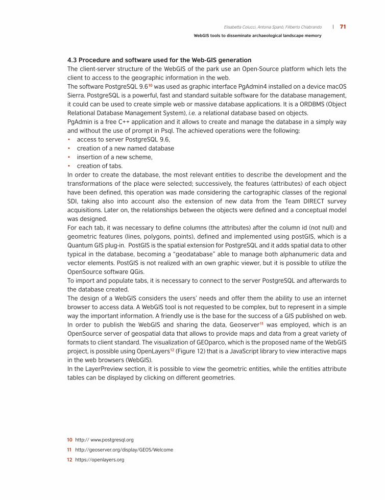
4.3 Procedure and software used for the Web-GIS generationThe client-server structure of the WebGIS of the park use an Open-Source platform which lets theclient to access to the geographic information in the web. The software PostgreSQL 9.610 was used as graphic interface PgAdmin4 installed on a device macOSSierra. PostgreSQL is a powerful, fast and standard suitable software for the database management,it could can be used to create simple web or massive database applications. It is a ORDBMS (ObjectRelational Database Management System), i.e. a relational database based on objects. PgAdmin is a free C++ application and it allows to create and manage the database in a simply wayand without the use of prompt in Psql. The achieved operations were the following: • access to server PostgreSQL 9.6,• creation of a new named database • insertion of a new scheme,• creation of tabs.In order to create the database, the most relevant entities to describe the development and thetransformations of the place were selected; successively, the features (attributes) of each objecthave been defined, this operation was made considering the cartographic classes of the regionalSDI, taking also into account also the extension of new data from the Team DIRECT surveyacquisitions. Later on, the relationships between the objects were defined and a conceptual modelwas designed.For each tab, it was necessary to define columns (the attributes) after the column id (not null) andgeometric features (lines, polygons, points), defined and implemented using postGIS, which is aQuantum GIS plug-in. PostGIS is the spatial extension for PostgreSQL and it adds spatial data to othertypical in the database, becoming a “geodatabase” able to manage both alphanumeric data andvector elements. PostGIS is not realized with an own graphic viewer, but it is possible to utilize theOpenSource software QGis.To import and populate tabs, it is necessary to connect to the server PostgreSQL and afterwards tothe database created. The design of a WebGIS considers the users’ needs and offer them the ability to use an internetbrowser to access data. A WebGIS tool is not requested to be complex, but to represent in a simpleway the important information. A friendly use is the base for the success of a GIS published on web. In order to publish the WebGIS and sharing the data, Geoserver11 was employed, which is anOpenSource server of geospatial data that allows to provide maps and data from a great variety offormats to client standard. The visualization of GEOparco, which is the proposed name of the WebGISproject, is possible using OpenLayers12 (Figure 12) that is a JavaScript library to view interactive mapsin the web browsers (WebGIS). In the LayerPreview section, it is possible to view the geometric entities, while the entities attributetables can be displayed by clicking on different geometries.
10 http:// www.postgresql.org
11 http://geoserver.org/display/GEOS/Welcome
12 https://openlayers.org
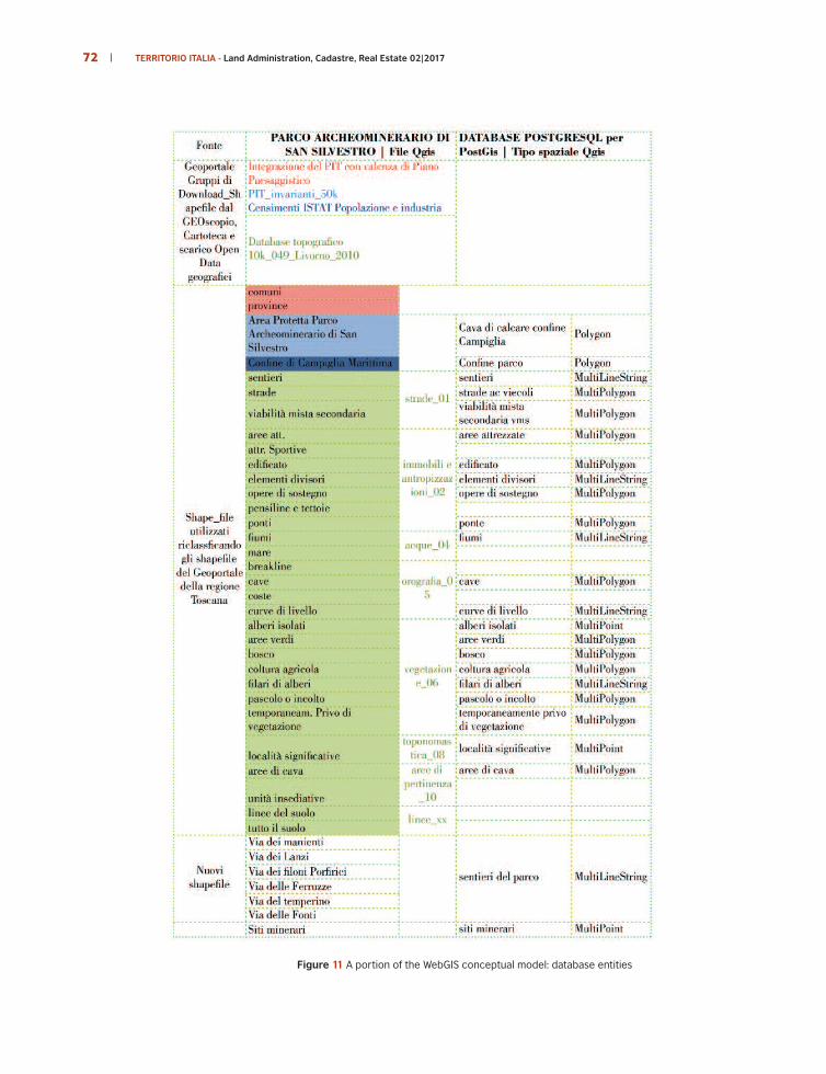
Figure 11 A portion of the WebGIS conceptual model: database entities
72 TERRITORIO ITALIA - Land Administration, Cadastre, Real Estate 02|2017
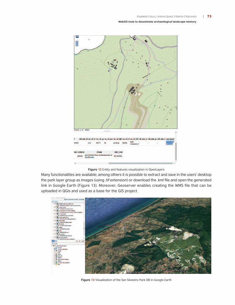
Figure 12 Entity and features visualization in OpenLayers
Many functionalities are available; among others it is possible to extract and save in the users’ desktopthe park layer group as images (using .tif extension) or download the .kml file and open the generatedlink in Google Earth (Figure 13). Moreover, Geoserver enables creating the WMS file that can beuploaded in QGis and used as a base for the GIS project.
Figure 13 Visualization of the San Silvestro Park DB in Google Earth
73Elisabetta Colucci, Antonia Spanò, Filiberto Chiabrando
WebGIS tools to disseminate archaeological landscape memory

Figure 14 Relationship among the software for the creation of WebGIS platform
The Archaeological Mine Park of San Silvestro WebGIS may be published in the next future, so the
Figure 15 reports the interface with the proposed logo.
Figure 15 Preview of the planned GEOparco web-site
74 TERRITORIO ITALIA - Land Administration, Cadastre, Real Estate 02|2017

75Elisabetta Colucci, Antonia Spanò, Filiberto Chiabrando
WebGIS tools to disseminate archaeological landscape memory
4.5 DiscussionThe application’s operational phase was characterized by the creation, storage, and web visualizationof the object relational database (ORDB). Surely a critical point that afflicts this application, like manyothers, is the lack of availability of data structured according to the standards, both on the geograficside and on that of cultural heritage.As recalled, the first possible harmonization was that related to the cartographic reference systemsthat allowed the integration of the different datasets: the ones distributed by the Tuscany Region,the datasets provided by the park in the form of geo-referenced study material and those of newcreation derived from 3D surveys of the park areas using drone technology.On the side of the geographical data provided by the regional infrastructures, the Italian panoramaoffers rather varied solutions and updates with respect to the specifications of the current standardsDespite this gap, for example for the Tuscany region the classification of the basic topographicdatabase does not meet the Inspire standard, particular attention was given to the design of thearchive in which the classes of the objects catalogue used by Tuscany Region were reported (anexample of which can be seen in Figure 16).
Regarding the standards and infrastructures of geographic data pertaining the cultural heritage,considerable attention has been paid to the use of consolidated GIS tools, for example the use ofthe Web Map Service of the OGC, which is certainly prefigured for updates in progress that will allowopen access to the archives of assets safeguarded by the national agency MIBACT.
Figure 16 Attributes Table of “Cave area” class. (above): the attribute table exported from PostGreSQL(below) table columns properties, (right) the catalog of the classes of the Tuscany Region DB

76 TERRITORIO ITALIA - Land Administration, Cadastre, Real Estate 02|2017
5 | CONCLUSIONS AND PERSPECTIVESAt present, the project of the database web publication, that we named at the moment GEOparco,can support the internal management of the park and the relationship with the other components ofterritorial valorization made by the park system.The potential of this WebGIS model lies in the opportunity to update the DB with new data, and in theaccess to an open system that allows to easily share data with non-specialized users. The parkauthority will be able to integrate the database into a single IT support, as well as link informationarchives located in different physical locations, establishing dynamic network connections thatconstitute the physical space in which the system is developed. A main feature is the interoperabilityof the DB with future datasets, i.e. “the possibility for spatial data to be combined so that the resultis consistent and that the added value of the datasets and related services is enhanced” (INSPIREDirective, 2007).Moreover, the prospect of access to data on the web, for example, if coordinated to the website thatpromotes the cultural and tourist resources of the park system (http://www.parchivaldicornia.it/it/il-parco-archeominerario-di-san-silvestro.html) would have the advantage of providing an immediateand easy to use tool, for dissemination purposes to complement the educational and tourist purposesof the website.Visitors would be given the opportunity to know, for example, the length, the difference in height,the travel time of a certain path within the park, or the historical periodization, the type and groupof mineral sites in the boundaries of the park; this obviously would allow them to plan a more informedvisit.A strong point in the creation of an integrated database such as the one proposed is the applicabilityto other territorial, landscape and built heritage, which will facilitate in the future, also in virtue ofthe OGC standards already mentioned, the integration in management and protection systems ofMibact, referred to the beginning of the paper. The full functionality of local and national systems forthe continuous monitoring of the landscape and of cultural heritage allow their full protection,conservation, and become engines of environmental, social and economic sustainability.Finally, we would like to suggest that the visibility carried out through WebGIS projects of landscapevalues can facilitate the exchange with new institutions. The recent International Program ofGeosciences and Geoparks (International Geosciences and Geoparks Program, IGGP), launched in2015 by UNESCO, has established Geoparks as territories that possess a specific geological heritage,whose sustainable development strategy provides for a management according to the concepts ofprotection, education and promotion. They have been defined as a new category of sites protectedby UNESCO and now, in Italy, there are ten geological parks recognized at European level forgeological, archaeological, naturalistic, historical and / or cultural interest. For these sites and others,such as the Parco Archeominerario di San Silvestro, an active role in the territorial economicdevelopment is foreseen and a significant impact on the dissemination of positive principlesconcerning the relationship between men and the environment are pursued. Since it is shown thatinformation systems can support these purposes it is good to promote their use.

AknowledgementsThe authors would like to acknowledge the Parchi della Cornia S.p.a company and especially the San Silvestro Park director, D.Brocchini.
Web Referenceshttp://inspire.ec.europa.eu (last consultation 20th October 2017)http://www.cidoc-crm.org/official_release_cidoc.html (last consultation 15th October 2017)https://www.qgis.org/it/ site/about/index.html (last consultation 7th September 2017)http://www.cartadelrischio.it/ (last consultation 20th May 2017)http://www.iccd.beniculturali.it/index.php?it/118/sistema-informativo-generale-delcatalogo (last consultation 28th August 2017)https://areeweb.polito.it/direct/(last consultation 22nd November 2017)http://www502.regione.toscana.it/geoscopio/cartoteca.html (last consultation 2nd October 2017)http://www.regione.toscana.it/-/geoscopio-wms (last consultation 2nd October 2017)www.centrointerregionale-gis.it/CONVERGO/documenti.asp (last consultation 10th February 2016)http://www.postgresql.org (last consultation 7th September 2017)http://geoserver.org/display/GEOS/Welcome (last consultation 20th May 2017)https://openlayers.org (last consultation 27th September 2017)https://carra-nl.com/ (last consultation 20th October 2017)https://beniculturali.academia.edu/SITARProjectKnowledgeExperienceBase (last consultation 22nd October 2017)https://support.esri.com/en/other-resources/gis-dictionary/term/desktop (last consultation 9th January 2018)https://www.autodesk.it/products/autocad-map-3d/free-trial (last consultation 10th January 2018)https://www.bentley.com/it/products/product-line/asset-performance/bentley-map (last consultation 10th January 2018)https://www.hexagongeospatial.com/products/power-portfolio/geomedia-webmap (last consultation 10th January 2018)http://www.esri.com/arcgis/about-arcgis (last consultation 10th January 2018)http://www.gfoss.it (last consultation 9th January 2018)
References Apollonio, F., Gaiani, M., Benedetti, B., (2012). 3D reality-based artefact models for the management of archaeological sites using3D GIS: a framework starting from the case study of the Pompeii Archaeological area, Journal of Archaeological Science 39, pp.1271-1287.Bianchi, G., 1996. Trasmissione dei saperi tecnici e analisi dei procedimenti costruttivi. In: Archeologia dell’Architettura, I, pp.53-65. Box, P.(1999). GIS and Cultural Resource Management: A manual for heritage managers. UNESCO.Brocchini, D., Chiabrando, F., Colucci, E., Sammartano, G., Spanò, A., Losè, L. T., & Villa, A. (2017). The geomatics contribution forthe valorisation project in the rocca of san silvestro landscape site. International Archives of the Photogrammetry, RemoteSensing and Spatial Information Sciences - ISPRS Archives, 42(5W1), 495–502. https://doi.org/10.5194/isprs-Archives-XLII-5-W1-495.Boroushaki, S., Malczewski, J. (2010). Participatory GlS: A Web-based Collaborative GIS and Multicriteria Decision Analysis. UrisaJournal, 22(1), 23. Colucci, E., (2017). Architettura e natura di paesaggi archeologici Analisi spaziali integrate in ambiente WEB-GIS per laconservazione e la comunicazione della memoria storica (…), Msc thesis, Politecnico di Torino, tutors, A. Spanò, F. Chiabrando, D.Brocchini, F. Noardo.D’Andrea, A., 2000, Modelli GIS nel Cultural Resource Management, Archeologia e Calcolatori,n .XI. pp 153-170. Djindjian, F., (2001). GIS usage in worldwide archaeology. Volume, Archeologia e Calcolatorin. In, Moscati P. (ed.), MethodologicalTrends and Future Perspectives in the Application of GIS in Archaeology, IX Dragi�evi�, S., Balram, S. (2004). A Web GIS collaborative framework to structure and manage distributed planning processes.Journal of Geographical Systems, 6(2), pp. 133-153. Drap, P., Merad, D., Seinturier, J., Boï, J. M., Peloso, D., Vannini, G., Nucciotti, M., Pruno, E., (2012). An Infor-mation System forMedieval Archaeology Based on Photogrammetry and Archaeological Database: The Shawbak Castle Project, In Euromed.ESRI, (2012). “Environmental Systems Research Institute.” GIS Dictionary, desktop GIS. 2012.Francovich, R. (1987). Un villaggio di minatori e fonditori di metallo nella Toscana del medioevo: S. Silvestro, in “Archeologia estoria del Medioevo italiano”.Francovich, R., Farinelli, R. (1994). Potere e attività minerarie nella To-scana altomedievale, in La storia dell’alto medioevo italianoalla luce dell’archeologia, secoli VI-X. Atti del convegno internazionale tenutosi a Siena il 2-6 dicembre 1992, Ecole Francaise deRome, Università degli Studi di Siena.Francovich, R. (2000), Le ragioni di un parco alle radici dell’archeologia mineraria. Le miniere di Campiglia Marittima nelle paginedei naturalisti e dei geologi dell’Ottocento, Padova, 1994. Handbook on geographic information systems and digital mapping,Series F No. 79, United Nations, New York.Gallo, C., Malatacca, F. (2012). Designing a WebGIS for spatial planning (No. 01-2012). Dipartimento di Scienze Economiche,Matematiche e Statistiche, Universita’di Foggia.Guideri, S., 2008. Il Sistema dei Parchi della Val di Cornia e il Parco Archeominerario di San Silvestro (1996-2006). In: Bailly-Maitre, M. C., Jourdanne-Annequin, C., Clermont-Joly, M., (edited by), Archéologie et paysage (…), Picard, Paris, pp. 187-195.Noardo, F. (2016). Spatial ontologies for Architectural Heritage, PhD thesis. Politecnico di Torino, tutors A. Spanò, A. Lingua.Noardo, F., Lingua, A., Aicardi, I., Vigna, B. (2016). Cartographic data harmonisation for a cross-border project development. In:APPLIED GEOMATICS, pp. 1-18. - ISSN 1866-9298
77Elisabetta Colucci, Antonia Spanò, Filiberto Chiabrando
WebGIS tools to disseminate archaeological landscape memory
78 TERRITORIO ITALIA - Land Administration, Cadastre, Real Estate 02|2017
Noardo, F., Spanò, A., (2015) Towards a spatial semantic management for the Intangible Cultural Heritage, In: INTERNATIONALJOURNAL OF HERITAGE IN THE DIGITAL ERA Multi-science, pp 15, pagine 133-147, ISSN: 2047-4970.Katsianis, M., Tsipidis, S., Kotsakis, K., Kousoulakou, A., (2008). A 3D digital workflow for archaeological intra-site research usingGIS, Journal of Archaeological Science 35 pp. 655.Kersten, T.P., Lindstaedt, M. (2012). Potential of Automatic 3D object reconstruction from multiple Images for applications inArchitecture, Cultural Heritage and Archaeology. International Journal of Heritage in the Digital Era, Multi Science Publishing,399-420. Piñas Azpitarte, M. (2012), Recreando Alejandría, dos visiones distintas de la misma ciudad: Los decorados digitales de la película“Ágora” y la pieza estereoscópica “Alejandría, el sueño de Alejandro Magno”, Virtual Archaeology Review, 3 (6), 12-19,http://dx.doi.org/10.4995/var.2012.4421.Sammartano, G., Spanò, Gomez Serito A. T. M., (2018) La tecnologia GIS per la gestione dello studio dei materiali lapidei. In:Fontana F., Aquileia, l’insula tra Foro e porto fluviale. Lo scavo dell’Università degli Studi di Trieste. 1. L,a strada, pp. 473-511.ISBN 978-88-8303-608-8 (in press).Serlorenzi, M., Jovine I., Leoni, G., De Tommasi, A., Varavallo A. (2015). A retrospective on GIS and AIS platforms for PublicArchaeology in Italy. Searching backward for roots and looking onwards for new methodological road-maps, in Proceedings ofCAA 2014 (42nd Conference on Computer Applications and Quantitative Methods in Archaeology. Scollar, I., (1999). 25 years of Computer Applications in Archaeology, in L. DINGWALL, S. EXON, V. GAFFNEY, S. LAFLIN, M. VANLEUSEN (Eds.), Archaeology in the Age of the Internet, Computer Ap-plications and Quantitative Methods in Archaeology 1997,BAR International Series 750, Oxford, 5-10.Semplici, A. (2011). “Bianca e sfolgorante appare la Rocca…”, Guida al Parco Archeominerario di San Silvestro, (a cura di) DeboraBrocchini, Silvia Guideri, Parchi Val di Cornia S.p.a..Spanò, A., Chiabrando, F., Dezzani, L., Prencipe, A. (2016), Digital Segusio: from models generation to urban reconstruction. In:Virtual Archaeology Review, vol. 7 n. 15, pp. 87-97. - ISSN 1989-9947.Spanò, A., Pellegrino, M., (2013) Craft data mapping and spatial analysis for historical landscape modeling. In: Journal Of CulturalHeritage, vol. 14 n. 3, Sup, S6-S13. - ISSN 1296-2074.Spanò, A., Cerruti, E., Bartolozzi, C., Novelli, F., (2014) Worthy Outcomes from a System Advancing the Sharing of CH Data andStakeholders Relations, In: Digital Heritage Progress in Cultural Heritage: Documentation, Preservation, and Protection / MarinosIoannides et al. © Springer International Publishing Switzerland, pp 11, pp. 606-616, ISBN: 9783319136943.Surace, L. (2012). La georeferenziazione delle in-formazioni territoriali. 138 Gazzetta Ufficiale n. 48 del 27/02/2012 -Supplemento ordinario n. 37.Stylianidis, E., Patias, P., Santana Quintero M. (2011), CIPA Heritage Documentation. Best Practices and Applications, Series 1,2007 & 2009, Greece, CIPA – The ICOMOS/ISPRS Commit-tee for Documentation of Cultural Heritage.Vacca, G., Fiorino, D. R., Pilia, D., (2017). A WebGIS for the knowledge and conservation of the historical buildings in Sardinia(Italy). ISPRS Archives, Volume XLII-4/W2, 171-178.Villa, A. (2017). Rocca medioevale di San Silvestro: modellazione 3D da rilievo UAV e laser scanning terrestre per lo studio el’analisi del manufatto. Rel. Antonia Teresa Spanò, Filiberto Chiabrando. Politecnico di Torino, Corso di laurea magistrale inArchitettura costruzione città.Weldrake, D., (2010), Writing an archaeological risk assessment, Archaeology Advisory Service, West Yorkshire.Wheatley, D., Gillings M., (2002). Spatial technology and archaeology: the archaeological applications of GIS, Taylor and Francis,London.
This work is licensed under a
Creative Commons Attribution - NonCommercial 3.0