ellerton drive extension - flora survey effort within the study …€¦ · · 2017-04-05gf g g g...
TRANSCRIPT

!(
!(
!(
!(
!(
!(
!(
!(
!(
!(
!(
!(
!(
!(
!(
!(
!(
!(
!(
!(
!(
!(
!(
!(
!(
�)
�)
�)
�)
�)
�)
DS6
DS5
DS4
DS3
DS2
DS1
Study area
Subject site
Flora survey effort
�) Quadrat
!( Inspection point
Threatened species transect
1:11000
www.nghenvironmental.com.au
0 250125 Meters
°
Ellerton Drive extension - Flora survey effort within the study area
A3 @Ref: 4733 - 2-1Author: DM
Notes:- Field data collected by nghenvironmental field staff (October 2012)- Development footprint and aerial imagery provided by QCC

!(!(
!(!(
!(
!(!(!(
!(
!(
!(!(
!(!(!(
!(
!(!(
!(
!(
!(
!(
!(
!(
!(
!(
!(!(!(
!(
!(
!(
!(
!(
!(
!(
!(
!(
!(
!(
!(
!(
!(
!(
!(!(
!(
!(
!(
!(
!(
!(
!(!(
!(
!(
!(
!(
!(
!(
!(
!(
�)
�)�)
�)
�) �)
�)�)
�)
�)
�)�)
�)
�)�)
�)
LC9LC8
LC7
LC6LC5
LC4
LC3
LC2LC1
DS6DS5
DS4
DS3DS2
DS1
LC10
Study area
5km buffer
10km buffer
Flora survey effort
�) Quadrat
!( Inspection point
Threatened species transect
1:70000
www.nghenvironmental.com.au
0 21 Kilometres
°
Ellerton Drive extension - Flora survey effort within the locality
A3 @Ref: 4733 - 2-2Author: DM
Notes:- Field data collected by nghenvironmental field staff (October 2012)- Base map sourced from ESRI Online © 2010 Microsoft Corporation and its data suppliers

Species Impact Statement
Ellerton Drive Extension
4733 Final v1.2 D-II
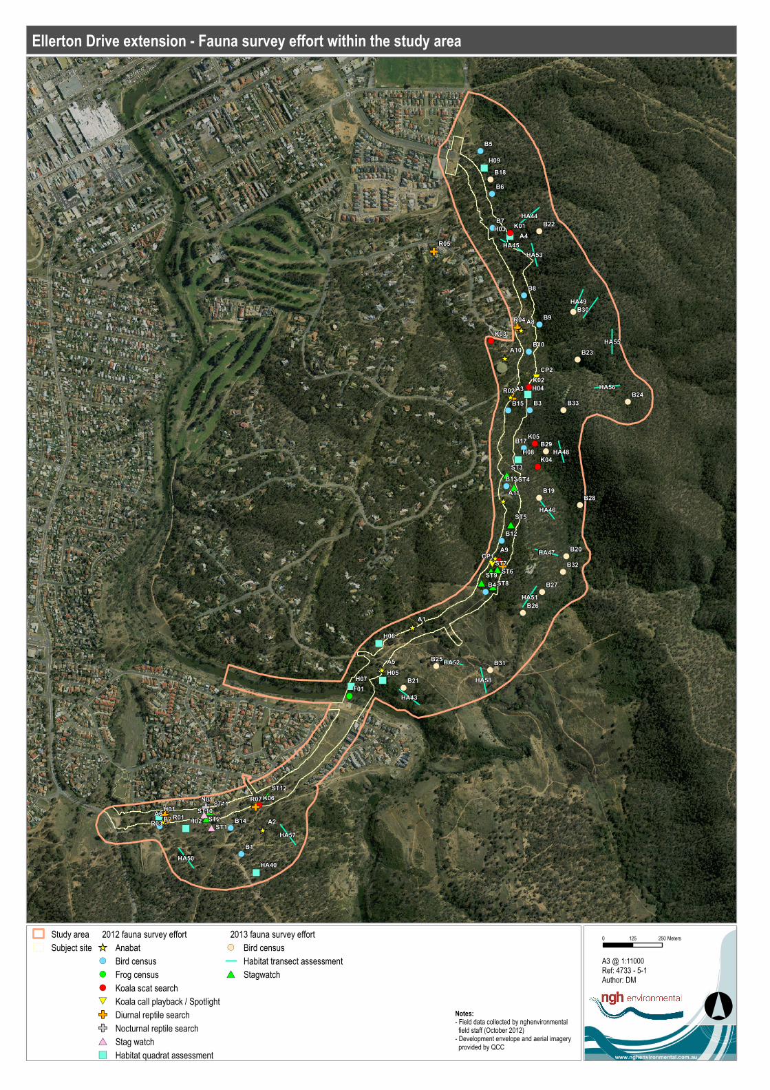
D.2 FAUNA
#*
#*
#*
#*
#*#*
#*#*
#*
#*
!(
!(
!(
!(
!(
!(
!(
!(
!(
!(
!(
!(
!(
!(
!(
!(
�
�
�
�
�
�
�
�
�
�
)
)
)
)
)
)
)
)
)
)
#
#
*
*
#
#
*
*
!
!
!
!
!
!
!
(
(
(
(
(
(
(
!(
!
!
!
!
!
!
!
!
!
!
!
!
!
!
!
(
(
(
(
(
(
(
(
(
(
(
(
(
(
(
GF
G
G
G
G
G
G
G
F
F
F
F
F
F
F
[
[
[
[
[
[
[
[
[
[
ST7
ST9
ST8
ST6
ST5
ST4
ST3
ST12
ST11ST10
HA58
HA56
HA44
HA51
HA50
HA57
HA43
HA49
HA45
HA55
HA53
HA52
HA47
HA46
HA48
B33
B32
B31
B30
B29
B28
B27
B26
B25
B24
B23
B22
B21
B20
B19
B18
B9
B8
B7
B6
B5
B4
B3
B2
B1
A9
A8
A6
A5
A4
A3
A2
A1
CP2
CP1
ST2
ST1
N01 K06
K05
K04
K03
K02
K01
H09
H08
H07
H06
H05
H04
H03
H02
H01
F01
R07
R05
R04
R03
R02
R01
B17
B15
B14
B13
B12
B10
A11
A10
HA40
Study area
Subject site
2012 fauna survey effort
[ Anabat
!( Bird census
!( Frog census
!( Koala scat search
#*
Koala call playback / Spotlight
GF Diurnal reptile search
GF Nocturnal reptile search
#* Stag watch
�) Habitat quadrat assessment
2013 fauna survey effort
!( Bird census
Habitat transect assessment
#* Stagwatch
1:11000
www.nghenvironmental.com.au
0 250125 Meters
°
Ellerton Drive extension - Fauna survey effort within the study area
A3 @Ref: 4733 - 5-1Author: DM
Notes:- Field data collected by nghenvironmental field staff (October 2012)- Development envelope and aerial imagery provided by QCC