elwha river ecosystem restoration implementation
TRANSCRIPT

Final Environmental Impact Statement Elwha River Ecosystem Restoration Implementation Purpose and Need: The Elwha River ecosystem and native anadromous fisheries are severely degraded as a result of two hydroelectric dams (projects) and their reservoirs built in the early 1900s. Congress has mandated the full restoration of this ecosystem and its native anadromous fisheries through the Elwha River Ecosystem and Fisheries Restoration Act (Public Law 102-495). The Department of the Interior has found there is a need to return this river and the ecosystem to its natural, self-regulating state, and proposes to implement the Congressional mandate by removing both dams in a safe, environmentally sound and cost effective manner and implementing fisheries and ecosystem restoration planning. Only dam removal would fully restore the ecosystem or its native anadromous fisheries. Proposed Action: The U.S. Department of the Interior proposes to fully restore the Elwha River ecosystem and native anadromous fisheries through the removal of Elwha Dam and Glines Canyon Dam and implementing fish restoration and revegetation. Dam removal would occur over a 2-year period. Elwha Dam would be removed by blasting, and Glines Canyon Dam by a combination of blasting and diamond wire saw cutting. Lake Aldwell would be drained by a diversion channel, and Lake Mills by notching down Glines Canyon Dam. Stored sediment would be eroded naturally by the Elwha River. The proposed action is located in Clallam County, on the Olympic Peninsula, in Washington State. Lead/Cooperating agencies: The National Park Service is the lead agency. The U.S. Fish and Wildlife Service, U.S. Bureau of Reclamation, U.S. Bureau of Indian Affairs, U.S. Army Corps of Engineers, and the Lower Elwha Klallam Tribe are cooperating agencies/governments on this EIS. Type of statement: This is a final environmental impact statement (EIS). Because public and agency comments did not substantially modify any of the alternatives or the environmental analysis in the draft EIS, the full text of the draft has not been reprinted. Rather, the attached material includes a summary of responses to comments, factual corrections and text changes in the form of errata sheets, and copies of letters received from agencies and organizations. Substantive comments from all written and oral comments on the draft EIS were summarized and responded to in the attached Responses to Comment section. The complete final EIS includes the draft EIS and the material attached to this abstract. This final EIS is tiered, or procedurally connected, to Interior's June 1995 final Elwha River Ecosystem Restoration EIS, which determined dam removal was required to fully restore the Elwha River ecosystem and anadromous fisheries. Abstract: In addition to the proposed action, two other alternatives are examined. They are: removing fine-grained sediment prior to dam removal by using suction dredges, and sending the slurry to the Strait of Juan de Fuca in a pipeline, and No Action (i.e., dams are retained as is, without fish passage measures). The Proposed Action is also the

Department of the Interior's "preferred alternative." Short-term adverse impacts from removing both dams would result from the release of sediment now trapped in the reservoirs. The finer grained particles would temporarily but significantly impact fish or other aquatic organisms. Impacts on water quality, river morphology, flooding, native anadromous and resident (i.e., trout and char) fisheries, living marine resources, wildlife, threatened and endangered species, vegetation, cultural resources, land use, recreation, aesthetic resources, and socioeconomics are also examined in this environmental impact statement. Both of the other alternatives would also have significant impacts on resources examined in this document. Public Involvement: Oral comments were taken on the draft EIS in Washington State in three public workshops on May 21-22, 1996. Written comments were taken for a 60-day period which ended June 27, 1996. Substantive comments were responded to in a question/answer format, and by making appropriate text changes to the draft. Those text changes are attached as errata sheets, and should be used in conjunction with Interior's April 1996 draft Elwha River Ecosystem Restoration Implementation EIS. To obtain a draft or the location of the nearest agency or library which has a copy of the draft, contact Olympic National Park at (360) 452-4501 x264. Copies will be sent to those who request them until the current supply is exhausted. All who received a draft EIS in the initial April 1996 mailing will also receive the attached material. Guide to Using This Document The attached document includes the following:
A series of "errata sheets" or changes to the text of Interior's draft Elwha River Ecosystem Restoration Implementation environmental impact statement (Implementation EIS)
Responses to Comments received on the Implementation EIS, indexed by subject
and by author
A new and revised Consultation and Coordination chapter
A new appendix (appendix 7), the US Fish and Wildlife Service's Biological Opinion, and
Copies of substantive comment letters received on the draft Implementation EIS
from all agencies and organizations The combination of these materials and Interior's draft Implementation EIS serves as an "abbreviated" final EIS. The reasoning behind an abbreviated EIS, and the contents of errata sheets and the Responses to Comments section is explained in further detail below. The regulations which determine how the National Environmental Policy Act (NEPA) will be carried out include an option for responding to public comments on a draft environmental impact statement (EIS) when few changes result from those comments.

The relevant section of these regulations (CFR 1503.4) states that if changes in response to public comments are minor and confined to factual corrections or explanations of why comments do not warrant further agency response, they may be written on errata sheets and attached to the draft EIS, instead of rewriting, printing and mailing the entire revised draft. The National Park Service (NPS) has opted to follow this "abbreviated" EIS procedure for the Elwha River Ecosystem Restoration Implementation EIS (Implementation EIS). NPS received 374 letters on the draft Implementation EIS. The number of separate comments in these letters and those taken at three workshops May 21-22, 1996 totaled nearly 500. Many of these comments were very similar or identical to those received on Interior's programmatic EIS on how best to restore the Elwha River ecosystem and native anadromous fisheries. This document, Elwha River Ecosystem Restoration EIS, was finalized in June 1995 (copies are available from Olympic National Park). Although NPS received a large number of comments, few resulted in even minor factual corrections to the draft Implementation EIS. When they did, or when the EIS team elaborated and explained material which may have been unclear in the draft, text changes in the form of errata sheets were made. These sheets must be used in conjunction with the draft EIS. Copies of the Implementation EIS are available by calling Olympic National Park at (360) 452-4501 x264 or by going to regional libraries that are listed in the Consultation and Coordination section of this document. In addition to the text changes, specialists from the EIS team responded directly to each substantive comment received. The NEPA regulations described above also allow agencies to summarize public comments and respond to those summaries when appropriate. In an effort to reduce paperwork, streamline the planning process and reduce printing costs, all substantive comments have been summarized and combined where there is overlap in this final Implementation EIS. The responses to these combined and summarized comments are contained in the attached Responses to Comments section. This section includes indices to help each commentor locate the response to his or her particular comment. Finally, NPS has included copies of substantive comment letters received from all agencies and organizations (e.g., special interest groups, businesses, and academic institutions). Contents Corrections and Revisions to the Draft Environmental Impact Statement 1 Summary 1 Introduction 1 Purpose and Need 1 Alternatives 1 Summary of Impacts 2 Fluvial Process and Sediment Transport2
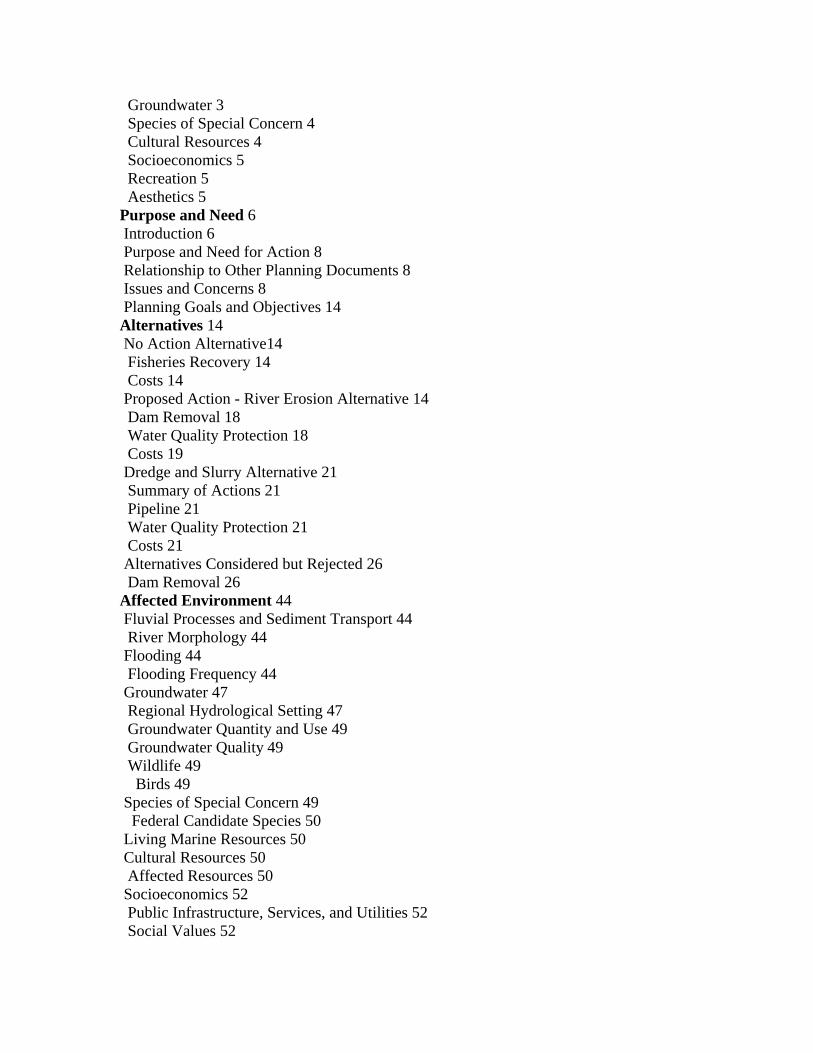
Groundwater 3 Species of Special Concern 4 Cultural Resources 4 Socioeconomics 5 Recreation 5 Aesthetics 5 Purpose and Need 6 Introduction 6 Purpose and Need for Action 8 Relationship to Other Planning Documents 8 Issues and Concerns 8 Planning Goals and Objectives 14 Alternatives 14 No Action Alternative14 Fisheries Recovery 14 Costs 14 Proposed Action - River Erosion Alternative 14 Dam Removal 18 Water Quality Protection 18 Costs 19 Dredge and Slurry Alternative 21 Summary of Actions 21 Pipeline 21 Water Quality Protection 21 Costs 21 Alternatives Considered but Rejected 26 Dam Removal 26 Affected Environment 44 Fluvial Processes and Sediment Transport 44 River Morphology 44 Flooding 44 Flooding Frequency 44 Groundwater 47 Regional Hydrological Setting 47 Groundwater Quantity and Use 49 Groundwater Quality 49 Wildlife 49 Birds 49 Species of Special Concern 49 Federal Candidate Species 50 Living Marine Resources 50 Cultural Resources 50 Affected Resources 50 Socioeconomics 52 Public Infrastructure, Services, and Utilities 52 Social Values 52

Traffic 52 Waste Disposal Areas 52 Indian Trust Resources 52 Recreation 52 Recreational Facilities 52 Land Use 52 Land Ownership 52 Aesthetic Resources 54 Regional Landscape 54 Impacts 56 Fluvial Processes and Sediment Transport 56 Methodologies for Analyzing Impacts 56 Impacts of No Action 56 Impacts of the Proposed Action-River Erosion Alternative 57 Impacts of the Dredge and Slurry Alternative 60 Flooding 63 Impacts of No Action 63 Impacts of the Proposed Action -River Erosion Alternative 64 Impacts of the Dredge and Slurry Alternative 67 Surface Water 67 Impacts of No Action 67 Impacts of the Proposed Action-River Erosion Alternative 67 Impacts of the Dredge and Slurry Alternative 68 Groundwater 69 Impacts of No Action 69 Impacts of the Proposed Action -River Erosion Alternative 69 Native Anadromous and Resident Fisheries 72 Methodologies for Analyzing Impacts 72 Impacts of No Action 72 Impacts of the Proposed Action-River Erosion Alternative 73 Impacts of the Dredge and Slurry Alternative 75 Vegetation 76 Impacts of No Action 76 Impacts of the Proposed Action-River Erosion Alternative 76 Species of Special Concern 76 Impacts of No Action 76 Impacts of the Proposed Action-River Erosion Alternative 76 Living Marine Resources 78 Impacts of the Proposed Action-River Erosion Alternative 78 Impacts of the Dredge and Slurry Alternative 78 Noise 78 Impacts of the Proposed Action-River Erosion Alternative 78 Cultural Resources 79 Impacts of No Action 79 Socioeconomics 79 Methodologies for Analyzing Impacts 79

Impacts of No Action 79 Public Health and Safety 81 Earthquakes 81 Hazardous Materials 81 Recreation 81 Impacts of the Proposed Action-River Erosion Alternative 81 Land Use 81 Impacts of the Proposed Action-River Erosion Alternative 81 Aesthetics 82 Impacts of tile Proposed Action-River Erosion Alternative 82 Required Impact Sections 82 Impacts on Energy Consumption 82 Unavoidable Adverse Impacts 82 Short-term Uses vs. Long-term Productivity 82 Consultation and Coordination 83 Preparers and Contributors 83 Preparers 83 Contributors 83 References 84 Bibliography 84 Glossary and Acronym List 87 Appendixes 88 Appendix 1. Public Law l02-495-Elwha Restoration Act 88 Appendix 2. Elwha River Fish Restoration Plan 88 Appendix 3. Revegetation Plan 90 Appendix 4. Flooding Impacts Associated with Removal of the Elwha and Glines Canyon Dams 91 Appendix 6. Requirements for Completing the Proposed Action 93 Consultation and Coordination 95 History of Public Involvement 95 Scoping Issues 96 Public Review of the Draft Environmental Impact Statement/Comments and Responses 97 Record of Public Comment 97 Public Workshops97 Written Comments 97 Preparers and Contributors 97 Agencies and Organizations That Received Copies of the Final Implementation Environmental Impact Statement 98 Responses to Substantive Comments Made on the Draft EIS 103 Purpose of Final EIS and Methodology 103 Organization of Comments and Responses 103 Index of Substantive Comment Letters by Category of Topic 103 Responses to Comments 107

Sediment 107 Sediment Transport 107 Channel Migration/Morphology 109 Aggradation 110 Beach/Estuary Changes 110 Alternatives 111 Analogies 112 Erosion of Delta 114 Sediment Studies/Modeling 114 Sediment Monitoring 116 Flooding 117 Protection of Property 117 Levees Near the Mouth 118 Ecosystem Restoration/Levee Removal 119 Surface Water 121 Industrial Pre-Treatment -Facility Effectiveness 121 Industrial Pre-Treatment -Flocculent Sludge 123 Water Quality Treatment -Existing Conditions 124 Water Treatment –General 125 Miscellaneous 125 Groundwater 126 City of Port Angeles Municipal Supply 126 Other Wells/Private Property 127 Miscellaneous 128 Fisheries 129 Status of Elwha Stocks 129 Impact of Harvest 130 Hatchery Fish to Restore Stocks 131 Restoration Potential 132 Analogies 135 Data and Assumptions 136 Phased Dam Removal 137 Immediate Restoration Efforts 137 Fish Passage/Retain the Dams 139 Other Factors Affecting Salmonid Populations 140 Miscellaneous 141 Vegetation 143 Wetlands 143 Vegetation Management 144 Miscellaneous 144 Wildlife 146 Insects 146 Waterfowl 146 Other Wildlife 147 Living Marine Resources 148 Estuary 148

Pipeline Outfall 148 General 149 Cultural Resources 150 Cultural Sites150 Tribal Lands 150 Interpretation 151 Miscellaneous 151 Socioeconomics 152 Cost Effectiveness 152 Lower Elwha Klallam Tribe 152 Project Costs153 Government Responsibility 155 No Action/Dam Retention 155 Alternative Sources of Funding 156 Local Costs and Benefits 156 Miscellaneous 158 Public Health and Safety 159 Security of Elwha Dam 159 Dam Removal 160 Hazardous Materials 160 Land Use, Recreation, and Esthetics 162 Acquired Lands 162 Access During Removal 163 Private Property Issues 164 Miscellaneous 165 National Environmental Policy Act Issues 167 Alternatives 167 Final Programmatic EIS (EIS #1) 167 Level of Detail/Supplemental EIS 168 Miscellaneous 169 Permitting 170 Power Generation 172 Port Angeles Power Supply 172 Replacement Power for Daishowa 173 Dam Removal 174 Sequence of Events 174 Alternatives 175 Analogies 176 Miscellaneous 176 Miscellaneous or General Comments 177 Comment Letters 179 Index of Substantive Comment Letters by Category of Author 179 Public Agency Comment Letters 181 Special Interest Group Comment Letters 197 Business Comment Letters 243

Appendix 7-Biological Opinion in Regard to the Elwha River Restoration Project 249 Tables Table 1. Summary of Costs for Each Action Alternative 2 Table 3. Substantive Issues and Concerns Analyzed in this EIS 9 Table 5. Summary of Mitigation Measures for River Erosion and Dredge and Slurry Alternative 15 Table 7. Water Quality Mitigation Measures 19 Table 9. Cost Estimates-River Erosion Alternative (Proposed Action) 20 Table 10. Cost Estimates-Dredge and Slurry Alternative 22 Table 11. Summary of Alternatives 24 Table 12. Impact Summary Chart 27 Table 28. Range of Final Sediment Release During and Following Dam Removal-River Erosion Alternative (Proposed Action) 58 Table 29. Sediment Before and After Dam Removal-River Erosion (Proposed Action) 59 Table 30. Fine-grained Sediment Behind Dams and Quantities Expected to Enter River upon Dam Removal-River Erosion (Proposed Action) and Dredge and Slurry Alternatives 61 Table 31. Range of Final Sediment Release During and Following Dam Removal-Dredge and Slurry Alternative 62 Table 33. Water Surface Elevations Before and After Dam Removal with the 100-Year Frequency Flood Event 64 Table 34. Structural Mitigation for Flooding Impacts 66 Table 39. Mitigation Measures Included-River Erosion Alternative (Proposed Action) 68 Table 43. Groundwater Impacts and Mitigation 70 Table 46. Impacts of Suspended Sediments on Adult Anadromous Salmonids-River Erosion Alternative (Proposed Action) 74 Table 48. Impacts of Suspended Sediments on Adult Anadromous Salmonids-Dredge and Slurry 75 Table 63. Summary of the Net Present Value of Elwha River Restoration Market Benefits over Project Life-at 3% Discount Rate 80 Figures Figure 3. Sequence of Documents and Events Leading to this Environmental Impact Statement 7 Figure 9. Floodplain Map 45 Figure 10. Northern Study Area 48 Figure 16. Land Ownership 53 Corrections and Revisions to the Draft Environmental Impact Statement

The errata sheets are organized with the same headings as the draft EIS. If there are no changes to a section, the headings are not repeated. Corrections to the text are noted by page number, paragraph, and sentence. A partial paragraph at the top of a page is counted as paragraph 1. Sentences within a partial paragraph are numbered from the first complete sentence at the top of the page. Material that has been deleted is shown by a strikeout and added text is underlined. The phrase “change to read” means that text has been added or deleted. The word “replace” indicates new phrasing for a sentence or paragraph. “Add the following text” is used where text has been added to clarify a passage. Typographical, spelling, and punctuation errors are not changed unless it is necessary to make the passage more understandable.
Pg. 10 = pg. 1&2 Summary Introduction Page 1, paragraph 1, sentences 1&2 – change to read: This document is a draft final environmental impact statement (DEIS FEIS), prepared to analyze environmental impacts of alternative ways to remove two hydroelectric projects on the Elwha River and manage sediment stored behind them. This DEIS FEIS is the second of two, which in combination study … Purpose and Need Page 3, paragraph 2, last sentence – change to read: The single action of removing both dams would restore to pre-dam, high quality condition the vast majority of habitat formerly available to Elwha anadromous fish. access to this 70+ miles of high quality habitat formerly available to Elwha anadromous fish. Alternatives Page 7, paragraph 1, sentence 1 – change to read: experiencing supply problems as the river is meandering migrating away from its current Ranney collector. Page 7, paragraph 1, sentences 3&4 – change to read: … a filter would be installed. Dry Creek Water Association could either would connect to the city of Port Angeles’ proposed new Ranney system (collector and temporary filter plant) as a replacement for the existing well field or to a separate treatment facility built to chlorinate and filter its supply. A package disinfection system would be provided to replace the existing wellhead chlorination system. Page 7, paragraph 2, sentence 1 – change to read: Additional mitigation measures not specifically required by the Elwha Restoration Act, but analyzed by this DEIS FEIS and recommended for adoption, would protect… Page 7, paragraph 7 (continued to page 8), sentence 2 – change to read: Under the No Action alternative, no costs associated with construction would be incurred unless the dams require Federal Energy Regulatory Commission licensing, in which case

those costs as identified in the programmatic EIS (DOI et at. 1995) to install fish passage measures and other upgrades would apply. conditions would remain as they are now – i.e., no fish passage measures would be installed on the dams. Therefore this EIS assumes that no costs associated with construction would be incurred. The Department of the Interior does not consider No Action to be a viable option. It is analyzed in the EIS for comparison purposed and because it is required by the National Environmental Policy Act (NEPA).
Pg. 11 = pg. 2&3 Page 8, table 1 – replace with the following corrected table: Table 1. Summary of Costs for Each Action Alternative (thousands of dollars)
ACTION RIVER EROSION DREDGE AND SLURRY Project/land acquisition 29,800a 29,800a
Dam removal 33,567 32,018 32,951 32,098Road rehabilitation 528 528Sediment managementbc 22,496 22,396Water quality mitigation 29,770 32,055 23,987 26,899Revegetation/wildlife 3,205 3,205Flooding mitigation 3,998 3,998Hazardous waste disposal 587 1,587 587 1,587Fish restorationcd 7,380 7,080 7,380 7,080Cultural resources mitigation
665 665
Monitoring/modeling 2,144 1,844Total TOTAL 111,115 113,080 127,441 130,100a Includes other lands and rights costs. b Includes data collection, decommission, construction management, O&M, and transmission line removal. bc Includes cost of slurry pipeline and dredging, all other sediment management costs for both included in monitoring/modeling. cd Includes hatchery expansion, operation and maintenance. Page 8, paragraph 1, sentence 1 – change to read: Some protection from flooding and water quality treatment is in place now and so is included in the analysis of No Action. Summary of Impacts Fluvial Processes and Sediment Transport Page 8, paragraph 3, sentence 1 – change to read: Under the proposed action (the River Erosion alternative), between 4.8 4.9 and 5.6 million cubic yards of fine-grained sediment (silts and clays) and between 1.2 and 2.6 2.7 million cubic yard of coarse grained sediment… Page 9, paragraph 1, sentence 3 – change to read: Instead of the 4.8 4.9 to 5.6 million cubic yards of fine-grained sediment…
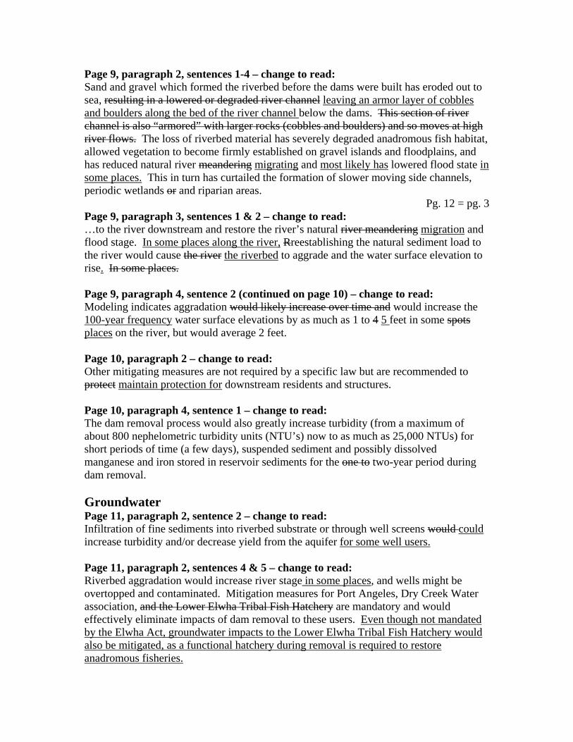
Page 9, paragraph 2, sentences 1-4 – change to read: Sand and gravel which formed the riverbed before the dams were built has eroded out to sea, resulting in a lowered or degraded river channel leaving an armor layer of cobbles and boulders along the bed of the river channel below the dams. This section of river channel is also “armored” with larger rocks (cobbles and boulders) and so moves at high river flows. The loss of riverbed material has severely degraded anadromous fish habitat, allowed vegetation to become firmly established on gravel islands and floodplains, and has reduced natural river meandering migrating and most likely has lowered flood state in some places. This in turn has curtailed the formation of slower moving side channels, periodic wetlands or and riparian areas.
Pg. 12 = pg. 3 Page 9, paragraph 3, sentences 1 & 2 – change to read: …to the river downstream and restore the river’s natural river meandering migration and flood stage. In some places along the river, Rreestablishing the natural sediment load to the river would cause the river the riverbed to aggrade and the water surface elevation to rise. In some places. Page 9, paragraph 4, sentence 2 (continued on page 10) – change to read: Modeling indicates aggradation would likely increase over time and would increase the 100-year frequency water surface elevations by as much as 1 to 4 5 feet in some spots places on the river, but would average 2 feet. Page 10, paragraph 2 – change to read: Other mitigating measures are not required by a specific law but are recommended to protect maintain protection for downstream residents and structures. Page 10, paragraph 4, sentence 1 – change to read: The dam removal process would also greatly increase turbidity (from a maximum of about 800 nephelometric turbidity units (NTU’s) now to as much as 25,000 NTUs) for short periods of time (a few days), suspended sediment and possibly dissolved manganese and iron stored in reservoir sediments for the one to two-year period during dam removal. Groundwater Page 11, paragraph 2, sentence 2 – change to read: Infiltration of fine sediments into riverbed substrate or through well screens would could increase turbidity and/or decrease yield from the aquifer for some well users. Page 11, paragraph 2, sentences 4 & 5 – change to read: Riverbed aggradation would increase river stage in some places, and wells might be overtopped and contaminated. Mitigation measures for Port Angeles, Dry Creek Water association, and the Lower Elwha Tribal Fish Hatchery are mandatory and would effectively eliminate impacts of dam removal to these users. Even though not mandated by the Elwha Act, groundwater impacts to the Lower Elwha Tribal Fish Hatchery would also be mitigated, as a functional hatchery during removal is required to restore anadromous fisheries.

Page 11, paragraph 3, sentences 2 & 3 – change to read: The Dry Creek Water Association (DCWA) could would either connect to the proposed new Ranney well supply, and temporary filtration plant to or require a separate filtration and chlorination facility. Either would protect DCWA users from the adverse impacts of dam removal.
Pg. 13 = pg. 3&4 Page 11, paragraph 4, sentence 2 – change to read: Mitigation measures to protect each are analyzed in this DEIS FEIS and recommended for adoption. Page 11, paragraph 5 – change to read: Several residents of the Lower Elwha Klallam Reservation and perhaps individual property owners who live along the lower river would experience higher groundwater levels, rendering their septic systems unusable following dam removal. A Mounded septic systems with lift stations would resolve this impact. Non-structural solutions to resolve flooding and/or water quality problems might also exist be possible. Species of Special Concern Page 15, paragraph 3 – change to read: Dam removal would adversely affect some species in the short term, primarily through construction noise by increasing turbidity in foraging waters, and possibly from increased noise associated with construction, as Mmurrelets and spotted owls may avoid the area if noise gets too loud. Surveys to date have shown no murrelet nests close to the damsites, but two consecutive years of data collection are required to fulfill US Fish and Wildlife Service procedures. If 1996 Ssurveys conducted in 1990, 1995 and 1996 confirmed that there are no nests of either species near the sites, mitigation including noise reduction or changes in the sequencing and timing of construction activities would be developed. and so required conservation measures (mitigation) have been limited to impacts the murrelets would experience from higher turbidities in nearshore marine waters, where the birds forage. Spotted owl surveys to date have not found nests near either dam, with the closest being nearly one mile from Glines Canyon Dam. As a result, adverse effects on northern spotted owls are not expected, although standard noise reduction techniques during dam removal may be employed to ensure murrelets and owls access to the river corridor and forest surrounding the dam sites. Page 16, paragraph 3, sentence 2 – change to read: …about 25.2 tons over the 18 month to 2 year dam removal time period. Page 16, paragraph 5, sentence 1 – change to read: There are no homes or nest sites of wildlife of special concern closer than 0.3 miles to either damsite. Page 16, paragraph 5, sentence 4 – change to read:

Nests of species of special concern (marbled murrelets and/or Northern spotted owls) (a species of special concern) have been located 1 mile from Glines Canyon Dam, and 1.2 miles from Elwha Dam.
Pg. 14 = pg. 4&5 Cultural Resources Page 17, paragraph 7, sentence 1 – change to read: Removing the dams could adversely affect some historic sites, because the river is expected to both meander migrate and experience an increase in flood stage in some places over what it does now. With mitigation, these impacts would be reduced to minor. Page 18, paragraph 2, sentence 1 – change to read: The agencies cooperating in the production of this DEIS FEIS,… Socioeconomics Page 18, paragraph 6, sentence 1 – change to read: The proposed action is estimated to cost $111.1 $112.1 million, and the Dredge and Slurry Alternative, $124.4 $130.1 million, Recreation Page 20, paragraph 5, last sentence – change to read: Restrictions on sport fishing during dam removal and restoration of native anadromous salmon and trout may adversely affect both marine and in-river recreational fishers for up to a decade or more in some cases. Aesthetics Page 22, paragraph 1, last sentence – change to read: If shorelines and other upland areas… The side slopes and terraces of the former reservoirs would be dominated by red alder, and in the climax successional stage, by Douglas fir and /or Western hemlock. Purpose and Need Introduction Page 25, Figure 3 – replace with the following corrected figure:
Figure 3. Sequence of Documents and Events Leading to this Environmental Impact Statement (Scan)
Page 26, paragraph 2, after last sentence – add the following: The draft implementation EIS was reviewed by the public for 60 days. Comments and questions were submitted in writing during this period (April 26 – June 27, 1996), as well as at three public workshops held during May 21 – 22, 1996. The responses to these questions and comments, accompanying changes to the text (errata sheets), and copies of letters received from local, state and federal agencies, businesses, and special interest groups constitute the final version of the Implementation EIS.

Purpose and Need for Action Page 29, paragraph 3, last sentence – change to read: Now, well-vegetated islands, low aquatic productivity, and a degraded an armored, channelized river are the norm below the dams.
Pg. 15 = pg. 8&9 Page 29, paragraph 4 – change to read: Beyond their impact to the river ecology and anadromous fisheries, the dams have altered the river’s estuary and nearshore marine environment, contributing to the erosion and steepening of beaches to the east, eliminating habitat for wildlife – several of them species of which are now species of special concern… Relationship to Other Planning Documents Page 31, paragraph 3, sentence 1 – change to read: This document is the final version of that second, Implementation EIS. Issues and Concerns Page 31, paragraph 4, last sentence – change to read: This list was supplemented with public input from two scooping sessions held in the fall of 1994, and with written comments collected from agencies and the general public during the 60-day review period for the programmatic EIS and draft of the Implementation EIS. Page 32 – 37, table 3 – replace with the following corrected table: Table 3. Substantive Issues and Concerns Analyzed in this EIS
RESOURCE OF CONCERN
SUBSTANTIVE ISSUES IMPACT TOPICS REQUIRING DETAILED
ANALYSIS Sediment About 17.7 million cubic
yards of clay, silt, sand, gravel, and cobbles have accumulated behind the dams, and much (less than half) of it would be released as a result of dam removal There would be the potential for increases in flooding from riverbed aggradation in some places after dams are removed
Impacts to reservoir area through time Impacts to river morphology in downstream channel, delta area and beaches Impact on and measures to protect downstream land uses and structures including homes, cultural resources, wells, and existing levees
Surface Water Releasing stored sediment would result in increases in turbidity, manganese and/or iron into surface water during dam removal, and
Impact of on river water quality Impact on and measures to protect Port Angeles

increased spikes in turbidity after the dams are removed
industrial users (Daishowa and Rayonier mills) and state fish rearing facility Impact on and measures to protect Tribal fish hatchery
Groundwater During dam removal fine sediment may infiltrate aquifers, increase turbidity and decrease yield Increased dissolved manganese and/or iron may change water quality Increased flood stage may change well water quality and quantity Change in groundwater levels may change downstream septic systems Increases in bedload may change well yields, either through wider meanders away from collection systems, or by burying existing riverbed collection systems
Impacts to and measures to protect from increased turbidity: Port Angeles water supply and Dry Creek Water Association wells; Lower Elwha Klallam Tribal Fish Hatchery; other users Impacts to and measures to protect from potential increases in manganese and iron: Port Angeles, Dry Creek Water Association, and Elwha Place Homeowners’ Association, and other will users Impacts to and measures to protect from changes of water table levels to Lower Elwha valley users Impacts to and measures to protect from increased flood potential: Elwha Place Homeowners’ Association and wells in the floodplain
Native Anadromous and Resident Fisheries
The restoration potential, and time to restore each stock after dam removal varies, and depends on stock availability, fishing pressure and habitat Fish habitat would change in the long term following dam removal Reintroduction of salmon
Assessment of stock availability, habitat and fishing pressure on chinook (summer/fall and spring), coho, steelhead (summer and winter), pink, chum, sockeye, steelhead, sea-run cutthroat trout, and native char Long-term impacts from dam removal to habitat

would increase competition with resident trout Release of fine sediment during dam removal would kill fish exposed to it, coat and kill eggs and potentially cause in-migrating adults to avoid entering the river
downstream of dams; restoration of inundated areas to riverine habitat; impacts to resident species Short-term impacts to and protection from turbidity for above stocks
Vegetation Areas occupied by the reservoirs or dams would revegetate following removal Some small changes in existing vegetation would occur during or following removal
General acreages of vegetation types which would return following dam removal; specific impacts to riparian and upland communities and wetlands; revegetation plans Wetlands associated with reservoir shorelines; upland vegetation removed to facilitate dam removal, waste disposal
Wildlife Revegetated areas would provide wildlife habitat; restored salmon would be a source of prey and nutrients for wildlife Loss of reservoir habitat would adversely affect trumpeter swans and ducks which use it
Impacts on terrestrial ecosystem; wildlife overall; elk and other large mammals; trumpeter swans, lesser scaup and diving ducks; fish eating mammals, raptors, and other birds; amphibians
Species of Special Concern Site-specific effects from dam removal (noise, dust, human activity) Change in existing habitat and long-term restoration of riverine, riparian, wetland and upland habitat
Impact on four federally listed threatened species, and one endangered species (listed respectively): -bald eagle -northern spotted owl -marbled murrelet -Stellar sea lion -peregrine falcon (endangered) Impact on six species that are candidates for federal
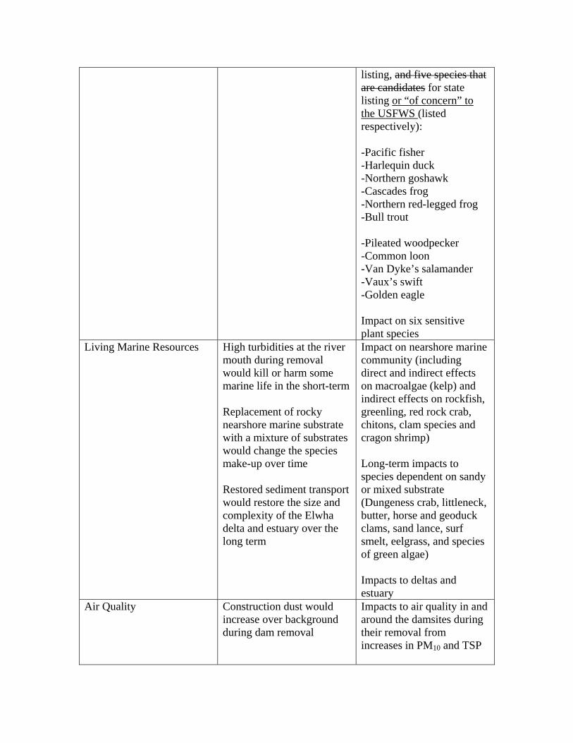
listing, and five species that are candidates for state listing or “of concern” to the USFWS (listed respectively): -Pacific fisher -Harlequin duck -Northern goshawk -Cascades frog -Northern red-legged frog -Bull trout -Pileated woodpecker -Common loon -Van Dyke’s salamander -Vaux’s swift -Golden eagle Impact on six sensitive plant species
Living Marine Resources High turbidities at the river mouth during removal would kill or harm some marine life in the short-term Replacement of rocky nearshore marine substrate with a mixture of substrates would change the species make-up over time Restored sediment transport would restore the size and complexity of the Elwha delta and estuary over the long term
Impact on nearshore marine community (including direct and indirect effects on macroalgae (kelp) and indirect effects on rockfish, greenling, red rock crab, chitons, clam species and cragon shrimp) Long-term impacts to species dependent on sandy or mixed substrate (Dungeness crab, littleneck, butter, horse and geoduck clams, sand lance, surf smelt, eelgrass, and species of green algae) Impacts to deltas and estuary
Air Quality Construction dust would increase over background during dam removal
Impacts to air quality in and around the damsites during their removal from increases in PM10 and TSP

Impacts to local residents from dust and construction activity
Ambient Noise Level Ambient noise levels would increase during construction, and may be heard by residents or wildlife
Impacts on local residents and park visitors from increased continuous noise levels (dBA) as dams are removed Impacts to above from acute instances of loud noise (such as blasting) Impacts of and protection from noise on species of special concern (marbled murrelets and Northern spotted owls)
Cultural Resources Removal of the hydroelectric projects means the loss of two historic resources Cultural resources in or near the floodplain may experience increased flooding or erosion from aggradation and increased surface water elevation during and following dam removal Construction activities, road grading, trenching to bury the slurry pipeline and offsite disposal of dam rubble could damage known or unknown cultural resources Draining the reservoirs and removing the dams may uncover cultural resources now inaccessible to members of the Low Elwha Klallam Tribe
Construction-related impacts and mitigation of these impacts to the hydroelectric projects; to cultural resources now inundated or buried by projects, including the tribe’s cleansing site, prophecy hole, and creation site; to cultural resources potentially affected by waste disposal or road grading Impacts from increased flooding or erosion and mitigation of these impacts to resources in the floodplain (Elwha Ranger Station Historic District, Elwha River bridge, CCC community kitchens in Altaire and Elwha campgrounds; archeological sites, cultural landscapes, or culturally sensitive areas
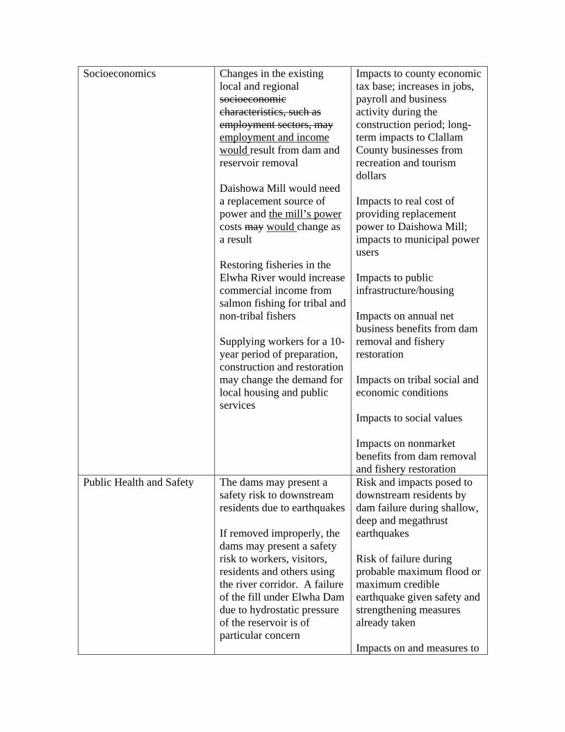
Socioeconomics Changes in the existing local and regional socioeconomic characteristics, such as employment sectors, may employment and income would result from dam and reservoir removal Daishowa Mill would need a replacement source of power and the mill’s power costs may would change as a result Restoring fisheries in the Elwha River would increase commercial income from salmon fishing for tribal and non-tribal fishers Supplying workers for a 10-year period of preparation, construction and restoration may change the demand for local housing and public services
Impacts to county economic tax base; increases in jobs, payroll and business activity during the construction period; long-term impacts to Clallam County businesses from recreation and tourism dollars Impacts to real cost of providing replacement power to Daishowa Mill; impacts to municipal power users Impacts to public infrastructure/housing Impacts on annual net business benefits from dam removal and fishery restoration Impacts on tribal social and economic conditions Impacts to social values Impacts on nonmarket benefits from dam removal and fishery restoration
Public Health and Safety The dams may present a safety risk to downstream residents due to earthquakes If removed improperly, the dams may present a safety risk to workers, visitors, residents and others using the river corridor. A failure of the fill under Elwha Dam due to hydrostatic pressure of the reservoir is of particular concern
Risk and impacts posed to downstream residents by dam failure during shallow, deep and megathrust earthquakes Risk of failure during probable maximum flood or maximum credible earthquake given safety and strengthening measures already taken Impacts on and measures to
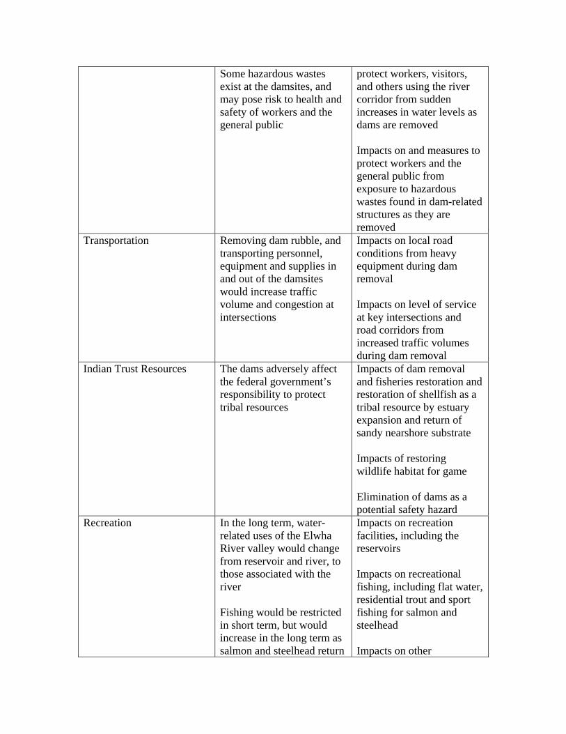
Some hazardous wastes exist at the damsites, and may pose risk to health and safety of workers and the general public
protect workers, visitors, and others using the river corridor from sudden increases in water levels as dams are removed Impacts on and measures to protect workers and the general public from exposure to hazardous wastes found in dam-related structures as they are removed
Transportation Removing dam rubble, and transporting personnel, equipment and supplies in and out of the damsites would increase traffic volume and congestion at intersections
Impacts on local road conditions from heavy equipment during dam removal Impacts on level of service at key intersections and road corridors from increased traffic volumes during dam removal
Indian Trust Resources The dams adversely affect the federal government’s responsibility to protect tribal resources
Impacts of dam removal and fisheries restoration and restoration of shellfish as a tribal resource by estuary expansion and return of sandy nearshore substrate Impacts of restoring wildlife habitat for game Elimination of dams as a potential safety hazard
Recreation In the long term, water-related uses of the Elwha River valley would change from reservoir and river, to those associated with the river Fishing would be restricted in short term, but would increase in the long term as salmon and steelhead return
Impacts on recreation facilities, including the reservoirs Impacts on recreational fishing, including flat water, residential trout and sport fishing for salmon and steelhead Impacts on other

Recreationists using the Elwha Sub-district of the park would need to find alternative locations during dam construction, because the sites would be closed to visitors
recreational activities, including white-water boating; recreational fishing; camping; hiking; recreational facilities and wildlife observation
Land Use The hydroelectric facilities conflict with numerous agency plans, and do not conform with neighboring land use Olympic National Park would acquire and manage lands now occupied by Lake Mills and Glines Canyon Dam facilities Future land managers of the Lake Aldwell lands may use or develop the lands. This use or development would affect vegetation, wildlife, air quality, cultural resources, recreation, traffic flow, aesthetics, water quality and/or fisheries Rubble and other waste from dam removal would restrict future use of land
Impacts to Olympic National Park from management of acquired Glines Canyon lands Impacts from future management of Lake Aldwell lands on land ownership, use and resources if Olympic National Park, US Fish and Wildlife Service, Washington State or the Lower Elwha Klallam Tribe acquires Impacts from waste disposal
Aesthetic Resources The appearance of uncovered reservoir land in the short-term is of concern Long-term management of the restored landscape is important to visitors, recreationists, land managers, etc.
Impacts on project area landscape from removal of dams and related structures and restoration of the river corridor Impacts on management of aesthetic resources after dams and reservoirs are removed
Planning Goals and Objectives Page 40, paragraph 2, after sentence 2 – add the following:
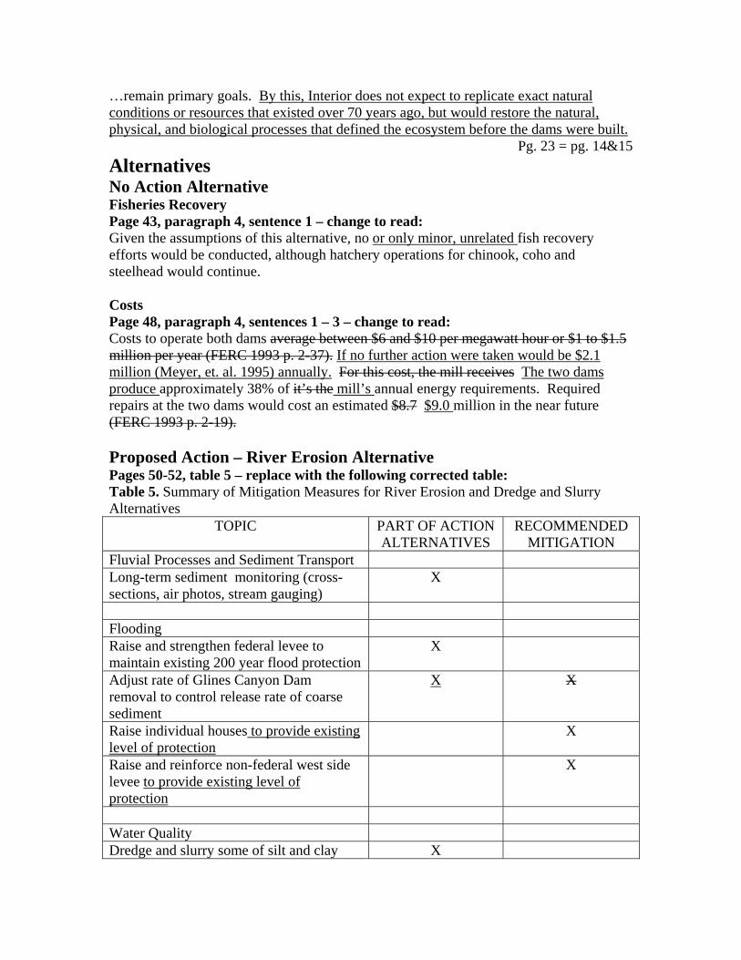
…remain primary goals. By this, Interior does not expect to replicate exact natural conditions or resources that existed over 70 years ago, but would restore the natural, physical, and biological processes that defined the ecosystem before the dams were built.
Pg. 23 = pg. 14&15 Alternatives No Action Alternative Fisheries Recovery Page 43, paragraph 4, sentence 1 – change to read: Given the assumptions of this alternative, no or only minor, unrelated fish recovery efforts would be conducted, although hatchery operations for chinook, coho and steelhead would continue. Costs Page 48, paragraph 4, sentences 1 – 3 – change to read: Costs to operate both dams average between $6 and $10 per megawatt hour or $1 to $1.5 million per year (FERC 1993 p. 2-37). If no further action were taken would be $2.1 million (Meyer, et. al. 1995) annually. For this cost, the mill receives The two dams produce approximately 38% of it’s the mill’s annual energy requirements. Required repairs at the two dams would cost an estimated $8.7 $9.0 million in the near future (FERC 1993 p. 2-19). Proposed Action – River Erosion Alternative Pages 50-52, table 5 – replace with the following corrected table: Table 5. Summary of Mitigation Measures for River Erosion and Dredge and Slurry Alternatives
TOPIC PART OF ACTION ALTERNATIVES
RECOMMENDED MITIGATION
Fluvial Processes and Sediment Transport Long-term sediment monitoring (cross-sections, air photos, stream gauging)
X
Flooding Raise and strengthen federal levee to maintain existing 200 year flood protection
X
Adjust rate of Glines Canyon Dam removal to control release rate of coarse sediment
X X
Raise individual houses to provide existing level of protection
X
Raise and reinforce non-federal west side levee to provide existing level of protection
X
Water Quality Dredge and slurry some of silt and clay X
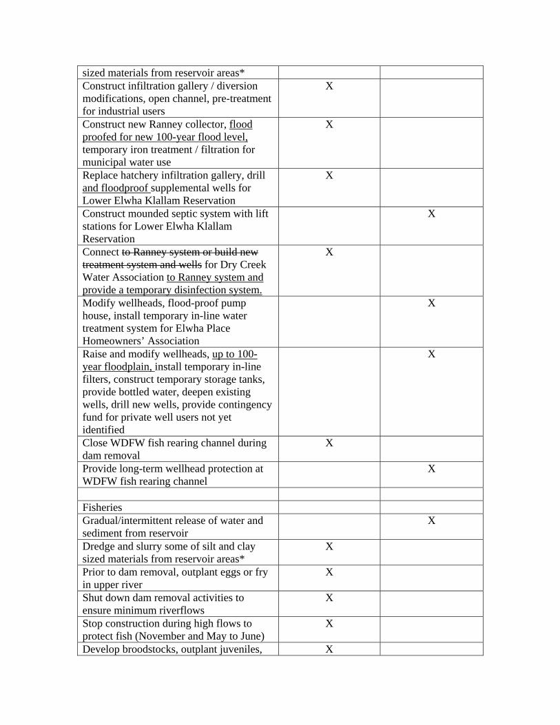
sized materials from reservoir areas* Construct infiltration gallery / diversion modifications, open channel, pre-treatment for industrial users
X
Construct new Ranney collector, flood proofed for new 100-year flood level, temporary iron treatment / filtration for municipal water use
X
Replace hatchery infiltration gallery, drill and floodproof supplemental wells for Lower Elwha Klallam Reservation
X
Construct mounded septic system with lift stations for Lower Elwha Klallam Reservation
X
Connect to Ranney system or build new treatment system and wells for Dry Creek Water Association to Ranney system and provide a temporary disinfection system.
X
Modify wellheads, flood-proof pump house, install temporary in-line water treatment system for Elwha Place Homeowners’ Association
X
Raise and modify wellheads, up to 100-year floodplain, install temporary in-line filters, construct temporary storage tanks, provide bottled water, deepen existing wells, drill new wells, provide contingency fund for private well users not yet identified
X
Close WDFW fish rearing channel during dam removal
X
Provide long-term wellhead protection at WDFW fish rearing channel
X
Fisheries Gradual/intermittent release of water and sediment from reservoir
X
Dredge and slurry some of silt and clay sized materials from reservoir areas*
X
Prior to dam removal, outplant eggs or fry in upper river
X
Shut down dam removal activities to ensure minimum riverflows
X
Stop construction during high flows to protect fish (November and May to June)
X
Develop broodstocks, outplant juveniles, X

and evaluate adult return during and after dam removal Expand Lower Elwha Klallam Tribal Fish Hatchery; dredge outlet, create new bypass
X
Restrict fishing during restoration X Vegetation Collect native plant materials from the Elwha Valley, seed both reservoirs with native grasses and forbs, plant trees of different ages and eradicate non-native vegetation.
X
Literature search, controlled planting, on-site cultivation, and biotechnical slope stabilization
X
Wildlife Trumpeter Swan mitigation X Species of Special Concern Noise reduction measures or changes in sequencing and timing of construction activities
X
Stop construction during critical marine feeding periods for marbled murrelet (November and May to June)
X
Air Quality and Noise Periodic spraying of roads with water X Cultural Resources HABS/HAER documentation of dams X Leave parts of Glines Canyon Dam in-place (thrust block, powerhouse, spillway, penstock, and gatehouse)
X
Documentation of affected resource(s), monitor, survey, stabilize riverbank, data recovery, and avoidance
X
Public Health and Safety Cofferdams progressive reservoir lowering and other measures to prevent foundation washout under Elwha Dam
X
Stop construction during high flows to protect dam workers (November and May
X

to June) Remove transformers, asbestos, and chemicals from damsites (hazardous materials)
X
Traffic Flaggers at congested intersections if needed
X
Recreation Close watershed access X Provide shuttle service for park visitors to Elwha subdistrict during dam removal
X
Restrict fishing during restoration X Provide interpretive facilities X Educate users on nearby similar opportunities
X
Land Use Leave bottom lands and lands along river corridor undeveloped
X
*Dredge and Slurry alternative only Dam Removal Page 54, paragraph 4, last sentence – change to read: Improvements required to use Olympic Hot Springs Lower Dam road to carry…
Pg. 26 = pg. 17&18 Page 57, paragraph 5, sentence 1 – change to read: To complement fisheries restoration, important marbled murrelet foraging periods in nearshore marine waters, and protect workers, no demolition… Water Quality Protection Page 63, paragraph 5 – change to read: To provide for existing water supplies various repairs, upgrades, and short-term treatments are proposed for the existing water systems (table 7). Construction activities required to begin dam removal (i.e., construction of the left cofferdam and diversion channel at Lake Aldwell) would cause some minor impacts to water quality before dam removal actually begins. The facilities would be in place and operating before dam removal begins. These impacts would be mitigated because water quality measures would be in place and operating prior to site mobilization and dam removal. Page 64, table 7 – replace with the following corrected table: Table 7. Water Quality Mitigation Measures PART OF ALTERNATIVE Industrial Supply Infiltration gallery/diversion modifications

Open channel pre-treatment
City Water New Ranney well – west bank Temporary iron treatment/filtration
Tribe Upgrade hatchery infiltration gallery Supplemental wells
Dry Creek WA Connect to Ranney system and temporary filtration new treatment (CI, filtration) system; package disinfection system or modification to existing wells and system
RECOMMENDED MITIGATION Tribe Mound sewage treatment Elwha Place Homeowners’ Association Flood proof existing wells
Temporary in-line treatment system
Well owners/residents upstream of 101 Temporary in-line filtration, bottled water Well owners upgradient of Lake Aldwell Drill new wells (if needed)Well owners and residents in river valley Raise and modify well heads/mound
sewage treatment as neededAll well owners (private) Contingency fund ($150,000) State rearing channel Offsite rearing
Wellhead protection
Costs Page 68, table 9 – replace with the following corrected table: Table 9. Cost Estimates – River Erosion Alternative (Proposed Action)
ACTIVITY REFERENCE YEAR (BUDGET YE(costs in thousands of dollars)
n-2 n-1 n
Total (1) (2) (3)Project Acquisition Direct Acquisition Costs
29,500 29,500
Other Lands & Rights Costs
300 250 50
Lands and Rights Subtotal
29,800 29,750 50
Engineering Design

Preconstruction Data Collection
458 458
Decommissioning of Projects
30 30
Water Quality Protection
1,5311,645 1,5231,637
Flood Protection 368 295 Dam Removal 800 300 500 Haz Waste Cleanup 53 45 8 Transmission Line Removal
10
Road Rehabilitation 48 Hatchery Expansions 405 32085 85 Engineering
Design Subtotal
3,7033,817 2,6513,085 820585 938
Direct Construction Costsa
Decommission of Projects
300 300
Water Quality Protection
24,78827,010 10,240 14,39816,620
Salvage of Water Treatment Equipment
(225)
Flood Protection 3,630 1,140 1,765 Dam Removal 20,200 9,200 Haz Waste Cleanup 534 200 Transmission Line Removal
650
Road Rehabilitation 480 Hatchery Expansions 4,040 2,300 3,1801,740 860 Direct
Construction Costs
54,39756,844 10,24012,540 19,21820,000 11,82510,965
Construction Management
8,490 1,920585 2,5602,518 1,5802,460
Waste Disposal Fees 1 500Sediment Management/WQ Monitoring
1,894 100 610
Sediment Modeling 100 70 30Cultural Resources 665 151 162Fish Restoration 2,6852,365 91136 166165 199187Revegetation/Wildlife 3,205 885 565

Marine Resources Monitoring
150 10 20 20
Construction Related O&M Costs
Glines Canyon and Elwha Dams
1,100 500 500 100
Water Treatment Facilities
3,6763,400 412349
Dredge Hatchery 250 O&M Costs
Subtotal 5,0264,750 500 500 512449
TOTAL 111,115113,080 45,23246,676 24,50025,004 16,06615,926 14a Includes those items subject to design and construction management allowances. Note: The preceding cost estimates are refined from those contained in the restoration project programmatic FEIS. These costs will be further refined when final project designs are developed. Generally, these further refinements can be expected to reduce costs as design constraints become more certain and contingencies are reduced accordingly. In addition, application of value engineering procedures have the potential to further reduce costs at the final design stage. A less probable likelihood is that costs could increase due to some as yet unforeseen cost element. Costs at April 1995 Price Level Revised: 17-Oct-95 18 Sep 96 Dredge and Slurry Alternative Summary of Actions Page 67, paragraph 2, after second bullet – add the following:
Erosion of coarse-grained sediment by natural river processes Page 69 paragraph 5, sentence 3 – change to read: A majority of the lake bed sediments (75%) within the pre-dam 100-year floodplain would be removed. Pipeline Page 71, paragraph 1, after last sentence – add the following: …would be required for this alignment. Although costs for this alignment are higher, construction involves fewer uncertainties at this level of development. The river erosion alternative was chosen as the preferred alternative because resolving issues for development of the dredge and slurry alternative would require further investigation. Water Quality Protection Page 71, paragraph 4, sentence 4 – change to read: About 1.2 to 2.6 2.7 million cubic yards of fine sediment in the deltas would still wash downstream as the deltas eroded. Costs Page 74, table 10 – replace with the following corrected table:
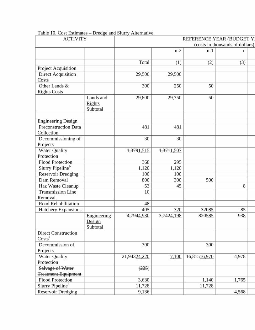
Table 10. Cost Estimates – Dredge and Slurry Alternative ACTIVITY REFERENCE YEAR (BUDGET YE
(costs in thousands of dollars) n-2 n-1 n
Total (1) (2) (3)Project Acquisition Direct Acquisition Costs
29,500 29,500
Other Lands & Rights Costs
300 250 50
Lands and Rights Subtotal
29,800 29,750 50
Engineering Design Preconstruction Data Collection
481 481
Decommissioning of Projects
30 30
Water Quality Protection
1,3791,515 1,3711,507
Flood Protection 368 295 Slurry Pipelineb 1,120 1,120 Reservoir Dredging 100 100 Dam Removal 800 300 500 Haz Waste Cleanup 53 45 8 Transmission Line Removal
10
Road Rehabilitation 48 Hatchery Expansions 405 320 32085 85 Engineering
Design Subtotal
4,7944,930 3,7424,198 820585 938
Direct Construction Costsa
Decommission of Projects
300 300
Water Quality Protection
21,94324,220 7,100 16,81516,970 4,978
Salvage of Water Treatment Equipment
(225)
Flood Protection 3,630 1,140 1,765Slurry Pipelineb 11,728 11,728Reservoir Dredging 9,136 4,568

Dam Removal 20,200 9,200 Haz Waste Cleanup 534 200 Transmission Line Removal
40
Road Rehabilitation 480 Hatchery Expansions 4,040 2,300 3,1801,740 860 Direct
Construction Costs Subtotal
71,80674,308 9,400 33,36332,078 21,37115,533
Construction Management
8,990 1,920585 3,0002,708 1,7002,570
Waste Disposal Fees 1,000 500Sediment Management/WQ Monitoring
1,594 100 550
Sediment Modeling 100 70 30Cultural Resources 665 151 162Fish Restoration 2,6852,365 91136 166165 199187Revegetation/Wildlife 3,205 885 565Marine Resources Monitoring
150 10 20 20
Construction Related O&M Costs
Glines Canyon and Elwha Dams
1,100 500 500 100
Water Treatment Facilities
8901,164 270362
Electricity for Lake Dredging
412 206
Dredge Hatchery Outlet
250
O&M Costs Subtotal
2,6522,926 500 500 576656
TOTAL 127,441130,100 36,08344,649 39,08537,272 25,73620,751 18a Includes those items subject to design and construction management allowances. b Uses overland route for pipeline to facilitate maintenance of slurry pipeline regardless of river flow; provides for discharge of sediment 1 mile offshore. Using Alignment A would reduce total cost by $4.2 million. Note: The preceding cost estimates are refined from those contained in the restoration project programmatic FEIS. These costs will be further refined when final project designs are developed. Generally, these further refinements can be expected to reduce costs as design constraints become more certain and contingencies are reduced

accordingly. In addition, application of value engineering procedures have the potential to further reduce costs at the final design stage. A less probable likelihood is that costs could increase due to some as yet unforeseen cost element. Costs at April 1995 Price Level Revised: 24-Oct-95 2-Oct-96
Pg. 32 = pg. 23&24 Page 76 & 77, table 11 – replace with the following corrected table: Table 11. Summary of Alternatives NO ACTION RIVER EROSION
(Proposed Action) DREDGE AND SLURRY
Dams Operation of Elwha and Glines Canyon Dam would continue.
Removal of features of both Elwha and Glines Canyon dams necessary to fully restore the ecosystem and fisheries of the Elwha River would occur over a 24-month period.
Same as Proposed Action
Sediment Management and Monitoring
Sediment would continue to accumulate behind the dams.
Natural river processes would be allowed to erode the reservoir areas; Dam removal would be phased to reduce sediment levels during some periods to help protect fish; River sediment processes would be monitored to help control dam demolition rates.
Downstream suspended sediment concentrations would be reduced by dredging lakebed sediments and transporting through a slurry pipeline to the Strait of Juan De Fuca. Dam removal phasing and monitoring would be the same as for the proposed action.
Flood Control No new flood control measures
The Lower Elwha Federal Flood Control Levee would be raised and strengthened to maintain existing levels of flood protection. Other flood control mitigation is recommended although not required by law.
Same as proposed action
Fisheries Fisheries partially maintained by hatcheries
Hatchery support, outplanting, harvest management, and optimal
Same as proposed action.

timing of dam removal would be used to help protect anadromous fish populations during the dam removal process and accelerate full restoration.
Revegetation No revegetation Reservoirs would be
revegetated to restore pre-dam conditions and processes.
Same as proposed action
Water Quality Protection Filtration through aquifer and chlorination for municipal and/or industrial supplies supply
Infiltration gallery and pre-treatment for industrial supplies; new Ranney well for municipal supply (including Dry Creek Water Association). Other treatments (filtration, new wells, mounded septic system, raised wellheads, contingency funds etc.) recommended for EPHA, Lower Elwha Klallam Tribe and individual well users.
Water quality facilities would generally be the same as the proposed action except that Fe/Mn treatment and filtration would not be required and the industrial pre-treatment would not be used intensively.
Disposition of Lands All project lands would remain in existing ownership (James River Corporation).
Lands acquired at the Glines Canyon Damsite would become part of Olympic National Park. Aldwell lands would be managed by the park, Washington state or held in trust for Lower Elwha Klallam Tribe.
Same as proposed action
Interpretation No changes in interpretation.
Interpretation would include leaving parts of the Glines Canyon project in place, wayside exhibits explaining key historic events in the construction of the dams,
Same as proposed action

physical and biological features, and documentation of dam removal and ecosystem restoration.
Cultural Resources No cultural resource mitigation occurs.
Cultural resource mitigating measures (avoidance, survey, documentation, monitoring) would occur in compliance with the Section 106 requirements of the National Historic Preservation Act.
Same as proposed action except with additional measures to mitigate impacts of dredging and construction of the slurry pipeline.
Costs $1.0 to 1.5 $2.1 million per year to operate; $8.7 $9.0 million for future repairs; $100,000 per year indirect costs to maintain Ediz Hook; $480,000 total hatchery costs per year
$111.1 $113.1 million total cost over an 18-year period plus increased power costs for Daishowa.
$127.4 $130.1 million total cost over an 18-year period plus increased power cost for Daishowa.
Permitting It is unknown how FERC licensing would be resolved. Litigation would probably resume.
Numerous federal, state, and local permits and review processes would be required. Several permits required for compliance with Clean Water Act sections.
Same as proposed action except with additional reviews for construction and operation of the slurry pipeline.
Alternatives Considered but Rejected Dam Removal Page 78, after paragraph 4 – add the following: Phased Removal of Both Dams During the comment phase on the draft Implementation EIS, Interior received several comments and a proposal to phase the removal of the two dams over a 13-year period. The phased approach of removing Elwha Dam, allowing the river to “clean up” for a period of time, and then removing Glines Canyon Dam later, was evaluated early in the planning process by the EIS interagency team. It was rejected as a reasonable alternative because of its unacceptable impacts on existing anadromous fish stocks, increased costs, and its delay in restoring the Elwha River ecosystem.

Phased removal would lengthen the period of time fish would be adversely and significantly affected by increased sediment loads. Sediment releases resulting from the removal of Elwha Dam would have a significant impact on aquatic life in the lower river for a period of 12 to 18 months. By removing Glines Canyon Dam 6 to 7 years later, fish would be subjected to another 12 to 18 months of high sediment loads. This phasing of dam removal would seriously threaten the long-term health of fish stocks remaining in the lower river, particularly chinook and chum salmon.
Delaying the removal of Glines Canyon Dam for such a long period of time
would in itself adversely affect Elwha anadromous fish stocks. Habitat quality would remain poor below the dam, as sediment transport would remain blocked and water temperatures abnormally high in low flow months. Higher quality upstream habitat would remain inaccessible. Again, because many Elwha stocks are rapidly declining, this kind of delay in restoring the Elwha ecosystem would have significant adverse effects on anadromous fisheries.
Separate dam removal contracts would cost more to prepare, administer and
implement, and the inflation inherent in delaying dam removal would increase overall project costs.
Phasing of dam removal would delay the release of sediments and nutrients from
Lake Mills and the upper reaches of the Elwha River. This would extend the period of time it would take to reestablish the natural hydrological, biological, and physical processes that are critical in restoring the Elwha River ecosystem and its anadromous fisheries.
Pages 84-100, table 12 – replace with the following table: Table 12. Impact Summary Chart IMPACT TOPIC NO ACTION RIVER EROSION
(Proposed Action) DREDGE AND SLURRY
SEDIMENT MANAGEMENT
Reservoir areas Reservoirs continue to trap sediments, (now 13.8 million cubic yards in Lake Mills and 3.9 million cubic yards in Lake Aldwell).
1.2-2.6 1.2-2.7 million cubic yards of coarse, and 4.8-5.6 4.7-5.6 million cubic yards of fine sediment would erode from reservoirs.
1.2-2.6 1.2-2.7 million cubic yards of coarse, and 1.2-1.4 million cubic yards of fine sediment would erode from reservoirs; remainder slurried to strait.
Downstream channel Reduced amounts of coarse-grained sediments (sand-
Fine-grained sediment and sand would move rapidly
Same as proposed action except less fine sediment

size and larger) downstream of reservoirs, less meandering of river, armoring of river channel.
downstream, approaching background levels in 2 to 6 years; coarse sediments deposit and aggrade riverbed; more meandering and streambank erosion would be a beneficial impact
eroding downstream (25% of total).
Delta, beaches and Ediz Hook
Continued beach erosion, recession of delta and erosion of western edge of Ediz Hook and Angeles Point.
Re-establish sediment supply, rebuilding of beaches and delta within 3 years; begin to reverse erosion of Ediz Hook within 5-10 years.
Same as proposed action.
FLOODING Increases in water surface elevation, aggradation
Degradation of riverbed has lowered flood stage in some places – a beneficial impact to property owners and adverse impact to the river’s ecosystem; houses (except behind federal levee) and private wells along river flood at less than 100 year frequency flood event, a potential minor to major adverse impact.
Riverbed aggradation would cause increases in river stage of up to 4 feet; mandatory mitigation on federal levee and for municipal and industrial water wells would provide current level of flood protection; without recommended mitigation other areas may experience major impacts due to more frequent flooding (not significantly different than existing conditions); short-term flooding
Same as proposed action-dredging of fine sediments would have no additional impacts on flooding.

impacts less than long-term impacts.
SURFACE WATER Short-term (during dam removal) critical indicators
Total suspended solids in river (peak concentrations)
Dams have reduced peak TSS to less than 1,500 parts per million. Moderate beneficial impact to water quality.
28,000 to 51,000 parts per million-major adverse impact for 1 to 3 day periods.
1,400 to 13,000 parts per million-major adverse impact for 1 to 3 day periods.
Total iron Dams may have slightly reduced to peaks of 20 to 2,300 micrograms per liter. Negligible or minor impact to water quality
30,000 to 50,000 micrograms per liter maximum for 1-3 day periods – major adverse impact.
5,000 to 15,000 micrograms per liter maximum for 1-3 day periods – moderate to major adverse impact.
Total manganese Dams may have slightly reduced to peaks of from 4 to 210 micrograms per liter. Negligible or minor impact to water quality.
500 to 10,000 micrograms per liter maximum for 1-3 day periods – possible major adverse impact to water quality
50 to 1,500 micrograms per liter maximum for 1-3 day periods – moderate to major adverse impact.
Turbidity Dams have reduced peak turbidity to 800 NTUs; moderate beneficial impact to water quality.
2,000 to 25,000 NTUs maximum for 1-3 day periods – major adverse impact.
1,000 to 10,000 NTUs maximum for 1-3 day periods – major adverse impact.
PH during dam removal
6.7 to 10.0 now; negligible impact.
5 to 9 – minor change.
6 to 9.5 – minor change.
Temperature (Celcius) during dam removal
Reservoirs have resulted in increased peak temperatures to 19o C. Major adverse impact to water quality/aquatic life
15o C to 19o C – minor to major beneficial impact.
15o C to 19o C – minor to major beneficial impact.
Dissolved oxygen during dam removal
95 to 110%; negligible or minor impact.
90 to 100% - minor change.
95 to 105% - minor change.
Long-term (from 1 year after dam

removal) critical water quality indicators Total suspended solids in river
Dams have reduced TSS concentration to less than 1,500 ppm; moderate beneficial impacts to water quality
Average 69 parts per million within 2 years after dam removal – moderate adverse impact.
Same as proposed action.
Turbidity Dams have reduced peak turbidity to 800 NTUs; moderate beneficial impact to water quality.
1 to 1000 NTUs within 2 years following dam removal – moderate adverse impact
1 to 1000 NTUs within 1 year following dam removal – moderate adverse impact.
Dissolved iron Dams may have reduced peak concentrations to 2,300 micrograms per liter; minor beneficial impact to water quality.
10 to 5,000 micrograms per liter within 2 years – minor adverse impact to water quality.
10 to 5,000 micrograms per liter within 1 year – minor adverse impact.
Dissolved manganese Dams may have reduced peak concentrations to 210 micrograms per liter; minor beneficial impact to water quality.
10 to 700 micrograms per liter within 2 years following dam removal – minor adverse impact to water quality
10 to 700 micrograms per liter within 1 year following dam removal – minor adverse impact to water quality
PH 6.7 to 10.0; negligible to minor impact
6.5 to 8.5 – minor beneficial impact.
Same as proposed action.
Temperature (Celcius)
Reservoirs have increased peak temperatures to 19o C; major adverse impact to water quality and aquatic life.
15o C to 17o C – major beneficial impact.
Same as proposed action.
Dissolved oxygen 95 to 110%; negligible or minor impact.
95 to 110% - no change over existing conditions.
Same as proposed action.
SURFACE WATER USERS
Daishowa and Rayonier mills
Existing treatment prevents adverse
Addition of infiltration gallery
Same as proposed action.
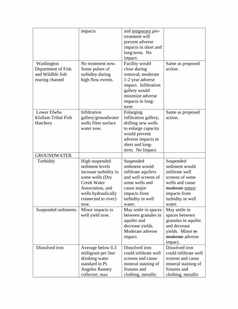
impacts and temporary pre-treatment will prevent adverse impacts in short and long-term. No impact.
Washington Department of Fish and Wildlife fish rearing channel
No treatment now. Some pulses of turbidity during high flow events.
Facility would close during removal; moderate 1-2 year adverse impact. Infiltration gallery would minimize adverse impacts in long-term
Same as proposed action.
Lower Elwha Klallam Tribal Fish Hatchery
Infiltration gallery/groundwater wells filter surface water now.
Enlarging infiltration gallery, drilling new wells to enlarge capacity would prevent adverse impacts in short and long-term. No Impact.
Same as proposed action.
GROUNDWATER Turbidity High suspended
sediment levels increase turbidity in some wells (Dry Creek Water Association, and wells hydraulically connected to river) now.
Suspended sediment would infiltrate aquifers and well screens of some wells and cause major impacts from turbidity in well water.
Suspended sediment would infiltrate well screens of some wells and cause moderate minor impacts from turbidity in well water.
Suspended sediments Minor impacts to well yield now.
May settle in spaces between granules in aquifer and decrease yields. Moderate adverse impact.
May settle in spaces between granules in aquifer and decrease yields. Minor to moderate adverse impact.
Dissolved iron Average below 0.3 milligram per liter drinking water standard in Pt. Angeles Ranney collector; max
Dissolved iron could infiltrate well screens and cause mineral staining of fixtures and clothing, metallic
Dissolved iron could infiltrate well screens and cause mineral staining of fixtures and clothing, metallic

concentration 1.0 milligram per liter.
tasting drinking water. Probability of impact low, minor to moderate impact if it occurs
tasting drinking water. Minor impact if it occurs.
Dissolved manganese No water samples tested above state standards.
Dissolved manganese could infiltrate well screens and cause mineral staining of fixtures and clothing. Probability of impact low, minor to moderate impact if it occurs.
Dissolved manganese could infiltrate well screens and cause mineral staining of fixtures and clothing. Minor impact if it occurs.
Coarse sediment/aggradation
Riverbeds nearly devoid of coarse sediment where wells are located; wells are built close to river’s edge
Aggradation and increases in surface water elevation would lead to overtopping and contamination of wells close to river’s edge or in floodplain. Major long-term adverse impact.
Same as proposed action
Water table levels – Lake Aldwell area
Lake Aldwell supports an artificially high groundwater level in east end of Indian Creek valley
Two wells would experience decrease or loss of yield. Major long-term adverse impact.
Same as proposed action.
Water table levels – lower reach area
Groundwater elevation in lower valley is artificially low because of degradation of riverbed.
Aggradation would increase groundwater levels and make septic systems unusable – moderate impact to those users in the long term.
Same as proposed action.
GROUNDWATER USERS
City of Port Angeles municipal supply
Water is filtered and is chlorinated, some high turbidity and
A second Ranney collector, treatment and flood
Same as proposed action.

iron levels. protection for the existing Ranney collector would prevent adverse impacts to water quality and yield. No Impact.
Dry Creek Water Association
Some high turbidity levels now.
Connecting to Port Angeles new Ranney Collector and temporary filtration plan would prevent adverse impact to water quality. No Impact
Same as proposed action except no filtration needed.
Elwha Place Homeowners’ Association
No impacts now. Increases in turbidity and iron or manganese could have minor to moderate impacts on well water quality; increased surface water elevation could flood and overtop wells; major impact if it occurs. Recommended mitigation would reduce impacts to negligible.
Increases in turbidity and iron or manganese could have minor impacts on well water quality; increased surface water elevation could flood and overtop wells; major impact if it occurs. Recommended mitigation would reduce impacts to negligible.
Lower Elwha Klallam Reservation residents
Groundwater elevation low high; septic systems installed and usable.
Increased groundwater elevation would render 10 septic systems unusable. Moderate impact in long-term.
Same as proposed action.
Individual wells in lower valley and upstream of Highway 101 bridge
Wells built close to river’s edge; some increases in turbidity now.
Increases in turbidity and iron or manganese could have minor to moderate impacts on well water quality; increased
Increased in turbidity and iron manganese could have minor impacts on well water quality; increased surface water

surface water elevation could flood and overtop wells; major impact if it occurs. Recommended mitigation would reduce impacts to negligible.
elevation could flood and overtop wells; major impact if it occurs. Recommended mitigation would reduce impacts to negligible.
Individual wells upstream of Lake Aldwell
Groundwater high because of Lake Aldwell.
Groundwater level and yield would drop or stop altogether. Major, long-term adverse impact. Recommended mitigation would reduce impact to negligible.
Same as proposed action.
Unidentified users Unknown impacts. May experience short-term increases in turbidity, iron and manganese, water level differences, unusable septic systems, or changes in yield. Impact intensity unknown. Mitigation would reduce impact to negligible.
Same as proposed action.
NATIVE RESIDENT AND ANADROMOUS FISHERIES
Long-term restoration
No chance of restoring native anadromous fish in the Elwha River; genetic integrity of the existing native stocks deteriorates due to continued use of hatchery stocks; existing stocks in
All Elwha River anadromous fish stock except sockeye salmon fully restored within 20 years. Hatchery support, outplanting, harvest management, and optimal timing of
The long-term beneficial impacts would be the same as the proposed action except full restoration of native fish stock would occur in slightly less time.

the lower river unsupported by artificial propagation would likely decline to extinction.
dam removal could halve restoration time.
Species-specific restoration potential
No restoration. The Elwha River could eventually produce an estimated 31,000 returning chinook salmon, 35,000 coho salmon, 274,000 pink salmon, 36,000 chum salmon, 10,000 steelhead, and 6,500 sockeye salmon per year.
Same as proposed action.
Short-term impacts Existing conditions, i.e. poor quality habitat, hatchery propagation and crowded spawning conditions would not change.
The release of fine sediment during and following dam removal would cause mortalities, physiological stress, or displacement of fish in the river for up to four years, and cause returning adults to avoid migrating up the river. Hatchery support, outplanting, harvest management, and optimal timing of dam removal would help protect fish during this period.
The short-term adverse impacts of fine sediment on trout and salmon and their habitat would be reduced by removing as much as 75% of the fine sediments with a dredge and slurry pipeline in combination with other measures. Direct fish losses and the risk of straying adults would be reduced.
Chinook salmon Same as above. Direct fish loss caused by extreme sediment. Hatchery support and outplanting would replace fish lost to
Same as proposed action except the direct fish loss caused by high sediment levels would be less.

high sediment levels and begin to reestablish stock in the middle and upper Elwha River.
Coho salmon Same as above. Same as for Chinook Salmon.
Same as proposed action except direct fish losses would be less.
Pink salmon Same as above. Direct loss, if pinks present, caused by extreme sediment levels. Hatchery support and outplanting of Dungeness stock would begin to reestablish pink salmon in the Elwha River.
Same as proposed action except, if pinks present, the direct fish loss caused by high sediment levels would be less.
Chum salmon Same as above. Direct fish loss caused by extreme sediment levels. Hatchery support and outplanting would reduce adult fish loss and replace young fish lost caused by high sediment levels. Begin to reestablish stock in the middle and upper Elwha River.
Same as proposed action except the direct fish loss caused by high sediment levels would be less.
Sockeye salmon Same as above. No direct fish loss caused by extreme sediment levels. There would be no hatchery or outplanting effects. The existing Lake Sutherland kokanee population may eventually reestablish a native sockeye run.
Same as the proposed action.

Steelhead Same as above. Same as for Chum Salmon.
Same as proposed action except direct fish losses would be less.
Sea-run cutthroat & char
Same as above. Direct fish loss caused by extreme sediment levels. There would be no hatchery or outplanting effects. Natural recolonization by remnant stocks would eventually reestablish anadromous populations.
Same as proposed action except the direct fish loss caused by high sediment levels would be less.
VEGETATION Restored communities
562 acres of vegetation, much of it important, low elevation riparian communities, would remain lost.
562 acres of vegetated lands would recover: 514 of forested lands and 48 of other vegetation.
Same as proposed action except for minor impacts of constructing the slurry pipeline.
Riparian communities
5.3 linear miles inundated.
5.3 miles returned Same as proposed action.
Wetlands 43 48 acres of vegetated wetlands, resulting from or enlarged by the higher water table would remain and 122 acres of unvegetated, riverine wetlands would remain lost; these losses have likely reduced biodiversity in the area.
Portion of 43 acres may be lost; 48 acres of vegetated and 122 acres of unvegetated wetlands would be restored
Same as proposed action.
WILDLIFE Terrestrial habitat including elk and other mammals, trumpeter swans and other birds
715 acres of natural wildlife habitat would remain lost. Without anadromous fish
Restoration of habitat and fish runs would be a major beneficial impact to most
Same as proposed action except for minor wildlife disturbances along the lower river

runs, critical to the wildlife community, natural biodiversity of the area would remain compromised.
species including elk. Species dependent on the reservoirs, including trumpeter swans, would lose habitat, but regional impacts would be minor.
while constructing the slurry pipeline.
SPECIES OF SPECIAL CONCERN
Federally listed species: bald eagle, northern spotted owl, marbled murrelet, Steller sea lion, and peregrine falcon
Natural populations of salmon would remain unavailable to foraging bald eagles. Up to 514 acres of potential habitat for spotted owls and murrelets would remain unavailable. Sea lions and falcons would sustain continued minor impacts.
Bald eagles, spotted owls, and Mmurrelets would be adversely impacted in the short term (2 to 5 years) by noise, turbidity, but return of salmon as prey and upland forest as habitat would have a major beneficial impact on murrelets, bald eagles and spotted owls in the long term. Sea lions and falcons would experience minor beneficial and no impacts, respectively.
All impacts would be the same as the proposed action except: spotted owls and murrelets may be impacted from the noise of dredging activities. Impacts to foraging bald eagles would be slightly less, because turbidity and impact on fish as prey would be less.
Candidates for federal listing including Pacific fisher, harlequin duck, northern red-legged frog, and bull trout, and rated “of concern” to the USFWS, including Pacific fisher, harlequin duck, and northern red-legged
Over 5 linear miles of riparian and riverine habitat would remain unavailable for Pacific fishers and harlequin ducks.
Harlequin ducks and bull trout would sustain short-term, minor impacts. All species would sustain major beneficial impacts in the long term.
Impacts to harlequin ducks and bull trout would be slightly less due to less turbidity in the river.

frog. Species or stocks considered for federal listing: coho, chum and chinook salmon, steelhead, and se-run cutthroat trout
Habitat for these species would remain unavailable, possibly contributing to the listing of these stocks under the Endangered Species Act.
All species would be adversely impacted in the short term, but over the long-term, restoration would offset some cumulative impacts occurring elsewhere in the region.
Same as proposed action.
Candidates for state listing including pileated woodpecker, Van Dyke’s salamander, and Vaux’s swift
Forest and riparian habitat for these species would remain inundated.
All species would sustain major beneficial impacts in the long term.
Same as proposed action.
LIVING MARINE RESOURCES
Nearshore marine communities
Existing marine communities would remain, the delta and estuary would be undersized, and clam populations would be lower than under pre-dam conditions.
Moderate adverse impacts would occur to local marine communities from silt and clay transported by the river. A major change would occur, from transport of sand and gravel, in the substrate and biological community at the river mouth and to the east. However, future conditions would approximate pre-dam conditions.
Same as proposed action.
AIR QUALITY Air quality Air quality is
presently high quality and would stay this way. The projects do not affect air quality.
Elwha Dam demolition would result in 105.3 tons of particulates and Glines Canyon Dam demolition,
Same as the proposed action except trenching for pipeline may add minor amounts of PM10 and TSP

25.2 tons over the 18-month to 2-year dam removal period. Impact to local area would be minor, except from use of one-half mile of unpaved haul road, which would have moderate adverse impacts to residents without mitigation. Sprinkling with water (required) would reduce impact to minor.
(particulates).
NOISE Continuous noise Noise from project
negligible impact on residents or wildlife.
Residents of approximately 20 homes closest to (within 0.6 mile) the Elwha Dam would experience short-term minor increases in noise levels to as high as a typical office environment (about 58 decibels) under poor atmospheric conditions. Residents further away would be unaware of day-to-day construction noise.
Noise levels for this alternative would be quantitatively indistinguishable from the proposed action. The trenching operations required for pipeline laying and the pumping stations required to pump the slurried fines would result in minor noise that could have minor, short-term impacts on residents in the immediate vicinity.
Acute noise No blasting or other sudden loud noise exists in the vicinity.
Residents beyond 1.2 miles of blasting sites would not be expected to hear blasting noise. The 20 residents within 0.6 miles of the Elwha Dam would periodically
Same as proposed action.

experience noise similar to moderate thunder. Minor short-term impact to these residents.
CULTURAL RESOURCES
Construction related impacts
No effects to properties listed on the National Register of Historic Places (NRHP); continued major adverse impacts to cultural resources inundated by the reservoirs; no effects to cultural resources in or near the floodplain.
Major adverse effect to hydroelectric projects. Mitigation through HABS/HAER inventory, documentation, and leaving some structures in place at Glines reduces impacts to minor. Permanent, major beneficial impacts to cultural resources important to the tribe by making previously inundated resources accessible. Minor to negligible impacts, with mitigation, to cultural resources and cultural landscapes in the immediate vicinity of damsites.
Same as proposed action except that trenching of pipeline could affect some cultural resources; with mitigation, impacts would be minor.
Offsite disposal of dam rubble
No effects to cultural resources.
Minor impacts, with mitigation.
Same as proposed action.
Increased flooding and erosion
No effects to cultural resources.
Minor impacts, with mitigation, to sites potentially affected by increased flooding and erosion.
Same as proposed action.
Construction of access roads and staging areas
No effects to cultural resources.
Moderate, short-term impacts to Elwha Ranger
Same as proposed action.

Station Historic District, Altaire and Elwha campgrounds kitchen shelters, known and potential landscapes, culturally sensitive areas, known and unknown archeological sites if roads built near or these areas are used for access/staging of equipment. With mitigation, impact minor.
SOCIOECONOMICS County economic base
Ten employees would continue to be required for the operation of the hydroelectric projects. Travel and tourism creates about 2,000 jobs and $21.3 million now. Tax receipts from tourism/travel estimated at $1.4 million.
Major long-term beneficial impacts would occur to the county’s economic base. Over the 10-year pre-construction, construction and restoration period, an additional 1150-1240 jobs, $60-65 million in business activity, and $32-34 million in personal income would be generated in Clallam County. After restoration completed, 446 annual jobs, $4.6 million in annual payroll in the recreation/tourism sector, and an annual increase in local sales taxes of
Higher capital costs of pipeline would incrementally increase net cost of project, but not significantly. Major long-term beneficial impacts to the county’s economic base would still occur under this alternative.

$296,000 would be generated. County property tax on projects eliminated ($230,000 per year). Local share of state sales tax would increase by $296,900 per year after project completion.
Infrastructure, services and utilities
Clallam County 1993 operating budget ($14.8 million); $4.3 million in property taxes collected, of this, $230,000 was from hydroelectric projects. A total of $2.1 million generated from sales tax payments to county general fund in 1993. Annual maintenance costs of $100,000 for Ediz Hook would continue. Housing stock adequate to meet future demand.
County would not collect $230,000 in annual property taxes from the projects. Annual maintenance costs for Ediz Hook reduced by $28,000 per year. Housing and public infrastructure would be adequate to meet construction worker and river-restoration related population demand.
Same as proposed action.
Estimated project cost
Not applicable $111.1 $113.1 million
$127.4 $130.0 million
Impacts to Daishowa America Mill and electric power consumer
Estimated 1996 cost of power production from the dams, without any improvement expenses is 12.29 mills; real priority firm for purchased
Daishowa’s power acquisition costs would start at 26.7 mills, and would decline to 23 mills by 2001. Estimated annual
Same as proposed action.

power is 26.7 mills; real rate expected to decline to 23 mills by 2001. Estimated annual real energy cost for replacement power in 2010 is $2.1 million. Dams would require $8.7 $9.0 million in repair costs; annual operational costs of the dams would continue at $2.1 million.
real energy cost for replacement power in 2010 is $4.0 million. Negligible impacts to overall electric rates. Dam repair costs of $8.7 $9.0 million not necessary. Power cost to the mill increases to $4 million annually. $440,000 in payments to local energy utility not collected.
Fisheries and fish processing
Continued major adverse impact-total annual net business benefits from Elwha fishery currently estimated at $840,000.
Major beneficial impact-total annual net business benefits from Elwha fishery would reach $3.5 million.
Same as proposed action.
Recreation and tourism
Travel/tourism expenditures (1993) in Clallam Co. $116.9 million. Related payroll income $18.8 million.
An increase of 734,000 annual visitor nights in Clallam County is expected with river restoration, generating business expenditures of $28.5 million annually. Related payroll income increased by $4.6 million annually.
Same as proposed action.
Social values Dams considered an important source of local pride to some residents
Minor impact to social structure
Same as proposed action.

County and region would continue to experience economic trends from resource based to tourism based economy. No sharp changes in social structure anticipated.
Lower Elwha Klallam Tribe
Major long-term adverse impact to level of tribe’s poverty, employment, income, health, and social structure.
Major beneficial impact to level of tribe’s poverty, employment, income health, and social structure.
Same as proposed action.
Nonmarket values No change or impacts expected.
Major beneficial impacts; restoration expected to generate $3.5 billion annually for 10 years.
Same as proposed action.
Net economic value of project
Daishowa America pays $2.1 million/yr. For 172 gigawatt hours. Major impact to commercial recreational fishery sectors continues. Overall, recreation and tourism continue slow growth trend.
Major beneficial impact; benefits from increase recreation and tourism would reach $133 million over 100 years of project life. The $3.5 million per year of net economic benefits after fish stocks were restored would reach $35 million over project life.
Same as proposed action.
PUBLIC HEALTH AND SAFETY
Earthquakes Glines Canyon Dam considered safe for currently identified maximum credible earthquake, and
Dam removal would remove danger from flooding caused by maximum credible
Same as proposed action.

probable maximum flood; safety of Elwha Dam is unknown. If MCE is modified, may need to reanalyze and modify structures.
earthquake; would eliminate need to correct structural deficiencies in the future.
Dam safety Both dams considered safe during currently identified probable maximum flood and maximum credible earthquakes (MCE).
Safety precautions built into dam remoal removal designs, no safety risks anticipated during deconstruction; dam removal would eliminate potential of dam failure.
Same as proposed action.
Hazardous materials Asbestos, lead based paint, petroleum hydrocarbons and PCBs would continue to pose a threat of further contamination. Some soil contaminated with hydrocarbons would require clean-up. would need to be remediated or capped.
Remediation or removal of materials (petroleum contaminated soils, underground storage tanks, asbestos, and various chemical stores) prior to dam removal would reduce the threat of further contamination.
Same as proposed action.
TRANSPORTATION Levels of service for peak weekday hours during year 2000 at 13 intersections between damsites and disposal area
Levels of service are very good (LOS A) for most intersections. They are acceptable (LOS B) at the intersection of Old Olympic Highway and Sequim-Dungeness Road and (LOS C) at the intersection of US
No changes to levels of service would be expected from the addition of project-related traffic.
Same as proposed action.

101 and Highway 112, and poor (i.e. long delays and poor traffic flow-LOS F or LOS*) for the intersection of Marine Drive and Highway 117.
Levels of service for peak weekend hours during year 2000 at 13 intersections between damsites and disposal area
Same as weekday except traffic flow is very good (LOS A) at the intersection of US 101 and Highway 112, and acceptable (LOS C) at Marine Drive and Highway 117.
No changes to levels of service would be expected from the addition of project related traffic.
Same as proposed action.
Levels of service for peak weekday hours during year 2005 at 13 intersections between damsites and disposal area
Same as for year 2000 weekday, except the intersection of US 101 and Highway 112 is now poor (LOS F), and LOS at US 101 and Old Olympic Highway has declined from A to B.
No changes to levels of service would be expected from the addition of project-related traffic.
Same as proposed action.
Levels of service for peak weekend hours during year 2005 at 13 intersections between damsites and disposal area
All intersections except those listed below are operating well (LOS A). Marine Drive and Highway 117 is at LOS C, US 101 and Highway 112 is at B; US 101 and Old Olympic Highway is at D (still considered acceptable); and Old Olympic Highway and Sequim-Dungeness Road is at LOS B.
No changes to levels of service would be expected from the addition of project-related traffic except LOS at US 101 and Highway 112 would decline from B to C.
Same as proposed action.

INDIAN TRUST RESOURCES
Federal trust responsibility to protect treaty fishing rights (up to one-half harvestable fish)
Dams have blocked access to, inundated and degraded fish habitat with major adverse impact to harvestable fish; access to usual and accustomed fishing places is blocked.
Permanent restoration of anadromous fisheries and access to usual and accustomed fishing places. Major, beneficial, long-term impact.
Same as proposed action except that fish restoration and access to usual and accustomed fishing places may occur sooner.
Federal trust responsibility to protect shellfish harvesting rights (to take up to one-half of non staked or cultivated bed shellfish)
Degraded shellfish habitat in estuary and nearshore marine areas, near elimination of sandy substrate has caused decline in hardshell clam populations; impact unquantified, but considered major, adverse.
Restoring sediment transport would reestablish sandy substrate, larger and more complex estuary for shellfish. Major, beneficial, long-term impact.
Same as proposed action.
Federal trust responsibility to protect right to hunt on open and unclaimed lands
Inundated wildlife habitat, and loss of salmon as prey has had a major, unquantified adverse impact on wildlife.
Restoration of 562 acres of land now inundated to natural vegetation, and of salmon throughout river would have major, long-term, beneficial impact to wildlife.
Same as proposed action.
Protection of primary purposes of Lower Elwha Klallam Reservation
Risk of flooding from Elwha Dam failure unknown but unacceptable to tribe. Impact should failure occur would be major and adverse. Near elimination of sediment beyond dams has contributed to erosion of tribal beaches. Impact
Dam removal would eliminate risk of flooding; restoring sediment transport would rebuild beach. Both major, permanent beneficial impacts.
Same as proposed action.

unquantified, but considered major and adverse.
RECREATION Recreation facilities, including reservoirs
No change, lake oriented – incongruous with pristine nature of Elwha River watershed.
Permanent loss of flatwater boating and fishing opportunities – other lakes available in area, so impacts considered moderate; significant permanent increase in sport and marine fishing for anadromous salmon and trout; significant permanent increase in river oriented recreation, with an increase of 5.3 miles of river.
Same as proposed action except that dredge and slurry operation could disrupt river recreation activities.
Recreational fishing Continued major adverse impact; only resident fish above RM 4.9; resident trout populations greater than pre-dam levels.
Restoration of anadromous trout and salmon would have a major long-term beneficial impact; moderate adverse short-term impact due to restricted access during construction and restricted fishing during restoration of runs; decrease in resident trout.
Same as proposed action except over the short-term, slurry pipeline in river could have a moderate adverse impact on river fishing.
White-water boating, hiking, camping, and wildlife observation
No change-current recreational facilities would remain available.
Short-term major impacts due to limitations on access during dam removal, such as from noise and dust, may detract
Same as proposed action except that over the short-term, slurry pipeline in river could have a minor impact on river recreation

from visitor experience. With mitigation, impacts would be minimized.
uses and recreationists seeking a wilderness experience.
LAND USE Acquiring Glines Canyon lands
Hydropower project inconsistent with neighboring land uses in park.
Land uses would change, but would conform with NPS policies – a permanent beneficial impact.
Same as proposed action except for additional short-term local effects from construction and use of the slurry pipeline.
Management of Lake Aldwell lands
Hydropower project contrasts with neighboring natural and rural land uses.
While lands would be managed for restoration of the Elwha River ecosystem, impacts on new upland uses would depend on the manager—either Olympic National Park, the state of Washington, or the Lower Elwha Klallam Tribe
Same as proposed action except for additional short-term local effects from construction and use of the slurry pipeline.
Consistency with local and regional land use plans
Land use at the dams is inconsistent with policies of the NPS and Olympic National Park, and with objectives of several local and regional plans.
Long-term restoration of shoreline areas and anadromous fisheries would be consistent with objectives of Olympic National Park, and several regional and local land use plans.
Same as proposed action.
Waste disposal No waste would be generated.
Impacts would be minor since potential locations are already large surface pit mines, industrial sites, or sanitary landfills.
Same as proposed action.
AESTHETICS

Short-term impacts No change in visual features. Major impacts associated with damming the river in a naturally appearing landscape would remain.
Major short-term impact during construction and for 2-3 years after dam removal until vegetation begins to recover.
Same as proposed action except that pipeline would have a moderate impact on visual quality depending on route selected.
Long-term restoration No change in visual features. Major impacts associated with damming the river in a naturally appearing landscape would remain.
Major beneficial impacts to aesthetics overall as area is restored to natural conditions and blend with surrounding landscape.
Same as proposed action.
Pg. 59 = pg. 44&47 Affected Environment Fluvial Processes and Sediment Transport River Morphology Page 107, paragraph 3, last sentence – change to read: As a result, sediment yields to the delta have dropped from a pre-dam total sediment supply of 280,000 cubic yards per year to 5,900 cubic yards per year, approximately 2% of the pre-dam volume (Schwartz 1994; FERC 1993). Flooding Flooding Frequency Page 109, paragraph 4, sentence 1 – change to read: Since the dams were built, less relatively little bedload had been introduced into the lower part of the river downstream of the dams, allowing the riverbed to degrade (become lower at some locations), which has reduced the flood hazard from pre-dam conditions to some properties along the lower river. Page 111, Figure 9 – Floodplain Map – replace with the following corrected map:
Figure 9. Floodplain Map (Scan) Groundwater Regional Hydrological Setting Page 114, paragraph 4, sentence 1 – change to read: An alluvial sand and gravel groundwater aquifer, which supplies municipal and industrial water for local residents and businesses, underlies the Elwha River valley (see BOR 1995a). Page 115, Figure 10 – replace with the following corrected map:
Figure 10. Northern Study Area (Scan)

Groundwater Quantity and Use Page 118, paragraph 3, last sentence change to read: There is little indication that river water quality affects the Ranney collector water supply except during high flow events following a prolonged dry spell when soil around the base of the collector caisson dries and cracks. This provides an infiltration path that bypasses the filtration normally provided by the riverbed sediments.
Pg. 60 = pg. 49 Groundwater Quality Page 119, paragraph 2, after last sentence add the following text: …mineral staining of fixtures and clothing. Iron and manganese are regulated by secondary standards and are advisory only. Page 119, paragraph 3, sentence 1 – change to read: Turbidity of the Ranney well water is lower than in the river because alluvial sands and gravels filter out a large portion of the particulate matter, the 1994 measured mean turbidity of 0.08 NTU (nephelometric turbidity units – a measure of how intensely much light is scattered by particles in the water) does not exceed drinking water standards of 1.0 NTU. Wildlife Birds Page 133, paragraph 4, after sentence 2 – add the following: …and lesser scaup are common winter residents on both reservoirs. Canada geese use the lakes during the fall and early winter, and at least two pairs nest at Lake Aldwell each spring. Mallards and gadwells have also been observed nesting at Lake Aldwell. Page 133, paragraph 5, sentence 5 – change to read: The Pacific Coast population currently totals approximately 14,000 16,300 birds, with 2,000 wintering in western Washington (FWS 1995e). Page 133, paragraph 5 sentences 8 & 9 – change to read: As a result, trumpeter swans have been increasing over the last 15 years (WDFW 1994b). In 1990-1992, sightings of trumpeters in winter index areas of the Pacific Coast region were already above year 2001 North American Waterfowl Management Plan goals of 10,000 birds. the Pacific coast population of trumpeter swans has increased from about 2,850 in 1968 to 16,300 birds in 1995. Species of Special Concern Page 134, paragraph 2, sentence 3 – change to read: Species in the area that are currently candidates for federal listing include the are the Pacific fisher, harlequin duck, northern goshawk, northern red-legged frog, and bull trout. The Pacific fisher, harlequin duck, northern goshawk and northern red-legged frog have been downgraded from federal candidate species to considered “of concern to the US Fish and Wildlife Service.”

Page 135, paragraph 6 – change to read: Sixty-seven surveys for murrelets were completed during the 1995 breeding season at 15 detection stations throughout the project area (Hathorn et al. 1995). A total of 145 murrelet detections (birds heard or seen) were recorded. Most (63%) were obtained at boat stations on Lake Mills (71 detections) and Lake Aldwell (21). Two detections on average were recorded per survey, with a range of 0 to 17. Observation patterns indicated low numbers of birds in daily north-south travel movements along the river. Surveys were conducted in 1995 and 1996 to determine if nesting by marbled murrelets occurs within the vicinity of the two dams (Hathorn, et al., 1995 and 1996). A total of 145 and 207 detections were recorded within the lower Elwha drainage in 1995 and 1996 respectively, which indicates low numbers of birds travel daily north to south through the study area. No evidence of nesting was found in the project area; within the vicinity of either Elwha Dam or Glines Canyon Dam; the nearest activity appeared to be occurs in upper parts of adjoining tributary streams such as Boulder Creek, or farther upriver, which is similar to earlier findings in earlier studies (FERC 1993,Hathorn, et al., 1996).
Pg. 61 = pg. 50 Page 136, paragraph 5, sentences 4 & 5 – change to read: …marginally suitable. These areas were surveyed are currently being surveyed for nesting, and will be resurveyed in 1996 to comply with requirements of the Endangered Species Act. If nesting birds are found in the project area. Aappropriate conservation measures will be included identified to mitigate anticipated effects of dam removal and other restoration activities (see Impacts section for Species of Special Concern and Appendix 7 for more information for more detail). Federal Candidate Species Page 137, paragraph 5 and page 138, paragraph 1, 2, and 3 – Pacific Fisher, Harlequin Duck, Northern Goshawk, and Northern Red Tailed Frog are now Species of Concern instead of Federal Candidate Species. Move all of the text but the Bull Trout paragraph to a new section entitled: Federal Species of Concern to U.S. Fish and Wildlife Service Pacific Fisher … Harlequin Duck … Northern Goshawk … Northern Red Tailed Frog … Living Marine Resources Page 142, paragraph 3, after last sentence – add the following: …need estuaries in which to feed and grow. The estuary is now smaller and less productive than before the dams were built as a result of them blocking the transport of coarse grained sediments and nutrients.
Cultural Resources Affected Resources Page 150, paragraph 3, last sentence – change to read: Located near the one-lane bridge are the Rayonier industrial intake / screen house and…
Pg. 62 = pg. 52 Socioeconomics Public Infrastructure, Services, and Utilities Page 153, paragraph 2, sentence 3 – change to read: The storage capacity of the existing five reservoirs is 11 17 million gallons. Social Values Page 157, paragraph 3, sentence 1 – change to read: The Olympic Power and Development Company, with financial backing from a Chicago investment firm and several Seattle businessmen initially drew public support for construction of the Elwha Dam. Traffic Waste Disposal Areas Page 163, paragraph 7, sentence 2 – change to read: It is a two-lane truck route bypassing located west of the City of Port Angeles downtown area. Indian Trust Resources Page 166, paragraph 5, sentence 2 – change to read: Relevant sections of this DEIS FEIS include Flooding, Public Health and Safety, Cultural Resources, Socioeconomics, Land Use and Aesthetics. Recreation Recreational Facilities Page 170, paragraph 3, sentence 2 – change to read: A spawning channel and a fishing site on the east side of the river as accessible from the Olympic Hot Springs Road (Elwha Valley Road) Crown Z Road. Land Use Land Ownership Page 175, Figure 16, Land Ownership – replace with the following corrected map:
Figure 16. Land Ownership (Scan)
Aesthetic Resources Regional Landscape Page 184, paragraph 2, sentence 1 – change to read:

Old growth forest valleys include the Hoh Rain Forest, Bogachiel, Sol Duc, and Queets River valleys; the Hoh, Sol Duc, and Quinault rivers are nationally famous for their scenic qualities.
Pg. 63 = pg. 56 Impacts Fluvial Processes And Sediment Transport Methodologies for Analyzing Impacts Page 191, after paragraph 4 – add the following: …coastal zone were evaluated by comparison to regional coastal processes. The U.S. Army Corps of Engineers computer program HEC-6 was used to model riverbed aggradation during and following dam removal (BOR 1996c). This moveable boundary model computes changes to and adjusts the cross section geometry and channel slope during the simulation. For each time step, this model computes hydraulics, sediment transport, and corresponding changes to the riverbed elevations and bed material size distributions. The model can compute vertical aggradation or degradation but cannot predict lateral changes. The model computes vertical riverbed aggradation if the rate of upstream sediment supply is greater than the computed sediment transport capacity. Sediment transport capacity, for a given flow and sediment size, is primarily related to river slope and velocity. Both slope and velocities tend to increase with riverbed aggradation. The Elwha River would respond to riverbed aggradation by evolving a steeper slope, not a flatter slope. Therefore, the rate of aggradation should decrease with time as the channel geometry evolves to a point of stability with its increased sediment load. Roughness coefficients (an indicator of the resistance to flow created by the channel bed and banks) in the model were greater for the floodplains than the main channel but were assumed to be constant with time. These roughness coefficients were conservatively calibrated to low-flow conditions. Impacts of No Action Page 192, paragraph 1, sentence 1 – change to read: Overall. The river below Glines Canyon Dam meanders migrates less frequently… Page 192, paragraph 1, sentence 3 – change to read: The loss of riverbed material has also dropped the river’s elevation in some places (especially below RM 2.5), and the water is now more often confined within the channel boundaries. Page 192, paragraph 1, sentence 5 – change to read: This contributes to a channelized, rather than meandering migrating river morphology. Page 192, paragraph 1, sentence 8 – change to read: The loss of streambed materials and its effect on reducing the meandering migrating nature of the river…

Page 193, paragraph 1, last sentence – change to read: However, it was not built to be structurally capable of constraining main channel migration if meander-belt width expands, as would be expected in the long term following dam removal the levee could fail during floodflows if the main river channel migrated over to and against the levee, because it was not built to withstand the relatively high velocities of the main river channel (COE 1987).
Pg. 64 = pg. 57 Page 193, paragraph 3, sentence 3 – change to read: As a result, total sediment yields to the delta have dropped to 5900 cubic yards per year, or approximately 2% of the pre-dam volume. Impacts of the Proposed Action – River Erosion Alternative Page 194, paragraph 1 – change to read: The US Army Corps of Engineers, which spends approximately $100,000 annually (January 1995 figures) to control further erosion of Ediz Hook, estimates that sediment supplied from the river before the dams were built was between 50,000 and 80,000 cubic yards per year (Schwartz 1994). Currently, the river contributes a negligible volume of sediment to Ediz Hook (approximately 5,000 cubic yards per year). Marine cliffs east of the river mouth also supplied sediment to the beaches and Ediz Hook, but this source, too, has been was vastly reduced to 40,000 cubic yards per year when the cliffs were stabilized in 1930 and again in 1958 to control erosion and protect a city water supply pipeline at their base. An additional 10,000 cubic yards per year come from sources west of the river mouth. In 1930 and again in 1958, these cliffs were stabilized to control erosion and to protect a city water supply pipeline at their base. It is estimated that the dams on the Elwha River have reduced sediment supply to the coastal zone between the Elwha River mouth and Ediz Hook by approximately 35%. Stabilization of the marine cliffs is estimated to have reduced beach and hook sediment supply by 55%. Page 194, paragraph 2, sentence 2 – change to read: The river channel is armored and meanders migrates over less of its floodplain as a result of the decreased sediment supply. Page 194, paragraph 6, sentence 2 – change to read: Of the 8.5 million cubic yards of coarse sediment currently trapped in both lakes, only about 14 to 30% 15 – 32% (1.2 million to 2.6 2.7 million cubic yards) would be eroded downstream from both reservoirs. Page 195, table 28 – replace with the following corrected table: Table 28. Range of Final Sediment Release During and Following Dam Removal – River Erosion Alternative (Proposed Action)
SOURCE OF IMPACT TIME OF IMPACT SUSPENDED SEDIMENT CONCENTRATIONS
AND DURATION Begin lake drawdown for dam removal
Starting in June, year 1b 31 to 43 days less than 200 ppma 123 to 217 days more than

200 ppm 52 to 170 days more than 1,000 ppm 0 to 26 days more than 10,000 ppm 6,700 to 43,000 ppm peak concentration
Stop dam removal during winter floods and to protect migrating fish
Starting in November, year 1
20 to 85 days less than 200 ppm (close to background levels)
Continue dam removal after winter floods
Starting between December, year 1 and February in January, year 2
0 to 3 days less than 200 ppm 20 to 126 days more than 200 ppm 20 to 83 days more than 1,000 ppm 0 to 2 days more than 10,000 ppm 5,600 to 11,000 ppm peak concentration
Stop dam removal during high spring runoff and to protect migrating fish
Starting in April or May, year 2
80 to 100 days less than 200 ppm (close to background levels)
Complete dam removal after high spring runoff
Starting in July and lasting to late October, year 2
0 days less than 200 ppm 90 to 111 days more than 200 ppm 87 to 108 days more than 1,000 ppm 3 to 25 days more than 10,000 ppm 15,000 to 51,000 ppm peak concentration
Flood induced erosion following dam removal
Starting November October, year 2 through September, year 4
606 to 698 days less than 200 ppm 9 to 103 days more than 200 ppm 5 to 79 days more than 1,000 ppm 2 to 6 days more than 10,000 ppm 21,000 to 38,000 ppm peak concentration
a Parts per million (ppm) by weight b Dam removal activities begin in November of the preceding year Page 195, paragraph 2, sentence 1 – change to read:

Of the 9.2 million cubic yards of fine-grained sediment trapped in both lakes, between 52 53 and 61% (4.8 4.9 million to 5.6 million cubic yards) would be eroded downstream from both dams.
Pg. 66 = pg. 59 Page 196, table 29 – replace with the following corrected table: Table 29. Sediment Before and After Dam Removal – River Erosion (Proposed Action) (million cubic yards) LAKE
MILLS LAKE
ALDWELL TOTAL
Fine-grained sediment (less than 0.75 mm) now
6.6 2.6 9.2
Fine-grained sediment released 3.6-4.1 1.2-1.5 4.8-5.64.9-5.6
Fine-grained sediment remaining 2.5-3.0 1.0-1.4 1.1-1.4
3.6-4.43.6-4.3
Coarse-grained sediment (larger than 0.75 mm) now
7.2 1.3 8.5
Coarse-grained sediment released 1.0-2.20.8-1.8
0.2-0.4 0.2-1.3
1.2-2.61.2-2.7
Coarse-grained sediment remaining 5.0-6.25.4-6.4
0.9-1.1 0.0-1.1
5.9-7.35.8-7.3
Page 196, paragraph 1, sentence 1 – change to read: …sediment modeling done by the Bureau of Reclamation, table 29 illustrates lists the percentage volumes of coarse and fine-grained sediment predicted to erode from the reservoirs after dam removal. Page 196, paragraph 2, after last sentence – add the following: …and the coarser materials would tend to aggrade the riverbed. Fine materials would be suspended and carried out almost immediately and most of the coarse grained materials would erode out more slowly in the months and years following dam removal. In the channel, sand-sized material would be flushed quickly from the system, in months to a few years. Gravel would take longer, appearing in measurable quantity throughout the lower river within two to six years. Cobbles and larger sized material would take considerably longer to move through the system, possibly on the order of years to decades under average hydrologic conditions. As gravel and larger sized material move through the system, they will essentially be reestablishing pre-dam conditions on the riverbed. Page 198, paragraph 1, sentence 4 – change to read: For the first year of dam removal, water quality conditions would include months of high turbidity with suspended sediment concentrations in the range of 500 200 to 6,000 10,000 parts per million, and peaks could exceed 50,000 40,000 during high flows or reservoir drawdowns (see table 28). Page 199, paragraph 2, after last sentence – add the following:

…over a wider swath of the floodplain. Increased channel migration would potentially threaten the integrity of the federal Lower Elwha Flood Control Levee as it was not designed or constructed to withstand high velocities of the main river channel.
Pg. 67 = pg. 60 Page 199, paragraph 3, after sentence 5 – add the following: …with increased surface water elevations. If riverbed aggradation of up to 5 feet is assumed (a conservative estimate, see below), water surface elevations during the 100-year flood would increase by an average of 2.5 feet above current conditions. If such increases did occur, it could result in adverse impacts at some locations (see Impacts to Flooding). Page 199, paragraph 4, last sentence – change to read: Depending on the location in the river channel, 100-year flood elevations would increase 1 to 4 5 feet in some flat areas. Modeling indicates that increases greater than 3.5 feet would occur only in a few short reaches of the river. Increases would typically be more in the range of 2 to 3.5 feet. Page 199, paragraph 5, last sentence – change to read: In reality, sediments could not erode from the reservoirs at this rate, but would remain in and just downstream of the reservoirs until there was excess transport capacity in the river. Page 199, paragraph 6, sentences 1 & 2 – change to read: Figure 21 is a similar river profile with current conditions and predicted river stage after 50 53 years. The long-term impacts shown in this figure include the short-term impacts shown in figure 20. This figure shows that, within 50 53 years, aggradation would be more evenly distributed throughout the entire lower reach of the river. Page 202, paragraph 1, sentence 2 – change to read: Coarse sediment redistribution would occur within 50 53 years; in fact, it would probably occur much sooner, depending on flow conditions (see Impacts to Flooding for more information). Page 203, paragraph 4, last sentence – change to read: Long-term aggradation downstream from the dams resulting would continue in some reaches (especially below RM 2.5) from transport of the natural sediment supply. This could result in a total would be expected to increase in the 100-year flood water elevations by of up to 4 3.5-5 feet at some locations, although, typically, the increase would be about 2 feet in the range of 2.5-3 feet. Page 203, paragraph 5, sentence 1 – change to read: Between 1.2 and 2.6 2.7 million cubic yards of fine coarse-grained sediment and 4.8 4.9 to 5.6 million cubic yards of coarse fine grained sediment would erode from the reservoirs following dam removal. Page 204, paragraph 1, sentence 2 – change to read:

Dam removal would restore a more free-flowing river with more meandering migration over its floodplain and increased bank erosion localized increases in bank erosion. Impacts of the Dredge and Slurry Alternative Page 204, paragraph 3, sentence 1 – change to read: Use of a dredge and slurry pipeline would not completely remove eliminate all fine-grained sediment from the reservoirs during dam removal but would remove about 75%. Page 204, table 30 – replace with the following corrected table: Table 30. Fine-grained Sediment Behind Dams and Quantities Expected to Enter River upon Dam Removal – River Erosion (Proposed Action) and Dredge and Slurry Alternatives (million cubic yards) LAKE
MILLS LAKE
ALDWELL TOTAL
Fine-grained sediments (less than 0.75 mm) present now
6.6 2.6 9.2
Proposed Action-fine-grained sediments washed out by river erosion
3.6-4.1 1.2-1.5 4.8-5.64.9-5.6
Dredge & Slurry-fine-grained sediments washed out by river erosion
0.9-1.0 0.35-0.4 0.3-0.4
1.2-1.4
Page 205, table 31 – replace with the following corrected table: Table 31. Range of Final Sediment Release During and Following Dam Removal – Dredge and Slurry Alternative
SOURCE OF IMPACT TIME OF IMPACT SUSPENDED SEDIMENT CONCENTRATIONS
AND DURATION Begin lake drawdown for dam removal
Starting in June, year 1b 41 to 81 days less than 200 ppma
79 to 179 days more than 200 ppm 7 to 76 days more than 1,000 ppm 0 to 1 day more than 10,000 ppm 1,700 to 11,000 ppm peak concentration
Stop dam removal during winter floods and to protect migrating fish
Starting in November, year 1
20 to 119 days less than 200 ppm (close to background levels)
Continue dam removal after winter floods
Starting between December, year 1 and February in January, year 2
0 to 36 days less than 200 ppm 20 to 84 days more than 200 ppm 12 to 38 days more than 1,000 ppm

0 days more than 10,000 ppm 1,400 to 2,700 ppm peak concentration
Stop dam removal during high spring runoff and to protect migrating fish
Starting in April or May, year 2
96 to 100 days less than 200 ppm (close to background levels)
Complete dam removal after high spring runoff
Starting in July and lasting to late October, year 2
1 to 6 days less than 200 ppm 88 to 108 days more than 200 ppm 22 to 61 days more than 1,000 ppm 0 to 1 day more than 10,000 ppm 3,900 to 13,000 ppm peak concentration
Flood induced erosion following dam removal
Starting November October, year 2 through September, year 4
625 to 708 days less than 200 ppm 5 to 84 days more than 200 ppm 4 to 13 days more than 1,000 ppm 0 days more than 10,000 ppm 5,300 to 9,400 ppm peak concentration
a Parts per million (ppm) by weight b Dam removal activities begin in November of the preceding year Flooding Impacts of No Action Page 207, paragraph 4, sentence 1 – change to read: Flooding now occurs along parts of the Elwha River (see figure 9, table 32, and appendix 4), but at a lower elevation in some places than before the dams were built. Page 208, paragraph 1, sentence 3 – change to read: The degree of degradation varies from Glines Canyon Dam to the mouth of the river, and is generally more obvious pronounced in the less steep sections such as in the lower reach. In general, bedrock controls have prevented extensive degradation of the riverbed, especially in the middle reach between the two dams and for the mile of river below the Elwha Dam. Page 208, paragraph 2, sentence 1 – change to read: …in some cases has also reduced the width and amount of the river’s meander migration.

Page 208, paragraph 3, sentences 2 & 3 – change to read: …the river does not meander migrate as much as before the dams were built (see Sediment, Fisheries, and Vegetation Impacts of the proposed action). Also, reduced channel meandering migration and lateral adjustment result… Page 208, paragraph 5, sentence 2 – change to read: Degradation of the riverbed, caused by trapping coarse-grained sediment behind the dams, has caused flood stage from Glines Canyon Dam to the mouth of the river to be lowered in some places. Impacts of the Proposed Action – River Erosion Alternative Page 210, table 33 – replace with the following corrected table: Table 33. Water Surface Elevations Before and After Dam Removal with the 100-year Frequency Flood Event RM EXISTING
WATER SURFACE
ELEVATION
PREDICTED WATER SURFACE
ELEVATION-LONG-TERM
INCREASE (feet)
0.1 Federal levee – downstream end
7.4 8.4 1.0
1.4 Elwha Place wells 32.1 35.4 3.31.6 Federal levee
(upstream end) 34.9 38.1 3.2
2.8 Washington State Fish Rearing Facility, Ranney collector
64.2 66.7 67.3 2.5 3.1
3.3 Route 112 bridge 76.0 77.9 77.7 1.9 1.73.3 Industrial water
intake 77.6 79.5 79.4 1.9 1.8
3.5 Private residences 78.4 80.2 81.8 1.8 3.43.6 Dry Creek Water
Association wells 83.3 84.6 84.8 1.3 1.5
4.9 Elwha Dam 109.7 111.5 1.87.7 Hwy 101 bridge 207.8 210.3 2.57.9 Private well 210.4 212.8 2.48.5 USGS gauging
station 232.1 234.5 2.4
9.6 ONP boundary 258.9 260.3 1.411.0 Elwha Campground 325.0 326.0 1.012.0 Elwha Ranger
Station 351.3 352.1 0.8
12.5 Altaire Campground & bridge
368.5 371.0 2.5
SOURCE: COE, 1995a

Page 211, paragraph 1, last sentence – change to read: Over the long-term (up to 50 years and beyond), aggradation caused by deposition of coarser-grained sediments would be greater than would continue to add to the aggradation that caused by the short-term (up to five years) release of sediments from behind the dams.
Pg. 71 = pg. 65 Page 211, paragraph 4, sentences 2 & 3 – change to read: With removal of the dams, the 100-year frequency flood water level elevation along the levee would increase from 1.0 foot at its downstream end to as much as to 4.0 feet near its middle and 3.0 feet at the upstream end. One thousand feet of the levee would need to be raised an average of 3 feet and The entire 8000 foot long levee would need to be raised an average of 3 feet, and 1000 feet of it armored with 2-foot thick riprap to retain the current level of flood protection. Page 214, paragraph 1, sentence 1 – change to read: After dam removal, water flow under four bridges – the Elwha Valley River Road near the fish rearing facility,… Page 214, paragraph 2, sentence 1 – change to read: As part of both action alternatives, Ttable 34 identifies mandatory and recommended structural mitigation for all buildings, wells, roads, and bridges that may be affected by the removal of Glines Canyon and Elwha dams. Page 214, paragraph 2, after last sentence – add the following: …flood protection than now exists for these structures. Flooding may affect other structures or property not anticipated by sediment modeling. Interior has committed to working with property owners to address and mitigate these impacts should they occur as a direct result of dam removal. Page 214, paragraph 3, last sentence – change to read: Properties could be purchased from owners or exchanged for federal or state land so that they could relocate away from the Elwha River. Page 214, paragraph 5, sentence 1 – change to read: Riverbed aggradation and subsequent raising of the water surface elevation up to 4 feet in some places between Glines Canyon Dam and the river mouth would cause could result in more frequent flooding at some locations, causing major adverse impacts. although not significantly different than existing conditions. Page 215, table 34 – replace with the following corrected table: Table 34. Structural Mitigation for Flooding Impacts
LOCATION AND STRUCTURE MITIGATION Lower Elwha flood control levee-RM 0.1-1.6
raise entire levee an average of 3 feet and armor upstream 1,000 feet with 2 foot thick riprap (required)
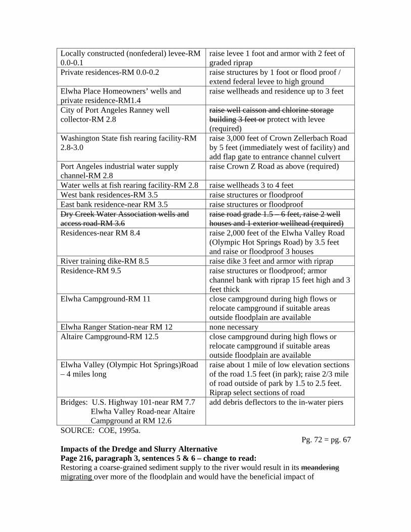
Locally constructed (nonfederal) levee-RM 0.0-0.1
raise levee 1 foot and armor with 2 feet of graded riprap
Private residences-RM 0.0-0.2 raise structures by 1 foot or flood proof / extend federal levee to high ground
Elwha Place Homeowners’ wells and private residence-RM1.4
raise wellheads and residence up to 3 feet
City of Port Angeles Ranney well collector-RM 2.8
raise well caisson and chlorine storage building 3 feet or protect with levee (required)
Washington State fish rearing facility-RM 2.8-3.0
raise 3,000 feet of Crown Zellerbach Road by 5 feet (immediately west of facility) and add flap gate to entrance channel culvert
Port Angeles industrial water supply channel-RM 2.8
raise Crown Z Road as above (required)
Water wells at fish rearing facility-RM 2.8 raise wellheads 3 to 4 feet West bank residences-RM 3.5 raise structures or floodproof East bank residence-near RM 3.5 raise structures or floodproof Dry Creek Water Association wells and access road-RM 3.6
raise road grade 1.5 – 6 feet, raise 2 well houses and 1 exterior wellhead (required)
Residences-near RM 8.4 raise 2,000 feet of the Elwha Valley Road (Olympic Hot Springs Road) by 3.5 feet and raise or floodproof 3 houses
River training dike-RM 8.5 raise dike 3 feet and armor with riprap Residence-RM 9.5 raise structures or floodproof; armor
channel bank with riprap 15 feet high and 3 feet thick
Elwha Campground-RM 11 close campground during high flows or relocate campground if suitable areas outside floodplain are available
Elwha Ranger Station-near RM 12 none necessary Altaire Campground-RM 12.5 close campground during high flows or
relocate campground if suitable areas outside floodplain are available
Elwha Valley (Olympic Hot Springs)Road – 4 miles long
raise about 1 mile of low elevation sections of the road 1.5 feet (in park); raise 2/3 mile of road outside of park by 1.5 to 2.5 feet. Riprap select sections of road
Bridges: U.S. Highway 101-near RM 7.7 Elwha Valley Road-near Altaire Campground at RM 12.6
add debris deflectors to the in-water piers
SOURCE: COE, 1995a. Pg. 72 = pg. 67
Impacts of the Dredge and Slurry Alternative Page 216, paragraph 3, sentences 5 & 6 – change to read: Restoring a coarse-grained sediment supply to the river would result in its meandering migrating over more of the floodplain and would have the beneficial impact of

reestablishing natural fluvial processes. Conversely, such meandering migration could increase bank erosion and may cause property damage along the river.
Pg. 73 = pg. 67&68 Page 216, paragraph 4, sentence 2 – change to read: Riverbed aggradation and raising of the water surface elevation from 1 to as much as up to 4 5feet in some places between Glines Canyon Dam and the river mouth would cause more frequent flooding at some locations, causing resulting in minor to major adverse impacts. Surface Water Impacts of No Action Page 218, paragraph 4 – delete entire paragraph: Use The city of Port Angeles…high turbidity periods. Impacts of the Proposed Action – River Erosion Alternative Page 221, paragraph 2, sentence 1 – change to read: Turbidity levels would far exceed water quality requirements be very high during dam removal and have major adverse impacts to water quality, as well as to users if proposed water quality mitigation measures were not integrated into project design. Page 223, paragraph 4 – change to read: The infiltration gallery would naturally reduce sediment load in intake water by filtration through the river alluvium. Each infiltration pipe would be surrounded by a graded sand and gravel filter that allows coarser particles to be filtered out of the inflowing water as it migrates The gallery would be composed of a series of looped pipes to maximize surface area and volume of water entering toward the infiltration pipe. In addition, a series of pumps would be used to increase the volume of water drawn from the infiltration gallery and delivered to the pre-treatment facility (and later, following dam removal, to the mills). Hydraulic gradient, water velocities, and interstitial space would all increase moving from the riverbed to the pipe. Natural seasonal flooding and bed scouring would aid in removing filtered fine material from the upper portions of the riverbed. Page 224, table 39 – replace with the following corrected table: Table 39. Mitigation Measures Included – River Erosion Alternative (Proposed Action)
SURFACE WATER USER MITIGATION MEASURE Industrial-Daishowa and Rayonier Mills Infiltration gallery
Open channel pre-treatment Mills and State Rearing facility Relocated (short-term)
Infiltration gallery (long-term) Lower Elwha Klallam Tribal Fish Hatchery Add to infiltration gallery
Two new wells for dilution Dredge existing outlet and create new bypass to Strait
Page 225, paragraph 1, sentence 3 – change to read:

As high turbidity would often correlate to high flow conditions, the system would be removing the most sediment at the highest river flows, and the return of settled solids would not induce a measurable increase in downstream turbidity. However, even during lower flows, the solids portion of flow returned to the river would be small compared to the average river flow, and impacts to the river would be minor or negligible.
Pg. 74 = pg. 68&69 Page 226, paragraph 1, sentence 2 – change to read: Also, the river could meander migrate away from the gallery and decrease yield. Page 226, paragraph 4, sentence 1 – change to read: Water Quality Monitoring. A sediment management monitoring plan administered by the US Geological Survey by the National Park Service for sediment management would include sampling for critical and basic water quality parameters. Page 226, paragraph 4, after last sentence – add the following: …post-dam removal water quality impacts. Information gathered from the sites will be used to help determine the dosing frequency of flocculent at the pre-treatment facility and other treatment parameters during dam removal. Impacts of the Dredge and Slurry Alternative Page 228, paragraph 1, sentences 2 & 3 – change to read: It is estimated that 75% of the lake bed sediment could be dredged, leaving 1.2 to 1.4 million cubic yards of fine material, or peaks of up to 10,000 NTUs of turbidity, to enter the water column. The magnitude of impacts would be much less than that under the River Erosion Alternative, where 4.9-5.6 million cubic yards of fine-grained material and peaks of up to 25,000 NTUs are possible. but the The durations of increased turbidity would be about the same for either alternative (see table 41). Page 228, paragraph 3, sentence 1 – change to read: Like the River Erosion alternative, an infiltration gallery, pumping stations and pre-industrial treatment are an integral part of the Dredge and Slurry alternative to protect the two mills now using Elwha River water. Groundwater Impacts of No Action Page 231, paragraph 1, after the last sentence – add the following: …in place because of this phenomenon. The riverbed materials are capable of filtering out (removing) the fine grained sediment that could enter the wells that are hydraulically connected to the river. Following dam removal, it is possible that the river may migrate closer to the wells and remove some of the material that had previously filtered out these fine grained sediments. Page 231, paragraph 2, sentence 1 – change to read: …a large portion of the particulate matter. High turbidity in the river is therefore not usually reflected in water collected from the Ranney well. However, if the river rises quickly following a prolonged drought, soil around the base of the Ranney collector

caisson dries and cracks, allowing surface water to bypass the filtration provided by the riverbed. During these “short-out” periods, turbidity in the Port Angeles municipal supply can be quite high. The 1994 measured mean turbidity of 0.08 NTU (nephelometric turbidity units – a measure of how intensely much light is scattered by particles in the water) normally does not exceed drinking water standards of 1.0 NTU.
Pg. 75 = pg. 69&70 Page 232, paragraph 2, sentence 1 – change to read: Meander River Migration and Flooding The dams have resulted in less frequent meander migration, flooding, and erosion. Page 232, paragraph 2, last sentence – change to read: Despite the reduction in meander migration frequency, the river has moved far enough away from the Port Angeles Ranney collector that yields have been affected. Page 232, paragraph 3, sentence 2 – change to read: Meander Migration and flooding frequency have been reduced through the elimination of sediment transport to the middle and lower reaches, resulting in the armoring of the downstream riverbed channel. Impacts of the Proposed Action – River Erosion Alternative Page 234, table 43 – replace with the following corrected table: Table 43. Groundwater Impacts and Mitigation
GENERAL LOCATIONa POSSIBLE IMPACTS PROPOSED MITIGATIONUpstream of Hwy. 101 Bridge
Increased flood potential (overtopping of wellhead) Water quality degradation due to increased river turbidity Water quality degradation due to iron and/or manganese
Raise and modify wellhead Temporary in-line sediment filter and bottled water as a backup Temporary storage tank and delivery of water to residence
Upstream of Lake Aldwell, Indian Creek Valley
Decreased piezometric level Increased flood potential
Drill well or deepen existing well Connect to new Ranney Collector Raise or modify wellhead
Dry Creek Water Association
Water quality degradation due to increased river turbidity Water quality degradation due to iron and/or manganese
Connect to new Ranney Collector Water Temporary water treatment system (Port Angeles)

City of Port Angeles Possible decreased yield from existing Ranney Collector Water quality degradation due to iron and/or manganese
Construct second Ranney Collector to provide supplemental flow Water Temporary water treatment system
Lower River Valley Wells Including State Rearing Channel Wells
Increased flood potential Water quality degradation due to increased river turbidity Water quality degradation due to iron and/or manganese
Raise and modify wellhead for the new 100-year flood level Temporary in-line sediment filter and bottled water as a backup Temporary storage tank and delivery of water to residence
Elwha Place Homeowners’ Association
Increased flood potential Water quality degradation due to increased river turbidity and/or iron and manganese
Modify wellheads and flood-proof pump house for the new 100-year flood level Temporary water treatment system
Lower Elwha Klallam Tribe Increased groundwater levels
Modify about 10 conventional septic systems to mound systems with lift stations
Unidentified Water Users Unanticipated impacts Monitor groundwater quality Contingency fund for mitigation
a Not all wells within a given general location would have the same impact and mitigation. Individual well construction features and specific location would determine impact and mitigation at each specific site. Page 235, paragraph 2, sentence 1 – change to read: …would increase with riverbed aggradation and bank erosion due to increased river meander migration. Page 235, paragraph 2, sentence 3 – change to read: When a wellhead is overtopped, raw, unfiltered river water flows can flow down from the top and contaminates the groundwater in the well.

Page 235, paragraph 3, sentence 3 – change to read: …facilitate fish restoration. Therefore, mitigation for these users is mandatory and built into both action alternatives.
Pg. 77 = pg. 72&73 Page 236, paragraph 2, last sentence – change to read: Cost estimates in this DEIS FEIS are based on Dry Creek Water Association connecting to the Port Angeles system. Page 236 paragraph 6, sentence 3 – change to read: If the river begins to meander migrate more frequently, it could eventually move closer to the wells, affecting their quality or stability. Page 238, paragraph 1, sentence 2 – change to read: Mitigation for Port Angeles, Dry Creek Water Association, and the Lower Elwha Klallam Tribal Fish Hatchery is mandatory built into the proposed action and would effectively eliminate… Page 238, paragraph 6, sentence 3 – change to read: Mitigation for the protection of Port Angeles, Dry Creek Water Association, and the Lower Elwha Klallam Tribal Fish Hatchery is considered mandatory necessary and included as part of the Dredge and Slurry alternative. Native Anadromous and Resident Fisheries Methodologies for Analyzing Impacts Page 241, after paragraph 2 – add the following: …thresholds would be exceeded were determined (see discussion below). Richer modeling was used to estimate maximum sustained yield production and escapement for each species (FERC 1993). These production numbers have been extensively reviewed and represent the best estimate of potential fish production. The model incorporated data from field studies that determined the quality of fish habitat in the Elwha River conducted by a consultant for the project owner during the FERC relicensing process. These habitat data were combined with average fish densities, such as smolts per square meter, and freshwater survival rates observed in other comparable Washington streams (e.g., S.F. Skykomish River for coho salmon, Dungeness River for Pink Salmon) to gauge carrying capacity for affected species. Using the escapement needed to reach carrying capacity, average marine survival, and average freshwater survival, the total expected production of adult fish, by species, was calculated. Impacts of No Action Page 241, paragraph 5, last sentence – change to read: The channel is also migrating less meandering with little of the pool and side channel habitat fish need to successfully rear (see Impacts of No Action on fluvial processes and sediment transport). Page 243, after paragraph 2 – add the following:
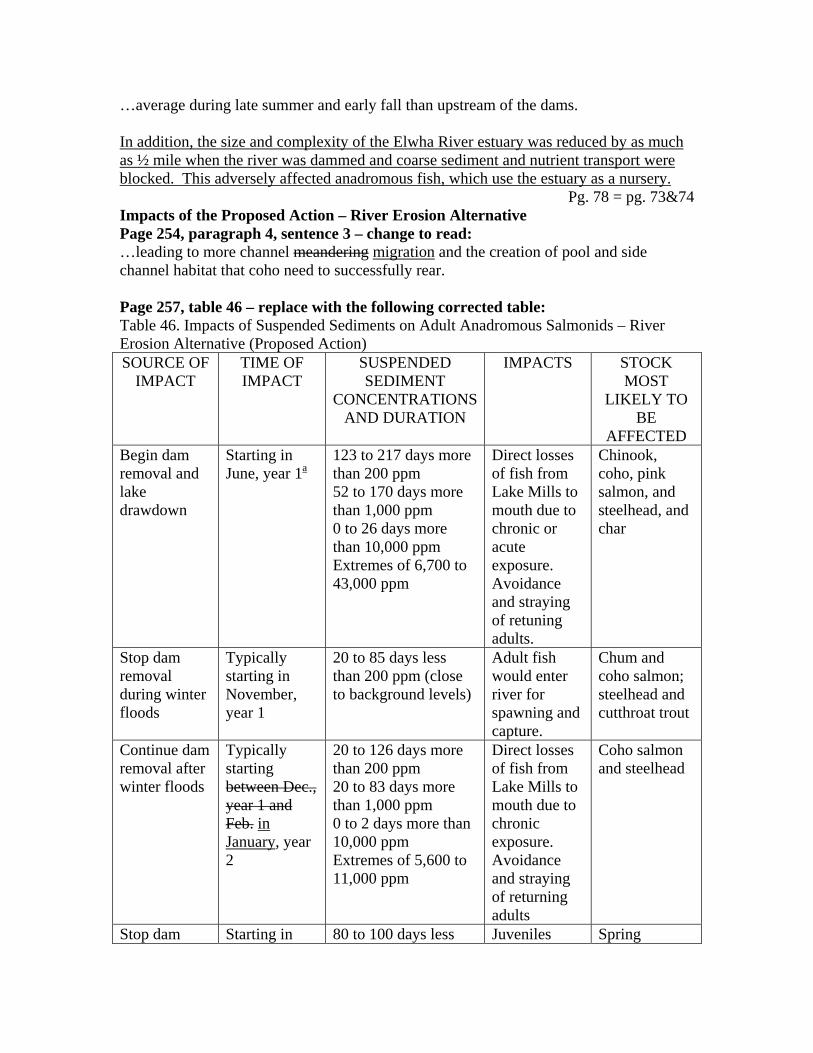
…average during late summer and early fall than upstream of the dams. In addition, the size and complexity of the Elwha River estuary was reduced by as much as ½ mile when the river was dammed and coarse sediment and nutrient transport were blocked. This adversely affected anadromous fish, which use the estuary as a nursery.
Pg. 78 = pg. 73&74 Impacts of the Proposed Action – River Erosion Alternative Page 254, paragraph 4, sentence 3 – change to read: …leading to more channel meandering migration and the creation of pool and side channel habitat that coho need to successfully rear. Page 257, table 46 – replace with the following corrected table: Table 46. Impacts of Suspended Sediments on Adult Anadromous Salmonids – River Erosion Alternative (Proposed Action) SOURCE OF
IMPACT TIME OF IMPACT
SUSPENDED SEDIMENT
CONCENTRATIONS AND DURATION
IMPACTS STOCK MOST
LIKELY TO BE
AFFECTED Begin dam removal and lake drawdown
Starting in June, year 1a
123 to 217 days more than 200 ppm 52 to 170 days more than 1,000 ppm 0 to 26 days more than 10,000 ppm Extremes of 6,700 to 43,000 ppm
Direct losses of fish from Lake Mills to mouth due to chronic or acute exposure. Avoidance and straying of retuning adults.
Chinook, coho, pink salmon, and steelhead, and char
Stop dam removal during winter floods
Typically starting in November, year 1
20 to 85 days less than 200 ppm (close to background levels)
Adult fish would enter river for spawning and capture.
Chum and coho salmon; steelhead and cutthroat trout
Continue dam removal after winter floods
Typically starting between Dec., year 1 and Feb. in January, year 2
20 to 126 days more than 200 ppm 20 to 83 days more than 1,000 ppm 0 to 2 days more than 10,000 ppm Extremes of 5,600 to 11,000 ppm
Direct losses of fish from Lake Mills to mouth due to chronic exposure. Avoidance and straying of returning adults
Coho salmon and steelhead
Stop dam Starting in 80 to 100 days less Juveniles Spring

removal during spring floods
April or May, year 2
than 200 ppm (close to background levels)
would migrate from the unaffected upper reaches to the Strait. Adult steelhead and spring chinook would enter the river.
chinook and steelhead
Complete dam removal after spring floods
Starting in July and lasting to late Oct., year 2; or to Feb., year 3
90 to 111 days more than 200 ppm 87 to 108 days more than 1,000 ppm 3 to 25 days more than 10,000 ppm Extremes of 15,000 to 51,000 ppm
Direct losses of fish from Lake Mills to mouth due to chronic or acute exposure. Avoidance and straying of returning adults.
Chinook, coho, chum, and pink salmon and steelhead
After dam removal high flows erode fine reservoir sediments
Winters & springs between Nov. Oct. year 2 to Sept. year 4
At least two 1 to 2 day periods with more than 10,000 ppm Extremes of 20,000 to 40,000 ppm.
Some direct losses of fish.
Chum and coho salmon and winter steelhead
a Dam removal activities begin in November of the preceding year Impacts of the Dredge and Slurry Alternative Page 263, table 48 – replace with the following corrected table: Table 48. Impacts of Suspended Sediments on Adult Salmonids – Dredge and Slurry SOURCE OF
IMPACT TIME OF IMPACT
SUSPENDED SEDIMENT
CONCENTRATIONS AND DURATION
IMPACTS STOCK MOST
LIKELY TO BE
AFFECTED Begin dam removal and lake drawdown
Starting in June, year 1a
79 to 179 days more than 200 ppm 7 to 76 days more than 1,000 ppm 0 to 1 days more than 10,000 ppm Extremes of 1,700 to 11,000 ppm
Possible direct losses of fish from Lake Mills to mouth due to chronic exposure. Avoidance and straying
Chinook, coho, pink salmon, and steelhead, and char

of retuning adults.
Stop dam removal during winter floods
Typically starting in November, year 1
20 to 119 days less than 200 ppm (close to background levels)
Adult fish would enter river for spawning and capture.
Chum and coho salmon; steelhead and cutthroat trout
Continue dam removal after winter floods
Starting between December, year 1 and February in January, year 2
20 to 84 days more than 200 ppm 12 to 38 days more than 1,000 ppm 0 days more than 10,000 ppm Extremes of 1,700 to 2,700 ppm
Some losses of fish from Lake Mills to mouth due to chronic exposure. Avoidance and straying of returning adults
Coho salmon and steelhead
Stop dam removal during spring floods
Starting in April or May, year 2
96 to 100 days less than 200 ppm (close to background levels)
Juveniles would migrate from the unaffected upper reaches to the Strait. Adult steelhead and spring chinook would enter the river.
Spring chinook and steelhead
Complete dam removal after spring floods
Starting in July and lasting to November year 2
88 to 108 days more than 200 ppm 22 to 61 days more than 1,000 ppm 0 to 1 days more than 10,000 ppm Extremes of 3,900 to 13,000 ppm
Possible direct losses of fish from Lake Mills to mouth due to chronic exposure. Avoidance and straying of returning adults.
Chinook, coho, chum, and pink salmon and steelhead
After dam removal high flows erode fine reservoir sediments
Winters & springs between Nov. Oct. year 2 to Sept. year 4
0 days with more than 10,000 ppm 1 or 2 days with extremes of 5,000 to 7,600 ppm.
Minor avoidance or stress.
Chum and coho salmon and winter steelhead
a Dam removal activities begin in November of the preceding year
Vegetation Impacts of No Action Page 266, paragraph 4, sentences 1 & 2 – change to read: The reservoirs inundated more than 5 linear miles or an estimated 534 acres of riparian vegetation habitat along the river. Riparian vegetation habitat is a critical component of the overall hydrologic processes of the Elwha River;…
Pg. 81 = pg. 76 Page 267, paragraph 3, sentence 1 – change to read; A total of 562 684 acres of potential natural vegetation and riparian habitat is inundated by the reservoirs and 31 acres are unavailable due to the dams and associated project facilities. Impacts of the Proposed Action – River Erosion Alternative Page 267, paragraph 4, after sentence 1 – add the following: …other vegetation in the reservoir beds. In addition, 122 acres of nonvegetated riparian / wetland habitat would be restored. Page 270, after paragraph 1 – add the following: …affected by reservoir draining. Expansion of the Tribal hatchery would primarily take place within existing hatchery or rearing pond boundaries, or along the access road. Impacts to wetlands as a result of the expansion would be minor or negligible. Raising and strengthening the federal levee would also involve some very minor and temporary impacts to wetlands during construction activities. Species of Special Concern Impacts of No Action Page 276, paragraph 1, last sentence – change to read: With fewer large riparian trees dying due to reduced meander, river migration, the number of snags has decreased that eagles could use as nesting, foraging, and roosting sites has decreased. Page 276, paragraph 8, sentence 1 – change to read: Northern Goshawk. This alternative would not impact goshawks. The loss of 418 acres of coniferous forest habitat resulting from the construction of the dams and reservoirs eliminated nesting habitat that was potentially used by the Northern goshawk. Impacts of the Proposed Action – River Erosion Alternative Page 278, paragraph 1, after last sentence – add the following: …along the shore temporarily. The Biological Opinion prepared in accordance with section 7 of the Endangered Species Act has determined that the proposed action “may affect but is not likely to adversely affect” bald eagles. Page 278, paragraph 4, after last sentence – add the following:

…would not be expected to adversely affect spotted owls. In accordance with section 7 of the Endangered Species Act, the US Fish and Wildlife Service has determined in their biological opinion that the Elwha Restoration Project “may affect but is not likely to adversely affect” the northern spotted owl (see appendix 7 for more information).
Pg. 82 = pg. 77 Page 278-279 last paragraph on 278 and 1st paragraph on 279 – delete and add the following: …northeast and sometimes northwest (Schwartz 1994). The US Fish and Wildlife Service in its Biological Opinion determined the marbled murrelet is likely to be adversely affected by the proposed project because of higher turbidity levels in nearshore marine waters during dam removal. The impacts to foraging murrelets are not expected to be severe since the general direction of the tidal currents is away from the shoreline to the northeast and northwest, there are strong tidal currents, turbid Elwha River water would be diluted when it flows into the strait, and there is better foraging habitat west of the river mouth. Page 279, paragraph 2, after last sentence – add the following: …increases in turbidity. Increased turbidity in marine waters, even with conservation measures, has the potential to adversely affect marbled murrelets in the short term. Suspension of reservoir drawdown periods, November 15 to December 15, and May 1 to June 30, will be required as a mandatory condition of the Biological Opinion. Page 279, paragraph 3 – change to read: Construction activity could adversely affect murrelets as they fly between the coast and their nest sites. Although murrelets primarily follow the river on these daily forays, it is expected that localized activity at either damsite would simply be avoided and would not interrupt movement patterns. If nesting birds and fledglings were in the vicinity of the dams, they might be adversely impacted from construction noise and activity. However, Mmarbled murrelet surveys conducted in 1990, 1995 and 1996 did not uncover any nesting murrelets in the vicinity of either dam. The surveys indicated low numbers of birds traveling through the project area but no evidence of nesting in the vicinity of either dam, Lake Mills, Lake Aldwell, or associated access roads. Murrelet surveys are planned for 1996 to comply with US Fish and Wildlife Service survey protocol which requires two consecutive years of survey to assess murrelet presence at a particular location. Since the completion of these surveys have now verified that marbled murrelet nesting does not occur within the vicinity of the two dams, restrictions on dam removal activities to protect nesting murrelets pursuant to the Endangered Species Act would not be required. The US Fish and Wildlife Service Biological Opinion states, “Terms and Conditions 1 through 4 would not be required should completion of ongoing surveys indicate murrelets do not occupy the area within 1 miles of the dams to be removed.” See appendix 7 for further details. Page 279, paragraphs 4 & 5 – delete entire paragraphs Construction activity…Endangered Species Act. Page 280, paragraph 1 – delete entire paragraph The biological assessment…not last longer than two years.
Page 280, paragraph 2, sentence 4 – change to read: Conservation Mitigation measures expected to be imposed by the US Fish and Wildlife Service include minimizing hovering…
Pg. 83 = pg. 77&78 Page 280, paragraph 7, sentence 1 – change to read: Nesting peregrines would not be impacted may be affected, but are not likely to be adversely affected by the proposed action. Page 281, paragraphs 1-6 – Only the Bull Trout is a Federal Candidate Species. Pacific Fisher, Harlequin Duck, Northern Goshawk, and Northern Red-Legged Frog are now considered “Species of Concern” to the US Fish and Wildlife Service. Move these paragraphs to a new section after paragraph 3, page 282: Federal Species of Concern to USFWS Pacific Fisher. … Harlequin Duck. … Northern Goshawk. … Northern Red-Legged Frog. … Page 284, paragraph 1 – change to read: The following species would be adversely impacted in the short term, most of them by turbidity or increased noise during the two year construction period: bald eagle, northern spotted owl, marbled murrelet, harlequin duck, and bull trout. The degree of impact to all but the marbled murrelet would be minor. Additional surveys necessary to comply with the Endangered Species Act and any appropriate mitigation would determine the degree of impact and appropriate mitigation for murrelets. Appropriate conservation measures have been included for the protection of the marbled murrelet. Page 284, paragraph 6, sentences 2, 3, & 4 – delete Page 284, paragraph 6 – add the following: …when compared to the proposed action. Noise from the generators would be expected to be audible for long distances; however, based on the 1995 and 1996 surveys documenting the absence of nesting, it would not be expected to impact nesting in the vicinity. Living Marine Resources Impacts of the Proposed Action – River Erosion Alternative Page 289, paragraph 4, sentences 2-4 – change to read: The cliffs originally supplied approximately 270,000 280,000 cubic yards of sediment to the nearshore environment each year. This was reduced to an estimated 90,000 40,000 cubic yards annually when the bluffs were stabilized to protect a water supply line into Port Angeles (Schwartz 1994). Since waves in the vicinity have the ability to transport 270,000 280,000 cubic yards of material sediment per year, beaches and the nearshore

habitat have been steepened and now provide a greatly reduced intertidal zone. Impacts of the Dredge and Slurry Alternative Page 291, delete paragraph 1 – add the following: And the Lower Elwha Klallam Tribe…minor or no impact with mitigation. Although the outfall would be placed in an area with a strong current to help disperse fine sediments, some turbid water would inevitably move to Freshwater Bay and along the shore east of the river mouth, as in the proposed action. Turbidity in these areas would be less than under the proposal. The increased total amount of fines reaching saltwater, though, and the additional fines discharged from the river, would combine to make the overall effects of this alternative similar to those of the proposed action. Coarse sediments would reach saltwater via the river in the same timeframes and would cause the same impacts as under the proposed action.
Pg. 84 = pg. 78&79 Noise Impacts of the Proposed Action – River Erosion Page 302, paragraph 2, sentence 1 – change to read: Continuous noise levels from construction equipment could have short-term (18 months to 2 years) minor adverse impacts on residents living within one-half mile of the Elwha damsite, Cultural Resources Impacts of No Action Page 305, paragraph 2, last sentence – change to read: Elwha Dam includes “…a rare, early example of the multiple-buttress type" structure and Glines Canyon Dam is significant because of "its association with the evolution of power plant design and contribution to the development of the automation of hydroelectric installation." Socioeconomics Methodologies for Analyzing Impacts Page 311, after paragraph 3 – add the following: …an update of the analysis (Meyer 1995). To determine local business and job impacts from construction expenditures under the preferred alternative, project engineers examined each construction line item in the EIS cost estimate, and drawing upon their experience in the northwestern part of Washington state, estimated the proportion of purchases and job hires that would be local vs. nonlocal. These data were then fed into a regional economic impact model (IMPLAN), which predicted total changes in income and employment in the local economy, given these initial project expenditures. The IMPLAN Model is discussed further in the supporting economic analysis technical report (Meyer, et al. 1995). The estimate of non-market value associated with dam removal was obtained by directly asking a sample of residents of Clallam County, the rest of Washington state, and the United States as a whole how much in taxes they would pay to restore the Elwha River. The survey was conducted by Dr. John Loomis of Colorado State University in

November, 1994. The procedure used is described in the technical literature as “contingent valuation.”
Pg. 85 = pg. 79&80 Contingent valuation is a standardized and widely used method for estimating the willingness of citizens to pay for recreation and for restoring or preserving natural attributes. It is recommended for use by federal agencies performing benefit-cost analysis and for valuing natural resource damages, and has been upheld as valid in the federal courts. Impacts of No Action Page 312, paragraph 3, sentence 1 – change to read: Under the No Action alternative, rapid demographic changes are not projected; however, the ongoing transition from extraction and harvest to tourism and service-based industries would be gradual. and lessen any acute changes in social conditions. Page 312, paragraph 4, last sentence change to read: An additional $8.7 $9.0 million in repair costs are expected in the near future (FERC 1993 p.2-19) if the dams remain. Page 312, after paragraph 7 – add the following paragraph: …decline of commercial or sport fishing locally. Survey data from Loomis (1995) indicate that water supply, fish and wildlife habitat, and scenic beauty are the elements of rivers considered most important by citizens of Clallam County, Washington State and of the United States in general. Page 313, paragraph 3, sentence 1 – change to read: There would be no additional costs or benefits over existing conditions, except for the $8.7 $9.0 million in required repair costs, if the dams were not removed. Page 313, paragraph 3, sentence 3 – change to read: Business benefits from fisheries would continue at $840,000 per year or could decline further. Page 314, paragraph 1, sentences 3 & 4 – change to read: It is estimated that present construction cost projections of between $111.1 $113.1 million and $127.4 $130.1 million will generate between $60 and $65 million in business activity in Clallam County over the 10-year construction period and an additional $32-$34 million in personal income. An estimated total of between 1,150 and 1,240 jobs would also be generated over the 10-year construction period (Meyer, et al. 1995);… Page 314, paragraph 4, sentence 4 – change to read: Even if they come from outside the region, all workers Although Interior plans to use as much local labor as possible (up to 75% of the workforce could come from the local area), even a 100% outside workforce could be accommodated by occupying these vacant units. Page 316, paragraph 1, sentence 2 – change to read: Over the 100 years following dam removal, additional recreation and tourism benefits

(discounted at 3%) would total $134 $132.3 million, expressed in present value terms. Pg. 86 = pg. 80&81
Page 317, table 63 – replace with the following corrected table: Table 63. Summary of the Net Present Value of Elwha River Restoration Market Benefits over Project Life – at 3% Discount Rate
MARKET BENEFITS BOTH DAMS REMOVED (millions of dollars)
Commercial Fisheries (Tribal & Non-tribal)
30.1
Sport Fish Business 4.5 Ediz Hook 0.9 Recreation and Tourism 132.6 132.3 Total Market Benefits 163.6a 162.7a
a Excludes sport fish business net revenue to avoid double counting Page 318, paragraph 3, sentences 2 & 3 – change to read: Estimated comparative business benefits and project costs are summed and displayed on this basis as single present dollar totals in tables 61 and 62 63. For the proposed action, benefits from increased recreation and tourism would amount to $133 $132 million over the life (100 years) of the project. Page 318, paragraph 4, after sentence 1 – add the following: …Alternatives section of the EIS. The preferred alternative of River Erosion would cost $113.1 million. Using the Dredge and Slurry approach would cost $130.1 million. Page 319, paragraph 3, sentence 1 – change to read: The estimated cost of implementing the proposed action is $111.1 $113.1 million, although further refining of costs and increased certainty of costs may reduce this figure. Public Health and Safety Earthquakes Impacts of No Action Page 321, paragraph 3, sentence 2 – change to read: Uncertainties about the location recurrence interval of recently discovered faults in the Puget Sound region suggest that the maximum credible earthquake rating may need to be reevaluated. Hazardous Materials Impacts of the Proposed Action – River Erosion Alternative Page 327, paragraph 5, after sentence 3 – add the following: …no hazardous materials would enter the river during dam removal. Some of the materials, including solvents, fuels, and lubricants would be salvaged and recycled. Other materials would be placed in drums and trucked to an approved disposal site. Contaminated soil would be excavated to the deepest detected contamination and removed, as would contaminated concrete and transformers. Recreation Impacts of the Proposed Action – River Erosion Alternative
Page 345, paragraph 5, after sentence 1 – add the following: …limitations on access to the watershed during construction. Access to Altaire campground, where a whitewater guide service currently launches, would be closed to unrestricted public access during dam removal.
Pg. 87 = pg. 81&82 Page 345, paragraph 6, sentence 2 – change to read: River features that would be created by dam removal are uncertain, and recreational access, including take out sites for whitewater rafting, would be planned when they are better known. Land Use Impacts of the Proposed Action – River Erosion Alternative Page 350, paragraph 5, sentence 3 – change to read: At Lake Aldwell, 268 acres of lakebed and 750 acres (1018 acres project lands minus 268) of additional lands would be converted to one of several different possible uses. Page 351, paragraph 4, sentence 5 – change to read: Natural resource management activities may include riparian protection, viewshed protection, creation of primitive recreational opportunities, selective small-scale harvest of timber on long rotations, vegetative management for cultural resources, and wildlife habitat management. Page 352, after paragraph 1 – add the following: …may have additional indirect impacts on the resources described above. The Elwha Restoration Act also authorizes leases of federal land to the tribe and the city of Port Angeles on Ediz Hook, and the acquisition of unspecified lands in Clallam County for the tribe. The act specifies the land for the tribe on Ediz Hook is to be used for a tribal cultural facility. Generally, impacts of leasing land to the tribe include the following: it would prevent its use for other purposes and involve impacts associated with development. These may include grading, removing vegetation, noise and its impacts to wildlife or human populations, construction traffic, dust, etc. Use of a cultural facility on Ediz Hook would require utilities and may generate some small amount of traffic. Transfer of fee land to the United States in trust for the tribe may result in a reduction in the county’s property tax base. At this time, there is no specific proposal for lease or use of the federal land, or for acquisition or use of other lands in Clallam County. Because the specifics are not known, a detailed environmental assessment of the proposal or alternatives to it is impossible. Page 353, paragraph 6, sentence 3 – change to read: If the slurry pipeline is placed in the riverbed, river recreation users would be adversely affected during the 18 month to two-year dam removal period. Aesthetics

Impacts of the Proposed Action – River Erosion Alternative Page 357, paragraph 3, after sentence 4 – add the following: …leaving exposed sandbars throughout the river’s movement zone. Should these earlier successional species be left in place long enough, they would eventually be succeeded by a forest dominated by Western hemlock or Douglas fir.
Pg. 88 = pg. 82&83 Page 358, paragraph 2, sentence 2 – change to read: The other (not in this DEIS FEIS but available from the National Park Service) shows… Required Impact Sections Impacts on Energy Consumption Page 365, paragraph 1, after sentence 1 – add the following: …grid (FERC appendix A, Part 9). BPA has a power surplus and has projected that the surplus will last through the five-year planning period. Unavoidable Adverse Impacts Page 365, paragraph 4, after last sentence – add the following: …some other wildlife at Lake Aldwell. Goundwater levels in the Lower Elwha Valley, and particularly for Lower Elwha Klallam Reservation residents, would be permanently raised. Other residents near Lake Aldwell may experience lowered water or well levels as a result of the restoration of natural hydrologic processes. Short-term Uses vs. Long-term Productivity Page 366, paragraph 7, sentence 2 – change to read: Dam removal, and hence impacts from construction noise and traffic, would be completed in 18 months two years. Consultation and Coordination Pages 369-371 and pages 378-382 of the draft Implementation EIS have been reprinted with corrections in the Consultation and Coordination section of this document. Preparers and Contributors Preparers Page 372-374 – add 1 year experience to the EXPERIENCE column of all preparers and contributors Page 737, Bruce Stoker – delete reference to Traffic in Title/Responsibility column Contributors Page 376, add after Dan Drake: Jerry Gilbert Geologic studies Page 376, add after Bill Holbert: Richard Link Geologic studies

Page 378, add the following after Fred Watts: M.J. Welling Traffic; TDA
Pg. 89 = pg. 84 References Bibliography Page 384, BOR references: The following BOR references were finalized from draft versions and the dates should be changed to 1996. (Note that these dates have not been changed throughout the FEIS and updated changes in this document are based on citations in the draft EIS): 1995b 1996b Report of water Quality Task Group, Elwha River, Washington (currently in draft). Water Quality Analyses and Mitigation Alternatives, Elwha River Dam Removal. 1995c 1996c 1995i 1996i 1995f – delete reference in bibliography and replace with: 1996f Sediment Analysis and Modeling of the River Erosion Alternative. Elwha Technical Services, PN-95-9. Pacific Northwest Region, Boise, ID. 1995j, 1995k, 1995l – these references have been incorporated into 1995b Page 385 – add the following references under BOR: 1995m Memorandum: Literature Review of and Visit to Glines Canyon dam; Safety Examination of Existing Dams (SEED) Program; National Park Service, Olympic National Park, WA. (Letter to Regional Director, Northwest Region, National Park Service). Operation and Structural Safety Group, Technical Service Center, Denver CO. 1996j Alluvium Distribution in the Elwha River Channel between Glines Canyon Dam and the Strait of Juan de Fuca, Washington (Elwha Technical Series PN-95-5). Pacific Northwest Region, Boise, ID. 1996k Report of Sediment Management Task Group, Elwha River, Washington [currently in draft] (Elwha Technical Series PN-95-12). Pacific Northwest Region, Boise, ID. Page 386, after Calambokidis 1994 – add the following reference: Campbell, O.W. 1996 Emergency Power for Port Angeles. James River Corporation, Port Angeles, Washington. 7 pages. Page 387, after Dean Runyan Associates – add the following reference:

DeLarm, M.R., E. Wold and R. Z. Smith. 1989 “Columbia Fisheries Development Program, Fishways and Stream Improvement Projects”. NOAA Technical Memorandum NMFS F/NWR-20. U.S. Department of Commerce, National Oceanic and Atmospheric Administration, National Marine Fisheries Service, Portland, OR.
Pg. 90 = pg. 85&86 Page 387, after DeShazo, J.J. – add the following reference: DOA (Department of Agriculture) 1989 “Forested Plant Association of the Olympic National Forest.” R6 ECOL Technical Paper 001-88. Henderson, J.A., D.H. Peter, R.D. Lesher, and D.C. Shaw. USDA Pacific Northwest Region. Page 389, FWS 1986 reference – change to read: FWS 1986 1986a Page 389, after FWS 1986 – add the following reference: 1986b Field tests of data collection procedures for the Elwha salmonid survival model. Wunderlich, R.C., and S.J. Dilley. U.S. Fish and Wildlife Service, Fisheries Assistance Office, Olympia, Washington. 61 p. Page 389, after FWS 1986 reference – add the following reference: 1990 Juvenile chinook passage at Glines Canyon Dam, Elwha River, 1989-1990. Dilley, S.J., and R.C. Wunderlich. U.S. Fish and Wildlife Service, Fisheries Assistance Office, Olympia, Washington. 41 p. Page 389, after FWS 1995d – add the following reference: 1995e “1995 Survey of Trumpeter Swans in North America” compiled by David F. Caithamer, Office of Migratory Bird Management, U.S. Fish and Wildlife Service, 11500 American Holly Drive, Laurel, MD 20708-4016. Page 390, after Hathorn, A.W., 1995 – add the following reference: Hathorn, A.W., C. Byrnes, T. DaSilva, P. Happe. 1996 “Marbled murrelet surveys in the Lower Elwha River Valley, Olympic National Park and vicinity – 1996 project completion report.” Prepared for Olympic National Park, Port Angeles, WA. Page 390, after Heaton T.H. 1984 – add the following reference: Henderson J.A., D.H. Peter, R.D. Lester and D.C. Shaw 1989 “Forested Plant Association of the Olympic National Forest.” R6 ECOL Technical Paper 001-88, USDA Pacific Northwest Region. Page 392, after Johnston, J.M…. - add the following reference: Jones, R.R., Jr., and E.O. Salo 1986 “The status of anadromous fish habitat in the North and South Fork Toutle River watersheds, Mount St. Helens, Washington, 1984.” Fisheries Research Institute
Completion Report FRI-UW-8601. School of Fisheries, University of Washington, Seattle, 53 p.
Pg. 91 = pg. 86&87 Page 393, after MacDonald, L.H. – add the following reference: Martin, D.J., L.J. Wasserman, R.P. Jones, and E.O. Salo. 1984 “Effects of Mount St. Helens Eruption on salmon populations and habitat in the Toutle River.” Fisheries Research Technical Completion Report FRI-UW-8412, School of Fisheries, University of Washington, Seattle, 130 p. Page 394, after Mausolf, R.G., and D.B. Sundvick – add the following references: McHenry, M.L. 1996 Freshwater habitat conditions affecting Strait of Juan de Fuca populations of coho salmon. Report to the Pacific Fishery Management council, Portland. 46 p. McHenry, M.L., J. Lichatowich, and R. Kowalski-Hagaman. 1996 Status of Pacific salmon & their habitats on the Olympic Peninsula. Washington. Lower Elwha Klallam Tribe, Port Angeles, Washington. 240 p. Page 394, after Meyer, P.A. 1995 – add the following reference: Meyer Resources, Inc. 1996 Economic Analysis of Proposals by the Elwha Citizen’s Advisory Committee Concerning Restoration of the Elwha River, Washington. Prepared for US Dept. of the Interior. Davis, California. Page 394, after Naiman, R.J…. – add the following reference: National Academy of Sciences 1996 Upstream: Salmon and Society in the Pacific Northwest. Committee on Protection and Management of Pacific Northwest Anadromous Salmonids, Board on Environmental Studies and Toxicology, Commission on Life Sciences. Page 396, after NPS 1995b – add the following reference: 1995c Analysis of Suspended Sediment Increases From Dam Removal and River Erosion of Stored Sediments: Glines Canyon Dam, Olympic National Park, (NPS 1995C), National Park Service Water Resources Division, Fort Collins, Colorado. June22, 1995. Draft Report. 14 p. Page 397, after Port Angeles Evening News – add the following reference: Powers, P.D., and J.F. Orsborn. 1985 “Analysis of barriers to upstream fish migration.” Part of BPS Fisheries Project 82-14, Part 4 of 4. Dept. Civil and Environ. Engr., Washington State University, Pullman, WA. Page 397, Randle… - change to read: Randle, T. And V.J. Lyons Glossary and Acronym List

Page 404, discount rate – change to read: Discount rate – The interest deducted in advance in purchasing, lending or selling something. The rate at which future benefits and costs are discounted because of positive time preference, or because of the existence of a positive real rate of power (i.e., placing higher value on current consumption or income than accruing it in the future). Page 405, GWH – change to read: Gwh - Gigawatt is a unit of electrical power, one thousand times larger than a megawatt and one billion times larger than a watt, it is a measure of the number of hours of electrical power used.
Pg. 92 = pg. 87&88 Page 405, KWh – change to read: KWh - A kilowatt is a unit of electrical power equal to 1,000 watts of power applied over one hour. A measure of the quantity of electrical power used, equal to 1,000 watt hours. Page 406, MWh – change to read: MWh –Megawatt hour, a unit of electrical energy equal to quantity of electrical power consumed, equal to one million watt-hours of electrical power. Page 406, NTU – change to read: NTU - Nephelometric turbidity unit is a measurement of how intensely much light is scattered by particles in the water. Page 407, real costs – change to read: real costs - Baseline cCosts that do not account for inflation. Page 407, after riprap – add the following: Roughness coefficient – Is an indicator used in modeling of the resistance to flow created by the channel bed and banks. Appendixes Appendix 1. Public Law 102-495 Elwha Restoration Act Page 418, Paragraph 2, last line of Sec. 7 – change to read: authrozation authorization $4,000,000 to carry out the land acquisition purposes of this section. Appendix 2. Elwha River Fish Restoration Plan Page 439, table 5 – replace with the following corrected table: Table 5. Hatchery-related capital costs. Item Cost ($K) Tribal Fish-Production Facility -Increase water supply 250-Upgrade incubation facilities 380-Upgrade brood holding and rearing 1040-Upgrade support facilities 470-Mobilization 176.4

-Upgrade existing production wells 60-Install new site supply drain 190-Construct new broodstock holding facilities
320
-Construct new incubation facility 380-Construct 8 new intermediate raceways 640-Site electrical distribution 100-Upgrade utility and install new service entrance
125
-Upgraded and new standby power generation
150
-Alarm and control monitoring system 75-Equipment storage shed 20-Upgraded and new fish rearing units 80-New outfall 280-Administration, contingency, engineering 991
1,460.6Sub-total: 3131
4,057WDFW Fish-Production Facilities -Build additional incubation facilities at Soleduc Hatchery
137 114
-Move fish to Soleduc Hatchery and mark them
589 491
-Move fish and incubation facilities back to Elwha, administer program
228 190
-Indirect Costs 199Sub-total: 954 994
Outplanting and Evaluation Equipment Boat 10Truck 25Distribution tank 3Miscellaneous 20Subtotal: 58
Total: 43635,109
Appendix 3. Revegetation Plan Page 450, after paragraph 4 – add the following list: …is included in Table H-1 of the Elwha Report, Appendix H. Primary Pseudotsuga menzeisii Douglas fir var. menzeisii

Alnus rubra Red alder Tsuga heterophylla Western hemlock Acer macrophyllum Bigleaf maple Salix spp. Willow Mahonia nervosa Oregon grape Gaultheria shallon Salal Rubus spectabilis Salmonberry var. spectabilis Polystichum munitum Sword-fern
Pg. 94 = pg. 90&91 Secondary Populus balsamifera Black cottonwood var. trichocarpa Thuja plicata Western red cedar Abies grandis Grand fir Holodiscus discolor Ocean-spray var. discolor Rubus parviflorus Thimbleberry var. parviflorus Rosa gymnocarpa Baldhip rose var. gymnocarpa Vaccinium parvifolium Red huckleberry Achlys triphylla Vanilla leaf Misc. native grasses and sedges 10-20 additional species Tertiary Cornus stolonifera Red-osier dogwood var. stolonifera Sedum spathulifolium Stone crop var. spathulifolium Appendix 4. Flooding Impacts Associated with Removal of the Elwha and Glines Canyon Dams Page 451, paragraph 1, sentence 8 – change to read: In summary, these studies have shown that (1) removal of the dams would not alter the existing hydrology flow regime downstream because of the dams'… Page 453, paragraph 3, sentences 5 & 6 – change to read: The 3 to 5-ft estimate of aggradation was based on apparent historical evidence of the pre-dam channel configuration in some portions of the valley downstream from Elwha Dam (BOR 1995b). Water surface increases based on an assumed aggradation of 3-5 ft. in the river reach between the dams are thought to represent a conservative assumption due to the large sediment transport capacity of this portion of the river (see Sediment

Report BOR 1996f). Pg. 95 = pg. 91&92
Page 456, paragraph 3, sentence 1 – change to read: (1)Lower Elwha Flood Control Levee. The federally constructed levee would require an average raise of 2.5 3 feet its entire length to retain its present level of protection. Page 457, table 1 – replace with the following corrected table: Table 1. Current and Predicted Increases in Water Surface Elevations Following Dam Removal WATER
SURFACE ELEVATION (feet)
“ INCREASE (feet)
CROSS SECTION NUMBER
RM EXISTING DAMS REMOVED
1+00 (Levee) 0.2 7.4 8.4 1.02+00 “ 0.5 13.6 16.4 2.84+00 “ 0.8 20.4 24.1 3.75+00 “ 1.1 28.4 32.4 4.06+00 “ 1.2 32.1 35.4 3.37+00 “ 1.4 34.9 38.1 3.27+50 1.6 40.4 43.7 2.38+00 1.9 44.7 47.7 47.9 3.0 3.29+00 2.2 49.6 52.1 50.4 2.5 0.810+00 2.5 54.6 56.6 57.6 2.0 3.011+00 2.6 60.4 62.1 1.7 1.112+00 (Fish Facility)
2.8 64.2 66.7 2.5
13+00 3.0 69.9 72.3 74.8 2.4 4.916+00 (Bridge) 3.3 76.0 77.9 77.7 1.9 1.717+00 (Intake) 3.35 77.6 79.5 79.4 1.9 1.819+00 3.5 78.4 80.2 81.8 1.8 3.420+00 (DC Wells)
3.7 83.3 84.6 84.8 1.3 1.5
21+00 4.8 104.9 106. 1.622+00 (Elwha Dam)
4.9 109.7 111.5 1.8
23+00 (101 Bridge)
7.7 207.8 210.3 2.5
24+00 7.9 210.4 212.8 2.425+00 (USGS Gauge)
8.5 232.1 234.5 2.4
26+00 9.0 239.8 241.6 1.827+00 (Park Bdry)
9.6 258.9 260.3 1.4
28+00 9.8 262.2 264.1 1.929+00 10.8 307.7 308.5 0.8

30+00 11.5 337.9 339.4 1.531+00 (Ranger Station)
12.0 351.3 352.1 0.8
32+00 (Bridge) 12.5 368.5 371.0 2.533+00 13.0 397.4 400.6 3.234+00 13.2 407.1 409.3 2.2 Page 459, paragraph 3, last sentence – change to read: …removed 100-year water surface elevation - 72 68 feet at the downstream end of the well field to 71 72 feet at the upstream end of the field.
Pg. 96 = pg. 93&94 Appendix 6. Requirements for Completing the Proposed Action Page 480, after last paragraph – add the following: An NPDES permit for the discharge of filtration backwash from the infiltration gallery for both the tribal hatchery and for supply water to the industrial pre-treatment facility may be required, although the material being discharged would largely be sand and fines already present in the river under normal conditions. The discharge of flocculent sludge during dam removal into the river is likely to require a water quality modification from the Washington Department of Ecology (WDOE). The modification would include stipulations on the kind of flocculent, timing of release and other factors to ensure the minimum environmental impact.
Consultation and Coordination History of Public Involvement The Federal Energy Regulatory Commission (commission) indicated its intent to write an environmental impact statement on whether to issue licenses for the Elwha and Glines Canyon dams by a Notice of Intent in the Federal Register on August 17, 1989. Formal scoping, or the early effort to involve agencies and the general public, was initiated in December 1989. Commission staff contacted interveners, state and federal agencies, Native American organizations, and members of the public who could provide input on the document. Two public scoping meetings were held in the state of Washington to identify issues and solicit public comments. After review of the comments, the commission wrote a scoping document that identified objectives, issues, and alternatives including Dam Retention (described in FERC 1993) and the No Action alternative. The No Action alternative was later eliminated as unreasonable. A draft environmental impact statement (draft EIS) was prepared by the commission and distributed to affected agencies and interested members of the public in February 1991; its Notice of Availability was published in the Federal Register March 1, 1991. Comments on the draft EIS were reviewed and responded to in a two-volume document that normally would have been the final environmental impact statement (final EIS). Prior to release of the final EIS, in October 1992, congress enacted Public Law 102-495, The Elwha River Ecosystem and Fisheries Restoration Act. Under the act, the secretary

of the Department of the Interior (Interior) was directed to study ways to restore the native anadromous fisheries and ecosystem of the Elwha River. The act stayed the licensing process for both dams until the required studies were completed. Interior requested that the commission environmental impact statement be forwarded to the Interior to be used as supplementary information when preparing the study. The commission's environmental impact statement was then finalized as the Draft Staff Report, dated March 1993, and released to Congress and the Interior. The final report and response to comments were not released to the general public.
Pg. 97 = pg. 95&96 The Elwha Report, mandated by Public Law 102-495, was made available for public review and comment from October 4 to November 8, 1993. An open house to discuss the Elwha Report, held during October 1993 in Port Angeles, was attended by approximately 200 persons. Staff from the agencies responsible for preparing the report (departments of the interior and commerce and the Lower Elwha Klallam Tribe) answered questions and recorded attendees' comments. The report was completed in January 1994 and submitted to Congress in June 1994. Portions of the report were modified based on comments that were received. Appendix M of the final document contains direct responses to public comments. On August 1, 1994, a Notice of Intent was placed in the Federal Register describing the National Park Service's intention to prepare two environmental impact statements. The first environmental impact statement, which relied heavily on both the FERC Draft Staff Report (adopted most of it) and the Elwha Report (incorporated the entire report by reference), examined whether to remove the dam(s). This environmental impact statement has been prepared to analyze a range of alternative ways to remove the dams and manage the sediment trapped behind them. The National Park Service is the "lead agency" responsible for the coordination and writing of both environmental impact statements. The US Bureau of Reclamation, US Bureau of Indian Affairs, US Fish and Wildlife Service, US Army Corps of Engineers, and the Lower Elwha Klallam Tribe are cooperating agencies. Members from each of these agencies make up the "EIS team." The agencies conducted the bulk of the studies required for the environmental impact statements and have provided extensive review and comments on both. The first draft environmental impact statement, Elwha River Ecosystem Restoration Draft Environmental Impact Statement, released for public review and comment in October 1994, analyzed a range of alternatives to restore the Elwha River anadromous and native fisheries and ecosystem. (1) No Action, (2) removing either of the dams and providing fish passage measures on the remaining dam, (3) retaining both dams with fish passage measures on both, and (4) removing both dams. Public workshops to receive comments on the draft environmental impact statement were held in Seattle and Port Angeles in November 1994. In addition, interested parties were invited to submit written comments during the 60-day public review and comment period. This document is the second of the two environmental impact statements prepared to analyze native anadromous fisheries and ecosystem restoration on the Elwha River. It is entitled Elwha River Ecosystem Restoration Implementation Environmental Impact Statement. Public scoping sessions for this document were held in conjunction with the

public meetings for the draft of Interior's first, or programmatic environmental impact statement (Elwha River Ecosystem Restoration Environmental Impact Statement). This environmental impact statement does not evaluate partial dam removal or other alternatives; this was done as part of the previous programmatic environmental impact statement. The focus of this implementation document is the safe, environmentally sound, and cost-effective removal of both Elwha and Glines Canyon dams. After beginning with a full range of options for dam removal and sediment management, the major sources of impact in this project, the EIS team analyzed whether any technical, safety, cost or environmental limitations made them infeasible (see Alternatives Considered but Rejected section in the Alternatives chapter). If two alternatives had identical environmental impacts and were equally technically feasible and safe, the less expensive of the two was selected for further analysis. One set of dam removal and two of sediment management remained after these criteria were applied. The sediment management scenarios are River Erosion and Dredge and Slurry Alternatives. The No Action Alternative was also included for comparison purposes.
Pg. 98 = pg. 96&97 To make these alternatives environmentally sound, mitigation for: surface and groundwater users, downstream residents who may experience slight increases in frequency of flooding, anadromous fish (both hatchery produced and native), nesting marbled murrelets (a species listed as threatened on the Endangered Species Act list that may be present in the project area), native vegetation affected by the invasion of nonnative weeds and plants, slopes now inundated by reservoirs that may require revegetation, marine life impacted by the discharge of sediment from the slurry pipeline, individuals experiencing increased noise or dust from the construction sites, cultural resources, workers and downstream resident's safety during dam removal, and local residents and visitors affected by closing the Elwha subdistrict in Olympic National Park has been analyzed and proposed in this document. Mitigation that is required as part of the Elwha Act has been built into the alternative and other mitigation, although not specifically required by the act, has been recommended by the EIS team (see Alternatives chapter for a listing of specific mitigation measures and individual impact topic sections for additional details). Scoping Issues Oral and written comments on scoping issues for the Implementation EIS were received at the public meetings held in Port Angeles and Seattle on November 14 and 15, 1994. Written comments were also received during the 60 day public comment period on first programmatic environmental impact statement. The EIS team responded to many of the scoping issues in the final version of the programmatic environmental impact statement, released in June 1995. Some issues were eliminated as less important; a summary of these issues and issues raised and subsequently eliminated by the EIS team is presented in the Purpose and Need chapter, "Issues dismissed from further analysis" section. Issues and concerns retained for further analysis in the implementation EIS are identified in table 3 in the Purpose and Need chapter in a section entitled "Issues and concerns." Public Review of the Draft Environmental Impact Statement/Comments

and Responses Public comments on the draft EIS were received in writing during the 60 day public comment period and orally at public meetings in Seattle and Port Angeles, Washington on May 21 and 22, 1996. All comments were examined and considered by the National Park Service according to requirements of 40 CFR 1503 (implementing regulations of the National Environmental Policy Act). The comments that were considered "substantive", and not just statements for or against the proposal were responded to in the section entitled "Response to Comments".
Pg. 99 = pg. 97&98 Record of Public Comment A Notice of Availability for the Elwha River Ecosystem Restoration Implementation Draft Environmental Impact Statement was published in the Federal Register on April 26, 1996. The 60 day public comment period for the draft EIS extended from April 26 through June 27, 1996. Approximately 1200 copies of the draft EIS were distributed to individuals, government agencies, special interest groups, and businesses for their review. Excluding individuals, everyone that received a copy of the draft EIS is recorded in the List of Recipients in this section of the document. Public Workshops Three public workshops were held in Seattle and Port Angeles, Washington to solicit public input on the project. Notification of the workshops was sent out with each EIS, published in local newspapers, and broadcast over local radio stations. The public workshops provided an opportunity for participants to have technical experts answer their questions on a one-to-one basis, and allowed oral and written comments to be recorded. Sixty-four persons attended the evening workshop in Seattle on May 21, 1996. Workshops held during the afternoon and evening of May 22, 1996 in Port Angeles, Washington had 35 and 52 persons in attendance respectively. The public was offered the opportunity to spend several hours visiting the following topic areas that were set up with visual displays and staffed by technical experts: fisheries; wildlife and living marine resources; flooding, water quality and quantity, and sediment management; dam removal and public health and safety; land use, recreation, aesthetics and traffic; and socioeconomics. Each group had a facilitator that summarized and recorded the comments and questions raised by the participants. Responses to the substantive comments recorded at the public workshops are grouped by topic and answered in the Responses to Comments section of this document. Written Comments Three hundred and seventy four letters were received from government agencies, businesses, special interest groups, and individuals during the public comment period. Fifty-six of these letters contained substantive comments that required clarification of information in the draft environmental impact statement, modification of text or direct responses. The comments are grouped by topic (i.e., fisheries, flooding) and are set up in a question and answer format in the Responses to Comments section of this document. All of the agency, special interest group, and business letters are reprinted for the public's

information in the Comment Letters section of this document. Pg. 100 = pg. 97&98
Preparers and Contributors See corrections to the preparers and contributors lists in the errata sheets. Agencies and Organizations That Received Copies of the Final Implementation Environmental Impact Statement Federal Department, Agencies, Committees and Laboratories Department of Energy Department of the Interior Environmental Protection Agency Federal Emergency Management Agency Federal Energy Regulatory Commission General Accounting Office House Fisheries and Wildlife Committee House Natural Resources Staff Idaho National Engineering Laboratory National Academy of Sciences National Biological Service National Marine Fisheries Service National Oceanic and Atmospheric Administration National Park Service Channel Islands National Park Mount Rainier National Park Olympic National Park Redwood National Park Rocky Mountain National Park St. Croix Scenic Riverway Yosemite National Park Natural Resources Conservation Service Pacific Fishery Management Council President's Council on Sustainable Development Senate Appropriations Committee Senate Energy & Natural Resources Committee U.S. Army Corps of Engineers U.S. Bureau of Indian Affairs U.S. Bureau of Land Management U.S. Bureau of Mines U.S. Bureau of Reclamation U.S. Coast Guard U.S. Congress Office of Technical Assessment U.S. Fish and Wildlife Service U.S. Forest Service Columbia Gorge

Olympic National Forest U.S. Geological Survey U.S. Office of Surface Mining U.S. Office of the Regional Solicitor Washington Area Power Administration Tribal Governments and Organizations Columbia River Intertribal Fisheries Commission Confederated Tribes of the Umatilla Reservation Covelo Indian Community - Round Valley Reservation Elwha Klallam Tribe Lower Elwha Fisheries Elwha Tribal Council Jamestown S'Klallam Tribe Makah Indian Tribe Northwest Indian Fisheries Commission Point No Point Treaty Council Port Gamble S'Klallam Tribe Puyallup Indian Tribe Puyallup Fisheries Department Quileute Indian Tribe Skokomish Indian Tribe Shoshoni Bannock Tribe Shoshoni Bannock Fisheries Department Small Tribes Organization of Western Washington Yakima Nation
Pg. 101 = pg. 98&99 States Agencies and Organizations State of California Department of Fish and Game State of Michigan Department of Natural Resources Fisheries Division State of Montana Environmental Quality Control State of New York Power Authority State of Oregon Department of Fish and Wildlife Natural Resources Council State of Washington Department of Community Development Department of Ecology Department of Fish and Wildlife

Department of Health Department of Natural Resources Department of Trade and Economics Department of Transportation Governor's Office Historic Preservation Office Parks and Recreation Commission Water Power Authority State of Wisconsin Department of Natural Resources Congress people Honorable Norman Dicks Honorable Jennifer Dunn Honorable Diane Feinstein Honorable Slade Gorton Honorable Richard Hastings Honorable Jim McDermott Honorable Jack Metcalf Honorable Patty Murray Honorable George Nethercutt Honorable Linda Smith Honorable Randy Tate Honorable Rick White County and Local Governments City of Forks City Council's Office City Planner / Attorney City of Port Angeles City Attorney's Office City Council's Office City Light City Manager Planning Department Utilities Department City of Sequim City Council's Office Planning Department Clallam County Commissioner's Office County Administrator County Attorney's Office Department of Community Development

Department of Roads and Public Works Clallam County Public Utility District #1 Commissioner's Office General Manager King County King County Surface Water Mgt. Port of Port Angeles Commissioner's Office Executive Director Seattle City Light Water Dept. Snohomish County Surface Water Management Tacoma Public Utilities
Pg. 103 = pg. 99 Organizations and Business Adele McCall Allegheny Electric Cooperative, Inc. American Rivers American Whitewater Affiliation Appalachian Mountain Club Aquaculture Research Institute Battelle Northwest Beak Consultants Bonneville Power Administration Buchanan Ingersoll Carolina Power and Light Company Century 21 Harbor Lights Chinook Northwest Inc. Clallam County - Sekiu Chamber of Commerce Clallam County Grange Clallam County Historical Society Clallam County Public Utility District #1 Coastal Consultants, Inc. Columbia Basin Fish & Wildlife Authority Columbia Gorge Audubon Society Common Sense Resource League Crescent West Inc. Cuttler and Stanfield Daishowa America Inc. Decision Data Dorsey & Whitney Dry Creek Grange #646 Dry Creek Water Association, Inc.

EA Engineering Ellison Timber and Properties Elwha Place Homeowners' Association Environmental Impact Services Environmental Planning Strategies Federation of Fly Fishers First Federal Savings and Loan Fish Pro Fletcher Far Ayotte Forks Chamber of Commerce Forks High School Foster Wheeler Environmental Friends of the Cowlitz Friends of the Earth Friends of the Eel Friends of the Elwha Gehrke's Gink Glen Canyon Environmental Studies Granite Construction Company Grant County Public Utilities District Graystone Greater Ecosystem Alliance Green Crow Partnership Harza Engineering HDR Engineering, Inc. Hood Canal Environmental Hung West & Associates, Inc. Hydro-Triad Limited Idaho National Engineering Laboratory Idaho Rivers United Indian Creek Campground Infraspect Inside Passage International Archeological Research Institute International Rivers Network IRN James River Corporation Jones & Jones Jorgensen Engineering King County Parks, Planning and Resources Klahane Club Lane & Lane Associates Lipman Auto Lighthawk Log Cabin Resort Mazamas

McGavick Graves Attorney at Law Mendocino Environmental Center Metamorphosis Meyer Resources, Inc. Montesano Vidette NW Conservation Act Coalition National Outdoor Leadership School National Park Foundation National Parks & Conservation Association National Wildlife Federation Native American Fish and Wildlife Society Neahkanie Mountain North Olympic Environmental Resource Center North Olympic Land Trust North Olympic Peninsula Visitor and Convention Bureau North Olympic Salmon Coalition North Peninsula Home Builders Association Northrop, Devine and Tarbell Northwest Chapter - Wilderness Watch Northwest Economic Association Northwest Ecosystem Alliance Northwest Hydraulics Consultants Northwest Power Planning Council Northwest Sportfishing Industry Association Okanogan Resource Council Olympic National Resources Center Olympic Outdoor Sportsmen's Association Olympic Park Associates Olympic Park Institute Olympic Peninsula Audubon Society Olympic Raft & Guide Service Olympic Rivers Council Outside Connection PacifiCorp Pacific Fishery Management Council Pacific Northwest Trail Association Pacific Power and Light Company Pacific State Marine Fisheries Commission Pacific Rivers Council Parametrix Perkins Coie Phelps Dodge Corporation Port Angeles Chamber of Commerce Port Angeles-Victoria Visitor Bureau Portland General Electric Port Townsend Chamber of Commerce

Preston, Gates and Ellis Preston, Gates, Ellis & Raivela Meeds Puget Sound Power and Light Company Puget Sound Water Quality Authority Radin and Associates, Inc. Rainier Evergreen Inc. Rayonier Inc. Recreational Equipment Inc. Redwoods Science Lab Rescue Elwha Area Lakes Riddell, Williams, Bullitt & Walkinshaw Ridolfi Engineering & Associates Rio Grande Restoration Project Rivers Council of Washington Rivers Network Robbin B. Sotir & Associates RUST Environment & Infrastructure, Inc. Save Our Wild Salmon Coalition SCS Engineers Seattle Aquarium Seattle Audubon Society Sequim Chamber of Commerce Shapiro and Associates Sierra Club Sierra Club Legal Defense Fund Simpson, Thacher & Bartlett Sol Duc Hot Springs Resort St. John's River Water Management District Stone and Webster Engineering Corporation Summit Technology TDA, Inc. Total Quality NEPA Terrestrial Ecology Tetra Tech The Mountaineers The Rockey Company The Trust for Public Land The Wilderness Society Triangle and Associates Trout Unlimited Trumpeter Swan Society Twanoh Group Sierra Club U.S. Savings Bank of Washington Van Ness Feldman Washington Appellate Defender Association Washington Environmental Council

Washington Sea Grant Program Washington State Grange Washington State Sportsman's Council Washington Wilderness Coalition WEC Wells National Estuarine Kraver & Quinn Research Reserve Roy F. Weston, Inc. Whidbey Islanders for a Sound Environment (WISE) Wilkinson Barker Wise Use Movement Woodward Clyde Wrong Mountain Wildlife Preserve
Pg. 107 = pg. 101 Libraries Aberdeen Timberland Branch Library Bellevue Branch Library Bremerton Branch Library Clallam Bay Branch Library Colorado State University Everett Public Library Forks Branch Library Holland Library - Washington State University Hoodsport Timberland Branch Library Kirkland Branch Library Kingston Branch Library Mansfield Library Port Angeles Branch Library Redmond Branch Library Renton Public Library Sequim Branch Library Port Townsend Public Library Seattle Public Library Tacoma Public Library University of Washington Washington State Department of Fish & Wildlife Library William G. Reed Branch Library Academic Institutions Albion College Central Washington University Charles Wright Academy Colorado State University Ferris State University Humboldt State University

Kansas State University Michigan State University Northwestern University Oregon State University Peninsula College Pitzer College St. Johns University The Evergreen State College University of California at Davis University of Montana University of Oregon University of Washington University of Wyoming Washington State University Western Washington University Williams College Newspapers Associated Press Bellingham Herald Citizen's News Daily Journal of Commerce East County News Everett Herald Forks Forum High Country News Hydrowire Newsletter Jimmy Come Lately Gazette Land Use Chronicle McClatchy Newspaper Montesano Vidette Out West Newspaper Peninsula Daily News Peninsula Gateway News Port Townsend Leader San Francisco Chronicle Seattle Post Intelligencer Seattle Times Sequim Gazette Shelton-Mason County Journal Tacoma News Tribune The Citizen News The Daily News The Daily World The Olympian

The Sun USA Today UPI
Pg. 109 = pg. 102 Magazines Backcountry TV Backpacker Current National Fisherman National Geographic Society New York Times Magazine Outside Magazine Pacific Northwest Magazine Peninsula Magazine Popular Mechanics Seattle Weekly Signpost Magazine Sunset Magazine The Christian Science Monitor U.S.A. Weekend Magazine Radio/TV Stations CNN KSOH-FM KAPY KAYO Aberdeen KBAM Radio KBWK Radio KGHO KGY Radio KING TV and Radio KIRO TV and Radio KJR Radio KKMO Radio KMAS KMPS Radio KOMO Radio and TV KONP KPLU KQEU KRKO KSTW TV KUOW KVAC/KLLM

KVOS TV KXLY TV KXRO/KDUX National Public Radio Northland Cable News (NCN) Seattle/King County News Bureau WNYC News
Pg. 110 = pg. 103 Responses to Substantive Comments Made on the Draft Environmental Impact Statement Purpose of Final EIS and Methodology The final environmental impact statement is to be an accurate analysis of impacts of the proposed action and its alternatives. Public and agency review of the draft statement helps to ensure its high quality. Interior received 374 comment letters on its Elwha Ecosystem Restoration Implementation draft EIS, as well as many questions and comments delivered orally at three public workshops held in May 1996. The National Park Service and cooperating federal agencies reviewed and responded to all comments which were not simple statements pro or con the proposal, i.e., those requiring additional explanation, analysis of data or those which debated facts or conclusions reached in the draft EIS. These are called "substantive" comments. Substantive comments were either answered in the question and answer section which follows, through changes in the text of the EIS, or in both places. Because many comments were duplicative, Interior summarized the substantive comments by resource concern ("Flooding," for example), and then further defined subtopics ("Protection of Property," as an example) as presented in comment letters and at the workshops. This allows the reader interested in a particular topic to review the substance of the issue and the EIS team's response. In some cases, summaries of the agency response have also been integrated into the errata sheets of the final EIS, so that anyone reading the final document will have a complete picture of the overall proposal, its alternatives and their impacts. Organization of Comments and Responses There are two indexes pertaining to the comments received on the draft EIS. The "Index by Author" lists authors of substantive comment letters by category or type of group: Public Agencies; Special Interest Groups, and Private Individuals. The authors in each category are presented alphabetically, with an assigned number. The author's name is then followed by one or more code words or topic areas which pertain to the major topics or resource concerns presented by the author to the EIS team, i.e. "fisheries." The reader can find the team's response to his/her comment by referring to the "fisheries" section of the question and answer section. In Responses to Comments, each author's letter number, as well as the paragraph of that letter being addressed (e.g. 180 "C") in the response, is noted. The "Index of Topics" presents the major topic or resource of concern followed by
a list of authors and the number of the correspondence. All of the substantive comment letters (with the exception of letters from individuals) are reprinted in the following section in the order that they were received.
Pg. 111 = pg. 103&104 In the question and answer section which follows, both environmental impact statements prepared by Interior to analyze ecosystem restoration for the Elwha River are referenced. The Elwha Ecosystem Restoration EIS, finalized in June 1995, is referred to as Interior's "programmatic EIS." A decision to remove the Elwha and Glines Canyon Dams was made using the programmatic EIS (and other information), and a second Implementation EIS to analyze dam removal and sediment management options was prepared. The draft of the Elwha Ecosystem Restoration Implementation EIS, released in April 1996, is referenced as the "draft EIS." Changes made to the text of the draft EIS and the Responses to Comments are part of the final Implementation EIS, referred to as "this EIS." When an appendix is cited (such as, see appendix 6), it is always referring to the draft Implementation EIS (i.e. draft EIS), unless otherwise stated in the sentence. Index of Substantive Comment Letters by Category of Topic (Comment letters from individuals are listed for information purposes only. Responses to substantives are in the following section, but the letters have not been reprinted in the FEIS). Fluvial Processes and Sediment Transport Clallam Citizens Coalition - 181 Clallam County Commissioners Office - 192 Washington Department of Fish and Wildlife - 163 Rescue Elwha Area Lakes - 148 Washington Department of the Natural Resources - 180 Washington Wilderness Coalition - 178 Bessey, Robert F. - 267 Clark, Welden and Virginia - 235 Hartmann, Eric W. - 245 Lydiard, Harry - 13 Payne, Randall - 171 Powne, Bob - 200 Sewell, James - 84A Flooding Clallam Citizens Coalition - 181 Clallam County Commissioner Office - 192 Elwha Place Homeowners Association - 233 Washington Department of Natural Resources -180 Brennan, Bruce and Marian - 81 Duncan, Dorothy - 204

Hartmann, Eric W. - 245 Hill, Marilyn - 157 Morrison, Kingsley - 261
Pg. 112 = pg. 104 Surface Water and Groundwater Quality and Supply City of Port Angeles - 241 Clallam Citizens Coalition - 181 Clallam County Commissioners Office - 192 Elwha Citizens Advisory Committee - 182 Daishowa America Port Angeles Mill - 244 National Parks and Conservation Association - 198 Northwest Rivers Project - 185 Rayonier - 262, 344 Rescue Elwha Area Lakes - 148 Washington Department of Ecology - 259 Jensen, William D. - 197 Lydiard, Harry - 13 Native Anadromous Fisheries American Rivers - 236 Clallam Citizens Coalition - 181 Clallam County Commissioners Office - 192 Elwha Citizens Advisory Committee - 182 The Mountaineers - 141 National Parks and Conservation Association - 198 Northwest Rivers Project - 185 Olympic Park Associates - 280 Pacific Fishery Management Council - 155, 186 Rescue Elwha Area Lakes - 148 Save Our Wild Salmon Coalition - 184 Trout Unlimited - 271 Washington Department of Natural Resources - 180 Washington Wilderness Coalition - 178 Bessey, Robert F. - 267 Briggs, Howard - 149 Clark, Welden and Virginia - 235 Gayeski, Nick - 162 Hartmann, Eric W. - 245 Hilt, Rusty - 156 Jensen, William D. - 197 Livingston, John - 205 McNulty, Tim - 225 Payne, Randall - 171 Ruff, Jim - 147 Whiteley, Arthur H. - 243

Vegetation Washington Department of Fish and Wildlife - 163 Inside Passage - 168 Olympic Park Associates - 280 Washington Department of Natural Resources - 180
Pg. 113 = pg. 104&105 Wildlife Rescue Elwha Area Lakes - 148 Jordan, Martha - 258 Sisson, Joel - 15 Living Marine Resources Clallam County Commissioners Office - 192 Hartmann, Eric W. - 245 Cultural Resources Clallam Citizens Coalition - 181 National Parks and Conservation Association - 198 Olympic Park Associates - 280 Lien, Carsten – 240 McNulty, Tim -225 Morrison, Kingsley - 261 Payne, Randall - 171 Socioeconomics Clallam Citizens Coalition - 181 Clallam County Commissioners Office - 192 Elwha Citizens Advisory Committee - 182 Daishowa America Port Angeles - 244 The Elwha Dams Removal Fund -188 The Mountaineers - 141 National Parks and Conservation Association - 198 Northwest Rivers Project - 185 Rescue Elwha Area Lakes - 148 Save Our Wild Salmon Coalition - 184 Trout Unlimited - 271 Washington Department of Natural Resources -180 Briggs, Howard - 149 Hartmann, Eric W - 245 Jensen, William D. - 197 Livingston, John - 205 Lydiard, Harry - 13 Public Health and Safety City of Port Angeles - 241 Clark, Welden and Virginia - 235

Hartmann, Eric W. - 245 Transportation Payne, Randall - 171
Pg. 114 = pg. 105 Recreation Volk, Carol - 2 Rescue Elwha Area Lakes - 148 Michalczik, Joseph H. - 208 Powne, Bob - 200 Land Use City of Port Angeles - 241 Clallam Citizens Coalition -181 Clallam County Commissioners Office - 192 Elwha Citizens Advisory Committee - 182 Washington Department of Fish and Wildlife - 163 Volk, Carol - 2 Olympic Park Associates - 280 Olympic Raft & Guide Service - 112 Washington Department of Natural Resources - 180 Clark, Welden and Virginia - 235 Sisson, Joel – 15 Aesthetics Olympic Park Associates – 280 NEPA City of Port Angeles - 241 Clallam Citizens Coalition - 181 Clallam County Commissioners Office - 192 Elwha Citizens Advisory Committee - 182 National Parks and Conservation Association - 198 Rayonier - 344, 262 Rescue Elwha Area Lakes - 148 Caltrider, Melanie - 17 Ruff, Jim - 147 Dam Removal American Rivers - 236 National Parks and Conservation Association -198 Northwest Ecosystem Alliance - 237 Rescue Elwha Area Lakes - 148 Payne, Randall - 171 Ramsey, Robert - 126

Ecosystem Clallam Citizens Coalition - 181 Clallam County Commissioners Office -192 National Parks and Conservation Association - 198 Washington Department of Natural Resources - 180 Gayeski, Nick - 162 Lien, Carsten - 240
Pg. 115 = pg. 105&106 Permits American Rivers - 236 City of Port Angeles - 241 Daishowa America Port Angeles Mill - 244 National Parks and Conservation Association -198 Northwest Ecosystem Alliance - 237 Northwest Rivers Project - 185 Save Our Wild Salmon Coalition - 184 Washington Department of Ecology - 259 Broman, Eric - 242 McNulty, Tim - 225 Electrical Power Clallam Citizens Coalition - 181 Elwha Citizens Advisory Committee - 182 Washington Wilderness Coalition - 178 Briggs, Howard - 149 General Olympic Park Associates - 280 Washington Department of Natural Resources - 180 Lydiard, Harry - 13 Morrison, Kingsley – 261 Responses to Comments Sediment Sediment Transport Channel Migration/Morphology Aggradation Beach/Estuary Changes Alternatives Analogies Erosion of Delta Sediment Studies/Modeling Sediment Monitoring Sediment Transport

How much of the fine and/or coarse sediment in the reservoirs would the river move? Over what period of time? Won't remaining sediments be unstable for a long period of time? (Washington Wilderness Coalition, 178A; workshop)
Pg. 116 = pg. 107&108 Between 15 and 32 percent of the coarse sediment and about 50 percent of the fine sediment would be eroded from the reservoirs. As table 29 (revised) shows, 4.9-5.6 million cubic yards of the 9.2 million cubic yards of fine-grained, and 1.2-2.7 million cubic yards of the 8.5 million cubic yards of coarse-grained sediments stored behind the dams are expected to wash out under "river power." Sediments that are readily accessible would be eroded by the river in a few years. Most of the remaining sediment would become revegetated on the former lake beds, and would not be readily accessible for fluvial transport. However, over very long periods of time (centuries) it is possible that much of this material, too, would be eroded and transported downstream by the river. Whereas fine material would be suspended and carried out almost immediately by the river, most of the coarse material in the reservoirs would erode out more slowly in the months and years following dam removal. In the channel, sand-sized material would be flushed quickly from the system, in months to a few years. Gravel would take longer, appearing in measurable quantity throughout the lower river within two to six years. As gravel and larger sized material move through the system, they would essentially be reestablishing pre-dam conditions on the riverbed. Why are coarse sediment release peaks so high? (workshop) Coarse sediment transport rate peaks related to dam removal are high because the material (mostly sand) is readily erodible (which was learned during the drawdown experiment in April 1994). When a notch is removed from the dam, a channel is cut very rapidly down to the new base level. This rapid erosion of coarse deposits provides a large amount of material in a short time for the river to transport. Where is the river channel in the cross section of the reservoir? (workshop) The previous river channel of the Elwha River is currently inundated by the reservoirs and buried by delta sediments. After dam removal the river course is expected to approximate its old alignment. In some areas, the course of the river would be constrained by bedrock canyons (such as the dam sites). Please clarify the relationship between frequency of flood events and additional "spikes" in sediment flushing. Is this a concern or a benefit? (workshop) After dam removal is complete, the river channel would continue to erode to greater widths as larger flood events occur. Each widening episode would release a spike of sediment associated with the erosion of the channel to a greater width. It is interesting to note that increments to channel width become smaller with increasing flow (and decreasing flood frequency) and, since there is more dilution capability with high

discharge, extremely high concentrations of sediment are not associated with erosional events caused by successive high flows after the first one or two high flows. This process is not viewed as a project benefit or concern. Won't fine material transported by the river in the proposed action become deposited in the lower river, raise the riverbed, and become entrained and eventually vegetated? Wouldn't this mean that flooding impacts of the two alternatives are different? (Clallam County Commissioners, 192D, N, O)
Pg. 117 = pg. 108 It is the coarse, rather than fine, sediments which are expected to cause increases in river stage flood frequency. The amount of fine material that could be deposited on the floodplain is not enough to significantly alter channel capacities or reduce flood conveyance, as the vast majority would be transported completely as 'wash load." A small amount of fine-grained sediment could deposit in very quiet, isolated (from the current) backwaters, but any in the river channel itself would remain too erosive to provide channel structure or influence channel morphology. Should overbank flooding occur during dam removal, some fine sediment may settle out on floodplains and help replenish and rejuvenate riparian soils eroded since dam construction. Fine sediment deposition in floodplain riparian zones is seen as a benefit to riparian vegetation dynamics. Since substantial quantities of fine-grained sediment would not be deposited in the lower river, and coarse-grained sediments would be allowed to erode naturally with both alternatives, the flooding impacts would be the same for both action alternatives. How long would dam removal take if you released a tolerable amount of sediment (1000 ppm) for fish at each notching? Is this better or worse for fish? (workshop) It would be very difficult (if not impossible) to release a constant and pre-defined concentration of suspended sediment during dam removal. If it could be done, assuming average flows in the river, a constant 1000 parts per million (ppm) suspended sediment concentration, and transport of about 5.5 million cubic yards of fine lakebed sediment, it would take about 3.75 years. From the fisheries standpoint though, short-duration high suspended sediment concentrations would be preferable to a longer sustained, lower level of suspended sediment concentration in the river. Won't river erosion result in silt depositing itself in between the gravels? Won't silt cover all the marine life if it is transported in a pipeline to the strait? (James Sewell, 84A; Robert Bessey, 267A) Analysis shows that silt and clay stay in suspension, both in the river and to some degree in the strong marine currents expected at the pipeline outfall location (see draft EIS, p.195). Because the Elwha River is relatively large and has a steep gradient, it can move fine sediment quickly through the system. The outfall for the slurry pipeline (off Angeles Point in water 60-100 feet deep) was chosen based on relative scarcity of substrate organisms. Underwater surveys at this location found that beyond 50 feet water depth,
kelp and macroalgae concentrations decrease substantially (draft EIS, p.290). In either alternative, fine sediment would temporarily be deposited on marine life in the area, but strong currents in the strait are expected to quickly dilute and disperse these sediments and rapidly carry them eastward. Coarse sediment would have a greater impact than fine material on marine life at the mouth of the river, and would result in a changed community of nearshore organisms (see Impacts to Living Marine Resources, pp. 288-289 of draft EIS).
Pg. 118 = pg. 108&109 Please explain how stopping work during dam removal can stop silt entering the river. How can turbidity be considered "background" during these work stoppages, particularly if flows are high? (Rescue Elwha Area Lakes, 148L; Clallam County Commissioners, 192B) Erosion of the reservoir sediments would occur during periods of dam removal. This vertical erosion would decrease and begin to stop when dam removal activities are stopped temporarily. When a relatively large reservoir pool remains, sediment concentrations in top-released lake water would quickly reduce to low values (the lake can serve as a settling basin for sediments eroded by the river upstream), but may not necessarily correspond to "background" levels. However, these concentrations should be substantially less than those that would occur during the active downcutting associated with dam notching. If dam removal were halted for a long-enough period, erosion of the reservoir sediments would stop. How does 15,000-50,000 ppm of sediment compare to turbidity in other rivers that empty into the strait? (workshop) It is expected that between one and three million cubic yards of sediment could move through the Elwha River in three years. This is comparable to what much larger rivers, such as the Skagit and Frasier rivers combined, discharge into northern Puget Sound (see p.202 of the Draft EIS). The Elwha River would intermittently deliver sediment to the coast for three or four years at about the same amount as these large rivers. Channel Migration/Morphology How would the channel downstream of the dams change shape and how would this affect flow and flooding? Has the river been stable in its meander below the dams? (Melanie Caltrider, 181AA; Clallam County Commissioners, 192P; workshop) The draft EIS provides an in-depth description of the Elwha River channel morphology as it is now on pp. 104 to 107, and of the relative size of floodplains on pp.107 to 109. The specific impact the dams have had on channel morphology is described on pp.192 to 193. The impact of dam removal is described on pp.198-202. To summarize, the Elwha River below Glines Canyon Dam migrates less frequently and over less of its floodplain than before the dams were built. This is because sediment transport has been blocked, and

riverbed sand and gravel are largely absent. Increasing the sediment supply to alluvial reaches would have an effect on channel morphology. However, it is not likely that a "massive reshaping over a period of several decades" would occur, as one commentor claimed. There is no evidence that a massive reshaping of the channel occurred after the sediment supply was shut off, so the morphology associated with the natural configuration is not vastly different from the existing condition. Since the dams were constructed, the Elwha River between Lake Mills and Lake Aldwell (and in the mile-long canyon reach below Elwha Dam) has responded by bed armoring and stabilization of channel features. The present river slope does not differ appreciably from the 1926 river slope, indicating that channel incision below Glines Canyon Dam has not occurred. Excessive channel migration has not occurred in this reach because the channel is fixed by the canyon walls. The river reach between RM 2.5 and RM 4.0 is a transition section between the bedrock controls of the upper reach and the lack of bedrock control of the lower reach. The Elwha River below RM 2.5 is not confined by canyon walls, and has responded to the dams by moderate channel migration and channel downcutting. Increases in both the frequency of channel migration and aggradation of the bed are expected in this section following dam removal.
Pg. 119 = pg. 109&110 Where is channel migration expected to be greatest? Won't it threaten the levees, or flow behind them? What would the channel look like near the mouth? (Melanie Caltrider, 181AA; Clallam County Commissioners, 194; workshop) The alluvial reaches, particularly the reach immediately above the mouth, would be more dynamic in terms of lateral adjustment when the dams are removed. For the most part, this return to dynamic behavior is a desired outcome of the project that would enhance the quality of the riparian/floodplain zone of the river and aquatic habitat. In the unlikely event that channel migration threatens levees or other infrastructure, relatively simple improvements can be made to protect these facilities (several are already included in the draft EIS, p. 215). Any number of channel configurations would form at the mouth of the Elwha River as more sediment is available to the river following dam removal (see p.203, draft EIS). Even though the channel would have a tendency to migrate more near the mouth of the river, its movement is constrained by the levees on the east and west sides of the river. Typically during high flows, a large amount of sediment is shifted about within days. At the river mouth, floodwaters would deposit sand and gravel bars 100 to 500 feet wide. Channels are continuously cut through these bars by the river, waves, and tidal currents. The floodwaters spread the sediment into side channels and onto terraces. Aggradation Increased surface elevations may eliminate Bosco Creek, but a new outlet to the strait may improve water quality in the river. (Clallam County Commissioners, 1925)

As stated in the draft EIS (p.226, third paragraph), increased water surface elevations could result in the elimination of Bosco Creek, where outflow from the hatchery now exits. The contingency plan proposed in the draft EIS includes dredging the creek, and constructing a new outlet from the fish hatchery to the Strait of Juan de Fuca. The impacts to river water quality of rerouting the hatchery flow to the strait are unknown, although changes are expected to be minimal.
Pg. 120 = pg. 110&111 Won't armoring banks to protect critical areas result in a coarser substrate and limit fisheries recovery? (Clallam County Commissioners, 192NN) This paragraph of the draft EIS (p.462) makes provision for what should be done in the unlikely case critical areas are threatened. Should bank armoring be needed, a very small reach (or reaches) of river channel would be affected and loss of "naturally-sized" substrate would be negligible. Beach/Estuary Changes Would littoral movement west of the river mouth cause fine-grained sediments to be deposited on the beach? Won't this reduce flood hazards from storms, wind, and tsunamis? (Clallam County Commissioners, 192G) The sequence of events expected at the river mouth as sediment transport is restored is described in the Department of the Interior's (Interior) programmatic EIS, p. 185 ("Increased sediment impacts to the Elwha River estuary"). To summarize, coastal currents would move coarse sediment deposits eastward into a spit-like landform that would form elongated offshore bars. This would allow mixing of saltwater and freshwater over a larger area, increasing the size of the estuary. Wave action would bring deposited sediments into beaches to the east of the mouth, widening them and reducing the steep profiles they now have. We agree that this would somewhat lessen the flood hazard from storm tides, wind, and tsunamis to residents near the mouth of the river. Fine-grained materials (silts and clays) would not tend to accumulate on the beach in the nearshore zone because of ebb and flood tides in the estuary and washing by waves. Bluff erosion was responsible for less erosion of Ediz Hook than the EIS says. (Harry Lydiard, 13D) Prior to construction of the dams, approximately 350,000 cubic yards per year (yd3/yr) of sediment was supplied to Ediz Hook; 50,000 to 80,000 yd3/yr were contributed by the Elwha River and the remainder (270,000 to 300,000) by the bluffs between the delta and Ediz Hook. The sediment load has been greatly reduced by the dams and armoring of the bluffs near the mouth of the river. FERC (1993, pp.3-19 and 4-2) estimated that the present day sediment yield from the Elwha River is between 4,000 and 6,000 yd3/yr and is about 40,000 yd3/yr from the bluffs. This estimate is based on the sediment rate below Elwha Dam being proportional to the watershed area.

What is the cost of maintaining Ediz Hook? Would this change following dam removal? (Harry Lydiard, 13D) Periodic nourishment of Ediz Hook would continue to be required even with the removal of the Elwha River dams. The delta and coast would take some time to adjust to the increase in sediment which would be provided from the Elwha River. In addition, stabilization of a portion of the shoreline which also contributed sediment to Ediz Hook has eliminated a significant source of sediment. It currently costs approximately $100,000 per year to maintain Ediz Hook. This could decrease by about $28,000 per year with the dams removed.
Pg. 121 = pg. 111&112 The seawall that has inhibited bluff erosion between the Elwha estuary and Ediz Hook should be eliminated to fully restore sediment transport. (Welden and Virginia Clark, 235D) The seawall was built to protect the city's water supply pipeline. Removing it would contribute additional sediment to Ediz Hook, but would also have significant cost impacts. Interior has the task of restoring the Elwha River ecosystem. Restoring full sediment transport to Ediz Hook is outside the scope of this project, and hence this EIS. Using a 1926 baseline to determine the change in the delta/estuary is incorrect. By then, 3.36 million cubic yards of sediment (280,000 per year) would have been blocked by the Elwha Dam. (Eric Hartman, 245F) On p.286, the draft EIS indicates that the Elwha River delta extended an additional 0.5 miles seaward in 1926 (based on a historic map) and that the delta would have continued to extend at least that far if the dams had not reduced the river's sediment supply. The exact size of the pre-dam (1913) delta is not known. It is not correct to assume that the Elwha River delta would have continued to build at a rate of 280,000 cubic yards per year since construction of Elwha Dam in 1913 because the strong currents of the strait would have continued to rework and carry away delta sediments. Alternatives It would have been more prudent to select the Dredge and Slurry alternative, since modeling always involves assumptions which may not be correct. For instance, the river may not return to background turbidity within two to six years. If your assumptions are incorrect, the Dredge and Slurry option would have had less impact. (Robert Bessey, 267D, E) The Dredge and Slurry alternative may appear to have significantly less risk of adverse consequences than the River Erosion alternative. However, since only about 75% of the fine sediment would be dredged under the Dredge and Slurry alternative, river turbidity would still be high during dam removal. (Water quality mitigation would still be required at almost the same expense as under the River Erosion alternative.) This is because submerged stumps and logs along the reservoir bottom preclude dredging all fine
sediment from the reservoirs. In addition, a total of 2.4 million cubic yards of fine sediment is buried within the delta of the two reservoirs and could not be dredged without also dredging 7.9 million cubic yards of sand, gravel, and cobbles at considerable cost. Although it is true that modeling involves assumptions, the computer models have been calibrated and verified with empirical data (drawdown tests). Interior chose to make conservative assumptions when assumptions were needed, and so impacts described in the draft EIS tend to either overestimate or predict the upper end of a range of reasonable impacts. Further, success of the River Erosion alternative is not dependent on computer model results, but rather on monitoring data which would be collected during dam removal. Actual flooding and water quality impacts depend greatly on the rate of dam removal, which would be slowed, if necessary, so as not to create adverse impacts greater than those described in the EIS.
Pg. 122 = pg. 112 The actual time required for river turbidity to return to natural conditions after dam removal (estimated as two to six years) would depend on future river flows (especially floods), and the amount of sediment remaining in the reservoirs. Floodflows can erode and transport sediment from the reservoirs, but each subsequent floodflow would have to be larger to erode significantly more sediment. Also, each larger floodflow would erode less sediment (because of previous erosion and vegetative growth) and would occur less frequently. Turbidity levels under the Dredge and Slurry alternative are expected to be 25% of those under the River Erosion alternative, but the duration of turbidity levels greater than natural conditions would be about the same. Therefore, the time it takes the river to return to background turbidity would more likely be due to the pattern and magnitude of floodflows than the choice of alternative implemented. Peak turbidities from either alternative would have significant impact on aquatic life and water users regardless of which alternative is selected. The choice of the River Erosion alternative was made based on these and other factors. For instance, the pipeline could affect land use, wildlife, river recreation activities, and aesthetics. The dredge would be a noisy, mechanical operation for several months that would affect wildlife and recreationists. When restoration was complete, additional impacts would occur as a result of removing the pipeline. River erosion was also preferable because it offered a natural ecological and cost-effective option to the engineered solution of dredging and slurrying the fines. What is the feasibility of vacuuming fines over a long period of time to keep water quality costs down? (workshop) The Dredge and Slurry alternative was designed to mitigate the effects of fine-grained materials that would otherwise erode from the deltas in Lake Mills and Lake Aldwell and increase the suspended sediment and turbidity in the river. With this alternative, the fine-grained materials would be removed by a suction dredge (like a vacuum) and transported through a slurry pipeline to the Strait of Juan de Fuca. The draft EIS has a more complete description of this alternative on pp.67-75.

Analogies Cite case studies where catastrophic floods or sediment releases (i.e., Mount St. Helens) have occurred and what we learned. (National Parks and Conservation Association, 198G) Patterns of sediment transport on the North Fork of the Toutle River were analyzed by the National Park Service Water Resources Division as part of this EIS (NPS, 1995c). This analysis contributed, conceptually, to the development of the suspended sediment model used in the analysis of Elwha River dam removals.
Pg. 123 = pg. 112&113 In the North Fork Toutle River, extremely high suspended sediment concentration spikes corresponded to periods of high flow during the fall/winter period following the eruption. Peak sediment concentration measured on the Toutle River after the Mount St. Helens eruption was 180,000 mg/l. Massive sediment aggradation was reported and sediment retention dams were constructed by the U.S. Army Corps of Engineers. Sediment concentrations and riverbed aggradation in the Elwha River after dam removal are expected to be much less. However, as predicted for the Elwha River, there is a marked reduction in suspended sediment concentration upon the recession of high flows. Also, over time; successive high flows tended to produce ever-decreasing peak suspended sediment concentrations. By the third year following the eruption, there was a marked and statistically significant reduction in suspended sediment concentrations. The volumes of sediment delivered to the North Fork Toutle River were orders of magnitude greater than those stored in the Elwha River. Nevertheless, the river quickly and dramatically recovered from the immediate effects of the eruption. The first adult summer steelhead was observed in the North Fork Toutle River in August 1980, only three months after the eruption. Steelhead redds (nests) were observed in Alder Creek, a North Fork tributary, in the spring of 1981. (Please see Interior's programmatic EIS, pp.157-158, for more information on the Mount St. Helens example and others). The Toutle River analogy may not be appropriate because of the totally different geologic conditions. The EIS should use the Fraser River example instead. (Clallam County Commissioners, 192HH) The North Fork Toutle River is not an exact analogy to the Elwha River. However, in many ways it represents a "worst case" situation with regard to the patterns of suspended sediment transport following a massive loading of sediment to the channel. No published reports of sediment transport on the Fraser River associated with dam removal were identified, so it was not used in developing sediment transport analyses for the Elwha River. The primary factor controlling sediment concentrations in the Elwha River would be the rate at which, through downcutting, widening, and lateral migrations, the river accesses suspendable sediments. This was all factored into the modeling of sediment concentrations following dam removal. With regard to fisheries recovery, the material released by Mount St. Helens was primarily "solid glass or obsidian-like pieces, or more porous-looking particles"
(programmatic EIS, p.158), which are abrasive to fish gills. Since the sediments in the Elwha River basin are glacial and not abrasive, fisheries restoration in the Elwha is expected to happen more quickly than in the Toutle River. Wouldn't the removal of Sweasey Dam on the Mad River be an appropriate comparison? It (the removal) resulted in an unstable river course, negative impacts on fish spawning grounds from sedimentation, and decreased river depth downstream. (Melanie Caltrider, 181AA, BB, J) The Sweasey Dam on the Mad River was removed in northern California in 1970 and was not used as an analogy for some very important reasons: unique geologic conditions and human-induced impacts. Ecosystem and fisheries restoration continues to be a problem on the Mad River for these reasons, which are not true of the Elwha River. Specifically, sediment loads in the Mad River are much higher than in the Elwha. The heavier sediment load is caused by highly erodible rock and soils, active tectonics (i.e., earthquakes and landslides), and human activities, such as logging. The reservoir impounded by the Mad River greatly, but artificially, reduced this high suspended sediment concentration in the river below the dam. When Sweasey Dam had to be removed, severe turbidity and adverse impacts to fisheries resulted as normal sediment loads were reestablished. Also, although the Mad River watershed is twice the size of the Elwha, it has significantly less discharge, and so was unable to adequately flush the stored sediments. When the Sweasey Dam was removed, the sediment exceeded the transport capacity of the river and it was deposited in the river channel, causing aggradation as the commentor mentioned. In contrast, modeling of the Elwha River indicates that there is excess transport capacity available to remove the sediments that would be eroding from the reservoirs. Although modeling predicts some aggradation, in most cases it is two feet or less. Also, although Elwha and Glines Canyon dams would be removed in controlled increments over a two-year period, Sweasey Dam was removed with explosives in August 1970 during a low-flow period. Controlling releases would encourage erosion and redeposition of reservoir sediments as the dams are removed, depositing them as a series of relatively stable terraces along the margins of both lakes, unlike the high steep banks created by sudden dam removal. Computer modeling by the BOR (BOR 1995f) indicates that turbidity in the river resulting from the release of these fine-grained sediments carried in suspension would be in the range of 500 to 600 parts per million (ppm) for the first year following dam removal. The terraces would become revegetated quickly, and turbidity would return to background levels in the river within two to six years following dam removal. See also Fisheries response to comments section. Erosion of Delta How well can the river remove existing delta sediments behind the dams? Would they need to be regraded or sluiced? (Bob Powne, 200A, B)

Sediments, even including the larger delta deposits, are expected to be rapidly and easily downcut by the river. This expectation is based on observations made during the drawdown test on Lake Mills in April 1994. The test was conducted during a period of low to moderate flow rates (900 to 1,800 cubic feet per second) and in coarse delta deposits of sand, gravel, and cobbles. The river readily incised channels through armor layers of cobbles up to 12 inches in diameter. Erosion of delta sediments would be monitored, and if some grading of remaining sediments is necessary for long-term safety or revegetation purposes, it can be accomplished as part of the revegetation effort.
Sediment Studies/Modeling
Pg. 125 = pg. 114 What type of lakebed or other studies were done to determine the percentage of fine and coarse material? (workshop) Several geologic investigations were conducted to determine the distribution, size gradations, and quantity of sediment in Lake Mills and Lake Aldwell. Hosey and Associates Engineering Company did a reconnaissance level sampling program of the nearshore sediments in the reservoirs in 1988. In 1989, Hosey collected data to determine the bathymetry of the reservoirs, the extent, thickness, and composition of the sediments in the reservoirs, expected plant growth on the drained reservoirs, and the effects of a 20 foot drawdown of Lake Mills. This information was gathered by taking various drill-hole and piston-core samples, thickness-probe tests, and by conducting seismic-refraction and ground-penetrating surveys. In April 1994, Daishowa America and the James River Corporation reduced the lake level by 18 feet, and BOR with the assistance of the National Park Service and Lower Elwha Klallam Tribe, conducted geologic mapping, photography, and sampling of the upper portion of the delta in Lake Mills. Sediments were collected and analyzed for size gradations and contaminants. Geologic mapping of Lake Aldwell was conducted by BOR in September and October 1994 by mapping the delta surface by boat and foot, and by digging tests pits and drilling from a barge. A dive team mapped underwater alluvial sediments during October 1994. The information collected in 1994, bathymetric data, geologic models of delta areas, and computer modeling resulted in determining the sediment distribution, thickness, size gradations, composition, and volumes that have been deposited in the reservoirs. This information is summarized in a report prepared by the U.S. Bureau of Reclamation. (BOR 1996j) Does the sediment model take into account changes in river transport capacity as the channel morphology changes, changes in channel shape over time due to sediment input, and variations in flow? (Clallam County Commissioners, 192C, 192MM; Robert Bessey, 267B) The U.S. Army Corps of Engineers computer program HEC-6 was used to model

riverbed aggradation during and following dam removal (BOR, 1996f). This moveable boundary model computes changes to and adjusts the cross-section geometry and channel slope during the simulation. For each time step, this model computes river hydraulics, sediment transport, and corresponding changes to the riverbed elevations and bed material size distributions. The model can compute vertical aggradation or degradation, but cannot predict lateral changes. The model computes vertical riverbed aggradation if the rate of upstream sediment supply is greater than the computed sediment transport capacity. Sediment transport capacity for a given flow and sediment size is primarily related to river slope and velocity. Both slope and velocities tend to increase with riverbed aggradation. The Elwha River would respond to riverbed aggradation by evolving to a steeper slope, not a flatter slope (as suggested by the commentor).
Pg. 126 = pg. 114&115 Below RM 2.5 the river has increased its length (decreased its slope) through meandering since construction of the dams. Roughness coefficients (an indicator of the resistance to flow created by the channel bed and banks) in the model were greater for the floodplains than the main channel but were assumed to be constant with time. These roughness coefficients were conservatively calibrated to low-flow conditions which, at higher flows, tend to overestimate channel depth and aggradation, and underestimate sediment transport capacity. Were storm tides considered in your estimates? They would reduce transport capacity, cause aggradation, raise the water table, and result in sediment trapped by vegetation. (Clallam County Commissioners, 192E, F) The effects of tides were considered in the HEC-6 model simulations. For sensitivity testing, tide elevations of 6.6, 3.6, and 0.0 feet were assumed. High-tide elevations were found to increase river stages from the mouth to 1.8 miles upstream. These stage increases also increased the amount of riverbed aggradation, although this would be temporary, as the river would again transport deposited sediments following the return to normal tide elevations. Because of this, tide elevations were assumed to be 0.0 feet during final short and long-term simulations. Water surface profiles for the 100-year flood were computed at the end of the HEC-6 simulations and compared with initial conditions. All 100-year flood elevations were computed assuming a high tide elevation of 6.6 feet (mean of the highest daily tides plus 1 foot). The effects of floodplain vegetation were simulated in the model by assuming very high roughness coefficients (Manning's n of 0.10). The high roughness coefficients resulted in slow velocities and floodplain aggradation. Was the bridge at Highway 101 modeled as a constriction to sediment transport? Is it designed for the new sediment and river regimes? Can this reach be modeled? (Clallam County Commissioners, 192K) The Highway 101 bridge was modeled as a constriction. The large cobbles and boulders in the riverbed immediately downstream from the bridge are believed to be of pre-dam

origin. River stages under this bridge are also believed to be about the same as under pre-dam conditions. Sediment transport capacity analysis indicates that aggradation of eight feet in the pool under the bridge would only increase river stages by 0.5 feet during the 100-year flood and the sediment transport capacity was calculated to be 15,000,000 tons/day. The floodflow capacity under the Highway 101 bridge is expected to be adequate even with assumptions of riverbed aggradation.
Pg. 127 = pg. 115&116 Isn't the ability to predict the effect of sediment and effectiveness of water quality mitigation poor? How far "off" could the modeling be? What are your contingencies? Wouldn't it make more sense to remove Elwha Dam and use your experience to calibrate the model before you remove Glines? (Elwha Citizens Advisory Committee, 182EE; National Parks and Conservation Association, 198H) Sediment modeling has been calibrated with measurements from the 1994 Lake Mills drawdown test. Hydraulic modeling of the lower river has been calibrated by matching computed water surface elevations to measured elevations. There is uncertainty in sediment modeling, but study conclusions indicate that removing Glines Canyon Dam at a rate of 7.5 feet every two weeks, during periods of low flow, would not cause excessive aggradation of the riverbed. An extensive monitoring program would be implemented prior to, during, and following dam removal to verify model predictions. The rate of reservoir sediment erosion and release downstream can be controlled by controlling the rate of dam removal The rate of dam removal would be decreased if the sediment release rates were too high. Additional information on how sediment would erode would be learned by the removal of Elwha Dam first. However, when compared to concurrent dam removal, removal of Elwha Dam first would cost more money, delay river restoration and associated benefits, and result in impacts occurring over two dam removal periods. To what degree would sediments be stabilized following dam removal? (Melanie Caltrider, 181AA) An alternative to mechanically relocating and stabilizing fine-grained reservoir sediments within each lake was considered but rejected (see p.82 of the draft EIS). This alternative was rejected because fine sediment would be difficult to stabilize over the long term and would periodically erode and increase turbidity during floodflows, a condition that could delay restoration of fish populations. Under the proposed action, more than half of the current reservoir sediments are expected to remain in a series of terraces along the margins of the former lake beds. These terraces are expected to revegetate within a year and stabilize to the point that turbidity drops to background levels within two to six years. Some regrading of the slopes to facilitate revegetation may be needed, and is included in the revegetation plan (see appendix 3). Sediment Monitoring

Please elaborate on the sediment monitoring program proposed for during and after dam removal. (Washington Wilderness Coalition, 178A) The proposed sediment monitoring program consists of cross surveys along the river channel and reservoirs, aerial photography, and stream gauging of flow and sediment (see pp.58 and 59 and cost tables on pp.68 and 74 of the draft EIS). The monitoring program would be intensive over the short term while conditions rapidly changed and less intensive over the long term while conditions changed more slowly. Final details would be coordinated with appropriate agencies.
Pg. 128 = pg. 116&117 To what extent would sequential dam removal be safer than the proposed action, particularly since the model has not been empirically tested? What about massive releases or accumulation of sediment? (Elwha Citizens Advisory Committee, 182EE) The model was calibrated with empirical evidence collected from the two drawdown tests in 1989 and 1994. These tests confirmed that the Elwha system could move lake sediment deposits in a relatively short time frame, and with only mitigatable impacts. It is true that uncertainties regarding the hydrology of a given day or week and assumptions inherent in modeling mean that we cannot predict the exact number of days it would take to flush stored lake sediment or precisely how much or where aggradation would occur. We can state with some certainty, though, that the river would be able to erode and transport sediment in a reasonably brief time frame. The proposal also has a built-in control of sediment release in the form of controlling the rate of dam removal. The decision to slow down (or speed up) dam removal would be made based on feedback from an intensive sediment monitoring program during removal (see pp. 58 and 59 of the draft EIS). Flooding Protection of Property Levees Near the Mouth Ecosystem Restoration/Levee Removal Protection of Property What are the provisions for protecting private property from flooding? Subject property (vacant land) is at upstream end of federal levee and would flood after dam removal. (Marilyn Hill, 157A; Marilyn Hill, 199A, B) Specific structural measures to protect private property from damage caused by dam removal are included in the draft EIS (p.215). Other non-structural mitigation has also been included in the draft EIS, including flood insurance for affected property owners and possible land trades or purchases, or relocation. Property situated behind the federal levee on the east side of the river would be protected by raising the levee three feet and armoring the upstream most 1,000 feet with riprap. Part of the subject property is located

at the upstream end of the levee and should be protected by this mitigation. Discussions with property owners at the final design stage of dam removal would be necessary to refine or alter these measures if needed. Would the tribal cemetery be flooded after dam removal? (Morrison Kingsley, 261B)
Pg. 129 = pg. 117&118 The Lower Elwha Klallam Tribal Cemetery, located behind the federal levee on Place Road, is protected against a 200-year-frequency flood. Since the levee would be raised to maintain the current level of flood protection, it would not be flooded with any higher frequency after dam removal. Would the reservation be flooded out if the dams are removed? (workshop) No. The reservation would not be flooded out if the dams are removed because the levee currently protects it from 200-year-frequency floods. It would be raised and strengthened to maintain the present level of flood protection before the dams are removed. Won't installing or upgrading dikes just create the flooding problem somewhere else, particularly for vacant land? (workshop) Much of the upgrading of the levees done for this project would be along the margins of the floodplain and would have little effect on flooding elsewhere. The EIS has not adequately addressed flood protection mitigation. (Dorothy Duncan, 204A; Morrison Kingsley, 261A; Bruce and Marian Brennan, 8lA) Mitigation measures have been adequately and specifically addressed in the draft EIS on pp.214 and 215. Mandatory and proposed mitigation measures have been described for all buildings, roads, and bridges that may be affected by the removal of Glines Canyon and Elwha dams. Discussions with property owners at the final design stage of dam removal may change or refine these measures if needed. During high flow would the river go dike to dike at the mouth? (workshop) Yes. Even under existing conditions, the river could inundate the area between the federal levee on the east side of the river and the private levee on the west side during a high frequency flood. Once flood waters recede, the Elwha River would return to its channel. Levees Near the Mouth The EIS states that the levees at the east and west side of the mouth offer unequal protection. Why? Why is mitigation for the east levee required, but only recommended for the west? (Bruce and Marian Brennan, 81A) The levee on the west side of the river, constructed in 1964, is privately owned and

locally constructed. Currently built, this levee provides a level of protection to withstand floods with the frequency of 25 to 50 years. In contrast, the levee constructed in 1988 on the east side of the river by the U.S. Army Corps of Engineers was built to withstand a 200-year flood.
Pg. 130 = pg. 118 Interior is committed to mitigating impacts to property owners that are direct results of dam removal. Therefore, it would strengthen (by raising and armoring) the west side levee to withstand the 25- to 50-year new flood level, which is expected to be from 1 to 3 feet higher near the mouth of the river. It would normally also strengthen the east side levee to a 100-year flood level. However, the U.S. Army Corps of Engineers has indicated that strengthening the levee to retain the previously authorized 200-year flood level protection is mandatory, i.e., a permit condition, of dam removal. Won't the high bank on the west side of the mouth be eroded? Or would more sediment in the river help? What mitigation do you propose if the impact is adverse? (Scott Ewing, 233A, B, workshop) Currently, the river is flowing along this bluff. Dam removal would not aggravate the situation, so no mitigation is proposed. In fact, aggradation of the west side of the lower river as a result of the return of natural sediment transport conditions may cause the channel to migrate east into the broad, flat floodplain and help alleviate current conditions. In addition, since the river would be transporting more sediment during dam removal, it would have less erosion capability, again helping, rather than hurting the existing situation. Who would pay for upgrading the levee on the west side of the mouth of the river? (Morrison Kingsley, 261A, workshop) Interior is committed to funding and completing actions taken to mitigate impacts from dam removal, including the recommended upgrade of the west side levee to maintain the current level of flood protection. This includes raising it as needed and armoring it with two feet of graded riprap. Local landowners may elect to increase the level of flood protection at their own expense. Won't the west side levee isolate fish in the estuary? Can it be relocated? (Washington Department of Natural Resources, 180F) The west side levee could be realigned in a northwesterly direction to provide more lateral space for the channel to migrate within the confines of the floodplain without compromising the existing flood control protection it provides. Can the federal (i.e., east-side) levee withstand increased sediment loads and meanders? (Clallam County Commissioners, 192L) The federal levee has not been designed to withstand the relatively high velocities of main channel flow. The levee would be reinforced with riprap prior to dam removal to

protect the structure in case the main channel migrates eastward across the floodplain and comes in direct contact with the levee. Ecosystem Restoration/Levee Removal
Pg. 131 = pg. 119 Define short term and long term. Is sediment removal or increased flood potential compatible with full restoration? (Clallam County Commissioners, 192I) For the purposes of this EIS, short term is defined as within five years of dam removal. Long term is defined as 50 years and beyond. The potential for aggradation in both cases was modeled, and flood control measures designed for the maximum reasonable expected levels. The goals of the project are to restore natural physical and ecological functions and anadromous fisheries to the Elwha River ecosystem. Returning natural sediment transport and any accompanying aggradation would not only be compatible with these goals, but would be instrumental in fulfilling them. The levees must be removed to fully restore the ecosystem. The EIS should more fully explore non-structural mitigation, including outright purchase of lands expected to be flooded. (Washington Department of Natural Resources, 180C, H; Melanie Caltrider, 181G, H; Clallam County Commissioners, 192L, M; Eric Hartmann, 245G; workshop) Removing the levees along the river would add slightly to the degree to which full ecosystem restoration could be achieved. However, the Elwha Act includes language to protect water users. Interior has interpreted the act to also call for protection of existing human uses in general, including protection from floods. The dam removal and ecosystem restoration processes balance these human uses while maximizing the ecological functioning of the river and its watershed. Restoring natural physical and ecological processes and returning anadromous fisheries to the Elwha River do not require removing the levees or exposing property to additional flooding, and yet accomplish the goals of the act. The federal levee on the east side of the river protects 700 acres, much of it in the Lower Elwha Klallam Reservation, and the tribal hatchery, required for fish restoration purposes, from flood frequencies of 200 years or less. It was constructed a distance from the main channel, largely behind the historic meander belt of the Elwha River. Because of the setback, the presence of the levee does not significantly affect channel morphology, wetlands, or the riparian zones in the lower river. Removing the levee would restore a very small wetland area that would be influenced by the river on an infrequent basis, but would result in major damage to property on the reservation, and would require the relocation of the fish hatchery. The levee on the west side of the river cuts off a small portion of the former estuary and constrains westward movement of the river. It also protects approximately 30 acres of private property and homes from a 25- to 50-year-frequency flood. Although removing this levee would result in a small increase in the size of the estuary, it would be at the cost

of major damage to property. Interior does not believe that the removal of either the west or east side levee is required to restore natural ecological processes or anadromous fisheries to the Elwha River, or is consistent with the goals of the act.
Pg. 132 = pg. 119&120 Even though structural solutions (e.g., raising the levees) to protect these uses have been recommended, non-structural mitigation is also an option. Non-structural measures such as flood insurance, purchase of property or development rights, land exchanges, land-owner relocations, and temporary flood protection measures are all possible if individual property owners and Interior agree that these are preferred options. Specific mitigation options for individual property owners would be discussed and decided at the final design stage of the project. Structural mitigation for flooding does not factor in long-term maintenance costs, whereas nonstructural would. (Washington Department of Natural Resources, 180D) Maintenance costs are the responsibility of the local sponsor and have not been included in dam removal and restoration costs. Since modifications would improve the structural integrity of the levees, maintenance costs should not be significantly different from existing costs, and possibly less. The local sponsor of the east side levee is the Lower Elwha Klallam Tribe; on the west side, it is the Lower Elwha Klallam Tribe and the private landowners adjacent to the levee. Surface Water Industrial Pre-Treatment Facility Effectiveness Industrial Pre-Treatment Flocculent Sludge Water Quality Treatment Existing Conditions Water Treatment General Miscellaneous Industrial Pre-Treatment Facility Effectiveness At what level of sedimentation would Rayonier mills photographic paper manufacturing process be affected differently than it is now with the pre-treatment facility in place during dam removal? Aren't the costs of the pre-treatment facility underestimated? (Clallam County Commissioners, 192Q; William Jensen, 197B) The mitigation facilities for water treatment are designed so that there would not be a level of sedimentation during dam removal that would adversely affect the Rayonier mill process through altered water chemistry. In other words, the treatment facility is designed to supply water of the same quality as the mills receive now, with the dams in place. Costs are realistic estimates of construction. Would the pre-treatment facility meet the mill's requirement for water quality at all times, or just on average? What about during landslides (such as described on p.227 of the draft EIS)? (Daishowa America, 244A)

The pre-treatment facilities would meet the mill's requirement for water quality at all times. The cumulative impacts, described on p. 227 of the draft EIS, refer to an unlikely scenario of simultaneous natural disasters which could cause abnormally high and overloaded river sediment loads. We do not expect that the proposed water mitigation facilities would be able to treat the required flows during these unusual events.
Pg. 133 = pg. 121&122 The EIS does not cite which standards would be employed in design, construction, and operation of the pre-treatment facility. (Daishowa America, 244B) Design, construction, and operation of the proposed water treatment facilities would follow standards of the state of Washington. The design and operation of the facilities would be in accordance with Washington Administrative Codes. These WAC codes define the necessary design requirements and the design submission and review process, as well as requiring water quality protection through proper operation and monitoring of the treatment plant and process. Construction would be required to follow all local, state, and federal codes. On-site construction management would ensure compliance with specifications, design, permits, and safety. Project specifications would be prepared in accordance with either the Construction Standards Institute (CSI) or Bureau of Reclamation standards. Who would operate the industrial pre-treatment facility during dam removal? How would it be paid for? How would the infiltration galleries be monitored and by whom? (Daishowa America, 241W; workshop) Federal government personnel trained in water treatment would operate the pre-treatment facilities during dam removal. After a period of time the government would decommission the plant and salvage the equipment. Interior would appropriate the funds to operate the plant during the impact period. Real-time water quality data would be used to control the infiltration gallery and pre-treatment facilities. These data would come from the existing monitoring station upstream of Lake Mills and from sensors that would be installed at the treatment channel as part of the proposed facilities. What are the cost assumptions for the pre-treatment facility? Do they provide for uninterrupted service? Repair and maintenance? For how long? (Daishowa America, 244E) The cost estimates allow for the continuation of water service to the mills during construction of the water treatment facilities and during removal of the existing rock diversion dam. This continuation of service would be accomplished through the use of a temporary pump station to pump water to the mill's 72 inch pipe during construction of the water treatment facilities. In addition, this pump station would be relocated to pump to these new treatment facilities while the existing rock diversion dam is removed.

Routine maintenance and repair of the facilities are parts of the operations and maintenance (O and M) costs for the water treatment facilities. O and M costs have been estimated for both the River Erosion and the Dredge and Slurry alternatives for dam removal for an impact period of four years.
Pg. 134 = pg. 122&123 Are mitigation measures adequate to permit the mill’s water treatment facilities to meet the following water quality requirements: maximum allowable solids, 0.05 ppm, targeted filtered water, 0.01 ppm? What are the peak sediment values expected at the mills with treatment? (Rayonier, 262A; workshop) The proposed pre-treatment facilities would be designed to provide the mills with at least the same level of water quality they have been receiving with the dams in place. Preliminary jar-test results indicated no problem removing even very high sediment loadings down to about 10 NTU of turbidity, comparable to turbidity levels in the water treated by the mills now. Therefore, these levels of water quality should still be achievable by the mill's water treatment plant. The EIS should analyze the effectiveness of the infiltration gallery and open channel pre-treatment. (Rayonier, 262B) The infiltration gallery and pre-treatment facility have been designed to provide the mills with water of the same quality as they receive with the dams in place. The details of the design (or "effectiveness") are in the Bureau of Reclamation's technical report on water quality. The method the Bureau of Reclamation used to design the pre-treatment facility is flawed. The facility needs to reduce peak turbidities as well. (Rayonier, 262C) "Averaging" is a way to describe the accountability from year to year of solids removed from the river and is not the basis of design of the pre-treatment system. The pre-treatment facilities are designed to produce a consistent effluent quality. Pre-treatment facilities would reduce the peak sediment loads. Won't the pre-treatment facility be overloaded when turbidity peaks continue for a period of time? Then turbid water would enter the mill. (Rayonier, 262D) The pre-treatment facilities are designed to produce a fairly consistent effluent quality by separating the solids from the water. The solids would be returned to the river in a manner that protects the equipment and does not harm the environment. The system would be designed to prevent "overloading" through the use of redundant units, and complete monitoring of all components of the sludge handling system. In addition, incoming river flow and turbidity would be monitored so that appropriate operational changes to the pre-treatment plant can be made. Industrial Pre-treatment Flocculent Sludge

To what degree would adding flocculent to the river affect its ability to carry sediment, and result in increased accumulation? (Clallam County Commissioners, 192R) Flocculent is not added directly to the river so there would not be any change in river water character from changed water chemistry. After reacting with the river solids, flocculent, in reacted form, would be admitted to the river in the sludge, or the agglomerated colloids plus flocculent. The feed rate of polymer would be automatic and would be proportional to the level of suspended sediment measured upstream of the water treatment facilities.
Pg. 135 = pg. 123 An excess amount of flocculent fed at the treatment plant could potentially cause an excessive discharge to the river. This situation would only be the result of a failure of several pieces of chemical feed instrumentation and monitoring devices. Generally, the return of high sediment loads usually coincides with high river flow periods so that the impact to the river is expected to be negligible. Flocculated particles require quiescent conditions to settle out, like those with extremely low flow-through velocity. The velocity in the river would not allow for much solids deposition, and the solids are expected to be deposited in the Strait of Juan de Fuca, where they would naturally settle if not for the dams. The EIS says flocculent would be discharged only during periods of high turbidity, but this may not be true. It may be settling during high turbidity but discharged as sludge after the turbidity event is over. (Washington Department of Ecology, 259A; Rayonier, 262F) It is true that the sludge created by settling sediment out of the water coming from the industrial infiltration gallery would not always be returned to the river during the highest flows or highest turbidity. The Glines Canyon Dam would be notched during January through March and June through October, the latter a period of relatively low flows. (A period of high flow, November to December, is preserved as a clean-water time for fish to move into the river, where they would be captured for stock building and preservation, during which no dam removal would take place.) However, the solids portion of flow returned to the river would be small compared to the average river flow, and impacts to the river would be negligible. This is in part because the high turbidity associated with dam removal would already have had a significant adverse impact on aquatic life before discharge of the sludge is required. The water quality technical report for the EIS says suspended solids can be settled to 20%. Is this feasible? Won't it alter the size of the sedimentation basins if 20% is unreasonable? (Daishowa America, 244C; Rayonier, 262G) The pre-treatment facilities are designed to produce a consistent effluent quality, not a

desired concentration of solids in the sludge. The percent solids in the returned sludge depends on the amount and settleability of the sludge and the time provided for settling. If a lower value than 20% solids occurs, the returned sludge would be lighter than predicted and would be more easily transported down river to the Strait of Juan de Fuca. It also would be more voluminous at a lower solids concentration, but, having a higher water content, would more closely resemble water and natural suspended material. Since the time for settling is limited, monitoring the incoming turbidity and the sludge in the sedimentation basin is planned to control the rate at which sludge is returned to the river.
Pg. 136 = pg. 123&124 The estimate of 20% solids by weight is based on actual experience from a water treatment facility. Final design of the sludge handling facilities for Elwha would consider a lower percent solids concentration for a conservative design. This would result in pumping at a higher flow rate. Won't the settling area be depleted during days or weeks of high turbidity? (Rayonier, 262E) The pre-treatment facilities would be designed and operated in a manner that permits the solids to be returned to the river quickly and safely. Historic data show that there would not be periods of high turbidity of such duration that would cause overloading of the pre-treatment facilities. Aren't permits required to return the flocculents to the river? This is not mentioned in the EIS. (Daishowa America, 244D) The return of flocculent sludge to the river would be regulated by a discharge permit with involvement from the Department of Ecology. The permit would be issued in accordance with the state’s administrative code, or would be a National Pollutant Discharge Elimination System (NPDES) permit. Precautions would be taken to ensure that any effect the flocculated material could have on the river is minimized. Water Quality Treatment Existing Conditions Please clarify to what extent the reservoirs lower turbidity during a storm vs. dampen peaks and extend the time the water is turbid. Is p.10 of the draft EIS correct? (Rescue Elwha Area Lakes, 148D) The commentor is correct in stating that both lakes have trapped sediment (a total of about 18 million cubic yards since 1913). This comment is consistent with the draft EIS which states on p.10 that "The reservoirs have affected water quality by acting as a large setting basin during floods, landslides, or other events which would normally produce surges of turbidity downstream." The EIS also correctly points out that the reservoirs do not trap all of the inflowing sediment, especially during floods. Inflowing sediment mixes with the lake water and the peak sediment concentration released downstream is less, and the duration of elevated concentration is longer, than compared with reservoir inflow.

Interior has said the river would never return to its present clarity. Is this true? (Rescue Elwha Area Lakes, 148F) The river would be as clear as it is now during low or normal flows. However, when higher flows occur (from storms or snowmelt), peak turbidities would be higher than they are now. As the draft EIS explains, the peaks would be higher, but pass more quickly than they do now. This is because the reservoirs dampen, but extend high turbidity levels over a longer period of time.
Pg. 137 = pg. 124&125 What is the pollution level entering the Elwha from Indian Creek and the Lower Elwha River users, particularly septic systems? Is the state failing to enforce its own regulations? (workshop) Specific water quality data from Indian Creek are not available. However, Indian Creek drains from Lake Sutherland, which has adequate water quality to meet state standards (Port Angeles Regional Watershed draft report, 1994). Indian Creek flows through timberland and farm land and some bank erosion has occurred near homes along the creek. Due to the land use, there is a potential for some non-point source pollution along the Indian Creek corridor. The lower Elwha River (below the Indian Creek confluence) has high water quality, and the community water systems with wells adjacent to the river meet all state drinking water standards. Though exempt from state regulation, the Lower Elwha Tribe community wells also meet state drinking water standards. To what degree do diversions of Elwha River water affect supply? What happens to users at low flow? Are fish protected? (Clallam County Commissioners, 192W; workshop) The Elwha and Glines Canyon projects are operated in run-of-river mode, which means that the amount of water entering the reservoirs is immediately discharged at the dams. The operators accomplish this by keeping the reservoir elevations as stable as possible, although some fluctuation of Lake Mills does occur. Since the reservoirs are not now used for storage for the later release of water during low flow periods, removal of the dams would not change water availability for water users or fish. However, the construction of a new Ranney well system for the city of Port Angeles, as partial mitigation of dam removal, would provide the city greater flexibility in meeting water demands. The state of Washington has not identified minimum instream flows needed for resource protection for the Elwha River. Therefore, it is not possible to estimate possible impacts to fisheries resulting from water diversions. Water Treatment General Can you shift to a different water treatment technology during removal if needed? Does the estimate for water quality treatment include a contingency for it not working as modeled? (workshop)

The water quality treatment facilities are designed based on proven technology, and are expected to work as stated. Contingencies are built into the design for factors such as changes in construction conditions and unanticipated rates of inflation. Also, a contingency fund is part of the water quality mitigation package. Money in the fund would be used to mitigate unforseen impacts, primarily to individual well users.
Pg. 138 = pg. 125&126 There would be flexibility built into the design of the pre-treatment facility and other mitigation to accommodate small changes, such as the type and amounts of chemicals used to remove the sediment from the water prior to delivery to the mills. Would creating an outlet from the tribe's hatchery directly to the Strait improve water quality in the river? (Clallam County Commissioners, 192S) No data are available on the quality of water released from the tribal hatchery. However, water quality leaving the hatchery currently is improved before entering the river by settling effects in ponds located downstream of the rearing vessels and in Bosco Creek. The extent to which water quality would change by routing outflow to the Strait rather than to the river is unknown. The EIS is not detailed enough on water quality mitigation. Where are the design specifications, drawings, etc.? (Melanie Caltrider, 181M) Two feasibility level drawings were prepared for the water treatment facilities and four feasibility level drawings were prepared for the rapid infiltration gallery and pump station facilities. These drawings plus associated cost estimates and further descriptions are available in the Bureau of Reclamation's technical report on water quality. Full design specifications are not prepared before the project reaches the preconstruction stage (budget year 1). Miscellaneous How far in advance of notching Glines Canyon Dam are the mills notified? (workshop) A specific schedule for notifying the mills of notching progress has not been determined. This schedule would be determined as part of preconstruction activities. Groundwater City of Port Angeles Municipal Supply Other Wells/Private Property Miscellaneous City of Port Angeles Municipal Supply There would be a minor adverse impact on the city's water supply from the slight

drop in pH predicted (from leaching of the metal in the distribution system). (City of Port Angeles, 241E, Y) Neutralizing the pH of the water (i.e., raising the pH back up from the oxidation process) with sodium bicarbonate (soda ash) would ensure that the pH leaving the plant is within acceptable limits to the city. The cost for this is included in costs for the plant.
Pg. 139 = pg. 126 When and how would the decision be made on a filtering system for treating iron and manganese? (City of Port Angeles, 241C, N) The preferred alternative includes iron and manganese treatment for both Ranney collectors during the dam removal period. This would also serve to filter out turbidity during the time it is in operation. Are costs to dispose of backwash from the city treatment filters included? (City of Port Angeles, 241M) Backwash from the temporary filters would either be disposed of with flocculent sludge from the industrial pre-treatment facilities, or with the filters as solid waste. No specific additional cost has been identified. Would the Dry Creek Water Association be connected to the new Ranney collector or to a separate system? (City of Port Angeles, 241D) At this time, it is expected the association would be connected to the proposed new Ranney collector. Would the Ranney collectors be protected from flooding? (City of Port Angeles, 241G) Yes. The pump deck of the proposed new collector would be located above the 100-year floodplain. A dike would be constructed to protect the existing Ranney collector, the Washington Department of Fish and Wildlife rearing channel, and the industrial diversion channel against 100-year floods. Would aggradation increase the frequency of the "short out" to the city Ranney well? Because of this "short out," the Ranney collector and the surface water in the river are hydraulically connected, and long-term turbidity would increase. (City of Port Angeles, 241H, 1, J, K; workshop) Aggradation is not likely to increase the frequency of the "short out" at the existing Ranney collector. The short-out tends to be associated with a rapid rise in river water surface elevation following a prolonged period of low flow (which has allowed soil around the based of the collector caisson to dry out and crack, thus providing an infiltration path which bypasses the filtration provided by the riverbed.) Generally, increased turbidity in the river would not affect the Ranney supply. However, the

proposed new Ranney collector would be designed to offset any impact by providing water to the city and Dry Creek Water Association during periods when the existing collector has to be shut down because of high turbidity. The municipal water treatment facility to treat iron and manganese should be permanent. Costs should not be much higher to make a permanent facility. (City of Port Angeles, 241B, J, K, BB, CC)
Pg. 140 = pg. 127 The project cost estimates reflect the assumption that the proposed filtration facilities to protect the city of Port Angeles and the Dry Creek Water Association from the potential impacts of dissolved iron and manganese associated with the proposed action would be temporary. These entities have the option of acquiring the facilities permanently by purchasing them from the United States government at the end of the construction period. Project impacts associated with the "short-out" problem experienced by the existing Ranney collector are anticipated to be negligible. It is anticipated that the number of days the existing collector is shut down due to high turbidity would not increase over existing conditions when the dams are removed, although the peaks during these shutoffs may be higher. The EIS says river water and the Ranney well are not hydraulically connected. This is not always true. (City of Port Angeles, 241Q) The draft EIS has been changed to add a sentence on the "short-out" experienced by the Ranney well during high flows following a prolonged dry period. Removing the dams is going to increase the number of days where turbidity approaches or exceeds 1 NTU. Although 5 NTU is allowable, the city shuts off its Elwha supply when 1 NTU is reached. (City of Port Angeles, 241R, BB, CC) The number of days where water from the existing Ranney collector exceeds 1 NTU is not expected to increase as a result of dam removal. Won't the Ranney collector(s) be "overcome and blocked by material" during dam removal? (Rescue Elwha Area Lakes, 148F) The draft EIS indicates that some fine sediment could lodge in the spaces between sediment grains in the river bed, potentially reducing recharge to the city of Port Angeles Ranney collector(s). This is a conservative statement, as the river flow velocity sufficiently exceeds the infiltration velocity to nearly preclude plugging. Also, periodic reworking of the riverbed by high flows would tend to clean out any settled fine material. The impact of any clogging would be minor compared to the loss in yield resulting from the river channel migrating away from the collector. What are the potential future EPA requirements concerning public surface supplies? Wouldn't the city of Port Angeles need to upgrade their water treatment
when these requirements take effect with or without dam removal? Would the proposed mitigation keep the city's supply in compliance with these regulations and therefore be a benefit of the project? (Friends of the Earth, 185D) It would be speculative to discuss whether the mitigation proposed for the city's municipal supply would meet future EPA standards.
Pg. 141 = pg. 127&128 Other Wells/Private Property Would wells on the west side of the mouth be protected? Those on the high bank and beach area also? (workshop) No impact to the wells is expected in those areas. Would the septic systems of residents other than the tribe be affected? (Clallam County Commissioners, 192T; workshop) A few of the septic systems for homes along the beach on the west side of the river could be affected. A groundwater-table rise is expected in the lower delta area, based on estimates of aggradation and rise of river stage. Some of these homes have water levels at 5 to 10 feet and may find their septic system drain lines inundated during high flow periods after the dams are removed. If so, mitigation would be the same as for the tribe, that is, to convert the conventional systems to mound systems. Interior would pay for such mitigation, if required, out of a contingency fund set aside to resolve unanticipated impacts on water users. Roads, foundations, agricultural uses, and other activities would also be affected by raising the water table. (Clallam County Commissioners, 192U) Currently, there are no agricultural activities or deep building foundations in the area expected to have adverse water level impacts. One farm along Lower Elwha Road, on the east side of the delta, is mostly hay and pasture ground and has a current water table deeper than 10 feet. The residential homes in the area are generally built with relatively shallow footings and pad foundations. It is possible that in some areas where the water table is already less than about five feet deep (primarily on the west side of the river near the mouth; tribal reservation land), the rise of the water table could weaken the load-bearing capacity of the foundation material. Whether this is true depends on a variety of factors, including soil types, water levels, bearing loads, and use. Because road use within the reservation is light, impacts are not expected. Miscellaneous Wetlands and rearing habitat would not form between the river and the levees. Sediment deposition downstream would cause aggradation, and the river would not be the low point - the water table would be raised under the river. (Clallam County Commissioners, 192H)

Groundwater level measurements and water balance data suggest that the river discharges to the groundwater system in the lower reaches. Sediment aggradation in the riverbed and raising of the river stage would not change the direction of the groundwater gradient in this area.
Pg. 142 = pg. 128&129 It is incorrect to say the dams do not alter existing hydrology, as removal would cause aggradation, a rise in the water table, and a "loss" of the flow to groundwater. (Clallam County Commissioners, 192LL) It would be more correct to say the flow regime, i.e., the amount and timing of river flow, would not be changed. The EIS has been changed to reflect this. The EIS talks about increased fines during dam removal and its impact on groundwater users. Won't there be increases in turbidity following dam removal as well? (City of Port Angeles, 241AA) Yes. See p.232 of the draft EIS, "The primary impact to wells... in both the long and short term would be from increases in turbidity." Fisheries Status of Elwha Stocks Impact of Harvest Hatchery Fish to Restore Stocks Restoration Potential Analogies Data and Assumptions Immediate Restoration Efforts Fish Passage/Retain the Dams Other Factors Affecting Salmonid Populations Miscellaneous Status of Elwha Stocks Isn't the urgency of the decline of Elwha stocks understated? When would Elwha stock become extinct without hatchery supplement? Are stocks steadily declining? (The Mountaineers, 141A; Save Our Wild Salmon Coalition, 184C; Friends of the Earth, 185G; National Parks and Conservation Association, 198C; Weldenn and Virginia Clark, 235A; American Rivers, 236A; Trout Unlimited, 271C) For some species, the dropoff is very serious, while the coho salmon run is relatively secure. For those species in rapid decline, government agencies and the Lower Elwha Klallam Tribe are working together to try to stabilize populations. For instance, the Elwha summer/fall chinook salmon run has declined seriously in recent years, largely as a result of disease-related pre-spawning mortalities. This is despite hatchery assistance. The Washington Department of Fish and Wildlife and the tribe, in consultation and

coordination with federal agencies, undertook emergency measures in 1996 to protect this stock. In addition, only about 200 chum salmon continue to spawn in the Elwha, most in a single side channel area in the lower river. The tribe is attempting to spread out the spawning distribution of these fish to protect against a catastrophic loss. In contrast, the coho salmon run is relatively stable, being produced at the tribal hatchery.
Pg. 143 = pg. 129&130 While it is impossible to accurately predict a specific year in which any Elwha stocks would become extinct, it is accurate to say that the risk of extinction increases each year restoration is not begun. Would shortening the permit process help stock recovery? (National Parks and Conservation Association, 198D; Tim McNulty, 225A) Stock recovery would benefit from the earliest possible implementation of the restoration process. However, because water quality mitigation measures must be in place before dam removal can be initiated, the permitting process could be shortened as much as one year and still not speed restoration (see appendix 6). Decreasing the time needed to obtain the water quality permits could accelerate the process, except that the various federal and state permitting agencies and their statutory responsibilities would dictate the speed at which permits can be secured. Interior would work with these agencies to accelerate the process as much as possible, while fully complying with applicable regulatory requirements. What do we know about the genetic integrity of the Elwha stocks, and whether this has changed since the dams were built (i.e., the 100 lb. question)? Can these stocks “genetically adapt" over time? (workshop) This question was addressed in Interior's programmatic EIS, pp. 158-159. To summarize, the genetics seem to be intact for most stocks, including chinook, coho, winter steelhead, cutthroat trout, char, and chum salmon. Discuss whether there are thresholds (numbers and genetic diversity) below which each stock would be lost. (workshop) Population sizes and genetic testing are being used as part of the stock-status assessment to determine the suitability and availability of each stock for restoration (see Appendix 2: Elwha Fish Restoration Plan). Preliminary results of this assessment were used to help determine the potential for restoration of each Elwha stock (see table 45, p.250, in the draft EIS). Specific thresholds were not determined. Discuss the apparently unique opportunity to restore a truly native wild stock (steelhead). (workshop) The indigenous rainbow trout population in the upper Elwha River produces seagoing fish (smolts) and is thought to be descended from the original Elwha steelhead. If these fish survive in the ocean, they return as either summer-run or winter-run steelhead. The

rainbow trout population is the broodstock of choice for restoring steelhead. Why do earlier Elwha reports rate stock viability as marginal or nonexistent, yet the EIS concludes that dam removal would result in "good" to "excellent" fish runs? How were stocks chosen for restoration? (Melanie Caltrider, 181R; workshop)
Pg. 144 = pg. 130&131 Even where some Elwha River stocks are extinct, closely related stocks may be used for restoration. For example, Dungeness River pink salmon can be used to restore Elwha River pink salmon (see also appendix 2 of the draft EIS, and pp. 159 and 164-166 of the programmatic EIS). Impact of Harvest Can the ecosystem and anadromous fisheries be fully restored given the rate of tribal, commercial, and sport fisheries? How would the fish harvest be managed to ensure full stock recovery? Explain "harvestable surplus." (Jim Ruff, 147C, D; Clallam County Commissioners, 192EE, JJ, OO, PP, X; Robert Bessey, 267F) This question was asked and answered in Interior's programmatic EIS. See pp. 164-170 for a detailed response, and discussion of assumptions and methodology. The state and tribe would manage Elwha River fisheries based on estimates of spawning needs and the numbers of returning fish, as they do today. The spawning escapement would likely need to be adjusted as monitoring data allow refinement. "Harvestable surplus" refers to the number of fish over and above the number needed to "escape" to spawn and seed the river system to maintain harvestable production (often referred to as maximum sustained yield or optimum sustained yield). (This is also discussed in pp. 164-170 of the programmatic EIS, mentioned above.) Won't this project benefit the tribal fishery at the expense of the non-tribal fishery? (Rescue Elwha Area Lakes, 147B) Table 62 of the draft EIS (p.316) compares benefits to tribal, commercial, and sport fisheries from dam removal. All three benefit enormously from removing the dams and restoring the ecosystem. Hatchery Fish to Restore Stocks Hatchery stock are not as well adapted to natural conditions as wild fish, yet you propose using them to reestablish populations in the Elwha River. Why? Could you try natural recolonization first and use hatchery supplements if it fails? (Rescue Elwha Area Lakes, 148G; Nick Gayeski, 162B, C, D, E; Clallam County Commissioners, 192CC, KK; Arthur Whiteley, 243A; Eric Hartmann, 245B; workshop) The proposal to simply remove the dams and allow "natural" recolonization of the river
(with no directed intervention from hatcheries) has considerable merit and appeal. However, this option was declined in favor of using releases of fish from hatcheries for most stocks to speed restoration with little or no compromise of genetic conservation goals (see below). It is the strong feeling of many concerned parties (e.g., state, tribe, commercial and sport fishing interests, private citizens) that restoration must be achieved as quickly as possible once the dams are removed, and that reliance on natural production and straying into the river system, especially during the current period of generally depressed salmon numbers, likely would require a much longer time, thereby threatening populations that are in low numbers.
Pg. 145 = pg. 131 Following are several of the considerations leading to Interior's proposed fish restoration plan.
The sooner restoration is achieved, the sooner the continued direct influence of hatchery programs would be eliminated; the tribe and the state have agreed to terminate competing releases of hatchery fish into the Elwha River when natural populations are restored. Current expectations are that hatcheries would be used for only two generations (e.g., six years for coho salmon), after which they could be used to help restore fish in other Strait of Juan de Fuca river systems. If restoration fails because hatchery fish are poorly adapted for natural rearing, the options of using wild fish from other proximate river systems or of allowing natural recolonization would remain (see appendix 2).
Fish produced by the hatcheries (coho, chinook, and steelhead) and their progeny
would continue to enter the Elwha River after the dams come down, even if the hatcheries stopped immediately. Direct releases of hatchery fish into these reaches would therefore have little effect other than to speed recovery.
The wild Elwha genetics are best preserved in hatchery stock for chinook and
coho. The available information shows that the chinook salmon from the lower Elwha River and hatchery are crosses of hatchery and wild stock. The coho salmon from the Elwha Tribal Hatchery consist of the ancestral stock of the Elwha River, albeit modified by the hatchery program and by some interbreeding with Dungeness River coho salmon. Hence these stocks are judged the donor stocks of choice.
Data indicate that the resident rainbow in the Elwha River are descended from the
native steelhead, and efforts are underway to identify which portions of the rainbow population have the least genetic influence from historic releases of hatchery rainbow trout in the system. Efforts to accelerate restoration of steelhead would employ the progeny of these wild resident rainbow trout and perhaps the progeny of the few wild steelhead originating from the lower Elwha River. Fish derived from Chambers Creek or Skamania steelhead would not be released into the newly accessible reaches of the Elwha.
Only offspring of chum salmon from the lower Elwha River would be released

into newly accessible reaches, but pink salmon have been judged to be extinct in the Elwha River. Attempts are underway to increase the populations of pink salmon in the Dungeness River, the closest river to the Elwha, and then to use these fish for restoration in the Elwha.
Pg. 146 = pg. 132 In recognition of the genetic issues with hatcheries, such as loss of fitness in
hatchery fish for natural rearing, the restoration plan would emphasize releases of juvenile fish at the earliest practicable stages of the life cycle (e.g., as "button-up" fry, having incubated on temperatures mimicking those in the portion of the Elwha system to receive these fish) to decrease exposure to the hatchery environment and increase exposure of these fish to natural selection in streams. This strategy is expected to decrease the time for restoration, defined by genetic adaptation to local conditions as well as by numbers of fish, by one generation.
In recognition of uncertainties in the restoration effort, a program of genetic
marking will be employed to allow us to evaluate the relative contributions of the proposed restoration effort and natural colonization through straying.
Are there any plans to control or reduce predation during the operation of the hatchery until natural production takes over? Any plans for predatory control during pulsed releases from hatchery? (workshop) No. Natural predation is considered normal in the Elwha River. In addition, predation increases generally lag behind population increases, allowing recovery to take hold. Hatchery fish would be released to balance survival and interaction with the natural environment. Would there be assurance that hatchery fish would be marked to distinguish them from the wild stocks? (workshop) All hatchery steelhead and a portion of the hatchery chinook and coho salmon would be ad-clipped. The least invasive mark is clipping the adipose fin (the fleshy appendage on the back of the fish between the dorsal and caudal fins). What are the cost savings and "research opportunities" of using natural recolonization? (Washington Department of Natural Resources, 180L) The cost savings would vary by species and would accrue from the elimination of hatchery modifications, raising of fish, and outplanting (see appendix 2, table 3). The costs of monitoring could be similar. However, the straying of existing hatchery fish into the upper watershed would complicate research looking at natural recolonization of wild stocks. Restoration Potential Unless nutrients (fish carcasses) and gravel are added between the dams, dam

removal is a prerequisite to full restoration, isn't it? Are there any plans to provide nutrient enrichment for juveniles? Would the upper river, since it is at carrying capacity now, need nutrients added before anadromous fish can be restored? (Clallam County Commissioners, 192Y; National Parks and Conservation Association, 198B; workshop)
Pg. 147 = pg. 132&133 As Interior's programmatic EIS shows, dam removal is a prerequisite to full restoration of the anadromous fisheries. Even adding gravel and fish carcasses would not restore habitat (for instance, pool and riffle habitat would be limited, the reservoirs would still present a huge and, in some cases, insurmountable barrier to juvenile emigration, water downstream would continue to be too warm during low flow late summer months, etc.), and fish passage measures installed on the dams would continue to be a source of fish mortality. Creel and snorkeling surveys and fish trapping suggest that the upper river is not at carrying capacity for resident fish. Also, although there is some overlap, juvenile anadromous fish occupy different in-stream microhabitats than resident trout. Existing nutrient sources, including fine organic matter and dissolved nutrients from the surrounding forest, leaf litter from riparian vegetation, terrestrial and aquatic insects, and resident fish carcasses, as well as the carcasses of returning anadromous fish, would be adequate for the early years. This is supported by studies of juvenile salmon and steelhead outplanted in the upper river that found existing average to high survival rates, such as 31% for steelhead fry to smolt survival (Wunderlich and Dilley 1986). While in-stream nutrient levels would increase as salmon runs recover, adding fish carcasses is not necessary to begin restoration. How would freshwater habitat problems on the Elwha's tributaries (Little River, etc.) affect the success of the restoration effort? (workshop) Little River and Indian Creek have been adversely affected by land management practices. Overall restoration would be little affected by habitat limitations in these streams, but Lake Sutherland restoration would likely benefit from improved passage conditions in Indian Creek. Would regional salmon runs be higher if this money was spent on several restoration projects rather than just the Elwha? (workshop) The EIS team is unaware of any restoration opportunities that offer such a large return, both in terms of fish and economics. During low flows, would there be enough water for fish after the city and mills use theirs? Would a reservoir or other storage be a good idea for these periods? (workshop) A minimum in-stream flow has not been identified for the Elwha River. However, numerous scientific studies indicate that reductions in summer low flows often reduce

coho salmon and steelhead production. Constructing a reservoir large enough to sustain in-stream flows during the low flow period would not be practical. What are the factors (variables, limitations, assumptions, etc.) that justify the fish restoration model results and the model itself? In other words, defend the fish production model and its results. (Rescue Elwha Area Lakes, 148J; Clallam County Commissioners, 192AA; workshop)
Pg. 148 = pg. 133&134 Field studies to determine quality of fish habitat in the Elwha River were conducted by a consultant for the project owner during the FERC licensing process. These habitat data were combined with average fish densities, such as smolts per square meter, and freshwater survival rates observed in other comparable Washington streams (e.g., S.F. Skykomish River for coho salmon, Dungeness River for pink salmon) to gauge carrying capacity for affected species. Using the escapement needed to reach carrying capacity, average marine survival (see below), and average freshwater survival, the total expected production of adult fish, by species, was calculated. Ricker modeling was used to estimate maximum sustained yield production and escapement for each species (FERC 1993; vol.2, pp. F-456 to F-462). These production numbers have been extensively reviewed and represent the best estimate of potential fish production. Numerous coded-wire tagging studies conducted in the 1980s and 1990s allow estimation of ocean migration patterns and current harvest rates. These data will allow fisheries managers to manage harvest rates to return adequate escapements to the Elwha River. Tagging studies of restored runs would permit refinement of harvest regimes. Pinks are nearly extinct. How can you predict that 274,000 would return? (Rescue Elwha Area Lakes, 148K) Although low numbers (fewer than 10) of pink salmon are seen annually in the Elwha River each odd year, Elwha pink salmon are believed to be extinct: fish seen in the Elwha are likely strays from other rivers. The restoration plan relies on broodstock from the Dungeness River with an initial outplant of 350,000 eggs. This would require 233 females (at 1,500 eggs per female) or 466 adults (at 50:50 sex ratio). Rounded to 450 adults, FERC's Ricker model was modified to reflect this higher starting point in Interiors plan. Efforts have already begun to assist Dungeness pink salmon recovery to allow transfer of fish to the Elwha. The sediment model is based on assumptions which may not be correct. For instance, fish habitat may not be restored in the two to six years the EIS predicts, and fine sediment may become embedded and enmeshed. (Robert Bessey, 267D, E) Although it is true that modeling does involve assumptions, the computer models have been calibrated and verified with empirical data (drawdown tests). Interior chose to make conservative assumptions when assumptions were needed, and so impacts described in the draft EIS tend to either overestimate or predict the upper end of a range of reasonable

impacts. Further, success of the river erosion alternative is not dependent on computer model results or even the alternative selected, but rather on monitoring data, which would be collected during dam removal. Actual flooding and water quality impacts depend greatly on the rate of dam removal, which would be slowed, if necessary, so as not to create adverse impacts greater than those described in the draft EIS. Both modeling and empirical data show that fine material would be suspended and carried out almost immediately by the river, and not become embedded or enmeshed. In the channel, sand-sized material would quickly be flushed from the system, much of it in a matter of months. Gravel would take longer, and under normal hydrologic conditions, would appear in measurable quantity throughout the lower river within two years. If flows were lower than average during dam removal, bed load would move more slowly, and be reestablished closer to the six year prediction. What level of turbidity can fish live with downstream? (workshop) See the Impacts of the River Erosion alternative on Native Anadromous and Resident Fisheries section in the draft EIS (pp. 239-265) for a discussion on the levels of turbidity and suspended sediment that fish can tolerate. How long would it take after dam removal to get good spawning gravels? (workshop) Depending on hydrologic conditions, spawning habitat is expected to improve to near natural conditions within two to six years. Is returning 14%-30% of the coarse material stored in the reservoirs enough for fish? (workshop) The amount of coarse material trapped in the reservoirs would be adequate to allow restoration of the middle and lower river to proceed. See the Native Anadromous and Resident Fisheries sections in the draft EIS for a discussion about the importance of gravel size to spawning fish. Recovery of the fisheries would not take as long as projected, but fish would return within two to five years. (Washington Wilderness Coalition, 178C; John Livingston, 205A) Fish would be returning to the river even during the dam removal period. The time schedules summarized in table 2 of the draft EIS estimate the time required to reach full production. Some limited harvest on Elwha stocks may begin within the first decade after dam removal. What if the gravel recruitment rate to the lower river and the rate at which the channel stabilizes to allow spawning are slower than the rate at which the fish species expand? Won't this limit the populations? (Clallam County Commissioners,

192 AA, BB) Whereas fine material would be suspended and carried out almost immediately by the river, most of the coarse material in the reservoirs would erode out more slowly in the months and years following dam removal. In the channel, sand-sized material would quickly be flushed from the system, in months to a few years. Gravel would take longer, appearing in measurable quantity throughout the lower river within two to six years. This would restore habitat and stabilize the channel well before full restoration for any stock is expected, and would therefore not limit restoration.
Pg. 150 = pg. 134&135 Is it possible to fully restore the Elwha fisheries to pre-dam conditions given other adverse factors that won't change? (Clallam County Commissioners, 192II) See response in the programmatic EIS, pp. 164-166--Issue: Definition of full restoration and how long would it take to achieve it. In summary, Interior is restoring habitat and passage, i.e., the natural physical and biological ecosystem processes that existed before the dams were built. This, in combination with harvest management and measures described in both the programmatic EIS and the draft EIS, would result in the full restoration of Elwha’s anadromous fisheries (see pp. 248-254 of the draft EIS). Address sockeye restoration. Would the Washington Department of Fish and Wildlife (WDFW) discontinue stocking the lake to encourage the sockeye populations? Would fishing regulations be changed? Does taking no active role with the kokanee of the lake meet the requirements for full ecosystem restoration? (Pacific Fishery Management Council, 150A; Clallam County Commissioners, 192FF; workshop) WDFW has agreed to readdress Lake Sutherland fish management following dam removal in order to maximize production of all stocks, not just sockeye salmon. Fish stocking and harvest regulations could be discontinued or modified to achieve this goal. As the commenter says, "Taking no active role with the kokanee of the lake" is considered the best option for restoring a sockeye salmon run. As stated above and in the EIS, Interior is restoring habitat and passage, i.e., the natural physical and biological ecosystem processes that existed before the dams were built. This would lead to full restoration of the anadromous fisheries, including sockeye. Smolts produced by Lake Sutherland kokanee would be better adapted to the Elwha River system than a sockeye stock imported from another lake (see appendix 2). Analogies Other undammed peninsula streams have low runs, why would the Elwha be any different after dams are removed? Compare salmon streams in trouble to healthy ones and identify the reasons for each. (Rusty Hilt, 156B, C; workshop) This question was asked and answered in Interior's programmatic EIS (see pp.159-160).

To summarize, the quality and quantity of freshwater habitat in each stream varies. If all other variables are equal, this will be the dominant reason stock strengths vary. For instance, those streams with the majority of their upper watersheds protected by their location within Olympic National Park (such as those along the Washington north coast) have the stronger runs (McHenry, et al. 1996). The shorter Strait of Juan de Fuca streams, having fish habitat largely outside the park, have severe habitat problems (McHenry 1996) and consequently weaker runs.
Pg. 151 = pg. 135&136 Is the comparison of the Toutle River to the Elwha appropriate? Discuss why. Would a comparison to the Fraser River, where a rockfall blocked the canyon, be appropriate? Commentor suggested that the geology of the watershed is the problem. (Clallam County Commissioners, 192HH) The purpose of comparing the Toutle River and Elwha River was to illustrate an extreme example of the resiliency of salmonid populations following exposure to high suspended sediment concentrations. Immediately following the eruption of Mount St. Helens, tremendous amounts of fine sediment were washed down the Toutle in magnitudes far greater than would occur in the Elwha during dam removal. In addition to suspended sediments, water temperatures were significantly elevated and riparian zones denuded (Martin, et al. 1984; Lucas 1985; Jones and Salo 1986). Yet, natural fish recovery in the Toutle River system began almost immediately (Rawding 1995). Impacts in the Elwha would be far less during dam removal, and the EIS team fisheries biologists believe that anadromous fisheries restoration would occur comparatively quickly, in part because of the Toutle River experience. See the programmatic EIS, pp.157-158, for more information. The rockfall on the Fraser River is an excellent example of how blocking river access, like the Elwha River Dams, can have a severe impact on salmon populations. Sockeye salmon populations in the Fraser River underwent a major crash in l913-l9l4, when rockslides caused by railroad construction in the canyon at Hell's Gate blocked much of the upper river, including most of the spawning grounds. Sockeye and other salmon that used the Fraser River remained at critically low densities until construction of "fishways" around the blockage in the 1930s. Damage to or loss of habitat was so great that natural recovery was precluded until upstream fishways were completed. (National Academy of Sciences, 1996). Because the Fraser River example was a rockfall that did not result in juvenile fish passage through two large reservoirs or past two hydroelectric dams, it does not offer a comparison to the Elwha River from the standpoint of fish passage. Discuss other examples (if any) of fisheries restoration as a result of dam removal. Compare impacts on fisheries of dam removal on the Mad River in California to dam removal on the Elwha River. (Melanie Caltrider, 181BB; Friends of the Earth, 185C; American Rivers, 236B; workshop) Other examples of dam removal and fishery restoration projects were described in response to comments made on Interior's programmatic EIS (see pp.157-158).

A review of the removal of Sweasey Dam on the Mad River was investigated by a consultant for James River during the Elwha FERC licensing process. The Joint Fish and Wildlife Agencies (JFWA; consisting of the National Marine Fisheries Service, U.S. Fish and Wildlife Service, National Park Service, Bureau of Indian Affairs, Washington Department of Wildlife, Point No Point Treaty Council, and the Elwha Tribe) analyzed the review in a March 27, 1992 letter to FERC. The JFWA analysis is summarized below.
Pg. 152 = pg. 136&137 The Mad River basin is more than twice as large as the Elwha, yet the Mad River has significantly less discharge. The basin is intensively managed for timber and agricultural uses, with their concomitant sediment and water quality impacts. The two basins are not comparable, especially in their ability to transport sediments downstream. The uncontrolled release of sediments was allowed during removal of Sweasey Dam, a method never proposed by FERC or Interior. The author of the review was unable to provide any evidence (other than reference to anonymous "researchers" at Humboldt State University) to substantiate the claim that fine sediment from behind the dam was still passing downstream 20 years after dam removal. The review also did not provide any supporting evidence for other supposed impacts (i.e., elevated water temperatures, migration of Mad River mouth) caused by the removal of Sweasey Dam. The review could not be substantiated. In short, the JFWA found no supporting evidence for the claims made in the review, found the two basins are not comparable, and determined that there is no credible reason to reference the removal of Sweasey Dam (see responses to sediment comments for additional information on the Mad River comparison). Data and Assumptions The statement "near elimination of spawning gravel" (p.12) is incorrect and not supported by scientific evidence. (Rescue Elwha Area Lakes, 148H) Some small amounts of gravel and other sediment remain in the lowest 2.5 miles of the river from erosions of the bluffs on the west side and from reworking of existing sediment in this wide flood plain. However, the loss of all but this minor source due to the construction of the dams has been well documented (FERC 1993, BOR 1996 PN-95-5). The lack of gravel has depleted spawning areas, reduced mainstem and offchannel rearing habitat, and decreased the size of the estuary. What are the combined effects of the levees and sediment input on side channel rearing habitat? Were impacts on all life stages considered? (Clallam County Commissioners, 192H, II) Side channel habitat is naturally formed by channel migration as it is influenced by discharge, substrate, sediment loads, and large, woody debris (i.e., logs and rootwads). Existing levees in the Elwha River do not significantly limit side channel formation. The

trapping of sediment and woody debris limit side channel formation by reducing channel meander. The impacts on all life stages were considered in the draft EIS. See Impacts sections, Fisheries (pp. 239-265) and Living Marine Resources (pp.285-291).
Pg. 153 = pg. 137 How do you know fish can go above Goblins Gate? (workshop) A consulting firm for James River surveyed the entire length of the Elwha River looking for migration barriers, determined using the criteria defined in Powers and Orsborn (1985). The lowest mainstem barrier was documented at RM 33.7, referred to as Carlson Canyon Falls. This site is well above Goblins Gate and is a barrier at low flows; chinook, coho, and steelhead can pass at higher flows. Phased Dam Removal What are the disadvantages (or advantages), if any, to Elwha fisheries restoration of phasing dam removal over a 13 year period? (Elwha Citizens Advisory Committee, 182K) Under a phased approach, aquatic resources would be affected by two separate dam removal periods rather than just one. Any gains in restoration in the river following removal of Elwha Dam would be mostly negated by the subsequent removal of Glines Canyon Dam. Fish spawning in Indian Creek and Little River would be able to access these tributaries, and would be safe once in them, but would need to pass through highly turbid mainstem habitat to reach them during the removal of Glines. Corresponding fish restoration costs would increase as restored fish populations in the middle river would be adversely affected by the removal of Glines and the release of sediments in Lake Mills. Consequently, much of this restoration would have to be repeated. Chinook and chum salmon runs would be at risk until Glines was removed and habitat restored. Immediate Restoration Efforts As an interim measure, would creating pools and adding spawning gravel below the dams be a benefit to the Elwha fisheries? Would this be feasible? How much would it cost? (Elwha Citizens Advisory Committee, 182Q) Chinook pre-spawning mortalities, resulting from disease, are exacerbated by the lack of adequate holding pools in the lower river. When fish are crowded together in the few good pools that remain, disease transfer from one fish to another increases. Construction of additional holding pools in the lower river could spread out the chinook and decrease disease transfer. This action is being assessed by federal, state, and tribal biologists for possible implementation in 1997. Since high water temperatures are considered a greater threat to chinook than limited holding areas, emergency actions undertaken in 1996 focused on providing cool-water holding areas (i.e., rearing channel, Bosco and Boston creeks).

Loss of gravel has had an adverse impact on spawning and has reduced rearing habitat in the river and estuary. FERC (1993) calculated that the cost of artificially replacing the natural gravel supply would be $500,000 to $700,000 per year (p. F-110). Gravel supplementation on a reduced scale could provide some benefits, but high flows would likely spread the material throughout the river, limiting effectiveness. Accelerating dam removal and the release of accumulated sediments would have a much greater beneficial impact.
Pg. 154 = pg. 137&138 Would operating Lake Mills now for an interim period to reduce water temperature in the middle and lower river help diseased chinook? (Elwha Citizens Advisory Committee, 182K) This has been tried in the past. A consulting firm hired by James River during the licensing process found that Lake Mills caused increased water temperatures to a greater degree than Lake Aldwell due to its relatively high volume (FERC 1993, p. 3-24). In addition, flow augmentation (an additional 100 cubic feet per second) released at depth from Lake Mills was monitored during a summer low flow season. Unfortunately, the greater flow and deeper release resulted in only a one degree temperature drop downstream, and this may have been due to a significant drop in air temperatures during the monitoring period. Although James River and Daishowa must be given credit for operating Glines for this purpose when requested, little effect has been observed downstream and no measurable changes were observed in the pre-spawning death rates of chinook salmon when this action has been taken. Can fish be passed past the dams during an interim period to initiate restoration? What about shutting down the turbines or removing them and passing fish over the spillways, using the existing Eicher screen, and drawing down the reservoirs to make them more river-like? (Elwha Citizens Advisory Committee, 182K) Outplanting juvenile fish above the dams can occur, but juvenile passage through the reservoirs and past the dams would result in significant additional mortalities compared to those fish below Elwha Dam. Given the declining chinook run and the high losses these fish incur during reservoir and dam passage, it is unlikely that state or tribal fisheries managers would agree to this action for chinook. Since the natural steelhead run is in very low numbers, these fish should not be passed above the dams. Coho salmon could be passed above the projects, but this is the stock in least need of immediate action. Shutting down the turbines to maximize passage over the spillways would help at Glines Canyon Dam, but only for those fish that managed to migrate through the reservoir. A 1990 study of outplanted juvenile chinook in the Elwha River (Dilley and Wunderlich 1990) found that less than one-half made it through Lake Mills. These fish would then need to navigate a second reservoir in Lake Aldwell and pass over the Elwha Dam spillway, which would not have received the costly modifications it needs to provide satisfactory survival (FERC 1993, p.241). In addition to high fish mortalities and expense, power production would be significantly curtailed.

Removal of the turbines is consistent with the interim operation plan approved by Interior (programmatic EIS, p. 12, draft EIS, pp.54 and 57). However, removal of the turbines and the associated modifications necessary to dissipate water velocities are considered to be part of decommissioning actions, which would render the projects unable to produce power.
Pg. 155 = pg. 138&139 The Eicher screen could be used, although it would need repair and maintenance work to bring it to original design standards. It also lacks the bypass facilities necessary to pass fish to the river, and so a bypass facility would have to be designed and installed at additional cost. Without such a facility, the fish would have to be manually collected and transported below the dam, increasing handling injuries and mortalities. The installation of a guide net to direct fish into the penstock containing the Eicher screen would be ineffective, because the net would quickly collect debris, resulting in the need for frequent cleaning to prevent failure; currents in the area of the Eicher penstock would cause water to flow through the net, resulting in fish passing through the net and into other penstocks without the Eicher screen; and the majority of fish would continue to pass over the spillway. In concert with removing the turbines and installing a velocity dissipator, Lake Mills could be drawn down about 80 feet. Although this would produce a more riverine environment, it would completely access the sediment delta and some fine sediments on the reservoir bottom. Consistent with the Elwha Act, water mitigation measures would have to be in place before this occurred. Without these measures, Lake Mills could only be drawn down a maximum of 18 feet, which would not produce riverine-like benefits: because it is a surface withdrawal, Lake Aldwell can only be drawn down about 8 feet. Gill nets should be eliminated from the river. (Elwha Citizens Advisory Committee, 182) Appropriate harvest management actions are a necessary part of Interior's restoration plan. However, the specific elimination of gill nets is inappropriate. Although gill nets are essentially non-selective, the tribal harvest is managed such that weak stocks are avoided. For example, the chinook salmon run returns prior to the coho run. Tribal fishery biologists document the movement of chinook to upstream areas via visual counts (from boats or snorkeling) before opening the coho fishery at the mouth of the river. The coho fishery moves upstream as the chinook vacate downstream areas. Sufficient harvest restrictions would be in place without the need to eliminate gill nets. Why begin fish restoration efforts now when you have said all along the dams would be removed before restoration starts? (Rescue Elwha Area Lakes, 148M) Fish restoration efforts would begin before dam removal (see appendix 2). Fish Passage/Retain the Dams

Would retaining the dam and using fish passage technology achieve full restoration of Elwha stocks? Why wasn't this considered as an alternative? Is this a less costly alternative? (Rescue Elwha Area Lakes, 148B; Howard Briggs, 149C; Melanie Caltrider, 181A; William Jensen, 197C; workshop)
Pg. 156 = pg. 139&140 No. Retention of the dams with the provision of fish passage measures and other actions was fully analyzed in Interior's programmatic EIS on restoration of the Elwha River ecosystem. (For additional information, see the programmatic EIS, pp. 171-172.) The reservoirs filter out most sediments and create unusually clear water that improves the lower river as spawning habitat. (Rescue Elwha Area Lakes, 148D) All bed-load sediments (i.e., sands, gravels, cobbles) are trapped within the reservoirs. Some fine sediments (e.g., silts and clays) are also trapped in the reservoirs, but much of this material continues through the reservoirs, even with the dams in place. Highly turbid conditions occur in the river now, primarily during high flow periods such as fall and winter rains and spring snowmelt. However, water is clear both above and below the dams during lower flow periods. These conditions would continue after the dams are removed and the reservoir materials have washed out. In general, spawning would be no more affected by fine sediments in the long term than it is now. Interior should include an alternative to remove the dam to its 50 foot level and restore remaining sediment to a meadow. Use dam debris to build fish passage system. (workshop) Partial dam removal was not considered a feasible alternative because the dams would lose their structural integrity. This would likely result in dam failure and catastrophic flooding. Why did fish continue to return to the lower river after it had been dammed for so many years? (workshop) The process of gravel depletion below Elwha Dam to RM 3.0 has been gradual. Erodible sources have provided spawning-size gravel below RM 3.0, although not enough to completely mask the effects of Elwha Dam. Consequently, fish spawning has continued in the lower river. In addition, artificial supplementation programs were begun by the Washington Department of Fisheries as early as the 1930s, contributing to salmon returns. Hatchery programs became the dominant production source in the 1970s. Other Factors Affecting Salmonid Populations How did the removal of Elwha chinook by the Washington Department of Fisheries in the 1950s and 1960s "to spawn elsewhere" damage today's Elwha fisheries? (Rusty Hilt, 156A) As early as the 1930s, the Washington Department of Fisheries spawned Elwha River

chinook, took their eggs to the Dungeness Hatchery to incubate and rear, and later released these fish back into the Elwha. These efforts helped maintain the existing Elwha River chinook stock, and we have no evidence that efforts in the 1950s and 1960s did otherwise.
Pg. 157 = pg. 140 Has there been an increase in oil (from spills, etc.) in the Strait of Juan de Fuca? If so, how does this affect the smolts? (workshop) The increase or decrease in the amount of oil that has been released in the strait is outside the scope of this EIS. What is the importance of the Elwha estuary on the fisheries? How do the levees impact the estuary and fish production? (Washington Department of Natural Resources, 180E, F) Estuaries are very important to salmon because they provide food and protective cover to young fish, and they allow fish to acclimate to brackish water before entering full sea water. The two dams have substantially reduced the size of this critical rearing habitat at the Elwha River mouth by blocking sediments that are needed to maintain the estuary. The "Living Marine Resources" sections address the importance of the estuary to fish and the impacts of the alternatives in the draft EIS. The federal levee on the east side of the river is "set back" at the natural meander limit of the Elwha River, thereby minimizing impacts to the estuary. The levee on the west side of the river cuts off a relatively small portion of the estuary, although the river has migrated away from this area in recent years. The impacts to fish production from the loss of this habitat are considered to be relatively minor and the restoration of the sediment supply would mitigate this loss. How does water temperature change now over the course of a year vs. with the dams out. Compare this to fish tolerances. (workshop) The draft EIS (table 17) includes information on existing temperatures and on expected changes (tables 37 and 38). High water temperature below the Elwha Dam is a limiting factor for salmonids. Tolerances to high temperature vary between species and life stages. The EIS includes some information on this in the Impacts to Fisheries section. Interior's programmatic EIS (p.170) also responds to a similar question. What is the potential of Atlantic Salmon escaping from nearby fish farms? What would the impact be on the Elwha fisheries, if they did escape? Are these fish farms regulated and could they be closed or mitigated to ensure protection of Elwha stock? (Arthur Whiteley, 243 B, Olympic Park Associates, 280B) Escapes of Atlantic salmon from net pens in Puget Sound have been documented. Safeguards against future net pen escapes are undertaken as a part of existing federal and state regulations.

Is there a reference for "rogue driftnet fishing no longer takes place beyond the 200 mile territorial waters of the U.S. and Canada?" (Eric Hartmann, 245H)
Pg. 158 = pg. 140&141 See response to this same question in Interior's programmatic EIS comment, p. 162. References include Office of Enforcement for the National Marine Fisheries Service communications and results of an intensive U.S. Coast Guard monitoring effort. Miscellaneous The EIS should include Pacific Fishery Management Council (PFMC) endorsement (Save Our Wild Salmon Coalition, 184B; Friends of the Earth, 185L; Pacific Fishery Management Council, 186A) The PFMC commented that "... the Elwha River represents the best restoration opportunity in the region." How is it that Dr. Winter's view of the safe backup population of native fish has gone from 75% (as expressed in A Review of Methods to Re-Introduce Anadromous Fish in the Elwha River) to zero? (Rescue Elwha Area Lakes, 148G) The subject reference incorrectly cites a meeting report written by Dr. Conrad Mahnken of the National Marine Fisheries Service. Dr. Winter was merely one of several meeting attendees and did not state that .... .75% of the native population should remain in the [Dungeness] river to guard against failure of the supplementation effort." Interior should consider a sustainable design for the hatchery egress channel as an alternative to dredging the channel. (Washington Department of Natural Resources, 180G) Dredging the hatchery egress channel is only a short-term mitigation measure to maintain hatchery operations during and immediately following dam removal. The tribe is considering alternative designs for long-term operation. If outplanting is necessary, can't it be accomplished with methods ("milk cans") less disruptive than helicopters? (Eric Hartmann, 245C) Transporting fish to the upper river using "milk cans" is infeasible given the number of fish proposed for outplanting. If eggs are used in remote site incubators, land transport would be a reasonable option, depending on the time of year. Have you considered blocking access to the river during high sediment loading (via a boom or net)? (workshop) The means to ensure survival of fish stocks during removal are discussed in the Fisheries section of the draft EIS (see pp.258-261), the fish restoration plan (appendix 2), and in
response to comments on Interior's programmatic EIS (see pp.168-169). To summarize, a combination of electro-shocking and small-mesh gill-netting as well as other equally less damaging techniques are anticipated to capture fish entering the Elwha during dam removal. The fish would be transferred to clean water areas or used to build stocks.
Pg. 159 = pg. 141&142 Fish have survived for tens of thousands of years without logjam removal. Such measures are not needed now. (Eric Hartmann, 245D) Over the years, a large amount of woody debris has accumulated behind the two dams. Some of this material would be removed during the dam removal process or incorporated in revegetation actions. However, a large amount of this material is expected to be released downstream. This material could potentially form an unnaturally large logjam, creating a flood hazard or fish barrier. Measures would be taken to prevent this. Are there any exotic fish in the reservoirs that would get washed into the river? (workshop) Small populations of non-native brook trout occupy the upper Elwha River. There are no exotic fish that occur exclusively in the reservoirs. Address methods employed to assure upstream utilization of the river. (Melanie Caltrider, 181AA) Numerous studies have shown that salmon and steelhead outplanted into a stream reach as juveniles return to that area as adults. Even without outplants, adult fish would stray to the upper river over time. The fish restoration plan includes outplanting to accelerate the return of fish to the upper river. Fish passage to the river reaches upstream from Lake Mills is not expected to be a problem, following dam removal, for species that historically occupied this reach before the dams were built. What are the short-term and long-term losses or gains in aquatic biodiversity from the project? (workshop) See sections on impacts on fisheries, vegetation, wildlife, species of special concern, and living marine resources in the draft EIS. A general discussion of biodiversity is located in Interior's programmatic final EIS, pp. 109-114. To summarize, biodiversity is expected to increase both in the aquatic and upland ecosystems in the Elwha River valley as a result of the restoration of sediment transport, natural flow regime, and the nutrients and biomass formerly supplied by anadromous fish. Would fish recovery be improved if Glines Canyon Dam was removed before Elwha Dam? (Randall Payne, 171D) Fish recovery would not improve if Glines Canyon Dam was removed before Elwha Dam, because the same amount of sediment would be washed downstream as for the proposed action. Therefore, the impacts on fish would be similar to those of the proposed

action (see pp. 248-26). Vegetation Wetlands Vegetation Management Miscellaneous
Pg. 160 = pg. 143 Wetlands The EIS should consider creating wetlands for use as wildlife habitat. (Washington Department of Fish and Wildlife, 163C) The creation of wetlands within the former lakebeds would be considered and implemented where appropriate. Won't expansion of the tribal hatchery have an impact on wetlands? (Workshop) The expansion of the hatchery would not have a significant impact on wetlands. Most of the proposed work would be within the existing hatchery or rearing ponds. Improvements to the water supply system would involve placing additional perforated pipes in the substrate below the active river channel. Additional piping would be located in or along the access road. Would moving the levee affect wetland or estuarine habitat? (Washington Department of Natural Resources, 180F) There are no plans to move existing levees as part of the proposed action. However, in order to provide the same level of flood protection following the removal of the dams, the height of the levees would need to be raised between one and four feet. Although raising and armoring the levees would result in localized impacts to wetland and estuarine habitat, the restoration of the fluvial processes would result in improvements to wetlands and to the estuarine zone that far exceed the impacts. Nonetheless, opportunities to improve wetlands and restore habitat would be explored. Interior should move Elwha Valley Road to upland rather than elevating and armoring it in its existing location. (Washington Department of Natural Resources, 180I) Wildlife in the floodplain might benefit from such a relocation, because disturbance to wildlife and their habitat from human activity and protection of public and private property would be reduced. However, if the Elwha Valley Road and structures within the floodplain were removed, there would also be significant short-term adverse impacts to wildlife and their habitat associated with the relocation. There may also be impacts on recreation users, traffic, air quality, and economics from relocating the road. Interior has defined the goal of the Elwha Act as restoring the natural physical and

ecological processes and anadromous fisheries in the Elwha River. Although smaller scale actions such as relocating the road might add incremental benefits to the ecosystem, the focus of the project has been on restoring the larger scale missing links in the natural Elwha River ecosystem, such as sediment transport and natural flow regimes. Nonetheless, options for road protection that do not entail armoring with riprap will be examined during final design.
Pg. 161 = pg. 143&144 What are the revegetation plans during the drawdown process? (workshop) Subsequent to dam removal, plant material production and collection activities would occur. During the drawdown process there would be no active planting activities until complete dewatering and debris removal of the reservoirs is complete (see appendix 3, p.441). Vegetation Management How would you keep exotic vegetation from recolonizing the site? (workshop) Exotic plants with the potential to cause difficulties during revegetation would be physically removed. Removal would occur as needed throughout the basin. The side slopes inundated by the reservoirs now would be planted with indigenous trees from local seed sources, which would create an area that is generally inhospitable to exotic species. Serious difficulties with exotic plants are not expected. Once the dams are removed, are there plans to manage riparian vegetation downstream of the dams? (workshop) Riparian vegetation within Olympic National Park would be managed consistent with National Park Service policies for protection of native biodiversity. The future Aldwell lands manager would be required to ensure that ongoing efforts to maintain the anadromous fish populations are not endangered, and so may be required to preserve riparian vegetation. No additional federal regulatory requirements (e.g., for managing vegetation) would be implemented on private land holdings outside the park. Miscellaneous Please include a list of the plant species to be collected in the final EIS. (Inside Passage, 168A) Plant species that are proposed for collection for use in revegetating the reservoirs are listed below. The categories reflect the quantity that would be collected, primary being the greatest effort and tertiary the least effort. A list of plant species occurring in the Elwha basin is included in table H-1 in appendix H of the Elwha Report. Primary Pseudotsuga menzeisii Douglas fir

var. menzeisii Alnus rubra Red alder Tsuga heterophylla Western hemlock Acer macrophyllum Bigleaf maple Salix spp. Willow Mahonia nervosa Oregon grape Gaultheria shallon Salal Rubus spectabilis Salmonberry var. spectabilis Polystichum munitum Sword-fern
Pg. 162 = pg. 144&145 Secondary Populus balsamifera Black cottonwood var. trichocarpa Thuja plicata Western red cedar Abies grandis Grand fir Holodiscus discolor Ocean-spray var. discolor Rubus parviflorus Thimbleberry var. parviflorus Rosa gymnocarpa Baldhip rose var. gymnocarpa Vaccinium parvifolium Red huckleberry Achlys triphylla Vanilla leaf Miscellaneous native grasses and sedges, 10-20 additional species Tertiary Cornus stolonifera Red-osier dogwood var. stolonifera Sedum spathulifolium Stone crop var. spathulifolium Twinberry should be added to the list of plants in the area. (Inside Passage, 168B) Thank you for your information. Twinberry (Lonicera involucrata) has been added to our list of lowland vascular plants of the Elwha River Valley. Are the stumps still in the reservoir? (workshop) A large amount of woody debris (stumps and logs) is still present along the reservoir bottom. The stumps that are exposed following dam removal would not be easily visible to persons looking at the reservoir areas. Additionally, the stumps and logs would provide organic material helpful to the restoration effort. The EIS should include a description of successional pathways expected in different

soils in the areas after dam removal. (workshop) The soils in the project area are developed either directly from glacial deposits, or on alluvium or colluvium derived primarily from glacial deposits. On the steep side slopes, the soils are well-drained colluvial units, and on floodplain areas, the soils are well-drained gravelly loams or gravelly sandy loams which become increasingly gravelly and cobbly with increasing depth (FERC 1993).
Pg. 163 = pg. 145&146 The western hemlock/Oregon grape/swordfern, the western hemlock/salal, the western hemlock/vanilla leaf, and the Douglas fir/salal are the primary plant associations expected to establish on the side slopes and terraces of the former reservoirs after the dams are removed. The floristic composition of these associations was described by Henderson, et al. (1989). In earlier stages, red alder is expected to dominate or codominate. There are two probable successional pathways. One is dominated by Douglas fir, and the other, less likely, pathway is dominated by western hemlock. Western hemlock and western red cedar are expected to dominate the climax stand (Henderson, et al. 1989) Wildlife In sects Waterfowl Other Wildlife Insects Would the drained reservoirs produce mosquitoes and other insects? What are the plans to control these insects? (Joel Sisson, 15B; workshop) There are no plans to have an insect management program after dam removal. Mosquitoes and other biting insects require muddy flats or stagnant water to live and reproduce. The removal of the reservoirs and the restoration of the river is not expected to result in a significant amount of this kind of habitat. Fine-grained sediment is needed to create the muddy, still water conditions these insects need. Either dam removal alternative would result in the vast majority of this sediment either washing out quickly from the reservoir area, or mixing with coarser sediments on remaining "benches." Since it would mix with sand and gravel, the fine-grained sediment would not prevent water from percolating through the soils. Few, if any, shallow pools of stagnant water would form. In portions of the reservoirs, water circulation is restricted by vegetation (e.g., the south end of Lake Aldwell), creating conditions where insects could and do live and breed. Removing the dams would create fast-flowing riverine conditions over a significant portion of the reservoir areas and create unsuitable conditions for mosquitoes. Waterfowl

What mitigation is planned for destruction of waterfowl habitat, particular for trumpeter swans? Cash payment is not acceptable. (Rescue Elwha Area Lakes, 148O, P; Martha Jordan, 258D)
Pg. 164 = pg. 146&147 There has never been any intent to make a cash payment to any group or individual in lieu of mitigation. More than five miles of additional riverine habitat suitable to many species of waterfowl would be restored when the dams are removed. Also, the productivity of the Elwha River estuary would increase following dam removal. This would offset, or in effect mitigate, impacts to many waterfowl species. Additional mitigation in the form of improving or protecting overwintering habitat outside the Elwha basin through wildlife easements or habitat modification is also proposed. Other slow-moving rivers in the area, estuaries, farm ponds, and agricultural lands are also suitable habitat. The EIS does not use the most recent information on trumpeter swans, and also quotes the goal of the North American Waterfowl Management Plan. Some do not agree with this goal. (Martha Jordan, 258A; workshop) We agree that the most current estimates should be used. The final EIS reflects the most recent population estimate (i.e., 1995 breeding bird survey) for the Pacific Coast population of trumpeter swans. Also, reference to the year 2001 North American Waterfowl Management Plan goal for trumpeter swans has been deleted. Why has growth of trumpeter swans slowed down? (Martha Jordan, 258B) Based on data compiled by the U.S. Fish and Wildlife Service's Office of Migratory Bird Management, the Pacific Coast population of trumpeter swans increased by 2,856 birds between 1990 and 1995, representing an increase of about 21% over this period. The growth rate during this period is only slightly less than the 23% that occurred between 1980 and 1985. It is not unusual for the growth rate of a population to decline as the population increases in size. (Reference: "1995 Survey of Trumpeter Swans in North America" compiled by David F. Caithamer, Office of Migratory Bird Management, U.S. Fish and Wildlife Service, 11500 American Holly Drive, Laurel MD 20708-4016.) Canadian geese, mallards, and gadwels use the reservoirs. (Martha Jordan, 258E) This is corrected in the final EIS. Other Wildlife Do deer come down the valley for salt? (workshop) We are unaware of deer migration to the mouth of the Elwha River specifically to obtain salt, but since it is done elsewhere in the area, it is possible that some individuals migrate locally to obtain salt or food at the shoreline.

Living Marine Resources Estuary Pipeline Outfall General
Pg. 165 = pg. 148 Estuary The EIS should mention that the current estuary is not as productive as it was before. (Eric Hartmann, 245F) The productivity of the estuary has been addressed on pp.12, 29, 247-248, and 286 of the draft EIS. A sentence has also been added to the Living Marine Resources -- Affected Environment section of the EIS. Would the dams have increased the productivity of the estuary for a short time by increasing the clarity of the water? (Clallam County Commissioners, 192Z) It is reasonable to expect there may have been a minor beneficial impact from the increased clarity of river water reaching the estuary. The actual impact is unknown. However, the estuary itself may have served the same purpose as the reservoirs in settling out turbidity, as its waters are relatively still. In other words, the reservoirs may just as likely have had no beneficial impact on the estuary. Also, as the draft EIS and commentor note, even if there were minor increases in estuarine productivity resulting from water clarity, they would be overwhelmed by the adverse impacts to productivity from the loss of estuarine area and diversity resulting from the dams. How much land (estuary) has been lost at the mouth? If you use the pipeline alternative, would the estuary not rebuild? (workshop) Based on information provided by tribal elders and on the comparison of old maps with the conditions that exist today, the estuary has receded between 1/4 to 1/2 mile. If the slurry pipeline alternative is implemented, the estuary would still be restored because it is the larger sized sediments, i.e., sand, gravel, and cobbles, that would be needed to rebuild the estuary, and these would not be transported by the pipeline. Moreover, the pipeline would not transport all of the accumulated fine-grained sediment. Consequently, there would still be almost 2 million cubic yards of fine sediments that would be available to the estuary during dam removal, and the natural supply thereafter. Pipeline Outfall What are the marine resources at the site of the pipeline outfall? (workshop) The marine resources in the vicinity of the pipeline outfall include a few species of red and brown algae, red rock crab, purple sea urchin, sunflower stars, clams, and a variety of fish, including skates and dogfish shark. The substrate consists of a mix of gravel, cobble, shell, and sand, and an occasional boulder.

Where would the sediments go at the outfall? (workshop) The sediments that would be transported through the slurry pipeline would consist of fine sand, silt, and clay. Consequently, they would not be deposited in measurable quantities at the site of the outfall because of the strong water currents. The smallest sized sediments would be dispersed throughout the Strait of Juan de Fuca and into Puget Sound.
Pg. 166 = pg. 148,149&150 General Has Interior given any thought to recolonizing or otherwise mitigating impacts to marine communities? (workshop) There are no plans to implement specific measures to promote the recolonization of plant and animal communities in the estuary affected by the sediment released by the removal of the dams. Natural recolonization would soon fill the void created by the plants and animals covered or affected by the deposited sediments. Would shellfish populations in the Strait of Juan de Fuca and Freshwater Bay improve with dam removal? (workshop) It is certain that the shellfish population in the vicinity of the Elwha River mouth would change because of the dramatic change in substrate. Existing populations of clams, including geoduck, butter, littlenecks, and horse clams, are low because of the high percentage of large-sized substrate, e.g., cobbles and boulders. The expected increase in sand and gravel in the substrate following dam removal would provide more suitable habitat for these bivalves and for other shellfish such as dungeness crab and cockles. Shellfish, such as mussels, kelp, and red rock crab, that prefer or depend on rocky substrates would decline in abundance. Cultural Resources Cultural Sites Tribal Lands Interpretation Miscellaneous Cultural Sites Have cultural sites inundated by the dams been identified? (workshop) It is known that sites sacred to the Lower Elwha Klallam Tribe were inundated following construction of the dams. Other sites could exist. Stipulations of a programmatic agreement among the National Park Service, Lower Elwha Klallam Tribe, Washington State Historic Preservation Office, and the Advisory Council on Historic Preservation Regarding Restoration of the Elwha River Ecosystem (June 8, 1995) provides a process

for the identification, evaluation under National Register criteria, and treatment of such sites.
Pg. 167 = pg. 150&151 Were the tribe's sacred sites at the dam or behind it? Would tourists have access to the cultural sites when they are unburied? (workshop) Some of the Lower Elwha Klallam's most important sacred sites were rendered inaccessible by dam construction and subsequent creation of Lakes Aldwell and Mills. In general, the public would have access to these sites following dam removal. However, Section 304 (a) of the National Historic Preservation Act (16 U.S.C. 470 et seq.) authorizes agency heads to withhold information regarding location, character, or ownership of resources that are listed in or eligible for listing in the National Register of Historic Places if disclosure may cause a significant invasion of privacy, risk harm to the resource, or impede the use of a traditional religious site by practitioners. What if a site considered sacred to the tribe is also considered sacred to another culture? How is it decided who takes "precedence?"(workshop) Legislation and executive orders provide for access to sacred sites by Native American tribes. However, these do not restrict access by members of the general public, or establish a "precedence" should different cultures regard the same site as sacred. Tribal Lands Which tribes now have access to the Aldwell project lands? (workshop) Through the courtesy of James River, all citizens currently have access to Lake Aldwell lands. However, by intertribal agreement, only Lower Elwha Klallam tribal members are allowed to harvest treaty reserved natural resources, such as fish and wildlife, within the Elwha River basin unless specifically invited by the Elwha Tribe. When was the land acquired for the lower Elwha reservation? (workshop) Land was acquired under terms of the Indian Reorganization Act (48 US Statute 984, 1934) in 1936-1937. What is the relationship between the cemetery down Place Road and the old traditional Klallam village? (workshop) The cemetery at Place Road is a Klallam cemetery. Interpretation Portions of the Glines Canyon Dam should not be left on site for interpretation. (Randall Payne, 171A; National Parks and Conservation Association, 198I; Tim

McNulty, 225B; Carsten Lien, 240A; Olympic Park Associates, 280C, D, F) Interior's proposal is to remove impediments to a naturally functioning ecosystem that existed prior to construction of the dams. It is not necessary to remove every vestige of the dams to accomplish that end. An interpretive plan, prepared according to Stipulation II (C) of the programmatic agreement between the National Park Service, Lower Elwha Klallam Tribe, the Washington State Historic Preservation Officer, and the Advisory Council on Historic Preservation regarding restoration of the river ecosystem would address themes, materials to be used, and site locations. Interpretation on site offers a unique and dramatic opportunity to present to the public the story of the dams, their construction, operation, and controversy around their relicensing.
Pg. 168 = pg. 151 Interior should limit interpretation of dam removal to dam sites because removing the dams is a disgrace that should not be advertised. (Melanie Caltrider, 181T, U) Clearly, Interior disagrees that dam removal is in any way a disgrace. Rather, it is an effort to restore an unbalanced and unhealthy ecosystem to its natural state, a goal with which the vast majority of EIS commentors wholeheartedly agree. In general, an interpretation plan for dam removal is not part of this proposal, and the cost for it is not included. Olympic National Park and other cooperators would undertake such an effort when funds become available. However, the park intends to leave portions of the Glines Canyon facility on site as partial mitigation for the loss of the historically significant hydropower projects. Interpretation will be at the dam site and will focus on the construction and operation of the dams and the issues (pro and con) that led to their removal. Miscellaneous The EIS notes that the public was notified of the programmatic agreement in appendix 5. When and to whom was notification given? (Olympic Park Associates 280F, G) The Washington State Historic Preservation Officer, Advisory Council on Historic Preservation, Lower Elwha Klallam Tribe, and federal agencies negotiated the programmatic agreement. The Advisory Council's regulations implementing Section 106 of the National Historic Preservation Act (36 CFR 800) provides for participation by the public as appropriate to the subject matter. The public was informed of the undertaking and of negotiations regarding the effects in public meetings and in the Elwha Report (January 1994), in Interior's draft programmatic EIS, and in subsequent documents. The EIS ignores the larger cultural issues. The dams are beneficial and provide power and clean water. Interior is deliberately destroying industrial civilization. (Melanie Caltrider, 181O, S) Interior does not see this as a cultural issue, but a philosophical difference on the appropriate balance of natural resources and human-made ones. It is not appropriate as an

EIS topic, although the draft EIS does examine impacts to water quality and power from dam removal. The description of cultural resources in the Affected Environment section of the draft EIS accurately and appropriately describes the social and cultural significance of the dams to the tribe, the larger community on the Olympic Peninsula, as well as those members of the Port Angeles community whose family members worked on construction of the dams.
Pg. 169 = pg. 152 Socioeconomics Cost Effectiveness Lower Elwha Klallam Tribe Project Costs Government Responsibility No Action/Dam Retention Alternative Sources of Funding Local Costs and Benefits Miscellaneous Cost Effectiveness If $111 million was spent on fish passage, Interior could have achieved full restoration of anadromous fisheries without removing the dams. Installing fish passage measures is more cost effective than removing the dams, i.e., more fish return for less money spent. (Rescue Elwha Area Lakes, 148B; Howard Briggs, 149B; Melanie Caltrider, 181E) Several rigorous studies, including the Elwha Report and Interior's programmatic EIS on the restoration of the Elwha River ecosystem and anadromous fisheries, found that full restoration is not possible without dam removal. Interior's programmatic EIS did examine state-of-the-art fish passage. Although many commentors on the programmatic EIS suggested other fish passage measures they had heard of on other dams, the EIS team did not find any that would result in more success than those it had proposed and analyzed (please see pp.141-146 of the programmatic EIS for more information), even if $111 million or more was spent. Dam removal is by far the most cost effective means of returning fish to the Elwha River. The programmatic EIS estimates capital cost to retain the two dams with fish passage measures is $38 million, or about 34% the cost of removing both dams. Yet, this alternative would only produce 12% of the native anadromous fish, and would result in a negative economic return (see draft EIS, table 11). This is not a project about restoration, but a control issue. There are simpler and less expensive restoration methods that would work without a doubt. (William Jensen, 197C). We disagree. Interior's programmatic EIS examined less expensive alternatives in both
the draft and final documents, yet none were able to fully restore the ecosystem and native anadromous fisheries. In fact, none were nearly as cost effective in returning anadromous fish to the Elwha River as dam removal.
Pg. 170 = pg. 152&153 Lower Elwha Kla11am Tribe What is the support for the statement that the tribe considers fisheries its most important asset? How many Klallam earn their living fishing? What about the casino the tribe is planning? (Melanie Caltrider, 181F; workshop) Tribal spokespersons emphasize the extreme importance of the Elwha River fisheries to them. Independent analysis of comparative economic advantage indicates that the Lower Elwha Klallam Tribe is in severe economic distress (see table 23), and its members have no economic resources except fish over which they can exert sufficient control to achieve an improved economic return. The number of Klallam who make their living fishing varies depending on the return. Very few tribal members own a boat and so cannot fish in the Strait of Juan de Fuca. About 20% of the total tribal fishing revenue comes from the Elwha River, and most of that is from the harvest of returning hatchery-produced coho salmon (FERC 1993, p. 3-100). About 60% of active tribal fishers in 1988 had gross fishing incomes below $1,000. At the present time, the tribe has no casino. Any choices it wishes to make to pursue its own economic development rest with the tribe, and not with Interior or this document. Does the tribe realize and accept that it would suffer economically during restoration? Do its members understand the "marginal value of fish which return to the river would be high when contrasted with the value of those fish as a marketable commodity?" (Clallam County Commissioners, 192DD) Tribal leaders and staff are closely involved in the EIS process, and periodically brief tribal membership. They understand the relative nature of cultural and economic benefits associated with returning salmon, and are prepared to sustain short-term economic losses to restore the Elwha River. Their position is summarized by Tribal Chairperson Francis Charles on p.94 of the final programmatic EIS: "I hate to think of the future, especially for our children, if our resources aren't there -- the fish, the nature, the wildlife, the plants -- which have always been provided for us. Our ancestors were raised to protect the river. They raised us to protect the river. We must be even stronger in the future -- protecting what was given to us for our children, and for our children's children -- and valuing what we have." Project Costs The following costs should be re-checked, as they seem too high: water quality mitigation at $24.838 million, project management at $8.096 million, building permanent flood control measures which must be maintained. The cost of flood

control measures should include long-term maintenance, and impact on the ecosystem. Wouldn't relocating homes and/or property be less expensive? On the other hand, cost of repair and maintenance of the dams under No Action ($8.7 million) is too low. (Friends of the Earth, 185N; Washington Department of Natural Resources, 180D; Elwha Citizen's Advisory Committee, 182I; Eric Hartmann, 245G)
Pg. 171 = pg. 153&154 Extensive planning was involved in identification of the water quality measures that would be necessary to comply with the requirement in the Elwha Act that municipal and industrial users be protected from the impacts of dam removal. Based on comments received on the draft EIS and additional information, the cost estimates have been further refined. In addition, the application of value engineering procedures at the final design stage or other factors may further reduce costs. (As an example, as this final EIS goes to print, Rayonier Mill has announced its impending closure for financial reasons. This may ultimately result in cost reductions in industrial water treatment facilities analyzed in this EIS). It is less probable that costs could increase due to some as-yet unforeseen element. The project management cost estimates (identified as construction management in the draft EIS) reflect a detailed evaluation of the skilled staffing necessary to oversee construction of the proposed plan elements. Based on information available at this time, more detailed evaluation of these costs is not likely to result in their reduction. Interior included, but did not specifically evaluate the cost of, non-structural means of flood protection in the draft EIS, including relocation or flood insurance (p.214). Another option may be temporary flood control (such as sandbagging), or a contingency fund to compensate owners for losses from flooding during dam removal. The flood control mitigation measures recommended in the draft EIS would protect owners under the most conservative assumptions, i.e., that aggradation continues over the long term and has a permanent adverse impact on property. The largest of these structural measures, the federal levee on the east side of the river at its mouth, is located at the far edge of the floodplain and so has little impact on the ecosystem. All other proposed flood control mitigation measures are much smaller and have less impact. The cost of even these conservative measures is less than 4% of the total project costs. Adjusting the $8.7 million capital expenditures for repair and maintenance of the projects under the No Action alternative from 1990 to 1995 level values increases the $8.7 million to $9.0 million. This change has also been made in the body of the draft EIS. Who pays the operation and maintenance cost of the pre-treatment plant for the mills after five years? Who pays for additional treatment if the plant does not work as planned? (workshop) Both dam removal alternatives reflect the expectation that the industrial users would assume responsibility for operation, maintenance, power, and replacement costs for the infiltration gallery system at the end of the construction period. A basic assumption is that the active treatment facilities (as opposed to the passive treatment/filtration provided

by the infiltration gallery) would be unnecessary and would be removed once the construction period is completed. Study team members are satisfied that the proposed facilities can provide an adequate level of treatment to protect the industrial users. Costs are always higher than anticipated for the Denver Service Center or Bureau of Reclamation. Have you considered a private contractor to remove the dams? (John Livingston, 205B; William Jensen, 197A)
Pg. 172 = pg. 154 The cost estimates are based on using private contractors to accomplish the work with government employees preparing designs and specifications and inspecting contractor activities. The costs associated with using a private consulting firm in lieu of government forces were not estimated. How does delay in removing the dams, like that proposed by Elwha Citizens Advisory Committee (ECAC), affect cost? (The Mountaineers, 141B; Elwha Citizens Advisory Committee, 182B; Friends of the Earth, 185I; National Parks and Conservation Association, 198E) Interior conducted a brief analysis of ECAC's recommendations (see Meyer Resources, August 1996), and found the recommendation by the Port Angeles ECAC, wherein Elwha Dam is removed in project year 5 and Glines Canyon Dam in either project year 12 or 13, would cost $116.8 million, more than Interior's preferred alternative. The increase is a result of increased mobilization, construction, and monitoring costs. The costs are expressed "without inflation" for comparison purposes. However, inflation will also likely increase over this time period. Inflation measures the "value of a dollar getting cheaper." If the project is delayed long enough for inflation to increase by 10%, $1 would only be worth 90c compared to when the estimate was made. Therefore, Congress would need to budget 10% more “post inflation" dollars for dam removal. The degree to which these "nominal" costs increase would be a direct function of the rate of inflation, and this rate is unknown. Delay would also delay benefits, particularly from the restored fisheries. Interior's analysis showed the longer period needed for restoration as a result of removing Glines Canyon Dam much later in the schedule would reduce total real fishery benefits to business by about $20 million (at a discount rate of 3%). Would armored streambeds be blasted? Is the cost included? Do log jams need to be removed? (Eric Hartmann, 245D) There are no plans to blast armored layers. Please see fisheries for response to the question on log jams. Did the analysis take into account money spent on workers during a prolonged, weather-related work stoppage? Has this been factored into the 2-year construction scenario? (Rescue Elwha Area Lakes, 148N)

Construction windows are provided in the schedule to allow for the passing of high flows and to provide for fish migrations. These delays were factored into project cost estimates. No other delays have been factored into the estimates.
Pg. 173 = pg. 155 Buying and taking down these dams with federal money would set a precedent for public funding of many more dam removal projects. The long-term economic costs to taxpayers would be staggering. (Melanie Caltrider, 181W) We respectfully disagree. Removal of the Elwha and Glines Canyon dams is a negotiated settlement. The specifics (i.e., one dam within a national park, the treaty rights of at least four Native American tribes are affected, a relatively small amount of power is produced, replacement power is readily available, the power supplies less than half of the needs of a single industrial user, all species of Pacific salmon are affected) of this project apply to no other. Licensing non-federal hydroelectric dams will continue to fall under the authority of the Federal Energy Regulatory Commission, the costs of which are borne by the project proponent. Why was the more expensive road route selected as preferred for costing purposes for the dredge and slurry pipeline? (workshop) The road alignment was selected to ensure that repairs could be made to the pipeline regardless of flow conditions in the river. A pipeline following the river alignment (the less expensive alternative) would not be accessible during higher flows. Government Responsibility What are the economic implications to the government for liability if it purchases the dams, i.e., flooding, mishaps during removal, etc.? (Melanie Caltrider, 181W) If the government purchased the dams, responsibility for existing associated liability would also transfer. Dam removal is designed to minimize risk, and the government would take requisite action to protect against adverse impacts during removal, as required in the Elwha Restoration Act. No Action/Dam Retention Can the project stay economically viable and operational if court action related to licensing continues and they must install fish passage and mitigation measures to operate according to licensing requirements? Aren't the loss of fish and deterioration of local ecosystems a cost of No Action, since they are a foregone benefit? (National Parks and Conservation Association, 198A; Eric Hartmann, 245A) The present project owners have indicated that if court actions related to licensing continue and they are required to install the passage and mitigation measures required by

FERC in its 1993 Draft Staff Report, they would need to reassess the viability of their operation. Salmon production under No Action was incorporated and appropriately valued in the analysis.
Pg. 174 = pg. 155&156 To what degree could mitigation costs required for licensing the projects be higher than predicted by the programmatic EIS? (Elwha Citizens Advisory Council, 182J) Numbers in Interior's programmatic EIS were taken from the FERC Draft Staff Report (1993), and from additional mitigation Interior and other fish and wildlife management agencies would require to ensure a state-of-the-art fish passage system. The costs of No Action are understated. For instance, standard project operation and maintenance costs for 40 years would exceed $45 million. Additional mitigation for fisheries, such as gravel augmentation or screens at Elwha and Glines Canyon dams, could add another $40 million if required. (Friends of the Earth, 185O) Some of the costs referred to in this summary question and your chart were included in the analysis of dam retention (in Interior's programmatic EIS) and/or of No Action (in both the programmatic EIS and the draft EIS). The costs associated with dam retention include the screens and fish passage you mention. The costs of adding gravel were not included, as this was not part of the dam retention alternative. Operation and maintenance costs were included as energy costs for both the No Action and Dam Retention alternatives. These costs were carried out over the life of the project in the programmatic EIS (see table 12), but were only reported for No Action as annual costs or costs expected in the near future in the draft EIS. This is so they could be compared directly to the capital costs of removing the dams. No costs for dam retention are part of this draft EIS, as the decision has been made based on the programmatic EIS to remove the dams. The No Action alternative is analyzed for comparison purposes only. Alternative Sources of Funding How feasible are the following sources of funding: a restoration fund from power revenues, grant revenues, proceeds from the sale of project lands; a state exemption from state sales taxes (this would reduce costs by 8%); state funding of the rearing channel following dam removal; state funds (from the Department of Natural Resources) for public access planning; or a cooperative effort between local businesses and workers (The Elwha Dams Removal Fund, 188A; Elwha Citizens Advisory Committee, 182C, MM, NN; Washington Department of Natural Resources, 180N). All sources of revenue would be explored during the project implementation process. Initial analysis of several of these sources of funds indicates that some have the potential for significant income, although the practicality of each is a factor that needs further exploration. The use of state funds or fostering a cooperative effort locally would likely

create greater community stewardship of the restoration project, which Interior agrees would be a benefit. However, the task of the EIS is to examine environmental impacts of alternatives. Since funding options are not expected to affect environmental impact, it is not analyzed as part of this document.
Pg. 175 = pg. 156&157 How much are the Glines and Aldwell lands worth, and could revenues from their private purchase be used to help fund dam removal? (Elwha Citizens Advisory Committee, 182LL) The Aldwell and Glines lands are large holdings. Consequently, their market price would be uniquely determined by negotiations between buyers and sellers. Such private sale negotiations were not anticipated by the Elwha Restoration Act, and we have not attempted to forecast their result in this EIS process. To what degree would delaying the removal of Glines Canyon Dam to generate income offset project costs? Wouldn't it be less than the Elwha Citizens Advisory Committee (ECAC) says, since the West Coast energy market is competitive and prices low? (Trout Unlimited, 271A) Using ECAC's assumptions, about $23 million in revenue might be obtained from operating the dams before they are removed. Interior's initial analysis shows that making more conservative assumptions, such as supposing that Daishowa would continue to pay existing prices for the power received, and dam repairs required by FERC would be made, would reduce total net revenue from operation of the dams to less than $10 million over this same period. Sources of revenue which slight other resource restoration efforts (particularly Columbia Dam) should not be used to restore the Elwha River. (Trout Unlimited, 271A) No income from other restoration efforts is expected to support the restoration of the Elwha ecosystem. Local Costs and Benefits Would most construction workers be from Clallam County? (Rescue Elwha Area Lakes, 148S) The Bureau of Reclamation (BOR) estimates that up to 75% of the work force could be drawn from the local area. This would be dependent upon a number of factors, including the capability and availability of the contractor's permanent staffs compared to the skills needed for restoration activities and the availability of local workers with skills needed by contractors. What would the local benefits be? (workshop)

As stated in the draft EIS (p.314), between $60 and $65 million in business activity in Clallam County over a 10-year pre-construction, construction, and restoration period, and an additional $34 million in personal income (payroll plus returns from savings and investments made) are expected to come from dam removal. In addition, a large percentage of the 1,150 to 1,240 construction jobs are expected to come from Clallam County.
Pg. 176 = pg. 157 How long have the hydropower projects been assessed at their current value and contributing $230,000 per year in property taxes? What were they contributing before this? Who would make up the difference and how? Would government in lieu taxes help? (Harry Lydiard, 13C; Melanie Caltrider, 181B; Elwha Citizens Advisory Committee, 182L) Taxes have approximated present levels since 1989. Previously, in the period 1980 through 1988, they were at about 15% of current levels. The $230,000 per year in property taxes to Clallam County would be lost, but revenues to local utilities (another public entity) would increase by $471 000 per year. Other taxes to the city and/or county from increased sales would result from dam removal. For instance, the local share of taxes on construction expenditures would average $52,000 per year for five years. Increased local taxes from project-related tourist growth is estimated to reach $296,000 per year 10 years after project startup. The in lieu tax payments would be about 10% of the $230,000 that Clallam County currently receives in property taxes from the projects. Neither current federal regulations nor the Elwha Restoration Act provide for federal payments that would fully offset the loss in property taxes. There is no set formula concerning how these beneficial and adverse impacts would be distributed to individual local residents. The EIS needs additional support for the claims of local economic benefit, i.e., 446 workers. Are these family wage jobs? Year-round jobs? If they are related to tourism, would they then be seasonal? What methods did you use to calculate benefits? (Rescue Elwha Area Lakes, 148R; workshop) To determine local business and job impacts from construction expenditures under the preferred alternative, project engineers examined each construction line item in the EIS cost estimate, and, drawing on their experience in the northwestern part of Washington State, estimated the proportion of purchases and job hires that would be local vs. non-local. These data were then fed into a regional economic impact model (IMPLAN), which predicted total changes in income and employment in the local economy, given these initial project expenditures. The IMPLAN Model is discussed further in the supporting economic analysis technical report (Meyer, et al., 1995). Direct local jobs and income would be largely related to construction activities and heavy

equipment operation. Indirectly created jobs and income would be spread throughout the local community, wherever residents receiving direct jobs and income spend their money. Incidence of jobs and income for families would be expected to follow existing employment profiles for Clallam County. The number of jobs and income available in any period would vary, and would follow the project schedule for construction expenditure.
Pg. 177 = pg. 157&158 Estimates of increased jobs and benefits in the local area from increased recreation and tourism were obtained by multiplying estimates of increased visitorship by average expenditure data per visit, and then using data from a 1994 study by Dean Runyan Associates for the state of Washington to estimate related local effects on jobs, payroll, and local taxes. These effects would begin at relatively low levels in project year 7, and their full effects would be felt by about project year 16. These jobs would be year round, but would be shaped to the intensity of tourism on the Olympic Peninsula (e.g., higher in the summer, lower in the winter). They would have a direct impact in services provided to sport fishing, recreation, and tourism. Miscellaneous Has money for the project been appropriated? (workshop) A total of $8 million was appropriated by the Congress in fiscal years 1996 and 1997 for the acquisition of the projects. No money has been appropriated for their removal. The agencies implementing this project, rather than citizens groups, are best able to sort out the technical and engineering issues involved. (Trout Unlimited, 271D) Thank you for your comment. The EIS team is a multiagency group of professional scientists, engineers, economists, and analysts with excellent credentials and experience. Please provide a brief explanation of the $3.5 billion/year for 10 years estimate of non-market values associated with the project (U.S. Army Corps of Engineers, 179A) The $3.5 billion annual non-market value associated with dam removal is an estimate of the amount of additional taxes Americans would be prepared to pay each year for 10 years to restore the Elwha River. The estimate was obtained by directly asking a sample of residents of Clallam County, the rest of Washington State, and the United States as a whole how much in taxes they would pay to restore the Elwha River. The survey was conducted by Dr. John Loomis of Colorado State University in November, 1994. The procedure used is described in the technical literature as "contingent valuation."

Contingent valuation is a standardized and widely used method for estimating the willingness of citizens to pay for recreation and for restoring or preserving natural attributes. It is recommended for use by federal agencies performing benefit-cost analysis and for valuing natural resource damages, and has been upheld as valid by federal courts.
Pg. 178 = pg. 158&159 The social impact of dam removal is not whether the dams are a source of pride because Port Angeles citizens built them, but rather that Port Angeles would lose a clean water supply and a clean source of power, and be returned to a hunter-gatherer society. Interior advocates the deliberate destruction of industrial civilization. (Melanie Caltrider, 181S) We disagree, but thank you for your comment. The EIS analyzes both the impacts to water quality and from the loss of power the projects produce. Public Health and Safety Security of Elwha Dam Dam Removal Hazardous Materials Security of Elwha Dam What are the safety concerns associated with a blowout and catastrophic flooding at Elwha Dam during removal, similar to the failure in 1912? (Friends of the Earth, 185K, M, P) The massive stabilizing fill of rock and earth constructed between 1913 and 1919 upstream of Elwha Dam, together with sheet piles, fir mats, and concrete channel lining, has allowed the project to operate satisfactorily for more than 80 years, and would be expected to continue to do so in the future. Although earthquake shaking and/or age may increase downstream seepage, a catastrophic blowout similar to that of 1912 is not likely with the stabilizing fill in place. The proposed dam removal plan significantly reduces the reservoir head on the gravity section by providing a deep diversion channel through the left abutment, before excavation of the fill begins, to prevent blowout. The EIS should mention dam safety issues at Elwha Dam. (Friends of the Earth, 185P) The draft EIS (p.55) includes information on the technical challenge imposed by the fill on the removal strategy for Elwha Dam. It also includes information on the safety of the dam (pp. 320-321) in an earthquake. This section notes that recent seismic research in the area may result in an updated MCE (maximum credible earthquake), which would then be used to reevaluate the seismic safety of Elwha Dam (which is now considered capable of surviving an MCE intact). A likely result of a large earthquake at Elwha Dam would be increased reservoir seepage through the channel fill materials rather than a

catastrophic failure of the gravity section or other feature. However, further analyses using an updated MCE may change this scenario. The EIS also notes that a dam failure would have catastrophic consequences on residents downstream, in particular on residents of the Lower Elwha Klallam Reservation. The tribe has indicated that even the low calculated risk of 0.2% of a very large quake is unacceptable for this reason.
Pg. 179 = pg. 159&160 Do the gunnite cap and other fill at Elwha Dam pose a safety threat if the dams are not removed? (workshop) Strong earthquake shaking may cause cracking of the concrete channel lining at Elwha Dam, and increased seepage downstream through the channel fill. A foundation blowout similar to 1912 is not likely with the channel fill in place. Would there need to be any modifications to Elwha Dam over time to ensure its safety? (workshop) Some maintenance has been deferred at Elwha Dam that would be completed if the dam is to remain, such as replacement of the spillway gate seals and repainting of steel gates and other features. Maintenance would also be required for continued operation of the power plant equipment. As noted above, the dam would be evaluated for seismic stability for an updated maximum credible earthquake, to determine whether any modifications would be required. Dam removal should proceed because of the threat of a major earthquake in the region. (Welden and Virginia Clark, 235C) We agree that the risk of a large earthquake occurring in the area is possible, and that dam removal would eliminate this threat. The Public Health and Safety - Earthquakes, Impacts of No Action section addresses this on pp. 320-321 of this draft EIS. Dam Removal Are "fail-safe" mechanisms built into the removal process (based on protecting fish, water quality, etc.)? Are communication and monitoring protocols well established, so that each specialist can say "this isn't working" and the response is quick? (workshop) Dam removal designs have incorporated safety measures to prevent uncontrolled releases of water during dam removal, or mitigate their impact should they occur (see p. 324 of the draft EIS). Water quality mitigation and fisheries mitigation measures would be in place prior to dam removal and should not require additional safety measures. Dam removal activities would also shut down from November 15 to December 15 and from May 1 to June 30 to complement fisheries restoration and to protect workers. Communication and monitoring protocols would be written into the dam removal contract should additional work stoppages or other measures be necessary.

What is the biggest safety concern with removing the dams? With retaining them? (workshop)
Pg. 180 = pg. 160&161 There is always some degree of risk associated with any major construction project, but the dam removal contractor(s) would be held to very stringent federal safety requirements for all operations. The risk of a failure of Elwha Dam during removal is largely eliminated by draining the reservoir through a diversion channel before removal begins. The risks of working on Elwha Dam during large floods is lowered by keeping Glines Canyon Dam in place, and shutting down all dam removal during November and December. There are also only minimal concerns with retaining the dams, as both have been inspected and modified to address dam safety concerns over the past 10 years. As previously noted, there has been some concern expressed over the seismic stability of Elwha Dam, although catastrophic failure during an earthquake is not expected. Hazardous Materials Hazardous materials must be removed at dam sites even with the No Action alternative. (Friends of the Earth, 185Q) The discussion of which hazardous materials would stay or be recycled on site, which would be remediated on site, and which would be removed if the dams remain is on page 327 of the draft EIS. To summarize, most would remain on site, as they are usable or occur in concentrations below those required by the state for removal. Leaking transformers at Glines damsite, some contaminated soil at the Glines switchyard, and underground fuel tanks near the Elwha Resort may need to be removed whether or not the dams stay in place. Specifically, how would the materials be removed? How would you prevent them from entering the water during removal? (City of Port Angeles, 241F; workshop) The hazardous materials that require removal under state and federal regulations are relatively small in concentration and amount, and consist of asbestos-containing materials, solvents, lubricants, fuels, paint, and pesticides at the dam sites, petroleum-contaminated soils at the Glines Canyon Dam switchyard, and underground storage tanks at the Elwha Resort. Many of the materials would be salvaged and recycled, and others that are stored in properly maintained drums or containers would be trucked to an approved disposal site. Petroleum-contaminated materials would be remediated by removing concrete, transformers, and soils down to the deepest detected contamination. Every hazardous material would be removed or remediated with procedures defined by the Washington Model Toxics Control Act and any applicable federal regulations. None of the materials would enter the water because they are stored in containers or on the land at the dam sites. Responsible parties should bear the cost of removing hazardous materials. (Eric Hartmann, 245E)

Cleanup costs are expected to be about $500,000, based on the preacquisition surveys conducted to date. While PCBs have been found in the soil at the Glines Canyon Switchyard, the concentrations are below the level requiring removal by state or federal regulations. The transformers have been checked and do not currently contain PCBs. Therefore, it would not normally be the responsibility of the dam owners to clean them up. Also, it is anticipated that much of the hazardous materials, i.e., solvents, lubricants, fuels, paint, pesticide, etc., that are located at the facilities, would be used or reused. Consequently, there could be a salvage value to some of the hazardous material to reduce the cost of removing or remediating the hazardous wastes. Final cleanup costs would be negotiated with the owners.
Pg. 181 = pg. 162 Land Use, Recreation, and Esthetics Acquired Lands Access During Removal Private Property Issues Miscellaneous Acquired Lands Would the park boundaries be expanded as part of this project? (workshop) The Elwha Restoration Act (PL 102-495) dictates lands associated with the Glines Canyon Project “…shall be managed pursuant to authorities otherwise applicable to the [Olympic National] Park." This would not change the exterior boundaries of the park, but would add land to the park's interior. Options for disposal of Elwha Project lands (including Lake Aldwell) are specified in the Elwha Restoration Act. They are: becoming part of the National Park system, being held in trust for the Elwha Klallam Tribe's use, becoming part of the National Wildlife Refuge system, or being managed by and for the use of the state of Washington. The U.S. Fish and Wildlife Service and the state have both indicated that they are not interested in acquiring the lands. The tribe has indicated interest, and has prepared a preliminary land use plan. The lands would qualify to be part of the National Park system, but it would require an act of Congress to add them. If the lands were added, it would change the boundaries of Olympic National Park (see figure 16 in the draft EIS). To what extent would land uses for the Aldwell lands be prescribed? Would they remain in a natural or semi-natural state? (Washington Department of Fish and Wildlife, 163B) The Elwha Restoration Act specifies that the portion of the river in which the federal government acquires both banks must be managed in accordance with “…the declared policy of section 1(b)" of the Wild and Scenic Rivers Act. Essentially, this means that a free-flowing river must be maintained. It does not mean that the portion of the restored river that would run through the Elwha Project lands must be declared a Wild and Scenic River. Additional controls to keep all of the Aldwell lands in a natural or semi-natural state are not anticipated.

A watershed management plan should be developed and implemented as part of the dam removal project to ensure future protection of the river (Washington Department of Natural Resources, 180J; Clallam County Commissioners, 192BB; Welden and Virginia Clark, 235B)
Pg. 182 = pg. 162&163 Lands within the Elwha basin are managed by a variety of landowners, including the National Park Service, National Forest Service, Washington Department of Natural Resources (DNR), Lower Elwha Klallam Tribe, Clallam County, James River, and private landowners (see draft EIS, figure 16). The Washington DNR has recommended that all interested parties be involved in a long-range planning process for the watershed. The National Park Service is interested in participating in such a process. To what degree would timber harvest be allowed on acquired lands, particularly if the Lower Elwha Klallam Tribe manages Aldwell lands? (Carol Volk, 2B) Selective timber harvest is an option for some of the Aldwell lands. The state of Washington logs its lands in the general vicinity, and the tribe has indicated that it may do some small-scale harvesting. However, the tribe has indicated that it would develop a forestry management plan that "advocates progressive and alternative practices" as opposed to clear cutting (October 17, 1993, letter from the tribe to Carol Volk). Public access to the river corridor should be assured. (Washington Department of Natural Resources, 180A, M; Elwha Citizens Advisory Committee, 182G, GG; Joseph Michalczik, 208A) We agree. However, the specific locations and types (e.g., foot, canoe, large boat) of access would be dependent on the ultimate disposition of project lands and coordination with interested parties. A watershed management plan process discussed above or recreation/access plan would help in this effort. The protected river corridor should be smaller than 600 acres. (Elwha Citizens Advisory Committee, 182M, HH) The land associated with the Glines Canyon Project would be managed in accordance with National Park Service policy consistent with the Elwha Restoration Act (Section 3[c][3]). The amount of Elwha Project lands set aside would depend on the ultimate management authority (see above), with the caveat that the "federal investment in restoration" must be protected (Section 3[c][3]). For example, the vast majority of Elwha Project lands would be protected if Congress chooses to add project lands to Olympic National Park. Glines Canyon Project lands should not be managed as wilderness. Vehicular access to the area west of Lake Mills (Olympic Hot Springs Road and Altaire campground) should not be eliminated. (Elwha Citizens Advisory Committee, 182FF)
The Elwha Restoration Act stipulates that Glines Canyon Project lands "...shall be managed pursuant to authorities otherwise applicable to the Park" (Section 3[c][3]). Management of the majority of these lands as wilderness would protect both the "federal investment in restoration" and the opportunity to observe restoration as part of a "living laboratory" (see The Elwha Report, pp. 121-122).
Pg. 183 = pg. 163&164 As a safety measure, vehicular access within the park's Elwha subdistrict would be controlled during the two year dam deconstruction period. Shuttle service to trailheads, popular sites (e.g., Olympic Hot Springs), and to allow river boating access is recommended. The long-term management of the lands not currently a part of the Glines Canyon Project is outside the scope of this EIS. Of the watershed, 83% is within the park and protected. Can the remaining 17% be protected somehow? (workshop) No additional federal regulatory requirements would be implemented on private land holdings as part of this project. Land management agreements including provisions for watershed protection could be pursued with all affected parties, including private land owners. Is it accurate that project lands must be managed to protect fisheries resources, regardless of the owner? (workshop) Yes. The Elwha Restoration Act requires that all acquired lands (project lands) would be managed to "restore, protect, and enhance fish resources. Access During Removal Would access to the park be maintained during demolition and construction for recreation purposes? How much of the subdistrict would be closed? Would a shuttle be provided? (Bob Powne, 200C; workshop) Roads (including Whiskey Bend Road) located in the Elwha Valley would be closed to all but construction traffic for a period of about two years. It is anticipated that trails in the Elwha Valley subdistrict of the park would also be closed for this same time period. Possible limited access to park roads located in the Elwha Valley may occur if a shuttle is approved in the final design stage of the project. The shuttle is a recommended mitigation measure for impacts to recreation users, and may be pursued by Olympic National Park. If so, it would provide limited access for the general public to the back-country trailheads from a parking area outside the construction area. Would roads be constructed during or after dam removal for recreation access? (workshop) There are no plans to construct additional roads for public access in connection with this project. Increased levels of maintenance and modifications of existing roads would occur

to allow heavy construction vehicle use as the project is implemented. (BOR 1995c) How would changes to accommodate construction traffic change the character of Olympic Hot Springs Road? (Randall Payne, 171B)
Pg. 184 = pg. 164 Large flatbed trucks, including an oversized one to transport a crane for removing cut blocks from Glines Canyon Dam, would use Olympic Hot Springs Road. To accommodate these vehicles, the road would be widened in some areas, and a few of the sharper turns would be straightened. Private Property Issues How would private property be protected during this project? (workshop) Mitigation measures protecting water quality from degradation and private property from flooding are listed in the draft EIS on pp. 214, 215, and pp. 222-226. At what point does Interior begin talks with property owners? (workshop) Interior would begin meeting with private property owners during the final engineering design phase. Would Interior be willing to trade for land affected by the project? (Joel Sisson, 15A) Structural and non-structural measures, including buyouts and land exchanges, are possible mitigation options for affected private lands. How would Olympic Raft and Guide Service be affected? (Olympic Raft and Guide Service, 112A) Access to Altaire campground, where the guide service launches, would be closed to unrestricted public access during dam removal. Shuttle service may be provided and commercial access negotiated. Dam removal would restore about five miles of riverine habitat likely to be suitable for whitewater rafting, although take out sites must be identified. Elwha Project lands, including Elwha Resort lease lands, would be acquired. The ultimate disposition of these lands has not yet been defined. Property shown as owned by the city of Port Angeles on the right side inset of figure 16 is not owned by the city. (City of Port Angeles, 241T) The property should be labeled as 30 (Cla11am County), not 40 (city of Port Angeles). The dam removal project should make certain that there is no net loss of private property or tax revenues. Property exchange issues with the county should be explored. (Melanie Caltrider, 181B; Elwha Citizens Advisory Committee, 182F,

182LL) Although some tax revenue would be lost from removal of the hydroelectric projects, additional tax revenue would result from the sale of replacement power to the Daishowa America Mill, and from sales taxes in conjunction with deconstruction and restoration actions, commercial and recreational fishing and support industries, and increased tourism (see Socioeconomics section of the draft EIS, and Interior's programmatic final EIS). Nevertheless, methods to further replace tax revenue and private property, including the option of land exchanges, are being investigated.
Pg. 185 = pg. 164&165 Agreements delineating land ownership in case of changes in the river's course should be in place before the dams are removed. These should include nearshore and delta areas as well. (Washington Department of Natural Resources 180P, Q, R) Interior is willing to meet with the Department of Natural Resources (DNR) to develop an agreement for the project lands the federal government acquires. Agreements covering private lands must be negotiated with the owners of those lands. The DNR has a trustee responsibility to ensure public access to aquatic lands, so Interior should take no actions that foreclose DNR options for developing public access to corridor and for property acquisitions to secure such access until the planning process is complete. (Washington DNR, 180M, N,O) Interior would continue to coordinate with the DNR to ensure adequate public access. Miscellaneous Two lakes used for recreation for several generations would be destroyed. Won't this have an adverse impact on local citizens and on the tourism industry? Where is the mitigation for this loss? (Rescue Elwha Area Lakes, 148Q) The loss of reservoir recreation is well documented in the draft EIS (see section on impacts to recreation, pp.343-348). Although this would have a moderate adverse impact for local users, removing the dams and restoring the anadromous fisheries would result in a significant, permanent increase in fish and river-related activities, and a concomitant beneficial impact to recreationists, including those local users. Mitigation for the loss of reservoir recreation would include directing park visitors to other nearby flatwater opportunities (see p. 346 of the draft EIS). Won't debris be a safety problem for river recreationists during dam removal? (Carol Volk, 2A) The dam removal plan includes a number of measures to guard against the release of debris, sudden releases of water, and other safety concerns. In addition, emergency notification procedures would be required, as they are now.

The final EIS should show consultation with Clallam County. (Melanie Caltrider, 181C) Interior has consulted with Clallam County on numerous occasions (see Preparers and Contributors section, pp.377 and 379).
Pg. 186 = pg. 166 The northern boundary of Olympic National Park was moved south in 1929. This should be noted in the EIS, as the action was likely taken to negate the conflict of having a hydroelectric operation within an existing national monument. (Olympic Park Associates, 280H) Comment noted. The reservation should be moved to allow for full restoration of the lower river ecosystem (Clallam County Commissioners, 192T) It is not necessary to move the reservation to allow for full restoration. The Lower Elwha Klallam Tribe manages lands west of the federal levee in a natural state. How much of a drop would the falls be at the upper dam? (Rescue Elwha Area Lakes, 148-I; workshop) There were no falls located at the Glines Canyon Dam area prior to its construction. After dam removal and restoration there would be no falls, although a narrowing of the river passage through the old Glines dam location may result in the creation of rapids as existed before the dam was built. Can the project move forward without acquisition of the dams? (workshop) Technically, yes. Final design, construction of water protection measures, and fish hatchery improvements could begin. However, except for the hatchery improvements, these actions would be unnecessary if the projects are not acquired. The Elwha Restoration Act stipulates $29.5 million as the purchase price of the projects, which the federal government must own before it can remove. Some immediate efforts are underway now to save declining fish stocks in the Elwha (see responses to fisheries comments, Immediate Restoration section), but these are separate from the full restoration effort described in the act. How would solid waste disposal areas be selected? (workshop) Interior anticipates using a contractor to remove the dams. It would be up to the contractor to select which of the site(s) evaluated on pp.163-165 in the draft EIS they would prefer using. Could Olympic Hot Springs be re-created? (workshop)

The creation of a new Olympic Hot Springs resort/spa is not within the scope of this project. National Environmental Policy Act Issues Alternatives Final Programmatic EIS (EIS #1) Level of Detail/Supplemental EIS Miscellaneous
Pg. 187 = pg. 167 Alternatives The Elwha Citizens Advisory Committee's phased alternative for dam removal should be in the EIS. (Harry Lydiard, 13E; Friends of the Earth, 185I) Several features of this alternative have merit, and Interior has engaged in independent analysis of them. However, phasing the removal of the two dams was discussed early by the EIS interagency team and was dropped because of its unacceptable impacts on existing anadromous fish stocks. Specifically, sediment releases resulting from the removal of Elwha Dam would have a significant impact on aquatic life in the lower river for a period of 12-18 months. By removing Glines Canyon Dam 6-7 years later, fish would be subjected to another 12-18 months of high sediment loads. This phasing of removal would seriously threaten the long-term health of the fish stocks remaining in the lower river, particularly chinook and chum salmon. The fisheries restoration team found this to be unacceptable. If the provisions of the Elwha Restoration Act are not implemented, i.e., the No Action alternative is either selected or comes to pass, litigation, suspended licensing, and resulting costs and impacts are likely and should be included in the EIS. (Friends of the Earth, 185E) This question was addressed in Interior's final programmatic EIS (p. 187). To summarize, litigation is likely if the dams remain without fish passage. Should licensing revert back to FERC, the costs of fish passage and mitigation measures acceptable to fish and wildlife agencies and the tribe are at least $38 million. Assuming that these costs are passed on to the mill in increased power costs, this, plus annual maintenance and operation costs, may result in local socioeconomic impacts, such as downsizing of the mill's work force. Final Programmatic EIS Not many people read the entire final programmatic EIS. No letters against dam removal were printed, but half the final EIS was devoted to letters in favor of it. (Jim Ruff, 147A) The federal NEPA regulations published by the Council on Environmental Quality (40 CFR 1500 et seq.) do not require the reprinting of any comment letters received on a draft

EIS. However, Interior chose to reprint all letters received in response to the Elwha River Ecosystem Restoration draft EIS, in favor of or in opposition to the proposal. There were many more letters received in favor of the proposed action than against it, and this is why it appears that "half the FEIS" was "devoted to letters in favor of it."
Pg. 188 = pg. 167&168 This draft EIS has not yet properly addressed legal concerns for James Martin Johnson, attorney for the building industry. (Rescue Elwha Area Lakes, 148A) Interior's final programmatic EIS responded to all substantive comments made on the draft programmatic EIS, including those referenced as having been made by James Martin Johnson. The final programmatic EIS was released in June 1995. Interior believes all substantive comments on the draft programmatic EIS, including Mr. Johnson's, were adequately addressed in the final document, either as a direct response to a question or comment, or as a text change in the body of the document. Level of Detail/Supplemental EIS The EIS is lacking in detail. For instance, there is no information on the "falls" that would be left behind when Elwha Dam is removed. (Rescue Elwha Area Lakes, 148U) The draft EIS provides detailed information on the alternatives considered, including methods, mitigation, and impacts. Additional information can be found in the appendixes or in reference material cited in the EIS and available by request from the National Park Service or cooperating agencies. No "falls" would be created by removing Elwha Dam (please see Elwha Dam Removal on pp.54-56 and responses to Recreation, Land Use, and Esthetics comments). The EIS is lacking in detail regarding the economic benefits from dam removal. It needs information on the document "Meyer 1995," including methodology, qualifications of the preparer, etc. Where are water quality treatment details? Where is more information on flooding, emergency power loss, interpretive facilities, or property tax revenues? A supplemental draft EIS should be issued with this information. (Melanie Caltrider, 181D, M, V, Z) A supplement to an EIS is only issued when an agency decides to make substantial changes to the proposal or "significant new circumstances or information relevant to environmental concerns and bearing on the proposed action or its impacts must be included" (CEQ regulations, 1502.9 [c] [I and ii]). Meyer, 1995, and Meyer, et al., 1995 are references cited in the bibliography (p.394 draft EIS), available by request from the National Park Service. Phil Meyer's qualifications and those of the entire EIS team are on pp. 372-374 of the draft EIS. Interior is charged with ensuring that information important to the decisions at hand is included in the EIS. To help reduce the size of the body of the EIS, detail that few might find interesting or informative is considered support, and is located in appendixes or the EIS administrative file. Therefore, the information exists, is part of the record, and does not require the issuance of a supplement to the draft EIS.
For example, water quality treatment details are available by requesting the U.S. Bureau of Reclamation technical report on water quality facilities (there are a limited number of copies available). Information on flooding is contained in the draft EIS in specific detail in both the impacts from flooding section (pp. 206-217) and appendix 4. The impact of lost property tax revenues (and increased public revenues from other sources) is found in the socioeconomics section of the draft EIS (pp. 311-319). The decisions on how to interpret dam removal would be made at a future date by the Olympic National Park and other cooperating agencies when funds become available. It is not considered part of this project, and costs for interpretation are not included in the cost of dam removal. Emergency power loss is addressed in the responses to comments on "power."
Pg. 189 = pg. 168&169 The proposed tribal cultural facility on Ediz Hook and dam removal are connected actions, and the impacts of the cultural facility should be included in this EIS. (Melanie Caltrider, 181K) The Elwha Restoration Act authorizes, but does not require, leases of federal land to the tribe and the city of Port Angeles, and acquisition of lands "in Clallam County" for the tribe. The proposed action removes a precondition to those authorizations, but does not commit the federal government to leasing or acquiring land without further decision making. It and dam removal are therefore not connected, or interdependent, actions. Generally, impacts of leasing land to the tribe include the following: it would prevent its use for other purposes and involve impacts associated with development. These may include grading, removing vegetation, noise and its impacts to wildlife or human populations, construction traffic, dust, etc. Use of the facility would require utilities and may generate some small amount of traffic. Transfer of fee land to the United States in trust for the tribe may result in a reduction in the county's property tax base. At this time, there is no specific proposal for lease or use of the federal land, and no specific proposal for acquisition or use of other lands in Clallam County. Because the specifics are not known, a detailed environmental assessment of the proposal or alternatives to it is impossible. A site-specific environmental review process can be initiated when, and if, specific proposals are made. Miscellaneous The ecosystem would not be fully restored if the dams are removed. Therefore the EIS is flawed. (Clallam County Commissioners, 192A) We disagree. Although human uses that did not exist before the dams were built would continue, the natural physical and biological processes essential to a healthy and functional ecosystem would be restored through dam removal. The return of these natural processes would result in restoration of the Elwha River aquatic and terrestrial ecosystem (please see responses to ecosystem comments). Permitting
Why are 33 months needed for permitting? Why wait for two years after acquisition before beginning dam removal? (Save Our Wild Salmon, 184D; Friends of the Earth, 185B, F, H; National Parks and Conservation Association, 198D; Tim McNulty, 225A; American Rivers, 236A; Northwest Ecosystem Alliance, 237A; Eric Broman, 242A).
Pg. 190 = pg. 170 The permitting process is iterative and interactive with the design process. Changes to the design may be required based on permit requirements. Some aspects of the permitting would need to be accomplished after the final design is complete. The design process would require approximately two years to complete. Permit applications would be filed as early in the process as possible so that regulators are fully aware of the designer's intentions and approaches. Aspects of the permitting that may require ongoing monitoring of water quality would continue after permits are issued. Hence the period of time required for permitting extends through the design and construction process. Permitting may require less time than indicated in appendix 6. The schedule for permitting was developed based on requirements for design and construction. The bar graph shown in this appendix is intended to show the range of activities. For permitting, these activities would be intermittent in this period, not continuous. The length of the design and construction period would dictate the period of time required for permitting. If direct discharge of filtration backwash is proposed, the action would require a state of Washington Department of Ecology (DOE) National Pollution Discharge Elimination System (NPDES) permit. This should be added to the appendix. (City of Port Angeles, 241L). The Department of the Interior and the cooperating agencies have met with the Washington DOE several times to discuss permitting requirements. At the time the EIS was written, no decision on whether a NPDES permit is required had been made. Also, note that the appendix already lists NPDES permits as required for the proposed action (p.480). Has the discharge of settled solids for the industrial pre-treatment facility been approved by the DOE? Is it allowed only in the short term, or also in the long term? (City of Port Angeles, 241V; Daishowa America, 244D) A final decision by the Washington DOE has not been made on whether the discharge of settled solids might be allowed in either the short term or long term. A permit application has not been filed at this time; however, the intent would be to discharge solids into the river during the dam removal process, or for a period of approximately two years. After that time, calculations indicate that water quality would, on average, be similar to current water diverted from the surface of the river. Based on these calculations, only a small volume of material would be settled in the flocculation basins each year. This material could be hauled to a land fill for disposal. The final design would be required to determine the extent of suspended solids concentration present in the water taken from

the infiltration gallery. Many elements of the proposed project would require permits or modifications from the Department of Ecology. These include a determination of federal consistency and/or local shoreline permits, permits for new wells, and a permit to discharge flocculent used in the settling basins for the proposed pre-treatment plant. The flocculent used in the basins should be discharged to the river only during high flows and high turbidity. (Washington Department of Ecology, 259A, B, C, D, E)
Pg. 191 = pg. 170,171&172 The permit appendix (appendix 6) has been updated to reflect this information. Water quality facilities would be further refined before applying for a water quality modification. However, at this time it appears that high flows and high turbidity during removal would not necessarily be coincident. High turbidity would occur when notches are formed in the dam. These would be in the months of January through March and June through October. The period of January to March would experience high flows. However, highest flows generally occur in November to December, when no notching would occur, primarily because of fisheries concerns. The period of June through October, when notching would occur, is a time of lower flows. Larger pumping facilities could be used to remove sludge more quickly, near the time of peak turbidity events. Why is the National Park Service (NPS) being given favorable treatment with respect to the permitting process? (James Sewell, 84A; Melanie Caltrider, 181L) The NPS is not receiving favorable treatment. Discharge of sediments resulting from dam removal activities is subject to the same regulations required of anyone discharging sediments into waters of the U.S. Obtaining all applicable permits (such as the National Pollutant Discharge Elimination System and Section 404 permit) for discharging dredge and fill materials into waters of the U.S. would be necessary prior to beginning dam removal activities. All other activities governed by environmental laws and regulations are also required for this project and would be obtained prior to beginning that particular activity. Appendix 6 of the draft EIS outlines all of the permits that may be required for this project. Power Generation Port Angeles Power Supply Replacement Power for Daishowa Port Angeles Power Supply How would power be supplied to Daishowa and other users of Elwha River-generated power if the dams are removed? (Washington Wilderness Coalition, 178B) This question was addressed in Interior's programmatic EIS (see pp.189-190). To summarize, only the Daishowa America Mill uses power generated by the Elwha and

Glines Canyon projects, which amounts to about 38% of the mill's power needs. Replacement power would be supplied by the Bonneville Power Administration through Port Angeles City Light, as is the rest of the power the mill currently consumes.
Pg. 192 = pg. 172 By removing the dams, would Port Angeles become completely dependent on power generated by the Columbia River dams? What happens when both the Columbia dams and Elwha dams are removed? (Melanie Caltrider, 181N, P) Port Angeles City Light operates a small hydropower plant on Morse Creek, but most of the power supplied to Clallam County comes from the Bonneville Power Administration (BPA). BPA supplies power to the region from a mix of resources, including hydropower, gas turbine generators, and a coal-fired power plant near Centralia. There are no plans to remove any of the Columbia River dams. Are the projects a potential source of emergency power for Port Angeles? What would the cost be to restore this ability to use the dams for emergency power? How difficult would it be to connect to the BPA grid? (Elwha Citizens Advisory Committee, 182J; Melanie Caltrider, 181P, Q) Many local emergency services (e.g., the hospital, telephone communications, fire stations, and county emergency [911]) are equipped with diesel-electric generating systems, and so do not need output from the Elwha projects during power outages. Regardless, Port Angeles City Light's average summer, non-industrial load is 25 megawatts, and the winter load averages 40 megawatts. The Elwha projects provide 18.7 average megawatts, ranging from 6 megawatts in the late summer and early fall to 29 megawatts during winter floods and spring runoff (Campbell 1996). Because the projects do not provide enough power to meet community needs, essential (emergency) loads would have to be segregated from noncritical loads within the city distribution system. This could not be accomplished without extraordinary measures, such as physically disconnecting powerlines to non-critical power users. The Elwha projects also provide relatively poor quality and uniformity of energy delivery when operating in a "stand-alone mode," such as would occur with a loss of BPA power. When connected to BPA (through Port Angeles City Light), the electrical inertia of the BPA system stabilizes the power quality and output of the Elwha projects. When separated from BPA, power operators must rely on generator governors that date back to the turn of the century and lack the rapid response time and sensitivity of modern hydro-power equipment. Manual adjustment is required at Elwha to regulate output voltage, although Glines Canyon uses a 1920s vintage automatic voltage regulator. When power from the dams was used in the community in the past, residential and commercial loads were primarily for space heating and lighting, and so were less sensitive to variations in power supply voltage, frequency, and output. Modern computer-operated machinery and sensitive process control systems are intolerant of the relatively poor Elwha power quality (Campbell 1996). It would be relatively inexpensive to equip the Elwha turbine generators with modern,

automatic control apparatus. However, the programmable logic controllers with the necessary algorithms to process the sensor output and provide corrective signals to the final control mechanism are very expensive (Campbell 1996). Because parallel operation with BPA provides very acceptable energy to the Daishowa America Mill, there is little justification for such an investment. It would be more cost effective to acquire diesel-electric generating equipment for those emergency services that do not already have them, but it is not the responsibility of the Elwha Restoration Project to fund them.
Pg. 193 = pg. 173&174 Replacement Power for Daishowa In the "Energy Consumption" section of the EIS, Interior should note that there is currently a large energy surplus in the Pacific Northwest, and Daishowa's additional need can be readily met. (Friends of the Earth, 185R) The Bonneville Power Administration (BPA) has a power surplus and has projected the surplus would continue through their five-year planning period. BPA can easily meet the additional power needs of the Daishowa America Mill, and this has been reflected in this EIS. Is power from the dams being used by someone other than Daishowa America Mill? If so, who? (Howard Briggs, 149A) No. Only the Daishowa America Mill consumes the power produced by the dams. Dam Removal Sequence of Events Alternatives Analogies Misce11aneous Sequence of Events Won't removal of Elwha Dam first destroy any ecosystem restoration when Glines is removed second? (Randall Payne, 171C, D) It is true that removal of one dam followed by removal of the other would affect ecosystem restoration to a greater degree than removing both at the same time. Ecosystem restoration benefits arising from the removal of Elwha Dam would be largely erased during removal of Glines Canyon Dam. This would result in a greater degree of risk for the fish stocks remaining in the lower river. The proposed action (and Dredge and Slurry alternative) would remove both at the same time for this reason. Why are you removing the dams during low flow season? (workshop) Dam removal would be done year-round, starting in November of the first construction year. The only times planned for shut down of dam removal activities are during

November 15 to December 15 and from May 1 to June 30. These shutdowns are necessary to protect workers and to complement fisheries restoration. For a more complete description of dam removal activities please refer to pp.54-58 of the draft EIS
Pg. 194 = pg. 174&175 Can Interior accelerate the dam removal (and permitting) process so that salmon stocks do not die out before removal? (Friends of the Earth, 185F; American Rivers, 236A; Northwest Ecosystem Alliance, 237A) (Please see responses to fisheries and permitting comments for additional information.) The proposed schedule for dam removal is based on decommissioning the dams, implementing water quality and flooding mitigation, initiating fish restoration activities, and acquiring the necessary permits prior to dam removal. Although preliminary permitting discussions have begun, most of these activities cannot begin until the dams have been purchased. When Interior owns the dams, several concurrent activities critical to the project's success must be completed before dam removal can proceed. For instance, decommissioning of the dams includes shutting down the power plants and activities such as de-energizing the electrical equipment, preparing equipment for long-term storage, removing hazardous materials, rerouting transmission lines, and decommissioning the grounding grid. Water quality treatments are required by the Elwha Act to be in place prior to dam removal. Flooding mitigation includes raising the federal and non-federal levees near the mouth of the river and other measures necessary to maintain the present level of flood protection. Fish restoration activities such as hatchery support, the development of broodstock, and outplanting would begin two years before dam removal. Would notching be minimized during storm events or maximized to take out as much sediment as possible? (workshop) During high flow periods, notches would be adjusted (made wider) to accommodate larger flows. This would allow dam removal operations to continue and would provide the opportunity for sediment to be accessed and eroded by the river. Work stoppages have been figured into dam removal activities for high flow periods (such as November and December) and may also be necessary during other times of the year. What would contractor's crew be doing when they're not working? (Rescue Elwha Area Lakes, 148N) The project schedule includes two work stoppage periods, one in May and June, and the other from November 15 to December 15. These are scheduled for safety and fish restoration reasons. If higher than normal flows occurs during dam removal, this may cause additional work stoppages for safety reasons, extending the contract duration. Construction activities above the reservoir level, outside the channel limits, or otherwise unaffected by river flows would likely continue during these periods. However, the contractor is ultimately the judge of how it would best meet the schedule required by

Interior. How long would the reservoirs erode without being vegetated? (workshop) The revegetation plan calls for reseeding and replanting native riparian vegetation on high gradient areas and along restored powerline corridors. Within one year, natural vegetation would begin to appear on the drained reservoirs. Within three years, vegetation would begin to appear natural, and would be stabilized enough to approximate pre-dam levels of erosion within 6 to 10 years.
Pg. 195 = pg. 175&176 Alternatives Discuss "phased" approach to dam removal and reason for rejection. (Friends of the Earth, 185I) (Please see responses to fisheries and socioeconomics comments for more information on phased dam removal.) Separate dam removal contracts would cost more to prepare, administer, and implement, and inflation would have an effect on the overall project costs. Phased dam removal was also rejected because it would lengthen the time period that fish would be impacted by increased sediment loads in the river, and would not provide access to suitable spawning habitat upstream of Lake Mills for a considerable amount of time, increasing the risk of extinction of additional species of salmon before Glines Canyon Dam were removed. Phasing also delays the return of natural sediment transport processes, flow regime, pre-dam water temperatures, and fish habit, as well as the anadromous fish themselves. Some of these impacts are described in Interior's programmatic EIS for the alternative "Remove Elwha Dam" only. What would you be able to learn from the removal of one dam that could be applied to the other? (workshop) The dams are quite different. Interior does not believe that much would be learned that is applicable to removal of the other from waiting and studying the removal of the first. See Fisheries, "Phased Dam Removal" for more information. The EIS should examine an alternative which removes a large-enough portion of the lower part of the dams to allow free flow of the river and fish passage. (Robert Ramsey, 126A) Since Elwha Dam was constructed on loose fill material and the foundation failed in 1912, there is an ongoing concern about the continued safety of the foundation. Because of these safety concerns, removal of the entire dam structure would be necessary to ensure that the foundation would not fail at a later date. The EIS team looked at removing a piece of the lower portion of Glines Canyon Dam, but found it to be infeasible for a number of reasons. A portion of the lower part of the dam could theoretically be removed, but would present many overwhelming technical

problems, including the underwater excavation of existing upstream sediments at the dam, the underwater installation of a temporary bulkhead, and the construction of additional structural support for the remaining upper portion of the dam (for stability under potential loading conditions). Controlled downstream releases necessary for gradual reservoir drawdown in stages (for sediment management) would require a temporary regulating gate or valve.
Pg. 196 = pg. 176 Analogies Cite cases where dam removal has been done successfully. Include a description of the impact and recovery of Mount St. Helens and the Toutle River. (Friends of the Earth, 185C; National Parks and Conservation Association, 198F) The Toutle River is a tributary of the Cowlitz River in Washington; the Cowlitz drains into the Columbia River. Prior to the eruption of Mount St. Helens, anadromous fish had access to about 175 miles of Toutle mainstem and tributary habitat, and 77% of this was impacted by the eruption (Martin, et al. 1984). Ash fall, mud flows, water temperatures that exceeded fish lethal limits, loss of instream cover, and riparian vegetation all contributed to a catastrophic loss of aquatic life. Additional information on the recovery of anadromous fish after the eruption is available in the responses to fisheries and sediment comment sections of this EIS, and in Interior's programmatic EIS, pp.157-158. Some of the larger dams that have been successfully removed in the United States include: Sweasey Dam, Mad River, California; Harpster Dam, South Fork Clearwater River, Idaho; Lewiston Dam, Clearwater River, Idaho; Mussers Dam, Middle Creek, Pennsylvania; Fulton Dam, Yahara River, Wisconsin; Hayman Falls Dam, Embarrass River, Wisconsin; Prairie Dells Dam, Prairie River, Wisconsin; and Woolen Mills Dam, Milwaukee River, Wisconsin. Many smaller timber crib dams have been successfully removed by the National Marine Fisheries Service to restore anadromous fish passage (DeLarm, et al. 1989). See Interior's programmatic EIS, pp. 157-158 for more information. Miscellaneous What is the lead agency for dam removal? (workshop) At this time, it is anticipated that the Bureau of Reclamation would prepare the designs and specifications for dam removal, although the U.S. Army Corps of Engineers is an option. Can dam materials be recycled? (workshop) Recycling of dam waste materials has been investigated to some degree, but would appear to increase overall project costs. Further evaluation of potential recycling opportunities would be performed during final design. The contractor may also identify additional recycling opportunities subject to Interior's approval.

Interior should review whether it is necessary to remove the rock check dam to ensure fish passage. (Harry Lydiard, 13A) The water quality mitigation plan provides for an infiltration gallery and other measures to meet the water quality needs of the mills and rearing channel (see table 5 of the draft EIS). These measures would eliminate the need for the rock dam.
Pg. 197 = pg. 176&177 Miscellaneous or General Comments Fish could have been returned to the Elwha River long ago if not for Interior's opposition to fish passage and restocking. (Rescue Elwha Area Lakes, 148V) As the draft EIS (pp. 30-31) indicates, the pace and details of this restoration effort have been dictated to a large extent by legal requirements and actions taken by the U.S. Congress (see also appendix B of The Elwha Report). The goals of Congress and Interior are full restoration of the anadromous fisheries and Elwha River ecosystem, neither of which can be accomplished through fish passage or restocking. Passing fish upstream during this process would have contributed to the decline of remaining stocks by subjecting fish to needless mortalities associated with upstream and downstream reservoir and dam passage. The proposed action requires permits which require exceptions to the rules and violate environmental laws (Rescue Elwha Area Lakes, 148C) The proposed action does not violate environmental laws, and in general does not require exceptions to permits. In fact, Interior anticipates applying for more than 30 federal, state, and local permits required to implement dam removal (see appendix 6). The Washington Department of Ecology (DOE) has indicated that a water quality modification would be required for the project. However, according to DOE, the point of the modification is to ensure that water quality would be protected to the maximum possible extent, i.e., to impose appropriate conditions on the project. Water quality modifications have been approved by the Washington DOE for various non-federal projects. Interior should use this project as a learning lab, and should collect all data on fish, macroinvertebrates, vegetation, and wildlife. Although some data collection is occurring now, it is not as thorough as it should be. (Nick Gayeski, 162A) Interior and cooperating agencies are attempting to collect adequate information on current biological communities to allow comparisons to the restored ecosystem. Additional cooperative efforts are being pursued. Could a citizens committee be formed for resolving property and flooding impact and mitigation issues? (workshop) Interior anticipates meeting individually with property owners at the final design stage to

determine which mitigation would best suit their needs. The dams should be relicensed for their remaining life. James River Corporation should set aside money to eventually remove them, and until then, should install fish ladders or elements of the REAL (Rescue Elwha Area Lakes) proposal. (Melanie Caltrider, 181Y)
Pg. 198 = pg. 177&178 The environmental impacts of keeping the dams in place and installing fish passage compatible with FERC licensing requirements were examined in detail in Interior's programmatic EIS (the "Dam Retention" alternative). Can the projects continue to operate without licenses? Isn't this an unlawful status quo that violates trust agreements with area tribes? (National Parks and Conservation Association, 198A) Section 5(a) of the Elwha Restoration Act authorizes the continued operation of both projects until (1) the Secretary of the Interior has acquired them or (2) five years after expiration of the current annual license in effect if "the Secretary's report required in section 3(c) does not provide for dam removal," at which time FERC licensing authority would be reinstated. The secretary has not yet acquired the projects, but The Elwha Report did provide for dam removal. This EIS does not speculate on possible legal challenges to this condition. What specific mitigation measures would be used to ensure traffic safety at the intersection of Olympic Hot Springs Road and U.S. Highway 101? Would a temporary traffic light work? (Randall Payne, 171B) The draft EIS notes that there could be safety concerns where trucks enter U.S. 101 from Olympic Hot Springs Road, and suggests that flaggers be used to help facilitate these movements. Traffic specialists on the EIS team do not feel that there are sight distance problems at this intersection, as there are unobstructed lines of sight for drivers on U.S. 101. Should there be backups on U.S. 101 due to trucks making left turns onto Olympic Hot Springs Road, westbound traffic may have less time as they come around the curve to slow. However, proper warning signs would be adequate for this problem. There are several reasons not to install a temporary signal. For instance, traffic on Olympic Hot Springs Road other than construction traffic would decline during dam removal, since this part of the park would be closed. Also, temporary signals would be unexpected and would require warning signs just as the proposed use of flaggers. Temporary signals often do not function well, and must be monitored closely for problems. The EIS team felt that flaggers could more easily and safely facilitate the operation of the intersection, since they would be able to react to either the presence of trucks or lack of truck traffic to keep U.S. 101 traffic flowing smoothly.
