empowering decisions to enrich and transport for the …
TRANSCRIPT

SINGAPORE
Empowering Decisions
to Enrich Land Transport
for the Community
ESRI International User Conference 2008

Empowering Decisions to Enrich Land Transport for the Community
SINGAPORE
2 © Land Transport Authority
Executive Summary
This paper chronicles the Land Transport Authority (LTA) of Singapore
journey in the adoption of Geographic Information System (GIS) technologies,
and has since become an enterprise GIS information infrastructure that
facilitates decision making in many facets of the business domains at LTA, and
disseminates GIS information effectively within the organisation and across
government agencies.
In 1999, with the advancements in GIS technologies and the intensifying
business needs, LTA embarked on a quest to rationalise its GIS applications. It
adopted a two-prong strategy; outside-in and inside-out approaches, in the
conceptualisation of an enterprise GIS information infrastructure.
At the core of the enterprise GIS information infrastructure is the Land
Transport GIS Data Hub, where all GIS information related to land transport
infrastructure are managed and maintained centrally governed by established
data management policies and processes to ensure data quality, consistency,
accuracy, completeness, security and to facilitate data sharing and information
disseminations. Leveraging on LTA’s enterprise workflow and document
management infrastructure, One-stop Retrieval & Infobank Interchange
(ORBIT) infrastructure, it extends the framework to business functions such as
a regulatory role, road management, civil engineering and traffic management.
The adoption of GIS technologies has brought forth several benefits to the
community, such as safeguarding public safety, smoother travelling experience
and pro-enterprise environment. Moving forward, LTA is committed to
building a scalable land transport system with a robust infrastructure that can
keep pace with a dynamic and growing population. It will also continuously
review its strategies and approaches in light of the new challenges to meet our
people’s needs and aspirations; as a people-centred land transport system.

Empowering Decisions to Enrich Land Transport for the Community
SINGAPORE
3 © Land Transport Authority
Introduction
For Singapore to realise its aspiration to be a thriving global city, its transport
infrastructure is critical. Managing land space is an on-going challenge in
major cities around the world, especially in Singapore where a limited land area
of approximately 650 square kilometres supports a growing population of 4.6
million. As the demand for greater mobility grows over the years, Land
Transport Authority (LTA) of Singapore has to rise to the challenge of
maintaining the delicate balance between effective, efficient use of land space
and, at the same time, meeting the diverse land transport needs of the people to
support a vibrantly growing economy, a bigger population, higher expectations
and more diverse lifestyles.
By placing people at its heart, LTA endeavours to develop a more
people-centred transport system that is technologically intelligent, yet
engagingly human so that Singaporeans can look forward to a more integrated
and user-friendly public transport system. This requires a continual process of
planning and adjustments as our economy and society change over time.
The primary role of LTA includes:
• Planning, designing, construction, management and maintenance of the
transit systems, roads and related facilities;
• Acting as agent of the Singapore Government in the administration,
assessment, collection and enforcement of various taxes, fees and charges
and other services relating to land transportation;
• Advising the Singapore Government on matters related to the land transport
system; and
• Representing Singapore internationally in respect of matters relating to land
transport.
Empowering Decisions to Enrich Land Transport for the Community
SINGAPORE
4 © Land Transport Authority
The Pioneering Years in GIS
The formation of LTA in 1995 through the merger of 4 public entities resulted
in LTA inheriting disparate systems supporting a multitude of interlocking
business processes with operations spread over more than 30 geographically
dispersed offices. As a developer of land transport infrastructure, LTA is
dependent on the digital maps to capture spatial engineering information, but
the technology was fast-aging amidst increasing maintenance cost in legacy
expertise.
Moreover, the swiftly changing urban landscape of a thriving Singapore
demanded an expansion in its road and rapid transit system networks to match
its phenomenal economic growth. More than 3,000 as-built drawings and
on-site surveys are received each year for conversion into digital maps.
Exchange of spatial information has been intensified due to increases in other
public infrastructure like utilities (telecommunications, water, gas, etc), water
bodies and managed green-spaces. The translation and conversion effort to
assimilate the spatial information was daunting, stumbled by myriad spatial
formats (e.g. AutoCad files) and standards (e.g. coordinate systems)
With the rapid expansion of business needs and the advancement in Geographic
Information System (GIS) technologies, LTA began to rationalise its GIS
challenges and the demand for information services not limited by spatial and
time barriers, but can occur anywhere, any time. The vision of a managed
environment to foster collaboration among subject-matter experts and a more
connected government in the sharing and exchanging of spatial information
between agencies, served to provide the impetus for change in LTA.

Empowering Decisions to Enrich Land Transport for the Community
SINGAPORE
5 © Land Transport Authority
The Endeavouring Years in GIS
In 1999, a joint review team comprising both internal IT and user management
staff, conducted an in-depth study of the existing Road Information
Management System (RIMS). This effort led to the recommendation for an
entire business processing re-engineering of the RIMS - a system with 12 sub-
systems comprising 61 modules, supporting 12 user departments - in the
management of the Development and Building Control function.
The study covered detailed review, analysis and diagnosis of existing processes,
technology and tools assessments and streamlining of procedures based on the
following set of criteria:
• criticality of functions
• simplification of procedures and processes
• reduce duplication through systems integration
• use of common standards & taxonomy
Through the review, new processes were established and workflow processes
refined to improve business efficiency and integration. The RIMS required
extensive re-development to incorporate these new and refined processes.
Based on the analysis of the business processes derived from the BPR study,
the proposed new system would require the following key components:
(a) Geographic Information Systems that provides a graphical representation
and information of places where spatial statistical analysis can be carried
out;
(b) Workflow Management System that manages business processes where
tasks are processed, managed, monitored and routed;
(c) Document Management System that manages documents by indexing and
storing them with strict access control.

Empowering Decisions to Enrich Land Transport for the Community
SINGAPORE
6 © Land Transport Authority
Implementation Strategy
Firstly, an outside-in approach was adopted to identify the nerve centre of
these myriad modules. Central to the business processes was a need for a
common repository of geographical information. Hence, the Land Transport
GIS Data Hub (LTGDH) was birthed to encapsulate the growing number of
digital map layers, such as road safeguarding information (eg. Road and Tunnel
Reserves, Road Land Polygons); road features information (eg. Kerb Lines,
Network Lines), road inventory information (eg. traffic lights, bus-stops); and
rapid transit system information (eg. RTS Lines, RTS Stations). To date, the
LTGDH has more than 70 layers of GIS information and growing.
Besides the need for a central repository of GIS information as a single source
of reference and retrieval, data governance was vital to establish clear
accountability, ownership, access rights and version control. Data quality and
accuracy is also ensured with centralised verification. To facilitate GIS
information exchange within LTA and across government agencies, LTGDH
adopted OpenGIS standard to support more than 10 GIS formats, and the
National Coordinate System, known as Survey21, to standardise on a
Singapore-wide location system with localised precision, as opposed to the
international Cassini-Soldner Coordinate System.

Empowering Decisions to Enrich Land Transport for the Community
SINGAPORE
7 © Land Transport Authority
LTGDH also leverages on LTA’s enterprise workflow and document
management infrastructure – the One-stop Retrieval & Infobank Interchange
(ORBIT) infrastructure – to enable knowledge-sharing and collaboration across
business units.
With the foundation of LTGDH and ORBIT, we next extended the framework
to other business applications through an inside-out approach.
Empowering Decisions to Enrich Land Transport for the Community
SINGAPORE
8 © Land Transport Authority
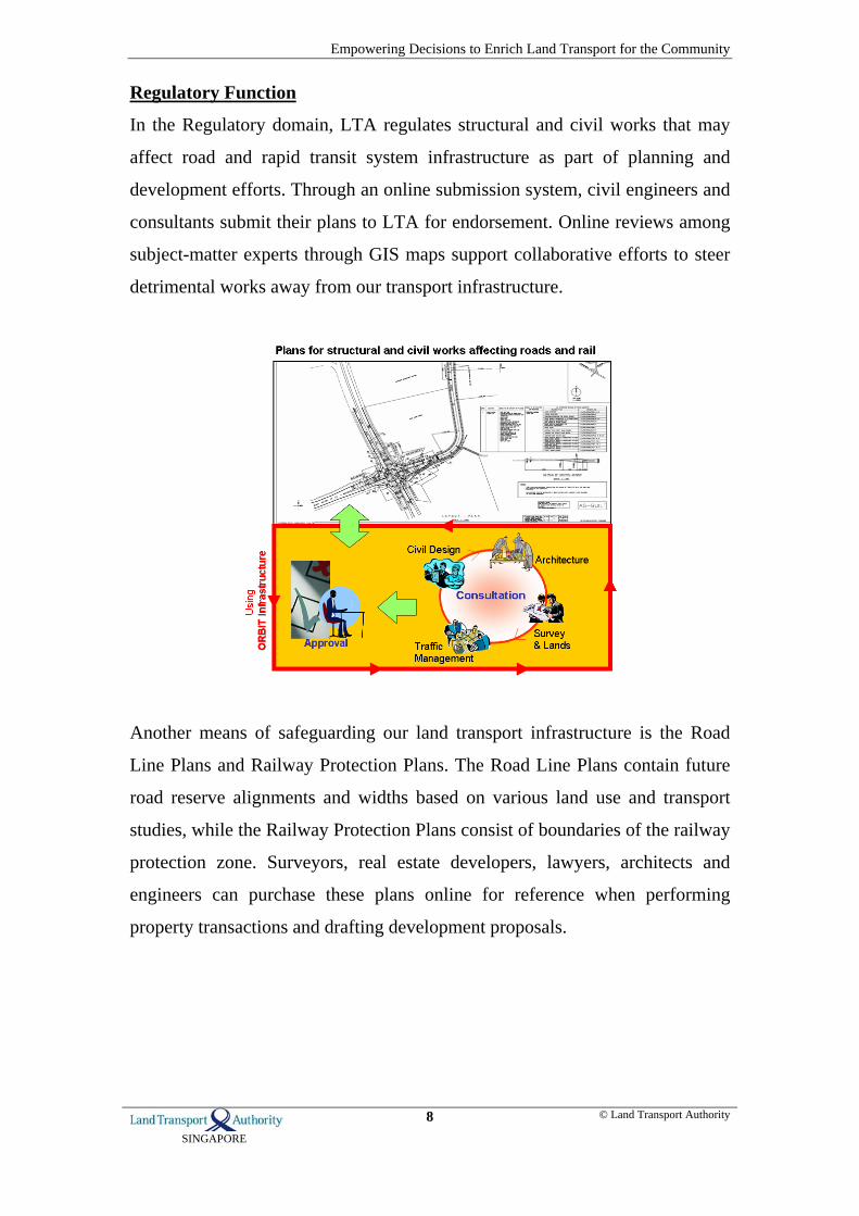
Regulatory Function
In the Regulatory domain, LTA regulates structural and civil works that may
affect road and rapid transit system infrastructure as part of planning and
development efforts. Through an online submission system, civil engineers and
consultants submit their plans to LTA for endorsement. Online reviews among
subject-matter experts through GIS maps support collaborative efforts to steer
detrimental works away from our transport infrastructure.
Another means of safeguarding our land transport infrastructure is the Road
Line Plans and Railway Protection Plans. The Road Line Plans contain future
road reserve alignments and widths based on various land use and transport
studies, while the Railway Protection Plans consist of boundaries of the railway
protection zone. Surveyors, real estate developers, lawyers, architects and
engineers can purchase these plans online for reference when performing
property transactions and drafting development proposals.

Empowering Decisions to Enrich Land Transport for the Community
SINGAPORE
9 © Land Transport Authority
Roads Management
In the Roads Management domain, LTA has spearheaded an inter-agency
system to coordinate road works so as to minimize disruption to road users.
Utility service agencies like telecommunication companies and utility providers
who need to carry out works such as laying of power cables and gas pipes, on
public streets or areas are required to apply for permits from the corresponding
government land-managing agencies. Through a one-stop portal –
LTA.PROMPT (Permit for Road Occupation Portal) – service agencies submit
their application for the road works permit.
LTA also uses GIS technology to plan the maintenance regime for the road
carriageways across Singapore. GIS maps help to visualise road carriageway
conditions captured by specialised vehicles. The road conditions are maintained
at an optimum level of roughness and skid resistance, minimal rate of
deformation, and within an allocated budget. With predictive forecasts on road
deterioration and structural life, road maintenance works are prioritised for
different treatment methods accordingly while optimising the use of the budget.

Empowering Decisions to Enrich Land Transport for the Community
SINGAPORE
10 © Land Transport Authority
Civil Engineering
LTA, being the main government agency for land transport developments in
Singapore, has over the years in the course of building land transport
infrastructure such as RTS lines and major expressway amassed a wealth of
information pertaining to the soil structures surrounding the structural
foundations of land transport infrastructure projects. The Civil Engineering
domain utilises GIS technology to capture borehole information for soil
analysis, planning of construction site excavation, foundation design and tunnel
alignment. To date, there are more than 8,000 borehole records captured.
Empowering Decisions to Enrich Land Transport for the Community
SINGAPORE
11 © Land Transport Authority
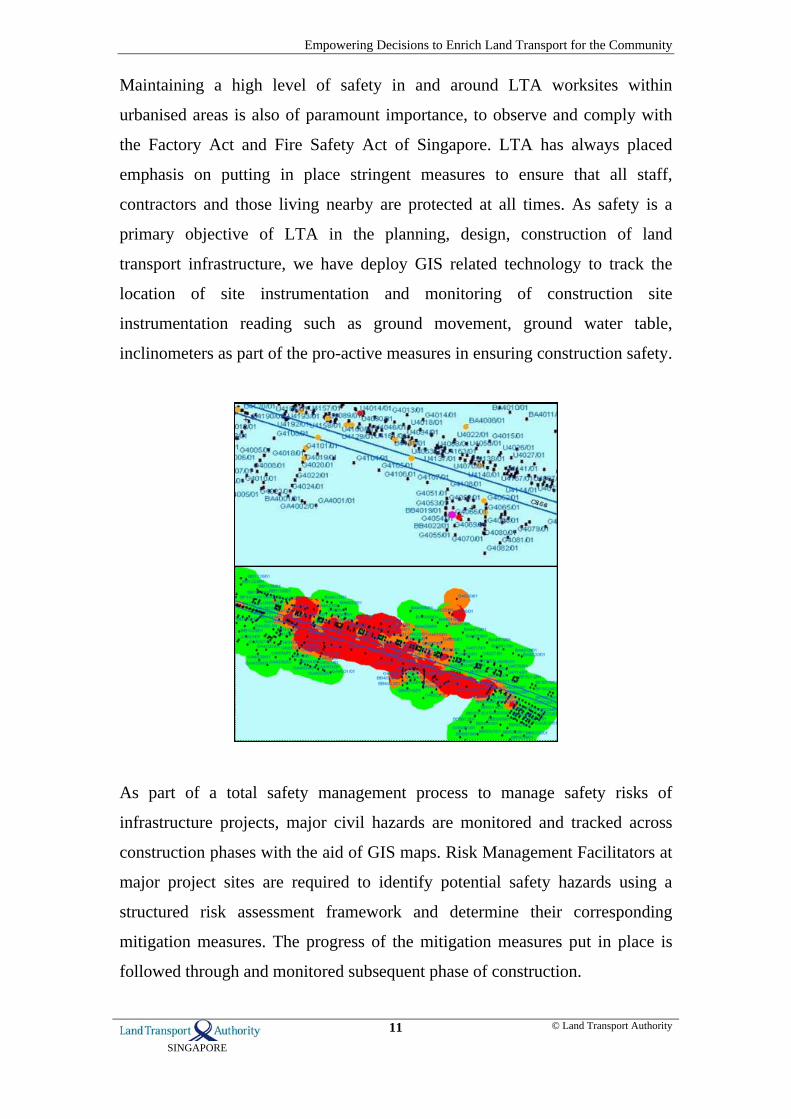
Maintaining a high level of safety in and around LTA worksites within
urbanised areas is also of paramount importance, to observe and comply with
the Factory Act and Fire Safety Act of Singapore. LTA has always placed
emphasis on putting in place stringent measures to ensure that all staff,
contractors and those living nearby are protected at all times. As safety is a
primary objective of LTA in the planning, design, construction of land
transport infrastructure, we have deploy GIS related technology to track the
location of site instrumentation and monitoring of construction site
instrumentation reading such as ground movement, ground water table,
inclinometers as part of the pro-active measures in ensuring construction safety.
As part of a total safety management process to manage safety risks of
infrastructure projects, major civil hazards are monitored and tracked across
construction phases with the aid of GIS maps. Risk Management Facilitators at
major project sites are required to identify potential safety hazards using a
structured risk assessment framework and determine their corresponding
mitigation measures. The progress of the mitigation measures put in place is
followed through and monitored subsequent phase of construction.
Empowering Decisions to Enrich Land Transport for the Community
SINGAPORE
12 © Land Transport Authority
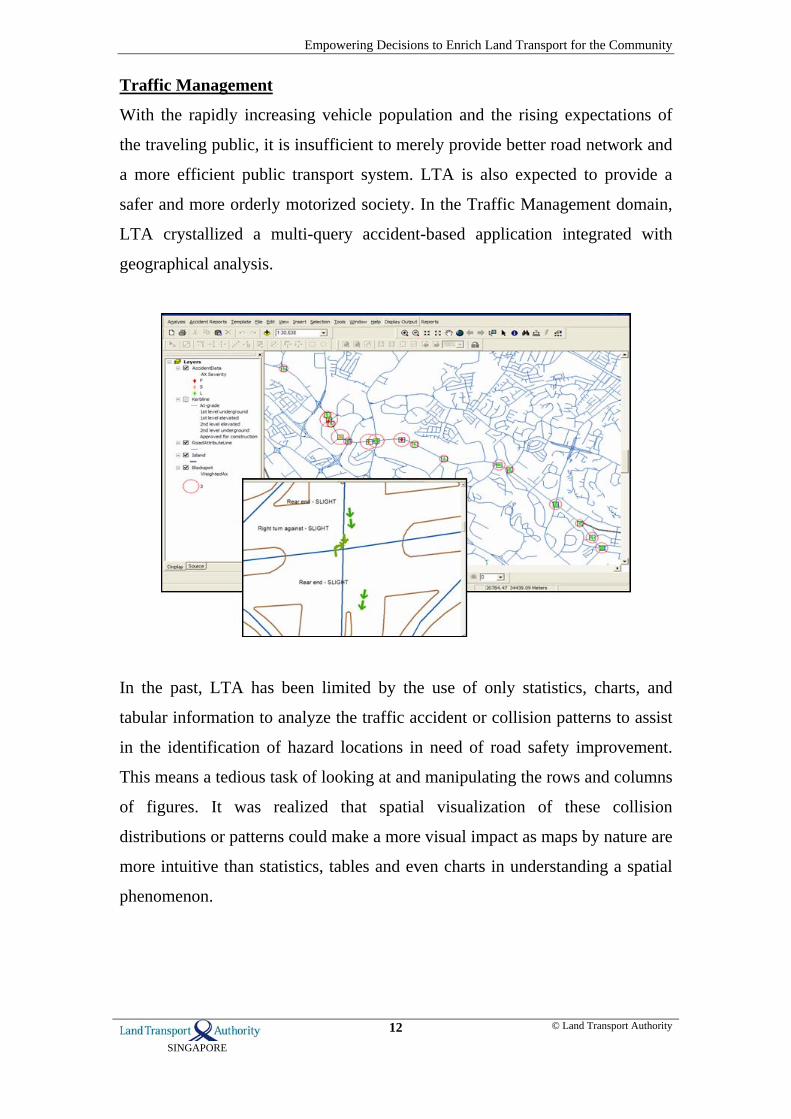
Traffic Management
With the rapidly increasing vehicle population and the rising expectations of
the traveling public, it is insufficient to merely provide better road network and
a more efficient public transport system. LTA is also expected to provide a
safer and more orderly motorized society. In the Traffic Management domain,
LTA crystallized a multi-query accident-based application integrated with
geographical analysis.
In the past, LTA has been limited by the use of only statistics, charts, and
tabular information to analyze the traffic accident or collision patterns to assist
in the identification of hazard locations in need of road safety improvement.
This means a tedious task of looking at and manipulating the rows and columns
of figures. It was realized that spatial visualization of these collision
distributions or patterns could make a more visual impact as maps by nature are
more intuitive than statistics, tables and even charts in understanding a spatial
phenomenon.

Empowering Decisions to Enrich Land Transport for the Community
SINGAPORE
13 © Land Transport Authority
Collaborating with the Singapore Traffic Police to capture traffic accident
information, traffic accident analysis makes use black spot analysis and
comparison grid analysis to identify accident-prone areas through geographical
visualisations leveraging on GIS technology, study the traffic scheme in that
area, and implement site treatments. This programme has yielded reduction in
accidents over a 2-year period in many troubled areas. This project has won the
prestigious Prince Michael International Safety Award 2007 for outstanding
achievements in its collaborative efforts in promoting road safety through
innovations in engineering and active public education.

Empowering Decisions to Enrich Land Transport for the Community
SINGAPORE
14 © Land Transport Authority
Other than ensuring road safety, LTA is also proactively disseminating
traffic-related information through our One.Motoring portal, an integrated
one-stop online site that house all motoring and road-related information in
Singapore and vehicle-related transactional e-Services. Leveraging on
Traffic.Smart, an intelligent traffic and incident management platform, LTA
broadcasts average travelling speed on major arterial roads and expressways
via an interactive GIS map. Accidents and road works are also indicated.
About One.Motoring
Launched in 2000, the ONE.MOTORING portal (www.onemotoring.com.sg) is an
indispensable online destination for the motor trade industry, vehicle owners, and the
general public in Singapore. With more than 8 million monthly page views, this
comprehensive information, service and community portal polled user satisfaction
ratings of 93% in 2008. It was also awarded the 2006 National Infocomm Award
(Merit), Singapore for the most innovative use of infocomm technology in the public
sector, among a number of international accolades and a Winner of the CIO Asia
Award in 2003.

Empowering Decisions to Enrich Land Transport for the Community
SINGAPORE
15 © Land Transport Authority
Benefits to Community
1. For Public – Safeguarding Public Safety
With regulatory functions, the structural integrity of land transport
infrastructure is protected against any constructional intrusion so that
community is safe using the roads and rapid transit systems. The geotechnical
instrumentation monitoring coupled with GIS technology further ensure that
the safety of all workers within LTA’s construction sites as well as the
community in the surrounding areas at all time by being proactive in
monitoring and minimising ground movement to protect the integrity of
structures and buildings in the vicinity. On the roads, motorists’ and
pedestrians’ safety is also protected by reducing the number of traffic accidents
at accident-prone areas using mitigating traffic schemes. As a result, traffic
accidents are reduced at treated traffic junctions by 66% and expressways by
90%.
2. For Road Users – Smoother Travelling Experience
With a more efficient and effective coordination of road works, disruptions to
traffic flow are minimised. Road carriageways are also proactively monitored
to prevent possible skidding during wet weathers. Corrective maintenance is
also in place to quickly resurface uneven road surfaces and localised sunken
road spots caused by unexpected geological conditions. Another way to
improve the travelling experience is to keep motorists abreast of average
travelling speed of vehicles along major arterial roads and expressways.
Motorists can plan their routes to side-step roads that are heavy-laden with
traffic or affected by road works and accidents.
3. For Businesses – Being Pro-Enterprise
With a no-wrong-door policy, the LTA.PROMPT portal provides a convenient
one-stop solution for applicants to seek approval for their road works from
multiple government agencies at the same time without making a single trip to
Empowering Decisions to Enrich Land Transport for the Community
SINGAPORE
16 © Land Transport Authority
the respective agencies affected. Applicants can query the status of their permit
applications online anytime anywhere. With this portal, applications are
processed within 2-3 weeks compared to 2-3 months previously. Plan approvals
for civil and structural works have also improved from 21 days to 10 days.
Civil engineers, consultants and private developers can also conveniently
acquire Road Line Plans and Railway Protection Plans instantaneously online
anytime anywhere compared to 10 days previously.
Implementation Challenges
1. Changing Mindsets
As LTA was formed through the merger of 4 public entities, we inherited many
legacy systems that function within individual department. Other than the need
to refresh obsolete technology, we need to change mindsets to move the
business users’ paradigms from department-based systems to cross-functional
systems to enterprise systems.
2. Managing Varying User Needs
Extensive business specific and business-unit specific processes had to be
streamlined to reduce duplication and these were done in close consultation
with process owners and key business users. Bringing together numerous
interest groups and negotiating to streamline their processes without losing
sight of their needs, was a mammoth task.
3. Lack of Standards and Governance Process
LTA has also inherited disparate data sets through the merger. They needed to
be standardised to migrate into a single repository for consistent interpretation
of the information. Moreover, the ownership of these data sets was unclear and
lack accountability. Data governance had to be enforced to establish
accountability and sanitise the data to maintain its quality and accuracy.

Empowering Decisions to Enrich Land Transport for the Community
SINGAPORE
17 © Land Transport Authority
The Future Years in GIS
Recently, the Ministry of Transport in conjunction with LTA completed a land
transport review to map out Singapore’s needs for land transport over the next
10-15 years. Our population has increased significantly in the intervening years
and become more diverse. Responding to this trend, the Rapid Transit System
(RTS) network will be doubled from 138km today to 278km so as to extend the
reach of the RTS to many more people and places. Additional roads will be
built to serve new developments and support economic growth as well.
However, we face increasing constraints in road building as Singapore becomes
more densely built up. GIS technology is the critical factor to more effective
and efficient decisions on land use for constructing the land transport
infrastructure.
Confronting a fast-paced development of land transport infrastructure and an
extensive use of intelligent traffic management technologies, LTA’s GIS
framework needs to be more agile and nimble to respond to changing business
needs. GIS will have to become a location-based service that business
applications can easily fuse geospatial content with geocentric business
processes and with other shared enterprise business services. With this
geospatial service-oriented architecture, it will also be easier to enable business
intelligence and analytics to extract strategic information across different
business platforms to make effective and timely business decisions.