engineering directive: e-21-002, pre-25% design scoping
TRANSCRIPT

ENGINEERING DIRECTIVE
Page 1 of 3
____________________________________ CHIEF ENGINEER
Pre-25% Design Scoping Procedure
General Guidance This Engineering Directive provides a procedure for refining the scope of a project approved by the Project Review Committee (PRC) and establishing the basis for a 25% design submission. This procedure shall apply to all municipal and state projects except for various location maintenance projects or as otherwise determined through consultation with the Deputy Chief Engineer for Project Development or his/her designee.
1. PRC approves the project. 1.1. Responsible section head assigns the Project Manager (PM). 1.2. Project Manager requests PARS Numbers. 1.3. Project Manager confirms purpose and need and evaluates need for Project Scoping
Meeting (PSM) and consults with the Deputy Chief Engineer for Project Development, if needed.
1.4. Project Manager notifies proponent to include PSM in design schedule, if needed. 2. Proponent issues the Design NTP or directs design advancement to begin within 24
months of PRC Approval and notifies MassDOT through the PM or local District office. 2.1. Proponent includes direction to develop schedule for participating in a Project Scoping
Meeting, performing data collection and conceptual design and conducting Over The Shoulder (OTS) Review within 6 months of Design NTP or direction to advance design.
3. Project Manager conducts the Project Scoping Meeting within 6 months of NTP or
design advancement using the Project Scoping Checklist (Attachment 2). Proceed to Step 4 if PSM not needed. 3.1. Create meeting invitation list using Attachment 1 as a guide. 3.2. Consult with District to identify meeting site. On-site meetings are preferred unless
conditions warrant a virtual site meeting using MaPIT or another digital tool. 3.3. Project Manager and/or Designer conducts overview of existing conditions. 3.4. Project Manager reviews Purpose and Need and Scope of Work as approved by PRC. 3.5. Identify any risks to pursuing scope as approved by the PRC. Examples include
underground utilities, limited right of way, environmental impacts. 3.6. Obtain input for cross section(s) to accommodate all users, project limits and project
scope; identify utility constraints, preliminary environmental permitting requirements, and design exceptions.
Number: E-21-002 Date: 03/31/21
Page 2 of 3
3.7. Determine data collection and conceptual analysis needs. Examples include draft design justification workbook, safety alternatives analysis, and typical section alternatives.
4. Designer performs data collection and develops conceptual design(s).
4.1. Data considerations: Utility survey, crash data, roadway safety audits, traffic counts, field survey and base plan, hydraulic analysis, borings, preliminary structures report, pavement test pits and cores, and other project data as required.
4.2. Design requirements: Consider public outreach meetings with local officials/general public/project abutters; perform early utility coordination; early environmental coordination; gather other data as needed. Develop conceptual (10% level) design(s) with critical cross sections, roll plan and preliminary profile views; preliminary Intersection Control Evaluation (ICE) Stage 2; prepare draft Design Justification Workbook identifying potential design exceptions; prepare preliminary project estimate; prepare design schedule using schedule template; prepare preliminary ROW impact summary; and provide preliminary construction staging using the default construction duration by project type.
5. Project Manager conducts the Pre-25% OTS Review to confirm the scope and cross section within 6 months of Design NTP (for municipal/state projects) or design advancement (for MassDOT in-house design). 5.1. Schedule meeting two weeks in advance using Attachment 1. Attach meeting material
to the meeting invitation to provide materials in advance of the meeting. 5.2. Project manager conducts OTS Review of Purpose and Need and scope as approved by
the PRC and the conceptual design(s) and analysis with the project team including all items identified in the Project Scoping Checklist (Attachment 2). In-person meetings are preferred on-site or in a District Office to confirm the scope, selection of preferred conceptual design, and resolve any remaining internal comments and public concerns.
5.3. Project manager documents the OTS Review and progress by summarizing the scoping meeting and OTS review.
6. Project Manager/Proponent schedules public outreach as needed within 3 months.
7. Project Manager evaluates the current scope of work and public feedback against the
PRC Approved Purpose and Need and Scope of Work. 7.1. If the scope has changed as defined in the DSC/PRC Resubmission Criteria below the
PM shall elevate the issue to the Office of the Chief Engineer through the Design Solutions Committee (DSC) for resolution in Step 8.
DSC/PRC Resubmission Criteria • The Project Contract Cost increases by an amount larger than the current contract
cost + design contingency: At the pre-25% Scoping Meeting, if an estimated contract cost is 10%
greater than the PRC estimated construction cost (including design contingency), the project scope will be reviewed.
Post pre-25%, if the estimated construction cost of any design submission or updated cost is 5% greater than the pre-25% estimated construction cost (including design contingency), the project scope must be confirmed by the DSC. If no pre-25% submission, then the baseline will be the PRC construction cost.
Page 3 of 3
• There is a change to the Project Scope or Project Limits that is outside of the original Purpose and Need of the project as approved at PRC, was not identified/approved during a Pre-25% Scoping Meeting or previous submission, or may cause a considerable delay to the schedule or deliverability of the project. Examples of project changes requiring review: A new design alternative is being recommended that was not previously
considered. The addition of new or expanded assets beyond the established project limits
or need. The project is combined with another project or split off from an existing
project. Modifications to the project scope or limits negatively impact project
deliverability or schedule. Examples include, but are not limited to: • New ROW impacts such as Article 97, 4f, 6f, cultural resources, rail
permits, new State or Local ROW, relocations, or additional survey work.
• New Environmental Permitting.
7.2. If the scope and public feedback align with the PRC Approved project, proceed to Step 10.
8. Design Solutions Committee (DSC) decides whether the design can proceed to the next
design stage (Step 10) or must be resubmitted to the Deputy Chief Engineer for Project Development for review and submission to PRC for further evaluation (Step 9).
9. Deputy Chief Engineer for Project Development reviews and submits project to PRC for further evaluation.
10. Project Manager proceeds to 25% Design by updating the Purpose and Need, documenting the scope, confirming the project description and amending initial design scope, if needed. 10.1. If the project description changes, the Project Manager coordinates with the
Advertising Program Manager to finalize the description and notify the District and Planning regarding the need to amend the project in the STIP if necessary.
10.2. Amend initial design scope based on above to include design through 25% Design Public Hearing or design completion depending on the project.
Attachments: Attachment 1 – Meeting Invite Chart Attachment 2 – Project Scoping Checklist
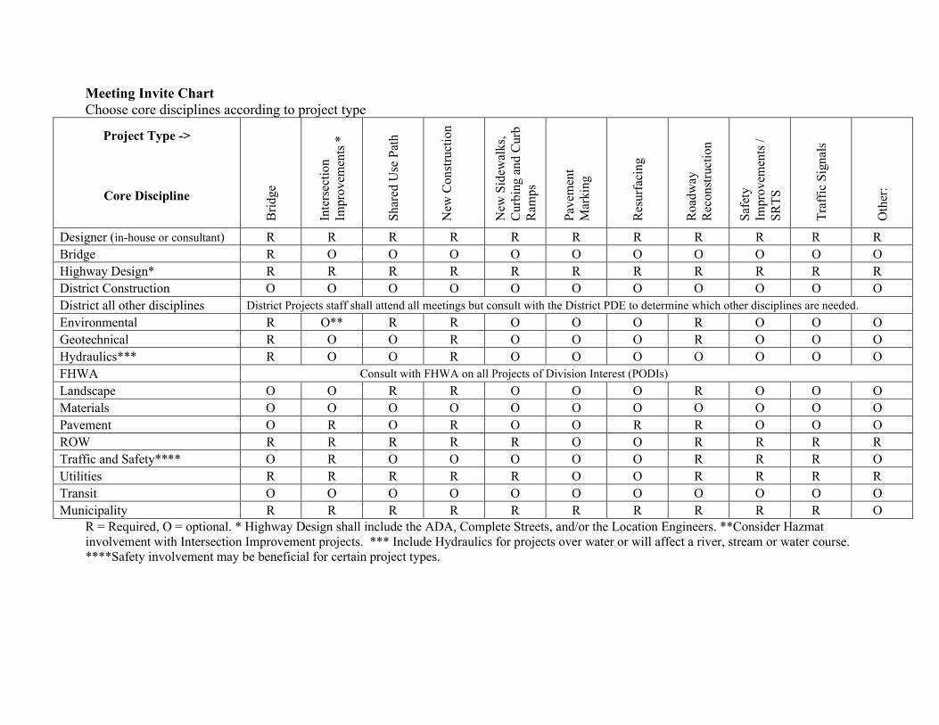
Meeting Invite Chart Choose core disciplines according to project type
Project Type ->
Core Discipline B
ridge
Inte
rsec
tion
Impr
ovem
ents
*
Shar
ed U
se P
ath
New
Con
stru
ctio
n N
ew S
idew
alks
, C
urbi
ng a
nd C
urb
Ram
ps
Pave
men
t M
arki
ng
Res
urfa
cing
Roa
dway
R
econ
stru
ctio
n
Safe
ty
Impr
ovem
ents
/ SR
TS
Traf
fic S
igna
ls
Oth
er:
Designer (in-house or consultant) R R R R R R R R R R R Bridge R O O O O O O O O O O Highway Design* R R R R R R R R R R R District Construction O O O O O O O O O O O District all other disciplines District Projects staff shall attend all meetings but consult with the District PDE to determine which other disciplines are needed. Environmental R O** R R O O O R O O O Geotechnical R O O R O O O R O O O Hydraulics*** R O O R O O O O O O O FHWA Consult with FHWA on all Projects of Division Interest (PODIs) Landscape O O R R O O O R O O O Materials O O O O O O O O O O O Pavement O R O R O O R R O O O ROW R R R R R O O R R R R Traffic and Safety**** O R O O O O O R R R O Utilities R R R R R O O R R R R Transit O O O O O O O O O O O Municipality R R R R R R R R R R O
R = Required, O = optional. * Highway Design shall include the ADA, Complete Streets, and/or the Location Engineers. **Consider Hazmat involvement with Intersection Improvement projects. *** Include Hydraulics for projects over water or will affect a river, stream or water course. ****Safety involvement may be beneficial for certain project types.
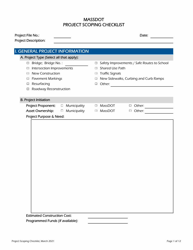
Project File No.: Date:
Project Description:
Other:
Project Proponent: Municipality MassDOT Other:
Asset Ownership: Municipality MassDOT Other:
Project Purpose & Need:
Estimated Construction Cost:
Programmed Funds (if available):
PROJECT SCOPING CHECKLIST
New Sidewalks, Curbing and Curb Ramps
Resurfacing
Roadway Reconstruction
MASSDOT
I. GENERAL PROJECT INFORMATION
B. Project Initiation
A. Project Type (Select all that apply):
Bridge; Bridge No. : Safety Improvements / Safe Routes to School
Intersection Improvements Shared Use Path
New Construction Traffic Signals
Pavement Markings
Project Scoping Checklist, March 2021 Page 1 of 12

Candidate for Preservation
If not Preservation; Substructure elements are worthy of analysis for re-use
Candidate for Superstructure Replacement
Candidate for Full Replacement
Comments:
Preliminary Structures Report (Check box if project to retain any portion of exist. structure)
Boring / Probe Layout Plan
Geotechnical Report
Hydraulic Report: Designer to Prepare MassDOT to Prepare
Bridge Type Selection Worksheet
Sketch Plans
Additional Studies:
Bridge is over Railroad (indicate the Line; Segment; MP in Comments)
If over Railroad, is this a Chapter 634 Bridge?
Increase Channel Width for Hydraulic or Environmental Purposes
Required Min. Horizontal Clearance for Bridge not over Railroad
Required Min. Horizontal Clearance for Bridge over Railroad, not Chapter 634
Required Min. Vertical Clearance for Bridge not over Railroad
Required Min. Vertical Clearance for Bridge over Railroad, not Chapter 634
For Horizontal Clearance: Specify in comments the clearance from what Controlling Element.
The Controlling Element may be face of abutment or pier; edge of travelled way, etc.
For Vertical Clearance: Specify in comments the clearance from what Controlling Element.
The Controlling Element may be roadway shoulder; top of rail; design year flood; etc.
Comments:
Describe Bridge Geometry (indicate Span Length; Skew: Structure Depth; etc.)
B. Bridge Studies, Analysis & Reports Required
C. Determine Required Bridge Clearance and Bridge Geometry
II. BRIDGE SCOPING CHECKLISTA. Examine Potential Bridge Project Types
Project Scoping Checklist, March 2021 Page 2 of 12
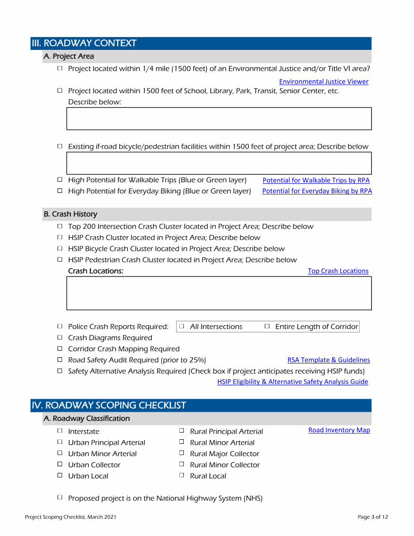
Project located within 1/4 mile (1500 feet) of an Environmental Justice and/or Title VI area?
Project located within 1500 feet of School, Library, Park, Transit, Senior Center, etc.
Describe below:
Existing if-road bicycle/pedestrian facilities within 1500 feet of project area; Describe below
High Potential for Walkable Trips (Blue or Green layer)
High Potential for Everyday Biking (Blue or Green layer)
Top 200 Intersection Crash Cluster located in Project Area; Describe below
HSIP Crash Cluster located in Project Area; Describe below
HSIP Bicycle Crash Cluster located in Project Area; Describe below
HSIP Pedestrian Crash Cluster located in Project Area; Describe below
Crash Locations:
Police Crash Reports Required: All Intersections Entire Length of Corridor
Crash Diagrams Required
Corridor Crash Mapping Required
Road Safety Audit Required (prior to 25%)
Safety Alternative Analysis Required (Check box if project anticipates receiving HSIP funds)
Interstate Rural Principal Arterial
Urban Principal Arterial Rural Minor Arterial
Urban Minor Arterial Rural Major Collector
Urban Collector Rural Minor Collector
Urban Local Rural Local
Proposed project is on the National Highway System (NHS)
IV. ROADWAY SCOPING CHECKLISTA. Roadway Classification
III. ROADWAY CONTEXTA. Project Area
B. Crash History
Road Inventory Map
Environmental Justice Viewer
Potential for Walkable Trips by RPAPotential for Everyday Biking by RPA
Top Crash Locations
RSA Template & Guidelines
HSIP Eligibility & Alternative Safety Analysis Guide
Project Scoping Checklist, March 2021 Page 3 of 12

Annual Daily Traffic (ADT) Daily Bicycle Volume
Percent Truck Traffic Daily Pedestrian Volume
Posted (or Statutory) Speed Limit
Measured Free Flow Speed (if available)
Project area is candidate for Motor Vehicle and/or Multimodal Safety Countermeasures;Including Traffic Calming, Road Diet and other Safety Measures
Target Design Speed
Comments:
Candidate for Shared-Use Path, Side Path, Separated Bike Lane or Buffered Bike Lane
Width of Existing Right-of-Way Layout
Number of Travel Lanes
Width of Travel Lanes
Width of Turning Lanes
Width of Shoulders
Width of On-Road Bicycle Facility, include buffer
Width of Shared-Use Path (note 1 side or both)
Width of Separated Bike Lane (note 1 side or both)
Width of Roadway Buffer
Width of Sidewalk*, include curb (note 1 side or both)
Width of On-Street Parking (note 1 side or both)
Width of Median
Width of Bus Stops**
*Less than 5.5' Sidewalk Width, including curb, requires waiver
**Confirm proposed bus stop width with transit agency; 8.5' Min., including curb, for MBTA
B. Existing Volumes
C. Existing Speeds
Existing: Proposed:
E. Determine Proposed Roadway Cross -Section
D. Determine Target Design Speed
E-20-001
Project Scoping Checklist, March 2021 Page 4 of 12

Existing Profile appears to meet design standards (verify during preliminary design)
Existing Sidewalks, Curb Ramps and Driveways appear ADA/AAB CompliantMaintain / Optimize Existing Profile
Improve Profile; Consider Min. Vertical Clearance, Stormwater Low Points and Flood Resiliency
Comments:
Existing Alignment appears to meet design standards (verify during preliminary design)Maintain / Optimize Existing Alignment
Improve Alignment
Comments:
Describe Limits with proximity to nearest feature, intersection, mile marker, town line, address, etc.
Begin Project:
For Bridge: Feet beyond Abutment in this direction:
End Project
For Bridge: Feet beyond Abutment in this direction:
Comments:
H. Determine Project Limits
F. Determine Roadway Profile
G. Determine Horizontal Alignment
Project Scoping Checklist, March 2021 Page 5 of 12

Ultra Thin Bond, Microsurfacing, Fog Seal, Chip Seal, Waterproof Surface Course, etc.
Mill & Overlay (Functional or Structural)
Hot/Cold in Place Recycling
Reclamation
Full Depth Reconstruction
New Construction
Other:
No Proposed Improvement
Address Accessible Ramps and Missing Crosswalks at Intersection(s)
Address Drainage Issues
Address Existing Traffic Signals within Project LimitsAddress Existing Bridge(s) within Project Limits (Plans Required)
Address Existing Culvert ConditionAddress Guardrail / Barrier
Address Lighting
Address Trees within Right-of-Way Layout
Address MassDOT ITS, Weather Sensors, VMS, Counting StationsOther; Describe below
Candidate for Full Road Closure and Detour; Describe possible detour route in Comments
Candidate for Accelerated Construction TechniquesCandidate for Stage Construction
Candidate for Alternative One-Way TrafficCandidate for Night Work
Potential Construction Lay Down Area; Describe in CommentsPotential for buried man-made objects / unidentified hazardous waste present
Potential for unexpected geotechnical or groundwater issues present
Seasonal or time restrictions required during construction
Project overlaps and/or adjacent to another project scope and/or schedule
Comments:
I. Proposed Pavement Treatment
J. Other Roadway Design Issues
V. CONSTRUCTABILITY
Estimated Culvert & Bridge Vulnerability
Project Scoping Checklist, March 2021 Page 6 of 12
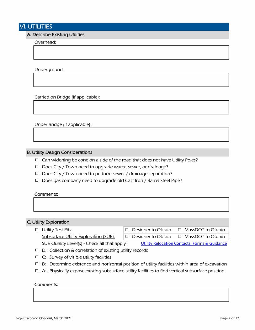
Overhead:
Underground:
Carried on Bridge (if applicable):
Under Bridge (if applicable):
Can widening be cone on a side of the road that does not have Utility Poles?
Does City / Town need to upgrade water, sewer, or drainage?
Does City / Town need to perform sewer / drainage separation?
Does gas company need to upgrade old Cast Iron / Barrel Steel Pipe?
Comments:
Utility Test Pits: Designer to Obtain MassDOT to Obtain
Subsurface Utility Exploration (SUE): Designer to Obtain MassDOT to Obtain
SUE Quality Level(s) - Check all that apply
D: Collection & correlation of existing utility records
C: Survey of visible utility facilities
B: Determine existence and horizontal position of utility facilities within area of excavation
A: Physically expose existing subsurface utility facilities to find vertical subsurface position
Comments:
C. Utility Exploration
VI. UTILITIESA. Describe Existing Utilities
B. Utility Design Considerations
Utility Relocation Contacts, Forms & Guidance
Project Scoping Checklist, March 2021 Page 7 of 12
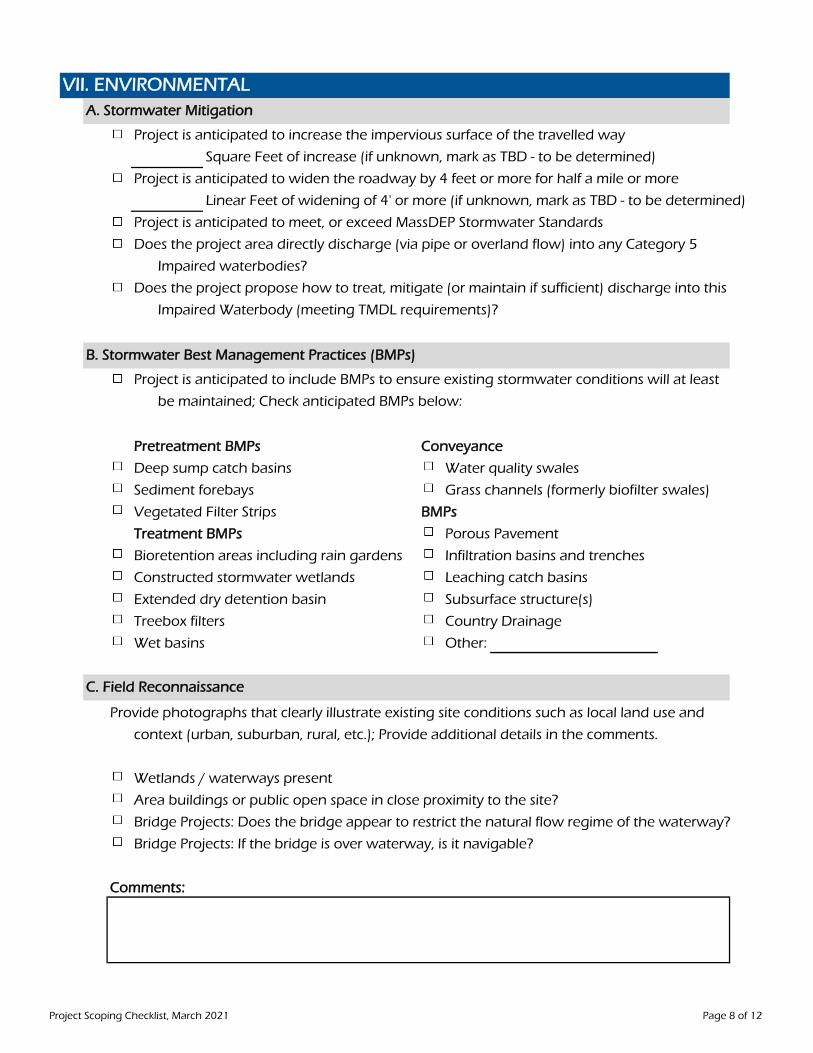
Project is anticipated to increase the impervious surface of the travelled way
Square Feet of increase (if unknown, mark as TBD - to be determined)
Project is anticipated to widen the roadway by 4 feet or more for half a mile or more
Linear Feet of widening of 4' or more (if unknown, mark as TBD - to be determined)
Project is anticipated to meet, or exceed MassDEP Stormwater Standards
Does the project area directly discharge (via pipe or overland flow) into any Category 5
Impaired waterbodies?
Does the project propose how to treat, mitigate (or maintain if sufficient) discharge into this
Impaired Waterbody (meeting TMDL requirements)?
Project is anticipated to include BMPs to ensure existing stormwater conditions will at least
be maintained; Check anticipated BMPs below:
Pretreatment BMPs Conveyance
Deep sump catch basins Water quality swales
Sediment forebays Grass channels (formerly biofilter swales)
Vegetated Filter Strips BMPs
Treatment BMPs Porous Pavement
Bioretention areas including rain gardens Infiltration basins and trenches
Constructed stormwater wetlands Leaching catch basins
Extended dry detention basin Subsurface structure(s)
Treebox filters Country Drainage
Wet basins Other:
Provide photographs that clearly illustrate existing site conditions such as local land use and
context (urban, suburban, rural, etc.); Provide additional details in the comments.
Wetlands / waterways present
Area buildings or public open space in close proximity to the site?
Bridge Projects: Does the bridge appear to restrict the natural flow regime of the waterway?
Bridge Projects: If the bridge is over waterway, is it navigable?
Comments:
VII. ENVIRONMENTALA. Stormwater Mitigation
B. Stormwater Best Management Practices (BMPs)
C. Field Reconnaissance
Project Scoping Checklist, March 2021 Page 8 of 12

Early Environmental Checklist
Bridge Project: Determine Nat'l Register of Historic Places status of structure - Eligible or Listed
Potential Permits / License required:
Chapter 91 Public Waterfront Act Section 106 - National Historic Preservation
Coastal Zone Management Act U.S. Army Corps of Engineers - Section 404
MA Wetlands Protection Act U.S. Coast Guard - Section 9 Rivers and Harbors
NEPA / MEPA Water Quality Certification - Section 401
NPDES - Section 402 Clean Water Act Wild and Scenic Rivers Act
Section 4(f) and/or 6(f) if the DOT Act MA Coastal Flood Risk Model (MC-FRM)
Section 10 Rivers and Harbors Unknown, to be determined
Other:
Comments:
Easements, Takings or Alterations anticipated to be requiredResponsibility: Municipality MassDOT Other:
Potential Article 97; Describe below
Easements, Permits or Licenses from DCR, Fisheries & Wildlife, MBTA or MWRA; Describe below
Impact to Railroad or Public Utility Corridor; Describe below
Comments:
D. Environmental Studies, Permits & Reports Required
VIII. RIGHT-OF-WAY
Consider potential impacts to Conservation Land, Open Space including Public Parks & Monuments, Public Reservations, Public Athletic fields, Public Concert area, Municipal commons and Public Playgrounds. Consider impacts to Public watershed properties, Fish & Wildlife property, DCR property, properties having an Agricultural Restriction or Conservation Restriction.
Right of Way Manual
Project Scoping Checklist, March 2021 Page 9 of 12
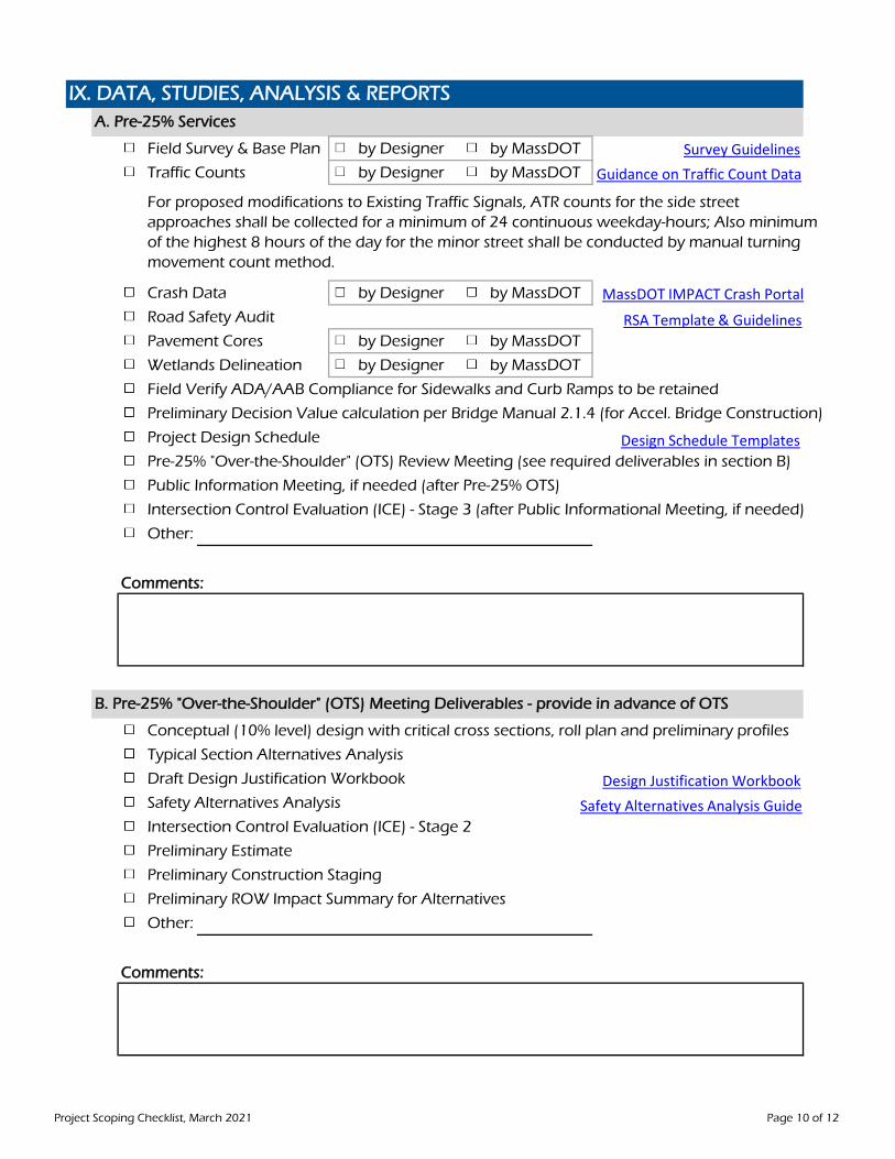
Field Survey & Base Plan by Designer by MassDOT
Traffic Counts by Designer by MassDOT
Crash Data by Designer by MassDOT
Road Safety Audit
Pavement Cores by Designer by MassDOT
Wetlands Delineation by Designer by MassDOT
Field Verify ADA/AAB Compliance for Sidewalks and Curb Ramps to be retained
Preliminary Decision Value calculation per Bridge Manual 2.1.4 (for Accel. Bridge Construction)
Project Design Schedule
Pre-25% "Over-the-Shoulder" (OTS) Review Meeting (see required deliverables in section B)
Public Information Meeting, if needed (after Pre-25% OTS)
Intersection Control Evaluation (ICE) - Stage 3 (after Public Informational Meeting, if needed)
Other:
Comments:
Conceptual (10% level) design with critical cross sections, roll plan and preliminary profiles
Typical Section Alternatives Analysis
Draft Design Justification Workbook
Safety Alternatives Analysis
Intersection Control Evaluation (ICE) - Stage 2
Preliminary Estimate
Preliminary Construction Staging
Preliminary ROW Impact Summary for Alternatives
Other:
Comments:
IX. DATA, STUDIES, ANALYSIS & REPORTS A. Pre-25% Services
For proposed modifications to Existing Traffic Signals, ATR counts for the side street approaches shall be collected for a minimum of 24 continuous weekday-hours; Also minimum of the highest 8 hours of the day for the minor street shall be conducted by manual turning movement count method.
B. Pre-25% "Over-the-Shoulder" (OTS) Meeting Deliverables - provide in advance of OTS
Survey GuidelinesGuidance on Traffic Count Data
MassDOT IMPACT Crash Portal
RSA Template & Guidelines
Design Schedule Templates
Design Justification WorkbookSafety Alternatives Analysis Guide
Project Scoping Checklist, March 2021 Page 10 of 12
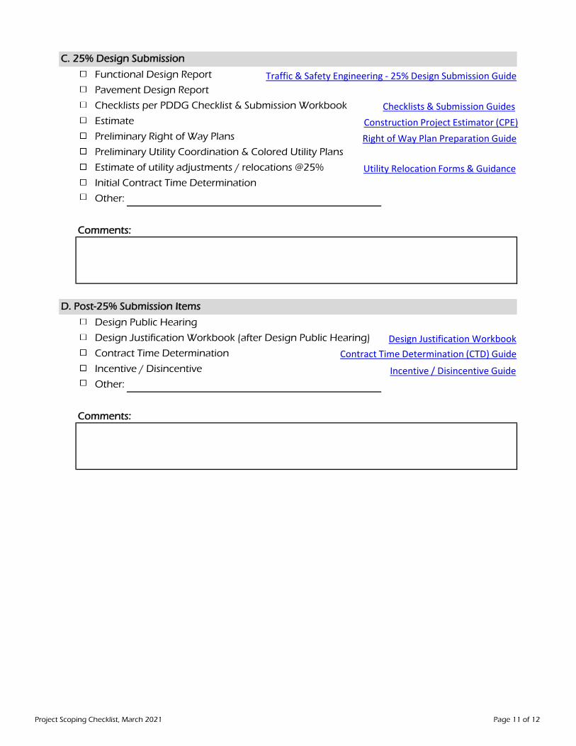
Functional Design Report
Pavement Design Report
Checklists per PDDG Checklist & Submission Workbook
Estimate
Preliminary Right of Way Plans
Preliminary Utility Coordination & Colored Utility Plans
Estimate of utility adjustments / relocations @25%
Initial Contract Time Determination
Other:
Comments:
Design Public Hearing
Design Justification Workbook (after Design Public Hearing)
Contract Time Determination
Incentive / Disincentive
Other:
Comments:
C. 25% Design Submission
D. Post-25% Submission Items
Traffic & Safety Engineering - 25% Design Submission Guide
Checklists & Submission GuidesConstruction Project Estimator (CPE)Right of Way Plan Preparation Guide
Contract Time Determination (CTD) Guide
Utility Relocation Forms & Guidance
Incentive / Disincentive Guide
Design Justification Workbook
Project Scoping Checklist, March 2021 Page 11 of 12
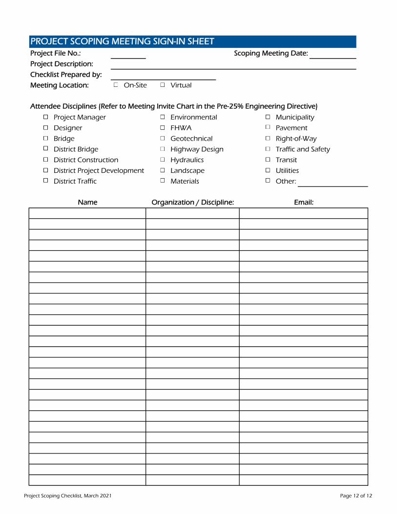
Project File No.: Scoping Meeting Date:
Project Description:
Checklist Prepared by:
Meeting Location: On-Site Virtual
Project Manager Environmental Municipality
Designer FHWA Pavement
Bridge Geotechnical Right-of-Way
District Bridge Highway Design Traffic and Safety
District Construction Hydraulics Transit
District Project Development Landscape Utilities
District Traffic Materials Other:
Name Organization / Discipline: Email:
Attendee Disciplines (Refer to Meeting Invite Chart in the Pre-25% Engineering Directive)
PROJECT SCOPING MEETING SIGN-IN SHEET
Project Scoping Checklist, March 2021 Page 12 of 12