engineering geodesy for integrative computational …...schluss wird auf die bedeutung der...
TRANSCRIPT

SummaryWithin the framework of the strategy of excellence of the German Research Foundation (DFG), the University of Stutt-gart was successful with two clusters of excellence. For one of these clusters, the cluster “Integrative Computational Design and Construction for Architecture” (IntCDC), geode-sy plays a major role. “The vision of this Cluster of Excel-lence is to harness the full potential of digital technologies to rethink design and construction based on integration and interdisciplinarity, with the goal of enabling game-changing innovation in the building sector. The Cluster aims to lay the methodological foundations to profoundly modernise the design and building process and related building systems by adopting a systematic, holistic and integrative computation-al approach. One key objective is to develop an overarching methodology of “co-designing” methods, processes and sys-tems based on interdisciplinary research encompassing archi-tecture, structural engineering, building physics, engineering geodesy, manufacturing and systems engineering, computer science and robotics, humanities and social sciences (Menges 2018a).” At first, this contribution will present the general aims of the cluster. Subsequently, the importance of geome-try, and therefore engineering geodesy, for construction will be outlined. This will be illustrated on the basis of IntCDC and a joint project. Based hereupon, processes and research activities within IntCDC will be presented that require geo- metric information and show potential to integrate engineer-ing geodesy.
ZusammenfassungIm Rahmen der Exzellenzstrategie der DFG war die Universi-tät Stuttgart mit zwei Exzellenzclustern erfolgreich. Für eines der Cluster, das Vorhaben „Integrative Computational De-sign and Construction for Architecture“ (IntCDC, Integriertes computerbasiertes Entwerfen und Bauen für die Architektur), spielt die Geodäsie eine wichtige Rolle. „Das Exzellenzcluster soll das volle Potenzial digitaler Technologien nutzen, um das Planen und Bauen in einem integrativen und interdisziplinären Ansatz neu zu denken und damit wegweisende Innovationen für das Bauschaffen zu ermöglichen. Eine zentrale Zielsetzung des Forschungsvorhabens ist die Entwicklung einer übergeord-neten Methodologie des „Co-Design“ von Methoden, Prozes-sen und Systemen, basierend auf interdisziplinärer Forschung zwischen den Bereichen Architektur, Bauingenieurwesen, Ingenieurgeodäsie, Produktions- und Systemtechnik, Infor-matik und Robotik sowie Geistes- und Sozialwissenschaften. (Menges 2018a).“ In diesem Beitrag wird zunächst die gene-relle Zielsetzung des Forschungsvorhabens vorgestellt. Im An-schluss wird auf die Bedeutung der Geometrie, und damit auch der Ingenieurgeodäsie, für das Bauen allgemein eingegangen.
Dies wird anhand von IntCDC und einem gemeinsamen Pro-jekt illustriert. Darauf aufbauend werden beispielhaft Prozesse und Forschungsarbeiten innerhalb von IntCDC, die geometri-sche Informationen benötigen, dargestellt und die potenzielle Integration der Ingenieurgeodäsie wird aufgezeigt.
Keywords: Engineering geodesy, architecture, computational construction, co-design assembly process
1 Introduction
Traditionally, work on the construction site is carried out manually; building design is provided in an analogue way, and the building process steps are documented in the same way. Building Information Modelling (BIM), some-times called Building Information Management, bridges the way towards a complete digital multifunctional mod-el for all crafts active during design, construction and for the whole life-cycle of a building. In principle, this digitalization provides a digital twin of the building thus enabling simulation and feedback during the design and construction phase.
In general, current process models distinguish design and building as independent, sequential steps. These pro-cess models do not consider feedback from building to design. This was the reason that the University of Stutt-gart was successful with the cluster “Integrative Com-putational Design and Construction for Architecture” (IntCDC) within the strategy of excellence of the German Research Foundation (DFG). Within IntCDC, even a feed-back from the construction phase of a currently realized building to the design phase of the currently realized and future buildings is of central importance. These feedback loops will be investigated, developed, implemented and evaluated. Even the parallel development or optimization of new construction systems, methods and processes is within the focus of the Cluster of excellence. This leads to the central aspect co-design of systems, methods and processes.
Another component of digitalization of design and construction is the automation of manufacturing or fab-rication and assembly processes. Here, geodesy and es-pecially engineering geodesy is involved by delivering geometry at different stages: before and during design, before start of construction, transfer of design into reality (stake out), monitoring during and after the construction phase, sometimes even the monitoring through the whole life-cycle of the building.
Engineering Geodesy for Integrative Computational Design and Construction
Volker Schwieger, Achim Menges, Li Zhang and Tobias Schwinn
DOI 10.12902/zfv-0272-2019 223144. Jg. 4/2019 zfv© Wißner-Verlag
FachbeitragSchwieger et al., Engineering Geodesy for Integrative Computational Design …

In this article, the focus is on the stake-out process in connection with the assembly of pre-fabricated compo-nents on the construction site. Any construction needs a stake-out process to transfer the geometry of the de-signed building or structure into reality. The building and assembly process carried out by a civil engineer is sepa-rated from the stake-out realized by a geodetic engineer. Form construction below ground, e. g. traffic route engi-neering current research and practice, already includes a joint stake-out and assembly process e. g. for paving concrete by slipform pavers. Another example is the tun-nel boring, where the tunnel boring machine is directly steered by the geometric quantities given by design. The geodetic engineer is responsible for the geometric control of the machine (position and orientation). For construc-tion above ground, e. g. multi-storey buildings or even high-rise towers, a joint stake-out and assembly process does not exist up to now. A pre-condition for the joint process is the automation of geodetic instruments that has existed for more than a decade (Möhlenbrink and Schwieger 2007, Kutterer 2019). Examples for the auto-mated processes, e. g. for bringing up walls, were pre-sented decades ago but did not come into practice. In the Cluster of Excellence, there are new pre-fabrication and assembly processes that are not driven by current manual work construction process descriptions (e. g. REFA 1978) but by the quality requirements of new designs, systems, materials and methods.
2 The Cluster of Excellence IntCDC
2.1 Research Relevance and General Objectives
The relevance and the objective and aims of IntCDC can be best understood following the text of the proposal directed to the German Research Foundation (DFG). In this article all passage in quotation marks are taken from Menges (2018a) or Menges (2018b).
The relevance is highlighted by the importance of ar-chitecture for society. “Architecture is of central ecolog-ical, economic, social and cultural relevance. Humans spend 87 % of their lives in buildings. The building in-dustry consumes more than 40 % of global resources and energy, and the demand for space keeps increasing dra-matically: over the next 35 years, urban buildings for an additional 2.6 billion people need to be constructed. In German cities alone, 400,000 new residential units and related commercial and public buildings are required every year. Yet, the productivity of the building industry has been stagnating for decades. The detrimental envi-ronmental impact and lack of productivity coupled with the multifaceted relevance of architecture clearly indi-cate that we urgently need new approaches to design and construction. Digital technologies make it possible to ad-dress these challenges in novel ways (Menges 2018a).”
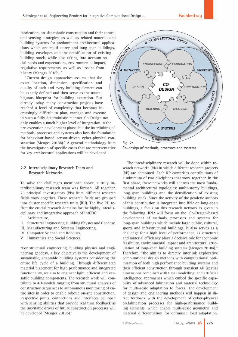
“The Cluster aims to lay the methodological founda-tions to profoundly modernise the design and building process and related building systems by adopting a sys-tematic, holistic and integrative computational approach (Menges 2018a).” This means that the cluster will over-come the sequential way in a digital chain by a digital feedback system (Fig. 1). One key objective “is to develop an overarching methodology of “co-designing” methods, processes and systems (Fig. 2) based on interdisciplinary research encompassing architecture, structural engineer-ing, building physics, engineering geodesy, manufactur-ing and systems engineering, computer science and ro-botics, humanities and social sciences (Menges 2018a).” Co-Design is also understood to include Co-Optimisa-tion. The development of Co-Design as a powerful fun-damental methodology that operates at the intersection of these Research Areas with the goal of facilitating their joint advancement is the most challenging target of the Cluster. “Our definition of Co-Design is the concurrent and feedback-driven development of generative meth-ods for exploration, analytical methods for optimisation, monitoring methods for capturing actual behaviour and performance, cyber-physical processes of off-site digital
Fig. 1: From digital chain to digital feedback
Menges
2018
b
224 zfv 4/2019 144. Jg. © Wißner-Verlag
Fachbeitrag Schwieger et al., Engineering Geodesy for Integrative Computational Design …
fabrication, on-site robotic construction and their control and sensing strategies, as well as related material and building systems for predominant architectural applica-tions which are multi-storey and long-span buildings, building envelopes and the densification of existing building stock, while also taking into account so-cial needs and expectations, environmental impact, regulative requirements, as well as lessons from history (Menges 2018b).”
“Current design approaches assume that the exact location, dimension, specification and quality of each and every building element can be exactly defined and then serve as the unam-biguous blueprint for building execution. But already today, many construction projects have reached a level of complexity that becomes in-creasingly difficult to plan, manage and execute in such a fully deterministic manner. Co-Design not only enables a much higher level of integration in the pre-execution development phase, but the interlinking of methods, processes and systems also lays the foundation for behaviour-based, sensor-driven, cyber-physical con-struction (Menges 2018b).” A general methodology from the investigation of specific cases that are representative for key architectural applications will be developed.
2.2 Interdisciplinary Research Team and Research Networks
To solve the challenges mentioned above, a truly in-terdisciplinary research team was formed. All together, 23 principal investigators (PIs) from different research fields work together. These research fields are grouped into cluster specific research units (RU). The five RU re-flect the crucial research domains for the highly interdis-ciplinary and integrative approach of IntCDC:I. Architecture,II. Structural Engineering, Building Physics and Geodesy,III. Manufacturing and Systems Engineering,IV. Computer Science and Robotics,V. Humanities and Social Sciences.
“For structural engineering, building physics and engi-neering geodesy, a key objective is the development of sustainable, adaptable building systems considering the entire life cycle of a building. Through differentiated material placement for high performance and integrated functionality, we aim to engineer light, efficient and ver-satile building components. The research work will con-tribute to 4D-models ranging from structural analysis of construction sequences to autonomous monitoring of en-tire sites in order to enable robotic on-site construction. Respective joints, connections and interfaces equipped with sensing abilities that provide real time feedback as the inevitable driver of future construction processes will be developed (Menges 2018b).”
The interdisciplinary research will be done within re-search networks (RN) in which different research projects (RP) are combined. Each RP comprises contributions of a minimum of two disciplines that work together. In the first phase, these networks will address the most funda-mental architectural typologies: multi-storey buildings, long-span buildings and the densification of existing building stock. Since the activity of the geodetic authors of this contribution is integrated into RN2 on long-span buildings, a focus on this research network is given in the following. RN2 will focus on the “Co-Design-based development of methods, processes and systems for long-span buildings which include large public, cultural, sports and infrastructural buildings. It also serves as a challenge for a high level of performance, as structural and material efficiency plays a decisive role for economic feasibility, environmental impact and architectural artic-ulation of long-span building systems (Menges 2018a).” Therefore, “the aim is to directly interlink explorative computational design methods with computational opti-misation of both high performance building systems and their efficient construction through transient 4D (spatial dimensions combined with time) modelling, and artificial intelligence approaches which embed the specific capa-bility of advanced fabrication and material technology for multi-scale adaptation to forces. The development of design and engineering methods will happen in di-rect feedback with the development of cyber-physical prefabrication processes for high-performance build-ing elements, which enable multi-scale geometric and material differentiation for optimised load adaptation.
Fig. 2: Co-design of methods, processes and systems
Menge
s 201
8b
225144. Jg. 4/2019 zfv© Wißner-Verlag
FachbeitragSchwieger et al., Engineering Geodesy for Integrative Computational Design …
Within one collaborative off-site and on-site cyber-phys-ical construction system, the prefabrication will be com-bined with on-site large-scale robotic processes for the construction of long-span building structures or the ro-botic assembly of prefabricated building elements. For long-span applications, efficient on-site construction poses a particular challenge. Thus, we will develop mon-itoring, sensing and machine control approaches, which in concert with the aforementioned continuous 4D me-chanical modelling of the construction process allow for the reduction of typically required scaffolding or tempo-rary support structures, as changing structural conditions and related deflections can be seamlessly compensated for. They lay the foundation for our study of semi-au-tonomous to fully autonomous long-span construction processes (Menges 2018b).”
3 Importance of Geometry within the Construction Process
3.1 General Ideas
As already indicated in chapter two, geometry is one of the important issues within the cluster IntCDC. Geometry may be regarded as the central element for digitalization of construction, since the other disciplines all refer to geometry. Naturally, beside geometry as e. g. coordinates, distances or squareness there are different important cri-teria thus as load capacity. Nevertheless, this contribu-tion focuses on the geometry, since engineering geo desy is responsible for acquiring and modelling geometric elements.
Engineering geodesy supports the whole design and construction process, beginning from the first planning up to the monitoring of the building during the construc-tion phase (especially assembly processes at the con-struction site) as well as after the acceptance survey up to the monitoring of the construction during the whole life-cycle of the building (e. g. Kuhlmann et al. 2014). The starting point is an initial survey of the construction site and environment. Then, the designed geometric proper-ties of any building have to be transferred into reality by the stake-out process. At this place, a superior coordinate system is of high importance since the erected building needs to be related to the environment as well as other buildings, boundaries or streets. Finally, an acceptance survey has to be implemented to control if the construc-tion was realized as planned. This may be expanded to a continuous monitoring of the progress (e. g. Schäfer and Thomsen 2007). After finalizing the construction phase, the building has to be monitored with respect to move-ments and deformations. Here, the current challenge is the area-wise detection of significant movements or deformations (Holst and Kuhlmann 2016). Möhlenbrink and Schwieger (2007) reported the readiness of engineer-ing geodesy to the digitalization and automation of these processes already in 2007.
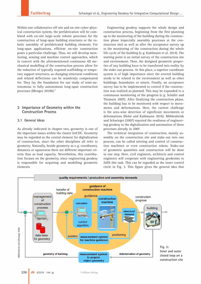
The technical integration of construction, mainly as-sembly on the construction site and stake-out into one process, can be called steering and control of construc-tion machines or even construction robots. Stake-out of geometric quantities and construction will be done in one step. Here, civil engineers, architects and control engineers will cooperate with engineering geodesists to fulfil this task. This can be regarded as the inner control circle in Fig. 3. This figure gives the general idea that
Fig. 3: Inner and outer closed loop on a construction site
Möh
lenb
rink
and
Schw
iege
r 20
06
226 zfv 4/2019 144. Jg. © Wißner-Verlag
Fachbeitrag Schwieger et al., Engineering Geodesy for Integrative Computational Design …

includes an outer control circle for steering the whole construction process and an inner control circle for the real technical control of construction machines or robots. In Möhlenbrink and Schwieger (2006), this procedure was presented on the base of a stake-out process of high-speed railway tracks. A similar process is described in Niemeier (2006) where he pointed out that tunnel boring machines controlled by geometric information delivered by engineering geodesists drive the construction process.
The mentioned inner closed loop as well as the out-er closed loop (Fig. 3) is driven by quality requirements or simply fabrication or assembly demands (Schwieger et al. 2010). Partly these demands are driven by geometric constraints (e. g. DIN 2005). The outer closed loop can be regarded as a task of the construction management by monitoring the planning and construction progress with respect to geometry. This is already realized dur-ing the construction of tunnels e. g. by total stations,
inclinometers or laser scanners. Since safety is an impor-tant issue on tunnel construction sites, the divergence of the bored tunnel is controlled in regular intervals.
For an accurate on-site assembly process, a correct and precise pre-fabrication of the building elements or structures that will be assembled on the construction site is required. Also at this place, exact geometry is one of the main concerns. In contradiction to the assembly process, fabrication, or rather pre-fabrication, does not need a superior coordinate system; a local element-based coordinate system is sufficient (compare quality control for mechanical engineering, e. g. Hennes 2017). Here, the elements are mainly manufactured using specialized ma-chines or even robots, meaning that no real stake-out process in the sense of engineering geodesy is required. Pre-fabrication has always been an integrated process of staking-out (in the sense of staking-out the shape) and fabrication in one step. In contrast, the final control sur-vey of the pre-fabricated elements that may be seen as quality control in the sense of dimensional metrology is
of vital importance for the later assembly process on the construction site. This is highlighted by the fact that up to 90 % of all quality control within industrial engineering relies on geometry (e. g. Dolezalek and Warnecke 1981).
3.2 Current Status and Challenges
In this section, the authors focus on the project “Robotic fabrication in Timber Construction” that shows the pos-sibilities that arise using well-known construction mate-rials in a new way by an integrative design, fabrication and construction approach. In this project, this includes the activation of reciprocal dependencies between ar-chitectural geometry, biomimetic engineering, structural design, robotic fabrication and geodetic evaluation. The importance of geometry and related challenges are the key points in the sense of this contribution.
Timber was the construction material to be used to build the pavilion at the horticultural show (Landesgar-tenschau) 2014 in Schwäbisch Gmünd (Fig. 4). With re-spect to sustainability aspects, the utilization of locally available building materials, e. g. timber, becomes crucial. Additionally, the timber construction industry is current-ly experiencing significant innovations in fabrication technology and structural applications. Plate structures are of particular interest as they are a performative con-struction system made of individual, planar elements. Geometrically, they can be organized in such a way that the individual plates constitute the primary load bearing structure. These individual plates have to be pre-fabri-cated very accurately off-site. Due to the extended kin-ematic range of robotic fabrication, complex connection geometries become feasible. This means that geometry is of crucial importance globally to control the optimal distribution of the individual plate segments, and locally through the control of the individual plates (Krieg et al. 2014).
Fig. 4: Pavilion at horticultural show 2014 in Schwäbisch Gmünd
Krie
g et
al.
2014
227144. Jg. 4/2019 zfv© Wißner-Verlag
FachbeitragSchwieger et al., Engineering Geodesy for Integrative Computational Design …

One task of engineering geodesy in this project was the quality assurance of the pre-fabrication process. A sam-ple of 24 out of overall 243 plates was analysed for this purpose. For the measurement, the laser tracker API Ra-dian™ was used together with an API IntelliProbe 360™, a hand-held probing instrument. The laser tracker is a po-lar measuring system delivering point coordinates with a standard deviation of 50 µm in a distance of about 10 m. The high measurement accuracy values are relevant due to the fabrication requirements of 1 mm standard devia-tion, demanding a tenfold improved measurement stand-ard deviation for quality control. The measurements, in-dicating the deviations between the pre-fabricated plates and the designed plates (CAD model) are determined to range between 0.001 mm and 0.352 mm. Taking into ac-count the real empirical accuracy of the measurements (around 0.3 mm), between 3 % and 4 % of the deviations out of approximately 200 deviations were significant. For the following assembly process this does not induce problems, since the deviations, even partly significant, remain small (Schwieger and Schmitt 2015).
The second task of engineering geodesy was the mul-tiple scanning of the pavilion after complete assembly. On the one hand, the match of the erected building with the designed building had to be controlled again, on the other hand the detection of any deformations of the pa-vilion over time was the other task. The laser scanner Leica HDS7000 was used for the area-wise acquisition for as-built control and deformation analysis, since it de-livers a high resolution and a 1 to 2 mm accurate point cloud. The pavilion was scanned from at least three dif-ferent laser scanner positions. The different positions were registered by referenced targets, which make it pos-sible to combine the different scans into one 3D mod-el. This process also includes cleaning the point cloud from outliers. Two epochs are compared directly using the geo-referencing (in the sense of using the same sta-ble network) which was realized using a tachymeter net- work. Fig. 5 shows geometric differences between the two
laser-scanned epochs. The standard deviation describing the relative accuracy between both epochs was calculated to σΔx = 6.9 mm. Compared to the measurement accura-cy of the laser scanner, this is a rather low value. The reason for this is the registration accuracy for the dif-ferent points of time. The comparison shows that 99.6 % of the deviations are in the range between –2 mm and 2 mm. Consequently, no deformations could be detected (Schwieger and Schmitt 2015).
This example shows that engineering geodesy was integrated into the design and construction process as quality control for pre-fabrication and on-site assembly. The stake-out of the pavilion was also part of the geodet-ic tasks, but this is not described since the realization was a standard tachymetric procedure.
Further improvement of the pre-fabrication process with respect to the already exceptionally high accuracy and low tolerances may be reached by integrating the ge-odetic measurement process completely into a sensor-ac-tuator controlled pre-fabrication process in a way that a crucial deviation from the designed plate will direct-ly lead to an reaction; for example to reject the respec-tive plate, or to correct the geometry by an additional pre-fabrication process, or, at its best, to re-design the following plates in real time so that these will compen-sate for the deviations induced by the identified plate. The other open issue is to develop and implement an integrated stake-out and assembly process on the con-struction site. Full digitalization and complete or partial automation are the base for an adequate realization. That may lead to a robotic assembly steered by geometric in-formation delivered by engineering geodesists. Therefore, the position and orientation of assembly robots and of individual plates to be assembled have to be known. Ad-ditionally, the current state of the building as well as the environment has to be acquired. Consequently, seamless positioning and 3D monitoring using area-wise acquisi-tion techniques, e. g. photogrammetry or laser scanning, are of major importance. Besides, a statistical assured
deformation analysis method for surfaces or complete objects does not exist up to now (Holst and Kuhlmann 2016).
Fig. 5: Color-coded deviations between the two laser-scanned epochs (different views)
Schw
iege
r an
d Sc
hmitt
201
5
228 zfv 4/2019 144. Jg. © Wißner-Verlag
Fachbeitrag Schwieger et al., Engineering Geodesy for Integrative Computational Design …

4. Geometry within IntCDC
4.1 Geodetic Research Program
Most of the challenges indicated in section 3.2 will be research issues in IntCDC. To give a first insight, the au-thors cite the proposal text directly concerning engineer-ing geodesy and photogrammetry. Engineering geodesy, represented by the Institute of Engineering Geodesy, will deal with “the integration of geodetic measurement techniques into machine and UAV guidance and control, area-wise-monitoring and multi-sensor data acquisition and quality modelling. Development of permanent mon-itoring methods including stochastic models and co-op-timisation of survey configurations, seamless positioning methods as well as process and quality modelling are also belonging to the research interests (Menges 2018b).” Photogrammetry, represented by the Institute of Photo-grammetry, will deal with the “automated analysis of mass geodata by means of pattern recognition methods, aiming at object recognition and 3D reconstruction. The development of kinematic monitoring methods, seam-less positioning methods, change detection methods as well as semantic modelling are further research focus areas (Menges 2018b).” In the following text, the term engineering geodesy is consequently used for the two sub-disciplines of geodesy. The general objectives of the proposal are cited in the following:
“In engineering geodesy, we will study ways to per-manently monitor construction sites. We will connect indoor and outdoor 3D data acquisition based on static and mobile platforms for time-varying objects and en-vironment. The gathered data will enable us to recon-struct and identify existing 3D objects, and, more impor-tantly, to monitor 3D objects under construction. With time constituting the 4th dimension, this will result in 4D modelling and simulation. Seamless precise position-ing of mobile multi-sensor systems like unmanned aerial vehicles (UAV) and robots will expand the possibilities of cyber-physical construction (Menges 2018b).”
“Engineering geodesy plays a crucial role as an in-terface between structural engineering, building physics, control engineering, computer science and robotics. We aim at a permanent kinematic and autonomous geometry survey of construction sites (outdoor and indoor) through 4D data acquisition based on precise seamless positioning of large-scale robots and UAVs. New stochastic sensor fusion models will help to guide the moving objects on predefined and adaptive paths. We also aim to derive pre-cise area-wise monitoring, 3D reconstruction and on-site change detection of the construction site, both in terms of geometry and semantics (object level). Imaging or scanning sensors will be stationary or mobile. Terres-trial laser scanners (TLS) need stochastically correct modelled point clouds to determine meshes as well as freeform volumes and surfaces and to optimise meas-urement configurations. We aim at a generic quality
model, which includes aspects such as feasibility, redun-dancy, but also completeness, accuracy and parameters for user comfort and ecological impact (Menges 2018b).”
The above text together with the challenges identified in section 3.2 defines the research environment for the geodetic partners in IntCDC within the RN defined in sec-tion 2.2. Individual PIs will work together and co-design will be realized within the RN particular by interacting among different RPs.
4.2 Exemplary Planned Engineering Geodetic Research
As written before, the activity of the geodetic authors of this contribution is integrated into RN2 on long-span buildings. Engineering geodesy is planning to contrib-ute to a RP named “Robotic Platform for Cyber-Physi-cal Assembly of Long-Span Fibre-Composite Structures” which will be an essential part of RN2. The long-term goal is to automate material handling and on-site as-sembly of pre-fabricated fibre-composite elements using a ground-based, medium-payload, mobile, robotic boom manipulator. Reaching this goal requires interdiscipli-nary advances in cyber-physical construction platform design, sensor selection and real-time signal processing, algorithms for motion control, robot gripper design, and human-machine interaction. The aim is to fully integrate stake-out and assembly in one process. The focus of the engineering geodetic group will be on seamless position-ing realized by a real-time robot total station network. First ideas and results using two robotic total stations were presented in Kerekes and Schwieger (2018); com-pare Fig. 6. For this RP it is planned that a real-time robotic total station network will be further extended and installed on the construction site to locate the assembly
Fig. 6: Kinematic positioning with two robotic total stations
Kerekes and Schwieger 2018
229144. Jg. 4/2019 zfv© Wißner-Verlag
FachbeitragSchwieger et al., Engineering Geodesy for Integrative Computational Design …

robot at any time. Possibilities to steer the robotic total stations in order to measure chosen points, which may lie on the robot, the building or a building component, will be investigated. Complementary robot-fixed sensor systems will support the positioning task. Data fusion and communication within the network and with the robot has to be analysed, and non-linear measurement equations have to be integrated into an appropriate filter approach delivering information (coordinates and even-tually attitude angles) on the sub-cm level. This RP will be an essential part of co-design by delivering an auto-mated or semi-automated assembly process for pre-fabri-cated fibre-composites. The real time robotic total station network will support to steer the assembly and stake-out process by seamless positioning.
Another important research topic will be on creating a holistic quality that integrates technical, environmental as well as social quality criteria. The engineering geodet-ic group has planned to contribute on technical quality and on integration aspects of the diverse criteria cata-logues. This holistic quality model will be important for the whole co-design process since it will describe and de-fine quality requirements that will steer and control the design and construction process in cascading feedback loops (compare e. g. Fig. 4).
AcknowledgementThe research published in this article is supported by the Deutsche Forschungsgemeinschaft (DFG, German Re-search Foundation) under Germany’s Excellence Strategy – EXC 2120/1 – 390831618. The authors cordially thank the DFG.
ReferencesDIN 18202 (2005): Toleranzen im Hochbau – Bauwerke, Beuth Verlag,
Berlin.Dolezalek, C.-M., Warnecke, H. J. (1981): Planung von Fabrikanlagen.
Springer Verlag. Berlin.Hennes, M. (2017): Messverfahren im Maschinenbau. In: Schwarz, W.
(Ed.): Ingenieurgeodäsie, Springer Nature, Berlin.Holst, C., Kuhlmann, H. (2016). Challenges and Present Fields of Action
at Laser Scanner Based Deformation Analyses. J. Appl. Geodesy, 10 (1).
Kerekes, G., Schwieger, V. (2018): Kinematic positioning in a real time robotic total station network system. 6th International Conference on Machine Control and Guidance. In Bornimer Agrartechnische Berichte, Heft 101, 35–43, Berlin, Germany.
Krieg, O., Schwinn, T., Menges, A., Li, J.-M., Knippers, J., Schmitt, A., Schwieger, V. (2014): Biomimetic Lightweight Timber Plate Shells: Computational Integration of Robotic Fabrication, Architectural Geo metry and Structural Design. In: Block, P., Knippers, J. Mitra, N., Wang, W. (Eds.): Advances in Architectural Geometry 2014. Sprin-ger, London.
Kuhlmann, H., Schwieger, V., Wieser, A., Niemeier, W. (2014): Engi-neering Geodesy – Definition and Core Competencies. Journal of Applied Geodesy, Heft 4, 327–334, de Gruyter.
Kutterer, H. (2019): Geodäsie – Schlüsseldisziplin für eine digitale Ge-sellschaft. In: Hanke, K., Weinhold, T. (Eds.): 20. Internationale Geo-dätische Woche Obergurgl 2019. VDE Verlag GmbH, Berlin.
Menges, A. (2018a): New Cluster of Excellence: Integrative Computa-tional Design and Construction for Architecture [Online]. https://icd.uni-stuttgart.de/?p=24111, accessed: 9 May 2019.
Menges, A. (2018b): New Cluster of Excellence: Integrative Compu-tational Design and Construction for Architecture. Proposal for a Cluster of Excellence. Unpublished.
Möhlenbrink, W., Schwieger, V. (2006): Navigation and Quality of Con-struction Processes. Proceedings on XXIII International FIG Con-gress, München, 8.–13.10.2006.
Möhlenbrink, W., Schwieger, V. (2007): Zur Prozessintegration der geo-dätischen Messtechnik. Allgemeine Vermessungsnachrichten, Heft 11-12.
Niemeier, W. (2006): Geodetic Techniques for the Navigation, Guidance and Control of Construction Processes. Proceedings on 3rd IAG Symposium on Geodesy for Geotechnical and Structural Engineer-ing, Baden, Austria, May 22–24.
REFA (1978): Methodenlehre des Arbeitsstudiums, 6 Bände: Grundla-gen, Datenermittlung, Kostenrechnung, Arbeitsgestaltung, Anfor-de rungsermittlung, Lohndifferenzierung. Ed.: REFA-Verband e.V., Hanser Verlag, München.
Schäfer, M., Thomsen, S. (2007): Baufortschrittsdokumentation mit terrestrischem 3D-Laserscanning im Rahmen des Projektes fu-ture:workspace – die Arbeitswelt von morgen: In: Brunner, F. (Ed.): Ingenieurvermessung 07, Beiträge zum 15. Internationalen Inge-nieurvermessungskurs, Graz, Herbert Wichmann Verlag, Heidelberg.
Schwieger, V., Beetz, A., Wengert, M., Schweitzer, J. (2010): Echt zeit-Integration ingenieurgeodätischer Messsysteme in Bauregelkreise. 16. Internationaler Ingenieurvermessungskurs. München, 23.–27.02.2010.
Schwieger, V., Schmitt, A: (2015) Quality Control and Deformation Analysis for a Timber Construction. GeoSiberia 2015, Novosibirsk, Russia, 20.–22.04.2015.
ContactProf. Dr.-Ing. habil. Volker Schwieger | Dr.-Ing. Li ZhangInstitut für Ingenieurgeodäsie, Universität StuttgartGeschwister-Scholl-Straße 24D, 70174 [email protected]@iigs.uni-stuttgart.de
Prof. AA Dipl. (Hons.) Achim Menges | Dipl.-Ing. Tobias SchwinnInstitut für Computerbasiertes Entwerfen, Universität StuttgartKeplerstraße 11, 70174 [email protected]@icd.uni-stuttgart.de
This article also is digitally available under www.geodaesie.info.
230 zfv 4/2019 144. Jg. © Wißner-Verlag
Fachbeitrag Schwieger et al., Engineering Geodesy for Integrative Computational Design …