engineering report - a123.g.akamai.neta123.g.akamai.net/7/123/11558/abc123/forestservic... ·...
TRANSCRIPT

Engineering Report:
Shasta-Trinity National Forest
Trinity River Management Unit
Analysis of
National Forest System Road
37N08Y (milepost 0.00 to 8.70)
for Motorized Mixed Use Designation

2
Forest: Shasta-Trinity Management Unit: Trinity River Road Number: 37N08Y Road Name: Hall Gulch Time of Visit: 11/18/11 @ 1645-1815
Study Segment road data from the forest transportation atlas:
Segment 1: East Fork Road to NFSR 37N15
Beginning Mile Post: 0.00 Ending Mile Post: 5.23
Segment 2: NFSR 37N15 to County Road 118
Beginning Mile Post: 5.23 Ending Mile Post: 8.70
Traffic Service Level: A B C D
Objective Maintenance Level: 1 2 3 4 5
Operational Maintenance Level: 1 2 3 4 5
Maintenance by: Forest Service (FS)
Non-Forest Service ROW or jurisdiction? Yes No
Any road use agreements, maintenance agreements, or other encumbrances?
Yes No
Description of agreements or encumbrances: There are a number of easements granted to the Forest Service from private individuals and commercial landowners, allowing the Forest Service to maintain jurisdiction over the entire road length. Much of the road is also under cost-share agreements with commercial timberland companies. Subject to Highway Safety Act? Yes No Non-highway-legal vehicles currently permitted? Yes No
3
Would motorized mixed use be consistent with State and local laws? Yes No
The proposed section is over 3 miles and therefore, if maintained at the current level, would not be consistent with California Vehicle Code (CVC), Combined Use Highways Designation (CVC Division 16.5, Chapter 2, Article 1, Section 38026). Based on the CVC and Forest Service Region 5 guidelines, the designation of motorized mixed use requires California Highway Patrol notification prior to designation. Based on the response from the CHP commissioner, the Forest may reconsider the decision to designate MMU and/or may adjust mitigation measures needed for implementation. Description of road management objectives (RMOs), existing use, and proposed use: NFSR 37N08Y has traditionally served administration of the STNF, including fuels and vegetation management, commodity extraction, fire suppression, and recreation. The road also provides access to private land, including residential properties as well as checkerboarded commercial timber land sections. The road is considered a highway by the Forest Service and is managed in accordance with the Highway Safety Act. The road is managed for passenger car vehicles and is appropriately posted with horizontal route identification markers. It is currently managed as open only to highway-legal vehicles. The road functions as an arterial route. Segments from mileposts 0.36 to 0.77 and 2.49 to 8.70 are managed under Cost-Share Agreements. Parties invest maintenance funds into the road based on their share of use. The northwest portion of the road accesses a number of private residences. Some of these have propane tanks which would require recurrent visits from a propane truck to service and refuel. The road segment studied for this report is proposed to be managed for all motor vehicles, with motorized mixed use. The proposed use of non-highway-legal vehicles on highway segments would be restricted to licensed operators only, in accordance with State law.

4
General Considerations: All motor vehicle operators need to be cognizant of the applicable State laws, and how they pertain to each age group, vehicle type, and National Forest System road classification (see next bullet). Through authorities delegated by the Secretary, the Forest Service may restrict or control use to meet road management objectives (36 CFR 212.5). The STNF currently manages this road as a highway, in accordance with the Highway Safety Act. The road is therefore subject to the provisions of the California Vehicle Code (CVC) for highways. Operators on roads managed by the Forest Service for passenger cars (maintenance level 3-5) are required to be in possession of a valid state driver’s license. State OHV Regulations: To operate on public lands, off of highways, motor vehicles must have either a street-legal license plate or a red sticker or a green sticker. For more information, see the CA State Parks Off-Highway Motor Vehicle Recreation site, available @ http://ohv.parks.ca.gov/ California has:
-requirements for ATV safety -conditions for operating ATVs -OHV equipment requirements -OHV operation requirements
Summary of Findings: The road is maintained to a standard allowing efficient passenger car through traffic at speeds up to 25 mph on straightaways. The road accesses private residences, commercial timberlands, and public lands. Private, residential, administrative, commercial, and recreational traffic can be expected on these segments. Segment 1 begins at the paved East Fork Road, and near where a private driveway intersects the study segment. This location is not adequate as an OHV staging area. Designating road segment 1 for motorized mixed use, with mitigation, results in a risk assessment of moderate crash probability and moderate crash severity.

5
Designating road segment 2 for motorized mixed use, with mitigation, results in a risk assessment of low crash probability and moderate crash severity. Road hazard mitigation should be prioritized regardless of mixed use, along with implementing a comprehensive communication, management, and enforcement plan. Associated implementation costs will depend on the designated allowed use. Implementing mitigation measures will reduce crash probability. Segments 1 and 2 appeared in accordance with the Forest transportation atlas assigned operational maintenance level of 3. Factors Considered: 1. Operator considerations:
• The current use on NFSR 37N08Y segments 1 and 2 appears to be
consistent with State law and Forest Service policy for operational maintenance level 3 roads.
• Private, residential, commercial, recreational and administrative traffic can be expected along this segment.
2. Crash history: None provided by unit
3. Observed Traffic volume and type:
Non-highway-legal vehicles: < 12 inch tread width < 50 inch tread width >50 inch tread width
Highway-legal vehicles:
< 12 inch tread width < 50 inch tread width >50 inch tread width
Passenger cars Commercial vehicles Recreation vehicles (RV’s)

6
None observed
4. Speed - Anticipated average speed (85th percentile): The road segment was driven at various speeds to simulate conditions encountered by a reasonable and prudent driver in a passenger car. Based on observation and engineering judgment, speeds are anticipated as: 25 mph – straightaways on segment 1 20 mph – straightaways on segment 2 *Privately posted, non-MUTCD standard speed limit signs were observed near private residences. 5. Road surface type: Segment 1 is surfaced with aggregate and transitions to improved native material prior to entering segment 2. Most of segment 1 uses an insloped road with inside ditch and culvert cross-drains. Recently installed diversion potential rolling dips were observed below these culvert structures. Some of these dips are abrupt and require slow speeds for low-clearance vehicles to negotiate. Segment 2 generally has an outsloped template with rolling dips. The traveled way width is variable; all segments are considered single-lane except for the northwest portion of segment 1, near private residences that approaches 20’ width. There are occasional turnouts available through the study segments. They are not intervisible. 6. Intersections with other roads and trails: The sight distances at the managed NFS road intersections are rated fair to good. There are also a number of unmarked private intersections rated fair. The intersections could be improved with vegetation clearing and improved signing. There are no non-sign traffic strategies (i.e., entrance treatment) on this road, allowing higher merging speeds between roads.

7
7. Other roadway factors: • The road accesses borrow sites as well as log landings, one with active pile
burning. • The road offers vistas of Wildcat Peak, Halls Gulch watershed, and Trinity
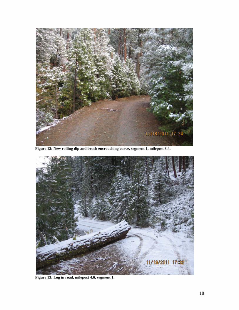
Lake. • A cedar log was observed partially blocking the road at milepost 4.6 (see
photos). • Snow and ice were encountered on the roadway.
8. Roadside conditions:
• Most of the study length has trees (up to 20’ height) growing in the shoulders and encroaching the travelled way.
• Moderate cut and fill slopes were observed. • There are some through-fill sections where the road crosses drainages.
9. Risk without mitigation if designating the road segment “open to all motor vehicles”:
Segment 1: Crash probability: High Med Low Crash severity: High Med Low Segment 2: Crash probability: High Med Low Crash severity: High Med Low
Crash probability was assessed based factors including: • Traffic volume, rates of speed, alignment, road segment uses, sight
distance, traveled way surface and width, operator requirements. Crash severity was assessed based on:
• Roadway geometry (embankments, slopes, horizontal and vertical alignments), difference in vehicle sizes, difference in speeds of OHVs and full-size passenger vehicles, potential path and objects encountered if a vehicle left the traveled way.

8
Alternatives and Mitigation Measures: Alternatives and mitigation measures are presented to assist with safe road management. They are to be considered, should the agency have the appropriate time, workload, and funding based on competing priorities. For all situations, the following mitigation measures apply:
• Clear communication and education to the visitors on allowed uses, safe motor vehicle use, and natural resources (informational signing and kiosks, maps, website, etc.).
• Improved route identification signing, consistent with the forest visitor map and forest motor vehicle use map. Repair and replace devices as needed.
• Clear brush and trees, especially along curves and at intersections, to improve sight distance. warning: improved sight distance may result in higher speeds
• Removal of roadside hazards such as boulders, trees, and debris. • Implement and maintain the appropriate Forest Service traffic
management strategies for the assigned operational maintenance level. • Combine the appropriate enforcement measures with the allowed uses for
the road. • Coordinate with other agencies to improve enforcement consistency. • Utilize a monitoring program to better determine the appropriate
management strategy for the types of use, new technologies, changes in visitor demands, and resource protection measures.
In addition, these mitigation measures would apply to the following alternatives. Although the following alternatives are not comprehensive for the situation, they represent the most likely and/or practical options based on engineering judgment. Alternative 1: Designate the road segments as “open to highway-legal vehicles only”. Continue to manage the road in accordance with maintenance level 3 standards.
• Maintain all roadway signing to MUTCD standards. • Approximate Implementation Cost: $ 0 • Expected risk:
Crash probability: High Med Low Crash severity: High Med Low * This results in a non-motorized mixed use situation.
This option carries forward the existing Road Management Objectives.

9
Alternative 2: Designate the road segments as “open to all motor vehicles”, including highway legal and non-highway-legal vehicles. Maintain the road in accordance with maintenance level 3 standards.
• Improve education and enforcement communication to explain the complexities of various allowed uses on the road.
• Install appropriate warning signs (“Share the Road”) of a type approved by the Department of Transportation on and along the highway to identify and communicate the potential hazards related to motorized mixed use.
• Improve sight distance by clearing vegetation along shoulders, curves, and at intersections.
• Implement appropriate traffic management strategies on intersecting maintenance level 2 roads.
• Notify the Commissioner of the California Highway Patrol and review their opinion.
• Approximate Implementation Cost: $ 8000 Covers safety signing, roadside brushing, and entrance treatments on intersecting maintenance level 2 roads.
• Expected risk: Segment 1: Crash probability: High Med Low Crash severity: High Med Low Segment 2: Crash probability: High Med Low Crash severity: High Med Low
Alternative 3: Designate the road segments as “open to all motor vehicles”, including highway-legal and non-highway-legal vehicles. Downgrade the road in accordance with maintenance level 2 standards. This would require implementing the appropriate traffic management strategies, in this case either “discourage passenger car vehicles” and/or “accept” -or- “encourage high clearance vehicle traffic”.
• This option is not consistent with the assigned road objective maintenance level. Since segment 1 access private residences and other private lands, coordination with these entities would be necessary before downgrading.
• Consider removing features such as ditches & culverts which may require frequent maintenance more associated with ML 3-5 roads. Some culverts have diversion potential dips installed directly below them; this stormproofing technique may offer some self-maintenance if the pipes

10
clog or fail. • Consider long-term impacts to the rest of the road not included in the
altered segment. • Approximate Implementation Cost: $ 6,000 per mile. This would mainly be
required for segment 1 since much of segment 2 is already outsloped. • Expected risk:
Crash probability: High Med Low Crash severity: High Med Low
Alternative 4: Construct OHV trail segment(s) to allow non-highway-legal vehicles to bypass the road and access adjacent maintenance level 2 roads.
• The terrain in this area is moderate to steep and would not readily provide for a parallel trail system.
• Approximate construction cost: $8000 per mile + crossing structures. * Alternative costs do not include planning, agreements, and long term maintenance costs associated with a new NFS trail.
Crash probability: High Med Low Crash severity: High Med Low * This results in a non-motorized mixed use situation.
Alternative 5: Transfer jurisdiction to Shasta County. • Despite the road being located in Trinity County, the Shasta County Board
of Supervisors and County engineers have advocated a change in Forest Service management of this route. Since the road accesses private parcels and private residences, this route would best be managed as a public road under an agency that manages and maintains roads for residential access.
• This option would also resolve the motorized mixed use issue, since Shasta County has made it clear they allow off-highway-vehicle use on unpaved County roads and accept the associated risks.
• The road also connects two county roads and would provide a logical county-managed addition.

11
Final Comments: Signing on National Forest System roads will conform to the standards presented in the FS sign and poster guidelines (available @ http://fsweb.wo.fs.fed.us/eng/roads_trails/signs_05/index.htm). In addition, roads managed under the Highway Safety Act, including the study segment here, must comply with the standards in the MUTCD (available @ http://mutcd.fhwa.dot.gov/). According to the Sign and Poster Guidelines for the Forest Service (2005):
The following priorities are to be used to minimize the potential conflicts of mixed use:
o Provide separate facilities. o Separate use periods. Roads may be designated for separate use
periods such as season, weekday/weekend, or day/night. Notify the public of the locations, effective dates, times, and duration that the roads may or may not be used. Provide appropriate signs as shown in Chapter 3A.
o Manage concurrent use. Upon designation and prior to allowing any mixed use, the Forest Supervisor is responsible for appropriately signing and mapping the route such that the dual traffic use is clear to all users.

12
Photos & Map
Figure 1: Looking south at East Fork Road (right) and segment 1 (left), milepost 0.0.

13
Figure 2: Looking southeast at the entrance to segment 1 at milepost 0.0; note private residence 500' down road.
Figure 3: Sierra Pacific Industries ownership sign, segment 1, milepost 0.3.

14
Figure 4: S-curve, milepost 0.6, segment 1.
Figure 5: Looking northwest at the intersection with NFSR 38N47 (left) and segment 1 (right), milepost 0.78.

15
Figure 6: Looking east at segment 1 from milepost 0.8, segment 1; note new rolling dip (with flagging).
Figure 7: Segment 1, milepost 1.0; "No Trespassing" sign on left.

16
Figure 8: Segment 1, milepost 1.47, private land access on left.
Figure 9: Private sign near residence, milepost 2.1, segment 1.

17
Figure 10: Looking east at the intersection with NFSR 37N08YC (right) and segment 1, milepost 2.5.
Figure 11: Segment 1, intersection with NFSR 37N08YB (left) and segment 1, milepost 2.9.
18
Figure 12: New rolling dip and brush encroaching curve, segment 1, milepost 3.4.
Figure 13: Log in road, milepost 4.6, segment 1.

19
Figure 14: Approaching crest in road, milepost 4.9, segment 1.
Figure 15: Intersection with NFSR 37N15 (left) and segment 2, milepost 5.2.

20
Figure 16: Halls Gulch multi-plate culvert, milepost 5.5, segment 2.
Figure 17: Smoldering slash piles at log landing, segment 2, milepost 5.9.

21
Figure 18: Looking south at the intersection with NFSR 37N42 (straight) and segment 2 (left), milepost 6.3.
Figure 19: Straightaway, segment 2, milepost 7.6.

22
Figure 20: View north toward Wildcat Peak, over Halls Gulch basin, milepost 8.5.
Figure 21: Looking east at segment 2, milepost 8.7.

23
Figure 22: Forest destination signing, segment 2, milepost 8.7.

24
Figure 23: Forest Visitor Map zoom view with study road.
Prepared by: Chris Bielecki Logging Engineer, USDA Forest Service
Study termini